Embed Size (px)
Citation preview
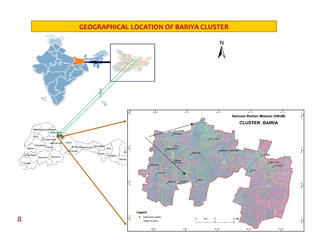
8
GEOGRAPHICAL LOCATION OF BARIYA CLUSTER
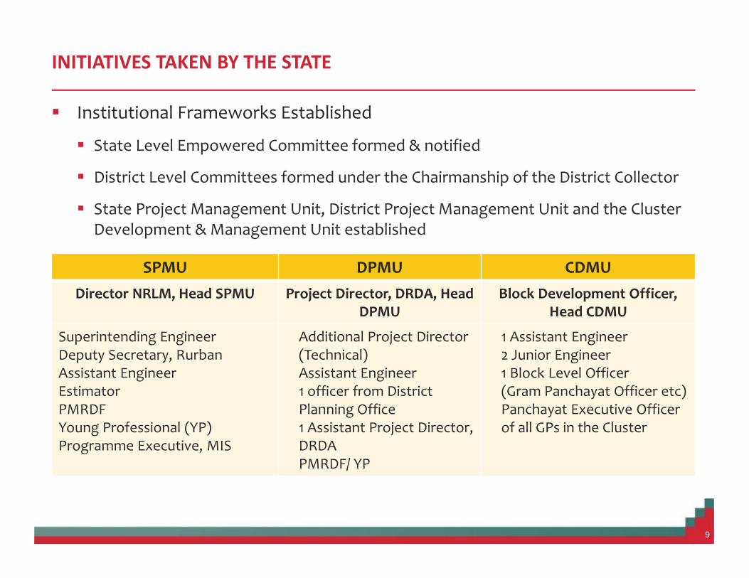
INITIATIVES TAKEN BY THE STATE
Institutional Frameworks Established
State Level Empowered Committee formed & notified
District Level Committees formed under the Chairmanship of the District Collector
State Project Management Unit, District Project Management Unit and the ClusterDevelopment & Management Unit established
9
SPMU DPMU CDMUDirector NRLM, Head SPMU Project Director, DRDA, Head
DPMUBlock Development Officer,
Head CDMU
Superintending EngineerDeputy Secretary, RurbanAssistant EngineerEstimatorPMRDFYoung Professional (YP)Programme Executive, MIS
Additional Project Director(Technical)Assistant Engineer1 officer from DistrictPlanning Office1 Assistant Project Director,DRDAPMRDF/ YP
1 Assistant Engineer2 Junior Engineer1 Block Level Officer(Gram Panchayat Officer etc)Panchayat Executive Officerof all GPs in the Cluster

Other Initiatives Taken
Dedicated Web MIS Portal for DataEntry and Analysis of the Clustersidentified http ://icapbihar.in
Dedicated Questionnaire Designedfor Village Level ,HH owner, Members
Digitization of all Village CadastralMaps
GIS Tagging of Available Resourcesand Potential Areas for development
10
Facebook Page
BAIRIYACLUSTERSAMPATCHAK
PATNA
11
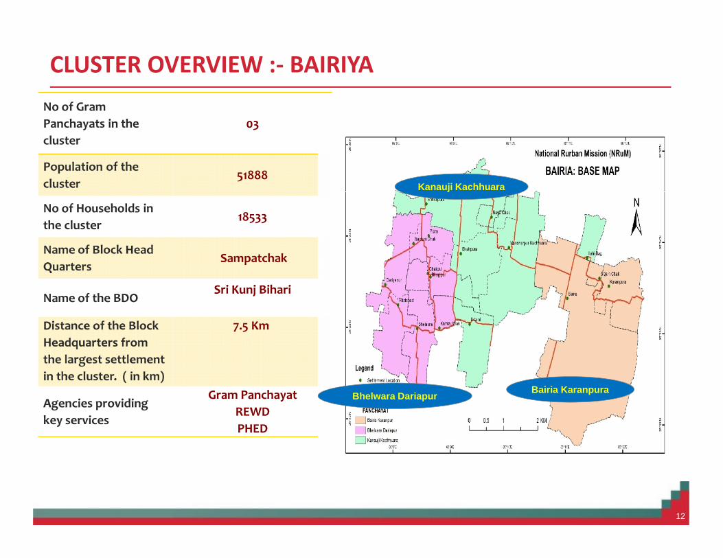
CLUSTER OVERVIEW :- BAIRIYA
12
No of GramPanchayats in thecluster
03
Population of thecluster
51888
No of Households inthe cluster
18533
Name of Block HeadQuarters
Sampatchak
Name of the BDOSri Kunj Bihari
Distance of the BlockHeadquarters fromthe largest settlementin the cluster. ( in km)
7.5 Km
Agencies providingkey services
Gram PanchayatREWDPHED
Bairia KaranpuraBhelwara Dariapur
Kanauji Kachhuara
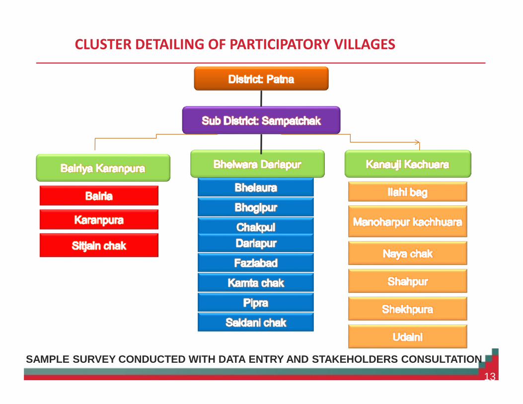
CLUSTER DETAILING OF PARTICIPATORY VILLAGES
SAMPLE SURVEY CONDUCTED WITH DATA ENTRY AND STAKEHOLDERS CONSULTATION13

GRAM PANCHAYAT I : BAIRIYA KARANPUR
As Per Census 2011 (Bihar)
14
Particulars Bairia Karanpura Sitjain chak
Total population 14194 2416 1002
Male population 7437 1310 530
Female population 6757 1106 472
Children(0-6) 2531 176 201
Literacy ratio 53% 64% 48%
Schedule Class 1644 570 17
Schedule Tribe 83 1 0
Total Workers 4342 913 297
Main Workers 20.1%(2853) 418 222
Marginal Workers 10.5% (1489) 495 75
No. of HouseHolds 2348 392 167
Geographical area(inhectares)
720.24 146.15 18.21

GRAM PANCHAYAT II : BHELWARA DARIYAPUR
As Per Census 2011 (Bihar)
15
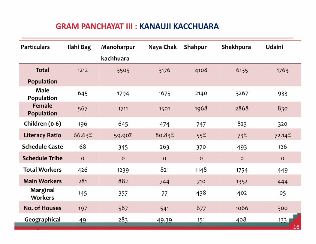
GRAM PANCHAYAT III : KANAUJI KACCHUARA
16
Particulars Ilahi Bag Manoharpur
kachhuara
Naya Chak Shahpur Shekhpura Udaini
Total
Population
1212 3505 3176 4108 6135 1763
MalePopulation
645 1794 1675 2140 3267 933
FemalePopulation
567 1711 1501 1968 2868 830
Children (0-6) 196 645 474 747 823 320
Literacy Ratio 66.63% 59.90% 80.83% 55% 73% 72.14%
Schedule Caste 68 345 263 370 493 126
Schedule Tribe 0 0 0 0 0 0
Total Workers 426 1239 821 1148 1754 449
Main Workers 281 882 744 710 1352 444MarginalWorkers
145 357 77 438 402 05
No. of Houses 197 587 541 677 1066 300
Geographical
Area
49 283 49.39 151 408- 133

Mapping of Available Resources in the area Bairiya Cluster
17
Point Features CodeLandmark (Religious) 01-00
Chhatri 01-01Church 01-02Grave 01-03Mosque 01-04Temple 01-05Idgah 01-06
Landmarks (Infrastructure) 02-00Chimney 02-01Govt. Dispensary/PHC 02-02Fountain 02-03Ground Level Reservoir 02-04Major Hospital 02-05Permanent Hut 02-06Temporary Hut 02-07Over Head Tank 02-08Combined Office 02-09Petrol Pump 02-10Power Pole 02-11Post Office 02-12Pylon 02-13Culvert on Rail 02-14Culvert on Road 02-15Telegraph Office 02-16All types of towers 02-17Tube well 02-18Watch Tower 02-19Lined well 02-20Unlined well 02-21
Polygon Features Code
Built-up (Residential) 06-00Building layout 06-01Building underConstruction 06-02Group of Building 06-03Single Building 06-04Slums 06-05
Waterbodies 08-00Pond 08-01River 08-02Tank Square 08-03Tanks dry limit 08-04Tanks with water limit 08-05
Public/Semi-public 09-00Govt. Dispensary Area 09-01Electric Sub Station 09-02Fire Station 09-03Fountain 09-04Ground Level Reservoir 09-05Hospital Area 09-06Petrol Pump Area 09-07Pump House 09-08Well by Shape 09-09Cultivation Limit 09-10Marshy Boundary 09-11Plantation with limits 09-12Brick Kiln 09-13Boulder Line 09-14

18
THEMATIC MAPPING :- SOIL MAP
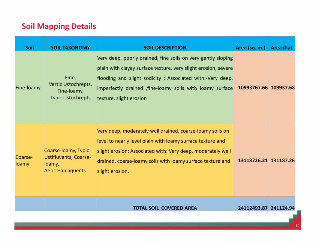
Soil Mapping Details
19
Soil SOIL TAXONOMY SOIL DESCRIPTION Area (sq. m.) Area (ha)
Fine-loamy
Fine,Vertic Ustochrepts,
Fine-loamy,Typic Ustochrepts
Very deep, poorly drained, fine soils on very gently sloping
plain with clayey surface texture, very slight erosion, severe
flooding and slight sodicity ; Associated with:-Very deep,
imperfectly drained ,fine-loamy soils with loamy surface
texture, slight erosion
10993767.66 109937.68
Coarse-loamy
Coarse-loamy, TypicUstifluvents, Coarse-loamy,Aeric Haplaquents
Very deep, moderately well drained, coarse-loamy soils on
level to nearly level plain with loamy surface texture and
slight erosion; Associated with: Very deep, moderately well
drained, coarse-loamy soils with loamy surface texture and
slight erosion.
13118726.21 131187.26
TOTAL SOIL COVERED AREA 24112493.87 241124.94
20
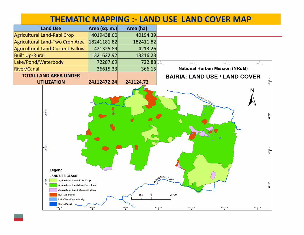
THEMATIC MAPPING :- LAND USE LAND COVER MAPLand Use Area (sq. m.) Area (ha)
Agricultural Land-Rabi Crop 4019438.60 40194.39Agricultural Land-Two Crop Area 18241181.82 182411.82Agricultural Land-Current Fallow 421325.89 4213.26Built Up-Rural 1321622.92 13216.23Lake/Pond/Waterbody 72287.69 722.88River/Canal 36615.33 366.15
TOTAL LAND AREA UNDERUTILIZATION 24112472.24 241124.72

21
THEMATIC MAPPING :- SLOPE MAP
22
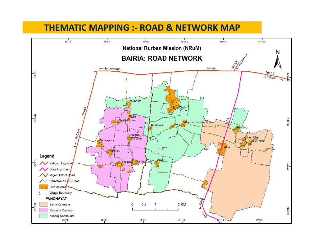
THEMATIC MAPPING :- ROAD & NETWORK MAP
23
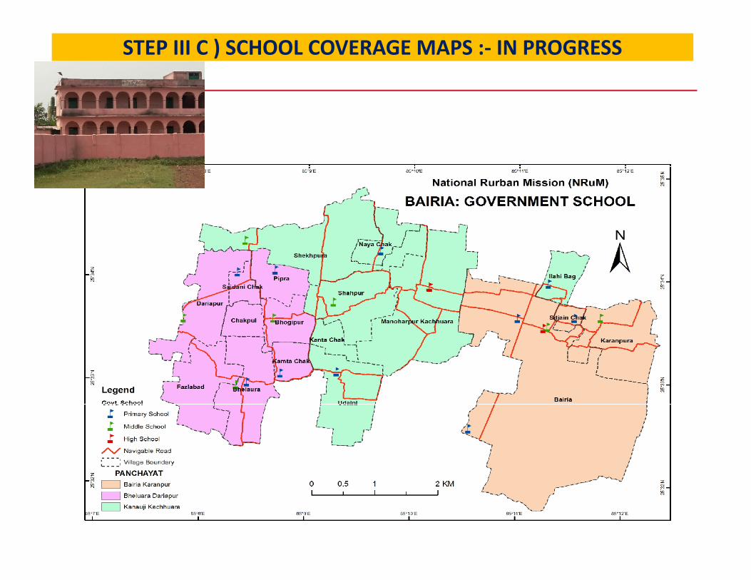
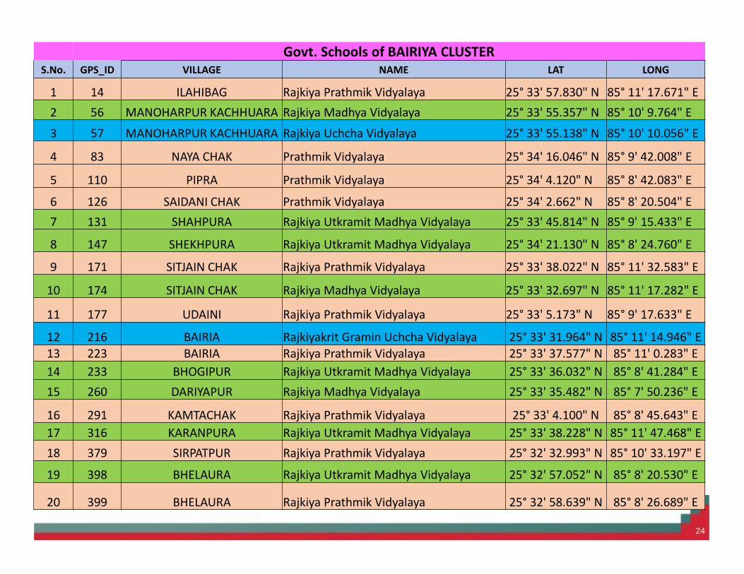
STEP III C ) SCHOOL COVERAGE MAPS :- IN PROGRESS
24
Govt. Schools of BAIRIYA CLUSTERS.No. GPS_ID VILLAGE NAME LAT LONG
1 14 ILAHIBAG Rajkiya Prathmik Vidyalaya 25° 33' 57.830" N 85° 11' 17.671" E2 56 MANOHARPUR KACHHUARA Rajkiya Madhya Vidyalaya 25° 33' 55.357" N 85° 10' 9.764" E3 57 MANOHARPUR KACHHUARA Rajkiya Uchcha Vidyalaya 25° 33' 55.138" N 85° 10' 10.056" E
4 83 NAYA CHAK Prathmik Vidyalaya 25° 34' 16.046" N 85° 9' 42.008" E
5 110 PIPRA Prathmik Vidyalaya 25° 34' 4.120" N 85° 8' 42.083" E6 126 SAIDANI CHAK Prathmik Vidyalaya 25° 34' 2.662" N 85° 8' 20.504" E7 131 SHAHPURA Rajkiya Utkramit Madhya Vidyalaya 25° 33' 45.814" N 85° 9' 15.433" E
8 147 SHEKHPURA Rajkiya Utkramit Madhya Vidyalaya 25° 34' 21.130" N 85° 8' 24.760" E
9 171 SITJAIN CHAK Rajkiya Prathmik Vidyalaya 25° 33' 38.022" N 85° 11' 32.583" E
10 174 SITJAIN CHAK Rajkiya Madhya Vidyalaya 25° 33' 32.697" N 85° 11' 17.282" E
11 177 UDAINI Rajkiya Prathmik Vidyalaya 25° 33' 5.173" N 85° 9' 17.633" E
12 216 BAIRIA Rajkiyakrit Gramin Uchcha Vidyalaya 25° 33' 31.964" N 85° 11' 14.946" E13 223 BAIRIA Rajkiya Prathmik Vidyalaya 25° 33' 37.577" N 85° 11' 0.283" E14 233 BHOGIPUR Rajkiya Utkramit Madhya Vidyalaya 25° 33' 36.032" N 85° 8' 41.284" E15 260 DARIYAPUR Rajkiya Madhya Vidyalaya 25° 33' 35.482" N 85° 7' 50.236" E
16 291 KAMTACHAK Rajkiya Prathmik Vidyalaya 25° 33' 4.100" N 85° 8' 45.643" E17 316 KARANPURA Rajkiya Utkramit Madhya Vidyalaya 25° 33' 38.228" N 85° 11' 47.468" E18 379 SIRPATPUR Rajkiya Prathmik Vidyalaya 25° 32' 32.993" N 85° 10' 33.197" E19 398 BHELAURA Rajkiya Utkramit Madhya Vidyalaya 25° 32' 57.052" N 85° 8' 20.530" E
20 399 BHELAURA Rajkiya Prathmik Vidyalaya 25° 32' 58.639" N 85° 8' 26.689" E
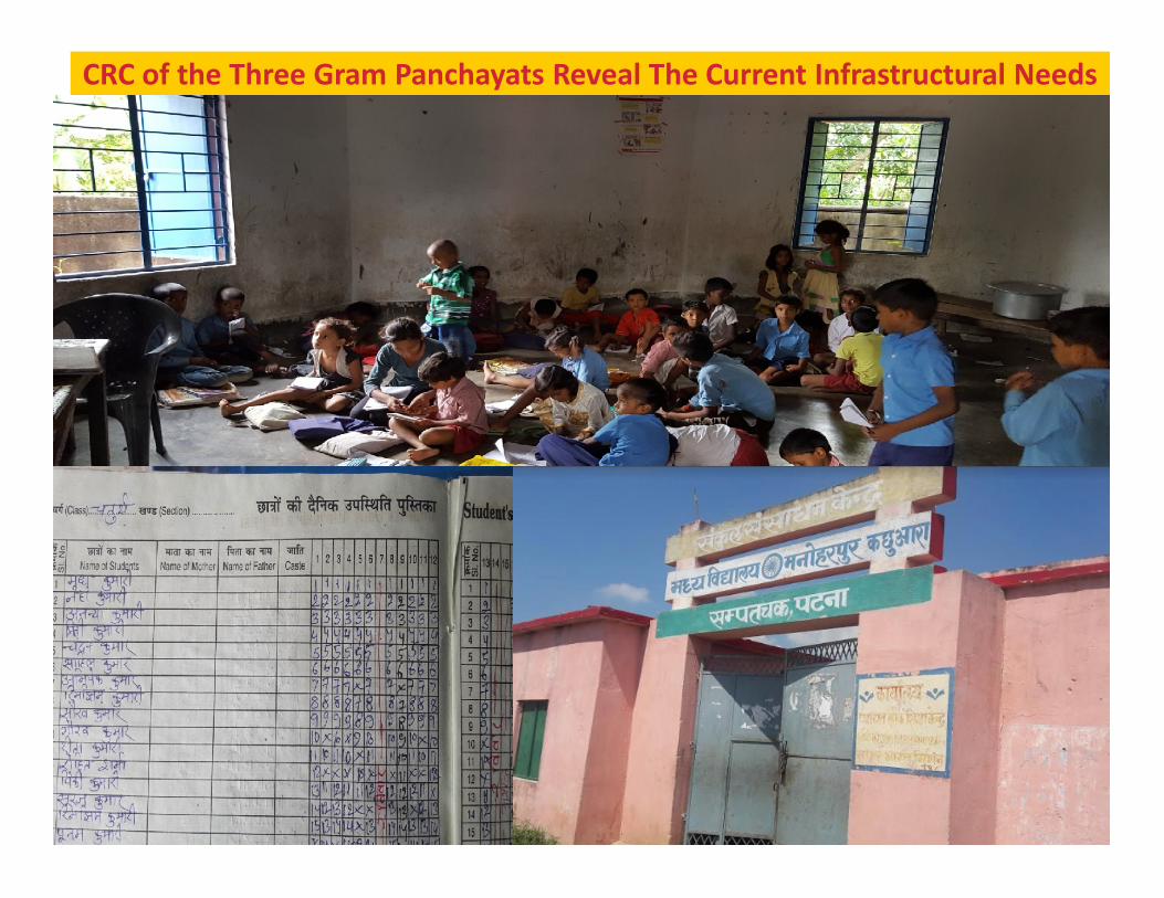
CRC of the Three Gram Panchayats Reveal The Current Infrastructural Needs
25
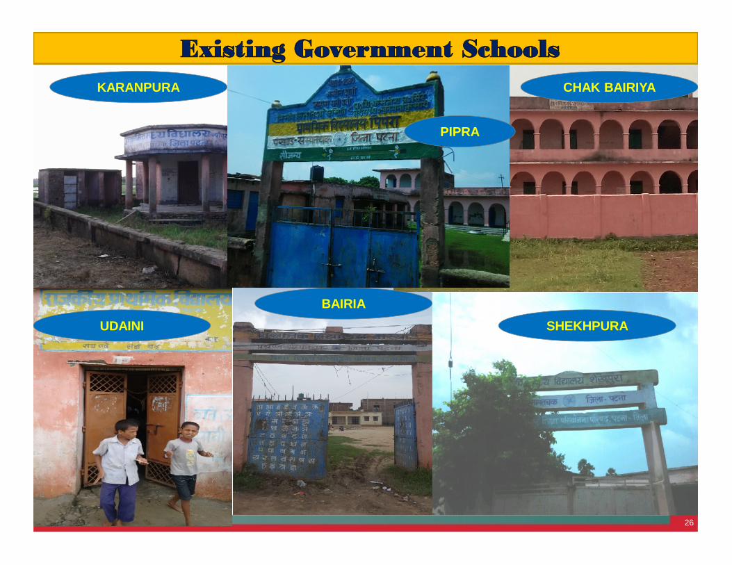
26
Existing Government SchoolsKARANPURA CHAK BAIRIYA
UDAINI SHEKHPURABAIRIA
PIPRA
27
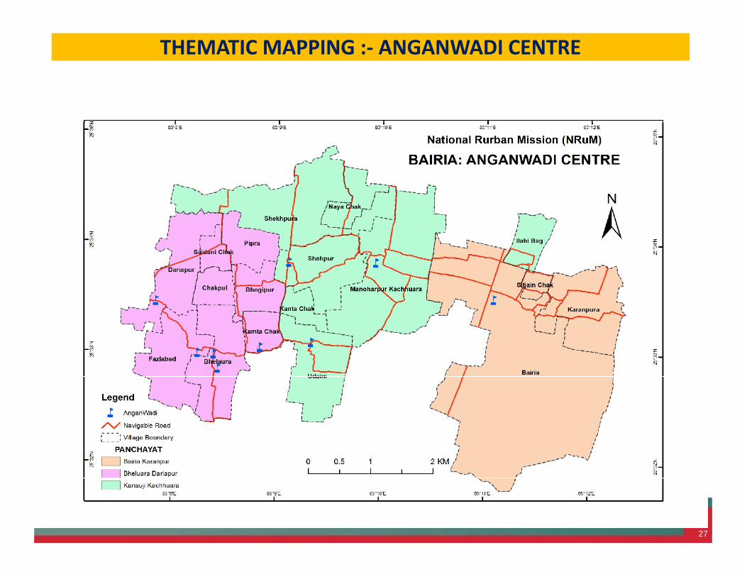
THEMATIC MAPPING :- ANGANWADI CENTRE
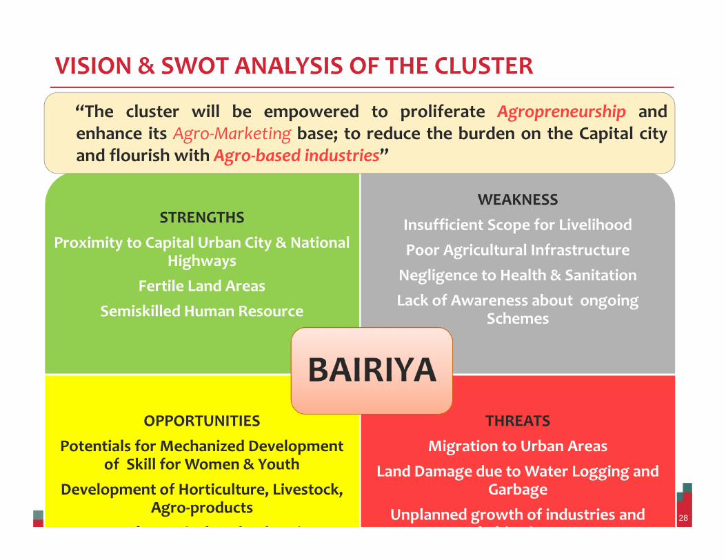
VISION & SWOT ANALYSIS OF THE CLUSTER
28
STRENGTHSProximity to Capital Urban City & National
HighwaysFertile Land Areas
Semiskilled Human Resource
WEAKNESSInsufficient Scope for LivelihoodPoor Agricultural Infrastructure
Negligence to Health & SanitationLack of Awareness about ongoing
Schemes
OPPORTUNITIESPotentials for Mechanized Development
of Skill for Women & YouthDevelopment of Horticulture, Livestock,
Agro-productsScope for Agricultural Industries
THREATSMigration to Urban Areas
Land Damage due to Water Logging andGarbage
Unplanned growth of industries andhabitations
BAIRIYABAIRIYA
“The cluster will be empowered to proliferate Agropreneurship andenhance its Agro-Marketing base; to reduce the burden on the Capital cityand flourish with Agro-based industries”
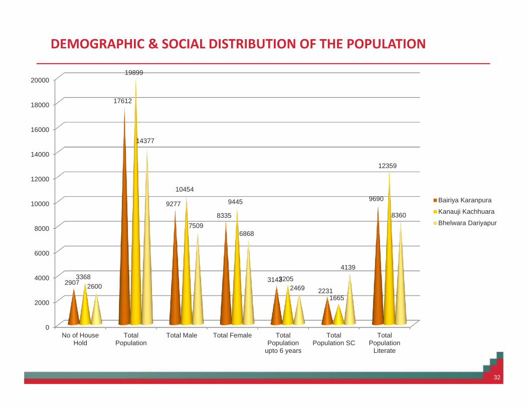
DEMOGRAPHIC & SOCIAL DISTRIBUTION OF THE POPULATION
32
0
2000
4000
6000
8000
10000
12000
14000
16000
18000
20000
No of HouseHold
TotalPopulation
Total Male Total Female TotalPopulation
upto 6 years
TotalPopulation SC
TotalPopulation
Literate
2907
17612
9277
8335
31432231
9690
3368
19899
10454
9445
3205
1665
12359
2600
14377
75096868
2469
4139
8360
Bairiya Karanpura
Kanauji Kachhuara
Bhelwara Dariyapur
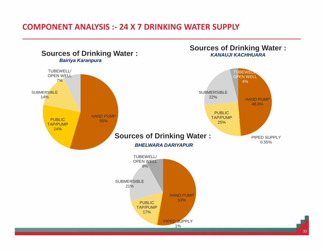
COMPONENT ANALYSIS :- 24 X 7 DRINKING WATER SUPPLY
33
HAND PUMP55%PUBLIC
TAP/PUMP24%
SUBMERSIBLE14%
TUBEWELL/OPEN WELL
7%
Sources of Drinking Water :Bairiya Karanpura
HAND PUMP53%
PIPED SUPPLY1%
PUBLICTAP/PUMP
17%
SUBMERSIBLE21%
TUBEWELL/OPEN WELL
8%
Sources of Drinking Water :BHELWARA DARIYAPUR
HAND PUMP48.6%
PIPED SUPPLY0.55%
PUBLICTAP/PUMP
25%
SUBMERSIBLE22%
TUBEWELL/OPEN WELL
4%
Sources of Drinking Water :KANAUJI KACHHUARA
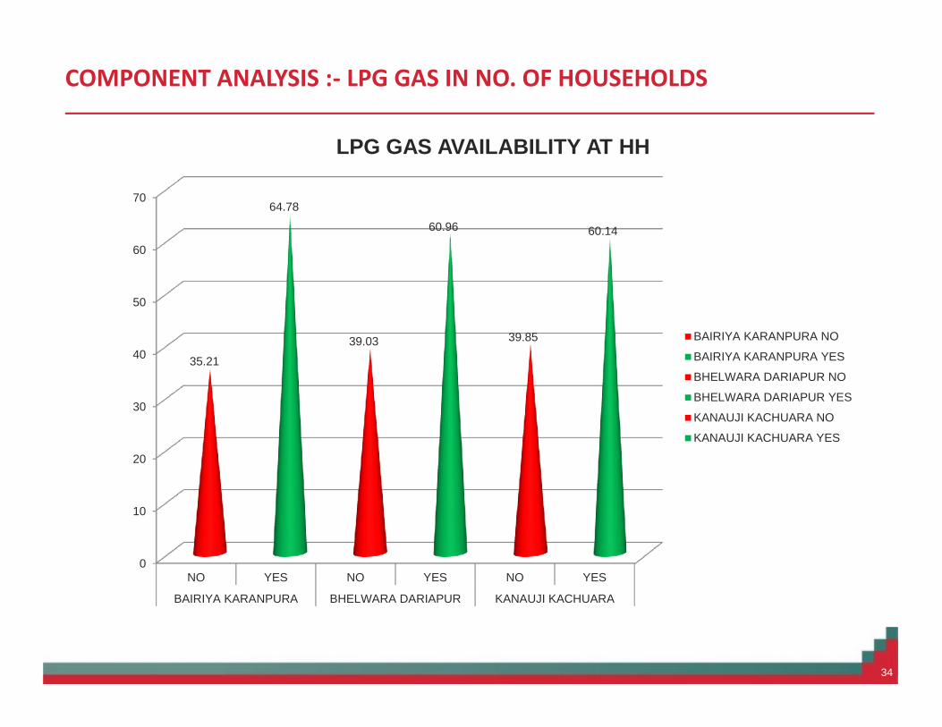
COMPONENT ANALYSIS :- LPG GAS IN NO. OF HOUSEHOLDS
34
0
10
20
30
40
50
60
70
NO YES NO YES NO YES
BAIRIYA KARANPURA BHELWARA DARIAPUR KANAUJI KACHUARA
35.21
64.78
39.03
60.96
39.85
60.14
LPG GAS AVAILABILITY AT HH
BAIRIYA KARANPURA NO
BAIRIYA KARANPURA YES
BHELWARA DARIAPUR NO
BHELWARA DARIAPUR YES
KANAUJI KACHUARA NO
KANAUJI KACHUARA YES
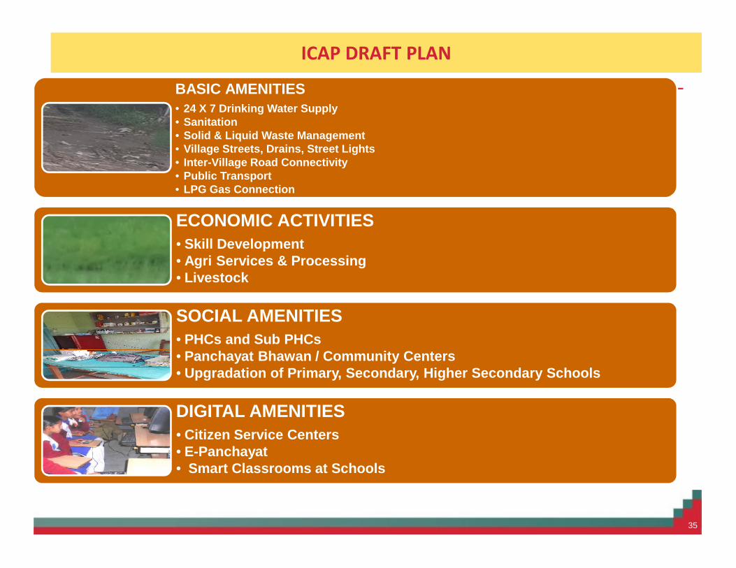
ICAP DRAFT PLAN
35
BASIC AMENITIES• 24 X 7 Drinking Water Supply• Sanitation• Solid & Liquid Waste Management• Village Streets, Drains, Street Lights• Inter-Village Road Connectivity• Public Transport• LPG Gas Connection
ECONOMIC ACTIVITIES• Skill Development• Agri Services & Processing• Livestock
SOCIAL AMENITIES• PHCs and Sub PHCs• Panchayat Bhawan / Community Centers• Upgradation of Primary, Secondary, Higher Secondary Schools
DIGITAL AMENITIES• Citizen Service Centers• E-Panchayat• Smart Classrooms at Schools

Deficiency Analysis and Identification of Needs in %
36
![dk;kZy; egkfujh{kd] lh,lMCY;wVh] lhlqcy] fctklu jksM+ ... ASI/Steno 21900017 KIRAN BARIYA BHIMSINGH BARIYA MP FEMALE ST 04.02.1993 THE INSPECTOR GENERAL CSWT BSF, BIJASAN ROAD, INDORE,](https://img.pdfslide.us/doc/110x75/5add24427f8b9a9a768c7451/dkkzy-egkfujhkd-lhlmcywvh-lhlqcy-fctklu-jksm-asisteno-21900017-kiran.jpg)