Embed Size (px)
Citation preview

INSTITUTE OF GEOGRAPHY AND SPATIAL ORGANIZATIONPOLISH ACADEMY OF SCIENCES
www.igipz.pan.pl
www.geographiapolonica.pl
Geographia PolonicaVolume 87, Issue 2, pp. 295-308http://dx.doi.org/10.7163/GPol.2014.18
80 YEARS AFTER THE 14TH CONGRESS OF THE INTERNATIONAL GEOGRAPHICAL UNION IN WARSAW, 23-31 AUGUST 1934
Antoni Jackowski • Elżbieta Bilska-Wodecka • Izabela Sołjan
Jagiellonian UniversityInstitute of Geography and Spatial ManagementGronostajowa 7, 30–387 Krakow: Polande-mails: [email protected] • [email protected] • [email protected]
AbstractIn 1934, the International Geographical Union arrived in Warsaw to attend its Congress which was held between 23rd and 31st August. A decision to accept the offer of the Polish government and meet for the first time in a Slavic country was taken at the previous Congress in Paris, in 1931. The Congress was attended by 693 participants from 44 countries, including 350 from Poland. The programme included 12 regional and thematic excursions and several cartographic exhibitions. Four volumes of Comptes Rendus du Congrès Inter-national de Géographie containing the proceedings of the Congress were published between 1935 and 1938.
Key wordshistory of geography • international geographical congress • International Geographical Union • Warsaw • Poland
http://dx.doi.org/10.7163/GPol.2014.18
2014
Antoni Jackows-ki • Elżbieta Bilska-Wodecka • Izabela Sołjan
Antoni Jackowski • Elżbieta Bilska-Wodecka • Izabela Sołjan 87 2 295
December 2013 February 2014
VARIA: CHRONICLE
The upcoming Regional Conference of the International Geographical Union (IGU) will be held in Krakow on 18-22 August 2014 on exactly the 80th anniversary of the 14th IGU Congress in Warsaw. Since that congress, which took place between 23rd and 31st August 1934, Poland has not had a chance to host a worldwide geographical event of that scale and prestige. This alone is sufficient
reason to devote a moment to that historic meeting, so momentous for the development of Polish geography.
Although the IGU was only established in 1922, geographers had already been meet-ing at worldwide events for some time. The first of these was held in Antwerp in 1871 and it was followed by nine more, including Rome in 1913, before the outbreak of the

296 Antoni Jackowski • Elżbieta Bilska-Wodecka • Izabela Sołjan
Geographia Polonica 2014, 87, 2, pp. 295-308
Great War. The host countries included: Bel-gium, France (twice), Italy (twice), Switzerland (twice), the United Kingdom, Germany and the United States of America. Poles attended some of them, but only as citizens of the pow-ers that had partitioned their country, which did not exist at that time. The first congress after the war was held quite late, in 1925 in Cairo, and this is when Poland was present officially for the first time. Cairo was followed by London and Cambridge in 1928 and Paris in 1931 (Lecomte de Martonne 1959; Kish 1992; Kosiński 2008). The latter congress was particularly rewarding for Poland as the IGU accepted the invitation of the Polish Government to organise the subsequent event in Warsaw, in 1934, and Eugeniusz Romer was formally elected Vice-President of IGU after having held this post unofficially since 1929.
The President of the Republic of Poland Ignacy Mościcki and Marshal of Poland Józef Piłsudski extended their honorary patronage to the Congress. For Poland, a country with-out statehood for more than 120 years before 1918, the organisation of an international event of this scale was as much an opportu-nity as a serious effort. In recognition of this
IGU agreed to give the Polish language equal status with the main congress languages (French and English) for the duration of the event (of which privilege none of the Polish del-egates took advantage). Poland was the first Slavic country to host an IGU congress and this was also the first post-war IGU congress to be attended by a sizeable German delega-tion, as the country was only admitted to the IGU shortly beforehand. This German partici-pation was seen as a political success on the Polish side. Also the Turks inaugurated their participation in IGU congresses by attending Warsaw.
On the Polish side the Congress was organ-ised by the National Geography Committee operating under the Polish Academy of Arts and Sciences (Polska Akademia Umiejętności) in Krakow. An Organising Committee was established with Eugeniusz Romer (IGU Vice-President, Jan Kazimierz University of Lvov) as Chairman (Fig. 1), Antoni Sujkowski (Chair-man of the Polish Geographical Society, War-saw School of Economics) as Deputy Chair-man (Fig. 2), Stanisław Pawłowski (Poznań University) as Secretary General (Fig. 3) and two Treasurers: Jerzy Loth (Warsaw School of Economics) and Stanisław Lencewicz
Figure 1. Eugeniusz Romer, Vice-President of the International Geographical Union, 1929-1938 and 1945-1949, Chairman of the Organisation Committee, Jan Kazimierz University, Lvov
Source: Archives of the Jagiellonian University Institute of Geography and Spatial Managment.
Figure 2. Antoni Sujkowski, Chairman of Pol-ish Geographical Society, Deputy Chairman of the Organisation Committee, Warsaw School of Economics
Source: Archives of the Jagiellonian University Institute of Geography and Spatial Managment.

29780 years after the 14th Congress of the International Geographical Union in Warsaw…
Geographia Polonica 2014, 87, 2, pp. 295-308
(Warsaw University). Members of the Com-mittee included: Jerzy Smoleński (Jagiellonian University), Mieczysław Limanowski (Stefan Batory University of Vilnius), August Zier-hoffer (Jan Kazimierz University of Lvov) and Jerzy Lewakowski (Military Geographic Insti-tute) (Fig. 4). The opening ceremony and Con-gress proceedings took place at the Warsaw Polytechnic while the closing ceremony was staged in the Grand Hall of the Warsaw Sci-entific Society at the Staszic Palace (Zier hoffer 1935). Staszic Palace also housed Warsaw University’s Department of Geography.
The opening ceremony was a major cel-ebration and the President of Poland, Igna-cy Mościcki, arrived accompanied by top national officials, including the Minister of Treasury Władysław Marian Zawadzki (acting as deputy to Prime Minister Leon Kozłowski), Speaker of the Parliament Kazi-mierz Świtalski, Head of the Foreign Min-istry Józef Beck, Minister of Religious Con-fessions and Public Enlightenment Wacław Jędrzejewicz and the government’s Com-missioner for the City of Warsaw Władysław Jaroszewicz. The President took a prominent chair before the front rows, which were tak-en by heads of embassies and consulates
of the countries present in Poland (Figs. 5, 6, 7, 8, 9 and 10).
The session was opened by the Chairman of the International Geographical Union Isaiah Bowman (USA). After the opening speeches (including by Wacław Jędrzejewicz) the floor was given to representatives of the delegations, including Belgium, Germany, France, the USA, the UK, Italy and the Neth-erlands. The German speech was made by Ludwig Mecking who was also a repre-sentative of the Reich government. Read today, his text contains many statements that come across as mendacious, particu-larly those about the friendly feelings of Ger-many and its Fuehrer Hitler towards Poland. On the other hand, the intervention of the head of the delegation of French geogra-phers, Emmanuel de Martonne, was received very positively, especially when he said: “Pol-ish geography existed even when there was no Poland”. Referring to the work of Ludomir Sawicki and Eugeniusz Romer he observed “During 15 years, independent Poland has made enormous achievements in geogra-phy. (…) One look at Poland reveals that it is a geographic body worthy of particular attention” (IKC 1934a: 13). Also he referred
Figure 3. Stanisław Pawłowski, Vice-President of International Geographical Union 1938-1939, Secretary General of the Organising Committee, Poznań University
Source: National Digital Archives (Narodowe Ar-chiwum Cyfrowe), NAC 1-N-439
Figure 4. Jerzy Lewakowski, member of the Or-ganising Committee, organiser of the international exhibition of contemporary cartography, later to become the Head of the Military Institute of Geography (Wojskowy Instytut Geograficzny)
Source: Archives of the Jagiellonian University Institute of Geography and Spatial Managment.

298 Antoni Jackowski • Elżbieta Bilska-Wodecka • Izabela Sołjan
Geographia Polonica 2014, 87, 2, pp. 295-308
Figure 5. Badge of the 14th IGU Congress
Source: Archives of the Jagiellonian University Institute of Geography and Spatial Managment.
Figure 6. Medal with image of Wacław Nałkowski minted to commemorate the 14th IGU Congress. The medal was designed by Wacław Nałkowski’s daughter, the Polish sculptor Hanna Nałkowska- -Bickowa (1888-1970)
Source: Lencewicz 1934.
Figure 7. Template of the 14th IGU Congress participant sheet
Source: IGU 1935: 21.
to Eugeniusz Romer as “the architect of the edifice of Polish geography”.
Charles Close, head of the Royal Geo-graphical Society, referring to the stature of geography in the contemporary world observed: “The world is understood as the fatherland of Man – here is the grand motif of our discipline” (IKC 1934a: 13). In Warsaw he was elected the next IGU Chairman.
The last speaker to address the Congress during its opening was Eugeniusz Romer. Wel-coming the guests on behalf of Polish geog-raphers he said: “The idea of Poland, never forgotten and today reborn, creating itself, striding towards new worlds, I put foremost in my mind. This idea was what attracted you here; this and that awareness of the serious-ness with which Poland desires to be known to you” (IKC 1934a: 14).
At the end of the first day of the Congress President Ignacy Mościcki hosted geographers from around the world at the Warsaw Royal Castle.
Altogether 693 delegates from 44 coun-tries of the world took part, including 367 Poles. Other large delegations included the French (87), German (50), British (44), Italian (43), Bel-gian (23), US and Spanish (10 each). A small Soviet delegation also arrived. Included among the international guests were several eminent geographers (Tab. 1). In the Polish del-egation the foremost group included universi-ty researchers, but there were also teachers, popularisers of local history and geography, students of geography and enthusiasts. Along-side professional researchers there were also junior members of the government and repre-sentatives of the army and navy.

29980 years after the 14th Congress of the International Geographical Union in Warsaw…
Geographia Polonica 2014, 87, 2, pp. 295-308
Figure 8. Agenda of the 14th IGU Congress
Source: IGU 1935: 132.
Figure 9. Timetable of social events, exhibitions and excursions during the 14th IGU Congress
Source: IGU 1935: 133.
300 Antoni Jackowski • Elżbieta Bilska-Wodecka • Izabela Sołjan
Geographia Polonica 2014, 87, 2, pp. 295-308
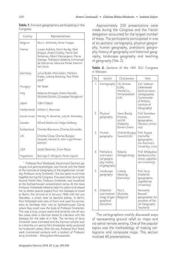
Table 1. Eminent geographers participating in the Congress
Country Representatives
Belgium Paul L. Michotte, Omer Tulippe
France Lucien Aufrère, Henri Baulig, Abel Briquet, André Cholley, Pierre Def-fontaines, Albert Demangeon. Pierre George, Théodore Lefebvre, Emmanuel de Martonne, Maurice Pardé, Maximi-lien Sorre
Germany Julius Büdel, Max Eckert, Norbert Krebs, Ludwig Mecking, Paul Wold-stedt1
Hungary Pál Teleki
Italy Roberto Almagià, Giotto Dainelli, Michele Gortani, Giuseppe Nangeroni
Japan Tubin Odauti
Netherlands Willem E. Boerman
Soviet Union Nikołaj N. Barański, Julij M. Shokalsky
Sweden Alfred Sőderlund, Helge Stalberg
Switzerland Charles Biermann, Charles Schneider
UK Charles Close, Charles Bungay Fawcett, Harold St. John Loyd Winter-botham
USA Isaiah Bowman, Erwin Raisz
Yugoslavia Borivoje Z. Milojević, Pavle Vujević
1 Professor Paul Woldstedt, the eminent German ge-ologist and geomorphologist, was friends with the Head of the Institute of Geography of the Jagiellonian Univer-sity, Professor Jerzy Smoleński. The two spent much time together during the Congress. Five years later, during the Second World War, Professor Smoleński was murdered at the Sachsenhausen concentration camp. At the news Professor Woldstedt rallied to help his widow and helped her to obtain special papers from the Gestapo to travel to Berlin. She arrived on 6 January 1940 with her son Stanisław, a priest, later to become bishop. In Berlin, Paul Woldstedt took care of them and used his connec-tions to facilitate their visit to Sachsenhausen Camp where they could view the body of Professor Smoleński. This was a truly unique event and certainly one of very few cases when a German dared to intervene with the Gestapo for the sake of a Pole. The remains of Jerzy Smoleński were cremated and the German scholar saw to it that the urn sent to Mrs Smoleńska really contained her husband’s ashes. After the war, Professor Paul Wold-stedt maintained contacts with a student of Professor Jerzy Smoleński – Mieczysław Klimaszewski.
Approximately 250 presentations were made during the Congress and the French delegation accounted for the largest number of these. The participants participated in one of six sections: cartography, physical geogra-phy, human geography, prehistoric geogra-phy, history of geography and historical geog-raphy, landscape geography and teaching of geography (Tab. 2).
Table 2. Sections of the 14th IGU Congress in Warsaw
No. Section Chairperson Host
1. Cartography I.G. Stresse (USA), Harold S.L. Winterbotham (UK)
Col. Tadeusz Zieleniewski (land surveyor, cartographer, Commander of Military Institute of Geography)
2. Physical geography
Henri Baulig (France),Julij M. Shokalsky (Soviet Union)
Prof. Stanisław Lencewicz (geographer, Warsaw Univer-sity)
3. Human geography
Charles Bungay Fawcett (UK)
Prof. August Zierhoffer (geographer, Jan Kazimierz University, Lvov)
4. Prehistoric and histori-cal geogra-phy, history of geography
Roberto Almagià (Italy)
Prof. Władysław Semkowicz (his-torian, Jagiellon-ian University)
5. Landscape geography
Ludwig Mecking (Germany)
Prof. Jerzy Smoleński (geographer, Jagiellonian University)
6. Didactics and method-ology of geo-graphical education
Paul L. Michotte (Belgium)
Konstanty Bzowski(geographer, As-sociation of Pol-ish Geography Teachers)
The cartographers mainly discussed ways of representing ground relief on maps and via aerial remote sensing. One of the popular topics was the methodology of making car-tograms and composite maps. This section involved 40 presentations.

30180 years after the 14th Congress of the International Geographical Union in Warsaw…
Geographia Polonica 2014, 87, 2, pp. 295-308
In the physical geography section there were 79 presentations mostly devoted to Quaternary research. Other topics includ-ed fossilized erosion surfaces and river and marine terraces.
The human geography section (82 pres-entations) focused on industry, urban geog-raphy (especially physiognomy), overpopula-tion and rural settlement. Polish geographers won some popularity in the last of the top-ics. Stanisław Pawłowski and Józef Czekalski were applauded for their settlement maps of Poland (1:500,000) depicting the concen-tration and dispersion of villages around the country. Detailed case studies in this area were presented by Julian Czyżewski (south- -eastern Poland), Stanisław Leszczycki and Stanisława Zajchowska (Western Carpathi-an Mts.), Maria Kiełczewska (Pomerania), Bogdan Zaborski (Vilnius and surroundings), Tadeusz Senik (Roztocze).
The Warsaw Congress added a session to the regular congress agenda covering the host country’s geography. The Polish Day
(24 August) involved lectures by eminent scholars, including geographers, geologists, historians and ethnologists. The most impres-sive were contributions by Eugeniusz Romer on the fundamental issues of human geogra-phy in Poland and by Mieczysław Limanowski on the geographical significance of the five largest Polish cities, including Poznań, Kra-kow, Lvov, Vilnius and Warsaw (Lencewicz 1934/1935). There was also a series of lec-tures delivered by the most eminent geogra-phers from various countries.
In between sessions, the participants had an opportunity to visit various schools in Warsaw, including elementary and second-ary schools, a school of commerce and the National Institute of Hygiene. The visitors were particularly impressed by the equip-ment and teaching methods in the geogra-phy laboratory at the Ministry of Religious Confessions and Public Enlightenment locat-ed at the Pedagogical Museum and head-ed by Gustaw Wuttke, Michał Janiszew-ski and Jadwiga Peretiatkowicz. The visitors
Figure 10. Opening ceremony of the 14th IGU Congress in the Hall of Warsaw Polytechnic with the participation of the President of Poland Ignacy Mościcki (in armchair)
Source: IGU 1935 : 101.

302 Antoni Jackowski • Elżbieta Bilska-Wodecka • Izabela Sołjan
Geographia Polonica 2014, 87, 2, pp. 295-308
committed themselves to spreading informa-tion about the laboratory in their own coun-tries (Polaczkówna 1935).
Social occasions were very popular. After the reception at the Royal Castle there were similar events at the Council of Ministers, the Town Hall (hosted by the Mayor Stefan Starzyński and his wife) and at the commer-cial association Resursa Obywatelska1 organ-ised at the end of the Congress and linked with a grand ball at the Bristol Hotel. A con-cert was also organised with eminent musi-cians playing at the Warsaw conservatory.
The Polish Geographic Society minted a special commemorative medal bearing an image of the geographer Wacław Nałkowski and a Latin inscription. Silver versions of the medal were handed to Isaiah Bowman, Emmanuel de Martonne, Eugeniusz Romer and Stanisław Pawłowski, while all other par-ticipants received bronze versions.
During the closing ceremony, Eugeniusz Romer summarised the accomplishments of the Congress. Its proceedings were then published in four volumes between 1935 and 1938 under the collective title Comptes Rendus du Congrès International de Géogra-phie. Varsovie 1934 (Lencewicz 1934/1935) (Fig. 11).
During one of the two IGU sessions, Euge-niusz Romer was again elected Vice-President. Other Polish geographers elected to various committees included Stanisław Pawłowski, Józef Czekalski, Stanisław Lencewicz, Julian Czyżewski and Henryk Arctowski. The del-egates also voted on several motions that were tabled. Two of the decisions are worth mentioning here: 1. The Joachim Lelewel Society was established with the aim of con-ducting research into the history of geog-raphy (named after a great Polish historian and social thinker), and 2. An appeal was
1 Resursa Obywatelska in Warsaw, a building erect-ed in 1860-1861 at Krakowskie Przedmieście Street 64. Between 1861 and 1939 this was the HQ of Warszaw-ska Resursa Kupiecka, or Warsaw Association of Com-merce. It burned down during the Nazi German invasion of Poland in September 1939 and was rebuilt during 1948-1950.
extended to national governments to intro-duce the topic of geography in schools of all types and levels due to its outstanding peda-gogical value (IKC 1934b: 5).
A number of cartographic exhibitions were arranged to accompany the Congress. They included an International Exhibition of Con-temporary Cartography at Warsaw Polytech-nic curated by Jerzy Lewakowski (Military Institute of Geography), an exhibition of the cartographic collection of the National Library with a trio of curators: Karol Buczek, Bolesław Olszewicz and Jan Stebnowski, an exhibi-tion about the process of map production with Tadeusz Krzanowski (Military Institute of Geography), an exhibition of contemporary Polish cartography organised by Stanisław Pietkiewicz (Warsaw University) and an inter-national map exhibition. An art exhibition “Poland and its People” was opened at the Zachęta Art Gallery. Polish and French cata-logues were also published on all of these exhi-bitions. The catalogue of the exhibition of the
Figure 11. Title page of the 1st volume Comptes Rendus du Congrès International de Géographie, Varsovie 1934 (IGU 1935)
30380 years after the 14th Congress of the International Geographical Union in Warsaw…
Geographia Polonica 2014, 87, 2, pp. 295-308
National Library collection was prepared by Karol Buczek and Bolesław Olszewicz.
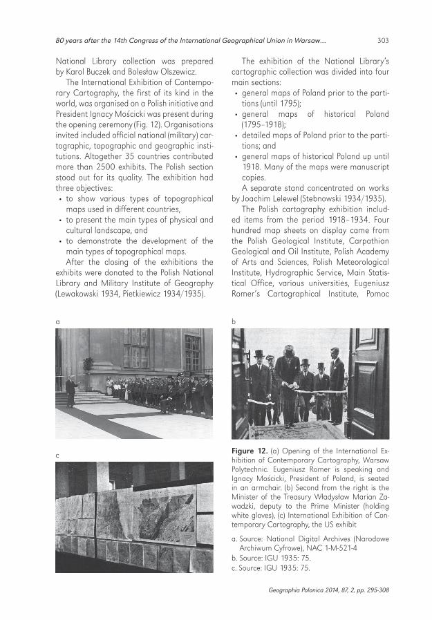
The International Exhibition of Contempo-rary Cartography, the first of its kind in the world, was organised on a Polish initiative and President Ignacy Mościcki was present during the opening ceremony (Fig. 12). Organisations invited included official national (military) car-tographic, topographic and geographic insti-tutions. Altogether 35 countries contributed more than 2500 exhibits. The Polish section stood out for its quality. The exhibition had three objectives: • to show various types of topographical
maps used in different countries, • to present the main types of physical and
cultural landscape, and • to demonstrate the development of the
main types of topographical maps. After the closing of the exhibitions the
exhibits were donated to the Polish National Library and Military Institute of Geography (Lewakowski 1934, Pietkiewicz 1934/1935).
The exhibition of the National Library’s cartographic collection was divided into four main sections: • general maps of Poland prior to the parti-
tions (until 1795); • general maps of historical Poland
(1795–1918); • detailed maps of Poland prior to the parti-
tions; and • general maps of historical Poland up until
1918. Many of the maps were manuscript copies. A separate stand concentrated on works
by Joachim Lelewel (Stebnowski 1934/1935).The Polish cartography exhibition includ-
ed items from the period 1918–1934. Four hundred map sheets on display came from the Polish Geological Institute, Carpathian Geological and Oil Institute, Polish Academy of Arts and Sciences, Polish Meteorological Institute, Hydrographic Service, Main Statis-tical Office, various universities, Eugeniusz Romer’s Cartographical Institute, Pomoc
Figure 12. (a) Opening of the International Ex-hibition of Contemporary Cartography, Warsaw Polytechnic. Eugeniusz Romer is speaking and Ignacy Mościcki, President of Poland, is seated in an armchair. (b) Second from the right is the Minister of the Treasury Władysław Marian Za-wadzki, deputy to the Prime Minister (holding white gloves), (c) International Exhibition of Con-temporary Cartography, the US exhibit
a. Source: National Digital Archives (Narodowe Archiwum Cyfrowe), NAC 1-M-521-4
b. Source: IGU 1935: 75.c. Source: IGU 1935: 75.
a b
c

304 Antoni Jackowski • Elżbieta Bilska-Wodecka • Izabela Sołjan
Geographia Polonica 2014, 87, 2, pp. 295-308
Szkolna publishing house, and the Polish Teachers’ Union. Additionally, Bogdan Zabor-ski also presented his cartographic products. The maps main themes were geological, geo-morphological, meteorological, hydrologi-cal, maritime, economic, and demographic, as well as soils, transport and tourism. More than one hundred maps were presented by the Książnica-Atlas publishing house, the dominant player in the school section (Pietkie-wicz 1934/1935).
Twelve regional and thematic excursions were organised (Tab. 3, Fig. 13) with 244 par-ticipants. Three of these, all longer than one day, took place before the Congress with 62 participants (Fig. 14). During the Congress there were three single day trips with 106 par-ticipants altogether. Four more trips were organised after the Congress and these had 76 participants (Fig. 15). All the trips were accom-panied by quality guidebooks which are still highly regarded by geographers today (Fig. 16).
Figure 13. Routes of excursions accompanying the 14th IGU Congress
Source: IGU 1935: 81.

30580 years after the 14th Congress of the International Geographical Union in Warsaw…
Geographia Polonica 2014, 87, 2, pp. 295-308
Table 3. Excursions
Region Duration (days) Leader Participants
Before the Congress
Polesie and Białowieża 7 Stanisław Lencewicz,Stanisław Pawłowski
15
Podole and Eastern Carpathian Mts.
9 Julian Czyżewski,August Zierhoffer
14
Krakow, Dunajec Valley, Tatras
8 Jerzy Smoleński 33
During the Congress
Vistula Valley near Płock 1 Stanisław Lencewicz 39
Vistula Valley near Warsaw 1 Jan Lewiński 17
Puławy and Kazimierz 1 Bogdan Zaborski 25
Tour of Warsaw 1 Regina Danysz-Fleszarowa 25
After the Congress
Northeastern Poland, Neman and Daugava river basins
5 Mieczysław Limanowski 13
Pomerania and the Baltic coast
7 Stanisław Pawłowski 26
Łysogóry Mts. – Harz-age core and Mesozoic covers
5 Stanisław Lencewicz 17
Polish Upper Silesia 4 Wiktor Ormicki 10
Vistula valley, industrial towns and spas
6 Jerzy Loth 10
Source: based on Lencewicz 1934/1935.
Society of Lvov to celebrate his 40 years of sci-entific creativity). This nearly 700 page long collection was edited by Henryk Arctowski and included contributions by Polish and foreign geographers, most of whom also took part in the Congress.
The 14th IUG Congress was rated very highly by the Union’s governing bodies and participants alike. This was reflected in the numerous reports of the event, scholarly and other, in the world’s periodicals. By far the largest body of such reports were published in Germany, although some were clearly biased. For example, accounts of excursions to areas formerly under the Prussian parti-tion of Poland questioned the legitimacy of Poland’s rule. The largest number of these reports referred to the excursion to Upper Silesia and to the related guidebook writ-ten by Jerzy Smoleński and Wiktor Ormicki. Reports from the Congress were published in France, Italy, the UK, Sweden, Lithuania, the USA, Bulgaria and Czechoslovakia.
A number of special events and publi-cations accompanied the Congress. They included a two-volume book Ruch regiona-listyczny w Europie2 (The Regionalist move-ment in Europe), which included a chapter on Geographic regionalism and its develop-ment in Poland by Stanisław Pawłowski and Economic regionalism in Poland by Wiktor Ormicki. A special session was devoted to the 40th anniversary of Eugeniusz Romer’s career in geography and he was presented with a spe-cially dedicated book Zbiór prac poświęcony przez Towarzystwo Geograficzne we Lwowie Eugeniuszowi Romerowi w 40-lecie jego twór-czości naukowej3 (A collection of papers devot-ed to Eugeniusz Romer by the Geographical
2 pAtkOwski A. (ed.), 1934. Ruch regionalistyczny w Europie. Warszawa: Wydawnictwo Sekcji Regjonali-styczno-Krajoznawczej Związku Nauczycielstwa Polskiego.
3 uhORCzAk F., 1934. Zbiór prac poświęcony przez Towarzystwo Geograficzne we Lwowie Eugeniuszowi Romerowi w 40-lecie jego twórczości naukowej. Lvov: Towarzystwo Geograficzne.

306 Antoni Jackowski • Elżbieta Bilska-Wodecka • Izabela Sołjan
Geographia Polonica 2014, 87, 2, pp. 295-308
The Congress was praised first of all for the quality of its content and its great contri-bution to the development of science in gen-eral and to geography in particular. The good standard of organisation of the event was often quoted along with the quality of the presentations, which often led to several-hour long discussions afterwards. The excursions also garnered plaudits that noted the good selection of itineraries and the excellent pre-paredness of the leaders. The trips to Polesie,
Figure 14. Participants on the excursion to Krakow in the lecture hall of the Jagiellonian University. First from the right: Jerzy SmoleńskiSource: National Digital Archives (Narodowe Archiwum Cyfrowe), NAC 1-M-522-1.
Figure 15. Participants on the excursion to south- -eastern Poland at an excavation site at the Old Castle in Grodno. Second from the right (holding folded coat) Mieczysław LimanowskiSource: National Digital Archives (Narodowe Ar-chiwum Cyfrowe), NAC 1-M-523-1.
Figure 16. Title page of the guidebook for the excursion to Upper Silesia by Jerzy Smoleński and Wiktor Ormicki
Krakow and the Tatras, and to the Baltic coast impressed the participants the most.
Many of the post-Congress reports were devoted to the cartographic exhibitions. They highlighted the importance of the Polish initia-tive to organise a grand worldwide cartography

30780 years after the 14th Congress of the International Geographical Union in Warsaw…
Geographia Polonica 2014, 87, 2, pp. 295-308
event in Warsaw. Indeed, this was the first of its kind and the authors of the accounts sug-gested that future congresses continue with this idea (Czekalski 1934/1935; Kish 1979).
The Congress provided an excellent oppor-tunity for the promotion of Poland. Each par-ticipant received numerous publications on Poland in foreign languages, as well as a full set of geographical studies published in Poland during the five years leading up to the event. Polish geographers proved that in many are-as they had achieved at least as much as their international colleagues. Human geography was the leading such field (especially in terms of rural settlement), along with geomorphol-ogy. The world cartography exhibition proved that Polish achievements in this area, and espe-cially the maps published by Military Institute of Geography, were world class and the tech-nology used to produce them was no different to that used internationally. The participants had also an opportunity to visit some of the leading Polish geography centres (Warsaw, Krakow, Poznań and Vilnius).
On the occasion of the Congress, Stani-sław Pawłowski wrote for the Gazeta Polska daily an article that provided a commentary on the contents of the proceedings. The arti-cle begins: “Geography has an enormous sig-nificance both internationally and in relation to individual states. There is only one Earth and there can only be one earth science. For more than two thousand years, this science was geography.” He continues: “Geography is a science of communication and accord between nations. More than once, there were
champions of universal values and the broth-erhood of peoples among geographers. Major fields within geography, such as cartography, physical geography and human geography, have been fulfilling the important role of unit-ing people. The edifice of geographical knowl-edge, erected by the joint effort of the world’s nations, is serving everyone. And again: Geog-raphy has great merit in the service of and for humanity. Geography is also serving nations and states. (…) Geography offers a picture of the real possibilities for the development of countries and the kind of conditions that make this development possible.”
“Knowledge about this piece of land where fate has placed societies is an indispensible step in the wise adaptation of humanity to natural conditions. Knowledge of the geog-raphy of other countries on earth, on the other hand, is the only serious foundation for the normalisation of interpersonal and inter-national relations. Hence geography serves states and nations as few other sciences do.” (Pawłowski 1934).
These words provide the best punch line for considering the importance of geography and geographical congresses in the process of stabilising interpersonal and international relations. Despite the 80 years that have passed since writing these words, they have lost none of their topicality.
Editors note:Unless otherwise stated, the sources of tables and figures are the author(s), on the basis of their own research.
References
CzekAlski J., 1934/1935. Les échos du Con-grès International de Géographie de Var-sovie. Przegląd Geograficzny, vol. 14, no. 3-4, pp. 188-194.
IGU, 1935. Comptes rendus du congrès interna-tional de géographie Varsovie 1934. Internation-al Geographical Union conference publication, Warszawa: Kasa im. Mianowskiego.
IKC, 1934a. Ilustrowany Kurier Codzienny. No. 235 (25 August), pp. 13-14.
IKC, 1934b. Ilustrowany Kurier Codzienny. No. 243 (2 September), p. 5.
kish g., 1979. Bibliography of International Geographical Congresses 1871-1976. Boston: G.K. Hall.
kish g., 1992. International Geographical Union: a brief history. GeoJournal, vol. 26, no. 2, pp. 224-228.
308 Antoni Jackowski • Elżbieta Bilska-Wodecka • Izabela Sołjan
© Antoni Jackowski • Elżbieta Bilska-Wodecka • Izabela Sołjan© Geographia Polonica© Institute of Geography and Spatial Organization
Polish Academy of Sciences • Warsaw • 2014
Article first received • December 2013Article accepted • February 2014
kosiński l.a., 2008. Międzynarodowa Unia Geogra-ficzna [in:] A. Jackowski, S. Liszewski, A. Richling (eds.), Historia geografii polskiej. Warszawa: Wydawnictwo Naukowe PWN, pp. 477-488.
leCOmte de mARtOnne h., 1959. Historie de l’Union Géographique Internationale et de Con-grès internationaux de géographie. The IGU – Newsletter, 10, pp. 3-20.
lenCewiCz s., 1934/1935. Międzynarodowy Kon-gres Geograficzny w Warszawie. Przegląd Geo-graficzny, vol. 14, no. 3-4, pp. 167-182.
lewAkOwski J., 1934. Mapa – obraz ziemi i życia. Tygodnik Ilustrowany, 37, pp. 729-730.
paWłoWski s., 1934. Na zamknięcie Międzynaro-dowego Kongresu Geograficznego w Polsce. Gazeta Polska, ann. 6, no. 241.
pietkiewiCz s., 1934/1935. Międzynarodowa wysta-wa kartografii współczesnej. Przegląd Geogra-ficzny, vol. 14, no. 3-4, pp. 182-183.
pOlACzkównA m., 1935. Sprawozdanie z posie-dzeń sekcji VI (Dydaktyki i metodyki nauczania) Międzynarodowego Kongresu Geograficznego w Warszawie 23-31/VIII 1934. Czasopismo Geo-graficzne, vol. 13, no. 1, pp. 11-14.
stebnOwski J., 1934/1935. Wystawa zbiorów kar-tograficznych Biblioteki Narodowej. Przegląd Geograficzny, vol. 14, no. 3-4, pp. 184-187.
zieRhOFFeR A., 1935. Międzynarodowy Kongres Geograficzny w Warszawie. Czasopismo Geo-graficzne, vol. 13, no. 1, pp. 1-10.
http://rcin.org.pl