Embed Size (px)
Citation preview
Home
Download
Documentation
Weblog
Community
Code
Django documentation
This document is for Django's development version, which
can be significantly different from previous releases. Get old
docs here: 1.2.
GeoDjango Tutorial
Introduction
GeoDjango is an add-on for Django that turns it into a world-class geographic web framework.
GeoDjango strives to make at as simple as possible to create geographic web applications, like
location-based services. Some features include:
Django model fields for OGC geometries.
Extensions to Django’s ORM for the querying and manipulation of spatial data.
Loosely-coupled, high-level Python interfaces for GIS geometry operations and data
formats.
Editing of geometry fields inside the admin.
This tutorial assumes a familiarity with Django; thus, if you’re brand new to Django please read
through the regular tutorial to introduce yourself with basic Django concepts.
Note
GeoDjango has special prerequisites overwhat is required by Django – please consult the
installation documentation for more details.
This tutorial is going to guide you through guide the user through the creation of a geographic
web application for viewing the world borders. [1] Some of the code used in this tutorial is taken
from and/or inspired by the GeoDjango basic apps project. [2]
Note
Proceed through the tutorial sections sequentially for step-by-step instructions.
Setting Up
Create a Spatial Database
Note
MySQL and Oracle users can skip this section because spatial types are already built into the
database.
First, a spatial database needs to be created for our project. If using PostgreSQL and PostGIS,
then the following commands will create the database from a spatial database template:
$ createdb -T template_postgis geodjango
Note
This command must be issued by a database user that has permissions to create a database. Here
is an example set of commands to create such a user:
$ sudo su - postgres
$ createuser --createdb geo
$ exit
Replace geo to correspond to the system login user name will be connecting to the database. For
example, johndoe if that is the system user that will be running GeoDjango.
Users of SQLite and SpatiaLite should consult the instructions on how to create a SpatiaLite
database.
Create GeoDjango Project
Use the django-admin.py script like normal to create a geodjango project:
$ django-admin.py startproject geodjango
With the project initialized, now create a world Django application within the geodjango project:
$ cd geodjango
$ python manage.py startapp world
Configure settings.py
The geodjango project settings are stored in the settings.py file. Edit the database connection
settings appropriately:
DATABASES = {
'default': {
'ENGINE': 'django.contrib.gis.db.backends.postgis',
'NAME': 'geodjango',
'USER': 'geo',
}
}
Note
These database settings are for Django 1.2 and above.
In addition, modify the INSTALLED_APPS setting to include django.contrib.admin,
django.contrib.gis, and world (our newly created application):
INSTALLED_APPS = (
'django.contrib.auth',
'django.contrib.contenttypes',
'django.contrib.sessions',
'django.contrib.sites',
'django.contrib.admin',
'django.contrib.gis',
'world'
)
Geographic Data
World Borders
The world borders data is available in this zip file. Create a data directory in the world
application, download the world borders data, and unzip. On GNU/Linux platforms the
following commands should do it:
$ mkdir world/data
$ cd world/data
$ wget http://thematicmapping.org/downloads/TM_WORLD_BORDERS-0.3.zip
$ unzip TM_WORLD_BORDERS-0.3.zip
$ cd ../..
The world borders ZIP file contains a set of data files collectively known as an ESRI Shapefile,
one of the most popular geospatial data formats. When unzipped the world borders data set
includes files with the following extensions:
.shp: Holds the vector data for the world borders geometries.
.shx: Spatial index file for geometries stored in the .shp.
.dbf: Database file for holding non-geometric attribute data (e.g., integer and character
fields).
.prj: Contains the spatial reference information for the geographic data stored in the
shapefile.
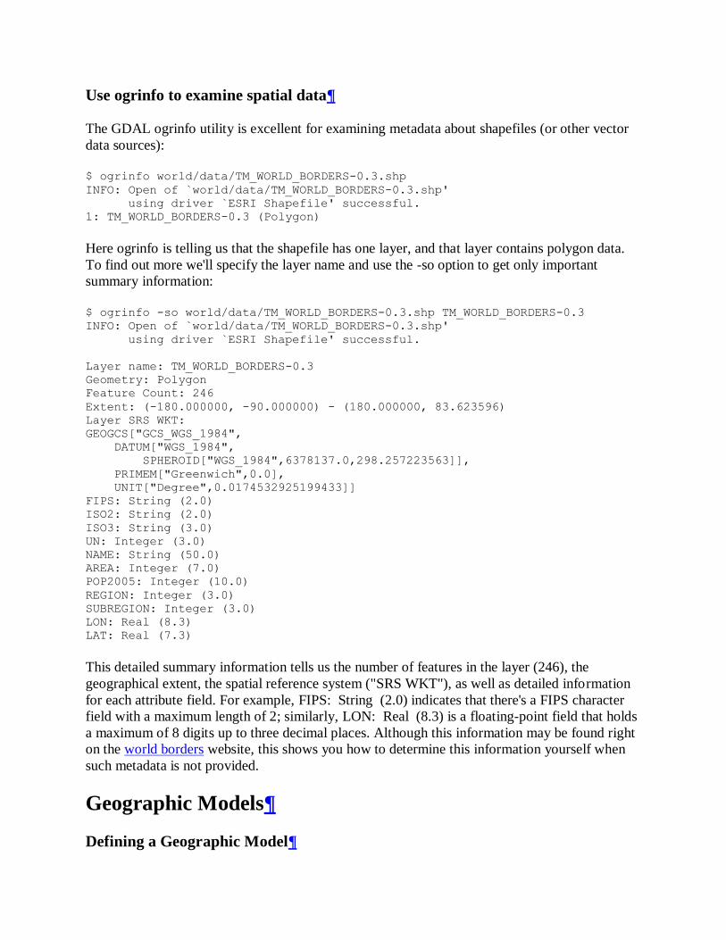
Use ogrinfo to examine spatial data
The GDAL ogrinfo utility is excellent for examining metadata about shapefiles (or other vector
data sources):
$ ogrinfo world/data/TM_WORLD_BORDERS-0.3.shp
INFO: Open of `world/data/TM_WORLD_BORDERS-0.3.shp'
using driver `ESRI Shapefile' successful.
1: TM_WORLD_BORDERS-0.3 (Polygon)
Here ogrinfo is telling us that the shapefile has one layer, and that layer contains polygon data.
To find out more we'll specify the layer name and use the -so option to get only important
summary information:
$ ogrinfo -so world/data/TM_WORLD_BORDERS-0.3.shp TM_WORLD_BORDERS-0.3
INFO: Open of `world/data/TM_WORLD_BORDERS-0.3.shp'
using driver `ESRI Shapefile' successful.
Layer name: TM_WORLD_BORDERS-0.3
Geometry: Polygon
Feature Count: 246
Extent: (-180.000000, -90.000000) - (180.000000, 83.623596)
Layer SRS WKT:
GEOGCS["GCS_WGS_1984",
DATUM["WGS_1984",
SPHEROID["WGS_1984",6378137.0,298.257223563]],
PRIMEM["Greenwich",0.0],
UNIT["Degree",0.0174532925199433]]
FIPS: String (2.0)
ISO2: String (2.0)
ISO3: String (3.0)
UN: Integer (3.0)
NAME: String (50.0)
AREA: Integer (7.0)
POP2005: Integer (10.0)
REGION: Integer (3.0)
SUBREGION: Integer (3.0)
LON: Real (8.3)
LAT: Real (7.3)
This detailed summary information tells us the number of features in the layer (246), the
geographical extent, the spatial reference system ("SRS WKT"), as well as detailed information
for each attribute field. For example, FIPS: String (2.0) indicates that there's a FIPS character
field with a maximum length of 2; similarly, LON: Real (8.3) is a floating-point field that holds
a maximum of 8 digits up to three decimal places. Although this information may be found right
on the world borders website, this shows you how to determine this information yourself when
such metadata is not provided.
Geographic Models
Defining a Geographic Model
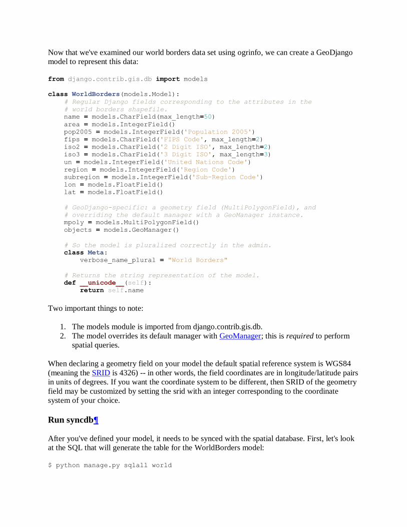
Now that we've examined our world borders data set using ogrinfo, we can create a GeoDjango
model to represent this data:
from django.contrib.gis.db import models
class WorldBorders(models.Model):
# Regular Django fields corresponding to the attributes in the
# world borders shapefile.
name = models.CharField(max_length=50)
area = models.IntegerField()
pop2005 = models.IntegerField('Population 2005')
fips = models.CharField('FIPS Code', max_length=2)
iso2 = models.CharField('2 Digit ISO', max_length=2)
iso3 = models.CharField('3 Digit ISO', max_length=3)
un = models.IntegerField('United Nations Code')
region = models.IntegerField('Region Code')
subregion = models.IntegerField('Sub-Region Code')
lon = models.FloatField()
lat = models.FloatField()
# GeoDjango-specific: a geometry field (MultiPolygonField), and
# overriding the default manager with a GeoManager instance.
mpoly = models.MultiPolygonField()
objects = models.GeoManager()
# So the model is pluralized correctly in the admin.
class Meta:
verbose_name_plural = "World Borders"
# Returns the string representation of the model.
def __unicode__(self):
return self.name
Two important things to note:
1. The models module is imported from django.contrib.gis.db.
2. The model overrides its default manager with GeoManager; this is required to perform
spatial queries.
When declaring a geometry field on your model the default spatial reference system is WGS84
(meaning the SRID is 4326) -- in other words, the field coordinates are in longitude/latitude pairs
in units of degrees. If you want the coordinate system to be different, then SRID of the geometry
field may be customized by setting the srid with an integer corresponding to the coordinate
system of your choice.
Run syncdb
After you've defined your model, it needs to be synced with the spatial database. First, let's look
at the SQL that will generate the table for the WorldBorders model:
$ python manage.py sqlall world
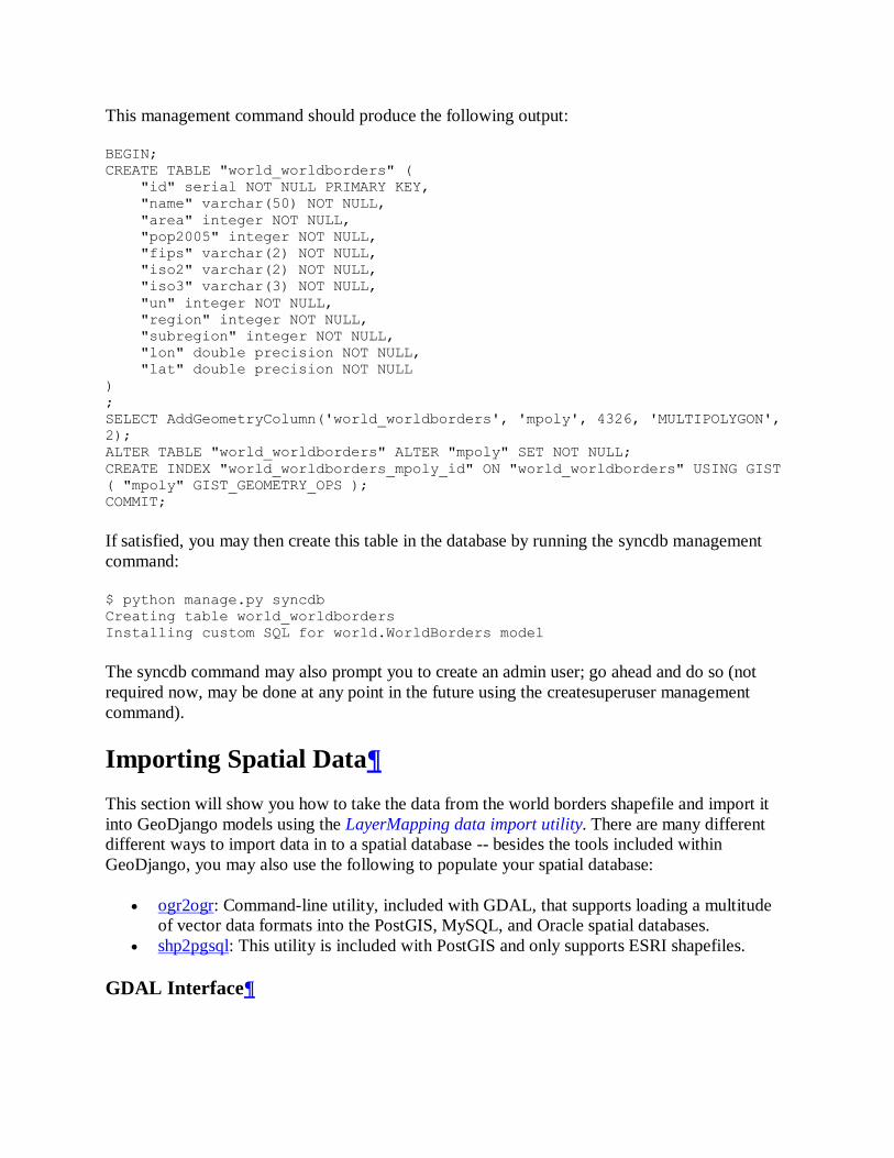
This management command should produce the following output:
BEGIN;
CREATE TABLE "world_worldborders" (
"id" serial NOT NULL PRIMARY KEY,
"name" varchar(50) NOT NULL,
"area" integer NOT NULL,
"pop2005" integer NOT NULL,
"fips" varchar(2) NOT NULL,
"iso2" varchar(2) NOT NULL,
"iso3" varchar(3) NOT NULL,
"un" integer NOT NULL,
"region" integer NOT NULL,
"subregion" integer NOT NULL,
"lon" double precision NOT NULL,
"lat" double precision NOT NULL
)
;
SELECT AddGeometryColumn('world_worldborders', 'mpoly', 4326, 'MULTIPOLYGON',
2);
ALTER TABLE "world_worldborders" ALTER "mpoly" SET NOT NULL;
CREATE INDEX "world_worldborders_mpoly_id" ON "world_worldborders" USING GIST
( "mpoly" GIST_GEOMETRY_OPS );
COMMIT;
If satisfied, you may then create this table in the database by running the syncdb management
command:
$ python manage.py syncdb
Creating table world_worldborders
Installing custom SQL for world.WorldBorders model
The syncdb command may also prompt you to create an admin user; go ahead and do so (not
required now, may be done at any point in the future using the createsuperuser management
command).
Importing Spatial Data
This section will show you how to take the data from the world borders shapefile and import it
into GeoDjango models using the LayerMapping data import utility. There are many different
different ways to import data in to a spatial database -- besides the tools included within
GeoDjango, you may also use the following to populate your spatial database:
ogr2ogr: Command-line utility, included with GDAL, that supports loading a multitude
of vector data formats into the PostGIS, MySQL, and Oracle spatial databases.
shp2pgsql: This utility is included with PostGIS and only supports ESRI shapefiles.
GDAL Interface
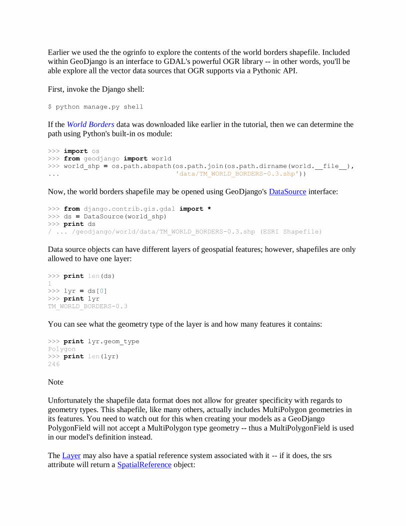
Earlier we used the the ogrinfo to explore the contents of the world borders shapefile. Included
within GeoDjango is an interface to GDAL's powerful OGR library -- in other words, you'll be
able explore all the vector data sources that OGR supports via a Pythonic API.
First, invoke the Django shell:
$ python manage.py shell
If the World Borders data was downloaded like earlier in the tutorial, then we can determine the
path using Python's built-in os module:
>>> import os
>>> from geodjango import world
>>> world_shp = os.path.abspath(os.path.join(os.path.dirname(world.__file__),
... 'data/TM_WORLD_BORDERS-0.3.shp'))
Now, the world borders shapefile may be opened using GeoDjango's DataSource interface:
>>> from django.contrib.gis.gdal import *
>>> ds = DataSource(world_shp)
>>> print ds
/ ... /geodjango/world/data/TM_WORLD_BORDERS-0.3.shp (ESRI Shapefile)
Data source objects can have different layers of geospatial features; however, shapefiles are only
allowed to have one layer:
>>> print len(ds)
1
>>> lyr = ds[0]
>>> print lyr
TM_WORLD_BORDERS-0.3
You can see what the geometry type of the layer is and how many features it contains:
>>> print lyr.geom_type
Polygon
>>> print len(lyr)
246
Note
Unfortunately the shapefile data format does not allow for greater specificity with regards to
geometry types. This shapefile, like many others, actually includes MultiPolygon geometries in
its features. You need to watch out for this when creating your models as a GeoDjango
PolygonField will not accept a MultiPolygon type geometry -- thus a MultiPolygonField is used
in our model's definition instead.
The Layer may also have a spatial reference system associated with it -- if it does, the srs
attribute will return a SpatialReference object:
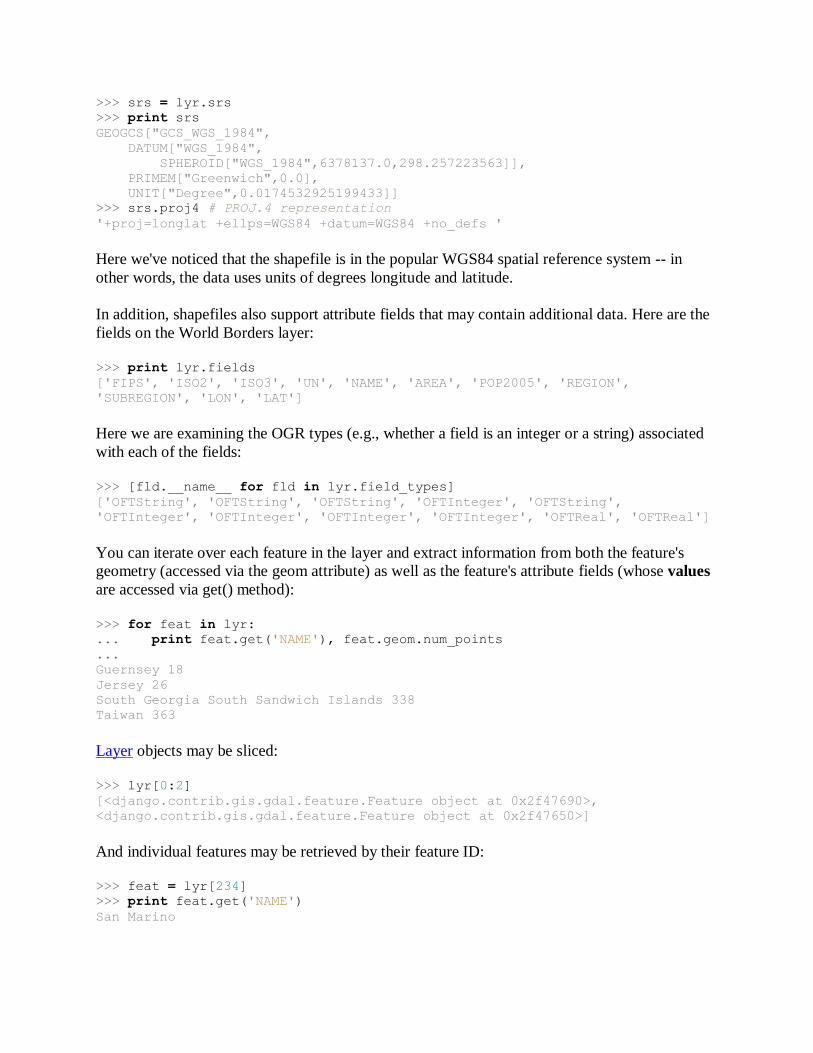
>>> srs = lyr.srs
>>> print srs
GEOGCS["GCS_WGS_1984",
DATUM["WGS_1984",
SPHEROID["WGS_1984",6378137.0,298.257223563]],
PRIMEM["Greenwich",0.0],
UNIT["Degree",0.0174532925199433]]
>>> srs.proj4 # PROJ.4 representation
'+proj=longlat +ellps=WGS84 +datum=WGS84 +no_defs '
Here we've noticed that the shapefile is in the popular WGS84 spatial reference system -- in
other words, the data uses units of degrees longitude and latitude.
In addition, shapefiles also support attribute fields that may contain additional data. Here are the
fields on the World Borders layer:
>>> print lyr.fields
['FIPS', 'ISO2', 'ISO3', 'UN', 'NAME', 'AREA', 'POP2005', 'REGION',
'SUBREGION', 'LON', 'LAT']
Here we are examining the OGR types (e.g., whether a field is an integer or a string) associated
with each of the fields:
>>> [fld.__name__ for fld in lyr.field_types]
['OFTString', 'OFTString', 'OFTString', 'OFTInteger', 'OFTString',
'OFTInteger', 'OFTInteger', 'OFTInteger', 'OFTInteger', 'OFTReal', 'OFTReal']
You can iterate over each feature in the layer and extract information from both the feature's
geometry (accessed via the geom attribute) as well as the feature's attribute fields (whose values
are accessed via get() method):
>>> for feat in lyr:
... print feat.get('NAME'), feat.geom.num_points
...
Guernsey 18
Jersey 26
South Georgia South Sandwich Islands 338
Taiwan 363
Layer objects may be sliced:
>>> lyr[0:2]
[<django.contrib.gis.gdal.feature.Feature object at 0x2f47690>,
<django.contrib.gis.gdal.feature.Feature object at 0x2f47650>]
And individual features may be retrieved by their feature ID:
>>> feat = lyr[234]
>>> print feat.get('NAME')
San Marino
Here the boundary geometry for San Marino is extracted and looking exported to WKT and
GeoJSON:
>>> geom = feat.geom
>>> print geom.wkt
POLYGON ((12.415798 43.957954,12.450554 ...
>>> print geom.json
{ "type": "Polygon", "coordinates": [ [ [ 12.415798, 43.957954 ], [
12.450554, 43.979721 ], ...
LayerMapping
We're going to dive right in -- create a file called load.py inside the world application, and insert
the following:
import os
from django.contrib.gis.utils import LayerMapping
from models import WorldBorders
world_mapping = {
'fips' : 'FIPS',
'iso2' : 'ISO2',
'iso3' : 'ISO3',
'un' : 'UN',
'name' : 'NAME',
'area' : 'AREA',
'pop2005' : 'POP2005',
'region' : 'REGION',
'subregion' : 'SUBREGION',
'lon' : 'LON',
'lat' : 'LAT',
'mpoly' : 'MULTIPOLYGON',
}
world_shp = os.path.abspath(os.path.join(os.path.dirname(__file__),
'data/TM_WORLD_BORDERS-0.3.shp'))
def run(verbose=True):
lm = LayerMapping(WorldBorders, world_shp, world_mapping,
transform=False, encoding='iso-8859-1')
lm.save(strict=True, verbose=verbose)
A few notes about what's going on:
Each key in the world_mapping dictionary corresponds to a field in the WorldBorders
model, and the value is the name of the shapefile field that data will be loaded from.
The key mpoly for the geometry field is MULTIPOLYGON, the geometry type we wish
to import as. Even if simple polygons are encountered in the shapefile they will
automatically be converted into collections prior to insertion into the database.
The path to the shapefile is not absolute -- in other words, if you move the world
application (with data subdirectory) to a different location, then the script will still work.
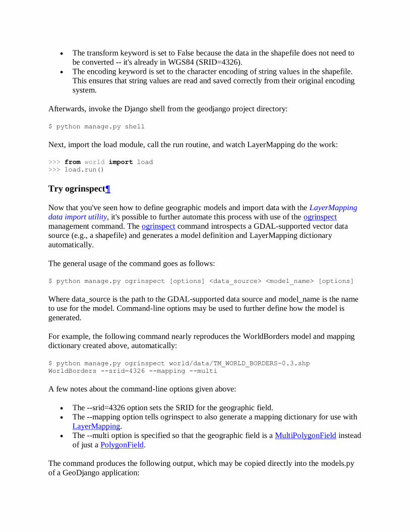
The transform keyword is set to False because the data in the shapefile does not need to
be converted -- it's already in WGS84 (SRID=4326).
The encoding keyword is set to the character encoding of string values in the shapefile.
This ensures that string values are read and saved correctly from their original encoding
system.
Afterwards, invoke the Django shell from the geodjango project directory:
$ python manage.py shell
Next, import the load module, call the run routine, and watch LayerMapping do the work:
>>> from world import load
>>> load.run()
Try ogrinspect
Now that you've seen how to define geographic models and import data with the LayerMapping
data import utility, it's possible to further automate this process with use of the ogrinspect
management command. The ogrinspect command introspects a GDAL-supported vector data
source (e.g., a shapefile) and generates a model definition and LayerMapping dictionary
automatically.
The general usage of the command goes as follows:
$ python manage.py ogrinspect [options] <data_source> <model_name> [options]
Where data_source is the path to the GDAL-supported data source and model_name is the name
to use for the model. Command-line options may be used to further define how the model is
generated.
For example, the following command nearly reproduces the WorldBorders model and mapping
dictionary created above, automatically:
$ python manage.py ogrinspect world/data/TM_WORLD_BORDERS-0.3.shp
WorldBorders --srid=4326 --mapping --multi
A few notes about the command-line options given above:
The --srid=4326 option sets the SRID for the geographic field.
The --mapping option tells ogrinspect to also generate a mapping dictionary for use with
LayerMapping.
The --multi option is specified so that the geographic field is a MultiPolygonField instead
of just a PolygonField.
The command produces the following output, which may be copied directly into the models.py
of a GeoDjango application:
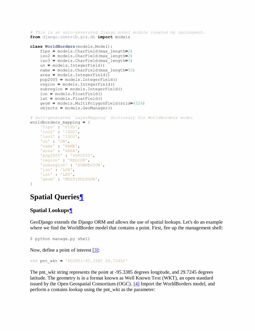
# This is an auto-generated Django model module created by ogrinspect.
from django.contrib.gis.db import models
class WorldBorders(models.Model):
fips = models.CharField(max_length=2)
iso2 = models.CharField(max_length=2)
iso3 = models.CharField(max_length=3)
un = models.IntegerField()
name = models.CharField(max_length=50)
area = models.IntegerField()
pop2005 = models.IntegerField()
region = models.IntegerField()
subregion = models.IntegerField()
lon = models.FloatField()
lat = models.FloatField()
geom = models.MultiPolygonField(srid=4326)
objects = models.GeoManager()
# Auto-generated `LayerMapping` dictionary for WorldBorders model
worldborders_mapping = {
'fips' : 'FIPS',
'iso2' : 'ISO2',
'iso3' : 'ISO3',
'un' : 'UN',
'name' : 'NAME',
'area' : 'AREA',
'pop2005' : 'POP2005',
'region' : 'REGION',
'subregion' : 'SUBREGION',
'lon' : 'LON',
'lat' : 'LAT',
'geom' : 'MULTIPOLYGON',
}
Spatial Queries
Spatial Lookups
GeoDjango extends the Django ORM and allows the use of spatial lookups. Let's do an example
where we find the WorldBorder model that contains a point. First, fire up the management shell:
$ python manage.py shell
Now, define a point of interest [3]:
>>> pnt_wkt = 'POINT(-95.3385 29.7245)'
The pnt_wkt string represents the point at -95.3385 degrees longitude, and 29.7245 degrees
latitude. The geometry is in a format known as Well Known Text (WKT), an open standard
issued by the Open Geospatial Consortium (OGC). [4] Import the WorldBorders model, and
perform a contains lookup using the pnt_wkt as the parameter:
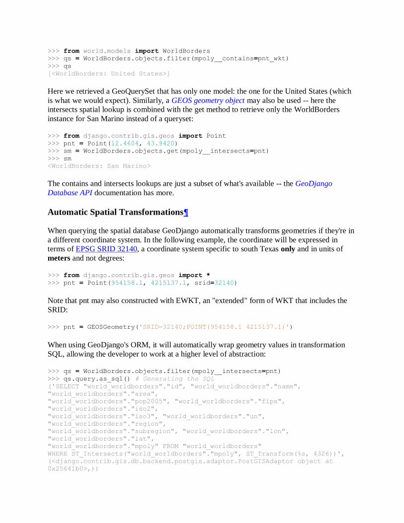
>>> from world.models import WorldBorders
>>> qs = WorldBorders.objects.filter(mpoly__contains=pnt_wkt)
>>> qs
[<WorldBorders: United States>]
Here we retrieved a GeoQuerySet that has only one model: the one for the United States (which
is what we would expect). Similarly, a GEOS geometry object may also be used -- here the
intersects spatial lookup is combined with the get method to retrieve only the WorldBorders
instance for San Marino instead of a queryset:
>>> from django.contrib.gis.geos import Point
>>> pnt = Point(12.4604, 43.9420)
>>> sm = WorldBorders.objects.get(mpoly__intersects=pnt)
>>> sm
<WorldBorders: San Marino>
The contains and intersects lookups are just a subset of what's available -- the GeoDjango
Database API documentation has more.
Automatic Spatial Transformations
When querying the spatial database GeoDjango automatically transforms geometries if they're in
a different coordinate system. In the following example, the coordinate will be expressed in
terms of EPSG SRID 32140, a coordinate system specific to south Texas only and in units of
meters and not degrees:
>>> from django.contrib.gis.geos import *
>>> pnt = Point(954158.1, 4215137.1, srid=32140)
Note that pnt may also constructed with EWKT, an "extended" form of WKT that includes the
SRID:
>>> pnt = GEOSGeometry('SRID=32140;POINT(954158.1 4215137.1)')
When using GeoDjango's ORM, it will automatically wrap geometry values in transformation
SQL, allowing the developer to work at a higher level of abstraction:
>>> qs = WorldBorders.objects.filter(mpoly__intersects=pnt)
>>> qs.query.as_sql() # Generating the SQL
('SELECT "world_worldborders"."id", "world_worldborders"."name",
"world_worldborders"."area",
"world_worldborders"."pop2005", "world_worldborders"."fips",
"world_worldborders"."iso2",
"world_worldborders"."iso3", "world_worldborders"."un",
"world_worldborders"."region",
"world_worldborders"."subregion", "world_worldborders"."lon",
"world_worldborders"."lat",
"world_worldborders"."mpoly" FROM "world_worldborders"
WHERE ST_Intersects("world_worldborders"."mpoly", ST_Transform(%s, 4326))',
(<django.contrib.gis.db.backend.postgis.adaptor.PostGISAdaptor object at
0x25641b0>,))
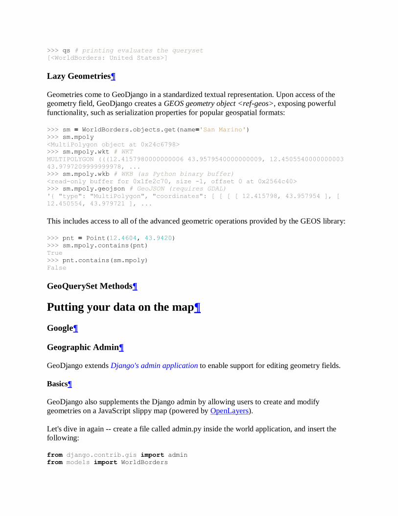
>>> qs # printing evaluates the queryset
[<WorldBorders: United States>]
Lazy Geometries
Geometries come to GeoDjango in a standardized textual representation. Upon access of the
geometry field, GeoDjango creates a GEOS geometry object <ref-geos>, exposing powerful
functionality, such as serialization properties for popular geospatial formats:
>>> sm = WorldBorders.objects.get(name='San Marino')
>>> sm.mpoly
<MultiPolygon object at 0x24c6798>
>>> sm.mpoly.wkt # WKT
MULTIPOLYGON (((12.4157980000000006 43.9579540000000009, 12.4505540000000003
43.9797209999999978, ...
>>> sm.mpoly.wkb # WKB (as Python binary buffer)
<read-only buffer for 0x1fe2c70, size -1, offset 0 at 0x2564c40>
>>> sm.mpoly.geojson # GeoJSON (requires GDAL)
'{ "type": "MultiPolygon", "coordinates": [ [ [ [ 12.415798, 43.957954 ], [
12.450554, 43.979721 ], ...
This includes access to all of the advanced geometric operations provided by the GEOS library:
>>> pnt = Point(12.4604, 43.9420)
>>> sm.mpoly.contains(pnt)
True
>>> pnt.contains(sm.mpoly)
False
GeoQuerySet Methods
Putting your data on the map
Google
Geographic Admin
GeoDjango extends Django's admin application to enable support for editing geometry fields.
Basics
GeoDjango also supplements the Django admin by allowing users to create and modify
geometries on a JavaScript slippy map (powered by OpenLayers).
Let's dive in again -- create a file called admin.py inside the world application, and insert the
following:
from django.contrib.gis import admin
from models import WorldBorders
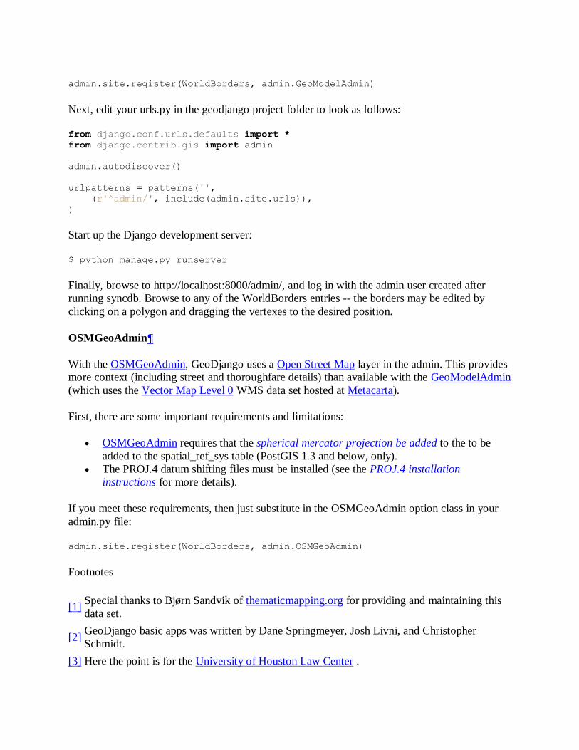
admin.site.register(WorldBorders, admin.GeoModelAdmin)
Next, edit your urls.py in the geodjango project folder to look as follows:
from django.conf.urls.defaults import *
from django.contrib.gis import admin
admin.autodiscover()
urlpatterns = patterns('',
(r'^admin/', include(admin.site.urls)),
)
Start up the Django development server:
$ python manage.py runserver
Finally, browse to http://localhost:8000/admin/, and log in with the admin user created after
running syncdb. Browse to any of the WorldBorders entries -- the borders may be edited by
clicking on a polygon and dragging the vertexes to the desired position.
OSMGeoAdmin
With the OSMGeoAdmin, GeoDjango uses a Open Street Map layer in the admin. This provides
more context (including street and thoroughfare details) than available with the GeoModelAdmin
(which uses the Vector Map Level 0 WMS data set hosted at Metacarta).
First, there are some important requirements and limitations:
OSMGeoAdmin requires that the spherical mercator projection be added to the to be
added to the spatial_ref_sys table (PostGIS 1.3 and below, only).
The PROJ.4 datum shifting files must be installed (see the PROJ.4 installation
instructions for more details).
If you meet these requirements, then just substitute in the OSMGeoAdmin option class in your
admin.py file:
admin.site.register(WorldBorders, admin.OSMGeoAdmin)
Footnotes
[1]
Special thanks to Bjørn Sandvik of thematicmapping.org for providing and maintaining this
data set.
[2]
GeoDjango basic apps was written by Dane Springmeyer, Josh Livni, and Christopher
Schmidt.
[3] Here the point is for the University of Houston Law Center .
[4]
Open Geospatial Consortium, Inc., OpenGIS Simple Feature Specification For SQL,
Document 99-049.
Questions/Feedback
Having trouble? We'd like to help!
Try the FAQ -— it's got answers to many common questions.
Search for information in the archives of the django-users mailing list, or post a question.
Ask a question in the #django IRC channel, or search the IRC logs to see if its been asked
before.
If you notice errors with this documentation, please open a ticket and let us know! Please
only use the ticket tracker for criticisms and improvements on the docs. For tech support,
use the resources above.
Contents
GeoDjango Tutorial
o Introduction
o Setting Up
Create a Spatial Database
Create GeoDjango Project
Configure settings.py
o Geographic Data
World Borders
Use ogrinfo to examine spatial data
o Geographic Models
Defining a Geographic Model
Run syncdb
o Importing Spatial Data
GDAL Interface
LayerMapping
Try ogrinspect
o Spatial Queries
Spatial Lookups
Automatic Spatial Transformations
Lazy Geometries
GeoQuerySet Methods
o Putting your data on the map
Geographic Admin
Basics
OSMGeoAdmin
Search
Search
Latest
1.0
0.96
All
Browse
Prev: GeoDjango
Next: GeoDjango Installation
Table of contents
General Index
Global Module Index
You are here:
Django dev documentation
o API Reference
contrib packages
GeoDjango
GeoDjango Tutorial
Last update:
June 21, 2010, 7:30 a.m. (CDT)
© 2005-2010 Django Software Foundation unless otherwise noted. Django is a registered
trademark of the Django Software Foundation. Hosting graciously provided by