Embed Size (px)
Citation preview

GGeeooJJoouurrnnaall ooff TToouurriissmm aanndd GGeeoossiitteess Year IIVV no.2, vol. 8, NNoovveemmbbeerr 22001111,, pppp.. 330099--331188ISSN 22006655--00881177, E-ISSN 22006655--11119988 Article no. 0088111144--8899
http://gtg.webhost.uoradea.ro/
GGEEOODDIIVV IINNTTEERRFFAACCEE:: AANN OOPPEENN SSOOUURRCCEE TTOOOOLL FFOORR MMAANNAAGGEEMMEENNTT AANNDD PPRROOMMOOTTIIOONN OOFF TTHHEE
GGEEOODDIIVVEERRSSIITTYY OOFF SSIIEERRRRAA DDEE GGRRAAZZAALLEEMMAA NNAATTUURRAALL PPAARRKK ((AANNDDAALLUUSSIIAA,, SSPPAAIINN))
Andrea SUMA *
Department of Earth Science, University of Ferrara, Saragat Street 1, 44122, Ferrara, Italy; e-mail: [email protected]
Pietro Domenico de COSMO
Geoscienze Department, University of Padova, Giotto Street 1, 35137, Padova, Italy; e-mail: [email protected]
Abstract: The main purpose of the present work is to show the prototype of an innovative WebGis graphical interface, related to Open Source (OS) Database Management System (DBMS), for the management and promotion of geodiversity features of the Sierra de Grazalema Natural Park (Andalusia, SW Spain). Located on the Betic Ranges, the study area shows a wide variety of geological and geomorphological features, mainly consisting in spectacular exo- and endokarstic landforms. The identification, interpretation and appropriate representation of the major exokarstic forms have been carried out through photointerpretation and spatial analysis functions of OS Geographical Information System (GIS) and Digital Terrain Model analytic tools. Furthermore, the field detection allowed a better understanding of these karst morphologies and their correct positioning in the stratigraphical and geological regional framework. Due to the large proportions of the Park surface (53.411 ha), the smaller scale zone of Sierra de Libar (85 squ. km) was chosen as pilot study area, in order to check the feasibility and to improve the design of the main research. The large amount of these preliminary data collected for the Sierra de Grazalema Natural Park have been inserted into a Database (DB) where spatial data are managed by GIS software. These DB allow the management, implementation and exportation of data, particularly on the Internet. The aim of the project, in addition to the collection and characterization of the geodiversity, provides the possibility of divulging through WebGIS, all the 2D and 3D informations collected. The ability to show all the available data online can be carried out through GeoDIV application, created ad-hoc for the project, using Mapserver OS application that allows viewing, querying and graphical output of spatial data. The continued implementation of the database will be directly linked to GeoDiv that will display automatically updates and changes to the database. Key words: Geodiversity, GeoDIV, Open Source, GIS, Sierra de Grazalema Natural Park
* * * * * * INTRODUCTION In the last decade geoweb applications (supported by Geographical Information
Systems, GIS) have started to be widely used at different levels to communicate and educate to Geodiversity and Geoconservation (Bissig, 2008; Reynard, 2008; Martin, * Corresponding author

Andrea SUMA, Pietro Domenico de COSMO
310
2010; Giordano et al., 2011) and, in some cases, to adopt new approaches for global Geoheritage management (Ghiraldi et al., 2009; Ghiraldi et al., 2010; Stankovic et al., 2011; Zanoletti et al., 2011).
By general, we can define web mapping as a set of applications that enables the visualization of geographically referenced data through an online web interface. While most web mapping applications today allow users to perform some spatial analysis (short path finding algorithms, measuring areas or tracks, etc.), this does not constitute a GIS application, because other and simple analytic functions are not permitted (imagine spatial queries, buffer analysis, etc.). On the other hand, Web GIS definition is clearly related to Geographic Information Systems that use web technologies as a method of communication between the elements of a GIS. The interaction between these components is usually very direct and internal in desktop GIS. Web GIS enables the communication of all components to happen remotely through the web, performing diverse data, analysis algorithms, users and visualization techniques that may be hosted at any location on the web. This seems to represent a valid reason to justify a general increasing effort to represent and communicate Geodiversity themes and features via Web GIS.
In our case, we decided to develop a Geodiversity WebGIS interface (GeoDIV) making solely recourse to open source (OS) software and aiming to represent the main geological and geomorphological features of a pilot study area within the Sierra de Grazalema Natural Park (SW Spain). Considering the recent momentum given to global studies on geological heritage and geoconservation through the Spanish participation in international projects connected with these themes (Global Geosites and European Geoparks) (Carcavilla et al. 2009; AA. VV., 2010), we posed the problem on how efficaciously communicate on the web the great richness and variety of a relatively small natural area. By means of the progressive development of the GeoDIV interface it can be possible to visualize, query and download all the geological, geomorphological and touristic data belonging to the local Geodiversity database. All these features have been previously identified and digitized through photointerpretation and spatial analysis functions of OS GIS and Digital Terrain Model (DTM) analytic tools, and by an intensive field survey performed to better understand morphologies and their correct positioning in the stratigraphical and geological regional framework. On the other hand, the use of OS software makes possible the cost reduction of design, management and maintenance of GeoDIV interface, at virtually no cost.
SCOPE OF WORK The main aim of the present work consists in creating and developing a user-
friendly Web GIS interface related to the Geodiversity features of a pilot study zone located in a Natural Park area in Andalusia, South-West Spain. We try to put forward and share the perspective in which Geodiversity is intended as the natural range of geological, geomorphological and soil features, including their assemblages, relationships, properties, interpretations and systems (Gray, 2004; Carcavilla et al., 2008). This innovative way of representing the geoheritage elements has a twofold extent: firstly being a potentially useful device for inventories and measures for the conservation of the geological heritage and geodiversity and, secondly, contributing to the exploitation of geological and mining tourism (geotourism) and the use of the geological resources to promote development in the rural areas. In particular, Geotourism is an aspect of sustainable tourism related not only to the knowledge and the conservation of geological and geomorphological heritage of our planet, but it can also offer employment opportunities within the tourism sector and is an activity with huge economic potential (Gray, 2004). In this sense it is worth to note how, granting importance to the
Geodiv Interface: An Open Source Tool for Management and Promotion of the Geodiversity …
311
conservation of the environment, the landscape, and the natural and cultural heritage, the “aware usability” of a region and its features (for instance a site of geological relevance) is enhanced and allows its preservation.
STUDY AREA The study area lies within the Sierra de Grazalema Natural Park, in the
northeastern part of the province of Cádiz (Andalusia, SW Spain). Due to the large proportions of the whole Park surface (53.411 ha), the smaller scale zone of Sierra de Libar (85 squ. km) was chosen as pilot study area, in order to check the feasibility and to improve the design of the project (figure 1).
Figure 1. Location of the study area (red polygon) within the borders of the Sierra de Grazalema
Natural Park (orange polygon) (Source: modified Landsat 2007 image)
Libar Massif is characterized by high seasonal rainfall and is mainly formed of
Jurassic dolomites and limestones, and Cretaceous marls and marly limestones, all belonging to Penibetic tectonic Unit of the westernmost part of the Betic Ranges (Martın-Algarra and Vera, 2004). The Jurassic rocks mentioned above tend to form a large anticline (generally N40°E), whilst Cretaceous rocks blanket the synclines and tectonic grabens (Martin-Algarra, 1987; Gracia and Benavente, 2006). This fold structure appears to be overthrusted by clayey tertiary Flysch (Campo de Gibraltar Complex) and subsequently cut by transverse faults (Andreo et al., 2006; Gracia and Benavente, 2006). The lithology and geological setting surely contributes to mould a peculiar landscape characterized by steep slopes and plateau-shaped mountain ridges, and, in particular, by a wide variety of geological and geomorphological elements, mainly consisting in spectacular exo- and endokarstic landforms (closed depressions, dolines, polje, karren assemblages, cave systems, cryptocorrosion planation surfaces, etc.).
Great part of this peculiar karstic landscape did not appear in the most recent lists of geosites compiled by the Spanish panels for the conservation and management of

Andrea SUMA, Pietro Domenico de COSMO
312
geodiversity and geoheritage (Villalobos and Pérez Muñoz, 2004, AA. VV., 2009). Only in recent times, by the adoption of the national Law 42/2007 (on Natural heritage and Biodiversity), an increasing interest in geoconservation arose in local authorities and regional and national administrations (García-Cortés and Carcavilla, 2009). In this sense, the integration of studies and the compilation of inventories has been promoted and financed by Andalusian regional government resulting in the “Andalusian Strategy for the Conservation of Geodiversity” (Carcavilla et al., 2009). At least 15 locations of interest within Libar Massif area have been reported in the Strategy inventory as part of a larger “Subbetic Karst area”. They have their own code and description report (Villalobos and Pérez Muñoz, 2004) in a list of areas and points of geological and geomorphological interest (figure 2). Besides these places of great interest, well known and officially recognized and listed in the geoconservative strategy mentioned above, at least 60 caves (of speleological interest), 4 minor poljes, 58 karst springs (some of which of great hydrological importance), a huge amount of dolines (isolated or organized in very spectacular fields) and impressive karrenfields are also present and not yet inventoried (figure 3). In this sense, our project also aims to help to provide a general perspective to this impressive and wide variety of karst landforms and systems.
Figure 2. Subbetic Karst area and its geosites inventoried in the Andalusian Strategy of the
Conservation of Geodiversity (Source: Villalobos and Pérez Muñoz, 2004)
MATERIALS AND METHODS As noted above, the Sierra de Libar area presents a great richness in karstic
landforms, which surely contributes to its considerable geodiversity. In order to achieve a correct identification, interpretation and appropriate representation of these major exokarstic forms (aimed at implementing GeoDIV database), a 3-phases methodology has been carried out.
All geological and geomorphological data have been collected through photointerpretation and spatial analysis functions of OS GIS and Digital Terrain Model

Geodiv Interface: An Open Source Tool for Management and Promotion of the Geodiversity …
313
(DTM) analytic tools. Integrative Remote-sensing detection and mapping of karst depressions was also performed (Suma et al., 2010; figure 4).
Figure 3. Areas and points of geological and geomorphological interest not yet part of the
Andalusian Strategy of the Conservation of Geodiversity. Upper left: El Algarrobo tectonic polje, NE of Montejaque (Malaga); upper right: Burfo base-level polje, N of the Sierra de Libar; lower left: large dolines field, NE of the Sierra de los Pinos; lower right: karrenfield of clints (locally known as
Torcal) next to the Puerto del Correo, central part of the Sierra de Libar (Source: A. Suma)
Moreover an intensive and detailed field survey (supported by an Ultra Mobile
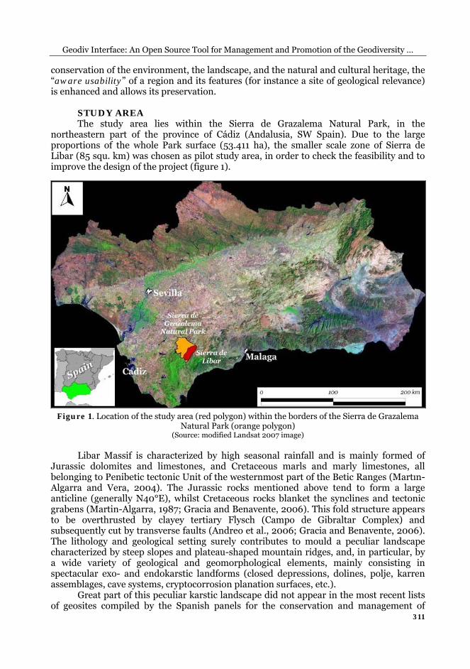
Personal Computer, UMPC) was carried out to complete data collection and perform the ground truth verification (through accurate GPS georeferencing) of previous remotely sensed data. Using UMPC device it was possible to work on field directly on a GIS program (Quantum GIS, QGIS) and, through the HSDPA (High-Speed Downlink Packet Access) transmission protocol, to send automatically and in real time shapefiles and image files to the GeoDIV Database (DB) (figure 5). The combined use of field survey, UMPC and OS Software (QGIS; Geographic Resources Analysis Support System, GRASS; The GIMP) permitted us to compile a general database of all the geological and geomorphological features of the study area and to produce geological and geomorphological detailed maps.
The large amounts of preliminary data previously collected have been inserted into the PostgreSQL DB where spatial data are managed by PostGIS. The whole project provides the possibility of divulging through the WebGIS all the 2D and 3D informations collected. The ability to show all the available data online, will be carried out through GeoDIV application, created ad-hoc for the project, using Mapserver OS application that allows viewing, querying and graphical output of spatial data (figure 6).

Andrea SUMA, Pietro Domenico de COSMO
314
Figure 4. Detection of karst depressions by remote sensing techniques. Lower right: 0,5 m spatial
resolution orthophoto of part of the study area. Upper right: 3/1 spectral band ratio derived by a pan sharpening merging method applied on a Landsat 7 ETM+ 2000 digital imagery; the reddish
and yellowish areas clearly show soil solution residues (with a high content in iron-bearing minerals), which mainly fill the bottom of dolines and small karst depressions. Left side images:
findings of small (from few millimeters to 2-3 centimeters) single or aggregated grains of Goethite and Hematite (below) on the bottom of enclosed depressions (above) in the Sierra de Libar area
(Source: Suma et al., 2010)
Figure 5. Schematic diagram illustrating the various implementation phases of GeoDIV database
It is worth to mention that the first web publication of our GIS data was done
through PMapper WebGIS interface (Mantovani et al., 2009; de Cosmo et al., 2008; de Cosmo, 2010). It allowed us to add layer (track, pathway, walk, points of interest), zoom,
Geodiv Interface: An Open Source Tool for Management and Promotion of the Geodiversity …
315
make queries, etc. but above all to produce and download a georeferenced “tif” extension raster map of the study area. Within the main GeoDIV WebGIS interface (very similar in use and visualization to any Windows or Linux desktop application), some integrative tools are present. The continued implementation of the database will be directly linked to GeoDIV that will display automatically updates and changes to the database. As a future extension it will also be possible to use personal GPS devices (with free operative systems or not) or mobile phones to download and install data of interest directly from the WebGIS interface or PostGIS database.
Figure 6. A screenshot of the GeoDIV WebGIS interface
RESULTS One the main of results of this study consists in the use of Open Source (and then
completely free) softwares for the development and maintenance of DBMS, WebGIS interface and UMPC. For instance, PostgreSQL and PostGIS allowed us to manage the entire dataset. We directed our’s efforts towards the carrying out of the final DB. This is the main core of the project because it contains: previously collected data, tracks and GPS points, remotely sensed data (orthophotos, aerial and satellite images) processed in GIS environment, videos and photos.

Andrea SUMA, Pietro Domenico de COSMO
316
Making easily accessible to a wide variety of users this large amount of geodiversity data (geosites and geomorphosites) was another important outcome. This was possible through the design and construction of the WebGIS interface which consents the exportation of customized thematic maps. Due to the use of OS softwares this interface could permit the development of innovative applications (downloading of P.O.I., tracks and multimedia contents on portable devices or mobiles).
Finally the use of UMPC device with gvSIG OS software enabled the acquisition of a large amount of data (GPS points, photos, videos, shapefiles, etc.) in a shorter time than traditional field survey.
DISCUSSION As noted above, the innovative procedures for the promotion of geoheritage have
developed only in recent times. The authors involved in these issues used different methods to develop ways for promoting geoheritage in many national contexts: from the simple creation of thematic maps (Castaldini et al., 2005; Serrano e Gonzalez-Trueba, 2005; Martin, 2010) to digital mapping outputs (Ghiraldi et al., 2009; Ghiraldi et al., 2010; Stankovic et al., 2011; Zanoletti et al., 2011). The latters used both OS and commercial softwares. Particularly those who used OS softwares (Ghiraldi et al., 2009; Ghiraldi et al., 2010; Zanoletti et al., 2011), if compared with traditional maps, experienced some obvious disadvantages: the requirement of a high band-width access to the Internet; the vulnerability to server and network problems; the need of a certain familiarity with GIS application. On the other hand the WebGIS applications present several advantages: cheapness if developed with Open Source software; easiness to be distributed to a wide audience and to be updated and maintained; interactivity options and connections to related information (multimedia contents).
In our case the combined use of different OS softwares and UMPC device has quickened the development and implementation of the DB. For instance PostgreSQL and PostGIS are able to manage spatial data in a quicker way if compared to other Relational DBMS (like MySQL). In addition, besides giving the position of the point of interest, the UMPC device allows to edit shapefiles and take videos and photos sending them in real time through HSDPA transmission protocol to the DB main server. At last, GeoDIV interface is fully customizable (thus improving the flexibility of visualization) unlike precompiled graphic interfaces such as PMapper.
CONCLUSIONS Due to the presence of a spectacular variety of karstic landforms (part of a broader
geodiversity and extended to the whole zone of the Sierra de Grazalema Natural Park) the chosen study area represents an ideal pilot area to set up and develop a geodiversity WebGIS interface. Enabling the visualization and the querying of geographically referenced data through its online interface, GeoDIV is an innovative (and virtually at near to zero cost) way of mapping geoheritage. In fact, it is a potentially useful device for inventories and measures for the conservation of the geological heritage and geodiversity. Furthermore, it can crucially contribute to stimulate and boost local geotourism and aware use of geological resources, the latter being activities with huge economic potential. The project described in this paper is a prototype and then is still in progress, particularly for data increasing and updating, and for the implementation of new innovative applications. As part of a more extended project in collaboration with Geotema L.t.d. (spin-off of Ferrara University) and Dolomiti Project L.t.d. (private society for the enhancement of geodiversity and geotourism in Northern Italy), some geological and geomorphological real field tours of Natural Parks (including Sierra de Grazalema Natural Park) through GPS devices are being developed.

Geodiv Interface: An Open Source Tool for Management and Promotion of the Geodiversity …
317
There are several advantages in the use of personal GPS devices or mobile phones: 1) the possibility of downloading and installing data directly from GeoDIV interface or PostGIS DB; 2) the importation of routes, tracks, waypoints of geological and geomorphological interest on the GPS devices or phones; 3) the visualization of short videos, animations or explicative documents when you are in proximity of a point or place of interest. In particular, the last point has a fundamental implication which deserves to be pointed out and which can be defined as a relevant form of “sustainable geotourism”. Making unneeded the installation of new informative and explanatory panels related to the local geodiversity, it consents to reduce the ecological impact and the not irrelevant costs of new poster design and maintenance, and also integrates local biodiversity knowledge enabling a fully holistic approach to the aware use of nature.
REFERENCES
AA. VV., (2009), Informe previo para la revisión y actualización del Inventario Andaluz de Georrecursos, Consejeria de Medio Ambiente, Dirección General de Gestión del Medio Natural, Junta de Andalucia, pp. 71;
AA. VV., (2010), Estrategia Andaluza de Gestión Integrada de la Geodiversidad, Consejeria de Medio Ambiente, Junta de Andalucia, BOJA 202 15-11-2010, pp.189;
Andreo B., Goldscheider N., Vadillo I., Vías J.M., Neukum C., Sinreich M., Jiménez P., Brechenmacher J., Carrasco F, Hötzl H., Perles M.J., Zwahlen F., (2006), Karst groundwater protection: First application of a Pan-European Approach to vulnerability, hazard and risk mapping in the Sierra de Libar (Southern Spain), Science of the Total Environment, 357, 54–73;
Bissig G., (2008), Mapping geomorphosites: an analysis of geotourist maps, Geoturystyka, Vol. 3, 3-12; Carcavilla L., Durán J.J., López-Martínez J., (2008), Geodiversidad: concepto y relación con el patrimonio
geológico. Geo-Temas, 10, 1299-1303, VII Congreso Geológico de España, Las Palmas de Gran Canaria; Carcavilla L., Durán J.J., García-Cortés A., López-Martínez J., (2009), Geological Heritage and
Geoconservation in Spain: Past, Present, and Future, Geoheritage, Volume 1, Numbers 2-4, 75-91; Castaldini D., Valdati J., Ilies D.C., Chiriac C., (2005), Geo-tourist map of the Natural Reserve of Salse di
Nirano (Modena Appennines, Northern Italy), Il Quaternario, 18(1), 245-255; De Cosmo P.D., Suma A., Gracia F.J., Mantovani F., (2008), Aplicación del software Open Source (Web GIS) a
la cartografía geológica y geomorfológica del área de Olvera (Cádiz), In: X° Reunión Nacional de Geomorfología (Cádiz, 14 - 19 September 2008);
De Cosmo P.D., (2010), Rilevamento geomorfologico e gestione dati spaziali attraverso l'uso combinato hardware-software Open-Source per il controllo e la gestione del rischio geologico, PhD thesis, Università degli Studi di Ferrara;
García-Cortés A., Carcavilla L., (2009), Documento Metodológico para la elaboración del Inventario Español de Lugares de Interés Geológico (Ielig), Instituto Geológico y Minero de España;
Ghiraldi L., Coratza P., De Biaggi E., Giardino M., Marchetti M., Perotti L., (2009), Development and usage of Geosites: new results from research and conservation activities in the Piemonte Region (Italy), Studia Universitatis Babeş-Bolyai, Geologia, 2009, 54 (2), 23 – 26;
Ghiraldi L., Coratza P., Marchetti M., Giardino M., (2010), GIS and geomatics application for the evaluation and exploitation of Piemonte geomorphosites, In: Regolini-Bissig G., Reynard E. (Eds) (2010), Mapping Geoheritage, Lausanne, Institut de géographie, Géovisions n°35, pp. 97-113;
Giordano E., Ghiraldi L., Perotti L., (2011), Digital tools for collection and visualization of geoscientific data, In: Managing Geosites in Protected Areas, International Symposium on Geosite Management, Conference 7-9 September 2011, pp. 17;
Gracia F.J., Benavente J., (2006), Origen y evolucion geomorfologica del Sistema de Poljes de la Sierra de Libar (Malaga), Boletin N°6 SEDECK, 42-53;
Gray M., (2004), Geodiversity: valuing and conserving abiotic nature, John Wiley & Sons Ltd; Mantovani F., Gracia F.J., de Cosmo P. D., Suma A., (2009), A new approach to landslide geomorphological
mapping using Open-Source software in the Olvera area (Cadiz, Spain), Landslides - Journal of the International Consortium on Landslides, Springer, Volume 7, Number 1 / March, 2010, 69-74;
Martın-Algarra A., (1987), Evolucion geologica alpina del contacto entre las Zonas Internas y las Zonas Externas de la Cordillera Betica (Sector Occidental), PhD Thesis, Faculty of Science, University of Granada;
Martin-Algarra A., Vera J. A., (2004), Cordillera Bética y Baleares – Cordillera Bética y Baleares – Zonas Externas Béticas – Subbético – El Subbético del sector occidental, 372-377, In: Geología de España, ed Pral., Madrid: Sociedad Geológica de España; Instituto Geológico y Minero de España;
Martin S., (2010), Geoheritage popularisation and cartographic visualisation in the Tsanfleuron-Sanetsch
Andrea SUMA, Pietro Domenico de COSMO
318
area (Valais, Switzerland), In: Regolini-Bissig G., Reynard E., (Eds) (2010), Mapping Geoheritage, Lausanne, Institut de géographie, Géovisions n°35, pp. 15-30;
Reynard E., (2008), Scientific research and tourist promotion of geomorphological heritage, Geografia Fisica e Dinamica Quaternaria, 31, 225-230, 2 fig;
Serrano E., Gonzalez-Trueba J.J., (2005), Assessment of geomorphosites in natural protected areas: the Picos de Europa National Park (Spain), Géomorphologie, 3, 197-208;
Stanković R., Prodanović J., Kitanović O., Nikolić V., (2011), Development of the Serbian Geological Resources Portal, In: 17th Meeting of the Association of European Geological Societies, Proceedings, pp. 61–65 Belgrade, 14–18 September 2011;
Suma A., Gracia F. J., Cosmo P.D., (2010), Detection and mapping of karst depressions through remote sensing approach: an example from Sierra de Líbar (Malaga, SW Spain), In: 18th International Karstological School "Classical Karst" (Postojna, 14th to 19th June, 2010), pp. 63;
Zanoletti E., Pirocchi A., Seno S., Spataro A., (2011), SITINET - Census, networking and development of geological and archaeological sites, In: Managing Geosites in Protected Areas, International Symposium on Geosite Management, Conference 7-9 September 2011, pp. 49;
Villalobos M., Pérez Muñoz A.B., (2004), Geodiversidad y Patrimonio Geológico de Andalucía, Itinerario geológico por Andalucía, Guía didáctica de campo, Consejería de Medio Ambiente, Junta de Andalucia.
Submitted: Revised: Accepted: Published online: 29.07.2011 19.10.2011 24.10.2011 26.04.2011