Embed Size (px)
Citation preview
GEODETIC MEASUREMENTS IN THE AEGEAN SEA REGION FOR THE DETECTION OF CRUSTAL DEFORMATION D. Delikaraoglou, H. Billiris, D. Paradissis National Technical University of Athens, Faculty of Surveying Engineering, Iroon Polytechneiou 9, 15780 Zografou, Greece P.C. England, B. Parsons Department of Earth Sciences, University of Oxford, Parks Road, Oxford, OX1 3PR, U.K. P.J. Clarke Department of Geomatics, University of Newcastle, Newcastle upon Tyne, NE1 7RU, U.K.
Abstract Greece and the Aegean Sea form part of one of the most rapidly
deforming parts of the Earth's surface, and are characterized by a high level of intra-plate seismic activity in comparison to neighboring regions. AEGEANET is a geodetic network that we have established in order to measure consistently the geodetic strain in the broader Aegean Sea region, including parts of the Greek mainland and spanning several areas of known fault systems. Our measurements so far span approximately 4-, and 42-year periods up to 1997 using a combination of old triangulation/trilateration-derived coordinates and recent, repeated GPS observations at various subsets of the stations of this network. The observed displacements reflect the present day and long-term tectonic deformation of the region, showing more than one metre of north-south extension across the network. The crust in this region appears to contain a few slowly deforming blocks separated by more rapidly deforming zones. This conclusion is supported by the velocity and strain fields that we have estimated for six sub-regions, which provide a more detailed view of the crustal deformation in this region.
Keywords: GPS; GPS networks; Aegean Sea; Strain accumulation; Strain ellipses;
Crustal deformation Greece;
1. INTRODUCTION - GEODYNAMIC SETTING The Aegean Sea and its surrounding area lie within the convergence zone
between the African and Eurasian plates and for that reason the tectonic activity in the region is very intense, accounting for the highest seismicity among the Mediterranean countries and indeed of the whole West Eurasia.
The most prominent morphological features of tectonic origin in the Aegean Sea and the surrounding area are (from south to north): the Mediterranean Ridge, the Hellenic Arc and its associated Hellenic Trench, and the Northern Aegean Trough. The Mediterranean Ridge is the submarine chain that runs from the Ionian Sea to Cyprus in parallel to the Hellenic Trench, which in turn runs parallel to the Hellenic Arc and consists of submarine depressions some 5 km deep and smaller linear trenches south of Crete and in the Ionian Sea. The Hellenic Arc, consists of an outer sedimentary arc, which links the Dinaric Alps (through the Greek mountain ranges, the Ionian Islands, Crete and the island of Rhodes) to the Turkish Taurides, and the inner Hellenic Volcanic Arc, which parallels the sedimentary arc and trench, and consists of volcanic islands stretching from Methana in the east, to Milos and Santorini in the Cyclades islands
Figure 1 – The geodynamic setting of the broader Aegean Sea region
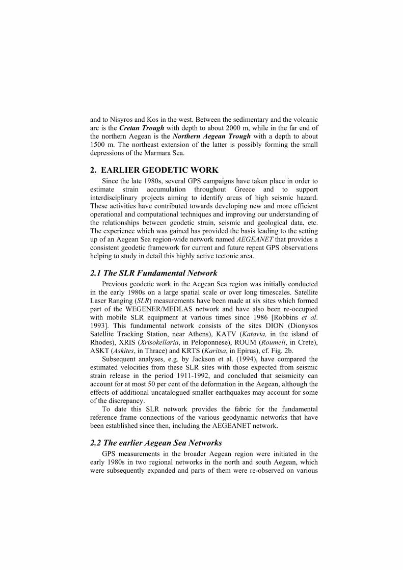
and to Nisyros and Kos in the west. Between the sedimentary and the volcanic arc is the Cretan Trough with depth to about 2000 m, while in the far end of the northern Aegean is the Northern Aegean Trough with a depth to about 1500 m. The northeast extension of the latter is possibly forming the small depressions of the Marmara Sea.
2. EARLIER GEODETIC WORK Since the late 1980s, several GPS campaigns have taken place in order to
estimate strain accumulation throughout Greece and to support interdisciplinary projects aiming to identify areas of high seismic hazard. These activities have contributed towards developing new and more efficient operational and computational techniques and improving our understanding of the relationships between geodetic strain, seismic and geological data, etc. The experience which was gained has provided the basis leading to the setting up of an Aegean Sea region-wide network named AEGEANET that provides a consistent geodetic framework for current and future repeat GPS observations helping to study in detail this highly active tectonic area.
2.1 The SLR Fundamental Network Previous geodetic work in the Aegean Sea region was initially conducted
in the early 1980s on a large spatial scale or over long timescales. Satellite Laser Ranging (SLR) measurements have been made at six sites which formed part of the WEGENER/MEDLAS network and have also been re-occupied with mobile SLR equipment at various times since 1986 [Robbins et al. 1993]. This fundamental network consists of the sites DION (Dionysos Satellite Tracking Station, near Athens), KATV (Katavia, in the island of Rhodes), XRIS (Xrisokellaria, in Peloponnese), ROUM (Roumeli, in Crete), ASKT (Askites, in Thrace) and KRTS (Karitsa, in Epirus), cf. Fig. 2b.
Subsequent analyses, e.g. by Jackson et al. (1994), have compared the estimated velocities from these SLR sites with those expected from seismic strain release in the period 1911-1992, and concluded that seismicity can account for at most 50 per cent of the deformation in the Aegean, although the effects of additional uncatalogued smaller earthquakes may account for some of the discrepancy.
To date this SLR network provides the fabric for the fundamental reference frame connections of the various geodynamic networks that have been established since then, including the AEGEANET network.
2.2 The earlier Aegean Sea Networks GPS measurements in the broader Aegean region were initiated in the
early 1980s in two regional networks in the north and south Aegean, which were subsequently expanded and parts of them were re-observed on various
occasions between 1988 and 2000 [e.g. Gilbert et al., 1994; Cruddace et al. 1999].
The first elaborate comparisons between GPS results and conventional geodetic measurements in the area were made as part of the Southeast Aegean Project (SEA 93) which took place in 1993 and included GPS observations in 16 pillars of the national geodetic triangulation/ trilateration network and five new GPS markers, as well as from two SLR sites within the area [Zacharis, 1994]. The estimated velocity fields from this network were also augmented with the corresponding fields computed within two prior similar projects: the South Aegean GPS project (SAE 88/92), with two GPS campaigns in 1988 and 1992, and the 1992 Sea Level Fluctuations (SELF) project. This first major efforts to compare historical geodetic data and newer GPS results revealed horizontal movements typically up to 30 cm over the nearly 16-year period between these datasets (except a large movement (85.3 cm) showed in the site KPRN in northern Crete). However, the overall results for these observed displacements and the corresponding site velocities were difficult to assess without some ambiguity, mainly because of the conceivably lower precision of the coordinates derived from the historical geodetic data (roughly 3 ppm vs. less than 1 ppm for the GPS-derived results).
2.3 The AEGEAN 88/96 Project The AEGEAN 88/96 project involved the realization of a regional
geodetic network consisting of 30 stations that spanned the entire Aegean Sea region [Ouzounis, 1998]. This network was first observed in 1988 and was re-occupied on three subsequent epochs: in 1989, 1992 and 1996. These campaigns allowed the first GPS-GPS velocity fields determinations that demonstrated the obvious advantages over the previous methods based on triangulation-GPS comparisons, that is: (i) there is no need to make scale and orientation assumptions in order to estimate unique velocity fields; (ii) the network stations can be chosen so that to serve better, in terms of geometry, the geodynamic requirements rather than the mutual station indivisibility of the conventional networks; and (iii) baselines can be chosen to vary over short, medium and long lengths so that to improve the quality of the sought GPS solutions.
3. The AEGEANET Network
3.1 Rationale The earlier geodetic works in the broader Aegean Sea region and several
more recent studies [e.g. Goldsworthy et al., 2000] based on evidence from geomorphology, the spatial distribution of the large earthquakes, and additional geodetic measurements have suggested that the active faulting in mainland Greece and the Aegean Sea is concentrated into a small number of discrete, linear zones that bound relatively rigid blocks that are in relative
motion. These zones are not always well defined even on land, and are clearest where the faulting produces large topographic offsets. This reason makes it difficult to provide an adequate description of the tectonics of the region, since it would require both the knowledge of the overall velocity field (i.e. the motions) and how this is achieved by faulting. However, the notion of considering Greece as a mosaic of rigid blocks whose boundaries change with time is still a useful framework for seismic hazard evaluation and monitoring. From the geodetic viewpoint, ideally this would require establishing a large-scale geodetic network for which the combination of modern space geodetic observations with longer-term geodetic data could provide an essential complementary method of quantifying the deformation over many known, and probably many unmapped, faults which encompass a wide variety of orientations, geometries and faulting types. The AEGEANET project constitutes a major attempt towards establishing such a geodetic network spanning a large area that includes a large number of the Aegean islands and parts of Macedonia and Thrace, as well as many known faults and has experienced in the recent past some of the larger earthquakes.
The overall objective for establishing the AEGEANET is to observe some 100 stations (and possibly more in the future) at regular time intervals using geodetic quality GPS receivers. The choice of stations and the scheme for repeat occupation intervals follows a three-tiered approach:
Small station spacing in areas of identified high seismic risk. Large spacing region-wide (to fill in gaps from previous networks). A number of permanent (e.g. International GPS Service (IGS) sites)
and semi-permanent stations occupied for relatively short time periods (three or more days).
This allows the fiducial stations in the network to be linked to the International Terrestrial Reference Frame (ITRF), as well as producing efficient observation strategies whereby local stations can be observed with respect to “local” permanent (during the observations) stations, thus reducing baseline lengths and observation periods during the observation campaigns.
The ultimate goal from this network is to obtain an integrated kinematic model that will accurately describe (spatially and quantitatively) the geodetic strain distribution throughout the Aegean Sea and the northern part of the Greek mainland. This will then be conceivably integrated with the seismic, geologic and other data to serve as a basic tool for seismic hazard assessment and monitoring.
3.2 GPS Observations The first AEGEANET observational GPS campaign took place in
September 1997 (days 254-269) and included GPS observations in a total of 94 sites, which included:
2 permanent reference platforms at the Dionysos Satellite Tracking Station (DION), near Athens.
66 concrete pillars from the national triangulation/trilateration geodetic network with available coordinates in the Hellenic Geodetic Reference System 1987 (denoted in the subsequent discussion as EGSA 87).
4 platforms from the SLR network (DION, ASKT, ROUM, KATV). 22 previously established GPS markers, which had been observed
during the SEA 93 campaign.
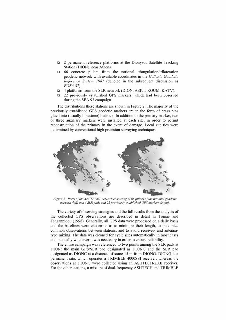
The distributions these stations are shown in Figure 2. The majority of the previously established GPS geodetic markers are in the form of brass pins glued into (usually limestone) bedrock. In addition to the primary marker, two or three auxiliary markers were installed at each site, in order to permit reconstruction of the primary in the event of damage. Local site ties were determined by conventional high precision surveying techniques.
Figure 2 - Parts of the AEGEANET network consisting of 66 pillars of the national geodetic
network (left) and 4 SLR pads and 22 previously established GPS markers (right).
The variety of observing strategies and the full results from the analysis of the collected GPS observations are described in detail in Tomae and Tsagannidou (1998). Generally, all GPS data were processed on a daily basis and the baselines were chosen so as to minimize their length, to maximize common observations between stations, and to avoid receiver- and antenna-type mixing. The data was cleaned for cycle slips automatically in most cases and manually whenever it was necessary in order to ensure reliability.
The entire campaign was referenced to two points among the SLR pads at DION: the main GPS/SLR pad designated as DIONG and the SLR pad designated as DIONC at a distance of some 15 m from DIONG. DIONG is a permanent site, which operates a TRIMBLE 4000SSI receiver, whereas the observations at DIONC were collected using an ASHTECH-ZXII receiver. For the other stations, a mixture of dual-frequency ASHTECH and TRIMBLE
GPS receivers was also used. The coordinates of DIONG were estimated in the ITRF reference frame at epoch 1997.72 by utilizing available GPS data from the ITRF sites GRAZ, (Austria), MATERA (Italy) and WETTZEL (Germany). The final solution was carried out with the Bernese v4.0 software suite [Rothacher et al., 1996] by accumulating the normal equations from available GPS data spanning several-hour sessions on a total of 18 days. From these coordinates of DIONG, the coordinates of DIONC were subsequently determined using two full days of common data between these two stations.
The solution of the remaining stations of the AEGEANET network was carried out in two sub-networks, termed respectively as AEGEANET-I and -II. The AEGEANET-I sub-network consisted of 42 sites from which the observations were analyzed in two parts, so that single-receiver-type daily networks could be formed in each case, i.e.:
(i) All observations collected at sites observing with ASHTECH receivers and in a radial baseline pattern using the DIONC site as reference station.
(ii) All observations collected at sites observing with TRIMBLE receivers and in a radial baseline pattern using the DIONG site as reference station.
The length in the observed baselines ranged from 15 to 450 km, and daily observing sessions were designed so that to include a range of processed baseline lengths to aid better integer ambiguity resolution. Generally, the Bernese solutions were based on the L3 frequencies combination for the longer baselines (greater than 20 km) and solutions based on the L1 frequency data for the sort baselines (< 15 km). The decision for this observing strategy was justified later on by the small rms values (typically at the sub-millimeter range up to 1-1.5 mm) that were obtained from this solution for the coordinates of these 42 stations. Another indication of the quality of the results was the percentage of successful resolution of the integer ambiguity parameters during the final processing of the GPS data, which was typically larger than 75% for the baselines having length greater than 100 km and larger than 85% for the baselines less than 100 km in length.
The AEGEANET-II subnetwork consisted of the remaining 50 sites. Their coordinates were estimated from multibaseline solutions, which used as reference stations the nearest sites whose coordinates were available from the AEGEANET-I solution. For a small number (15) of stations in this subset, the solutions for the final coordinates were obtained by averaging the coordinate values from individual session solutions for various baselines. For these baselines, a single solution was not possible (i.e. via the summation of normal equations resulting from all available observations), because for the various observing periods at the stations involved, the height of the antennas varied from occupation to occupation.
3.3 Comparison with other geodetic data In order to analyze further these GPS results from the geodynamic
viewpoint, we have estimated the horizontal displacements field, the
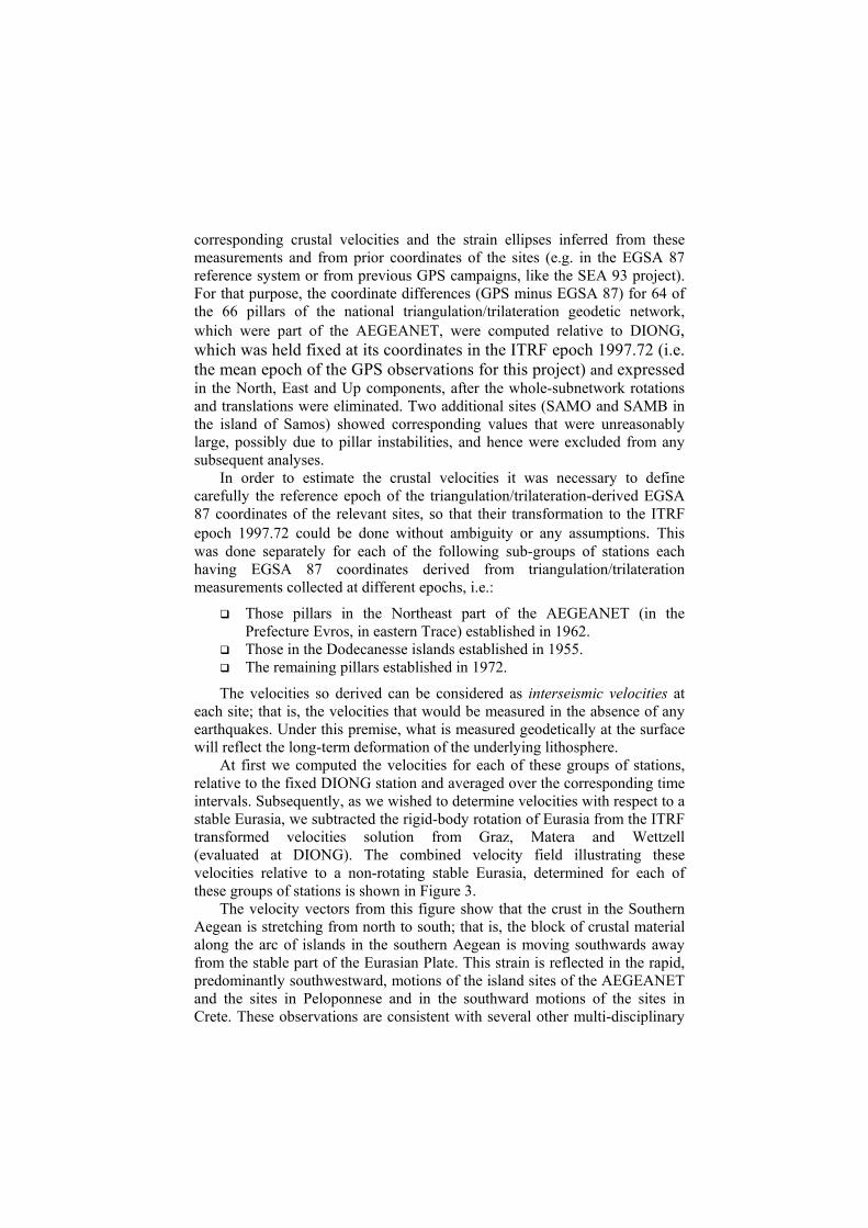
corresponding crustal velocities and the strain ellipses inferred from these measurements and from prior coordinates of the sites (e.g. in the EGSA 87 reference system or from previous GPS campaigns, like the SEA 93 project). For that purpose, the coordinate differences (GPS minus EGSA 87) for 64 of the 66 pillars of the national triangulation/trilateration geodetic network, which were part of the AEGEANET, were computed relative to DIONG, which was held fixed at its coordinates in the ITRF epoch 1997.72 (i.e. the mean epoch of the GPS observations for this project) and expressed in the North, East and Up components, after the whole-subnetwork rotations and translations were eliminated. Two additional sites (SAMO and SAMB in the island of Samos) showed corresponding values that were unreasonably large, possibly due to pillar instabilities, and hence were excluded from any subsequent analyses.
In order to estimate the crustal velocities it was necessary to define carefully the reference epoch of the triangulation/trilateration-derived EGSA 87 coordinates of the relevant sites, so that their transformation to the ITRF epoch 1997.72 could be done without ambiguity or any assumptions. This was done separately for each of the following sub-groups of stations each having EGSA 87 coordinates derived from triangulation/trilateration measurements collected at different epochs, i.e.:
Those pillars in the Northeast part of the AEGEANET (in the Prefecture Evros, in eastern Trace) established in 1962.
Those in the Dodecanesse islands established in 1955. The remaining pillars established in 1972.
The velocities so derived can be considered as interseismic velocities at each site; that is, the velocities that would be measured in the absence of any earthquakes. Under this premise, what is measured geodetically at the surface will reflect the long-term deformation of the underlying lithosphere.
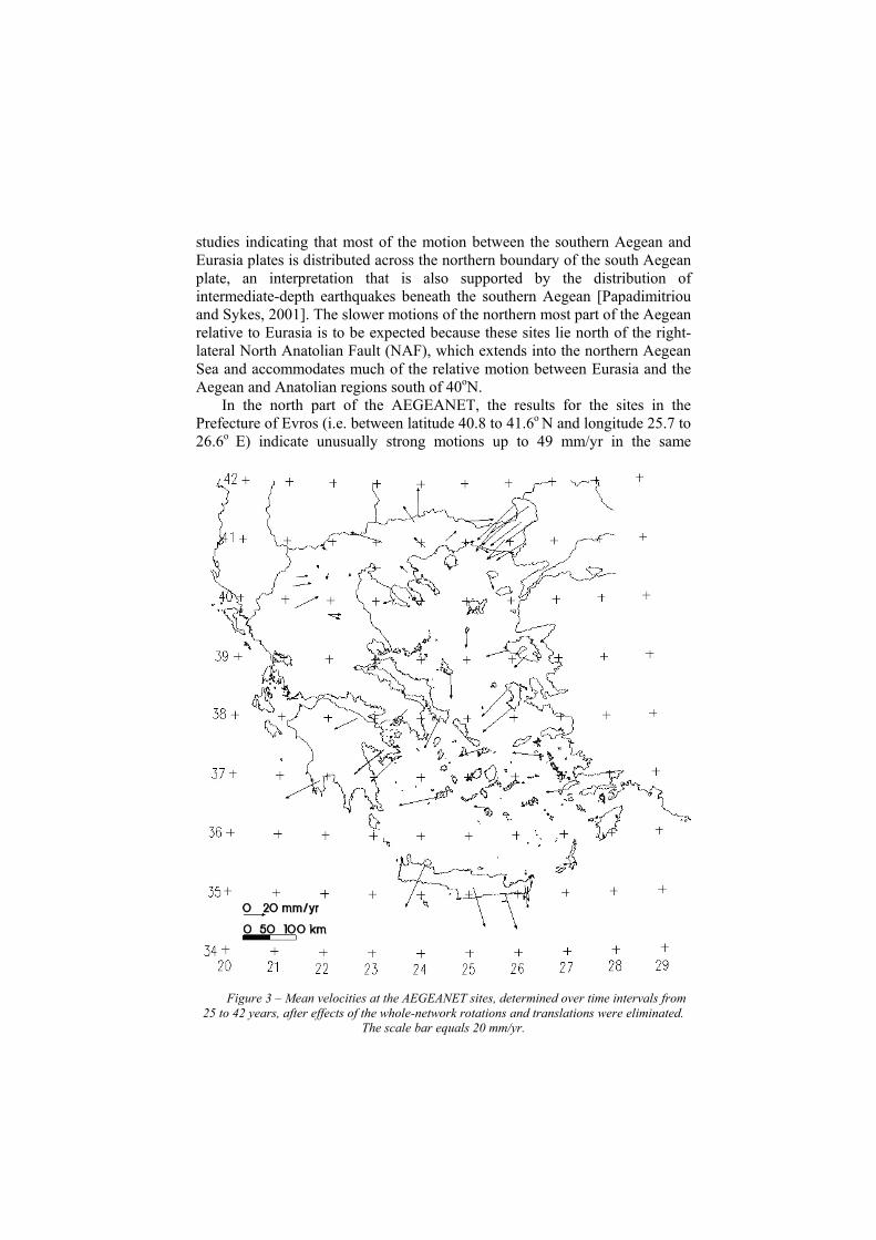
At first we computed the velocities for each of these groups of stations, relative to the fixed DIONG station and averaged over the corresponding time intervals. Subsequently, as we wished to determine velocities with respect to a stable Eurasia, we subtracted the rigid-body rotation of Eurasia from the ITRF transformed velocities solution from Graz, Matera and Wettzell (evaluated at DIONG). The combined velocity field illustrating these velocities relative to a non-rotating stable Eurasia, determined for each of these groups of stations is shown in Figure 3.
The velocity vectors from this figure show that the crust in the Southern Aegean is stretching from north to south; that is, the block of crustal material along the arc of islands in the southern Aegean is moving southwards away from the stable part of the Eurasian Plate. This strain is reflected in the rapid, predominantly southwestward, motions of the island sites of the AEGEANET and the sites in Peloponnese and in the southward motions of the sites in Crete. These observations are consistent with several other multi-disciplinary
studies indicating that most of the motion between the southern Aegean and Eurasia plates is distributed across the northern boundary of the south Aegean plate, an interpretation that is also supported by the distribution of intermediate-depth earthquakes beneath the southern Aegean [Papadimitriou and Sykes, 2001]. The slower motions of the northern most part of the Aegean relative to Eurasia is to be expected because these sites lie north of the right-lateral North Anatolian Fault (NAF), which extends into the northern Aegean Sea and accommodates much of the relative motion between Eurasia and the Aegean and Anatolian regions south of 40oN.
In the north part of the AEGEANET, the results for the sites in the Prefecture of Evros (i.e. between latitude 40.8 to 41.6ο Ν and longitude 25.7 to 26.6ο Ε) indicate unusually strong motions up to 49 mm/yr in the same
Figure 3 – Mean velocities at the AEGEANET sites, determined over time intervals from 25 to 42 years, after effects of the whole-network rotations and translations were eliminated.
The scale bar equals 20 mm/yr.
southwestward direction. This may be due to the presence of small faults in this area, a suggestion which cannot be tested until repeat GPS observations are carried out in order to study the area in greater detail. In the remaining northern part of the AEGEANET network (i.e. the Western part of Macedonia), the eastward displacements and velocities are overall much smaller (i.e. from 0.15 to 0.75 m and respectively 5.8 up to 29 mm/yr) as compared to those observed for the south part.
The sites in the Dodecanesse islands exhibit a slightly different pattern with motions in the westward direction exceeding 1.2 m, over the 42-year period.
3.4 Variation of Strain Apart from studying the displacements and the velocities fields, it is
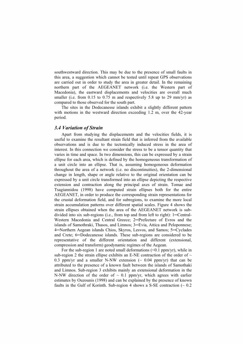
useful to examine the resultant strain field that is inferred from the available observations and is due to the tectonically induced stress in the area of interest. In this connection we consider the stress to be a tensor quantity that varies in time and space. In two dimensions, this can be expressed by a strain ellipse for each area, which is defined by the homogeneous transformation of a unit circle into an ellipse. That is, assuming homogeneous deformation throughout the area of a network (i.e. no discontinuities), the 2-dimensional change in length, shape or angle relative to the original orientation can be expressed by a unit circle transformed into an ellipse depicting the respective extension and contraction along the principal axes of strain. Tomae and Tsagiannidou (1998) have computed strain ellipses both for the entire AEGEANET, in order to produce the corresponding strain representations for the crustal deformation field, and for subregions, to examine the more local strain accumulation patterns over different spatial scales. Figure 4 shows the strain ellipses obtained when the area of the AEGEANET network is sub-divided into six sub-regions (i.e., from top and from left to right): 1─Central-Western Macedonia and Central Greece; 2─Prefecture of Evros and the islands of Samothraki, Thasos, and Limnos; 3─Evia, Attica and Peloponnese; 4─Northern Aegean islands Chios, Skyros, Lesvos, and Samos; 5─Cyclades and Crete; 6─Dodecanesse islands. These sub-regions are considered to be representative of the different orientation and different (extensional, compression and transform) geodynamic regimes of the Aegean.
For the sub-region 1 are noted small deformations (<0.1 ppm/yr), while in sub-region 2 the strain ellipse exhibits an E-NE contraction of the order of ~ 0.3 ppm/yr and a smaller N-NW extension (~ 0.04 ppm/yr) that can be attributed to the presence of a known fault between the islands of Samothaki and Limnos. Sub-region 3 exhibits mainly an extensional deformation in the N-NW direction of the order of ~ 0.1 ppm/yr, which agrees with earlier estimates by Ouzounis (1998) and can be explained by the presence of known faults in the Gulf of Korinth. Sub-region 4 shows a S-SE contraction (~ 0.2
ppm/yr) and almost negligible extension (~ 0.01 ppm/yr), while the remaining two sub-regions exhibit extensional deformations in all directions reaching ~ 0.25 ppm/yr in the North direction in sub-region 5 and ~ 0.1 ppm/yr in the N-NE direction for sub-region 6.
Figure 4 – Strain ellipses for six sub-regions of the AEGEANET network, determined from the EGSA 87-GPS velocities fields for the sub-group of 66 pillar stations. The strain ellipse’s scale
bar equals 0.2 ppm/yr.
3.4 Comparison with the Aegean 93 GPS results A similar comparison was done for the additional 26 points of the
AEGEANET (i.e. 4 SLR pads and 22 GPS markers), which had been previously observed with GPS in 1993. The GPS coordinates for this campaign were referenced to the mean ITRF epoch 1993.5, via the primary point of Dionysos (DIONG) which was held fixed to its ITRF93 position (i.e. the so-called Dionysos Datum 1993 or DD93 solution). The comparison of the
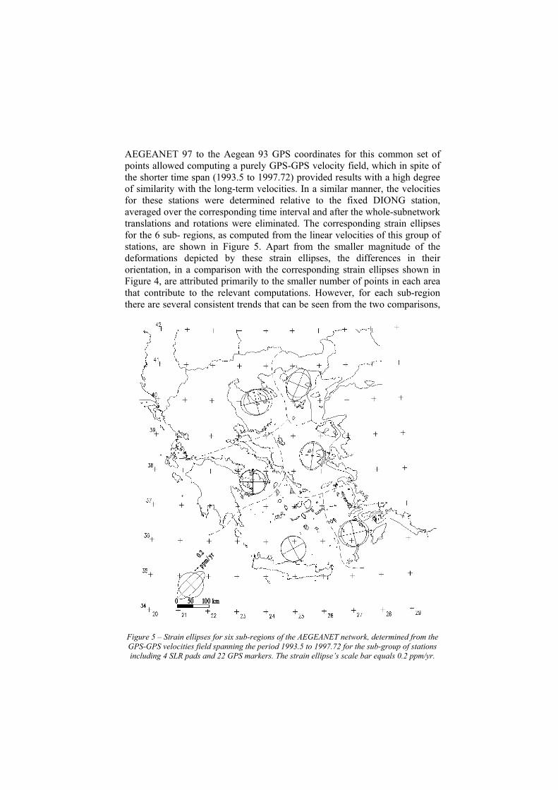
AEGEANET 97 to the Aegean 93 GPS coordinates for this common set of points allowed computing a purely GPS-GPS velocity field, which in spite of the shorter time span (1993.5 to 1997.72) provided results with a high degree of similarity with the long-term velocities. In a similar manner, the velocities for these stations were determined relative to the fixed DIONG station, averaged over the corresponding time interval and after the whole-subnetwork translations and rotations were eliminated. The corresponding strain ellipses for the 6 sub- regions, as computed from the linear velocities of this group of stations, are shown in Figure 5. Apart from the smaller magnitude of the deformations depicted by these strain ellipses, the differences in their orientation, in a comparison with the corresponding strain ellipses shown in Figure 4, are attributed primarily to the smaller number of points in each area that contribute to the relevant computations. However, for each sub-region there are several consistent trends that can be seen from the two comparisons,
Figure 5 – Strain ellipses for six sub-regions of the AEGEANET network, determined from the GPS-GPS velocities field spanning the period 1993.5 to 1997.72 for the sub-group of stations including 4 SLR pads and 22 GPS markers. The strain ellipse’s scale bar equals 0.2 ppm/yr.
such as, for instance, the high extensional strains noted for the Northern Aegean and the sub-region of the Dodecanesse islands.
4. Conclusions A coordinated effort of GPS campaigns has resulted in the establishment
of an Aegean Sea region-wide geodetic network, termed AEGEANET. GPS and other geodetic measurements on this network have been adopted as geodetic background for the most recent geodynamic interpretations related to the broader Aegean Sea region. Velocity fields spanning a 40 yr time interval, determined from comparisons of GPS with conventional geodetic measurements, have provided measures of the long-term crustal deformation, while shorter span GPS-GPS velocity fields have demonstrated that measurements of strain can be made for present-day deformations of local regions spanning a few tens of kilometers.
The AEGEANET has been augmented with the Central Greece Network (CGN), a similar network of some 70 stations spanning Central Greece and the northern part of Peloponnese, which has provided similar results for the crustal strain in central Greece from repeated GPS measurements in the interval 1989-1997 [Clarke et al., 1998]. Together with the new Continuous Ionian Network (CION), a 46-station GPS network in Western Greece, the Ionian Sea and Crete [Peter at al., 1998; Kahle et al., 1995, 1996], these three major geodetic networks cover the entire Greek territory providing a consistent integrated framework to study the kinematics and dynamics of the regional plate interactions.
Future work will include further repeat GPS measurements on these networks which will quantify further the localized strain fields in the various sub-regions of the Aegean extensional basin and of the north-western and central Greece respectively, so that to continue monitoring for likely seismic hazards in these highly active tectonic regions.
References Clarke, P.J, R. R. Davies, P. C. England, B. Parsons, H. Billiris, D. Paradissis, G. Veis, P. A. Cross, P. H. Denys, V. Ashkenazi, R. Bingley, H.-G. Kahle, M.-V. Muller & P. Briole (1998) – “Crustal strain in central Greece from repeated GPS measurements in the interval 1989-1997”, Geoph. J. Int. 135, 195-214.
Cruddace, P.R., P.A. Cross, G. Veis, H. Billiris, D. Paradissis, J. Galanis, H. Lyon-Caen, P. Briole, B.A.C. Ambrosius, W.J.F. Simons, E. Roegies, B. Parsons, P. England, H.-G. Kahle, M. Cocard, P. Yannick, G. Stavrakakis, P. Clarke, M. Lilje (1999) – “An Interdisciplinary Approach to Studying Seismic Hazard Throughout Greece”, in Geodesy Beyond 2000. The challenges of the first decade. 279-284, Springer.
Gilbert L.E., Kastens K., Hurst K., Paradissis D., Veis G., Billiris H., Höppe W., Schlüter W. (1994) – “Strain results and tectonics from the Aegean GPS experiment”,EOS, Trans. Am. Geophys. Un., 135, 116.
Goldsworthy, M., Jackson, J. (2000) – “Active normal fault evolution in Greece revealed by geomorphology and drainage patterns”, Geological Society, London, Special Publication 157, p 967-981.
Jackson J.A., Haines J., Holt W. (1994) – “The horizontal velocity field in the deforming Aegean Sea region determined from the moment tensors of earthquakes”, J. Geophys. Res., 135 (B12), 17657-17684.
Kahle, H.-G., M.V. Mueller, A. Geiger, G. Danuser, S. Mueller, G. Veis, H. Billiris and D. Paradissis (1995) – “The strain field in northwestern Greece and the Ionian Islands: results inferred from GPS measurements”, Tectonophys., 249, 41-52.
Kahle, H.-G., M.V. Mueller, and G. Veis (1996) – “Trajectories of crustal deformation of western Greece from GPS observations 1989-1994”, J. Geophys. Lett., 23, 677-680.
Ouzounis, A. (1998) – “Tectonic motions in the Aegean Sea region determined from GPS observations”, Dipl. Thesis (in Greek), Dept. Surveying Eng., Nat. Tech. Univ. Athens.
Papadimitriou, E., Sykes, L (2001) – “Evolution of the stress field in the northern Aegean Sea (Greece)”, Geophys. J. Int. 146, 747–759.
Peter, Y., H.-G. Kahle, M. Cocard, G. Veis, S. Felekis and D. Paradissis (1998) – “Establishment of a permanent GPS network across the Kephalonia fault zone, Ionian Islands, Greece”, Tectonophys., 294, 253-260.
Robbins J.W., Smith D.E., Ma C. (1993) – “Horizontal crustal deformation and large-scale plate motions inferred from space geodetic techniques”, in Contributions of Space Geodesy to Geodynamics: Crustal Dynamics, pp. 21-36, (Eds Smith, D.E. & Turcotte, D.L.), AGU Geodynamics Series, Vol.23, Washington.
Rothacher, M., Beutler, G., Gurtner, W., Brockmann, E., Mervart L., 1996, in “Bernese GPS Software Version 4.0.”, Rothacher M., Mervart L. (Eds.)”, University of Bern, Switzerland.
Tomae E., Tsaganidou, Z. (1998) - “Geodetic Determination of tectonic displacements in the broader Aegean Sea region”, Dipl. Thesis (in Greek), Department of Surveying Engineering, National Technical University of Athens.
Zacharis, E. (1994) – “Position determinations with GPS in the Southern Aegean region”, Dipl. Thesis (in Greek), Dept. Surveying Eng., Nat. Tech. Univ. Athens.