Embed Size (px)
Citation preview

GeoDayz - 2018 Texas Section GeoDayz Sponsor
GeoDayz – 2018 Host
The Post-Geo Dayz Guidebook Including Abstracts, Sli de Presentations and Photos
Version 2.9 March 2, 2018

GeoDayz-2018 Guidebook GeoDayz – 2018 Host
Table of Contents
PDF Page #
A. Pre-GeoDayz Flyer and Announcements …………… 3 B. Sponsors of GeoDayz
Financial Sponsors …………………………………… 4 Supporting Sponsors ……………………………….. 4
C. Introductions1. Henry M. Wise, President, AIPG Texas Section .. … 5 2. Michael D. Campbell, VP, AIPG Texas Section ……… 5 3. Glen A. Collier, Councilor-at-Large, AIPG
Texas Section, and Host of GeoDayz-2018 …………… 6 4. Regina Capuano, Councilor-at-Large, AIPG
Texas Section ……………………………………………………….. 6 5. John Berry, Councilor-at-Large, AIPG Tx Section ….. 6
D. OBJECTIVES of the GeoDayz -2018 PROGRAM ……………………….. 7
E. GUEST LUNCHEON SPEAKERKevin Stafford, Ph.D., Associate Professor of Geology Department of Geology, Stephen F. Austin State University, Nacogdoches, Texas ………………………………………………. 8
F. GeoDayz SCHEDULE of DEMONSTRATIONS AND LECTURES …… 9
G. GeoDayz FACILITY MAP ………………………………………………………….. 10
H. GeoDayz LECTURE and DEMONSTRATION SUMMARIES …………. 11
1. Project Management Practices and Case Histories … 12Henry M. Wise, P.G., C.P.G. Michael D. Campbell, P.G., P.H., C.P.G.
Texas Section GeoDayz Sponsor
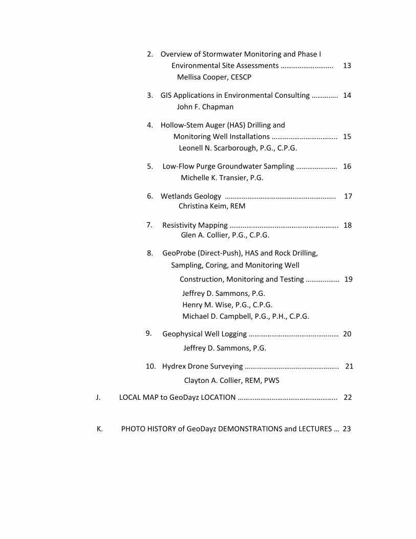
2. Overview of Stormwater Monitoring and Phase IEnvironmental Site Assessments ………………………. 13 Mellisa Cooper, CESCP
3. GIS Applications in Environmental Consulting ………….. 14 John F. Chapman
4. Hollow-Stem Auger (HAS) Drilling and Monitoring Well Installations …………………………….. 15
Leonell N. Scarborough, P.G., C.P.G.
5. Low-Flow Purge Groundwater Sampling …………………. 16 Michelle K. Transier, P.G.
6. Wetlands Geology ………………………………………………….. 17 Christina Keim, REM
7. Resistivity Mapping …………………………………………………. 18 Glen A. Collier, P.G., C.P.G.
8. GeoProbe (Direct-Push), HAS and Rock Drilling, Sampling, Coring, and Monitoring Well
Construction, Monitoring and Testing ……………… 19
Jeffrey D. Sammons, P.G. Henry M. Wise, P.G., C.P.G. Michael D. Campbell, P.G., P.H., C.P.G.
9. Geophysical Well Logging ………………………………………… 20
Jeffrey D. Sammons, P.G.
10. Hydrex Drone Surveying ………………………………………….. 21
Clayton A. Collier, REM, PWS
J. LOCAL MAP to GeoDayz LOCATION …………………………………………….. 22
K. PHOTO HISTORY of GeoDayz DEMONSTRATIONS and LECTURES … 23

AIPG - TX presents
2018 GEODAYZ
Feb. 24 & 25, 2018
1120 NW Stallings Dr. Nacogdoches, TX
Featuring Demonstrations or Presentations of: • Project Management Practices: Scope of Work, Health
and Safety, Laboratory Selection, Duplicates and Blanks,Project Preparation, Practices, and Case Histories.
• Wetlands Geology: Presentation on soil and hydrologycharacteristics that determine identification of wetlands;will include discussion of how hydric soils are formed,changes in soil chemistry, and the role of geology inwetlands development.
• Direct-Push Technology Sampling of Soils andSediments, and Rocks: Use direct-push technology todemonstrate environmental soil sampling, OVMscreening, logging, & decontamination protocol. Rotaryand RSD Drilling and Sampling (and Coring) inconsolidated sediments. Well construction & testing.
• Hollow Stem Auger (HSA) Drilling & Monitor WellInstallation in Unconsolidated Sediments:Demonstrate monitor well installation using hollow-stemauger.
Low-Flow Purge Groundwater Sampling: Use on-sitemonitor wells to demonstrate low-flow sampling usingbladder pump, RF2, and peristaltic pump.
Geophysical Well Logging: Use on-site monitor well todemonstrate geophysical logging of monitoring wells,demonstrating rig up, calibration, software, induction,gamma, SP, single point resistivity.
Resistivity Mapping: Demonstrate aquifer mappingthrough the use of identification of highly-resistive “major”sands, input to internal data storage application, andoutput into 3-D modelling software.
Drone Surveying: Demonstrate utilization of sUAV(drone) in conducting various surveys.
GIS Mapping: Demonstrate various ways GIS mapping isused is used in environmental projects.
Stormwater Monitoring & Phase I ESA: Provide anoverview of stormwater monitoring for construction &industrial facilities. Provide an overview of Phase IEnvironmental Site Assessment.
Learn About the Application of Geological Techniques
For Students & Professionals
See Pre-GeoDayz Event Registration Material (here)

Back to GeoDayz Page
The Sponsors of GeoDayz As of February 23, 2018
Financial / Supporting Sponsors
Supporting Sponsors
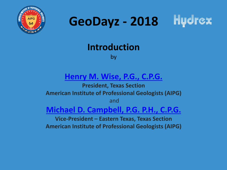
GeoDayz - 2018
Introduction by
Henry M. Wise, P.G., C.P.G. President, Texas Section
American Institute of Professional Geologists (AIPG) and
Michael D. Campbell, P.G. P.H., C.P.G. Vice-President – Eastern Texas, Texas Section
American Institute of Professional Geologists (AIPG)
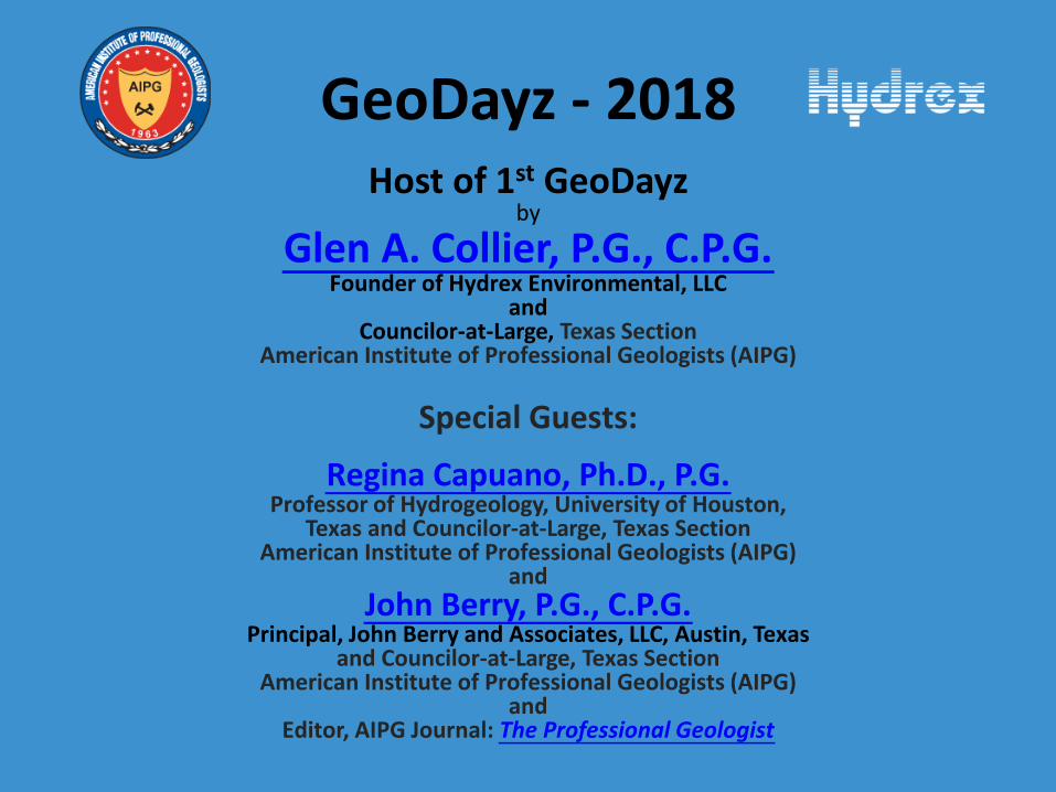
GeoDayz - 2018 Host of 1st GeoDayz
by
Glen A. Collier, P.G., C.P.G. Founder of Hydrex Environmental, LLC
and Councilor-at-Large, Texas Section
American Institute of Professional Geologists (AIPG)
Special Guests:
Regina Capuano, Ph.D., P.G. Professor of Hydrogeology, University of Houston,
Texas and Councilor-at-Large, Texas Section American Institute of Professional Geologists (AIPG)
and John Berry, P.G., C.P.G.
Principal, John Berry and Associates, LLC, Austin, Texas and Councilor-at-Large, Texas Section
American Institute of Professional Geologists (AIPG) and
Editor, AIPG Journal: The Professional Geologist

GeoDayz Introduction
Objectives of the GeoDayz Program,
Held by Texas Section AIPG and Hosted by Hydrex Environmental
An Industry-Academic Training Program,
Preparation of Students for Employment in Industry,
Status of Environmental Industry: One Degree or Two?
Status of Mining Industry: Public Attitudes?
Role of U.S. and World Economy in Students’ Future?

GeoDayz Introduction (Cont’d)
Make-up of the Environmental Field Environmental Consulting Companies
Industry Environmental/Energy Groups (non-profits):(water, air, wetlands biology (bugs and bunnies), to wind, solar, renewables)
City, County, State, and Federal Agencies
University and Colleges
Environmental Project Focus Academic Training and Industry Training
Science (Fundamentals) and Applications (Industry), and Develop and Manage Natural Resources (mineral E &D)
and Protect Environment from Expediencies of Industry.
Transition from Academics to Industry

Texas Section
AIPG-TX is Pleased to Announce the Guest Speaker
For the 2018 GeoDayz Event Will Be
Kevin Stafford, Ph.D.
Dr. Stafford Will Speak On
“Remote Sensing and Geophysical Characterization of Evaporite Karst Geohazards for Spatial Delineation and
Improved Infrastructure Development within the Delaware Basin, West Texas”
Dr. Kevin Stafford is an Associate Professor of Geology at Stephen F. Austin
State University. He joined SFASU in 2008 after completing his Ph.D. at New
Mexico Institute of Mining and Technology where he specialized in karst
processes and associated phenomena. His research includes
carbonate/evaporite diagenesis, hydrogeology, and geochemistry of natural
waters associated with karst systems ranging from modern carbonates to
ancient evaporites. His work includes significant components of remote
sensing and geophysical characterization for improved spatial delineation of
megaporosity and fluid flow paths within karst aquifers, while current
research is focused on karst geohazard characterization for risk assessment
and infrastructure remediation.
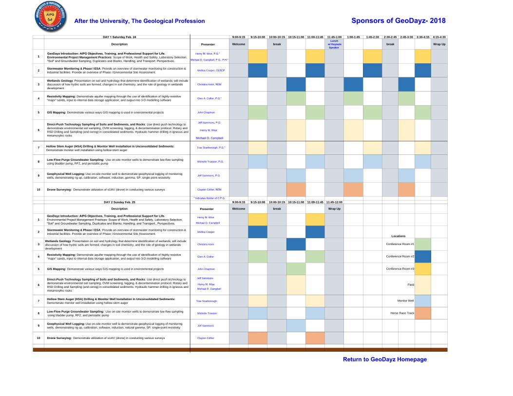
DAY 1 Saturday Feb. 24 9:00-9:15 9:15-10:00 10:00-10:15 10:15-11:00 11:00-11:45 11:45-1:00 1:00-1:45 1:45-2:30 2:30-2:45 2:45-3:30 3:30-4:15 4:15-4:30
Description Presenter Welcome breakLunch
w/ Keynote Speaker
break Wrap Up
1GeoDayz Introduction: AIPG Objectives, Training, and Professional Support for Life. Environmental Project Management Practices: Scope of Work, Health and Safety, Laboratory Selection, "Soil" and Groundwater Sampling, Duplicates and Blanks, Handling, and Transport. Perspectives.
Henry M. Wise, P.G.*
Michael D. Campbell, P.G., P.H.*
2Stormwater Monitoring & Phase I ESA: Provide an overview of stormwater monitoring for construction & industrial facilities. Provide an overview of Phase I Environmental Site Assessment.
Mellisa Cooper, CESCP
3Wetlands Geology: Presentation on soil and hydrology that determine identification of wetlands; will include discussion of how hydric soils are formed, changes in soil chemistry, and the role of geology in wetlands development
Christina Keim, REM
4Resistivity Mapping: Demonstrate aquifer mapping through the use of identification of highly-resistive “major” sands, input to internal data storage application, and output into 3-D modelling software
Glen A. Collier, P.G.*
5 GIS Mapping: Demonstrate various ways GIS mapping is used in environmental projects John Chapman
6
Direct-Push Technology Sampling of Soils and Sediments, and Rocks: Use direct-push technology to demonstrate environmental soil sampling, OVM screening, logging, & decontamination protocol. Rotary and RSD Drilling and Sampling (and coring) in consolidated sediments. Hydraulic hammer drilling in igneous and metamorphic rocks
Jeff Sammons, P.G.
7 Hollow Stem Auger (HSA) Drilling & Monitor Well Installation in Unconsolidated Sediments: Demonstrate monitor well installation using hollow-stem auger
Trae Scarborough, P.G.*
8Low-Flow Purge Groundwater Sampling: Use on-site monitor wells to demonstrate low-flow sampling using bladder pump, RF2, and peristaltic pump
Michelle Transier, P.G.
9Geophysical Well Logging: Use on-site monitor well to demonstrate geophysical logging of monitoring wells, demonstrating rig up, calibration, software, induction, gamma, SP, single point resistivity
Jeff Sammons, P.G.
10 Drone Surveying: Demonstrate utilization of sUAV (drone) in conducting various surveys Clayton Collier, REM
DAY 2 Sunday Feb. 25 9:00-9:15 9:15-10:00 10:00-10:15 10:15-11:00 11:00-11:45 11:45-12:00
Description Presenter Welcome break Wrap Up
1GeoDayz Introduction: AIPG Objectives, Training, and Professional Support for Life. Environmental Project Management Practices: Scope of Work, Health and Safety, Laboratory Selection, "Soil" and Groundwater Sampling, Duplicates and Blanks, Handling, and Transport., Perspectives.
Henry M. Wise
Michael D. Campbell
2Stormwater Monitoring & Phase I ESA: Provide an overview of stormwater monitoring for construction & industrial facilities. Provide an overview of Phase I Environmental Site Assessment.
Mellisa Cooper
3Wetlands Geology: Presentation on soil and hydrology that determine identification of wetlands; will include discussion of how hydric soils are formed, changes in soil chemistry, and the role of geology in wetlands development
Christina Keim
4Resistivity Mapping: Demonstrate aquifer mapping through the use of identification of highly-resistive “major” sands, input to internal data storage application, and output into 3-D modelling software
Glen A. Collier
5 GIS Mapping: Demonstrate various ways GIS mapping is used in environmental projects John Chapman
6
Direct-Push Technology Sampling of Soils and Sediments, and Rocks: Use direct-push technology to demonstrate environmental soil sampling, OVM screening, logging, & decontamination protocol. Rotary and RSD Drilling and Sampling (and coring) in consolidated sediments. Hydraulic hammer drilling in igneous and metamorphic rocks
Jeff Sammons
7Hollow Stem Auger (HSA) Drilling & Monitor Well Installation in Unconsolidated Sediments: Demonstrate monitor well installation using hollow-stem auger
Trae Scarborough
8Low-Flow Purge Groundwater Sampling: Use on-site monitor wells to demonstrate low-flow sampling using bladder pump, RF2, and peristaltic pump
Michelle Transier
9Geophysical Well Logging: Use on-site monitor well to demonstrate geophysical logging of monitoring wells, demonstrating rig up, calibration, software, induction, natural gamma, SP, single-point resistivity
Jeff Sammons
10 Drone Surveying: Demonstrate utilization of sUAV (drone) in conducting various surveys Clayton Collier
Horse Race Track
Locations
Conference Room #1
Conference Room #2
Conference Room #3
Field
Monitor Well
Henry M. Wise
Michael D. Campbell
Henry M. Wise
Michael D. Campbell
* Indicates Holder of C.P.G.
After the University, The Geological Profession Sponsors of GeoDayz- 2018
Return to GeoDayz Homepage

XX
X X X X X X X XX
XX
XX
X
X
X
X
X
X
X
X
X
X
X
X
X
X
X
X
X
X
X
X
X
XX
XX
XX
XXXXXXXXXX
X X X X X X X X X X X X X X X X X X X
XX
XX
XXXXXX
X
X
X X X X X X X X X X X X X X X X X X X X
XX
X
!'
0 50 100 15025
Feet ³
HIGHWAY 59 / NW STALLINGS Sign In (Main Office)
Vans to EOC(Drone)
Field Location(Geoprobe)
2
13
ShopWell Location
!' Well LocationRestroomConference Rooms 1, 2, 3Drone Demo (EOC)Field Location (Geoprobe)
Russell Drilling Rig
Entrance
RR R
R
R
R
R
R
R
BreakRoom
Facility MapNacogdoches, Texas
AIPG GeoDayz 2018
E N V I RO N M E N TA L

Summary
GeoDayz: Project Management Practices, Protocol, and Case Histories
by
Henry M. Wise, P.G.,C.P.G. President, AIPG-Texas Section
and Michael D. Campbell, P.G., P.H., C.P.G.
Vice-President, AIPG-Texas Section
The topics covered during GeoDayz are presented to provide attendees with an introduction to the methods and approaches employed during most environmental projects. The presentations are by no means intended to provide a working knowledge of these methods. This would require additional exposure and detailed discussions generally provided by company training programs using their own protocols. AIPG Webinars also offer specific coverage of some of the topics introduced during GeoDayz, and these will also help to prepare you for employment in the environmental and associated industries.
We will discuss the current status of the environmental and mining industries in the U.S. including public attitudes, the U.S. and world economy, as well as the current and anticipated future political environment regarding environmental and mining-related regulations as they relate to employment opportunities and job growth within consulting companies, industry environmental or energy groups and non-profits focusing on issues related to water, air, sensitive habitats {AKA bugs and bunnies}, windmills, solar energy and renewables in general, as well as in city, county, state, and federal regulatory agencies throughout the U.S. and overseas. We will introduce federal and state regulatory programs by the U.S. Environmental Protection Agency and their legislation-driven programs first introduced in the mid-1970s for currently operating industrial activities known as RCRA and for historical and abandoned sites containing constituents of concern potentially affecting human health and the environment. These are known as CERCLA or Superfund sites. The states also have similar regulations.
Because projects are conducted outside, around heavy equipment, and on lands with unknown hazards and exposure, health and safety issues constitute a large and important part of almost all environmental projects; We will discuss the major elements of health and safety; the primary features of typical project management will also be discussed in terms of establishing the scope of work, the elements of soil and groundwater sampling, laboratory selection and data QC/QA considerations, data handling and interpretation for projects ranging from Phase I site assessments, to Phase II site investigations to establish the horizontal and vertical extent of contaminants and their potential exposures affecting human health and the environment, culminating in the remediation and removal of surface and subsurface materials deemed hazardous materials.
Here is a PDF of the topics discussed during our presentations (with links to external websites or papers of special interest for your follow-up consideration):
Presentation:http://www.aipg-tx.org/_docs/GeoDayzFirstLecture.pdf
Summary
GeoDayz: Overview of Stormwater Monitoring
and Environmental Site Assessments
by
Mellisa Cooper, CESCP
Stormwater management has become increasingly important in controlling pollution in our
waterways. In this discussion, the steps and processes in developing a stormwater
management program for both industrial facilities and construction sites will be presented.
Federal and state regulatory requirements will be covered as well as stormwater sampling and
monitoring procedures. The presentation will also give a brief overview of Stormwater Pollution
Prevention Plans (SWP3s), good housekeeping measures, best management practices (BMPs),
and spill prevention methods.
In addition to stormwater, a brief overview of Phase I Environmental Site Assessments (ESA),
including the “why’s and “how’s” of Phase I ESAs, will be provided. Topics to be discussed
include the ASTM standards, use and review of local, state, and federal records, identifying
recognized environmental conditions (RECs) and how to present the findings in a meaningful
way.
Presentation:http://www.aipg-tx.org/_docs/GeoDayz_Stormwater-PhaseI_Presentation.pdf

Summary
GeoDayz: GIS Applications in Environmental Consulting
by
John F. Chapman
GIS has become a prevalent tool across a wide variety of industries and municipalities. As an
environmental consulting firm working on behalf of this swathe of clients, Hydrex Environmental
leverages GIS capabilities in all facets of its workload. This presentation is divided into
three parts.
The first section will provide attendees with an introduction to the basics of GIS, covering
central concepts such as, data layers and types, spatial reference, and software. The
second section will illustrate how Hydrex integrates GIS in project workflow, field data
collection, and reporting. The third section will discuss more advanced applications of GIS
utilization, such as UAVs, 3-D modeling, programming, and web services.
Presentation:
http://www.aipg-tx.org/_docs/GeoDayz_GIS_Mapping_Presentation.pdf

Summary
GeoDayz: Hollow Stem Auger (HAS) Drilling
And Monitor Well Installation
by
Leonell N. Scarborough, P.G., C.P.G.
Hollow Stem Auger (HSA) drilling is a proven and cost effective technique for collection of soil
samples and installation of wells in shallow geologic settings consisting of unconsolidated or
weakly cemented soils. In this presentation we will introduce and discuss HSA drilling
techniques as they relate to environmental sampling. We will discuss the advantages and
disadvantages of HSA drilling, safety considerations, and appropriate geologic settings for
application of HSA techniques. Information on the assembly options and various components of
the HSA rotating assembly will be presented along with general decontamination procedures.
We will also explore sample collection techniques and well setting procedures employed with
HSA drilling. Use of HSA equipment, as well as a mock well installation, will be included as
part of the presentation.
Presentation:
http://www.aipg-tx.org/_docsGeoDayz_Hollow_Stem_Auger_Presentation.pdf

Summary
GeoDayz: Low-Flow Purge Groundwater Sampling
by
Michelle K. Transier, P.G.
As pollution awareness rises, the need for sample accuracy is essential. Low-flow purge
groundwater sampling helps provide just that. This presentation is intended to provide an
introduction to low-flow purging and sampling field methods. A brief overview into applicable
regulatory guidance, requirements, and application will be discussed followed by a
demonstration of low-flow purging and sampling techniques via an on-site monitor well.
In addition, illustrations will provide a visual cross-sectional view of what occurs below
ground when employing traditional purging methods vs. low-flow purging methods.
Examination of the pros and cons for each method will be explored. The demonstration will
also provide information on utilization of bladder pumps, electric submersible pumps, and
peristaltic pumps as well as basic mechanics for each.
Presentation:
http://www.aipg-tx.org/_docs/GeoDayz_Low-Flow_GW_Sampling_Presentation.pdf
Summary
GeoDayz: Wetlands Geology
by
Christina R. Keim, REM
When evaluating land for the presence or absence of wetlands, the existing soil conditions are a
source of considerable information. While the formation of hydric soils is influenced by the
interactions of several soil forming factors, the overriding factor is water. The unique
characteristics of hydric soils result from periodic or permanent inundation or saturation.
Reduction and oxidation (redox) are the dominant chemical processes taking place in wetland
soils. The redox reactions lead to mobilization of soluble Fe and Mn (depletion) and subsequent
reoxidation (concentration), collectively called redoximorphic features. These features will be
briefly reviewed for use as components of field indicators of hydric soils.
Landscape position and movement of water within the landscape determines the distribution of
wetlands, while the characteristics of each wetland type are also determined greatly by
landscape position. Therefore, because of differences in landscape position and associated
hydrologic characteristics, different types of wetlands produce distinctive hydric soils. Problem
soils are hydric soils that do not exhibit the common hydric soil morphologies. The lack of a
morphological indicator despite the soil developing anaerobic conditions in the upper part can
be caused by many things including problematic parent material and certain other
environmental conditions. Several geologic formations across eastern Texas have associated
parent material that have resulted in problematic hydric soils, two of which, that will be
discussed in further detail, are the Lissie and Yegua formations. This presentation discusses
the formation, structure, and determination of wetland soils and how they relate to the regional
landscape and geology.
Presentation: http://www.aipg-tx.org/_docs/GeoDayz_Wetland_Soil_ &_Geology_Presentation.pdf

Summary
GeoDayz: Resistivity Mapping
by
Glen A. Collier, P.G., C.P.G. Councilor-at-Large, AIPG-Texas Section
The Carrizo-Wilcox aquifer supplies groundwater to most of East Texas. While predicting and
modeling the conditions of the aquifer for future production purposes, hydrogeologists utilize
knowledge of the regions structure and stratigraphy, laboratory chemical analyses, geophysical
logs, aquifer tests and GIS 3D modeling software.
The stratigraphy of East Texas, as it relates to the occurrence of fresh groundwater, consists of
alternating sequences of continental, deltaic, and marine sediments predominantly of Eocene
age. Continental (Carrizo Sand) and deltaic units (Wilcox Group), composed of quartz sand with
varying amounts of silt and clay, contain the fresh groundwater in the area and form the major
conduits for its movement. In order to evaluate geochemical properties of the Carrizo-Wilcox
aquifer, results of chemical analyses performed on the aquifer are input into GIS software and
mapped to identify areas exhibiting favorable water quality. Additionally, geophysical logs are
utilized to determine changes in subsurface lithology and identify freshwater sands. SP
deflections, both positive and negative, generally occur at bed contacts, while freshwater sand
zones typically display electrical resistivity responses greater than 20 ohms. Stratigraphic picks
of tops and bottoms are developed from these geophysical logs. After correlating these picks
with other nearby logs, data can be input into a 3D GIS application to model the aquifer and
identify areas suitable for water production. Yield projections are then estimated using the
specific capacity equation (Specific Capacity = GPM/Drawdown) and pumping tests are
used to confirm the efficiency of a well and ensure proper development. This presentation
serves to demonstrate an empirical method of utilizing geophysical logs, chemical
analyses, aquifer tests and GIS software to identify freshwater sands and model aquifers.
Presentation:
http://www.aipg-tx.org/_docs/GeoDayz_Resistivity_Mapping_Presentation.pdf

Summary
GeoDayz: GeoProbe (Direct-Push) Technology and Sampling
of Soils, Sediments, and Rocks
by
Jeffrey D. Sammons, P.G. and
Henry M. Wise, P.G.,C.P.G. President, AIPG-Texas Section
and Michael D. Campbell, P.G., P.H., C.P.G.
Vice-President, AIPG-Texas Section
Since the late 1980’s direct push technology (DPT, widely commercialized by GeoProbe)) has been employed as an efficient and cost-effective means for collecting undisturbed samples of soil. DPT tools also provide for the sampling of soil gas, or vapor, and groundwater. At its onset, DPT technology was smaller, more mobile, and more versatile than drilling equipment for shallow environmental Investigations. Today the trend is toward larger and larger DPT equipment. GeoProbe, maker of the 6620DT rig included in this demonstration, is recognized as the leader in DPT technology.
This demonstration will focus on the GeoProbe direct push sampling of soils using two types of sampling equipment: Macro Core Sampling and Dual-Tube Sampling. The advantages and disadvantages of each will be discussed. We will demonstrate field organic vapor monitoring, which often forms the basis for selection of samples and analytes, and field logging using the Unified Soil Classification System. The importance of decontamination protocol and procedures will be stressed, as well as preparation for submittal to the laboratory.
Other techniques required for drilling in sediments and consolidated formations will conclude the presentation. The former, hollow-stem auguring method is used to construct monitoring wells. The basic elements of such construction will be demonstrated, The latter involves rotary drilling by air (to remove cuttings) and by "mud" after the water table has been encountered (which serves to also remove cuttings as they are produced by the tri-cone drilling bit.
Presentation:
http://www.aipg-tx.org/_docs/GeoDayz2018FirstDemoGeoProbeDrillingandSampling.pdf

Summary
GeoDayz: Geophysical Well Logging
by
Jeffrey D. Sammons, P.G.
Geologists utilize geophysical logging equipment to collect subsurface data from
boreholes and existing wells. The data sets collected can help determine physical
properties of subsurface materials surrounding a borehole, well construction details,
the properties of fluids in a formation, and the fluid pore space properties of a
formation. The data sets collected from this process can also be utilized to determine
general trends of subsurface features in an area when combined and correlated with
data collected from other boreholes or wells in the surrounding region. Before
collection of subsurface data can occur, geophysical logging equipment has to be
calibrated, and all rigging required for use in a borehole or well has to be set up. A
variety of tools including gamma, spontaneous potential, and induction resistivity tools,
are lowered and raised in a borehole or well and are used to record real time data.
After each tool is run, the data is collected and stored in post-processing software so
that it can be formatted at a later time for analysis and interpretation of borehole or
well characteristics. This presentation will use an existing well to demonstrate the set-
up, calibration and geophysical logging procedure for proper data collection.
Presentation: http://www.aipg-tx.org/_docs/Geophysical_Logging_Presentation.pdf

Summary
GeoDayz: Drone Surveying
by
Clayton A. Collier, REM, PWS
Unmanned Aerial Systems (UAS), also called drone systems, are revolutionary equipment that
can be utilized to increase efficiency while striving for the maximum level of accuracy. UAS
implementation provides extensive and highly detailed data collection that is quicker, safer, and
more cost effective than traditional ground surveying. Hydrex Drone Division engages powerful
software processing that ensures reliable and accurate analysis and yields many products that
can be used for virtually every industry.
From pinpoint landfill density measurements and stockpile inventory calculations, to large-scale
crop assessments, real-estate mapping, and hurricane damage assessment, this aerial
technology has numerous applications. Data from the drone, along with drone photogrammetry
software, is used to calculate results within inches of accuracy. UAS surveys provide high
resolution (2 cm/0.79 in per pixel) and high accuracy (4 cm/1.5 in horizontal x 7 cm/2.75 in
vertical) aerial surveys with quick turnaround time. Deliverables often consist of but are not
limited to ortho-mosaic imagery (natural color and color-infrared), topographic mapping (digital
surface and terrain models), volumetric calculations, slope analysis, 3-dimensional point cloud
modeling or multi-spectrum vegetation analysis. Additional applications include performing
density studies for landfills, monitoring pit progression for mines, leak detection and evaluating
secondary containment for oil and gas companies. All drone operations are subject to
compliance with all applicable FAA regulations. Additional OSHA, MSHA, or other site specific
requirements may apply. This presentation serves to demonstrate the use of drones for
conducting various aerial surveys.
Presentation:http://www.aipg-tx.org/_docs/GeoDayz_Drone_Presentation.pdf

NW
Sta
lling
s Dr/L
oo
p 22
4
W Austin St
Old Tyler R
dPowers St
No
rth S
t
E Main St/State Hwy 7
E Main St
E Hospital St
No
rth
St
Hydrex Offices
Hydrex Offices
Fredonia Hotel &
ConventionCenter
Old Tyler R
d
FredoniaHotel
NW
Sta
lling
s D
r/Lo
op
224
To Fredonia Hotel
To Hydrex Offices

Photo History of GeoDayz - 2018 in Nacogdoches, Texas
Photo History of GeoDayz - 2018 Nacogdoches, Texas February 24 and 25, 2018
Hosted by Hydrex Environmental, LLC

Photo History of GeoDayz - 2018 in Nacogdoches, Texas
GeoDayz Registration Table
Host of GeoDayz, Glen Collier, P.G., C.P.G., Founder of Hydrex introduces GeoDayz.

Photo History of GeoDayz - 2018 in Nacogdoches, Texas
Michael D. Campbell, P.G., P.H., G.P.G. introducing the AIPG Texas Section Officers/Lecturers and establishing expectations for students and young professionals for the next two days.
GeoDayz Luncheon. Mr. Collier introducing Luncheon Speaker, Kevin Stafford, Ph.D. Associate Professor of Geology, Stephen F. Austin State University, Nacogdoches, Texas
(here).

Photo History of GeoDayz - 2018 in Nacogdoches, Texas
Dr. Stafford speaks on West Texas carbonates and associated hydrogeology.
A message from Steve White of GeoProbe, one of the GeoDayz Sponsors, during the Luncheon.

Some of the Attendees of Geodayz at the Luncheon.
18 University of Houston Department of Earth and Atmospheric Sciences students and faculty member, Dr. Regina Capuano (center), attended 2018 GeoDayZ with Michael D. Campbell (white hat).
Photo History of GeoDayz - 2018 in Nacogdoches, Texas

Photo History of GeoDayz - 2018 in Nacogdoches, Texas
Rotating Demonstrations and Lectures
Click on above to enlarge (and here)
Four lectures were presented each session on Saturday and two lectures on Sunday for each of the above subjects and demonstrations. 10 to 15 students were present for the 45-minute sessions.
This involved each lecturer presented 6 lectures over the two day period, and that each demonstration was presented 6 times during Geodayz.
The following photos provide various views of the demonstrations and lectures that functioned not unlike classes during college days.

Photo History of GeoDayz - 2018 in Nacogdoches, Texas
Demonstrations
Ms. Michell Transier, P.G., and Mr. Nathan Echart discuss effects of head loss while sampling groundwater.

Photo History of GeoDayz - 2018 in Nacogdoches, Texas
Mr. Trae Scarborough, P.G., C.P.G., discussing Hollow-Stem Auger (HAS) used for drilling and sediment sampling, and for monitoring well construction.
Mr. Trae Scarborough, P.G., C.P.G., discussing HAS activities.

Photo History of GeoDayz - 2018 in Nacogdoches, Texas
Attendees watch Low-Flow Purge Sampling Demonstrations
Setting up Groundwater Sampling Equipment
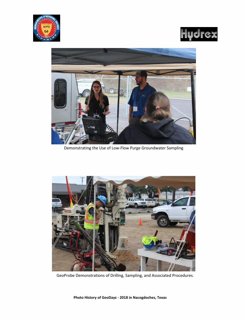
Photo History of GeoDayz - 2018 in Nacogdoches, Texas
Demonstrating the Use of Low-Flow Purge Groundwater Sampling
GeoProbe Demonstrations of Drilling, Sampling, and Associated Procedures.
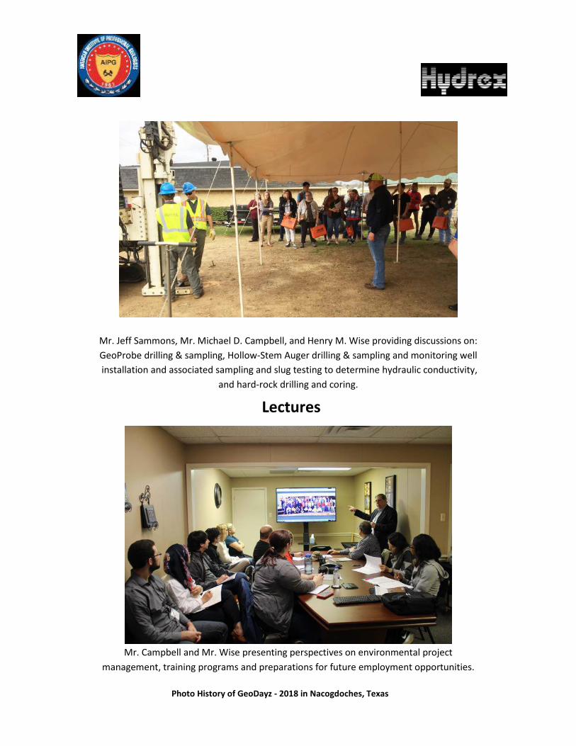
Photo History of GeoDayz - 2018 in Nacogdoches, Texas
Mr. Jeff Sammons, Mr. Michael D. Campbell, and Henry M. Wise providing discussions on: GeoProbe drilling & sampling, Hollow-Stem Auger drilling & sampling and monitoring well installation and associated sampling and slug testing to determine hydraulic conductivity,
and hard-rock drilling and coring.
Mr. Campbell and Mr. Wise presenting perspectives on environmental project management, training programs and preparations for future employment opportunities.
Lectures

Photo History of GeoDayz - 2018 in Nacogdoches, Texas
Mr. John Chapman discussing GIS Mapping used in Environmental Projects.
Session on the Utilization of Drones in Environmental Mapping, presented by Mr. Clayton Collier, REM, PWS.

Photo History of GeoDayz - 2018 in Nacogdoches, Texas
Presentations on Stormwater Monitoring by Ms. Mellisa Cooper (left) and Phase I Environmental Site Assessments (ESA) by Ms. Whitney Johnson (right).
The Saturday Night Mixer
XXX