Embed Size (px)
Citation preview
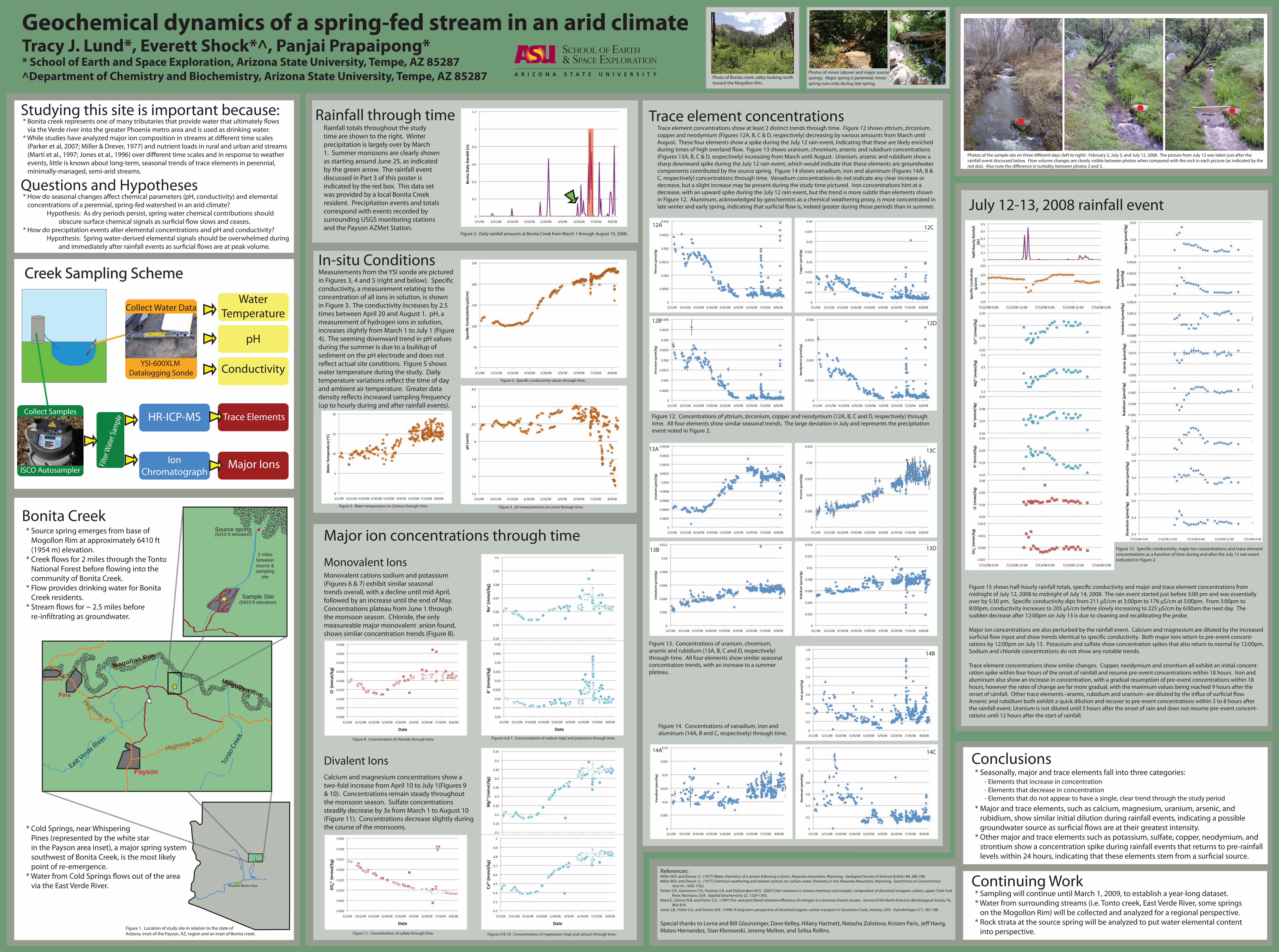
Geochemical dynamics of a spring-fed stream in an arid climateTracy J. Lund*, Everett Shock*^, Panjai Prapaipong** School of Earth and Space Exploration, Arizona State University, Tempe, AZ 85287^Department of Chemistry and Biochemistry, Arizona State University, Tempe, AZ 85287
Creek Sampling Scheme
Bonita CreekMajor ion concentrations through time
Monovalent Ions Monovalent cations sodium and potassium (Figures 6 & 7) exhibit similar seasonal trends overall, with a decline until mid April, followed by an increase until the end of May. Concentrations plateau from June 1 through the monsoon season. Chloride, the only measureable major monovalent anion found, shows similar concentration trends (Figure 8).
Divalent IonsCalcium and magnesium concentrations show a two-fold increase from April 10 to July 1(Figures 9 & 10). Concentrations remain steady throughout the monsoon season. Sulfate concentrations steadily decrease by 3x from March 1 to August 10 (Figure 11). Concentrations decrease slightly duringthe course of the monsoons.
Figure 14. Concentrations of vanadium, iron and aluminum (14A, B and C, respectively) through time.
14A 14C
14B
Rainfall totals throughout the studytime are shown to the right. Winterprecipitation is largely over by March1. Summer monsoons are clearly shownas starting around June 25, as indicatedby the green arrow. The rainfall event discussed in Part 3 of this poster is indicated by the red box. This data setwas provided by a local Bonita Creek resident. Precipitation events and totals correspond with events recorded by surrounding USGS monitoring stations and the Payson AZMet Station.
WaterTemperature
pH
Conductivity
HR-ICP-MS
IonChromatograph
Trace Elements
Major IonsFilte
r Wat
er Sa
mpl
e
Collect Samples
ISCO Autosampler
Collect Water Data
YSI-600XLM Datalogging Sonde
* Source spring emerges from base of Mogollon Rim at approximately 6410 ft (1954 m) elevation.* Creek �ows for 2 miles through the Tonto National Forest before �owing into the community of Bonita Creek.* Flow provides drinking water for Bonita Creek residents.* Stream �ows for ~ 2.5 miles before re-in�ltrating as groundwater.
Figure 1. Location of study site in relation to the state of Arizona, inset of the Payson, AZ, region and an inset of Bonita creek.
Figure 2. Daily rainfall amounts at Bonita Creek from March 1 through August 10, 2008.
In-situ ConditionsMeasurements from the YSI sonde are picturedin Figures 3, 4 and 5 (right and below). Speci�cconductivity, a measurement relating to the concentration of all ions in solution, is shown in Figure 3. The conductivity increases by 2.5 times between April 20 and August 1. pH, a measurement of hydrogen ions in solution, increases slightly from March 1 to July 1 (Figure 4). The seeming downward trend in pH values during the summer is due to a buildup of sediment on the pH electrode and does not re�ect actual site conditions. Figure 5 shows water temperature during the study. Daily temperature variations re�ect the time of day and ambient air temperature. Greater datadensity re�ects increased sampling frequency(up to hourly during and after rainfall events).
Figure 3. Speci�c conductivity values through time.
Figure 4. pH measurements (in units) through time.Figure 5. Water temperature (in Celsius) through time.
Figures 6 & 7. Concentrations of sodium (top) and potassium through time.Figure 8. Concentration of chloride through time.
Figures 9 & 10. Concentrations of magnesium (top) and calcium through time.Figure 11. Concentration of sulfate through time.
Figure 13. Concentrations of uranium, chromium, arsenic and rubidium (13A, B, C and D, respectively) through time. All four elements show similar seasonal concentration trends, with an increase to a summer plateau.
13A
13B
13C
13D
Figure 12. Concentrations of yttrium, zirconium, copper and neodymium (12A, B, C and D, respectively) through time. All four elements show similar seasonal trends. The large deviation in July and represents the precipitation event noted in Figure 2.
12A 12C
12B 12D
Trace element concentrations Trace element concentrations show at least 2 distinct trends through time. Figure 12 shows yttrium, zirconium, copper and neodymium (Figures 12A, B, C & D, respectively) decreasing by various amounts from March until August. These four elements show a spike during the July 12 rain event, indicating that these are likely enriched during times of high overland �ow. Figure 13 shows uranium, chromium, arsenic and rubidium concentrations (Figures 13A, B, C & D, respectively) increasing from March until August. Uranium, arsenic and rubidium show a sharp downward spike during the July 12 rain event, which would indicate that these elements are groundwater components contributed by the source spring. Figure 14 shows vanadium, iron and aluminum (Figures 14A, B & C, respectively) concentrations through time. Vanadium concentrations do not indicate any clear increase or decrease, but a slight increase may be present during the study time pictured. Iron concentrations hint at a decrease, with an upward spike during the July 12 rain event, but the trend is more subtle than elements shown in Figure 12. Aluminum, acknowledged by geochemists as a chemical weathering proxy, is more concentrated in late winter and early spring, indicating that sur�cial �ow is, indeed greater during those periods than in summer.
References:Miller W.R. and Drever J.I. (1977) Water chemistry of a stream following a storm, Absaroka mountains, Wyoming. Geological Society of America Bulletin 88, 286-290.Miller W.R. and Drever J.I. (1977) Chemical weathering and related controls on surface water chemistry in the Absaroka Mountains, Wyoming. Geochimica et Cosmochimica Acta 41, 1693-1702.Parker S.R., Gammons C.H., Poulson S.R. and DeGrandpre M.D. (2007) Diel variations in stream chemistry and isotopic composition of dissolved inorganic carbon, upper Clark Fork River, Montana, USA. Applied Geochemistry 22, 1329-1343.Marti E., Grimm N.B. and Fisher S.G. (1997) Pre- and post-�ood retention e�ciency of nitrogen in a Sonoran Desert stream. Journal of the North American Benthological Society 16, 805-819.Jones J.B., Fisher S.G. and Grimm N.B. (1996) A long-term perspective of dissolved organic carbon transport in Sycamore Creek, Arizona, USA. Hydrobiologia 317, 183-188.
Special thanks to Lorna and Bill Glaunsinger, Dave Kelley, Hilairy Hartnett, Natasha Zolotova, Kristen Paris, Je� Havig,Mateo Hernandez, Stan Klonowski, Jeremy Melton, and Selisa Rollins.
Conclusions
Figure 15. Speci�c conductivity, major ion concentrations and trace element concentrations as a function of time during and after the July 12 rain event indicated in Figure 2.
July 12-13, 2008 rainfall event
Figure 15 shows half-hourly rainfall totals, speci�c conductivity and major and trace element concentrations from midnight of July 12, 2008 to midnight of July 14, 2008. The rain event started just before 3:00 pm and was essentially over by 5:30 pm. Speci�c conductivity dips from 211 µS/cm at 3:00pm to 176 µS/cm at 5:00pm. From 5:00pm to 8:00pm, conductivity increases to 205 µS/cm before slowly increasing to 225 µS/cm by 6:00am the next day. The sudden decrease after 12:00pm on July 13 is due to cleaning and recalibrating the probe.
Major ion concentrations are also perturbed by the rainfall event. Calcium and magnesium are diluted by the increased sur�cial �ow input and show trends identical to speci�c conductivity. Both major ions return to pre-event concent-rations by 12:00pm on July 13. Potassium and sulfate show concentration spikes that also return to normal by 12:00pm.Sodium and chloride concentrations do not show any notable trends.
Trace element concentrations show similar changes. Copper, neodymium and strontium all exhibit an initial concent-ration spike within four hours of the onset of rainfall and resume pre-event concentrations within 18 hours. Iron and aluminum also show an increase in concentration, with a gradual resumption of pre-event concentrations within 18 hours, however the rates of change are far more gradual, with the maximum values being reached 9 hours after the onset of rainfall. Other trace elements--arsenic, rubidium and uranium--are diluted by the in�ux of sur�cial �ow. Arsenic and rubidium both exhibit a quick dilution and recover to pre-event concentrations within 5 to 8 hours after the rainfall event. Uranium is not diluted until 3 hours after the onset of rain and does not resume pre-event concent-rations until 12 hours after the start of rainfall.
* Cold Springs, near Whispering Pines (represented by the white star in the Payson area inset), a major spring system southwest of Bonita Creek, is the most likely point of re-emergence.* Water from Cold Springs �ows out of the area via the East Verde River.
* Seasonally, major and trace elements fall into three categories: - Elements that increase in concentration
- Elements that decrease in concentration - Elements that do not appear to have a single, clear trend through the study period
Continuing Work* Sampling will continue until March 1, 2009, to establish a year-long dataset.* Water from surrounding streams (i.e. Tonto creek, East Verde River, some springs on the Mogollon Rim) will be collected and analyzed for a regional perspective.* Rock strata at the source spring will be analyzed to put water elemental content into perspective.
* Major and trace elements, such as calcium, magnesium, uranium, arsenic, and rubidium, show similar initial dilution during rainfall events, indicating a possible groundwater source as sur�cial �ows are at their greatest intensity.* Other major and trace elements such as potassium, sulfate, copper, neodymium, and strontium show a concentration spike during rainfall events that returns to pre-rainfall levels within 24 hours, indicating that these elements stem from a sur�cial source.
("
(#$"
%*(!*!'" %*)!*!'" +*$!*!'" &*,*!'" &*$,*!'" -*(,*!'" '*'*!'"
Rainfall through timeStudying this site is important because:
* How do seasonal changes a�ect chemical parameters (pH, conductivity) and elemental concentrations of a perennial, spring-fed watershed in an arid climate? Hypothesis: As dry periods persist, spring water chemical contributions should obscure surface chemical signals as sur�cial �ow slows and ceases.* How do precipitation events alter elemental concentrations and pH and conductivity? Hypothesis: Spring water-derived elemental signals should be overwhelmed during and immediately after rainfall events as sur�cial �ows are at peak volume.
* Bonita creek represents one of many tributaries that provide water that ultimately �ows via the Verde river into the greater Phoenix metro area and is used as drinking water. * While studies have analyzed major ion composition in streams at di�erent time scales (Parker et al, 2007; Miller & Drever, 1977) and nutrient loads in rural and urban arid streams (Marti et al., 1997; Jones et al., 1996) over di�erent time scales and in response to weather events, little is known about long-term, seasonal trends of trace elements in perennial, minimally-managed, semi-arid streams.
Questions and Hypotheses
Photos of the sample site on three di�erent days (left to right): February 2, July 3, and July 12, 2008. The picture from July 12 was taken just after the rainfall event discussed below. Flow volume changes are clearly visible between photos when compared with the rock in each picture (as indicated by thered dot). Also note the di�erence in turbidity between photos 2 and 3.
Photos of minor (above) and major sourcesprings. Major spring is perennial; minorspring runs only during late spring.
Photo of Bonita creek valley looking northtoward the Mogollon Rim.
Phoenix Metro Area
Roosevelt Lake
Payson
Mogollon Rim
Mogollon Rim
Pine
Strawberry
Payson
Highway 260
Highway 87
East Verde River
Tont
o Cr
eek
Source spring(6410 ft elevation)
Sample Site(5910 ft elevation)
2 milesbetweensource &sampling
site
PaysonPayson


![AIR BLOW GUN 表 [更新済み]€¦ · Concent or Coupling Concent or Coupling 1/4 Hose Concent or Coupling Concent or Coupling 141181 141180 141182 EDP # Air Pressure:0.5MPa Max](https://img.pdfslide.us/doc/110x75/5f0716617e708231d41b3d68/air-blow-gun-e-concent-or-coupling-concent-or-coupling-14-hose.jpg)