Embed Size (px)
Citation preview
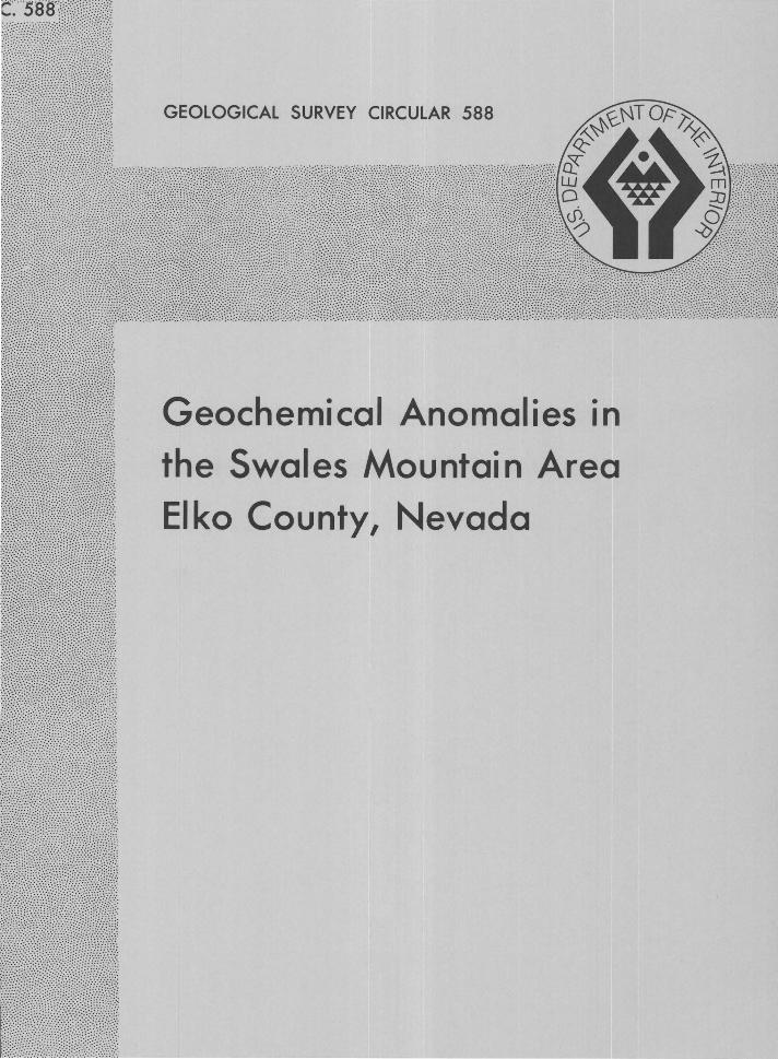
GEOLOGICAL SURVEY CIRCULAR 588
Geochemical Anomalies in
the Swales Mountain Area
Elko County, Nevada

Geochemical Anomalies in
the Swales Mountain Area
Elko County, Nevada
By K. B. Ketner, J. G. Evans, and T. D. Hessin
G E 0 L 0 G I C A L S U R V E Y C I R C U L A R 588
Washington J 968
United States Department of the Interior STEWART L. UDALL, Secretary
Geological Survey William T. Pecora, Director
Free on application to the U.S. Geological Survey, Washington, D.C. 20242
CONTENTS
Page
Abstract ......................................................................... . 1 Structure ....................................................................... . Page
4 4 4
Introduction ................................................................. . 1
1 4
Rock alteration ............................................................. . Mineralization .............................................................. .
Stratigraphy ................................................................. . Suggestions for prospecting ..................................... . 13 13 Intrusive rocks ............................................................. . References cited ......................................................... .
FIGURE 1. 2.
3. 4-10.
ILLUSTRATIONS
Page Index map of Elko County, Nev., and adjacent areas .......................................................................... 1 Geologic map of part of Swales Mountain quadrangle showing mineralized areas, sample loca-
tions, and drill sites ............................................................................. ................. .................................. 2 Diagram showing drill holes in Swales Mountain area ...................................................................... 5 Maps of Swales Mountain area showing concentrations, in samples of mineralized rock, of-
4. Gold .................................................................................................................................................. 6 5. Silver ................................................................................................................................................ 7 6. Molybdenum .................................................................................................................................... 8 7. Mercury ............................................................................................................................................ 9 8. Copper ............................................................................................................... .............. .................. 10 9. Lead .................................................................................................................................................. 11
10. Zinc .................................................................................................................................................. 12
iii

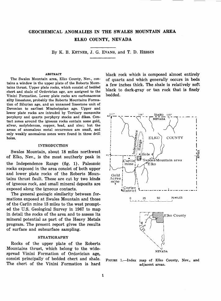
GEOCHEMICAL ANOMALIES IN THE SWALES MOUNTAIN AREA
ELKO COUNTY, NEVADA
By K. B. KETNER, J. G. EVANS, and T. D. HESSIN
ABSTRACT
The Swales Mountain area, Elko County, Nev., contains a window in the upper plate of the Roberts Mountains thrust. Upper plate rocks, which consist of bedded chert and shale of Ordovician age, are assigned to the Vinini Formation. Lower plate rocks are carbonaceous silty limestone, probably the Roberts Mountains Formation of Silurian age, and an unnamed limestone unit of Devonian to earliest Mississippian age. Upper and lower plate rocks are intruded by Tertiary monzonite porphyry and quartz porphyry stocks and dikes. Contact zones around the igneous rocks contain some gold, silver, molybdenum, copper, lead, and zinc; but the areas of anomalous metal occurrence are small, and only weakly anomalous zones were found in three drill holes.
INTRODUCTION
Swales Mountain, about 18 miles northwest of Elko, Nev., is the most southerly peak in
the Independence Range (fig. 1). Paleozoic rocks exposed in the area consist of both upper and lower plate rocks of the Roberts Mountains thrust fault. These are cut by two kinds of igneous rock, and small mineral deposits are exposed along the igneous contacts.
The general geologic similarity between formations exposed at Swales Mountain and those of the Carlin mine 13 miles to the west prompted the U.S. Geological Survey in 1967 to map in detail the rocks of the area and to assess its mineral potential as part of the Heavy Metals program. The present report gives the results of surface and subsurface sampling.
STRATIGRAPHY
Rocks of the upper plate of the Roberts Mountains thrust, which belong to the widespread Vinini Formation of Ordovician age, consist principally of bedded chert and shale. The chert of the Vinini Formation is hard
1
black rock which is composed almost entirely of quartz and which generally occurs in beds a few inches thick. The shale is relatively soft black to dark-gray or tan rock that is finely bedded.
I
I
Gold I Ac_resl m1ne 1 •
·~ ·~ l~
I \ ~d1~fifct \ __________ --l- ---------~
0 25 50 75 MILES
r ~~-.. Elko County
~ . :~ \ ~ I ., :
',., ~ ' . '·..j
NEVADA
FIGURE 1.-Index map of Elko County, Nev., and adjacent areas.
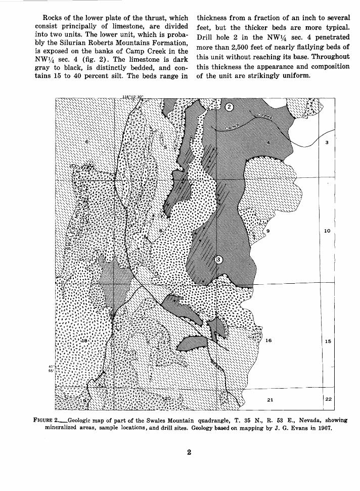
Rocks of the lower plate of the thrust, which consist principally of limestone, are divided into two units. The lower unit, which is probably the Silurian Roberts Mountains Formation, is exposed on the banks of Camp Creek in the NW1,4 sec. 4 (fig. 2). The limestone is dark gray to black, is distinctly bedded, and contains 15 to 40 percent silt. The beds range in
40 55'
thickness from a fraction of an inch to several feet, but the thicker beds are more typical. Drill hole 2 in the NW%, sec. 4 penetrated more than 2,500 feet of nearly flatlying beds of this unit without reaching its base. Throughout this thickness the appearance and composition of the unit are strikingly uniform.
FIGURE 2._Geologic map of part of the Swales Mountain quadrangle, T. 35 N., R. 53 E., Nevada, showing mineralized areas, sample locations, and drill sites. Geology based on mapping by J. G. Evans in 1967.
2
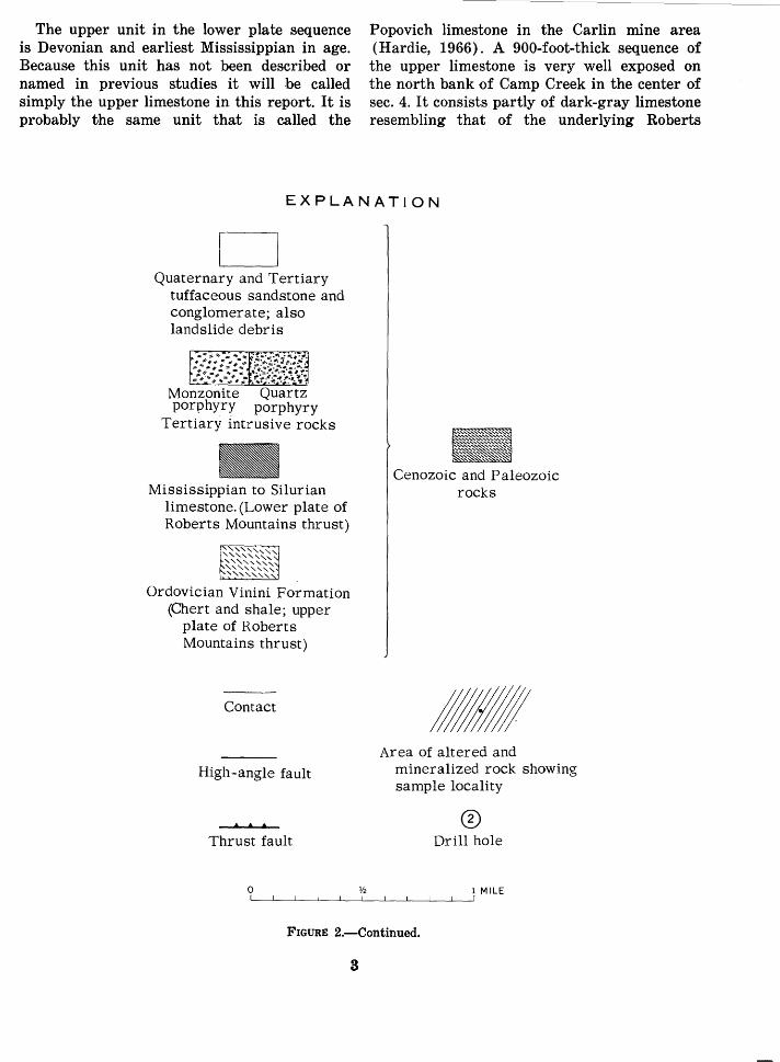
The upper unit in the lower plate sequence is Devonian and earliest Mississippian in age. Because this unit has not been described or named in previous studies it will be called simply the upper limestone in this report. It is probably the same unit that is called the
Popovich limestone in the Carlin mine area (Hardie, 1966). A 900-foot-thick sequence of the upper limestone is very well exposed on the north bank of Camp Creek in the center of sec. 4. It consists partly of dark-gray limestone resembling that of the underlying Roberts
EXPLANATION
D Quaternary and Tertiary
tuffaceous sandstone and conglomerate; also landslide debris
Monzonite Quartz porphyry porphyry
Tertiary intrusive rocks
Mississippian to Silurian limestone. (Lower plate of Roberts Mountains thrust)
Ordovician Vinini Formation (Chert and shale; upper
plate of Roberts Mountains thrust)
Contact
High-angle fault
. . . Thrust fault
0
Cenozoic and Paleozoic rocks
Area of altered and mineralized rock showing sample locality
® Drill hole
1 MILE
FIGURE 2.-Continued.
3
Mountains Formation and partly of a distinctive sequence of alternating sandy and shaly beds. The sandy beds are brown or tan and consist of sand-size grains of carbonate and quartz. The shaly beds are gray and consist of fine-grained limestone and clay.
Beds of loosely consolidated sandstone and conglomerate of Tertiary and Quaternary age cover the lower slopes east and west of Swales Mountain. Many of the sandy beds consist partly of volcanic ash. Andesite and latite lava flows and ash beds overlie the Vinini Formation north of Swales Mountain.
INTRUSIVE ROCKS
Intrusive roc.ks in the Swales Mountain area consist mainly of monzonite porphyry and quartz porphyry. A stock of monzonite form.s the south end of Swales Mountain in sec. 18, and a thick dike of monzonite extends from the NW%, sec. 16 northward through sec. 5. Most of the other intrusive rocks shown in figure 2 are qua~tz porphyry. The two types of roc.k are easily distinguished : the monzonite is rather dark and is spotted with black biotite; the quartz porphyry is light colored and is spotted with crystals of clear quartz. Geologic relations and radiometric data indicate that the intrusive rocks are of Tertiary age.
STRUCTURE
The Roberts Mountains Formation and the upper limestone unit are separated from the overlying Vinini Formation by a thrust fault. A thrust fault such as this one, which separates younger limestones from overlying older siliceous rocks, in this region is generaUy called the Roberts Mountains thrust fault (Roberts and others, 1958). Originally the thrust fault probably lay almost horizontally in the Swales Mountain area, but now both lower plate and upper plate rocks and the thrust fault that separates them are folded into an arch or anticline that trends north. The association of intrusive rocks with the anticline suggests that forcible e·mplacement of igneous rocks may have caused the anticlinal structure. The Roberts Mountains Formation and the upper limestone unit are exposed along the axis of this anticline, and they underlie the Vinini Formation at unknown depths on the flanks of the anticline.
4
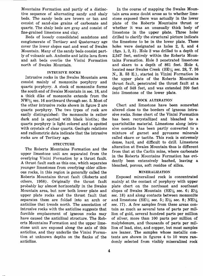
In the course of mapping the Swales Mountain area some doubt arose as to whether limestone exposed there was actually in the lower plate of the Roberts Mountains thrust or whether it was an unusually thick body of limestone in the upper plate. Three hoi& drilled to clarify the structural picture indicate the limestone to be in the lower plate. These holes were designated as holes 2, 3, and 4 (figs. 1, 2, 3). Hole 2 was drilled to a depth of 2,547 feet, entirely within the Roberts Mountains Formation. Hole 3 penetrated limestone and skarn to a depth of 861 feet. Hole 4, located near Swales Creek (SE%, sec. 28, T. 36 N., R. 53 E.), started in Vinini Formation in the upper plate of the Roberts Mountains thrust fault, penetrated the thrust fault at a depth of 348 feet, and was extended 200 feet into limestone of the lower plate.
ROCK ALTERATION
Chert and limestone have been somewhat altered close to the borders of igneous intrusive rocks. Some ,chert of the Vinini Formation has been recrystallized and bleached to a quartzitelike material. Limestone along intrusive contacts has been partly converted to a mixture of garnet and pyroxene minerals called skarn or tactite. This rock is extremely dense, hard, and difficult to drill. Limestone alteration at Swales Mountain thus is different from that at the Carlin mine, where carbonate, in the Roberts Mountains Formation has evidently been extensively leached, leaving a bleached, porous, soft residue of silica.
MINERALIZATION
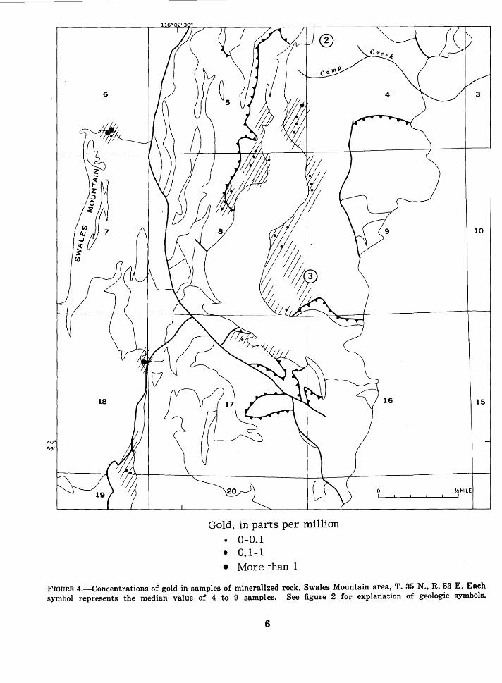
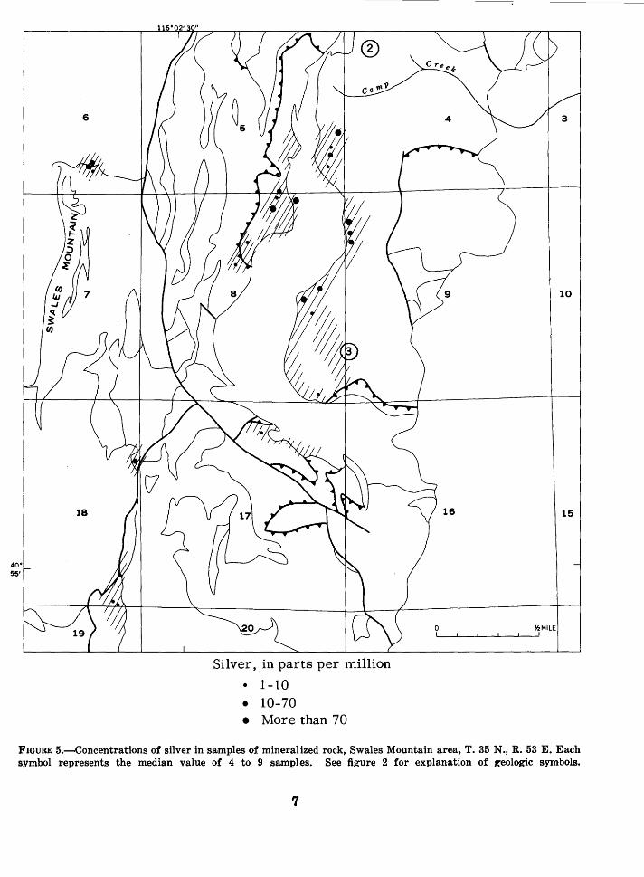
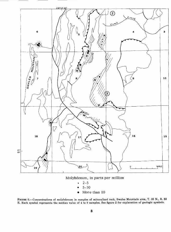
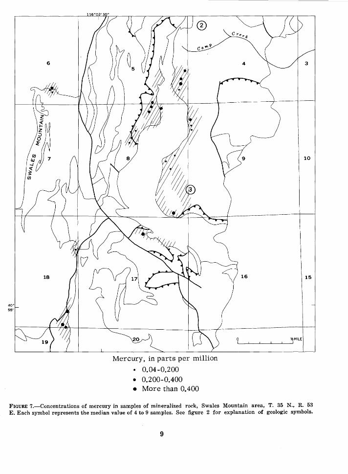
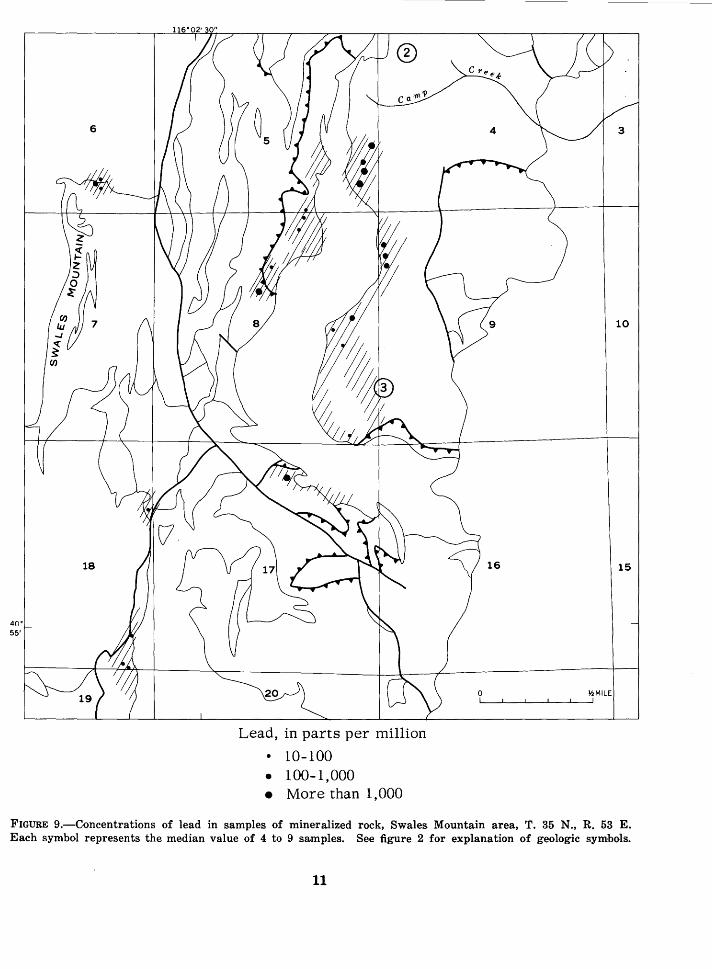
Exposed mineralized rock is concentrated mainly at the contact of povphyry with upper plate chert on the northeast and southeast slopes of Swales Mountain (SE%, sec. 6; Elh sec. 18) and along contacts between monzonite and limestone (SE%, sec. 5; Elh sec. 8; NE%, sec. 17). A few samples from these areas. contain as much as several tens of parts per million of gold, several hundred parts per million of silver, more than 100 parts per million of molybdenum, and thousands of parts per million of lead, zinc, and copper, but most samples are leaner. The samples whose metallic contents are shown in figures 4 to 10 were randomly selected from visibly mineralized rock
Upper limestone unit
Roberts Mountains Formation
HOLE 3
} ;l~;~tly anomalous in silver,
~---
FEET 0
100
200
lead, and barium
Roberts Mountains Formation
Zone I slightly anomalous in gold
HOLE 2
Vinini Formation
HOLE 4
Zone slightly
J anomalous in
Roberts molybdenum Mountains and e c r m r u y thrust "' fault ---t----H
Lower plate limestone
Barium
FIGURE 3.-Drill holes in the Swales Mountain area, showing formations and zones of slight metal concentrations.
310-089 0-68-2
5
10
15
~MILE
Gold, in parts per million • 0-0.1 • 0.1-1 • More than 1
FIGURE 4.-Concentrations of gold in samples of mineralized rock, Swales Mountain area, T. 35 N ., R. 53 E. Each symbol represents the median value of 4 to 9 samples. See figure 2 for explanation of geologic symbols.
6
Silver, in parts per million
• 1-10 • 10-70 • More than 70
FIGURE 5.-Concentrations of silver in samples of mineralized rock, Swales Mountain area, T. 35 N., R. 53 E. Each symbol represents the median value of 4 to 9 samples. See figure 2 for explanation of geologic symbols.
7
Molybdenum, in parts per million
2-5 • S-10 • More than 10
FIGURE 6.-Concentrations of molybdenum in samples of mineralized rock, Swales Mountain area, T. 35 N., R. 53 E. Each symbol represents the median value of 4 to 9 samples. See figure 2 for explanation of geologic symbols.
8
10
15
¥.!MILE
Mercury, in parts per million
• 0.04-0.200 • 0.200-0.400 • More than 0.400
FIGURE 7.-Concentrations of mercury in samples of mineralized rock, Swales Mountain area, T. 35 N., R. 53 E. Each symbol represents the median value of 4 to 9 samples. See figure 2 for explanation of geologic symbols.
9
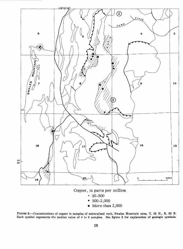
Copper, in parts per million • 30-500 • 500-2,000 • More than 2,000
FIGURE B.-Concentrations of copper in samples of mineralized rock, Swales Mountain area, T. 35 N., R. 53 E. Each symbol represents the median value of 4 to 9 samples. See figure 2 for explanation of geologic symbols.
10
Lead, in parts per million
• 10-100 • 100-1,000 • More than 1,000
FIGURE 9.-Concentrations of lead in samples of mineralized rock, Swales Mountain area, T. 35 N., R. 53 E. Each symbol represents the median value of 4 to 9 samples. See figure 2 for explanation of geologic symbols.
11
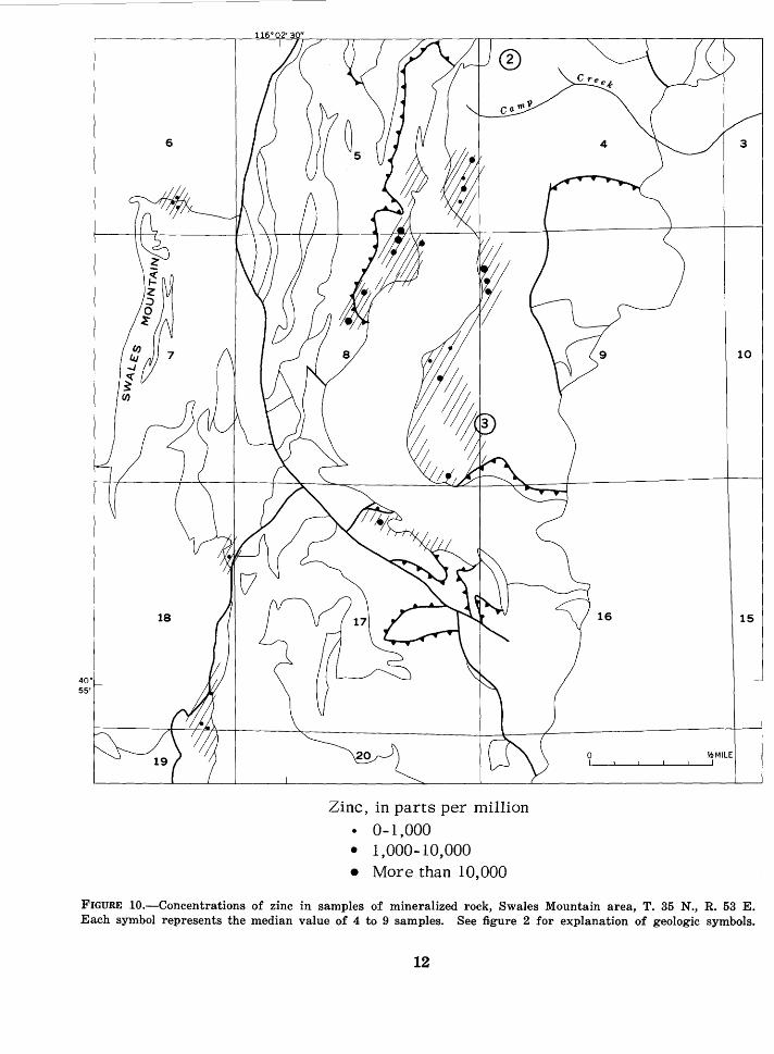
Zinc, in parts per million • 0-1,000 • 1,000-10,000 • More than 10,000
FIGURE 10.-Concentrations of zinc in samples of mineralized rock, Swales Mountain area, T. 35 N., R. 53 E. Each symbol represents the median value of 4 to 9 samples. See figure 2 for explanation of geologic symbols.
12
at each site. The tonnage of mineralized rock cannot be estimated, but the narrow extent of surface exposures indicates that it is small.
Nearly 300 3-inch segments taken at regular intervals from drill core were analyzed by spectographic and atomic absorption techniques. Barely detectable amounts ( 0.02 to 0.1 ppm) of gold were found in some samples from hole 2 between 1,080 and 1,230 feet below the surface. Silver, lead, and barium were found in the top 100 feet of hole 3 in concentrations only slightly greater than those of ordinary rock. Mercury, and molybdenum were found in slightly above-normal concentrations in hole 4 in the Vinini Formation within 50 feet of the Roberts Mountains thrust, and barium was found in above-normal concentrations in lower plate limestone within 40 feet of the thrust. The metal contents of all samples of drill core are too low to be of any immediate economic significance.
SUGGESTIONS FOR PROSPECTING
Disseminated gold deposits should be sought at Swales Mountain in the kinds. of rocks that carry disseminated gold elsewhere. In the Carlin mine (Hardie, 1966) and the Cortez district (Erickson and others, 1966) gold is disseminated in the Roberts Mountains Formation. At the Gold Acres mine (Ketner, 1965) gold is disseminated in broken rock along the Roberts Mountains thrust. The presence of small gold deposits in the upper plate rocks at Swales Mountain suggests the possibility of
13
more extensive deposits in the Roberts Mountains Formation where it lies concealed by upper plate rocks or in the broken rock along subsurface parts of the Roberts Mountains thrust. Exploratory efforts therefore should include drilling through the upper plate in areas immediately surrounding Swales. Mountain. Unfortunately there is no way of knowing how deep the thrust zone lies or how far below the thrust the Roberts Mountains Formation lies. Both could be very close to the surface without revealing their presence in any way.
Lower plate rocks intruded by igneous rocks are concealed beneath alluvium on the east flank of the mountain (sees. 4, 9) . Exploration of these rocks would require drilling through the alluvium east of the area where lower plate rocks are exposed.
REFERENCES CITED
Erickson, R. L., VanSickle, G. H., Nakagawa, H. M., McCarthy, J. H., Jr., and Leong, K. W., 1966, Gold geochemical anomaly in the Cortez district, N evada: U.S. Geol. Survey Circ. 534, 9 p.
Hardie, B. S., 1966, Carlin gold mine, Lynn district, Nevada: Nevada Bur. Mines Rept. 13, pt. A, p. 73-83.
Ketner, K. B., 1965, Economic geology, in Gilluly, James, and Gates, Olcott, Tectonic and igneous geology of the northern Shoshone Range, Nevada: U.S. Geol. Survey Prof. Paper 465, p. 129-144.
Roberts, R. J., Hotz, P. E., Gilluly, James, and Ferguson, H. G., 1958, Paleozoic rocks of north-central Nevada: Am. Assoc. Petroleum Geologists Bull., v. 42, no. 12, p. 2813-2857.
U.S. GOVERNMENT PRINTING OFFICE: 1968 0-310-089