Embed Size (px)
Citation preview
GEO User Interface CommitteeStatus of Task US-09-01a
UIC Member Task Lead: Lawrence Friedl, USA-NASA
UIC Co-Chair Task Lead: Task Coordinator: Ellsworth LeDrew, IEEE (Canada) Amy Jo Swanson, USA-NASA
11th UIC Meeting • Stresa, Italy 2-May-2009
2
Group on Earth Observations Task US-09-01a
Sections of Presentation- Quick Review of Task - Status- Preliminary Results- CEOS Item- Discussion - Recommendations/Decisions
3
Group on Earth Observations Task US-09-01a
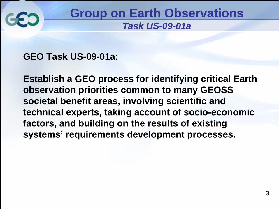
GEO Task US-09-01a:
Establish a GEO process for identifying critical Earth observation priorities common to many GEOSS societal benefit areas, involving scientific and technical experts, taking account of socio-economic factors, and building on the results of existing systems’ requirements development processes.
4
Group on Earth Observations Task US-09-01a
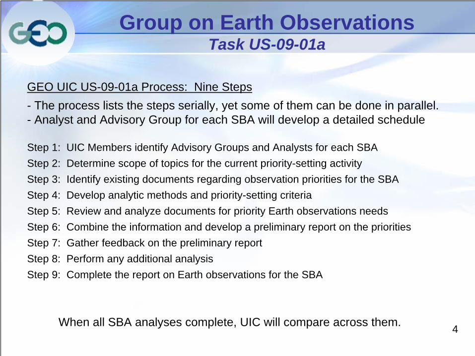
GEO UIC US-09-01a Process: Nine Steps - The process lists the steps serially, yet some of them can be done in parallel. - Analyst and Advisory Group for each SBA will develop a detailed schedule
Step 1: UIC Members identify Advisory Groups and Analysts for each SBA Step 2: Determine scope of topics for the current priority-setting activityStep 3: Identify existing documents regarding observation priorities for the SBA Step 4: Develop analytic methods and priority-setting criteriaStep 5: Review and analyze documents for priority Earth observations needsStep 6: Combine the information and develop a preliminary report on the prioritiesStep 7: Gather feedback on the preliminary report Step 8: Perform any additional analysisStep 9: Complete the report on Earth observations for the SBA
When all SBA analyses complete, UIC will compare across them.
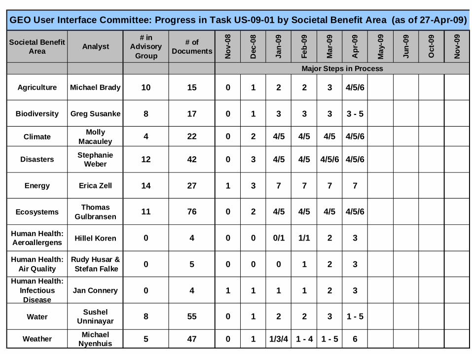
Societal Benefit Area Analyst
# in Advisory
Group
# of Documents
Nov-
08
Dec
-08
Jan-
09
Feb-
09
Mar
-09
Apr
-09
May
-09
Jun-
09
Oct
-09
Nov-
09
Agriculture Michael Brady 10 15 0 1 2 2 3 4/5/6
Biodiversity Greg Susanke 8 17 0 1 3 3 3 3 - 5
Climate Molly Macauley 4 22 0 2 4/5 4/5 4/5 4/5/6
Disasters Stephanie Weber 12 42 0 3 4/5 4/5 4/5/6 4/5/6
Energy Erica Zell 14 27 1 3 7 7 7 7
Ecosystems Thomas Gulbransen 11 76 0 2 4/5 4/5 4/5 4/5/6
Human Health: Aeroallergens Hillel Koren 0 4 0 0 0/1 1/1 2 3
Human Health: Air Quality
Rudy Husar & Stefan Falke 0 5 0 0 0 1 2 3
Human Health: Infectious Disease
Jan Connery 0 4 1 1 1 1 2 3
Water Sushel Unninayar 8 55 0 1 2 2 3 1 - 5
Weather Michael Nyenhuis 5 47 0 1 1/3/4 1 - 4 1 - 5 6
Major Steps in Process
GEO User Interface Committee: Progress in Task US-09-01 by Societal Benefit Area (as of 27-Apr-09)
6
Group on Earth Observations Task US-09-01a
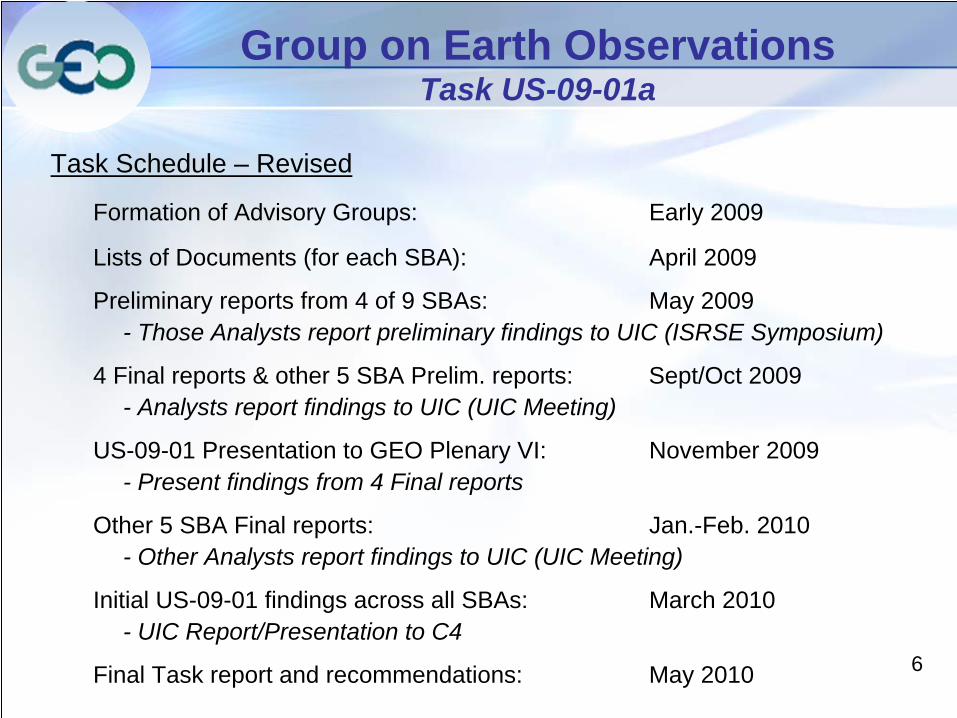
Task Schedule – Revised
Formation of Advisory Groups: Early 2009
Lists of Documents (for each SBA): April 2009
Preliminary reports from 4 of 9 SBAs: May 2009- Those Analysts report preliminary findings to UIC (ISRSE Symposium)
4 Final reports & other 5 SBA Prelim. reports: Sept/Oct 2009- Analysts report findings to UIC (UIC Meeting)
US-09-01 Presentation to GEO Plenary VI: November 2009- Present findings from 4 Final reports
Other 5 SBA Final reports: Jan.-Feb. 2010- Other Analysts report findings to UIC (UIC Meeting)
Initial US-09-01 findings across all SBAs: March 2010- UIC Report/Presentation to C4
Final Task report and recommendations: May 2010
7
Group on Earth Observations Task US-09-01 – Preliminary Results
US-09-01a:Preliminary Results
Energy Societal Benefit Area
8
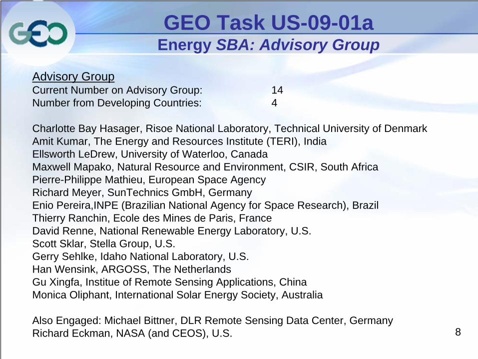
GEO Task US-09-01a Energy SBA: Advisory Group
Advisory GroupCurrent Number on Advisory Group: 14Number from Developing Countries: 4
Charlotte Bay Hasager, Risoe National Laboratory, Technical University of DenmarkAmit Kumar, The Energy and Resources Institute (TERI), IndiaEllsworth LeDrew, University of Waterloo, CanadaMaxwell Mapako, Natural Resource and Environment, CSIR, South AfricaPierre-Philippe Mathieu, European Space AgencyRichard Meyer, SunTechnics GmbH, GermanyEnio Pereira,INPE (Brazilian National Agency for Space Research), BrazilThierry Ranchin, Ecole des Mines de Paris, FranceDavid Renne, National Renewable Energy Laboratory, U.S.Scott Sklar, Stella Group, U.S.Gerry Sehlke, Idaho National Laboratory, U.S.Han Wensink, ARGOSS, The NetherlandsGu Xingfa, Institue of Remote Sensing Applications, ChinaMonica Oliphant, International Solar Energy Society, Australia
Also Engaged: Michael Bittner, DLR Remote Sensing Data Center, GermanyRichard Eckman, NASA (and CEOS), U.S.
9
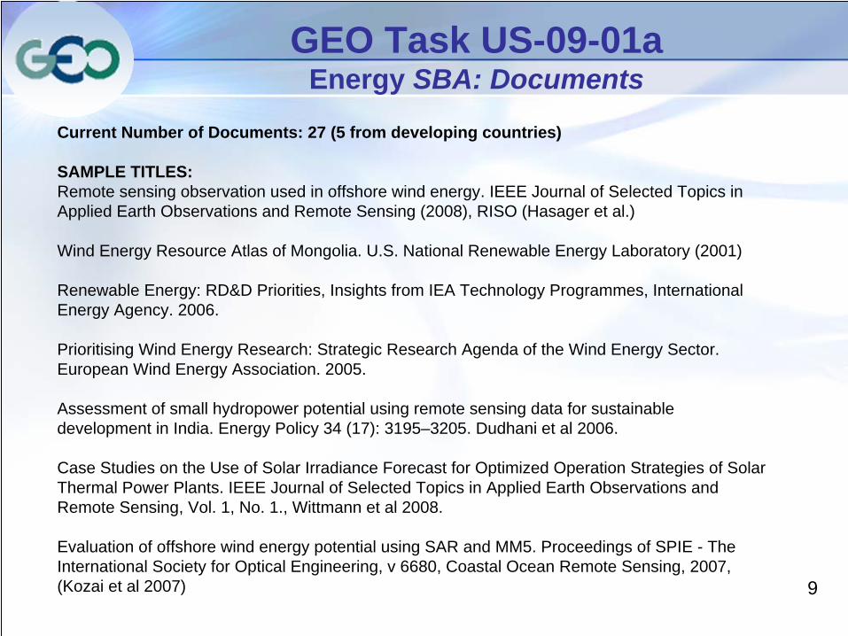
GEO Task US-09-01a Energy SBA: Documents
Current Number of Documents: 27 (5 from developing countries)
SAMPLE TITLES:Remote sensing observation used in offshore wind energy. IEEE Journal of Selected Topics in Applied Earth Observations and Remote Sensing (2008), RISO (Hasager et al.)
Wind Energy Resource Atlas of Mongolia. U.S. National Renewable Energy Laboratory (2001)
Renewable Energy: RD&D Priorities, Insights from IEA Technology Programmes, International Energy Agency. 2006.
Prioritising Wind Energy Research: Strategic Research Agenda of the Wind Energy Sector. European Wind Energy Association. 2005.
Assessment of small hydropower potential using remote sensing data for sustainable development in India. Energy Policy 34 (17): 3195–3205. Dudhani et al 2006.
Case Studies on the Use of Solar Irradiance Forecast for Optimized Operation Strategies of Solar Thermal Power Plants. IEEE Journal of Selected Topics in Applied Earth Observations and Remote Sensing, Vol. 1, No. 1., Wittmann et al 2008.
Evaluation of offshore wind energy potential using SAR and MM5. Proceedings of SPIE - The International Society for Optical Engineering, v 6680, Coastal Ocean Remote Sensing, 2007, (Kozai et al 2007)
10
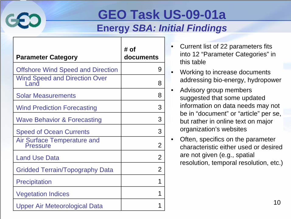
GEO Task US-09-01a Energy SBA: Initial Findings
Parameter Category# of documents
Offshore Wind Speed and Direction 9Wind Speed and Direction Over
Land 8
Solar Measurements 8
Wind Prediction Forecasting 3
Wave Behavior & Forecasting 3
Speed of Ocean Currents 3Air Surface Temperature and
Pressure 2
Land Use Data 2
Gridded Terrain/Topography Data 2
Precipitation 1
Vegetation Indices 1
Upper Air Meteorological Data 1
• Current list of 22 parameters fits into 12 “Parameter Categories” in this table
• Working to increase documents addressing bio-energy, hydropower
• Advisory group members suggested that some updated information on data needs may not be in “document” or “article” per se, but rather in online text on major organization’s websites
• Often, specifics on the parameter characteristic either used or desired are not given (e.g., spatial resolution, temporal resolution, etc.)
11
Group on Earth Observations Task US-09-01 – Preliminary Results
US-09-01a:Preliminary Results
Disaster Societal Benefit Area
12
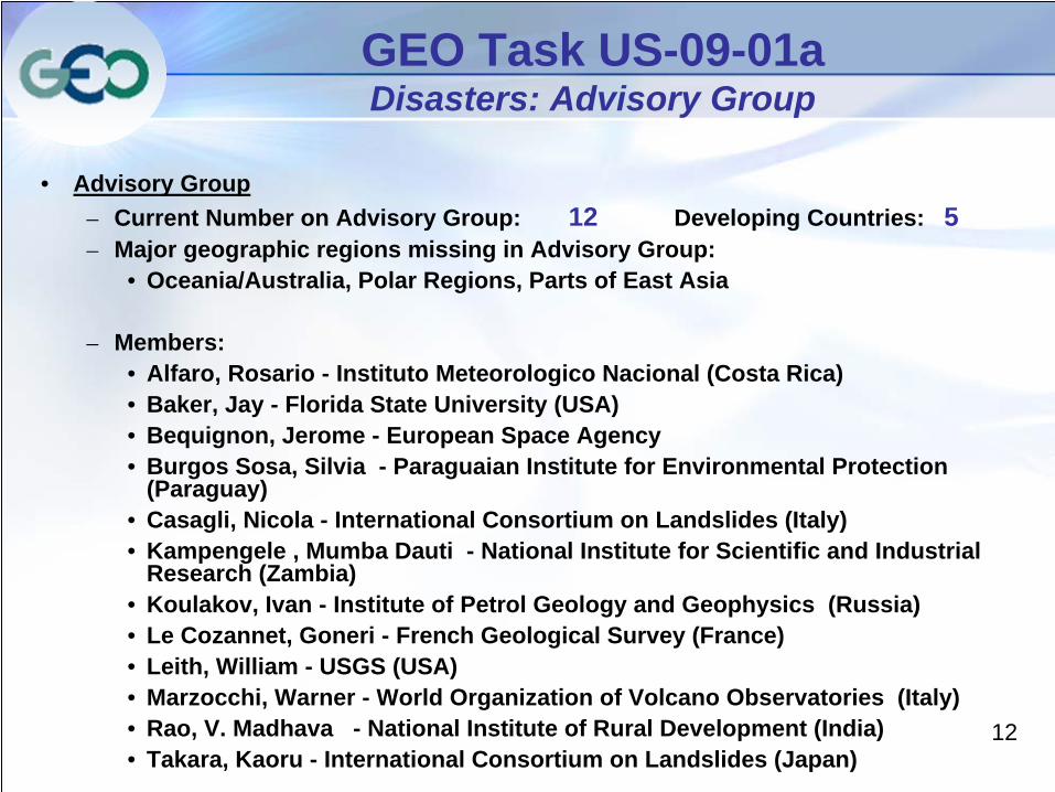
GEO Task US-09-01a Disasters: Advisory Group
• Advisory Group– Current Number on Advisory Group: 12 Developing Countries: 5– Major geographic regions missing in Advisory Group:
• Oceania/Australia, Polar Regions, Parts of East Asia
– Members:• Alfaro, Rosario - Instituto Meteorologico Nacional (Costa Rica)• Baker, Jay - Florida State University (USA)• Bequignon, Jerome - European Space Agency• Burgos Sosa, Silvia - Paraguaian Institute for Environmental Protection
(Paraguay)• Casagli, Nicola - International Consortium on Landslides (Italy)• Kampengele , Mumba Dauti - National Institute for Scientific and Industrial
Research (Zambia)• Koulakov, Ivan - Institute of Petrol Geology and Geophysics (Russia)• Le Cozannet, Goneri - French Geological Survey (France)• Leith, William - USGS (USA)• Marzocchi, Warner - World Organization of Volcano Observatories (Italy)• Rao, V. Madhava - National Institute of Rural Development (India)• Takara, Kaoru - International Consortium on Landslides (Japan)
13
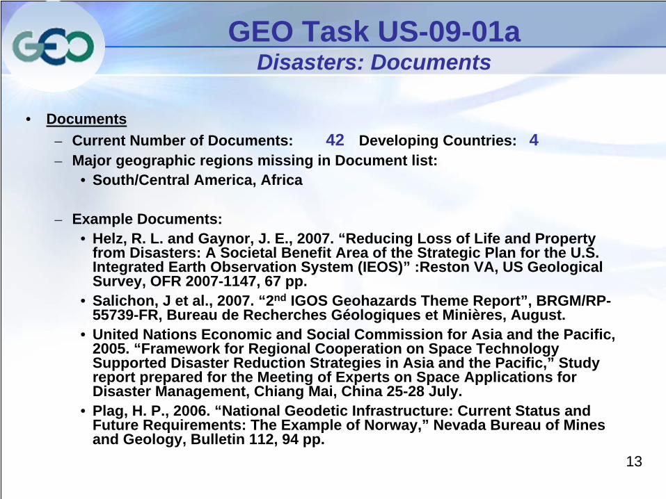
GEO Task US-09-01a Disasters: Documents
• Documents– Current Number of Documents: 42 Developing Countries: 4– Major geographic regions missing in Document list:
• South/Central America, Africa
– Example Documents:• Helz, R. L. and Gaynor, J. E., 2007. “Reducing Loss of Life and Property
from Disasters: A Societal Benefit Area of the Strategic Plan for the U.S. Integrated Earth Observation System (IEOS)” :Reston VA, US Geological Survey, OFR 2007-1147, 67 pp.
• Salichon, J et al., 2007. “2nd IGOS Geohazards Theme Report”, BRGM/RP- 55739-FR, Bureau de Recherches Géologiques et Minières, August.
• United Nations Economic and Social Commission for Asia and the Pacific, 2005. “Framework for Regional Cooperation on Space Technology Supported Disaster Reduction Strategies in Asia and the Pacific,” Study report prepared for the Meeting of Experts on Space Applications for Disaster Management, Chiang Mai, China 25-28 July.
• Plag, H. P., 2006. “National Geodetic Infrastructure: Current Status and Future Requirements: The Example of Norway,” Nevada Bureau of Mines and Geology, Bulletin 112, 94 pp.
14
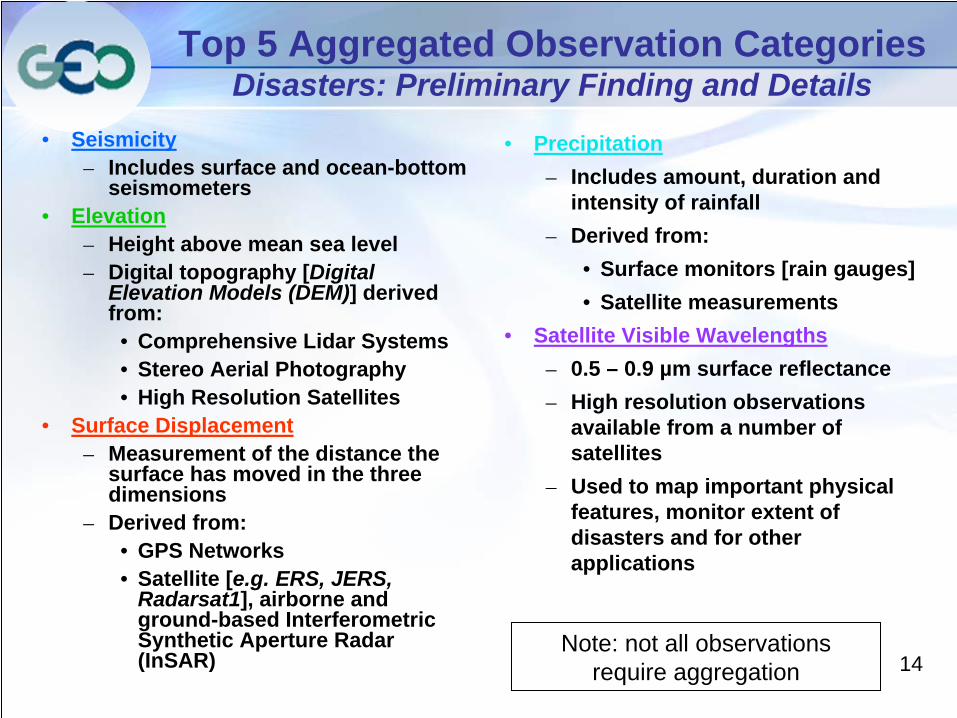
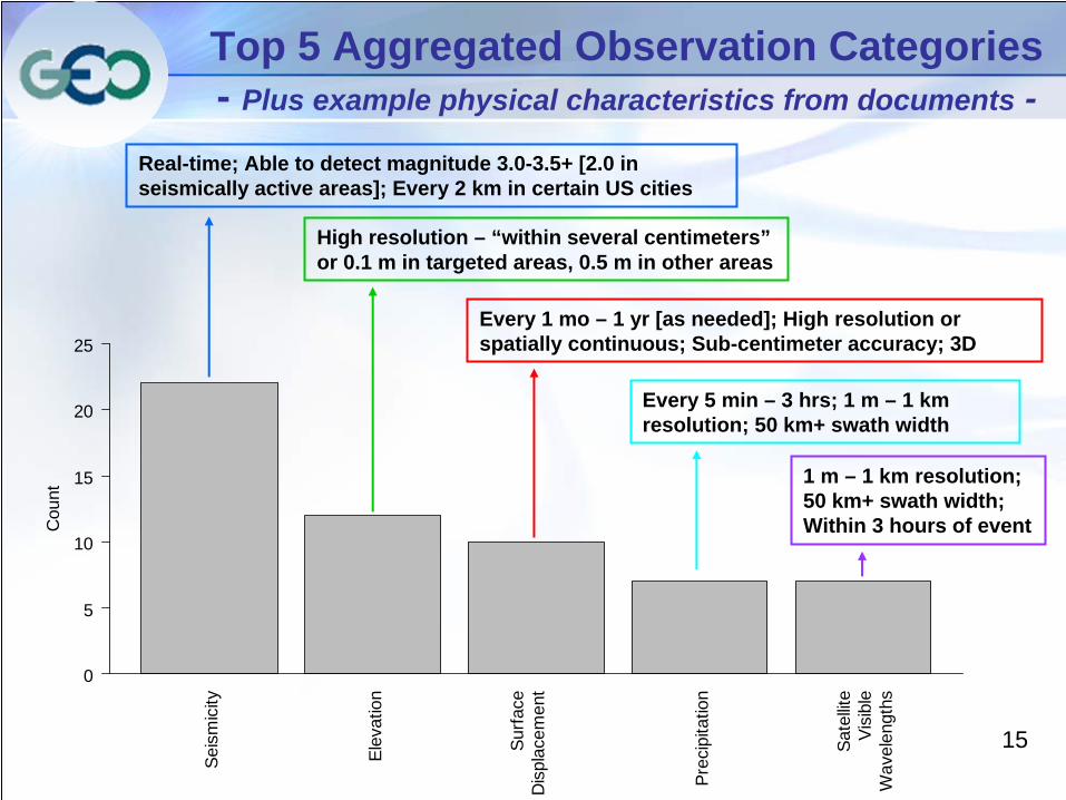
Top 5 Aggregated Observation Categories Disasters: Preliminary Finding and Details
• Seismicity– Includes surface and ocean-bottom
seismometers • Elevation
– Height above mean sea level– Digital topography [Digital
Elevation Models (DEM)] derived from:
• Comprehensive Lidar Systems• Stereo Aerial Photography• High Resolution Satellites
• Surface Displacement – Measurement of the distance the
surface has moved in the three dimensions
– Derived from:• GPS Networks • Satellite [e.g. ERS, JERS,
Radarsat1], airborne and ground-based Interferometric Synthetic Aperture Radar (InSAR)
• Precipitation– Includes amount, duration and
intensity of rainfall– Derived from:
• Surface monitors [rain gauges]• Satellite measurements
• Satellite Visible Wavelengths– 0.5 – 0.9 µm surface reflectance– High resolution observations
available from a number of satellites
– Used to map important physical features, monitor extent of disasters and for other applications
Note: not all observations require aggregation
15
Seis
mic
ity
Elev
atio
n
Surfa
ceD
ispl
acem
ent
Prec
ipita
tion
Sate
llite
Visi
ble
Wav
elen
gths
Cou
nt
0
5
10
15
20
25
Top 5 Aggregated Observation Categories - Plus example physical characteristics from documents -
Real-time; Able to detect magnitude 3.0-3.5+ [2.0 in seismically active areas]; Every 2 km in certain US cities
High resolution – “within several centimeters” or 0.1 m in targeted areas, 0.5 m in other areas
Every 1 mo – 1 yr [as needed]; High resolution or spatially continuous; Sub-centimeter accuracy; 3D
1 m – 1 km resolution; 50 km+ swath width; Within 3 hours of event
Every 5 min – 3 hrs; 1 m – 1 km resolution; 50 km+ swath width
16
Group on Earth Observations Task US-09-01 – Preliminary Results
US-09-01a:Preliminary Results
Ecosystems Societal Benefit Area
1717
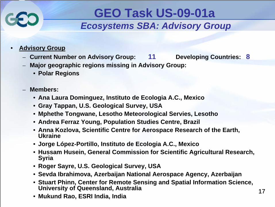
GEO Task US-09-01a Ecosystems SBA: Advisory Group
• Advisory Group– Current Number on Advisory Group: 11 Developing Countries: 8– Major geographic regions missing in Advisory Group:
• Polar Regions
– Members:• Ana Laura Dominguez, Instituto de Ecologia A.C., Mexico• Gray Tappan, U.S. Geological Survey, USA• Mphethe Tongwane, Lesotho Meteorological Servies, Lesotho• Andrea Ferraz Young, Population Studies Centre, Brazil• Anna Kozlova, Scientific Centre for Aerospace Research of the Earth,
Ukraine• Jorge López-Portillo, Instituto de Ecologia A.C., Mexico• Hussam Husein, General Commission for Scientific Agricultural Research,
Syria• Roger Sayre, U.S. Geological Survey, USA• Sevda Ibrahimova, Azerbaijan National Aerospace Agency, Azerbaijan• Stuart Phinn, Center for Remote Sensing and Spatial Information Science,
University of Queensland, Australia• Mukund Rao, ESRI India, India
1818
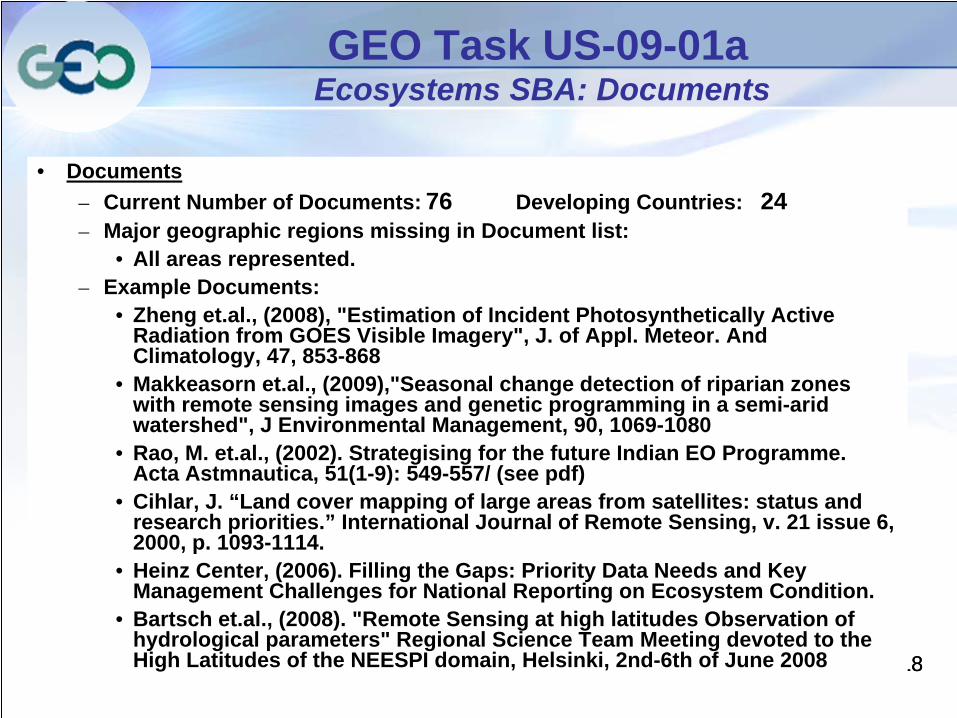
GEO Task US-09-01a Ecosystems SBA: Documents
• Documents– Current Number of Documents: 76 Developing Countries: 24– Major geographic regions missing in Document list:
• All areas represented. – Example Documents:
• Zheng et.al., (2008), "Estimation of Incident Photosynthetically Active Radiation from GOES Visible Imagery", J. of Appl. Meteor. And Climatology, 47, 853-868
• Makkeasorn et.al., (2009),"Seasonal change detection of riparian zones with remote sensing images and genetic programming in a semi-arid watershed", J Environmental Management, 90, 1069-1080
• Rao, M. et.al., (2002). Strategising for the future Indian EO Programme. Acta Astmnautica, 51(1-9): 549-557/ (see pdf)
• Cihlar, J. “Land cover mapping of large areas from satellites: status and research priorities.” International Journal of Remote Sensing, v. 21 issue 6, 2000, p. 1093-1114.
• Heinz Center, (2006). Filling the Gaps: Priority Data Needs and Key Management Challenges for National Reporting on Ecosystem Condition.
• Bartsch et.al., (2008). "Remote Sensing at high latitudes Observation of hydrological parameters" Regional Science Team Meeting devoted to the High Latitudes of the NEESPI domain, Helsinki, 2nd-6th of June 2008
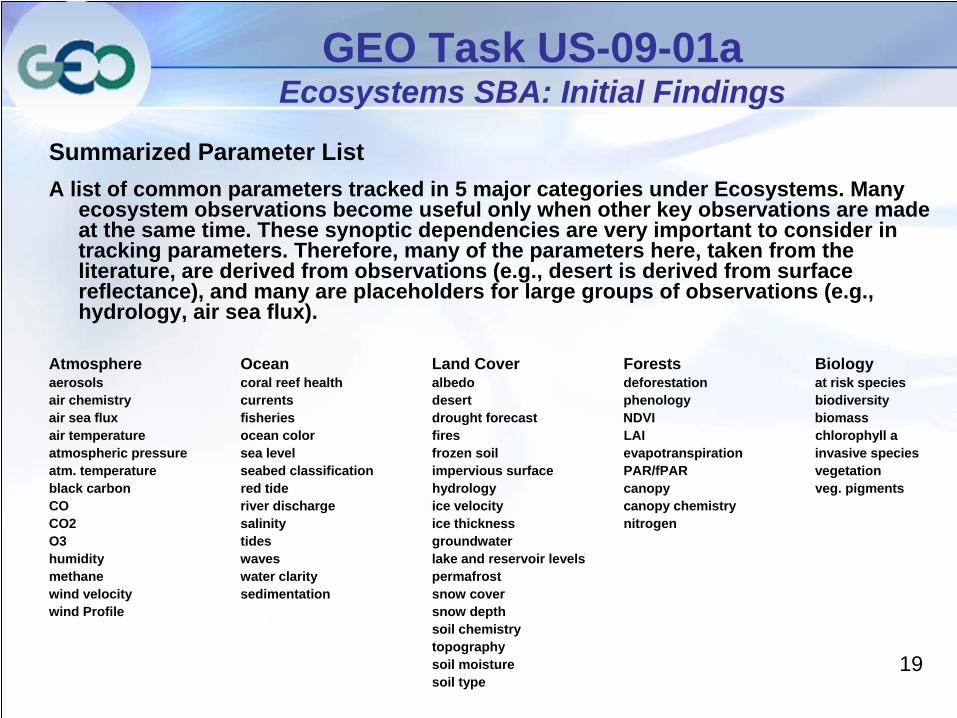
19
Summarized Parameter ListA list of common parameters tracked in 5 major categories under Ecosystems. Many
ecosystem observations become useful only when other key observations are made at the same time. These synoptic dependencies are very important to consider in tracking parameters. Therefore, many of the parameters here, taken from the literature, are derived from observations (e.g., desert is derived from surface reflectance), and many are placeholders for large groups of observations (e.g., hydrology, air sea flux).
Atmosphere Ocean Land Cover Forests Biologyaerosols coral reef health albedo deforestation at risk speciesair chemistry currents desert phenology biodiversityair sea flux fisheries drought forecast NDVI biomassair temperature ocean color fires LAI chlorophyll aatmospheric pressure sea level frozen soil evapotranspiration invasive speciesatm. temperature seabed classification impervious surface PAR/fPAR vegetationblack carbon red tide hydrology canopy veg. pigmentsCO river discharge ice velocity canopy chemistryCO2 salinity ice thickness nitrogenO3 tides groundwaterhumidity waves lake and reservoir levelsmethane water clarity permafrost wind velocity sedimentation snow coverwind Profile snow depth
soil chemistrytopographysoil moisturesoil type
GEO Task US-09-01a Ecosystems SBA: Initial Findings
20
Group on Earth Observations Task US-09-01 – Preliminary Results
US-09-01a:Preliminary Results
Climate Societal Benefit Area
2121
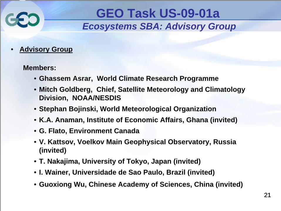
GEO Task US-09-01a Ecosystems SBA: Advisory Group
• Advisory Group
Members:• Ghassem Asrar, World Climate Research Programme• Mitch Goldberg, Chief, Satellite Meteorology and Climatology
Division, NOAA/NESDIS • Stephan Bojinski, World Meteorological Organization• K.A. Anaman, Institute of Economic Affairs, Ghana (invited)• G. Flato, Environment Canada• V. Kattsov, Voelkov Main Geophysical Observatory, Russia
(invited)• T. Nakajima, University of Tokyo, Japan (invited)• I. Wainer, Universidade de Sao Paulo, Brazil (invited)• Guoxiong Wu, Chinese Academy of Sciences, China (invited)
2222
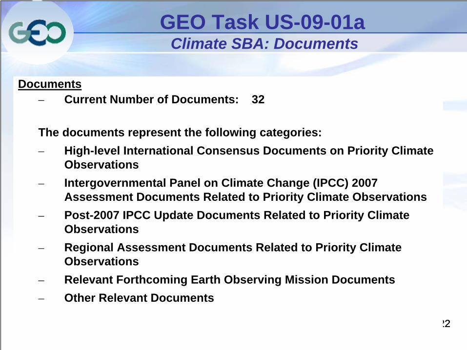
GEO Task US-09-01a Climate SBA: Documents
Documents– Current Number of Documents: 32
The documents represent the following categories: – High-level International Consensus Documents on Priority Climate
Observations– Intergovernmental Panel on Climate Change (IPCC) 2007
Assessment Documents Related to Priority Climate Observations– Post-2007 IPCC Update Documents Related to Priority Climate
Observations– Regional Assessment Documents Related to Priority Climate
Observations– Relevant Forthcoming Earth Observing Mission Documents– Other Relevant Documents
2323
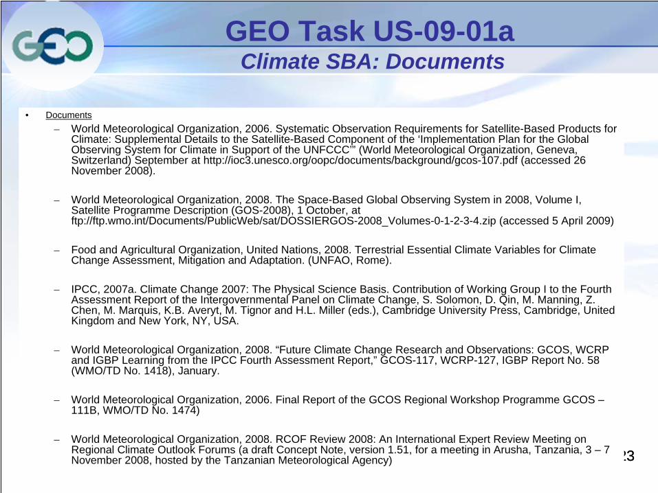
GEO Task US-09-01a Climate SBA: Documents
• Documents– World Meteorological Organization, 2006. Systematic Observation Requirements for Satellite-Based Products for
Climate: Supplemental Details to the Satellite-Based Component of the ‘Implementation Plan for the Global Observing System for Climate in Support of the UNFCCC’” (World Meteorological Organization, Geneva, Switzerland) September at http://ioc3.unesco.org/oopc/documents/background/gcos-107.pdf (accessed 26 November 2008).
– World Meteorological Organization, 2008. The Space-Based Global Observing System in 2008, Volume I, Satellite Programme Description (GOS-2008), 1 October, at ftp://ftp.wmo.int/Documents/PublicWeb/sat/DOSSIERGOS-2008_Volumes-0-1-2-3-4.zip (accessed 5 April 2009)
– Food and Agricultural Organization, United Nations, 2008. Terrestrial Essential Climate Variables for Climate Change Assessment, Mitigation and Adaptation. (UNFAO, Rome).
– IPCC, 2007a. Climate Change 2007: The Physical Science Basis. Contribution of Working Group I to the Fourth Assessment Report of the Intergovernmental Panel on Climate Change, S. Solomon, D. Qin, M. Manning, Z. Chen, M. Marquis, K.B. Averyt, M. Tignor and H.L. Miller (eds.), Cambridge University Press, Cambridge, United Kingdom and New York, NY, USA.
– World Meteorological Organization, 2008. “Future Climate Change Research and Observations: GCOS, WCRP and IGBP Learning from the IPCC Fourth Assessment Report,” GCOS-117, WCRP-127, IGBP Report No. 58 (WMO/TD No. 1418), January.
– World Meteorological Organization, 2006. Final Report of the GCOS Regional Workshop Programme GCOS – 111B, WMO/TD No. 1474)
– World Meteorological Organization, 2008. RCOF Review 2008: An International Expert Review Meeting on Regional Climate Outlook Forums (a draft Concept Note, version 1.51, for a meeting in Arusha, Tanzania, 3 – 7 November 2008, hosted by the Tanzanian Meteorological Agency)
24
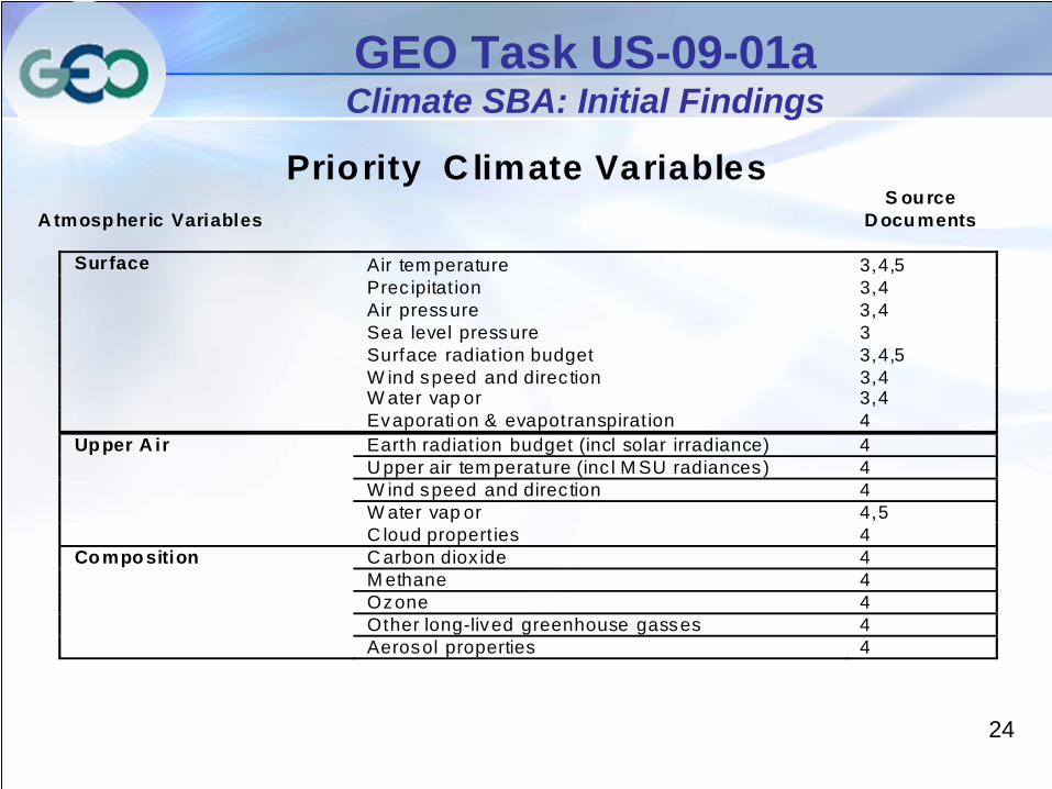
GEO Task US-09-01a Climate SBA: Initial Findings
Priority C limate Variables A tmosp heric Variables
S ou rce D ocu ments
Surface Air tem perature 3,4,5 Prec ipitat ion 3,4 Air pressure 3,4 Sea level pressure 3 Surface radiat ion budget 3,4,5 W ind speed and direc tion 3,4 W ater vap or 3,4 Evaporati on & evapotranspirat ion 4 Upper A ir Earth radiat ion budget (incl solar irradiance) 4 U pper air tem perature (inc l M SU radiances) 4 W ind speed and direc tion 4 W ater vap or 4,5 C loud propert ies 4 Compo sition C arbon diox ide 4 M ethane 4 Ozone 4 Other long-lived greenhouse gasses 4 Aerosol properties 4
25
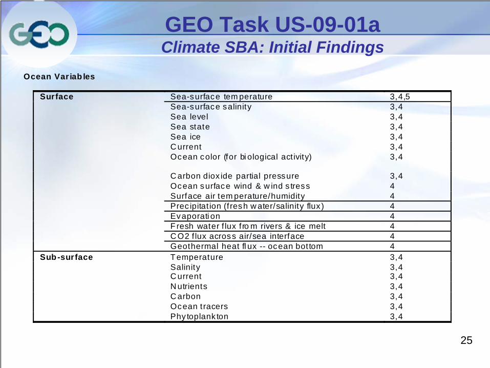
GEO Task US-09-01a Climate SBA: Initial Findings
Ocean Var iab les Surface Sea-surface tem perature 3,4,5 Sea-surface salinity 3,4 Sea level 3,4 Sea state 3,4 Sea ice 3,4 C urrent 3,4 Ocean color (for bi ological act ivity) 3,4 C arbon diox ide partial pressure 3,4 Ocean surface wind & w ind s tress 4 Surface air tem perature/humidity 4 Prec ipitat ion (f resh w ater/salinity flux ) 4 Evaporati on 4 Fresh water f lux fro m rivers & ice melt 4 C O2 f lux across air/sea interface 4 Geothermal heat fl ux -- ocean bottom 4 Sub-surface Temperature 3,4 Salinity 3,4 C urrent 3,4 N utrients 3,4 C arbon 3,4 Ocean tracers 3,4 Phy toplank ton 3,4

26
GEO Task US-09-01a Climate SBA: Initial Findings
T errestrial Variables Snow cover 4, 1a Glac iers and ice caps 4, 1a Perm afros t and seasonally- adjusted ground 4, 1a Albedo 4, 1a Land cover (inc l vegetation type) 4, 1a
F ract ion of absorrbed photo- synthet ically ac tive radiat ion 4, 1a
Leaf area index 4, 1a Biom ass 4, 1a Land surface tem perature 4 F ire dis turbance 1a S t b li d
27
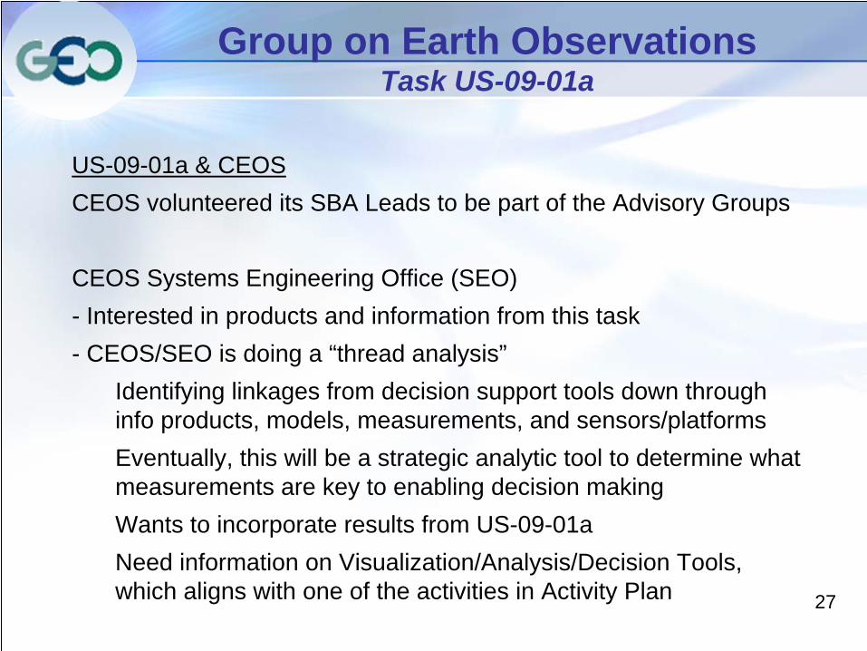
Group on Earth Observations Task US-09-01a
US-09-01a & CEOS CEOS volunteered its SBA Leads to be part of the Advisory Groups
CEOS Systems Engineering Office (SEO)- Interested in products and information from this task- CEOS/SEO is doing a “thread analysis”
Identifying linkages from decision support tools down through info products, models, measurements, and sensors/platformsEventually, this will be a strategic analytic tool to determine what measurements are key to enabling decision makingWants to incorporate results from US-09-01aNeed information on Visualization/Analysis/Decision Tools, which aligns with one of the activities in Activity Plan
28
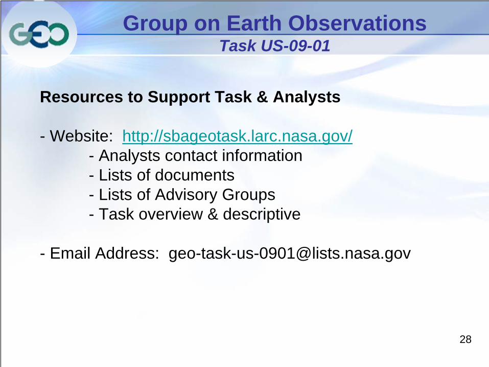
Group on Earth Observations Task US-09-01
Resources to Support Task & Analysts
- Website: http://sbageotask.larc.nasa.gov/- Analysts contact information- Lists of documents- Lists of Advisory Groups- Task overview & descriptive
- Email Address: [email protected]
29
Group on Earth Observations Task US-09-01
Back-up Slides
30
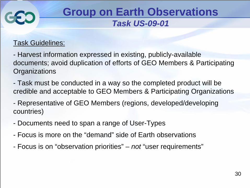
Group on Earth Observations Task US-09-01
Task Guidelines:
- Harvest information expressed in existing, publicly-available documents; avoid duplication of efforts of GEO Members & Participating Organizations
- Task must be conducted in a way so the completed product will be credible and acceptable to GEO Members & Participating Organizations
- Representative of GEO Members (regions, developed/developing countries)
- Documents need to span a range of User-Types
- Focus is more on the “demand” side of Earth observations
- Focus is on “observation priorities” – not “user requirements”
31
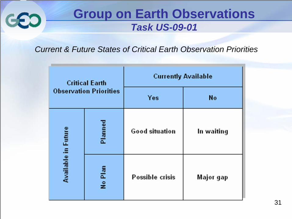
Group on Earth Observations Task US-09-01
Current & Future States of Critical Earth Observation Priorities