Embed Size (px)
Citation preview
Geo-microwave Sounder/GeoSTAR
Development and PATH (Precipitation All
Weather Temperature and Humidity
Soundings) Status
Shyam Bajpai Ph.D.
NOAA/NESDIS/Office of Systems Development
Advanced Satellite Planning and Technology
March 7, 2012
1

Topics • Overview
• Background
• Limitations of Current GOES IR Sounder
• Polar IR and MW Soundings
• NOAA Sample User Requirements
• GeoSTAR development and Current Status
• GeoSTAR Applications and Benefits
• NOAA GeoSTAR Working Group
• Potential Next Steps
2

Overview
• OSD has been working with NASA and JPL (Bjorn Lambrigtsen,
PI) to advance the Technology Readiness Level (TRL) of a
geostationary microwave sounder, the Geostationary Thinned
Aperture Radiometer (GeoSTAR) to better meet NWS requirements.
• Benefits of a geostationary microwave sounder:
– Continuous coverage in all weather conditions
– Rapid data refresh for monitoring severe weather
– Improved hurricane tracking capability
• JPL’s work (PI Bjorn Lambrigtsen) on Geo-STAR since ~ 2000 is
leading to manifesting on the Decadal Survey mission called
PATH, after 2020, and potentially on GOES-R follow-on Program
• JPL is looking for an earlier flight opportunity through the NASA
Earth Venture Instrument (EV-I1) – seeking partnership with
NOAA.
3

Background
• Microwave Sounders have been flying on NOAA’s Polar-orbiting
Operational Environmental Satellites (POES) since 1978.
– Microwave Sounding Unit (MSU), 100 km res, 4-channels, (1978-1998)
– Advanced MSU A, 45-km res, 15 channels (1998-)
– Advanced MSU B / Microwave Humidity Sounder, 15-km res, 5 channels (1998-)
– Advanced Technology Microwave Sounder (ATMS), (2011-)
• AMSU observations have contributed to improvement of weather and severe
storm prediction.
• However, limited refresh rate of AMSU and IR-only capability of GOES leaves
a gap in NOAA’s ability to improve the accuracy of severe storm forecasts,
especially over the data-sparse oceans. Therefore, a geostationary
microwave capability, such as Geo-STAR, was recommended by the science
community and National Research Council (NRC) in 2007.
– A sounding suite of IR and Geo-STAR will be able to make observations under
clear as well as cloudy conditions, every 15-30 minutes, leading to more accurate
hurricane prediction
– Geo-STAR humidity observations will improve our ability to predict severe weather
and pre-tornado environment, leading to improved lead time for tornado warnings.
4
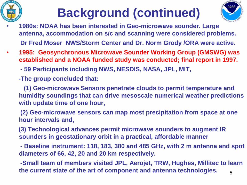
Background (continued)
• 1980s: NOAA has been interested in Geo-microwave sounder. Large
antenna, accommodation on s/c and scanning were considered problems.
Dr Fred Moser NWS/Storm Center and Dr. Norm Grody /ORA were active.
• 1995: Geosynchronous Microwave Sounder Working Group (GMSWG) was
established and a NOAA funded study was conducted; final report in 1997.
- 59 Participants including NWS, NESDIS, NASA, JPL, MIT,
-The group concluded that:
(1) Geo-microwave Sensors penetrate clouds to permit temperature and
humidity soundings that can drive mesoscale numerical weather predictions
with update time of one hour,
(2) Geo-microwave sensors can map most precipitation from space at one
hour intervals and,
(3) Technological advances permit microwave sounders to augment IR
sounders in geostationary orbit in a practical, affordable manner
- Baseline instrument: 118, 183, 380 and 485 GHz, with 2 m antenna and spot
diameters of 66, 42, 20 and 20 km respectively.
-Small team of members visited JPL, Aerojet, TRW, Hughes, Millitec to learn
the current state of the art of component and antenna technologies.
5

Yellow: Available Soundings (No clouds), Red: Not Available (Clouds)
Current GOES IR sounding http://www.orbit.nesdis.noaa.gov/smcd/opdb/goes/soundings/skewt/html/
skewhome.html
Limitations of GOES IR Sounder
6

7
Impact of AMSU on Sounding Retrievals from
NASA’s Aqua Satellite
(a) Atmospheric Infrared Sounder
(AIRS) Cloudy Retrievals
(b) AIRS + AMSU Cloudy Retrievals
Fig. (a-b) Show Sounding Retrievals on May 20, 2006.
- Blue Color Indicates 0% clouds
- White Color indicates absence of valid retrieval due to clouds
- Dark Red indicates clouds
- Dots are markers that show center of FOV.
(courtesy of Bjorn Lambrigtsen / JPL)
GeoSTAR capability will be similar to Fig. b with better refresh rate.
Example: GeoSTAR will refresh every 30 minutes as compared to single
polar orbiting satellite with refresh rate of 12 hours.

Observational Requirements Coverage Spatial
Resolution
Vertical
Resolution
Refresh
Rate
Atmospheric Vertical Temperature CONUS 10 km 1 – 3 km 60 min
Hemisphere 10 km 1 – 3 km 60 min
Atmospheric Vertical Moisture CONUS 10 km 1-3 km 60 min
Hemisphere 10km 1-3 km 60 min
Total Water Content CONUS 25 km - 60 min
Hemisphere 100 km - 180 min
Precipitation Rate CONUS 10 km - 5 min
Hemisphere 10 km - 30 min
Sea Surface Winds Coastal 1 km - 60 min
CONUS/Offshore 10 km - 60min
Hail Detection CONUS 2 km TBD 5 min
Hemisphere 2 km - 15 min
(Sample NOAA User Requirements)
8

NASA’s Decadal Survey Missions 9

Very Large Array (VLA) at National Radio Astronomy Observatory (NRAO)
ESA’s Soil Moisture and Ocean Salinity (SMOS) launched in 2009
Aperture Synthesis Concept in Operation
10

GeoSTAR is an interferometric system Concept -Sparse array employed to synthesize large aperture
-Cross-correlations (Fourier transform of Tb field)
-Inverse Fourier transform on ground (Tb field)
-Optimal Y configuration: 3 sticks; N elements. Each element is one receiver, 3.5 wide (2.1 cm @ 50 GHz, 6 mm @ 183 GHz). Example: N = 100 Pixel = 0.09° 50 km at nadir (nominal) -One “Y” per band.
Technology MMIC receivers
-Receivers off-the-shelf @ < 100 GHz; Chips available
Correlator chips -Chips developed for IIP, some issues remain, development Continues under IIP-10
System -Image reconstruction (Brightness temps from correlations) demonstrated under Proto-type GeoSTAR development
GeoSTAR System Concept
11

• 1998-1999: NASA New Millennium Program (EO-3 mission) - $0.7M
-“GEO/SAMS (Synthetic Aperture Microwave Sounder)” Concept selected for
Phase A: Concept, instrument & mission study was completed.
• 2003-2006: NASA/ESTO Instrument Incubator Program (IIP-03) - $3.0M
-Proof-of-concept prototype: T-sounder operating at 50 GHz
-Technology: 50-GHz MMIC receivers; low-mutual-coupling feed horn array
-Outcome: Successful, proved that STAR concept works.
-OSD: Provided strong Letter of support to Lambrigtsen for his IIP Proposal.
• 2004: NOAA Study of GeoSTAR for Geo/MEO Missions- $100K
• 2007 Decadal Survey: PATH (Precipitation and All weather Temperature
Humidity Mission) is Selected as one of the Missions by NRC.
• 2007: NOAA GeoSTAR Assessment study – ($150K)
JPL GeoSTAR development and Current Status
12

• 2008-2011: NASA Instrument Incubator Program (IIP-07) - $3.6M + NOAA
funding ($750 K)
-Develop technology required for q-sounding at 183 GHz (subsystems only)
-Technology: 183-GHz MMIC receivers; alias-rejecting antenna array; ASIC
correlator & digitizer
-Outcome: Successful (except for ASIC correlator)
• 2011-2014: NASA Instrument Incubator Program (IIP-10) - $4.5M
-Develop all elements required for “GeoSTAR-full” (PATH mission)
-Fully functional q-sounder with flight-like ASIC correlator
-Technology: All elements brought to near TRL 6, ready for PATH implementation
- OSD: Provided strong Letter of Support to Bjorn Lambrigtsen for his proposal.
•Status of GeoSTAR Technology in 2011
-Receivers & antenna: Ready to implement for all bands, all near TRL 6
-Correlator: Ready to implement with FPGA (per feasibility study), at TRL 6;
Swedish ASIC correlator, now being tested, may be substituted when ready TRL 6
-Mass, power, volume: Moderately low estimates per Team-X studies
-Summary: Ready to implement “GeoSTAR-lite” (PATH precursor/demonstrator)
JPL GeoSTAR development and Current Status (contd.)
13

• Objectives – Technology risk reduction
– Develop system to maturity and test performance
– Evaluate calibration approach
– Assess measurement accuracy
• Small, ground-based – 24 receiving elements - 8 per Y-arm
– Operating at 50-55 GHz
– 4 tropospheric AMSU-A channels: 50.3 - 52.8 - 53.71/53.84 - 54.4 GHz
– Implemented with miniature MMIC receivers
– Element spacing as for GEO application (3.5 )
– FPGA-based correlator
– All calibration subsystems implemented
GeoSTAR Prototype Development
14

DRO
25.15 GHz
4-w
ay P
ower
Div
ider
8-w
ay P
ower
D
ivid
er Radiometers
1 - 8
8-w
ay P
ower
D
ivid
er8-
way
Pow
er
Div
ider
Radiometers
9 - 16
Radiometers
17 - 24
+10 dBm
-2 dBm+8 dBm
-7
-10
Frequency
from QNX PC
(Optical Isolated)
Serial
RS 232
Phase Control
from CIB
DC Power
+5V, 150 ma
9
Phase
ShifterAmp
-1
Phase
ShifterAmp
-1
Phase: 0, 45, 90, 135 TP
Phase
ShifterAmp
Agilent 8247
Freq Synthesizer
25-27 GHz
DC Power
+15V, 100 ma
2
2
Alternate LO source
Compact receivers
Low-power MMICs
LO phase switching system: Ultrastable operation
Correlator:
• Efficient
• Redundant
• OK for ASICs
Feedhorns:
Low mutual
coupling
Innovative array layout
STAR concept and key technologies developed & tested
First images
at 50 GHz
by aperture
synthesis
GeoSTAR Prototype Development
15

The image of NOAA Team at JPL
April 20, 2006, taken by proto-type GeoSTAR
Bajpai Dittberner
Adang
From Left: Shyam Bajpai, Gerry Dittberner, Tom Adang is seen in part, he is out of field of view
16

NOAA Geo-STAR
Users Working Group
17
• A NOAA Working Group on Geostationary Microwave Soundings was
established in 2010 with members from STAR, NHC, NWS/ST, OSD,
and GOES-R.
• The Working Group meets periodically to discuss the requirements and
benefits of GeoSTAR, assess development progress, and determine what
further steps are needed to continue development and implementation of
GeoSTAR at NOAA.
– As a result of a July 2010 mid-term progress review in Silver Spring,
the Group recommended the following steps for the final (3rd) year of
the current GeoSTAR IIP effort by JPL
• Potential impacts on NWP and hurricane intensity forecast using OSSE’s
• Better understanding of instrument specifications (NEDT, Spectral
coverage…)
• Validation of GeoSTAR’s precipitation and cloud parameter capabilities by
testing STAR’s microwave – only retrieval systems.

GeoSTAR Applications and Benefits
to NOAA Operational Services
The Geo-STAR Users Working Group determined that GeoSTAR
will benefit the following applications:
• Tropical Cyclone Center Location
• Tropical Cyclone Structure Determination
• Microwave-based Intensity Estimates
• CIMSS SATCON Technique
• Rainfall Analysis and Forecasting
• Severe Local Storm Forecasting
• All Weather Temperature and Humidity Soundings
18

Example of expected performance from GeoSTAR
Brightness Temperature Images at 183±7 GHz
Left: At full WRF (Weather research Forecast Model) spatial resolution (1.3 km)
Right: At GeoSTAR spatial resolution (25 km) (Horizontal axis in the units of 1.4 km, vertical axis in the units of 1.33 km)
19
20

Conclusions and Potential Next Steps
• Conclusions – In past 10 years, the GeoSTAR instrument has matured from a
concept to a capability ready for space demonstration
– Technology similar to GeoSTAR is flying on ESA’s SMOS polar-
orbiting sun-synchronous research satellite
– NOAA has partnered with NASA and JPL on GeoSTAR at nearly
every stage of its development
• Next Steps- As a precursor to the Decadal Survey recommended
PATH mission (Tier III – several years away):
– Bjorn Lambrigtsen/JPL plans to submit a proposal under NASA
Earth Ventures Instrument Announcement of Opportunity for an
early pathfinder demonstration of GeoSTAR
– JPL is requesting partnership where NOAA might contribute in the
areas of both science and ground activities including data
processing, product generation, and archiving.
– This is an excellent opportunity for NOAA/NESDIS to form a
partnership with JPL for the demonstration Mission!
21