Embed Size (px)
Citation preview
le Reply Refer To: RP-?-!
Huffco Petroleun Corporation Attention: Nr. Donald B. Holt Pott Office Box 4436 Houston. Texas 77210
Gentlemen:
Reference 1s cede tc your Supplemental Plan of Exploration received January 30. 1986. for Lease OCS-G 4436. Block 234. South Harsh Island Area. This plan includes the activit ies proposed for Wells C. 0. end E.
In accordance with 30 CFR 250.34. revised December 13. 1979. and our letter dated January 29. 1979. this plan has oeen determined to be complete as of February 6. 1986. eed Is now being considered for approval.
Tour plan control number S-1791 am should be referenced In year communication and correst onco conceming this plan.
rinccre1y yours.
(Orig. Sgd.) A. Donald Giroir
Acting Regional Supervisor Rules and Production
bcc: ,Letse OCS-G 4436 (OPS-3-2) (FILE ROOM) ( 0PS-2-4_*/Eublic, Info. Copy of the plan (Pull.REC.)
MJTo1bert:gcw:2/?/86 Disk la
T'^ram Btrvlcfc
Information Servicei
HUFFCO PETROLEUM CORPORATION W W HAMA
PO BOX 4438 HOUSTON, TEXAS 77210
January 14, 1 r 6 T t l l « ? « • » »
• * W « S t»*«ACEME«T U.S. Oepartment o f the I n t e r i o r Minerals Management Serv ice P.O. Box 7944 Me ta i r i e , Louis iana 70002
J M 3 0 1986
Attention: Regional Supervisor Rules and Production
CMC*
RE: OCS-G 4436, Block 234 South Marsh Is land Area Supplemental Plan of Exp lo ra t ion
Gentlemen:
In accordance with 30 CFR 250.34, as amended, Huffco Petroleum Corporation herein respectfully submits for your approval, a Supplemental Plan of Exploration for lease OCS-G 4436, Block 234, South Marsh island Area, Offshore, Louisiana.
Huffco Petroleum corporation submits ten (10) copies nf T. ie proposed Supplemental Plan of Exploration. Six (6) copies are considered Proprietary Information and are exempt from disclosure as allowed for in subsection (b) paragraph (9) of the Freedom of Information Act (81 Stat. 54; U.S.C. 552) as amended by Public Law 93-502, November 21, 1974, (88 Stat. 1561). Four copies are considered "Public Information". The information believed to be exempt is geological and/or geophysical. As Operator of this lease, Huffco Petroleum Corporation requests that this information and data considered to be exempt be dispensed for use only by the U.S. Government.
Thank you for your consideration in this matter. I f further information is required, please contact the undersigned at your earliest convenience.
Operations Manager
DBH/JAC/kg
Enclosures ll Public
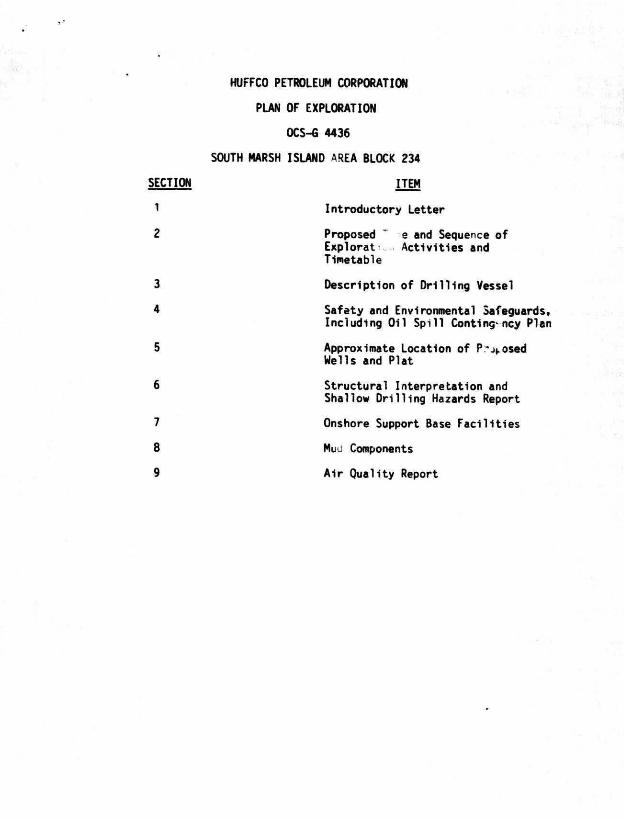
HUFFCO PETROLEUM CORPORATION
PLAN OF EXPLORATION
OCS-G 4436
SOUTH MARSH ISLAND AREA BLOCK 234
SECTION ITEM
1 Introductory Letter
2 Proposed T e and Sequence of Explorat Ac t i v i t ies and Timetable
3 Description of D r i l l i ng Vessel
4 Safety and Environmental Safeguards, Including Oi l Sp i l l Contingency Plan
5 Approximate Location of P r o s e d Wells and Plat
6 Structural Interpretat ion and
Shallow Dr i l l i ng Hazards Report
7 Onshore Support Base Fac i l i t i es
8 Muu Components
9 A i r Quality Report
PLAN OF EXPLORATION
OCS-G 4436
PROPOSED TYPE AND SEQUENCE OF EXPLORATION ACTIVITIES AND TIMETABLE
Section 2
Huffco Petroleum Corporation proposes t< Supplemental Plan of Exploration to d r i l l three additional wells on South M^rsh Island Block 234 to further evaluate the subject lease to determine the potential for future development.
Exploratory d r i l l ng of the f i r s t well is scheduled tc commence approximately February 21, 1986, subject to the approval of this Plan of Exploration and issuance of the required Permit to D r i l l . Exploratory dr i l l i n g should be completed by July 6, 1986.
I t should be emphasized that this schedule is tentative in the meaning of 30 CFR 250.34-l(a). Additional exploratory d r i l l i n g must be predicated upon the need to define structures and/or reservoir limits. The fabrication and installation of platforms, producing f a c i l i t i e s and pipelines are contingent upon the success of the r wells. In addition to the dr i l l i n g of wells, other activities which may bt conducted under this plan would be the setting of caissons or a template over temporarily abandoned wells, a velocity survey in a wellbore and soil borings.
PLAN OF EXPLORATION
OCS-G 4436
DESCRIPTION OF DRILLING VESSEL
Section 3
The water depth in South Marsh Island Block 234 approximately 15 to 20 feet.
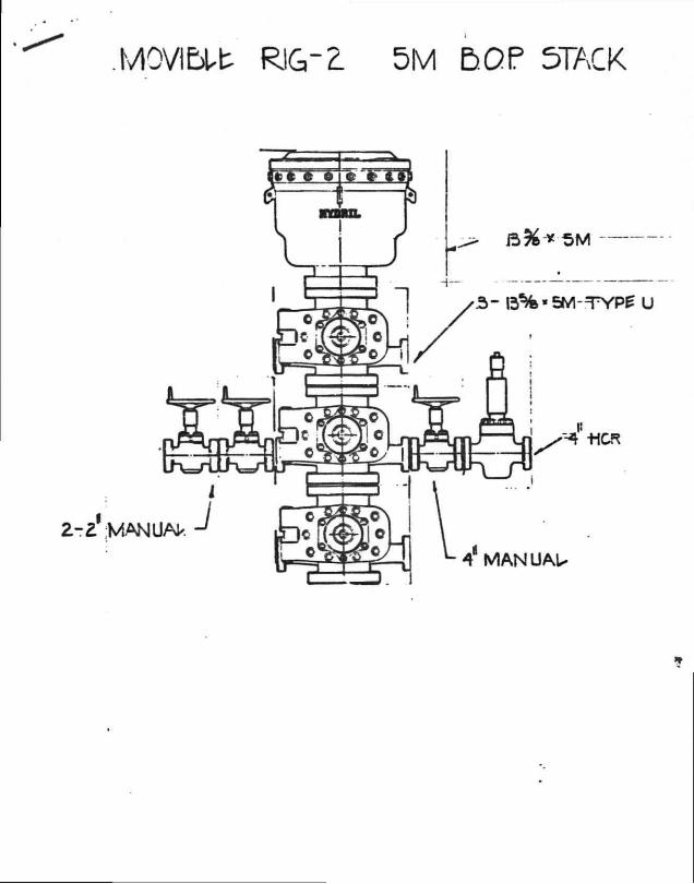
A submersible rig similar to the "Teledyne Movlble Rig 2" will be utilized for exploratory drilling. A description of the rig, including the diverter system Is included in this section.
I
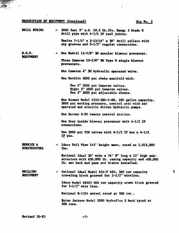
magna OF WBQBBSL i£&naa& Elf, Wo. 2
DRILL mXHC
B.O.P. EQUIPMENT
DERRICK ft SUBSTRUCTURE
DRILLING EQUIPMENT
- 2000 feet 3" o.d. 19.S l b . / f t . Range 3 Grade G d r i l l pipe vith 4-1/2 IP tool joint*.
Twelve 7-1/4" x 2-13/16- x 30' d r i l l col lar* w i t h l i p grooves and 5-1/2" regular connections.
- On* Budr l l 13-5/8" SH annular blowout preventer.
Thro* Cameron 13-5/8" SH Typo V aingle blowout fitiaatan.
Ont Csmeron 4" SH hydraulic operated valve.
One Movible 5000 pal choke Manifold with:
Two 4" 5000 pal Cameron valves. Eight 2" 5000 pal Cameron valves. Two 2" 5000 pal adjustable chokes.
Ono Koomey Model T222-2BD-1-6H, 180 gallon capacity. 3000 pal working pressure, cont ro l unit wi th a i r operated and e lec t r ic driven hydraulic pumps.
One Koo.uey S-80 remote control station.
On* Gray inside blowout preventer with 4-1/2 ZP connections.
Two 5000 pal TZV valves with 4-1/2 IP box x 4-1/2 IP pin.
Ideco Pull View 143' height twist, rated at 1.015,000 lb*.
National Ideal 30' wide x 76* 8" long x 13* high »ub-•tructur* with 650,000 lb. casing capacity and -4)0,000 lb. tet beck aud pan* and drain* Installed.
National Ideal Model 654-P 450, 500 ton capacity traveling block grooved for 1-1/2" wireline.
Ideco Model 46503 560 ton capacity crown block grooved for 1-1/2" wire l ine.
National H-1324 swivel rated at 500 tor...
Byron Jackson Hodel 5500 Hydroflex 5 hook rated at 500 tons.
Bevlsed 10-93 • 7 -
MOVl&Ut RIG" 2. 5M BOP 5TACK
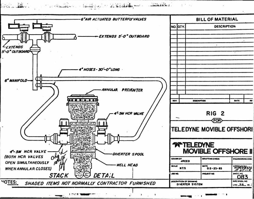
6"AIR ACTUATED BUTTERFLY VALVES
EXTENDS 50" OUTBOARD
4"-5M NCR VALVE
(BOTH HCR VALVES
OPEN SIMULTANEOUSLY /I
WHEN ANNUL A R CLOSES)
STACK
NO. Q7Y. DESCRIPTION
BILL OF MATERIAL
MV •ATI M
RIG 2 <FOR>-
TELEDYNE MOVIBLE OFFSHORI
^TELEDYNE MOVIBLE OFFSHORE II
JRLE D
NTS.
ORAMlMOCMKa
02-23-63
I M M U W O C M I
I M I T N O
083. 'PTES: SHADED ITEMS NOT NORMALLY CONTRACTOR FURNISHED DIVERTER SYSTEM
IMXXMO
MW. MA _ K
PLAN OF EXPLORATION
OCS-G 4436
SAFETY AND ENVIRONMENTAL SAFEGUARDS
Section 4
Safety features during d r i l l i n g operations w i l l include well control and blowout prevention equipment that meets or exceeds the requirements of OCS Order No. 2.
011 in any form shall not be disposed of into the waters of the Gulf.
Liquid waste materials containing substances which may be harmful to aquatic l i f e or wildlife, or injurious in any manner to l i f e or property shall be treated to avoid disposal of harmful substances into the waters of the Gulf.
Drilling muds containing o i l are not disposed of int., the Gulf. This type of material 1s loaded and barged to shore for proper disposal. Drilling mud containing toxic substances is neutralized prior to disposal.
Drill cuttings, sand and solids containing o i l are not disposed of into the Gulf, unless the o i l has been removed.
The subject offshore mobile d r i l l i n g unit is equipped with drip pans under the rig floor. All o i l from diesel engines is pumped to a sump and then pumped into barrels for return to an onshore site.
Operator personnel are instructed in the techniques and methods necessary to pi event pollution. Non-operator personnel are instructed and supervised to insure that non-pollutlon practices are adhered to.
The facilities are inspected daily.
OIL SPILL CONTINGENCY PLAN
Huffco Petroleum Corporation's Oil Spill Contingency Plan has been approved by the Minerals Management Service. This plan designates an Oil Spill Team consisting of Huffco Petroleum Corporation personnel and contract personnel. This team s duties are to eliminate the sources of the o i l s p i l l , remove all sources of possible ignition, deploy the most viable means of available transportation to monitor the movement of the slick, and contain and remove the slick 1f possible.
Huffco Petroleum Corporation is a member of Clean Gulf Associates (CGA). The CGA has 4 permanent bases 1n Louisiana; at Venice, Grand Isle, Intracoastal City and Cameron, and two bases in Texas; at Galveston and Rockport. Each base is equipped with fast response skimmers and there is a barge mounted high volume open sea skimmer based at Grand Isle. In addition to providing equipment, the CGA also supplies advisors for clear, up operations.- Response time for a s p i l l in South Marsh Island Block 234 would be epproximately 4 hours depending upon the location of company operated workboats or workboats available for charter.
PLAN OF EXPLORATION
OCS-G-4436
APPROXIMATE LOCATION OP PROPOSED WELLS AND PLAT
Section 5
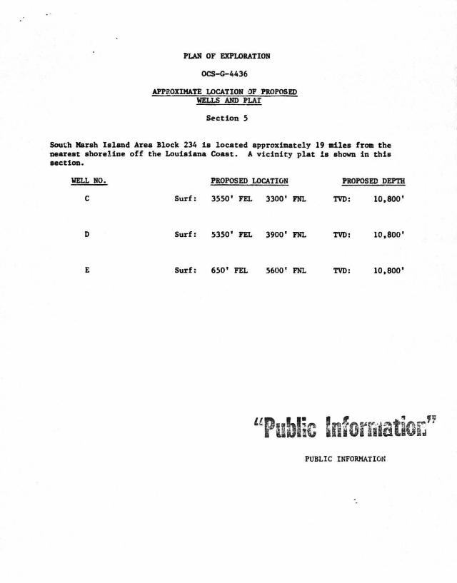
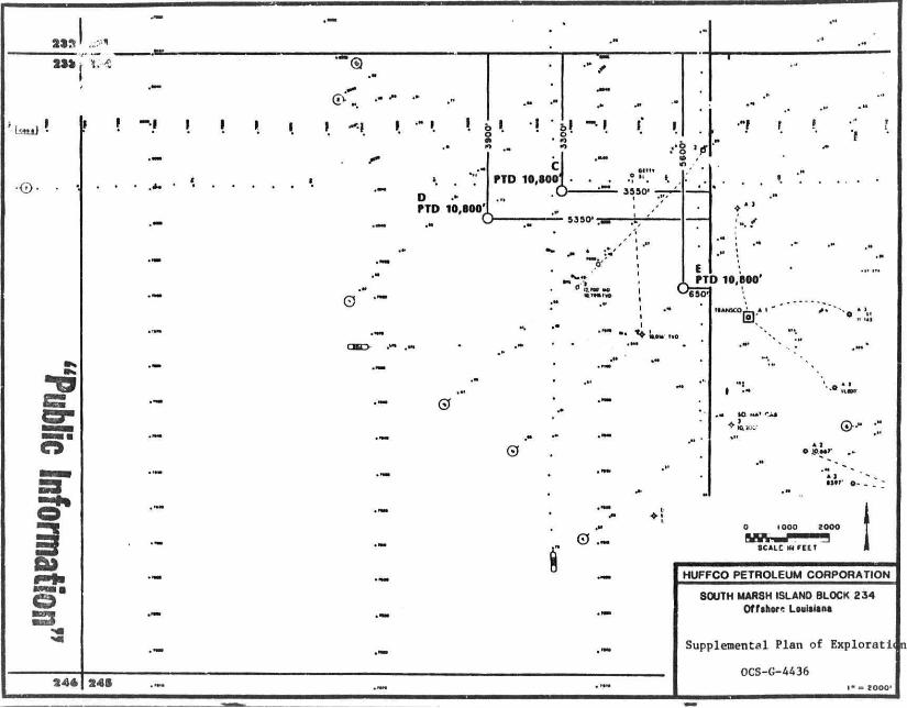
South Marsh Island Area Block 234 i s loceted approximately 19 miles from the nearest shoreline o f f the Louisiana Coast. A v i c i n i t y p l a t Is shown i n thi s section.
WELL NO. PROPOSED LOCATION PROPOSED DEPTH
C Surf: 3550' FEL 3300' PNL TVD: 10,800'
Surf: 5350' PEL 3900' FNL TVD: 10,800'
Surf: 650' FEL 5600' FNL TVD: 10,800'
' Public biforriiati PUBLIC INFORMATION
f ban}
•O
5
3 4 4
I I I I
fTD 10,800'
0 -
0
2 4 8
SOUTH MARSH ISLAND BLOCK 234 Offshore Louisiana
Supplemental Plan of Exploratii n
0CS-G-4436
PLAN OF tXPLORA'. ION
OCS-G 4436
STRUCTURAL INTERPRETATIONS AND SHALLOW HAZARDS REPORT
Section 6
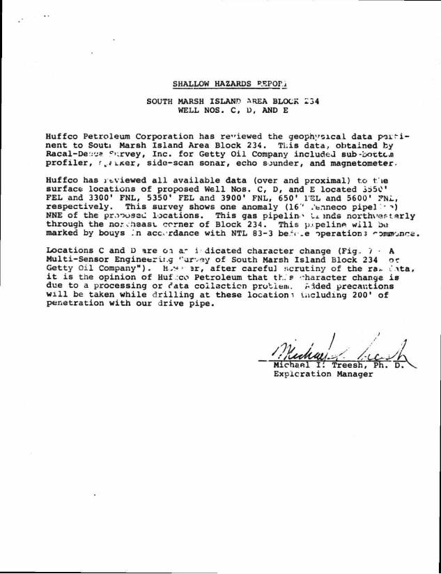
SHALLOW HAZARDS PSPOr.i
SOUTH MARSH ISLAND AREA BLOCK *34 WELL NOS. C, D, AND E
Huffco Petroleum Corporation has re"iewed the geophysical data p o i ' f i -nent to Souti Marsh Island Area Block 234. Tl.is data, obtained by Racal-De':'j* c»;rvey. Inc. f o r Getty O i l Company included sub-boctcn p r o f i l e r , r,.fLJier, side-scan sonar, echo sounder, and magnetometer.
Huffco has J cviewed a l l available data (over and proximal) to t ie surface locations of proposed Well Nos. C, D, and E located 3/55C FEL and 3300' FNL, 5350' FEL and 3900' FNL, 650' I'EL and 5600' 7UL, respectively. This survey shows one anomaly (16'' .'t.ineco pipel '* "») NNE of the pr.-)oussu locations. This gas pipeline Li. mds n o r t h v a r t a r l y through the no; ..least corner of Block 234. This p.« pelin« w i l l bo marked by bouys .'n accordance with NTL 83-3 be.S _e operations «• Mseonce.
Locations C and D i r e o i a- indicated character change (Fig. 7 • A Multi-Sensor Engineering ''urv?y of South Marsh Island Block 234 or Getty O i l Company"). H ,*•» • ?r, a f t e r careful scrutiny of the ra*. . \ t a , i t i s the opinion of Huf ,:co Petroleum that tr.. P "haracter change i s due to a processing or rata c o l l e c t i o n problem, ^ided precautions w i l l be taken while d r i l l i n g at these locations including 200* of penetration w i t h our drive pipe.
Expicration Manager
PLAN OF EXPLORATION
0CS-G--4436
OI SHORE SUPPORT BASE FACILITIES
Section 7
Huffco Pen-oleum Corporation - . • i l l use existing onahore base f a c i l i t i e s loceted et Freshwater City Offshore t t Anal loceted approximately 10 miles east of Kaplan, Louisiana. This w i l l serve as port of debarkation for supplies and crews. No onshore expansion or construction i s anticipated with respect to this acti-'ity.
This base is capable of providing the services necessary for proposed a c t i v i t i e s I t has 24-hour ?«rvlco, a radio t.wer with phone patch, dock < J ce equipment arid supply storage base, drinking ar J i- '.11 water, etc.
rUN OF EXPLORATION
OCS-6 4436
MUD COMPONENTS
Section 8
i
t
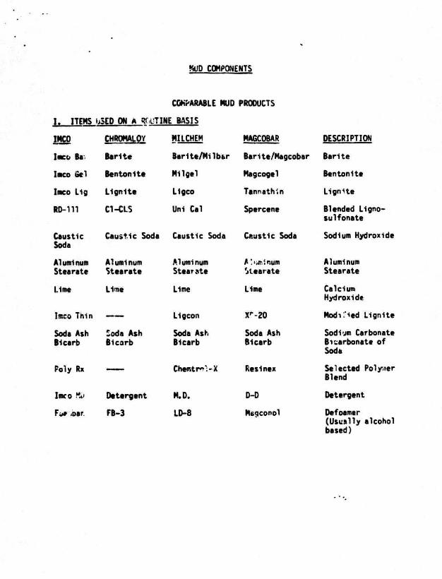
MUD COMPONENTS
COMPARABLE MUD PRODUCTS
1. ITEMS uSCD ON A Rf-uTINE BASIS
IMCO
IMCO Ba
IMCO Sel
Imco Lig
RD-111
Caustic Soda
Alumi num Staarate
Lime
Imco Thin
Soda Ash Bicarb
Poly Rx
IBKO Ky
Fur 4>ar.
CHROMALOY
Barite
Bantonltt
Lignite
C1-CLS
MILCHEM MA6C0BAR
Barlte/Milbar Barita/Magcobar
Milgel
Ligco
Uni Cal
Aluminum Staarate
Lima
Soda Ash Bicarb
Detergent
FB-3
Aluminum Stearate
Lime
Ligcon
Soda Ash Bicarb
Chentr»VX
M.D.
LD-8
Magcogel
Tannathin
Spercene
Caustic Soda Caustic Soda Caustic Soda
A !'iminum Stearate
Lima
Xr-20
Soda Ash Bicarb
F.esinex
D-D
Maqconol
DESCRIPTION
Barite
Bentonlte
Lignite
Blended Lignosuifonate
Sodium Hydroxide
Aluminum Stearate
Calcium Hydroxide
Modi"."*ed Lignite
Sodium Carbonate Bicarbonate of Soda
Selected Polymer Blend
Detergent
Defoamer (Usually alcohol based)
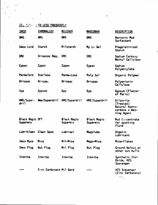
I I . !»'.* • 'ED LESS FREQUENTLY
IMCO CHROMALLOY MILCHEM MAGCOBAR
DMS DMS DMS DMS
l aco Loid Starch Mil starch My Lo Gal
CMC Dnoscos Reg. CMC CMC
Cypan Cypan Cypan Cypan
Permaloid Star lose Perma-Lose Poly Sal
Drispac Drispac Drispac Drispac
Gyp Gypsum Gyp Gyp
HME/Super- Hme/SuperdHl HME/Superdril HME/Superdril dnl
Black Magic DFT Supermix
Black Magic Black Magic Supermix Supermix
Lubrikleen Clean Spot Lubrisal Magolube
Imco Myca Mica Mil-Mica Mago-Mica
Imco Plug Nut Plug Mil Plug Nut Plug
Ironite Ironite Ironite Ironite
Zinc Carbonate Mil Card
DESCRIPTION
Nonionic Mud Surfactant
Pregelatinlzed Starch
Sodium Carboxy Methyl Cellulose
Sodium Polyacrylate
Organic Polymer
Polyanionin Cellulose
6ypsum (Plaster of Pans)
Gilsonlte (Treated) Natural Hydrocarbons • Watting Agent
Mud Concentrate for spotting fluid
Organic Lubricant
Mica-Flakes
Ground Walnut or othar nut hulls
Synthetic Iron Oxide. H2S Scavenger
H?S Scavenger (Zinc Carbonate)
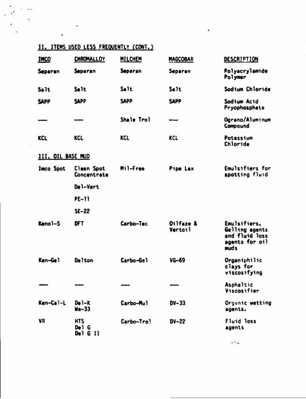
I I . ITEMS USED LESS FREQUENTLY (CONT.)
IMCO
Separan
Salt
SAPP
KCL
CHROMALLOY
Separan
Salt
SAPP
KCL
I I I . OIL BASE MUD
IMCO Spot
Kenol-S
Ken-Gel
Clean Spot Concentrate
Dal-Vert
PE-11
SE-22
DFT
Da Hon
Ken-Cal-L Del-K Wa-33
VR HTS Dal G Del G II
MILCHEM
Separan
Salt
SAPP
KCL
Mil-F ree
Carbo-Tec
Carbo-Gel
Carbo-Mul
Carbo-Trol
MA6C0BAR
Separan
Salt
SAPP
Shale Trol
KCL
Pipe Lax
011faze & Vertoll
VG-69
DV-33
DV-22
DESCRIPTION
Polyaery1amide Polymer
Sodium Chloride
Sodium Acid Pryophosphete
Ograno/Aluminum Compound
Potassium Chloride
Emulslfiers for spotting fluid
Emulslfiers. Gelling agents and fluid loss agents for oil muds
Organiphilie clays for vlscosifylng
Asphaltic Viscosifier
Organic wetting agents.
Fluid loss agents
4 ilii HiliMlllinil!
P.O. Box 218753 Houston, Texas 77218 713-558-0607
January 20, 1986
PROJECTED AIR EMISSION SCHEDULE FOR SUPPLEMENTAL EXPLORATION PROJECT
GENERAL INFORMATION
Location of Fac i l i t y :
Distance Offshore: Name of Rig/Platform: Operator:
Contact Person: Total Well Footage to be D r i l l ed : Total Well Footage to be Dr i l l ed in 1985! Date Dr i l l i ng Wil l Begin: Date Dr i l l i ng Wil l End:
South Marsh Island 234 OCS-G-4436 19 miles Submersible Huffco Petroleum Corporation P. 0. Box 4436 Houston, Texas 77210 Barbara Dougherty 32,400' 32,400' February 21, 1986 July 6, 1986
MAJOR SOURCE (OFFSHORE)
Power used aboard drilling vessel; approximate footage to be drilled 32,400'.*
Emitted Substance
CO
so, NOX VOC TSP
Projected Emissions (lbs/day*»tons/year]
( 95) 6.42 ( 30) 2.04 (446) 30.13 ( 36) 2.43 ( 32) 2.14
Based on 60 hphr / f t . from Table 4-3, "Atmospheric Emissions from Offshore Oil and Gas Development and Production", EPA No. 450/3-/7-026, June 1977.
** Emission factors from Table 3 .3 .3 -1 , "Compilation of A i r Pollutant Emission Factors", Third Ed i t ion , EPA Report AP-42, August 1977.
Projected Air Emissions South Marsh Island 234 Huffco Petroleum Corporation Page 2
MINOR SOURCES (OFFSHORE)*
Including helicopter landing and take-off (7 trips/week); supply boat (7 trips/week) and crew boat (4 trips/week); loading and unloading operations.
Projected Emissions (tons/year)
Emitted Substance
CO
mi VOC TSP
.78
.02
.17
.08
.03
* Tables 3.2.1-3, 3.2.3-1, and 2.1, "Compilation of Air Pollutant Emission Factors", Third Edition, EPA Report AP-42, August 1977.
TOTAL ALL SOURCES (TONS/YEAR)
1985 CO so2 NOX VOC TSP
Major 6.42 2.04 30.13 2.43 2.14 Minor .78 .02 .17 .08 .03
Total 7.20 2.06 30.30 2.51 2.17
ONSHORE SOURCES
These should be about the same as minor sources unless new facilities are installed at the onshore base. No additional facilities are required or planned at this time.
EMISSION EXEMPTION DETERMINATION
For CO: E = 3400D2/3 = 3400 (19) 2 / 3 = 24,209 Tons/Year For NOX, VOC, TSP & S02: E = 33.3D = 33.3 (19) = 632.7 Tons/Year
As per DOI/MMS regulations, this facility is exempt from further air quality review as i t has been determined that its operations will not have a significant adverse environmental impact on air quality.


![Aunts Aren't Gentlemen[1]](https://img.pdfslide.us/doc/110x75/577cb4a21a28aba7118c9727/aunts-arent-gentlemen1.jpg)