Embed Size (px)
Citation preview
Genesis of Adjacent Morphologically Distinct Soils in Northwest FloridaN. E. WASHER* AND M. E. COLLINS
ABSTRACTIn northwest Florida plinthitic soils commonly form adjacent to
well-drained, nonplinthitic soils on the same landform. Differencesin these soils are related primarily to natural drainage. The hy-pothesis that a lithological discontinuity occurred below the plinthichorizon in the plinthitic soils was proposed and tested: strata belowthe discontinuity impeded drainage through the soils, causing plin-thite to form. Properties of three plinthitic soils and one nonplin-thitic soil from the East Pittman Creek watershed were comparedto test this hypothesis. Pedologically significant differences in mor-phology (e.g. consistence, color, and texture), clay-free silt content,and fine sand content as a percentage of total sand content wereobserved between plinthic and 1C horizons and between the plin-thitic and nonplinthitic soils. Three distinct strata were identifiedusing the principle of random association. Anomalously high clay,iron, and phosphorus contents in the horizons above the 2C horizonsand the laminar ironstone at the boundary between the Btv and 2Chorizons indicated that the lower stratum impeded water movement.In conclusion, a pedologically significant lithological discontinuitydoes exist in the soils in East Pittman Creek watershed.
Additional Index Words: plinthite, Paleudults, pedostratigraphy.
JUXTAPOSITION of morphologically distinct soils innorthwest Florida, such as Plinthic and Typic Pa-
leudults, has been observed without explanation orhas been attributed to random parent material vari-ability. Because the distinct soil morphologies of thesetwo subgroups imply different genetic pathways, theappearance of morphologically distinct soils formingunder very similar conditions should be regarded asanomalous. Yet, this anomaly occurs widely in north-west Florida as suggested by the research of Carlisleand Zelazny (1974, 1976), Dantzman and Caldwell(1967), and Caldwell and Dantzman (1967) as well asin the soil survey (Sullivan, 1975) of the area.
Red Typic Paleudults are commonly observed ad-jacent to Plinthic or Arenic Plinthic Paleudults withyellowish-brown sola and mottled plinthic horizons.Although both subgroups are considered well drained,the plinthitic soils have some restriction to watermovement. While this may appear to explain the dif-ferences in soil morphologies, the reason for the dif-ferent drainages remains unknown.
Of the soil-forming factors (Jenny, 1980), parentmaterial and relief are most likely to vary among thesesoils. Drainage could vary according to the edge effect(Daniels and Gamble, 1967) by which position of asoil relative to the summit center controls its drainage.The edge effect can be avoided by sampling represen-tative soils at the same relative landscape position.
Parent material is the other likely variable. Possiblesoil parent materials in northwest Florida include lat-erally and vertically variable materials such as the Ci-
Soil Science Dep., G-159 McCarty Hall, Univ. of Florida, Gaines-ville, FL 32611. Contribution of the Inst. of Food and AgriculturalSciences, Univ. of Florida, Florida Agric. Exp. Stn. Journal no. 7636.Received 6 Oct. 1986. ""Corresponding author.
Published in Soil Sci. Soc. Am. J. 52:191-196 (1988).
tronelle Formation (Matson, 1916) as well as poorlydenned marine (Cooke, 1945) and stream (Vernon,1942) terrace deposits. Vertical variability would ap-pear as discontinuities in soils in which contrastingstrata are superposed. Lateral variability would causesome soils to exhibit contrasting strata while nearbyones do not.
The hypothesis proposed and tested here is that lith-ologic variability created different pedogenetic con-ditions. These discontinuities are present in the plin-thitic soils and are absent in the nonplinthitic soils inthe area. This lithological discontinuity separates theupper, permeable materials from underlying, lesspermeable strata. Plinthite forms just above the con-tact between the two materials.
This hypothesis was tested in a representative wa-tershed in Holmes County, in the central part ofnorthwest Florida. Properties of three plinthitic andone nonplinthitic soils were compared to determinewhether they formed in uniform parent materials andhow the presence of a discontinuity could allow plin-thite to form in these soils.
MATERIALS AND METHODSDescription of the Study Area
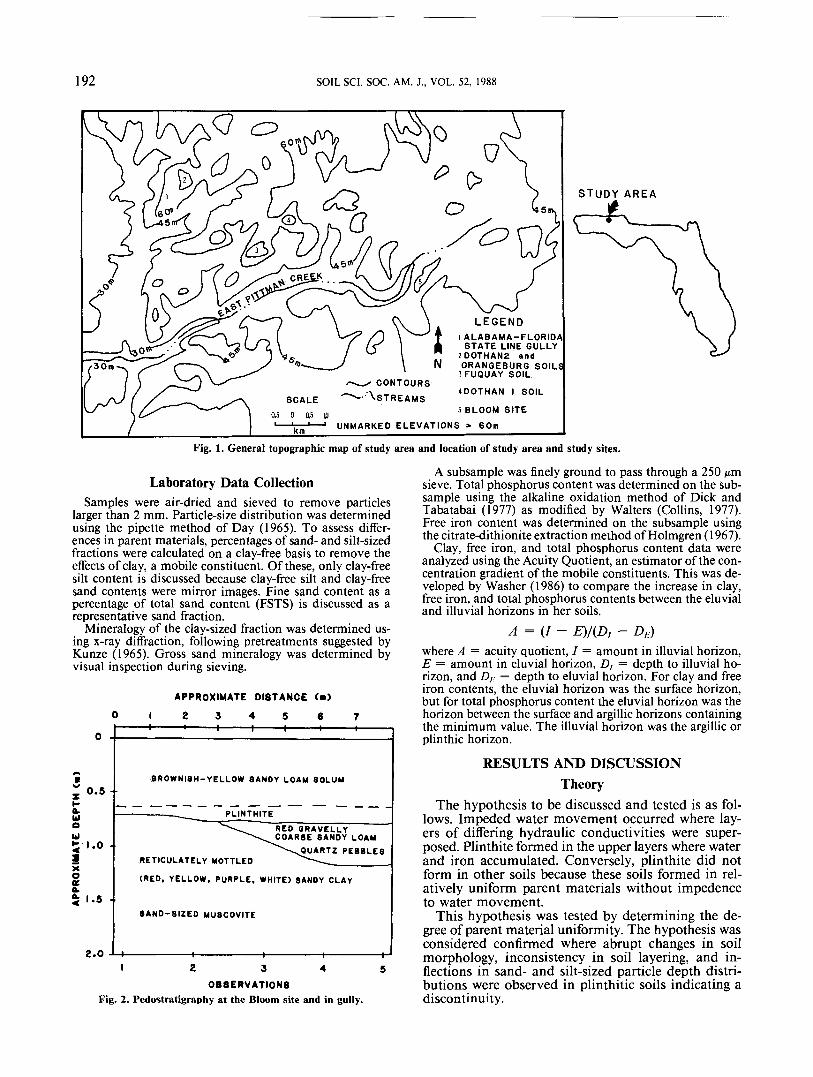
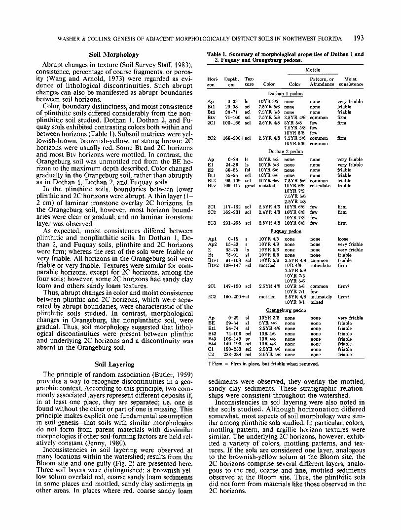
The study area, East Pittman Creek watershed, is locatedin north central Holmes County in northwestern Florida(Fig. 1). The climate is humid, warm temperate, with a meanannual temperature of 19.5 °C and a mean annual rainfallof 1524 mm.
The landscape is dissected by East Pittman Creek and itstributaries. The geology of the area has not been systemat-ically studied, resulting in contradictory speculation on sed-imentary origins, ages, and corresponding geomorphic sur-faces. Thus, sediments have been described as fluvial(Vernon, 1942), marine (Cooke, 1945; Sullivan, 1975), anddeltaic (Alt, 1974), with corresponding geomorphic surfacesof stream terrace, marine terrace, or alluvial fan. Proposedages range from Oligocene (Doering, 1960) to Pleistocene(Cooke, 1945; Vernon, 1942).
In the watershed, soils on upland, freely drained surfacesare primarily Paleudults. Most soils on summit and back-slope landscape positions are Plinthic Paleudults (Dothanor Tifton series), Arenic Plinthic Paleudults (Fuquay series),or Typic Paleudults (Faceville or Orangeburg series) (Sulli-van, 1975). Plinthitic soils and nonplinthitic soils are com-monly observed on the same summit.
Field Data CollectionFour pedons were selected for study on representative
summits with <2% slopes (Fig. 1) comprising Plinthic, Ar-enic Plinthic, and Typic Paleudults. The edge effect (Danielsand Gamble, 1967) was avoided by selecting sites on thesame part of the summit relative to the center—the areabetween the shoulder and the center.
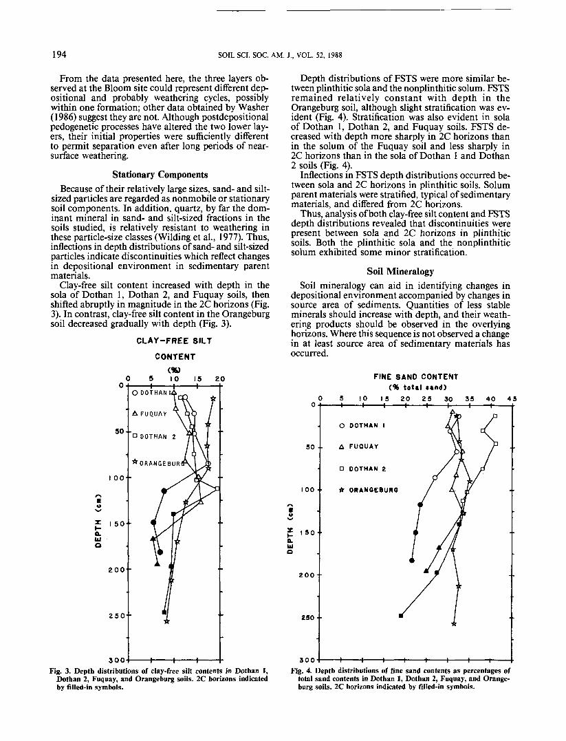
A loamy, siliceous, thermic Arenic Plinthic Paleudult (Fu-quay series); fine-loamy, siliceous, thermic Plinthic Paleu-dults (Dothan series) at two sites; and a fine-loamy, sili-ceous, thermic Typic Paleudult (Orangeburg series) weresampled and described according to Chapter 4 of the SoilSurvey Manual (Soil Survey Staff, 1981). Layering of soilmaterials was observed by constructing an auger transect atthe Bloom Site (Fig. 2).
191
192 SOIL SCI. SOC. AM. J., VOL. 52, 1988
STUDY AREA
1 ALABAMA-FLORIDASTATE LINE GULLY
2DOTHAN2 andORANGEBURG SOILS
3FUOUAY SOILCONTOURS
'^STREAMS 400THAN I SOIL5 BLOOM SITE
UNMARKED ELEVATIONS > 60m
Fig. 1. General topographic map of study area and location of study area and study sites.
Laboratory Data CollectionSamples were air-dried and sieved to remove particles
larger than 2 mm. Particle-size distribution was determinedusing the pipette method of Day (1965). To assess differ-ences in parent materials, percentages of sand- and silt-sizedfractions were calculated on a clay-free basis to remove theeffects of clay, a mobile constituent. Of these, only clay-freesilt content is discussed because clay-free silt and clay-freesand contents were mirror images. Fine sand content as apercentage of total sand content (FSTS) is discussed as arepresentative sand fraction.
Mineralogy of the clay-sized fraction was determined us-ing x-ray diffraction, following pretreatments suggested byKunze (1965). Gross sand mineralogy was determined byvisual inspection during sieving.
APPROXIMATE DISTANCE (m)
0 I 2 3 4 5 6 7
0.5 •
a.UI
Ul
Xott1.6
2.0
4-t-
BROWNISH-YELLOW SANDY LOAM SOLUM
PLINTHITE
*ETICULATELY MOTTLED
RED GRAVELLYSANDY LOAM
PEBBLES
(RED, YELLOW, PURPLE. WHITE) SANDY CLAY
SAND-SIZED MUSCOVITE
-«- -»- -i-I 2 3 4
OBSERVATIONSFig. 2. Pedostratigraphy at the Bloom site and in gully.
A subsample was finely ground to pass through a 250 /urnsieve. Total phosphorus content was determined on the sub-sample using the alkaline oxidation method of Dick andTabatabai (1977) as modified by Walters (Collins, 1977).Free iron content was determined on the subsample usingthe citrate-dithionite extraction method of Holmgren (1967).
Clay, free iron, and total phosphorus content data wereanalyzed using the Acuity Quotient, an estimator of the con-centration gradient of the mobile constituents. This was de-veloped by Washer (1986) to compare the increase in clay,free iron, and total phosphorus contents between the eluvialand illuvial horizons in her soils.
A = (I- E)/(D, - DE)where A = acuity quotient, / = amount in illuvial horizon,E = amount in eluvial horizon, D, = depth to illuvial ho-rizon, and D, = depth to eluvial horizon. For clay and freeiron contents, the eluvial horizon was the surface horizon,but for total phosphorus content the eluvial horizon was thehorizon between the surface and argillic horizons containingthe minimum value. The illuvial horizon was the argillic orplinthic horizon.
RESULTS AND DISCUSSIONTheory
The hypothesis to be discussed and tested is as fol-lows. Impeded water movement occurred where lay-ers of differing hydraulic conductivities were super-posed. Plinthite formed in the upper layers where waterand iron accumulated. Conversely, plinthite did notform in other soils because these soils formed in rel-atively uniform parent materials without impedenceto water movement.
This hypothesis was tested by determining the de-gree of parent material uniformity. The hypothesis wasconsidered confirmed where abrupt changes in soilmorphology, inconsistency in soil layering, and in-flections in sand- and silt-sized particle depth distri-butions were observed in plinthitic soils indicating adiscontinuity.
WASHER & COLLINS: GENESIS OF ADJACENT MORPHOLOGICALLY DISTINCT SOILS IN NORTHWEST FLORIDA 193
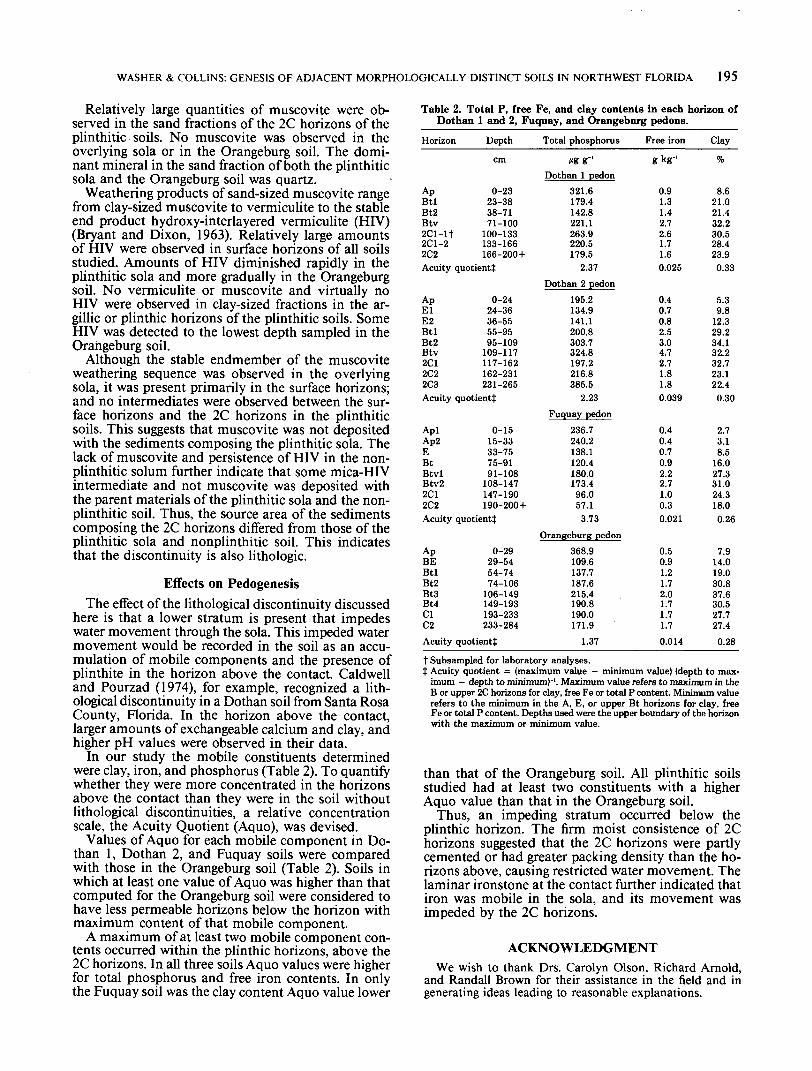
Soil MorphologyAbrupt changes in texture (Soil Survey Staff, 1983),
consistence, percentage of coarse fragments, or poros-ity (Wang and Arnold, 1973) were regarded as evi-dence of lithological discontinuities. Such abruptchanges can also be manifested as abrupt boundariesbetween soil horizons.
Color, boundary distinctness, and moist consistenceof plinthitic soils differed considerably from the non-plinthitic soil studied. Dothan 1, Dothan 2, and Fu-quay soils exhibited contrasting colors both within andbetween horizons (Table 1). Subsoil matrices were yel-lowish-brown, brownish-yellow, or strong brown; 2Chorizons were usually red. Some Bt and 2C horizonsand most Btv horizons were mottled. In contrast, theOrangeburg soil was unmottled red from the BE ho-rizon to the maximum depth described. Color changedgradually in the Orangeburg soil, rather than abruptlyas in Dothan 1, Dothan 2, and Fuquay soils.
In the plinthitic soils, boundaries between lowerplinthic and 2C horizons were abrupt. A thin layer (1-2 cm) of laminar ironstone overlay 2C horizons. Inthe Orangeburg soil, however, most horizon bound-aries were clear or gradual; and no laminar ironstonelayer was observed.
As expected, moist consistences differed betweenplinthitic and nonplinthitic soils. In Dothan 1, Do-than 2, and Fuquay soils, plinthite and 2C horizonswere firm; whereas the rest of the sola were friable orvery friable. All horizons in the Orangeburg soil werefriable or very friable. Textures were similar for com-parable horizons, except for 2C horizons, among thefour soils; however, some 2C horizons had sandy clayloam and others sandy loam textures.
Thus, abrupt changes in color and moist consistencebetween plinthic and 2C horizons, which were sepa-rated by abrupt boundaries, were characteristic of theplinthitic soils studied. In contrast, morphologicalchanges in Orangeburg, the nonplinthitic soil, weregradual. Thus, soil morphology suggested that lithol-ogical discontinuities were present between plinthicand underlying 2C horizons and a discontinuity wasabsent in the Orangeburg soil.
Soil LayeringThe principle of random association (Butler, 1959)
provides a way to recognize discontinuities in a geo-graphic context. According to this principle, two com-monly associated layers represent different deposits if,in at least one place, they are separated; i.e. one isfound without the other or part of one is missing. Thisprinciple makes explicit one fundamental assumptionin soil genesis—that soils with similar morphologiesdo not form from parent materials with dissimilarmorphologies if other soil-forming factors are held rel-atively constant (Jenny, 1980).
Inconsistencies in soil layering were observed atmany locations within the watershed; results from theBloom site and one gully (Fig. 2) are presented here.Three soil layers were distinguished: a brownish-yel-low solum overlaid red, coarse sandy loam sedimentsin some places and mottled, sandy clay sediments inother areas. In places where red, coarse sandy loam
Table 1. Summary of morphological properties of Dothan 1 and2, Fuquay and Orangeburg pedons.
Mottle
Hori-zon
ApBtlBt2Btv2C1
2C2
ApElE2BtlBt2Btv
2C12C2
2C3
Depth,cm
0-2323-3838-7171-100
100-166
Tex-ture
Issclsclsclscl
166-200+scl
0-2424-3636-5555-9595-109
109-117
117-162162-231
231-265
IsIsfslsclsclgrscl
sclscl
scl
Color
Dothan10YR 3/2
Color
1 pedonnone
7.5YR 5/6 none7.5YR 5/87.5YR 5/82.5YR 4/8
2.5YR 4/8
Dothan10YR 4/310YR 5/810YR 6/610YR 6/610YR 6/6mottled
2.5YR 4/62.4YR 4/8
2.5YR 4/8
none2.5YR 4/6SYR 5/87.5YR 5/810YR 5/87.5YR 5/610YR 5/62 pedon
nonenonenonenone7.5YR 5/610YR 6/810YR 7/27.5YR 5/62.5YR 4/810YR 6/610YR 6/810YR 7/310YR 6/8
Pattern, orAbundance
nonenonenonecommonfewfewfewcommoncommon
nonenonenonenonecommonreticulate
fewfewfewfew
Moistconsistence
very friablefriablefriablefirmfirm
firm
very friablevery friablefriablefriablefriablefriable
firmfirm
firmFuquay pedon
AplAp2EBtBtvlBtv2
2C1
2C2
0-1515-3333-7575-9191-108
108-147
147-190
ssIssisclscl
scl
190-200+sl
10YR 4/310YR 4/310YR 5/610YR 5/610YR 5/6mottled
2.5YR 4/8
mottled
nonenonenonenone2.5YR 4/810R 4/87.5YR 5/810YR 7/310YR 5/610YR 5/610YR 7/12.5YR 4/810YR 8/1
nonenonenonenonecommonreticulate
commonfewintimatelymixed
loosevery friablevery friablefriablefriablefirm
firmt
firmt
Orangeburg pedonApBEBtlBt2Bt3Bt4ClC2
0-2929-5454-7474-106
106-149149-193193-233233-284
sisisisclscsclsclscl
10YR 3/2SYR 4/62.5YR 4/610R 4/610R 4/810R 4/82.5YR 4/62.5YR 4/6
nonenonenonenonenonenonenonenone
nonenonenonenonenonenonenonenone
very friablefriablefriablefriablefriablefriablefriablefriable
t Firm = Firm in place, but friable when removed.
sediments were observed, they overlay the mottled,sandy clay sediments. These stratigraphic relation-ships were consistent throughout the watershed.
Inconsistencies in soil layering were also noted inthe soils studied. Although horizonation differedsomewhat, most aspects of soil morphology were sim-ilar among plinthitic sola studied. In particular, colors,mottling pattern, and argillic horizon textures weresimilar. The underlying 2C horizons, however, exhib-ited a variety of colors, mottling patterns, and tex-tures. If the sola are considered one layer, analogousto the brownish-yellow solum at the Bloom site, the2C horizons comprise several different layers, analo-gous to the red, coarse and fine, mottled sedimentsobserved at the Bloom site. Thus, the plinthitic soladid not form from materials like those observed in the2C horizons.
194 SOIL SCI. SOC. AM. J., VOL. 52, 1988
From the data presented here, the three layers ob-served at the Bloom site could represent different dep-ositional and probably weathering cycles, possiblywithin one formation; other data obtained by Washer(1986) suggest they are not. Although postdepositionalpedogenetic processes have altered the two lower lay-ers, their initial properties were sufficiently differentto permit separation even after long periods of near-surface weathering.
Stationary ComponentsBecause of their relatively large sizes, sand- and silt-
sized particles are regarded as nonmobile or stationarysoil components. In addition, quartz, by far the dom-inant mineral in sand- and silt-sized fractions in thesoils studied, is relatively resistant to weathering inthese particle-size classes (Wilding et al., 1977). Thus,inflections in depth distributions of sand- and silt-sizedparticles indicate discontinuities which reflect changesin depositional environment in sedimentary parentmaterials.
Clay-free silt content increased with depth in thesola of Dothan 1, Dothan 2, and Fuquay soils, thenshifted abruptly in magnitude in the 2C horizons (Fig.3). In contrast, clay-free silt content in the Orangeburgsoil decreased gradually with depth (Fig. 3).
CLAY-FREE SILT
CONTENT
Depth distributions of FSTS were more similar be-tween plinthitic sola and the nonplinthitic solum. FSTSremained relatively constant with depth in theOrangeburg soil, although slight stratification was ev-ident (Fig. 4). Stratification was also evident in solaof Dothan 1, Dothan 2, and Fuquay soils. FSTS de-creased with depth more sharply in 2C horizons thanin the solum of the Fuquay soil and less sharply in2C horizons than in the sola of Dothan 1 and Dothan2 soils (Fig. 4).
Inflections in FSTS depth distributions occurred be-tween sola and 2C horizons in plinthitic soils. Solumparent materials were stratified, typical of sedimentarymaterials, and differed from 2C horizons.
Thus, analysis of both clay-free silt content and FSTSdepth distributions revealed that discontinuities werepresent between sola and 2C horizons in plinthiticsoils. Both the plinthitic sola and the nonplinthiticsolum exhibited some minor stratification.
Soil MineralogySoil mineralogy can aid in identifying changes in
depositional environment accompanied by changes insource area of sediments. Quantities of less stableminerals should increase with depth, and their weath-ering products should be observed in the overlyinghorizons. Where this sequence is not observed a changein at least source area of sedimentary materials hasoccurred.
10 15 20
S O -
I 00- •
F 150 -ILkiO
200' •
250 •
300
O DOTHAN Ih
-r- -t-Fig. 3. Depth distributions of clay-free silt contents in Dothan 1,
Dothan 2, Fuquay, and Orangeburg soils. 2C horizons indicatedby filled-in symbols.
•w
Q.UJO
50 •
100 ••
150"
200-
250 •
300
FINE SAND CONTENT<% total «and>
10 15 20 25 30 35 40 45-H———I———I———I———I———I———I——
O OOTHAN I
A FUQUAY
O DOTHAN 2
* ORANQEBURG
Fig. 4. Depth distributions of fine sand contents as percentages oftotal sand contents in Dothan 1, Dothan 2, Fuquay, and Orange-burg soils. 1C horizons indicated by filled-in symbols.
WASHER & COLLINS: GENESIS OF ADJACENT MORPHOLOGICALLY DISTINCT SOILS IN NORTHWEST FLORIDA 195
Relatively large quantities of muscovite were ob-served in the sand fractions of the 2C horizons of theplinthitic soils. No muscovite was observed in theoverlying sola or in the Orangeburg soil. The domi-nant mineral in the sand fraction of both the plinthiticsola and the Orangeburg soil was quartz.
Weathering products of sand-sized muscovite rangefrom clay-sized muscovite to vermiculite to the stableend product hydroxy-interlayered vermiculite (HIV)(Bryant and Dixon, 1963). Relatively large amountsof HIV were observed in surface horizons of all soilsstudied. Amounts of HIV diminished rapidly in theplinthitic sola and more gradually in the Orangeburgsoil. No vermiculite or muscovite and virtually noHIV were observed in clay-sized fractions in the ar-gillic or plinthic horizons of the plinthitic soils. SomeHIV was detected to the lowest depth sampled in theOrangeburg soil.
Although the stable endmember of the muscoviteweathering sequence was observed in the overlyingsola, it was present primarily in the surface horizons;and no intermediates were observed between the sur-face horizons and the 2C horizons in the plinthiticsoils. This suggests that muscovite was not depositedwith the sediments composing the plinthitic sola. Thelack of muscovite and persistence of HIV in the non-plinthitic solum further indicate that some mica-HIVintermediate and not muscovite was deposited withthe parent materials of the plinthitic sola and the non-plinthitic soil. Thus, the source area of the sedimentscomposing the 2C horizons differed from those of theplinthitic sola and nonplinthitic soil. This indicatesthat the discontinuity is also lithologic.
Effects on PedogenesisThe effect of the lithological discontinuity discussed
here is that a lower stratum is present that impedeswater movement through the sola. This impeded watermovement would be recorded in the soil as an accu-mulation of mobile components and the presence ofplinthite in the horizon above the contact. Caldwelland Pourzad (1974), for example, recognized a lith-ological discontinuity in a Dothan soil from Santa RosaCounty, Florida. In the horizon above the contact,larger amounts of exchangeable calcium and clay, andhigher pH values were observed in their data.
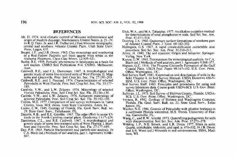
In our study the mobile constituents determinedwere clay, iron, and phosphorus (Table 2). To quantifywhether they were more concentrated in the horizonsabove the contact than they were in the soil withoutlithological discontinuities, a relative concentrationscale, the Acuity Quotient (Aquo), was devised.
Values of Aquo for each mobile component in Do-than 1, Dothan 2, and Fuquay soils were comparedwith those in the Orangeburg soil (Table 2). Soils inwhich at least one value of Aquo was higher than thatcomputed for the Orangeburg soil were considered tohave less permeable horizons below the horizon withmaximum content of that mobile component.
A maximum of at least two mobile component con-tents occurred within the plinthic horizons, above the2C horizons. In all three soils Aquo values were higherfor total phosphorus and free iron contents. In onlythe Fuquay soil was the clay content Aquo value lower
Table 2. Total P, free Fe, and clay contents in each horizon ofDothan 1 and 2, Fuquay, and Orangeburg pedons.
Horizon Depth
cm
Ap 0-23Btl 23-38Bt2 38-71Btv 71-1002C1-1T 100-1332C1-2 133-1662C2 166-200+Acuity quotient}
Ap 0-24El 24-36E2 36-55Btl 55-95Bt2 95-109Btv 109-1172C1 117-1622C2 162-2312C3 231-265Acuity quotient!
Apl 0-15Ap2 15-33E 33-75Bt 75-91Btvl 91-108Btv2 108-1472C1 147-1902C2 190-200+Acuity quotient}:
Ap 0-29BE 29-54Btl 54-74Bt2 74-106Bt3 106-149Bt4 149-193Cl 193-233C2 233-284Acuity quotient}
Total phosphorus
*»gg~'Dothan 1 pedon
321.6179.4142.8221.1263.9220.5179.5
2.37
Dothan 2 pedon195.2134.9141.1200.8303.7324.8197.2216.8385.5
2.23Fuquay pedon
236.7240.2138.1120.4180.0173.496.057.1
3.73Orangeburg pedon
368.9109.6137.7187.6215.4190.8190.0171.9
1.37
Free iron
gkg-'
0.91.31.42.72.61.71.60.025
0.40.70.82.53.04.72.71.81.80.039
0.40.40.70.92.22.71.00.30.021
0.50.91.21.72.01.71.71.70.014
Clay
%
8.621.021.432.230.528.423.90.33
5.39.8
12.329.234.132.232.723.122.40.30
2.73.18.5
16.027.331.024.318.00.26
7.914.019.030.837.630.527.727.40.28
t Subsampled for laboratory analyses.} Acuity quotient = (maximum value — minimum value) (depth to max-
imum — depth to minimum)"'. Maximum value refers to maximum in theB or upper 2C horizons for clay, free Fe or total P content. Minimum valuerefers to the minimum in the A, E, or upper Bt horizons for clay, freeFe or total P content. Depths used were the upper boundary of the horizonwith the maximum or minimum value.
than that of the Orangeburg soil. All plinthitic soilsstudied had at least two constituents with a higherAquo value than that in the Orangeburg soil.
Thus, an impeding stratum occurred below theplinthic horizon. The firm moist consistence of 2Chorizons suggested that the 2C horizons were partlycemented or had greater packing density than the ho-rizons above, causing restricted water movement. Thelaminar ironstone at the contact further indicated thatiron was mobile in the sola, and its movement wasimpeded by the 2C horizons.
ACKNOWLEDGMENTWe wish to thank Drs. Carolyn Olson, Richard Arnold,
and Randall Brown for their assistance in the field and ingenerating ideas leading to reasonable explanations.
196 SOIL SCI. SOC. AM. J., VOL. 52, 1988