Embed Size (px)
Citation preview
GCDP Referral ID T-01-PEM-3-15
Review Date 3/12/2015
Municipality PEMBROKE. T.
Board Name PLANNING BOARD
Applicant's Name Yancey's Fancy Inc.
Location 857 Main Rd. (NYS Rt. 5), Pembroke
Referral Type Site Plan Review
Variance(s)
Zoning District Interchange (INT) District
PLANNING BOARD DECISIONAPPROVAL
EXPLANATION:The proposed telecommunication tower is a customary accessory use to manufacturing facilities and should pose no significant county-wide or inter-community impact.
GENESEE COUNTY PLANNING BOARD ZONING REFERRALS NOTICE OF FINAL
ACTION
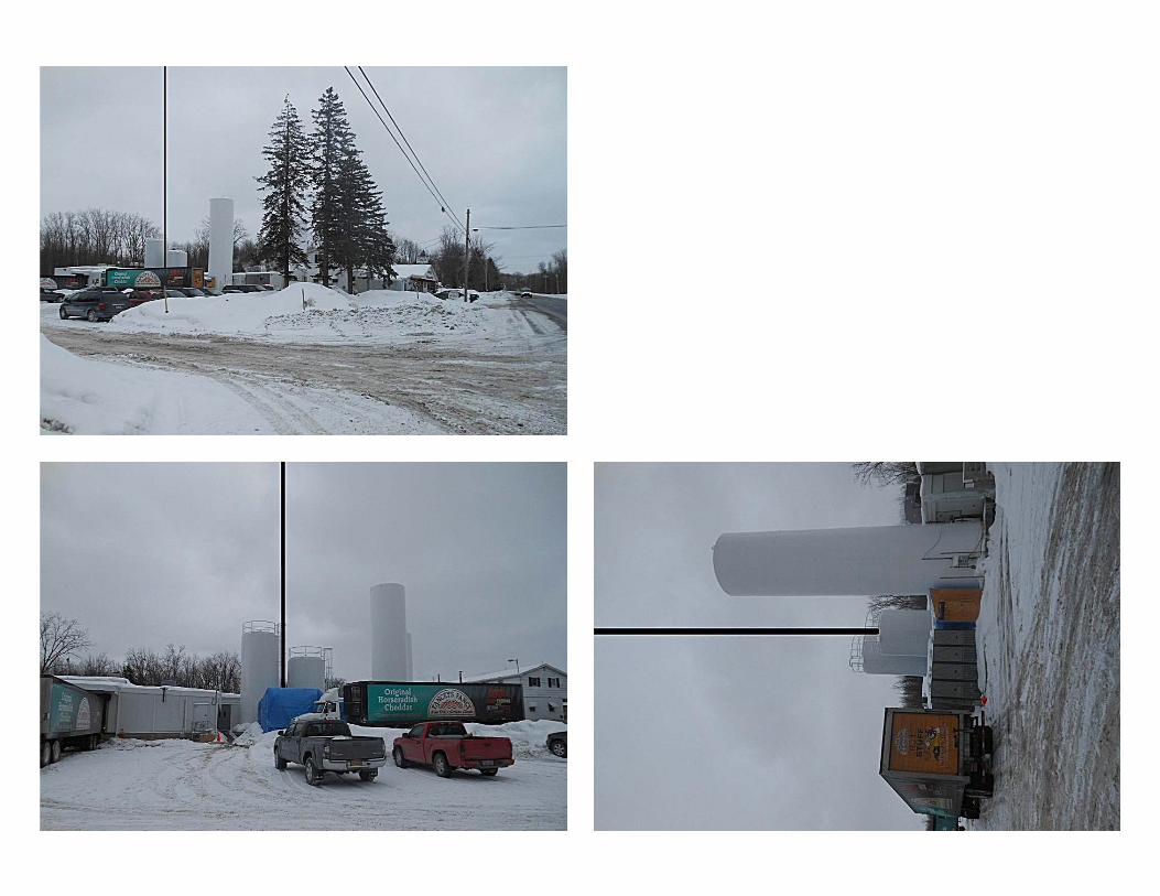
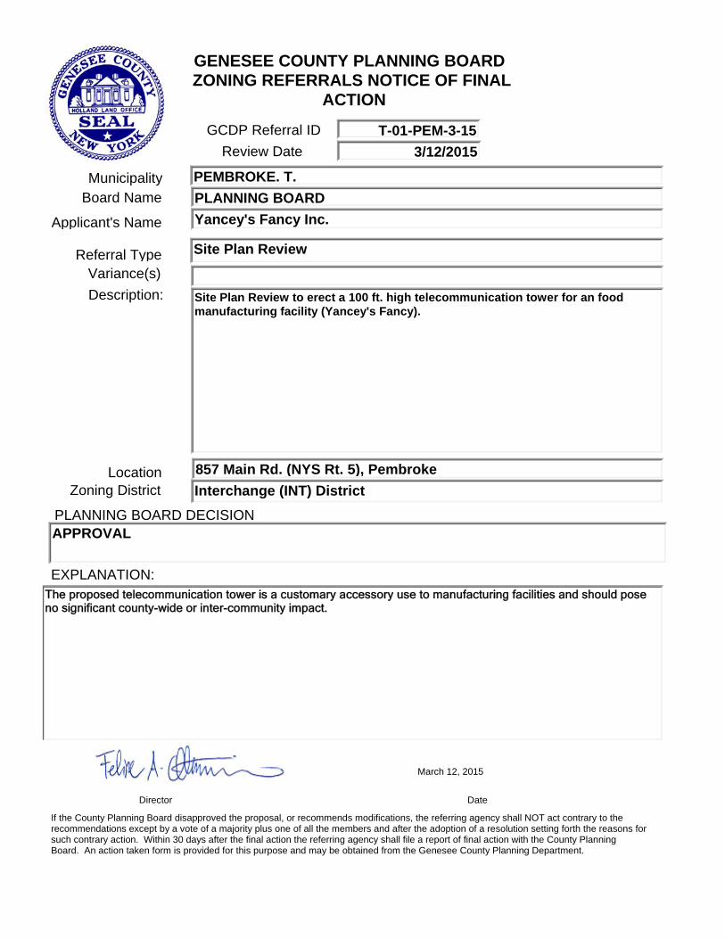
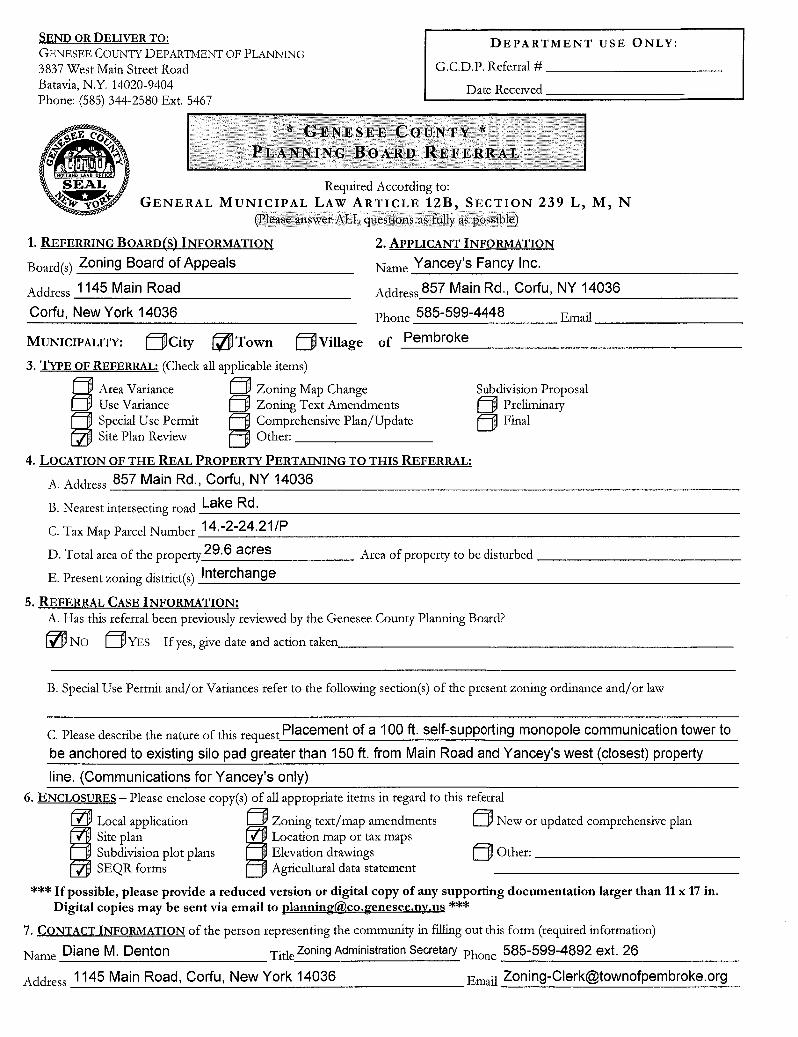
Description: Site Plan Review to erect a 100 ft. high telecommunication tower for an food manufacturing facility (Yancey's Fancy).
Director Date
If the County Planning Board disapproved the proposal, or recommends modifications, the referring agency shall NOT act contrary to the recommendations except by a vote of a majority plus one of all the members and after the adoption of a resolution setting forth the reasons for such contrary action. Within 30 days after the final action the referring agency shall file a report of final action with the County Planning Board. An action taken form is provided for this purpose and may be obtained from the Genesee County Planning Department.
March 12, 2015
SEND OR DELIVER TO: GENESEE COUNTY DEPARTMENT OF PLANNING
3837 West Main Street Road Batavia, N.Y. 14020-9404 Phone: (585) 344-2580 Ext. 5467
DEPARTMENT USE ONLY:
G.C.D.P. Referral #
Date Received
* GENESEE COUNTY * PLANNING BOARD REFERRAL
Required According to: GENERAL MUNICIPAL LAW ARTICLE 12B, SECTION 239 L, M, N
(Please answer ALL questions as fully as possible)
1. REFERRING BOARD(S) INFORMATION
Board(s) Zoning Board of Appeals
Address 1145 Main Road
2. APPLICANT INFORMATION
Name Yancey's Fancy Inc.
Address 857 Main Rd., Corfu, NY 14036
Corfu, New York 14036 Phone 585-599-4448 Email
MUNICIPALITY: Efil City Town ifT
Village of Pembroke
3. TYPE OF REFERRAL: (Check all applicable items)
Area Variance 0 Zoning Map Change Subdivision Proposal Use Variance Zoning Text Amendments Preliminary
Special Use Permit Comprehensive Plan/Update Ej Final Site Plan Review Other:
4. LOCATION OF THE REAL PROPERTY PERTAINING TO THIS REFERRAL:
A. Address 857 Main Rd., Corfu, NY 14036
B. Nearest intersecting road Lake Rd.
C. Tax Map Parcel Number 14.-2-24.21/P
D. Total area of the property 29.6 acres Area of property to be disturbed
E. Present zoning district(s) Interchange
5. REFERRAL CASE INFORMATION: A. Has this referral been previously reviewed by the Genesee County Planning Board?
PIS NO LJYES If yes, give date and action taken
B. Special Use Permit and/or Variances refer to the following section(s) of the present zoning ordinance and/or law
C. Please describe the nature of this request Placement of a 100 ft. self-supporting monopole communication tower to
be anchored to existing silo pad greater than 150 ft. from Main Road and Yancey's west (closest) property
line. (Communications for Yancey's only) 6. ENCLOSURES — Please enclose copy(s) of all appropriate items in regard to this referral
Local application Zoning text/map amendments Ej New or updated comprehensive plan 1 Site plan
SEAR forms
Location map or tax maps Subdivision plot plans ' Elevation drawings
Agricultural data statement
***If possible, please provide a reduced version or digital copy of any supporting documentation larger than 11 x 17 in. Digital copies may be sent via email to planning(&,co.genesee.ny.us "*
7. CONTACT INFORMATION of the person representing the community in filling out this form (required information)
Phone Name Diane M. Denton Tide Zoning Administration Secretary 585-599-4892 ext. 26
Address 1145 Main Road, Corfu, New York 14036 Email [email protected]
iI
Other:
i
SMART GROWTH DEVELOPMENT AREA? CURRENT SET BACK OF BUILDING
FRONT REAR A SIDE
STREET LOCATION # TAX MAP PARCEL #/ey,
A 43 9. / 41 -2 -2 Y,2/ ,4=7 r; ZONING DISTRICT /
SIZE OF PARCEL CORNER LOT
J
X
APPLICANT ADDRESS
TELEPHONE #
g-,r1 444/4/ /2e7Ae4 .--cyr-14)//t/i/ / VC 36
(g-r5.) C 99 I/ 4/
PROPERTY OWNER (IF OTHER THAN ABOVE) NAME
ADDRESS
TELEPHONE #
PERMIT OR VARIANCE FOR: NEW CONSTRUCTION ADDITION SIGN HOME OCCUPATION OTHER
IF THIS APPLICATION IS FOR A VARIANCE PLEASE STATE THE SECTION OF THE ORDINANCE UNDER WHICH THE VARIANCE REQUESTED
DESCRIBE REASON FOR VARIANCE
DATE
TOWN OF PEMBROKE 1145 MAIN ROAD
CORFU, NEW YORK 14036 585-599-4892
APPLICATION FOR: ZONING APPEAL DATE APPLIED FOR SPECIAL USE PERMIT LAND SEPARATION APPLICATION NUMBER •.) • / j
TEMP. SPECIAL USE PERMIT SUB DIVISION REFERRED TO PLANNING USE VARIANCE ZONE DISTRICT CHANGE REFERRED TO ZBA AREA VARIANCE TAE PLAN REVIEW PUBLIC HEARING REQ.
DOES THIS PROJECT REQUIRE APPROVAL FROM THE FOLLOWING? CHECK THOSE THAT APPLY:
GENESEE CO. HEALTH DEPARTMENT TOWN BOARD GENESEE CO. SOIL & WATER Z.B.A. DEPARTMENT OF TRANSPORTATION ,ta PLANNING BOARD COUNTY PLANNING DEPARTMENT PUBLIC HEARING
D.E.C.
DESCRIPIION OF PROPOSED PROJECT OR REASON FOR PERMIT REQUEST 6,--)/4ce. ✓ Potffr ,7L'4 I OD/ Se/ 111 ' 3 flopc,rri mo/t/ppok- crvnfri t/ifi:c47170A1 -1-c::›144=,' C: -77-714/e r -9--0 be ,44/ch,,,rerl
las to: X ; 5 -117, /Q Sl 10A r.3- re 4-71-,P r 74h,44/ I' O ' 40" 41.4,-_,v I2.24c:73 4,./ca 6.1," 4✓e.T.71- Jc e-e- /0 s- es-/- ...) r pp is 1-6/ 1 .7.4./ e . el' r),4,7 44 14v; C 4 9,.:74/ 4.- lc. ,Xl izc '1' 77A/ Z)
INSTRUCTIONS FOR COMPLETING THIS APPLICATION: I. INCLUDE SITE SKETCH PLAN, PREFERABLY A LAND SURVEY WITH CURRENT AND PROPOSED SET BACKS. 2. IF APPLICANT IS NOT THE OWNER OF THE LAND ON WHICH THE PROPOSED PROJECT IS LOCATED, THEY ARE THEN
REQUIRED TO OBTAIN WRITTEN PERMISSION FROM THE LAND OWNER FOR THE PROJECT. 3. A SEQR FORM (EAF) MUST BE INCLUDED WITH THE APPLICATION. 4. APPLICANT OR REPRESENTATIVE SHOULD ATTEND PLANNING BOARD AND/OR ZBA MEETING.
NOTE: IF THE REQUEST IS FOR A USE OR AREA VARIANCE, THE PLANNING BOARD'S ONLY ACTION WILL BE TO MAKE A RECOMMENDATION TO THE ZON OA OF APPEALS FOR APPROVAL OR DISAPPROVAL.
APPLICANT SIGNATURE
617.20 Appendix B
Short Environmental Assessment Form
Instructions for Completing
Part 1- Project Information. The applicant or project sponsor is responsible for the completion of Part 1. Responses become part of the application for approval or funding, are subject to public review, and may be subject to further verification. Complete Part 1 based on information currently available. If additional research or investigation would be needed to fully respond to any item, please answer as thoroughly as possible based on current information.
Complete all items in Part 1. You may also provide any additional information which you believe will be needed by or useful to the lead agency; attach additional pages as necessary to supplement any item.
Part 1- Project and Sponsor Information
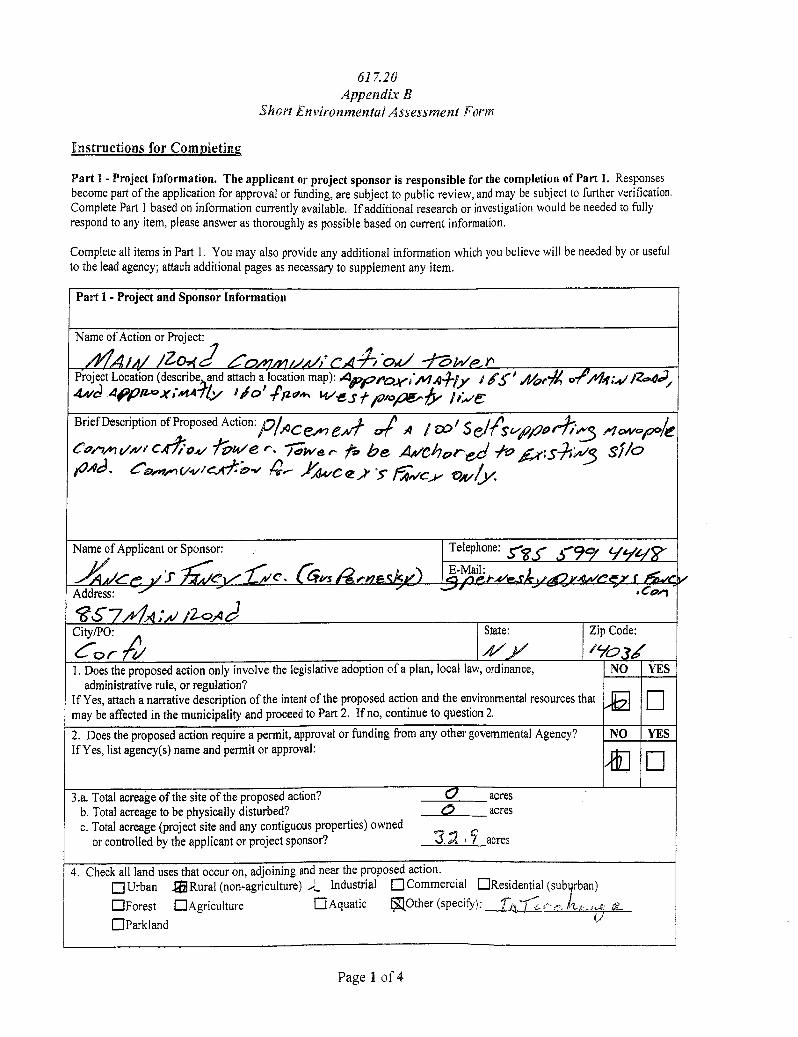
Name of Action or Project:
4 /zo..(2 -,..4 I ,-E /bsti Ad.:, phi- r Project Location (describe and attach a location map): Appea k.,,,A 4441.y 145' 44,71/ /214;411Z:04).,
• 4.r/c) APP/1-0X;.414ily I /O P ,12.c74.. was i.potow"4/ 1.,./e-
Brief Description of Proposed Action:p /ACS „,./1 - a( A / co'W Sel(Sti2P ,4i'l/t3 Alo/✓(Ppele e COo")/Pl VA" C41,04/ 7 b7/ e r '.
4 77;We e- ta be Avcb areej .11-0 A4..;s771:,,/5 silo
I, 0 4 d . Ca.*. - ari. / c."1-9: 0.̀ -v 74-).--- ../(.vc e 1- 'r ., , 6/1/Cy- VA/6/.
Name of Applicant or Sponsor:
c. :r A.; 4 1..... . v
Telephone: slSs- 3..--, wzig-
E-Mail: - a - 1'4/ /All! 4 4r,./
Address: a cgan
S257/14,4;Al /2-0.141 City/PO:
Co r State:
4//s1 Zip Code:
/Y034 1. Does the proposed action only involve the legislative adoption of a plan, local law, ordinance,
administrative rule, or regulation? If Yes, attach a narrative description of the intent of the proposed action and the environmental resources that may be affected in the municipality and proceed to Part 2. If no, continue to question 2.
NO YES
Z
2. Does the proposed action require a permit, approval or funding from any other governmental Agency? If Yes, list agency(s) name and permit or approval:
NO YES
Ain
3.a. Total acreage of the site of the proposed action? 0 acres b. Total acreage to be physically disturbed? e, acres c. Total acreage (project site and any contiguous properties) owned
or controlled by the applicant or project sponsor? 3..2 , 5 acres
4. Check all land uses that occur on, adjoining and near the proposed action. ■ Urban fa Rural (non-agriculture) ,), Industrial .11 Commercial
■ Forest ■ Agriculture ■ Aquatic 5lOther (specify):
■ Parkland
NI Residential (suburban)
r ,,,--i-..: ,,,,,,,,,,,,,„ ,.. ill
Page 1 of 4
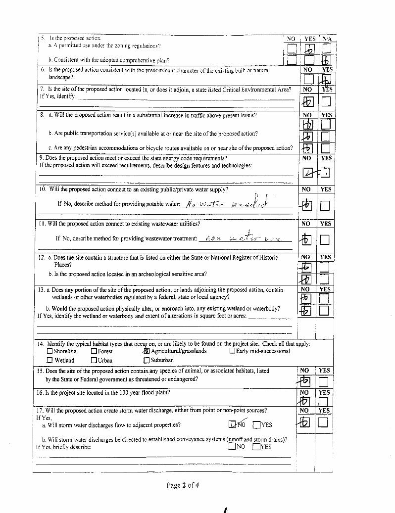
Is the proposed action. NO YES f NiA a. A permitted use under the zoning regulations?
b. Consistent with the adopted comprehensive plan?
— In _
!1 [..J ' 6. Is the proposed action consistent with the predominant character of the existing built or natural landscape?
NO YES
E. 7. Is the site of the proposed action located in, or does it adjoin, a state listed Critical Environmental Area? If Yes, identify:
NO YES
E
8. a. Will the proposed action result in a substantial increase in traffic above present levels?
b. Are public transportation service(s) available at or near the site of the proposed action?
c. Are any pedestrian accommodations or bicycle routes available on or near site of the proposed action?
NO YES
11 ❑
51 ❑
FE ❑
9. Does the proposed action meet or exceed the state energy code requirements? If the proposed action will exceed requirements, describe design features and technologies:
NO YES
ff.-72
10. Will the proposed action connect to an existing public/private water supply?
If No, describe method for providing potable water: , a V) 6 11,-;:,,-- :),<1 .•__ c-
NO YES
ll. Will the proposed action connect to existing wastewater utilities?
If No, describe method for providing wastewater treatment: A e 4 (A-- eL, r - 0.; ,; '.4:
NO YES
41 ❑
12. a. Does the site contain a structure that is listed on either the State or National Register of Historic
b. Is the proposed action located in an-archeological sensitive area? 4E1
Places? NO YES
❑
RE
❑ 13. a. Does any portion of the site of the proposed action, or lands adjoining the proposed action, contain
wetlands or other waterbodies regulated by a federal, state or local agency?
b. Would the proposed action physically alter, or encroach into, any existing wetland or waterbody? If Yes, identify the wetland or waterbody and extent of alterations in square feet or acres:
NO YES
'E E 4EI
❑
14. Identify the typical habitat types that occur on, or are likely to be found on the project site. Check all that apply: ■ Shoreline ■ Forest :ill Agricultural/grasslands ■ Early mid-successional
■ Wetland ■ Urban ■ Suburban
15. Does the site of the proposed action contain. any species of animal, or associated habitats, listed by the State or Federal government as threatened or endangered?
NO YES
---1 ❑
16. Is the project site located in the 100 year flood plain? NO YES
-fb I 1-1 17. Will the proposed action create storm water discharge, either from point or non-point sources? If Yes,
a. Will storm water discharges flow to adjacent properties? EaKr; YES
b. Will storm water discharges be directed to established conveyance systems (runoff and storm drains)? If Yes, briefly describe: ❑ NO EYES
NO YES
a
Page 2 of 4
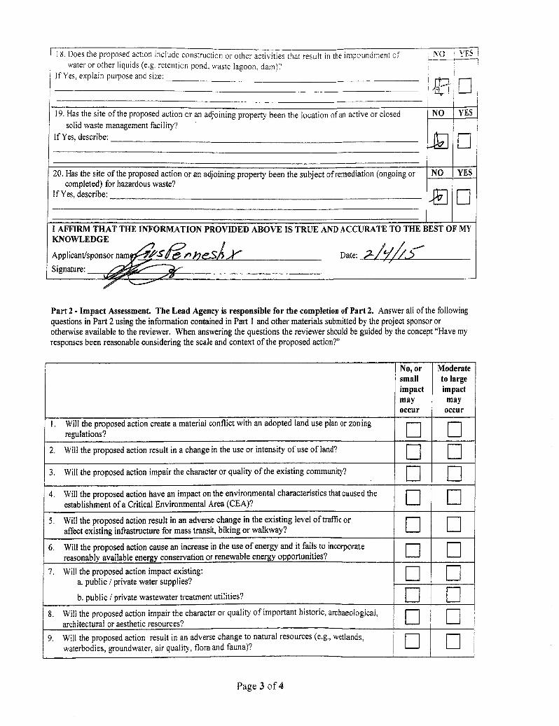
18. Does the proposed action include construction or other activities that result in the impoundment of water or other liquids (e.g. retention pond. waste lagoon. dam)?
If Yes, explain purpose and size:
NO YES
— ,LJ-- -
19. Has the site of the proposed action or an adjoining property been the location of an active or closed solid waste management facility?
If Yes, describe:
NO YES
—
20. Has the site of the proposed action or an adjoining property been the subject of remediation (ongoing or completed) for hazardous waste?
If Yes, describe:
NO YES
I AFFIRM THAT THE INFORMATION PROVIDED ABOVE IS TRUE AND ACCURATE TO THE BEST OF MY KNOWLEDGE
Applicant/sponsor nam 1 fr-S-de)t► ji eSA .4'. Date: 2-////...5
Signature: .401ri!IIIIIIIM
Part 2 - Impact Assessment. The Lead Agency is responsible for the completion of Part 2. Answer all of the following questions in Part 2 using the information contained in Part 1 and other materials submitted by the project sponsor or otherwise available to the reviewer. When answering the questions the reviewer should be guided by the concept "Have my responses been reasonable considering the scale and context of the proposed action?"
No, or small impact may occur
Moderate to large impact
may occur
1. Will the proposed action create a material conflict with an adopted land use plan or zoning regulations?
❑
2. Will the proposed action result in a change in the use or intensity of use of land? _
3. Will the proposed action impair the character or quality of the existing community? E 4. Will the proposed action have an impact on the environmental characteristics that caused the
establishment of a Critical Environmental Area (CEA)?
_ —
— —
5. Will the proposed action result in an adverse change in the existing level of traffic or affect existing infrastructure for mass transit, biking or walkway?
— ❑
6. Will the proposed action cause an increase in the use of energy and it fails to incorporate reasonably available energy conservation or renewable energy opportunities?
❑
— 7. Will the proposed action impact existing:
a. public / private water supplies?
b. public / private wastewater treatment utilities?
C —
C —
8. Will the proposed action impair the character or quality of important historic, archaeological, architectural or aesthetic resources?
— — —
9. Will the proposed action result in an adverse change to natural resources (e.g., wetlands, waterbodies, groundwater, air quality, flora and fauna)?
— —
Page 3 of 4

.4/07" : m/e_s4 proPer-ly vva-/- s 404/A/
.co'
TW NCO ADD TIO\ GRAPHICAL S.
5 10 it
/CO , Ser IfPa
Clivopoi Twer
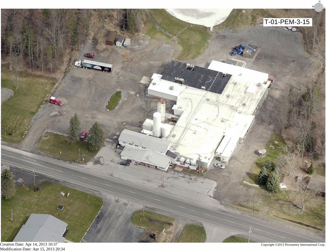
T-01-PEM-3-15
N
E
S
W
Creation Date: Apr 14, 2013 10:37Modification Date: Apr 15, 2013 20:34
Copyright ©2013 Pictometry International Corp.