Embed Size (px)
Citation preview
Genesee County, MI Executive Summary
Submitted to:
Michael Ortiz, Director Genesee County Department of Equalization
1101 Beach Street Flint, MI 48502 (810) 257-3017
Submitted by:
Annie Metcalf, Executive Consultant Andrew Faley, GeoSpatial Analyst Jim Fries, Executive Consultant
PlanGraphics, Inc. 112 East Main Street Frankfort, KY 40601
(502) 223-1501 Fax: (502) 223-1235
August 6, 2002

Table of Contents
Title Page What is this report about?......................................................................................................... 1 Who needs geographic information, and why do they need it? ............................................... 1 GIS: What is it?......................................................................................................................... 2 Why does Genesee County need an enterprise GIS implementation? ................................... 4 What benefits do GIS and an enterprise effort bring?.............................................................. 5 How will Genesee County’s GIS look?..................................................................................... 10 How will GIS activities be organized? ...................................................................................... 14 How will GIS become a reality?................................................................................................ 21 A Far-sighted Investment ......................................................................................................... 24Summary of Recommendations ............................................................................................... 25 List of Figures Figure 1: Map Database Layering Concept ................................................................................ 3 Figure 2: Genesee County Data Themes.................................................................................... 11 Figure 3: System Configuration Overview................................................................................... 13 Figure 4: Hardware Configuration ............................................................................................... 13 Figure 5: Organizational Structure .............................................................................................. 15 Figure 6: Proposed Generalized Project Schedule ..................................................................... 23
List of Tables
Table 1: Outsourcing Option Variables ....................................................................................... 19 Table 2: Annual Capital and Operating Cost for GIS Implementation ........................................ 24
1227 PlanGraphics, Inc. i

Executive Summary
What is this report about?
In the Fall of 2001, Genesee County retained PlanGraphics, Inc., to assess Geographic Information System (GIS) needs, inventory GIS activities in the County, and determine the opportunities for the County’s future involvement in using GIS technology. The objectives of this summary are to provide an overview of GIS concepts and to present the findings of our evaluation, including a review of the conceptual design and the implementation strategy, to the County.
Who needs geographic information, and why do they need it?
Spatial location is the
common denominator for indexing important facts.
Almost all government information is referenced to geography—a singular place on the face of the Earth that can be identified by means of a unique identifier, such as an address, parcel number, or coordinate location. Governments are, therefore, in the forefront of spatial data system implementation. Because nearly any fact of importance can be related to a specific place on the surface of the Earth, the spatial location of events and phenomena is the only element needed to relate various pieces of information to one another.
Of all information gathered and stored by
local governments, 80 percent is “geographic.”
Geographic information is used every day by Genesee County and by service providers within the County’s jurisdiction. In addition to maps, Genesee County, in general, collects, stores, and manages (and makes decisions based upon) facts and data about emergency response, infrastructure, land use, and other County services. Whether by street address, Census tract/block, or parcel number, this information is collected and, in some cases, stored within computer databases. Many maps and data sets are used by the County to record and update this information.
The collection and management of spatial data support daily operations within the County, as well as decision-support functions such as emergency response, planning and development, and infrastructure improvements.
1227 PlanGraphics, Inc. 1
Genesee County Executive Summary August 6, 2002
Unfortunately, these maps and data sources are often outdated and inefficient to use. Genesee County is no exception to these problems that are common among local county government and public and private utilities. Many jurisdictions throughout the United States, including within the State of Michigan, have had successful GIS implementations and have found GIS to be the answer to at least some of these problems.
Some jurisdictions have chosen to implement GIS technology throughout the organization in a coordinated and cooperative manner (enterprise approach). Others have implemented GIS in a more incremental fashion without a coordinated plan. The second approach often results in systems that can only be used by a limited number of individuals or departments, causing further redundancy and inconsistency in geographic information.
With the increasing prevalence of GIS technology throughout County government, Genesee County is now faced with the dilemma of choosing a course for implementing GIS technology. The question is no longer whether the County will implement GIS but what approach will be used—coordinated or fragmental? The benefits of GIS technology and recommendations for its implementation are described in the remainder of this Executive Summary.
GIS: What is it?
A geographic information system (GIS) relates geographic data, in the form of digital maps, with text and statistical data and digital records about people, places, and things to support operations and decision-making.
A GIS stores, manages, displays, and analyzes spatial data. Spatial data is information that either contains some reference to geographic location or that can be related to some particular geographic location.
A GIS is more than hardware and software.
GISs are comprised of a number of components. Among those components are:
• Applications • Data • Hardware and software
1227 PlanGraphics, Inc. 2
Genesee County Executive Summary August 6, 2002
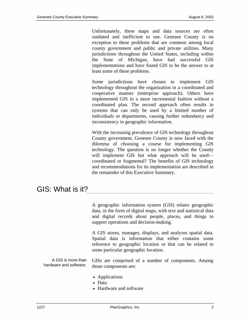
• Institutional relationships • People and procedures.
The term “GIS” is sometimes applied to the software that performs the manipulation of the data and application processing. However, such additional “system” components as data, people, and institutional arrangements are every bit as important as the software itself and possibly more so.
The power of GIS is its ability to relate diverse
facts to common geography.
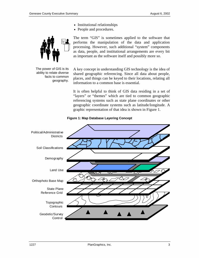
A key concept in understanding GIS technology is the idea of shared geographic referencing. Since all data about people, places, and things can be keyed to their locations, relating all information to a common base is essential.
It is often helpful to think of GIS data residing in a set of “layers” or “themes” which are tied to common geographic referencing systems such as state plane coordinates or other geographic coordinate systems such as latitude/longitude. A graphic representation of that idea is shown in Figure 1.
Figure 1: Map Database Layering Concept
Geodetic/SurveyControl
State PlaneReference Grid
Land Use
Demography
Soil Classifications
TopographicContours
Political/AdministrativeDistricts
Orthophoto Base Map
1227 PlanGraphics, Inc. 3
Genesee County Executive Summary August 6, 2002
Why does Genesee County need an enterprise GIS implementation?
Improve Quality and Meet
Higher Expectations All organizations, including county governments, are under pressure to provide more with less. While GIS will not make this demand go away, GIS can provide the tools for more accurate and useful information that is critical for effectively managing the County. GIS implementations in other regions have already proven that the technology is sound and that better geographic information management supports a higher quality of service for taxpayers.
Among the many advantages of implementing a GIS are:
• Cost efficiency of coordinating the development • Non-duplication of resources • Taking advantage of shared technology • Leveraging past investments.
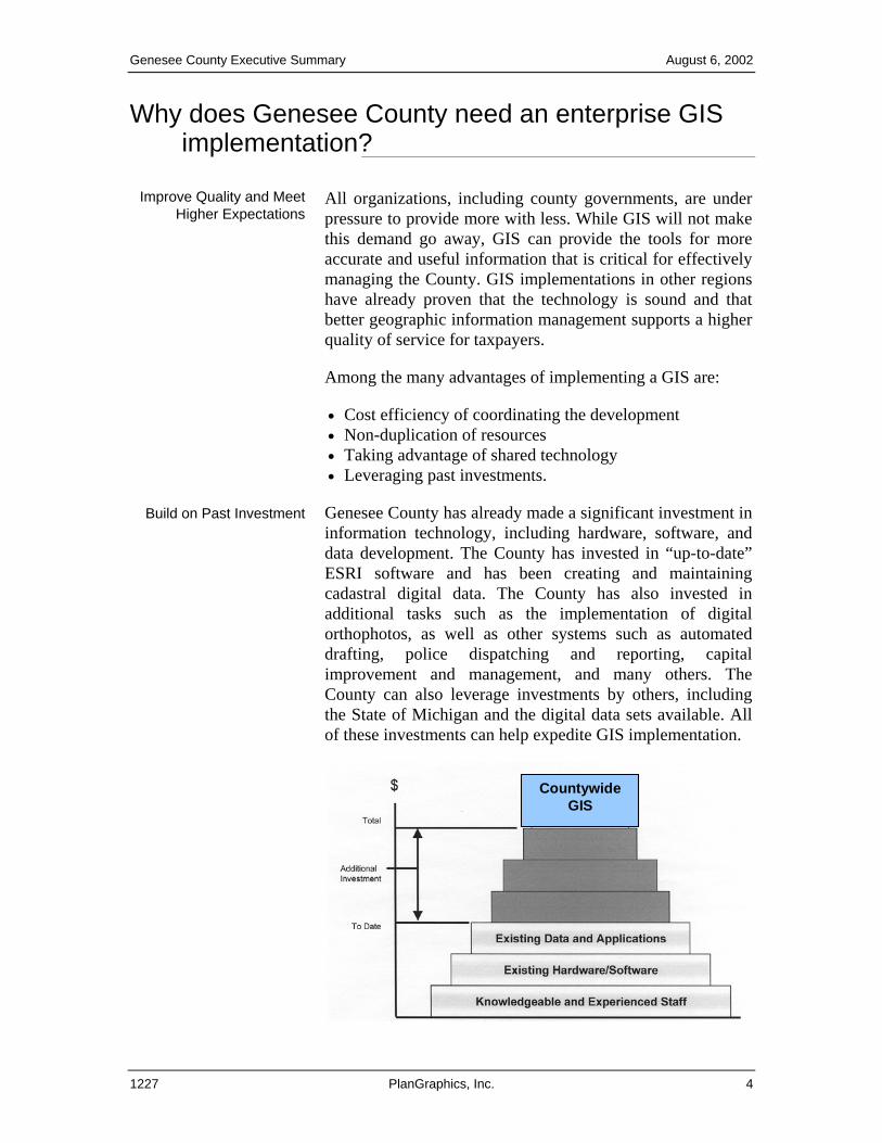
Build on Past Investment Genesee County has already made a significant investment in information technology, including hardware, software, and data development. The County has invested in “up-to-date” ESRI software and has been creating and maintaining cadastral digital data. The County has also invested in additional tasks such as the implementation of digital orthophotos, as well as other systems such as automated drafting, police dispatching and reporting, capital improvement and management, and many others. The County can also leverage investments by others, including the State of Michigan and the digital data sets available. All of these investments can help expedite GIS implementation.
Countywide
GIS
1227 PlanGraphics, Inc. 4
Genesee County Executive Summary August 6, 2002
The County is at a pivotal point in the decision-making process as it relates to technology implementation. The County now has the opportunity to take advantage of its past investment.
Lost Opportunity If the opportunity is not taken at this time, the investments in developing the base map, automated databases, and the data communications network may be lost or decreased.
If the County chooses an incremental approach to the implementation of GIS, the benefits will be limited, and the County will not realize the full potential of sharing information and valuable tools across the entire organization.
Foundation for Strategic and Spatial Information
Initiatives
Over the next two to four years, the County will be undertaking major strategic and information technology initiatives. Development of an enterprise GIS effort will provide a foundation to support these initiatives and will make them more cost-effective.
What benefits do GIS and an enterprise effort bring?
Virtually every geographic information user in the County will see real benefits from building an enterprise GIS. Some of the benefits have already been seen in some areas.
Example benefits that each department may realize as a result of GIS implementation are as follows:
• The Board of Commissioners will be able to see the firsthand benefits of GIS through the improved ability to locate officials within the County. The office will also realize some of the greatest gains in identifying representative candidates for Board Commission appointments and through the ability to track complaints or requests for services through the use of GIS.
• Equalization will recognize benefits through having the ability to share information with the rest of the County in a more efficient manner, reduce the amount of time maintaining the County base map, query and analyze property information, and improve the process for automated notifications.
1227 PlanGraphics, Inc. 5
Genesee County Executive Summary August 6, 2002
• Planning will find GIS invaluable for developing and implementing a document management system to manage legacy records, building a detailed flood management system, delineating wetlands in support of planning and zoning, and developing or serving maps over the Internet.
• The Drain Commission will realize greater efficiencies in both Water and Wastewater Services and Surface Water Management by gaining access to cadastral digital base maps and incorporating water and sewer infrastructure locations and conditions into the base maps. GIS will provide the departments with easier access to facility data that will allow staff to respond more effectively. Utility maintenance benefits will also be realized from integrating maps and records.
• GIS will support Emergency Management by allowing access to information about critical buildings or hazards, such as chemical or fuel storage. Benefits will also be realized from having the ability to track disaster impacts, prepare damage assessments, and project potential evacuation areas.
• The Register of Deeds will see the benefit of GIS by having the ability to add a spatial representation to the departmental applications that are already in place. Additionally, GIS will provide the opportunity to disperse data across the County, while keeping the policy of enhanced access in place.
• GIS will benefit Parks and Recreation through the improved ability to schedule activities, support the development of an automated work management system and an automated asset inventory program, and create maps to download from the department’s Web site.
• The Road Commission will be able to improve support of annual maintenance projects, capital improvement programs, special assessments, and traffic studies. GIS will also support the creation of custom maps, improve the ability to track maintenance, and support access to and viewing of additional data resources, such as up-to-date parcel data.
1227 PlanGraphics, Inc. 6
Genesee County Executive Summary August 6, 2002
• The Health Department will recognize improvements in the ability to perform inspection routing, community health assessment, strategic planning, and incident preparedness and analysis. GIS will improve access to up-to-date parcel data and will support access to internal resources, such as maps, drawings, and plans.
• The Sheriff will be able to query traffic accidents, citations, and crime incidents. GIS will also enhance and speed retrieval of valuable information for tactical purposes, including building photos, aerial photos, street layouts, and floor plans.
• The Treasurer’s office should expect benefits from improved access to parcel data and identification of tax delinquencies and demolition candidates. With GIS, the office will also be able to improve efficiency of revitalization efforts and the delineation of political and administrative boundaries for all jurisdictions and districts.
General Benefits and Opportunities
Some common benefits and opportunities achieved from developing an integrated enterprise system for Genesee County would include increased productivity, information security, avoidance of new staff/overhead in the future, reduced facility costs and planning, efficiency gains and cost savings for engineering, improved customer service, opportunities for outside revenue, and investments in data improvement.
Increased Productivity A direct benefit that can be realized from a properly implemented GIS is the reduction in staff time for current operations. The most profound positive impacts will be seen in areas of map update and “seek and access” time for maps and geographically referenced records. The efficiency of map update operations will be improved by 30 percent to 50 percent. This will free some staff time for special projects (e.g., zoning studies, inspection analysis, data collection) not currently carried out or greatly delayed. Office staff and field staff spend a significant amount of time locating the proper maps and records to answer routine questions. The amount of time spent performing this activity is largely the result of limitations with the current procedures, which rely on manual activities for storing maps and other records. Experience from sites with an operating GIS shows efficiency gains from 3:1 to 25:1 in finding and accessing
1227 PlanGraphics, Inc. 7
Genesee County Executive Summary August 6, 2002
maps and geographic information. A major objective of GIS is to provide this information, in an easily accessible form, to multiple departments. GIS is expected to provide efficiencies in such activities as emergency preparedness and response, planning for flood and drainage control facilities, locating utilities in the field, customer response, maintenance planning, improvement project planning and design, and certain financial analyses that are geographically based.
Information Security For some maps and records, multiple copies, in an easily reproducible form, are not maintained. This is an inherent limitation of a manual records system. In addition to the inflexibility of repeated updates on paper or mylar, a major loss of original copies would be expensive and, in some cases, impossible to replace. A major side benefit of any automated system is its ability to keep copies of maps in safe storage and to use a digital medium—not paper maps—as the format for updates.
Reduced Facility Costs and Planning
Genesee County, like many other county governments, spends substantial time and money on emergency repairs for water and sewer systems and for drainage control facilities. These operations are managed well, but instances may occur where current manually based procedures for scheduling and maintenance tracking have contributed to lost time and money. GIS, along with other management systems, can help in projecting maintenance needs and scheduling appropriate maintenance in an optimal manner. A GIS database can also support a more efficient one-call system benefiting all organizations managing underground infrastructure.
Efficiency Gains and Cost Savings for Engineering
A significant part of the cost of engineering design projects involves geographic information collection and mapping. The GIS could be used as a tool to help prepare specifications for design projects. In addition, opportunities exist to use the GIS to generate maps and information for contractors, which would otherwise need to be gathered and collected by the contractors. Some cost savings on contracted design projects are possible.
Improved Customer Service
The GIS can deliver potentially profound benefits that cannot easily be quantified but which have a positive result in raising the quality of services and in being more responsive to customers of Genesee County. When integrated with other County data and information systems, GIS can support better response to routine customer inquiries and complaints. The system can support analyses for customer isolation
1227 PlanGraphics, Inc. 8
Genesee County Executive Summary August 6, 2002
identification and notification in the event of a main break or scheduled shut-off.
If implemented wisely, improved information management systems, including GIS, can impact all of these areas. Citizens are demanding more accurate and complete answers to questions. GIS will provide a tool to access the necessary information and will present answers more effectively by using graphics. Custom maps or public access terminals can be used to present information to a more sophisticated and computer-literate public.
Opportunities for Outside Revenue
Many public and private organizations that have implemented GIS programs have been successful in using these systems to generate revenue from the GIS database and derived products. Within the State of Michigan, an “Enhanced Access” policy has been enacted. GIS can support the County’s implementation of Enhanced Access through the sale of particular map or database products, license agreements or subscriptions to GIS data with fee or royalty payments, on-line access to data through a fee-per-use, or custom product creation.
Improved Information Quality
A large part of the GIS development cost will be for database creation, including the capture of map features and associated attribute data. The GIS database development process will produce a digital version of current data sources, as well as improve the quality and augment the detail of information of those current sources. Some of these activities have already begun within the County. It is difficult to quantitatively measure the value of data improvement, but it will provide the basis for enhanced operations, better decision-making, and the ability to respond to growth. This data improvement should be considered an investment that yields future payback. GIS will provide the tools to keep the database efficiently updated to a high level of quality to build on that investment.
1227 PlanGraphics, Inc. 9
Genesee County Executive Summary August 6, 2002
How will Genesee County’s GIS look?
² ² ² ²²
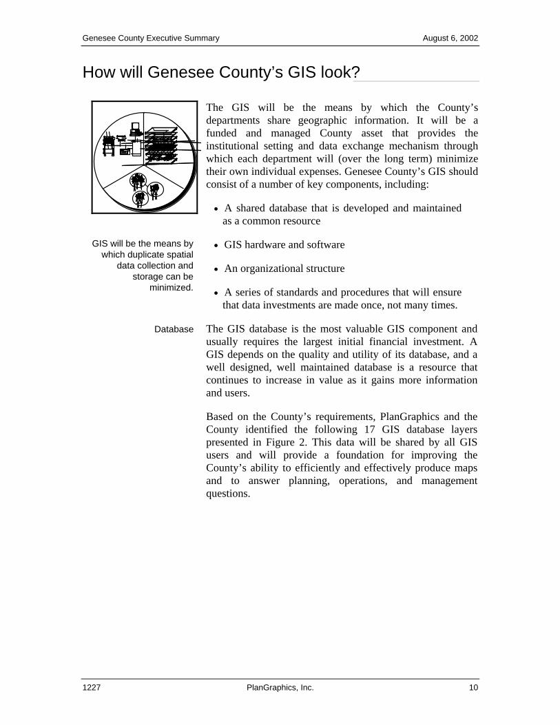
The GIS will be the means by which the County’sdepartments share geographic information. It will be afunded and managed County asset that provides theinstitutional setting and data exchange mechanism throughwhich each department will (over the long term) minimizetheir own individual expenses. Genesee County’s GIS shouldconsist of a number of key components, including:
• A shared database that is developed and maintained as a common resource
GIS will be the means by which duplicate spatial
data collection and storage can be
minimized.
• GIS hardware and software
• An organizational structure
• A series of standards and procedures that will ensure that data investments are made once, not many times.
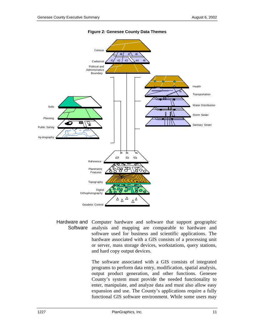
Database The GIS database is the most valuable GIS component and usually requires the largest initial financial investment. A GIS depends on the quality and utility of its database, and a well designed, well maintained database is a resource that continues to increase in value as it gains more information and users.
Based on the County’s requirements, PlanGraphics and the County identified the following 17 GIS database layers presented in Figure 2. This data will be shared by all GIS users and will provide a foundation for improving the County’s ability to efficiently and effectively produce maps and to answer planning, operations, and management questions.
1227 PlanGraphics, Inc. 10
Genesee County Executive Summary August 6, 2002
Figure 2: Genesee County Data Themes
DigitalOrthophotography
Topography
PlanimetricFeatures
Geodetic Control
41 42 43 44 45
48 47 46
Hy drography
Public Saf ety
Soils
41 42 43 44 45
48 47 46
Ref erence
41 42 43 44 45
48 47 46
Political andAdministrativ e
Boundary
Sanitary Sewer
Storm Sewer
Water Distribution
Planning
Transportation
41 42 43 44 45
48 47 46
Cadastral
Census
Health
Hardware and
Software Computer hardware and software that support geographic analysis and mapping are comparable to hardware and software used for business and scientific applications. The hardware associated with a GIS consists of a processing unit or server, mass storage devices, workstations, query stations, and hard copy output devices.
The software associated with a GIS consists of integrated programs to perform data entry, modification, spatial analysis, output product generation, and other functions. Genesee County’s system must provide the needed functionality to enter, manipulate, and analyze data and must also allow easy expansion and use. The County’s applications require a fully functional GIS software environment. While some users may
1227 PlanGraphics, Inc. 11
Genesee County Executive Summary August 6, 2002
be able to use simple query and mapping software, development of an integrated enterprise GIS requires a comprehensive software environment to support a wide range of users.
Based on Genesee County’s GIS needs and our knowledge of GIS software products, PlanGraphics recommends the Countycontinue to use Environmental Systems Research Institute,Inc. (ESRI), GIS software.
The majority of local governments throughout the nation (andthe world) are already using ESRI software to meet their GIS needs. This software is compatible with the data already beingcreated at the County level, as well as at the State andTownship level, therefore making data integration and sharingmore feasible across all platforms.
Another consideration for Genesee County is using the Internet with GIS in order to leverage the availability ofinformation to all members of the community. By using theInternet as a means of displaying information, GeneseeCounty can increase its level of communication with thepeople within the County, surrounding communities, and theworld. Many communities throughout the U.S. have beenusing GIS on the Internet as an economic development enginethrough the “easy-to-access” and display of current maps presenting demographic and real estate data. With this data available and accessed by potential investors via the Internet,the County can increase its viability. Using GIS and theInternet can be seen as a technique to increase the overallproductivity of all departments within Genesee County.
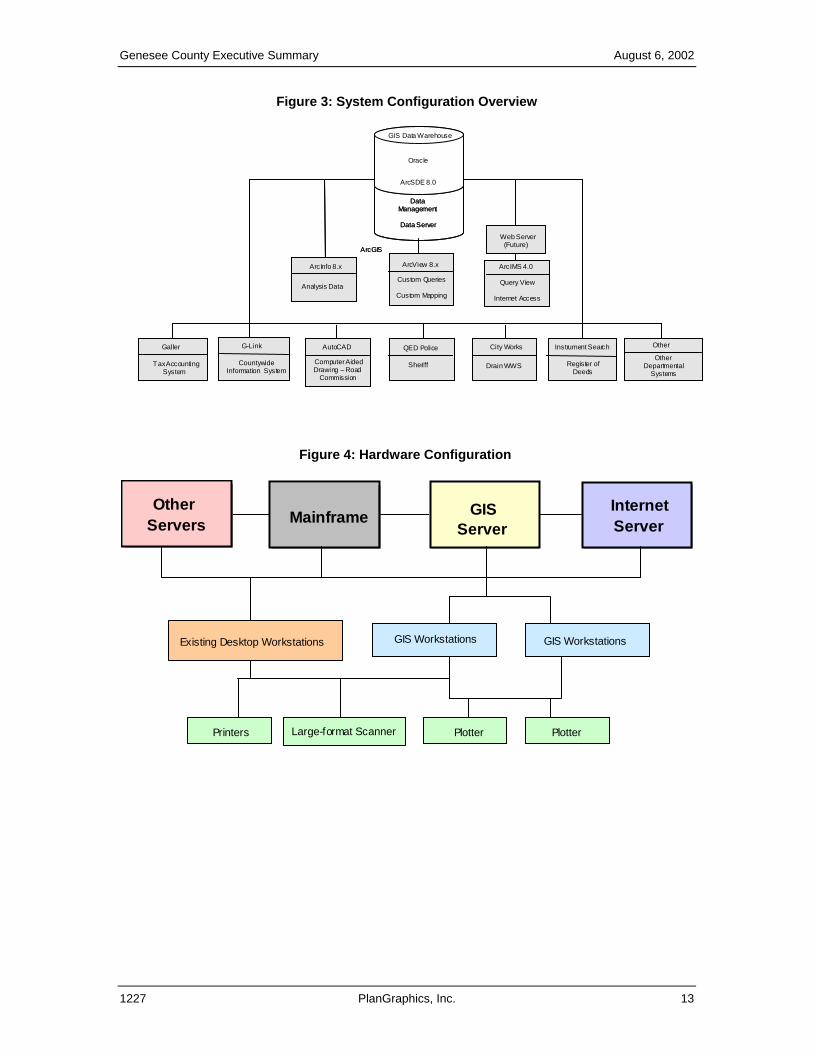
Figure 3 shows the initial configuration for the integration of GIS with existing systems already in place at the County. Figure 4 illustrates how all County staff will access the GIS through their own desktops, in addition to the high performance GIS workstations necessary for the management and maintenance of the GIS and supporting data.
1227 PlanGraphics, Inc. 12
Genesee County Executive Summary August 6, 2002
Figure 3: System Configuration Overview
City Works
Drain WWSOther
DepartmentalSystems
AutoCAD
Computer AidedDrawing – Road
Commission
Galler G-Link
CountywideInformation System
Tax AccountingSystem
QED Police
Sheriff
Instrument Search
Register ofDeeds
Web Server(Future)
ArcView 8.x
Custom Queries
Custom Mapping
ArcIMS 4.0ArcInfo 8.x
Analysis Data
ArcGIS
Query View
Internet Access
Other
Oracle
ArcSDE 8.0
DataManagement
Data Server
GIS Data Warehouse
Figure 4: Hardware Configuration
GISServer
InternetServer Mainframe
Other Servers
Existing Desktop Workstations GIS WorkstationsGIS Workstations
Plotter PlotterLarge-format ScannerPrinters
1227 PlanGraphics, Inc. 13
Genesee County Executive Summary August 6, 2002
How will GIS activities be organized?
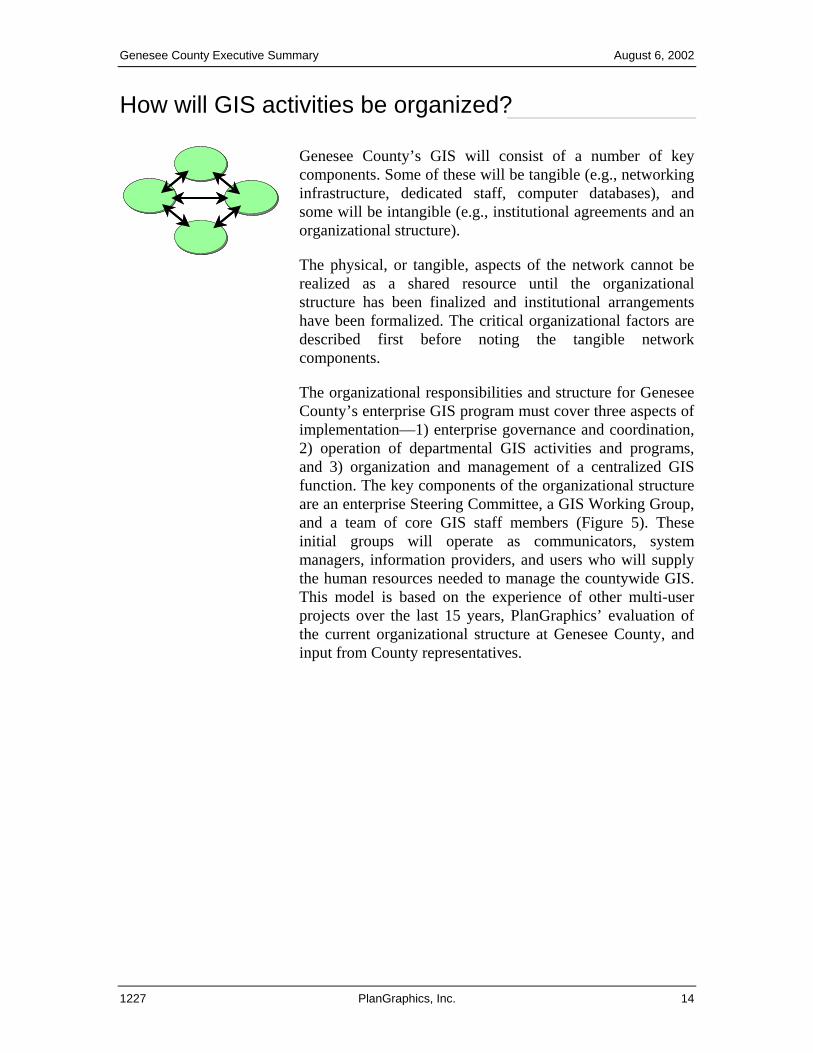
Genesee County’s GIS will consist of a number of key components. Some of these will be tangible (e.g., networkinginfrastructure, dedicated staff, computer databases), andsome will be intangible (e.g., institutional agreements and anorganizational structure).
The physical, or tangible, aspects of the network cannot be realized as a shared resource until the organizationalstructure has been finalized and institutional arrangementshave been formalized. The critical organizational factors aredescribed first before noting the tangible network components.
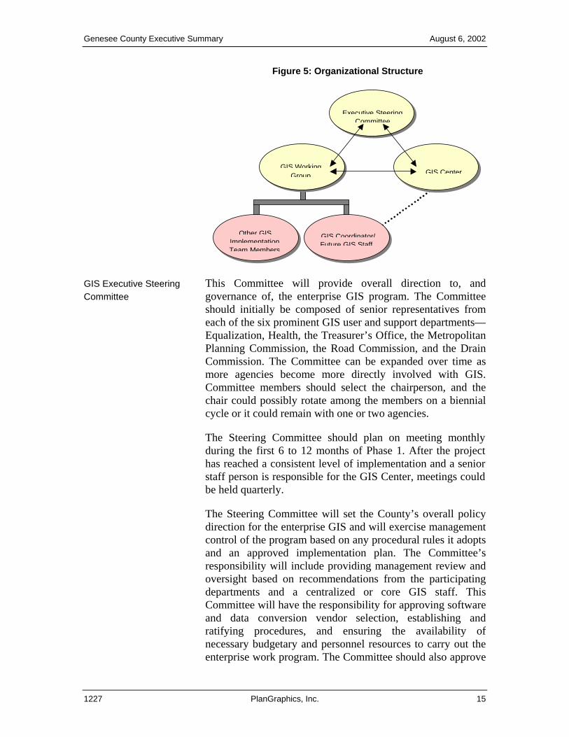
The organizational responsibilities and structure for Genesee County’s enterprise GIS program must cover three aspects of implementation—1) enterprise governance and coordination, 2) operation of departmental GIS activities and programs, and 3) organization and management of a centralized GIS function. The key components of the organizational structure are an enterprise Steering Committee, a GIS Working Group, and a team of core GIS staff members (Figure 5). These initial groups will operate as communicators, system managers, information providers, and users who will supply the human resources needed to manage the countywide GIS. This model is based on the experience of other multi-user projects over the last 15 years, PlanGraphics’ evaluation of the current organizational structure at Genesee County, and input from County representatives.
1227 PlanGraphics, Inc. 14
Genesee County Executive Summary August 6, 2002
Figure 5: Organizational Structure
Executive Steering
Committee
Other GISImplementationTeam Members
GIS Coordinator/Future GIS Staff
GIS CenterGIS Working
Group
GIS Executive Steering Committee
This Committee will provide overall direction to, andgovernance of, the enterprise GIS program. The Committeeshould initially be composed of senior representatives fromeach of the six prominent GIS user and support departments—Equalization, Health, the Treasurer’s Office, the MetropolitanPlanning Commission, the Road Commission, and the Drain Commission. The Committee can be expanded over time asmore agencies become more directly involved with GIS.Committee members should select the chairperson, and thechair could possibly rotate among the members on a biennial cycle or it could remain with one or two agencies.
The Steering Committee should plan on meeting monthly during the first 6 to 12 months of Phase 1. After the project has reached a consistent level of implementation and a senior staff person is responsible for the GIS Center, meetings could be held quarterly.
The Steering Committee will set the County’s overall policydirection for the enterprise GIS and will exercise managementcontrol of the program based on any procedural rules it adoptsand an approved implementation plan. The Committee’sresponsibility will include providing management review andoversight based on recommendations from the participatingdepartments and a centralized or core GIS staff. ThisCommittee will have the responsibility for approving software and data conversion vendor selection, establishing andratifying procedures, and ensuring the availability ofnecessary budgetary and personnel resources to carry out theenterprise work program. The Committee should also approve
1227 PlanGraphics, Inc. 15
Genesee County Executive Summary August 6, 2002
system planning recommendations and budgets for the coreGIS staff and enterprise assets and resources.
At a minimum, the operation of the Steering Committeeshould be re-evaluated at the conclusion of the initial implementation phase for the enterprise GIS. This evaluation should consider the opportunity to expand participation in theenterprise program to include other parties, including otheragencies, cities, and townships. The involvement of theseparties in further GIS implementation should be carefullyweighed to determine their potential participation on theSteering Committee. If it is decided that participation shouldbe expanded, the County may wish to consider whether therole of the GIS Steering Committee will remain the same forinternal County requirements or if a new committee for multi-organizational coordination should be created.
GIS Working Group PlanGraphics recommends that a GIS Working Group beformed and comprised of one staff member from each of theorganizations represented on the Executive Steering Committee, Information Services, and the core GIS staff. Thepurpose of the GIS Working Group is to carry out thedirectives established by the County’s Steering Committeeand to implement procedures for integrated operations andmanagement of both the enterprise system and departmental GIS activities and programs. The GIS Working Group willhave primary responsibility for ensuring successful inter-departmental coordination and GIS implementation.
The Group will have a lead role in establishing policies and procedures to be presented to the Steering Committee forapproval. This Group will participate in the evaluation of theprocurement for services related to hardware and softwareselection and data conversion vendor selection. The GISWorking Group will also have a role in the approval processfor management of the data conversion effort, standard systemdevelopment, work program development, and budgetpreparation.
1227 PlanGraphics, Inc. 16
Genesee County Executive Summary August 6, 2002
GIS Center In addition to creating the Steering Committee and theWorking Group, PlanGraphics also suggests establishing a GIS Center. The Center would be centrally responsible formanaging the County’s enterprise GIS facilities and data.PlanGraphics recommends that the Center’s staff initiallyhave four enterprise functions—1) GIS coordination and program management, 2) GIS application development,3) organization and provision of training and general GIStechnical support, and 4) completion of specialized projectsfor participating departments on a fee-for-services basis. The functions are presented in priority order.
Outsourcing Options Some of the basic options for addressing resource balancing in terms of GIS implementation in Genesee County include—1) redefining existing priorities to allow for staff time needed to support GIS, 2) hiring temporary or contract labor to offset the existing workload during implementation, 3) outsourcing some existing duties, 4) outsourcing some of the GIS implementation and/or support functions, and 5) improving the efficiency of current processes and activities via automation and/or changes in processes.
Most GIS implementation programs use a combination of all of these options to develop a strategy. Some of the factors that impact the County’s eventual solution include demand for staff to support other new initiatives, funding availability, the desire and ability to outsource specific functions, and many others.
Genesee County will find it necessary to contract or outsource some or all tasks associated with the implementation of an enterprise GIS. The County should consider and investigate further the following three outsourcing options:
1. Outsource Specific Implementation Activities
• Specific items of implementation that require specialized expertise should be outsourced.
• A GIS Coordinator should be hired/appointed to oversee these contracts and carry out all other aspects of implementation.
2. Outsource Implementation
• Most tasks associated with implementation should
1227 PlanGraphics, Inc. 17
Genesee County Executive Summary August 6, 2002
be outsourced.
• Existing County staff would perform the management and coordination of all contracts.
• A GIS Manager should be hired/appointed.
• An approximate one-year delay in the hiring of other GIS positions should occur.
3. Outsource GIS Implementation and Operations
• A County staff member should be assigned to manage large contracts and to focus on the management and implementation of GIS.
• All tasks associated with implementation, except management of all contracts, would be outsourced.
• It would not be necessary to hire/appoint a GIS Manager.
• Some internal GIS expertise would be advantageous for the County.
• Traditionally referred to as a turnkey implementation, referring to the concept that the GIS is developed, installed, and then supported by one or more contractors.
• This approach typically entails turning over many of the design and purchasing decisions to the outsource contractor.
• This approach is commonly used when an organization is limiting GIS implementation to a subset of tasks.
• Recently, local governments have been using this approach for outsourcing the development of Internet/intranet uses of GIS for specific purposes, such as providing public access to GIS, and not for a traditional enterprise GIS as PlanGraphics has recommended for Genesee County.
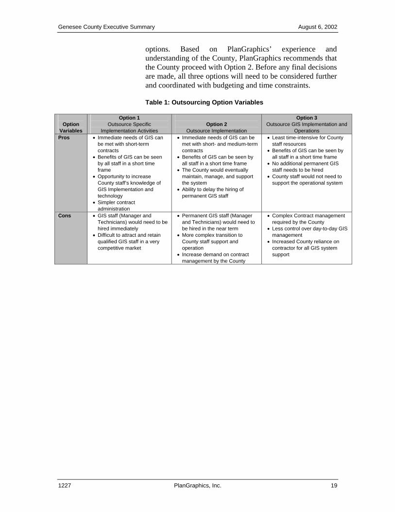
Table 1 outlines the Pros and Cons of each option, and Table 2 presents a cost comparison table for each of the
1227 PlanGraphics, Inc. 18
Genesee County Executive Summary August 6, 2002
options. Based on PlanGraphics’ experience and understanding of the County, PlanGraphics recommends that the County proceed with Option 2. Before any final decisions are made, all three options will need to be considered further and coordinated with budgeting and time constraints.
Table 1: Outsourcing Option Variables
Option
Variables
Option 1 Outsource Specific
Implementation Activities
Option 2
Outsource Implementation
Option 3 Outsource GIS Implementation and
Operations Pros • Immediate needs of GIS can
be met with short-term contracts
• Benefits of GIS can be seen by all staff in a short time frame
• Opportunity to increase County staff’s knowledge of GIS Implementation and technology
• Simpler contract administration
• Immediate needs of GIS can be met with short- and medium-term contracts
• Benefits of GIS can be seen by all staff in a short time frame
• The County would eventually maintain, manage, and support the system
• Ability to delay the hiring of permanent GIS staff
• Least time-intensive for County staff resources
• Benefits of GIS can be seen by all staff in a short time frame
• No additional permanent GIS staff needs to be hired
• County staff would not need to support the operational system
Cons • GIS staff (Manager and Technicians) would need to be hired immediately
• Difficult to attract and retain qualified GIS staff in a very competitive market
• Permanent GIS staff (Manager and Technicians) would need to be hired in the near term
• More complex transition to County staff support and operation
• Increase demand on contract management by the County
• Complex Contract management required by the County
• Less control over day-to-day GIS management
• Increased County reliance on contractor for all GIS system support
1227 PlanGraphics, Inc. 19
Genesee County Executive Summary August 6, 2002
Future GIS Staff Positions In terms of GIS staffing, PlanGraphics recommends the use
of existing staff in the initial stages of implementation with the creation of two or more permanent GIS staff positions in the future. Existing staff includes GIS staff in Equalization, who will need to support GIS implementation priorities and participate in the implementation activities assigned to the GIS Working Group.
Future permanent staffing positions include the addition of a GIS Coordinator and one or two GIS Technicians (database and application developers) to support the needs of all County departments. These new staff members will work closely with the GIS Executive Steering Committee and GIS Working Group to deploy GIS in Genesee County.
Training and Education Successful implementation planning and management procedures must include training and education components. Providing training on a long-term basis is a critical factor in the success of GIS. Three types of GIS training and education programs should be considered for Genesee County:
• Orientation and Introductory Training in GIS Technology
• Specialized Training—GIS Software, Hardware Operation, and System and Database Administration
• Professional Growth and Development—Technical and Management issues that impact GIS development and applications.
The sources for training programs in Southeastern Michigan are numerous, either from private companies or through the many university programs. Therefore, County staff should take advantage of these opportunities for training.
The County should send personnel to training sessions incrementally over a period of time consistent with development and application needs. In addition to GIS-related training, some County participants will need basic computer skills courses/training (i.e., Windows, Excel, Access, etc.) to raise the skill level of personnel in most departments.
1227 PlanGraphics, Inc. 20
Genesee County Executive Summary August 6, 2002
In-house training for users will be critical to the ongoing success of the enterprise GIS. Any future GIS staff should design and conduct select customized training for GIS users.
How will GIS become a reality?
GIS implementation will occur
over a multi-year period.
PlanGraphics recommends that Genesee County approach GIS implementation in two phases. The first phase of implementation is referred to as the Initial Phase, and it will last for approximately two and a half years. One of the major objectives of this phase is to begin to implement enterprise GIS in Genesee County. By focusing on the immediate needs of all those involved, the benefits of GIS to County personnel and decision-makers will therefore be demonstrated.
Phase 1—Initial Phase The first phase of implementation is referred to as the Initial Phase. This phase will last for approximately two and a half years. The objectives of this phase include the following:
• Establish organizational structure, funding, and policies and procedures that will govern the enterprise GIS.
• Enhance the existing land base and migrate a core set of data (cadastral, orthophotos, street centerlines, administrative boundaries) to enterprise data sets within the ArcGIS and SDE software environments.
• Establish a GIS Center, including hiring staff and contracting for implementation services.
• Develop a subset of the priority applications defined in the GIS Needs Assessment/Conceptual System Design Working Paper. Those applications that can be used throughout a number of departments in the County should be developed first, thereby ensuring that all County personnel will be exposed to this new technology. A maximum of five to six of the priority applications should be implemented throughout the County during this phase. These five to six applications should, once again, be implemented throughout the entire County to ensure that everyone sees the benefits of GIS during the initial phase of implementation.
1227 PlanGraphics, Inc. 21
Genesee County Executive Summary August 6, 2002
• Identify, evaluate, and support key initiatives during the initial phase of implementation (i.e., Treasurer’s Office delinquent property program, homeland security, and emergency preparedness).
• Develop the majority of map themes and layers (and some key attribute data) outlined in the GIS Needs Assessment/Conceptual System Design Working Paper.
• Develop and implement GIS data maintenance standards, procedures, and software tools.
• Purchase and install additional hardware and software.
• Integrate at least three to four of the existing computer and information systems within the County with the GIS during the first implementation phase.
• Provide GIS training and education for County staff during this phase of implementation. Training will be targeted at all levels of users, and everyone in the County should be exposed to some type of GIS education during this phase.
Phase 2—Extended Implementation
Phase 2 of implementation is referred to as the Extended Phase. This phase will last for approximately one and a half years. The major objectives of this stage of implementation are as follows:
• Review and evaluate the County’s enterprise GIS to date, including the assessment of status, cost, schedule, and benefits.
• Develop and implement a strategy for transition of activities to be performed in-house by GIS staff, as opposed to being outsourced.
• Evaluate applications developed to date and other recently implemented software and hardware.
• Review the project’s organizational and administrative framework to ensure that the needs of all participants are being met. This will also ensure that necessary modifications will be addressed and made to structures, roles, and responsibilities of all parties involved.
1227 PlanGraphics, Inc. 22
Genesee County Executive Summary August 6, 2002
• Continue development of priority applications, along with the conversion and acquisition of additional data.
• Hire additional GIS support staff (i.e., GIS technicians).
• Continue GIS training and education for County staff during this phase of implementation.
• Continue status reports and briefings on project progress to date.
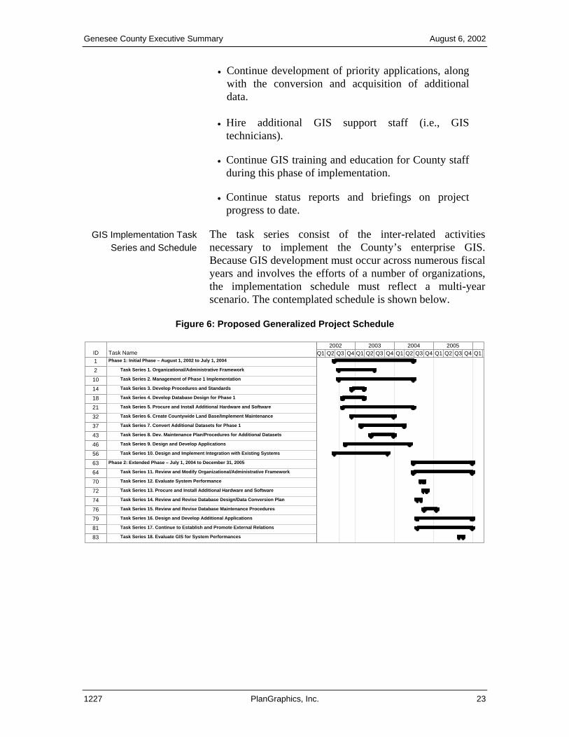
GIS Implementation Task Series and Schedule
The task series consist of the inter-related activities necessary to implement the County’s enterprise GIS. Because GIS development must occur across numerous fiscalyears and involves the efforts of a number of organizations, the implementation schedule must reflect a multi-year scenario. The contemplated schedule is shown below.
Figure 6: Proposed Generalized Project Schedule
ID Task Name1 Phase 1: Initial Phase – August 1, 2002 to July 1, 2004
2 Task Series 1. Organizational/Administrative Framework
10 Task Series 2. Management of Phase 1 Implementation
14 Task Series 3. Develop Procedures and Standards
18 Task Series 4. Develop Database Design for Phase 1
21 Task Series 5. Procure and Install Additional Hardware and Software
32 Task Series 6. Create Countywide Land Base/Implement Maintenance
37 Task Series 7. Convert Additional Datasets for Phase 1
43 Task Series 8. Dev. Maintenance Plan/Procedures for Additional Datasets
46 Task Series 9. Design and Develop Applications
56 Task Series 10. Design and Implement Integration with Existing Systems
63 Phase 2: Extended Phase – July 1, 2004 to December 31, 2005
64 Task Series 11. Review and Modify Organizational/Administrative Framework
70 Task Series 12. Evaluate System Performance
72 Task Series 13. Procure and Install Additional Hardware and Software
74 Task Series 14. Review and Revise Database Design/Data Conversion Plan
76 Task Series 15. Review and Revise Database Maintenance Procedures
79 Task Series 16. Design and Develop Additional Applications
81 Task Series 17. Continue to Establish and Promote External Relations
83 Task Series 18. Evaluate GIS for System Performances
Q1 Q2 Q3 Q4 Q1 Q2 Q3 Q4 Q1 Q2 Q3 Q4 Q1 Q2 Q3 Q4 Q12002 2003 2004 2005
1227 PlanGraphics, Inc. 23
Genesee County Executive Summary August 6, 2002
A Far-sighted Investment
$$$$
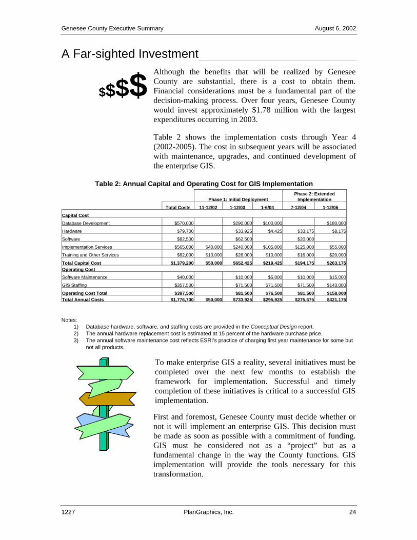
Although the benefits that will be realized by Genesee County are substantial, there is a cost to obtain them. Financial considerations must be a fundamental part of the decision-making process. Over four years, Genesee County would invest approximately $1.78 million with the largest expenditures occurring in 2003.
Table 2 shows the implementation costs through Year 4 (2002-2005). The cost in subsequent years will be associated with maintenance, upgrades, and continued development of the enterprise GIS.
Table 2: Annual Capital and Operating Cost for GIS Implementation
Phase 1: Initial Deployment Phase 2: Extended
Implementation Total Costs 11-12/02 1-12/03 1-6/04 7-12/04 1-12/05 Capital Cost Database Development $570,000 $290,000 $100,000 $180,000
Hardware $79,700 $33,925 $4,425 $33, $8,175
Software $82,500 $62,500 $20,
Implementation Services $565,000 $40,000 $240,000 $105,000 $125,000 $55,000
Training and Other Services $82,000 $10,000 $26,000 $10,000 $16,000 $20,000
Total Capital Cost $1,379,200 $50,000 $652,425 $219,425 $194,175 $263,175Operating Cost Software Maintenance $40,000 $10,000 $5,000 $10,000 $15,000
GIS Staffing $357,500 $71,500 $71,500 $71,500 $143,000
Operating Cost Total $397,500 $81,500 $76,500 $81,500 $158,000Total Annual Costs $1,776,700 $50,000 $733,925 $295,925 $275,675 $421,175
000
175
Notes: 1) Database hardware, software, and staffing costs are provided in the Conceptual Design report. 2) The annual hardware replacement cost is estimated at 15 percent of the hardware purchase price. 3) The annual software maintenance cost reflects ESRI’s practice of charging first year maintenance for some but
not all products.
To make enterprise GIS a reality, several initiatives must be completed over the next few months to establish the framework for implementation. Successful and timely completion of these initiatives is critical to a successful GIS implementation.
First and foremost, Genesee County must decide whether or not it will implement an enterprise GIS. This decision must be made as soon as possible with a commitment of funding. GIS must be considered not as a “project” but as a fundamental change in the way the County functions. GIS implementation will provide the tools necessary for this transformation.
1227 PlanGraphics, Inc. 24
Genesee County Executive Summary August 6, 2002
Summary of Recommendations
• PlanGraphics recommends that a coordinated enterprise-wide approach be used for GIS implementation.
• PlanGraphics recommends that Genesee County develop a number of core database layers, including survey control features, digital orthophotography, detailed planimetrics, street centerlines, property features, topography, and a number of other layers, including public safety, geopolitical, demographics, assessment, land use, zoning, and utility facilities.
• PlanGraphics recommends that Genesee County invest in the hardware and software required to support the enterprise GIS according to the configuration previously stated in this document.
• PlanGraphics recommends that Genesee County continue with the ESRI suite of GIS products. By maintaining the ESRI product line, Genesee County will experience advantages in terms of data sharing and system compatibility.
• PlanGraphics recommends that Genesee County implement an organizational structure consisting of the GIS Executive Steering Committee, a GIS Working Group, and a GIS Center. The County should eventually hire or appoint a GIS Coordinator and additional GIS support staff.
• PlanGraphics recommends that Genesee County follow the GIS Implementation Plan previously discussed in this Executive Summary to ensure successful GIS implementation.
• If Genesee County does not adopt the recommendations in this report at this time, PlanGraphics recommends that a work plan based on a subset of these recommendations be developed. The components of this work plan will be dependent upon budget and staffing constraints.
1227 PlanGraphics, Inc. 25