Embed Size (px)
DESCRIPTION
Generation and Application of Gridded Aviation Forecast Parameters in GFE and AvnFPS. Chris Leonardi Aviation Focal Point, NWS Charleston WV National Weather Association Annual Meeting October 19, 2006. The past. - PowerPoint PPT Presentation
Citation preview

Generation and Application of Generation and Application of Gridded Aviation Forecast Gridded Aviation Forecast Parameters in GFE and Parameters in GFE and AvnFPS AvnFPS
Chris LeonardiChris LeonardiAviation Focal Point, NWS Charleston WVAviation Focal Point, NWS Charleston WV
National Weather Association Annual MeetingNational Weather Association Annual MeetingOctober 19, 2006October 19, 2006
NWS Charleston WVNWS Charleston WV
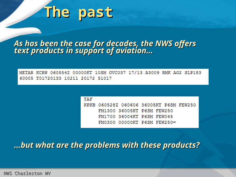
The pastThe past
As has been the case for decades, the NWS offers As has been the case for decades, the NWS offers text products in support of aviation…text products in support of aviation…
……but what are the problems with these products?but what are the problems with these products?

NWS Charleston WVNWS Charleston WV
The problemsThe problems
•Limited to a few specific airportsLimited to a few specific airports• Of particular concern since the FAA wants to greatly increase Of particular concern since the FAA wants to greatly increase
(2-3 times) the number of TAFs(2-3 times) the number of TAFs• Generally skewed towards commercial interests and not the Generally skewed towards commercial interests and not the
general aviation communitygeneral aviation community
•Hard to get a sense of overall current/forecast Hard to get a sense of overall current/forecast weather patternweather pattern• Where’s the front?Where’s the front?• How will the fog set up across the area?How will the fog set up across the area?
•Collaboration between WFOs is spotty at bestCollaboration between WFOs is spotty at best
•No graphical presentationNo graphical presentation

NWS Charleston WVNWS Charleston WV
National Gridded Forecast National Gridded Forecast Database (NDFD)Database (NDFD)
2.5km resolution database of various weather parameters like 2.5km resolution database of various weather parameters like temperature, wind, sky cover, etc.temperature, wind, sky cover, etc.
But what about aviation specific parameters like ceiling height But what about aviation specific parameters like ceiling height and visibility???and visibility???

NWS Charleston WVNWS Charleston WV
The new gridsThe new grids
In addition to relevant NDFD parameters (Sky, Wx, In addition to relevant NDFD parameters (Sky, Wx, Wind, PoP), we have added the following:Wind, PoP), we have added the following:• PredHgtPredHgt – “conditional ceiling height” in hundreds of – “conditional ceiling height” in hundreds of feet (0-250)feet (0-250)• Ceiling if Sky Ceiling if Sky ≥ 57%, height of predominant cloud layer ≥ 57%, height of predominant cloud layer
otherwiseotherwise• InternalInternal Collaboration grid…also used with Sky to construct Collaboration grid…also used with Sky to construct
CigHgt grid for web displayCigHgt grid for web display
• CigHgtCigHgt – ceiling height in feet (0-25000) – ceiling height in feet (0-25000)• Ceiling height if sky >57%, otherwise no ceilingCeiling height if sky >57%, otherwise no ceiling• Generated as last step (totally dependent on Sky/PredHgtGenerated as last step (totally dependent on Sky/PredHgt• Source of Source of externalexternal web graphic web graphic
• VsbyVsby – visibility in miles (0-10) – visibility in miles (0-10)

NWS Charleston WVNWS Charleston WV
More grid detailsMore grid details
•Updated 4 times a day at main issuance times Updated 4 times a day at main issuance times (00Z, 06Z, 12Z, 18Z)(00Z, 06Z, 12Z, 18Z)
•Generated on an hourly basis out to 30 hoursGenerated on an hourly basis out to 30 hours
•Represent prevailing conditions only (ie. no Represent prevailing conditions only (ie. no TEMPOs)TEMPOs)
•Loose collaboration with PBZ/JKL on Loose collaboration with PBZ/JKL on PredHgt/VsbyPredHgt/Vsby

NWS Charleston WVNWS Charleston WV

NWS Charleston WVNWS Charleston WV
What tools do we use?What tools do we use?
• High-resolution spatial/temporalHigh-resolution spatial/temporal model data model data
– LAMP (NGM-based), LAV (GFS-based)LAMP (NGM-based), LAV (GFS-based)– Local models (WSEta, WRF)Local models (WSEta, WRF)– NCAR NCV gridsNCAR NCV grids
• GFE smart tools/proceduresGFE smart tools/procedures– Model ingest tools for LAV/WRF/NCV dataModel ingest tools for LAV/WRF/NCV data– Tools for improved manipulation/interpolationTools for improved manipulation/interpolation
of data of data– Tools for exact placement of fogTools for exact placement of fog

NWS Charleston WVNWS Charleston WV
How do we generate grids?How do we generate grids?Here is a typical “smart tool” to generate grids based Here is a typical “smart tool” to generate grids based on expected fog:on expected fog:

NWS Charleston WVNWS Charleston WV
How do we generate grids?How do we generate grids?
Here are examples of Here are examples of the grids that are the grids that are created.created.
Note the level of detail that Note the level of detail that these tools allow us to these tools allow us to work with!work with!

NWS Charleston WVNWS Charleston WV
Application of grids – Element Application of grids – Element imagesimages
PNG images are created from these grids and PNG images are created from these grids and posted to our web page.posted to our web page.

NWS Charleston WVNWS Charleston WV
Application of grids – Point Application of grids – Point aviation forecastsaviation forecasts
We can also display ceiling/visibility forecast information We can also display ceiling/visibility forecast information anywhere in our CWA – NOT just for TAF sites!anywhere in our CWA – NOT just for TAF sites!

NWS Charleston WVNWS Charleston WV
How do I get this How do I get this information?information?
Go to Go to http://weather.gov/charlestonwvhttp://weather.gov/charlestonwv
For a point specific plot of ceiling/visibility:For a point specific plot of ceiling/visibility:
Enter your city/state or zip codeEnter your city/state or zip code
OR click on the map at a location of interest…OR click on the map at a location of interest…
On the next page, click on “Hourly Weather Graph”On the next page, click on “Hourly Weather Graph”

NWS Charleston WVNWS Charleston WV
Where else can I see all this Where else can I see all this neat stuff?!?neat stuff?!?
It’s all available NOW on the NWS Charleston It’s all available NOW on the NWS Charleston Aviation Page!Aviation Page!
http://weather.gov/charlestonwv/aviation/aviation.phphttp://weather.gov/charlestonwv/aviation/aviation.php

NWS Charleston WVNWS Charleston WV
Application of grids – Skeleton TAFsApplication of grids – Skeleton TAFs
We can import the grids into AvnFPS to create first-We can import the grids into AvnFPS to create first-guess TAFs.guess TAFs.

NWS Charleston WVNWS Charleston WV
Gridded TAF +/-Gridded TAF +/-
• Positives:Positives:• Quick writing of TAFs…*if* sufficient work has been Quick writing of TAFs…*if* sufficient work has been
put into gridsput into grids• Potential to generate many more TAFs than Potential to generate many more TAFs than
previously possiblepreviously possible• Potential for quick area-wide amendmentsPotential for quick area-wide amendments
• Negatives:Negatives:• No TEMPOs generated (can be typed in)No TEMPOs generated (can be typed in)• Only one cloud layer generated (can type in more)Only one cloud layer generated (can type in more)• Copy/paste/deleting can be cumbersomeCopy/paste/deleting can be cumbersome• Local effects tricky to include at timesLocal effects tricky to include at times

NWS Charleston WVNWS Charleston WV
These are all good services…These are all good services…
but what about the numbers?but what about the numbers?

NWS Charleston WVNWS Charleston WV
Verification comparisonVerification comparison
Comparing FY05 to FY06 GPRA standards:Comparing FY05 to FY06 GPRA standards:
• IFR PODIFR POD– Roughly the same for each year, but still below goalRoughly the same for each year, but still below goal
– Winter performance better than FY05, summer performance Winter performance better than FY05, summer performance worse than FY05worse than FY05
• IFR FARIFR FAR– Improved in FY06Improved in FY06
– Both winter and summer saw improvementBoth winter and summer saw improvement
• IFR CSI is slightly improved in FY06IFR CSI is slightly improved in FY06

NWS Charleston WVNWS Charleston WV
Seasonal breakdownSeasonal breakdown
• Why the winter season improvement?Why the winter season improvement?• “ “Systemic” thinkingSystemic” thinking
• Fewer TEMPOsFewer TEMPOs
• Why the summer struggles?Why the summer struggles?• Local effects vs. synoptic effectsLocal effects vs. synoptic effects
• Fewer TEMPOs = worse IFR fog/storm performance?Fewer TEMPOs = worse IFR fog/storm performance?

NWS Charleston WVNWS Charleston WV
Overall picture?Overall picture?
Our statistical Our statistical performance has performance has remained steady (or remained steady (or improved slightly) – and improved slightly) – and new services are being new services are being offered.offered.

NWS Charleston WVNWS Charleston WV
The challengesThe challenges
• Verification statistics still need to improveVerification statistics still need to improve– Winter has shown definite improvementWinter has shown definite improvement– Summer has been similar to past years…we need further work Summer has been similar to past years…we need further work
herehere
• Forecaster work load has increased Forecaster work load has increased significantlysignificantly• Difficult to forecast local phenomena in gridsDifficult to forecast local phenomena in grids
– FogFog– Elevation effects on ceilingElevation effects on ceiling– Short-term visibility restrictions in precipShort-term visibility restrictions in precip
• Need more model/science-based toolsNeed more model/science-based tools

NWS Charleston WVNWS Charleston WV
The next stepsThe next steps
• Publicity for gridded aviation productsPublicity for gridded aviation products– Letter/visits to airportsLetter/visits to airports
– Fly-ins/talks with flying clubsFly-ins/talks with flying clubs
• Inclusion of TEMPO gridsInclusion of TEMPO grids– Automatic inclusion in TAFsAutomatic inclusion in TAFs
– Short, targeted TEMPO groups could improve summer performanceShort, targeted TEMPO groups could improve summer performance
• Further improvement of model data and smart tools Further improvement of model data and smart tools (RUC13, NCV)(RUC13, NCV)
• Tighter collaboration with neighboring offices Tighter collaboration with neighboring offices (CWSUs?)(CWSUs?)
•Ultimate goal – highly detailed 3D aviation database Ultimate goal – highly detailed 3D aviation database across the CONUS (interactive route forecasts!)across the CONUS (interactive route forecasts!)

NWS Charleston WVNWS Charleston WV
Questions?Questions?