Embed Size (px)
Citation preview

GENERAL MANAGEMENT PLAN (Draft)
Long-range management guidance focused on the specific natural resources, historic-cultural resources, recreation opportunities, and the education-
interpretation opportunities for…
SANILAC PETROGLYPHS HISTORIC STATE PARK
Prepared by:
Paul Curtis, Management Plan Administrator
Kristen Bennett, Park Planner John Bugg, Planning Assistant Jeff Johnson, Student Assistant
Anna Popp, Student Intern PLAN APPROVALS: Chief, Parks and Parks and Recreation Division Date Deputy Director, Resources Date Director, Michigan Department of Natural Resources Date
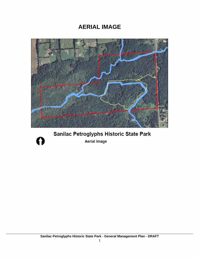
AERIAL IMAGE
___________________________________________________________________________________________________________________ Sanilac Petroglyphs Historic State Park - General Management Plan - DRAFT
1
___________________________________________________________________________________________________________________ Sanilac Petroglyphs Historic State Park - General Management Plan - DRAFT
2
TABLE OF CONTENTS
SECTION PAGE Executive Summary …………………………………………………………4 Introduction……………………………………………………………………6 Planning Process Overview Planning Objectives Planning Team…….…………………………………………………….. …...7 Core Values ……………………………………………………………..........9 DNR / PRD Mission Park Identity
- Park Purpose - Park Significance
Legal Mandates General Management Plan………………………………………………….15 Primitive Zone
Cultural Landscape Zone History Education Zone
Future Plan Inserts (List)………………………………………………. …...22
10-Year Action Plan (LONG-RANGE ACTION GOALS TO ATTAIN GMP) …….... (INSERT)
5-Year Action Plan (SPECIFIC ACTIONS TO IMPLEMENT) …………………. (INSERT)
Annual Action Plan and Progress Report ………………………….. (INSERT) Operational / Management Resources………………………………... (INSERT) - Annual Work Plan (NOTE…this should tie-in with Phase 4 – Annual Report of Management
Planning) - Staffing plan - Budget plan - Equipment inventory and needs - Training (required and desired) - Public relations / marketing / outreach - Programming (special events, MCCC activities, volunteers, etc.) - Public health, safety and welfare
- Water system - Wastewater system - Electrical system - Law enforcement - Emergency access plans
___________________________________________________________________________________________________________________ Sanilac Petroglyphs Historic State Park - General Management Plan - DRAFT
3
- Wildfire management plan - Dam Safety reports
- CRS - FOIA - Raster Image Index - Raster Images of historic park plans - Park Infrastructure data - Parcel mapping of land ownership - Other…
Supporting Analysis……………………………………………………23 Park Setting
- Location and surrounding community - Demographics - General history of park - Land ownership and issues - Relationship to other park resources - Current land use Natural Resources - Geology and Ecoregional context - Water resources - Climate - Soils - Flora - Fauna - Conservation Concerns Historic / Cultural Resources - Physical environment - Cultural environment - Archaeological resources - Buildings and structures - Historic landscape Education / Interpretation / Visitor Services Resources - LAPS ‘Kids in Park’ - Interpretive programming, displays, and signage - Volunteer programs Recreational Resources - Developed opportunities - Areas of conflict Park Use Statistics and Economic Impacts - 2008 use statistics - 2008 economic impact analysis Stakeholder Input
Planning Overview………………………………………………………41
- Documents - Meetings - Plan Reviews
Sanilac Petroglyphs HSP Deed (scanned)…………..……………...42

EXECUTIVE SUMMARY
___________________________________________________________________________________________________________________ Sanilac Petroglyphs Historic State Park - General Management Plan - DRAFT
4
ves:
eptember of 2010.
Management Planning is a defined strategic process within the PRD Strategic Plan (2009), reflecting the following Goals and Objecti
• Goal 1, Objective 1.2: “Strengthen, update, and implement Management Plans.” • Goal 3, Objective 3.1: “Perform landscape level assessment of recreation
opportunities in decision making.” • Goal 8, Objective 8.1: “Continue to use the CCMSP, MSWC, NRC, SWC, and
Ecoregional Teams and partners to advise in PRD planning, policy development, and issue resolution.”
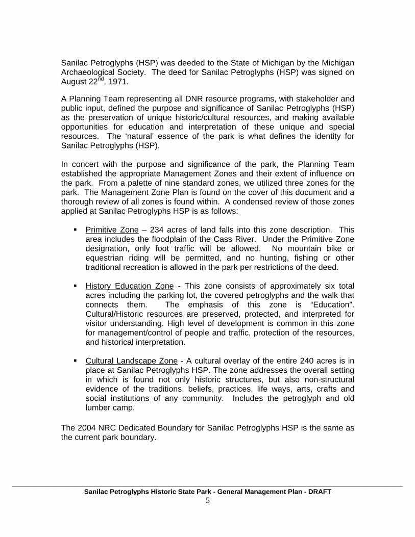
Sanilac Petroglyphs Historic State Park (HSP) is a 240 acre park located in Sanilac County, just east of Cass City, Michigan. Long-range planning for Sanilac Petroglyphs HSP began in February of 2007 when Parks and Recreation Division Planning and Operations staff met to initiate the Management Planning process. The process was put on hold for other Department and Division planning priorities until a planning grant was secured from the Coastal Zone Management Program in the fall of 2010 for Sleeper SP and Port Crescent SP. The proximity of Sanilac Petroglyphs HSP to these two parks and commonality of stakeholders made it a logical decision to re-start planning for Sanilac Petroglyphs HSP in S “Management Planning”, is a comprehensive resource based process, based on our adaptation of the National Park Service planning methodology. In our iteration, which focuses on the four tenants of our Mission Statement, we; inventory the (1) natural resource values of the park, establish its (2) historic/cultural resources, identify the (3) recreational opportunities and explore the (4) educational and interpretation opportunities; establish the “significance” (identity) of the park; and apply appropriate management zones that prescribe how the park will be managed.
___________________________________________________________________________________________________________________ Sanilac Petroglyphs Historic State Park - General Management Plan - DRAFT
5
Sanilac Petroglyphs (HSP) was deeded to the State of Michigan by the Michigan Archaeological Society. The deed for Sanilac Petroglyphs (HSP) was signed on August 22nd, 1971. A Planning Team representing all DNR resource programs, with stakeholder and public input, defined the purpose and significance of Sanilac Petroglyphs (HSP) as the preservation of unique historic/cultural resources, and making available opportunities for education and interpretation of these unique and special resources. The ‘natural’ essence of the park is what defines the identity for Sanilac Petroglyphs (HSP). In concert with the purpose and significance of the park, the Planning Team established the appropriate Management Zones and their extent of influence on the park. From a palette of nine standard zones, we utilized three zones for the park. The Management Zone Plan is found on the cover of this document and a thorough review of all zones is found within. A condensed review of those zones applied at Sanilac Petroglyphs HSP is as follows:
Primitive Zone – 234 acres of land falls into this zone description. This area includes the floodplain of the Cass River. Under the Primitive Zone designation, only foot traffic will be allowed. No mountain bike or equestrian riding will be permitted, and no hunting, fishing or other traditional recreation is allowed in the park per restrictions of the deed.
History Education Zone - This zone consists of approximately six total
acres including the parking lot, the covered petroglyphs and the walk that connects them. The emphasis of this zone is “Education”. Cultural/Historic resources are preserved, protected, and interpreted for visitor understanding. High level of development is common in this zone for management/control of people and traffic, protection of the resources, and historical interpretation.
Cultural Landscape Zone - A cultural overlay of the entire 240 acres is in
place at Sanilac Petroglyphs HSP. The zone addresses the overall setting in which is found not only historic structures, but also non-structural evidence of the traditions, beliefs, practices, life ways, arts, crafts and social institutions of any community. Includes the petroglyph and old lumber camp.
The 2004 NRC Dedicated Boundary for Sanilac Petroglyphs HSP is the same as the current park boundary.

___________________________________________________________________________________________________________________ Sanilac Petroglyphs Historic State Park - General Management Plan - DRAFT
6
he park’s “Identity”).
here are four phases of planning, implemented in the following order:
Phase 1- anagement Plan (GMP) - Long-range (20 yr)
Phase 2- yr) goals to
Phase 3- ns to implement
Phase 4- e this year and what progress was made on last year’s plan.
’s operational decisions? What will be the visitor’s overall xperience?
s” which define pecific characteristics of the land, addressing management for:
Education opportunities
fferences und from park to park are acknowledged, highlighted and celebrated.
INTRODUCTION
Planning Process Overview. The Management Planning Process develops a series of planning steps, each built upon the previous, that keep all planning and action decisions focused on (1) the mission of the Parks and Parks and Recreation Division, and (2) the specific Purpose and Significance of the park(t T
General M Goals.
Long-range Action Goals Plan - long range (10attain the GMP (requires review of Phase 1). 5-Year Implementation Plan – specific actio(requires review of Phase 1 and Phase 2). Annual Action Plan and Progress Report – what will be don
This is the General Management Plan, the first step in our planning process. In this phase of planning, we are defining what the park will look like in twenty years. What will be the condition of flora and fauna? How will we address historic and cultural resources? What recreational opportunities will be provided? What education and interpretation efforts will meet the visitor? What will guide the managere A key tool of this plan is the identification of “Management Zones
Natural resources Historic/cultural resources Recreational opportunities
These four elements represent the primary goals of the PRD Mission Statement, and provide guidance for both planning and management decisions. Within the parameters of this guidance, “Purpose” and “Significance” statements are developed for the park that establishes its unique identity and focus. No two parks are the same and this emphasis is directed at ensuring that the difo

___________________________________________________________________________________________________________________ Sanilac Petroglyphs Historic State Park - General Management Plan - DRAFT
7
o-day management of the park will be guided by this General Management Plan.
nning Team’. The following ersons were participants in this planning process:
Planning Objectives. The objective of this General Management Plan is to bring together Department staff, impacted and impacting stakeholders, and the public who use the park in a planning process that will define and clarify the unique “Purpose” and “Significance” of Sanilac Petroglyphs HSP. Collectively, we will reinforce those attributes in the planning and management decisions that impact the park through the implementation of the Management Zone Plan. Future action plans, whether focused on a development proposal, a resource improvement initiative, an interpretive program, or day-t
PLANNING TEAM
Accomplishment of our planning objectives was and is dependent upon the valuable input provided by all members of the ‘Plap Name Representing Paul Curtis DNR-PRD, Management Plan Administrator
e rvisor
ecialist ren
ation Specialist
er er
ire Supervisor
ficer t
on Bonnette DNR-WD, Technician
hority (MSHDA)
Kristen Benn t DNR-PRD, Bay City District Planner Carl Lindell DNR-PRD, Bay City District SupeGeorge Lauinger DNR-PRD, Sleeper SP Manager Betsy Kish DNR-PRD, Port Crescent SP Manager Ray Fahlsing DNR-PRD, Stewardship Unit Manager Lisa Gamero DNR-PRD, Stewardship Cultural SpGlenn Palmg DNR-PRD, Stewardship Ecologist Bob Clancy DNR-PRD, Stewardship RestorJeff Johnson DNR-PRD, Student Assistant James Baker DNR-FD, Bay City Unit ManagKathrin Schroud DNR-PRD, Bay City Biologist Bruce Miller DNR-FMD, Rose Lake Area FTom Hoane DNR-FMD, Geologist Scott Brown DNR-LED, Conservation OfArnie Karr DNR-WD, Cass BiologisD Michigan State Housing Development Aut
ayne Lusardi Marine Archaeologist
Dean Anderson Archaeologist W Michigan Archaeological Society Don Simons President
ian n Saginaw Chippewa Ind Tribe of Michiga Ms. Charmaine Benz Councilperson

___________________________________________________________________________________________________________________ Sanilac Petroglyphs Historic State Park - General Management Plan - DRAFT
8
e
s. Bonnie Ekdahl Ziibiwing Center
Asso iates
Ms. Marcella Hadden PR RepresentativMr. Willie Johnson Ziibiwing Center M Birchler Arroyo c
hleill Bahm Birchler Arroyo Associates *
* ractual work with us
in developing management plans for Port Cr cent SP and Sleeper SP.)
David Birc r Birchler Arroyo Associates * J
(We were assisted in this effort by the planning consultants, Birchler Arroyo Associates, who graciously accommodated our planning input needs as part of their cont
es

___________________________________________________________________________________________________________________ Sanilac Petroglyphs Historic State Park - General Management Plan - DRAFT
9
n plans.
CORE VALUES
Guidance for the General Management Plan stems from the mission statement of the Department of Natural Resources (DNR) and the Parks and Recreation Division (PRD), and the purpose and significance statements that have evolved through the planning process. The core values found in these statements must be reflected in this long-range general management plan for Sanilac Petroglyphs HSP and subsequently reflected in any shorter-range actio DNR Mission Statement “The Michigan Department of Natural Resources is committed to the conservation, protection, management, use and enjoyment of the state’s natural and cultural resources for current and future generations.” PRD Mission Statement “Acquire, protect, and preserve the natural, historic, and cultural features of Michigan’s unique resources and provide public recreation and educational opportunities.” The core values derived from the statements are that PRD will acquire, preserve, and protect; (1) natural resources, (2) cultural resources, (3) provide public recreation, and (4) provide educational opportunities. Park Purpose Park purpose statements are based on park legislation, legislative history, special designations and DNR policies. These statements reaffirm the reasons for which Sanilac Petroglyphs HSP was identified as part of the state park system.
• This property was conveyed to the DNR on August 22, 1971, for use by the public with specific deed restrictions. Administration of the property was assigned to Parks Division to carry out those specific management requirements.
• To provide a place to view the Petroglyphs. • To physically preserve the Petroglyphs from degradation.
• To provide educational and interpretive opportunities for the public that
reflect the mission of the DNR, MSHDA-Office of State Archaeologist, thunique qualities of the petroglyphs, and the significance to Native Americans.
e

___________________________________________________________________________________________________________________ Sanilac Petroglyphs Historic State Park - General Management Plan - DRAFT
10
Park Significance Park Significance statements capture the essence of the park’s importance to our state’s natural and cultural heritage. These statements demonstrate the distinctiveness of Sanilac Petroglyphs HSP. Understanding the park’s significance helps managers make decisions that preserve those resources and values necessary to accomplish the park’s purpose. Sanilac Petroglyphs HSP:
• Contains the most extensive single group of petroglyphs know in Michigan
• Contains unique bedrock outcroppings of Marshall Sandstone
• The petroglyphs are a sacred site for Native Americans with spiritual significance to a broader population.
• The park and surrounding area have cultural significance due to historic
and current uses.
• In addition to the petroglyphs, the park contains other features of archaeological significance (e.g. logging camp and old Cass Road).
• The park is an active ethnological site for current cultural practices by the
Saginaw Chippewa Indian Tribe.
• Natural features include white pine that dates back to the big fire of the late 1800’s.
• There are opportunities for interpretive trail for its educational significance
as well as for strong mutual education partnerships between Native Americans / DNR / Michigan Archeological Society (MAS).
• The North Branch Cass River is an important asset to the park.
• The exposed bedrock found within the park is unique and presents a
physical record of the past. It is apparent that a unique primitive technique was used to cut the petroglyph images into the rock. However, the condition of the petroglyphs needs attention and a plan for stewardship should be developed with Native American and MAS partners.
Legal Mandates For general management plans, all legal mandates will be identified and will serve to further guide the development of the plan and subsequent action plans. The term legal mandate refers not only to state law, but also administrative policies and directives of the Natural Resources Commission, the DNR, and PRD. There are several legal mandates specific to Sanilac Petroglyphs HSP,
___________________________________________________________________________________________________________________ Sanilac Petroglyphs Historic State Park - General Management Plan - DRAFT
11
detailing specific responsibilities of its owner and the duties of agencies designated to manage it, as well as general legal mandates having to with natural resource and historical protection. At Sanilac Petroglyphs HSP, the following legal mandates have been identified: Deed Restrictions The site was given as a gift to the DNR from the Michigan Archaeological Society (MAS). The deed spells out restrictions on the property’s use. This property is conveyed fro the use by the public and under the following conditions:
(1) To preserve the aboriginal petroglyphs and develop said premises for the benefit of mankind from the present to distant future generations as a cultural and educational facility (as distinguished from a sports or recreational facility) for promoting a better appreciation of man’s natural and cultural heritage and of his continuing relationship to his environment.
(2) Except as it may be, both a part of and incidental to a display, a demonstration, or a research project in furtherance of aforesaid purpose, no part of said premises, nor the product thereof, shall be used for private or public economical gain. Entrance or admission fees to the areas may be charged by the Michigan Department of Natural Resources or its successors as deemed necessary.
(3) If the property is not used for the intended purpose by the Michigan Department of Natural Resources, or its successors, within a reasonable time hereafter, or if thereafter it ceases to be so used, then in that event it shall revert to the party of the first part, its successors or assigns.
*A scanned copy of original deed is attached to the end of this document (starting on page 45).
Natural Resources and Environmental Protection Act, Public Act 451 of 1994, Part 741 This act is the recodification of law that established the Michigan State Park System and defined its powers and duties. Notable in this law is Section 324.74102, which identifies the duties of the department and reinforces the core values.
This section reads: (1) The legislature finds: (a) Michigan State Parks preserve and protect Michigan’s significant natural and historic resources. (b) Michigan State Parks are appropriate and uniquely suited to provide opportunities to learn about protection and management of Michigan’s natural resources. (c) Michigan State Parks are an important component of Michigan’s tourism industry and vital to local economies.

___________________________________________________________________________________________________________________ Sanilac Petroglyphs Historic State Park - General Management Plan - DRAFT
12
(2) The department shall create, maintain, operate, promote, and make
available for public use and enjoyment, a system of state parks to preserve and protect Michigan’s significant natural resources and areas of natural beauty or historic significance, to provide open space for public recreation, and to provide an opportunity to understand Michigan’s natural resources and need to protect and manage those resources.
Michigan Historical Commission Act, P.A. 271 of 1913, Section 4 Under Section 4, the Michigan Historical Commission is responsible for collecting, preserving, and displaying objects and materials relating to the history of Michigan and its people. Additionally, it states that DoS must display in historical museums objects indicative of the life, customs, dress, and resources of the residents of Michigan.
The section reads: The commission shall collect, arrange, and preserve material, including records, archives, paintings, and statuary illustrative of an relating to the history of Michigan and the old northwest territory; procure and preserve narratives of the early pioneers; collect material concerning the Indian tribes in Michigan; collect, prepare, and display in the Michigan historical museum objects indicative of the life, customs, dress, and resources of the early residents of Michigan; …
DNR Director’s Land Use Order 5.12 (17) This land use order lists prohibited conduct at Sanilac Petroglyphs Historic State Park, including entering into the fenced area containing the petroglyph rock when the entry gate is closed or walking upon or otherwise coming into contact with the petroglyph rock within the fenced area.
Land Ownership / Land Acquisition
___________________________________________________________________________________________________________________ Sanilac Petroglyphs Historic State Park - General Management Plan - DRAFT
13
LOTS (Land Ownership Tracking System)
EASEMENTS
___________________________________________________________________________________________________________________ Sanilac Petroglyphs Historic State Park - General Management Plan - DRAFT
14

GENERAL MANAGEMENT PLAN With the guidance of the Sanilac Petroglyphs HSP Planning Team (made up of Department resource staff, stakeholders, and public), the park “Purpose and Significance” statements were drafted and adopted. These statements established an identity for the park, to include the following: Sanilac Petroglyphs HSP was established for the purpose of preserving an educational natural resource. Based on this ‘identity’ for the park, a Management Zone Plan” was subsequently drafted and adopted with stakeholder and public support. The Management Zone Definitions apply to each zone used, with special considerations highlighted in the descriptive narratives of management guidance for each zone of the park.
___________________________________________________________________________________________________________________ Sanilac Petroglyphs Historic State Park - General Management Plan - DRAFT
15

PRIMITIVE ZONE
234 acres of the park falls under this zone description. This zone emphasizes the park’s high quality natural resources. Attaining and maintaining a high quality natural resource condition dictates the extent to which recreational improvements or uses are allowed. The low wetland areas within the park represent the Cass River floodplain. The soils in these areas are loam or silt loam and are easily subject to damage. Under the Primitive Zone designation, only dispersed and low frequency use, such as foot traffic, will be allowed. No mountain bike or equestrian uses are permitted.
___________________________________________________________________________________________________________________ Sanilac Petroglyphs Historic State Park - General Management Plan - DRAFT
16

___________________________________________________________________________________________________________________ Sanilac Petroglyphs Historic State Park - General Management Plan - DRAFT
17
Following are the prescribed qualities for the Primitive Zone:
Natural Resources. The Natural Resources Management Plan outlines several management objectives for this zone. A survey is proposed for non-native invasive species and then control of these invasive species as much as practical.
This zone will reflect natural processes, with vegetative management only allowed to restore and maintain natural ecological structure and processes (such as removing of invasive species), to address hazard trees, and to manage pests and disease.
Historic/Cultural Resources. Evidence of a timber camp is present within the park boundary. If any activity in this zone requires earthwork, it must first be reviewed and approved by Stewardship.
Recreational Opportunities. In compliance with the deed restrictions,
only low impact recreation (e.g. hiking, birding, educational and interpretive activities, etc.) associated with nature and cultural appreciation, will be allowed in this zone. No equestrian or mountain biking trails will be allowed. Hunting, trapping, and shore fishing is prohibited.
Education Opportunities. The natural resources of the park provides
educational opportunities. Specific planning recommendations for education and interpretation will require input from Marketing Education and Technology (MET). There is interpretive signage along the trail.
Visitor Experience. This area will reflect a ‘natural’ feel, a significant
sense of solitude, and a lack of man-made improvements.
Management Focus. Management of this zone will be focused on maintaining the low human-impact character of this area with an emphasis on natural resource quality.
Development. Only trail improvements (can include boardwalks and/or
overlooks) and educational or interpretive signage will be the evidence of man-made elements in this zone. Any improvements needed for resource protection, such as erosion control, shall be ‘natural’ in character. The focus is to maintain as little evidence of human activity as possible. All development will meet the approval requirements of the PRD planning process.
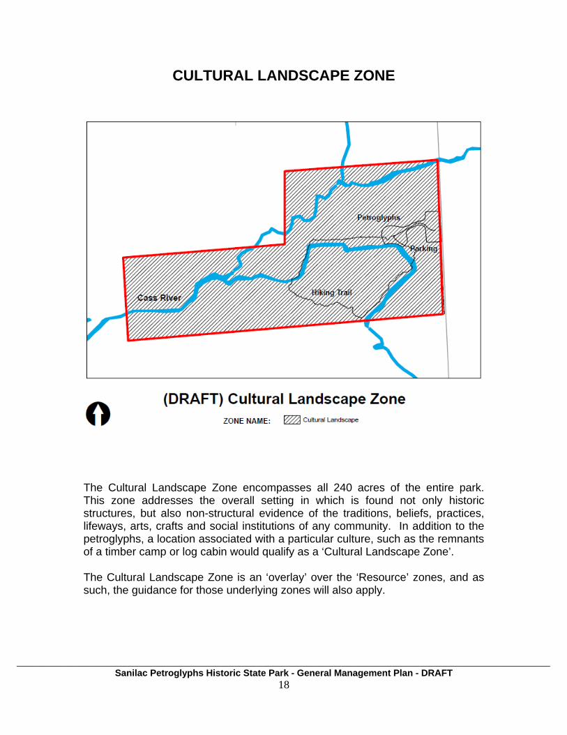
CULTURAL LANDSCAPE ZONE
The Cultural Landscape Zone encompasses all 240 acres of the entire park. This zone addresses the overall setting in which is found not only historic structures, but also non-structural evidence of the traditions, beliefs, practices, lifeways, arts, crafts and social institutions of any community. In addition to the petroglyphs, a location associated with a particular culture, such as the remnants of a timber camp or log cabin would qualify as a ‘Cultural Landscape Zone’. The Cultural Landscape Zone is an ‘overlay’ over the ‘Resource’ zones, and as such, the guidance for those underlying zones will also apply.
___________________________________________________________________________________________________________________ Sanilac Petroglyphs Historic State Park - General Management Plan - DRAFT
18

___________________________________________________________________________________________________________________ Sanilac Petroglyphs Historic State Park - General Management Plan - DRAFT
19
Natural Resources. Natural resources that have been identified as important to the cultural landscape are managed to perpetuate those qualities. This can include vegetation management tools.
Historic/Cultural Resources. Structures, remnants, and other landscape
characteristics and features which represent the evolution of the resource, temporal change and the continuum of time will be preserved, protected and enhanced. Rehabilitation or adaptive re-use for operational or education purposes are permitted.
Recreation Opportunities. Visitors can engage in sightseeing,
recreational, and education activities in a cultural setting compatible with and sensitive to the setting and the underlying zone requirements.
In compliance with the deed restrictions, only low impact recreation (e.g. hiking, birding, educational and interpretive activities, etc.) associated with nature and cultural appreciation, will be allowed in this zone. No equestrian or mountain biking trails will be allowed. Hunting, trapping, and shore fishing is prohibited.
Education Opportunities. Interpretive signage at trail heads, on the trail,
overlooks and other points of interest. The story of how this area was settled and used by prehistoric peoples, Native Americans, and early Europeans could be conveyed, sensitive to the underlying management zones.
Visitor Experience. For resources available to public viewing and/or use,
moderate visitor encounters are accommodated. Visitors engage in sightseeing, recreational, and education activities in a cultural setting. Moderate noise, time commitment and interaction with others can be expected. Visitors may encounter Native American rituals or events at various times of the year at the petroglyphs.
Management Focus. Management focuses on the compliance with the
deed restrictions, and maintaining the cultural character of the zone, with emphasis on natural resource quality.
Development. Non-historic development and activities that do not conflict
with the cultural landscape are tolerated in this zone. Moderate levels of development and accessibility could be provided to support visitor access and use. All development will meet the approval requirements of the PRD planning process.
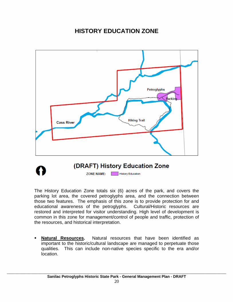
HISTORY EDUCATION ZONE
The History Education Zone totals six (6) acres of the park, and covers the parking lot area, the covered petroglyphs area, and the connection between those two features. The emphasis of this zone is to provide protection for and educational awareness of the petroglyphs. Cultural/Historic resources are restored and interpreted for visitor understanding. High level of development is common in this zone for management/control of people and traffic, protection of the resources, and historical interpretation. Natural Resources. Natural resources that have been identified as
important to the historic/cultural landscape are managed to perpetuate those qualities. This can include non-native species specific to the era and/or location.
___________________________________________________________________________________________________________________ Sanilac Petroglyphs Historic State Park - General Management Plan - DRAFT
20

___________________________________________________________________________________________________________________ Sanilac Petroglyphs Historic State Park - General Management Plan - DRAFT
21
Historic/Cultural Resources. The petroglyphs are the primary resource for this zone. They will be protected for visitor understanding and in-depth interpretation of historic period(s) and culture(s). Cultural and natural resources (including historic buildings, structures, and landscapes) may be restored to specific time period(s) if essential for the visitor understanding of historic period(s) and rehabilitated to support visitor and staff activities for in-depth interpretation of historic period(s).
Recreation Opportunities. Park visitors engaged in viewing the
petroglyphs, sightseeing and educational activities in a cultural setting.
Education Opportunities. Active interpretation is provided by the DNR at the petroglyphs as is interpretive signage at the site and parking lot. We recognize that there might be others that would want to participate in interpretation efforts. There is need for improved protection of the petroglyphs, and discussion in this planning process focused on the possibility of an “interpretive building” to cover the petroglyphs and provide a controlled environment for assured protection and expanded education/interpretation opportunities.
In addition, the Ziibiwing Center (operated by the Saginaw Chippewa Indian Tribe in Mount Pleasant, MI.) provides an excellent and complete indoor exhibit that focuses on the significance of the Sanilac Petroglyphs. A nominal entrance fee is charged, and for those interested in the Native American culture, the Ziibiwing Center is a ‘must see.’
Visitor Experience. For resources available to public viewing and/or use,
moderate visitor encounters are accommodated. Visitors engage in sightseeing and education activities in a cultural setting. Moderate noise, time commitment and interaction with others can be expected. Native Americans hold several ceremonies throughout the year, which visitors may respectfully observe.
Management Focus. The management focus of this zone will be the
preservation and protection of the petroglyphs and maintain the historic/cultural integrity of the zone. Keep development consistent with the zone. Strive for quality visitor experience of historic interests. Preserve and protect the petroglyphs and carry out the specific conditions of the deed.
Development. There is a desire to improve protection of the petroglyphs with
consideration of a more enclosed structure at the petroglyphs. Development of parking, access to petroglyphs and installation of signage/kiosks will be considered within this zone. All development will meet the approval of the PRD planning process

___________________________________________________________________________________________________________________ Sanilac Petroglyphs Historic State Park - General Management Plan - DRAFT
22
FUTURE PLAN INSERTS 10-Year Action Goals Plan (LONG-RANGE ACTION GOALS TO ATTAIN GMP) - Phase-2 of the Management Planning Process. Includes review and update of General Management Plan. 5-Year Implementation Plan (SPECIFIC ACTIONS TO IMPLEMENT) - Phase-3 of the Management Planning Process. Includes review and update of General Management Plan and Phase 2 Plan. Annual Work Plan and Progress Report - Phase-4 of the Management Planning Process.
Operational/Management Resources - The following categories are established as a guide for the park manager to use to supplement this working document. Other categories can be added as needed.
- Annual Work Plan (NOTE…this should tie-in with Phase 4 – Annual Report of Management Planning)
- Phase III Natural Resources Management Plan - Staffing plan - Budget plan - Equipment inventory and needs - Training (required and desired) - Public relations / marketing / outreach - Programming (special events, MCCC activities, volunteers, etc.) - Public health, safety and welfare
- Water system - Wastewater system - Electrical system - Law enforcement - Emergency access plans - Wildfire management plan - Dam Safety reports
- CRS - FOIA - Raster Image Index - Raster Images of historic park plans - Park Infrastructure data - Parcel mapping of land ownership - Other…

SUPPORTING ANALYSIS
240 acres
Sanilac County, Greenleaf Township
Latitude: 43.656423 Longitude: -83.017867
(Latitude and Longitude are taken at the entrance to the park)
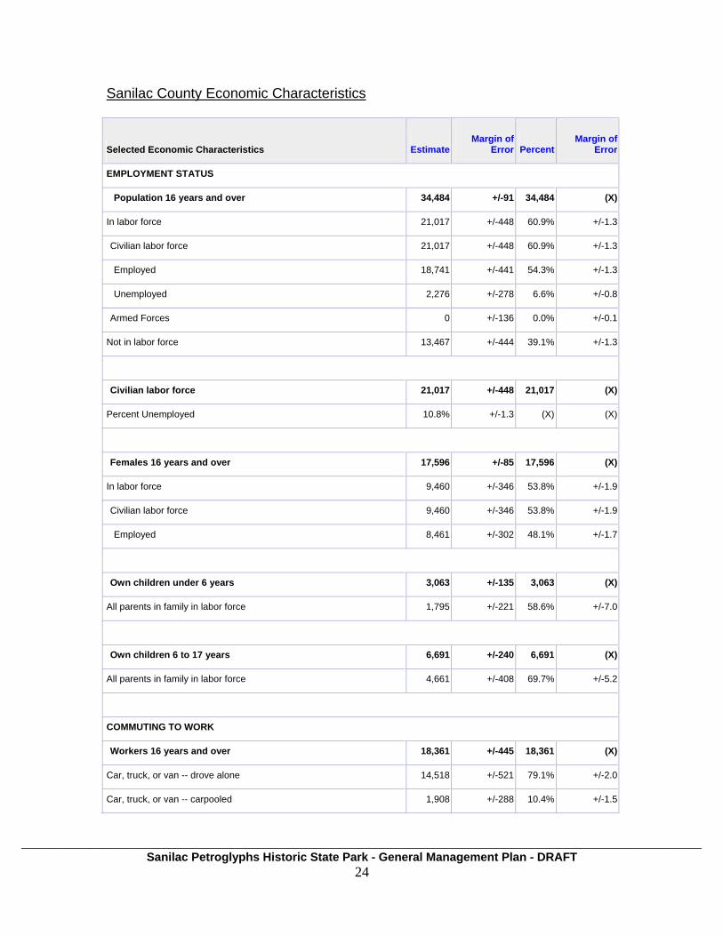
LOCATION AND SURROUNDING COMMUNITY Sanilac Petroglyphs is located in Greenleaf Township in Sanilac County. It is on the North branch of the Cass River, one mile south of the Bay City-Forestville Road. It lies four miles east of M-53. It is 80 miles from Flint, 77 miles from Port Huron, 62 miles from Saginaw, 45 miles from Bay City, and about 90 miles from Detroit. It is approximately an hour to an hour and a half drive for millions of Michigan residents. Sanilac County Demographics As of 2010, Sanilac County's population is 43,349 people. Since 2000, it has had a population growth of -2.67 percent. The median home cost in Sanilac County is $111,870. Home appreciation the last year has been -4.10 percent. Compared to the rest of the country, Sanilac County's cost of living is 14.90% Lower than the U.S. average. Sanilac County public schools spend $4,784 per student. The average school expenditure in the U.S. is $5,678. There are about 19.7 students per teacher in Sanilac County. The unemployment rate in Sanilac County is 16.90 percent (U.S. avg. is 10.20%). Recent job growth is Negative. Sanilac County jobs have decreased by 10.16 percent. (U.S. Census Bureau website)
___________________________________________________________________________________________________________________ Sanilac Petroglyphs Historic State Park - General Management Plan - DRAFT
23
___________________________________________________________________________________________________________________ Sanilac Petroglyphs Historic State Park - General Management Plan - DRAFT
24
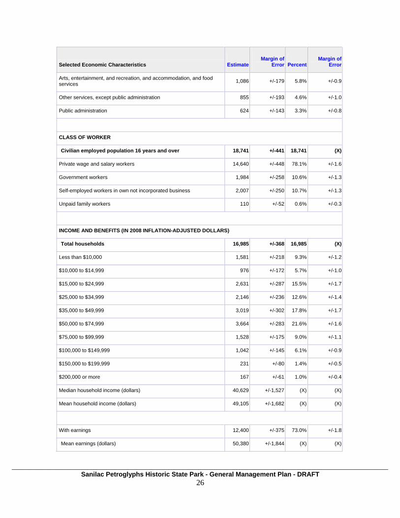
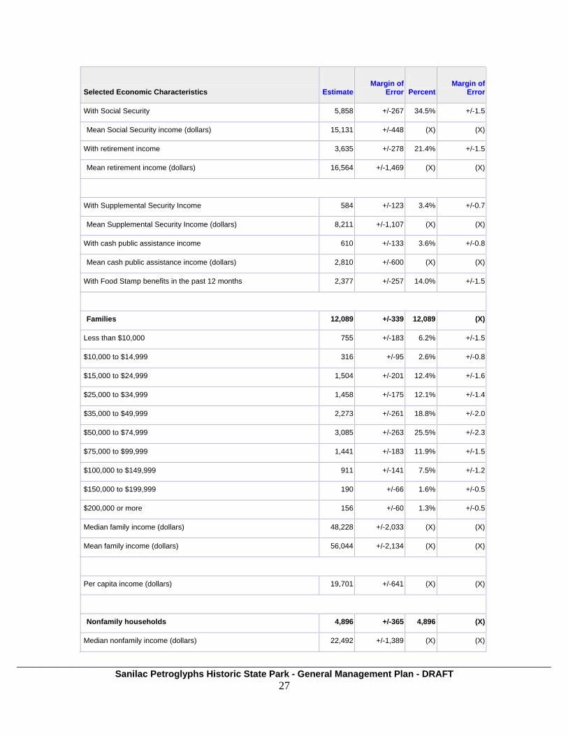
Sanilac County Economic Characteristics
Selected Economic Characteristics Estimate
Margin of
Error
Percent
Margin of Error
EMPLOYMENT STATUS
Population 16 years and over 34,484 +/-91 34,484 (X)
In labor force 21,017 +/-448 60.9% +/-1.3
Civilian labor force 21,017 +/-448 60.9% +/-1.3
Employed 18,741 +/-441 54.3% +/-1.3
Unemployed 2,276 +/-278 6.6% +/-0.8
Armed Forces 0 +/-136 0.0% +/-0.1
Not in labor force 13,467 +/-444 39.1% +/-1.3
Civilian labor force 21,017 +/-448 21,017 (X)
Percent Unemployed 10.8% +/-1.3 (X) (X)
Females 16 years and over 17,596 +/-85 17,596 (X)
In labor force 9,460 +/-346 53.8% +/-1.9
Civilian labor force 9,460 +/-346 53.8% +/-1.9
Employed 8,461 +/-302 48.1% +/-1.7
Own children under 6 years 3,063 +/-135 3,063 (X)
All parents in family in labor force 1,795 +/-221 58.6% +/-7.0
Own children 6 to 17 years 6,691 +/-240 6,691 (X)
All parents in family in labor force 4,661 +/-408 69.7% +/-5.2
COMMUTING TO WORK
Workers 16 years and over 18,361 +/-445 18,361 (X)
Car, truck, or van -- drove alone 14,518 +/-521 79.1% +/-2.0
Car, truck, or van -- carpooled 1,908 +/-288 10.4% +/-1.5

___________________________________________________________________________________________________________________ Sanilac Petroglyphs Historic State Park - General Management Plan - DRAFT
25
Selected Economic Characteristics Estimate
Margin of
Error
Percent
Margin of Error
Public transportation (excluding taxicab) 107 +/-104 0.6% +/-0.6
Walked 690 +/-178 3.8% +/-1.0
Other means 236 +/-85 1.3% +/-0.5
Worked at home 902 +/-170 4.9% +/-0.9
Mean travel time to work (minutes) 29.7 +/-1.6 (X) (X)
OCCUPATION
Civilian employed population 16 years and over 18,741 +/-441 18,741 (X)
Management, professional, and related occupations 4,518 +/-366 24.1% +/-1.9
Service occupations 2,790 +/-242 14.9% +/-1.3
Sales and office occupations 4,270 +/-346 22.8% +/-1.7
Farming, fishing, and forestry occupations 408 +/-106 2.2% +/-0.6
Construction, extraction, maintenance and repair occupations 2,392 +/-299 12.8% +/-1.6
Production, transportation, and material moving occupations 4,363 +/-390 23.3% +/-1.9
INDUSTRY
Civilian employed population 16 years and over 18,741 +/-441 18,741 (X)
Agriculture, forestry, fishing and hunting, and mining 1,295 +/-210 6.9% +/-1.1
Construction 1,594 +/-212 8.5% +/-1.2
Manufacturing 4,511 +/-405 24.1% +/-2.1
Wholesale trade 461 +/-132 2.5% +/-0.7
Retail trade 2,344 +/-312 12.5% +/-1.6
Transportation and warehousing, and utilities 846 +/-174 4.5% +/-0.9
Information 228 +/-63 1.2% +/-0.3
Finance and insurance, and real estate and rental and leasing 604 +/-125 3.2% +/-0.7
Professional, scientific, and management, and administrative and waste management services 793 +/-164 4.2% +/-0.9
Educational services, and health care and social assistance 3,500 +/-257 18.7% +/-1.4
___________________________________________________________________________________________________________________ Sanilac Petroglyphs Historic State Park - General Management Plan - DRAFT
26
Selected Economic Characteristics Estimate
Margin of
Error
Percent
Margin of Error
Arts, entertainment, and recreation, and accommodation, and food services 1,086 +/-179 5.8% +/-0.9
Other services, except public administration 855 +/-193 4.6% +/-1.0
Public administration 624 +/-143 3.3% +/-0.8
CLASS OF WORKER
Civilian employed population 16 years and over 18,741 +/-441 18,741 (X)
Private wage and salary workers 14,640 +/-448 78.1% +/-1.6
Government workers 1,984 +/-258 10.6% +/-1.3
Self-employed workers in own not incorporated business 2,007 +/-250 10.7% +/-1.3
Unpaid family workers 110 +/-52 0.6% +/-0.3
INCOME AND BENEFITS (IN 2008 INFLATION-ADJUSTED DOLLARS)
Total households 16,985 +/-368 16,985 (X)
Less than $10,000 1,581 +/-218 9.3% +/-1.2
$10,000 to $14,999 976 +/-172 5.7% +/-1.0
$15,000 to $24,999 2,631 +/-287 15.5% +/-1.7
$25,000 to $34,999 2,146 +/-236 12.6% +/-1.4
$35,000 to $49,999 3,019 +/-302 17.8% +/-1.7
$50,000 to $74,999 3,664 +/-283 21.6% +/-1.6
$75,000 to $99,999 1,528 +/-175 9.0% +/-1.1
$100,000 to $149,999 1,042 +/-145 6.1% +/-0.9
$150,000 to $199,999 231 +/-80 1.4% +/-0.5
$200,000 or more 167 +/-61 1.0% +/-0.4
Median household income (dollars) 40,629 +/-1,527 (X) (X)
Mean household income (dollars) 49,105 +/-1,682 (X) (X)
With earnings 12,400 +/-375 73.0% +/-1.8
Mean earnings (dollars) 50,380 +/-1,844 (X) (X)
___________________________________________________________________________________________________________________ Sanilac Petroglyphs Historic State Park - General Management Plan - DRAFT
27
Selected Economic Characteristics Estimate
Margin of
Error
Percent
Margin of Error
With Social Security 5,858 +/-267 34.5% +/-1.5
Mean Social Security income (dollars) 15,131 +/-448 (X) (X)
With retirement income 3,635 +/-278 21.4% +/-1.5
Mean retirement income (dollars) 16,564 +/-1,469 (X) (X)
With Supplemental Security Income 584 +/-123 3.4% +/-0.7
Mean Supplemental Security Income (dollars) 8,211 +/-1,107 (X) (X)
With cash public assistance income 610 +/-133 3.6% +/-0.8
Mean cash public assistance income (dollars) 2,810 +/-600 (X) (X)
With Food Stamp benefits in the past 12 months 2,377 +/-257 14.0% +/-1.5
Families 12,089 +/-339 12,089 (X)
Less than $10,000 755 +/-183 6.2% +/-1.5
$10,000 to $14,999 316 +/-95 2.6% +/-0.8
$15,000 to $24,999 1,504 +/-201 12.4% +/-1.6
$25,000 to $34,999 1,458 +/-175 12.1% +/-1.4
$35,000 to $49,999 2,273 +/-261 18.8% +/-2.0
$50,000 to $74,999 3,085 +/-263 25.5% +/-2.3
$75,000 to $99,999 1,441 +/-183 11.9% +/-1.5
$100,000 to $149,999 911 +/-141 7.5% +/-1.2
$150,000 to $199,999 190 +/-66 1.6% +/-0.5
$200,000 or more 156 +/-60 1.3% +/-0.5
Median family income (dollars) 48,228 +/-2,033 (X) (X)
Mean family income (dollars) 56,044 +/-2,134 (X) (X)
Per capita income (dollars) 19,701 +/-641 (X) (X)
Nonfamily households 4,896 +/-365 4,896 (X)
Median nonfamily income (dollars) 22,492 +/-1,389 (X) (X)
___________________________________________________________________________________________________________________ Sanilac Petroglyphs Historic State Park - General Management Plan - DRAFT
28
Selected Economic Characteristics Estimate
Margin of
Error
Percent
Margin of Error
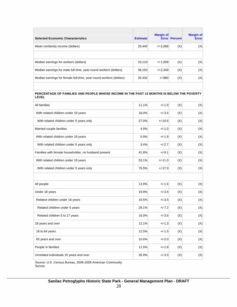
Mean nonfamily income (dollars) 29,440 +/-2,068 (X) (X)
Median earnings for workers (dollars) 23,110 +/-1,009 (X) (X)
Median earnings for male full-time, year-round workers (dollars) 38,153 +/-2,349 (X) (X)
Median earnings for female full-time, year-round workers (dollars) 26,332 +/-880 (X) (X)
PERCENTAGE OF FAMILIES AND PEOPLE WHOSE INCOME IN THE PAST 12 MONTHS IS BELOW THE POVERTY LEVEL
All families 11.1% +/-1.9 (X) (X)
With related children under 18 years 18.0% +/-3.5 (X) (X)
With related children under 5 years only 27.0% +/-10.6 (X) (X)
Married couple families 4.9% +/-1.0 (X) (X)
With related children under 18 years 5.9% +/-1.9 (X) (X)
With related children under 5 years only 3.4% +/-2.7 (X) (X)
Families with female householder, no husband present 41.8% +/-9.1 (X) (X)
With related children under 18 years 53.1% +/-11.0 (X) (X)
With related children under 5 years only 76.5% +/-17.0 (X) (X)
All people 13.9% +/-1.6 (X) (X)
Under 18 years 19.9% +/-3.5 (X) (X)
Related children under 18 years 19.5% +/-3.5 (X) (X)
Related children under 5 years 29.1% +/-7.2 (X) (X)
Related children 5 to 17 years 16.0% +/-3.6 (X) (X)
18 years and over 12.1% +/-1.3 (X) (X)
18 to 64 years 12.5% +/-1.5 (X) (X)
65 years and over 10.6% +/-2.0 (X) (X)
People in families 11.5% +/-1.8 (X) (X)
Unrelated individuals 15 years and over 26.9% +/-3.0 (X) (X)
Source: U.S. Census Bureau, 2006-2008 American Community Survey

Per Capita Personal Income, 2008
Race and Ethnicity (chart)
Race and Ethnicity for Sanilac County, Total Population of 43,484
619, 1.44%122, 0.28% 248, 0.58%
62, 0.14%
41,787, 97.55%White
Black or African American
American Indian and AlaskaNativeAsian
Some other race
Source: U.S. Census Bureau, 2006-2008 American Community Survey
___________________________________________________________________________________________________________________ Sanilac Petroglyphs Historic State Park - General Management Plan - DRAFT
29
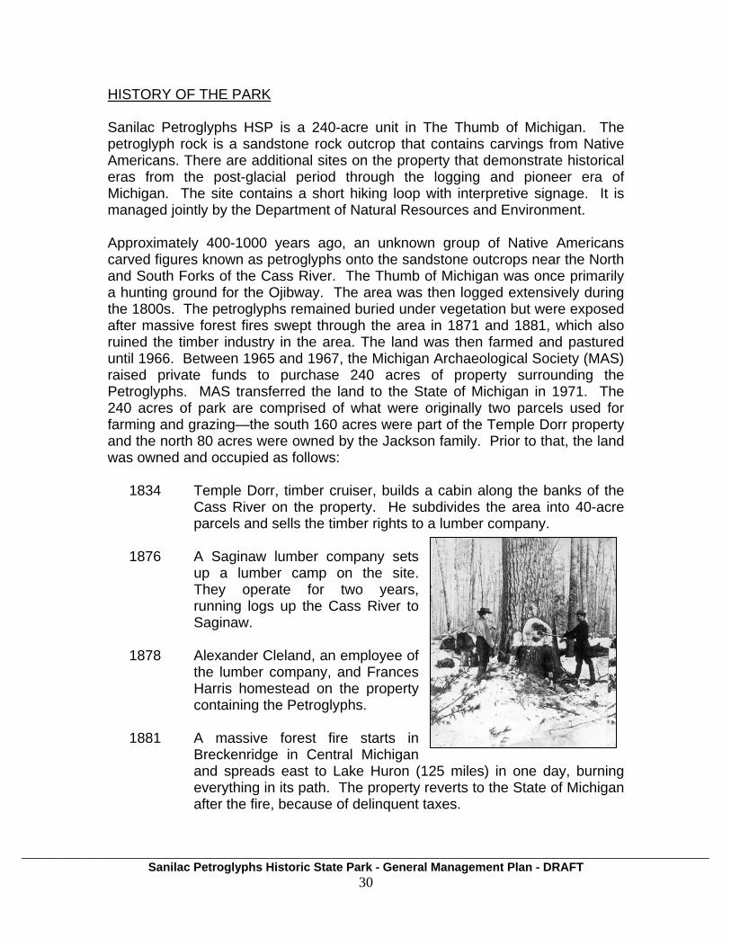
HISTORY OF THE PARK Sanilac Petroglyphs HSP is a 240-acre unit in The Thumb of Michigan. The petroglyph rock is a sandstone rock outcrop that contains carvings from Native Americans. There are additional sites on the property that demonstrate historical eras from the post-glacial period through the logging and pioneer era of Michigan. The site contains a short hiking loop with interpretive signage. It is managed jointly by the Department of Natural Resources and Environment. Approximately 400-1000 years ago, an unknown group of Native Americans carved figures known as petroglyphs onto the sandstone outcrops near the North and South Forks of the Cass River. The Thumb of Michigan was once primarily a hunting ground for the Ojibway. The area was then logged extensively during the 1800s. The petroglyphs remained buried under vegetation but were exposed after massive forest fires swept through the area in 1871 and 1881, which also ruined the timber industry in the area. The land was then farmed and pastured until 1966. Between 1965 and 1967, the Michigan Archaeological Society (MAS) raised private funds to purchase 240 acres of property surrounding the Petroglyphs. MAS transferred the land to the State of Michigan in 1971. The 240 acres of park are comprised of what were originally two parcels used for farming and grazing—the south 160 acres were part of the Temple Dorr property and the north 80 acres were owned by the Jackson family. Prior to that, the land was owned and occupied as follows:
1834 Temple Dorr, timber cruiser, builds a cabin along the banks of the
Cass River on the property. He subdivides the area into 40-acre parcels and sells the timber rights to a lumber company.
1876 A Saginaw lumber company sets
up a lumber camp on the site. They operate for two years, running logs up the Cass River to Saginaw.
1878 Alexander Cleland, an employee of
the lumber company, and Frances Harris homestead on the property containing the Petroglyphs.
1881 A massive forest fire starts in
Breckenridge in Central Michigan and spreads east to Lake Huron (125 miles) in one day, burning everything in its path. The property reverts to the State of Michigan after the fire, because of delinquent taxes.
___________________________________________________________________________________________________________________ Sanilac Petroglyphs Historic State Park - General Management Plan - DRAFT
30

1882 A group of real estate investors from Detroit purchase the property, a 720 acre plot, and plan to subdivide it and sell off 40-acre parcels. Pending sale, the property is rented to the Olson family.
1911 The 720-acre plot containing the petroglyph rock was traded to Jay
Britton after real estate investors fail to sell any of the subdivided parcels.
1966 The Michigan Archaeological Society purchases 240 acres of
property surrounding the Petroglyphs, from two different owners. 1971 Michigan Archaeological Society gives the 240-acre property to the
State of Michigan for educational and interpretive purposes RELATIONSHIP OF SANILAC PETROGLYPHS TO OTHER PARK RESOURCES Sanilac Petroglyphs contain the largest quantity of known Native American rock carvings in Michigan. There are, however, other glyphs in the Great Lakes Region, in the U.S. and Canada. The Peterborough Petroglyphs, near Peterborough, Ontario, were rediscovered by historian Charles Kingam in 1924. The site is managed as a provincial park. The Peterborough Petroglyphs consist of more than 900 images, which are carved into a slab of crystalline limestone, 180 feet by 100 feet wide. About 300 of these are discipherable shapes, including humans, shamans, animals, solar symbols, geometric shapes and boats. The stone is believed to have been carved by the Algonkian people between 900 and 1400 AD. Today, the First Nations people of Ontario call the carvings Kinomagewapkong, meaning "the rocks that teach." However, there are several other theories of the date and authors of the petroglyphs, including:
• Retired Harvard professor Barry Fell believes the petroglyphs are inscriptions by a Norse king named Woden-lithi (Servant of Odin), who was said to have sailed from Norway up the St. Lawrence River in about 1700 BC.
• Mayanologist David H. Kelley viewed the petroglyphs and declared that some of the symbols were European, dating perhaps to ca. 1000 BC
___________________________________________________________________________________________________________________ Sanilac Petroglyphs Historic State Park - General Management Plan - DRAFT
31

• According to Andis Kaulins and Megaliths.co.uk, the petroglyphs are a sky map of the heavens from c.3117 BC based on European tradition; they have nothing to do with Native American traditions.
The Jeffers Petroglyphs of Southwest Minnesota is another example. The Jeffers Petroglyphs are a series of approximately 2000 American Indian images carved in quartzite outcrops preserved by the Minnesota Historical Society since 1966. Archaeologists date the carvings from as far back as 5000 years old to 250 years old. It also contains large section of reconstructed prairie eco-system and
a large visitor center Today American Indians, including The Iowa, Arapaho, Cheyenne and Dakota peoples visit and worship at this site.
CURRENT LAND USE
The park is focused and centered on the petroglyphs. There are also limited recreational opportunities on the property, including a short hiking loop and a day-use area for picnicking. There is a one-mile interpretive trail that contains 10 history-related interpretive points. There is a stretch of trail by the river that gets flooded every spring. There are two pedestrian bridges along the trail. The park is bordered by private and public property. Portions of Sanilac State Game Area border the park to the east and the west. Park staff have distributed “no hunting” signs to landowners to discourage hunting on the Petroglyphs site. Other private land nearby is largely agricultural.
___________________________________________________________________________________________________________________ Sanilac Petroglyphs Historic State Park - General Management Plan - DRAFT
32

Natural Resources
___________________________________________________________________________________________________________________ Sanilac Petroglyphs Historic State Park - General Management Plan - DRAFT
33
ECO-REGIONAL CONTEXT Sanilac Petroglyphs falls within sub-subsection VI.5.1, the Sandusky Lake Plain, eco-region1 of Michigan. It is characterized by a flat lake plain that slopes gradually to Lake Huron and a narrow moraine that parallels the shore of Saginaw Bay and Lake Huron and occupies the center of the narrow sub-subsection. Agricultural development has been intensive as a result of a lake-modified climate and productive loamy soils Topography
1 Albert, Dennis A. 1995. Regional landscape ecosystems of Michigan, Minnesota, and Wisconsin: a working map and classification. Gen. Tech. Rep. NC-178. St. Paul, MN: U.S. Department of Agriculture, Forest Service, North Central Forest Experiment Station. Jamestown, ND: Northern Prairie Wildlife Research Center Online. http://www.npwrc.usgs.gov/resource/habitat/rlandscp/index.htm (Version 03JUN1998).
___________________________________________________________________________________________________________________ Sanilac Petroglyphs Historic State Park - General Management Plan - DRAFT
34
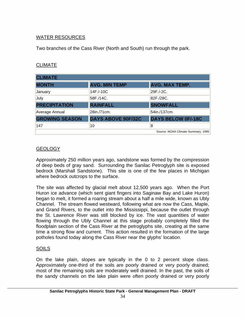
WATER RESOURCES Two branches of the Cass River (North and South) run through the park. CLIMATE CLIMATE MONTH AVG. MIN TEMP AVG. MAX TEMP. January 14F./-10C 29F./-2C. July 58F./14C. 82F./28C. PRECIPITATION RAINFALL SNOWFALL Average Annual 28in./71cm. 54in./137cm. GROWING SEASON DAYS ABOVE 90F/32C DAYS BELOW 0F/-18C 147 10 8
Source: NOAA Climate Summary, 1995
GEOLOGY Approximately 250 million years ago, sandstone was formed by the compression of deep beds of gray sand. Surrounding the Sanilac Petroglyph site is exposed bedrock (Marshall Sandstone). This site is one of the few places in Michigan where bedrock outcrops to the surface. The site was affected by glacial melt about 12,500 years ago. When the Port Huron ice advance (which sent giant fingers into Saginaw Bay and Lake Huron) began to melt, it formed a roaring stream about a half a mile wide, known as Ubly Channel. The stream flowed westward, following what are now the Cass, Maple, and Grand Rivers, to the outlet into the Mississippi, because the outlet through the St. Lawrence River was still blocked by ice. The vast quantities of water flowing through the Ubly Channel at this stage probably completely filled the floodplain section of the Cass River at the petroglyphs site, creating at the same time a strong flow and current. This action resulted in the formation of the large potholes found today along the Cass River near the glyphs’ location. SOILS On the lake plain, slopes are typically in the 0 to 2 percent slope class. Approximately one-third of the soils are poorly drained or very poorly drained; most of the remaining soils are moderately well drained. In the past, the soils of the sandy channels on the lake plain were often poorly drained or very poorly
___________________________________________________________________________________________________________________ Sanilac Petroglyphs Historic State Park - General Management Plan - DRAFT
35
drained. Low dunes within these channels had excessively drained soils. Most of the lacustrine soils were drained to allow agricultural development of the land. Peat soils were also burned. On the end moraines, slopes are gentle to moderate, generally in the 2 to 6 percent slope class, and soils are moderately well and well drained. Soils on the end moraines are classified as Hapludalfs, with some Argiaquolls; those of the lake plain are classified as Haplaquents, with some Haplaquods (USDA Soil Conservation Service 1967). It cannot be assumed that any piece of land can be used for recreation. Some soils are unsuitable for recreation. Among the soil properties that affect recreation uses are the following:
• Flood hazard severely limits use of soils for camps and recreation buildings, but such soils are suitable for hiking and nature study and other less intensive uses.
• If bedrock is at shallow depth, it is difficult to level soils for playgrounds
and campsites, to construct roads and trails, and to establish vegetation. Shallow soils are poorly suited for uses that require extensive grading.
• A clayey or sandy surface layer makes some soils undesirable for
playgrounds, campsites, or other uses that require heavy foot traffic.
• Soils high in clay content are sticky when wet and remain wet for long periods after rains. Loose sandy soils are unstable and dusty when dry. Sandy loam and loam soils are the most suitable for recreation uses that require heavy foot traffic.
• The absorptive capacity of soils determines whether a septic tank
absorption field will work. The soil should be deep and permeable, there should be no seasonal high water table, the slope should not be steep, and there should be no danger of flooding.
The soil at Sanilac Petroglyphs is mainly Alluvial land with poorly drained loams, with 0 to 2 percent slopes as well as Tyre loamy sand and sandy loam, and Iosco sandy loam and Croswell loamy sand. FLORA Several different types of plant habitats exist at Sanilac Petroglyphs. A portion of the low floodplain along the two forks of the Cass River is occupied by swamp forest (elm-ash-maple) and dogwood-alder fen. Most of the area surrounding the petroglyphs is occupied by old-field type vegetation, resulting from grazing. Plants common to the area are wild carrot, self-heal, tawny hawkweed, common
___________________________________________________________________________________________________________________ Sanilac Petroglyphs Historic State Park - General Management Plan - DRAFT
36
St. John’s Wort, common chickweed, English plantain, deptford pink, pale-flowered cinquefoil, pussy toes, and common mullein. The area also contains a few scattered hawthorn trees.
In the area to the west, occupying the higher ground created by outcropping of bedrock, is a birch-aspen woodland. Bare rock is evident in some spots and the shrubs consist of such species as shadbush, bush honeysuckle, and common honeysuckle. Bracken fern, blueberry, and wintergreen are common.
Many of the plants in the area were used by Indians historically, including bulrushes, reeds, and cattails, which were used to make mats, baskets, and fibers. Arrowhead, yellow pond lily, and bracken served as medicines, and the roots were used for food. Berries were obtained from the haw, wild strawberry, blueberry, wild currant (ribes americanum), and wintergreen. Berries and medicinal beverages were made from shadbush, pin cherry, choke cherry, common elder, blackberry (rubus alleghenensis), and nanny berry (viburnum lentago). In addition, beech and butternut supplied nuts and medicine. Field sumac and alder (alnus rugosa) provided medicinal beverages and dyes. White ash supplied wood for arrows, sleds, and baskets, whereas the bark of the white birch was used in making canoes, dishes, and buckets. Sap for syrup and sugar was collected from the red, sugar, and soft maples; resins for cement and sealers were provided by white pine and tacamahac poplar. Smoking material was obtained from willow bark, sumac, meadowsweet, and the dried flowers of goldenrods and asters.
Burreeds, sedges, and spike rushes are found along the river. Other species include cardinal flower, fringed loosestrife (steironema ciliatum), shrubby cinquefoil, Joe-pye weed, boneset, button bush, peppermint, agrimony, water hemlock (cicuta maculate), and white and yellow avens (geum canadense, g. aleppicum). Common spring species in the area are starry false Solomon seal (smilacina stellata), small-flowered crowfoot, bristly crowfoot, silvery cinquefoil, golden ragwort (senecio aurens), yellow trout lily, Michigan lily, yellow clover, smooth yellow violet, long-spurred violet, and blue violet (viola papilionacea). The Michigan Natural Features Inventory (MNFI) and the Michigan Department of Natural Resources and Environment (MDNR) categorize and list plant and animal communities that are endangered (E), threatened (T), and probably extirpated, or extinct, (X), according to the Endangered Species Act of the State of Michigan2. This list also includes species of special concern (SC), which are likely to become endangered if their population declines. Similarly, the U.S. Fish & Wildlife Service lists species that are endangered nationally. In Sanilac
2 see Section 36503 of 1994 PA 451, MCL 324.36503 http://www.state.mi.us/orr/emi/admincode.asp?AdminCode=Single&Admin_Num=29901021&Dpt=NR&RngHigh=

___________________________________________________________________________________________________________________ Sanilac Petroglyphs Historic State Park - General Management Plan - DRAFT
37
County, there are 15 species listed by the state and one that is federally listed, including the Northern Riffleshell, which is listed endangered (LE). These species have been identified by MNFI and MDNR scientists within Sanilac County or are believed to live within Sanilac County, given available habitat. These species may or may not actually occur within Sanilac Petroglyphs Historic State Park, but given the available habitat and a portion of the Cass River, it is likely that many do occur there.
Natural Features in Sanilac County
Scientific Name Common Name Federal Status
State Status
Adlumia fungosa Climbing Fumitory SC Alasmidonta marginata Elktoe SC Alasmidonta viridis Slippershell Mussel SC Ammocrypta pellucida Eastern Sand Darter T Ammodramus henslowii Henslow's Sparrow T Ammodramus savannarum Grasshopper Sparrow SC Bog Cistothorus palustris Marsh Wren SC Emys blandingii Blanding's Turtle SC Epioblasma torulosa rangiana
Northern Riffleshell LE E
Great Blue Heron Rookery Great Blue Heron Rookery
Lampsilis fasciola Wavy-rayed Lampmussel T Obovaria subrotunda Round Hickorynut E Pleurobema coccineum Round Pigtoe SC Rallus elegans King Rail E Simpsonaias ambigua Salamander Mussel E Spiza americana Dickcissel SC Villosa iris Rainbow SC FAUNA The MNFI indicates the potential for several birds and aquatic species to be found at the park, including mussels, turtles, salamanders, as well as sparrows, wrens, and blue herons. In addition to those things found in the MNFI, there is large and small game at the park too. Game consists of all types typical to Southeast Michgan, including deer, rabbits, squirrels, ground birds, and many other small mammals.
___________________________________________________________________________________________________________________ Sanilac Petroglyphs Historic State Park - General Management Plan - DRAFT
38
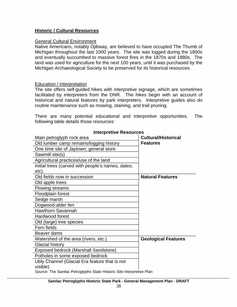
Historic / Cultural Resources General Cultural Environment Native Americans, notably Ojibway, are believed to have occupied The Thumb of Michigan throughout the last 1000 years. The site was logged during the 1800s and eventually succumbed to massive forest fires in the 1870s and 1880s. The land was used for agriculture for the next 100 years, until it was purchased by the Michigan Archaeological Society to be preserved for its historical resources. Education / Interpretation The site offers self-guided hikes with interpretive signage, which are sometimes facilitated by interpreters from the DNR. The hikes begin with an account of historical and natural features by park interpreters. Interpretive guides also do routine maintenance such as mowing, staining, and trail pruning. There are many potential educational and interpretive opportunities. The following table details those resources:
Interpretive Resources Main petroglyph rock area Old lumber camp remains/logging history One time site of Jaytown, general store Sawmill site(s) Agricultural practices/use of the land Initial trees (carved with people’s names, dates, etc).
Cultural/Historical Features
Old fields now in succession Old apple trees Flowing streams Floodplain forest Sedge marsh Dogwood-alder fen Hawthorn Savannah Hardwood forest Old (large) tree species Fern fields Beaver dams
Natural Features
Watershed of the area (rivers, etc.) Glacial history Exposed bedrock (Marshall Sandstone) Potholes in some exposed bedrock Ubly Channel (Glacial Era feature that is not visible)
Geological Features
Source: The Sanilac Petroglyphs State Historic Site Interpretive Plan

___________________________________________________________________________________________________________________ Sanilac Petroglyphs Historic State Park - General Management Plan - DRAFT
39
PHYSICAL ENVIRONMENT There are over 100 carvings by Native Americans on the 20 by 40 foot petroglyph rock, which is believed to be part of a former Native American village. There are carvings on other nearby rock outcrops that were done by workers at a lumber camp during the 1870s. BUILDINGS AND STRUCTURES A large pavilion covers the sandstone petroglyphs. There is a 15 foot security fence that surrounds the pavilion to keep out wildlife and vandals. There are no historic buildings on the site. There is said to be a foundation of a cabin belonging to a timber cruiser, Temple Dorr, who purchased land from the government in order to sell it to lumber companies. HISTORIC LANDSCAPE There is at least one old white pine tree that is over 100 years old, a survivor of the great forest fires of the 1800s.
VOLUNTEER PROGRAMS Grantors have included the Michigan Historical Center Foundation, Charles Stewart Mott Foundation, as well as other private donations. The Thumb Area Boy Scout Troop has donated benches in the park. More detailed information can be found in The Sanilac Petroglyphs State Historic Site Interpretive Plan. This plan was developed in 1993 by consultants for the DoS and the Michigan Historical Museum. It provides an assessment of cultural, natural, and built features and proposes strategies for site management and programming decisions. Recreational Resources Hiking is the only recreation allowed at Sanilac Petroglyphs. There is also a small day-use area that can be used for picnicking. Hunting, trapping, camping, and other recreational opportunities are not permitted there.
PUBLIC LAND MANAGERS
State Game Areas: Fish Point, Deford, Rush Lake, Sanilac, Vassar, Port Huron, Minden City, Cass City, Murphy Lake, Tuscola, Verona
State Wildlife Areas: Fish Point, Quanicassee, Wildfowl Bay
___________________________________________________________________________________________________________________ Sanilac Petroglyphs Historic State Park - General Management Plan - DRAFT
40
State Parks: Lakeport, Port Crescent, Sanilac Petroglyphs, Albert E. Sleeper;
Environmental Areas: Fish Point, McKinley, Rose Island, Sebewaing, Thomas, Weale, Bay Port.
AREAS OF CONFLICT With multiple interests comes the potential for conflict between users or between users and the natural or historic resources of the park. Areas of conflict at Sanilac Petroglyphs include:
Vandalism - Vandals have defaced the petroglyphs and altered them by adding their own carvings in the soft sandstone. Illegal Hunting - Adjacent public hunting lands allow easy access to the site for this unauthorized activity.

___________________________________________________________________________________________________________________ Sanilac Petroglyphs Historic State Park - General Management Plan - DRAFT
41
Park Use Statistics and Economic Impacts Although there are not annual counts of the number of visitors, a 1993 interpretive plan states that there were 3500 visitors that year, between Memorial Day and Labor Day. The average number of visitors per day was 15 to 35, with the majority of them coming on the weekends. Sunday is the busiest day. This plan suggests that most of the visitors live more than a 30 minute drive from the site. The park is small and offers few developed recreational opportunities, drawing visitors who come primarily to view the petroglyphs. Its economic impact should be expected to be quite small. Administration is carried out primarily by staff from Sleeper State Park. During the summer season (Memorial Day through Labor Day), HAL employs interpretive guides, who work collectively about 70 hours per week, or 840-900 hours per season total.
PLANNING OVERVIEW Documents: Stewardship Management Plan (Contact Stewardship) Michigan Natural Features Inventory (Contact Stewarship) Sanilac Petroglyph deed (Attached) Meetings: September 30, 2010 Start-up Meeting November 3, 2010 Planning Team Meeting December 16, 2010 PlanningTeam Meeting January 18, 2011 Stakeholder Input Workshop (Date) Public Input Workshop Plan Reviews: (Date) PRD – Management Team (Date) SLP – Ecoteam (Date) Statewide Council (Date) NRC-MSPAC
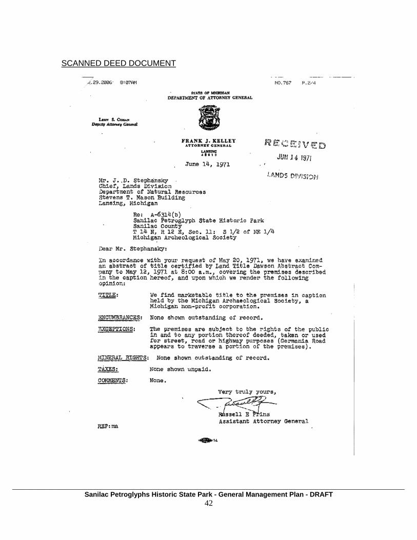
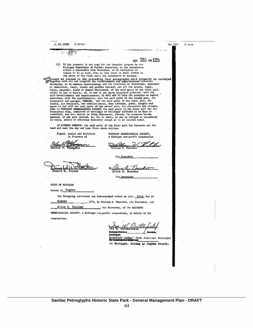
SCANNED DEED DOCUMENT
___________________________________________________________________________________________________________________ Sanilac Petroglyphs Historic State Park - General Management Plan - DRAFT
42

___________________________________________________________________________________________________________________ Sanilac Petroglyphs Historic State Park - General Management Plan - DRAFT
43
___________________________________________________________________________________________________________________ Sanilac Petroglyphs Historic State Park - General Management Plan - DRAFT
44