Embed Size (px)
Citation preview

INTERNATIONAL HYDROGRAPHIC ORGANIZATION
THE INTERNATIONAL
HYDROGRAPHIC REVIEW
GENERAL INDEX 1923 - 1990to papers published from 1923 to 1990
by alphabetical order of authors
Published by the INTERNATIONAL HYDROGRAPHIC BUREAU
MONACO - October 1993
500X-1993 P-2


INTERNATIONAL HYDROGRAPHIC ORGANIZATION
THE INTERNATIONAL
HYDROGRAPHIC REVIEW
GENERAL INDEX 1923 - 1990to papers published from 1923 to 1990
by alphabetical order of authors
Published by the INTERNATIONAL HYDROGRAPHIC BUREAU
MONACO - October 1993


PREFACE
By Rear Admiral Christian Andreasen President of the Directing Committee
Throughout the history of the International Hydrographic Organization one of the important functions of the organization has been to foster the transfer of information between Member States. The publication of professional papers in the INTERNATIONAL HYDROGRAPHIC REVIEW concerning hydrography and topics related thereto has provided hydrographers throughout the world with information of great significance for the advancement of mapping and charting. We hydrographers can be proud of the quality products that have resulted which, in turn, have fostered the safety of navigation, advanced the scientific knowledge of the oceans and served to protect our marine environment. This GENERAL INDEX 1923-1990 of the INTERNATIONAL HYDROGRAPHIC REVIEW is published to provide ready access to this important series of articles which document the history not only of the International Hydrographic Organization, but also that of hydrography itself.


TABLE OF CONTENTS
Number Item Page
I Aids and Radio Aids to Navigation 1
II Astronomy and Navigation 13
III Automated systems - data logging and processing 24
IV Cartography 29
V Data Management of Swath Sounding Systems - Monograph 1988 39
VI Engraving and reproduction of charts 40
VII Geodesy 44
VIII Geographical positions 55
IX Historical, personal and obituary notices 58
X Hydrographic Training and Technical Assistance 69
XI Hydrographic work. Reports on surveys 72
XII Hydrographic Offices and other Maritime and scientific organizations 87
XIII International Hydrographic Bureau - Work, Conferences 96
XIV Instrumentation and equipment 99
XV Interactive Cartographic Systems - Monograph 1989 115
XVI Miscellaneous 116
XVII Nomenclature and units 121
XVIII Oceanography - bathymetry, meteorology, seismic, gravity, magnetism 124
XIX Photogrammetry and aerial photography 139
XX Positioning systems and methods 146
XXI Practical Hints to Hydrographic Surveyors 150
XXII Radio Navigational Warnings. Maritime Safety Information Systems 153
XXIII Radiotelegraphy and Phonotelemetry 155
XXIV Sea boundaries and zones. Law of the Sea. Legal Liability. Resource Management
159
XXV Sonar - echo sounders, side-scan, acoustics 163
XXVI Surveying vessels - boats and airborne craft 176
XXVII The Electronic Chart and Information Systems - Monography 90 184
XXVIII Tides and currents 185
XXIX Treatises on Hydrography and Nautical Publications 204
XXX Bibliography 210


INDEX


la. AIDS TO NAVIGATION (Liehts. sienals, buovaees)
1923 to 1935
AUTHOR TITLE Edit. Page
Observations on Visibility of Lights in Denmark (1930) 1931/2 200
Experiments relative to Visibility of Buoyage 1927/2 183
Experiment Ground for Maritime Signals in the vicinity of Berlin
1928/2 149
Visibility of distant objects 1932/1 182
(R) New Projector for making an alignment (Ch. Dévê), Paris, 1930
1931/1 267
Something new in Metallic Mirrors. (Dr. H.W. Edwards) Los Angeles
1934/2 164
Evaporated Metal Mirrors. (R.C. Williams) London, 1934 1935/1 154
(E) Unification of Buoyage. (Proposal put forward by Great Britain at the Lisbon Conference, 1930)
1932/1 192
Unification of Bouyage. (Draft drawn up by the French Lighthouse Service, 1932)
1933/1 184
Report of the work of the Technical Conference on Maritime Signals, Paris, 1933
1934/2 123
Vitar Islands i 50 ar, 1878-1928. (The development of Icelandic Lighthouses during 50 years)
1929/2 187
Question relative to the Description of Fog Signals 1925/1 187
Description of the Fog-signalling Apparatus by aerial and submarine waves, used on board the lightship Fladen
1928/1 127
Duplex Directional Fog Signal. (Chance Bros., Birmingham)
1928/2 151
Synchronous Signalling. (Great Britain) 1928/2 191
Barlow, E. (E) Sound Transmission and Meteorological Conditions 1929/2 203
Berger, R. (E) Sound Signals 1929/1 175
Blondel, A. (E) On the use of Yellow-tinted Classes in the design of Maritime or Aviation Lighthouses
1935/1 176
Collinder, P. On the Reliability of Aerial Fog Signals 1929/1 25
Foitzik, L. (E) Range of Visibility by Day and Optical Range by Night
1932/2 269
Fraser, R.J. &G oui ding SmithfF.C.
(E) Aids to Navigation on the Hudson Bay Route 1934/1 112
G.S.S. Character erf Lights (similarity of character) 1924/2 113
G.S.S. Character o f Lights (similarity of character) 1924/1 27
H.B. (E) Improvements in the technique of Maritime Signalling
1935/2 113

la. AIDS TO NAVIGATION (Lights, sienals, buovaees)
1923 to 1935
AUTHOR TITLE Edit. Page
H.B. Observations on Visibility of Lights. (Great Britain, 1925- 1929; Denmark, 1925-1929; U.SA. 1923; France, 1925; - Table of Probable Frequency of Visibility. - Horinzontal Visibility from ships at sea)
1931/1 144
H.B. Observations on Visibility of Lights. (Method of reduction. - Observations carried out in Sweden, Denmark, Belgium, Argentina)
1925/1 141
J.M.P. (R) The Netherlands Light List for 1924 1924/1 168
Langmuir, I. & Westendorp.W.F.
(E) Light Signals in Aviation and Navigation 1932/2 277
Marootte, E (E) The Range of Flashing Lights and Coloured Light Beacons
1934/2 184
Niblack, A.P. Summary of data on Coastal Signals 1926/2 121
Niblack, A.P. Summary of data on Uniformity in Storm Warning Signals
1926/2 103
Niblack, A.P. Summary of data on Safety of Life at Sea together with Signals used in connection therewith
1927/1 115
Niblack, A.P. Summary of data on Port Signals, with proposals for their Unification
1927/1 65
Niblack, A.P. Summary of the Proposals, Discussions and Conclusions of the various International Conferences on Uniformity in Buoyage and Buoy-lighting with data of existing systems
1925/1 101
Niblack, A.P. Data concerning existing Systems of Buoyage (tables) 1925/1 140
Phaff, J.M. Report of Observations of Lights in the United Kingdom 1924/2 67
Phaff, J.M. Visibility of Lights. - General 1923/1 108
Phaff, J.M. Unification of Buoyage 1926/2 55
Stevenson, D.A. (E) Development of Lighthouses 1932/2 278
Van Braam Van Vloten, P. Visibility of Lights 1924/2 95

la. AIDS TO NAVIGATION (Lights, signals, buoyages)
1936 to 1941
AUTHOR TITLE Edit. Page
(E) Fog-pierdng Lights 1936/2 167
(E) Nomenclature of Maritime Lights 1940/2 52
Alessi, Dr. D. (E) Newly Devised Method of Lighting the Lagoon of Venice
1941/1 59
Bencker, H. Fog Signals by Rotating Nautophone (Pendulum Vibrator)
1938/1 41
Cippioo, R. The present state of the technique of Maritime Lighthouses
1939/2 66
H.B. A Uniform System of Maritime Buoyage 1936/2 72
H.B. Unification of Buoyage 1936/1 163
H.B. Different Means of Lighting and the Range of Lights with Reflectors
1937/1 137
J.D.N. Visibility of Navigational Lights 1936/2 18
Nares, J.D. On the Use of Yellow-tinted Classes 1936/2 22
Shank land, E.C. On the Use of Yellow-tinted Classes 1936/1 98

la. AIDS TO NAVIGATION [lights, signals, hunvarMl
1942 to 1970
AUTHOR TITLE Edit. Page
Unifying our Aids to Navigation Internationally 1947 201
Blaise, P. & Petry, P. A reply to the article entitled 'Nominal range" by Captain A]do Macchiavelli, Director of the Italian Naval Hydrogaphic Institute
1969/2 81
Blaise, P. k Petry, P. Luminous intensity and range of lights - Geographic range
1968/2 161
Crouse-Hinds Co. Unattended Fully Automatic Lighthouses 1950/1 133
Dupont, J. The Development of Air Traffic and the Use of Air Radio-beaoons by Ships
1960/2 55
Hugon, P. The Introduction of Aeronautical Beacons into Coastal Marine Beaconage
1956/2 123
Macchiavelli, A. Nominal range 1969/2 77
Nares, J.D. & Bencker, H. Uniformity in Buoyage 1945 8

lb. RADIO AIDS TO NAVIGATION AND HYDROGRAPHY
1942 to 1970
AUTHOR TITLE Edit. Page
Radio Aids to Marine Navigation 1947 127
General Principles and Use of the Decca Navigator 1947 166
Systematic Trials with the Decca Navigator carried out on board the French Surveying Vessel Amiral Mouchez
1948/1 14
(Erratum) 1948/2 8
Constant Radar Range Sounding 1948/1 19
LORAC - A Radiolocation System having Long Range Accuracy
1949/1 31
Method of Compulation of the Homofocal Grid for Hyperbolic Navigation Charts
1949/1 41
Consol Navigation System 1949/2 65
'Manual del Radarista' (G. Montefinale), {Reiriew) 1958/2 67
Radio Aids to Air Navigation (J.H.H. Grover), (Review) 1959/1 182
"Estudo do Sistema Tellurometer’ (Joachim B.V. Soeiro de Brito), (Review)
1960/1 175
"Radioaiuti alia Navigazione Aerea e maritima’ (G. Monte-Finale), (Review)
1960/2 162
'Cinematica Navale e Radar' (B. Ponza di San Martino), [Review]
1961/1 1%
'Uso del radar a bordo" (L. Martin Roca), (Review) 1962/1 185
Aslakson, C.I. The Velocity of Light 1964/1 69
Aslakson, C.I. Shoran Investigations for Triangulation 1947 178
A.V. ‘The Use of Radar at Sea" (Review) 1953/1 59
Bencker, H. Principle of Radio Electric Detection (RADAR) 1945 14
Benson, D.R. Long range navigational warnings - A suggested international world-wide scheme
1969/2 71
Bolstad, R.C. Hydrography with E.R. Type Raydist 1958/2 67
British Hydrographic Dept. Structures for Maximum Radar Returns 1955/2 79
British Hydrographic Dept. The Decca Navigator in Hydrographic Surveying 1955/1 89
British Hydrographic Dept. Radar in Surveying 1952/2 85
Brunei, A. Radio Position-Fixing Systems in French Hydrography 1957/2 127
Brunei, A. Radio-Acoustic Ranging on the Skerki Bank 1943 35
Burmins ter, C.A. Electronic Position Indicator 1954/1 113
Burmister, A. Electronics in Hydrographic Surveying 1957/2 117
Burmister, C.A Shoran in Hydrographic Surveying 1947 181
Burmister, Cj \. Electronics in Hydrographic Survey 1949/1 119

lb . RADIO AIDS TO NAVIGATION AND HYDROGRAPHY
1942 to 1970
AUTHOR TITLE Edit. Page
Busch, C.W. A Radio Position Finding Equipment for Depth Surveying
1957/1 65
Busch, Dr. Atlas-Radiolog, A Radio Position Finder Equipment for Depth Surveying
1957/2 57
Cie Française Thomson- Houston
Teleradar 1955/2 75
Clarke, J.O. The Use of Loran for Survey Work in the Pacific 1954/2 47
Comstock, A.L.& Michener, P.Z.
Raydist locates Boring Sites for Chesapeake Crossing 1959/1 73
Davis, C.W. New Developments in Marine Loran Reoeiving Equipment
1949/1 26
Davis, C.W. Loran Receiving Equipment for the Mariner 1954/2 53
Davis, C.W. Recent Developments in the Use of Loran 1953/2 7
Decca Navigator Co. Two Range Decca 1955/2 11
Decca Navigator Co. The Decca Hydrographic Survey Chain in Sweden 1950/2 11
Decca Navigator Co. The Decca Navigator as an Aid to Hydrographic Survey 1951/1 99
Dept, of Transports, Canada Radar Reflectors used in Canada 1955/2 94
Dickson, J.H. Radar Chart-Matching Devices 1953/1 147
Faust, W. Observations of the Operational Chracteristics of European Consol Beacons
1957/1 67
Fish, G.R. Electronic Control Systems used on Hydrographic Surveys
1960/1 85
Freiesleben, H.C. Comparison between Two Decca Chains 1957/1 49
Freiesleben, H.C. Artificial Satellites as an Aid to Navigation 1964/1 49
French Institute of Navigation Checking of 'Decca' Pattern of French Chain on Chart N° 3033 1er, from Lorient to the Gironde (H.P.)
1955/1 71
Gabier, H. & Gresky, G. Subjective Aural Result or Objective Visual Indication of Radio Direction Finding?
1952/1 149
Gabier, H. On the Properties and Application of Modem Shipbome Direction Finders
1950/2 86
German Hydrographic Institute Radar Technique for Beaconage Purposes 1956/2 117
Gonzalez Fernandez, J. Use of Raydist Type "E.R." in Survey of North Bar of Amazon River
1956/2 67
Gonzalez Fermandez, J. Note on Use of Raydist Systems in Brazilian Hydrography
1958/2 81
Grassot, P. & Hugon, P. An Automatic Reading Apparatus for 'Consol* Signals 1953/2 39
Griswold, W. Loran Survey of Gulf Stream 1952/2 93
H.B. "Electronic Navigation" (L.M. Orman), (Review) 1951/1 109

lb. RADIO AIDS TO NAVIGATION AND HYDROGRAPHY
1942 to 1970
AUTHOR TITLE Edit. Page
Harries, H.D. Experiences with Radio Navigation Systems made during a Voyage to Ecuador and back
1957/1 59
Hastings, Ch. E The Application of Raydist to Hydrographic Surveying 1949/2 19
Hastings, C.E. New Raydist Range Systems 1956/1 49
Hastings, C.E. Latest Development in Raydist for Precise Position Location
1954/2 33
Hastings, C.E. Raydist in Hydrography and Surveying 1955/2 19
Hastings Raydist Inc Raydist D.M. System 1959/1 71
Hawker, H.G. The Mark 10 Decca Receiver 1957/1 35
Hawker, H.G. Some Developments of the Decca Navigator System; Dectra
1957/1 41
Hogben, H.E. Primary and Secondary Radar. Application to Marine Navigation
1947 128
Hogben, H.E. & Hansford, R.F. Ship-bome Radar. Factors in the Design of Navigational Radar for Marine Transport
1947 137
Honore, E. Sc Torcheux, E. Rana Radio-Navigators 1953/2 33
Hugon, P. Landscape Detection by means of Radar 1948/1 11
Hugon, P. Control of Experimental Decca Chain N°4 (Southern France) and Possibilities of Maritime Use off Mediterranean Coast
1956/2 81
Hugon, P. Trying out the Loran System 1949/2 52
Hugon, P. Mobile Decca Chain Tests in Zone from Penmarc’h to Belle-Ue
1951/2 50
Immler, W. (P.V.) Bearings Card and Position Charts by Radiogoniometry (Aiwfrncf)
1945 69
J.D.N. International Meeting on Radio Aids to Marine Navigation.1st Series (Extracts from Documents)
1946 31-74
1. A technical appreciation of the various apparatus 1946 322. Hyperbolic Navigation 1946 493. Charts for Radar, etc 1946 514. Gee 1946 555. Loran 1946 596. Decca 1946 617. Consol 1946 668. P.O.P.I. 1946 709. Comer Reflectors 1946 74
J.D.N. Identification of Radar-screen views 1948/1 10
J.D.N. English and Danish Decca Navigational Chains 1949/1 8
Jensen, P.C.S. The Danish Decca Chain in Greenland 1952/2 53
Jones, E.E Summary of Article "Shoran Study and Calibration* 1950/2 92
Jones, C.H. Loran Being Used Extensively in Survey of Gulf Stream 1951/1 107

lb. RADIO AIDS TO NAVIGATION AND HYDROGRAPHY
1942 to 1970
AUTHOR TITLE Edit. Page
Jourdain, M. Application of Decca Navigator to Measurements at Sea 1956/2 101
Lacombe, H. The Rana Radionavigator 1955/2 27
Langeraar, I.W. The Use of Decca as an Aid to the Hydrographic Survey of Netherlands New Guinea
1957/2 29
Langeraar, W. The Stability of Decca Patterns Under Various Circumstances and the Influence of Time on that Stability
1953/1 29
Larsson, H. Investigation of the Accuracy obtained with the Decca System for Survey in the Southern Baltic
1949/2 25
Leifson, G. Hyperbolic Positioning Systems for Hydrographic Surveys
1953/1 19
Lochard, J. Possibilities of Radio Direction-Finding with Decametric Waves as a Means of Radio Navigation
1956/2 93
Lunel General Comments regarding Use of Radiolocation Systems and Ultrasonic Sounding in Hydrography
1957/1 21
Miller, I .A. Two-Range Decca installed on the Hydrographic Vessel Kapuskasing (Canada), 1956 Season
1957/2 19
Miller, I .A. Application of Two-Range Decca to Hydrographic Survey in Canada
1956/1 29
Monteiro de Barra, J.A. & Oliveira, J.L. de.
Use of Raydist System in Portuguese Guinea Survey 1954/2 11
Nat Res. Council of Canada New Electronic Aids to Marine Navigation 1951/2 76
Nautical Magazine Anomalous Propagation in Radar 1956/2 119
Nizery, B. Applications of Tor an to trials at sea 1970/1 71
Powell, C. The Decca Navigator in Hydrography 1957/1 53
Powell, C. Developments in Decca. Recent Refinements in a Radio Aid to Surveying
1954/2 37
Powell, C. (Erratum) 1949/2 6
Powell, C. The Decca Navigator as an Aid to Hydrographic Survey 1949/1 13
R.W.K. 'Electronic positioning systems for surveyors’ (A.A. Ferrara), (Review)
1968/1 189
Rampioni, Y. Comparative Features of Loran and Consol Long-Range Navigational Aids
1955/2 49
Rannie, J.L. Shoran Triangulation in Canada 1950/1 100
Revel, F. Calibration of a radio-positioning chain - Decca Hi-Fix trials for accuracy and late identification process
1969/1 17
Roberts, W.J.M. Large scale offshore surveying for the oil industry 1970/2 41
Ross, J.E.R. Shoran Operations in Canada 1953/2 23
Roussel, G A Electronic Surveying in Offshore Areas 1955/1 97

lb. RADIO AIDS TO NAVIGATION AND HYDROGRAPHY
1942 to 1970
AUTHOR TITLE Edit. Page
Smith-Rœe, R.L. Radio Wave Propagation in relation to Marine Navigational Aids
1947 156
Soeiro de Brito, J.B.V. Sofala Bank Survey by the Mozambique Hydrographic Survey
1953/2 15
Stanner, W. Morphology of Radio Aids to Navigation 1959/1 97
S tanner, W. Observation of Consol Signals at Great Distances with Special Emphasis on the so-called "Peiltakt" Phenomenon
1955/2 65
Stanner, W. A Physical Classification of Radio Aids to Navigation 1954/2 63
Stassinopoulos, AC. A Few Remarks on the Use of Radar in Navigation 1952/1 136
Studds, (R.F_A.) Shoran and the Electronic Position Indicator for the Control of Offshore Hydrographic Surveys
1952/2 18
Swedish Hydrographic Office The Use of the Decca Navigator by the Royal Swedish Hydrographic Office
1956/1 35
U.S. Navy Hydrographic Office Use of Radar and Radar Beacons in Hydrographic Surveying by U.S.S. Tanner (AGS-15)
1948/2 35
U.S. Navy Hydrographic Office Loran - The New Radio Navigator 1946 9
U.S. Navy Hydrographic Office Radar - An Aid to Piloting 1945 29
Verstelle, J. Th. The Decca System for Ship Acceptance Trials 1959/1 79
Vers tel le, J. Th. Use of the Decca Navigator Survey System in New Guinea for Hydrography and as a Geodetic Framework
1958/1 35
Verstelle, J. Th. An Evaluation of the Accuracy of Decca as a Means of Distance Measuring Over Land
1954/2 73
Verstelle, J. Th Investigation cm Accuracy of the Decca Navigator System. August 1949 Report on Trials in the Netherlands (Decca as an Aid to Land-Surveying)
1949/2 59
Verstelle, J. Th. The Need for Coordination of Geographical Grids of the World in Relation to Position-Fixing by Radionavigation Systems
1952/1 13
Verstelle, J. Th. Standard Sheets of Hyperbolic Patterns for Survey Use 1958/1 81
Wachtler, Dr. M. Navigation by Radio Direction-Finder without the Use of a Compass
1957/2 113
Waterfield, H.H. & Hilliard, C. Raydist for Shallow-Water Hydrography 1952/2 129
Wedemeyer, A. Grid of Position and Great Circle Charts by Wireless 1945 67
Wyatt, G. Radar and Radar Charts 1950/2 21

lb. RADIO AIDS TO NAVIGATION AND HYDROGRAPHY
1971 to 1976
AUTHOR TITLE Edit. Page
Asche; G.P. The Omega system of global navigation 1973/1 87
Ashmore, S.A. Harbor survey operations using Cubic Autotape 1975/1 19
Bradley, E.M. Practical experience with Hi-Fix 1971/1 67
Grant, S.T. Rho-Rho Loran-C combined with satellite navigation for offshore surveys
1973/2 35
Langhome, D.N. & Hooper, DJ. An examination of the stability of the Port of London Authority estuary Decca Hi-Fix chain
1974/2 89
Marshall, A.G. Development of the MRB 201/301 1973/1 43
Moraes, A.G. The use of Hi-Fix in Indian waters 1976/2 95
Nard, G. Results of recent experiments with Differential Omega 1973/1 101
Powell, C. The Decca Hi-Fix/6 position fixing system 1974/1 81
Roubertou, A.M. Bathymetric surveying on the Continental Shelf 1972/1 37
Royal Danish Navy Test of the Omega navigation system and of a combined Loran A /C receiver
1971/1 45
Servel de Cosmi, M. Two radionavigational systems : Omega and Differential Omega
1972/1 45
Walter, M.M. Wire drag operations using Raydist "T” 1972/2 15
Zieleman, G. it van Opstal, L.H.
Geometric and mathematical properties of a modified hyperbolic pattern
1972/2 47
Zucker, C.M. Determination of shore and ship positions from visual and electronic measurements at sea
1971/1 91

lb. RADIO AIDS TO NAVIGATION AND HYDROGRAPHY
1977 to 1980
AUTHOR TITLE Edit. Page
Gray, D .R The propagation velocity of Decca-frequency transmissions over sea ice
1977/1 59
Roberts, W.J.M. The role of the contract hydrographic surveyor 1977/2 19

lb. RADIO AIDS TO NAVIGATION AND HYDROGRAPHY
1981 to 1985
AUTHOR TITLE Edit. Page
Bôhme, J.F. Automatic positioning by redundant measurements 1982/1 59
Gray, D.H. & Mortimer, T. Loran-C coordinate converters - Plague or panacea 1982/1 109
Haugh, A. Position fixing requirements of the oil industry 1981/1 115
Hedge, A.R. Navigation and positioning requirements for marine survey operations
1985/2 95
Janes, H.W., Eaton, R.M. & Wilson, J.
UHF Syledis for coastal survey positioning 1985/2 59
Lapine, LA. Daily system check of electronic position systems 1985/2 83
Maestre Gimeno, V. A step forward in the methods of getting a fix at sea 1985/2 121
McCartney, B.S. Underwater acoustic positioning systems : State of the art and applications in deep water
1981/1 91
McCullough, J.R., Irwin, B.J. & Bowles, R.M.
Loran-C latitude-longitude conversion at sea : Programming considérations
1985/1 83
Milne, P.H. Correlation of surface and underwater position fixing techniques
1981/1 77
Nard, G. Spread spectrum concept applied in new accurate medium-long range radiopositioning system
1985/1 53
Teunon, I.C. Recent developments in high-accuracy microwave positioning systems
1985/1 73
Weeks, C.G. Hydrographers of the world, unite - Some thoughts on the processing of multiple position lines
1982/2 43

II. ASTRONOMY AND NAVIGATION
1923 to 1935
AUTHOR TITLE Edit. Page
(R) The Air Almanac for the year 1933, Naval Observatory, Washington
1934/1 145
(R) Atmospheric Refraction in the Gulf of Naples. (E. Majo)
1928/1 272
(R) Observation of the Dip of the Sea Horizon on board the 'Kasuga", 1933. (T. Akiyosi) Tokyo, 1934
1934/2 171
(R) Simplification of Nautical Astronomy Claculations at Sea. (W. Feldhusen) Hamburg 1933
1934/1 135
Nomogram of Altitudes 1928/1 275
(R) Nomograms for use in Navigation. Tokyo, 1933 1934/1 137
(R) Nautical Tables for the use of the Royal Navy, (Kingdom of the Serbs, Croats and Slovenes). Belgrade, 1928
1929/2 237
(R) A Standardized Navigator’s Workbook. (W.A. Mason) Annapolis, 1931
1932/1 260
(R) The Calculator's Guide. (J. Boccardi) Catania, 1902 1930/1 252
(R) Graphical Piloting Methods. (USA). (F. L. Mosher) Annapolis, 1930
1931/1 265
(R) Terestriika Navigadja. (J.M. Luteroti) Dubrovnik 1927
1929/2 236
(R) Tablioe Nawigacyjne, Gdynia, 1933 1934/1 136
(R) Complete 60° Star Lists for position fixing by the Equal Altitude Method; (W. Arnold) New York, 1930
1934/1 137
The Saint Hilaire Method in practice; (W.E. Sommerville) Glasgow, 1929
1929/2 240
Distance Tables - A study of existing distance tables. Answers to Circular Letter 8-H, 1928. (France, Italy, Germany, Great Britain, Greece, Japan, USA, Finland, Brazil, Siam, Chile, Yugoslavia, Argentina, Egypt, Portugal, Estonia, Spain, New Zealand, Australia, China, Denmark, Monaco, Netherlands and Sweden)
1933/1 88
(R) Charts giving Lines of Equal Distances from Ports 1930/1 244
(R) Brown's Distance Chart (W.D. Campbell) Glasgow 1932/1 260
(R) Technische Navigation und Météorologie. (H. Meldau) Bremen, 1927
1928/2 238
(R) Handbook of Boat Navigation on the Rhine; (J. Lhotellier) Strasbourg 1928
1929/2 241
Foitzik, L. (E) Range of Visibility by Day and Optical Range by Night
1932/2 269
Freiesleben, HC. (E) Researches on the Dip of the Sea Horizon 1934/2 118

II. ASTRONOMY AND NAVIGATION
1923 to 1935
AUTHOR TITLE Edit. Page
Hubbard, L.S. (E) Refraction on Georges Bank, 1931. (U.S. Coast and Geodetic Survey)
1934/1 115
J.F.P. (R) Nautical Almanac 4c Astronomical Ephemeris (1767- 1923)
1924/2 197
J.F.P. (R) Ocean Passages for the World. (B.T. Somerville) London, 1923
1924/1 167
Kaiser, LA. How North Atlantic Steamer Lines may be made Safer and Simpler
1927/2 199
Lugeon, J. Crepuscular Tables, Warsaw, 1935 1935/2 144
Michler, H. (E) Observations with Bubble Sextant on board S.S. 'Arucas' in May 1933
1934/2 113
Mich 1er, H. (E) Measurements of Dip of Horizon from S.S. "Arucas" in May 1933
1935/1 127
Moll, E. Measurement of the Dip of the Horizon. (Pulfrich instrument)
1931/1 209
Nares, J.D. Refraction 1932/2 121
Ogura, S. On the Dip of the Sea Horizon. (Various tables by Koss, Kohlschütter, Brehmer, Chauvenet, Hall)
1931/1 101
Ogura, S. On the Altitude Observations of a Heavenly Body near Horizon
1931/1 112
Rannie, J.L. (E) Excessive Cases of Lateral Refraction 1927/2 203
Rude, G.T. Earth's Rotational Force and Navigation 1933/1 151
Rude, G.T. The Mariner's Practical Star Finder 1932/1 49
Schweppe The present state of the Study of Navigation and Nautical Meteorology for Transoceanic Aerial Traffic
1928/2 61
Sone, A. On the Error of Position of a ship determined Astronomically in the area of the Kurosio
1931/1 119
Vanssay de Blavous, P. de Ansermet’s solution of the problem of Snellius 1933/1 172
Weens, P.V.H. Around the Atlantic with the Lindberghs 1934/2 110
Weems, P.V.H. New developments in Air navigation. (The Gatty ground Speed and Drift Indicator. Aircraft plotting board. Air Almanac)
1932/2 152
Weems, P.V.H. Altitude Errors due to Refraction 1933/2 190
Zubov, N.N. Some considerations on Ice Navigation in the Polar Basin
1933/2 224

II. ASTRONOMY AND NAVIGATION
1936 to 1941
AUTHOR TITLE Edit. Page
The American Air Almanac 1941/1 48
Aircraft Navigational Manual 1941/1 50
Star Places for Surveyors 1941/1 47
A.T.L. (R) The Methods of Modem Navigation (Ed. J. Willis), Glasgow, 1935
1936/1 164
Bencker, H. Notes on the Use of Deflectors 1941/1 85
Bencker, H. (R) Preparative Tables for the Determination of Longitude (time) By the Method of Equal Altitudes of various Stars. Calculated and published by the Hydrographic Department of the Imperial Japanese Navy, Tokyo (1921-1940) (A review)
1941/2 29
Bencker, H. Historical and Bibliography Index concerning the development and improvement of the Compass
1941/1 119
Collins, E.B. (E) Polar Navigation with H.O. Publication 214 1941/1 37
Cot, D.F. Aeronautical Ephemerides - Recent Charts 1937/2 71
Daviot, L. The Bastien Position Calculator 1939/2 157
Dreisonstok, J.Y. (E) Creating a Horizon 1939/2 147
Fontoura da Costa Astronomical Fixes by Azimuth - Astronomical Fixes by simultaneous altitude and azimuth of the sun - Radiogoniométrie fixes for distances nearer the station
1937/2 29
Gougenheim, M.A. Note on the calculation of the Position at Sea 1941/2 18
Grambow, J.B. Historical Note on the Treatise 'Modem Navigation' 1940/1 171
H.B. (R) Problèmes de Navigation astronomique particuliers à la Navigation Aérienne (The problems of astronomical navigation peculiar to aerial navigation (L. Daviot),Paris, 1936
1937/1 145
H.B. (R) Recent Nautical Tables (Aquino, Tillman) 1937/2 272
H.B. (R) Complementi di Navigazione Aera (Complements of Aerial Navigation) (N. Galante), Roma, 1938
1938/2 170
H.B. (R) Practical Air Navigation and the use of the Aeronautical Charts of the U.S. Coast and Geodetic Survey (T.C. Lyon), Washington, 1938
1938/2 169
H.B. (R) New Nautical Tables. (Fontoura & Penteado), Lisboa, 1936- H.O. 214, U.S. Navy Department, Washington, 1936- A. Yustchenko, Leningrad, 1935
1937/1 147
Hellweg, J.F, (E) Time Determination and Time Broadcast 1938/1 136
La Porte, F. The Track of the Orthodromic Curve on Mercator Charts 1937/1 21
P.V. Earth's Rotational effect on the Bubble Sextant 1941/1 51
Papworth, K.M. Astro-Radio Points 1939/2 141

II. ASTRONOMY AND NAVIGATION
1936 to 1941
AUTHOR TITLE Edit. Page
Repsold, A. Chronometer and Nautical Almanac 1937/2 246
Rückert, J. (E) Modem Navigation 1939/1 141
Siems, F.B.T. Light Star Sights 1938/2 18
Weems, P.V.H. Aeronautical Charts 1938/2 93

II. ASTRONOMY AND NAVIGATION
1942 to 1970
AUTHOR TITLE Edit Page
"Apparent Places of Fundamental Stars' (Review) 1946 125
'Satellites et navigation' (P. Gaudillère) : in Navigation, VoL III, 1960, Paris (Review)
1961/1 201
'The principles of navigation' (EW. Anderson), (Review) 1966/2 190
Bencker, H. Standardisation of Time and Accurate Determination of Exact Time
1945 41
Bhattacharji, J.C. Astrofix by Altitudes of Two Pairs of Stars, one near Meridian and another near Elongation
1965/2 95
Bhattacharji, J.C. A Method of Simultaneous Determination of Astronomical Latitude, Azimuth and Time from Observations of an unknown Star
1963/2 155
Bhattacharji, J.C. Azimuth from Observations of Close Circum polar Stars 1959/1 51
Blythe, J.H. Star Clock 1960/2 123
Blythe, J.H., Duncombe, R.L. & Sadler, D.H.
Sight reduction tables for marine navigation 1967/1 83
Boella, M. Present Scientific Possibilities of Time Comparisons at Great Distances
1953/2 133
Collins, E.B. The German Air Almanac 1942 14
Cooper, R.I.B. Variations in the Length of the Day 1952/2 139
Couillault, P. Star Identifier 1958/2 61
Court, A. Refractive Temperature 1950/2 138
Dupuy, M. Paper on Astronomical Navigation by Means of Diagrams (Addition)
1952/1 72
Dupuy, M. Summary of Paper on Astronomical Navigation by means of Diagrams
1950/2 147
Fagerhobn, P.O. Concerning the margins between the draughts of ships and the depths of fairways
1966/1 7
Feaster, J.B. Method of Using the Stars Listed under 'Additional Stars* in the 'Nautical Almanac'
1948/2 78
Fichera, E Campaign for determining the longitude of the fundamental point of the astronomic observatory in Naples. Ill - The equation of longitude
1968/2 73
Fichera, E. Campaign for determining the longitude of the fundamental point of the astronomic observatory in Naples. IV - The optimum conditions for solving the equation for longitude
1969/1 39
Fichera, E , Mancuso, S. & Pugliano, A.
Campaign for determining the longitude of the fundamental point of the astronomic observatory in Naples. II - Preliminary study of an impersonal micrometer
1968/1 81

II. ASTRONOMY AND NAVIGATION
1942 to 1970
AUTHOR TITLE Edit. Page
Fichera, E , & Pugliano, A. Campaign for determining the longitude of the fundamental point of the astronomic observatory in Naples. V - Astronomic longitude and geographic longitude
1969/2 85
Fichera, E , & Pugliano, A. Campaign for determining the longitude of the fundamental point of the astronomic observatory in Naples. I - The Chauvenet Problem and the determination of longitude by meridian observations
1967/2 73
Forsstrom, R. & Wahl, G. Draught margins 1970/1 133
Freiesleben, H.C. Investigations into the Dip of the Horizon 1951/1 97
Freiesleben, H.C. Studies of Refraction 1948/2 77
Freiesleben, H.C., H.B. Altitude Position Lines on Charts according to Garcia (translation)
1945 52
Freiesleben, H.C. Accuracy of a Fix by Two Bearings on an Artificial Satellite
1961/2 33
Freiesleben, H.C. Refraction Occuring Immediately Above the Water Surface
1951/2 102
French Institute of Navigation Summary of Papers Presented before the "Journées d'études" of the French Institute of Navigation (Paris, 11 and 12 October 1956)
1957/1 11
Ghosh, S.K. Determination of Azimuth and Latitude from Observations of a Single Unknown Star by a New Method
1953/2 71
Gougenheim, A. Computation of the Fix at Sea by means of Commandant Guyou's ’Pocket Tables’
1949/1 99
Gougenheim, A. Remarks on the Computation of Equal-Altitude Observations
1960/1 79
Gougenheim, A. Navigational Chart of the North Atlantic using an Oblique Conformai Map Projection
1965/2 67
Gougenheim, A. Latitude and Azimuth Determination by the Observation of a Single Unknown Star
1954/2 95
Gougenheim, A. A new Method of Computation of Equal Altitude Observations
1958/2 53
Griffin, W.L. Ocean navigation fairways through Gulf of Mexico "Oilfields"
1967/1 177
H.B. The Azeredo Rodriguez "Star Identifier" (Review) 1947 213
H.B. "Ocean Passages for the World" (B.T. Somerville and A.F.B. Woodhouse), (Review)
1951/2 142
H.B. "Logarithms and Navigation Tables' (V. George), (Review)
1946 95
Harris, K.E. Perspective Navigation 1957/2 107
Hugon, P. New Table for computing Sumner line from D.R. Position
1946 87

IL ASTRONOMY AND NAVIGATION
1942 to 1970
AUTHOR TITLE Edit. Page
Hugon, P. Simplifying Astronomical Fix in Polar Areas 1950/2 75
Hugon, P. Principles of Inertial Navigation for Use by Maritime and Aerial Mobiles and by Missiles
1964/1 129
Kerrick, A.H. Precise Astronomic Positions from Projected Star Positions Analytically Processed (Part I)
1954/2 105
Kotlaric, S.M. New Star Finder superseding the Star Globe 1963/1 63
Kotlaric, S.M. Practical value of slight reduction tables 1966/2 33
Kotlaric, S.M. New Methods of Ship's Position Finding from Celestial Observations
1956/1 97
Kotlaric, S.M. Star finder and identifier S-3a 1967/1 75
Lyon, T.C. Transpolar Celestial for High Speed Navigation 1952/2 142
Makishima, T. Navigation using the altitude and azimuth of an artificial satellite
1969/2 61
Maurer, H. Chart of Equal Azimuth 1945 59
McCormick, J.A. U.S. Coast and Geodetic Survey Blue Coast Pilots 1962/1 139
Moitoret, V.A. 'Novi Identifikator Zvijezda" (S.M. Kotlaric), (Review) 1969/11969/2
153161
Müller, O. Note on the Givry Correction 1955/2 99
Moody, A.B. Recent Developments in Polar Navigation 1950/2 67
Moody, A.B. Navigation in the Antarctic 1950/2 70
Nichols, H. Obtaining a Fix with No Common Centre Object 1950/2 165
Oudet, L Towards a progress in nautical information 1968/2 149
Oudet, L. Maritime Traffic and Hydrography 1965/1 169
Oudet, L. Costly shortcomings in nautical information 1969/2 153
P.V. "A Study on tine Errors of Reflecting Instruments" (P. Allard) (Review)
1943 90
P.V. 'A New Time and Azimuth Table' (C. Lutjen), (Review) 1946 %
P.V. 'Azimuth Tables, Charts and Diagrams for Azimuth, Determination' (A. Wedemeyer and K. Schutte), (Review)
1945 71
Romberg, F.E. Nan-Graphical Position Determination from Star Sights 1963/1 59
Ross, J.E.R. Refraction 1945 35
Sadler, D.H. Astronomy and Navigation 1950/1 66
Stansell, TA. The Navy Navigation Satellite System - description and status
1970/1 51
Stassinopouk», A Present-day Requirements of Astronomic Navigation 1947 100
Taussig, J.K. Jr. Radar, Collisions and the Rules of the Road 1950/1 139

II. ASTRONOMY AND NAVIGATION
1942 to 1970
AUTHOR TITLE Edit. Page
Trombetti, C Santoni Solar Triangulation 1953/1 13
Vanssay P. de On Refraction and Refraction Tables 1944 17
Verstelle, J. Th. Speed Trials 1964/1 45
Weems, P.V. U.S. Hydrographic Publication 249 (Star Tables) 1949/2 132
Weems, P.V.H. Space Navigation 1962/2 53
Winterfeldt, L. Uncommon Deviations 1955/2 153
Zimmermann, G. Simultaneous determinations of longitude and latitude in Africa with the prismatic astrolabe
1967/2 97

II. a st r o n o m y a n d n a v ig a t io n
1971 to 1976
AUTHOR TITLE Edit. Page
Coleman, J.M. Ac Mclntire ̂W.G. Transiting coastal river channels 1971/1 11
Dawson, J. Identified submerged objects 1976/1 93
Ferro, S. A digital method for star sights 1974/2 83
Knox, R.W. Mara} St Hilaire without tears 1975/2 169
Knox, R.W. Two-star fix (Letter to the Editor) 1976/2 155
Knox, R.W. Time balls and time signals 1972/1 161
KotlariC, S.M. Two-star fix without use of altitude difference method 1971/2 93
Kotlarii, S.M. Simplification in observation and computation of a two- star fix without use of the altitude difference method
1975/2 157
Kotlarü, S.M. Sight reduction - by tables or by celestial navigation computer ?
1976/2 125
Oudet, L. The value of a nautical chart 1973/1 149
Sinzi, A.M. An opinion on radio time signals 1974/2 139
Steele, J.McA. The improved UTC system to be introduced on 1 January 1972
1972/2 137
Thamsborg, M. Factors relating to the passage of deep draught ships through the Baltic Approaches
1975/2 21
van Weelde, H.H. Deep draught surveys in the Southern North Sea 1973/1 13
White, J.C.E. Hydrographic and tidal information for deep draught ships in a tidal estuary
1972/2 33

IV. CARTOGRAPHY fPROIECTlONS. SYMBOLS. USE OF ORICINAL CHARTS, AIR CHARTS, ETC.)
1985 to 1990
AUTHOR TITLE Edit. Page
Czartoryski, ]. Accuracy of cartographic processes in the construction of nautical charts.
1987/1 79
Furness, R.A. k Halls, I.W. Some thoughts on Cartographic Production Systems for Nautical Charting.
1990/1 17
Kerr, A.J., Eaton, R.M. & Anderson, N.M.
The Electronic Chart. Present status and future problems. 1986/2 97
Koo, T.K. Efficient methods for generating digital charts. 1990/2 119
Satyanarayana, P. 4c Prakash, S. Computer assisted cartography in nautical diarting - An appraisal.
1988/1 115
Watson, W.F. Ocean charting 1986/1 119

V. DATA MANAGEMENT OF SWATH SOUNDING SYSTEMS - Monograph July 1988
AUTHOR TITLE Edition Page
Burke, R.G., Forbes, S. & White, K.
Processing 'Large" Data Sets from 100% Bottom Coverage 'Shallow' Water Sweep Surveys - A New Challenge for the Canadian Hydrographic Service
1988/2 75
Claussen, H. & Kruse, I. Application of the DTM-Program TASH for Bathymetric Mapping
1988/2 117
Cloet, R.L. Swathe Sounding Data Base Management 1988/2 127
Herlihy, D.R., Matula, S.P. & Andreasen, G
Swath Mapping Data Management within the National Oceanic and Atmospheric Administration
1988/2 55
Midthassel, A , Solvberg, E. & Pohner, F.
Data Management of Swath Sounding Systems 1988/2 91
Moustier De, C. State of the Art in Swath Bathymetry Survey Systems 1988/2 25

VI FNGRAV1NG AND REPRODUCTION OF CHARTS
1923 to 1935
AUTHOR TITLE Edit. Page
How the British Admiralty Charts are produced 1928/1 29
Process of Steel-plating of engraved copper Chart plates for printing Hydrographical Charts. (Italian Hydrographic Institute)
1928/1 35
The Chromium Process 1928/1 33
The Autoengraver. (Norwegian Geographical Office) 1928/1 41
(E) The Mechanical Production of Plates for printing Charts. (Dr. Hans Meyer)
1930/1 180
Craster, J.E.E. Photo-Mechanical Processes of Map Production. (Ordnance Survey)
1926/2 219
Hooykaas, J.C.F. Galvanoplastie precipitation of Copper on engraved Plates, in use at the Dutch Hydrographic Office
1924/1 123
Japanese Hydrographic department
The Offset Gravure Zinc Plate adopted by the Japanese Hydrographic Department for chart production and its advantages
1932/2 132
Marsischky (E) Mechanica! Cartographic lettering for Photomechanical Reproduction
1930/2 200
Niblack, A.P. Chart Plates : Engraving, Correction and Repair. (Replies to Circular letter N° 49 of 1922 : Chile, Denmark, U.S.A. (Ourdan and Grays machines), France, Great Britain, Netherlands, Italy, Japan, Sweden (electrotype process), Greece, Portugal, Siam)
1924/2 27
Niblack, A.P. Engraving Copper Chart Plates. A summary of replies received - Distortion caused by printing. - Engraving machines used in U.S.A. (Gray, Ourdan, Larrabee-Lampe Pantograver)
1925/2 36
Niblack, A.P. Mechanical engraving of Copper Chart Plates (Larrabee- Lampe Pantograver)
1927/1 33
Niblack, A.P. Chart Printing. (Replies to Circular Letter N° 1-H of 1927)
1928/1 9
Reinius, C.P. Some results of Experiments in Chart Printing from Copper Plates
1929/2 29
Romagna Manoia, C. The Drawing and Printing of Marine Charts at the Istituto Idrografico della R. Marina
1932/1 139
Smithells, C.J. (E) Photography on Copper 1930/2 203
Sundberg, H. The Galvanoplastie method used by the Swedish Hydrographic Office
1926/2 33

VI. ENGRAVING AND REPRODUCTION OF CHARTS
1936 to 1941
AUTHOR TITLE Edit. Page
(E) A giant camera of the U.S. Coast and Geodetic Survey
1936/2 130
Deetz, C.H. (E) Reproduction (Extract from Cartography) 1938/2 166
Meyer, Dr. Hans; H.F. & Mangelsdorff, R.
(E) Galvanic Engraving and Retouching 1938/2 97
Odeteiû, H. On the engraving of Chartplates by Galvanic Etching 1937/2 25

VI. ENGRAVING AND REPRODUCTION OF CHARTS
1942 to 1970
AUTHOR TITLE Edit. Page
DU-Original Process 1947 200
Lithographic Procedure for Revising the Nautical Chart 1949/1 154
Grained Vinylite and the Medina-Looney Process 1949/1 160
Preparing Gradient Tints for Lithographic Reproduction 1949/1 163
Aeronautical Chart and Inf. Center
Fostercote, a Drafting Medium on Plastic 1953/2 49
Barnette, D.P. Nautical Chart Paper 1948/1 85
Barnette, D.P. Plastic Sheets in Lithographic Production 1949/1 156
Beaton, R.J. & Stirling, R.C. Automation of Ocean Charting 1964/1 121
Bruder, W.A. Acetate Drawings, U.S. Coast and Geodetic Survey 1955/2 95
Bruder, W.A. Bromoil Transfer Procedure. U.S. Coast and Geodetic Survey
1953/1 15
Bruder, W.A. Pigmented Process Transfer. U.S. Coast and Geodetic Survey
1954/1 27
Chavanier, C. Remarks Concerning Matrices and Processes of Reproduction Suited to Cartographic Activities of French Navy Hydrographic Office
1952/2 43
Crump, W.C Map Making 1948/2 63
Espenshade, Jr. EB. Problems in Map Editing 1949/1 144
Hera Pachero, M. de la Copper-Plate Restoration for Charts of Spanish Hydrographic Institute
1950/1 40
Hod gins, W.O. Conversion to Negative Engraving for Nautical Chart Production
1964/1 185
Hydrographic Office Sweden Method for transferring a Chart Picture, engraved on a Copper Plate, to a Plastic Film as an Original for platemaking for Offset Printing
1961/2 99
Hydrographic Institute of the Italian Navy
New Chart Reproduction Methods of Italian Navy Hydrographic Institute
1954/2 91
Jensen, P. Method Used at the Danish Hydrographic Office for Transfer from Copper to Zinc via Plastic Sheet
1953/2 47
Looney, J.P. Color Proving on Opaque White Plastic (Polyvinyl Chloride-Acetate Copolymer)
1960/2 143
Medina, G. Modem Methods of Nautical Chart Production 1951/1 9
Ogden, A.G. A New Method for Obtaining an Original from an Engraved Copper Plate
1954/1 23
Ordnance Survey Use of Enamelled Plates in Map Drawing and Reproduction
1950/1 47
Sachs, S. Plastic Sheets in Map Reproduction 1950/2 168
Streifler, J.J. Plastic Scribing 1958/1 25
Thom, G.A. Hydrographic Chart Production in New Zealand 1954/2 87

VI. ENGRAVING AND REPRODUCTION OF CHARTS
1942 to 1970
AUTHOR TITLE Edit. Page
U.S.A. Hydrographic Office Recent United States Progress and Interesting Technical Developments in Cartography
1955/1 25
Wilson, ].F. The Dark-Plate Method of Relief Portrayal 1958/1 171

VII. GEODESY (Ellipsoid. Pendulum, Method of the Least Squares, etc)
1923 to 1935
AUTHOR TITLE Edit. Page
(R) Lavori Geodetid oompiuti in Italia e Colonie dal 1922 at 1926 dall’Istituto Idrografia della Regia Marina
1927/2 214
(R) Verhandhingen der Baltischen Geodâtischen (Commission, Helsingfors, 1928
1928/2 239
(E) Bulletin of the Geodetic Section of the International Geodetic and Geophysic Union - Extract from the Report of Proceedings of the Prague Meeting, 1927
1929/2 195
(E) Geodesy in British India 1931/1 259
Geodetic Surveys in the U.SA. 1935/2 137
(R) Physics of the Earth - II. The Figure of the Earth. Washington, 1931
1932/1 245
(R) Measurement of Seven Base Lines of the Baltic Polygon executed in the year 1929. (L Bonsdorff)
1932/1 254
The measurement of the Santa Elena Geodetic Base by the Hydrographic Service of the Ecuador Navy
1934/1 27
(R) Triangulaçâo e levantamento da Carta do Ilha do Principe. (JA. Capêlo), Lisbon, 1934
1935/1 167
(R) Note concerning the Coefficient of Geodetical Refraction. (Silvo Ballarin)
1930/1 246
Measurement of Differences of Height by Tide-gauge 1932/1 125
The Adjustment of Triangulation. (Hydrographic Department, London)
1931/2 211
Semi-rigorous Adjustment of Triangulation. (Hydrographic Department, London)
1931/2 223
Semi-graphic Co-ordinate Computation. (Hydrographic Department, London)
1931/2 231
Tables for the International Ellipsoid of Reference. (International Geodetic and Geophysic Union)
1927/1 226
Tables of Meridional Parts. (E.A. Wedemeyer) 1928/1 203
(R) Topographic Manual.(U.S.C. & G. Survey) Washington, 1928
1929/2 229
(R) Manual of First Order Triangulation. (C.V. Hodgson) Washington, 1926
1930/1 257
(R) Manual of Second and Third Order triangulation and Traverse. (C.V. Hodgson) Washington, 1929
1930/1 257
(R) Manual of First Order Levelling. Washington, 1929 1930/1 259
(R) The Calculator’s Guide. (J. Boccardi) Catania 1930/1 252
(E) Dutch Pendulum Observations in the Atlantic, the Pacific and the Indian Oceans
1929/1 191
(R) The Continental Undulations of the Geoid. (R.A. Hirvonen) Helsinki, 1934
1934/2 173
VII. GEODESY (Ellipsoid, Pendulum, Method of the Least Squares, etc)
1923 to 1935
AUTHOR TITLE Edit. Page
(R) I Risultati della Crociera gravimetrica del R. Sommergibile Vettor Pisani e la Gravità in Italia. (G. Cassinis)
1934/2 185
Bourgeois, General The new "Méridienne" de France" 1930/1 112
Cassinis, G. (E) An Italian Gravimetric Cruise in the Mediterranean 1932/1 148
De Graaff Hunter, J. (E) Isostasy in India 1933/1 192
Fedorov, E.K. (E) Astronomical Determinations in Franz Josef Land in 1933
1935/2 138
Forbush, S.E. (E) Gravity Determination on the Carnegie 1935/1 134
Gulatee, B.L. Deflection of the Plumb-line. (Survey of India) 1933/2 182
J.M.P. (R) De Methode der kleinste Kwadraten. (J.L.H. Luymes) The Hague, 1923
1924/2 190
Nares, J.D. The Adjustment of a Quadrilateral when one triangle has already been adjusted
1932/2 46
P.V. (R) Traité de Géodésie. (P. Tardi) Paris, 1934 1934/2 171
P.V. (R) Bulletin Géodésique N°30 1932/1 245
P.V. (R) Progressi e tendenze nei procedimenti per determinazione di gravità relativa. (G. Cassinis). (Vening Meinesz apparatus, Lejay apparatus. Bibliography)
1931/2 250
P.V. (R) Is the Earth an Ellipsoid with Three Unequal Axes? (W. Heiskanen)
1930/1 247
P.V. (R) The use of the Interference of Light for the measurement of Base Lines. (Y. Vàisàlâ) Finnish Geodetic Institute, 1930
1931/1 230
Patton, R.S. The expanded program for the Geodetic Survey of the United States
1931/2 92
Sheliagin, V. (E) Determination of a Radio-astronomic Position in 1934 in the Pakhtusov Islands (East coast of Novaya Zemlya)
1935/2 140
Tonta, L. Short note on the measurement of the Acceleration of Gravity at Sea and on an Italian Gravimetric Cruise in the Tyrrhenian Sea (1931)
1931/2 245
Vanssay de Blavous, P. DE Compensation of a Polygon with a central station. (Compensation of a quadrilateral: angles of equal weight, angles of unequal weight)
1932/2 48
Vanssay de Blavous, P. DE Ellipsoids and Tables. (Replies to Circular Letters Nos. 18-H and 20-H of 1927)
1927/2 125
Vening Meinesz, FA. (E) Maritime Gravity Survey in the Netherlands East Indies; tentative interpretation of provisional results, Amsterdam, 1930
1931/1 254

VII. GEODESY (Ellipsoid. Pendulum. Method of the Least Squares, etc)
1936 to 1941
AUTHOR TITLE Edit. Page
(R) Tavole fondamental! per la reduzione dei valori osservati della gravita. (Fundamental Tables for Reducing observed Gravity Values)(G. Cassinis, P. Dore, S. Ballarin) Milano, 1937
1937/2 275
(R) International Geodetic Bibliography (G. Perrier and P. Tardi) Paris, 1935
1937/1 151
International Geodetic Bibliography 1940/1 210
A.I.G.G. Study of a full compensation of the European Geodetic Net
1938/2 138
Bowie, W. Use of Triangulation 1939/1 133
Chapman, S. United States Geophysical Expedition to the Pacific Ocean
1939/2 45
Commons, G.C. Correcting Closure Error 1939/2 141
Cot, D.F. French Gravity Measuring Cruise in the Western Part of the Mediterranean
1937/2 75
Cuvillo, J. (E) Geodetic Base in the Island of Grand Canary measured by the Hydrographic Expedition of the Archipelago
1936/2 182
E.C.M. Measurement of Gravity at Sea 1939/1 98
Guiducci, A. (E) Misura delle Distanze con il método della 'Piccola Base’, nel Relievo a Scale a Grande Denominatore. (Measurement of Distances by the 'Short-Base' Method in Surveys on Scales with a large denominator (Small- Scale) Surveys)
1941/2 43
Guilatee, B.L. Gravity Reductions and the Figure of the Earth 1939/1 86
H.B. (R) Professional Papers - Ordnance Survey Office 1936/2 178
Herrmann, Dr. K. The New 400-Grade Division 1938/1 108
Hotine, M. (E) The East African Arc 1937/1 142
J.D.N. Association of Physical Oceanography; International Union of Geodesy and Geophysics
1937/1 17
Judson, L.V. (E) International Standardisation of Base Line Tapes and Wires
1936/2 176
Kumagai, N. (E) Studies in the distribution of gravity anomalies in North-East Honsyu and the Central Part of the Nippon Trench, Japan
1941/1 32
Leahy, L.R. Gravity measuring cruise of U.S. Barracuda 1937/2 69
Lejay, R.P. Pierre (E) Discussion on the results of a gravimetric survey of the Philippine Islands
1940/2 82
Marti, P. (E) Relative determinations of Gravity at Sea (Cruises of French Submarines Fresnel 1933 & Espoir 1936)
1939/1 96
NOrgaard, G. The trend of gravity survey 1940/2 79
Norlund, N.E. & Spender, M. (E) Survey by Short Base Method 1936/1 84

VII. GEODESY (Ellipsoid, Pendulum, Method of the Least Squares, etc)
1936 to 1941
AUTHOR TITLE Edit. Page
P.V. (R) Aus der Praxis der Triangulations Arbeiten le OrcL beim (Methods of 1st Order Triangulation by the) Rachsamt für Landesaufnahme (E. Gigas), Stuttgart, 1936
1936/2 187
P.V. (R) Istruzioni per la Compensazione delle Triangulazioni di Ordine topografico (Instrutions for the Compensation of Triangulation of a topographical order)(G. Fomi) Genova, 1936
1936/2 188
P.V. (R) Errors in Resection (J.E Jackson) London, 1935 1936/1 155
P.V. (A) Deflection of the Vertical in Tahiti (M.A Gougenheim)
1941/2 73
Rinner, Dr. K. On Multiple Backward Resection 1940/1 200
Schmerber, C., Tardi.P. & Caillol, P.
(E) Method of Measuring angles by "Serial Repetitions" by Means of a Repeating instrument
1939/1 154
Vanssay de Blavous, P. DE Stereographic Projections 1939/1 24
Vanssay de Blavous, P. DE Generalization of the Conformai Conic Projection and the Double Circular Projection of the Sphere
1937/1 40
Vanssay de Blavous, P. DE Ellipse of Errors in the Determination of Geodetic Points 1936/2 13
Vanssay de Blavous, P. DE Conformai Projections of the Ellipsoid 1939/21940/2
2511
Vanssay de Blavous, P. DE Table of the Stereographic Polar Projection between Latitudes 39° to 51°
1941/2 83
Vening Meinesz, F.A (E) Interpretation of the Anomalies of Gravity 1937/1 107
Vening Meinesz, FA. The Wegener Theory 1940/1 163

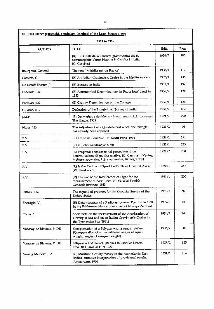
VII. GEODESY (Ellipsoid, Pendulum, Method of the Least Sauares, etc)
1942 to 1970
AUTHOR TITLE Edit. Page
Publications of the Finnish Geodetic Institute (Review) 1942 148
The Geodetic Tavistock Theodolite 1946 118
The New Wild Theodolites and Levels 1946 123
Co-ordination of Geographical Grids of the World 1948/2 12
' Hydrostatische Elbubergange im Rahmen des Nordseekustennivellements" (H.U. Sandig ic G. Scheel), Mitteilung Nr 19 des Instituts fur Angewandte Ceodisie, 1957 (Review)
1959/1 185
’Report of Proceedings of the French National Committee on Geodesy and Geophysics (for the Year 1957)’, Paris, [Review]
1959/1 186
"First-Order Traversing with the Tellurometer' (G.J. Humphries & H.H. Brazier),Empire Survey Review, London, 1958 (Review)
1959/1 186
'Gravimetric Deflections of the Vertical'(J.C. Bhattacharji), Bulletin o f the National Institute of Sciences of India, 1958, [Review)
1959/1 187
"Geodesia e Hidrografia" (V. Candarias Amillategui), (Review)
1960/1 171
"The use of artificial satellites for geodesy’ (Ed. G. Veis), {Review)
1964/1 193
Allan, A.L. The Tienstra Method of Resection 1962/2 71
Allan, T.D., Johansen, A. & Montanan, C.
Automatic recording and processing of marine geophysical data
1968/2 73
Aslakson, C.I. Shoran Investigations for Triangulation 1947 178
Barahona Fernandes, JA. Geodetic applications of artificial satellites 1967/1 95
Bernard, P. Visual and Photographic Reception of Time Signals 1944 108
Bhattacharji, J.C. On the Nature of Deflections of the Vertical derived from Dip Observations in Oceanic Islands
1961/1 167
Bhattachaiji, J.C. A graphical method of adjusting a doubly-braced quadrilateral of measured lengths when their weights are also taken in consideration
1966/2 119
Bhattacharji, J.C. A rapid Machine Computation Method of Conversion between Lambert Grid and Spherical Co-ordinates
1964/2 53
Browne, W.E. Triangulation Connexion of Norway and Denmark 1948/1 23
Brunei, A. The Shape of the earth given by artificial satellites 1966/2 149
Cravat, H.R. "Leapfrog” Barometric Levelling 1958/1 22
Cubranic, N. Connection of Elevations of the Middle Dalmatian Islands with Elevations on the Continent
1963/2 165
De Almeida Castro, J. Step adjustment of conditioned observations 1966/2 107
VII. CEODESY (Ellipsoid, Pendulum. Method of the Least Squares, etc)
1942 to 1970
AUTHOR TITLE Edit. Page
Franco, A. Dos Santos. Propagation of random errors along an analogic aerial triangulation strip
1966/2 97
Fuchs Radial Triangulation with marking Stereoscope and Single Photograph Triangulator
1943 39
Gossett, F.R. Flare Triangulation between Florida and the Bahamas 1949/1 112
Gougenheim, A. Use of Equal Altitudes Instruments for Accurate Determination of Latitudes
1950/1 86
Gougenheim, A. Gravimetric Tides 1952/2 22
Gougenheim, A. Dip as a Means of Geoldal Research in Pacific Ocean Islands
1959/1 111
Gougenheim, A On the Plane Representation of the Spherical Subtended Angle
1944 41
Heiskanen, W.A Intercontinental Connection of Geodetic Systems 1955/1 141
Heiskanen, W.A. On the World Geodetic System 1953/1 99
Husson, J.C. & Thieriet, D. A proposal aid to geodesy: the spatial system "GEOLE" 1970/2 111
IGN, France Geodetic flare triangulation 1967/2 115
1GN, France Geodetic connexion between France and North Africa by simultaneous sighting on the Echo I artificial satellite
1967/2 101
International Association of Geodesy
Compensation of the European Levelling Networks 1956/1 121
Jensen, H. A Study of Phototheodolite Cameras 1943 42
Lambert, W.D. Deflections of the Vertical from Gravity Anomalies 1948/1 79
Lepley, L.K. Ocean terrain analysis 1966/1 97
Môller, O. Length of the Geodesic determined from Mercator Co-ordinates
1956/2 137
Morelli, C. The geophysical situation in Italian waters (1966.0) 1966/2 133
P.V. "Transit Observations in Geodetic Astronomy" (A Gougenheim), [Review)
1943 88
P.V. Determination of the Station by the Inverse Centre of Gravity Method (A Courtier), [Review]
1943 89
P.V. "Bulletin Géodêsique" [Review) 1945 89
Poling, AC. A Taped Base Line and Automatic Meteorological Recording Instruments for the Calibration of Electronic Distance Measuring Instruments
1965/2 173
Schmidt, A. (Erratum) 1948/1 7
Schmidt A Radio Aids and Geodesy 1947 14
Schmidt, A. The Absolute Plumb Line Deflection 1963/1 75
Schmidt, A The Absolute Plumb-Line Deflection - II 1965/1 105
Schmidt, A (Erratum) 1966/1 161

*
VII. GEODESY (Ellipsoid, Pendulum, Method of the Least Sou ares, etc)
1942 to 1970
AUTHOR TITLE Edit. Page
Simmons, L.G. Satellite triangulation 1968/1 95
Sinzi, A.M., Owaki, N. & Suzuki, H.
Vertical deflection from dip observations 1968/2 129
Stassinopoulos, A. Report on the First-Order Triangulation of Greece 1947 208
Surveying and Mapping Thermal Expansion of Invar Surveying Tapes 1955/1 207
Tison, J.C. Marine geodesy 1969/1 109
Trotti, L. A bathymetric and geological survey in the Middle Adriatic Sea
1968/2 59
Van Gent, W.G. The Surinam traverse 1969/1 7
Vans say, P. De Method of Calculation for the Adjustment of Observation Results
1944 37
Volet, C. & Bonhoure, A. A Few Characteristics of Rustless Invar 1944 109
Watson, J.A. 4c Johnson, G.L. The marine geophysical survey in the Mediterranean 1969/1 81

VII. GEODESY (Ellipsoid, Pendulum, Method of the Least Squares, etc)
1971 to 1976
AUTHOR TITLE Edit. Page
Bhist, F.A. History and theory of datum planes of the Great Lakes 1972/1 109
Dohler, G. The mean water level at Pointe-au-Pere as used for the International Great Lakes Datum (1955)
1971/2 117
Fischer, I. On the mystery of mean sea level slopes 1976/2 17
Fischer, I. Deflections and geoidal heights across a seamount 1976/1 117
Pugh, D.T. & Alcock, G.A Gradients on the mean and instantaneous sea surface level in a shallow water region
1976/2 29
Shipley, A.M. Choosing a chart datum 1972/1 123
Wemelsfelder, P.J. Mean Sea Level as a fact and as an illusion 1971/1 115

VII. GEODESY (Ellipsoid. Pendulum, Method of the Least Sauares. etc)
1977 to 1980
AUTHOR TITLE Edit. Page
Floyd, R.P. Stable and enduring monuments for vertical control networks
1980/1 77
Melior, J.R., Royan, I.J. & Priest, R.J.
Third order hydrostatic levelling 1978/2 99
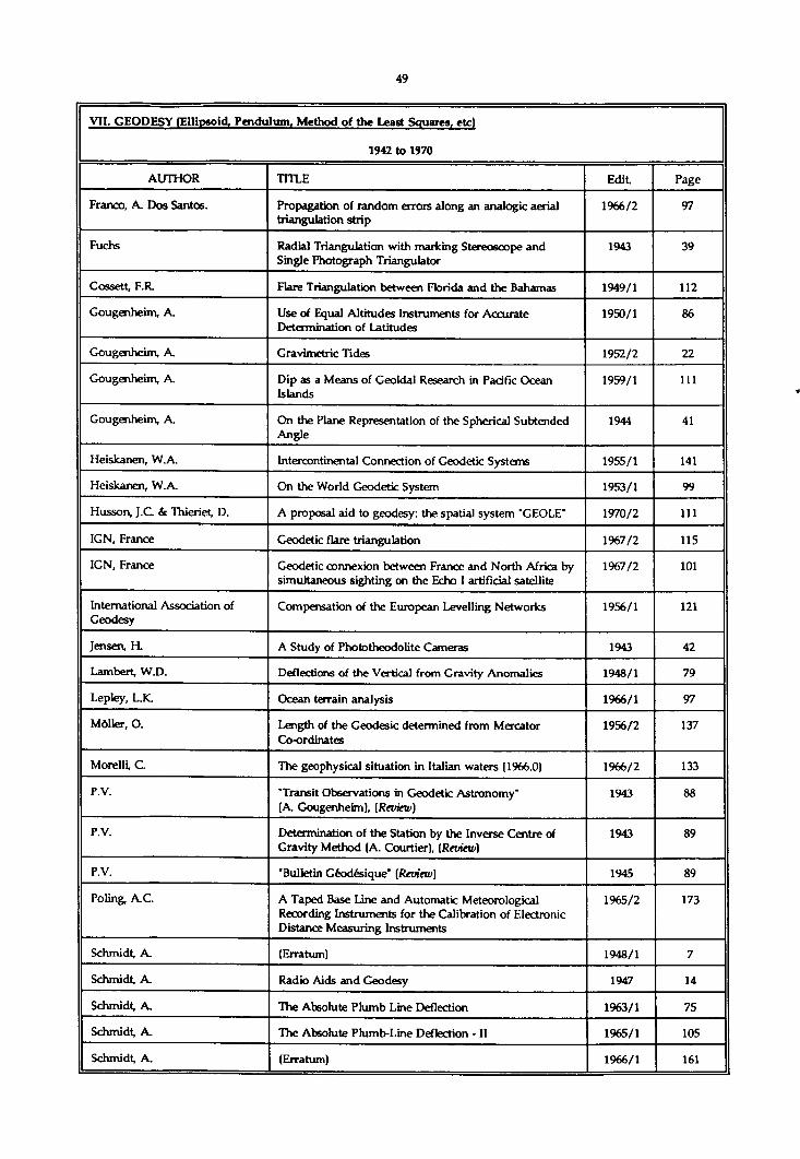
VII. GEODESY fElliosoid, Pendulum, Method of the Least Squares, etc)
1981 to 1985
AUTHOR TITLE Edit. Page
Cumbelic, P. A numerical method for computing the craft's position directly from observations of two celestial bodies or Simulation Method
1983/2 83
Fischer, I.K. The role of the sea and the seafarers in early geodesy 1983/1 107
Minkel, D.H. Establishing hydrographic control using Doppler 1984/2 57
Vogel, T.J. Horizontal datums for nautical charts 1981/2 53
Weightman, J-A. Satellite geodesy and offshore oil 1982/1 31

VII. GEODESY (Ellipsoid. Pendulum. Method of the Least Squares, etc)
1985 to 1990
AUTHOR TITLE Edit. Page
Beaton, R.J. Marine Geodesy in the Department of Defense (USA) 1986/1 109
Komaki, K., Sasaki, M. & Hashimoto, H.
Plan for satellite geodesy in Japan. 1986/2 91

VIII. GEOGRAPHICAL POSITIONS fLoneitudes, Meridian of Oririn, etc)
1923 to 1935
AUTHOR TITLE Edit. Page
(E) Tables for observations with the Prismatic Astrolabe. (R.P. de la Villemarqué) Zi-Ka-Wei, 1928
1928/21929/2
235225
Use of Wireless Telegraphy in Longitude Determination (U.SA.)
1928/2 85
(R) Wireless Longitude. (U.S.C. & G. Survey) 1924 1929/2 234
Bencker, H. Geographical Positions - World Longitude Determinations
1927/1 23
Enin, W.G. The Prime Meridian 1927/2 189
Gougenheim, A. The recent determination of a world—wide series of Fundamental Longitudes
1928/2 73
Green, F.M. The determination of Secondary Meridians by the Electric Telegraph (1874-1876)
1932/2 61
Rollet de l'lsle Historical notes on the Difference of longitude between Paris and Greenwich
1926/2 177
Tonta, L. Accurate Determination of the Position at Sea. (Error of the bisector. - Mean errors)
1931/2 33
Torreson, O.W. The determination of Geographical Position for Scientific Observations at sea and especially in connection with Magnetic Work
1931/2 112
Vanssay de Blavous, P.DE Calculation of the Geographical Co-ordinates on the International Ellipsoid
1929/2 39

V ill C.FOC.RAPHICAL POSITIONS fLonritudes, Meridian of Orion, etc)
1936 to 1941
AUTHOR TITLE Edit. Page
(E) Locating the Washington Monument 1936/2 182
World Longitudes 1937/1 109
Anderson, C.L. Taut wire and Sun Azimuth computation 1938/2 109
Lushene, J.P. (E) World Longitude 1933 1936/2 170
P.V. (R) Tafeln zür Ubertragung geographischer Koordinaten auf den Intemationalen Erdellipsolde im Bereich 35° bis 71° Breite. - Helsinki, 1941 (Tables for the conversion of the International Ellipsoid between Latitudes 35° and 71°)
1941/2 80

VIII. GEOGRAPHICAL POSITIONS (Longitudes. Meridian of Origin, etc)
1942 to 1970
AUTHOR TITLE Edit. Page
List of Geodetic Positions based on European Datum (E.D.) of Points used for Nautical Chart Construction in the Netherlands and Norway
1956/2 129
Gougenheim, A. New Geodetic Astronomy Method: The Method of Azimuth Lines
1952/2 28
Tardi, P. Unification of Geodetic Grids of the World Application to General Problems of Navigation
1952/2 63
Viglieri, A. International Hydrographic Bureau Special Publication N°24: Geographical Positions
1953/1 117

IX. HISTORICAL. PERSONAL AND OBITUARY NOTICES
1923 to 1935
AUTHOR TITLE Edit. Page
(E) Two fundamental Geographical Inventions. (Gemma Frisius, 1508-1555) New York, 1935
1935/2 154
Origin of Meridional Parts. (First tables by Edw. Wright- Some remarks on the Mercator chart of 1569)
1931/1 85
(R) Medkdan Charts of the first half of the 17th Century. (S. Crino) Rome, 1931
1932/1 262
(R) As Cartas de M arear. (Fontoura Da Costa) Lisbon, 1934
1934/2 191
(R) Die verschollene Columbus-Karte von 1498, in einer türkischen Wehkarte von 1513. (P. Kahle) Leipzig, 1933
1934/1 150
(R) Histoire générale de la Navigation du XVe au XXe siècle. (F. Marguet) Paris, 1931
1932/1 259
(R) Early history of Magnetism. (Dr. Kramer) Birmingham, 1932
1932/2 275
(R) The Astrol bes of the World. (R.T. Gunther) Oxford, 1932
1934/1 147
(E) History of the Charts of the Brazilian Coast 1935/2 141
Gallery of Portraits of Distinguished Hydrographers and Explorers
1923/1 64
(E) Pierre Vernier (1580-1637) 1932/1 197
Works of Johann Heinrich Lambert 1931/1 78
(E) Nevil Maskelyne (1732-1811) 1933/1 193
Commodore Samuel Harris Müller (1849-1930) 1930/1 7
Professor W.M. Davis (1850-1934) 1934/2 10
J.P. Van Der Stok (1851-1934) 1934/2 8
Rear-Admiral A.P. Niblack. Obituary (1859-1929) 1929/2 9
Professor Louis Joubin (1861-1935) 1935/2 9
Death of the President of the Directing Committee. (Admiral Sir John Franklin Parry, K.C.B.) (1863-1926)
1926/2 193
Baron Adrien De G er lâche De G ornery (1865-1934) 1935/1 7
Robert Lee Faris (1868-1932) 1933/1 7
Vice-Admiral Hugo Dominik (1871-1933) 1934/1 7
P.H Gal lé (1874-1934) 1934/2 9
Rear-Admiral Luigi Tonta (1874-1935) 1935/2 7
Colonel E. Lester Jones, Obituary. (1876-1929) 1929/2 13
Retirement of George Washington Littlehales 1933/1 10
Commander ES. Bjôrset 1933/1 9
Vice-Admiral Sir Percy Douglas, K.C.B., C.M.G. 1933/2 7

IX. HISTORICAL. PERSONAL AND OBITUARY NOTICES
1923 to 1935
AUTHOR TITLE Edit. Page
Almagia, R. (E) Pin Rei'is’ World Map and Columbus’ Chart of 1498 1934/2 193
Baxandall, D. (E) The Inventor of the Station Pointer 1933/1 194
Berget, A. The Chevalier De Borda (1733-1799) 1932/1 39
Douglas, H.P. (E) Fitzro/s Hydrographic Surveys. (1831-1836) 1932/2 258
Drury, B. (E) An index to the Abbreviations and Features. (1852) 1924/2 140
C.S.S. (R) A Marinharia dos Desobrimentos (The Art of Navigation during the Age of Discoveries). (A. Fontoura Da Costa), Lisbon, 1934
1935/2 154
Gunther, R.T. (E) J.F. Campbell (1822-85) and his Refracting Quadrant 1935/1 170
H.B. (R) Navigational Antecedents. (H.D. McGuire) Anru. polis, 1933
1934/1 151
H.B. (R) The Progress of Navigation (C.H. Brown) Glasgow, 1932
1932/1 259
J.D.N. (R) 'Hie Discoveries of the Fiji Islands. (G.C. Henderson) London, 1933
1934/1 149
J.D.N. The First Charting of the Australian Continent 1934 /2 90
J.D.N. Sir Edgeworth David, K.B.E. (1858-1934) 1934/2 11
J.M.P. A Compass Rose by C. de Bie (1689) (Dr. F.C. Wieder, Leiden)
1924/2 129
L.T. Hadley’s Octant (A.D. 1731) 1931/2 52
Lee, Ida (E) The First Sighting of Australia by the English 1934/2 92
Leeuw, J.H. de (E) Astronomical Refraction in History 1935/1 142
LôchstOer, J. (E) On the History of the Nautical Mile 1934/2 131
Long, A.T. The Godfrey Sextant (1730-1732) 1931/2 61
Maurer, H. Johann Heinrich Lambert (1728-1779) 1931/1 70
Mercator, G. (E) Text and translation of the Legends of the Original Chart of the World by Gerhard ** Mercator issued in 1569
1932/2 7
Michell, Rev. John (E) A recommendation of Hadley's Quadrant (1765) 1933/2 111
Nouhuys, J.W. Van Mercator's World Atlas ’ad usum Navigantium’ 1933/2 237
P.V. (R) Use of the properties of a Segment containing an Angle in Navigation and in Hydrographic Surveys
1933/2 110
Parry, Sir John F. Matthew Fontaine Maury (1806-1873) 1924/2 155
Parry, Sir John F. H.S.H. Prince Albert 1 of Monaco. (1848-1922) 1923/1 20
Parry, Sir John F. (R) Founders of Oceanography and their Work. (W. Herciman) London, 1923
1924/1 163
Parry. Sir John F. A great British Hydrographer, Francis Beaufort (1774- 1857)
1924/1 143

IX. HISTORICAL. PERSONAL AND OBITUARY NOTICES
1923 to 1935
AUTHOR TITLE Edit. Page
Rollet de l'lsle Remarks on the Bust of Beautemps-Beauprê (1766-1854) 1924/2 160
Rollet de l’lsle The Archives of the Hydrographic Service of the French Navy
1924/2 145
Wedemeyer, A. Comments on the existing copies of the Mercator1 s Chart of 1569
1931/2 204
Wright, Edw. (E) A Table for the true Dividing of the Meridians in the Sea Chart (1599)
1931/1 94

IX. HISTORICAL, PERSONAL AND OBITUARY NOTICES
1936 to 1941
AUTHOR TITLE Edit. Page
(R) History of the Magnetic Compass (J. Hennessy) London, 1935
1936/1 164
(E) Notes on Surveying Apparatus and Inventions (The first theodolite: The reticule)
1936/2 137
(R) Matthew Fontaine Maury, 1806-1873, the Pathfinder of the Seas (C. Lewis), Annapolis, 1927
1936/1 167
Captain Francisco Vidal Gormaz (1838-1907) 1937/2 11
Major General A. W. Greely, U.SA. (1844-1935) 1936/1 9
Giovanni Piero Magrini (1877-1935) 1936/1 8
Julien Olivier Thoulet (1843-1936) 1936/2 10
Doctor Sinkiti Ogura (1884-1936) 1937/1 8
Rear Admiral Raymond Stanton Patton (1882-1937) 1938/1 10
Admiral Sir Herbert Edward Purey-Cust (1857-1938) 1939/1 9
Vice-Admiral Hydrographic Engineer Augusto Ramos Da Costa (1865-1939)
1940/1 10
Rear-Admiral W.S. Crosley (1871-1939) 1939/1 7
Rear-Admiral Walter R. Gherardi (1875-1939) 1939/2 13
Dr William Bowie (1872-1940) 1941/1 6
Cannenburg, W.V. (E) The Marine Clock of Christiaen Huygens 1936/2 162
Clark, E.S. (E) Nathaniel Bowditch, LL.D. Mathematician, Navigator, Astronomer, (1773-1838)
1937/2 7
Costa, V. Rear-Admiral Hydrographic Engineer Julio Zeferino Schultz Xavier (1850-1939)
1940/2 6
Cresswell, M. (E) Captain James Cook (1728-1779) 1938/1 126
Fontoura Da Costa The Discovery of Brazil in 1500 1939/1 147
Fontoura Da Costa (R) Cartografia e Cartografos Portuguese's dos Seculos XV e XVI (A. Cortesao), Lisbon, 1935
1936/2 166
Catty, H. A Historic Sextant 1939/1 152
Givry, M. Note on the Plotting of Bearings on the Mercator Chart (1829)
1941/2 16
H.B. (R) A few scattered explanations on my Monumenta Cartographica Africae et Aegypti (Y. Kamal), Leiden, 1935
1936/1 169
H.B. The Centenary of the Position Line 1938/1 141
H.B. Captain Abel Fontoura Da Costa (1871-1940) 1941/2 6
J.D.N. Vice-Admiral Sir Henry Percy Douglas (1876-1939) 1940/1 8
M.E. A new copy of G. Mercator's Orbis Imago (1538) 1938/2 101
Marbois, A.J. Early United States Coast Pilots 1940/2 50

IX. HISTORICAL, PERSONAL AND OBITUARY NOTICES
1936 to 1941
AUTHOR TITLE Edit Page
P.V. Dr Jean-Baptiste Charcot (1867-1936) 1936/2 8
P.V. Ingénieur Hydrographe Générale E. Fichot (1867-1939) 1939/2 9
Pélissier, LA. Carte du Comité France-Amérique 1937/2 77
Perrier, G. Obituary Notice on Jules Mikhallovitch Schokalsky (1856-1940)
1940/2 8
Votaw, H.C. Midway - The North Pacific's Tiny Pet 1941/1 41
Winter, H. (E) How long has Magnetic Variation really been known?
1936/2 168

IX. HISTORICAL. PERSONAL AND OBITUARY NOTICES
1942 to 1970
AUTHOR TITLE Edit. Page
Obituary : Rear Admiral Andrew Theodore Long, U.S.N. 1946 6
Obituary : Rear Admiral D. Léon Herrero y Garda 1947 10
Obituary : Commander G.B. Spicer-Simson 1947 12
Obituary : Mr John G. Kellar 1947 13
Obituary : H.S.H. Prince Louis II of Monaco 1949/1 7
H.S.H. Rainier III, Sovereign Prince of Monaco 1950/1 7
Obituary : Admiral Sir Mostyn Field 1950/2 6
Obituary : Commodore H.O. Ravn 1950/2 8
Obituary : Professor Martin Knudsen 1950/2 9
Obituary : Rear Admiral Don Wenceslas Benitez Inglott 1955/1 7
"The Mathematical Practitioners of Tudor and Stuart England" (E.G.R. Taylor), (Review)
1955/1 203
Obituary : Admiral J.D. Nares, D.S.C., R.N. 1957/1 9
Obituary : Rear Admiral Lamar R. Leahy, U.S.N. 1958/2 7
Obituary : André Courtier 1959/1 7
"Admiral Sir Francis Beaufort" (K.st. B. Collins), The Journal of tie Institute of Navigation, N°3, London 1958. (Review)
1960/1 177
Obituary : Donatien COT 1962/1 7
"Portugaliae Monumenta Cartographia" (A. Cortesao and A. Teixeira da Mota), (Review)
1962/2 115
"The journals of Captain James COOK" (Ed. J.C. Beaglehole), (Review)
1962/2 116
Obituary : Vice Admiral Sir John Edgell 1963/2 7
"The geometrical seaman" (E.G.R. Taylor and M.W. Richey), (Review)
1963/2 205
Obituary : Ingénieur Hydrographe Général L. Damiani 1964/1 7
"A regiment for the sea, and other writings on navigation" (E.G.R. Taylor), (Review)
1964/1 193
Obituary : Rear Admiral van Asbeck 1967/1 7
Obituary : Rear Admiral Balen Garcia 1967/1 7
"The Admiralty Chart" (G.S. Ritchie), (Review) 1967/2 169
"The Journals of Captain James Cook" (Ed. J.C. Beaglehole), (Review)
1968/1 190
Darrdani, L. The Life and Works of Beautemps-Beaupré 1954/2 145
H.B. Obituary : Rear Admiral Johan Marie Phaff 1945 6

IX. HISTORICAL. PERSONAL AND OBITUARY NOTICES
1942 to 1970
AUTHOR TITLE Edit. Page
H.B. Obituary : Ing. Hydrographe général P. de Vanssay De Blavous
1947 7
P.V. Obituary : Ingénieur hydrographe général C.D.M. Rollet De risle
1944 6
Rough, J. An Unpublished Letter from Nansen 1958/2 137
Rough, J. More evidence of Chateaubriand's accuracy in "L'Itinéraire de Paris à Jérusalem"
1967/1 197

IX. HISTORIES AND OBITUARIES
1971 to 1976
AUTHOR TITLE Edit. Page
Obituary : Vice Admiral Sir Archibald Day 1971/1 7
Fifty years ago Allissues
Gougenheim, A. 250 years of hydrography in France 1971/2 31
Grousson, R. Obituary : Ingénieur Hydrographe Général André Gougenheim
1976/1 21
Ritchie, G.S. Italy’s contribution to world hydrography - 1300-1950s 1973/2 19
Ritchie, G.S. 500 years of graphical and symbolical representation on marine charts
1976/1 141
Sadler, D.H. The tercentenary of the Royal Observatory at Greenwich 1975/2 7

IX. HISTORICAL, PERSONAL AND OBITUARIY NOTICES
1977 to 1980
AUTHOR TITLE Edit. Page
Fifty years ago Allissues
Cotter, C.H. The development of the mariner's chart 1977/1 119
Lah, L.J. Centenary of the Argentine Navy Hydrographic Servioe 1979/2 11
Monahan, D. The General Bathymetric Chart of the Oceans; seventy- three years of international cooperation in small scale thematic mapping
1977/2 9
Monteith, W.J., Kerr, A.J. & Pittman, A.
The history of the Great Lakes charting advisers 1978/1 145
Oudet, L. Hydrography and Navigation 1980/1 101
Pritchard, J.S. Early French hydrographic surveys in the Saint Lawrence River
1979/1 125
Ritchie, G.S. Obituary : Ammiraglio di Divisione Alfredo Vilieri 1980/1 7

IX. HISTORICAL. PERSONAL AND OBITUARY NOTICES
1981 to 1985
AUTHOR TITLE Edit. Page
Fifty years ago Allissues
Bourgoin, J. Three centuries of French hydrography in Canada 1984/1 7
G.S.R. Obituary : Captain Isaac Wilhelm Tegner 1981/2 7
G.S.R. Obituary : Dr. Günther BOhnecke 1982/1 7
Has lam, D.W. The British contribution to the hydrography of Canada 1984/1 17
Holsen, J. The development of survey instruments 1984/1 81
Ritchie, G.S. Some aspects of the history of oceanography as seen through the publications of the International Hydrographic Bureau 1919-1939
1981/2 11
Ritchie, G.S. Hydrography, yesterday, today and tomorrow 1982/2 7
Sandilands, R.W. Hydrography surveying in the Great Lakes during the nineteenth century
1983/2 55

IX. HISTORICAL, PERSONAL AND OBITUARY NOTICES
1985 to 1990
AUTHOR TITLE Edit. Page
Obituary - Commodore AH. Cooper 1988/1 7
Obituary - Rear Admiral Francis L. Fraser 1990/2 1
Fifty years ago Allissues
Cailliau, E.J. Hydrography in the North - South dialogue. 1987/1 25
Douglas, G.R. 6c MacPhee, S.B. Hydrography for the year 2000. 1986/1 21
Liu Chang Cui The present and future of the Chinese surveying and charting.
1988/1 11
Newson, D.W. Hydrographic contributions to safety at sea 1975-1985. 1986/2 7

X. HYDROGRAPHIC TRAINING AND TECHNICAL ASSISTANCE
1977 to 1980
AUTHOR TITLE Edit. Page
Campbell, R.J. Hydrographic surveying for ports and approaches 1980/2 7
Kapoor, D.C. Standards of competence for hydrographic surveyors 1980/1 25
Sathaye, N.N. The requirement for hydrographic surveys in ports and anchorages
1980/2 13
Williams, C.R. Hydrographic surveying and charting - the need and the means
1980/2 25

X. HYDROGRAPHIC TRAINING AND TECHNICAL ASSISTANCE
1981 to 1985
AUTHOR TITLE Edit. Page
Bolton, M. Hydrography - A perspective.... 1984/1 49
X. HYDROGRAPHIC TRAINING AND TECHNICAL ASSISTANCE
1986 to 1990
AUTHOR TITLE Edit. Page
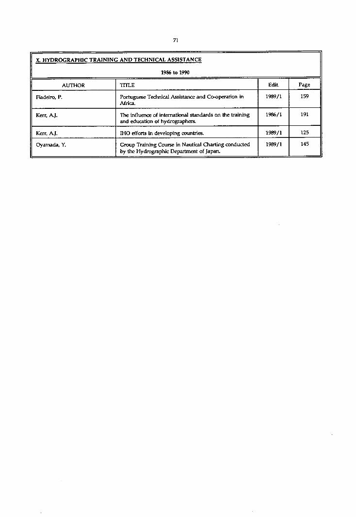
Fiaddro, P. Portuguese Technical Assistance and Co-operation in Africa.
1989/1 159
Kerr, A.J. The influence of international standards on the training and education of hydrographers.
1986/1 191
Kerr, A.J. IHO efforts in developing countries. 1989/1 125
Oyamada, Y. Group Training Course in Nautical Charting conducted by the Hydrographic Department of Japan.
1989/1 145

XI. HYDROGRAPHIC WORK. REPORTS ON SURVFYS
1923 to 1935
AUTHOR TITLE Edit. Page
(R) Deep Sea Soundings in the East Indian Archipelago (Koninklijk Meteorologisch en Magnetisch Observatorium te Batavia)
1926/2 224
Japanese Marine Expedition to the South Seas, 1927 1927/1 226
(E) Survey of Georges Bank. (New appliances used by the U.S.C & G. Survey. Portable RA.R. Set)
1932/1 172
(E) United States Naval Surveys (1931) 1932/1 181
(R) Trabajos de campo que se efectuan en la Comision Hidrogrâfica para el levantamiento de las cartas y planos. (J. Cervera), Madrid, 1927
1928/1 276
(R) Resumen de los Trabajos de la Comision Hidrogrâfica de Espafta en la costa de Galicia en los aftos 1903-1918, Madrid, 1925
1928/2 240
(E) Expedition to Baffin Bay (U.S. Coast Guard) 1928 1928/2 223
The Cambridge University East Greenland Expedition, 1926
1929/1 237
Record of the Hydrographic Work undertaken by the Russian Navy during the past century
1929/1 17
(E) Soviet Work in the Arctic 1933/2 233
Russian Hydrographic Expedition in Siberia, 1933 1934/2 169
(R) Résultats des Campagnes Scientifiques du Prince de MONACO, Vol. LXXXIX. (List of Stations)
1935/1 179
Question referring to the Accuracy of Hydrographic Soundings
1925/1 188
Methods of Soundings(a) Lead lines used - (b) sounding machines and other appliances used - (c) method of checking lead lines - (d) method of running lines of soundings and keeping on them - (e) method used for fixing the position of the soundings - (f) instruments used for fixing and plotting soundings - (g) method of obtaining specimens of the bottom - (h) system used for reducing soundings to chart datum - (i) scheme of soundings, examination of dangers off salient points - Answers to Circular Letter N° 5-H of 1933 : Netherlands, Germany, Italy, USA, (Spain, Portugal, Great Britian, Australia, Denmark, France, China, Poland, Sweden, Norway, Siam)
1934/1 36
Methods of Sweeping used in various countries.(USA : The Standard Wire Drag. The Light Wire Drag. The Wire Sweep).France : Drague flottante. Drague hydrographique française.Sweden : Spar Sweep, Bar Sweep.(Great Britain, Argentina, Chile, Denmark, Norway, Germany, Netherlands, Belgium, Spain, Portugal, Italy, Greece, Siam, China, Australia, Brazil)
1934/1 67
An Air-pressure Sounding Machine 1925/1 190

XI. HYDROGRAPHIC WORK. REPORTS ON SURVEYS
1923 to 1935
AUTHOR TITLE Edit. Page
Description of the U.S.C & GS Sounding Tube 1928/1 221
Sounding Machines used by the U.S. Coast & Geodetic Survey
1929/1 215
Thermoelectric Sounder by Commander Laboureur 1929/2 175
(R) Sounding by Fish-lead (Marti), Paris, 1926 1927/2 213
Offshore Soundings. Use of floating Beacons (France) 1928/2 101
Floating Signals used by the U.S. Coast & Geodetic Survey
1929/1 219
(E) Two drum hydrographic Floating Signal. (U.S.C & G. Survey)
1931/1 267
(E) Investigation into Shoals off the Coast of Annam (Juniata Bank, Duperré Breakers)
1933/1 176
On the results of Soundings in the vicinity of the Yamato Bank, 1933
1934/2 170
(R) Annali Idrografid (VoL 11), Genoa, 1927 1928/1 282
(R) Anales Hidrogrâficos - Argentina (Tome VIII), 1928 1929/1 243
(R) Annual Report of the Director, U.S. C & G. Survey, 1927
1929/1 244
(R) Annales Hydrographiques (3e Série, Tome VIII), Paris, 1927-28
1929/2 241
(R) Annual report of the U.S. Hydrographic Office for the fiscal year 1928
1930/1 254
(R) Annua] report of the Director, U.S.C. & G. Survey, for the fiscal year ended June 30, 1929
1930/1 255
Akhmatov, V. Cartography of the Arctic within the limits of the USSR frontiers
1930/1 161
Albert, G. Charts of the Progress of Hydrography of the British Isles and Sweden
1927/2 51
Bencker, H. The Bathymetric Soundings of the Oceans, (With chronological list of oceanic explorations from the year 1800 - List of principal oceanic depths and of principal oceanic shallows)
1930/2 64
Brown, T.T. The Navy-Princeton Gravity Expedition to the West Indies in 1932
1934/2 82
Canadian Hydrographic Service Charting of Hudson Bay and Strait 1930/2 44
Canadian Hydrographic Service Hudson Bay Survey (1930) 1931/2 235
Collinder, P. A summary of Hydrographic results obtained during an Arctic Cruise in 1929 (Bjômôy)
1930/2 37
Edgell, J.A. & Jackson, A.L. The Islands of the Tristan D'Acunha Group 1934/2 20
Edgell, J.A. Taut Wire Measuring Operations at Sea 1932/2 74
C.S.S. (R) Anais Hidrographicos, Tomo I, Rio de Janeiro, 1933 1934/1 134

XI. HYDROGRAPHIC WORK. REPORTS ON SURVEYS
1923 to 1935
AUTHOR TITLE Edit. Page
C.S.S. (R) Anales Hidrogrâfioos, VoL I, 1932 (Uruguay) 1934/2 168
Gherardi, W.R. The Cuban Survey 1933/1 61
Gougenheim, A. Nomographic determination of the Inclination Correction of Soundings taken by means of a Fish-lead (plomb- poisson)
1932/2 84
Guyader, P.L. Extract from a report of a Voyage to Greenland of the Hospital Ship "Sainte-Jeanne d'Arc" (1929)
1930/1 51
Heck, N.H. The Coast & Geodetic Survey and Oceanography in the Pacific
1928/1 251
Imamura, A. & Kawase, E. A new Volcano off the East Coast of Alaid Island, 1933- 1934
1934/2 170
Japanase Hydrogaphic Department
Report on Oceanic Survey in the western part of the North Pacific carried out by H.I.J.M.S. "Mansyu" from April 1925 to March 1928
1932/2 128
John, D. Dilwyn (E) The Second Antarctic Commission of the R.R.S. ’Discovery II’ , (1931-33)
1934/2 77
Johnson, H.F. Correction for Inclination of Sounding Wire (US Lake Survey)
1933/2 176
Kemp, S. The voyage of the R.R.S. ’Discovery II’, surveys and soundings (1929-1931)
1932/2 260
Kruger, H.C. The Towed Sounder used by the Conservancy Department of the Naval Yard at Wilhelmshaven and the experiments made therewith
1927/2 161
Lallemand, Ch. Some recent geographical Discoveries in the Antarctic Region ("Norvegja" 1927-1931 ; Sir Douglas Mawson 1929-1930)
1932/2 264
Libby, H.E (E) Graphic Pressure Sounder (USA) 1932/1 231
Littlehales, G.W. Measures for the settlement of Reports of Doubtful Dangers in the Ocean. (Form of the slope of Wake Island)
1932/2 96
Littlehales, G.W. The International Scientific Expedition to the West Indies in 1932
1932/2 124
Long, A.T. The "Norvegia’ Antarctic Expedition of 1929-1930 1931/1 28
Long, A.T. The Antarctic Cruise of the "Discovery' 1929-1930 1931/1 23
Luymes, J.L.H. The Adjustment of the Hydrographic Surveys in the Moluccas
1929/2 67
Luymes, J.L.H. Short sketch of the Progress of Ooeanography and the Expedition of the Royal Dutch Vessel "Willebrord Snellius"
1930/1 142
Luymes, J.L.H. Expedition of the H.N.M.S. "Willebrord Snellius" (1929- 1930)
1931/2 65
Luymes, J.L.H. The Hydrographic Survey of the Netherlands East Indian Archipelago
1927/2 45

XI. HYDROGRAPHIC WORK. REPORTS ON SURVEYS
1923 to 1935
AUTHOR TITLE Edit. Page
Marti, P. (E) Employment of Floating Marks (beacons) by the Algeria-Tunisia Hydrographic Expedition
1932/1 164
Marti, S. Sounding equipment by means of the Fish-lead (with recording gear)
1933/1 103
Marti, P. Exploration of the Submarine Volcanic Region of the Catwick Islands (1929)
1930/1 75
Maureb, H. The Soundings of the Exploring Vessel "meteor" and Nautical Science (Corrections to soundings)
1928/1 167
Nares, J.D. A method of mooring a Floating Beacon in Deep Water 1931/1 190
Otte, F. Hydrographic Surveying in China 1928/1 63
P.V. (R) Die Echolotungen des Meteor (Text und Echolotprofile). (H. Maurer), Berlin, 1933
1934/1 138
Pélissier Note on certain Shoals of the Newfoundland Bank 1928/2 93
Pélissier Concerning two Dangers of Doubtful Existance off the coasts of Annam
1928/1 223
Ravn, H.O. The Maritime Survey of Denmark (History and Methods) 1930/1 129
Reinius, G. & Bouveng, E. Sounding in shallow water from a Vessel under way. (Appliances adopted in Sweden)
1925/2 57
Reinius, G. Ohlsson-Odelsiô, H. & Collinder, P.
Boat Sounding and Examination of Shoals in Sweden. (Spar Sweep and Submarine sentry)
1924/2 51
Rollet de l’lsle Methods now in use by the Ingénieurs Hydrographes of the French Navy
1926/2 183
Romagna Manoia, G. Report on the Scientific researches carried out by H.I.M.S. 'Città di Milano’ at Spitsbergen during the Arctic Expedition of 1928
1929/2 83
Romagna Manoia, G. (E) Description of Viœ-Admiral MAGNACHI's Sounding machine (new type)
1934/1 128
Rubartelli, L. Report of the Hydrographic Expedition of the "Ammiraglio Magnaghi" in the Red Sea, 1928-1929
1930/1 46
Rude, G.T. (E) The Surveys of Georges Bank (Radio Acoustic Ranging)
1932/2 238
Rude, G.T. Recent progress in Hydrographic Surveying 1935/1 122
Rude, G.T. (E) Hydrographic Data 1935/1 181
Samoilovich, R.L. (E) Expedition in the Ice-breaker "Sedov” in 1934 1935/2 135
Schulz, B. (E) Scientific Exploration in the Barents Sea by the "Poseidon" in 1927
1930/1 243
Slaucitajs, L. A short Historical Sketch of Hydrographic Work of the Latvian Coast and to seaward
1931/2 97
Smith, E.H. Narrative Account of the "Marion" Expedition (in the North of Davis Strait)
1929/1 197
XI. HYDROGRAPHIC WORK. REPORTS ON SURVEYS
1923 to 1935
AUTHOR TITLE Edit. Page
Smith, E.H. (E) The "Marion' Expedition to Davis Strait and Baffin Bay, 1928 - Scientific Results - Part 3 : Arctic Ice, with special reference to its Distribution to the North Atlantic Ocean
1932/1 238
Swainson, O.W. (E) Rigid Control for the survey of an Offshore Bank (US C. & G. survey)
1931/1 266
Tonta, L. On the Curvature of the Lead-line and the Correction for its Inclination
1927/2 105
Tonta, L. On the Curvature of the Lead-line and the Correction for its Inclination
1930/2 175
U.S.Field Engineers (E) Progress on the Georges Bank Project 1932/2 242
Vallaux, C. Ice Observation and Patrol in the waters of Newfoundland in 1929
1931/1 59
Vanssay De Blavous, P. de Use of the properties of the Arc containing an Angle (Position Line) in Navigation and in Hydrographic Surveys; (Historical - various uses - accuracy of intersection)
1930/2 7
Verstelle, J. Th. The small LUCAS sounding machine 1935/1 161
Wandel, C.F. (E) Historical Remarks concerning the Reykjanaes-Ryg 1935/1 179
Wordie, J.M. (E) Work done during the Third Commission of the R.R.S. "Discovery II", 1933-1935
1935/2 77
Wüst, G. Thermometric Measurement of Depth. (Tables and Bibliography)
1933/2 28
Wyatt, A.G.N. (E) Surveying Cruises of H.M.S. "Challenger" off the Coast of Labrador in 1932 and 1933
1934/2 70
ZorelL F. Sounding of the Deeps in the vicinity of Japan 1929/1 187

XI. HYDROGRAPHIC WORK. REPORTS ON SURVEYS
1936 to 1941
AUTHOR TITLE Edit. Page
High Latitude expedition on the Russian Ice Breaker "Sadko" (1935)
1937/2 177
The Soviet Polar Enterprise. Some preliminary results 1938/1 84
(E) The British Graham Land Expedition 1937/1 133
(R) The "Snellius" Expedition, 1929-1930 (P.M. van Riel), Utrecht, 1934
1936/1 167
(E) Ramapo Bank (U.S.H.O.) 1937/1 99
Submarine Canyons 1938/1 66
(R) The Origin of Submarine Canyons (D. Johnson) 1941/1 31
British Admiralty Mark IV Oropesa Sweep 1940/1 111
(R) Annali del R. Istituto Superiore Navale, Naples, 1936 1937/2 273
(R) Annales de l'institut de Physique du Globe, Paris, 1937
1937/2 274
Baker, E.H.B. Winter Surveying in Labrador 1936/1 10
Bonetti, M. (E) Hydrographie Work recently carried out by the Italian Royal Navy in the Aegean Sea, The Red Sea, and the Indian Ocean
1940/1 25
Brunei, A. (E) Notes on the Hydrographic Drag, M-1931 1937/2 173
Bryan, G.S. Los Jardines (E.D.) 1940/2 48
Bryan, G.S. The Wilkes Exploring Expedition 1940/1 131
Chapman, S. United States Geophysical Expedition to the Pacific Ocean
1939/2 45
Cot, D.F. French Gravity Measuring Cruise in the Western part of the Mediterranean
1937/2 75
Defant, A. The Altair Peak (Kuppe) 1940/1 167
Defant, A. (E) Survey of the Morphological details of the Ocean bottom by means of echo sounding (Altair Kuppe, Joséphine Bk., Aramis Bk.)
1939/2 56
Edgell, J.A. Notes on Wire Drag Surveys 1936/1 21
G.C.L.B. Progress of the Discovery Committee’s Investigations 1938/1 85
Georgi (R) Norvegja rundt Sydpollandet. (The "Norvegia" around the South Polar Land) (G. Isachsen), Oslo, 1934
1936/1 109
Gougenheim, M.A. Corrections to soundings with the Fish Lead 1937/2 155
H.B. (R) Annaes Hydrogrâficos, Tomo III, Rio de Janeiro, 1935 1936/2 170
Jones, O.T. (E) Theories of the origins of the Caftyons (Extract from an article entitled 'Continental Slopes and Shelves"
1941/2 53
Kuenen, P.H. Submarine Canyons 1939/1 121
Lofthouse, J.A. The Survey methods employed on the Cays 1940/1 188
XI. HYDROGRAPHIC WORK. REPORTS ON SURVEYS
1936 to 1941
AUTHOR TITLE Edit. Page
Mackintosh, N.A. (E) The Fifth Commission of the R.R.S. "Discovery II" 1941/2 59
Mason, K. (E) Notes on the Northern Sea Route 1941/1 36
Murray, H.W. (E) Submarine Scarp off Cape Mendocino, California 1941/1 27
P.V. (R) Morphologie des Atlantischen Ozeans (Th. Stocks) 1939/2 58
P.V. (R) Morphologie des Atlantischen Ozeans - (Grundkarte der Ozeanischen Lotungen - 1:5 000 000 (Von Th. Stocks), Berlin & Leipzig, 1937
1938/1 74
P.V. Soundings in the North Atlantic Ocean 1938/1 59
P.V. (A) Submarine Mountains in the Gulf of Alaska (H.W. Murray), Washington
1941/2 74
P.V. Soundings in the Pacific Ocean 1941/2 77
P.V. Soundings in the North Atlantic Ocean 1936/1 170
P.V. Soundings in the North Atlantic Ocean 1938/2 66
P.V. -d°- (Corrections to Sheet A of the General Bathymetric Chart of the Oceans, 3rd Edition, April 1935)
1937/1 97
Pélissier, L.A. Search for Shoals 1937/2 85
Perks, J.P-H. The "Snellius" deep-sea anchoring equipment 1939/1 80
Rittenburg, I.E. (E) Wire Drag surveys, Pacific Coast, 1934-1937 1938/2 107
Ross, S.E. Some Geographical Results of the Second BYRD Antarctic Expedition, 1933-1935
1938/1 76
Rude, G.T. (E) A Survey of Atlantis 1941/1 15
Samoïlovich, R.L. (E) Fifteen Years of Soviet Arctic Exploration 1936/1 80
Seiwell, H.R. Anchoring Ships on the High Seas 1941/1 19
Shepard, F.P. (R) New Bathymetric Map off California 1938/1 60
Shepard, F.P. & Beard, C.N. Submarine Canyons : Distribution and longitudinal profiles
1938/2 120
Smith, P.A. (E) The Accuracy of Soundings and Positions obtained by methods used in U.S. Coast and Geodetic Survey
1936/2 174
Smith, P.A. Submarine Valleys 1938/1 61
Southern, R.M. Surveys on the West Coast of Siam during the years 1934-1935
1937/2 81
Swanson, L.W. & McCarthy, R.H.
(E) Lead Shot Buoy Spacer for Wire Drag 1936/2 143
Zubov, N.N. The drift of the ice-breaker "Sedov" 1940/2 67
Zubov, N.N. (E) The drift of the "Sedov" 1939/2 93

XI. HYDROGRAPHIC WORK. REPORTS ON SURVEYS
1942 to 1970
AUTHOR TITLE Edit. Page
Hydrographic Work of China between the years 1937 and 1947
1947 196
Activities of the Italian Hydrographic Office 1937-1948 1948/2 23
’Oceanographic Results of "Snellius" Expedition' (1929- 1930) (Riel, P.M. van), (Review)
1951/1 114
"Annales Hydrographiques', Paris, 1956 (Review) 1958/2 147
Marine Surveying in Britain during the Seventeenth and Eighteenth Centuries (A.H. W. Robinson), "The Geographical Journal", London, 1957 (Review)
1958/2 159
"Subsidios Para O Estudo do Regime Hidrografioo do Porto da Beira’ (J-A. Barahona Fernandes), Lisboa, 1958 (Review)
1960/1 174
"Annales Hydrographiques", Paris 1957 (Review) 1960/2 161
Hydrography in the Royal Navy (G.S. Ritchie), London, 'The Transactions of the Society of Engineers", 1958 (Review)
1960/2 166
"Levé bathymétrique de la côte du Maroc" (A. Gougenheim), (Review)
1961/1 199
“Soviet Antarctic expedition - Vols I & 11’ (Review) 1965/1 182
"Soviet Antarctic expedition - Vol. II!" (Review) 1965/2 211
A Joint Survey Team Report on a preliminary survey in Malacca Strait and Singapore
1970/1 7
Abel, R.B. Recent Advances in Oceanographic Operations Aboard U.S.N. Oceanographic Survey Vessels
1951/1 88
Arrhenius, G. The Swedish Round-The-World Deep Sea Expedition 1951/1 111
Bailey, R.T. Hydrographic Survey of Lake Nyasa (1955 to 1959) 1960/1 43
Bencker, H. The Development of Maritime Hydrography and Methods of Navigation
1944 117
Bencker, H. Chronological List of the Main Maritime Discoveries andExplorations(Erratum)
1944
1948/2
130
7
Bonnin, P. Use of Billy Towers in Triangulation of Southern Coast of Senega]
1950/1 128
British Hydr. Dept Locating of Wrecks 1951/1 113
British Hydr. Dept 'Discovery Reports" (H.F.P. Herdman), (Review) 1950/2 20
Brudhikrai, L.J. Development of Hydrographic Work in Siam from the beginning up to the present
1947 48
Brudhikrai, L.J. Development of Hydrographic Work in Siam from the beginning up to the Present (Plates)
1950/2 16
Campbell, A.C. & Osborn, R.T. An Analytic Adjustment of a Sounding Line 1964/1 28

XI. HYDROGRAPHIC WORK. REPORTS ON SURVEYS
1942 to 1970
AUTHOR TITLE Edit. Page
Capurro, L.R.A. Comprehensive Survey of the Rio de la Plata Area 1965/1 25
Chesterman, W.D., St-Quinton, J.M.P., Chan, Y. & Matthews, H.R.
Acoustic surveys of the sea floor near Hong Kong 1967/1 35
Cooper, A.H. Survey of the Adelaide River 1964/2 31
Crary, A.P. Bathymetric Chart of the Arctic Ocean along the Route of T-3, April 1952 to October 1953
1955/1 165
Dahlgren, Per & Richter, H. Swedish Hydrography 1644-1944 - The Nautical Chart of Sweden
1947 186
Dixon, J.B. Hydrographic Surveying in the Antarctic 1965/2 21
Duffo, H. Hydrographic Soundings in Surf Areas 1965/2 47
Eaton, R.M. Airborne Hydrographic Surveys in the Canadian Arctic 1963/2 45
Fagerholm, P.O. The Swedish Marker Buoy System 1963/2 21
Fagerholm, P.O. New Methods Applied in Swedish Hydrographic Surveying
1963/1 9
Caskell, T.F. & Ashton, W. H.M.S. "Challenger's" World Voyage 1950-195Z Part II : Indian Ocean and Mediterranean
1954/1 101
Gaskell, T.F. & Ritchie, G.S. H.M.S. "Challenger’s" World Voyage 1950-195Z Part I : Atlantic and Pacific Oceans
1953/2 111
Gilg, J.G. A bathymetric evaluation of doubtful hydrographic data 1970/1 113
Gonzales Fernandez, J. Determination of danger lines with a Helicopter 1966/1 25
Grousson, R. Search for Wreck of 350-Ton Floating Crane in North Sea 1951/2 84
H.M.S. "Challenger" Soundings Obtained in the South-West Pacific Ocean (Chart.)
1952/2 Facing104
Hall, G.P.D. Survey of a Newly Discovered Feature (Genista Bank)off the Arabian Coast(Erratum)
1955/11955/2
1759
Hall, G.P.D. Hall Bank. A new tablemount in Mozambique Channel 1967/1 31
Heaton, M.J.P. Profile, plan and section : three developments for seabed survey
1968/1 73
Herschdorfer, S. & Kuipers, G. Hydrographic Surveying for Oil Exploration and Exploitation
1961/1 49
Hurley, R.J. Bathymetric Data from the Search for USS "Thresher" 1964/2 43
Hydr. Office of France History of a Shoal off the West Coast of France (The Rochebonne Plateau)
1962/2 99
Jones, B.G. & Shofnos, W. Mapping the Low-Water Line of the Mississippi Delta 1961/1 63
Karo, H.A. Basic Surveys for Beach and Harbor Studies 1958/2 21
Karo, H.A. Hydrographic Automatic Data Processing 1963/1 141
Karo, H.A. Scientific Survey in Winyah bay 1960/1 59

XI. HYDROGRAPHIC WORK. REPORTS ON SURVEYS
1942 to 1970
AUTHOR TITLE Edit. Page
Kawakami, K. Joint preliminary hydrographic survey of the Malacca Strait
1969/2 27
Kiaer, R. Survey of the North Sea 1964/2 37
Knox, R.W. Verification and Review of the Hydrographic Survey 1953/1 9
Koo, V.H. Organization and Activities of the Hydrographic Department of the Chinese Navy
1949/2 123
Mallory, J.K. Exploration of the "Verna" seamount 1966/1 17
Martin, P.L.C. The Contribution of Sedimentology to Hydrography in the Study of Coast and Estuary Changes
1965/2 159
Mawdsley, F.P. & Drozdiak, Construction of sextant angle graphs with the aid of a 1969/2 37R.W. computer 1970/1 175
Met, F.A. Charting of Puerto Palenque 1960/1 57
Mosbech, P.E Some experiments with the use of a helicopter for special survey jobs
1969/2 33
Naval Hydr. Office of France Recent French Bathymetrical Operations in the Antarctic Ocean
1953/1 65
P.V. Report on Results of the Work of the "Altair" to the NW of the Azores
1942 17
Paisley, J.T.K. Survey of a Sea peak in the Mozambique Channel 1955/2 149
Raasveldt, G.D. Hydrographic survey of Surinam 1968/1 47
Ritchie, G.S. The relationship between Hydrographic and Oceanographic surveying
1967/1 67
Roberts, W.J.M. Large scale offshore surveying for the oil industry 1970/2 41
Roberts, W.J.M. Dangerous Wrecks in the Southern North Sea. Methods of Search
1965/2 31
Rogalia, E.H. Survey of the Anton Dohm Seamount 1962/1 59
Rogalia, E.H. International Hydrographic Investigations in the North Sea
1962/1 143
Schùller, JA . Brief History of Hydrography in the Kingdom of the Netherlands
1949/2 104
Seehusen, K.H. The Danish "Galathea" Expedition (1950-1952) 1950/2 17
Shaffer, J.D. Survey of the Gibbs Seamount 1965/1 37
Spiess, F.N., Loughridge, M.S., McGehee, M.S. & Boegeman, D.E.
An acoustic transponder system 1969/2 139
Terrell, M. Channel Power Cable Survey (1960) 1962/1 51
Thunberg, A. Hydrographic surveying and data processing 1968/1 21
Treadwell, T.K. Hydrographic Surveys in the Arctic 1958/2 33
Treheme, P.C. Diving as an Aid to Surveying 1963/1 15

XI. HYDROGRAPHIC WORK. REPORTS ON SURVEYS
1942 to 1970
AUTHOR TITLE Edit. Page
Treheme, P.C Hydrographic Surveys off the Libyan Coast for an Oil Terminal
1962/1 39
Triquet, J. Hydrography of the Ocean Coast of the Belgian Congo 1949/2 124
Tuori, H. Hydrography in Finland 1949/2 111
USC&CS Narrow-beam transducer sounding system yields excellent results in operation aboard USC&GS ship "Surveyor"
1966/1 37
Uschakow, G.A. First results of the Scientific Work of the "Papanin’ Expedition (Summary)
1942 16
Watanabe, K. A device with outriggers for increasing sounding width 1969/1 131
Weeks, G.G. McQ The application of work study to the compilation of a fair sheet
1968/1 135
Worm-Leonhard, H. Wire-drag Operations in Greenland (1959) 1960/2 33

XI. HYDROGRAPHIC WORK. REPORTS ON SURVEYS
1971 to 1976
AUTHOR TITLE Edit. Page
Ashmore; S.A. Harbor survey opeartions using Cubic Autotape 1975/1 19
Bonn in, P. Necessity is the mother of invention 1972/1 31
Irving, E. Contract surveys 1974/2 153
Macdonald, G.D. An automated hydrographic survey in James Bay, Canada
1975/2 121
Mackaye; J.M. Automation of hydrographic surveying 1972/2 149
Malmquist, L. Distance keeping and frequency synchronization in Swedish hydrographic surveying (1972)
1973/1 35
Robillard, W.G. Technical obsolescence - A surveyor's dilemma 1973/2 151
Roubertou, A.M. Bathymetric surveying on the Continental Shelf 1972/1 37
Russell, I.C. Precision hydrographic surveys in the North Sea - location of wrecks and obstructions
1972/1 15
Suzuki, R. A simple pipe-drag sweeping device 1972/1 7
van Weelde, H.H. Deep draught surveys in the Southern North Sea 1973/1 13
Walter, M.N. Wire drag operations using Raydist "T" 1972/2 15
Westerberg, F. Depth checking in fairways 1974/1 18

XI. HYDROGRAPHIC WORK. REPORTS ON SURVEYS
1977 to 1980
AUTHOR TITLE Edit. Page
Bailey, R.T. Sound velocity corrections for the North Sea surveyor 1978/1 123
Bech, H.S.T. Towed echo-sounders for parallel sounding 1979/1 13
Burton, B.W. An investigation of a sandwave field at the south western end of Sandettié Bank, Dover Strait
1977/2 45
Chaumet-Lagrange, M. Surveying in the Gironde 1977/2 61
Davies, A.M., Heaps, N.S. Note on the use of field data to test and verify North Sea models
1980/1 119
Codley, V.M. Charted port positions in the Pacific as defined by satellite determined positions using multiple observations
1980/2 77
Hovland, M. & Indreeide, A. Detailed seabed mapping for a pipeline across the Norwegian Trench
1980/2 101
Karalus, B.J.S. Aerial photography and the use of helicopters in hydrography
1980/1 169
Kirby, R., Parker, W.R. & van Oostrum, W.H.A.
Definition of the seabed in navigation routes through mud areas
1980/1 107
Moller-Rasmussen, G. Automation of hydrographic data collection and processing in Denmark
1979/2 41
Pelletier, B.R. Bottom samples as taken by the hydrographer and the geologist
1977/2 103
Riemersma, J.G. Quality control of offshore positioning surveys 1980/2 41
Roberts, W.J.M. The role of the contract hydrographic surveyor 1977/2 19
Ruffman, A., Meagher, L. Stewart, J.McG. & Monahan, D.
Multi-disdplinary survey of the Sénégal/Gambia continental margin
1979/1 81
Stephenson, A.G. New methods in hydrographic survey 1979/2 31
Turner, L.G. * Mitchell, H.L. Satellite imagery and its application to offshore mapping in Australia
1978/2 21
XI. HYDROGRAPHIC WORK. REPORTS ON SURVEYS
1981 to 1985
AUTHOR TITLE Edit. Page
AJper, S. & Bossier, J.D. Toward improved accuracy standards for hydrographic surveying
1985/2 39
Barbier, J.M. & Chaumet- Lagrange, M.
Dredging control by hydrographic soundings 1983/2 33
Barbier, J.M., Chaumet- Lagrange, M. & Fourcassies, C.
Sounding data processing by mini-computer 1982/1 71
Bonnot, J.F. Contribution made by aircraft and photogrammetry towards the solving of common hydrographic and cartographic problems
1982/2 123
Done, P. The Fly River : A continuing hydrographic challenge 1985/2 21
Froidefond, J.M. & Berthois, L. Morphometric processing of sounding profiles and comparison with visual analysis
1984/2 17
Haskins, G.L. Future of hydrography - The problems ahead 1983/2 19
Haslam, D.W. Contract hydrographic surveys 1985/2 7
Haslam, D.W. & Pielou, F.A. Present state of hydrographic surveying of the North Sea and English Channel
1985/1 17
Kapoor, D.C. Hydrographic surveys to aid exploration and exploitation in the Exclusive Economic Zone
1981/1 7
Kember, I D. How often ? Towards an optimum survey interval for mobile seabeds
1984/1 55
Kerr, A.J. & Dinn, D.F. The use of robots in hydrography 1985/1 41
Langhome, D.N. The stability of the top metre of the sea bed - Its importance to engineering and navigational projects
1982/2 79
Lapine, LA. Inertial Survey System (ISS) 1981/2 41
Laughton, A.S. The first decade of GLORIA 1983/1 13
Macdonald, G. Computer-assisted sounding selection techniques 1SS4/1 93
McCaffrey, E.K. A review of the bathymetric swath survey system 1981/1 19
Minkel, D.H. Establishing hydrographic control using Doppler 1984/2 57
Sandilands, R.W. Hydrographic surveying in the Great Lakes during the nineteenth century
1983/2 55
Stenborg, E. Sea surveying - A probability model 1983/2 47
Troop, P.M. The legal liability of the chartmaker 1985/1 115

XI. HYDROGRAPHIC WORK. REPORTS ON SURVEYS
1985 to 1990
AUTHOR TITLE Edit. Page
Billard, B. Assessment of various configurations for locating the mean surface reference in Laser Hydrography.
1989/1 93
Bujika, N.M. Hydrography in the navigable part of the Zaire river. 1987/2 23
Casey, M.J. & Monahan, D. Contours and contouring in hydrography. Part 11. Interpolation
1986/1 37
Casey, M.J. & Vosburgh Airborne hydrographic surveying in the Canadian Arctic
1987/1 111
Connolly, B.J. Maximum mobility survey team 1986/1 55
Gravgaard, J.O. Dredging the Hatter Bam route 1986/2 15
Myres, J.A.L. Survey tasks arising from the United Nations Convention on the Law of the Sea.
1986/1 65
Pasquay, J.N. Safety of modem shipping and requirements in hydrographic surveying and nautical charting.
1986/2 65
Pathak, M.C., Kotnala, K.L., Prabaharan, N. & G an es an, P.
Positioning and Surveying requirements for exploration and exploitation of ocean wealth.
1990/1 93
Sato, T. & Oshima, S. Continental shelf survey project of Japan. 1988/1 41
Stenborg, E. The Swedish parallel sounding method. State of the art. 1987/1 7

XII. HYDROGRAPHIC OFFICES AND OTHER MARITIME AND SCIENTIFIC ORGANIZATIONS
1923 to 1935
AUTHOR TITLE Edit. Page
The Hydrographic Office of the Estonian Republic 1928/1 73
The Hydrographic Department of the Navy of the Kingdom of the Serbs, Croats & Slovenes
1928/1 77
Regulations concerning the Organisation of the Hydrographic Service of the United States of Brazil
1933/2 12
Organisation of the Maritime Hydrographic Service in Poland
1933/2 9
The Institute of Optics, Paris 1928/2 145
Creation of the Hydrographic Service of the Navy of the Republic of Ecuador
1934/1 20
Hydrographic Offices (addresses) 1927/2 219
Naval Hydrographic Service of the Oriental republic of Uruguay
1934/2 12
Regulations concerning the Organisation of the Hydrographic Office of the Republic of Ecuador
1934/1 20
(R) The Royal Observatory, Greenwich 1925/1 31
Royal decree concerning the Reorganisation of the Hydrographic Service of the Spanish Navy
1928/1 55
(E) Woods Hole Oceanographic Institution 1934/1 110
(R) The Netherlands Royal Meteorological Institute 1929/1 239
(E) The Liverpool Observatory and Tidal Institute 1934/1 108
Organisation of the Spanish Hydrographic Office 1929/1 11
Akhmatov, V. (R) The Hydrographic Office, Leningrad, 1927 1928/1 67
Basset, F.B. The Hydrographic Office of the U.S.A. 1924/1 147
Basset, F.B. International Ice Observation and Ice Patrol Service 1924/1 129
Bjôrset, E The Norwegian Hydrographic Office (History and Organization) (Note)
1931/2 203
Bjôrset, E. The Norwegian Hydrographic Office (History and Organization)
1931/1 39
Bjôrset, E. The Norwegian Life-boat Institution 1928/1 253
Crossley, W.S. The Hydrographic Office of the U.S. Navy 1928/1 43
Da Graça Aranha, H. The Diretoria de Navegaçâo da Marinha do Brasil 1933/2 17
Dagnin, J.N. (R) El Servicio Hidrogrâfico 1931/1 259
G.S.S. (R) The Hydrographic Office of the U.S. Navy. (GA. Weber)
1927/1 231

VII. HYDROGRAPHIC OFFICES AND OTHER MARITIME AND SCIENTIFIC ORGANIZATIONS
1923 to 1935
AUTHOR TITLE Edit. Page
G.S.S. The new Offices of the International Hydrographic Bureau (1931)
1931/1 7
G.S.S. The Department of Hydrography and Navigation of Chile
1925/2 13
Gherardi, W.R. The Hydrographic Office of the U.S. Navy 1931/1 202
H.B. (R) Hydrographic Office of the Imperial Japanese Navy, Tokyo, 1926
1927/2 23
J.F.P. (R) The Japanese Hydrographic Office, Tokyo, 1923 1924/2 185
J.F.P. (R) The Coast and Geodetic Survey, Washington, 1923 1924 195
J.F.P. (R) The United States Coast and Geodetic Survey, its work, methods and organisation (1928)
1930/1 255
Kjaer, B. The Norwegian Service for the Scientific Exploration of Svalbard and the Polar region (1906-1932)
1933/1 46
Luang Samruat Vithi Smude The Hydrographic Service of the Royal Siamese Navy 1933/2 20
Luymes, J.L.H. The Netherlands Hydrographic Service 1926/2 14
Niblack, A.P. The Swedish Hydrographic Service 1927/1 15
Niblack, A.P. Regulations governing the Organisation of the Hydrographic Service of the Argentine Republic
1927/2 17
Niblack, A.P. The Norwegian Hydrographic Office 1927/1 11
Niblack, A.P. The Royal Danish Hydrographic Service 1927/1 19
Parry, (Sir John F.) Trinity House of England 1925/2 27
Parry, (Sir John F.) The Destruction of the Offices of the Japanese Hydrographic Department by the earthquake of 1st September 1923
1924/2 167
Parry, (Sir John F.) The Portuguese Hydrographic Office 1925/1 27
Parry, (Sir John F.) A visit to the Dutch Hydrographic Office 1924/1 29
Parry, (Sir John F.) The Spanish Hydrographic Service 1925/2 25
Phaff, J.M. The Italian Hydrographic Institute 1925/2 19
Phaff, J.M. (E) The activities of the Hydrographic Institute of the Royal Italian Navy
1932/1 127
Rollet de L'Isle The Archives of the Hydrographic Office 1924/2 145
Stirling, A.G. The Nautical Branch of the U.S. Naval Observatory 1932/1 150

XII. HYDROGRAPHIC OFFICES AND OTHER MARITIME AND SCIENTIFIC ORGANIZATIONS
1936 to 1941
AUTHOR TITLE Edit. Page
International Centre - Malaga - Governmental decree concerning its foundation
1936/1 46
(E) Seventy-five years from the Hydrographischen Bureau of the Royal Prussian Navy Department to the Nautischen Abteilung of the Oberkommandos der Kriegsmarine 1861-1936
1937/2 13
Organisation and Duties of the Division of Navigation and Hydrography of Brazil
1941/1 13
Crossley, W.S. Some facts about Hydrography in the United States Navy
1938/1 30
Hellweg, J.F. (E) The United States Naval Observatory 1937/1 103
J.D.N. Methods of recruiting and training Surveying assistants (Italy, Denmark, Great Britain & Australia, Portugal, Sweden, Canada, U.SA. (Hydrographic Office), Uruguay, Brazil, Chile, France, Latvia, Argentina, Norway, Siam)
1938/1 13
J.D.N. Methods of Recruiting and training Surveying assistants (continued) (Yugoslavia)
1938/2 25
Krabbe, Th. (E) Life saving Arrangements for the Shipwrecked on the South Coast of Iceland
1936/2 69
McEwen, G.F. (E) The Story of Scripps Institution of Oceanography, La Jolla, California
1938/1 55
Wilches, B.R. The Military Geographic Institute of Colombia 1940/1 54
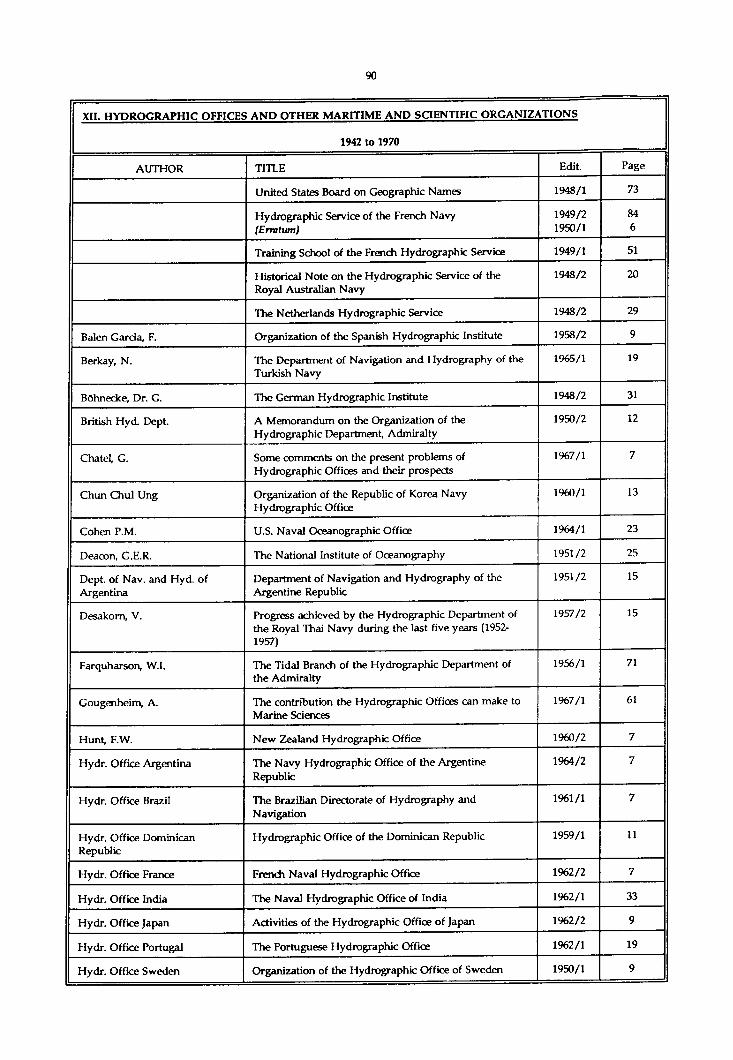
XII. HYDROGRAPHIC OFFICES AND OTHER MARITIME AND SCIENTIFIC ORGANIZATIONS
1942 to 1970
AUTHOR TITLE Edit. Page
United States Board on Geographic Names 1948/1 73
Hydrographic Service of the French Navy (Erratum)
1949/21950/1
846
Training School of the French Hydrographic Service 1949/1 51
Historical Note on the Hydrographic Service of the Royal Australian Navy
1948/2 20
The Netherlands Hydrographic Service 1948/2 29
Balen Garda, F. Organization of the Spanish Hydrographic Institute 1958/2 9
Berkay, N. The Department of Navigation and Hydrography of the Turkish Navy
1965/1 19
Bôhnecke, Dr. G. The German Hydrographic Institute 1948/2 31
British Hyd. Dept. A Memorandum on the Organization of the Hydrographic Department, Admiralty
1950/2 12
Chatel, G. Some comments on the present problems of Hydrographic Offices and their prospects
1967/1 7
Chun Chul Ung Organization of the Republic of Korea Navy Hydrographic Office
1960/1 13
Cohen P.M. U.S. Naval Oceanographic Office 1964/1 23
Deaeon, G.E.R. The National Institute of Ooeanography 1951/2 25
Dept, of Nav. and Hyd. of Argentina
Department of Navigation and Hydrography of the Argentine Republic
1951/2 15
Desakom, V. Progress achieved by the Hydrographic Department of the Royal Thai Navy during the last five years (1952- 1957)
1957/2 15
Farquharson, W.I. The Tidal Branch of the Hydrographic Department of the Admiralty
1956/1 71
Gougenheim, A. The contribution the Hydrographic Offices can make to Marine Sciences
1967/1 61
Hunt, F.W. New Zealand Hydrographic Office 1960/2 7
Hydr. Office Argentina The Navy Hydrographic Office of the Argentine Republic
1964/2 7
Hydr. Office Brazil The Brazilian Directorate of Hydrography and Navigation
1961/1 7
Hydr. Office Dominican Republic
Hydrographic Office of the Dominican Republic 1959/1 11
Hydr. Office France French Naval Hydrographic Office 1962/2 7
Hydr. Office India The Naval Hydrographic Office of India 1962/1 33
Hydr. Office Japan Activities of the Hydrographic Office of Japan 1962/2 9
Hydr. Office Portugal The Portuguese Hydrographic Office 1962/1 19
Hydr. Office Sweden Organization of the Hydrographic Office of Sweden 1950/1 9

XII. HYDROGRAPHIC OFFICES AND OTHER MARITIME AND SCIENTIFIC ORGANIZATIONS
1942 to 1970
AUTHOR TITLE Edit. Page
Hydr. Office Uruguay The Uruguayan Navy Hydrographic Office 1959/1 13
Hydr. Service Canada Organization and Training of the Professional and Technical Personnel of the Canadian Hydrographic Service
1960/1 7
J.D.N. Institute of Navigation, Great Britain 1948/1 91
Kang, C.H. The Chinese Navy Hydrographic Office 1969/2 11
Kolokythas, H.E Hydrographic Service of the Royal Hellenic Navy 1960/2 21
Kotlaric, S.M. The Hydrographic Institute of the Yugoslav Navy 1960/1 25
Lowry, C.C. Starting up a Small Hydrographic Service. The Story of the New Zealand Surveying Service
1957/2 9
Mallory, J.K. South African Hydrographic Office. History and Organization
1958/2 15
Nares, J.D. Visits of President of Directing Committee to the French and Scandinavian Hydrographic Offices and Vessels
1948/2 9
National Oceanogr. Data Center (NODC)
The U.S. National Oceanographic Data Center 1962/2 49
Philippine Coast & Geodetic Survey
Organization and Training of the Philippine Coast & Geodetic Survey
1960/1 19
Studds, (R.FA.) The United States Coast and Geodetic Survey : Its Work and Products
1952/1 45
Surahardja, T. The Hydrographic Service of Indonesia 1961/1 19
Tam be, R.Y. & Sathaye, N.N. The Hooghly River Survey 1961/1 33
U.S. Coast & Geodetic Survey Sesquicentennial of the U.S. Coast & Geodetic Survey 1958/1 11
U.S. Coast & Geodetic Survey Sesquicentennial of the U.S. Coast & Geodetic Survey 1957/2 83
Vargas, J.A. U.S. Naval Oceanographic Office Harbor Survey Assistance program
1970/1 41

VII Hvnwnr.KAPHir OFFICES AND OTHER MARITIME AND SCIENTIFIC ORGANIZATIONS
1971 to 1976
AUTHOR TITLE Edit. Page
Barreto, M.R. The centenary of the Brazilian Hydrographic Service 1976/1 7
Gougenheim, A. 250 years of hydrography in France 1971/2 31
Herrera, R. The centenary of the Hydrographic Institute of Chile 1975/1 7
Kapoor, D.C. International cooperation in hydrography 1976/2 7
Moitoret, V.A. The International Hydrographic Bureau : 50 years of progress
1971/2 7
Newson, D.W. & Richardson, A.
The international scheme of medium and large scale charts of the north-eastern Atlantic area
1975/1 87
Ribuffo, F. The Italian Hydrographic Institute is one hundred years old
1973/2 7
Ritchie, G.S. Italy’s contribution to world hydrography -1300 - 1950s-
1973/2 19
Ritchie, G.S. Intemational cooperation in hydrography 1973/1 7
U.K. Hydrographic Department The international charting principles between Technical Resolution B 10.1
1974/2 131
van Weelde, H.H. The centenary of the Netherlands Hydrographic Office 1974/2 7

XII. HYDROGRAPHIC OFFICES AND OTHER MARITIME AND SCIENTIFIC ORGANIZATIONS
1977 to 1980
AUTHOR TITLE Edit. Page
Prince Albert, heir to the Prince of Monaco at the Xlth International Hydrographic Conference
1977/2 Frontispie
ce
Fiftieth anniversary of the laying of the foundation stone of the IHB’s headquarters
1979/2 7
Dyde, B.S. & Uhlig, S.J. A Praising the case for a hydrographic survey vessel : the planner’s viewpoint
1980/1 87
Kappor, D.C. The creation of hydrographic services in developing countries
1978/1 9
Lah, L.J. Centenary of the Argentine Navy Hydrographic Service 1979/2 11
Macchiavclli, A. International cooperation in hydrography (Letter to the Editor)
1977/1 131
Monteith, W.J., Kerr, A.J. & Pittman, A.
The history of the Great Lakes charting advisers 1978/1 145
Ritchie, G.S. The widening horizons of hydrography 1978/2 7
Ritchie, G.S. Report by the President of the Directing Committee (1972-1977)
1977/1 7
Sathaye, N.N. Establishment of the Singapore Hydrographic Department
1978/1 15
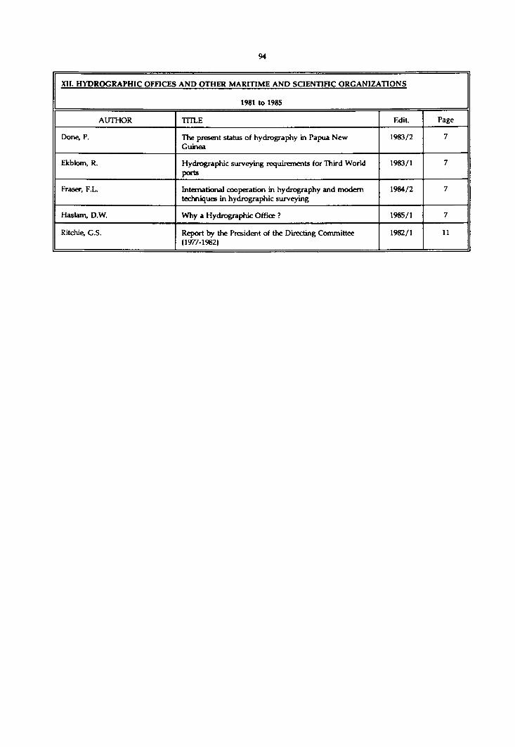
XII. HYDROGRAPHIC OFFICES AND OTHER MARITIME AND SCIENTIFIC ORGANIZATIONS
1981 to 1985
AUTHOR TITLE Edit. Page
Done, P. The present status of hydrography in Papua New Guinea
1983/2 7
Ekblom, R. Hydrographic surveying requirements for Third World ports
1983/1 7
Fraser, F.L. International cooperation in hydrography and modem techniques in hydrographic surveying
1984/2 7
Has lam, D.W. Why a Hydrographic Office ? 1985/1 7
Ritchie, G.S. Report by the President of the Directing Committee (1977-1982)
1982/1 11
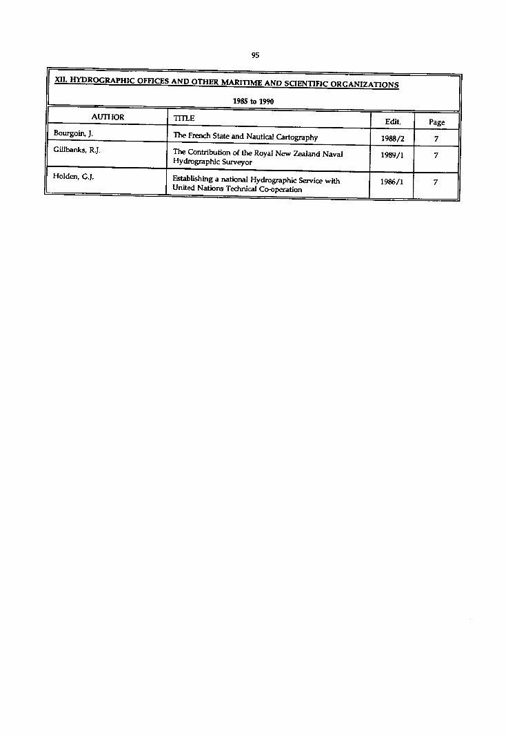
XII. HYDROGRAPHIC OFFICES AND OTHER MARITIME AND SriFNTTlFir n i f r a w i7 VTIONS
1985 to 1990
AUTHOR TITLE Edit. PageBourgoin, J. The French State and Nautical Cartography 1988/2 7Gillhanks, R.J. The Contribution of the Royal New Zealand Naval
Hydrographic Surveyor1989/1 7
Holden, G.J. Establishing a national Hydrographic Service with United Nations Technical Co-operation
1986/1 7

XIII. INTERNATIONAL HYDROGRAPHIC BUREAU, Work, Conferences
1923 to 1935
AUTHOR TITLE Edit. Page
List of States which are Members of the I.H.B. 1923/1 5
Prefatory Notes. (Various activities of the I.H.B.) 1923/1 6
Prefatory Notes. (Various activities of the I.H.B.) 1924/2 11
Prefatory Notes. (Various activities of the I.H.B.) 1924/1 9
Prefatory Notes. (Various activities of the I.H.B.) 1925/2 9
Prefatory Notes. (Various activities of the I.H.B.) 1925/1 9
Prefatory Notes. (Various activities of the I.H.B.) 1926/2 11
Prefatory Notes. (Various activities of the I.H.B.) 1927/1 9
Work of the Bureau (Report on the) 1923/1 27
Work of the Bureau (Report on the) 1924/2 15
Work of the Bureau (Report on the) 1924/1 13
Work of the Bureau (Report on the) 1925/1 15
Provisional Resolutions adopted and Wishes expressed by the Second International Hydrographic Conference
1927/1 49
Technical Questions submitted to the Third International Hydrogaphic Conference
1932/1 190
c.s.s . Adoption of the Resolutions of th I.H.C. 1919 1923/1 35
G.S.S. The Second International Hydrographic Conference 1927/1 43
C.S.S. The New Offiœs of the International Hydrogaphic Bureau (1931)
1931/1 7
J.M.P. Technical Publications received by the Bureau 1923/1 23
Niblack, A.P. The relation of the International Hydrographic Bureau to the League of Nations
1926/2 19
Niblack, A.P. International Co-operation in Maritime Matters 1927/2 9
Niblack, A.P. Co-operation of the International Hydrographic Bureau with other International Organizations
1929/1 53
Parry, Sir John F. Languages used by the I.H.B. 1923/1 57
Parry, Sir John F. History of the inception of the International Hydrographic Bureau
1923/1 9

XIII. INTERNATIONAL HYDROGRAPHIC BUREAU, Work. Conferences
1936 to 1941
AUTHOR TITLE Edit. Page
The Washington Conferenœ of the International Union of Geodesy and Geophysics -1939
1940/2 61
(A) International Geodetic Bibliography. (G. Perrier & P. Tardi) Paris, 1935
1937/1 151
The International Exhibition of Polar Exploration, Bergen, 1940
1938/1 144
Hannemann, M. International research in the Gulf Stream 1938/2 86
J.D.N. Association of Physical Oceanography; International Union of Geodesy and Geophysics
1937/1 17
J.D.N. (A) International Aspects of Oceanography (T.W. Vaughan) Washington, 1937
1938/1 58
J.D.N. The International Exhibition of Polar Exploration, Bergen, 1940
1939/2 44
Nares, J.D. Communication to be made to the General Assembly of the Association Internationale d'Océanographie Physique (Washington, 1939)
1939/2 20

XIII. INTERNATIONAL HYDROGRAPHIC BUREAU, Work, Conferences
1942 to 1970
AUTHOR TITLE Edit. Page
The International Scientific Congress held on the occasion of the LXXVth Anniversary of the Italian Military Geographic Institute
1948/2 14
Reflections on an Exhibition 1963/1 153
Albini, C.F. With Regard to a Reform of the Repertory of Technical Resolutions
1964/1 11
A.V. Participation of International Hydrographic Bureau in Work of International Association of Geodesy at Xth Meeting of International Union of Geodesy and Geophysics held in Rome from 14th to 25th September, 1954
1954/2 165
Bencker, H. Thirtieth Anniversary of the International Hydrographic Bureau. Its creative Origins and its Creation
1951/2 68
Chapman, S. Scientific Programme of the International Geophysical Year 1957-1958
1955/1 157
Farquharson, W.C. International Hydrography 1835 1953/2 123
J.D.N. IXth General Assembly of the International Union of Geodesy and Geophysics, 1951
1951/2 28
Kotlaric, S.M. An Addition to the Discussion on Uniformity in Charts and Hydrographic Documents and a Reform of the Repertory of Technical Resolutions
1965/2 7
Langeraar, W. Uniformity in Charts and Hydrographic Documents 1963/2 11
Langeraar, W. Uniformity in Charts and Hydrographic Documents 1964/2 21
Nares, J.D. Speech: Delivered by the President of the Directing Committee to the Personnel of the Bureau on the occasion of the 30th Anniversary of the Creation of the International Hydrographic Bureau, 21st June 1951
1951/2 7
Nichols, C.L. A Director Comments on the International Hydrographic Bureau
1951/2 63
Nichols, C.L. The Progress of the International Hydrographic Bureau 1954/1 13
Nichols, C.L. The International Hydrographic Bureau 1952/1 68
Nichols, C.L. Hydrographic Coordination Steadily Increases 1951/1 7
Viglieri, A. Work of the Triangulation Section of the International Association of Geodesy at the IXth General Assembly held in Brussels
1951/2 31

XIV. INSTRUMENTATION AND EQUIPMENT
1923 to 1935
AUTHOR TITLE EDIT. Page
(R) Catalogues of Instruments 1927/2 217
List of Instruments amongst those shown at the Oceanographic Exhibition of Seville, 1st May-15th June, 1929
1932/2 219
Schwarzschild’s Air Navigation Sextant with Artificial Horizon
1928/2 169
Sextant fitted with an Artificial Horizon by W. Ludolph A.G., Bremer haven
1928/2 173
A new form of Sextant. (C.F. Casella, London) 1928/2 177
Portable Instruments for measuring Angles 1929/2 129
Coutinho-Plath Sextant. (Hamburg) 129
O.P.L. Bubble Octant. (Levallois) 137
The R.A.E. Bubble Sextant by H. Hughes & Son, London 144
Amici-Magnaghi Reflecting Circle. (Italy) 146
Plath Surveying Sextant with Pentagonal Prism. (Hamburg)
150
(E) Conditions of Test for Sextants. - National Physical Laboratory, Teddington
1929/2 151
Conditions of Test for Sextants. -British Admiralty Spécifications
1930/1 185
Askania n° 60 L Surveying Sextant and other instruments
1930/2 133
New Wild Sextant, (Heerbrugg, Switzerland) 1935/2 115
(R) Observaciones de Precisiôn con el Sextante. (De Cafiete del Pinar) San Fernando, 1934
1934/2 190
Micrometer Hydrographic or Survey Sextant. (H. Hughes & Son, Ltd)
1935/1 154
Husun improved Bubble Sextant 1935/1 155
(R) Experiments at Sea with the Bubble Sextant. (E.O. Hulburt) Washington, 1933
1935/2 150
The Henri Wild Universal Theodolite, Heerbrugg (Switzerland)
1927/2 210
New Ch as selon Theodolite with Microscope. (Paris) 1928/2 183
Internal Focusing Anallatic Tacheometer. (Cooke, Troughton & Simms)
1929/1 227
The Tavistock Theodolites. (Watts-Zeiss Theodolite; Cooke, Troughton & Simms double-reading Theodolite)
1930/1 206
The Tavistock Theodolite (con/.) 1932/1 205
(R) A new Reading Microscope (by H. Wedemeyer, Gottingen)
1934/1 147

XIV. INSTRUMENTATION AND EQUIPMENT
1923 to 1935
AUTHOR TITLE EDIT. Page
The Hammer-Fennel Tacheometer. Kassel 1934/2 159
New small Wild Theodolite 1935/1 148
The Henri Wild Telescope Level, Heerbrugg, (Switzerland)
1927/2 209
The Illumination of the Bubble of a Spherical Level. (A. De Grammont)
1929/1 221
Reversible Level constructed by Cooke, Troughton & Simms, Ltd, London
1932/1 215
Chromium Plating for Theodolite Circles. (U.S. Coast and Geodetic Survey)
1930/2 204
Glass Fibers for Reticules. (U.S. Coast and Geodetic Survey)
1931/1 263
"Hezzanith" Patent Centring Error Detector by Heath & Co. London
1931/1 264
Plates of Silver for Theodolite Circles. (U.S. Coast and Geodetic Survey)
1933/1 183
(E) Graduation of Precision Circles. (U.S. Bureau of Standards)
1935/1 156
(R) Traité de Têlémêtrie. (P. Mazuir) Paris, 1931 1932/1 261
A new Extensible Levelling Stave. (R. Reiss) Liebenwerda
1934/2 159
The Barr and Stroud Prismatic Night Binocular, Type C.F. 15
1932/1 233
Prismatic Astrolabe of Messrs. Claude and Driencourt. S.O.M. disign. Geodetic Model (Paris)
1930/1 196
Nocturnal Vision by means of the "Noctovisor" (L. Baird), 1927
1930/1 239
(R) L'Astrolabio a Prisma. Descrizione el uso. (G. Fomi) Genoa, 1932
1934/1 146
Portable Chronograph of the Cambridge Instrument CO. 1929/1 225
Oscillograph outfit for Research Work by the Cambridge Scientific Instrument Company
1929/2 213
(R) Correction of the effect of the Magnetic Field on the Rates of Watches. (P. Ditisheim) Paris, 1928
1929/2 217
(R) The effect of Vibration on the Rates of Chronometers. (G.P. Arcay) Paris, 1928
1929/2 218
A Precision Chronograph constructed by the Rev. Fr. Lejay
1930/1 212
(R) The Theory of the Gyroscopic Compass and its Deviations. (A.L. Rawlings) London, 1929
1929/2 238
Device for taking Bearings in foggy weather 1930/1 240

XIV. INSTRUMENTATION AND EQUIPMENT
1923 to 1935
AUTHOR TITLE EDIT. Page
(R) Theoria i Praktika Ghiroskopitcheskovo Kompassa. (B.I. Koudrevitch) Leningrad, 1929
1930/1 253
The Askania patented Telecompass, Bambergwerk, Berlin
1930/2 123
The Askania Aircraft Compasses 1930/2 127
The Pemberton Azimuth Angle Attachment (Henry Hughes ic Son, London)
1932/1 229
The "Stella" Duai Magnetic Compass. (Glasgow) 1934/2 157
Micrometer Station Pointer. (H. Hughes & Son) London 1935/2 119
The Luminous Protractor 1930/1 239
Hoey Position Plotter. (U.S.A.) 1932/1 237
Goerz Solar Compass with special fitting for Latitude and Azimuth. (Berlin)
1931/2 158
The Chemikeeff Electric Log 1929/1 233
The new S.A.L. Log 1930/1 203
New Logs. (Cone resistance log, Hamburg; Dynamometric blade log, Baule system, ChaviUe, (France)
1930/2 134
The Addison-Luard Calculator 1930/1 240
The Addison-Luard Course and Wind Calculator, Type D. (H. Hughes) London
1934/2 163
The S.I.P.L. Navigational Calculator, Paris 1929/2 171
Machine for calculating Position, Le Sort system, by J. Carpentier, Paris
1930/2 114
A. M. L. Position Line Slide Rule (Bygrave Slide Rule), Henry Hughes and Son, London
1935/2 122
Bottom Samplers. (Scripps Institution) La Jolla, 1927 1928/2 159
The Rask Electrical Beacon Lamp. (Great Britain) 1934/1 123
Moltchanoff Recording Theodolite for atmospheric soundings. (Alasnia Werke, Berlin)
1932/1 223
Ambard, M. (R) Checking a Divided Circle by two methods and explanation of the Contradictions found. (F. Muhlig, 1933)
1935/2 153
Armistead Rust (E) The Range or Direction Indicator. (U.S.A.) 1934/2 150
Baker, T.Y. (E) The 45° Prismatic Astrolabe by Cooke, Troughton & Simms, Ltd, London
1932/1 218
Bencker, H. The Determination of the Magnetic of Liquid Compasses 1928/1 181
British Admiralty Details of the Ormonde and Fitzroy types of Floating Beacons
1934/1 118
Brown & Ferguson The Willis Navigating Machine, Glasgow 1932/2 151

XIV. INSTRUMENTATION AND EQUIPMENT
1923 to 1935
AUTHOR TITLE EDIT. Page
Carruthers, J.N. A suggested Totalising Anemometer for Oceanographers 1935/1 33
Cassinis, C. (E) New Instruments for estimating Topographical Distances
1930/2 195
Chandon, E., Volontat, R. DE & Gougenheim, A.
Apparatus for Measuring the Absolute Personal Equation in Observations with the Prismatic Astrolabe
1934/2 136
Chandon, E., & Gougenheim,A. Instruments for observing Equal Altitudes in Astronomy. Almucantar by S.C. Chandler Jr. (1883). Nadirinstrument by Dr. A.Beck (1890). Claude & Driencourt Prismatic Astrolabe. Jobin Prismatic Astrolabe. S.O.M. Prismatic Astrolabe. Wild Theodolite with Extra Prism. Circumzenithal by Nuil & Frii (1905 & 1922). Pentagonal-Prism Astrolabe by Cooke, Troughton & Simms. Bent Telescope by De La Baume Pluvinel (1922). Appliances for Elimination of the Personal Equation. Bibliography
1935/1 39
Coldewey, H. (E) New precise Liquid Compass Card 1930/2 188
Cooke, Troughton & Simms The Cooke 45° Prismatic Astrolabe 1935/2 116
Curtis, H.L. & Duncan, R.C. A method for the Accurate Measurement of short Time Intervals
1929/1 213
Damilatis, P. The Azimuth-Meter (Greece) 1930/1 124
Dubois, R. & Laboureur, L. (E) Note concerning a Direct Reading Electrical Chronograph for accurate reading of very short intervals of Time
1932/2 234
Ennis, C.C. Note on compensation of Density of Sca-water and on Corrections for deep-sea Reversing Thermometers
1933/1 131
Favé, M.L. Quadrant with spherical level for fixing the position in a Balloon
1928/2 161
C.B. The New Spherical Compass 1935/2 151
Gerard, W.G. Reversing Thermometers 1933/1 124
H.B. (R) The Pratt Protractor and Plotting Scale. (U.S.A.) 1935/2 119
Hickman, C.N. (E) A portable Spark Chronograph for either direct or alternating current
1931/2 242
Hughes & Son, H. The Holmes Master Magnetic Compass and Path Indicator, London
1932/2 145
J.F.P. (R) The Marine Chronometer, its History and Development (R.T. Gould) London, 1923
1924/2 186
Kaster, H.B. The Spherant. (University of California) 1931/2 146
Kuenen, Ph. H. (E) The four-metre Sounding Tube of the Snellius Expedition
1932/2 225
Lejay, Rev. Fr. P. Suppression of Contacts in Astronomical Clocks 1928/2 229
Littlehales, G.W. Mechanical means of finding Geographical Positions in navigation
1929/2 207
Maurer, H. A source of Error in the Solar Compass 1931/2 163

XIV. INSTRUMENTATION AND EOUIPMENT
1923 to 1935
AUrHOR TITLE EDIT. Page
Maxwell, P.S.E. Sextants and Mirrors 1934/2 135
Michler, H. (E) Observations with Bubble Sextant on board S.S. Arucas in May 1933
1934/2 113
P.V. (R) On the Graduation Errors of Circles used in Geodetic Operations (J. Baillaud) Paris, 1934
1935/1 170
Parker, W.E. (E) Use of Range-finders for Hydrographic Surveying. (U.S. Coast and Geodetic Survey)
1934/1 117
Parkhurst, D.L. A Micrometer Microscope equiped with an Illuminated Scale
1928/1 270
Parkhurst, D.L. (E) New Theodolite for Primary Triangulation. (U.S. Coast and Geodetic Survey)
1932/1 211
Phaff, J,M. Note relative to a Compass Rose designed by C. De Bie (1689) (Dr. F.C. Wieder, Leiden)
1924/2 129
Plath, C. & SchiUy, F. (E) Periscope Sextant with attached Compass 1932/1 226
PulfricK C. (E) A new Portable Instrument for measuring Angles 1931/1 221
Reinius, G. & Leche, C. Transits for Testing Compasses 1927/1 39
Reinius, G. & Bouveng, E. The Testing and Adjustment of the Station-Pointer (Protractor). (Method used by the Swedish Hydrographic Office)
1925/1 37
Rollet de l'lsle (E) Description of a Reflecting Circle. (France) 1934/2 147
Romagna Manoia, G. (E) Description of Vice-Admiral Magnaghi's Sounding Machine (new type)
1934/1 128
Rude, G.T. (E) The determination of the Compass Error 1932/2 245
Seran, H.A. Taut Wire Measuring Apparatus. (U.S. Coast and Geodetic Survey)
1935/1 152
Service Géographique de l'Armée
Note on the Internal Reading Microscope fitted to azimuth circle N“13
1935/2 125
Soule, F.M. Note on the practical Correction of deep-sea Reversing Thermometers and the determination of the Depth of Reversal from Protected and Unprotected Thermometers
1933/1 126
Survey of India (E) Dr. De Craaff Hunter's Trestle Tower for geodetic triangulation
1933/2 242
Talley, B.B. (E) An improved Plane Table Board. (U.S.A.) 1934/1 126
Tenani, M. Experiments in the stable compensation of the Quadrantal Deviation of Magnetic Compasses obtained by means of Cylindrical Compensators
1930/1 170
Tonta, L. Concerning the Correction of the Quadrantal Error in Compasses of large magnetic moments
1928/1 173
Trombetti, C. (E) A new type of Iron Trigonometrical Beacon. (Italy) 1934/1 119
U.S. - H.O. New Standard Sextant of the U.S. Navy 1931/2 154
U.S.Coast and Geodetic Survey (E) Bibly Steel Tower for triangulation 1933/2 243

XIV. INSTRUMENTATION AND EQUIPMENT
1923 to 193S
AUTHOR TITLE EDIT. Page
Watts 6c Son, E.R. (E) The Connolly Standard Compass for checking field compasses and observing Magnetic Declination
1933/2 249
Wilke Station Pointer with Station Holders for hydrographic surveying during protracted use of the same terrestrial landmarks
1933/2 193
Wood, A.B. k Ford, J.M. The Phonic Chronometer. (H. Tinsley & Co.) London 1928/1 257
Wüst, G. Thermometric Measurement of Depth 1933/2 28

XIV. INSTRUMENTATION AND EQUIPMENT
1936 to 1941
AUTHOR TITLE Edit. Page
Wild Geodetic and Topographic Instrument exhibited during the IVth International Hydrographic Conference, Monaco, 1937
1937/2 229
The Geodetic Instruments produced by Messrs. Carl Zeiss, Jena
1939/1 163
(E) Tavistock Theodolite (Cooke, Troughton & Simms Ltd)
1937/1 115
(E) Modifications to Wild Theodolites 1937/1 116
(E) The new Chasselon azimuth circle with two microscopes
1939/1 170
(E) Surveyor's Level - Series S 300 (Cooke, Troughton & Simms Ltd)
1936/1 116
The Mountbatten Ruler for Chart Work 1936/2 145
The Hagner Position Finder (Henry Hughes & Son Ltd) 1937/1 121
The Longines Siderograph 1940/2 95
The "De Vries" Recording Tide Gauge 1939/1 156
(E) The Insulating Water Bottle as used in the British Hydrographic Service
1936/1 116
(R) A graphical Method for calculating the corrections on deep-sea reversing thermometers. (J.P. Tully), Copenhagen, 1937
1937/2 264
The Buchanan Piezometer 1940/2 98
New Scientific Apparatus for the Arctic 1940/1 205
Marooni Direction Finder, Type 579/354 N. 1938/1 121
Berroth, A. (E) An auxiliary for extremely accurate measurement of angles
1^36/1 130
Borden, F.S. Taut-Wire, Sun azimuth Traverses 1939/2 98
Carruthers, J.N. The Lowerstoft Crossbow Float 1939/2 149
Collinder, P. The Jaderin Bubble Sextant 1936/2 114
Engle, F.G. Automatic brake Sounding Machine 1938/2 147
Freiesleben, Dr. H.C. (E) Testing of Bubble and Pendulum Sextants 1938/2 131
Grône A New Map-Plotting Instrument (Kleinkoordinatograph) 1939/1 167
H.B. The Husun Filament Card Dead-Beat compass with nonresonant suspension
1937/2 242
H.B. (R) Iron Open Work Trigonometrical Signal for rocky terrain as used in the Military Geographical Institute, Florence
1936/2 177
Horsfield, W. & Erritt, W.A. (E) Programme Finder for Use with Prismatic Astrolabe 1936/2 147

XIV. INSTRUMENTATION AND EQUIPMENT
1936 to 1941
AUTHOR TITLE Edit. Page
Hotine, M. (E) Triangulation Beacon Lamps - Type Cooke, Troughton & Simms
1938/2 150
Hughes & Son, H. Cothic Bubble Sextant with detachable Artificial Horizon and Electric Lighting
1936/1 132
Lauwers, J. Apparatus for taking Samples of Sea Water 1937/1 124
Mathisson, J.C. (E) Serial Temperatures by Bathythermograph 1941/1 68
Mattison, G.C. (E) Lighted Survey Buoys 1941/1 55
Maxwell, P.S.E. Sextants and Mirrors - Part II 1936/1 129
Maxwell, P.S.E. Modem Methods of Time-recording as used in H.B.M. Hydrographic service
1936/1 33
P.V. Earth's Rotational effect on the Bubble Sextant 1941/1 51
Raynor, L.P. Calibration of Taut-Wire Apparatus 1939/2 146
Riemann, W. Measurements with a new type of levelling instrument with double image and inclinable line of sight for hilly country
1939/2 102
Shankland, E.C. The Submarine Cable Plough 1939/1 46
Sheehan, J.M. (E) Surface Navigation with Bubble Octant 1936/1 134
Smallfield, E.J. Triangulations Beacons 1941/1 53
Snowden Piggot, C. Core samples of the Ocean bottom 1938/2 67
Société Française Radio- Electrique
Obstacle-detector, model S.F.R. - D.16 1936/1 111
Somma, A. (E) Special aspirating Thermometer for measuring the temperature of the Air at Sea
1938/2 142
Spilhaus, A.F. A Bathythermograph 1938/2 153
Van Cleve, R. Fifteen-Gallon Water-Bottle 1938/1 119
Varney, F.M. (E) A Marine Coring Instrument - Its Construction and Use
1936/2 144
Vigoureux, P. (E) Clocks controlled by quartz oscillators 1940/2 92
Vigoureux, P. (R) Quartz Oscillators 1940/1 207
Vockerodt, K. A new "Lodis" Levelling Stave 1940/1 202
Warwick, HC. (E) Small Buoy used in Development of Shoals 1941/1 57
Weems, P.V.H. Analysis of Bubble Acceleration Errors 1936/1 74
Weems, P.V.H. The averaging Sextant 1937/2 244
Williams, J.D.L. The Williams Position Line Plotter 1936/1 137
Wilson, R.M. A new Photoalidade 1938/1 116

XIV. INSTRUMENTATION AND EOUIPMENT
1942 to 1970
AUTHOR TITLE Edit. Page
Specification of Instruments exhibited at the seat of the International Hydrographic Bureau during the Vth International Hydrographic Conference
1947 214
The Geodetic Tavistock Theodolite 1946 118
The New Wild Theodolites and Levels 1946 123
Sextant Favé-Lepetit (Recording Type 107) 1948/2 102
The British Admiralty Transmitting Magnetic Compass (Type II)
1947 203
The Nôgaard Gravimeter 1948/1 84
Wild Stereoplotting Apparatuses 1946 124
The K.E.K. (King, Elliot, Kail) Stereoscopic Plotter 1948/2 79
The Santoni Stereocartograph, Model IV 1948/2 87
Projection Ruling Machine 1949/2 155
The S.O.M. Poivilliers Type D Stereotopographer 1949/2 160
The Fairchild Camera Transit 1948/2 59
A Pendulum Astrolabe 1947 199
The Nardin Chronometer 1945 88
Sounding Clock 1947 197
The Roberts Radio Current Meter 1947 210
The Portable Tide-Predicting Machine 1949/1 107
Foxboro Liquid Level Gauges for Open Vessels 1949/2 150
The Angleprism 1950/1 123
Description of AGA Geodimeter, type NASM-1, Bergstrand System
1953/1 171
Periscopic Sextant for Aerial Observations 1953/2 181
Information on Various Instruments Displayed during the Course of the Vlth International Hydrographic Conference, Monaco, April-May 1952, or Forming the Subject of Descriptive Brochures Distributed
1953/2 183
"La Modema Utilizzazione dei Cronografi Imprimenti" (J.Verbaandert), Bollettino di Geodesia e Science Affini, Firenze, 1958 (Review)
1959/1 183
"Automatic type placement” : in The Military Engineer, Vol.52 1960 (Review)
1961/1 201
"Photography of the ocean floor' (A.S. Laughton), (Review)
1961/2 113
"The sea floor" (A.S. Laughton), [Review] 1961/2 114
Abbotts, W.E. The Solartron Transdeptor 1963/2 179

XIV. INSTRUMENTATION AND EOUIPMENT
1942 to 1970
AUTHOR TITLE Edit. Page
Alexiou, A.G. Conducing Underwater Surveys with a multi-purpose Instrument
1963/2 99
Askania-WerkeAktiengesellschaft
New Geodetic Instruments 1950/2 60
Bachmann, W.K. New Repetition Theodolite 1942 124
Bencker; H. In the Shade of a Sun Dial 1956/1 197
Bialek, E.L. Errors in the determination of depth by pressure gauges utilizing a linear p ressu re-depth relationship
1966/1 69
Boyle, A.R. Automatic Data Handling in Hydrographic Work 1964/2 149
British Institute of Navigation The Admiralty Gyro-Magnetic Compass, Type 5 1955/1 209
Brookes & Gatehouse Ltd A Miniature Echo Sounder for Inshore Navigation and Survey
1961/2 57
Brunei, A. Traverse in French Hydrographic Surveys by Geodimeter and Tellurometer
1960/1 97
Carruthers, J.N. A Simple Device for Bottom Current Observations 1959/1 167
Carstens, R.H. Problems in Fathogram Interpretation 1954/2 115
Cooke, Troughton & Simms Surveying Instruments 1953/2 179
Covillault, P. Note on Micrometer-Drum Hydrographic Circles 1961/1 187
Covillault, P. A New Marine Chronometer the Chronostat III Leroy 1962/1 171
Doniol, R. A New French Nautical Sextant 1951/2 100
Dorrestein, R. An Electrical of Salinity and Water Temperature for Use at Sea
1956/2 177
Duroche, J. The BBT-Neyrpic Currentograph 1953/1 159
Emery, SA. Small Coordinatograph 1950/2 167
Emery, K.O. & Champion, A.R. The Underway Bottom Sampler 1948/1 61
Franco (A. Dos Santos) Comparative Precision of Prismatic Astrolabes 1951/1 83
Cougervheim, A. A High-Precision Prismatic Astrolabe 1957/2 99
Griffiths, J.W.R. & White, D.A The Effect of Stylus Size on the Performance of a Chemical Recorder
1956/1 61
Haines, R.G. Sonar equipment for shallow water survey and wreck location
1966/1 53
Haines, R.G. A gating system for deep water sounding 1966/1 43
Haines, R.G. Developments in Ultrasonic Instruments 1963/1 49
Harvey, G.N. Deflectors and their Use in relation to Magnetic Compasses
1948/2 125
Hashimoto, T., Maniwa, Y & Kato, M.
Research on Telesounders (Wireless Remote Control Echo Sounding)
1965/2 59
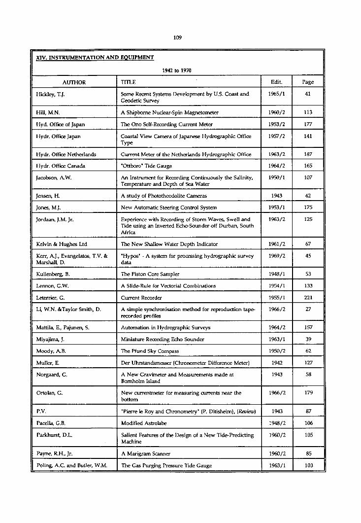
XIV. INSTRUMENTATION AND EQUIPMENT
1942 to 1970
AUTHOR TITLE Edit. Page
Hickley, T.J. Some Recent Systems Development by U.S. Coast and Geodetic Survey
1965/1 41
Hill, M.N. A Shipbome Nudear-Spin Magnetometer 1960/2 113
Hyd. Office of Japan The Ono Self-Recording Current Meter 1953/2 177
Hydr. Office Japan Coastal View Camera of Japanese Hydrographic Office Type
1957/2 141
Hydr. Office Netherlands Current Meter of the Netherlands Hydrographic Office 1963/2 187
Hydr. Office Canada "Ottboro" Tide Gauge 1964/2 165
Jacobson, A.W. An Instrument for Recording Continuously the Salinity, Temperature and Depth of Sea Water
1950/1 107
Jensen, H. A study of Phototheodolite Cameras 1943 42
Jones, M.J. New Automatic Steering Control System 1953/1 175
Jordaan, J.M. Jr. Experience with Recording of Storm Waves, Swell and Tide using an Inverted Echo-Sounder off Durban, South Africa
1963/2 125
Kelvin & Hughes Ltd The New Shallow Water Depth Indicator 1961/2 67
Kerr, A.J., Evangelatos, T.V. & Marshall, D.
'Hypos' - A system for processing hydrographic survey data
1969/2 45
Kullenberg, B. The Piston Core Sampler 1948/1 53
Lennon, G.W. A Slide-Rule for Vectorial Combinations 1954/1 133
Leterrier, G. Current Recorder 1955/1 221
Li, W.N. &Taylor Smith, D. A simple synchronisation method for reproduction tape- recorded profiles
1966/2 27
Mattila, E., Pajunen, S. Automation in Hydrographic Surveys 1964/2 157
Miyajima, J. Miniature Recording Echo Sounder 1963/1 39
Moody, A.B. The Pfund Sky Compass 1950/2 62
Muller, E. Der Uhrstandsmesser (Chronometer Difference Meter) 1942 127
Norgaard, G. A New Gravimeter and Measurements made at Bornholm Island
1943 58
Ortolan, G. New currentmeter for measuring currents near the bottom
1966/2 179
P.V. "Pierre le Roy and Chronometry" (P. Ditisheim), (Review) 1943 87
Pacella, G.B. Modified Astrolabe 1948/2 106
Parkhurst, D.L Salient Features of the Design of a New Tide-Predicting Machine
1960/2 105
Payne, R.H., Jr. A Marigram Scanner 1960/2 85
Poling, A.C. and Butler, W.M. The Gas Purging Pressure Tide Gauge 1963/1 103

XIV. INSTRUMENTATION AND EOUIPMENT
1942 to 1970
AUTHOR TITLE Edit. Page
Pratje, O. A New Core Sampler and its First Test 1951/1 116
Reed Research Inc Reed Research Focalmatic Auto-Focusing Projector 1951/2 107
Richard, J. On a Bottle of Simple Construction of Oceanographic Research
1942 139
Richarme, P. Notes on the Pantograph-cutter for Charts in Relief 1949/2 156
Roberts, E.B. An Improved Radio Current Meter 1955/2 163
Roumégoux, L. Continuous Air Flow Tide Gauge 1964/1 109
Rusby, S. A long range side-scan sonar for use in the deep sea (GLORIA project)
1970/2 25
Sauzay, A. A New Plotting Method for Hydrographic Soundings 1960/2 37
Schober, H. The Day and Night Alidade with Telescope 1944 103
Schumacher, A. The Perfected Form of the Surface Water Sampler of O. Sund.
1942 136
Skillman, T.L. Rubidium-Vapor Magnetometer 1960/1 107
Smith, W. & McIntyre, A.D. A Spring-loaded Bottom-Sampler 1955/1 213
Stowall, M.A. Dial Gage Meter Bar 1949/2 154
Tewinkel, G.C. The Reading Plotter 1948/1 87
Thunberg, A. Hydrographic surveying and data processing 1968/1 21
Trager, H. The Coordimat 1961/2 53
Tucker, M.J. A Wave Recorder for Use in Ships 1953/1 167
U.S. Navy Hydr. Office Border Scale Subdividing Device 1948/2 67
Ulysse Nardin S.A. A Quartz Crystal Controlled Electronic Marine Chronometer by Ulysse Nardin in Collaboration with Ebauches S.A.
1963/1 149
USC&GS Narrow-beam transducer sounding systems yields excellent results in operation aboard USC&GS ship Surveyor
1966/1 37
Wilcox, B.W. U.S. Coast & Geodetic Survey Tide-Predicting Machine: Automatic Read-out Attachment
1960/2 93
Williamson, R.L. Hodges, G. & Eady, E.
A new sound velocity meter 1968/1 177
Wong, H.K., Chesterman, W.D. & Bromhall, J.D.
Comparative side-scan sonar and photographic survey of a coral bank
1970/2 11
Worzel, J.L. Ocean Bottom Sampler for Ships Under Way 1950/1 103
Zeiss-Aerotopograph G.M.B.H. Photogrammetric Instruments 1954/2 163

XIV. INSTRUMENTATION AND EOUIPMENT
1971 to 1976
AUTHOR TITLE Edit. Page
Bonn in, P. Necessity is the mother of invention 1972/1 31
Bonnot, J.F. Howaldt Bathysonde 1971/1 155
Crandall, C.J. Coastal aerial photo-laser survey (CAPS) - A nearshore charting system
1976/1 53
Dixon, J.B. A new station pointer - the HP 65 1976/2 119
Jollymore, P.G. Erratum 1972/1 165
Jollymore, P.G. A portable digital sounding system for Arctic use 1971/2 35
Nicholson, W.M. Status of data buoy development in the United States 1973/2 121
Ritchie, G.S. Technological advances and the sea surveyor 1974/1 7
Robillard, W.G. Technical obsolescence - A surveyor's dilemma 1973/2 151

XIV. INSTRUMENTATION AND EOUIPMENT
1977 to 1980
AUTHOR TITLE Edit. Page
Calder, M. Wrelads - The Australian laser depth sounding system 1980/1 31
Desnoes, Y. Off-line contouring of the data from the multi-beam ’Sea Beam"
1980/1 55
Floyd, R.P. Stable and enduring monuments for vertical control networks
1980/1 77
Gobey, C.S. The Kelvin-Hughes MS-48 echosounder and digitizer - Evaluation by the U.K. Hydrographic Department
1977/2 29
Renard, V. & Allenou, J.P. Sea Beam, multi-beam echosounding in Jean Charcot : Description, evaluation and first results
1979/1 35
Russell, I.C. Dual channel sidescan sonar - its uses and operation in hydrographic surveying
1978/1 27

XIV. INSTRUMENTATION AND EOUIPMENT
1981 to 1985
AUTHOR TITLE Edit Page
Holsen, J. The development of survey instruments 1984/1 81
Huff, L.C. A study of future depth recorder requirements 1981/2 33
Kolouch, D. Interferometric side-scan sonar - A topographic sea-floor mapping system
1984/2 35
Macdonald, C. The use of microprocessors for track control and data verification on hydrographic surveys in Canada
1981/1 39
McCartney, B.S. Underwater acoustic positioning systems : State of the art and applications in deep water
1981/1 91
Milne, P.H. Correlation of surface and underwater position fixing techniques
1981/1 77
Ritchie, G.S. Hydrography, yesterday, today and tomorrow 1982/2 7
Tripe, R.L.K. A critical review of automated hydrography within the Canadian Hydrographic Service
1981/1 67
Weeks, C.G. Selection criteria for shipboard automated systems 1981/1 29

XIV. INSTRUMENTATION AND EQUIPMENT
1985 to 1990
AUTHOR TITLE Edit. Page
Axelsson, R., Steinvall, O. & Sundberg, P.
Programmable scanner for laser bathymetry. 1990/1 161
Compton, J.S. & Hudson, M.A. New charting technology in Australia - The laser Airborne Depth Sounder.
1988/2 145
Fourgassie, A Evaluation of NR52 GPS receivers in geodesy. 1989/2 141
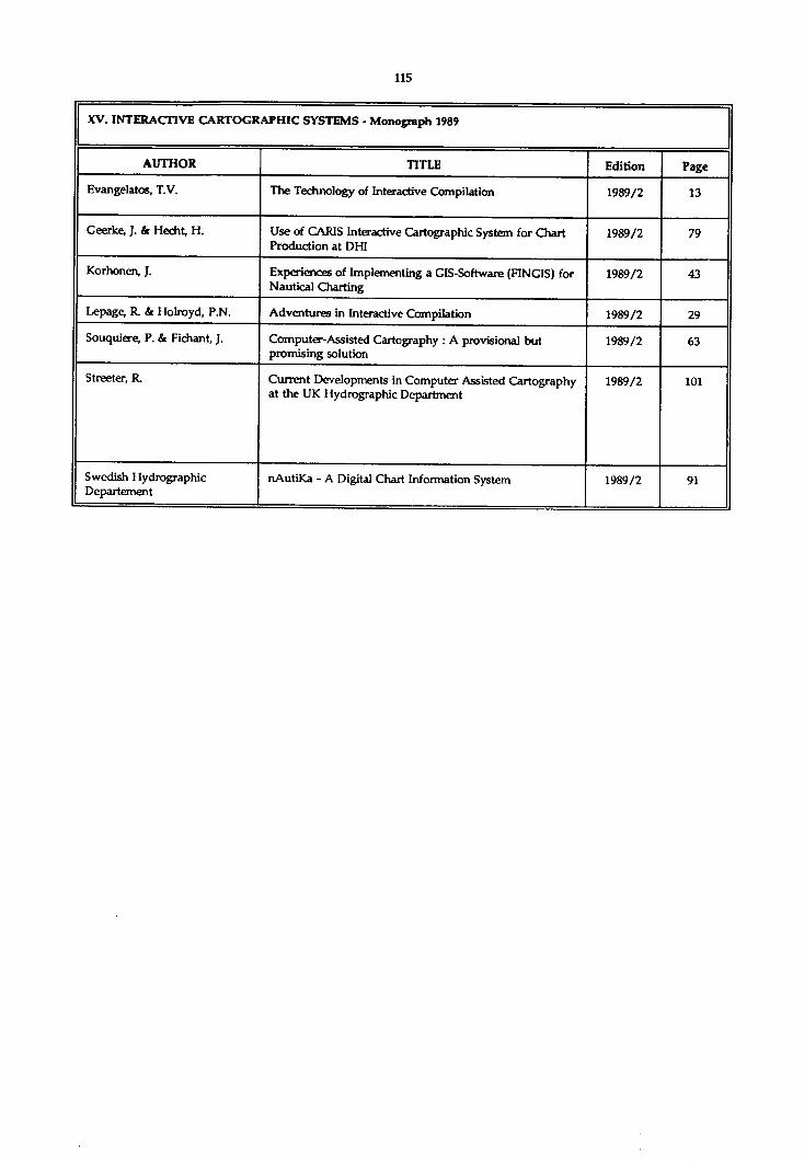
XV. INTERACTIVE CARTOGRAPHIC SYSTEMS - Monograph 1989
AUTHOR TITLE Edition Page
Evangelatos, T.V. The Technology of Interactive Compilation 1989/2 13
Geerlce, J. & Hecht, H. Use of CARIS Interactive Cartographic System for Chart Production at DHI
1989/2 79
Korhonen, J. Experiences of Implementing a GIS-Software (FINGIS) for Nautical Charting
1989/2 43
Lepage, R. & Holroyd, P.N. Adventures in Interactive Compilation 1989/2 29
Souquiere, P. & Fichant, J. Computer-Assisted Cartography : A provisional but promising solution
1989/2 63
Streeter, R. Current Developments in Computer Assisted Cartography at the UK Hydrographic Department
1989/2 101
Swedish Hydrographic Département
nAutiKa - A Digital Chart Information System 1989/2 91

XVI. MISCELLANEOUS
1923 to 193S
AUTHOR TITLE Edit. Page
Notice to Contributors to The Hydrographic Review 1933/2 loose leaf
A Standardized form of Notioes to Mariners 1935/1 8
Supply to ships of Charts and Nautical Documents and Instruments. (Great Britain, Denmark, Italy, France)
1930/1 214
Supply to ships of Charts and Nautical Documents and Instruments.(Co«tJ(Germany, Spain, Norway, Netherlands, Portugal, Sweden)
1930/2 135
Supply to ships of Charts and Nautical Documents and Instruments.(Con(J (Belgium)
1931/1 191
(H) The new International Code of Signals 1934/1 152
(R) Deep Sea Diving. (W. Beebe) New York, 1930. (The Bathysphere and depth recorder)
1931/1 245
(E) Deep Sea Dives with the Bathysphere 1935/1 182
A.P.N. (R) Modem Harbours, Conservancy and Operation. (E.C. Shank land) Glasgow, 1926
1926/2 226
Borden, F.S. (E) Cost of Hydrography 1932/2 256
H.B. The Sundial of the International Hydrographic Bureau 1932/1 185
J.D.N. Visit of H.B.M. Surveying Ship Ormonde to Monaco 1934/1 34
J.D.N. Canadian Ports and Shipping Directory. (F.W. Wallace) Québec, 1934
1934/2 199
J.D.N. Definition of the words ’Hydrographer” and ’Hydrography’
1934/1 8
Niblack, A.P. The further applications of Science to Hydrography and Navigation
1929/2 15
Parry, Sir John F. Use of the words "Hydrography" and "Hydrographer" 1923/1 59
Richard, Dr. J. (E) Concerning a simple method for the Extraction of Fresh Water from Sea Water, from Salt or Polluted Waters, from all Aqueous Substances and even from the Atmosphere by means of Heat from the Sun's Rays
1929/2 218
Rollet de l'lsle Use of the words "Hydrographer" and "Hydrography" 1924/2 171
Shank Land, E.C. Dredged Channel Curves and their relation to the Turning Circle of ships
1931/2 132
Shank land, E.C. The Hydrography and Cartography of a great Seaport 1932/2 107
Spender, M. (E) Note on the appearance of Coral Reefs and Navigation amongst them
1931/1 249
Vanssay de Blavous, P. DE Various Interpretations of a Ballot 1929/1 59
Veen, J. Van Sand Waves in the North Sea 1935/1 21

XVI. MISCELLANEOUS
1936 to 1941
AUTHOR TITLE Edit. Page
Estuary of the River Mersey. Effect of the discharge of sewage on the conservancy of the River
1938/2 155
(R) On the division of Earth’s surface into zones of illumination (R. Putnis) Riga, 1935
1937/2 268
Horse Latitudes 1939/2 109
(E) How the Wreck of the Lusitania was found 1936/1 165
(R) Beobachtungen des "Grünen S trahis’ (Observations on the "Green Flash"), (G. Schrôder), Berlin, 1935
1936/1 167
Notice to Contributors to The Hydrographic Review 1938/1 7
Bowie, W. (E) Science in the U.S.C. & G. Survey 1936/1 99
H.B. (R) Ricerche sul Regime dei Litorali nel Mediterraneo (Investigation of the formation of the Mediterranean Shoreline) (A D'Arrigo), Rome, 1936
1937/1 154
I.H.B. Wireless Signals for the Use of Seamen and Urgent Notices to Mariners
1936/2 66
I.H.B. Urgent Notices to Mariners by Wireless Telegraphy (Form, Code, Zones and Broadwasting Stations, Reprint, Numbering)
1939/1 64
J.D.N. (R) Water Pollution Research - Survey of the River Tees 1938/2 157
Marbois, A.J. Early United States Coast Pilots 1940/2 50
P.V. (A) Investigation of the Microseismic Disturbance and its variations (P. Bernard), Paris
1941/2 82
Shank land, E.C. A contribution on the hydrographic research and development of the Yantlet dredged channel in the Thames estuary
1940/2 23
Steers, J.A. (E) The Coral Cays of Jamaica 1940/1 188
Vallaux, C. (E) Note on the Growth of Coral Reefs 1936/1 87
Vanssay de Blavous, P. DE The Epicentres of Earthquakes in relation to the Mid- Atlantic Ridge and the Carlsberg Ridge in the Indian Oceanl939/2
1939/2 23
Votaw, H.C. Midway - The North Pacific’s Tiny Pet 1941/1 41
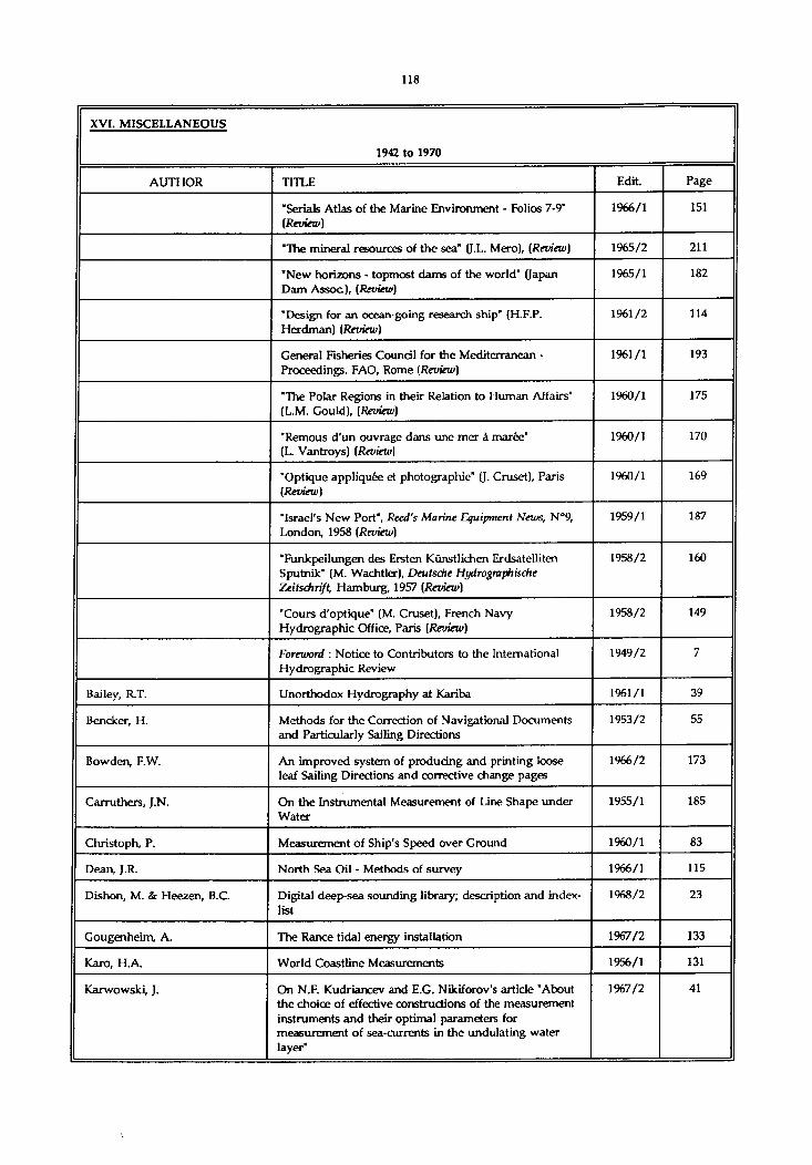
XVI. MISCELLANEOUS
1942 to 1970
AUTHOR TITLE Edit. Page
"Serials Atlas of the Marine Environment - Folios 7-9" (Review)
1966/1 151
"The mineral resources of the sea" (J.L. Mero), (Review) 1965/2 211
"New horizons - topmost dams of the world" (Japan Dam Assoc), (Review)
1965/1 182
"Design for an ocean-going research ship' (H.F.P. Herdman) (Review)
1961/2 114
General Fisheries Council for the Mediterranean - Proceedings. FAO, Rome (Review)
1961/1 193
"The Polar Regions in their Relation to Human Affairs" (L.M. Gould), (Review)
1960/1 175
"Remous d’un ouvrage dans une mer à marée" (L. Vantroys) (Review)
1960/1 170
"Optique appliquée et photographie" (J. Cruset), Paris (Review)
1960/1 169
"Israel's New Port", Reed's Marine Equipment News, N°9, London, 1958 (Review)
1959/1 187
"Funkpeilungen des Ersten Künstlichen Erdsatelliten Sputnik" (M. Wachtler), Deutsche Hydrogmphische Zeitschrift, Hamburg, 1957 (Review)
1958/2 160
"Cours d'optique" (M. Cruset), French Navy Hydrographie Office, Paris (Review)
1958/2 149
Foreword : Notice to Contributors to the International Hydrographic Review
1949/2 7
Bailey, R.T. Unorthodox Hydrography at Kariba 1961/1 39
Bencker, H. Methods for the Correction of Navigational Documents and Particularly Sailing Directions
1953/2 55
Bowden, F.W. An improved system of producing and printing loose leaf Sailing Directions and corrective change pages
1966/2 173
Carruthere, J.N. On the Instrumental Measurement of Line Shape under Water
1955/1 185
Christoph, P. Measurement of Ship's Speed over Ground 1960/1 83
Dean, J.R. North Sea Oil - Methods of survey 1966/1 115
Dishon, M. & Heezen, B.C. Digital deep-sea sounding library; description and index- list
1968/2 23
Gougenheim, A. The Ranee tidal energy installation 1967/2 133
Karo, H.A World Coastline Measurements 1956/1 131
Karwowski, J. On N.F. Kudriancev and E.G. Nikiforov’s article "About the choice of effective constructions of the measurement instruments and their optimal parameters for measurement of sea-currents in the undulating water layer"
1967/2 41

XVI. MISCELLANEOUS
1942 to 1970
AUTHOR TITLE Edit. Page
Knox, R.W. 'Shore and sea boundaries’ (A.L Shalowitz), [Review) 1965/2 212
Kotlaric, S. Unification of Systems for Keeping Up to Date Navigational Publications Printed as Volumes, Avoiding the Writing or Erasing of Corrections, or the Pasting on of Coupons
1952/1 31
Lacombe, H. Note on Diffraction of Swell in Perpendicular Incidence 1950/2 122
Langeraar, W. Comments on "Hydroceanography" 1967/1 71
Li, W.N. & Taylor Smith, D. A simple synchronisation method for reproducing tape- recorded profiles
1966/2 27
Lyman, J. International Initialography 1963/2 15
Martin, P.L.C. Determination of Bottom Shifts in Rio NuiSez Estuary 1961/1 111
Matsuzaki, T. The present status of private hydrographic activities in Japan
1970/2 7
Moitoret, VA. U.K. Hydrographic Office conducts searching review of Sailing Directions
1970/1 143
Mosetti, F. A Method for ascertaining Periods from a Continuous Series of Observational Data
1961/2 107
Olson, F.C.W. A system of Morphometry 1960/1 147
Oudet, L. Towards a progress in nautical information 1968/2 149
Oudet, L. The New Golden Age of Hydrography 1956/2 9
Oudet, L. New French Sailing Directions 1960/1 157
Oudet, L. Costly shortcomings in nautical information 1969/2 153
P.V. "Earthquakes' (E Rothé), [Review] 1944 114
R.W.K. "Shore and sea boundaries" (A.L. Shalowitz), (Review) 1963/2 205
Reith, J. A Method for the Rapid Construction of Sextant Angle Graphs.
1962/1 165
Ritchie, G.S. The relationship between Hydrographic and Oceanographic surveying
1967/1 67
Rouch, J. Discovery of Marguerite Bay (Antarctica) 1962/2 105
Rouch, J. The Discovery of Charcot Land (Antarctica) 1965/1 173
Rouch, L. More evidence of Chateaubriand's accuracy in 'L'Itinéraire de Paris à Jérusalem"
1967/1 197
Rutley, J .IA The Demolition of Ripple Rock 1959/1 19
Shalowitz, A.L. Boundary Problems Associated with the Continental Shelf
1955/1 111
Shamblin, O.H. Reservoir Sedimentation Surveys in the Department of the U.S. Army
1961/1 99
Stride, A.H. Geological Interpretation of Asdic Records 1961/1 131
Verstelle, J. Th. Accuracy of Speed Trials on the Measured Mile 1958/2 85
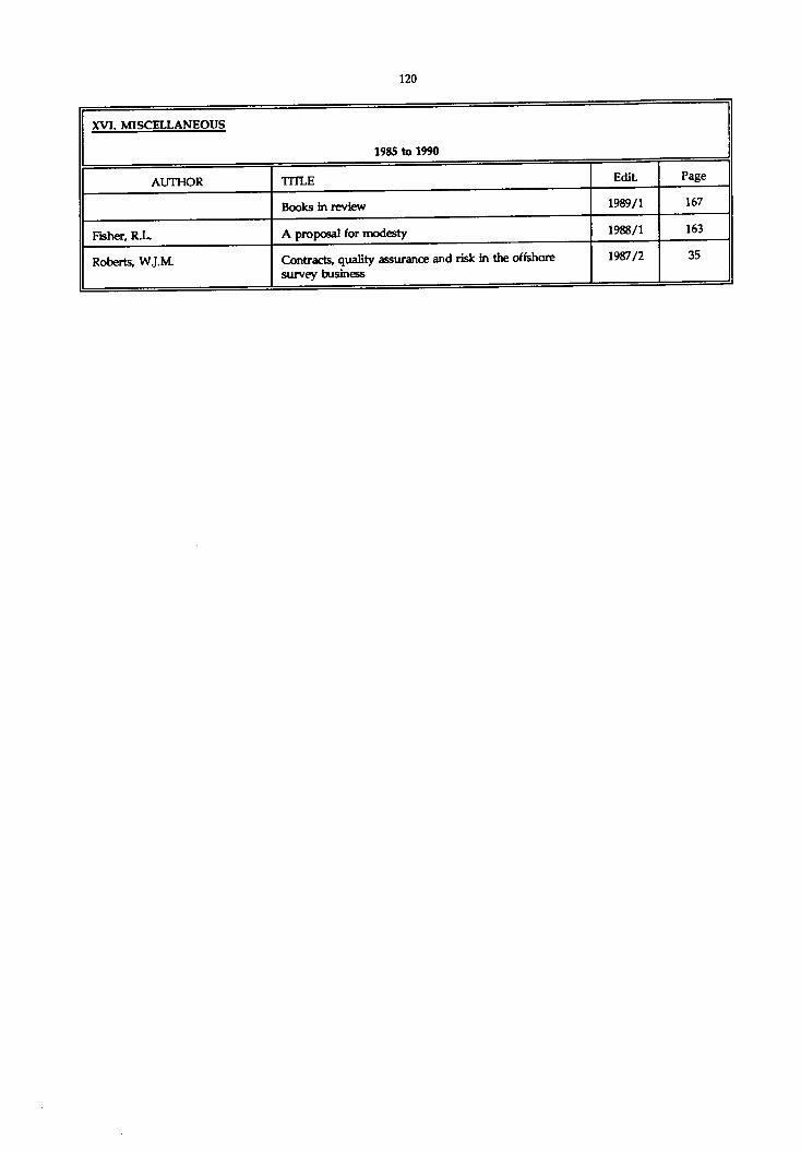
XVI. MISCELLANEOUS
1985 to 1990
AUTHOR TITLE Edit. Page
Books in review 1989/1 167
Fisher, R.L. A proposal for modesty 1988/1 163
Roberts, W.J.M. Contracts, quality assurance and risk in the offshore survey business
1987/2 35

XVII. NOMENCLATURE AND UNITS fTerminoloev. Notations, etc.)
1923 to 1935
AUTHOR TITLE Edit. Page
Correspondence on the subject of Notations 1928/1 233
Transcription of Place Names (U.S.S.R.) 1931/1 194
Transcription of Geographical Names, (Japan). (With a list of names)
1931/2 189
(E) Countries'Names in European languages using the Latin Alphabet
1935/2 142
Names of Coastal Area uncovering at Low Water 1927/1 225
Names for Lunar Positions 1927/1 226
Bencker, H. Ice Terminology 1931/2 114
Bjôrset, E.S. Proposed Alteration of the Norwegian Unit of Distance at sea
1923/1 34
Bjôrset, ES. Proposed Alteration of the Norwegian Unit of Distance at sea
1924/2 172
G.S.S. Transcription of Place Names. (Replies to Circular Letter N° 36 of 1922)
1924/1 33
Mitunobu, T. Spelling of the Japanese Language in Roman Characters 1932/2 76
Niblack, A.P. Terminology of Submarine Relief 1928/2 9
P.V. (R) Mehrsprachiges WOrterbuch für Photogrammetrie, Berlin, 1934
1935/1 179
Parry, Sir John F. Use of the Metric System in relation to Charts etc 1923/1 31
Rauschelbach, H. (E) Definition of Terms used for describing and calculating the Tidal Phenomena in the Sea
1933/1 165
Spicer Simson, G.B. The Metric System 1925/1 45
Vanssay de Blavous, P. DE Units of Length. (Information concerning the Fathom and Nautical Mile)
1928/1 227

XVII. NOMENCLATURE AND UNITS (Terminoloev, Notations, etc)
1936 to 1941
AUTHOR TITLE Edit. Page
Turkish Place Names 1936/2 73
(R) Japanese Place Names (Hydrographic Department, Tokyô, 1936)
1937/1 101
(E) The Divisions of the Circle 1939/2 165
Herrmann, Dr.K. The new 400. grade Division 1938/1 108

XVII. NOMENCLATURE AND UNITS (Tenninoloev, Notations, etcl
1942 to 1970
AUTHOR TITLE Edit Page
Alphabetical List of Common Geographical Names 1942 75
I.H.B. Uniform Policy for Handling Geographic Names (I.H.B. Circular-Letter N° 16 H of 18th September 1948)
1948/2 160
Handling of Geographical Names on Nautical Charts and Documents
1950/1 49
International Committee on the Nomenclature of Ocean Bottom Features (Minutes of Meeting held at the International Hydrographic Bureau at Monaco, 22nd September, 1952)
1954/1 93
General Principles governing the Naming of New Small Oceanic Features
1955/2 157
French Translation of Nomenclature of Ocean Bottom Features
1958/1 159
"Illustrated glossary of snow and ice" (T. Armstrong, B. Roberts and C. Swithinbank), (Review)
1967/2 171
Bencker, H. Maritime Geographical Terminology 1942 60
Comité National Français de Géodésie et Géophysique
French Translation of Nomenclature of Ocean Bottom Features
1962/1 179
Espenshade, Jr. E.B. Problems of Place Names 1948/1 75
Hydr.Dep.of the Turkish Navy Vocalulary of Turkish Nautical Terms 1951/2 111
P.V. Report of the Committee on the Criteria and Nomenclature of the Major Divisions of the Ocean Bottom
1942 9
Schumacher, A. Kartenmasstab und Hydrographische Namengebung (Chart Scale and Hydrographic Designations)
1942 42

w i l l . nrFANOCRAPHY. Bathvmetry, meteorology, seismic, eravity, magnetism
1923 to 1935
AUTHOR TITLE Edit. Page
The Department of Terrestrial Magnetism of the Carnegie Institution of Washington
1925/2 33
Annual change in the distribution of Magnetic Elements, its application to the drawing up of magnetic maps. (Institut de Physique du Globe, Paris)
1932/1 126
(R) Regions of Magnetic Pertubation. (H Maurer) Berlin, 1929
1930/2 194
(E) Variation of Compass Deviation as a result of Solar Heating in the Red Sea
1931/1 256
(E) Compass Deviation of a ship struck by Lightning 1935/2 153
(E) Description of the Portable Magnetometer of the Ordnance ** Survey built by the Cambridge Instruments Co. Ltd
1930/2 185
(E) Osservazioni di Magnetismo a Roma dal XVI secolo fino ai nostri giomi. (L. Palazzo) Roma, 1931
1932/1 255
(E) Early History of Magnetism. (Dr. Kramer) 1932/2 275
The International Meteorological Organization 1933/2 202
The Netherlands Royal Meterological Institute 1929/1 239
(R) Meteorology of Polar Regions. (G.C. Simpson) London, 1929
1930/1 251
(R) Instructions to Marine Meteorological Observers. (Weather Bureau) Washington, 1925
1929/2 237
(R) Barometers and the measurement of Atmospheric Pressure. (C.F. Marvin) Washington, 1919
1929/2 238
The modem Radio-meteorograph by Prof. Moltchanoff, Askania-Werke, Berlin
1933/1 181
(R) Fizicheskaya Okeanografiya. (J. Scholkalsky) Leningrad, 1933
1935/1 178
(R) Algumas con tribui çoes para o estudo progressivo da modema oœanografia. (A. Ramos Da Costa) Lisboa,1930
1932/1 239
(R) A survey of some of the Methods used in modem Dynamical Oceanography. (G.F. McEwen) La Jolla, 1930
1932/1 239
(R) Congreso Intemadonal de Oœanografia, Hidrografia Marina e Hidrologia Continental, Sevilla, 1929
1932/1 241
First Ibero-American Oceanographic Conference, Madrid-Malaga, April, 1935
1935/2 12
(R) Report of the Committee on Submarine Configuration and Oceanic Circulation, 1931 (U.S.A.)
1932/1 243
(R) Annual Report of the Director of the Scripps Institution of Oceanography, La Jolla, Cal. (1930-1931)
1932/1 243
(R) Transactions of the American Geophysical Union- Twelfth Annual Meeting. (1930-1931)
1932/1 244

XVJII. OCEANOGRAPHY, Bathymetry, meteorology, seismic, eravity, magnetism
1923 to 1935
AUTHOR TITLE Edit. Page
(E) Earthquake South of Newfoundland, November 18th, 1929
1930/1 242
Submarine Valleys 1934/2 188
(R) Oceanography and the Navy. (C.C. Slayton) Annapolis, 1934
1934/2 190
(R) Some new oceanographic Instruments (Permanent International Council of Copenhagen)
1928/1 274
(R) Measurement of Salinity of Sea Water. (J.H. Service) Washington, 1928
1929/2 227
Barlow, E.W. (E) Fog at Sea 1931/1 251
Bauer, H A (E) Oceanographical and Meteorological Results of the Sedov Expedition of 1930
1934/2 187
G.S.S. (R) Praktische Orkankunde. (L.Schubart) Berlin, 1934 1934/2 187
G.S.S. (R) Tiefseebuch. (G.Wüst) Berlin, 1934 1935/1 177
Garbett, L.G. Meteorology as an aid to Navigation 1933/2 50
Gherardi, W.R. Oceanographic Work of the Hydrographic Office and the United States Navy during the year 1932
1934/1 30
Gregg, W.R. (E) History of the application of Meteorology to Aeronautics with special reference to the United States
1934/1 131
Heck, N.H. The Coast and Geodetic Survey and Oceanography in the Pacific
1928/1 251
Huber, E.V. (E) Scheme for the organization of a Meterological Service for the Atlantic
1929/2 222
Idrac; M.P. (E) Note on a Submarine Temperature Recorder by M.P. Idrac
1932/1 235
J.D.N. (R) Physics of the Earth. V.:Oceanography. National Research Council, Washington, 1932
1V32/2 285
J.F.P. (R) The Marine Observer’, London, Jan. 1924 1924/2 198
J.F.P. (R) The Marine Observer", London, October 1924 1924/1 169
Kohl-Larsen, L (E) The arctic voyage of the Graf Zeppelin 1932/1 199
Lacour, D. Sc Laursen, V. (E) The Copenhagen Variometer. Magnetic Variometer for horizontal force
1931/1 266
Littléhales, G.W. Sounding the Depths of the Ocean for mapping the Conformation and Topography of the Bottom
1933/1 157
Ljungdahl, G.S. An attempt to determine the Magnetic Declination at Sea on board an ordinary motor boat
1933/1 52
Ljungdahl, G.S. A magnetic Survey of Sweden 1934/2 186
Lumby, J.R. The Surfaœ-sampler, Lowestoft 1928/1 273
Magrini, J. (R) Bibliographia Oceanographica, Venice, 1931 1934/2 189

XVIII. OCEANOGRAPHY, Bathymetry, meteorology, seismic, gravity, magnetism
1923 to 1935
AUTHOR TITLE Edit. Page
Magrini, J. (E) Bibliographia Oceanographica 1934/1 145
Mayo, C.B. The Portrayal of the Floor of the North Pacific Ocean 1935/1 30
Nippoldt, A. Secular Variations of Terrestrial Magnetism 1930/2 98
P.V. (R) Das ozeanographische Beobachtungsmaterial (Serienmessungen) des Meteor. (Dr. G. Wüst) Vol IV, Part II, Berlin, 1932
1935/2 136
P.V. (R) Géographie générale des Mers. (C. Vallaux) Paris, 1933
1934/1 133
P.V. (R) Einführung in die Geophysik - III. Dynamische Ozeanographie. (A.Defant) Berlin, 1929
1930/1 248
P.V. (R) Problème der Wasserwellen. (H. Thorade) Hamburg, 1931
1931/2 249
P.V. (R) Teorie moderne su l'origine e su la struttura dei dcloni. (C.Fabris)
1932/1 261
Peters, W.J. (E) Tilting Deviations in Magnetic Declinations 1930/2 191
Rude, G.T. Mapping the Ooean floor 1935/1 169
Shepard, F.P. (E) Investigations of Submarine Valleys. (American Geophysical Union) 1933
1934/1 143
Sigematu, R. (E) A brief note on the Depths of the Sea in the vicinity of the Mariana Islands
1933/2 219
Tonta, L. Compass for measuring Variation at Sea. (Istituto Idrografico, Genoa)
1931/2 142
Ullrich, W. (E) The Chief Rules for the treatment of Magnetic Compasses on board ship
1935/2 151
Vans say de Blavous, P.DE Magnetic Charts (cont.) 1929/2 121
Vanssay de Blavous, P. DE Magentic Charts. (Magnetics charts drawn up by various countries)
1929/1 67
Watts & Son, E.R. (E) The Connolly Standard Compass for checking field compasses and observing magnetic declination
1933/2 249
Wenner, F., Smith, E.H. & Soule, F.M.
(R) Apparatus for Determination aboard ship of the Salinity of sea Water by the Electrical Conductivity method
1931/1 265
Whitemarsh, R.P. (E) Great Sea Waves 1935/1 182
Wüst, G. (E) Bottom Water and Bottom Configuration of the Great Atlantic Deeps
1933/2 209
Wüst, G. (E) Salinity and Water Movement in the Suez Canal 1935/1 137

XVIII. OCEANOGRAPHY, Bathymetry, meteorology, seismic, gravity, magnetism
1936 to 1941
AUTHOR TITLE Edit Page
(R) Terrestrial Magnetism and Electricity (Part I : Magnétisme terrestre - Ch. Maurain) Paris, 1935
1936/2 167
(R) Manuale di Meteorologjca Nautica, Genova, 1935 1936/1 166
Instructions for use, adjustment, and care of Shipboard Theodolite Type : Aero, 1928, U.S.N.
1941/1 72
(E) Fog Investigations 1941/2 68
Limits of Oceans and Seas (U.S.S.R.) 1936/1 160
Submarine Canyons 1938/1 66
(R) The Origin of Submarine Canyons (D. Johnson) 1941/1 31
(E) Rate of formation of Marine Sediments 1938/2 130Bencker, H. Notes on the Use of Deflectors 1941/1 85
Bencker, H. Historical and Bibliographic Index concerning the development and improvment of the Compass
1941/1 119
Bryan, G.S. Los Jardines (E.D.) 1940/2 48Brvsson Cunningham (E) The theory of River Bars 1939/1 113Bullard, EC. Geophysical Study of Submarine Geology 1940/2 65
Carnegie Institution (E) Annual Report of the Director of the Department of Terrestrial Magnetism (1939-40) Washington
1941/2 70
Ciocardel R. (E) Influence of the Winds on the Changes in the Delta of the Danube
1938/1 68
Ciocardel, R. The general Circulation of Water in the Black Sea 1938/2 87
Collin der, P. On the variation in the magnetic moment of the compensating magnets, with a simplified method of observation
1940/1 68
Collinder, P. On Compass Testing in Sweden, especially with regard to the detection of iron in compass bowls
1940/1 59
Defant, A. (E) Survey of the Morphological details of the Ocean bottom by means of echo sounding
1939/2 56
Defant, A. The Altair Peak (Kuppe) 1940/1 167
Defant, A. The Altair peak (Kuppe) 1940/1 167
Dietrich, G. (E) Some morphological results of the cruise of the Meteor, January to May 1938
1939/2 52
H.B. (R) Atlas of Oceanographic and Meteorological observations in the China Seas and in the Western part of the North Pacific Ocean (Kon. Magn. Ins.) - 'sGravenhage, 1936)
1937/2 270
H.B. The naming of Nares & Puerto Rico Deeps 1936/1 90H.B. (R) Short period vertical oscillations in the western basin
of the North Atlantic (H.R. Seiwell) Massachussetts, 19371937/2 205
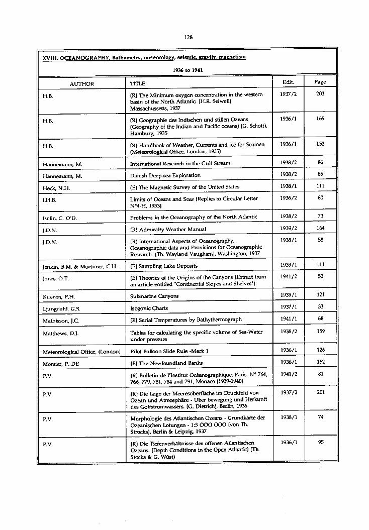
XVIII. OCEANOGRAPHY. Bathymetry, meteoroloev. seismic, eravity, maenetism
1936 to 1941
AUTHOR TITLE Edit. Page
H.B. (R) The Minimum oxygen concentration in the western basin of the North Atlantic (H.R. Seiwell) Massachussetts, 1937
1937/2 203
H.B. (R) Geographie des Indischen und stillen Ozeans (Geography of the Indian and Pacific oceans) (G. Schott), Hamburg; 1935
1936/1 169
H.B. (R) Handbook of Weather, Currents and Ice for Seamen (Meteorological Office, London, 1935)
1936/1 152
Hannemann, M. International Research in the Gulf Stream 1938/2 86
Hannemann, M. Danish Deep-sea Exploration 1938/2 85
Heck, N.H. (E) The Magnetic Survey of the United States 1938/1 111
I.H.B. Limits of Oceans and Seas (Replies to Circular Letter N°4-H, 1933)
1936/2 60
Iselin, C. O'D. Problems in the Oceanography of the North Atlantic 1938/2 73
J.D.N. (R) Admiralty Weather Manual 1939/2 164
J.D.N. (R) International Aspects of Oceanography, Oceanographic data and Provisions for Oceanographic Research. (Th. Wayland Vaugham), Washington, 1937
1938/1 58
Jenkin, B.M. & Mortimer, C.H. (E) Sampling Lake Deposits 1939/1 111
Jones, O.T. (E) Theories of the Origins of the Canyons (Extract from an article entitled "Continental Slopes and Shelves')
1941/2 53
Kuenen, P.H. Submarine Canyons 1939/1 121
Ljungdahl, G.S. Isogonic Charts 1937/1 33
Mathisson, J.C. (E) Serial Temperatures by Bathythermograph 1941/1 68
Matthews, D.J. Tables for calculating the specific volume of Sea-Water under pressure
1938/2 159
Meteorological Office, (London) Pilot Balloon Slide Rule -Mark 1 1936/1 126
Morsier, P. DE (E) The Newfoundland Banks 1936/1 152
P.V. (R) Bulletin de l’institut Océanographique, Paris. N° 764, 766, 779, 781, 784 and 791, Monaco (1939-1940)
1941/2 81
P.V. (R) Die Lage der Meeresoberflâche im Druckfeld von Ozean und Atmosphère - Uber bewegung und Herkunft des Golfstromwassers. (G. Dietrich), Berlin, 1936
1937/2 201
P.V. Morphologie des Atlantischen Ozeans - Grundkarte der Ozeanischen Lotungen -1 :5 OOO OOO (von Th. Strocks), Berlin & Leipzig 1937
1938/1 74
P.V. (R) Die Tiefenverhaltnisse des offenen Atlantischen Ozeans. (Depth Conditions in the Open Atlantic) (Th. Stocks & G. Wüst)
1936/1 95

XVIII. OCEANOGRAPHY, Bathymetry, meteorology, seismic, eravitv, maenetism
1936 to 1941
AUTHOR TITLE Edit. Page
P.V. Soundings in the North Atlantic 1936/11937/11938/11938/2
170975966
P.V. (R) Morphologie des Atlantischen Ozeans (Th. Stocks) 58
P.V. Soundings in the Pacific Ocean 1941/2 77
Perlewitz, P. (E) The Wind according to the Beaufort Scale and its velocity
1936/1 144
Rude, G.T. (E) A Survey of Atlantis 1941/1 15
Schubert, O.V. (E) The Oceanographic Work on the second partial voyage of the German North Atlantic expedition, January to July 1938
1939/2 46
Shepard, F.P. & Beard, C.N. Submarine Canyons : Distribution and logitudinal profiles
1938/2 120
Slaucitajs, L. (R) Geomagnetic elements of environment of Riga (L.Slaudtajs) Riga, 1938
1939/2 86
Smith, P.A. Submarine Valleys 1938/1 61
Stetson, H.C. (E) The Dredge of the Woods Hole Oceanographic Institution
1939/1 108
Stickley, A.R. (E) A Solution to the problem of adjusting the Counterbalance of a Shipboard Theodolite
1939/2 162
Vallaux, C. Deep Circulation in the Oceans 1938/2 9
Vanssay de Blavous, P. DE Remarks on Article of Dr. Wüst on the Divisions of the Oceans
1936/2 57
Vigneron, H. The Ocean Waves 1938/2 128
Wûst, G. (E) Die Gliederung des Weltmeeres (The Divisions of the Oceans)
1936/2 46

XVIII. OCEANOGRAPHY, Bathymetry, meteorology, seismic, cavity , maenetism
1942 to 1970
AUTHOR TITLE Edit. Page
French Translation of Nomenclature of Ocean Bottom Features
1958/1 159
"Les océans" (J. Rouch), (Review) 1958/2 151
"Allgemeine Meereskunde’ (G. Dietrich & K. Kalle), (Review)
1958/2 155
"Report on Oceanographic Surveys carried out in the Gulf of Thailand during the years 1956-1957"(A Penyapol), (Review)
1958/2 157
"Wetter und Meereskunde für Seefahrer, Vierte Auflage" (J. Krauss & W. Stein), (Review)
1959/1 181
"The Annual Variation of the Slope of the Water Surface in the Gulf of Bothnia", Societas Scientiarum Fenttica, Helsinki, 1957 (Review)
1959/1 183
Determination of the Slope of the Water Surface in the Gulf of Finland" (E. Lisitzin), Geophysica; Helsinki, 1958 (Review)
1959/1 183
"Present Status and Future Development of Oceanography" (R. Fleming), Proceedings of the Eighth Pacific Science Congress (Review)
1959/1 184
"Oceanographic Information for Engineering Submarine Cable Systems" (C.H. Elmendorf & B.C. Heezen), The Bell System Technical Journal, 1957 (Review]
1959/1 184
"Her Verloop van het Zoutgehalte in de Zeeschelde" (R. Codde), Revue C.Tijdscbrift (Review)
1959/1 185
"Changes in Sand Level on the Beach and Shelf at La Jolla, California" (D.L. Inman & G.A. Rusnak) Contributions 1956, Scirpps-Institution of Oceanography, La Jolla, (Review)
1959/1 187
"The Floors of the Oceans. I. The North Atlantic". (B.C. Heezen, M. Tharp & M. Ewing), New York (Review)
1960/1 173
"Morskoi Atlas" (I.V. Isakov), Vol I. and Vol II, (Review) 1960/1 173
"Les découvertes océanographiques modernes" (J. Rouch), (Review)
1960/2 162
"Die Westkuste Sudamerikas im Bereich des Peru- Stroms" (E. Schweigger), 1959 (Review)
1960/2 164
'Sounding Profiles between Fiji, Christmas and Tahiti Islands' (G.S. Ritchie), Deep-Sea Research, London, 1958 (Review)
1960/2 165
"Les recherches océanographiques de l'année géophysique internationale" (A. Gougenheim), La Nature, 1959 (Review)
1960/2 166
"Dynamique des mers" (H. Lacombe), (Review) 1961/1 195
"Le spiagge italiane in erosione e le antistanti valli sottomarine" (A. D'Arrigo), (Review)
1961/2 195

XVIII. OCEANOGRAPHY, Bathymetry, meteoroloev, seismic, eravitv, magnetism
1942 to 1970
AUTHOR TITLE Edit Page
"Atlantic ocean Atlas - Temperature and salinity profiles" (F.C. Fuglister), [Review]
1961/2 111
"Ozeanologie, Band I" (E Bruns), {Review) 1962/1 186
"Ocean wave spectra’ [Conference Proceedings), (Review) 1964/2 176
"La mer et le vent - Météorologie nautique' (R. Clausse and A. Viaut), (Review)
1964/2 176
'Submarine geology' (F.P. Shepard, D.L. Inman and E.D. Goldberg) 2nd Ed. [Review]
1964/2 177
"Physics of the marine atmosphere" (H.U. Roll), (Review) 1966/1 149
"Wind waves, their generation and propagation on the ocean surface" (B. Kinsman), (Review)
1966/1 150
"Cours d’océanographie physique" (H. Lacombe), (Review)
1966/2 189
"Developments in sedimentology - Volume 5" (J.C. Ingle), (Review)
1966/2 192
"Methoden und Ergebnisse der Theoretischen Ozeanographie - Vol. II" (W. Krauss), (Review)
1967/2 172
Albini, C.F. Hydroceanography 1966/2 91
Alexiou, A.G. Conducting Underwater Surveys with a multi-purpose Instrument
1963/2 99
Allan, T.D. A bathymetric chart of the Red Sea 1966/1 33
Balay, M A Causes and Periodicity of Large Floods in Rio de la Plata 1959/1 123
Bates, C.C. & Fleming, R.H. Oceanography in the Hydrographic Office 1948/1 63
Bencker, H. Report Concerning the Preparation of the 3rd Edition of the General Bathymetric Chart of the Oceans
1953/1 73
Brunei, A. Gravity Acceleration Measurements at Sea by Gravimeters
1960/2 153
Deacon, G.E.R. Ocean Waves and Swell 1946 97
Dishon, M. Determination of Average Ocean Depths from Bathymetric Data
1964/2 77
Doodson, A.T. Storm Surges 1947 108
Duffo, H. Wave pattern diagrams 1966/1 121
Errulat, F. Earth Magnetic measurements at Sea with Double Compass as Immersed Apparatus
1943 47
Frank oam, C.E.N. Ocean Weather Ships - Some Navigational and Oceanographical Aspects
1963/2 142
Gilman, L. & Scheepers, G.L.M. Geomagnetic Observations at Gough Island and Tristan daCunha
1959/1 161
Gougenheim, A. Oceanography and Hydrography - Fundamental Research and Descriptive Oceanography
1965/1 127

XVIII. OCEANOGRAPHY, Bathymetry, meteoroloev. seismic, eravitv, magnetism
1942 to 1970
AUTHOR TITLE Edit. Page
Hess, H.H. Drowned Ancient Islands of the Pacific Basin 1947 81
Hine, A. More Uncommon Deviations 1957/1 155
Iselin, C. O'D. Preliminary Report on Long Period Variations in the Transport of the Gulf Stream System
1947 92
Jordan, G.F. Pamplona Searidge 1779-1957 1958/1 147
Jordaan, J.M., Jr. Experience with Recording of Storm Waves, Swell and Tide vising an Inverted Echo-Sounder off Durban, South Africa
1963/2 125
Karo, H.A. Oceanography in the U.S. Coast and Geodetic Survey 1960/2 127
Karo, H.A. Oceanographic Expedition of the Ship Explorer 1961/1 155
Karwowski, J. On N.F. Kudriancev and E.G. Nikiforov’s article 'About the choice of effective constructions of the measurement instruments and their optimal parameters for measurement of sea-currents in the undulating water layer'
1967/2 41
Kiaer, R. The Norwegian Hydrographic Office and the Magnetic Survey of Norway
1954/1 7
Kort, V.G. Scientific Research of Vityaz during IGY 1960/2 137
Langeraar, W. Comments on 'Hydroceanography' 1967/1 71
Laska, M. General characteristics of the southern Baltic water level variations and daily mean water level values in the Bay of Gdansk for the 11-year period 1955-1965
1966/2 45
Laska, M. Spectral analysis of the periodic water level changes in the Baltic
1969/1 115
Lauwers, J. Sea Deposits 1948/2 141
Lisitzin, E. The Influence of Water Density Variations on Sea Level in the Northern Baltic
1959/1 153
Lundbak, A. The North Sea Storm Surge of February 1st, 1953. Its Origin and Development
1956/1 185
Lyman, J. The U.S. Navy International Geophysical Year Program in Oceanography
1958/2 111
May, W.E. The Magnetism of Ships 1948/1 92
McClure, K.C. Technical Aspects of the Aries Flights 1946 108
McLellan, H.J. An I.G.Y. Cruise from Texas A. & M. 1960/1 139
Meynier, A. Submarine Canyons and Oceanic Regression 1943 85
Molloy, A.E. Sea floor bathymetry near the Clarion and Clipperton fracture zones
1968/1 107
Moreira Da Silva, P. Some New Methods for the Rapid Processing of Oceanic Data
1957/2 137
Morelli, C. Gravity and the International Geophysical Year 1958/2 133

XVIII. OCEANOGRAPHY, Bathymetry, meteorology, seismic, gravity, magnetism
1942 to 1970
AUTHOR TITLE Edit. Page
Mosby, H. Experiments on Turbulence and Friction near the Bottom of the Sea
1948/2 109
Nares, J.D. Future Plans for the Preparation of Sheets of the General Bathymetric Chart of the Oceans
1953/2 137
Naval Hydr. Office of France Recent French Bathymetrical Operations in the Antarctic Ocean.
1953/1 65
Nishimura, M. & Hara, M. The use of portable underwater television in Japan 1968/1 123
Ostrekhim, M.Y. Bathymetry and Glaciology of Central Portion of Arctic Ocean
1956/2 171
P.V. "Météorologie et Physique du Globe" (J. Rouch), (Review) 1942 146
P.V. "A Problem of Submarine Morphology: The Great Continental Talus Canyons" (A Perpillou) (Review)
1945 75
P.V. "Os Vales Submarine» Portugueses" (C.F. de Andrade), (Review)
1942 46
P.V. "Morphologie des Atlantischen Ozeans" (T. Stocks), (Review)
1942 29
P.V. "D. Joao de Castro" Bank 1944 10
P.V. "Turbulence - An Example taken from a Study of the Sea" (F. Model), (Review)
1945 87
Pettersson, H. & M/S "Dagmar Sal en'
Possible Observation of Deep-Scattering Layer 1956/2 175
Ritchie, G.S. First Navado Cruise 1965/2 81
Roberts, E.B.. Geomagnetic Researches in the International Geophysical Year
1958/2 127
Roberts, E.B. What Geomagnetism Means to Navigators 1953/2 63
Rogalla, E.H. On the Results of North Sea Research Hydrographic Investigations on board FRV Anton Dohm in Summer 1959-60 and Winter 1962-63
1"65/1 135
Rouch, J. Variations in Sea Level at Monaco 1959/1 117
Sharaf El Din, S.H. & Rifat, E.M.
Variation of sea level at Alexandria 1968/2 175
Smith, S.M. An Investigation of Automatic Bathymetric Data Processing
1963/1 131
Spencer-Jones, H. The Positions of the Magnetic Poles 1949/1 93
Stockard, H.P. Airbone Geomagnetic Surveys by the United States Hydrographic Office
1956/2 143
Stockard, H.P. & Woodcock,F.B.
A New Magnetic Aircraft for the United States Navy Hydrographic Office
1960/2 117
Trotti, L. A bathymetric and geological survey in the Middle Adriatic Sea
1968/2 59
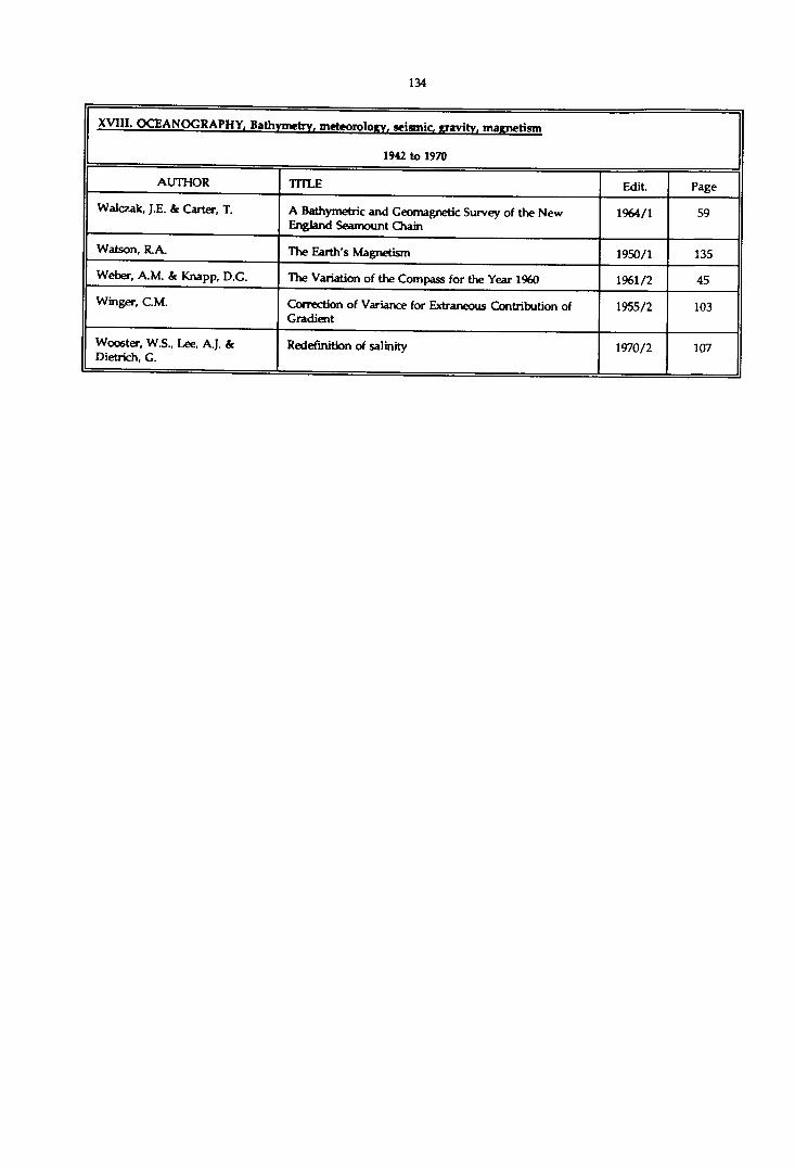
XVIII. OCEANOGRAPHY, Bathymetry, meteoroloev. seismic, rravitv. marru>H«m
1942 to 1970
AUTHOR TITLE Edit. Page
Walczak, J.E. & Carter, T. A Bathymetric and Geomagnetic Survey of the New England Seamount Chain
1964/1 59
Watson, R.A. The Earth’s Magnetism 1950/1 135
Weber, A.M. & Knapp, D.G. The Variation of the Compass for the Year 1960 1961/2 45
Winger, CM. Correction of Variance for Extraneous Contribution of Gradient
1955/2 103
Wooster, W.S., Lee, A.J. & Dietrich, G.
Redefinition of salinity 1970/2 107

XVIII. OCEANOGRAPHY, Bathymetry, meteorology, seismic, gravity, magnetism
1971 to 1976
AUTHOR TITLE Edit. Page
Nomenclature of ocean bottom features 1971/1 203
Bonnot J.F. Howaldt Bathysonde 1971/1 155
Brooks, M. Errata 1971/2 161
Brooks, M. Some effects of a wide separation of source and hydrophone in shallow-water seismic profiling
1971/1 85
Chesterman, W.D. & Wong, H.K.
Bottom sediment distribution in certain inshore waters of Hong Kong
1971/2 51
Coleman, J.M. & Mclntire, W.G. Transiting coastal river channels 1971/1 11
Got, H. & Leenhardt, O. Geological cartography in the Atlantic and the Mediterranean
1972/2 121
Grim, P.J., Keller, G.H. & Barday, R.J.
Computer produced profiles of microtopography as a supplement to contour maps
1972/1 81
Haworth, R.T. Gravity and magnetic natural resource map», offshore Eastern Canada
1974/1 131
Laughton, A.S., Robeiis, D.G. & Graves, R.
Deep ocean floor mapping for scientific purposes and the application of automatic cartography
1973/1 125
Le Gall, J.Y. An oceanographic grid system for continental margin areas
1974/1 191
Leenhardt, O. Resolution in continuous seismic profiling 1971/2 71
Pascoe, L.N. World bathymetric charts 1972/1 153
Pascoe, L.N. Errata 1973/2 157
Richardson, A. A study of some cartographic techniques used by British oceanographers
1975/1 103
Roubertou, A.M. Bathymetric surveying on the Continental Shelf 1972/1 37
Sherman, J.C. Topography and submarine mountains : a special problem of terrain representation
1973/2 141
Striem, H.L. <c Miloh, T. Tsunamis induced by submarine slumpings off the coast of Israel
1976/2 41

XVIII. OCEANOGRAPHY, Bathymetry, meteorology, seismic, eravitv, magnetism
1977 to 1980
AUTHOR TITLE Edit. Page
Allan, T.D. Satellites scan the seas 1978/2 121
Dechambenoy, C. Le Floc'h. J. Pontier, L. Raillard, J. & Sirou, F.
Measuring the surface thermal structure of the sea off Brittany by ship and aircraft
1977/2 125
Ruffman, A. Meagher, L., Stewart, J. McG. k Monahan, D.
Multi-disdplinary survey of the Sénégal/Gambia continental margin
1979/1 81

XVIII. OCEANOGRAPHY, Bathymetry, meteoroloev, seismic, eravitv, magnetism
1981 to 1985
AUTHOR TITLE Edit. Page
Duncan, C.P., Schladow, SG. & Williams W.G.
Surface currents near the Greater and Lesser Antilles 1982/2 67
Imayoshi, B. et al Representations on bathymetric charts 1981/2 77
Kember, I.D. How often ? Towards an optimum survey interval for mobile seabeds
1984/1 55
Ritchie, G.S. Some aspects of the history of oceanography as seen through the publications of the International Hydrographic Bureau 1919-1939
1981/2 11

XVIII. OCEANOGRAPHY, Bathymetry, meteorology, seismic, eravitv. maenetism
1985 to 1990
AUTHOR TITLE Edit. Page
Hamed, AA. & El Gindy, A.A Storm surge generation by winter cyclones at Alexandria, Egypt.
1988/1 129
Ruiz CaAavate, A., Villanueva, P., Morales, F. & Bryden, H
Oceanography study in four sections of the Strait of Gibraltar.
1988/2 159

XIX. PHOTOCRAMMETRY AND AERIAL PHOTOGRAPHY
1923 to 1935
AUTHOR TITLE Edit. Page
Use of Aircraft for Surveying. (Replies to Circular Letter No. 34-H of 1926 : U.S.H.O., Argentina, Australia)
1927/2 53
Utilization of Photographs from Aircraft by the Hydrographic Expedition to Indo-China
1929/2 220
(E) High Altitude Photography. (USA) 1932/1 184
The "Cadastre" aerial photography apparatus by Gallus, Courbevoie (France)
1928/1 269
The WILD Stereo-plotting Machine. - The Autograph 1928/1 275
The Stereo-Autotachygraph, Dresdnen 1929/1 223
(E) New Camera for Aerial Photography (USA - K-7A) 1930/1 238
The Labrely system "Planiphote" (by J. Richard, Paris) 1930/2 182
Doctor G asser's Optical projector, Liebenwerda 1930/2 183
The "Altiphote", Labrely system (by J. Richard, Paris) 1931/1 263
Bonnafous, H. Range-finding Sights for Aerial Photography 1923/1 85
Chrétien, H. Photographic Apparatus. - The Hypergonar (Henri Chrétien. Paris)
1928/2 233
Gruber, O.v. (E) Photogrammetric Equipment of the "Graf Zeppelin" on the Arctic Voyage of 1931. (Double Camera)
1932/1 201
Henney, F.A. (E) Photo mapping methods used in Europe 1932/1 249
Luymes, J.L.H. Summary of a Report on trials of Aerial Photographic Mapping in the Netherlands
1923/1 88
McGauly, C. (E) Porto- Rican-Nicaraguan Aerial Survey. (U.S. Hydrographic Office)
1931/2 238
Miller, O.M. (E) Planetabling from the air. An approximate method of Plotting from Oblique Aerial Photographs
1932/1 250
Miller, O.M. (E) An optical device to aid in Mapping from Photographs (Washington, 1935)
1935/2 128
P.V. (R) Topography without Topographers. (F. Ollivier), Paris, 1929
1930/1 250
Rollet de l’lslc Employment of Aerial Photography in connection with Surveying by the Hydrographic Service of the French Navy
1923/1 73
Roussilhe, H. Note on the Solution of the Pothenot Problem in Space. (Roussilhe apparatus)
1929/2 93
Salt, J.S.A. (E) A simple method of Surveying from Air Photographs. - Parallax Tables (Air Survey Committee, London)
1934/1 146
Sargent, A.H. (E) Photographic Mapping of Alaska from the Air (1929). (Cameras and photographic equipment)
1930/2 178
Vanssay De Blavous, P. De Use of Aircraft for Surveying. (Report of the U.S.C. & G. Survey - British Air Survey Committee Publications)
1928/1 79

XIX. PHOTOGRAMMETRY AND AERIAL PHOTOGRAPHY
1923 to 1935
AUTHOR TITLE Edit. Page
Vanssay De Blavous, P. De Resection in Space of the Position of an Aeroplane at the moment when a Photograph is taken
1927/2 69
Vanssay De Blavous, P. De Use of Aircraft in Surveying. (Brock Projector, U.S.A.) 1929/1 189
Vanssay De Blavous, P. De The use of Aviation in Surveying. (Methods for obtaining inclination of photographs)
1935/1 13
Vanssay De Blavous, P. De Use of Aircraft for Surveying. (The Barr & Stroud Epidiascope and Topographical Stereoscope. - Fourcade Stereogoniometer. - Extension of the Arundel Method. - Santoni Automatic Camera. - A geometrical demonstration of the Double Root condition)
1930/1 101
Vanssay De Blavous, P. De The use of Aircraft in Surveying. (Radial method. - Method of the isocentre. - Conjugate photographs. - The Fourcade Stereogoniometer. - Appendices)
1931/2 7

XIX. PHOTOGRAMMETRY AND AERIAL PHOTOGRAPHY
1936 to 1941
AUTHOR TITLE Edit Page
Results of the work carried out by the acro-photo survey expedition of the Central Hydrographical Department of "Gusmp" (Russian Chief Administration of the Northern sea route) (1935)
1937/2 181
Buchholtz, A. (E) On a new Apparatus for Transformation by drawing 1936/1 119
Fro ta, F. The use of aerial photography at the Hydrographic Service
1938/2 103
Grenell, S.B. (E) A projector for transferring detail from odd-scale compilations to Hydrographic Sheets
1936/2 138
Hughes & Son, H. Williamson Hydrographic Camera 1936/2 119
Jones, B.G. (E) Common Errors of Inexperienced Personnel in the Compilation of Air Photographs
1936/2 171
P.V. (R) Northernmost Labrador Mapped from the Air, (A. Forbes), New York, 1938
1938/2 157
P.V. (R) Einführung in die Luft - und Erbildmessung. (Introduction to Aerial and Terrestrial Photogrammetry) (K. Schwidefsky) Leipzig and Berlin, 1936
1937/1 145
Reading, O.S. (E) The Nine Lens Aerial Camera of the U.S.C. & G. Survey
1936/2 131
Romagna Manoia, G. (E) Photogrammetry and the preparation of Marine Charts
1938/1 102
Schwidefsky, Dr. I. (E) Photogrammetry for small scale cartography 1940/2 74
Solaini, L. (E) Photogrammetry and the Present-day Topographical Requirements
1938/1 105
Vanssay de Blavous, P. de Use of Aircraft in Surveying (Conjugate Photographs - Dangerous Surfaces)
1940/1 13

XIX. PHOTOGRAMMETRY AND AERIAL PHOTOGRAPHY
1942 to 1970
AUTHOR TITLE Edit. Page
Report on the Use of Air Photographs 1948/1 37
Specifications for Aerial Photography for U.S. Navy Hydrographic Office
1948/2 45
Bencker, H. The Evolution of Photogrammetric Instruments 1952/1 78
Brooks, H.R. Use of Aerial Photographs for Revision of Land Information on Nautical Charts
1955/2 129
Fagerholm, P.O. & Thun berg, A.
Stereo triangulation with Photographs from 10 000 m Altitude
1958/2 43
Fagerholm, P.O. Photogrammetry in Swedish Hydrographic Surveying 1957/2 85
Franco (A. Dos Santos) & Cuimares, A.
Modification of Mean Projection Plane of the Multiplex Apparatus of the "Diretoria de Hidrografia e Navagaçâo" and its Effects on Photogrammetric Restitution Operations applied to Cartography
1952/1 7
Francos (A. Dos Santos) Adjustment of Aerial Triangulation 1964/1 169
Herunter, F. Cameras for Aerial Photography 1942 142
Jones, B.G. Photogrammetric Surveys for Nautical Charts 1955/2 111
Jones, B.G. Low-water Photography in Cobscook Bay, Maine 1958/1 31
Karo, H.A. Sesquicentennial of Coast & Geodetic Survey. Symposium. 1. - Development and Use of Photogrammetry in the Coast and Geodetic Survey
1957/2 83
McBeth, F.H. A Method of Shoreline Delineation 1956/2 21
McCurdy, P.G. Manual of Coastal Delineation from Aerial Photographs 1948/1 35
Richter, H. Mapping by Aerial Photography in Antarctica 1943 32
Ritscher, A. Photogrammetric Survey Flights of the German Antarctic Expedition 1938-39
1943 29
Saunders, H.E. & Blodgett, G.D. Reconnaissance Mapping from Aerial Photographs in unexplored Country
1956/1 141
Saunders, H.E. & Blodgett, G.D. The Preparation of a Reconnaissance Map Covering the Coasts of Wilkes Land and Adjacent Coasts in Antarctica (2nd Part)
1956/2 149
Sherman, S. 1. Training in Photogrammetry by the U.S. Navy Hydrographic Office
1948/2 39
Tewinkel, G.C. 2. Wanted training in Photogrammetry 1948/2 43
Tewinkel, G.C. Aerotriangulation Adjustment 1958/1 15
U.S. Coast & Geodetic Survey Sesquicentennial of the U.S. Coast and Geodetic Survey 1958/1 11
Zarzycki, J.M. The Use of Horizon Camera, Doppler Navigator, and Statoscope in Aerial Triangulation
1965/2 185

XIX. PHOTOGRAMMETRY AND AERIAL PHOTOGRAPHY
1971 to 1976
AUTHOR TITLE Edit. Page
Burton, B.W. & Duhaut, J. Progress with air photography from helicopters for hydrographic work
1975/2 37
Crandall, C.J. Coastal aerial photo-laser survey (CAPS) - A nearshore charting system
1976/1 53
Masry, S.E. Measurement of water depth by analytical plotter 1975/1 75Phillips, J.O. Coastal boundary surveys 1971/1 129Seshachalapathi, T. Ground cooperation for coast-lining with aerial
photographs1974/2 51

XIX. PHOTOGRAMMETRY AND AERIAL PHOTOGRAPHY
1977 to 1980
AUTHOR TITLE Edit. Page
Brewer, R.K. Project planning and field support for NOS photobathymetry
1979/2 55
Calder, M. WRELADS - The Australian laser depth sounding system
1980/1 31
Collins, J. Costs benefits of photobathymetry 1979/2 69
Enabnit, D.B. & Nield, van K. Airborne laser hydrography 1980/2 93
Karalus, B.J.S. Aerial photography and the use of helicopters in hydrography
1980/1 169

XIX. PHOTOGRAMMETRY AND AERIAL PHOTOGRAPHY
1981 to 1985
AUTHOR TITLE Edit. Page
Bonnot, J.F. Contribution made by aircraft and photogrammetry towards the solving of common hydrographic and cartographic problems
1982/2 123

XX. POSITIONING SYSTEMS AND METHODS
1971 to 1976
AUTHOR TITLE Edit. Page
Eaton, R.M., Wells, D.E. & Stuifbergen, N.
Satellite navigation in hydrography 1976/1 99
Grant, S.T. Rho-Rho Loran-C combined with satellite navigation for offshore surveys
1973/2 35
Stedtnitz, W. fc Helms, H. The Atlas Alpha Doppler Navigator System 1974/1 95

XX. POSITIONING SYSTEMS AND METHODS
1977 to 1980
AUTHOR TITLE Edit. PageAllan, T.D. Satellites scan the seas 1978/2 121Godley, V.M. Charted port positions in the Pacific as defined by
satellite determined positions using multiple observations
1980/2 77
Hothem, L.D. & Strange W .E Doppler satellite positioning of offshore structures 1977/1 39Szymonski, M. Some notes on the accuracy of the Navy Navigation
Satellite System1980/2 67
Turner, L.G. & Mitchell, H.I. Satellite imagery and its application to offshore mapping in Australia
1978/2 21

XX. POSITIONING SYSTEMS AND METHODS
1981 to 1985
AUTHOR TITLE Edit. Page
Cook, G.E Principles and present status of Navstar GPS 1984/2 69
Doyle, F.J. Satellite systems for cartography 1982/1 93
Lapine, LA. Inertial Survey System (ISS) 1981/2 41
May boum, R. GPS for marine navigation 1984/2 79
Minkel, D.H. Establishing hydrographic control using Doppler 1984/2 57
Norton, J.H. NAVSTAR Global Positioning System 1982/1 23
Preiss, W.J. Satellite positioning - The surveyor's operational requirement
1985/2 75
Szymonski, M. Analysis of the geometry of transit of a navigation satellite
1983/1 47
Weightman, J.A. Satellite geodesy and offshore oil 1982/1 31

XX. POSITIONING SYSTEMS AND METHODS
1985 -1990
AUTHOR TITLE Edition Page
Fiadeiro, P. Calculation of exact position using intersection, resection and distances with least square adjustments.
1987/1 71
Harre, I. Accuracy Evaluation of Polar Positioning Systems taking POLARFIX as an Example.
1990/1 37
Mapp, G.R., Byrnes, H.J. & Heinzen, M.R.
Sounding vessel position from adjustment by variations of parameters.
1987/2 91
McLintock, D.N. A coordinated approach to the quality control of offshore positioning.
1986/1 95
Stansell Jr., TA. The Global Positioning System 1986/2 51

XXI. PRACTICAL HINTS TO HYDROGRAPHIC SURVEYORS
1923 to 1935
AUTHOR TITLE Edit. Page
(E) Revolving Heliotrope, Leningrad, 1934 1935/2 153
A graphical method of adjusting Plane Table Traverses 1934/1 157
Baker, S.J. (E) Use of Aluminium Sheets with Plane Table Board 1935/2 134
BUby, J.S. Floating Hydrographical Signal, Three-Barrel Buoy 1933/2 257
Bilby, J.S. Water Signal for Triangulation and Hydrography. (U.S.C. & G. Survey)
1934/1 160
Chovan, W.J. Method of improving Poor Quality Lead Line 1935/1 164
Church, E.F. A Hint to Topographers 1932/2 279
Cooke, Troughton & Simms Helio Beacon 1933/1 198
Graham, L.D. Plotting Three Point Fixes without the use of a protractor 1935/1 164
H.B. A simple device to provide against possible Swinging of the Lead in ship sounding
1934/1 159
H.B. Note on an Air-pressure Sounding Machine 1933/1 200
H.B. Determination of the ship's Position by observations of Two Points the Bearings of which intersect at a small angle
1933/1 198
J.D.N. To plot a Station Pointer Fix graphically 1933/2 252
J.D.N. Canvas Mark Buoy 1933/1 197
J.D.N. To plot a Station Pointer Fix graphically 1934/2 201
J.D.N. Foreword to Practical Hints to Hydrographic Surveyors 1932/2 279
Luisoni, A. Azimuth Lantern 1933/2 253
Mich 1er, H. A hint when measuring the Dip of the Sea Horizon 1933/2 256
Nares, J.D. The "banner" method of attaching a Flag to a Beacon 1932/2 283
Nares, J.D. Canvas Current Drag 1932/2 280
Nares, J.D. A method of obtaining Current Observations from a ship in deep water without anchoring
1934/1 158
Paton, H A & Deane, W.F. Hydrographic Signal with triangular cross-section 1932/2 281
Survey of India Heliographing from a Mirror on top of a Triangulation Mast
1933/1 197
U.S.C. & G. Survey The Care of Instruments 1934/2 202
Verstelle, J. Th. To plot a Station Pointer Fix graphically 1934/1 155
Verstelle, J. Th. Current Drag 1933/2 258
Verstelle, J. Th. The small Lucas Sounding Machine 1935/1 161

XXI. PRACTICAL HINTS TO HYDROGRAPHIC SURVEYORS
1936 to 1941
AUTHOR TITLE Edit. Page
(E) A new material for Geographers 1936/2 152
Anderson, BJ. (E) Construction of Marine Towers 1937/1 129
Borden, F.S. Tidal Observations at sea with the Dorsey Fathometer 1937/2 255
Clayton, PA. The Measurement of Short distances by Range-Finder 1937/2 264
Cluett, S.L. (E) Determination of Offshore Position by sextant altitude of mountain peak
1936/1 142
Collinder, P. On the graphical resection of a Station 1936/2 154
Durant-Gasselin, Damiani (E) Notes on the use of Metallic Targets 1937/2 255
Hyman, R.P. Protractor fitting for wire drag 1937/2 263
K.C. Practical Hydrological Work at the Polar Stations 1940/1 190
Moore, W.L. (E) Field Method of Changing Scale for topographical features
1936/2 159
Scaife, W.M. (E) Targets and Station Marks for Mountain Triangulation
1937/1 130
Simmons, L.G. (E) A few tricks in reconnaissance 1936/1 139
Smith, PA. (E) The three-point fix - graphical 1936/2 157
Smith, PA. Aluminium mounted Topographic Sheets 1936/2 149
Sutherland, O.S. (E) A unique Broken Base Method 1936/2 158
Swanson, LW. Whitewash Signals 1939/2 145

XXI. PRACTICAL HINTS TO HYDROGRAPHIC SURVEYORS
1942 to 1970
AUTHOR TITLE Edit. Page
Brunei, A. Memorandum on Establishment of Coastal Chain of Geodetic Signals by Traverse
1951/2 79
Naval Hydrographic Office of France
Braking Device for Sounding Boat Tide Distribution Diagram
1950/1 125
Sharpey-Schafer, J.M. Observations of Tidal Streams in Deep Water 1952/2 135
Tappan, H.F. Care and feeding of 'Rapidograph' type drawing pens 1969/1 149
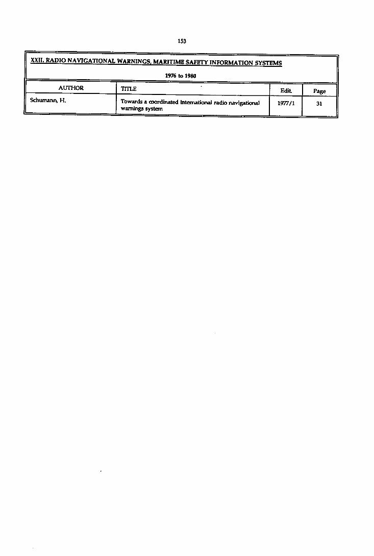
XXII. RADIO NAVIGATIONAL WARNINGS, MARITIME SAFETY INFORMATION CYQTFUQ
1976 to 1980
AUTHOR TITLE Edit PageSchumann, H. Towards a coordinated international radio navigational
warnings system1977/1 31

XXII. RADIO NAVIGATIONAL WARNINGS. MARITIME SAFETY INFORMATION SYSTEMS
19*5 to 1990
AUTHOR TITLE Edit. Page
BeU, J.CTM
SafetyNET - An INMARSAT Service for the Global Promulgation of Maritime Safety Information
1989/1 73
Hall, S.C. The Defense Mapping Agency's Navigation Information Network.
1989/1 61
Hearsey, R.E. Marine Safety Information 1988/1 81

XXIII. RADIOTELEGRAPHY AND PHONOTEIFMETRY
1923 to 1935
AUTHOR TITLE Edit. Page
Directional Wireless as an Aid to Navigation. (Radio Research Board, London)
1929/1 151
Direction Finding in Navigation 1928/2 193
(E) Directional Radio as an Aid to Marine Navigation. (U.S. Bureau of Standards)
1935/2 148
(R) Radio Beacons and Radiobeacon Navigation. (G.R. Putnam) Washington, 1931
1932/1 256
(R) Les Radiophares. (H. Blondel) Paris, 1930 1932/1 256
Errors of Radio Beams and of Radio Compasses. (Replies to Circular Letter N° 3-H of 1926, and bibliography)
1926/2 200
Protractor for use with Gnomonic Charts for Position Finding by Wireless Bearings
1928/1 275
Is it possible to transmit Cartographic Drawings by Telegraph?
1926/2 197
Transmission of Meteorological Charts by Radio in Europe
1927/1 225
(R) Note on the Standardisation of Radio Time-Signals. (G. Bigourdan) Paris, 1928
1929/1 171
(E) International Radiotelegraph Convention and General and Supplementary Regulations, Washington, 1927
1929/2 191
(R) The Orfordness Rotating Beacon and Marine Navigation. (Radio Research Board) London, 1931
1932/1 257
(E) A Cathode-Ray Direction Finder for Collision Prevention. (Radio Research Board) London, 1934
1934/2 165
(E) Marconi’s Wireless Pilot 1935/1 159
(E) A new Rotating Radio Beacon. (Radio Research in Japan)
1935/2 150
Results of the Tests made on the Loth Cable in the Harbour of CoruAa
1929/1 205
(R) Guidage Radio-électrique des Navires et des Aéronefs. (P. David) Paris, 1931
1932/1 258
(R) The Ship's Position by Three Radiobearings. (H. Maurer)
1930/1 245
(R) Direct Measurement of Distance from W/T Station by Electric Waves. (W. Burstyn) Berlin, 1929
1930/1 246
(E) Unterwasserschalltechnik - Submarine Akustik in Theorie und Praxis. (F. Aigner) Berlin, 1922
1929/2 226
(R) Experiment with reference to the Propagation of Submarine Sound-waves. (P. Marti) Paris, 1928
1932/1 183
Radio-acoustic method of Position Finding in Hydrographic Surveys. (U.S.C. & G. Survey)
1925/1 53

XXIII. RAninTEI.FCRAPHY AND PHONOTELEMETRY
1923 to 1935
AUTHOR TITLE Edit. Page
Nueva Navegadon Fisica 1928/1 276
(RJ Radio-acoustic Position Finding. (U.S.C. & G. Survey) Washington, 1928
1929/2 225
Sound-ranging Apparatus by the Cambridge Scientific Instrument Co. Ltd.
1929/2 215
(E) Survey of Georges Bank. (New appliances, portable RA.R. set)
1932/1 172
Chavanier, M.C. (E) Trials of Radiogoniométrie Pœition-finding in Indo- China
1933/1 174
Douglas, H.P. A method of obtaining Greenwich Mean Time by the use of Wireless Time Signals : Marconi Time Signal Receiver R.P. 11a
1929/2 155
H.B. The Deviometer. (U.SA.) 1931/1 198
Jolly, H. (E) Report on the Geodetic Application of Wireless Telegraphy
1931/1 227
P.V. (R) Analytisch-geometrische Untersuchungen über die Azimutgleiche in der Mercatorkarte. (W.Immler) Hamburg 1928
1929/1 245
Reinius, G. i t Collinder, P. On a Wireless Direction-finding Chart (Skagerrak- Kattegat) published by the Hydrographic Office of Sweden
1924/2 117
Richmond, T.J. Diagram for Position Finding by Long Distance Bearings and for finding the bearing of one point from another
1931/2 106
Richmond, T.J. Radio-acoustic Position Line 1929/1 119
Riddell, R.A. & Cowie, G.D. (E) Relating Magnetophone to Buoy Anchor on R.A.R. buoy and control Hydrography. (U.S.C. & G. Survey)
1932/2 248
Rude, G.T. Radio-acoustic Sound Ranging. (U.S.C. it G. Survey) 1932/2 71
Rude, G.T. (E) The Survey of Georges Bank (Radio-acoustic Ranging)
1932/2 238
S.C.A.M. Sound-ranging with reference to Ultra-sonic Parasitic Noises
1927/2 157
Schive, J. Graphical Computation of Great Circle Course and Rad» Bearings
1927/1 221
Shalowitz, A.L. (E) The Physical Basis of modem Hydrographical Surveying
1932/1 157
Smith-Rose, R.L. An automatic Recorder of Signals from a Rotating Beacon Transmitter
1932/2 236
Tonta, L. Submarine Phonotelemetry (I).A new radio-acoustic position line
1927/2 139
Tonta, L. Notes on Submarine Phonotelemetry (Sound-ranging) 1931/1 14
Tonta, L. Submarine Phonotelemetry. (Experiments carried out in U.SA.)
1928/2 189

XXIII. RADIOTELEGRAPHY AND PHONOTFI.EMFTBY
1923 to 1935
AUTHOR TITLE Edit. Page
Tonta, L. The Radio-acoustic Position by Three Time Intervals (its reduction to the problem of Snellius-Pothenot)
1929/1 111
Tonta, L. IcortL) Submarine Phonotelemetry (II). Accuracy of radio-acoustic position line
1928/1 91
Vanssay de Blavous, P. DE The Position at Sea by Radiogoniométrie Bearings taken on board. (Influence of the ellipsoid, use of Mercator's projection, Littrow’s projection, oblique perspective projection, polar stereographic projectioa - Curves of equal azimuth. - Bibliography)
1933/2 87
Vanssay de Blavous, P. DE rhe Position at Sea by Radiogoniométrie Bearings 1935/2 17
Vanssay de Blavous, P. DE Navigation by Great Circle Sailing and Radiogoniométrie Bearings. (Various systems of projection)
1928/2 39

YYllï. RAniOTEI.F.ORAPHY AND PHONOTELEMFTRY
1936 to 1941
AUTHOR TITLE Edit. Page
The Automatic Radio Compass 1937/2 245
Cowie, G.D. Sono-Radio Buoy 1937/2 261
Dorsey, Dr. H.C. (E) Radio Acoustic Ranging circuits 1938/2 140
Dorsey, Dr. H.G. Electromagnetic Hydrophones or "Magnetophones" 1939/2 153
Mcllwraith, C.G. The Sono-Radio Buoy 1937/2 258
Miyadi, M. (R) On variations in transit time of Wireless Signal on the Short Wave
1941/1 67
P.H. A novel use of short waves for navigation in foggy weather
1938/2 139
Rude, G.T. The Sono-Radio Buoy 1937/2 66
Rude, G.T. Radio Acoustic Ranging 1937/2 67
Senior, J. (E) Sono-Radio buoy 1938/2 141
Tucker, W.S. (E) Direction Finding by Sound 1937/1 141

XXIV. SEA BOUNDARIES AND ZONES. LAW OF THE SEA. LEGAL LlABIUTY, RESOURCE MANAGEMENT
1971 to 1976
AUTHOR TITLE Edit Page
Beazley, P.B. Territorial sea baselines 1971/1 143
Thamsborg, M. Hydrography as related to maritime boundary problems 1974/1 157
Thamsborg, M. Notes on hydrographic assistance to the solution of sea boundary problems
1971/2 149

XXIV. SEA BOUNDARIES AND ZONES. LAW OF THE SEA, LEGAL LIABILITY, RESOURCE MANAGEMENT
1977 to 1980
AUTHOR TITLE Edit. Page
Beazley, P.B. Half-effect applied to equidistance lines 1979/1 153
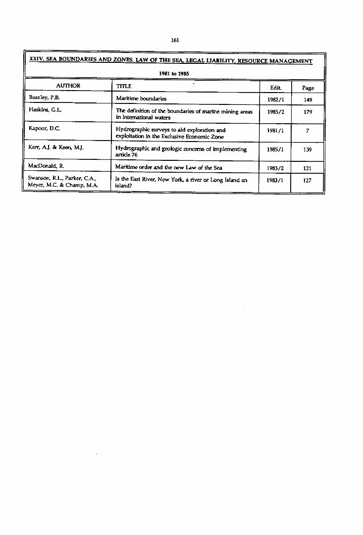
XXIV. SEA_BOUNDARIES AND ZONES. LAW OF THE SEA, LEGAL LIABIUTY, RESOURCE MANAGEMENT
1981 to 1985
AUTHOR TITLE Edit Page
Beazley, P.B. Maritime boundaries 1982/1 149
Haskins, G.L. The definition of the boundaries of marine mining areas in international waters
1985/2 179
Kapoor, D.C. Hydrographic surveys to aid exploration and exploitation in the Exclusive Economic Zone
1981/1 7
Kerr, A.J. & Keen, M.J. Hydrographic and geologic concerns of implementing article 76
1985/1 139
MacDonald, R. Maritime order and the new Law of the Sea 1983/2 121
Swanson, R.L., Parker, C A , Meyer, M.C. & Champ, M.A.
Is the East River, New York, a river or Long Island an island?
1983/1 127
------------------

XXIV. SEA BOUNDARIES AND ZONES. LAW OF THE SEA, LEGAL LIABILITY, RESOURCE MANAGEMENT
1986 to 1990
AUTHOR TITLE Edit. Page
Abbasi, I .A. Importance of Hydrography in Resource Exploration. 1989/1 135
Carrera, G. A method for the delimitation of an equidistant boundary between coastal States on the surface of a geodetic ellipsoid.
1987/1 147
Done, P. Aspects of Trinidadian marine boundary legislation 1987/2 115
Obloy, E.J. The liability of the electronic chartmaker for negligent charting.
1990/2 131
Ritchie, G.S. The role of the hydrographic surveyor in offshore exploration and exploitation.
1986/1 29
Siddiquie, H.N., Hashimi, N.H., Vora, K.H. & Pathak, M.C.
Exploration of the continental margins of India. 1987/1 91
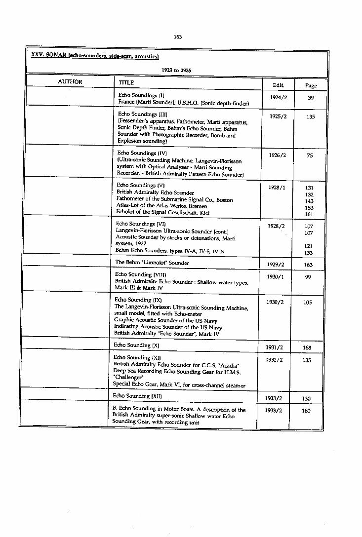
XXV. SONAR (edio-sounders, si de-scan, acoustics)
1923 to 1935
AUTHOR TITLE Edit Page
Echo Soundings (I)France (Marti Sounder); U.S.H.O. (Sonic depth-finder)
1924/2 39
Echo Soundings (III)(Fessenden's apparatus, Fathometer, Marti apparatus, Sonic Depth Finder, Behm's Echo Sounder, Behm Sounder with Photographic Recorder, Bomb and Explosion sounding)
1925/2 135
Echo Soundings (IV)(Ultra-sonic Sounding Machine, Langevin-Florisson system with Optical Analyser - Marti Sounding Recorder. - British Admiralty Pattern Echo Sounder)
1926/2 75
Echo Soundings (V)British Admiralty Echo Sounder Fathometer of the Submarine Signal Co., Boston Atlas-Lot of the Atlas-Werke, Bremen Echolot of the Signal Gesellschaft, Kiel
1928/1 131132 143 153 161
Echo Soundings (VI)Langevin-Florisson Ultra-sonic Sounder (cont.) Acoustic Sounder by stocks or detonations, Marti system, 1927Behm Echo Sounders, types IV-A, IV-S, IV-N
1928/2 107107
121133
The Behm "Limnolot” Sounder 1929/2 163
Echo Sounding (VIII)British Admiralty Echo Sounder : Shallow water types Mark III k Mark IV
1930/1 99
Echo Sounding (IX)The Langevin-Florisson Ultra-sonic Sounding Machine, small model, fitted with Echo-meter Graphic Acoustic Sounder of the US Navy Indicating Acoustic Sounder of the US Navy British Admiralty "Echo Sounder’, Mark IV
1930/2 105
Echo Sounding (X) 1931/2 168
Echo Sounding (XI)British Admiralty Echo Sounder for C.G.S. ’Acadia’ Deep Sea Recording Echo Sounding Gear for H.M.S. 'Challenger"Special Echo Gear, Mark VI, for cross-channel steamer
1932/2 135
Echo Sounding (XII) 1933/2 130
B. Echo Sounding in Motor Boats. A description of the British Admiralty super-sonic Shallow water Echo Sounding Gear, with recording unit
1933/2 160

XXV. SONAR fecho-sounders, side-scan, acoustics)
1923 to 1935
AUTHOR TITLE Edit. Page
Echo Sounding (XIII)Germany :Atlas-Echolot, types 20 & 22 (Atlas-Werke, Bremen)Atlas-EchographGreat Britain :British Admiralty Deep Water Echo Sounding Machine, Standard Pattern, Mark X. (Henry Hughes & Son, Ltd., London)British Admiralty Silent Super-Sonic Echo Sounder (various types)British Admiralty Boat Super-Sonic Shallow Water Echo Sounding Gear with magneto-striction transmitter France :Continuous Echo Sounder using Rifle-shots for Deep Water use. (S. Marti, Montbéliard, various types) Langevin-Florisson-Touly Sounder (S.C.A.M., Paris) Langevin-Florisson Sounder combined with Marti RecorderLangevin-Florisson Sounder with Echo meter Langevin-Florisson Sounder with Echo scope
1934 /2 25
26 29
31
36
38
3846
515859
Echo Sounding (XIV)The Dorsey Fathometer (U.S.C. & G. Survey) Hydrographic precision Soundings with the Marti Hammerblow sounder
1935/2 50
53
(R) Unterwasserschalltechnik - Submarine Akustik in Theorie und Praxis (F. Aigner), Berlin, 1922
1929/2 226
(R) The Transmission of Sound through Sea Water. (J.H. Service, Washington, 1928)
1929/2 228
(R) Measurement of salinity of Sea Water (J.H. Service, Washington, 1928)
1929/2 227
(R) Zvoukovoie Izmierenie Gloubin (Sonic Measurement of Depth). (K.S. Oukhov), Leningrad, 1927
1930/1 253
Velocity of Propagation of Sound through Sea Water 1925/2 183
Velocity of Propagation of Sound through Sea Water. (U.S.C. & Survey. Tables)
1925/1 69
(R) Tables of the Velocity of Sound in Pure Water and Sea Water for use in Echo Sounding and Sound Ranging. (British Admiralty Publication H.D. No. 282)
1928/1 277
Reduction of Echo-Soundings. (Slope correction - diagram by U.S.C. & G. Survey)
1928/1 164
Slope Corrections for Echo Soundings 1931/1 122
Bilbliography relating to Echo Sounding 1925/2 190
Bilbliography relating to Echo Sounding 1934/2 62
Bencker, H. Echo Sounding (II). Ultra Sound. Piezo electric quartz (Langevin)
1924/1 51
Collinder, Per Methods of Echo Sounding and the principal results obtained. (The most important echo sounding expeditions. The greatest depth in the Baltic)
1934 /2 63

XXV. SONAR fecho-sounders, side-scan, acoustics)
1923 to 1935
AUTHOR TITLE Edit. Page
Cowie, G.D. & Reed, T.B. (E) Determination of Velocity of Sound in sea water in Cape Cod Bay. (U.S.C. & G. Survey)
1932/2 251
Edgell, J.A. False Echoes in Deep Water 1935/1 19
Ennis, C.C. (E) Use of regional constant Correction factors for reduction of Echo Soundings - Carnegie Institution, Washington, 1933
1935/2 95
G.S.S. Echo Sounding : test carried out by the U.S.S. "Stewart", 20-29 June 1922
1923/1 71
H.B. (R) Correct Velocities for Echo Soundings in the Pacific Ocean. (U.S. Coast and Geodetic Survey Tables)
1927/1 229
Hayes, J.H. (Appendix - Depth Contour due to Gradient) 1933/2 154
Hayes, HLC. (E) Recent developments in Acoustical Depth-finding Apparatus
1927/2 205
Hayes, H.C. (E) Measuring Ocean Depths by Acoustic Methods. (USA : Angle of Reflection method. Standing Wave method. Echo method)
1924/1 93
Hayes, J.H. A. Report on sea trials of deep Water Echo Sounding Gear in H.M.S. "Challenger" and "Ormonde"
1933/2 130
J.D.N. Addendum - Slope Corrections for Echo Soundings 1933/2 181
Langevin, Prof. On the Ultra-Sonic Mirage 1931/1 140
Lübcke, E. The Velocity of Sound in Sea Water 1930/1 190
Marti, P. Determination of the Slope of the Sea Bottom by a Single Acoustic Sounding
1933/2 172
Marti, P. Note on Acoustic Sounding.History - General Conditions for the use of Sonic Soundings - A review of Existing Instruments - Discussion
1931/1 124
Maurer, H. The Soundings of the Exploring Vessel "meteor" and Nautical Science. (Correction of echo soundings)
1928/1 167
Maurer, Dr. H. Echo Sounding - VII (Correction to soundings) 1929/2 21
Nares, J.D. Echo Soundings. (Slope corrections for) 1933/1 38
P.V. (R) Die Echolotungen des "Meteor". (Dr. H. Maurer, Berlin, 1933. - List of soundings and profiles)
1934/1 138
P.V. Erratum - Slope Corrections for Echo Soundings 1933/2 180
Renqvist, H. (E) Bathymetric Chart of the Bothnian Bay and the North Kvark. Echo soundings in the years 1927-1929
1932/1 254
Rust, H. Multiple Echoes observed in sonic soundings on a Soft Bottom
1935/2 106
Schreiber, E. (E) The Echograph.(Self-recording echo sounder of the Elektroakustik G.m.b.H. of Kiel)
1933/1 178
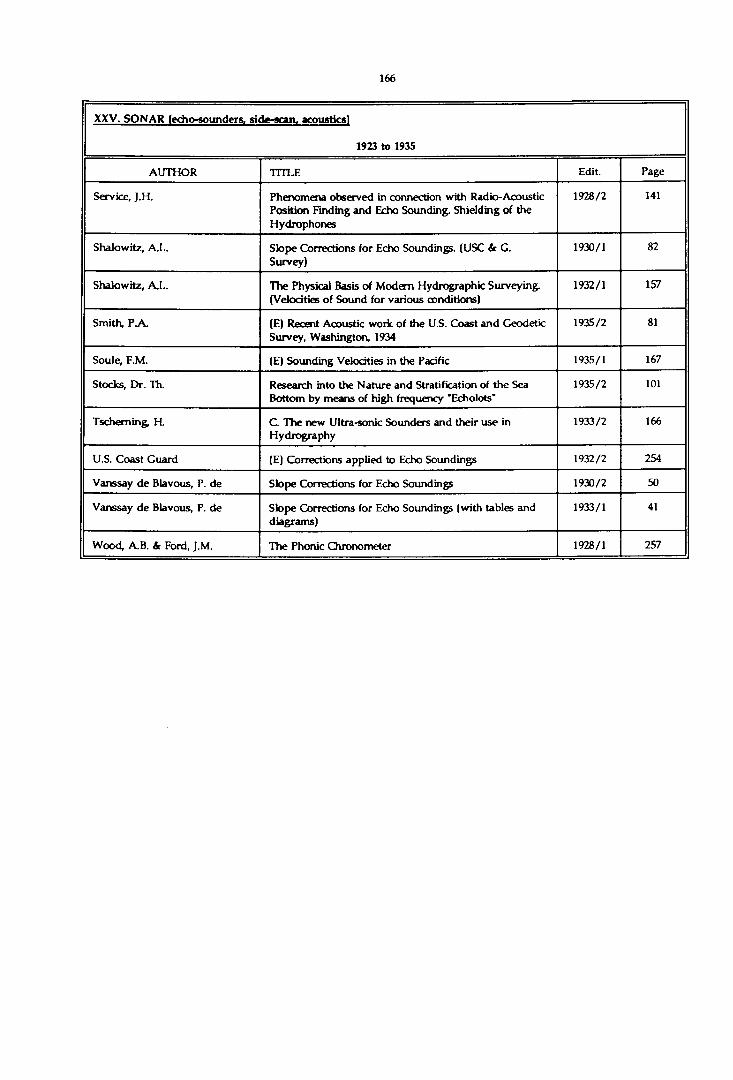
XXV. SONAR (echo-sounders, side-scan. acoustics)
1923 to 1935
AUTHOR TITLE Edit. Page
Service, J.H. Phenomena observed in connection with Radio-Acoustic Position Finding and Echo Sounding. Shielding of the Hydrophones
1928/2 141
Shalowitz, A.L. Slope Corrections for Echo Soundings. (USC & G. Survey)
1930/1 82
Shalowitz, A.L. The Physical Basis of Modem Hydrographic Surveying. (Velocities of Sound for various conditions)
1932/1 157
Smith, PA. (E) Recent Acoustic work of the U.S. Coast and Geodetic Survey, Washington, 1934
1935/2 81
Soule, F.M. (E) Sounding Velocities in the Pacific 1935/1 167
Stocks, Dr. Th. Research into the Nature and Stratification of the Sea Bottom by means of high frequency 'Echolots'
1935/2 101
Tscheming, R C. The new Ultra-sonic Sounders and their use in Hydrography
1933/2 166
U.S. Coast Guard (E) Corrections applied to Echo Soundings 1932/2 254
Vanssay de Blavous, P. de Slope Corrections for Echo Soundings 1930/2 50
Vanssay de Blavous, P. de Slope Corrections for Echo Soundings (with tables and diagrams)
1933/1 41
Wood, A.B. & Ford, J.M. The Phonic Chronometer 1928/1 257

XXV. SONAR (echo-sounders, side-sran( arnnstircj
1936 to 1941
AUTHOR TITLE Edit Page
The Florisson Scam altimeter for airplanes 1940/2 89
Dorsey, Dr. H.G. (E) The Submarine Signal C° Portable Depth Recorder 1941/1 62
Doughet & Pélissiei, L. Echo Soundings in the Southern Ocean 1939/2 17
Hayward, J.T. The Absolute Altimeter 1940/2 90
I.H.B. Echo Sounding (XVII)(Universal Echo Sounder (British Admiralty - Henry Hughes a Son Ltd.)
1937/2 211
I.H.B. Echo Sounding (XVIII)The new British Admiralty Recording Echo Sounders: Universal, M.S. XII, M.S. XV. - Some recent ultrasonic instruments : Scam-Touly, Langevin-Touly, Marconi, Lan gevin-Flo risson. - The Marconi Magneto-striction supersonic Echo Sounding Equipments. The Atlas Echolot, High Frequency Type
1938/2 26
I.H.B. Plotting and Publication of Echo Soundings. (Replies to Circular letter 8-H of 1934)
1937/1 87
I.H.B. Echo Sounding (XVI)Electrolytic Recorder, Langevin-Touly Type - Outboard Oscillators for British Admiralty Echo Sounding Apparatus)
1937/1 111
I.H.B. Insertion on Charts of Echo Soundings and the Calibration of Echo Sounding Machines. (Replies to Circular Letter 3-H of 1933)
1937/1 71
I.H.B. Echo Sounding devices presented by the Marconi Sounding Device Company during the IVth International Hydrographic Conference, Monaco, 1937. (Marconi Echometer, type 421, 424, 429, 439), Marconi magneto Striction Equipment, with Recorder)
1937/2 226
I.H.B. (E) A Magnetostridon Echo Depth Recorder 1936/2 87
I.H.B. Echo Sounding (XV) - New British Admiralty Recorder Echo Sounders : M.S. Ill, M.S. IV, M.S. X, MS, XII
1936/2 78
Kuwahara, S. Velocity of Sound in Sea-Water and Calculation of the Velocity for use in Sonic Sounding
1939/2 123
Kuwahara, S. (E) Corrction to the Echo-Depth for the density of water in the Pacific Ocean
1940/1 160
Macmillan, D.H. Echo Sounding in Harbour Hydrography 1939/2 110
Môckel, W. (E) Deep Sea Echo Soundings and their importance for Navigation
1939/1 117
Mortimer, C E it Worthington,E.B.
A new application of echo-sounding 1940/2 86
Oggioni, G. (E) Uhra-Sonic Waves 1937/2 207
Rude, G.T. The Dorsey Fathometer 1937/2 65

XXV. SONAR (echo-sounders, side-scan. acoustics)
1936 to 1941
AUTHOR TITLE Edit. Page
Sadahiro Matsuo Investigation of a direct reading depth meter for 'Pilotage' using a new ultrasonic sounding principle (Quasi 'Modulated Frequency' principle)
1938/1 33
Smook, J.M. (E) Deep Sea Electric Bomb 1936/2 140
Swainson, O.W. Velocity and Ray Paths of Sound Waves in sea water 1937/2 93
Tschemin& H. Recent Improvement in the Ultrasonic Echo Sounding apparatus (S.CA.M.)
1936/2 106

XXV. SONAR (echo-sounders, side-scan, acoustics)
1942 to 1970
AUTHOR TITLE Edit. Page
SRA Echo Sounding Equipment, Type PEK-2G 1948/1 42
The S.A.FA.R. Ultrasonic Echo-Sounding Instruments 1948/1 47
Ben dix Supersonic Depth Recorder 1948/1 51
The Marconi Magnetostriction Echo-Sounder 1948/2 96
SFR-Carpentier 476 Sounding Machine 1949/1 57
The Nil Ison Echo-Sounder 1949/1 68
Atlas Echo Sounders 1954/1 139
"An acoustic aid to sea bed survey" (W.D. Chesterman, P.R. Clynick & A H . Stride, (Review)
1961/2 113
Ahrens, E. Use of Horizontal Sounding for Wreck detection 1957/2 73
Alden, J.M. & Farrington, L.A. High Resolution Direct Graphic Recording of Underwater Sound
1962/1 125
Bialek, E.L. Adoption of New Sound Speed Equations by U.S. Naval Oceanographic Office
1964/2 73
Brookes & Gatehouse Ltd A miniature Echo Sounder for Inshore Navigation and Survey
1961/2 57
Brooks, M. Some trigonometric formulae for the interpretation of continuous seismic profiles
1970/2 65
Capurro, L.R.A. Velocity of Sound in Sea Water 1963/1 47
Chan, Y., Chesterman, & Matthews, H.R.
Acoustic surveys of the sea floor near Hong Kong 1967/1 35
Cohen, Ph. M. Directional Echo Sounding on Hydrographic Surveys 1959/1 29
Crease, )., Laughton, A.S. & Swallow, J.C.
The Significance of Precision Echo Sounding in the Deep Ocean
1964/2 63
Directorate of Hydr. and Nav. of Brazil
The Brazilian EB-4 Echo Sounding Machine (Ecobatimetro EB-4)
1953/1 143
Edo Corporation Edo Model 185 Depth Sounder 1953/2 157
Engelmann, I. Towed echosounders for parallel sounding 1967/2 7
Fahrentholz, S. Profile and Area Echograph for Surveying and Location of Obstacles in Waterways
1963/1 23
Gabier, M.J. Limits of Accuracy of Echo Soundings in Ocean Regions 1961/2 7
Gabier, H.M. On the Efficiency of Acoustic Waves in Echo Soundings of Fish Shoals
1951/1 122
German Hydrographic Institute Echo Sounding Apparatus 1948/1 44
Glenn, M.F. Introducing an operational multi-beam array sonar 1970/1 35
Green, G.K., Gibson, W.M. & Healy, H.J.
Innovations in Bar Checks 1950/2 162
Haines, R.G.
iSonar Equipment for shallow water survey and wreck location
1966/1 53

XXV. SONAR fecho-sounders, si de-scan, acoustics)
1942 to 1970
AUTHOR TITLE Edit. Page
Haines, R.G. Developments in Ultrasonic Instruments 1963/1 49
Haines, R.G. A gating system for deep water sounding 1966/1 43
Hashimoto, T. & Nishimura, M. Reliability of Bottom Topography obtained by Ultrasonic Echo Sounder
1959/1 43
Hashimoto, T., Maniwa, Y., Omoto, O. & Noda, H.
Echo Sounding of Frozen Lake from Surface of Ice 1963/2 31
Hashimoto, T., Maniwa, Y. & Kato, M.
Research on Telesounders (Wireless Remote Control Echo Sounding)
1965/2 59
Herdman, H.F.P. Directional Echo Sounding 1955/2 135
Hoffman, J. Hyperbolic Curves applied to Echo Sounding 1957/2 45
Hughes, A.J. Influence of Echo Sounding on Hydrography 1950/1 29
Hydr. Office of Japan Precise Echo Sounder for Shallow Water 1953/2 143
Jagodzinski, Z. Multiple Echoes in Echo Sounders and the Probability of Detection of Small Targets
1960/1 63
Kalle, K. Nomograms for the Graphic Determination of the Horizontal Velocity of Sound
1942 58
Kampa, E.M. & Boden, B.P. Submarine Illumination and the Twilight Movements of a Sonic Scattering Layer
1955/1 183
Kelvin & Hughes, Ltd The New Shallow Water Depth Indicator 1961/2 67
Kelvin & Hughes (Marine) Ltd Echo Sounders and Tide and Current Recorders. Insulated Water Bottle
1953/2 159
Krause, D.C. Interpretation of Echo Sounding Profiles 1962/1 65
Krause; D.C. & Kanaev, V.F. Narrow-beam echo-sounding in marine geomorphology 1970/1 23
Kunze, W. General Aspects of Application of Horizontal Echo Sounding. Method to Shipping
1957/2 63
Leenhardt, O. Developments in mud probing 1969/2 99
Leenhardt O. Suggestions for probing a soft mud bottom 1966/1 59
Leenhardt O. Analysis of continuous seismic profiles 1969/1 51
Lord, N.W. The Timing of Sound in the Ooean 1964/1 85
Malloy, R.J., Harbison, R.N. & Kearse, C.D.
U.S. Coast and Geodetic Survey Geological Echo Profiling Program
1964/1 37
Marconi, Co. Echo Sounding Apparatus: New Marconi "Graphette" Dry-Paper Recording Echometer
1955/1 211
Maul, G.A. Precise echo sounding in deep water 1970/2 93
Maul, G A & Bishop, J.C. Mean sounding velocity - A brief review 1970/2 85
Miyajima, J. Miniature Recording Echo Sounder 1963/1 39
Naval Hydr. Office of France Regulations Prescribed by the "Service Hydrographique" of the French Navy for the Carrying-out of Soundings to be used for Further Improvement of the Chart
1950/2 58
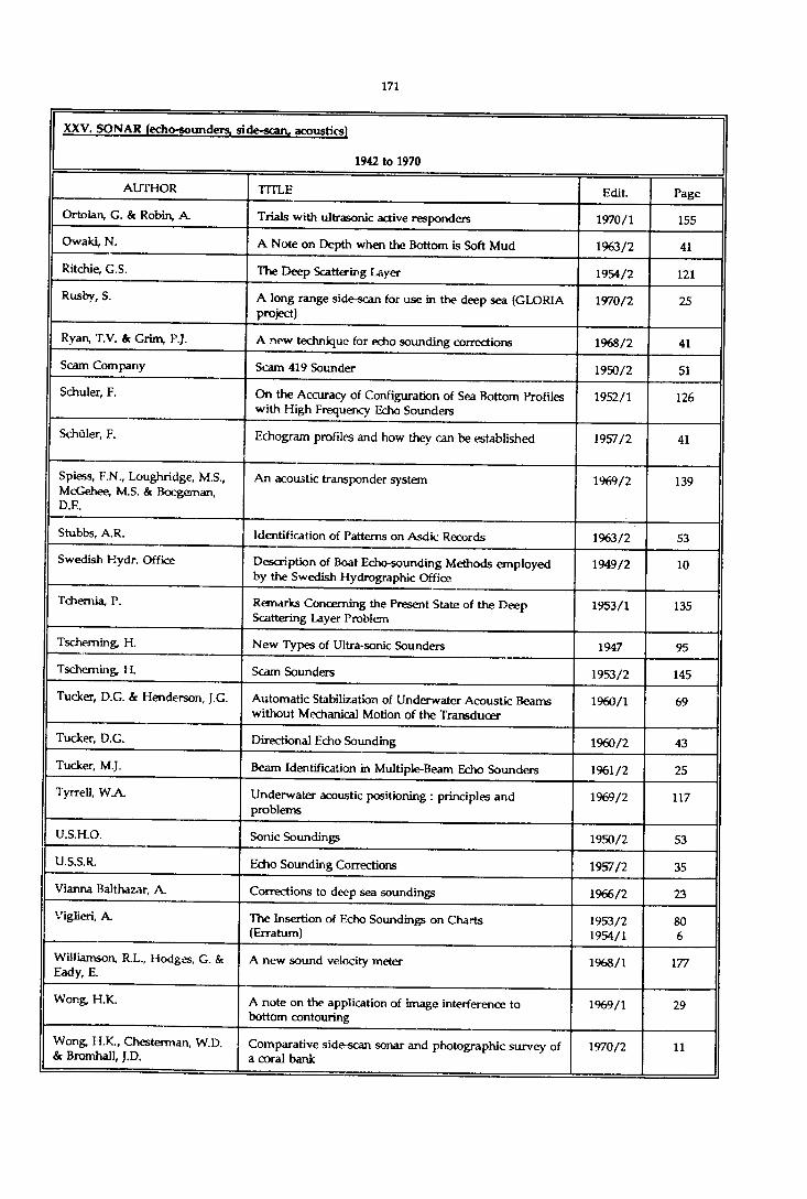
XXV. SONAR (echo-sounders, side-scan, acoustics)
1942 to 1970
AUTHOR TITLE Edit. Page
Ortolan, G. & Robin, A. Trials with ultrasonic active responders 1970/1 155
Owaki, N. A Note on Depth when the Bottom is Soft Mud 1963/2 41
Ritchie, G.S. The Deep Scattering Layer 1954/2 121
Rusby, S. A long range side-scan for use in the deep sea (GLORIA project)
1970/2 25
Ryan, T.V. Ac Grim, P.J. A new technique for echo sounding corrections 1968/2 41
Scam Company Scam 419 Sounder 1950/2 51
Schuler, F. On the Accuracy of Configuration of Sea Bottom Profiles with High Frequency Echo Sounders
1952/1 126
Schüler, F. Echogram profiles and how they can be established 1957/2 41
Spiess, F.N., Loughridge, M.S., McGehee, M.S. & Boegeman, D.E.
An acoustic transponder system 1969/2 139
Stubbs, A.R. Identification of Patterns on Asdic Records 1963/2 53
Swedish Hydr. Office Description of Boat Echo-sounding Methods employed by the Swedish Hydrographic Office
1949/2 10
Tchemia, P. Remarks Concerning the Present State of the Deep Scattering Layer Problem
1953/1 135
Tscheming, H. New Types of Ultra-sonic Sounders 1947 95
Tscheming, H. Scam Sounders 1953/2 145
Tucker, D.G. & Henderson, J.G. Automatic Stabilization of Underwater Acoustic Beams without Mechanical Motion of the Transducer
1960/1 69
Tucker, D.G. Directional Echo Sounding 1960/2 43
Tucker, M.J. Beam Identification in Multiple-Beam Echo Sounders 1961/2 25
Tyrrell, W A Underwater acoustic positioning : principles and problems
1969/2 117
U.S.H.O. Sonic Soundings 1950/2 53
U.S.S.R. Echo Sounding Corrections 1957/2 35
Vianna Balthazar, A. Corrections to deep sea soundings 1966/2 23
Viglieri, A. The Insertion of Echo Soundings on Charts (Erratum)
1953/21954/1
806
Williamson, R.L., Hodges, G. & Eady, E.
A new sound velocity meter 1968/1 177
Wong, H.K. A note on the application of image interference to bottom contouring
1969/1 29
Wong, H.K., Chesterman, W.D. & Bromhall, J.D.
Comparative side-scan sonar and photographic survey of a coral bank
1970/2 11

XXV. SONAR [echo-sounders, si de-scan, acoustics)
1971 to 1976
AUTHOR TITLE Edit. Page
Berkson, J.M. & Clay, C.S. Transformation of side-scan sonar records to a linear display
1973/2 55
Bryant, R.S. Side scan sonar for hydrography - an evaluation by the Canadian Hydrographic Service
1975/1 43
Burke, R. & Robson, J. An evaluation of the Bo'sun multibeam sonar system 1975/2 53
Calder, M. Calibration of echo sounders for offshore sounding using temperature and depth
1975/2 13
Engelmann, I. The new Danish DK/SON-1 echosounding and data processing system
1973/1 25
Flemming, B.W. Side-scan sonar : a practical guide 1976/1 65
Greenberg, D.A. & Sweers, H.E. Possible improvements to Matthews' Tables in areas of Canadian data holdings
1972/1 127
Grim, P.J., Keller, G.H. & Barday, R.J.
Computer produced profiles of microtopography as a supplement to contour maps
1972/1 81
Haslam, D.W. Telesounding - a reply (Letter to the Editor) 1975/1 153
Hopkins, J.C. Tape recording of side scanning sonar signals 1972/1 59
Hopkins, J.C. A note on methods of producing corrected side scan sonar displays
1972/2 99
Jollymore, P.G. A portable digital sounding system for Arctic use (Erratum)
1971/21972/1
35165
Kumm, W.H. What's going on down there ? 1974/2 71
Leenhardt, O. Side scanning sonar - A theoretical study 1974/1 61
MacPhee, S.B. Developments in narrow beam echo sounders 1976/1 43
Russel, I.C. Precision hydrographic surveys in the North Sea - Location of wrecks and obstructions
1972/1 15
Ryan, T.V. The Matthews Tables - 35 years later 1974/2 23
Sherwood, R. The use of a computer for correction of ocean soundings 1974/2 37
Stubbs, A.R., McCartney, B.S. & Legg, J.C.
Telesounding, a method of wide swathe depthmeasurement(Errata)
1974/1
1974/2
23
161
Ulonska, A. A more accurate hydrographic survey by direct measurement of sound velocity in the sea
1972/1 71
Weeks, CG.McQ. The use of a dual frequency echo sounder in sounding an irregular bottom
1971/2 43
Wentzell, H. The Atlas bottom mapping recorder for gapless surveying of inshore waterways
1975/2 133

XXV. SONAR (echo-sounders, side-scan, acoustics)
1977 to 1980
AUTHOR TITLE Edit. Page
Bailey, R.T. Sound velocity corrections for the N o r* Sea surveyor 1978/1 123
Gobey, C.S. The Kelvin-Hughes MS-48 echosounder and digitiser - Evaluation by the U.K. Hydrographic Department
1977/2 29
Mageau, C. Captain Cook and the crumpled echogram 1979/1 107
Renard, V. & Allenou, J.P. Sea Beam, multi-beam echosounding in "Jean Charcot’ : description, evaluation and first results
1979/1 35
Russel, l.C. Dual channel si descan sonar - its uses and operation in hydrographic surveying
1978/1 27

XXV. SONAR (echo-sounders, si de-scan, acoustics)
1981 to 1985
AUTHOR TITLE Edit. Page
Fraser, F.L. International cooperation in hydrography and modem techniques in hydrographic surveying
1984/2 7
Huff, L.C. A study of future depth recorder requirements 1981/2 33
Kok>uch, D. Interferometric side-scan sonar - A topographic sea-floor mapping system
1984/2 35
Laughton, A.S. The first decade of 'GLORIA' 1983/1 13
McCaffrey, E.K. A review of the bathymetric swath survey system 1981/1 19
Steenstrup, P.R. Considerations in the design, installation and operation of a complete sounding system
1984/2 51

XXV. SONAR fecho-sounders, side-scan, acoustic*)
1985 to 1990
AUTHOR TITLE Edit Page
Humphrey, P.B. Project SWATHMAP : Military sonars in service to science.
1987/2 53
Zheng, G. The formulation of echo sounding correction tables 1990/1 61

XXVI. SURVEYING VESSELS
1923 to 1935
AUTHOR TITLE Edit. Page
The Surveying Vessels of the French Navy 1925/2 193
The French Oceanographic Vessel "Président Théodore Tissier"
1934 /2 18
The Surveying Vessels of the Royal British Navy 1925/1 66
The British Royal research Ship "Discovery II" 1930/1 194
H.M. Surveying Ship "Challenger’ 1931/2 187
The new Motor Surveying Vessel for Uruguay 1931/2 186
The German Surveying Vessels 1929/1 9
The Surveying Vessels of the USA 1928/1 53
The Survey ship "Hydrographer" (U.S. Coast and Geodetic Survey)
1928/2 25
The Research Vessel "Misago-Maru" 1934/1 16
The Surveying Vessels of the Siamese Navy 1928/1 61
The Surveying Vessels of the Chinese Navy 1928/1 65
The Surveying Vessels of the Japanese Navy 1928/1 54
The Woods Hole Oceanographic Institution Research Vessel "Atlantis"
1932/1 1%
The Survey ship "Hydrographer" (U.S. Coast and Geodetic Survey)
1931/2 186
Surveying Ships (continuedj (U.S. Coast and Geodetic Survey) "Explorer"
1939/1 10
Note on the French Surveying Vessel "Amiral Mouchez" 1939/2 15
H.M. Surveying Ship "Franklin" 1939/1 23
The R.R.S. "Research" 1938/2 7
The Brazilian Surveying Vessel "Jacequay" 1937/2 21
The Motor Vessel 'E. Lester Jones" 1941/1 12
The New Ship "Explorer" of the Coast and Geodetic Survey of the U.S.A.
1941/1 11
Canadian Hydrographic Service New Spanish Surveying Vessel "Tofifto" (and tenders "Castor & Pollux"
1934/1 12
Canadian Hydrographic Service The Polish Surveying Ship, O.R.P. "Mewa" 1933/2 11
Canadian Hydrographic Service The C.G.S. "Wm J. Stewart", Hydrographic Survey Steamer
1933/1 17
Canadian Hydrographie Service The Polish Surveying Ship, O.R.P. "Mewa" 1934/1 17
Canadian Hydrographic Service The Danish Surveying Vessel "Hejmdal" 1935/2 10
Canadian Hydrographic Service Surveying Vessels (Norway, Australia, Greece) 1934/2 16
Rarbeno, G. Boats for Surveying Vessels 1928/2 33
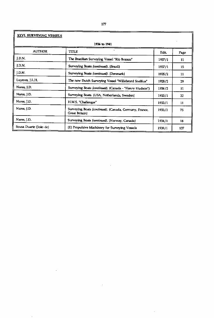
XXVI. SURVEYING VESSELS
1936 to 1941
AUTHOR TITLE Edit Page
J.D.N. The Brazilian Surveying Vessel "Rio Branco" 1937/1 11J.D.N. Surveying Boats (continued). (Brazil) 1937/1 15J.D.N. Surveying Boats (continued). (Denmark) 1935/2 11Luymes, J.L.H. The new Dutch Surveying Vessel 'Willebrord Snellius" 1928/2 29Nares, J.D. Surveying Boats (continued). (Canada - "Henry Hudson") 1936/2 11Nares, J.D. Surveying Boats. (USA, Netherlands, Sweden) 1933/1 22Nares, J.D. H.M.S. "Challenger" 1933/1 11Nares, J.D. Surveying Boats (continued). (Canada, Germany, France,
Great Britain)1933/2 75
Nares, J.D. Surveying Boats (continued). (Norway, Canada) 1934/1 18Sousa Duarte (Joéo de) (E) Propulsive Machinery for Surveying Vessels 1939/1 137

XXVI. SURVEYING VESSELS
1942 to 1970
AUTHOR TITLE Edit. Page
The Portuguese Surveying Vessel "D. Joao de Castro" 1942 6
The Brazilian Surveying Ship "Itacurussa" 1944 9
R.N. Surveying Ships and Boats (Great Britain) 1948/1 99
Danish Surveying Vessel "Freja" 1948/1 103
List of Chinese Hydrographic Surveying Vessels and Boats in operation (1947)
1948/1 104
Swedish Surveying Vessels and Boats 1948/1 105
The Portuguese Surveying Vessel 'Alimrante Lacerda" 1948/2 145
Survey vessels of the German Hydrographic Institute 1948/2 146
New Floating Equipment for Belgian Hydrographic Services
1949/2 171
"Challenger", The Life of a Survey Ship (G.S. Ritchie), London, 1957 [Review]
1958/2 154
Anais Hidrograficos New Brazilian Survey Vessels 1958/1 9
British Hydr. Dept New Inshore Survey Craft H.M.S. "Echo" 1960/1 39
British Hydr. Dept New Photographs of RM . Surveying Ship "Vidal" and the new 29 ft. Surveying Motorboat, etc
1954/2 facing164
British Hydr. Dept The New British Surveying Ship H.M.S. "Vidal" 1952/2 128
British Hydr. Dept New Photos of H.M.S. "Vidal" 1954/2 5
Canadian Hydrog. Service New Ocean-Charting Ships 1950/1 146
Capurro, L.R.A. Argentine Oceanographic Vessel "General San Martin" 1956/1 203
Danish Hydr. Office Danish Survey Launches 1960/2 25
Davies, R.M. Australian Oceanographic Frigates 1962/2 35
Engelsen, I. Oceanographic research Vessel "H.U. Sverdrup" 1962/2 29
Ekblom, R.T.J. Wheelhouse design in hydrographic launches 1969/1 141
Fagerhobn, P.O. "Gustav Af Klint" a New Old Swedish Survey Ship 1964/2 23
Frome, H.W. U.S. Coast and Geodetic Survey ships "McArthur" and "Davidson"
1968/2 7
French Hydrograph. The French Surveying Dispatch Vessels "Lapérouse" and "Beautemps-Beaupré"
1948/1 98
Giminez, L.M. Argentine Surveying Vessels 1951/1 132
Herdman, H.F.P. A New British Research Ship 1962/2 25
Hydr. Office Portugal Survey Vessel "Salvador Correia" of the Portuguese Oceanographic Research Service
1963/1 7
Hydr. Inst, of the Italian Navy New Italian Surveying Vessel "Staffetta" 1954/1 149
Hydr. Office of Japan Specifications of Japanese Surveying Vessels 1951/1 134

XXVI. SURVEYING VESSET-S
1942 to 1970
AUTHOR TITLE Edit. Page
Hydr. Office of Japan New Japanese Research Ship Tansei Maru" 1965/1 7
Hydr. Office of Norway Norwegian Surveying Vessel "Sjôvem" 1950/1 151
Hydr. Inst of the Spanish Navy Spanish Surveying Vessel 'Juan de la Cosa' 1950/1 148
Hydr. Office of Japan Japanese Surveying Vessels 'Daiichi Tenkai-Maru' and "Daiyon Kaiyo-Mam'
1952/2 128/129
Hydr. Inst, of the Spanish Navy Twin Auxiliary Surveying Ships, "H-2' and 'H-3' 1953/1 177
Karo, H A The New "Surveyor" 1961/1 27Knox, R.W. The U.S. Coast and Geodetic Survey Surveying Ships 1948/1 96
Mallory, J.K. The South African naval Hydrographic Surveying Ship 'Natal"
1960/2 29
Mathisson, J.C. U.S. Coast & Geodetic Survey Ships "Peirce" and "Whiting"
1964/1 17
Netherlands' Navy Hyd Dept. Survey Vessels of the Royal Netherlands Navy 1952/2 126Poulet The Hydrographic Auxiliary Vessels 'Astrolabe' and
"Boussole”1965/1 15
Ravina y Poggio, R Hydrographic Survey Launches of the Spanish Hydrographic Institute
1962/2 45
Rogalia, E.H. A New German fisheries Research Vessel 1965/2 13
Sieber, A. The Surveying and Research Ship "Gauss' of the German Hydrographic Institute
1951/1 137
U.S.H.O. Survey Vessels of the USA Navy 1950/2 174
Watanabe, R.T.J. A device with outriggers for increasing sounding width 1969/1 131

XXVI. SURVEYING VESSELS
1971 to 1976
AUTHOR TITLE Edit Page
The new Italian hydrographic ship "Ammiraglio Magnaghi' (photo only)
1976/1 Frontispie
ce
Anders in, J.J. The Finnish survey vessel "Airisto’ 1976/1 33
Antonides, L.J. Sc Kreffer, J.C. The new Netherlands hydrographic vessels "Buyskes and "Blommendal"
1975/2 71
Burton, B.W. Sc Duhaut, J. Progress with air photography from helicopters for hydrographic work
1975/2 37
Cercas Diaz, D.L. New Spanish Hydrographic Ships 1976/1 27
Mackay, J.M. Automation of hydrographic surveying 1972/2 149
Os bom, J.H.S. New hydrographic vessel - HMAS "Flinders" 1973/2 33
Walters, J.C New South African Survey Vessel : SAS "Protea" 1972/2 7

XXVI. SURVEYING VESSELS
1977 to 1980
AUTHOR TITLE Edit. Page
The new Netherlands hydrographic/Oceanographic ship "Ty deman*
1977/2 Frontispie
ce
The new Greek survey ship 'Naftilos' 1978/1 Frontispie
ce
The new Nigerian survey ship ’Lana' 1978/1 Frontispie
ce
Abelleyra, J.I. de New Argentine oceanographic vessel 'Puerto Deseado' 1979/2 23
Dyde, B.S. & Uhlig, S.J. Appraising the case for a hydrographic survey vessel : the planner's viewpoint
1980/1 87
Goh, S.C. K.D. 'Mutiara* - the new survey ship of the Royal Malaysian Navy
1980/1 15
Sciotti, J.L. Argentina's new hydrographic vessel "Comodoro Rivadavia"
1979/1 7

XXVI. SURVEYING VESSELS
1981 to 1985
AUTHOR TITLE Edit. Page
Bashforth, R.L. 9-metre survey motor boats of the Hydrographic Service of the Royal Navy
1981/1 13
Dongen, F.A van The 'Mitra", a new survey vessel for the North Sea 1985/1 31
Holden, G.J. Hydrographic survey catamaran for the port of Liverpool
1982/2 21
Indian Hydrogr. Office "Sandhayak" class - A new class of Indian Surveying Ships
1984/1 43
Kilt, J.M. 19.9 metre survey launch of the Danish Administration of Navigation and Hydrography
1982/1 19
Nakanishi, A New Japanese survey vessel "Takuyo" 1985/2 51
Sims, D.H. Performance evaluation of high speed survey boat "RodolT
1982/2 31

XXVI. SURVEYING VESSELS
1985 to 1990
AUTHOR TITLE Edit Page
Barr, P. CSS Acadia. - 75 years of service 1987/2 15
Belgian Ministry of Public Works & Eurosense
BEASAC - A survey hovercraft for observing the beaches and offshore areas near the Belgian coast.
1989/1 53
Chimot, J.M. Class 2 survey vessels (BH2) of the "Lapérouse’ type. 1989/1 27
Dyberg, U. HSwMS Johan Nordenankar. - A Swedish hydrographic survey ship.
1986/1 77
Fiadeiro, P; & Silva Ribeiro, A. New survey vessels for the Portuguese Navy. 1989/1 45Frithz, H. Hydrographic survey bar sweeper for the Swedish
Hydrographic Office - HSwMS Nils StrOmcrona.1986/2 41
German Hydrographic Institute Survey, wreck search and research vessel Atair. 1988/2 17
Huggett, W.S. CSS John P. Tully. - A hydrographic and geophysical research vessel.
1986/2 31
Kerr, A.J., Adams, A.L. & Burke, R.G.
CSS FCG Smith. - Hydrographic acoustic sweep vessel 1987/2 7
Leech, J. New survey motor launches for the Royal Australian Navy.
1989/1 19
Schiffner, S. Survey ship Carl Fr. Gauss. 1989/2 7
U.K. Hydrographic Department HMS Roebuck. - The ship and her systems 1988/1 21
Van Cauwenberghe, C. The Ter Streep, a new survey vessel for the Belgian conshelf.
1987/1 15

XXVII. THE ELECTRONIC CHART AND INFORMATION SYSTEMS - Monograph 1990
AUTHOR TITLE Edition Page
Astle, H. & Van Opstal, l.H. ECMAN - A standard database management system for electronic chart display and information systems (ECDIS)
1990/2 101
Eaton, R.M., Astle, H., Glavin, S.J., Grant, S.T., Masry, S.E. & Shaw, B.W.
Learning from an Electronic Chart Testbed 1990/2 31
Grant, S,Casey, M., Evangelatos, T. Hecht, H.
The management and dissemination of electronic navigational chart data in the 1990's
1990/2 17
Guo Xin ECDIS development in China 1990/2 55
Kaufmann, R. & Glavin, S.J. General guidelines for the use of colour on electronic charts
1990/2 87
Kerr, A. J. Status report on activities of IMO and IHO concerning the electronic chart
1990/2 7
Lanziner, H. Michelson, D., Lachance, S. & Williams, D.
Experiences with a commercial ECDIS 1990/2 69
Norwegian Hydrographic Service
Abstract of questionnaire on ECDIS from "The North Sea Project - A test project for the Electronic Navigational Chart - Experiences and conclusions"
1990/2 45
Sandvik, R. Updating the electronic chart - The SEATRANS Project 1990/2 59

XXVIII. TIDES AND CURRENTS
1923 to 1935
AUTHOR TITLE Edit. Page
(R) Marés e Problemas Correlatives. (A, Lem os) Rio de Janeiro, 1928
1929/2 233
(R) Tides and Currents in Portsmouth Harbor, N.H. 1929/2 232
(R) Considerazioni teorico-sperimentali sul regime del le maree del Mare Adriatico. (M. Tenani) Roma, 1929
1930/1 241
(R) Le problème de la Marée de l'Euripe. (D. Egjnitis) Athens, 1930
1932/1 247
(R) Die Gezeiten-Erscheinungen der Jade. (M. Blum) Berlin, 1931
1932/1 248
(R) Historical review of Dynamical Explanations of Tides. (S.F. Grace - Association of Physical Oceanogrpahy) Helsingfors, 1931
1934/1 142
Tides : Harmonic Analysis. (Request for information. - Circular Letter N°30 of 1922)
1923/1 70
Harmonic Analysis of Tides. (Replies to Circular Letter No. 30 of 1922)
1924/1 39
(R) The Analysis of Tidal Observations. (AT. Doodson) Liverpool, 1928
1929/1 241
(R) Instructions for Tide Observations. (U.S. Coast and Geodetic Survey)
1928/2 239
(R) British Admiralty Tide Tables, 1927, and Instructions for Analysing Tidal Observations
1929/1 242
Harmonic Analysis of Tides. Names of stations for which the International Hydrographic Bureau has published or will publish slips containing constants
1932/1 99
(R) Guida practica per l’analisi armonica delle maree. (Venice, 1926)
1932/1 249
(E) Tide-Gauge Observations in France (1932) 1935/2 110
(R) Resultater af Vanstands-Observationer paa den Norske Kyst, Heft VI, Oslo 1904
1926/2 209
United States of America - Tide Stations where three or more years of observations have been obtained (1927)
1929/1 211
Genera] Repertory of Tidal Authorities and Tidal Records. (Norway, Sweden, Denmark, Netherlands, France, Spain, Egypt, India, Netherland East Indies, Siam, Japan) with 9 charts indicating the position of tide recording stations for Netherland East Indies and Japan
1932/1 55
General Repertory of Tidal Authorities and Tidal Records (conf.) (Canada, U.S.A. Australia)
1932/2 160
General Repertory of Tidal Authorities and Tidal Records (conf.) (Portugal, Azores, Portuguese Colonies)
1933/1 136
General Repertory of Tidal Authorities and Tidal Records (conf.) (Poland)
1934/1 104
(E) Currents along the coast of Indo-China 1931/1 268

XXVIII. TIDES AND CURRENTS
1923 to 1935
AUTHOR TITLE Edit. Page
General Repertory of Tidal Authorities and Tidal Records (cont) {Belgium, Yugoslavia, Greeœ, Chile, Suez Canal Co.)
1935/2 31
(R) Tidal Datum Planes. (HA. Manner) Washington, 1927
1929/2 230
(R) Chart Datums. (HA. Manner) Washington, 1930 1932/1 246
(R) A Study of the Variation of Mean Sea Level from a level surface. (H.G. Avers) Washington, 1927
1929/2 217
(R) Mean Sea Level Determination from short series of Tide Observations. (G.T. Rude) Washington, 1927
1929/2 232
(R) On the existence of a Sub-surface Tide in the Western Mediterranean. (F.M. Navarro) Monaco, 1934
1935/1 172
(R) Interne Gezeiten-Wellen. (O.Pettersson) Copenhagen, 1933
1935/1 172
(E) The portable Automatic Tide-gauge of the U.S.C. & G.S.
1926/2 210
A Mechanical Synthetizer by Eisenhour (U.S.A.) 1928/1 271
A Water-level Gauge of the Long-distance Recording type
1929/1 235
Measurement of Difference of Height by Tide-gauge 1932/1 125
A brief history of Tidal Work in India and the Indian Tide Tables
1932/1 122
(R) Eighth Annua] Report of the Tidal Institute of Liverpool. (1927)
1928/1 283
(R) Ninth Annual Report of the Tidal Institute of Liverpool. (1928)
1929/1 240
(R) Annali Idrologid, 1927, Venice 1930/1 251
(R) Annales de la Commission pour l’Etude des Raz de Marée, N°l, Paris, 1931
1932/1 240
(R) Zapiski po Gidrografi, Volume LXVI. (Tides at the entrance of the White Sea - Currents of the Caspian Sea)
1932/1 252
(R) The Liverpool Observatory and Tidal Institute 1934/1 108
(R) Bibliography on Tides, 1910-1927 (J. Proudman) Venice, 1929
1930/1 261
(R) Instructions for reducing and analysing Tidal Stream Observations. (H.D. Warburg) London, 1929
1930/1 260
(E) Currents along the coast of Indo-China 1931/1 268
(R) Surface Currents in the North Sea. (J.B. Tait) Aberdeen, 1931
1933/2 236
(R) The development of our conception of the Gulf Stream System. (C. O'D Iselin, Woods Hole Institution)
1934/1 140

XXVIII. TIDES AND CURRENTS
1923 to 193S
AUTHOR TITLE Edit. Page
(E) The Water Circulation of the North Atlantic 1934/2 174
(E) Currents of the North Sea 1935/1 173
(R) Aggregation of Stationary Current Overfalls in the waters of North-West Africa. (E. Rômer) Berlin, 1935
1935/1 175
On a new Repeating Current Meter. (Ekman, modified) 1927/2 207
Two new Recording Current Meters. (Prof. Sverdrup) Copenhagen
1927/2 208
The Alfred Merz Apparatus for measuring the Flow of strong and Weak Currents
1929/1 157
Buchanan-Wollaston Recording Current-meter 1929/1 231
Current Meter, Dr. Rauschelhach design, Ozean I 1930/1 115
(E) Note on a new Idrac apparatus for recording the Speed and Direction of Submarine Currents at great depths
1930/1 238
(E) A new Current Measuring Instrument : The Carruthers Drift Indicator (new improved model)
1931/1 271
The Mitchell Current Meter 1934/1 144
Tidal Currents. Replies to Circular Letter N°2 H of 1933 : Observations, apparatus, analysis, tables, publication of results : Great Britain, Poland, Egypt, Germany, Norway, Netherlands, Netherland East Indies, Denmark, France, Italy, U.S.A., Japan, Chile, Argentina, Brazil, Siam, Australia, Monaco, Portugal, Spain, Sweden
1934/2 97
Bencker, H. A Study of the Tide Tables published by the different Nations
1929/1 127
Borden, F.S. (E) Measuring strong Currents in comparatively Deep Water. (U.S.C. & G. Survey)
1931/1 269
Brooks, Ch.F. & Fitton, E.M. (E) Weekly succession of Gulf Stream temperatures in the Straits of Florida
1931/1 269
Carruthers, J.N. A "Vertical Log" Current-Meter 1935/2 62
Carruthers, J.N. (E) Further investigations upon the Water Movements in the English Channel - Drift Bottle experiments in the summers of 1927, 1928 and 1929 with critical notes on Drift-Bottle Experiments in general
1931/1 254
Carruthers, J.N. (E) The Flow of Water through the Straits of Dover as gauged by continuous Current Meter Observations at the Vame Light Vessel
1929/1 193
Chandon, E. (R) Tidal research in the Red Sea and the Gulf of Suez 1930/2 176
Cline, I.M. (E) Tides and Coastal Currents developed by Tropical Cyclones. (U.S. Weather Bureau)
1934/1 140
Corkan, R.H. (E) An annual pertubation in the Range of Tide 1934/2 182
Courtier, A. Données numériques concernant les marées des côtes de France
1935/1 171

XXVIII. TIDES AND CURRENTS
1923 to 1935
AUTHOR TITLE Edit. Page
Courtier, A. Note on the modification of Mean Sea Level under the action of Currents
1933/2 124
Courtier, A. Note on a method for a Rough Prediction of Diurnal Tides
1933/2 116
Crestani, G. Floats used in Italy for the study of Surface Currents of the Ocean
1931/1 185
Ekman, V.W. An improved type of Current Meter. (Copenhagen) 1932/2 228
Fichot, E (R) A study of the Theory of Tides. (Shimesu Miyahara) Tôkyô, 1932
1933/1 76
H.B. (R) The How of Water through the Straits of Dover as gauged by continuous Current-Meter Observations at the Vame Light-vesseL Part II - Second Report on the results obtained. (J.N. Camithers) London, 1935
1935/2 145
H.B. The Tide Calculator of Commander R.A. Vago, Buenos- Aires
1932/1 236
Haight, F.J. Unusual Tidal Movements in the Sulu Sea 1929/1 163
Hooykaas, J.C.F. (R) Current Tables, Straits of Malacca and Java Sea, 1935 1935/2 147
Idrac, P. New Speed and Direction Recorder for Submarine Currents. (Idrac systm)
1928/2 155
Idrac, P. Idrac apparatus for measuring Vertical Submarine Currents
1935/1 158
Japanese Hydrographic Department
Report on Oceanic Surveys in the Western part of the North pacific carried out by H.I.J.M.S. Mansyu from April 1925 to March 1928
1932/2 128
Kirkpatrick, R.Z. Panama Tidal Differences 1932/2 266
Kisindo, S. Methods of Ocean Current Observations now used by the Hydrographic Department, Tôkyô, and some Results obtained to date
1934/1 81
Kjaer, R. & Fjeldstad, J.E Tidal Observations in the Arctic 1934/1 89
Kuhlmann, F. The Kuhlmann Submarine or High-Sea Tide-gauge, Wilhelms haven
1927/2 169
Kuribayasi, K. k Sanematu, Y. On a method of Observing Tides in the open sea where it is possible to anchor
1933/1 64
Lallemand, Ch. & Prévôt, E (E) Long-period Variations of the Mean Sea Level on the French Coast
1929/2 199
Luymes, J.L.H. Tidal information for Mixed Tides and a comparison of two methods for a Rough Prediction of Diurnal Tides
1933/1 29
Luymes, J.L.H. International Low Water 1926/2 61
M armer, H.A. The Greatest Daily Tide 1934/2 183
Manner, H.A. On Cotidal Maps 1928/2 195
Manner, H.A. (E) The importance of Tide Observations. (American Geophysical Union)
1934/1 141

XXVIII. TIDES AND CURRENTS
1923 to 1935
AUTHOR TITLE Edit Page
M armer, H.A. Tidal Characteristics from Harmonic Constants 1931/2 81
M armer, H.A. (E) Panama Tides 1931/1 270
Marmer, H.A. Hydrographic Datum Planes 1929/1 37
Manner, H.A. (E) Mean Sea Level and Half-tide Level 1933/1 161
Marmer, H.A. Tidal Phenomena in East River, New York Harbor 1934/1 95
Marti, S. Description and directions for use of the S.Marti Mercury Registering Tide Gauge
1933/1 110
Niblack, A.P. Ocean Currents in relation to Oceanography, Marine Biology, Meteorology and Hydrography
1927/1 181
Ogura, S. On the Tidal and Drift Currents at Urkt Road, North Sakhalin
1930/1 57
Ogura, S. (E) On the Tides and Tidal Currents in the Northern part of the Hwang Hai (Yellow Sea)
1934/2 181
Ogura, S. On the Tides and Tidal Currents in the Inland Sea of Japan
1931/2 68
P.V. (R) Strommessungen und ozeanographische Serien- Beobachtungen der 4-Lânder-Untemehmung im Kattegat: 10-17 August 1931. (A. Defant & O.V. Schubert)
1934/2 179
P.V. (R) OberflâchenstrOmungen des Nordatlantischen Ozeans zwischen 15° und 50° n.B. (O.H. Felber) Hamburg, 1934
1934/2 178
P.V. (R) Problème der Wasserwellen (H. Thorade) Hamburg, 1931
1931/2 249
P.V. (R) Oceanic Transgressions. (E. Le Danois) Paris, 1934 1935/2 146
P.V. (R) Der hydrographische Afbau und die dadurch bedingten Strômungen im Skagerrak. (G.Kobe) Berlin, 1934
1935/2 145
P.V. (R) Uber Stromunruhe. (H. Thorade) Berlin, 1934 1935/1 174
P.V. (R) Methoden zum Studium der MeeresstrOmungen. (H.Thorade) Hamburg, 1933
1934/1 139
Pal men, E (E) Measurement of Currents in the Gulf of Bothnia 1932/2 276
Pellerin, E. Compensation for Submarine Pressure 1927/2 179
Pettersson, H. (E) A Recording Current Meter for deep sea work 1934/2 153
Phaff, J.M. A rapid method of Calculation of the Harmonic Tidal Constants by a system of Cards and Machines
1927/1 25
Phaff, J.M. (R) Tides and Tidal Streams. (H.D.Warburg) London, 1922
1923/1 65
Phaff, J.M. International Low Water (Diumal tides, semi-diurnal tides, mixed tides, tides having small ranges)
1925/2 63

XXVIII. TIDES AND CURRENTS
1923 to 1935
AUTHOR TITLE Edit. Page
Prévôt, E. (E) Determination of the International Datum for Heights, taking into account the Law of Variation of the annual Mean Sea Level, Paris, 1929
1929/2 219
Purey-Cust, H.E. (R) Description of a form of Vacuum Tide-gauge 1925/2 61
Rauschelbach, H. (E) Recording Tide-gauge with Distant Recorder. - Rauschelbach system - type Ozean 2
1932/1 224
Rauschelbach, H. Contributions to the history of the High Sea Tide Recorder
1932/2 231
Rude, C.T. (R) Harmonic Analysis and Prediction of Tides (Paul Schureman) Washington, 1924
1925/1 189
Rude, C.T. Earth’s Deflective Force exhibited in Tides and Currents 1928/1 239
Sanchez Y Ferragut, J.N. (E) Determination prâctica de la altura de la marea respecto al nivei medio, utilizando las constantes armônicas
1931/1 272
Shoulejkin, W. Description of a Maregraph for observations in the Open Sea
1930/1 200
Sigematu, R. (E) On the Current in the Okhotsk Sea and the origin of the Oyasio
1934/2 182
Spiess, F. Mooring of Ships in deep water for the Direct Measurement of Currents (Meteor)
1932/1 7
Spiess, F. Mooring of Ships in deep water for the Direct Measurement of Currents (conf.)
1932/2 106
Stemeck, R. The Tides of the Arctic Ocean 1928/2 207
Sverdrup, H.U. (E) Some oceanographic results of the Carnegie's work in the Pacific The Peruvian Current
1931/1 240
Thompson, d'Arcy W. (E) The Great North Atlantic Current 1928/2 227
Vallaux, C. On the question of the Humboldt Current 1930/1 66
Vries, J.J. DE Current Observations made by means of a Selfregistering Tide-gauge in the Helsdeur
1926/2 215
W.G.G. The Jacobsen Current Meter 1933/2 196
Warburg, H.D. Co-ordination of Chart Datums 1925/2 129
Woskressensky, S. Study of the Regime of Coastal Waters by means of Fixed Automatic Devices
1928/2 215
Wüst, G. (E) The Gulf Stream 1931/1 232

XXVIII. TIDES AND CURRENTS
1936 to 1941
AUTHOR TITLE Edit Page
Tidal Data along the Norwegian Coast 1941/1 84
(R) 1910-1935 Survey of Currents of the Indian Ocean and China Seas (EW. Barlow) London, 1935
1936/1 149
The Ekman Current Meter - 1932 Pattern 1936/2 119
The Wollaston Current Meter 1936/2 122
Description of two methods of using the Wollaston Current Meter
1937/1 126
(E) The Calibration of the Vertical Log Current-Meter 1940/1 101
Renquist-Witting Tide Gauge (as installled at the Port of Gdynia)
1938/2 152
The 'De Vries" Recording Tide Gauge 1939/1 156
An Harmonic Tide Computer 1937/1 124
(R) Tides and Currents in New York Harbor (H A Marmer), Washington, 1935
1936/2 181
Bencker, H. The Admiralty Tide Tables, Part III, and the prediction of the height of tide by a new method
1940/1 120
Bencker, H. A calendar of the fundamental Harmonic Tides and diagrams for their graphical prediction
1937/2 53
Bencker, H. Diagrams for the Harmonic Prediction of Tides 1940/1 139
Bencker, H. Year Book of the Fundamental Harmonic Tides for the year 1942
1941/1 76
Bencker, H. Calendar of fundamental Harmonic Tides and Diagrams for their graphical prediction (con/.)
1939/1 59
BOhnecke, G. (E) Report on current measurements at station N°369 of the German Surveying Vessel Meteor, 19th April 1937
1938/2 83
Caballero y Lastres, E. Motives and Considerations concerning the official appellation of Peruvian Current
1937/2 61
Carruthers, J.N. The Lowestoft Crossbow Float 1939/2 149
Clowes, A.J. & Deacon, G.ER. (E) The Deep-water Circulation of the Indian Ocean 1936/1 147
Courtier, A. Classification of Tides in four types 1939/1 50
Doodson, A.T. A Current-Meter for measuring turbulence 1940/1 79
Geissler, H. (E) Setting out Deep sea Tide Gauges 1939/2 160
H.B. (R) The Tides of Puerto Pizarro (V. Cortez), Lima, 1935 1936/1 165
H.B. (R) Connection between the swell along the coast of Morocco and the microseismic distrubances in Western Europe (P. Bernard), Paris, 1937
1937/2 271
H.B. (Rj Accuracy of Tide Predictions 1940/1 208
H.B. (R) Currents in Narragansett Bay, Buzzards Bay, and Nantucket & Vineyard Sounds (F.J. Haight) Publ. Spéc N°208, C&G.S., Washington, 1936
1937/2 268
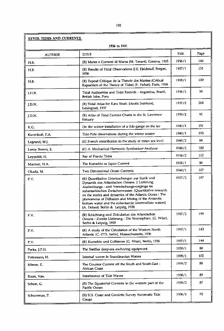
XXVIII. TIDES AND CURRENTS
1936 to 1941
AUTHOR TITLE Edit. Page
H.B. (R) Maree e Correnti di Marea (M. Tenani), Genova, 1935 1936/1 166
H.B. (R) Results of Tidal Observations (J.E. Fjeldstad) Bergen, 1936
1937/1 151
H.B. (R) Exposé Critique de la Théorie des Marées (Critical Exposition of the Theory of Tides) (E. Fichot), Paris, 1938
1938/1 100
I.H.B. Tidal Authorities and Tidal Records - Argentina, Brazil, British Isles, Peru
1936/1 50
J.D.N. (R) Tidal Atlas for Kara Strait. (Arctic Institute), Leningrad, 1937
1937/2 268
J.D.N. (R) Atlas of Tidal Current Charts in the St. Lawrence Estuary
1939/2 92
K.G. On the winter installation of a tide-gauge on the ice 1940/1 191
Kurenkoff, FA. Tide-Pole observations during the winter season 1940/1 193
Legrand, M.J. (E) French contribution to the study of mean sea level 1940/2 84
Leroy Brown, S. (E) A. Mechanical Harmonic Synthesizer-Analyser 1940/2 100
Leypoldt, H Bay of Fundy Tides 1938/2 112
Marmer, H.A. The Kuroshio or Japan Current 1938/1 86
Okada, M. Two Dimensional Ocean Currents 1940/1 107
P.V. (R) Quantitative Untersuchungen zur Statik und Dynamik des Atlantischen Ozeans. 2 Lieferung. Ausbreitungs - und Vermischungsvorgànge im subantarkischen Zwischenwasser. (Quantitative research on the statics and dynamics of the Atlantic Ocean : The phenomena of Diffusion and Mixing of the Antarctic bottom water and the subantarctic intermediate waters) (A. Defant) Berlin & Leipzig, 1936
1937/2 197
P.V. (R) Schichtung und Zirkulation des Atlantischen Ozeans - Zweite Lieferung - Die Stratosphàre. (G. Wüst), Berlin & Leipzig, 1935
1937/2 199
P.V. (R) A study of the Circulation of the Western North Atlantic (C. O'D, Iselin), Massachussetts, 1936
1937/1 143
P.V. (R) Kuroshio und Golfstrom (G. Wüst), Berlin, 1936 1937/1 144
Perks, J.P.H. The Stiellms deep-sea anchoring equipment 1939/1 80
Pettersson, H. Internal waves in Scandinavian Waters 1939/1 102
Rômer, E. The Counter-Current off the South and South-East : African Coast
1939/2 88
Roon, Van. Interference of Tide Waves 1938/1 89
Schott, G. (E) The Equatorial Currents in the western part of the Pacific Ocean
1939/2 87
Schureman, P. (E) U.S. Coast and Geodetic Survey Automatic Tide Gauge
1936/1 70
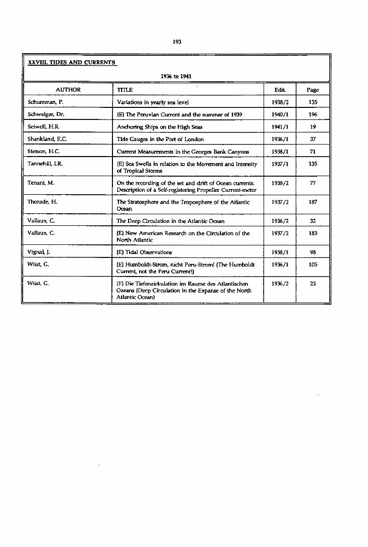
XXVIII. TIDES AND CURRENTS
1936 to 1941
AUTHOR TITLE Edit Page
Schureman, P. Variations in yearly sea level 1938/2 135
Schweiger, Dr. (E) The Peruvian Current and the summer of 1939 1940/1 196
Seiwell, H.R. Anchoring Ships on the High Seas 1941/1 19
Shankland, E.C. Tide Gauges in the Port of London 1936/1 37
Stetson, H.C. Current Measurements in the Georges Bank Canyons 1938/1 71
Tannehill, I.R. (E) Sea Swells in relation to the Movement and Intensity of Tropical Storms
1937/1 135
Tenani, M. On the recording of the set and drift of Ocean currents. Description of a Self-registering Propeller Current-meter
1938/2 77
Thorade, H. The Stratosphere and the Troposphere of the Atlantic Ocean
1937/2 187
Vallaux, C The Deep Circulation in the Atlantic Ocean 1936/2 32
Vallaux, C. (E) New American Research on the Circulation of the North Atlantic
1937/2 183
Vignal, J. (E) Tidal Observations 1938/1 98
Wüst, C. (E) Humboldt-Strom, nicht Peru-Strom! (The Humboldt Current, not the Peru Current!)
1936/1 105
Wûst, G. (E) Die Tiefenzirkulation im Raume des Atlantischen Ozeans (Deep Circulation in the Expanse of the North Atlantic Ocean)
1936/2 23

XXVIII. TIDES AND CURRENTS
1942 to 1970
AUTHOR TITLE Edit. Page
"Natural oscillations of the Bay of Fundy" (D.B. Rao), (Review)
1969/2 163
‘River mouths, estuaries, lagoons and deltas' (J. Larras), (Revieur)
1966/1 149
'Tidal computations in rivers and coastal waters" (J.J. Dronkers), (Review)
1965/1 181
"The dynamic method in oceanography" (L.M. Form in), (Review)
1964/2 175
"Les Marées" (J.Rouch), (Review) 1962/2 115
"Variazioni stagionali delle costani armoniche delle maree" (S.Polli), (Review)
1962/1 187
'Sea-level recordings at Scott Base, Antarctica, 1957" (W.J.P. MacDonald & A.L. Burrows), (Review)
1962/1 187
'Trans-Antarctic Expedition - Tides in Weddell Sea" (J.G.D. Pratt), (Review)
1961/2 111
'Results of current measurements by towed electrodes in the northern North Atlantic during the ICY’ (H.Weidemann), (Review)
1961/1 200
'Cours de pratique des marées" (A. Gougenheim), (Review)
1960/1 171
'Construction of the Tide Stations at Brevoort Harbour and Resolute Northwest Territories" (G.CDohler), (Review)
1959/1 182
"The Tidal Model at the University of Southampton" (P.B. Morice), Nature, London, 1958 [Review)
1958/2 160
"Terre Adélie, marées, 1950-1952" (F.Tabuteau, M.Marret k B.Imbert), (Review)
1958/2 151
Standard Development of Tide-Generating Potential (I.H.B. Circular-Letter N° 4-H of 30th April 1954)
1954/1 29
Marti Mercury Tide-Gauge 1953/2 165
Publication of Tidal Harmonic Constants by the international Hydrogaphic Bureau (S.P. N° 26)
1951/2 96
Foxboro Liquid Level Gauges for Open Vessels 1949/2 150
The Portable Tide-Predicting Machine 1949/1 107
Mean Sea Level 1944 116
Inner Waves 1944 116
Aragnol, A. The Use of Algebraic Methods in the Harmonic Analysis of Tidal Observations
1953/2 103
Balay, M.A. Determination of Plane of Reduction of Soundings at any Place
1952/2 105
Balay, M A Antarctic Tides 1950/2 95

XXVIII. TIDES AND CURRENTS
1942 to 1970
AUTHOR TITLE Edit. Page
Balay, M A Determination of Mean Level of Argentine Sea 1956/2 31
Balay, M A Differentia] Tide-Gauge for Recording Seiches 1951/2 92
Balay, M A Seasonal Variations in Mean Level of Argentine Sea 1958/1 117
Baussan, J. A Study of the Semi-annual Component of Sea Levels in the Asiatic Archipelago
1943 61
BaussanJ. Study of the Annual Component of Sea Level in the Asiatic Archipelago
1942 48
Bencker, H. An Account of the Method of Calculating the Year Book of the Fundamental Harmonic Tides (1940-1944)
1943 6
Bencker, H. Year Book of the Fundamental Harmonic Tides for the Year
1945 91
Bencker, H, Priming and lagging 1954/2 129
Bencker, H. Year Book of Fundamental Tides for the Year 1943 1942 50
Canadian Hyd. Ser. Description of Haskell Self-Registering Water Level Gauge
1952/2 123
Canadian Hyd. Ser. Curley Water Level Printing Gauge 1952/2 125
Carruthers, J.N. Realism in Current-measuring in the Upper Layers of the Sea
1947 54
Carruthere, J.N. A New Automatic Current Float 1954/2 155
Cartwright, D.E. & Catton, D.B. On the Fourier Analysis of Tidal Observations 1963/1 113
Castillejo, F.F. & Hamon, B.V. Reducing Meteorological Effects on Monthly Mean Sea Levels
1964/2 143
Ciriani, T A & Stocchino, C. Tide and tidal current predictions by digital computer IBM 7090
1967/1 117
Defant, A. Scylla and Charybdis and the Currents of the Straits of Messina
1942 30
Disney, L.P. & Rossiter, J.R. Recomendations for Operation of Tide Gauges and Reduction of Tidal Records
1961/2 39
Dohler, G. Chart datum 1968/1 67
Doodson, A.T. The Harmonic Development of the Tide-Generating Potential
1954/1 37
Doodson, A.T. Remaries on Tide-Gauges 1952/2 72
Doodson, A.T. The Analysis of Tidal Observations for 29 Days 1954/1 63
Doodson, A.T. (Erratum) 1955/2 7
Doodson, A.T. Analysis and Prediction in Shallow Waters 1956/1 85
Doodson, A.T. The Calculation of Harmonic Constants from Non- Harmonic Data
1950/1 12
Doodson, A.T. (Erratum) 1948/1 7
Doodson, A.T. Tide Models 1947 73

XXVIII. TIDES AND CURRENTS
1942 to 1970
AUTHOR TITLE Edit. Page
Doodson, AT. Tidal Movement 1976/2 135
Doodson, AT. Tides in Shallow Water 1947 65
Doodson, AT. The Analysis of High and Low Waters 1951/1 13
Egedal, J. On Seasonal Changes in Sea Level 1952/2 137
Engel, I. Currents in the Eastern Mediterranean 1967/2 23
Engel, I. Vertical hydrographic sections in the eastern Mediterranean
1968/1 167
Eyries, M. The Concordance Method and Harmonic Analysis by Approximate Constants
1976/1 127
Eyries, M. Analysis of short-period tidal observations 1966/1 98
Finnegan, H.E. Proposed New Format for Tabulating Predictions of Tidal High and Low Waters and Tidal Current Phases
1955/1 55
Floyd, W.R. Hydrographic and Tidal Investigations of the International Passamaquoddy Tidal-Power Survey
1961/1 77
Franco, A Dos Santos Brazilian Navy Instruction on Tides 1963/1 127
Franco, A Dos Santos Shallow-Water Tides 1956/1 77
Franco, A Dos Santos Relative Accuracy of some Methods of Harmonic Analysis of Tides
1965/2 149
Franco, A Dos Santos Harmonic Analysis of the Tide by the Semi-Graphic Method
1963/2 69
Franco, A. Dos Santee The Munk-Cartwright method for tidal prediction and analysis
1968/1 155
Franco, A Dos Santos Fundamentals of power spectral analysis as applied to discrete observations
1970/1 91
Franco, A. Dos Santos The semi-graphic method of analysis for seven days tidal observations
1966/1 75
Franco, A. Dos Santos Datum for sounding reduction 1966/2 7
Franco, A. Dos Santos Harmonic Analysis of Tides through Linear Combinations of Ordinates
1965/1 83
Franco, A Dos Santos Harmonic Analysis of Tides for 7 Days of Hourly Observations
1964/2 109
Cardiner, RA. Survey of Low Water Mark 1950/2 102
Oilman, L. Tidal Predictions for South African Waters 1960/2 99
Godin, G. Daily mean sea level and short-period seiches 1966/2 75
Godin, G. The analysis of current observations 1967/1 149
Godin, G. The resolution of tidal constituents 1970/2 133
Gordon, D.L. Rationalisation of chart datum on the British Isles 1968/1 55
Gougenheim, A French Projects for Tidal Power Stations 1963/1 91

XXVIII. TIDES AND CURRENTS
1942 to 1970
AUTHOR TITLE Edit. Page
Gougenheim, A. Harmonic Analysis of a Short Period of Tidal Observations. Separation of two Constituents of approximately Equivalent Angular Velocity
1955/2 141
H.B. The British Admiralty Tidal Prediction Form (HD-289- June 1947)
1948/2 119
Hams, D.L. Pore, N.A. & Cummings, R.A.
Tide and Tidal Current Prediction by High Speed Digital Computer
1965/1 95
Hicks, S.D. The tide prediction centenary of the United States Coast and Geodetic Survey
1967/2 121
Hisdal, V. On the analysis of non-equidistant observations of the tide
1967/1 129
Hodges, G.F. The engineering of production of a recording current meter
1967/2 151
Horn, W. Some Recent Approaches to Tidal Problems 1960/2 65
Hyd. Off. Canada "Ottboro’ Tide Gauge 1964/2 165
Hydr. Off. Netherlands Current Meter of the Netherlands Hydrographic Office 1963/2 187
Imbert, B. The Saint-Chamond-Granat Precision Tide-Gauge 1954/1 145
Karwowski, J. Measurement of Sea Currents by means of Drift Bottles 1963/2 119
Lacombe, H. Determination of the Tide in the Offing from Tidal Stream Data
1950/2 104
Laska, M. Spectral analysis of the periodic water level changes in the Baltic
1969/1 115
Laska, M. Genera] characteristics of the Southern Baltic water level variations and daily mean water level in the Bay of Gdansk for the 11-year period 1955/1965
1966/2 45
Lennon, G.W. The Treatment of Hourly Elevations of the Tide using an IBM 1620
1965/2 125
Lisitzin, E. Variations of Sea Level in the Baltic 1953/1 131
Lisitzin, E. The Contemporary Knowledge of the Causes of the Seasonal Cycle of Sea Level in the Oceans
1961/1 141
Lisitzin, E. The Relationship between Air Presure and Sea Level in the Baltic
1961/2 71
Lisitzin, E. Determination of Mean Sea level in the Northern Part of the Baltic
1962/2 91
Lisitzin, E. Sea level variation in the Sea of Japan 1967/2 11
Liverpool Obs. and Tidal Inst New Tide-Predicting Machines 1951/2 88
M armer, H.A. Is the Atlantic Coast Sinking? The evidence from the Tide
1950/1 25
Moreira Da Silva, P. A New Diagram for Tidal Prediction (DG-02) 1958/2 105
Murray, M.T. Optimisation Processes in Tidal Analysis 1965/1 73

XXVIII. TIDES AND CURRENTS
1942 to 1970
AUTHOR TITLE Edit. Page
Murray, M.T. A General Method for the Analysis of Hourly Heights of Tide
1964/2 91
Nan’niti, T. A Current Meter Using a Phototube 1953/2 171
Ortolan, G. New currentmeter for measuring currents near the bottom
1966/2 179
P.V. ‘Bases of a Sea Current Planisphere" (G. Schott), (Review)
1945 85
P.V. "Ergebnisse der Strommessungen und der Ozeanographischen Serienmessungen" (O.v. Schubert), (Review)
1945 78
Poling, A.C. & Butler, W.M. The Gas Purging Pressure Tide Gauge 1963/1 103
Proudman, J. The Applicability of Laplace's Differential Equations of the Tides
1948/2 112
Redfield, AC. The Analysis of Tidal Phenomena in Narrow Emtaayments
1951/1 92
Romanovsky, M.V. Direct Measurement of Ocean Currents 1950/1 102
Rossiter, J.R. A Further Note on the Determination of Mean Sea Level 1960/2 61
Rossiter, J.R. Note on Methods of Determining Monthly and Annual Values of Mean Water Level
1958/1 105
Rossiter, J.R. The Work of the Permanent Service for Mean Sea Level 1963/1 85
Rossiter, J.R, Note on Variations in Tidal Differences 1958/2 91
Roubertou, A. The Brillié Tide-Gauge 1955/2 159
Roumégoux, L Application of Automation in the Study and Prediction of Tides
1964/1 113
Roumégoux, L. Continuous Air Flow Tide Gauge 1964/1 109
Schott, G. The Equatorial Currents in the Western Pacific Ocean 1943 74
Sharaf El Din, S.H. & Rifat, E.M.
Variation of sea level at Alexandria 1968/2 175
Shipley, A.M. On the occasional failure of Newton iteration in tidal prediction
1968/1 151
Shipley, A.M. Tidal predictions on a medium sized digital computer 1966/1 85
State Commission Report (1926) Self-Registering Tide-Gauges with Electric Transmission, used for Investigations Relating to the Reclaiming of the Zuiderzee.
1944 98
Studds, R.FA. Mean Sea Level 1952/2 7
Sundby, E The Tidal Work of "Norges Sjôkartverk" 1952/2 60
Taylor, Ch.B. Jr & Harris, W.D. Measurement of Tidal Currents at Lituya Bay 1961/1 89
Thorade, H. The Equatorial Counter-Current in the Atlantic Ocean and its Origin
1943 64

XXVIII. TIDES AND CURRENTS
1942 to 1970
AUTHOR TITLE Edit. Page
Tomczak, C. Verification of a Progressive Wave in the Southern North Sea
1960/1 129
Westbrook, D.K Tidal Currents Survey - New Field Techniques 1962/2 77
Wyrtki, K. On the Presentation of Ocean Surface Currents 1960/1 111
Zetler, B.D. A Method of Infering the Amplitudes of the Tidal Constituents M2 and (K1 + Ol)
1953/2 95
Zetler, B.D. k Groves, G.W. A Program for Detecting and Correcting Errors in Long Series of Tidal Heights
1964/2 103
Zetler, B.D. & Lennon, G.W, Some comparative tests of tidal analytical processes 1967/1 139
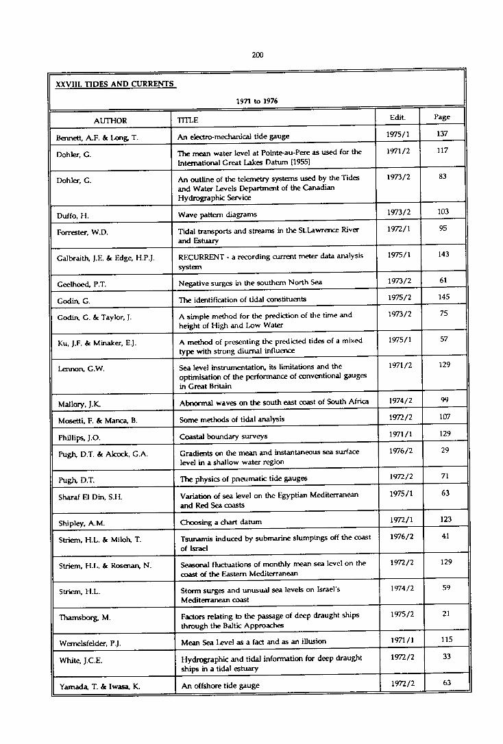
XXVIII. TIDES AND CURRENTS
1971 to 1976
AUTHOR TITLE Edit. Page
Bennett, A.F. 6c Long, T. An electro-mechanical tide gauge 1975/1 137
Dohler, G. The mean water level at Pointe-au-Pere as used for the International Great Lakes Datum (1955)
1971/2 117
Dohler, G. An outline of the telemetry systems used by the Tides and Water Levels Department of the Canadian Hydrographic Service
1973/2 83
Duffo, H. Wave pattern diagrams 1973/2 103
Forrester, W.D. Tidal transports and streams in the St.Lawrence River and Estuary
1972/1 95
Galbraith, J.E. & Edge, H.P.J. RECURRENT - a recording current meter data analysis system
1975/1 143
Geelhoed, P.T. Negative surges in the southern North Sea 1973/2 61
Godin, G. The identification of tidal constituents 1975/2 145
Godin, G. & Taylor, J. A simple method for the prediction of the time and height of High and Low Water
1973/2 75
Ku, J.F. & Minaker, E.J. A method of presenting the predicted tides of a mixed type with strong diurnal influence
1975/1 57
Lennon, G.W. Sea level instrumentation, its limitations and the optimisation of the performance of conventional gauges in Great Britain
1971/2 129
Mallory, J.K. Abnormal waves on the south east coast of South Africa 1974/2 99
Mosetti, F. 6c Manca, B. Some methods of tidal analysis 1972/2 107
Phillips, J.O. Coastal boundary surveys 1971/1 129
Pugh, D.T. & Alcock, G.A. Gradients on the mean and instantaneous sea surface level in a shallow water region
1976/2 29
Pugh, D.T. The physics of pneumatic tide gauges 1972/2 71
Sharaf El Din, S.H. Variation of sea level on the Egyptian Mediterranean and Red Sea coasts
1975/1 63
Shipley, A.M. Choosing a chart datum 1972/1 123
Striem, H.L. 6c Miloh, T. Tsunamis induced by submarine slumpings off the coast of Israel
1976/2 41
Striem, H.L. 6c Rosenan, N. Seasonal fluctuations of monthly mean sea level on the coast of the Eastern Mediterranean
1972/2 129
Striem, H.L. Storm surges and unusual sea levels on Israel's Mediterranean coast
1974/2 59
Thamsborg, M. Factors relating to the passage of deep draught ships through the Baltic Approaches
1975/2 21
Wemelsfelder, P.J. Mean Sea Level as a fact and as an illusion 1971/1 115
White, J.C.E. Hydrographic and tidal information for deep draught ships in a tidal estuary
1972/2 33
Yamada, T. 6c Iwasa, K. An offshore tide gauge 1972/2.
63

XXVIII. TIDES AND CURRENTS
1977 to 1980
AUTHOR TITLE Edit. Page
Amin, M. Some recent investigations into the harmonic shallow water corrections method of tidal predictions
1977/1 87
Amin, M. A note on extreme tidal levels 1979/2 133
Amin, M. ic Graff, J. Some notes on simplifying the HSWC method of tidal analysis
1980/2 167
Blain, W.R. & Webber, N.B. The rapid digitization of tide chart records 1978/2 85
Cartwright, D.E. Oceanic tides 1978/2 35
Ekblom, R. The ten percent method of predicting tide levels between high and low water
1978/2 93
Franco, A dos Santos On the shallow-water harmonic tidal constituents 1980/2 139
Gill, S.K. & Porter, D.L. Theoretical offshore tide range from a simple Defant tidal model compared with observed offshore tides
1980/1 155
Glen, N.C. Erratum 1978/1 163
Glen, N.C. The Admiralty method of tidal predictions, N.P. 159 1977/1 73
Graff, J. it Karunaratne, A Accurate reduction of sea level records 1980/2 151
Karunaratne, DA. An improved method for smoothing and interpolating hourly sea level data
1980/1 135
Levesque, L., Murty T.S. & El-Sabh, M.I.
Numerical modeling of tidal propagation in the St. Lawrence Estuary
1979/2 117
Merry, C.L. Processing of tidal records at Hout Bay Harbour 1980/1 149
Muir, L.R. Bernoulli effects on pressure-activated water level gauges
1978/2 111
Swanson, R.L. & Thurlow, C.I. A uniform tidal datum system for the United States of America
1979/1 143
Zetler, B., Cartwright, D.E. & Berkman, S.
Some comparisons of response and harmonic tide predictions
1979/2 105
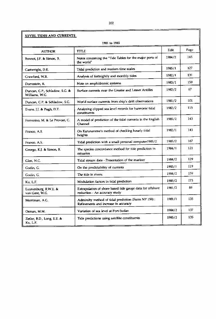
XXV1I1. TIDES AND CURRENTS
1981 to 1985
AUTHOR TITLE Edit. Page
Bonnot, J.F. k Simon, B. Notes concerning the 'Tide Tables for the major ports of the world”
1984/2 145
Cartwright, D.E Tidal prediction and modem time scales 1985/1 127
Crawford, W.R. Analysis of fortnightly and monthly tides 1982/1 131
Dorrestein, R. Note on amphidromic systems 1983/1 159
Duncan, C.P., Schladow, S.G. k Williams, W.C.
Surface currents near the Greater and Lesser Antilles 1982/2 67
Duncan, C.P. k Schladow, S.G. World surface currents from ship's drift observations 1981/2 101
Evans, J.J. k Pugh D.T. Analysing clipped sea-level records for harmonic tidal constituents
1982/2 115
Fomerino, M. & Le Provost, C. A model of prediction of the tidal currents in the English Channel
1985/2 143
Franco, A.S. On Karunaratne’s method of checking hourly tidal heights
1982/1 143
Franco, A.S. Tidal prediction with a small personal computer1985/2 1985/2 167
George, K.J. k Simon, B. The species concordance method for tide prediction in estuaries
1984/1 121
Glen, N.C. Tidal stream date - Presentation of the mariner 1984/2 129
Godin, G. On the predictability of currents 1983/1 119
Godin, G. The tide in rivers 1984/2 159
Ku, L.F. Modulation factors in tidal prediction 1985/2 173
Luynenburg, R.W.E. k van Gait, W.G.
Extrapolation of shore-based tide gauge data for offshore reduction - An accuracy study
1981/2 89
Merriman, A.G. Admiralty method of tidal prediction (Form NP 159) : Refinements and increase in accuracy
1981/1 135
Osman, M.M. Variation of sea level at Port-Sudan 1984/2 137
Zetler, B.D., Long, E.E. k Ku, L.F.
Tide predictions using satellite constituents 1985/2 135

XXV1I1. TIDES AND CURRENTS
1985 to 1990
AUTHOR TITLE Edit. Page
Abdallah, A.M., Eid, F.M. On the steric sea level in the Red Sea. 1989/1 115
Amin, M. A method for approximating the nodal modulations of real tides.
1987/2 103
Amin, M. On the conditions for classification of tides 1986/1 161
El Cindy, AJV, Eid, F.M. Long term variations of monthly mean sea level and its relation to atmospheric pressure in the Mediterranean Sea.
1990/1 147
Forrester, W.D. Direct inference of tidal constituents. Research note. 1986/2 107
Franco, A.S. ic Harari, J. Tidal analysis of long series. 1988/1 141
Franco, A.S., De Mesquita, A.R. On the practical use in hydrography of filtered daily values of Mean Sea Level.
1986/2 133
Garcia Lafuente, J., Almazân, J.L., Castillejo, E., Khribeche, A. & Hakimi, A.
Sea level in the Strait of Gibraltar : Tides. 1990/1 111
Glen, N.C. The tidal survey of the British Isles 1986/1 153
Godin, G. The use of nodal correction in the calculation of harmonic constants.
1986/2 143
Graff, J. Vertical control of offshore platforms. 1986/2 83
Hamon, B.V. & Middleton, J.F. Return periods of extreme sea levels, the exceedance probability method.
1989/2 165
Hamon, B.V. Spurious long period tides due to tide gauges errors. 1988/1 159
Joshi, M. Tide Guide 1986/1 175
Le Provost, Ch. The geoid and Mean Sea Level. 1990/1 171
Littlewood, A. A new approach to the presentation of tidal information. 1987/1 141
Sharaf El Din, S.H. Sea level variation along the Western coast of the Arabian Gulf.
1990/1 103
Simon, B. Calculation of the tide offshore for sounding reduction. 1990/2 149
Tait, B.J., Grant, S.T., St Jacques, D., Stephenson, F.
Canadian Arctic tide measurement techniques and results.
1986/2 111
Woodworth, P.L., Spencer, N.E. & A)cock, G.
On the availability of European Mean Sea Level Data. 1990/1 131
Zetler, B.D. The evolution of modem tide analysis and prediction - Some personal memories.
1987/1 123

XXIXa. TREATISES ON HYDROGRAPHY
1923 to 1935
AUTHOR TITLE Edit. Page
(R) Hydrographic Manual {U.S. C & G. Survey), Washington, 1928
1928/2 236
(R) Topographic Manual (U.S.C & G. Survey), Washington, 1928
1929/2 229
(R) General Instructions for the Hydrographic Surveyors of the Admiralty, London, 1933
1934/2 167
C.S.S. (R) Handledning i Sjômatning, Stockholm, 1923 1924/2 189
H.B. (R) Handbuch fur Küstenvermessungen, Berlin, 1927 1928/1 279
H.B. (R) Handledning i Sjômatning, Stockholm, 1924-1926 1928/1 281
H.B. (R) Manuale di Idrografia per la Costruzione delle carte marine, Livorno, 1927
1928/1 278
J.M.P. (R) Hydrographisch Opnemen (J.L.H. Luymes) The Hague, 1925
1926/2 229

XXIXa. TREATISES ON HYDROGRAPHY
1936 to 1941
AUTHOR TITLE Edit Page
H.B. (R) Hydrografia (Theoretical and Practical Manual for Hydrographic Surveys) (G. Maximov), Leningrad, 1935
1937/1 152
H.B. (R) Handledning I. Sjômâtning (Manual for Hydrographic Surveys) (Kungl. SjOkarteverket), Stockholm, 1936
1937/1 153
H.B. (R) Hydrographic and Geodetic Surveying Manual for the use of U.S. Naval Surveys (J.G. Kellar), Washington, 1937
1938/2 160
H.B. (R) Hydrographisch Opnemen (Hydrographic Surveys) ’s-Gravenhage, 1938
1938/2 163
J.D.N. (R) Admiralty Manual of Hydrographic Surveying 1939/2 164

XXIXa. TREATISES ON HYDROGRAPHY
1942 to 1970
AUTHOR TITLE Edit. Page
Extracts from the book ‘Specifications for Field Inspection Survey"
1948/2 55
"Vereffeningsmethoden bij Hy drogra phische Opnemingen", Hydrographic Department The Hague, 1957 (Review)
1958/2 154
"Manual del Hidrografio" (V. Gandarias & R. Ribas), (Review)
1961/1 194
"Electronic surveying and mapping" (S. Laurila), (Review)
1962/1 185
"Manual de Hidrografia" (J.A. Barahona Fernandes), (Review)
1967/2 170
Bencker, H. Regiment of the Sea or Nautical Compendium - Chronological and Analytical List of various Tables or Treatises on Navigation
1943 91
Burmins ter, C.A. Electronics in Hydrographic Survey 1949/1 119
Burmister, C.A. Shoran in Hydrographic Surveying 1947 181
H.B. "Manuale di Idrografia" (Romagna-Manoia G.) (Review) 1950/2 171
Hastings, Ch.E. The Application of Raydist to Hydrographic Surveying 1949/2 19
Lars son, H. Investigation of the Accuracy obtained with the Decca System for Survey on the Southern Baltic
1949/2 25
Moody, A.B. The Nautical Mile 1950/1 77
P.V. "Regimen of Coasts (A. de Rouville), (Review) 1944 112
P.V. "Manual of the Certificated Hydrographic Surveyor" (Review)
1944 111
Powell, C. The Decca Navigator as an Aid to Hydrographic Survey 1949/1 13
Razmara, H A Razmara Method of Teaching Topographic Surveying and Geodetic Operations
1950/1 132
Service Hydr., Paris Program of Lectures delivered for Hydrographic Engineers' Instruction
1943 18
U.S. Navy Hydr. Office Use of Radar and Radar Beacons in Hydrographic Surveying by U.S.S. Tanner (AGS-15)
1948/2 35

XlXb. NAUTICAL PUBLICATIONS
1971 to 1976
AUTHOR TITLE Edit Page
Jones, D.A. Computerized Coast Pilots 1971/1 197
Kerr, A.J. Recent changes in Canadian Sailing Directions 1974/1 125

XlXb. NAUTICAL PUBLICATIONS
1977 to 1980
AUTHOR TITLE Edit. Page
Faleev, V.I. The World Ocean Atlas - A new cartographic work devoted to the nature of the World Ocean
1977/2 37

XlXb. NAUTICAL PUBLICATIONS
1981 to 1985
AUTHOR TITLE Edit. Page
Bonnot, J.F. & Simon, B. Notes concerning the T ide Tables for the major ports of the world'
1984/2 145
Perrotte, R. A methodological approach to nautical chart design 1984/1 111
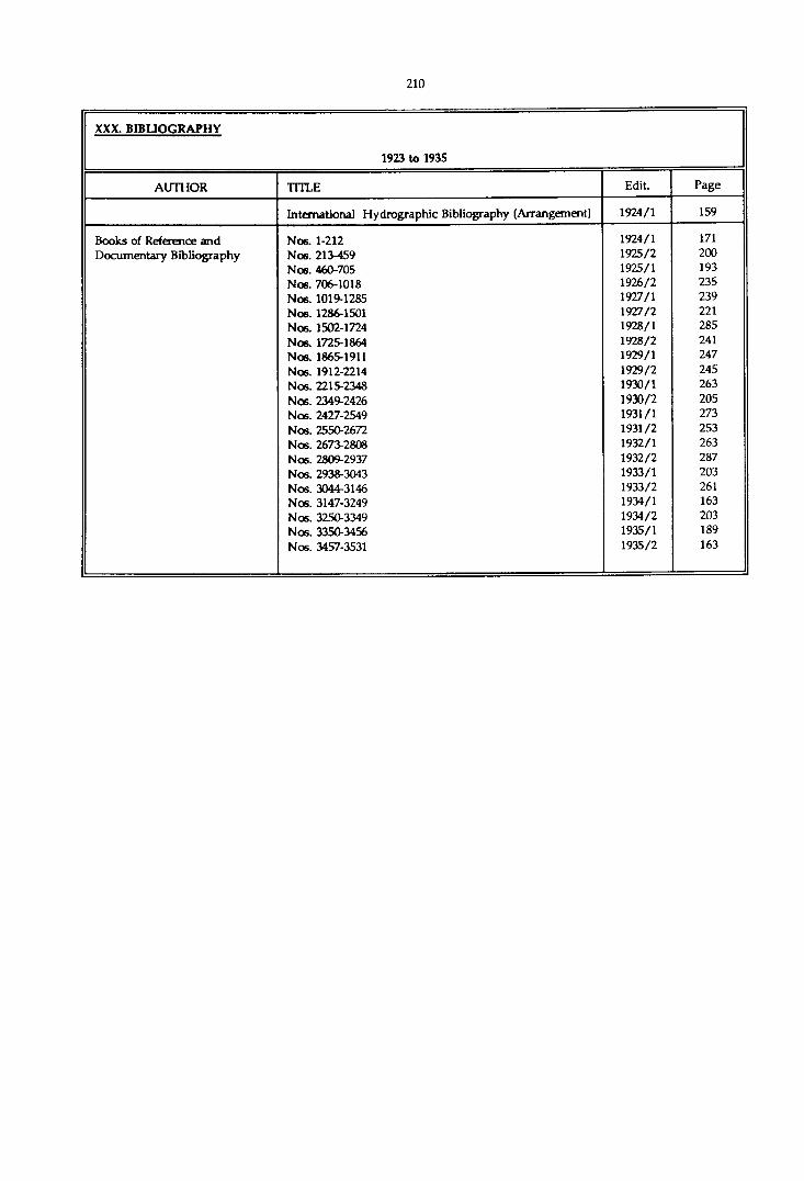
XXX. BIBLIOGRAPHY
1923 to 1935
AUTHOR TITLE Edit. Page
International Hydrographic Bibliography (Arrangement) 1924/1 159
Books of Reference and Nos. 1-212 1924/1 171Documentary Bibliography Nos. 213-459 1925/2 200
Nos. 460-705 1925/1 193Nos. 706-1018 1926/2 235Nos. 1019-1285 1927/1 239Nos. 1286-1501 1927/2 221Nos. 1502-1724 1928/1 285Nos. 1725-1864 1928/2 241Nos. 1865-1911 1929/1 247Nos. 1912-2214 1929/2 245Nos. 2215-2348 1930/1 263Nos. 2349-2426 1930/2 205Nos. 2427-2549 1931/1 273Nos. 2550-2672 1931/2 253Nos. 2673-2808 1932/1 263Nos. 2809-2937 1932/2 287Nos. 2938-3043 1933/1 203Nos. 3044-3146 1933/2 261Nos. 3147-3249 1934/1 163Nos. 3250-3349 1934/2 203Nos. 3350-3456 1935/1 189Nos. 3457-3531 1935/2 163
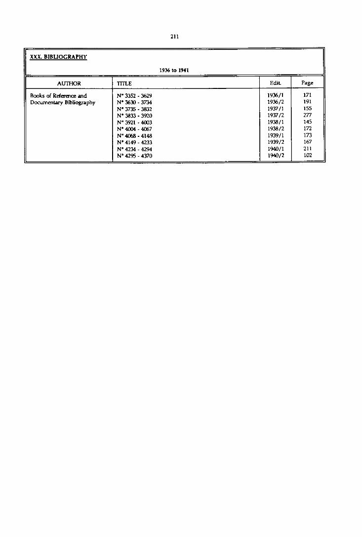
XXX. BIBLIOGRAPHY
1936 to 1941
AUTHOR TITLE Edit. Page
Books of Reference and N° 3352 - 3629 1936/1 171Documentary Bibliography N” 3630 - 3734 1936/2 191
N* 3735 - 3832 1937/1 155N° 3833 - 3920 1937/2 277N° 3921 - 4003 1938/1 145N° 4004 - 4067 1938/2 172N° 4068 - 4148 1939/1 173N- 4149 - 4233 1939/2 167N° 4234 - 4294 1940/1 211N° 4295 - 4370 1940/2 102

XXX. BIBLIOGRAPHY
1942 to 1970
AUTHOR TITLE Edit. Page
Between 1950 and 1967 bibliographic references were published at the end of the Review. After 1967 bibliography forms part of Section IV of the International Hydrographic Bulletin.