Embed Size (px)
Citation preview

General Habitat Assessment
±15-acre Site
11048 and 11079 Laurel Avenue City of Bloomington, San Bernardino County, California
Prepared for:
Boruchin Administrative Trust c/o Allan N. Lowy ESQ, (PLC), Of Council Turner Aubert & Friedman, LLP
8383 Wilshire Blvd., Ste. 510 Beverly Hills, CA 90211-2406
Prepared by:
Scott Cameron
Ecological Sciences, Inc. 601 Glade Drive
Santa Paula, CA 93060 805.921.0583
July 2014

601 GLADE DRIVE ♦ SANTA PAULA, CA 93060 ♦ TEL 805.921.0583 ♦ FAX 805.921.0683
email: [email protected]
July 7, 2014
Boruchin Administrative Trust c/o Allan N. Lowy ESQ, (PLC), Of Council Turner Aubert & Friedman, LLP 8383 Wilshire Blvd., Ste. 510 Beverly Hills, CA 90211-2406 SUBJECT: Results of a Habitat Suitability Evaluation, ±15-acre Site, City of Bloomington, San
Bernardino County, California Ladies and Gentlemen: This letter report presents findings of a reconnaissance-level survey conducted to generally evaluate the suitability of a ±15-acre site (consisting of two separate parcels) to support sensitive biological resources as part of the environmental review process. Introduction The subject ±15-acre site is regionally located in the City of Bloomington, San Bernardino County, California (Plate 1). Specifically, the project site is located at 11048 (±10 acres) and 11079 (±5 acres) Laurel Avenue. The site occurs on the “Fontana” USGS 7.5-minute topographic map, Township 1 South, Range 5 West, Section 28 (Plate 2). Projects proposed in this area that contain potentially suitable habitat to support sensitive biological resources must demonstrate to reviewing agencies that potential project-related impacts to sensitive biological resources are adequately addressed and mitigated pursuant to the California Environmental Quality Act (CEQA) and the federal Endangered Species Act (Act) of 1973, as amended. Biological resources within the project site may fall under the jurisdiction of several federal and state agencies, including, but not necessarily limited to, California Department of Fish and Wildlife (CDFW), U.S. Fish and Wildlife Service (FWS), City of Bloomington (City), County of San Bernardino (County), Regional Water Quality Control Board (RWQCB), and U.S. Army Corps of Engineers (USACE). Accordingly, results of this habitat suitability evaluation are intended to provide the applicant and resource agencies with preliminary biological information required for planning and permitting decisions concerning the proposed project. Due to the inherent limitations of unseasonal or habitat-based data, definitive conclusions regarding the actual presence or absence of selected sensitive biological resources cannot be made in this report. Therefore, conclusions relative to potential presence or absence of certain sensitive biological resources are based solely on the nature of habitat present. This general analysis of biological resources is based on information compiled through field reconnaissance, literature review, and by applicable reference materials. Methods used in this study are outlined below. Investigative Methods Information Review Documentation pertinent to the biological resources in the vicinity of the site was reviewed and analyzed. Primary data sources reviewed to evaluate the occurrence potential of special-status resources on the subject site, included, but were not necessarily limited to: (1) California Natural Diversity Data Base

plate 1
Regional Site LocationJuly 2014 15-acre Boruchin Site
Survey Area

plate 2
USGS Topographic Vicinity MapJuly 2014
15-acre Boruchin Site
= Study Area Boundary
4 Boruchin Administrative Trust General Habitat Assessment
July 7, 2014
(CNDDB 2014); (2) California Native Plant Society (CNPS 2014) on-line inventory for the Fontana and surrounding 7.5-minute quadrangle maps; (3) available literature pertaining to habitat requirements of special-status species potentially occurring in the project site; (4) 2013 USFWS Information, Planning, and Conservation System Database (IPaC); and (5) historic distributional data contained in Hall (1981); Grinnell and Miller (1944); Garrett and Dunn (1981); Holland (1986); Stebbins (1985); Hickman (1993); and CNPS (2001). Field Survey Ecological Sciences Principal Biologist, Scott Cameron, conducted a reconnaissance-level field survey to characterize on-site habitats and to evaluate their potential to support sensitive species on May 22, 2014. Plant species and vegetation communities were primarily identified by walking transects throughout the site. All direct observations of wildlife were recorded, as was wildlife sign. In addition to species actually detected, expected use of the site by other wildlife was evaluated from habitat analysis of the site, combined with known habitat preferences of locally occurring wildlife species. The site was also evaluated for the potential presence of plant, animal, or habitats considered rare, threatened, sensitive, endangered, or otherwise unique by regulatory or resource agencies. Weather conditions during the May 2014 survey were overcast and calm with air temperatures of approximately 61-63 °F. Existing Site Conditions The parcel located at 11048 Laurel Avenue is characterized as a highly degraded site exposed to various types of anthropogenic disturbances. A small residence along with corrals and pens used for goats, chickens, pigs, turkeys, geese, etc, as well as pasture for a cow is present on site. The remainder of the site is highly disturbed and exposed to extensive manure, debris, soil dumping, as well as recurring discing activities. A tree wind row bisects the eastern portion of the site. A majority of the site is relatively barren of vegetation due to the aforementioned activities. Patchy non-native plant species recorded include foxtail chess (Bromus madritensis ssp. rubens), ripgut grass (Bromus diandrus), Mediterranean grass (Schismus sp.), Bermuda grass (Cynodon dactylon), oat (Avena sp.), filaree (Erodium cicutarium), mustard (Brassica sp.), cheeseweed (Malva parviflora), Lamb’s quarters (Chenopodium album), common prickly lettuce (Lactuca serriola), golden crownbeard (Verbesina encelioides), puncture vine (Tribulus terrestris), and fleabane (Conyza bonariensis). Native species present on site included a few scattered common sunflower (Helianthus annuus). In addition, ornamental landscaping such as tree-of-heaven (Ailanthus altissima), Peruvian pepper (Schinus molle), Acacia (Acacia sp.), and common olive (Olea europea) are present. Elevation is approximately 1,040 feet above msl. Plates 3a-3b photographically illustrate existing site conditions. Plate 4 schematically illustrates site features/vegetation types. The parcel located at 11079 Laurel Avenue is characterized by unfinished residential development (2 houses) located in the southwestern portion of the site, disced areas with gravel and debris in the northern half of the site, and an abandoned orchard in the southern part of the site. A brick wall surrounds the parcel. Various construction equipment and debris is also present on site. Surrounding land uses include rural residential and agriculture. The site is mostly barren except for the orchard area. Patchy non-native plant species recorded include foxtail chess, ripgut grass, Mediterranean grass, oat, filaree, mustard, cheeseweed, Lamb’s quarters, common prickly lettuce, mustard, golden crownbeard, puncture vine, and fleabane. Native species present on site included a few scattered telegraph weed (Heterotheca grandiflora) and common sunflower. Elevation is approximately 1,040 feet above msl. Plates 3c-3b photographically illustrate existing site conditions. Plate 4 schematically illustrates site features/vegetation types. Wildlife Common avian species observed on both parcels included red-tailed hawk (Buteo jamaicensis), common raven (Corvus corax), mourning dove (Zenaida macroura), killdeer (Charadrius vociferus), Bullock's oriole
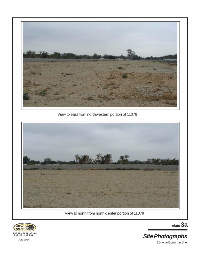
plate 3a
View to east from northwestern portion of 11079
View to north from north-center portion of 11079
Site PhotographsJuly 2014
15-acre Boruchin Site

plate 3b
View to south of orchard area of 11079
View to west from southwestern portion of 11079
Site PhotographsJuly 2014
15-acre Boruchin Site

plate 3c
View to west from southeast portion of 11048
View to east from southwestern portion of 11048
Site PhotographsJuly 2014
15-acre Boruchin Site
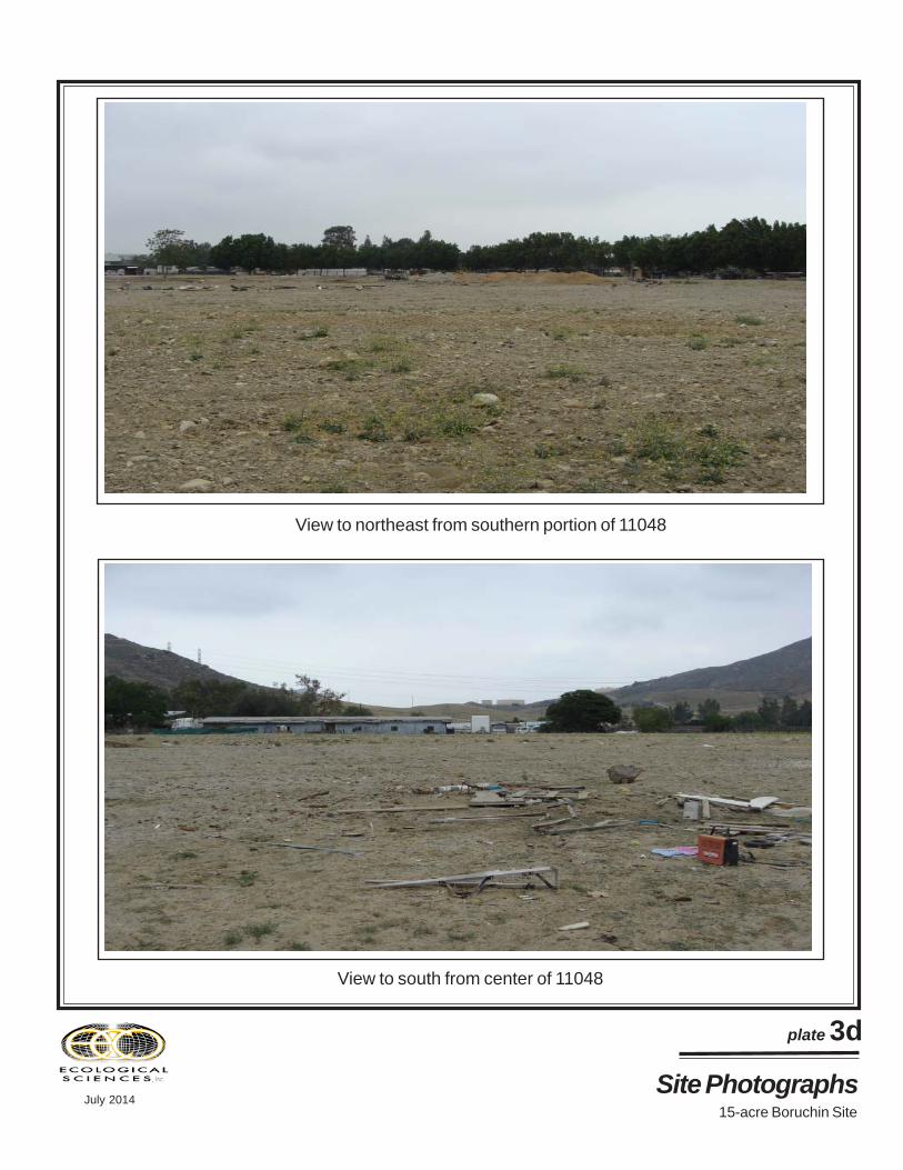
plate 3d
View to northeast from southern portion of 11048
View to south from center of 11048
Site PhotographsJuly 2014
15-acre Boruchin Site

plate 4
Site Features SchematicJuly 2014 15-acre Boruchin Site
=Study Area
Map Key= orchard= disced gravel with debris= development= tree wind row= soil/manure piles= disced with debris= disced/grubbed/grazed/debris (extensive cobbles/gravels/manure)= grazed pasture= earthen berm
○ ○ ○ ○
○ ○ ○ ○
○ ○ ○ ○
○
○
○
○○
○
○ ○
○ ○ ○
○○
○
○
○
○○○
○
○
○ ○ ○ ○
1107911048

plate 5Project Area Soils
July 2014 15-acre Boruchin Site
= Study Area Boundary= Extent of Soil Analysis
NAP
Source: Natural Resources Conservation Service (NRCS-website accessed May 21, 2014)
Soil Map KeyTuB=Tujunga loamy sandDb=Delhi fine sand
11 Boruchin Administrative Trust General Habitat Assessment
July 7, 2014
(Icterus bullockii), western kingbird (Tyrannus verticalis), northern mockingbird (Mimus polyglottos), house finch (Carpodacus mexicanus), and house sparrow (Passer domesticus). Mammals recorded, or of which sign was detected, included California ground squirrel (Spermophilus beecheyi). General Soils Analysis / Soil Conservation Map Review A review of soil maps prepared by the Natural Resources Conservation Service (NRCS) website for San Bernardino County, Southwestern Part, California indicate that the subject site is primarily located within an area mapped as Delhi sand (Db), with a small portion containing Tujunga loamy sand (TuB) in the northeast corner of each parcel. Soils are highly variable throughout the site due to exposure to various human activities as described. Soils on 11048 contain large areas of cobble/gravel substrates with manure and other debris assimilated in the substrate (friable to compact), while those present in 11079 include gravels and other debris and also vary from friable to compact. Plate 5 (previous page) illustrates mapped area soils. Sensitive Biological Resources Evaluation Discussed in this section are plant and wildlife species potentially present in the study area that have been afforded special recognition by federal or state agencies. The focus of this discussion is on those species that would potentially pose considerable constraints on the proposed project because of their high sensitivity status (listed or proposed for listing as rare, threatened, or endangered) with state and/or federal resource agencies. In addition, plants included on Lists 1, 2, 3, or 4 of the CNPS inventory are also considered of special-status. Vegetation communities that are unique, of relatively limited distribution, or of particular value to wildlife and considered sensitive by state and/or federal resource agencies are also generally discussed. In general, those species presented in Tables 1 and 2 that are “not expected” or that have a “low occurrence potential” generally correspond to “less than significant” under CEQA. The occurrence potential of special-status plant and wildlife species is primarily based on habitat types present, occurrence records of sensitive species from the site vicinity, and results of the on-site reconnaissance survey. No focused botanical or zoological surveys were conducted. Special-Status Plant Species No special-status plant species were detected on site during the reconnaissance-level survey and none are expected due to lack of suitable habitat. Special-status plant species known from the region that potentially occur within the project site are summarized below in Table 1.
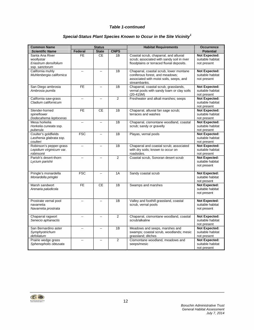
Table 1
Special-Status Plant Species Known to Occur in the Site Vicinity1
Common Name Status Habitat Requirements Occurrence Scientific Name Federal State CNPS Potential Chaparral sand verbena Abronia villosa var. aurita
-- -- 1B Chaparral, coastal scrub with sandy soils Not Expected: suitable habitat not present
Plummer’s mariposa lily Calochortus plummerae
FSC -- 1B Chaparral, cismontane woodlands, coastal scrub, Lower coniferous forests, and grasslands; associated with granitic soils.
Not Expected: suitable habitat not present on site
Parry’s spineflower Chorizanthe parryi ssp. parryi
FSC -- 3 Chaparral and coastal scrub; associated with sandy or rocky openings.
Not Expected: suitable habitat not present
Many-stemmed dudleya Dudleya multicaulis
FSC -- 1B Chaparral, coastal scrub, and grasslands; often associated with clay soils.
Not Expected: suitable habitat not present
12 Boruchin Administrative Trust General Habitat Assessment
July 7, 2014
Table 1-continued
Special-Status Plant Species Known to Occur in the Site Vicinity1
Common Name Status Habitat Requirements Occurrence Scientific Name Federal State CNPS Potential Santa Ana River woollystar Eriastrum densifolium ssp. sanctorum
FE CE 1B Coastal scrub, chaparral, and alluvial scrub; associated with sandy soil in river floodplains or terraced fluvial deposits.
Not Expected: suitable habitat not present
California muhly Muhlenbergia californica
-- -- 1B Chaparral, coastal scrub, lower montane coniferous forest, and meadows; associated with moist soils, seeps, and streambanks.
Not Expected: suitable habitat not present
San Diego ambrosia Ambrosia pumila
FE -- 1B Chaparral, coastal scrub, grasslands, vernal pools with sandy loam or clay soils (20-415M)
Not Expected: suitable habitat not present
California saw-grass Cladium californicum
-- -- 2 Freshwater and alkali marshes; seeps Not Expected: suitable habitat not present
Slender-horned spineflower Dodecahema leptoceras
FE CE 1B Chaparral, alluvial fan sage scrub; terraces and washes
Not Expected: suitable habitat not present
Mesa horkelia Horkelia cuneata ssp. puberula
-- -- 1B Chaparral, cismontane woodland, coastal scrub; sandy or gravelly
Not Expected: suitable habitat not present
Coulter’s goldfields Lasthenia glabrata ssp. coulteri
FSC -- 1B Playas, vernal pools Not Expected: suitable habitat not present
Robinson’s pepper-grass Lepidium virginicum var. robinsonii
-- -- 1B Chaparral and coastal scrub; associated with dry soils; known to occur on roadsides.
Not Expected: suitable habitat not present
Parish’s desert-thorn Lycium parishii
-- -- 2 Coastal scrub, Sonoran desert scrub Not Expected: suitable habitat not present
Pringle’s monardella Monardella pringlei
FSC -- 1A Sandy coastal scrub Not Expected: suitable habitat not present
Marsh sandwort Arenaria paludicola
FE CE 1B Swamps and marshes Not Expected: suitable habitat not present
Prostrate vernal pool navarretia Navarretia prostrata
-- -- 1B Valley and foothill grassland, coastal scrub, vernal pools
Not Expected: suitable habitat not present
Chaparral ragwort Senecio aphanactis
-- -- 2 Chaparral, cismontane woodland, coastal scrub/alkaline
Not Expected: suitable habitat not present
San Bernardino aster Symphyotrichum defoliatum
-- -- 1B Meadows and seeps, marshes and swamps; coastal scrub, woodlands; mesic grassland; ditches
Not Expected: suitable habitat not present
Prairie wedge grass Sphenopholis obtusata
-- -- 2 Cismontane woodland, meadows and seeps/mesic
Not Expected: suitable habitat not present

13 Boruchin Administrative Trust General Habitat Assessment
July 7, 2014
Table 1-continued
Special-Status Plant Species Known to Occur in the Site Vicinity1 1Based primarily on review of 2014 CNDDB, 2014 CNPS online databases, and 2014 USFWS IPaC. Federal FE: Federally Endangered FT: Federally Threatened Species FPE: Federally Proposed Endangered FPT: Federally Proposed Threatened FC: Federal Candidate Species State CE: State Endangered CT: State Threatened CR: State Rare
CNPS List 1A: Plants presumed extinct in California. List 1B: Plants rare and endangered in California and elsewhere List 2: Plants rare and endangered in California, but more
common elsewhere List 3: Taxa about which more information is needed List 4: Plants of limited distribution
Special-Status Wildlife Species No special-status wildlife species were directly observed during the May 2014 survey, however, several species have potential to occur on site. Sensitive wildlife species known from the site vicinity that potentially occur are summarized below in Table 2.
Table 2
Special-Status Wildlife Species Known from the Site Vicinity1
Common Name Status Habitat Requirements Occurrence Scientific Name Federal State Potential INVERTEBRATES Delhi Sands flower-loving fly Rhaphiomidas terminatus abdominalis
FE -- Open, sandy (Delhi) dune areas commonly supporting buckwheat, croton, telegraph weed, Camissonia and Oenothera.
Low Potential: only marginally suitable due Only to mapped Delhi soils
REPTILES Coast horned lizard Phrynosoma blainvillii
-- CSC Relatively open grasslands, scrublands, and woodlands with fine, loose soil.
Low Potential: marginally suitable habitat present where friable soils occur
Orange-throated whiptail Aspidoscelis hyperythrus
FSC CSC Relatively open grasslands, scrublands, and woodlands with fine, loose soil
Not Expected: suitable habitat not present
Coastal western whiptail Aspidoscelis tigris multiscutatus
-- ♦ Sage scrub, chaparral, grassland Not Expected: suitable habitat not present
Silvery legless lizard Anniella pulchra pulchra
FSC CSC Stabilized dunes, beaches, dry washes, pine, oak, and riparian woodlands, and chaparral; sparse vegetation with sandy or loose, loamy soils.
Not Expected: no suitable habitat present
San Bernardino ringneck snake Diadophis punctatus modestus
FSC -- Woodlands, grassland, chaparral, and scrub habitats; often found in mesic areas under rocks, logs, and debris.
Not Expected: no suitable habitat present
San Diego banded gecko Coleonyx varigatus abbotti
-- -- Coastal and cismontane southern California; granite or rocky outcrops in coastal scrub and chaparral
Not Expected: suitable habitat not present
Northern red diamond rattlesnake Crotalus ruber ruber
-- CSC Sage scrub, chaparral, grasslands Not Expected: suitable habitat not present
BIRDS White-tailed kite Elanus leucurus
MNBMC CFP Open vegetation and uses dense woodlands for cover.
Low Potential: possibly forages over the site; no suitable nesting habitat present

14 Boruchin Administrative Trust General Habitat Assessment
July 7, 2014
Table 2-continued
Special-Status Wildlife Species Known from the Site Vicinity1
Common Name Status Habitat Requirements Occurrence Scientific Name Federal State Potential Northern harrier Circus cyaneus
-- CSC Coastal salt marsh, freshwater marsh, grasslands, and agricultural fields.
Low Potential: possibly forages over the site; no suitable nesting habitat present
Sharp-shinned hawk Accipiter striatus
-- CSC Woodlands and forages over dense chaparral and scrublands.
Not Expected: no suitable habitat present
Cooper’s hawk Accipiter cooperi
-- CSC Dense stands of live oaks and riparian woodlands.
Low-Moderate Potential: may forage over the site; no suitable nesting habitat present
Ferruginous hawk Buteo regalis
FSC, MNBMC
CSC Grasslands, agricultural fields, and open scrublands.
Low Potential: possibly forages over the site as seasonal migrant; does not breed in area
Golden eagle Aquila chrysaetos
-- CSC, CFP
Mountains, deserts, and open country. Low Potential: species known from project vicinity and may forage over the site; no suitable nesting habitat present
Prairie falcon Falco mexicanus
-- CSC Grasslands, savannas, rangeland, agricultural fields, and desert scrub; requires sheltered cliff faces for shelter.
Low Potential: may forage over the site in winter; no suitable nesting habitat present
Western burrowing owl Athene cunicularia hypugea
FSC, MNBMC
CSC Grasslands and open scrub. Low Potential: marginally suitable foraging and nesting habitat present
California horned lark Eremophila alpestris actia
-- CSC Grasslands, disturbed areas, agriculture fields, and beach areas.
Moderate Potential: marginally suitable foraging habitat present
Loggerhead shrike Lanius ludovicianus
FSC, MNBMC
CSC Grasslands with scattered shrubs, trees, fences or other perches.
Moderate Potential: marginally suitable habitat present
S. California rufous-crowned sparrow Aimophila ruficeps canescens
-- CSC Coastal sage scrub, grasslands Not Expected: suitable habitat not present
Bell’s sage sparrow Amphispiza belli belli
MNBMC CSC Coastal sage scrub, chaparral Not Expected: suitable habitat not present
Tricolored blackbird Agelaius tricolor
-- CSC Marshes for nesting; forages in fields and scrub habitats
Not expected: suitable habitat not present
California coastal gnatcatcher Polioptila californica californica
FT CSC Coastal sage scrub in areas of flat or gently sloping terrain
Not Expected: suitable habitat not present
Least Bell’s vireo Vireo bellii pusillus
FE CE Willow dominated riparian habitat with dense understory
Not expected; suitable habitat not present
Southwestern willow flycatcher Empidonax traillii extimus
FE -- Riparian habitats along rivers, streams, or other wetlands usually with standing water
Not expected; suitable habitat not present
Yellow warbler Dendroica petechia
-- CSC Riparian thickets and woodlands Not Expected: suitable habitat not present
Yellow-breasted chat Icteria virens
-- CSC Riparian thickets and riparian woodlands with dense understory
Not Expected: suitable habitat not present
Mountain plover Charadrius montanus
FPT CSC Agricultural areas, fallow fields, grasslands, prairies
Not Expected: no suitable habitat present

15 Boruchin Administrative Trust General Habitat Assessment
July 7, 2014
Table 2-continued
Special-Status Wildlife Species Known from the Site Vicinity1
Common Name Status Habitat Requirements Occurrence Scientific Name Federal State Potential MAMMALS Western mastiff bat Eumops perotis
FSC (ssp.
californicus)
CSC Primarily arid lowlands and coastal basins with rugged, rocky terrain, along with suitable crevices for day-roosts; primarily a cliff-dweller
Not Expected: suitable habitat not present
Western yellow bat Lasurius xanthininus
-- CSC Valley footlhill riparian, desert riparian, palm oasis
Not Expected: suitable habitat not present
Pocketed free-tailed bat Nyctinomops femorosaccus
-- CSC Pine juniper woodlands, desert scrub, palm oasis, desert wash, desert riparian; rocky areas with high cliffs
Not Expected: suitable habitat not present
San Diego desert woodrat Neotoma lepida intermedia
-- CSC Moderate to dense sage scrub; rocky outcrops
Not Expected: no suitable habitat present
San Diego black-tailed jackrabbit Lepus californicus bennettii
FSC CSC Chaparral, coastal scrub, grasslands Not Expected: suitable habitat not present
Los Angeles pocket mouse Perognathus longimembris brevinasus
FSC CSC Grasslands and coastal sage scrub; prefers lower elevational areas with open ground and sandy soils.
Not Expected: suitable habitat not present
Northwestern San Diego pocket mouse Chaetodipus fallax fallax
-- CSC Open shrublands, sandy areas Not Expected: suitable habitat not present
San Bernardino kangaroo rat Dipodomys merriami parvus
FE CSC Coastal sage scrub; prefers lower elevational areas with open ground and sandy soils.
Not Expected: suitable habitat not present
Stephens’ kangaroo rat Dipodomys stephensi
FE CE Grasslands, open sage scrub Not Expected: no suitable habitat present
KEY: 1Based primarily on review of 2014 CNDDB and 2014 USFWS IPaC. Federal—U.S. Fish and Wildlife Service FE: Federally Endangered FT: Federally Threatened FPE: Federally Proposed Endangered FPT: Federally Proposed Threatened FC: Federal Candidate for listing as threatened
or endangered FSC: Federal Species of Concern-no formal protection is
granted to this designation MNBMC: Migratory Nongame Birds of Management Concern
State—California Department of Fish and Wildlife CE: California Endangered CT: California Threatened CCE: California Candidate (Endangered) CCT: California Candidate (Threatened) CFP: California Fully Protected CP: California Fully Protected CSC: California Species of Special Concern
Special-Status Habitats Special-status habitat types are vegetation communities that support concentrations of sensitive plant or wildlife species, are of relatively limited distribution, or are of particular value to wildlife. Although sensitive habitats are not necessarily afforded legal protection unless they support protected species, potential impacts to them may increase concerns and mitigation suggestions by resources agencies. Special-status habitats know from this site vicinity include Riversidean Alluvial Fan Sage Scrub, Southern Cottonwood Willow Riparian Forest, Southern Sycamore Alder Riparian Woodland, and Southern Willow Scrub. None of these native or special-status habitats were recorded on site.
16 Boruchin Administrative Trust General Habitat Assessment
July 7, 2014
Wildlife Movement Corridors The proposed project site is surrounded by existing development, and therefore, the subject site does not occupy an important location relative to regional wildlife movement. As such, development of the site would not be expected to have any substantial effect on local or regional wildlife movement. Jurisdictional Resources Based on the field investigation conducted by Ecological Sciences, USACE “waters of the United States” per Sections 401-404 of the Federal Clean Water Act and “streambeds” per Section 1600-1603 of the CDFG Code were not observed on the property. Discussion The level of constraint that a sensitive biological resource would pose to potential development typically depends on the following criteria: (1) the relative value of that resource; (2) the amount or degree of impact to the resource; (3) whether or not impacts to the resource would be in violation of state and/or federal regulations or laws; (4) whether or not impacts to the resource would require permitting by resource agencies; and (5) the degree to which impacts on the resource would otherwise be considered “significant” under CEQA. On-site habitats have been assigned a relatively low biological constraint rating based on the degree in which expected impacts to on-site resources would meet the criteria discussed above. This designation is primarily due to the generally high level of site disturbances (associated with recurring and historic anthropogenic disturbances) resulting in low biological diversity (i.e., replacement and exclusion of many native species with fewer non-native species) and an overall low potential for special-status species to utilize or reside within areas proposed for development (due to absence of suitable habitat). No special-status plant species are expected on site due to lack of suitable habitat. The intent of the botanical survey was to generally evaluate the potential of the site to support sensitive plant species based on existing site conditions and habitat types present. Long-standing weed abatement/fire break discing and other anthropogenic disturbances have likely altered soil chemistry and other substrate characteristics such that on-site soils may not currently be capable of supporting those sensitive plant species known from the site vicinity. Site development would not eliminate significant amounts of habitat for potentially occurring special-status plant species, nor reduce population size of sensitive plant species below self-sustaining levels on a local or regional basis (if present). No special-status wildlife species were directly recorded on site, however, the California horned lark and loggerhead shrike have a moderate occurrence potential. However, these species were deemed by the Service to be too widespread and common to warrant listing as threatened or endangered, and as such, were removed from formal sensitive species status. Impacts to isolated, non-native grassland or remnant buckwheat scrub (non-sensitive habitat types in general) could amount to an incremental reduction of potential foraging habitat that may be considered locally adverse. However, site development would not eliminate significant amounts of habitat for these species, nor reduce population size below self-sustaining levels on a local or regional basis. No nesting birds were incidentally observed during surveys conducted on the subject site in May 2014. Although many native bird species are not protected by state or federal/state endangered species acts, most are protected under the federal Migratory Bird Treaty Act (MBTA) of 1918 (16 U.S.C. 703-711) and CDFG Code sections 3503, 3503.5, and 3800 which prohibits take, possession, or destruction of birds, their nests or eggs. If it were later determined that active nests of any of special-status or native species would be lost or indirectly impacted as a result of site-preparation, it could result in adverse impacts and would be in conflict with these regulations. If construction activities (e.g., tree removal) were proposed during the nesting season, a nesting bird survey is recommended prior to development to determine if

17 Boruchin Administrative Trust General Habitat Assessment
July 7, 2014
active nests are present in the construction zone or within an appropriate buffer area as part of project approval. Often the most effective manner in which to establish these buffer areas is to have a biological monitor present during demolition and grubbing. Development activities performed outside of the avian breeding season (generally September 1 to January 31) usually eliminates the need to conduct pre-activity nesting surveys for most native species known from the site vicinity, and ensure that there were no constraints to construction relative to the MBTA/CDFG code. Compliance with the MBTA/CDFG codes would be necessary prior to development; however no special permit or approval is typically required in most instances. The site is mapped within an area known to contain Delhi Soils, a component associated with the Delhi sands flower-loving fly (Rhaphiomidas terminatus abdominalis-DSFF). DSFF have relatively narrow habitat requirements that are determined by appropriate plant species and open sand as defining characteristics (Kingsley 1996). The presence of Delhi soils appears to be the most determinative factor of whether an area can provide suitable DSFF habitat. Delhi sands constitute the primary component of a complex ecosystem. A variety of microhabitat characteristics generally constitute potential DSFF habitat (e.g., Delhi soils, vegetation composition, soil chemistry, topography, percent vegetative cover, frequency of non-native plant species, exposure to disturbances, etc.). However, it is widely acknowledged that a gradient of habitat suitability exists for DSFF, composed of varying degrees of natural and artificial conditions. Comprehensive DSFF population data is generally lacking and key factors regulating DSFF populations have not been fully identified. As such, whether this taxon would persist over a long-term basis in less than ideal conditions is currently unknown. While those specific microhabitat conditions mentioned above are considered optimal to support DSFF, DSFF sometimes occur in areas not typically considered suitable for this taxon. Although individual DSFF have been recorded from sites supporting mostly ruderal, non-native vegetation; most known DSFF-occupied sites contain areas, or are adjacent to areas, of relatively undisturbed exposed patches of friable, sandy soils in association with native plant species. History of DSFF colony sites indicates that previously disturbed (by grading, agriculture, etc.) Delhi sands formations may revert over a few years (through erosion, aeolian processes, fossorial animal activity, and natural vegetative succession) back to conditions capable of supporting DSFF populations. However, these natural processes are dependent upon a cessation of disturbance-related land uses, which prevent the natural reestablishment of a more characteristic Delhi sand community (associated with potential DSFF habitat). Based on results of the May 2014 habitat assessment, existing conditions present at the site are not consistent with those known or expected to support extant DSFF populations in the region. No exposed natural or semi-natural open areas with unconsolidated wind-worked granitic soils or dunes are present. While one potential indicator species (telegraph weed) was recorded on site, the context in which this plant species occurs does not constitute a substantive native Delhi soils plant community more commonly associated with potential DSFF habitat. On-site substrate conditions (e.g., extensive coverage of cobbles and gravels in a highly degraded environment) are not consistent with those most often correlated with DSFF habitat. Exposure to long-standing substrate disturbances (e.g., agriculture, historic equestrian, and other recurring anthropogenic disturbances such as discing and manure/debris dumping) have substantial negative effects on potential DSFF habitat and these activities may also prevent potentially suitable DSFF microhabitat soil conditions from developing. Under current conditions, the site would generally be considered prohibitive to DSFF occupation. The underlying soil environment appears to be the most definitive factor of whether an area could potentially support DSFF. Quality of Delhi soils present within the study area was rated for its potential to support DSFF. The area mapped as containing Delhi soils was visually inspected and rated based on a scale of 1 to 5, with 5 being the best quality and most suitable habitat in the biologist’s judgment:
1. Soils dominated by heavy deposits of alluvial material including coarse sands and gravels with little or no Delhi sands and evidence of soil compaction. Unsuitable.

18 Boruchin Administrative Trust General Habitat Assessment
July 7, 2014
2. Delhi sands are present but the soil characteristics include a predominance of alluvial materials (Tujunga Soils). Very Low Quality.
3. Although not clean, sufficient Delhi sands are present to prevent soil compaction. Some sandy soils exposed on the surface due to fossorial animal activity. Low Quality.
4. Abundant clean Delhi sands with little or no alluvial material or Tujunga soils present. Moderate abundance of exposed sands on the soil surface. Low vegetative cover. Evidence of moderate degree of fossorial animal activity by vertebrates and invertebrates. Moderate Quality
5. Sand dune habitat with clean Delhi sands. High abundance of exposed sands on the soil surface. Low vegetative cover. Evidence (soil surface often gives under foot) of high degree of fossorial animal activity by vertebrates and invertebrates. High Quality
Based on the above ratings and existing site conditions, the study area would be considered Unsuitable to Very Low Quality for DSFF. Moreover, the subject site would not likely be considered an important or viable property for preservation or restoration due to overall absence of suitable habitat on or adjacent to the site, geographic location relative to known or potential occupied or sites, and surrounding land uses that have long since fragmented habitats in the area. Conclusion Results of the habitat suitability evaluation indicate that habitats present on the ±15-acre site generally represent lower biological resource values based on the degree in which expected impacts to on-site resources would meet CEQA criteria. The context in which on-site habitats occur (e.g., highly disturbed conditions present in an isolated environment) is the direct consequence of long-standing exposure to various anthropogenic activities resulting in low biological diversity (e.g., dominance of non-native species), absence of special-status plant communities, and overall low potential for most special-status species to utilize or reside on site. Construction activities would not initially be expected to directly impact federal- or state-listed threatened or endangered species, jeopardize the continued existence of listed species (or special-status species), nor directly impact designated critical habitat. Site development would also not be expected to substantially alter the diversity of plants or wildlife in the area because of current degraded site conditions. The loss of these habitats would not be expected to substantially affect special-status resources or cause a population of sensitive plant or wildlife species to drop below self-sustaining levels. Although no listed species (currently protected by state or federal endangered species acts) are initially expected to occur due to absence of suitable habitat, the potential presence of several special-status species (e.g., those with a moderate occurrence potential) may impose some degree of constraint to development depending upon the nature of both direct and indirect impacts on these resources, as well as on the particular species and seasonal timing of construction activities. During permitting procedures, certain measures (generally described in Discussion section) to avoid or further reduce potential project-related impacts to sensitive biological resources may be necessary pursuant to CEQA.

19 Boruchin Administrative Trust General Habitat Assessment
July 7, 2014
φ I hereby certify that the statements furnished above and in the attached exhibits present required reporting information for this biological survey, and that the facts, statements, and information presented herein are true and correct to the best of my knowledge and belief. Sincerely, Ecological Sciences, Inc.
Scott D. Cameron Principal Biologist
20 Boruchin Administrative Trust General Habitat Assessment
July 7, 2014
References California, State of. 1989. Fish and Game Code. California Natural Diversity Data Base (CNDDB). 2014. Computer Reports for the "Fontana" and surrounding USGS 7.5-minute quadrangle maps. California Native Plant Society, 2001. Inventory of Rare and Endangered Plants of California (sixth edition). Rare Plant Scientific Advisory Committee, David P. Tibor, Convening Editor. California Native Plant Society. Sacramento, CA. x + 388pp. California Native Plant Society. 2014. Review of species accounts from website. Fontana Quadrangle Map. CNPS.org. Environmental Laboratory. 1987. Corps of Engineers Wetlands Delineation Manual. Technical Report Y-87-1, US Army Engineer Waterways Experiment Station, Vicksburg, Miss. Garrett, K. and J. Dunn. 1981. Birds of Southern California, Status and Distribution. The Artisan Press, Los Angeles, California. 408 pp. Grinnell, J., and A. H. Miller. 1944. The Distribution of the Birds of California. In Pacific Coast Avifauna. No. 27. Cooper Ornithological Club. Berkeley, California. Hall, E.R. 1981. The Mammals of North America. John Wiley and Sons, New York (2 vol.). Hickman, James C., ed. 1993. The Jepson Manual. University of California Press, Berkeley and Los Angeles, California. 1400 pp. Natural Resource Conservation Service (NRCS). 2014. Custom Soil Resource Report for San Bernardino County, Southwestern Part, California. U.S. United States Department of Agriculture. NRCS website accessed May 2014. Stebbins, R.C. 1985. A Field Guide to Western Reptiles and Amphibians, Second Edition. Peterson field guide series, Houghton Mifflin Co. 336 pp. U.S. Fish and Wildlife Service. 1999. Fish and Wildlife Service, Endangered and Threatened Wildlife and Plants; Review of Plant and Animal Taxa that are Candidates or Proposed for Listing as Endangered or Threatened; Annual Notice of Findings on Recycled Petitions; Annual Description of Progress and Listing Actions; Proposed Rule, Federal Register, Volume 64, Number 205. 50 CFR Part 17, October 25. United States Fish and Wildlife Service. 2014. Information, Planning, and Conservation System Database. http://ecos.fws.gov/ipac/. May.