Embed Size (px)
Citation preview
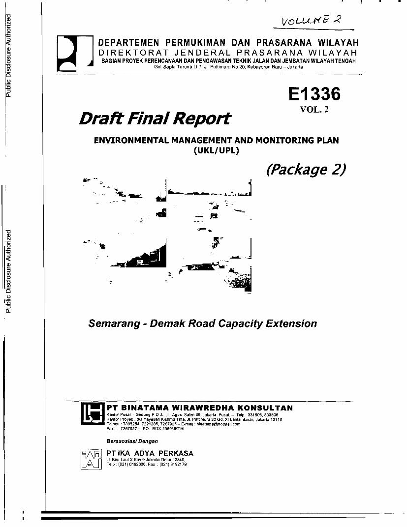
DEPARTEMEN PERMUKIMAN DAN PRASARANA WILAYAHDIREKTORAT JENDERAL PRASARANA WILAYAH
BAGIAN PROYEK PERENCANAAN DAN PENGAWASAN TEKNIK JALAN DAN JEMBATAN WILAYAH TENGAHGd. Sapta Taruna Lt.7, Ji. Paftimura No.20, Kebayoran Baru - Jakarta
El 336Draft Final Report VOL. 2
ENVIRONMENTAL MANAGEMENT AND MONITORING PLAN(UKL/ UPL)
(Package 2)
AN
Semarang - Demak Road Capacity Extension
ff PT BINATAMA WIRAWREDHA KONSULTANI JO Kantor Pusat , Gedung P.O.J., JI. Agus Salim 69, Jakarta Pusat. - Telp. 331606, 333806
Kantor Proyek :dfa Yayasan Kishma Tirta, JI. Pattimura 20 Gd. Xi Lantai dasar, Jakarta 1211 0Telpon :7395254, 7221285, 7267925 - E-mail :[email protected]. _7267927- P. BOX 4969/JKTM
Berasosiasi Den gan
PT IKA ADYA PERKASAK Q JI. Biru Laut X Kay 9 Jakarta Timur 13340Telp (021) 6192636, Fax. (021) 819217
Pub
lic D
iscl
osur
e A
utho
rized
Pub
lic D
iscl
osur
e A
utho
rized
Pub
lic D
iscl
osur
e A
utho
rized
Pub
lic D
iscl
osur
e A
utho
rized
Pub
lic D
iscl
osur
e A
utho
rized
Pub
lic D
iscl
osur
e A
utho
rized
Pub
lic D
iscl
osur
e A
utho
rized
Pub
lic D
iscl
osur
e A
utho
rized

Draft Final Report Road Environmental Management and Monitoring Plan (UKUUPL) - Package 2Semarang - Demak Road Section (Capex)
a. Field Survey and Measuring
This activity will be carried out for the purpose of planning as well as
studies, including detailed design, UKL/UPL, etc. The activity is
intended to obtain any information related to:
. Certain location including permanent and supporting poles
bordering the location of road betterment project.
. Initial conditions, including conditions of existing road, bridges,
canals, public facilities and the facilities exist around the location of
Semarang - Demak Road Betterment project.
. Land use in project surrounding, especially those of may be
affected by project activities (building/house, business base,
facilities, and public facilities and infrastructures), etc.
b. Field Survey and Measuring
The land used for Semarang - Demak Road Betterment project,
especially between sta. 0+000 to sta. 3+400 locates outside of Right
of Way (ROW). The land at the left side of road (to Demak direction)
until sta. 1+200 are owned by private (Yayasan Sultan Agung, Mascom
Graphy, etc.), the width of which will be acquitted of 2.3 to 9.1 m.
While at the right side one (to Demak direction), the land that will be
used by the project is PT Kereta Api Indonesia's proprietary rights
(presently, Semarang - Demak line does not operate any longer). Due
to the road widening plan, the pre-construction phase will also require
to undertake relocation of canal at sta. 0+000 to 3+400 as well as
human crossing bridge (JPO) replacement at sta. 1+100 (in the front
of Islamic Hospital of Sultan Agung).
4.2 Construction Phase
Construction Preparation
a. Project Office and Base Camp Establishment and Operation
The base camp for the activities during construction implementationwill be established close to the project location.
b. Manpower MobilizationThe manpower required by the project will be mobilized from either in
or out of project area. Most of them are unskilled laborers, carpenters,and masonries that will be recruited from local workforce.
c. Mobilization of Heavy-Duty Equipment
The heavy-duty equipment that will be mobilized will consist of among
others the followings:
Association of PT Binatama Wirawredha Konsultan and PT. Ika Adya Perkasa Page - 2
Draft Final Report Road Environmental Management and Monitorng Plan (UKLUUPL) - Package 2Semarang - Demak Road Section (Capex)
* Dump truck of 3 - 4 m3
* Bulldozer of 100 - 150 HP* Motor Grader* Rubber wheel loader* Chained wheel loader* Excavator of 80 - 140 HP* Iron wheel crusher of 6 - 9 ton* Vibrating crusher of 6 - 9 ton* Vibrating crusher of 1.5 - 3 ton* Rubber wheel crusher of 8 - 10 ton• Compressor of 4000 - 6500 I/min.* Concrete mixer of 0.3 - 0.6 m3
Construction Imp/ementation
d. Materials Transportation
The materials transportation will be carried out on excavated and pilledmaterials for land preparation and drainage, as well as constructionmaterials for pavement structure, median development and minorworks.
e. Land Preparation
This will include road pavement widening, land excavation, pilling andcramming. The additional road pavement width will be 2.21 to 13.60meter. Excavation works for rigid pavement structure will includeoverall road width at sta. 0+000 to 1+600; for road wideningpavement structure will be at sta. 1+600 to 20+100; and for drainagecanal will be shifted from road widening of sta. 0+000 to 1+200,1+600 to 7+800.
t Road Pavement and Bridge Structure WorksThe structure of widening pavement will include Aggregate Class B inthick of + 25 cm, Lean Concrete 10 cm, Rigid Pavement 30 cm, and ACWearing Course 5 cm. The numbers of bridges and culverts that willbe improved (recoated or repaired) are 17 along Semarang - Demakroad link. All bridges in Kabupaten Demak have been 2 x 7 m ofwidth. The widening will be conducted along J1 Raya Ranggalawe tokabupaten boundaries road link.
g, Median Development
The median that will be constructed comprises of 2 types i.e. doublecurb of 1.5 m width and Concrete Barrier of 0.6 m.
Association of PT Binatama Wirawredha Konsultan and PT. Ika Adya Perkasa Page - 3
_ -

Draft Final Report Road Environmental Management and Monitoring Plan (UKLUUPL) - Package 2Semarang - Demak Road Section (Capex)
h. Drainage and Sidewalk Works
The location of new drainage will be at sta. 0+000 to 1+200, 1+6000
to 7+800. This drainage canal is very important, especially at J1.
Ranggalawe to terminal intersection of Terboyo road link, which is
susceptible to flood. The sidewalk will be constructed along road links
that are included in Kota Semarang (sta. 0+000 to 3+600) and densely
populated area / resident activities in Kabupaten Demak.
i, Minor Works
This activity is the last phase of construction phase. This work will
include:
* Hot mix asphalt for minor works* Stabilization of vegetation* Thermoplastic road marks* Single road sign with spotlighted engineering grade
* Direction pole* Kilometer pole* Hectometer pole* Guard Rail* Pre-cast curb
4.3 Post-Construction Phase
a. Road Operation
Road operation is the activity relates to the completion of overall road
betterment activities, on which the road can be operated with no
construction activity obstacles.
b. Road Maintenance
Road maintenance works will cover road treatment and maintenance
as well as building and supporting facilities. This activity includes:
* Pavement routine maintenance* Shoulder routine maintenance* Canal, drainage, excavation and piling routine maintenance
* Road equipment routine maintenance* Bridge routine maintenance
5. Construction Implementation Schedule
The construction of Semarang - Demak Road Betterment will be carried out at the
end of Fiscal Year of 2005.
Association of PT Binatama Wirawredha Konsultan and PT Ika Adya Perkasa Page -4

Draft Final Report Road Environmental Management and Monitorng Plan (UKUUPL) - Package 2Semarang - Demak Road Section (Capex)
III. AFFECTED ENVIRONMENTAL COMPONENTS
3.1 PHYSICAL-CHEMICAL COMPONENTS3.1.1 Climate, Air Quality and Noise
a. Climate
As most of Indonesian regions, the study area of Semarang - Demak RoadBetterment project is tropical zone with the annual rainfall of 2,183 - 2,215mm. The peak rainy season happens in December to January. Thetemperature ranges from 240 C to 330 C, the humidity varies from 62% to84% on average, and the wind speed is 5.9 km/hr on average.
b. Air QualityThe measuring of air quality in the study area will be carried out in twolocations i.e. Semarang - Demak Road T-Intersection (Genuk Sari) and inBuyaran Village, Kecamatan Karangtengah. The air quality parameterscover 502, NO2, CO, 02, dust and noise. The measuring results will furtherbe compared with quality standard in accordance with the Decree ofGovernor of Central java Province No. 8 Year 2001 on the Quality Standardof Ambient Air in Central Java. The measuring results of air quality areshown in Table 3.1.
Table 3.1 Air Quality Measuring Results
Threshold Value Location-1 Location-2No. Parameter (NAB) (ot / m3) (LJ / m3)
1. S02 632 7.55 3.742. N02 316 1.69 0.933. CO 15,000 5,061.78 4,741.134. 02 235 10.72 792.025. Du 230 1,584.3 12.02
Source: Measuring Result, Februaly 2004
Notes: NAB = Nilal Ambang Satas in accordance with SK Governor of Central Java No. 8 Year2001 on Ambient Air Quality Standard in Central Java.
c. NoiseThe measuring of air quality in the study area will be carried out bysampling from the distance of 10 m, 25 m, 50 m, and 100 m of study areaand conducted in five locations, i.e. location-i in Puskesmas Sayung (sta.9+300), location-2 in SMU Muhammadiyah 2 (sta. 10+300), location-3 inSDN Karang Tengah 1 and 2 (sta. 18+600), location-4 in SLTPN KarangTengah 1 (sta. 19+500), and location-5 in SMUN 3 Demak (sta. 21+200).Detailed measuring result is presented in Table 3.2.
Association of PT Binatama Wirawredha Konsultan and PT. Ika Adya Perkasa Page - 5
I~~~~~~~~~~~~ I I I _

Draft Final Report Road Environmental Management and Monitoring Plan (UKUUPL) - Package 2Semarang - Demak Road Section (Capex)
Table 3.2 Measuring Result of Noise Level
Location Quality Distance from
No. Location Lci Standard Sound Source(Sta ___ 10 25 50
1. Puskesmas Savung 9+300 65 77 63 59
2. SMU Muhammadiyah 2 10+300 55 75 61 61
3. SDN Karang Tengah 1 and 2 18+600 55 76 62 58
4. SLTPN Karang Tengah 1 19+500 55 76 65 60
S. SMUN 3 Demak 21+200 55 74 62 58
Source: Prnmary Survey, February 2004
Notes: *) Quallty Standard based on the Ministerial Decree of Environment No. Kep-48/
MENLH/11/1996 stipulating:
Offlce complex and trade area = 65 dBA; Green Open-Space (Paddy fleld) = 50
dBA, Residence, school and similar type = 55 dBA
3.1.2 Hydrology and Water Quality
a. Hydrology
Water surfaces exist in the study area are in the form of irrigation water,
river including several tributaries that flow in the right side of road to ocean
direction (Java Sea) in north side of road, and fishponds in Kabupaten
Demak area.
b. Water Backup
The study area is an area that may naturally be stagnated by water due to
rise and fall of tides of the sea. The areas along northern coast of Java Sea,
i.e. at the north side of railway, are flooded area due to high tide. The
backup of water occurs because the sea level is higher than land surface
level.
c. Water Quality
The measuring of water quality was carried out in two locations, i.e.
location-1 at Kali Babon locates in the north side of road in Kota Semarang
(sta. 4+100) and location-2 at irrigation channel in the south side of road in
Kabupaten Demak (sta. 18+040). The measuring results shown that for the
water quality in the study area does not exceed the quality standard for
physical and chemical parameters in accordance with PP No. 82 Year 2001
on Water Pollution Management and Control, while for Fecal Coli form
parameter, the water quality exceeds quality standard. The result of
laboratory test on water quality of surface water in the study area is
attached the Annex herein.
Association of PT Sinatama Wirawredha Konsultan and PT. Ika Adya Perkasa Page - 6

Draft Final Report Road Environmental Management and Monitoring Plan (UKUUPL) - Package 2Semarang - Demak Road Section (Capex)
3.2 PHYSIOGRAPHICAL AND GEOLOGICAL
3.2.1 Topographical
The study area of Semarang - Demak Road Betterment project locates around 1- 2 km from coastal line of Java Sea having the height of 1 - 3 m under sea level,which may lead to water backup resulting from either topographical condition orinfluence of rise and fall of tides (rob).
3.2.2 Geological
Rock formation in the study area is alluvial sedimentation, which are formed fromclay, silt, sand, gravel and slabs of stone that have not been naturallyconsolidated.
3.2.3 Type of Soil
The types of soil in the study area are alluvial and grumosal types. Alluvialassociated soil exists in lowland, which is generally planted with non-productivetrees, while grumosal soil is generally planted with the types of horticulture andrice.
3.3 SPATIAL AND LAND USE
3.3.1 Spatial
Based on the Guidelines of Spatial Planning (RTRW) of Kotamadya Semarang(1995 - 2005) and Spatial Planning of Kabupaten Demak (1995 - 2055), thestudy area of Semarang - Demak Road Betterment project is included in UrbanRegional Section (BWK) -IV and Planning Region (WP) -II (Kecamatan Genuk) ofKotamadya Semarang, which function as industrial area in northern KotamadyaSemarang. It is also included in Planning Region Unit (SWP) -I (KecamatanDemak, Wonosalam and Karang Tengah) and Planning Region Unit (SWP) -II,which function as area for the development of food crops agriculture, trade,fishery, government affairs, estate, forestry and animal husbandry (SWP-III).
3.3.2 Land Use
In Kecamatan Genuk area (Semarang), the land use is dominated with buildingsand yards, while in Kecamatan Sayung (Demak) the land use pattern is atransition phase from typical rural to urban as paddy field is still dominant but notmore than 50% of total area. In three other kecamatans (Karang Tengah,Wonosalam and Demak), the land uses are dominated by paddy field that aremore than 50% of total area. The land use pattern in the kecamatan of studyarea is shown in Table 3.3.
Association of PT Binatama Wirawredha Konsultan and PT. Ika Adya Perkasa Page - 7

Draft Final Report Road Environmental Management and Monitoring Plan (UKUUPL) - Package 2Semarang - Demak Road Section (Capex)
Table 3.3 Land Use in the kecamatan of Study Area
No. Land Use Genuk Sayn Karang Tengah Wonosalam I Demak I
No. ____Land___Use __ Ha ox Ha 0/a Ha % Ha % Ha %
1. Paddy field 263 9.6 2,969 36.2 3,496 68.4 3,815 85.5 3,910 57.3
2. Yard & buildings 1,030 37.6 1 19.8 712 13.9 1,183 20.3 851 15.6
3. Non-irrigated field & 677 24.7 1,195 14.5 186 3.6 540 9.3 1,057 18.3
estate _
4. Fishpond 340 12.4 1,856 22.6 493 9.6 0 0 0 8.5
5. Pool / pond 0 0 0 0 0 0 0 0 0 0
6. Swamp 194 7.1 0 0 0 0 0 0 0 0
7. Others (dry land) 232 8.5 0 0 0 0 0 0 0 0
8. Others (river, road, etc.) 99 3.6 225 2.7 269 5.2 246 4.2 284 0.3
Total 2,739 100 7,869 100 5,154 100 5,732 100 6,113 100
Source: Statistic of Kecamatan Genuk, Sayung, Karang Tengah, Wonosalam and Demak (2002)
The land use around (right and left side) of Semarang - Demak Road Bettermentproject location is generally for the purposes of industry, trade and services(Kecamatan Genuk), and residence, industry and paddy field (Kecamatan Sayung,
Karang Tengah, Wonosalam and Demak Kota). Detailed description of land use is
illustrated in Table 3.4.
Table 3.4 Location and Condition of Land Use in Semarang - Demak RoadBetterment Project Area
Road Link Location Boundaries and Land UseNo. (Sta) Length (m) Left Side of Road Right Side of Road
1. Sta 0 + 000 to Kaligawe toll bridge to Terboyo * Industry * Industry
Sta 1 + 200 Terminal (1,200)* School * Disposal canal
* University * Unused land
* Hospital
* Unused land
2. Sta 1 + 200 to Terboyo Terminal to Industrial * Industry * Industry
Sta 2 + 200 Estate of Terboyo (1,000)* Trade * Trade
* Residence * Residence
* Mosque
3. Sta 2 + 200 to Industrial Estate of Terboyo to * Industry * Trade
Sta 3 + 000 Simpang Genuk ((1,800)* School * Densely
populated* University residence
* Hospital
* Unused land
4. Sta 3 + 000 to Simpang Genuk to Kali Babon * Residence * Industry
Sta 4 + 100 (1,100) * Industry * Paddy field
* Unused land
Association of PT Binatama Wirawredha Konsultan and PT. Ika Adya Perkasa Page - 8
Draft Final Report Road Environmental Management and Monitoring Plan (UKUUPL) - Package 2Semarang - Demak Road Section (Capex)
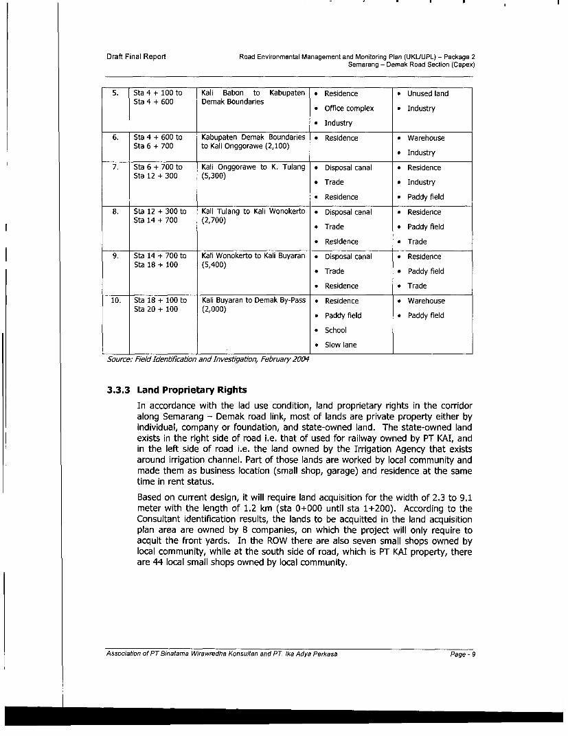
5. Sta 4 + 100 to Kali Babon to Kabupaten * Residence * Unused landSta 4 + 600 Demak Boundaries
* Office complex * Industry
* Industry
6. Sta 4 + 600 to Kabupaten Demak Boundaries * Residence * WarehouseSta 6 + 700 to Kali Onggorawe (2,100) * Industry
7. Sta 6 + 700 to Kali Onggorawe to K. Tulang * Disposal canal * ResidenceSta 12 + 300 (5,300) * Trade a Industry
* Residence * Paddy field
8. Sta 12 + 300 to Kali Tulang to Kali Wonokerto * Disposal canal * Residencei Sta 14 + 700 (2,700) * Trade * Paddy field
* Residence * Trade
9. Sta 14 + 700 to Kali Wonokerto to Kali Buyaran * Disposal canal * ResidenceSta 18 + 100 (5,400) * Trade * Paddy field
* Residence * Trade
10. Sta 18 + 100 to Kali Buyaran to Demak By-Pass * Residence * WarehouseSta 20 + 100 (2,000) * Paddy field * Paddy field
* School
* Slow lane
Source: Field Identilfcation and Investlgation, February 2004
3.3.3 Land Proprietary Rights
In accordance with the lad use condition, land proprietary rights in the corridoralong Semarang - Demak road link, most of lands are private property either byindividual, company or foundation, and state-owned land. The state-owned landexists in the right side of road i.e. that of used for railway owned by PT KAI, andin the left side of road i.e. the land owned by the Irrigation Agency that existsaround irrigation channel. Part of those lands are worked by local community andmade them as business location (small shop, garage) and residence at the sametime in rent status.
Based on current design, it will require land acquisition for the width of 2.3 to 9.1meter with the length of 1.2 km (sta 0+000 until sta 1+200). According to theConsultant identification results, the lands to be acquitted in the land acquisitionplan area are owned by 8 companies, on which the project will only require toacquit the front yards. In the ROW there are also seven small shops owned bylocal community, while at the south side of road, which is PT KAI property, thereare 44 local small shops owned by local community.
Association of PT Binatama Wirawredha Konsultan and PT Ika Adya Perkasa Page - 9

Draft Final Report Road Environmental Management and Monitoring Plan (UKUUPL) - Package 2Semarang - Demak Road Section (Capex)
3.4 BIOLOGICAL COMPONENTS
3.4.1 Flora
The area of along Semarang - Demak road is used for residence and industrial
areas allowing this area is dominated by yard plants (ornament, fruit, and shading
plants), wet paddy field (wetland cultivation), dry land cultivation plants (estate),
reforesting plants (in industrial area), and shading plants (along ROW). In the
study area there are no rare plants that are protected by the regulations.
3.4.2 Fauna
The fauna exist in the study area are domesticated and wild animals. The
domesticated animals that have economical value are categorized into several
types i.e. domesticated animal, poultry and fish, while wild animals comprise of
types of reptilian, aves, insect, amphibian, and mammalian.
3.5 SOCIO-ECONOMIC, CULTURE AND PUBLIC HEALTH
3.5.1 Socio-Economic
a. Demographic
Based on the statistics of Kota Semarang (2002), the total population of
Kota Semarang is 1,350,005 comprising 671,032 men and 678,973 women
in 2002. The statistics of Kabupaten Demak (2002), Kabupaten Demak has
a total population of 996,384 comprising 492,123 men and 503,191 women.
The total population, sex ratio and density of each kecamatan in study area
is shown in Table 3.5.
Table 3.5 Total Population and Density in Study AreaNo. Kecamatan Area Total Population Sex Density
o. ___________ c a (Km2) Man Woman Total Ratio (Person/Km2)
1. Genuk 27.39 32,477 31,477 63,904 103 2,333
2. Sayung 78.69 43,977 45,081 89,058 98 1,132
3. Karang Tengah 51.54 28,097 28,228 56,325 99 1,093
4. Wonosalam 57.84 31,951 33,011 64,962 97 1,123
5. Demak Kota 61.18 46,551 48,225 94,776 97 1,550
Source: Statistics of Kota Semarang and Kabupaten Demak, 2002
b. Population Structure and Growth
The structure of population based on sex in the study area can be indicated
by the sex ratio, i.e. 103 (Genuk), 98 (Sayung), 99 (Karang Tengah), 97
(Wonosalam and Demak Kota respectively. During last five years (1998-
2002), the population growth of Kota Semarang is 1,47%, while Kabupaten
Demak is 2,6%.
The composition of population based on productive age group (15-64 years
old) and non-productive age (0-14 and > 65 years old) in each kecamatan
Association of PT Binatama Wirawredha Konsultan and PT. Ika Adya Perkasa Page - 10

Draft Final Report Road Environmental Management and Monitoring Plan (UKUUPL) - Package 2Semarang - Demak Road Section (Capex)
of the study area is shown in Table 3.6. The table shows that thedependency ratio (ratio of non-productive population and productivepopulation) is 45.2 for Kecamatan Genuk in Semarang and 57.1 for eachkecamatan in Kabupaten Demak.
Table 3.6 Composition of Population per Productive and Non-Productive Age Groups
No. Age Kecamatan ____ __ ______
Group Genuk Sayung Krg Tengah Wonosalam Demak1. 0- 14 18,005 28,854 18,254 30,698 21,0432. 15 - 64 44,019 56,699 35,854 60,339 41,3593. > 65 1,88 3,505 2,218 3,739 2,56
Total 63,904 89,058 56,326 94,776 64,962Dependency 45.2 57.1 57.1 57.1 57.1RatioII
Source: Statistics of Kecamatan Genuk, Sayung, Karang Tengah, Wonosalam and Demak (2002)
c Economics Activities
The condition and development of trading and shopping area in the studyarea is indicated by the number of traditional markets as the transactionfacilities of economics activities. In Semarang - Demak road link that will beimproved there are 3 local traditional markets, i.e. Genuk. Sayung, andOnngorawe traditional markets. In addition to traditional markets, there arealso many small shops (kios), small restaurants (warung makan) andvendors along the road.
The economics sectors that are dominant based on its contributions to localrevenue, which are reflected in the Gross Regional Domestic Product (PDRB)on market price basis of 2001 are: trade, hotel and restaurant (40.47%),processing industries (8.26%), and services (12.55%) for KotamadyaSemarang, and agricultural sector (44.03%), big and retail trade as well asindutrial sectors for Kabupaten Demak.
d. Livelihood and Income
Based on statistics of each kecamatan in the study area in 2002, majormeans of livelihood of population in Kecamatan Genuk (Semarang) is worker(47.54%), service and others (23.44%). While in three kecamatans of thestudy area of Kabupaten Demak (Sayung, Karangtengah, and Wonosalam),most of population livelihoods are farmers (>50%), and then laborers. InKecamatan Demak no sectors dominate the means of livelihood, whichspreads evenly to all sectors (30% of each sector) as shown in Table 3.7.
Association of PT Binatama Wirawredha Konsultan and PT. Ika Adya Perkasa Page - I1

Draft Final Report Road Environmental Management and Monitoring Plan (UKLUUPL) - Package 2Semarang - Demak Road Section (Capex)
Table 3.7 Composition of Livelihood in the Study AreaType of Genuk Sayung Karang Wonosalam Demak
NO. Livelihood Tengah ___
o. Livelihood Total | % Total | % Total % Total % Total |
1. Farmer 6,718 16.63 18,919 51.95 17,287 59.52 22.792 65.58 24,475 32.76
2. Fisherman 23 0.06 1,225 3.36 227 0.78 0 0 0 0
3. Entrepreneurship 207 0.51 0 0 68 0.23 305 0.88 0 0
4. Labor 19,203 47.54 8,864 24.34 6,437 22.04 4,529 13.03 4,603 6.16
5. Trade 2,100 5.20 3,814 10.47 1,967 6.74 3,268 9.40 6,353 8.50
6. Transportation 921 2.28 1,138 3.12 763 2.61 11,161 3.34 0 0
7. Servant/Army 1,3431 3.33 1,073 2.95 678 2.32 737 2.12 0 0
8. Pension 409 1.01 255 0.70 193 0.66 150 0.43 0 0
9. Other services 9,466 23.44 1,133 3.11 1,581 5.41 1,810 5.21 16,243 21.74
10. Plantation 0 0 0 0 0 0 0 0 45 0.06
11. Fishery 0 0 0 0 0 0 0 0 22,771 30.47
12. Livestock 0 0 0 0 0 0 0 0 232 0.31
Total 40,390 100 34,421 100 29,201 100 44,752 100 74,722 100
Source: Statistics of Kecamatan Genuk, Sayung, Karangtengah, Wonosalam and Demak (2002)
According to the statistics of Kotamadya Semarang (2002), regional income
per capita of Kotamadya Semarang on market price basis in 2001 was Rp.
9,295,038. While the statistics of Kabupaten Demak shows that the regional
income per capita in 2002 was Rp. 2,410,086. Based on interview result with
respondents conducted in site, income per capita per month on average is
less than Rp. 100,000 (90.35% of total respondents).
3.5.2 Socio-Culture
a. Socio-Culture Condition
In general the community of study area is divided into two groups, i.e. semi-urban and urban communities. At Semarang - Demak road betterment planarea, the community still hold certain traditions, especially those of related
to belief and religion. In addition, the community movement in study areais in high level as they can access to surrounding areas easily due to the
availability of road infrastructures that are in good condition, as well as the
availability of public transportation passing through the study area.
b. Education
There sufficient types and number of education facilities are available to the
study area allowing appropriate level of education of the community, and
only small possibility of existence of illiterate people. The type and numberof education facility is presented in Table 3.8.
Association of PT Binatama Wirawredha Konsultan and PT. Ika Adya Perkasa Page - 12

Draft Final Report Road Environmental Management and Monitoring Plan (UKUUPL) - Package 2Semarang - Demak Road Section (Capex)
Table 3.8. Amount and Type of Education Facility in Study AreaNo. Education Facility Sub-district
Genuk Sayung Krg. Wonosalam DemakTengah
1. Kindergarten 31 21 19 23 342. Elementary School & M.Ib 39 51 40 45 673. Junior High School & M.Ts. 10 11 7 8 134. Senior High School & M.A. 6 53 3 2 11S. Islamic School (Pesantren) 14 0 0 0 06. University 1 0 0 0 1
Source: Statistics of Kecamatan Genuk, Sayung, Karangtengah, Wonosalam and Demak in 2002
Most of respondents in the study have appropriate education levelcomprising Senor High School (SLTA) of 30.70%, Elementary School(20.18%) and Junior high graduated (19.30%).
c. Community PerceptionMost of the respondents do not know the information on Semarang -Demak road betterment project, i.e. 80.7%, and only 19.3% respondentsknow the project. From 22 respondents who know about the project,50.54% respondents got the information from the kecamatan/kelurahanoffice or staff, while other 47.41% from other sources, including from theConsultants who are carrying out field measuring activities.All of 114 respondents interviewed in the study area agree with the projectplan. They viewed that the project would give benefits to wider community(33.13%), the project would reduce traffic congestion and accident(24.38%), and project can provide work opportunity of employment(21.88%), as shown in Table 3.9.
Table 3.9. Respondent's Response to the Projectl ~~~~~~~~~~~~~Response to Agree with the Project Responden t Amount
Amounts (%/)Agree, Reason: 114 100,00a. Give some benefits to wider communitha 53 33.13b. Provide work opportunitn 35 21.88c. Provide business opportunit ot (trade, etc) 22 13.75d. Increase of social welfare 7 4.38
ject tional development 4 2.50Ac f.T Batars 39 24.38
TOTAL 160 100.00Source : Prlmar)y 5urvey, February 2004Note., ) the It is possible to give more than one answers
Most of the respondents (65.8%) expressed their willing to enroll their familymembers in the project in conformity with their capabilities. The mostrespondents gave suggestions to the project to construct median, sidewalks,and zebra cross (34.08%), while the remaining respondents are willing to theproject to develop road safety equipment and facilities, including road lights,
Association of PT Binatama Wirawredha Konsultan and PT Ika Adya Perkasa Page - 13

Draft Final Report Road Environmental Management and Monitoring Plan (UKUUPL) - Package 2Semarang - Demak Road Section (Capex)
cross bridge and traffic light in T-intersection. The respondents' suggestions
are presented in Table 3.10.
Table 3.10. Respondent Suggestion of the Project
No. Suggesbons Resondents Percentage
1. Construction of median, sidewalk, zebra-cross 61 34.08
2. Providing traffic lights in the T-intersection 19 10.61
3. Construction of a cross bridge 29 16.20
4. Provision of road lights 33 18.44
5. Availability of good drainage 15 8.83
6. Availability of alternative road for bicycle or 2 1.12
heavy-duty vehicle (bus / truck / container)7. Construction of U-turn 3 1.68
8. Others 17 9.50
TOTAL 180 100.00
Source: Primary Survey, February 2004Note : ) It is possible to respondent to give more than one suggestions
3.5.3 Public Health
The type and amount of health facilities in a study area are good enough, except
for Karangtengah Sub-district that has a minim number and type of health facility,
however, it is easy to access to the health facility in its surrounding area nearby,
so that this is not significantly influence the condition of people's health in
Karangtengah Sub-district, as described in Table 3.11.
Table 3.11. Type and number of Health Facility in Study Area
No. Type of Facility Genuk Sayung Krg. Wonosalam DemakTengah ______
1. Hospital 1 0 0 1 1
2. Village Clinic (Puskesmas) 5 7 5 5 12
3. Policlinic 8 2 0 0 3
4. Maternity Hospitals 0 2 0 1 8
5. Medical Specialist 14 0 0 0 0
_ (Doctor) I I _I I I
Source: Statistics of Kecamatan Genuk, Sayung, Karangtengah, Wonosalam and Demak, 2002
According to the Village Clinic officer in Kecamatan Sayung the health obstruction
that is frequently suffered by the community member is Respiratory Disease
(ISPA). This information is supported by the result of interview with respondent
in the study (7 9.8 2%). The result of the interview is shown in Table 3.12.
Association of PT Binatama Wirawredha Konsultan and PT Ika Adya Perkasa Page - 14

Draft Final Report Road Environmental Management and Monitoring Plan (UKUUPL) - Package 2Semarang - Demak Road Section (Capex)
Table 3.12 Types of Diseases Suffered by Local Community
No. Type of Disease Amount of Percentage (%)1. Influenza / Throat / Respiratory 91 79.822. Diarrhea / Dysentery ......... 1 0.883. Skin / Itch / Scabies / Ringworm 3 2.634. Others 19 16.16
TOTAL 80 100.00
3.6 PUBLIC FACILITIES AND INFRASTRUCTURE
3.6.1 Road Condition
The condition of existing Semarang - Demak road that will be improved may bedivided into 2 sections, i.e. section-I from under Kaliwage toll road to theboundary of Kota Semarang and Kabupaten Demak (sta 0+000 to STA 4+600)and section-2 from the city boundary to the end of road link in Demak by pass(sta 4+600 to STA 20+100).
The physical condition of existing road in section-1 at the time of implementation,which consists of 4 lanes of two ways with the width of roadway of 11.54 m to17.9 m was in deteriorate condition resulted from both water backup and trafficdensity. At the end of this section-1, which is 600 m before the boundary of kotaand kabupaten, the road has 2 lines and 4 lanes of 3.5 m width of each. While insection-2 the condition of the road is still good with 2 lines and 4 lanes. However,in the area of city surrounding the road narrowed (bottleneck) from the directionof Demak to Semarang, which is susceptible to traffic accidents. According to theTechnical Implementation Office (Balai Pelaksana Teknis) of Bina Marga,Semarang the area that is seriously affected by traffic accidents is in city borderarea (road access to kota from kabupaten) that close to Sayung Market andKarangtengah Market (Onggorawe).
3.6.2 Traffic Condition
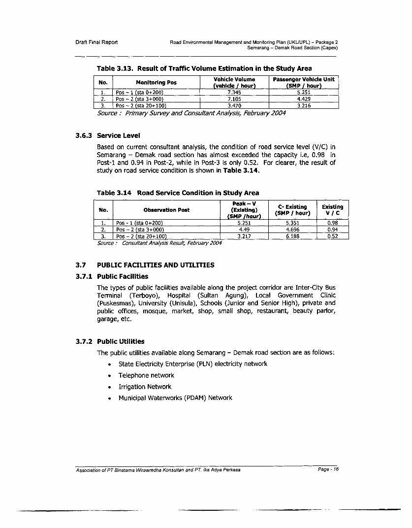
The Semarang - Demak road link services public transportation of long distanceroute with medium until high speed. This road is national roadservicing/connecting inter-city in Java island and also between Java island andnearby islands. This road link is part of North Java Road corridor that is the arteryof Indonesian economics activities, with daily traffic volume of 5.251 smp atmaximum.
The Consultant has conducted a survey of traffic count volume during 24 hours ofworking days (Monday - Tuesday) and holiday (Saturday - Sunday), at 3monitoring spots. The survey was conducted from the beginning (Kaligawe Street,sta 0+200), T-intersection road of Semarang - Demak and Genuk Sari (sta3+000) and the end of project (Semarang Demak Road close Demak By-Pass (sta20+100), which results are illustrated in Table 3.13.
Association of PT Binatama Wirawredha Konsultan and PT Ika Adya Perkasa Page - 15
Draft Final Report Road Environmental Management and Monitoring Plan (UKLUUPL) - Package 2Semarang - Demak Road Section (Capex)
Table 3.13. Result of Traffic Volume Estimation in the Study Area
Vehicle Volume Passenger Vehicle UnitNo. Monitoring Pos (vehicle / hour) (SMP / hour)
1. Pos - 1 (sta 0+200) 7.345 5.251
2. Pos - 2 (sta 3+000) 7.105 4.4293. Pos - 2 (sta 20+100) 3.470 3.216
Source: Primary Survey and Consultant Analysis, February 2004
3.6.3 Service Level
Based on current consultant analysis, the condition of road service level (V/C) in
Semarang - Demak road section has almost exceeded the capacity i.e, 0.98 inPost-1 and 0.94 in Post-2, while in Post-3 is only 0.52. For clearer, the result of
study on road service condition is shown in Table 3.14.
Table 3.14 Road Service Condition in Study Area
Peak - V C Existing ExistingNo. Observation Post (Existing)
(SMP /hour) MP/ hour) V / c1. Pos - 1 (sta 0+200) 5.251 5.351 0.98
2. Pos - 2 (sta 3+000) 4.49 4.696 0.94
3. Pos - 2 (sta 20+100) 3.217 6.188 0.52
Source: ConsultantAnalysis Result, February 2004
3.7 PUBLIC FACILITIES AND UTILITIES
3.7.1 Public Facilities
The types of public facilities available along the project corridor are Inter-City BusTerminal (Terboyo), Hospital (Sultan Agung), Local Government Clinic(Puskesmas), University (Unisula), Schools (Junior and Senior High), private andpublic offices, mosque, market, shop, small shop, restaurant, beauty parlor,garage, etc.
3.7.2 Public Utilities
The public utilities available along Semarang - Demak road section are as follows:
* State Electricity Enterprise (PLN) electricity network
* Telephone network
* Irrigation Network
* Municipal Waterworks (PDAM) Network
Association of PT Binatama Wirawredha Konsultan and PT. Ika Adya Perkasa Page - 16

Draft Final Report Road Environmental Management and Monitoring Plan (UKUUPL) - Package 2Semarang - Demak Road Section (Capex)
IV. POTENTIAL IMPACTS
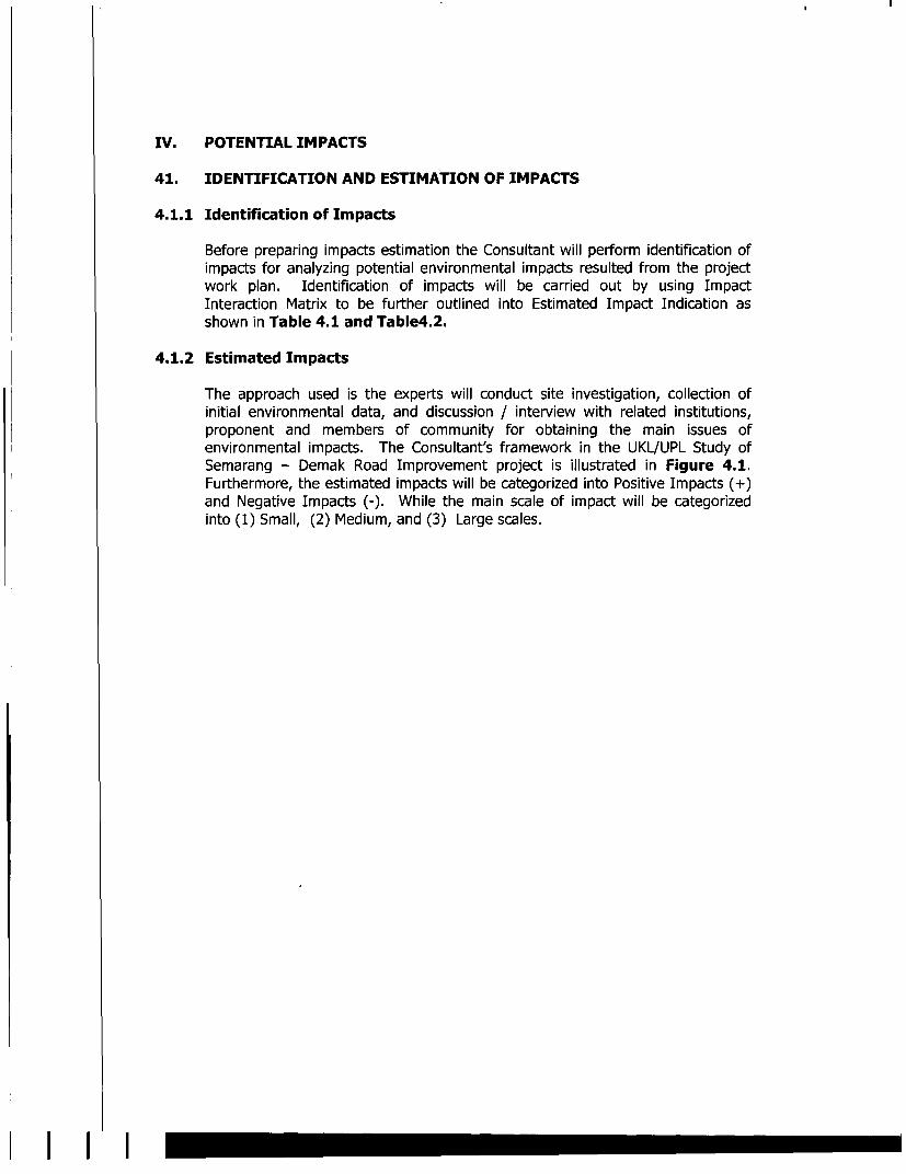
4.1 IDENTIFICATION AND ESTIMATION OF IMPACTS4.1.1 Identification of Impacts
Before preparing impacts estimation the Consultant will perform identification ofimpacts for analyzing potential environmental impacts resulted from the projectwork plan. Identification of impacts will be carried out by using ImpactInteraction Matrix to be further outlined into Estimated Impact Indication asshown in Table 4.1 and Table4.2.
4.1.2 Estimated Impacts
The approach used is the experts will conduct site investigation, collection ofinitial environmental data, and discussion / interview with related institutions,proponent and members of community for obtaining the main issues ofenvironmental impacts. The Consultant's framework in the UKL/UPL Study ofSemarang - Demak Road Improvement project is illustrated in Figure 4.1.Furthermore, the estimated impacts will be categorized into Positive Impacts (+)and Negative Impacts (-). While the main scale of impact will be categorized into(1) Small, (2) Medium, and (3) Large scales.
Figure 4.1 FRAMEWORK of STUDY PREPARATION OF UKL/UPL FORROAD BETTERMENT PROJECT
PREPARATION STUDY OF UKLJUPL OFSEMARANG -DEMAK ROAD BETTERMENT
Description of Proposed Road GOI Laws and Regulations onBetterment Project lEnvironmental
Scope of Works of Environmental study for Road Betterment Project
Field Survey and Investigation Data Collection of Environmental(Preliminary) Components
Description of Existing Environmental Condition in the Location ofRoad Betterment Project
Identification, Estimation and Analysis of Environmental Impact ofthe Road Betterment Project
Recommendations to UKL & UPL
Association of PT Binatama Wirawredha Konsultan and PT Ika Adya Perkasa Page - 17

Draft Final Report Road Environmental Management and Monitoring Plan (UKUUPL) - Package 2Semarang - Demak Road Section (Capex)
TABLE 4.1 MATRIX OF UKL - UPL STUDY IMPACT INTERACTION
SEMARANG - DEMAK ROAD BETTERMENT
No. ENVIRONMENTAL COMPONENT A B ACTIVITY COMPONENTS________________ ~~A B IC D E F G H I -J IK IL M
I Chemical Physics1 Climate2 Air Qulaity X X - - - - X -
3 Land Quality4 Noise - X X X - - - X
5 Vibration6 Phisiographic and Geological7 Hydrology and Water Quality X X - - - X - - X - - -
8 Land Use / Spatial Planning
11 Biology1 Flora- - - - - - - - - - - - -
2 Fauna3 Water Biota
Ill Socio-Economics and Culture1 Community2 Livelihood / Economics - x - x-3 Land Ownership Structure4 People Mobility (Movement) - X - - - - X X - X -
5 Public Health - X X
6 Security and Safety -- -x x -
7 Community Perception X X -X -X X X - X
8 IV Public Facilities and Infrastructure
1 Road Infrastructure (road, traffic) - X - - - X X X X X X X
2 Utilities (Telephone, Electricity, Wate - X3 Public / Social Facilities - Xj-- x
Note:Pre ConstructionA. Field Survey and MeasuringB. Land Acquisition, Relocation of Drainage and Human Cross Bridge (JPO)ConstructionC. Establishment and Operation of Project Office and Base CampD. Manpower MobilizationE. Mobilization of Heavy EquipmentF. Materials TransportationG. Land PreparationH. Road Pavement and Bridge Structure WorksI. Median DevelopmentJ. Side Walk and Drainage WorksK. Minor WorksPost ConstructionL. Road OperationM. Road Maintenance.
X = Impact exists- = No impacts
Association of PT Binatama Wirawredha Konsultan and PT Ika Adya Perkasa Page - 18

Draft Final Report Road Environmental Management and Monitoring Plan (UKUUPL) - Package 2Semarang - Demak Road Section (Capex)
Table 4.2 Estimated Impacts Indication
No. Activities that may be source of Affected Environmental Sub- Potential ImpactsImpacts Components
A. PRE - CONSTRUCTION1. Field Survey and Measuring * Community Perception * Positive Perception of the
Community
2. Land acquisition, Relocation of * Surface Water * Surface water flow obstaclesDrainage and Human Cross Bridge * Economic Activities * Business area obstruction(JPO)
B. CONSTRUCTION1. Establishment and operation of * Quality of surface water * Surface water obstades
Project Office and Base Camp
2. Mobilization of Manpower * Work and business opportunities * Work and business. Community Perception opportunities
* Social restless of localmanpower
3. Mobilization of Heavy-Duty * Noise * Increase of NoiseEquipment * Traffic * Traffic obstacles
4. Materials Transportation * Air quality * Air pollution* Noise * Increase of noise* Traffic * Traffic obstacles
5. Land Preparation * Air quality * Air pollution* Noise * Increase of noise* Surface Water * Surface water flow obstacles
* Accessibility obstacles* Accessibility * Obstruction of public health* Community's health * Traffic Obstacles
* Negative Perception of the* Traffic community* People's Perception
* Accessibility obstacles* Traffic obstacles6. Road Pavement and Bridge Structure * Accessibility * Negative perception of theWorks * Traffic community
* Public Perception* Work Safety obstacles* Traffic obstacles7. Median Development * Work Safety
* Traffic* Surface water obstacles8. Construction of Drainage and * Surface Water * Accessibility disturbance
Sidewalk * Accessibility Obstacles * Negative perception* Public perception
* Work safety obstacles9. Minor Works * Work Safety * Traffic obstacles* Traffic
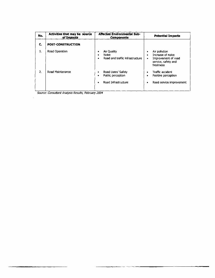
C. POST-CONSTRUCTION1. Road Operation * Air Quality * Air pollution
* Noise * Increase of noise* Road and traffic infrastructure * Improvement of road service,
safety and freshness
2. Road Maintenance * Road Users' Safety * Traffic accident* Public perception * Positive perception* Road Infrastructure * Road service improvement
Source: ConsultantAnalysis Results, February 2004
Association of PT Binatama Wirawredha Konsultan and PT Ika Adya Perkasa Page - 19

Draft Final Report Road Environmental Management and Monitoring Plan (UKLUUPL) - Package 2Semarang - Demak Road Section (Capex)
4.2 PRE-CONSTRUCTION PHASE
4.2.1 Field Survey and Measuring
a, Public Perception
The interaction between field survey and measuring team and local
community will form community perception. As the activity plan will locate
on existing road with dense traffic and high rate of traffic accident, i.e. six
events in Demak Resort where 16 died, 4 seriously injured, and 18 slightly
injured, it is estimated that the Semarang - Demak road betterment project
will lead to positive impact forming positive perception of public to the
project.
4.2.2 Land Acquisition, Drainage and Human Cross Bridge (JPO) Relocation
a. Sufface Water Flow Obstacles
The implementation of drainage relocation activities along sta. 0+000 to
3+400 may obstruct surface water flow. Moreover, the area around the
drainage relocation activities is area with low elevation that is susceptible to
the seawater tide. The drainage relocation activities may cause potential
impact in the form of surface water obstacles.
b. Obstruction of Business Activities
The implementation of land acquisition, relocation of drainage and human
cross bridge, especially at sta 0+000 to sta 3+400 that is densely populated
area, may obstruct the activities of people running business in that location.
In the left side (direction of Demak) of road widening plan there are some 7
small shops and garages.
4.3 CONSTRUCTION PHASE
Construction Preparation
4.3.1 Establishment and Operation of Project Office & Base Camp
a. Surface Water Quality DisturbanceThe disturbance of surface water quality may come from waste disposalduring office and base camp operation. In addition, solid wastes fromorganic and non-organic, plastic and other garbage thrown to the earth orwater canal adjacent to project office and base camp may be a potentialpollutant to surface water. The surface water pollution may also be causedby spilled oil or fuel that are washed away by rain water to irrigation channelor river.
Association of PT Binatama Wirawredha Konsultan and PT. Ika Adya Perkasa Page - 20
Draft Final Report Road Environmental Management and Monitoring Plan (UKUUPL) - Package 2Semarang - Demak Road Section (Capex)
4.3.2 Mobilization of Manpowera. Work and Business Opportunities
In the construction phase of road betterment project it may require 200persons of manpower. It is expected that the manpower will be taken formthe local community around the project location as 65.8% of respondentshave stated the willing to enroll their family members in project works. It isestimated that this work opportunity even limited may give positive impactto the local community. Because apart from work opportunity they alsohave the opportunity to run business, for instance, they may sell employees'daily needs to consume.
b. Social Restless of Local ManpowerThe manpower required by the project (assuming 200 persons) will berecruited based on several qualifications, i.e. road engineer, projectmanager, foreman, and unskilled laborer. A priority of the recruitment ofmanpower will be given to local community in order to avoid social jealousy.Social jealousy may be reflected in the form of demonstration/protest,stealing/destruction of project equipment/vehicle, base camp, violence act tonon-local project employee.
4.3.3 Mobilization of Heavy-Duty Equipmenta. Noise Increase
The activities of mobilization of heavy-duty equipment such as dump truck,backhoe, bulldozer, grader and other construction equipment from rentallocation to base camp may lead to potential impacts in the form of noisethat may increase along road passed through. This may also occur on thetransportation of materials by heavy-duty equipment from quarry location,which is 50 - 100 km from project site.
b. Traffic Obstacles
Traffic obstacles or congestion may occur in dense traffic area, especially atthe area where the project started i.e. in the intersection of TerboyoTerminal (sta 1+200) and in the intersection of Jalan Genuk Sari (sta3+000). During the mobilization of heavy-duty equipment, the trafficcongestion will lead to the obstacle of goods and passenger transportationresulting in wasting of time and fuel that will bring into high cost economy.
4.3.4 Materials Transportationa. Air Pollution
It estimates that the materials transportation activities using dump truckwith the size of 3 - 4 m3 will be 10 vehicles per day. This activity mayincrease air pollution along road passed through. This impact may come
Association of PT Binatama Wirawredha Konsultan and PT Ika Adya Perkasa Page -21

Draft Final Report Road Environmental Management and Monitoring Plan (UKUUPL) - Package 2Semarang - Demak Road Section (Capex)
from transported materials/soils that are not properly covered, which then
are blown by the wind. The other impacts that may occur are the increase of
NOx, Sox, CO gases and Pb from motorized vehicle exhausts resulted from
engine ignition.
b. Noise
The frequency of back and forth of vehicles transporting materials will cause
potential impact in the form of noise increase along road passed through.
This impact will come from the sound of engine of vehicles.
c. Traffic Obstacle
It estimates that the materials transportation activities using dump truck
with the size of 3 - 4 m3 will be 10 vehicles per day. The materials forming
sand and river stone will be carried from quarry location in Muntilan
(Kabupaten Magelang) or Kalikuto (Kabupaten Kendal) to the project site
with the distance of 50 - 100 km. It estimated that the materialstransportation activities may lead to traffic congestion as the road passed
through is national road having high level of traffic volume, especially truck
and inter-city bus. Due to this activity the traffic volume may increase of 5%
- 10%. The most obstacle will occur at Jalan Raya Kaligawe section (sta
0+000), and Jalan Genuk Raya (sta 3+000), where the ratio of V/C during
the activity take place may reach 1.03 - 1.18.
4.3.5 Land Preparation
a. Air Pollution
It estimates that the impacts resulted from land preparation activities
(leveling and cramming) will be the increase of dust content in the air
around project site. This will be worsening if the activities are carried out in
dry season. The existing road has high volume of traffic that the land
leveling and cramming activities may increase dust content in the air.
b. Noise
Land preparation activities conducted using vehicles and heavy-duty
equipment may bring about raise of noise. All the heavy-duty equipment like
bulldozer being operated can reach 7OdBA from the distance of 10m. This
will disturb project surrounding as the project locates in the densely
populated area, which activities include school/university,hospital/Puskesmas that need quiet situation.
c. Surface Water Flow Obstacles
Land preparation activities that include land leveling and cramming may
obstruct surface water flow. The obstruction of surface water course will
Association of PT Binatama Wirawredha Konsultan and PT Ika Adya Perkasa Page - 22

Draft Final Report Road Environmental Management and Monitoring Plan (UKUUPL) - Package 2Semarang - Demak Road Section (Capex)
lead to the obstacle of traffic in the project area, especially in the areas withlow elevation like Jalan Raya Kaligawe (sta 1+000) to Terboyo terminal(1+200).
d. Accessibility Obstacles
Land preparation implementation will include land leveling and crammingactivities in the areas where residences, industrial or other business areas,and paddy fields. It is estimated that these activities may cause theobstacles of access roads comprising of Jalan Raya Kaligawe at sta 0+000(access to Terminal Terboyo and Jalan Semarang - Demak), sta 3+000 (T-intersection of Genuk Sari to Purwodadi direction), sta 4+600 (denselypopulated area), and sta 14+700 to sta 18+100 (school, trade andwarehouse areas).
e. Public Health Obstruction
Land preparation activities may also give potential impact to public health inproject site. The increase of dust coming from the construction materials willcause the decrease of air quality in the project are and surroundings,especially if the activities are carried out in dry season. This decrease of airquality will hamper public health of local community accordingly. Moreover,up to present, many people in the project area have frequently sufferedrespiration disease.
f Traffic Obstacles
The land preparation activities will need several traffic lanes for materialspile, heavy-duty vehicle parking area, and back and forth of vehiclestransporting materials or people working for project resulting in thedecrease of traffic volume. This traffic density due to the decrease of roadservice will give an impact in the form of traffic congestion, especially inJalan Raya Kaligawe and Jalan Genuk Sari, which traffic volumes have beenhigh. The use of traffic land for land preparation activities as width as 1 to 2meters will bring into road constriction (bottleneck) resulting in the increaseof ratio to 1.26 - 1.54.
g. Public Perception
Accumulative potential negative impacts described above may finallyinfluence public perception to the project, which may develop to negativeperception. The community will conclude that the project has led manyobstructions to their daily activities.
Association of PT Binatama Wirawredha Konsultan and PT Ika Adya Perkasa Page - 23

Draft Final Report Road Environmental Management and Monitoring Plan (UKUUPL) - Package 2Semarang - Demak Road Section (Capex)
4.3.6 Road Pavement and Bridge Structure Works
a. Accessibility Obstacles
Road pavement and bridge structure works will include leveling and
cramming of roadway as well as re-overlaying bridge and culvert exist along
project site. These activities will take place in the areas where there are any
access road to residence, industrial or other business areas, and paddy
fields. It is estimated that these activities may lead to the obstacles of
access roads comprising of Jalan Raya Kaligawe at sta 0+000 (access to
Terminal Terboyo and Jalan Semarang - Demak), sta 3+000 (T-intersection
of Genuk Sari to Purwodadi direction), sta 4+600 (densely populated area),
and sta 14+700 to sta 18+100 (school, trade and warehouse areas).
b. Traffic Obstacles
The road pavement structure works will consist of: aggregate base, prime
coat, teack coat, ACWC, AC Binder and AC Base Course. In Jalan Raya
Kaligawe (sta 0+000) to Jalan Genuk Sari (sta 3+000), road service will
decrease that V/C ratio may increase to 1.26 - 1.54. This means that the
traffic volume will exceed the road capacity during the implementation of
road pavement structure activities.
c. Public Perception
The impact of accessibility obstacle due to the road pavement and bridge
structure activities resulting in traffic obstacles will finally influence public
perception to the project, which may develop to negative perception. Public
will conclude that the project has led many obstructions to their daily
activities.
4.3.7 Development of Median
a. Work Safety Obstruction
It is estimated that the development of median may lead to obstruction of
security and safety, especially to the workers carrying out median
construction activities as Semarang - Demak road is designed to high speed
traffic in conformity with its status as national road, and due to the high
volume of traffic.
b. Traffic Obstacles
Traffic congestion and obstacles would occur during the implementation of
median development. With the existing condition, where the traffic volume
is high, the median development may lead to the decrease of road service
due to the existence of workers on the roadway. Accordingly, the decrease
of road service will cause traffic congestion at certain sections where the
activities are carried out.
Association of PT Binatama Wirawredha Konsultan and PT. Ika Adya Perkasa Page - 24

Draft Final Report Road Environmental Management and Monitoring Plan (UKUUPL) - Package 2Semarang - Demak Road Section (Capex)
4.3.8 Drainage and Sidewalk Development
a. Surface Water Flow ObstaclesIt is estimated that the development of drainage in both left and right sideof road of 1.5 m - 2 m width will hamper surface water flow, especially atdisposal canal channeling water from south direction toward Java Sea innorth side of road. This obstacle will become worse in the industrial andother public activity areas, where backup of water occurs during rainyseason, especially in Kaligawe, Genuk, and around Semarang - Demakboundaries (sta 4+600) having low elevation.
b. Accessibility Obstacles
The development of drainage and sidewalk will comprise of overallexcavation at the edge of roadway in the areas, which activities will hamperaccess road to residence area, public activities (hospital, school), businessarea and paddy field. During the implementation of works, road access topublic activities through this road will be obstructed. The activities inresidence area will also hamper public movement from and to residencearea.
4.3.9 Minor Works
a. Work Safety Obstruction
Minor works are the last construction works, i.e. finishing phase in the formof hot mix asphalt overlay, stabilization with vegetation, installation of roadsigns, direction pole, and other road equipment. These activities, even inminor volume, may lead to the obstruction of work safety in project site.
b. Traffic Obstacles
The function of minor works, even a finishing phase of construction, will bevital as this relates to the road signs and marks and other road safetyaspects. This activity may lead to the traffic obstacles even for temporarilyand not in long time.
4.4 POST-CONSTRUCTION PHASE
4.4.1 Road Operation
a. Air Pollution
The measuring results of air quality in the study location showed that allparameters of air quality (NOx, Sox, Ox, C02) except dust are underthreshold rate in accordance with the Government Regulation (PP) No.41/1999. However, the better condition of Semarang - Demak road afterbetterment may lead to the increase of traffic volume. As the consequence,
Association of PT Binatama Wirawredha Konsultan and PT Ika Adya Perkasa Page -25

Draft Final Report Road Environmental Management and Monitoring Plan (UKLIUPL) - Package 2Semarang - Demak Road Section (Capex)
gas emission from vehicle exhaust will decrease the air quality. This impact
will spread along road corridor in the radius of 100 m at the left and right
side of road even the high intensity will occur in the peak hours.
b. Noise
The noise will come from the vehicles passing through the road. The
measuring results in the location study represented by 5 point samples
showed that, in general, the noise grade have exceed quality standard
despite sampling was conducted at the distance of 50 m from sound sources
since the passing vehicles mostly were truck and bus. The land use pattern
regulating the land may be used for various purposes including industry,
residence and public services (hospital, school) as well as commercial
activities (market, shop) has led to the difficulty of application of noise
standard.
c. Social Services, Safety and Freshness Improvement
The operation of Semarang - Demak road after betterment implementation
will increase road services that include safety and freshness aspects. The
improvement of traffic course accompanied with the increase of services,
safety and freshness will automatically support the development of
economics and industrial activities in Kota Semarang and Kabupaten Demak.
d. TrafficAccident
The road that has been improved with good condition and sufficient width,
which lines and lanes have been adjusted to standard national road will
normally encourage people to drive the vehicle in high speed that may result
in susceptible condition to traffic accident. In addition, the road with good
condition will directly improve road users' movement of both those of using
vehicles and pedestrians.
e. Public Perception
The road in better condition after construction implementation, which will be
able to support economics and other activities, may lead to form positive
perception of public. Public will conclude that the project has given many
benefits to their daily activities as well as economics activities, especially in
safety and freshness aspects.
4.4.2 Road Maintenance
a. Road Service Improvement
Road maintenance activities will finally have impact to road service
improvement. Organization of road use should also be performed in the
maintenance period, for instance regulation of parking area and business
Association of PT Binatama Wirawredha Konsultan and PT. Ika Adya Perkasa Page - 26

Draft Final Report Road Environmental Management and Monitoring Plan (UKUUPL) - Package 2Semarang - Demak Road Section (Capex)
activities. It is expected that proper road maintenance will bring intoappropriate road services.
Furthermore, the summary of environmental impacts of Semarang - Demakroad project are shown in Table 4.3.
Table 4.3 Environmental Impacts may OccurSource of Impact Type of Impact Level of Impact Remarks
PRE-CONSTRUCTION0. Field Survey and * Positive perception of * V/C => 1, and high * (-) I, Large
Measuring public rate of accident1. Land Acquisition, * Obstacle of surface * Volume of water * (-)I, Large
Relocation of Drainage water flow backupand Human Cross * Obstruction of business * 7 business location * (-)1, LargeBridge (JPO) area
CONSTRUCTION1. Establishment and * Obstacle of surface * Fecal Coli > quality * (-)I, Medium
Operation of Project water flow standardOffice and Base Camp
2. Mobilization of * Work and business * 200 manpower * I 1, Smallmanpower opportunities * (-) I, Large
* Social restless of local * 65.8 % are willingmanpower to involve
3. Mobilization of Heavy- * Noise increase * > 70 dBA * I-)1, SmallDuty Equipment * Traffic obstacles * V/C => 1 * (-) NI, Large
4. Materials * Air pollution * Dust > quality * (-)I, MediumTransportation * Noise standard and
* Traffic obstacles pollutant gas* > 55 dBA * (-) NI, Small* V/C=>1 * (-)I, Large
5. Land Preparation * Air pollution * Dust > quality * (-) NI, Smallstandard andpollutant gas
* Noise * > 70 dBA * I-)1, Large* Surface water flow * volume of water * I-)1, Small
obstacle backup* Accessibility obstruction * Covering of access * (-) NI, Small* Public health obstruction * High level of * I-)1, Medium
respiration disease* Traffic obstacles * V/C => 1 * I-)1, Large* Public negative * Cumulative * (-) NI, Small
perception negative impacts
6. Road Pavement and * Accessibility obstruction * Covering of access * I-)1, MediumBridge Structure Works * Traffic obstacles * V/C => 1 * (-)1, Large
* Negative perception of * Negative perception * (-) NI, Smallpublic of public
Association of PT Binatama Wirawredha Konsultan and PT. Ika Adya Perkasa Page - 27

Draft Final Report Road Environmental Management and Monitoring Plan (UKLUUPL) - Package 2Semarang - Demak Road Section (Capex)
Source of Impact Type of Impact Level of Impact Remarks
7. Median Development * Work safety obstruction * K3 and work * (-) I, Mediumaccident
* Traffic obstacles * V/C => 1 * (-)NI, Small* Negative perception
of public
8. Drainage and Sidewalk * Surface water flow * Volume of water * (-) I, SmallDevelopment obstacle backup
* Accessibility obstruction * Covering of access * (-) NI, Small* V/C => 1 * (-)I, Small
9. Minor Works * Work safety obstruction * K3 and work * (-) I, Small
* Traffic obstacles accident* V/C => * (-) 1, Small
POST-CONSTRUCTION1. Road Operation * Air pollution * Dust > quality * (-) NI, Small
standard andpollutant gas
* Noise . => 55 dBA * (-) I Small* Improvement of traffic * Minor traffic * (+) I, Large
services, safety and accident andfreshness congestion
* Traffic accident * Accident rate * (-) NI, Small
* Positive perception * Road service, safety * (+) I, Largeand freshnessimprovement
2. Road Maintenance * Road service * Traffic smoothness * (+) I, Medium
improvement
Source: Consultant's Analysis Results, Februa,y 2004Notes: (-) / (+) = Negative / Positive
I/ NI = Important/ Not Important
Association of PT Binatama Wirawredha Konsultan and PT Ika Adya Perkasa Page - 28
Draft Final Report Road Environmental Management and Monitoring Plan (UKUUPL) - Package 2Semarang - Demak Road Section (Capex)
V. ENVIRONMENTAL MANAGEMENT PLAN (UKL)Environmental Management Plan (UPL) of Semarang - Demak Road Improvementproject is summarized in Table 5.1.
VI. ENVIRONMENTAL MONITORING PLAN (UPL)Environmental Management Plan (UPL) of Semarang - Demak Road Improvementproject is summarized in Table 6.1.
Association of PT Binatama Wirawredha Konsultan and PT Ika Adya Perkasa Page - 29

i
I
I
iII
Ii
IV. POTENTIAL IMPACTS
41. IDENTIFICATION AND ESTIMATION OF IMPACTS
4.1.1 Identification of Impacts
Before preparing impacts estimation the Consultant will perform identification ofimpacts for analyzing potential environmental impacts resulted from the projectwork plan. Identification of impacts will be carried out by using ImpactInteraction Matrix to be further outlined into Estimated Impact Indication asshown in Table 4.1 and Table4.2.
4.1.2 Estimated Impacts
The approach used is the experts will conduct site investigation, collection ofinitial environmental data, and discussion / interview with related institutions,proponent and members of community for obtaining the main issues ofenvironmental impacts. The Consultant's framework in the UKL/UPL Study ofSemarang - Demak Road Improvement project is illustrated in Figure 4.1.Furthermore, the estimated impacts will be categorized into Positive Impacts (+)and Negative Impacts (-). While the main scale of impact will be categorizedinto (1) Small, (2) Medium, and (3) Large scales.

Figure 4.1FRAMEWORK
STUDY PREPARATION OF UKL/UPL FOR ROAD BETTERMENT PROJECT
PREPARATION STUDY OF UKL/UPL OFl
| SEMARANG - DEMAK ROAD BETTERMENTl
Description of Proposed Road GOI Laws and Regulations on
Betterment Project Environmental
Scope of Works of Environmental study for Road BettermentProject
Field Survey and Investigation | Data Collection of Environmental
(Preliminary) Components
Description of Existing Environmental Condition in the Locationof Road Betterment Project
Identification, Estimation and Analysis of Environmental Impactof the Road Betterment Project
Recommendations to UKL dan UPL

Table 4.2 Estimated Impacts Indication
No. Activities that may be source Affected Environmental Sub- Potential Impactsof Impacts Components
A. PRE - CONSTRUCTION
1. Field Survey and Measuring * Community Perception . Positive Perception of theCommunity
2. Land acquisition, Relocation ofDrainage and Human Cross Bridge * Surface Water * Surface water flow(JPO) * Economic Activities obstacles
* Business area obstruction
B. CONSTRUCTION
1. Establishment and operation of * Quality of surface water * Surface water obstaclesProject Office and Base Camp
2. Mobilization of Manpower * Work and business * Work and businessopportunities opportunities
* Community Perception * Social restless of localmanpower
3. Mobilization of Heavy-Duty * Noise * Increase of NoiseEquipment * Traffic . Traffic obstacles
4. Materials Transportation * Air quality * Air pollution* Noise * Increase of noise* Traffic * Traffic obstacles
5. Land Preparation * Air quality * Air pollution* Noise * Increase of noise* Surface Water * Surface water flow
obstacles* Accessibility * Accessibility obstacles* Community's health . Obstruction of public health
* Traffic Obstacles* Traffic * Negative Perception of the* People's Perception community
. Accessibility obstacles6. Road Pavement and Bridge * Accessibility * Traffic obstaclesStructure Works * Traffic . Negative perception of the
* Public Perception community
* Work Safety obstacles7. Median Development * Work Safety * Traffic obstacles* Traffic
8. Construction of Drainage and * Surface Water * Surface water obstaclesSidewalk * Accessibility Obstacles a Accessibility disturbance
* Public perception * Negative perception
9. Minor Works * Work Safety * Work safety obstacles. Traffic . Traffic obstacles
No. Activities that may be source Affected Environmental Sub- Potential Impacts
of Impacts Components
C. POST-CONSTRUCTION
1. Road Operation * Air Quality * Air pollution* Noise * Increase of noise* Road and traffic infrastructure * Improvement of road
service, safety andfreshness
2. Road Maintenance * Road Users' Safety * Traffic accident* Public perception * Positive perception
* Road Infrastructure * Road service improvement
Source: Consultant Analysis Results, Februaly 2004

TABLE 4.1 MATRIX OF UKL - IPL STUDY IMPACT INTERACTIONSEMARANG - DEMAK ROAD BETTERMENT
r^K=- IluI -No. ENVIRONMENTAL COMPONENT CONSTRUC- CONSTRUCTION CONSTRUC-
TION TIONA B C D E F G H I J K L M
I Chemical Physics1 Climate2 Air Qulaity - - - - - X X - - - - X -3 Land Quality- - -- -4 Noise - - - - X XX - - - - X -5 Vibration - - - - - - - - - -6 Phisiographic and Geological- - -- -7 Hydrology and Water Quality - X X - - - X - - X8 Land Use / Spatial Planning- - ----
ll Biology - - - - - - - -- -1 Flora2 Fauna3 Water Biota- - - -
IlIl Socio-Economics and Culture1 Community - --- - -2 Livelihood / Economics - X x X - - - - -3 Land Ownership Structure - ---- -4 People Mobility (Movement) - X - - - - X X - - X -5 Public Health - - X - - -- -6 Security and Safety - - - - - - - - - - X -7 Community Perception X X -X - X X X -8
IV Public Facilities and Infrastructure1 Road Infrastructure (road, traffic) - X - - - X X X X X X X X2 Utilities (Telephone, Electricity, Water) - X-- - - - -
3 Public / Social Facilities - - - - - - - - - X - X
Note: A. Field Survey and MeasuringB. Land Acquisition, Relocation of Drainage and Human Cross Bridge (]PO)C. Establishment and Operation of Project Office and Base CampD. Manpower MobilizationE. Mobilization of Heavy-Duty EquipmentF. Materials TransportationG. Land PreparationH. Road Pavement and Bridge Structure WorksI. Median DevelopmentJ. Road OperationK. Road MaintenanceX = Impact exists- = No impacts

I
I
ii
i
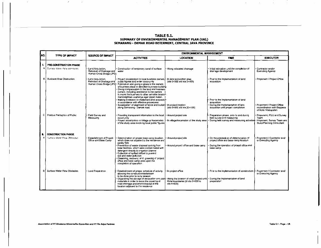
TABLE 5.1.SUMMARY OF ENVIRONMENTAL MANAGEMENT PLAN (UKL)
SEMARANG - DEMAK ROAD BETERMENT, CENTRAL JAVA PROVINCE
NO. TYPE OF IMPACT SOURCE OF IMPACT ENVIRONMENTAL MANAGEMENTACTIVITIES LOCATION TIME EXECUTOR
L PRE-CONSTRUCTION PHASEa Fiti.i ;Ic.a Cit O S:I* * LandAcquisition, Construction of temporary canal of surface -Along relocated drainage Initial relocation until the completion of Contractor and/or
Reloction of Drainage and water drainage development Executing AgencyHuman Cross Bridge (JPO)
B. Business Area Obstruction Land Acquisition, . Project socialization to local business owners, * In land acqluisition area Prior to the implementation of land Proponent I Project OfficeReloction of Drainage and public figures and wider community (sta 0+000 s/d sta 3+400) acquisitionHuman Cross Bridge (JP * Publication and giving a grace to the owners
of busness place to demolish business buildingGiving compensation to the land and businessowners, including assistance to the owners Ito move the business to other sensible locationmemindahkan usahanyaagar dapatmelan- I
*Making Endeavor to implement land acquisitio Prior to the implementation of landin accordance with effective procedures acquisition
* Socialization of alignment of fence and buildir * In project location During the implementation of land Proponent / Project Officealong Semarang -Demak road (sta 0+000 s/d sta 20+100) acquisiton until project completion iacordination with Bappedaof Kota I Kabupaten
C. Positive Perception of Public * Field Survey and Providing transparent information to the local Around project site Preparation phase, prior to and during Proponent, P3JJ and SurveyMeasuring community field survey and measuring Team
* Project socialization in Village or Kecamatan * In village/kecamatan of the study area During field survey and measuring activitie * Proponent, Survey Team andof the study area involving local public figures Stusy/Planning Consultant
IL CONSTRUCMON PHASEA *. a,e _ e. F l.; C S.:1' Establishment of Project Determination of proper base camp location, Around project site On the preparation of determination of * Proponent / Contractor and/
Office and Base Camp which does not adjacent to the residence and project office and base camp location or Executing Agencypaddy field
* Prevention of waste disposal coming from Around project office and base camp During the operation of proejct office andtoilet facilities, which were contaminated with base campdetergent directly to irrigation channel
* Collection of spilled oil/fuel to preventsoil and water pollution
* Cleansing, recovery, and greening of projectoffice and base camp area upon thecompletion of operation
B. Surface Water Flow Obstacles Land Preparation Establishment of proper schedule of activity In project office Prior to the implementafton of construction Proponent / Contractor and/allowing the constructionVextension or Executing Agencyto be done prior to rainy season
* Organizing the storage of excavation and pilin * Along the location of initial project until During the implementation of landmaterials in order to avoid the covering of Kota boundaries (di sta 0+000 to preparationroad drainage and environmental at the sta 4+600)location adjacent to the residence
Assoclatfon of PTBinatamm Wrkwr.dha Knsuftan and PT lke Ady. P.rk,ss Table 5.1 -Page -1/6
TABLE 5.1.SUMMARY OF ENVIRONMENTAL MANAGEMENT PLAN (UKL)
SEMARANG - DEMAK ROAD BETERMENT, CENTRAL JAVA PROVINCE
ENVIRONMENTAL MANAGEMENTNO. TYPE OF IMPACT SOURCE OF IMPACT ENVION Mi EXECUTOR
ACTMTIES LOCATION TIME EXECUTOR |
C. Surface Water Flow Obstacles Cosntruction of Drainage * Public socialization on accessibility obstacles * In project site * Pnor to construction phase * Proponent / Contractor
and Sidewalk that may occur and mitigation measures Executor* Organizing the storage of excavation and pili - In project site, especially at densely During the construction of drainage and
materals in order to avoid the covenng of populated area sidewalkdrainage
* Taking into account land disposal of Around paddy fields locate in projectexcavation result in drainage location area
D. Air Pollution Materials Transportation Establishment of proper schedule for At project location During the transportation of matenals Contractor andtor protect
materials transportation executor
* Providing appropriate cover for the vehicles At the quarned materials storage * Contractor or Quarry
transporting materials to avoid dust attack quarry industnalist
* Performing periodic cleansing at the area At sta 0+000 to sta 3+000, sta 4+ Contractor andlor project
where dusts may nse 100 to sta 6+700, sta 12+000 to executorsta 14+700, sta 18+100 to sta 20+100
Land Preparation Implementation of land leveling and oammin * At the area of activities During cosntruction implementation Contractor or project
in accordance with SOP konstruksi executor
* Performing periodic cleansing at the area At sta 0+000 to sta 3+000, sta 4+100where dusts may rise to sta 6+700, sta 12+000 to sta 14+
700, sta 18+100to sta 20+100* Provision of divider hedge at the project area At the location of project activities,
to prevent people back and forth especially around residence or denselypopulated area
E. Noise Mobilization of Heavy-Dut * Mobilization of heavy-duty equipment will nol Around project locatiion and the road During mobilization of heavy-duty Contractor or project
Equipment carried out in peak hours of local passed through equipment executor
community around the project location* Checking the worthiness of materials At the area where the vehicles locate
transportaton vehicles and at project location
* Materials Transportation Materals transportation to not carried out in Around project activity area and the During the transportation of matenals Contractor or project
the peak hours of local community in road passed through executor
prqect surrounding* Checking the worthiness of materials At the storage of materials and During the transportation of materials
transportation vehicles project location
* Land Preparation Matenals transportation activities to not carrj *Around project locatiion and the road Contractor or project
to not carried out in the peak hours of local passed through executor
community in of project surroundingkegiatan
* Checking the worthiness of materials * At the storage of materials and * During the transportation of materialstransportation vehicles project location
Assocetjon of PT Binatama Wrawrodha Konsuh'tn and PT lka Adya Pe*assa Table 5.1 -Page -216

TABLE 5.1.SUMMARY OF ENVIRONMENTAL MANAGEMENT PLAN (UKL)
SEMARANG - DEMAK ROAD BETERMENT, CENTRAL JAVA PROVINCE
NO. TYPE OF IMPACT SOURCE OF IMPACT ENVIRONMENTAL MANAGEMENTACTMVTIES LOCATION TIME EXECUTOR
F. Gangguan Aksesbilitas Land Preparation Construction of other access road as an At densely populated area with high * During the implementadon of land Proponent / Contractor oraltemative during the implementation of projecl mobilization (sta 0+000 to sta 4+600, preparation Project Executor
sta 14+700 to sta 18.1 00)* Socialization of accessibililty obstruction Related villages/residences around Prior to the implementaiton of work
that may occur and the mitigation measures project site schedule* Preventing placement of matenals in the area At densely populated area with high During the implementaiton of landthat mnay cover access road mobilization (sta 0+000 to ala 4+600, preparation
14.700 to sta 18+1 00)* Providing plank/metal sheet for temporary At densely populated area with high
access to certain locations with high mobilization (sta 0+000 to sta 4+600,accessibility sta 14+700 to sta 18+100)
Road Pavement and Bridg * Socialization of accessibilitty obstruction Related villages/residences around Prior to the implementaiton of work Proponent / Contractor orStructure Works that may occur and the mitigation measures project site schedule Project Executor
atau penanganannyaConstruction of other access road as an At densely populated area with high During the implementaiton of landaltemative during the implementation of project mobilization (sta 0+000 to sta 4+600. preparation
for tem ~ sta 14+70010o sta 18+100)* Providing plank/metal sheet for temporary At densely populated area with high
access to certain locations wAh high mobilization (sta 0+000 to sta 4+600,accessibility sta 14+700 to sta 18+100)
Construction of Drainage Construction of other access road as an At the location having high mobilizatior Duringthe constnuction of drainage and Proponent / Contractor orand Sidewalk alternative during the implementation of project of community (sta 0+000 to sta 4+600. sidewalk Project Executor
sta 14+700 to sta 18+100)* Socialization of accessibililty obstruction Related villages/residences around Prior to the implementaiton of work
that may occur and the mitigation measures project site scheduleatau penanganannysa Preventing placement of materials in the area At densely populated area with high Duringthe construction of drainage andthat may cover access to the residence mobilization (sta 0+000 to sta 4+600. sidewalk
sta 14+700 to sta 18+100)* Providing plank/metal sheet for temporary At the location having high mobilization
access to certain locations with high of community (sta 0+000 to sta 4+600.accessibility sta 14+700 to sta 18+100)
G. Work Safety Obstades Median Development Installation of signpost announcing on the At project site where the development Prior to the implementation of median Proponent Contractordevelopment of median resulting in road of median takes place developmentconstriction, which is placed of 100 m toproject activity location
* Installabon of road directional signal for * Di lokasi tapak proyek yang sedang * At night timeearly waming at both the beginning and enc ada pembangunan medianof median development area
Minor Works Installation of signpost announcing on the Di lokasi tapak proyek yang sedang Prior to the implementation of median Proponent / Contractordevelopment of median resulting in rosad ada pembangunan median developmentconstriction, which is placed of 100 m toproject activity location
*Installation of road directional signal for Di lokasi tapak proyek yang sedang At night timeearly waming at the beginning and end or ada pembangunan medianmedian devt area especially in noght time
Association of PT Binatams Wlrewredha Konsultan and PT lka Adya Pe,*oss Table 5.1 -Page -3/6

TABLE 5.1.SUMMARY OF ENVIRONMENTAL MANAGEMENT PLAN (UKL)
SEMARANG - DEMAK ROAD BETERMENT, CENTRAL JAVA PROVINCE
ENVIRONMENTAL. MANAGEMENT
NO. TYPE OF IMPACT SOURCE OF IMPACT ENVION TIMEEEXECUTOACTMTIES LOCATION TIME EXECUTOR
H. Work and Business Opportunities Mobilization of Manpower Prioritizing local community to be recruited *In the study ara, especially around On the preparation stage and recruitment ProponentVContractor and/
as the project manpower in conformity with protect site of employees or Project Executor
their qualificationGiving the opprtunities to the local businessman Before the project commencementfor supply of project needs
I. Social Restless Mobilization of Manpower Priontizing local community to be recruited In the study ara, especially around On the preparation stage and recruitment Proponent/Contractor and/
as the project manpower in conformity with project site of employees or Project Executor
their qualificationGiving guidance to migrant manpower who At project office and base camp During the construction activitieswrIt stay in project base camp
I. Negative Perception Land Preparation Providing transparent information on Aroun project site -On the preparation stage prior to the Proponent, Project Manajemer
project plan commencement of project and Contractor
Project socialization in villages / kecamatans In the village / kecamatan of the study During field survey and/or measurng and Proponent, Survey Team and
of the study area involving local public figures area prior to the commencement of construction Study/Planning Consultant
Road Pavemetn and Providing transparent information on Aroun project site On the preparation and before the Proponent, Project Manajemer
Bridge Structure Works project plan commencement of cosntruction and Contractor
* Project socialization in villages / kecamatans * In the village / kecamatan of the study During field survey and/or measurng and Proponent, Survey Team and
of the study area involving local public figures area prior to the commencement of construction Study/Planning Consultant
J Public Health * Land Preparation Implementation of land leveling and cramminc -At the project activity area During construction implementation Contractor or Project
in accordance with SOP Execor
* Performing periodic cleansing at the area At sta 0+000 to sta 3+000, sta 4+1 00 During construction implementationwhere dusts may nse to sta 6+700, sta 12+00 to sta 14+
700, sta 18+100 to sta 20+100
K. Traffic Obstacles / Congestion Mobilization of Heavy-Du * Coordination with Dinas Bina Marga andn Along route of mobilization of heavy- During mobilization of heavy-duty Proponent / Contractor,
Equipment Dinas Perhubungan Kota Semarang and duty equipment equipment Project Executor
Kab. Demak during project implementation* Appointment of the officer at the beginning Access road to project location
and end of project area for regulating heavy- (sta 0+000, sta3+000 dan sta 20+100)duty equipment coming in and out the project
* Mobilization of heavy-duty during traffic Along route of mobilization of heavy-volume is in low level and lack of public duty equipmentactivities
* Installation of road directional signs Access road to project location(sta 0+000, sta3+000 dan sta 20+100)
Materials Transportation Coordination with Dinas Bina Marga andn Contraktor or Project Executor office Pnor to the implementation of materials * Proponent I Contractor,
Dinas Perhubungan Kota Semarang and transportation Project Executor
Kab. Demak during project implementation* Appointment of the officer at the beginning Access road to project location During materals transportation Contractor or Project
and end of project area for regulating heavy- (sta 0+000, sta3+000 dan sta 20+100) Executor
duty equipment coming in and out the project* Mobilization of heavy-duty during traffic Contraktor or Project Executor office Prior to the implementation of materials
volume is in low level and lack of public transportationactivities
* Installation of road directional signs Access road to project location During matenals transportation(sta 0+000, sta3+000 dan sta 20+100)
Asseciation of PT 8inathma Wlrawredha Konsulban and PT lks Adya Pe,rasa Table 5.1 -Page -4/6

TABLE 5.1.SUMMARY OF ENVIRONMENTAL MANAGEMENT PLAN (UKL)
SEMARANG - DEMAK ROAD BETERMENT, CENTRAL JAVA PROVINCE
NO. TYPE OF IMPACT SOURCE OF IMPACT ENVION MNAGEMENTACTIVrIIES LOCATION TIME EXECUTOR
L. Traffic Obstades/ Congestion Land Preparation Coordination wih Dinas Bina Marga andn Dinas Bina Marga Office * During the preparation of basic soil Proponent I Contractor IDinas Perhubungan Kota Semarang and ExecutorKab. Demak during project implementation
* Installation of road directional signs The location to go in in out of project During land preparation Contractor or Project Executo
Road Pavement and Coordination with Dinas Bina Marga andn * Along the road where the activities Prior to the starting of road pavement and Proponent I PU Bina MargaBridge Structure Works Dinas Perhubungan Kota Semarang and take place bridge structure works and related agenciesKab. Demak during project implementation terkait lainInstallation of signspot for early waming due The location to go in in out of project * During the implementation of works * Contractor l Executorto the median development workMedian Development Coordination wdh Dinas Bina Marga andn Along protect site * Pnor to the starting of road pavement and Proponent I Contractor IDinas Perhubungan Kota Semarang and bridge structure works ExecutorKab. Demak during protect implementation
Instatlation of road signpost informing on In the project site where median * Sebelum dilakukannya kegiatan pembangu-median development works that may development works take place nan medianresult in moad constriction since 1 00 m before
* Installation of signspot for early waming due Night timeto the median development work
Minor Works Coordination with Dinas Bina Marga andn Along protect site Prior to the starting of road pavement and * Proponent I Contractor!Dinas Perhubungan Kota Semarang and bridge structure works ExecLtorKab. Demak during project activities
* Installation of road signpost informing on In the project site where median Prioe to commencement of medianmedian development works that may development works take place development worksresult in road constriction since 100 m before
11. POST-CONSTRUCTION PHASEA A,. :.-. Road Operation * Reforestation at the left and side of road ROW at the edge of roadway * On the implementation of minor works and Proponent in coordination
for netralizing I minimizing air pollution after the construction works finished with Local Govemment of KotaSemarang dlan Kab. Demak* Regulating both public and pnvate vehicles Along roadway, especially at the On the operation and implementation of Traffi policeparking anywhere location adjacent to Terminal Terboyc road
and crowded areaB. Noise Road Operation * Reforestation at the left and side of road ROW at the edge of roadway On the implementation of minor works and Proponent in coordination
as the sound barier of noise coming from after the construction works finished with Local Govemment of Kotathe vehicles passing through the road Semarang dan Kab. Demak* Providing sound barier combined with At schools, hospitals, Puskesmas, and -On the operation of road Related agencies, i.e. schoolsivegetation to reduce noise and air polution office complex Local Education Agency (Din ain certain locations that are susceptible to P&K and Local Health Agencynoise increase (Dinas Kesehatan) |
Assoclatlon ot PTBn tsmna W.q,wr,wdha Konsfton and PT lka Adya Pekasa Table 5.1 -Page -516
TABLE 5.1.SUMMARY OF ENVIRONMENTAL MANAGEMENT PLAN (UKL)
SEMARANG - DEMAK ROAD BETERMENT, CENTRAL JAVA PROVINCE
ENVIRONMENTAL MANAGEMENTNO. TYPE OF IMPACT SOURCE OF IMPACT ACTMTIES LOCATION TIME EXECUTOR
C. Improvement of Road Services, Road Operation Socialization to local community on the Around densely populated area * On the completion of construction works * Proponent
Safety and Freshness road function, regulation and benefit (Kecamatan Genuk, Sayung and and to be a routine workcertain spots)
Socialization on proper riding on the road Along Semarang -Demak road * Pemda Kota Semarang and
*Regulating public transportation utilizing DLLAJR ancd traffic polices
the shoulder for parking* Law enforcement in the implementation of
traffic regulation
D. Traffic Accident * Road Operation Controlling vendors utilizing shoulder and Along project site, especially at On the road operation * Pemda Kota Semarang and
sidewalk trading location densely populated area Kab. Demak
* Providing zebra cross, signposts and Close to RSI Sulatan Agung, Pasar In line with the implementaiton of minor Proponent, Contractor and
directional sign at the location where people Genuk, Sayung, Onggorawe and works Project Executor
cros the road frequently, i.e. school, hospital university/other achool buildings
* Providing hedge at the median as for Di dekat RSI Sulatan Agung, Pasardirecting the pedestrians Genuk, Sayung, Onggorawe dan
kampus/sekolah lainnya* Providing slow lane for non-motorized vehicle Di daerah keluar masuk ke pabrik/
such pedicab (becak), cart and bicycle indlustri, pasar dan sekolah* Appointing some officers to regulate the traffi * Di sepanjang lokasi tapak proyek, * On the road operation DLLAJR and traffic polices
in peak hours allowing high volume of terutama di sekolah dan RSpedestrians crossing the road
E. Positive Perception Road Operation Providing good services to road users * Along project site On the road operation Proponent in coordinationwith Pemda Kota
* Giving guidance / information to public * At inconvenience time of local community
* The enforcement of traffic regulation and When the traffice violance occurs DLLAJR and traffic polices
providing sanctions (certain times)
F. Road Services Improvement Road Maintenance Early reparation of road and other supporting Along road section * On the beginning of road operabon Proponent in coordination
equipment damages with Dinas Bina Marga ofKota Semarang
* Coordination with Pemda and related agencies Pemda Kota Semarang andKab. Demak
* Law enforcement on traffic regulation - On the completion of construction works DLLAJR and traffic polices
violance*Establishment of local government regulation(Perda) on ROW, hedge, building and openspace alignmentProviding publication board on RUTR at the * At industrial, services, trade andlocations that are susceptible to traffic residence areassaccident, building and open space
Assoriatfion ot PT Binatama Wirwredha Konsultan and PT 1ka Adya Perksaa Table 5.1 -Page - 6

TABLE 6.1SUMMARY OF ENVIRONMENT MONITORING PLAN (UPL)
SEMARANG - DEMAK ROAD BETTERMENT PROJECT, CENTRAL JAVA
ENVIRONMENT MONITORINGNO. TYPE OF IMPACT SOURCE OF IMPACT IMPACT measuring STANDARD ENVION MOI EXECUTOR
llfETHOD LOCATION PERIOD EXECUTOR1. PRE-CONSTURCTION PHASEA. Surface Water Flow Obstacl * Land acquisition, Emergence of water backup in Direct field observation on the surface In the area along side the activity Twice, on the execution period of - Proponent/water drainage and JPO project surrounding water flow direction (sta 0+000 to sta 3+400) water drainage relocation Project Managementrelocation Emergence of water backup in Interview with the community living
project surrounding in project site
B. Business obstreuction *Land acquisition, Number of land or business owners Interview with land and business owners In the area along side the activity Twice, on the survey and measunng Proponent, in coordinationrelocation of drainage having objection to the project at project site (sta 0+000 to sta 3+400) period and prior to consutruction with study and supervisionand human cross bridge Social restless of land and business Direct field observation on the land Three times, on the land acquisition consultant(JPO) owners acquisition process processC. Positive perception of public *Field survey and Local commundy's attitude and Interview with the community living Surrounding the project location Twice, on the survey and measunng * Proponent, in coordinationmeasuring perception to the project in project site (and informan as the information period and prior to consutruction with study and supervision* Local community's grievance to the * Monitoring of issues developed in local source) consultantproject plan community
IL CONSTRUCTION PHASE:Va,p. F 1 . OrCs, :i * Establishment and * Spiled oil that may lead to the land Observation of waste disposal of Surrounding office location and Twice, during construction phase Proponent, andoperation of of a project and water pollution project office and base camp base camp Supervision consultantoffice and base camp
* Monitoring of water surface quality Random survey and measunng of On water side /river that become Every Sa months, during construction Proponent /when the activity takes place water quality in project surrounding the waste banishment cahannel phase Local Bapedalda orPSL
B. Surface Water Flow Obstacl * Land Preparation Emergence of water backup in Direct observation in the field on the * All along activities location Twince, during land preparation phas* Proponent /project surrounding surface water flow direction (sta 0+000 to sta 3+400) Project Management* Grievance of local community living Observation on excavated materials pilesin the project surrounding at the edge of roadway
* Interview with the community living Along project sitein project site
Construction of drainage * Emergence of water backup in * Direct observation in the field on the Alongside project area * Twice, during construction of Proponent /and sidewalk project surrounding surface water flow direction (especially at sta 0+000 to sta 4+600) drainage channel and sidewalk Project Management* Emergence of water backup in Observation on excavated materials pileproject surrounding at the edge of roadway
* Interview with the community living Alongside project siein project site
C. Air Pollution Material Transportation Increase of dust content in the air, Direct measuring of air qulariy in site The area adjacent to schools Every 3 months dunng construction ProponentHC, CO, NO, SO2 dan Pb to be analyzed in the labolatorium phase Project Management* Observation of houses passed Monitoring on public grievances using Residence area
through to identify the volume of dus observation and interview methodscovering their houses
* Increaseof respiratory disease (ISPAvictims
* Grievance of local community livingin the project surrounding
* Direct measuring of air quality insite to be compared with qualitystandard (Local Govt. Reg. No.
_ ______ _______ 199_________________________________ _____41/1999) . .
Associatlion ot PT Binatams Wrawwrdha Konslfltn and PT IIk Adya Perkass Table 6.1 -Page 1V6

TABLE 6.1SUMMARY OF ENVIRONMENT MONITORING PLAN (UPL)
SEMARANG - DEMAK ROAD BETTERMENT PROJECT, CENTRAL JAVA
ENVIRONMENT MONrlORJNG
NO. TYPE OF IMPACT SOURCE OF IMPACT IMPACT measurlng STANDARD ENVION blOI EXECUTOR
_ ~~~~~~~~~~~~~~~METHOD LOCATION PERIOD EXECUTOR
C. Air Pollution Land Preparation Increase of dust content in the air, * Direct measuring of air qulaity in site The area adjacent to schools * Every 3 months during construction Proponent /
HC, CO, NO%, SO2 dan Pb to be analyzed in the labolatorium phase Project Management
lIncreaseof respiratory disease (tSPA * Monitorng on public gnevances using Residence areavictims observation and interview methods
* Grievance of local community livingin the project surrounding
* Direct measuring of air quality insite to be compared with qualitystandard (Local Govt. Reg. No.41/1999)
D. Noise Mobilization of Heavy- Obstruction of teaching-leaming Measuring of noisy level at site for Residence area, schools, campus, Every 3 months during construction Proponent /
Duty Equipment activities in the schools and local 30 minutes in every monitonng spot hospital and local govemment clinic phase Project Management
govemment clinic/hospital (the distance of 10, 50 and 100 m of (Puskesmas)
activties ROW in the moming, noon & aftemroon)* Grievance of local community living Field interview with people live adjacent
in the project surrounding to the project area* Noise gradel that exceed the quality
standard (SK MENEG LA No.KEP/481MENLH/1 11 996)
Matenals Transportation Obstruction of teaching-leaming * Measuring of noisy level at site for Residence area, schools, campus, * Every three months, dunng the Proponent
activities in the schools and local 30 minutes in every monitoring spot hospital and local govemment ctinic construction period Project Management
govemment clinic/hospital (the distance of 10, 50 and 100 m of (Puskesmas)activities ROW in the moming, noon & aftemoon)
* Grievance of local community living Field interview with people live adjacentin the project surrounding to the protect area
* Noise gradel that exceed the qualitystandard (SK MENEG LA No.KEP/48/MENLH/1 in 996)
Land Preparation Obstruction of teaching-learning Measurng of noisy level at site for Residence area, schools, campus, Every three months, dunng the Proponent
activities in the schools and local 30 minutes in every monitoring spot hospital and local govemment clinic construction period Project Management
govemment clinic/hospital (the distance of 10, 50 and 100 m of (Puskesmas)activities ROW in the moming, noon & aftemoon)
* Grievance of local community living Field interview vwith people live adjacentin the project surrounding to the project area
* Noise gradel that exceed the qualitystandard (SK MENEG LA No.KEP/48/MENLH/1 1/1 996)
E. Accessibility Obstacles Land Preparation Vanish of access road to houses Field observation to the obstruction In densely populated area * Once, durng land preparation phase * Proponent /
residents, schools, hospitals, local resulted from the project activities (especially on sta 0+000 to Project Management
govt. clinic, pray places, business Direct observation to the installation of sta 4+600, sta 14+700 to 18+100)
places, offices, etc. signpost at the area lossing of assets.lComplaint from the people who lives Interview with the people suffered the Alongside project site O Once, on the land preparation phase
surrounding the activity area due to impacts of project and when public complaints occur
the vanishment of those access road
Associ/ation of PT Binteama Wirawiudha Konsultan and PT Ika Adys Penkasa Table 6.1 -Page 2/6
TABLE 6.1SUMMARY OF ENVIRONMENT MONITORING PLAN (UPL)
SEMARANG - DEMAK ROAD BETTERMENT PROJECT, CENTRAL JAVA
ENVIRONMENT MONITORINGNO. TYPE OF IMPACT SOURCE OF IMPACT IMPACT me.surlng STANDARD METHOD ENVION PERIIN EXECUTOR
Road Pavement and Loss of access road to residence Field observation to the obstruction In the area which are full of people's Once, on road and bndge concrete Proponent /Bridge Structure Works area, schools, hospitals, Puskesmas resulted from the project activities activity (especially on sta 0+000 to structure construction period Project Management
religious buildings, business area, Direct observation to the installation of sta 4+600, sta 14+700 to 18+100)offices complex, etc. signpost at the area lossing of assets.Grievance of the community live Interview with the people suffered the In the area alongside the projects Once, on road and bridge concreteadjacent to the project area due to impacts of project path structure construction period andthe loss of access road when complain received from the
peopleF. Accessibility Obstacles Construction of drainage Loss of access road to residence Field observation to the obstruction * In the area which are full of people's Twice, during the constuction of Proponent /
and sidewalk area, schools, hospitals, Puskesmas resulted from the project activities activity (especially on sta 0+000 to drainage and sidewalk works Project Managementreligious buildings, business area, * Direct observation to the installation of sta 4+600, sta 14+700 to 18+100)offices complex, etc. signpost at the area lossing of assets.
Grievance of the community live Interview with the people suffered the Alongside project site Twice, durng the constuction ofadjacent to the project area due to impacts of project drainage and sidewalk works andthe loss of access road and when public complaints occur
G. Work Safety Obstacles Median Development People attitude and perception Field observation to the completeness of At the locations that are susceptible During the implementation of material Proponenton the activity K3 equipments to the traffice accident (Genuk, transportation Project ManagementGrievance of the local community on Monitonng of community grievance Sayung and Onggorawe)activity implementation Observation of workers' discipline in
using the K3 equipment*Observation to the installation ofroad signs and directional signs
* Interview with the workers on Around protect site and informationtheir complaints sources
Minor Works People antitude and perception Field observation to the completeness of On unsafe location especially in During the implementation of materiat Proponent Ion the activity K3 equipments Genuk, Sayung and Onggorawe transportation Project ManagementGrievance of the local community on * Monitoring of community grievance areasactivity implementation Observation of workers' discipline in
using the K3 equipment*Observation to the installation ofroad signs and directional signs
*Interview with the workers on *Around project site and informationtheir complaints sources
H. Work and Business Opportu Manpower Mobilization Number of local manpowers work * Field observation In the study area, especially in Twice, after recruitment of manpowe * Proponent /in the project and run business in project site and during construction phase Project Managementproject site Interview with local community members Twice, dunng construction phase
* Reaction and perception of local and public figurescommunity on work and businessopportunities
I. Social Restless Manpower Mobilization * Changes of custom and attitude of Field observation In the study area, espeially in Twice, during construction phase Proponent /local community project site Project Management
* Local community attitude and * Interview with local community membersperception to migrant workers and public figures, including religious
* Destruction and intimidation intentions figuresto the projedt
Asseclaeeon of PT B/nataems Wiraw,dha Konsultmn and PT lka Adys Penkass Table 6.1 -Page 316

TABLE 6.1SUMMARY OF ENVIRONMENT MONITORING PLAN (UPL)
SEMARANG - DEMAK ROAD BETTERMENT PROJECT, CENTRAL JAVA
ENVIRONMENT MONITORING
NO. TYPE OF IMPACT SOURCE OF IMPACT IMPACT measuring STANDARD METHOD LOCATION PERIOD EXECUTOR
Y Negative Perception Land Preparation Local community attitude and Interview with local community in At project site (and information -Twice, dunng the implementation of Proponent /
perceiption to the project project site from numerous resources) land preparation Project Management
Community grievance to the Monitoring of grievance of localimplementation of project community pertaining to the negative
impacts of project
Raod Pavement and Local community attitude and Interview with local community in At project site (and information Twice, durng the implementation of Proponent /
Bridge Structure Works perceiption to the project project site from numerous resources) road pavement and bndge structure Project Management
* Community grievance to the Monitoring of grievance of local works
implementation of project community pertaining to the negativeimpacts of project
K. Public Health * Land Preparation Increase of respiratory disease Field observation to the community Alongside the road dunng land Twice, during the implementation of Proponent /
victim, especially ISPA suffered respiratory disease preparation land preparation Project Management
* Grievance of community living Interview with the community living in At the residence area or schools Every three months, during land
in project surrounding project site preparation
L. Traffic Obstacles Mobilization of heavy- Traffic congestion /queue Measunng traffic volume at primary Project site Once during construction phase Proponent /
duly equipment arterial road for 1 x 24 hours Protect Management
* Road users' grievance durng Observation to the road users' Twice during construction phase
project activities practices* Increase of traffic accident during * Structured interview with road users
project activities on the impacts of project
Matenals Transportation * Traffic congestion /queue * Measuring traffic volume at prmary Project site Once dunng construction phase Proponent /
arterial road for 1 x 24 hours Project Management
* Road users' gnevance during * Observation to the road users' Twice dunng construction phase
project activities practices* Increase of traffic accident dunng Structured interview with road users
project activiies on the impacts af project
Land Preparation Constraint of roadway width due Measuring traffic volume at prmary Project site Once dunng construction phase * Proponent /
the number of activties arterial road for 1 x 24 hours Project Management
* Traffic congestion /queue Observation to the road users' Twice during construction phase
practices* Road users' grievance during Structured interview with road users
project activities on the impacts of project* Increase of traffic accident during
project activities
Raod Pavement and * Constraint of roadway width due * Measuring traffic volume at primary * Project site Once during construction phase Proponent/
Bridge Structure Works the number of activties arterial road for 1 x 24 hours Project Management
* Traffic congestion /queue Observation to the road users' Twice dunng construction phase
practices* Road users' grievance durng * Structured interview with road users
project activities on the impacts of project* Increase of traffic accident during
project activities
Asosiatlon of PT Binatama Wtawredha Konsuftan and PT Ika Adya Perkasa Table 6.1 -Page 416

TABLE 6.1SUMMARY OF ENVIRONMENT MONITORING PLAN (UPL)
SEMARANG - DEMAK ROAD BETrERMENT PROJECT, CENTRAL JAVA
ENVIRONMENT MONITORINGNO. TYPE OF IMPACT SOURCE OF IMPACT IMPACT measurling STANDARDMETHOD LOCATION PERIOD EXECUTOR
Median Development Constraint of roadway width due Measuring traffic volume at primary Project site Once during construction phase Proponent /the number of activties arterial road for 1 x 24 hours Project Management
* Traffic congestion /queue * Observation to the road users' Twice durng construction phasepractices
* Road users' grievance during Structured interview with road usersproject activities on the impacts of project
* Increase of traffic accident duringproject activities
* Minor Works Constraint of roadway width due Measuring traffic volume at primary Proect site * Once dunng construction phase Proponent /the number of activties arterial road for 1 x 24 hours Project Management* Traffic congestion /queue Observation to the road users' Twice during construction phase
practices* Road users' grievance during Structured interview with road users
protect activities on the impacts of project* Increase of traffic accident during
project adivities
IH. POST-CONSTRUCTION PHASEA. Air Pollution Road Operation Increase of dust content in the air, Measuring of air quality in site to be Adjacento the residence and Six monthly during two years after Proponent /
HC, CO, NOR, SO, dan Pb analyzed in the laboratonum densely populated area the completion of construction phase Project Management* Increaseof respiratory disease (ISPA * Monitonng of community grievance using In local communny residence Annually in line with the preparation o * Bapedal Jateng,
victims observation and interview in field Local environmental status Bapedaldas of Kota* Grievance of local community living Semarang dan Kab. Demakin the project site* Mmeasuring of air quality in site
to be compared with qualitystandard (Local Govt. Reg. No.41/1999)
B. Noise Road Operation * Obstruction of teaching-learning at Measuring of noise level in site for Residence area, school/campus, Tiga bulan sekali, selama konstruksi Proponent/schools and obstacles of Puskesmas/ 30 minutes in each observation spot with hospitat and Puskesmas berlangsung Project Managementhospital activities the distance of 10, 50 and 100 m from
* Grievance of local community ROW in the moming, noon and aftemoon* Noise level exceeds the quality Interview with local community living
standard (SK MENEG LH around project areaNo. KEP/481MENLH/1 1/1996)
C. Traffic Accident * Road Operation Intencity of traffic accident after * Measuring of increase of intencity of * Along improved road * Setiap tiga bulan sekali, setelah Proponent /raod betterment construction finished traffic accident selesainya konstruksi jalan Project Management
* Number of traffic accident during * Collection of information on traffic * local police station (POLRES) * Setiap enam bulan sekali, setelahroad operation accident in local police station selesainya konstruksi jalan
Assodation ofPT Binatans tewlrawedha Konsultan and PT ks Adys Parkasa Table 6.1- Page 5/6

TABLE 6.1SUMMARY OF ENVIRONMENT MONITORING PLAN (UPL)
SEMARANG - DEMAK ROAD BETTERMENT PROJECT, CENTRAL JAVA
ENVIRONMENT MONITORINGNO. TYPE OF IMPACT SOURCE OF IMPACT IMPACT m.asurfng STANDARD UETHOD LOCATION PERIOD EXECUTOR
D. Improvement of Services, Sa - Road Operation Raising of speed of vehicles on Measuring traffic volume at primary . Around road corridor -Once during post-construction phase - Proponent I
and Freshness the roadway arterial road for 1 x 24 hours Project Management
Road users' comments Observation to the road users'Reduction of traffic congestion practicesDecrease of traffic accident Structured interview with road users
on the impacts of project to the -Twice during post-construction phase
improvement of road services andfreshness
E. Positive Perception . Road Operation Community attituse and perception t * Sikap dan persepsi masyarakat ter- Around project site Six monthly durng post-construction Proponent /
the mad operabon, which has been hadap pengoperasian jalan setelah phase Protect Management
improved ditingkatkan* Presence of community grievance to * Pemantauan terhadap adaltidaknya
the condition and level of services keluhan masyarakat terhadap kondisiof improved road dan tingkat pelayanan jalan setelah
ditingkatkan
F. Road Services Road Maintenance * Raising of speed of vehicles on Measuring traffic volume at primary Around road corridor Twice during post-construction phase * Proponent!
the roadway artenal road for 1 x 24 hours Project Management
* Road users' comments Observation to the road users'* Reduction of traffic congestion practices* Decrease of traffic accident * Structured interview with road users
kecelakaan lalu lintas * on the impacts of project to theimprovement of road services andfreshness
Asso.aton of PT Binatama Wfruwredha Konsultan and PT Ika Adys Pe,kasa Table 6.1 -Page 616