Embed Size (px)
Citation preview
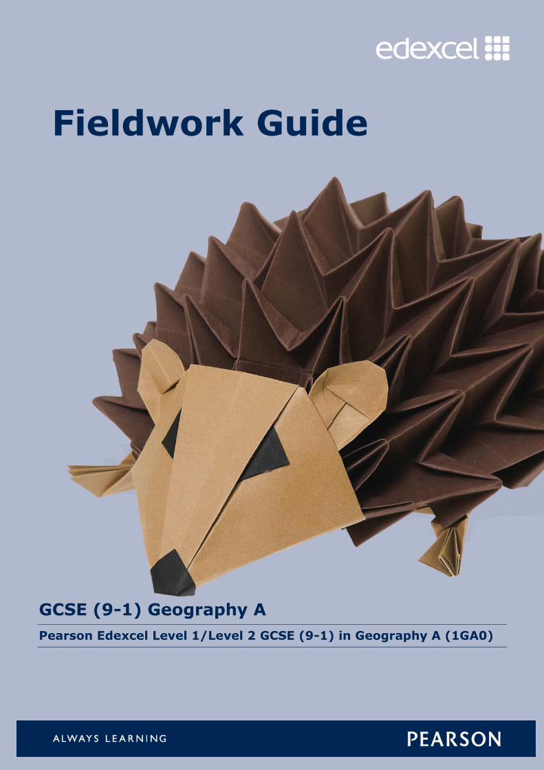
Fieldwork Guide
GCSE (9-1) Geography A
Pearson Edexcel Level 1/Level 2 GCSE (9-1) in Geography A (1GA0)

Fieldwork – Support for GCSE Specification A
Contents
A context and rationale for fieldwork in Pearson Edexcel
GCSE Geography A 2
Introduction and assessment overview 2
(1) Fieldwork standards, requirements and the route to
enquiry 4
Fieldwork requirements 5
Assessment of fieldwork in the examination 7
Fieldwork examination questions 8
Familiar and unfamiliar questions 9
The route to enquiry 14
(2) Planning and delivering an integrated fieldwork
strategy 15
Fieldwork progression 15
Organising a field trip 16
Funding for self-led fieldwork 17
Opportunities for provider-led fieldwork 17
(3) Undertaking geographical fieldwork 18
1–2 Pre-fieldwork and planning 18
3 Design: where and how many? 20
4 Equipment considerations; how to record. Primary data collection 22
5 Data processing and presentation 24
6 Analysis and conclusions 26
7 Critically reflecting on the results 27
(4) Suggested fieldwork opportunities 28
7A: Investigating physical environments (river landscapes) 28
7A: Investigating physical environments (coastal landscapes) 30
7B: Investigating human landscapes (central/inner urban area(s)) 32
7B: Investigating human landscapes (rural settlements) 34
(5) Resources to support fieldwork and research 36
(6) Virtual fieldwork 37
(7) Further support and guidance 38
Fieldwork – Support for GCSE Specification A
© Pearson Education Ltd 2017
2
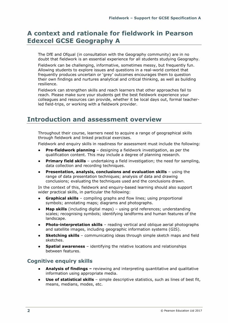
A context and rationale for fieldwork in Pearson
Edexcel GCSE Geography A
The DfE and Ofqual (in consultation with the Geography community) are in no
doubt that fieldwork is an essential experience for all students studying Geography.
Fieldwork can be challenging, informative, sometimes messy, but frequently fun.
Allowing students to explore issues and questions in a real-world context that
frequently produces uncertain or ‘grey’ outcomes encourages them to question
their own findings and nurtures analytical and critical thinking, as well as building
resilience.
Fieldwork can strengthen skills and reach learners that other approaches fail to
reach. Please make sure your students get the best fieldwork experience your
colleagues and resources can provide, whether it be local days out, formal teacher-
led field-trips, or working with a fieldwork provider.
Introduction and assessment overview
Throughout their course, learners need to acquire a range of geographical skills
through fieldwork and linked practical exercises.
Fieldwork and enquiry skills in readiness for assessment must include the following:
● Pre-fieldwork planning – designing a fieldwork investigation, as per the
qualification content. This may include a degree of planning research.
● Primary field skills – undertaking a field investigation; the need for sampling,
data collection and recording techniques.
● Presentation, analysis, conclusions and evaluation skills – using the
range of data presentation techniques; analysis of data and drawing
conclusions; evaluating the techniques used and the conclusions drawn.
In the context of this, fieldwork and enquiry-based learning should also support
wider practical skills, in particular the following:
● Graphical skills – compiling graphs and flow lines; using proportional
symbols; annotating maps; diagrams and photographs.
● Map skills (including digital maps) – using grid references; understanding
scales; recognising symbols; identifying landforms and human features of the
landscape.
● Photo-interpretation skills – reading vertical and oblique aerial photographs
and satellite images, including geographic information systems (GIS).
● Sketching skills – communicating ideas through simple sketch maps and field
sketches.
● Spatial awareness – identifying the relative locations and relationships
between features.
Cognitive enquiry skills
● Analysis of findings – reviewing and interpreting quantitative and qualitative
information using appropriate media.
● Use of statistical skills – simple descriptive statistics, such as lines of best fit,
means, medians, modes, etc.
Fieldwork – Support for GCSE Specification A
© Pearson Education Ltd 2017
3
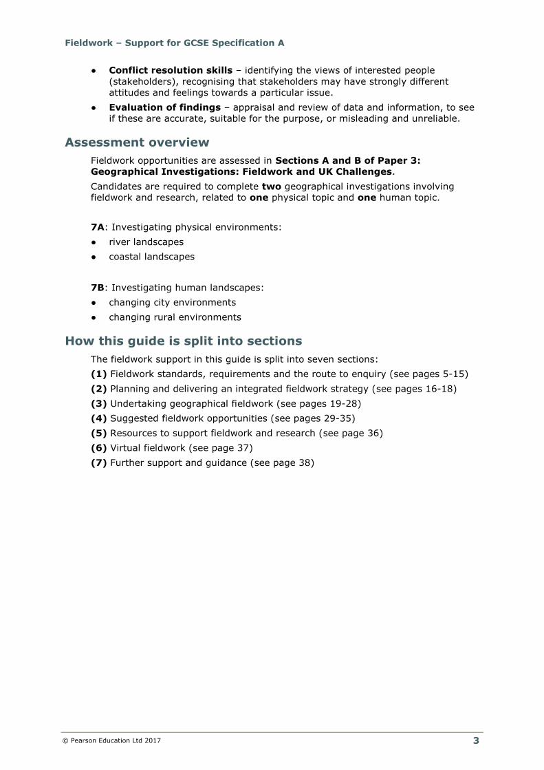
● Conflict resolution skills – identifying the views of interested people
(stakeholders), recognising that stakeholders may have strongly different
attitudes and feelings towards a particular issue.
● Evaluation of findings – appraisal and review of data and information, to see
if these are accurate, suitable for the purpose, or misleading and unreliable.
Assessment overview
Fieldwork opportunities are assessed in Sections A and B of Paper 3:
Geographical Investigations: Fieldwork and UK Challenges.
Candidates are required to complete two geographical investigations involving
fieldwork and research, related to one physical topic and one human topic.
7A: Investigating physical environments:
● river landscapes
● coastal landscapes
7B: Investigating human landscapes:
● changing city environments
● changing rural environments
How this guide is split into sections
The fieldwork support in this guide is split into seven sections:
(1) Fieldwork standards, requirements and the route to enquiry (see pages 5-15)
(2) Planning and delivering an integrated fieldwork strategy (see pages 16-18)
(3) Undertaking geographical fieldwork (see pages 19-28)
(4) Suggested fieldwork opportunities (see pages 29-35)
(5) Resources to support fieldwork and research (see page 36)
(6) Virtual fieldwork (see page 37)
(7) Further support and guidance (see page 38)
Fieldwork – Support for GCSE Specification A
© Pearson Education Ltd 2017
4
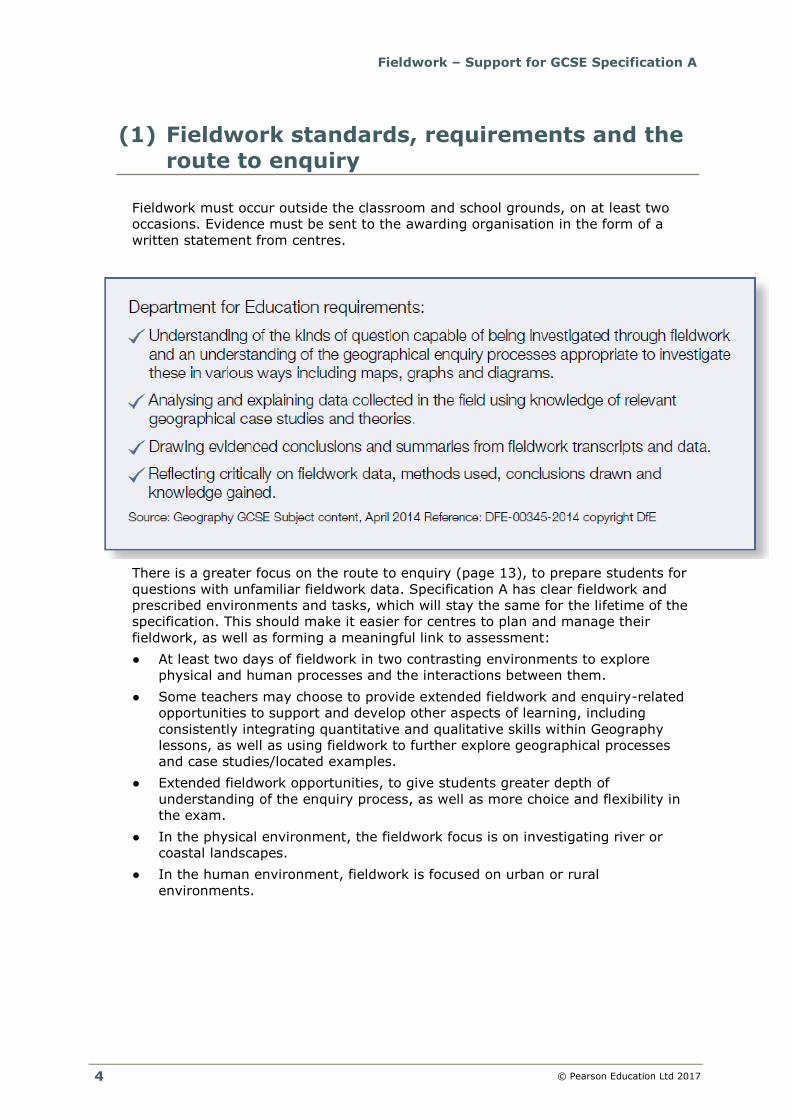
(1) Fieldwork standards, requirements and the
route to enquiry
Fieldwork must occur outside the classroom and school grounds, on at least two
occasions. Evidence must be sent to the awarding organisation in the form of a
written statement from centres.
There is a greater focus on the route to enquiry (page 13), to prepare students for
questions with unfamiliar fieldwork data. Specification A has clear fieldwork and
prescribed environments and tasks, which will stay the same for the lifetime of the
specification. This should make it easier for centres to plan and manage their
fieldwork, as well as forming a meaningful link to assessment:
● At least two days of fieldwork in two contrasting environments to explore
physical and human processes and the interactions between them.
● Some teachers may choose to provide extended fieldwork and enquiry-related
opportunities to support and develop other aspects of learning, including
consistently integrating quantitative and qualitative skills within Geography
lessons, as well as using fieldwork to further explore geographical processes
and case studies/located examples.
● Extended fieldwork opportunities, to give students greater depth of
understanding of the enquiry process, as well as more choice and flexibility in
the exam.
● In the physical environment, the fieldwork focus is on investigating river or
coastal landscapes.
● In the human environment, fieldwork is focused on urban or rural
environments.
Fieldwork – Support for GCSE Specification A
© Pearson Education Ltd 2017
5
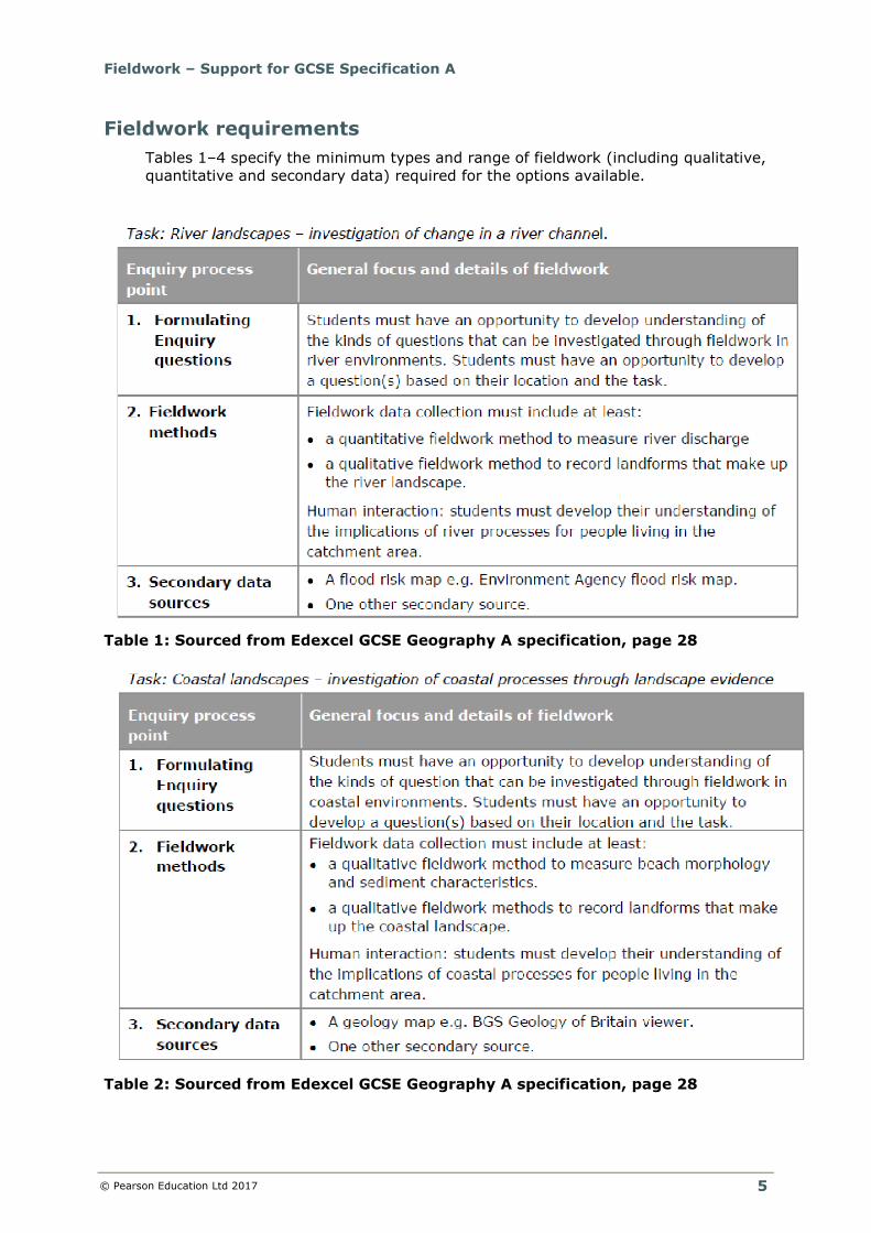
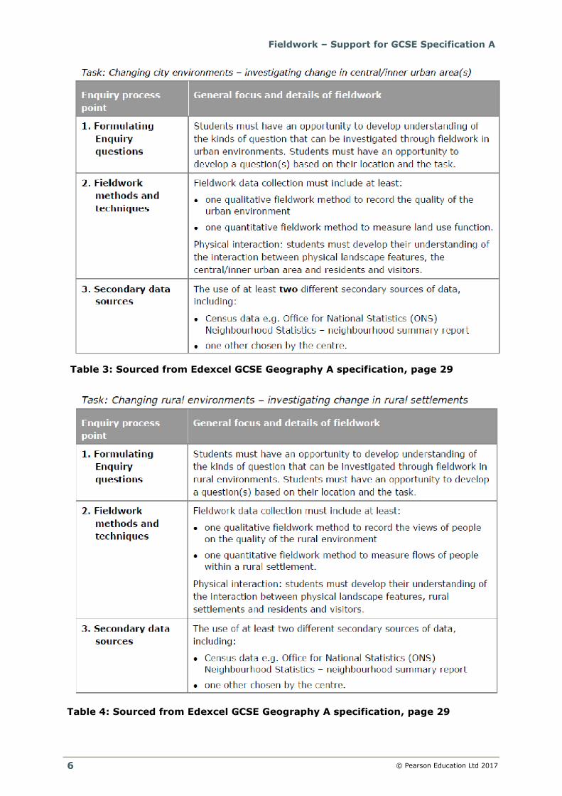
Fieldwork requirements
Tables 1–4 specify the minimum types and range of fieldwork (including qualitative,
quantitative and secondary data) required for the options available.
Table 1: Sourced from Edexcel GCSE Geography A specification, page 28
Table 2: Sourced from Edexcel GCSE Geography A specification, page 28
Fieldwork – Support for GCSE Specification A
© Pearson Education Ltd 2017
6
Table 3: Sourced from Edexcel GCSE Geography A specification, page 29
Table 4: Sourced from Edexcel GCSE Geography A specification, page 29
Fieldwork – Support for GCSE Specification A
© Pearson Education Ltd 2017
7
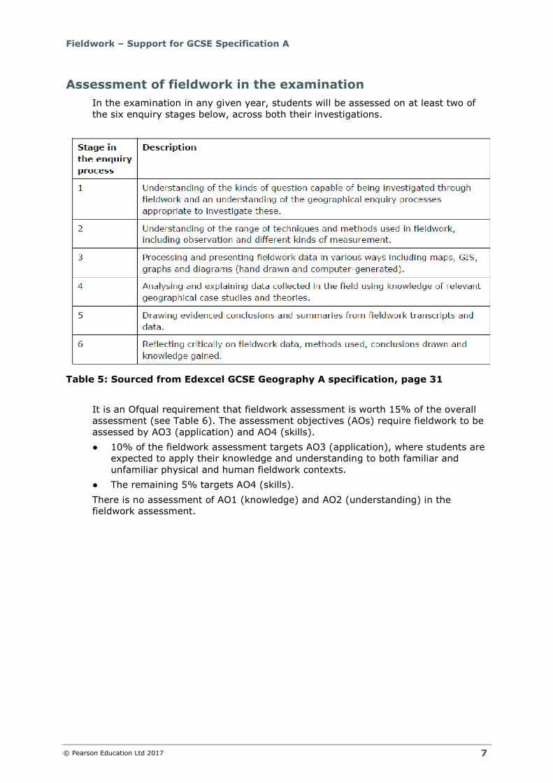
Assessment of fieldwork in the examination
In the examination in any given year, students will be assessed on at least two of
the six enquiry stages below, across both their investigations.
Table 5: Sourced from Edexcel GCSE Geography A specification, page 31
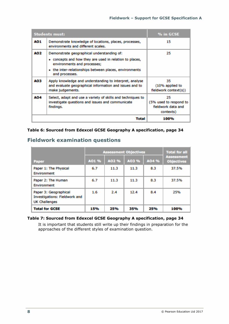
It is an Ofqual requirement that fieldwork assessment is worth 15% of the overall
assessment (see Table 6). The assessment objectives (AOs) require fieldwork to be
assessed by AO3 (application) and AO4 (skills).
● 10% of the fieldwork assessment targets AO3 (application), where students are
expected to apply their knowledge and understanding to both familiar and
unfamiliar physical and human fieldwork contexts.
● The remaining 5% targets AO4 (skills).
There is no assessment of AO1 (knowledge) and AO2 (understanding) in the
fieldwork assessment.
Fieldwork – Support for GCSE Specification A
© Pearson Education Ltd 2017
8
Table 6: Sourced from Edexcel GCSE Geography A specification, page 34
Fieldwork examination questions
Table 7: Sourced from Edexcel GCSE Geography A specification, page 34
It is important that students still write up their findings in preparation for the
approaches of the different styles of examination question.
Fieldwork – Support for GCSE Specification A
© Pearson Education Ltd 2017
9
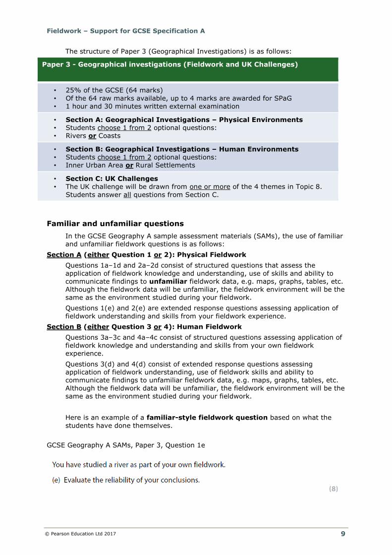
The structure of Paper 3 (Geographical Investigations) is as follows:
Paper 3 - Geographical investigations (Fieldwork and UK Challenges)
• 25% of the GCSE (64 marks)
• Of the 64 raw marks available, up to 4 marks are awarded for SPaG
• 1 hour and 30 minutes written external examination
• Section A: Geographical Investigations – Physical Environments
• Students choose 1 from 2 optional questions:
• Rivers or Coasts
• Section B: Geographical Investigations – Human Environments
• Students choose 1 from 2 optional questions:
• Inner Urban Area or Rural Settlements
• Section C: UK Challenges
• The UK challenge will be drawn from one or more of the 4 themes in Topic 8.
Students answer all questions from Section C.
Familiar and unfamiliar questions
In the GCSE Geography A sample assessment materials (SAMs), the use of familiar
and unfamiliar fieldwork questions is as follows:
Section A (either Question 1 or 2): Physical Fieldwork
Questions 1a–1d and 2a–2d consist of structured questions that assess the
application of fieldwork knowledge and understanding, use of skills and ability to
communicate findings to unfamiliar fieldwork data, e.g. maps, graphs, tables, etc.
Although the fieldwork data will be unfamiliar, the fieldwork environment will be the
same as the environment studied during your fieldwork.
Questions 1(e) and 2(e) are extended response questions assessing application of
fieldwork understanding and skills from your fieldwork experience.
Section B (either Question 3 or 4): Human Fieldwork
Questions 3a–3c and 4a–4c consist of structured questions assessing application of
fieldwork knowledge and understanding and skills from your own fieldwork
experience.
Questions 3(d) and 4(d) consist of extended response questions assessing
application of fieldwork understanding, use of fieldwork skills and ability to
communicate findings to unfamiliar fieldwork data, e.g. maps, graphs, tables, etc.
Although the fieldwork data will be unfamiliar, the fieldwork environment will be the
same as the environment studied during your fieldwork.
Here is an example of a familiar-style fieldwork question based on what the
students have done themselves.
GCSE Geography A SAMs, Paper 3, Question 1e
Fieldwork – Support for GCSE Specification A
© Pearson Education Ltd 2017
10
To answer this style of question, students will need to weigh up, with advantages
and disadvantages, the extent to which each ‘sub-conclusion’ would likely be the
same if the methods were repeated:
● Were there likely equipment and/or human errors?
● Were measurements repeated to produce similar results? If not, would you
expect to get the same result if you repeated the study at another time?
● Were there any issues with sampling strategies?
Examiners will allocate equally weighted marks: 4 marks for A03 and 4 marks for
A04. Possible discussions for students to focus on are shown below in the indicative
content.
Fieldwork – Support for GCSE Specification A
© Pearson Education Ltd 2017
11
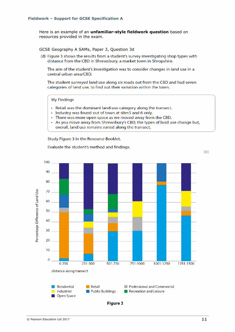
Here is an example of an unfamiliar-style fieldwork question based on
resources provided in the exam.
GCSE Geography A SAMs, Paper 3, Question 3d
Fieldwork – Support for GCSE Specification A
© Pearson Education Ltd 2017
12
Graph 1: Divided bar chart to show land use along a transect. Sourced from
Edexcel GCSE Geography A, sample assessment material.
Students should do the following to prepare for this style of examination question:
● Study and ‘read’ the graph – look at the pattern of land use.
● Consider how inner urban areas are changing, specifically in relation to their
land use.
● Consider the land use evident in the data presentation technique.
● Apply fieldwork knowledge and understanding to assess the strengths and
weaknesses of the student’s methodology.
● Interpret, analyse and evaluate what the graph shows.
● Use skills to select and describe information from the graph provided.
● Communicate their assessment of the strengths and weaknesses of the
student’s method and findings.
Examiners will allocate equally weighted marks: 4 marks for A03 and 4 marks for
A04. Possible discussions for students to focus on are shown in the indicative
content on the next page.
Fieldwork – Support for GCSE Specification A
© Pearson Education Ltd 2017
13
A top Level 3 answer should:
● have a balanced argument
● include specific evidence
● be one where the student supports their statements
● refer to all human processes/relevant areas of the enquiry process
● have clear communication, using relevant geographical terminology
consistently.
Fieldwork – Support for GCSE Specification A
© Pearson Education Ltd 2017
14
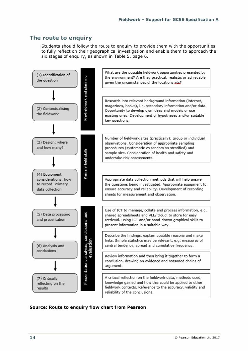
The route to enquiry
Students should follow the route to enquiry to provide them with the opportunities
to fully reflect on their geographical investigation and enable them to approach the
six stages of enquiry, as shown in Table 5, page 6.
Source: Route to enquiry flow chart from Pearson
Fieldwork – Support for GCSE Specification A
© Pearson Education Ltd 2017
15
(2) Planning and delivering an integrated
fieldwork strategy
It is strongly recommended that centres plan their fieldwork opportunities as part
of an integrated two-year strategy, making clear the links between the fieldwork
and the knowledge/understanding of the content relevant in the specification. In
that respect, the order of teaching units should largely dictate the programme of
fieldwork (or vice-versa).
Schools must provide opportunities for:
● one from Topic 7A: Investigating physical environments (either river landscapes
or coastal landscapes)
● one from Topic 7B: Investigating human environments (either central/inner
urban areas or rural settlements).
More fieldwork opportunities are always encouraged, developing a range of
geographical and interpersonal skills that will be nurtured throughout the GCSE
course.
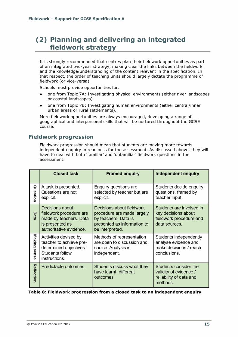
Fieldwork progression
Fieldwork progression should mean that students are moving more towards
independent enquiry in readiness for the assessment. As discussed above, they will
have to deal with both ‘familiar’ and ‘unfamiliar’ fieldwork questions in the
assessment.
Table 8: Fieldwork progression from a closed task to an independent enquiry
Fieldwork – Support for GCSE Specification A
© Pearson Education Ltd 2017
16
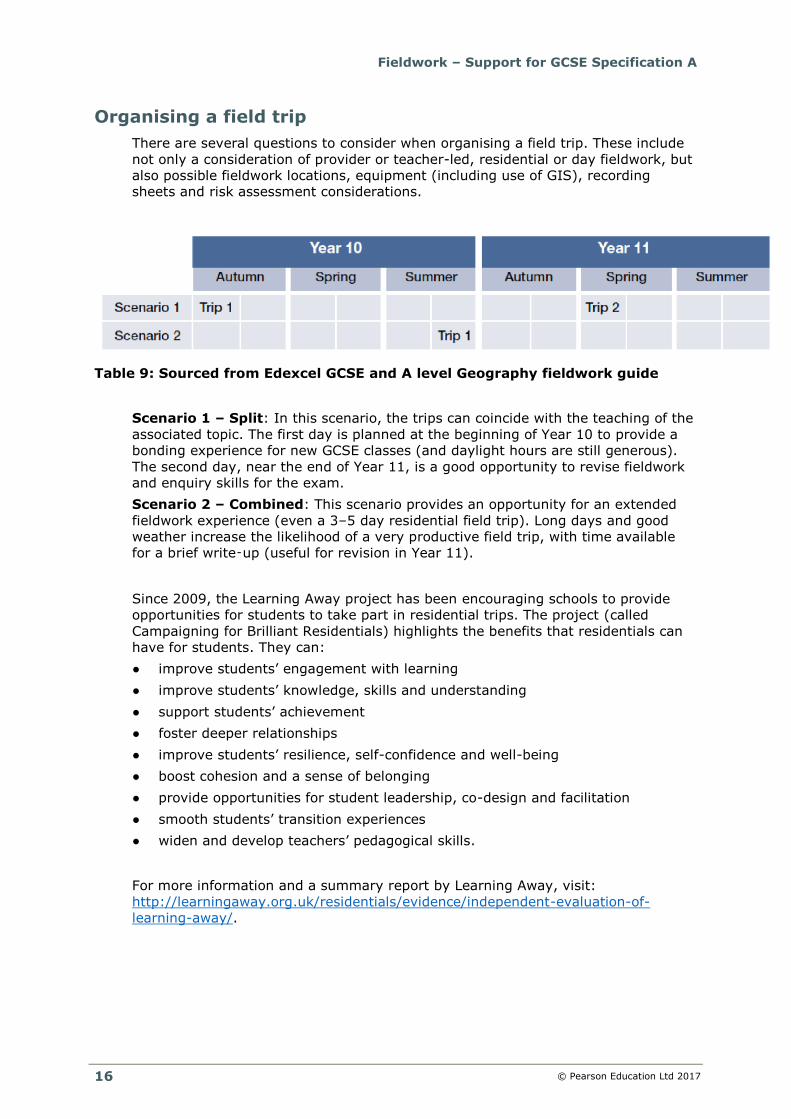
Organising a field trip
There are several questions to consider when organising a field trip. These include
not only a consideration of provider or teacher-led, residential or day fieldwork, but
also possible fieldwork locations, equipment (including use of GIS), recording
sheets and risk assessment considerations.
Table 9: Sourced from Edexcel GCSE and A level Geography fieldwork guide
Scenario 1 – Split: In this scenario, the trips can coincide with the teaching of the
associated topic. The first day is planned at the beginning of Year 10 to provide a
bonding experience for new GCSE classes (and daylight hours are still generous).
The second day, near the end of Year 11, is a good opportunity to revise fieldwork
and enquiry skills for the exam.
Scenario 2 – Combined: This scenario provides an opportunity for an extended
fieldwork experience (even a 3–5 day residential field trip). Long days and good
weather increase the likelihood of a very productive field trip, with time available
for a brief write‑up (useful for revision in Year 11).
Since 2009, the Learning Away project has been encouraging schools to provide
opportunities for students to take part in residential trips. The project (called
Campaigning for Brilliant Residentials) highlights the benefits that residentials can
have for students. They can:
● improve students’ engagement with learning
● improve students’ knowledge, skills and understanding
● support students’ achievement
● foster deeper relationships
● improve students’ resilience, self-confidence and well-being
● boost cohesion and a sense of belonging
● provide opportunities for student leadership, co-design and facilitation
● smooth students’ transition experiences
● widen and develop teachers’ pedagogical skills.
For more information and a summary report by Learning Away, visit:
http://learningaway.org.uk/residentials/evidence/independent-evaluation-of-
learning-away/.
Fieldwork – Support for GCSE Specification A
© Pearson Education Ltd 2017
17
Funding for self-led fieldwork
Financial options are available to centres to support the planning and delivery of
teacher-led fieldwork opportunities:
● The Frederick Soddy Trust Schools Award Scheme provides small
monetary funds:
http://www.geography.org.uk/resources/fieldwork/fieldworkfunding/#top
● The FSC Bursary Fund provides bursaries to a maximum per school of £1500
for residential courses and £450 for day visits per academic year:
http://www.field-studies-council.org/about/the-fsc-bursary-fund.aspx
Opportunities for provider-led fieldwork
For provider-led fieldwork opportunities, the Field Studies Council (FSC) and PGL
provide tailor-made residential and non-residential visits to support the delivery of
the investigations, with the support of experienced tutors. They have centres
around the UK to complete both the physical and human investigations:
● Locations of FSC centres: http://www.field-studies-council.org/centres.aspx
● Locations of the PGL centres: http://www.pgl.co.uk/en-gb/school-
trips/secondary-schools/centres#.WNZMRORFfzR
Fieldwork – Support for GCSE Specification A
© Pearson Education Ltd 2017
18
(3) Undertaking geographical fieldwork
Whilst it is not practical for departments to set up fully student-led field trips at
GCSE, it is beneficial for students to be involved in the decision-making process.
Research suggests that the more ownership they have, the better the experience
will be…
More ownership, more engagement, more enquiry = better outcomes!
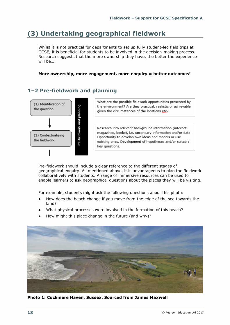
1–2 Pre-fieldwork and planning
Pre-fieldwork should include a clear reference to the different stages of
geographical enquiry. As mentioned above, it is advantageous to plan the fieldwork
collaboratively with students. A range of immersive resources can be used to
enable learners to ask geographical questions about the places they will be visiting.
For example, students might ask the following questions about this photo:
● How does the beach change if you move from the edge of the sea towards the
land?
● What physical processes were involved in the formation of this beach?
● How might this place change in the future (and why)?
Photo 1: Cuckmere Haven, Sussex. Sourced from James Maxwell
Fieldwork – Support for GCSE Specification A
© Pearson Education Ltd 2017
19
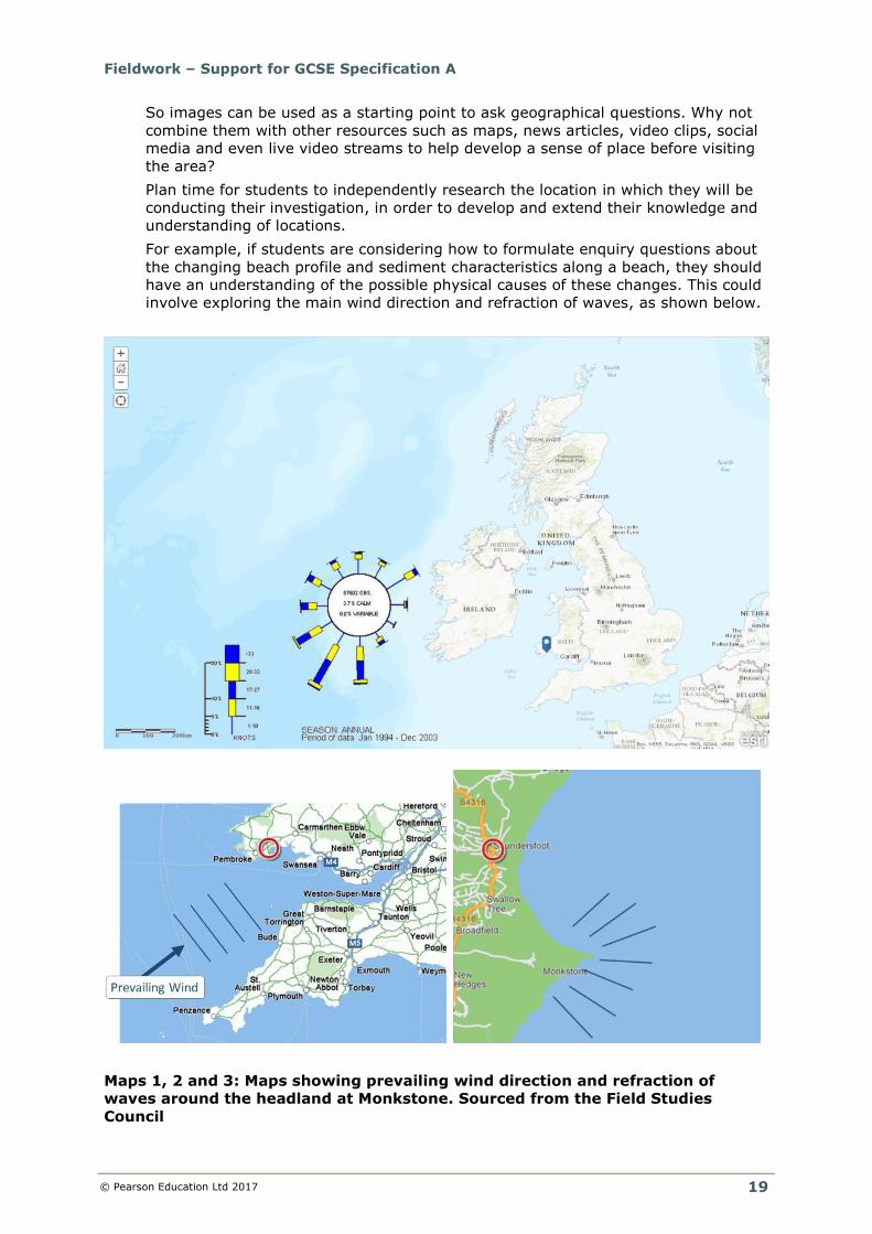
So images can be used as a starting point to ask geographical questions. Why not
combine them with other resources such as maps, news articles, video clips, social
media and even live video streams to help develop a sense of place before visiting
the area?
Plan time for students to independently research the location in which they will be
conducting their investigation, in order to develop and extend their knowledge and
understanding of locations.
For example, if students are considering how to formulate enquiry questions about
the changing beach profile and sediment characteristics along a beach, they should
have an understanding of the possible physical causes of these changes. This could
involve exploring the main wind direction and refraction of waves, as shown below.
Maps 1, 2 and 3: Maps showing prevailing wind direction and refraction of
waves around the headland at Monkstone. Sourced from the Field Studies
Council
Fieldwork – Support for GCSE Specification A
© Pearson Education Ltd 2017
20
These maps could be discovered by students using software such as Google Maps,
Scribble Maps, ArcGIS Online or Where’s the Path?
Once you have collaboratively decided on the general basis of the topic and
completed some background research, students then need to decide on the aims
(general statements of what you are trying to find out) and hypotheses (statements
that can be tested).
For the Edexcel GCSE Geography A specification, the aims of the four types of
investigation have been created for you and will remain the same for the lifetime of
the qualification:
● River landscapes – investigation of change in a river channel
● Coastal landscapes – investigation of coastal processes through landscape
evidence
● Changing city environments – investigating change in central/inner urban
area(s)
● Changing rural environments – investigating change in rural settlements.
Once you have decided on the type of investigation, students then need to create a
hypothesis. It is important that this is clear and measurable. For example:
● River velocity increases with distance downstream along River Dee
● Sediment size decreases from north to south along Dawlish Warren
● Environmental quality of Chester increases as you move away from the CBD
3 Design: where and how many?
Sampling
Prior to collecting the data, students need to consider the type of sampling
strategies they will use: stratified, systematic or random sampling. Sampling is the
process of measuring a small number of sites or people to obtain a perspective on
all sites and people.
Why do geographers use sampling?
● Sampling is quick.
● Sampling is cheap.
● Often it is impossible to access a whole population due to time constraints,
money, equipment and accessibility of the survey sites.
This all means that geographers have to use appropriate sampling strategies to
generate data from a representative sample.
In a systematic sample, measurements are taken at regular intervals, e.g.
● every 5th person who walks past
● every 20 metres along a street
● every 50 metres along a beach.
In a random sample, each member of the population is equally likely to be
included in the sample.
Fieldwork – Support for GCSE Specification A
© Pearson Education Ltd 2017
21
For taking random samples of an area, use a random number table to select
numbers. Use pairs of numbers as x and y co-ordinates. You could use metre rule
interval markings (e.g. to take pebble samples on a beach) or grid references (e.g.
to find random samples in a city).
Stratified sampling is when the population is split into sub-groups. In a stratified
sample, a proportionate number of measurements are taken from each group.
For example, an urban ward may contain 8 deprived wards and 2 undeprived
wards. A random sample may by chance miss all the undeprived areas. By contrast,
with a stratified sample, you can make sure that 80% of your samples are taken in
the deprived areas and 20% in the undeprived areas.
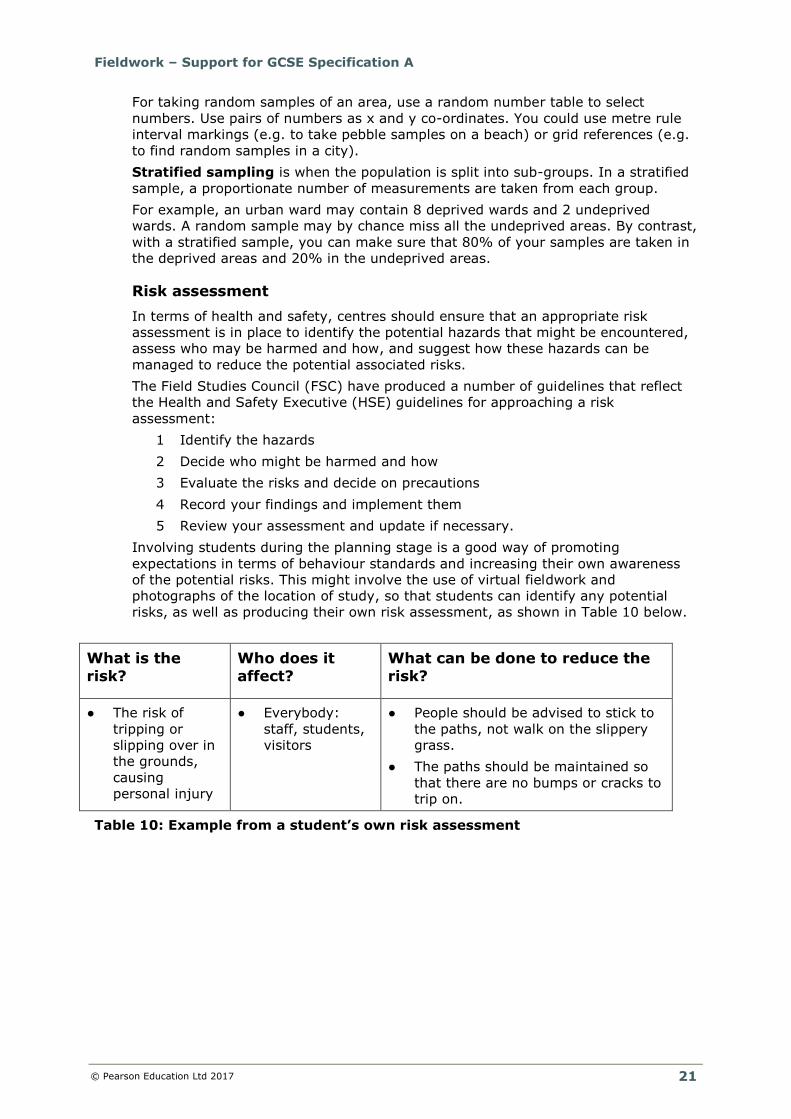
Risk assessment
In terms of health and safety, centres should ensure that an appropriate risk
assessment is in place to identify the potential hazards that might be encountered,
assess who may be harmed and how, and suggest how these hazards can be
managed to reduce the potential associated risks.
The Field Studies Council (FSC) have produced a number of guidelines that reflect
the Health and Safety Executive (HSE) guidelines for approaching a risk
assessment:
1 Identify the hazards
2 Decide who might be harmed and how
3 Evaluate the risks and decide on precautions
4 Record your findings and implement them
5 Review your assessment and update if necessary.
Involving students during the planning stage is a good way of promoting
expectations in terms of behaviour standards and increasing their own awareness
of the potential risks. This might involve the use of virtual fieldwork and
photographs of the location of study, so that students can identify any potential
risks, as well as producing their own risk assessment, as shown in Table 10 below.
What is the
risk?
Who does it
affect?
What can be done to reduce the
risk?
● The risk of
tripping or
slipping over in
the grounds,
causing
personal injury
● Everybody:
staff, students,
visitors
● People should be advised to stick to
the paths, not walk on the slippery
grass.
● The paths should be maintained so
that there are no bumps or cracks to
trip on.
Table 10: Example from a student’s own risk assessment
Fieldwork – Support for GCSE Specification A
© Pearson Education Ltd 2017
22
4 Equipment considerations; how to record. Primary data collection
For both the physical and human investigations, students are required to complete
at least one qualitative and one quantitative method.
For a rural study this might involve the quantitative method of recording the quality
of the environment through an environmental quality survey (EQS). The observer
makes judgements on the environmental quality against a range of indicators, often
on a sliding scale (e.g. –3–+3 to represent a negative to positive evaluation), as
shown below.
Table 11: EQS survey data collection sheet. Sourced from the Field Studies
Council
Fieldwork – Support for GCSE Specification A
© Pearson Education Ltd 2017
23
For all four types of study, a qualitative method that could be used is the recording
of landforms/environments using annotated field sketches or annotated
photographs. These can be used to look at a view of the whole landscape from a
given point, or in detail at given features.
Using scaffolds can help students add meaningful annotation to their sketches and
photos.
Table 12: Annotated field sketch/photo scaffold prompts. Sourced from the
Field Studies Council
Range of equipment
Map Marketing and The Consortium Education provide a range of fieldwork
equipment for centres to buy:
● http://www.mapmarketing.com/geography-resources/fieldwork-
equipment/prodlist_ct302.htm?size=12
● https://www.educationsupplies.co.uk/curriculum-resources/geography
Centres could create their own fieldwork equipment. Royal Geographical Society
(RGS) provide a number of ideas about how this could be achieved:
● http://www.rgs.org/OurWork/Schools/Fieldwork+and+local+learning/Local+lea
rning/Fieldwork+in+the+local+area/Make+your+own+fieldwork+equipment.ht
m
Fieldwork – Support for GCSE Specification A
© Pearson Education Ltd 2017
24
5 Data processing and presentation
Students should have the opportunity to display their data using a number of
different graphical techniques. When investigating the perception of a place,
students could use epitome words and present them as a word cloud using
Wordle.TM
Photo 2: WordleTM for a rural study. Sourced from the Field Studies Council
Fieldwork – Support for GCSE Specification A
© Pearson Education Ltd 2017
25
GIS could be used to create layered maps with proportional circles, like the
example shown below on the mean sediment size along a stretch of beach.
Map 4: Located proportional circles to show the mean sediment size. Sourced
from the Field Studies Council
Students should also be provided with the opportunity to create a series of hand-
drawn graphs to represent their data.
Graph 2: Beach profiles for Dawlish Warren. Sourced from Michael Chiles
Fieldwork – Support for GCSE Specification A
© Pearson Education Ltd 2017
26
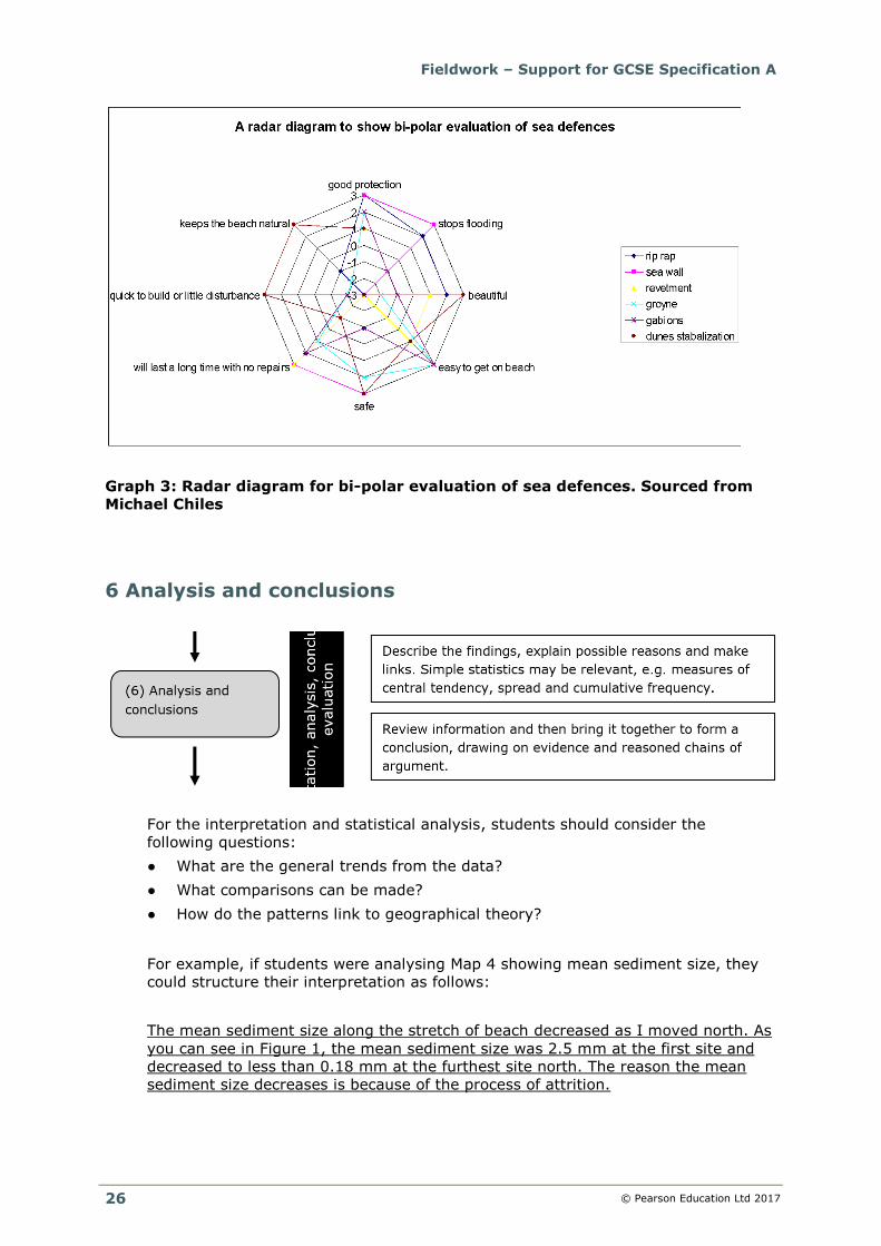
Graph 3: Radar diagram for bi-polar evaluation of sea defences. Sourced from
Michael Chiles
6 Analysis and conclusions
For the interpretation and statistical analysis, students should consider the
following questions:
● What are the general trends from the data?
● What comparisons can be made?
● How do the patterns link to geographical theory?
For example, if students were analysing Map 4 showing mean sediment size, they
could structure their interpretation as follows:
The mean sediment size along the stretch of beach decreased as I moved north. As
you can see in Figure 1, the mean sediment size was 2.5 mm at the first site and
decreased to less than 0.18 mm at the furthest site north. The reason the mean
sediment size decreases is because of the process of attrition.
Fieldwork – Support for GCSE Specification A
© Pearson Education Ltd 2017
27
For their conclusion, students should consider whether they have proved the
hypothesis set and how the data reflects the overall enquiry question.
Students should consider the following key points when writing their conclusions:
● What did the investigation prove/disprove?
● How accurately does the data support the geographical theories?
● They should summarise the possible reasons for the anomalies.
7 Critically reflecting on the results
For the evaluation, students should make reference to the accuracy, validity and
reliability of the conclusions from the investigation. They should consider the
following questions:
● How successful were the sampling and collection methods used to gather the
data?
● How accurate were the results and conclusions drawn?
Accuracy means how close a measurement was to the true value. The true value is
the measurement that would be obtained in an ideal measurement. Student
measurements (perhaps of channel width or river velocity) are generally less
accurate, and so further away from the true value, than measurements taken by
professional surveyors and engineers.
Students should consider what might have been the sources of error.
● Measurement error: mistakes made when collecting the data (such as
someone misreading a clinometer).
● Operator error: differences in the results collected by different people (such
as different people giving different environmental quality scores).
● Sampling error: where a sample is biased. Some elements of the population
are less likely to be included than others.
Students should discuss the reliability of their results by considering the extent to
which the measurements were taken in a consistent way. For example, methods
that are taken by different students at different sites should be checked for their
reliability.
Validity means the suitability of the method used to answer the question that it was
intended to answer. For each method, ask these questions.
● Was your sampling strategy (random/systematic/stratified) appropriate?
● Did the method you use actually measure the geographical process or feature
that it was supposed to measure?
A valid conclusion is supported by accurate and reliable data obtained using a valid
method. Are your conclusions valid?
Fieldwork – Support for GCSE Specification A
© Pearson Education Ltd 2017
28
(4) Suggested fieldwork opportunities
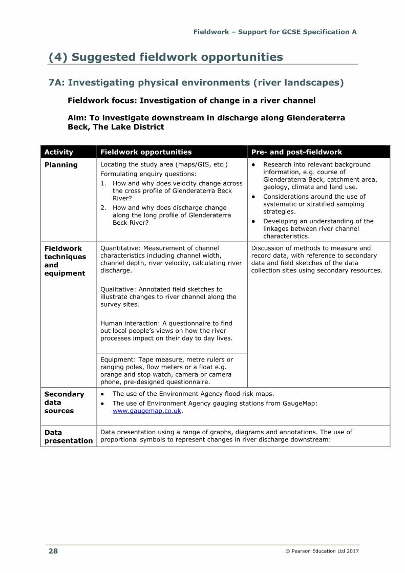
7A: Investigating physical environments (river landscapes)
Fieldwork focus: Investigation of change in a river channel
Aim: To investigate downstream in discharge along Glenderaterra Beck, The Lake District
Activity Fieldwork opportunities Pre- and post-fieldwork
Planning Locating the study area (maps/GIS, etc.) Formulating enquiry questions: 1. How and why does velocity change across
the cross profile of Glenderaterra Beck River?
2. How and why does discharge change along the long profile of Glenderaterra
Beck River?
● Research into relevant background information, e.g. course of
Glenderaterra Beck, catchment area, geology, climate and land use.
● Considerations around the use of
systematic or stratified sampling strategies.
● Developing an understanding of the
linkages between river channel characteristics.
Fieldwork
techniques
and
equipment
Quantitative: Measurement of channel characteristics including channel width, channel depth, river velocity, calculating river
discharge.
Qualitative: Annotated field sketches to illustrate changes to river channel along the
survey sites.
Human interaction: A questionnaire to find out local people’s views on how the river processes impact on their day to day lives.
Discussion of methods to measure and record data, with reference to secondary data and field sketches of the data
collection sites using secondary resources.
Equipment: Tape measure, metre rulers or ranging poles, flow meters or a float e.g.
orange and stop watch, camera or camera phone, pre-designed questionnaire.
Secondary
data
sources
● The use of the Environment Agency flood risk maps.
● The use of Environment Agency gauging stations from GaugeMap: www.gaugemap.co.uk.
Data
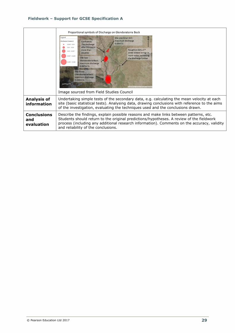
presentation Data presentation using a range of graphs, diagrams and annotations. The use of proportional symbols to represent changes in river discharge downstream:
Fieldwork – Support for GCSE Specification A
© Pearson Education Ltd 2017
29
Image sourced from Field Studies Council
Analysis of
information Undertaking simple tests of the secondary data, e.g. calculating the mean velocity at each site (basic statistical tests). Analysing data, drawing conclusions with reference to the aims of the investigation, evaluating the techniques used and the conclusions drawn.
Conclusions
and
evaluation
Describe the findings, explain possible reasons and make links between patterns, etc.
Students should return to the original predictions/hypotheses. A review of the fieldwork process (including any additional research information). Comments on the accuracy, validity and reliability of the conclusions.
Fieldwork – Support for GCSE Specification A
© Pearson Education Ltd 2017
30
7A: Investigating physical environments (coastal landscapes)
Fieldwork focus: Investigation of coastal processes through
landscape evidence
Aim: To investigate the impact of coastal processes at Saundersfoot
Bay, Pembrokeshire
Activity Fieldwork opportunities Pre- and post-fieldwork
Planning Locating the study area (maps/GIS, etc.) Designing an investigation: ● Identification of a question and aims
linked to geographical theory. ● Fieldwork equipment considerations to
ensure accuracy and reliability. ● Discussion of health and safety.
Contextualising the study/wider significance of
the topic area, etc. ● Research into relevant background
information, e.g. maps showing prevailing
wind and refraction of waves around the headland at Monkstone.
● Developing an understanding of both the
spatial and temporal changes to coastlines.
Fieldwork
techniques
and
equipment
Quantitative: Completing a beach profile including transects up the beach measuring
slope gradient. Carry out a sediment analysis including measuring the sediment size and shape, e.g. Power’s scale.
Qualitative: Annotated field sketches to illustrate changes to the profile of the beach
along the survey sites.
Human interaction: A questionnaire to find out local people’s views on how coastal processes impact on their day to day lives.
Discussion of methods to measure and record data, with reference to secondary data and field sketches of the data collection sites using
secondary resources.
Equipment: Rulers or calipers, sediment
roundness chart, tape measure, ranging poles, clinometers, camera or phone, pre-designed questionnaire.
Secondary
data sources
● Geological maps to develop understanding of the formation of large-scale coastal landforms using the BGS map viewer: http://mapapps.bgs.ac.uk/geologyofbritain/home.html.
● The use of the Met Office Regional Climate Data to investigate the long-term wind data:
http://www.metoffice.gov.uk/climate/uk/regional-climates/.
Data
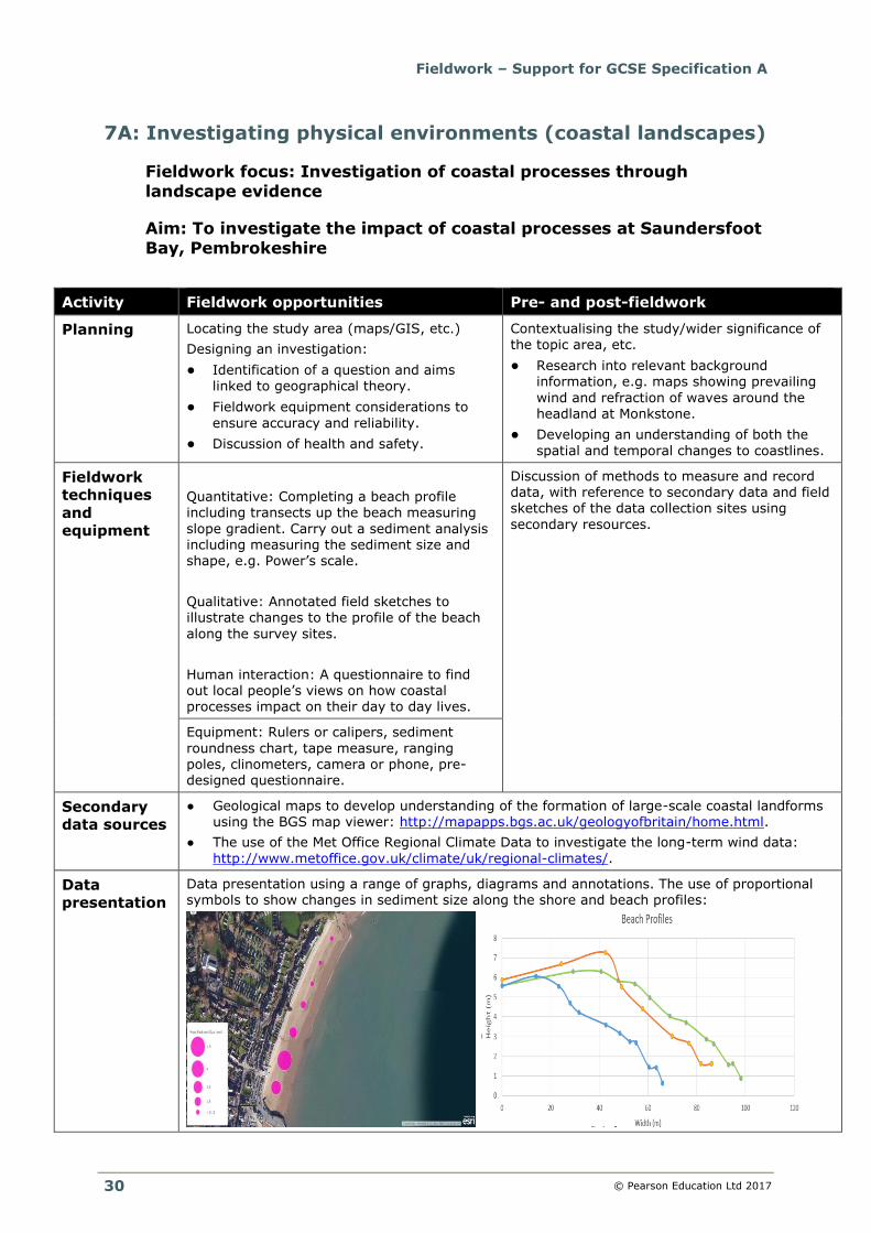
presentation Data presentation using a range of graphs, diagrams and annotations. The use of proportional symbols to show changes in sediment size along the shore and beach profiles:
Fieldwork – Support for GCSE Specification A
© Pearson Education Ltd 2017
31
Image sourced from Field Studies Council
Analysis of
information Undertaking simple tests of the secondary data, e.g. calculating the mean sediment size at each site (basic statistical tests). Analysing data, drawing conclusions with reference to the aims of
the investigation, evaluating the techniques used and the conclusions drawn.
Conclusions
and
evaluation
Describe the findings, explain possible reasons and make links between patterns, etc. Students should return to the original predictions/hypotheses. A review of the fieldwork process (including any additional research information). Comments on the accuracy, validity and reliability of the conclusions.
Fieldwork – Support for GCSE Specification A
© Pearson Education Ltd 2017
32
(4b) Human geography
7B: Investigating human landscapes (central/inner urban
area(s))
Fieldwork focus: Investigating change in central/inner urban
areas(s)
Aim: To investigate changes in Shrewsbury’s CBD
Activity Fieldwork opportunities Pre- and post-fieldwork
Planning Locating the study area (maps/GIS, etc.) Designing an investigation: ● Identification of a question and aims
linked to geographical theory. ● Fieldwork equipment considerations to
ensure accuracy and reliability. ● Discussion of health and safety.
Contextualising the study/wider significance of the topic area, etc. ● Research into relevant background
information, e.g. historic land use from a
Goad plan of Shrewsbury in 1987. ● Developing an understanding of spatial
changes in land use from the CBD.
Fieldwork
techniques
and
equipment
Quantitative: A land-use survey to record land use function along a transect.
Qualitative: Street observations to illustrate the quality of Shrewsbury’s environment along the land-use transect.
Physical interaction: Annotated photographs and interviews about the influence of people on changes to the physical environment of the chosen study area.
Discussion of methods to measure and record data, with reference to secondary data, field
sketches and photos of architecture of the data collection sites using secondary resources. Collecting data from several radial transects from a central point outwards.
Equipment: Base maps of area of study, land use classification key e.g. RICEPOTs (see box on next page), camera, and pre-
designed questionnaire.
Secondary
data
sources
Census data e.g. Office for National Statistics (ONS) Neighbourhood Statistics – neighbourhood summary report.
Use of Goad maps to explore changes in land use over time.
Data
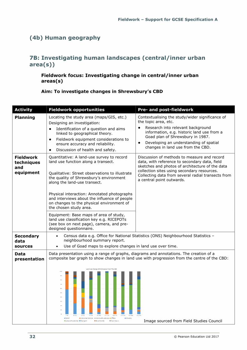
presentation Data presentation using a range of graphs, diagrams and annotations. The creation of a composite bar graph to show changes in land use with progression from the centre of the CBD:
Image sourced from Field Studies Council
Fieldwork – Support for GCSE Specification A
© Pearson Education Ltd 2017
33
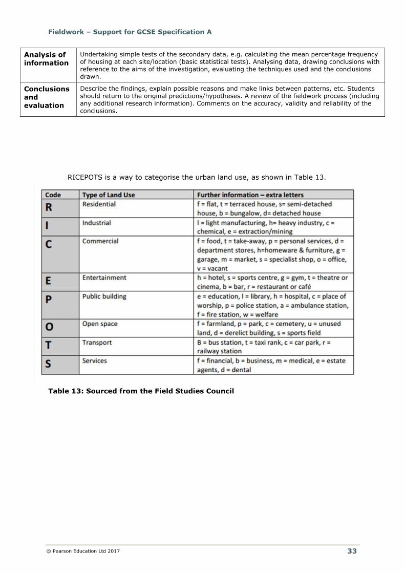
RICEPOTS is a way to categorise the urban land use, as shown in Table 13.
Table 13: Sourced from the Field Studies Council
Analysis of
information Undertaking simple tests of the secondary data, e.g. calculating the mean percentage frequency of housing at each site/location (basic statistical tests). Analysing data, drawing conclusions with reference to the aims of the investigation, evaluating the techniques used and the conclusions drawn.
Conclusions
and
evaluation
Describe the findings, explain possible reasons and make links between patterns, etc. Students should return to the original predictions/hypotheses. A review of the fieldwork process (including any additional research information). Comments on the accuracy, validity and reliability of the conclusions.
Fieldwork – Support for GCSE Specification A
© Pearson Education Ltd 2017
34
7B: Investigating human landscapes (rural settlements)
Fieldwork focus: Investigating change in rural settlements
Aim: To investigate the changes in rural settlements both inside and outside of the Yorkshire Dales National Park
Activity Fieldwork opportunities Pre- and post-fieldwork
Planning Locating the study area (maps/GIS, etc.) Designing an investigation: ● Identification of a question and aims
linked to geographical theory. ● Fieldwork equipment considerations to
ensure accuracy and reliability. ● Discussion of health and safety.
Contextualising the study/wider significance of the topic area, etc. ● Research into relevant background
information, e.g. services, housing, crime
and accessibility of Hellifield. ● Fieldwork design – where and how many
sites (justified). Possible development/ customisation of recording sheets.
Fieldwork
techniques
and
equipment
Quantitative: A pedestrian count and traffic
count to measure the flows of people at different survey sites.
Qualitative: Questionnaire to record the views of people on changes to the Yorkshire Dales National Park.
Physical interaction: Interviews with
different stakeholders to develop an understanding of the interrelationship between people and the surrounding environment. This would involve a series of questions to investigate the views of residents and visitors on the changes to the landscape both inside and outside of the
National Park. A number of different stakeholders could be interviewed to gain a wider range of views.
Discussion of methods to measure and record data, with reference to secondary data and field
sketches of the data collection sites using secondary resources.
Equipment: Pre-designed questionnaire, pedestrian and traffic count.
Secondary
data
sources
Census data e.g. Office for National Statistics (ONS) Neighbourhood Statistics – neighbourhood summary report.
Investigating crime statistics both inside and outside of the National Park.
Data
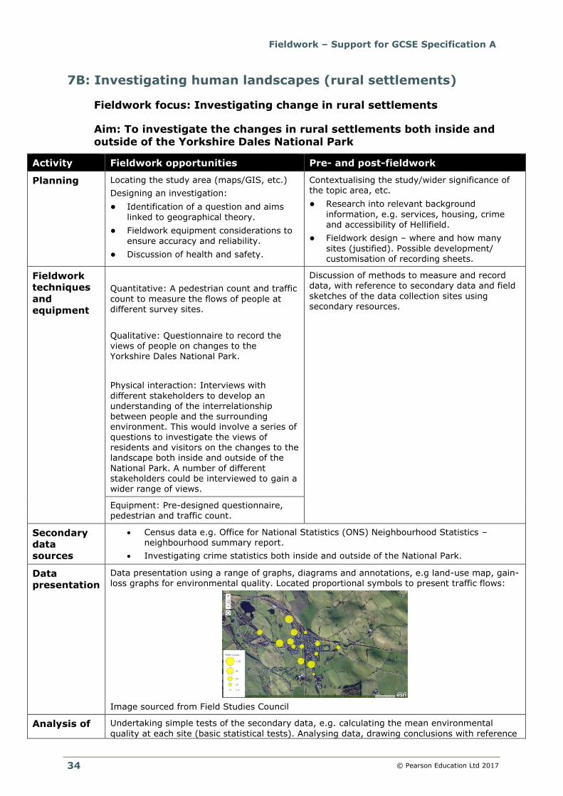
presentation Data presentation using a range of graphs, diagrams and annotations, e.g land-use map, gain-loss graphs for environmental quality. Located proportional symbols to present traffic flows:
Image sourced from Field Studies Council
Analysis of Undertaking simple tests of the secondary data, e.g. calculating the mean environmental
quality at each site (basic statistical tests). Analysing data, drawing conclusions with reference
Fieldwork – Support for GCSE Specification A
© Pearson Education Ltd 2017
35
information to the aims of the investigation, evaluating the techniques used and the conclusions drawn.
Conclusions
and
evaluation
Describe the findings, explain possible reasons and make links between patterns, etc. Students
should return to the original predictions/hypotheses. A review of the fieldwork process (including any additional research information). Comments on the accuracy, validity and reliability of the conclusions.
Fieldwork – Support for GCSE Specification A
© Pearson Education Ltd 2017
36
(5) Resources to support fieldwork and research
Several organisations provide support for teachers to contextualise the fieldwork
and add relevance to the issue/topic being studied:
● Geofile and Geo Factsheet – these include publications on a range of topics.
Although aimed at an AS/A2 audience, they can provide some useful
background reading to contextualise a topic area.
● Newspapers – especially Independent, Guardian, Telegraph, The Times.
Other international papers may also be suitable for contextualising a particular
local issue. Search their blogging areas for background opinion. Look at local
newspapers for a more in-depth focus on local issues (especially editorial
sections).
● BBC website – look at the local section for reactions to particular issues.
● YouTube may provide clips of documentaries, as well as uploaded local videos.
● For stretch, search the online databases of The Economist, Ecologist and New
Scientist for some up-to-date and accessible resources.
● The Field Studies Council have an excellent website: http://www.geography-
fieldwork.org. They also have a range of specialist identification guides (fold-out
charts) for many of the fieldwork topics in the specification, e.g.
http://www.field-studies-council.org/publications/pubs/geographical-
investigations.aspx.
● Topic Eye Geography is a magazine series for students written by leading
authors and examiners. There may be some resources in here that help
contextualise the course and fieldwork/research:
http://crossacademe.co.uk/series/23/a-level-geography
● Geography Review and Wideworld are now available online and they are
searchable through an online magazine subscription service. This is the link to
their magazines page:
https://www.hoddereducation.co.uk/Geography#&pid=2&limit=true&type=0.
● Subscriptions to social media feeds including Facebook and Twitter, to keep
up to date and create links with other Geography departments to share best
practices on designing and delivering successful fieldwork opportunities.
● Digimap for Schools is a useful mapping tool that students can use to create
GIS maps for their data presentation of fieldwork data, as well as background
research for their location of study: http://digimapforschools.edina.ac.uk.
Fieldwork – Support for GCSE Specification A
© Pearson Education Ltd 2017
37
(6) Virtual fieldwork
It should be stressed that virtual fieldwork is not intended to be used as a way of
short-cutting or bypassing the original fieldwork opportunities which are central to
the delivery of this specification.
Virtual fieldwork, in the context of this specification, is a term that refers to either
of the following:
1 Pre- and post-fieldwork that supports the main focus of the fieldwork and
other research. This might include Google Maps and Google Street View for
instance, as a tool to select appropriate sites. Or photographs/video from
past field visits (when conditions were different) to demonstrate particular
features/landscapes/processes, etc. YouTube may be useful in this respect.
Virtual fieldwork may also be used as a tool to help teach field skills before
the visit, or prepare a risk assessment, so ‘blending’ a range of
opportunities.
2 A simulation exercise, where, because of constrained circumstances,
candidates cannot collect the data personally in the field. In this instance,
alternative data will need to be sourced from other individuals and
providers. See Specification: Fieldwork and exceptional circumstances.
Whilst option 2 may offer a workable, practical and satisfactory alternative to real
fieldwork, this approach is not without its limitations:
● Virtual trips cannot replicate real objects and experiences (e.g. rocks, plants,
smells and noises) – only visual aspects (e.g. views of landscapes) can easily
be simulated.
● Students may treat a virtual field trip as similar to a computer game and thus
not learn the analytical approaches or problem-solving in the same way as
when they are confronted by the ‘real thing’.
● A virtual environment cannot recreate the challenges of doing an enquiry in an
unfamiliar setting, which develops self-reliance.
● A simulation exercise can’t recreate the social benefits of fieldwork, especially
the value of residential experiences.
● It is difficult to develop and embed the skills and experiences associated with
real fieldwork (which forms part of the assessment).
There are many examples of virtual fieldwork tours on the internet.
● One example is from the Geographical Association (UK):
http://www.geography.org.uk/projects/makingmyplaceintheworld/virtualfieldwo
rk
o This describes a range of activities and also has a downloadable
PowerPoint linked to the topic:
http://www.geography.org.uk/download/GA_PRMMPVirtualFieldwork.ppt
● The Digital Explorer website has a manual on virtual fieldwork in the context of
Google Earth: http://digitalexplorer.com/ge/adf/advanced-google-earth-
manual.pdf.
Fieldwork – Support for GCSE Specification A
© Pearson Education Ltd 2017
38
(7) Further support and guidance
A number of online resources support the designing of the fieldwork opportunities:
● Planning and Developing Fieldwork
Geographical Association: http://www.geography.org.uk/
A series of thoughtful fieldwork-related journal articles:
● The Case for Qualitative Fieldwork
Royal Geographical Society: http://www.rgs.org/
● Data Skills in Geography Project
Royal Geographical Society: http://www.rgs.org/
● Innovation in Fieldwork
Royal Geographical Society: http://www.rgs.org/
There are also a number of books and published resources that could be used:
● A–Z Advancing Geography: Fieldwork
Geographical Association. Holmes & Farbrother (2000)
● Fieldwork Through Enquiry
Geographical Association. Widdowson & Parkinson (2013)
● Methods of Presenting Fieldwork Data
Geographical Association. St John & Richardson (1997)
● Geography Review Practical Fieldwork Articles can be accessed through
an archive back to 1993: https://www.hoddereducation.co.uk/
Additional resources that might be useful:
● Edexcel GCSE Geography A and B Maths for Geographers guide:
https://qualifications.pearson.com/content/dam/pdf/GCSE/Geography-
A/2016/teaching-and-learning-materials/Edexcel-2016-GCSE-Geography-A-B-
Maths-for-Geographers.pdf
● Edexcel GCSE/AS-A level Geography command words:
https://qualifications.pearson.com/content/dam/pdf/GCSE/Geography-
A/2016/teaching-and-learning-materials/Command-words-2016.pdf
Fieldwork – Support for GCSE Specification A
© Pearson Education Ltd 2017
39