Embed Size (px)
Citation preview
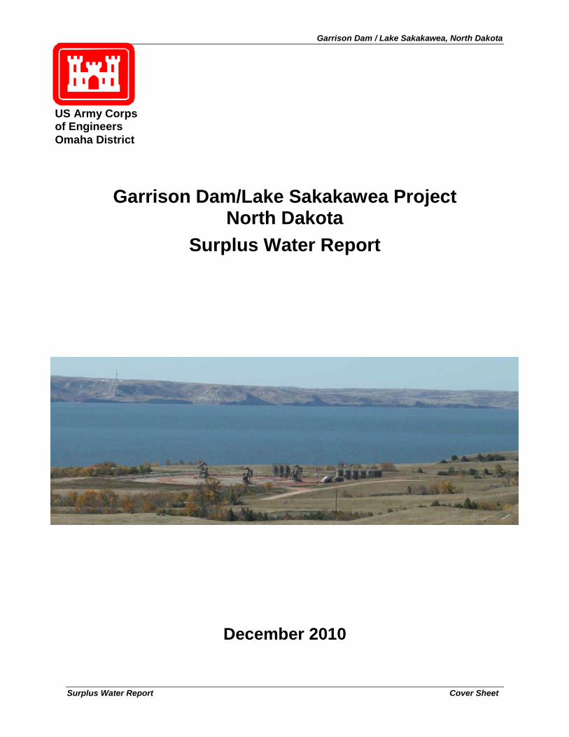
Garrison Dam / Lake Sakakawea, North Dakota
Surplus Water Report Cover Sheet
Garrison Dam/Lake Sakakawea Project
North Dakota Surplus Water Report
December 2010
US Army Corps of Engineers Omaha District
Garrison Dam / Lake Sakakawea, North Dakota
Surplus Water Report Cover Sheet
GARRISON DAM / LAKE SAKAKAWEA PROJECT, NORTH
DAKOTA SURPLUS WATER REPORT
Omaha District U.S. Army Corps of Engineers
December 2010
Garrison Dam / Lake Sakakawea, North Dakota
Surplus Water Report Cover Sheet
GARRISON DAM / LAKE SAKAKAWEA, NORTH DAKOTA SURPLUS WATER REPORT
December 2010
Prepared By:
The U.S. Army Corps of Engineers, Omaha District
Omaha, NE
Abstract: The Omaha District is proposing to temporarily make available 100,000 acre-feet/year of surplus water (equivalent to 257,000 acre-feet of storage) from the sediment storage portion of the carryover multiple use zone of the Garrison Dam / Lake Sakakawea Project, North Dakota to meet municipal and industrial (M&I) water supply needs. Under Section 6 of the Flood Control Act of 1944 (Public Law 78-534), the Secretary of the Army is authorized to make agreements with states, municipalities, private concerns, or individuals for surplus water that may be available at any reservoir under the control of the Department. Terms of the agreements are normally for five (5) years, with an option for a five (5) year extension, subject to recalculation of reimbursement after the initial five (5) year period. This proposed action will allow the Omaha District to enter into surplus water agreements with interested water purveyors and to issue easements for up to the total amount of surplus water to meet regional water needs. During the temporary period, a permanent reallocation study may be conducted to address the potential for permanent changes in allocation of storage to the authorized purposes of the Garrison Dam / Lake Sakakawea Project, including municipal and industrial (M&I) water supply. The Proposed Action (temporary use of surplus water) will not impede the capability and function of Garrison Dam / Lake Sakakawea to serve its authorized purposes. An Environmental Assessment, which is attached to this Surplus Water Report, identifies the baseline environmental conditions and provides an analysis of potential impacts from the proposed use of surplus water. There are no significant environmental impacts associated with implementing the proposed action.
For more information contact:
Commander, U.S. Army Corps of Engineers
Attn: Ms. Kayla Eckert-Uptmor, Chief, Planning Branch, Omaha District
1616 Capitol Avenue, Omaha, NE 68102-4901
Phone: (402) 995-2693
Fax: (402) 995-2758

Garrison Dam / Lake Sakakawea, North Dakota
Surplus Water Report i
Garrison Dam / Lake Sakakawea, North Dakota
Surplus Water Report ii
EXECUTIVE SUMMARY The Omaha District, U.S. Army Corps of Engineers (Corps) under the Operation & Maintenance Program has prepared this Garrison Dam / Lake Sakakawea, ND, Surplus Water Report to identify and quantify whether surplus water is available in the Project, as defined in Section 6 of the 1944 Flood Control Act. Surplus water agreements with water users derived from this process may be executed with existing and potential future applicants, pursuant to policy, upon approval of this Report by the Assistant Secretary of the Army (Civil Works) and completion of required NEPA coordination. The term of the proposed temporary surplus water use is for a five (5) year period, renewable for an additional five (5) year period, subject to recalculation of reimbursement after the initial five (5) year period.
This Surplus Water Report and accompanying Environmental Assessment investigate the engineering and economic feasibility and environmental effects of temporary use of up to 100,000 acre-feet/year of surplus water (257,000 acre-feet of storage) from the sediment storage portion of the carryover multi-purpose zone of the Garrison Dam / Lake Sakakawea Project. Surplus water, if available, may be used to meet existing and projected municipal and industrial (M&I) water supply needs in the region. The 100,000 acre-feet/year of yield (257,000 acre-feet of storage) evaluated for surplus water use in this report is an estimate that was selected to ensure that an adequate quantity of water was identified to meet the needs of existing and future M&I water users. This Surplus Water Report will serve as the basis to enter into surplus water agreements until such time as a permanent reallocation study can be completed.
A 10-year study period has been established for this surplus water study. The length of the study period was selected for several reasons. First, surplus water agreements may be executed for a five (5) year period, renewable for an additional five (5) year period. Second, prior to the end of the 10-year study period, it is anticipated that a reallocation study of the six Federal reservoir projects within the Missouri River basin (including the Garrison Dam / Lake Sakakawea Project) will be completed, which will determine if changes to the permanent allocation of storage among the authorized project purposes and modifications to existing Federal water resource infrastructure may be warranted. Third, the primary water demand driving regional water needs at this time is the North Dakota oil and gas industry. Industry and state estimates indicate that demand from this industry is temporary and will decrease significantly after 10 years. The surplus water agreements executed upon the approval of this Report will serve as measures to address temporary water needs of the region during the 10-year study period.
The Garrison Dam/Lake Sakakawea Project is a unit of the comprehensive Pick-Sloan Plan for development in the Missouri River Basin. The operation of the upper Missouri River’s six mainstem reservoirs and the lower Missouri River’s levees and navigation channel provides for flood control, navigation, irrigation, hydropower, municipal and industrial water supply, fish and wildlife, water quality, and recreation. The temporary use of 100,000 acre-feet/year of surplus water in Lake Sakakawea would result in net annual depletions of 527 acre-feet from the system for the ten year period, because all but 527 acre-feet of the 100,000 acre-feet/year in water use will come from the Missouri River under both with and without project conditions. The primary difference between with and without project conditions is the location of the water withdrawals. Under without project conditions (No Action), the vast majority of withdrawals will come from the free-flowing reaches of the Missouri River upstream of Lake Sakakawea. Under with project conditions (Proposed Action), withdrawals will come from the Garrison Dam / Lake Sakakawea Project.
Garrison Dam / Lake Sakakawea, North Dakota
Surplus Water Report iii
The Daily Routing Model (DRM), developed during the 1990’s as part of the Missouri River Mainstem Reservoir System Master Water Control Manual Review and Update Study (Master Manual), was used as an analytical tool in this study to estimate the hydrologic effects that an additional 527 acre-feet of depletions would have at Lake Sakakawea, the other system reservoirs, and free-flowing reaches of the Missouri River.
A comparison of DRM simulated water surface elevations, stream flows, and river stages between without project conditions and a depletion of 527 acre-feet from Lake Sakakawea (with project conditions) was performed to assess the magnitude of changes resulting from the proposed temporary use of surplus water from the Project. Modeling results indicate that stage and flow reduction estimates throughout the system are extremely small, because all but 527 acre-feet of the 100,000 acre-feet/year in surplus water will come from the Missouri River under both with and without project conditions. Because the Missouri River projects are operated as an integrated system taking into account system withdrawals both in and outside of the Federal projects, no changes to system operations will be required as a result of the temporary use of surplus water from the Garrison Dam / Lake Sakakawea Project.
The method used to estimate the cost to the surplus water user for the capital investment of surplus water in the Garrison Dam/Lake Sakakawea Project is the updated cost of storage method, because it results in a greater value than benefits foregone by the temporary use of surplus water, revenues foregone, or replacement cost of the water. The relationship between reservoir storage and provided yield was calculated as 2.57, indicating that 257,000 acre-feet of storage (1.079% of total usable storage) would be required to provide a yield of 100,000 acre-feet/year.
The reasonable annual price for the use of surplus water is determined by the same procedure used to determine the annual payment for an equivalent amount of storage annualized over a 30-year period plus an estimated annual cost for operation and maintenance, repair, replacement, and rehabilitation (OMRR&R). Annual payments for these surplus agreements are based on a 30-year payment schedule and the repayment interest rate identified in EGM 11-01 Federal Interest Rates for Corps of Engineers Projects for Fiscal Year 2011. The appropriate interest rate is the Water Supply Interest Rate based on PL 99-662. The FY 11 interest rate is 4.25%. The annual payment for the updated cost of temporary surplus water ($35,383,148 over a 30-year period at an interest rate of 4.25%) is $2,022,804. The total annual cost of storage, including the annual estimated OMRR&R costs allocated to the surplus water storage ($67,733), is $2,090,537 which is an annual cost of $8.13 per acre-foot of surplus water storage at FY 2011 price levels (equivalent to $20.91 per acre-foot of yield). The actual annual price for any surplus water agreement will be calculated based upon the appropriate price level for the fiscal year in which the surplus water agreement is signed.
Repayment costs will be recalculated at the end of the first five (5) year period of the surplus water agreements. All cost figures based on the WSA of 1958 interest rates will need to be recalculated at that time, using the current Water Supply Interest Rate based on PL 99-662.
An alternatives analysis was conducted, which assessed non-structural measures (conservation, recycling, and temporary permits to convert irrigation water to industrial use) and structural measures (project modifications to increase storage capacity, temporary use of surplus water including associated infrastructure, groundwater withdrawals including associated infrastructure, and surface water withdrawals including associated infrastructure). The No Action – Next Least
Garrison Dam / Lake Sakakawea, North Dakota
Surplus Water Report iv
Costly Alternative is a combination of measures, including: improvements to the Williston Regional Water Treatment Plant, temporary permits to convert irrigation water to industrial use, continued use of existing water depots, continued use of existing Lake Sakakawea water intake easements, and withdrawals from free-flowing reaches of the Missouri River.
A test of financial feasibility was conducted, which demonstrated that providing surplus water from the Garrison Dam / Lake Sakakawea Project is a lower cost alternative than the most likely, least costly alternative for providing the needed water supply. An analysis of environmental impacts was conducted using the same DRM outputs that were used to assess impacts to project purposes. The analysis of environmental impacts identified no significant impacts from providing surplus water from the Garrison Dam / Lake Sakakawea Project. Environmental benefits may result from fewer truck miles travelled under with-project conditions because providing surplus water from the Project may allow some water providers to be closer to water use locations than under without project conditions.
The temporary use of surplus water assessed in this report is both economically and financially justified and will not affect the authorized purposes of Garrison Dam / Lake Sakakawea Project. It is recommended that 257,000 acre-feet of storage (equivalent to 100,000 acre-feet/year of yield) in the Garrison Dam / Lake Sakakawea Project be made available for temporary use for municipal and industrial water users for a period of five years, with an option to renew for an additional five years. The annual payment is $8.13 per acre-foot of storage (equivalent to $20.91 per acre-foot of yield) at FY 2011 price levels.
Garrison Dam / Lake Sakakawea, North Dakota
Surplus Water Report v
Garrison Dam / Lake Sakakawea, North Dakota
Surplus Water Report vi
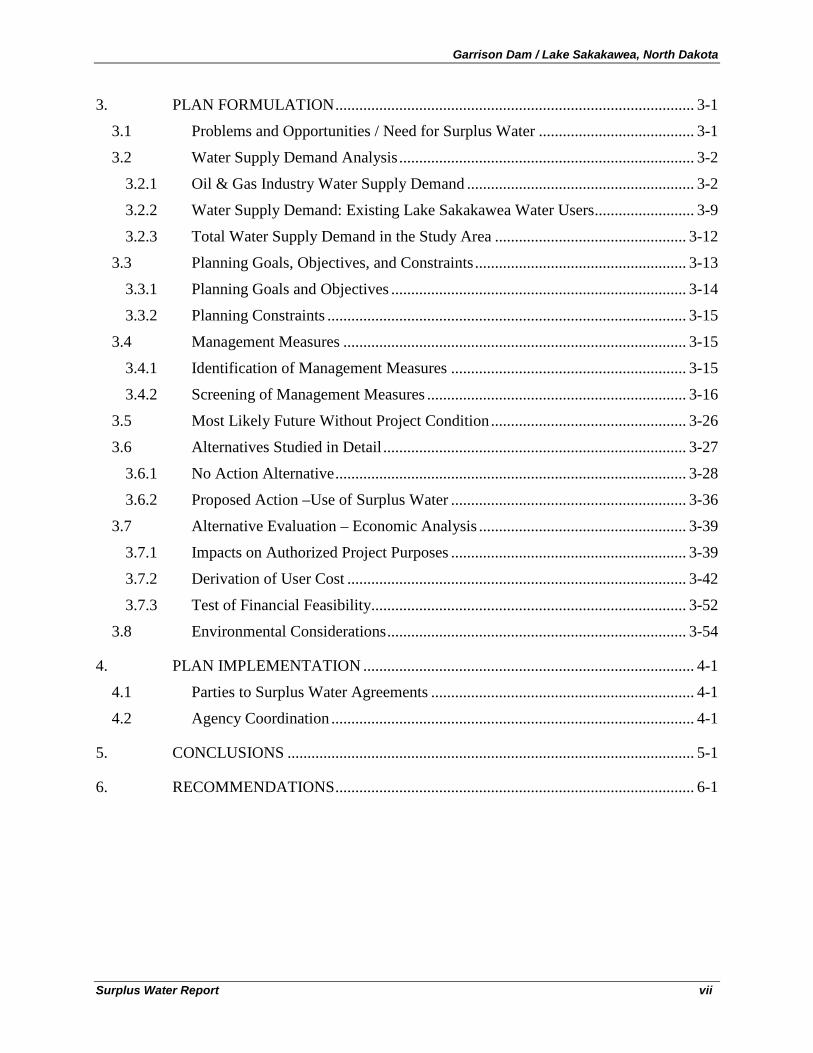
TABLE OF CONTENTS
EXECUTIVE SUMMARY ............................................................................................................ II
1. INTRODUCTION .................................................................................................... 1-1
1.1 Study Purpose ...................................................................................................... 1-1
1.2 Study Authority .................................................................................................... 1-2
1.3 Need for Surplus Water ....................................................................................... 1-3
1.4 Report Organization ............................................................................................. 1-3
2. PROJECT BACKGROUND .................................................................................... 2-1
2.1 Project Location ................................................................................................... 2-1
2.2 Project Authorization ........................................................................................... 2-1
2.3 Project Description............................................................................................... 2-1
2.3.1 Garrison Dam ....................................................................................................... 2-1
2.3.2 Lake Sakakawea................................................................................................... 2-4
2.4 Authorized Project Purposes ................................................................................ 2-4
2.5 Missouri River System Reservoir Regulation...................................................... 2-6
2.5.1 Flood Control ....................................................................................................... 2-9
2.5.2 Navigation .......................................................................................................... 2-10
2.5.3 Irrigation ............................................................................................................ 2-11
2.5.4 Municipal and Industrial (M&I) Water Supply ................................................. 2-12
2.5.5 Hydropower ....................................................................................................... 2-13
2.5.6 Fish and Wildlife................................................................................................ 2-14
2.5.7 Recreation .......................................................................................................... 2-14
2.5.8 Water Quality ..................................................................................................... 2-15
2.6 North Dakota Water Permit Process .................................................................. 2-15
2.7 Corps of Engineers Surplus Water Agreements, Easements, and Permits ........ 2-16
2.7.1 Surplus Water Agreements ................................................................................ 2-16
2.7.2 Easements .......................................................................................................... 2-17
2.7.3 Regulatory Permits............................................................................................. 2-17
2.7.4 Existing Agreements, Easements, and Permits .................................................. 2-17
2.7.5 Pending Agreements, Easements, and Permits .................................................. 2-18
2.8 Historic Water Use ............................................................................................. 2-19
2.9 Corps Studies and Reports by Others ................................................................ 2-25
Garrison Dam / Lake Sakakawea, North Dakota
Surplus Water Report vii
3. PLAN FORMULATION .......................................................................................... 3-1
3.1 Problems and Opportunities / Need for Surplus Water ....................................... 3-1
3.2 Water Supply Demand Analysis .......................................................................... 3-2
3.2.1 Oil & Gas Industry Water Supply Demand ......................................................... 3-2
3.2.2 Water Supply Demand: Existing Lake Sakakawea Water Users ......................... 3-9
3.2.3 Total Water Supply Demand in the Study Area ................................................ 3-12
3.3 Planning Goals, Objectives, and Constraints ..................................................... 3-13
3.3.1 Planning Goals and Objectives .......................................................................... 3-14
3.3.2 Planning Constraints .......................................................................................... 3-15
3.4 Management Measures ...................................................................................... 3-15
3.4.1 Identification of Management Measures ........................................................... 3-15
3.4.2 Screening of Management Measures ................................................................. 3-16
3.5 Most Likely Future Without Project Condition ................................................. 3-26
3.6 Alternatives Studied in Detail ............................................................................ 3-27
3.6.1 No Action Alternative ........................................................................................ 3-28
3.6.2 Proposed Action –Use of Surplus Water ........................................................... 3-36
3.7 Alternative Evaluation – Economic Analysis .................................................... 3-39
3.7.1 Impacts on Authorized Project Purposes ........................................................... 3-39
3.7.2 Derivation of User Cost ..................................................................................... 3-42
3.7.3 Test of Financial Feasibility............................................................................... 3-52
3.8 Environmental Considerations ........................................................................... 3-54
4. PLAN IMPLEMENTATION ................................................................................... 4-1
4.1 Parties to Surplus Water Agreements .................................................................. 4-1
4.2 Agency Coordination ........................................................................................... 4-1
5. CONCLUSIONS ...................................................................................................... 5-1
6. RECOMMENDATIONS .......................................................................................... 6-1
Garrison Dam / Lake Sakakawea, North Dakota
Surplus Water Report viii
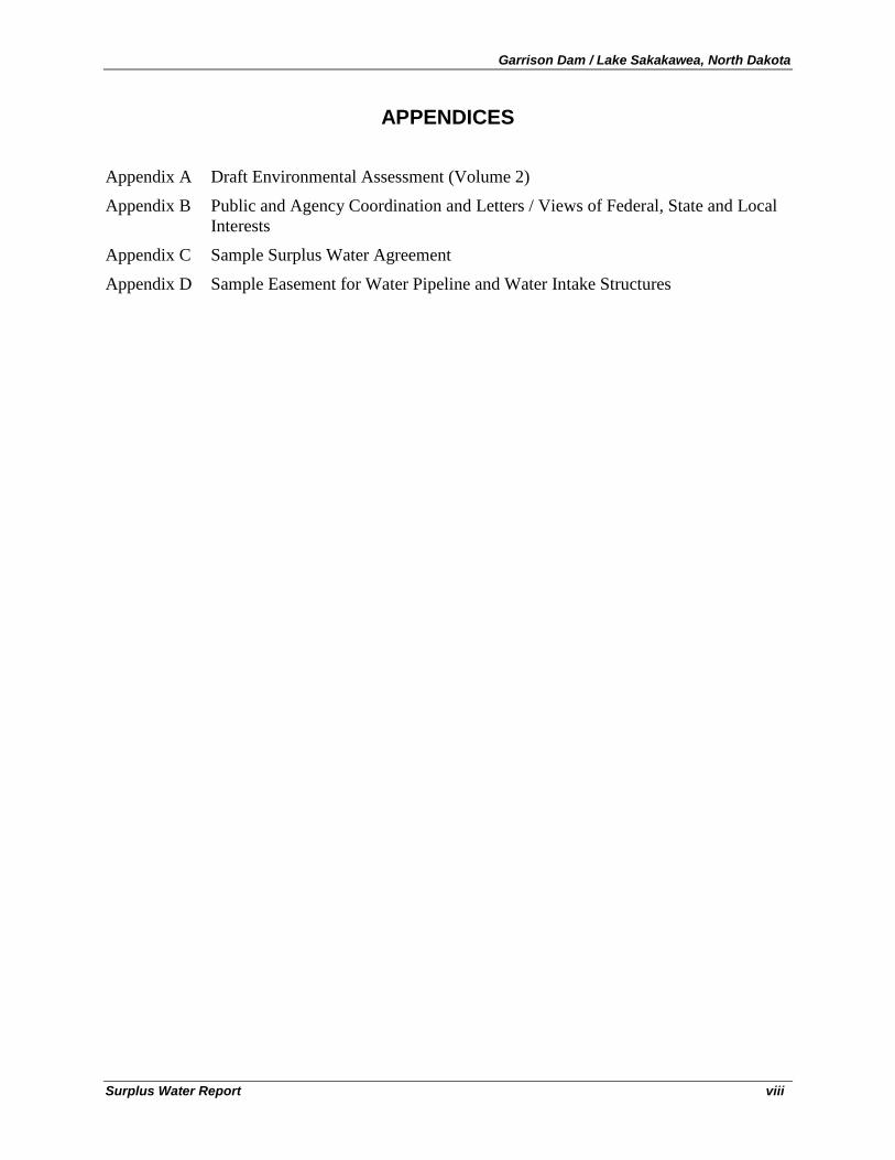
APPENDICES
Appendix A Draft Environmental Assessment (Volume 2)
Appendix B Public and Agency Coordination and Letters / Views of Federal, State and Local Interests
Appendix C Sample Surplus Water Agreement
Appendix D Sample Easement for Water Pipeline and Water Intake Structures
Garrison Dam / Lake Sakakawea, North Dakota
Surplus Water Report ix
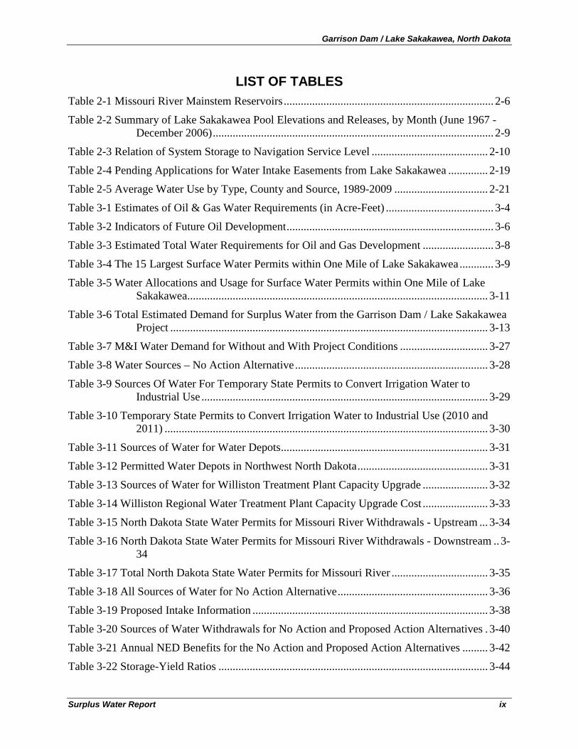
LIST OF TABLES Table 2-1 Missouri River Mainstem Reservoirs .......................................................................... 2-6
Table 2-2 Summary of Lake Sakakawea Pool Elevations and Releases, by Month (June 1967 - December 2006) ................................................................................................... 2-9
Table 2-3 Relation of System Storage to Navigation Service Level ......................................... 2-10
Table 2-4 Pending Applications for Water Intake Easements from Lake Sakakawea .............. 2-19
Table 2-5 Average Water Use by Type, County and Source, 1989-2009 ................................. 2-21
Table 3-1 Estimates of Oil & Gas Water Requirements (in Acre-Feet) ...................................... 3-4
Table 3-2 Indicators of Future Oil Development ......................................................................... 3-6
Table 3-3 Estimated Total Water Requirements for Oil and Gas Development ......................... 3-8
Table 3-4 The 15 Largest Surface Water Permits within One Mile of Lake Sakakawea ............ 3-9
Table 3-5 Water Allocations and Usage for Surface Water Permits within One Mile of Lake Sakakawea.......................................................................................................... 3-11
Table 3-6 Total Estimated Demand for Surplus Water from the Garrison Dam / Lake Sakakawea Project ................................................................................................................ 3-13
Table 3-7 M&I Water Demand for Without and With Project Conditions ............................... 3-27
Table 3-8 Water Sources – No Action Alternative .................................................................... 3-28
Table 3-9 Sources Of Water For Temporary State Permits to Convert Irrigation Water to Industrial Use ..................................................................................................... 3-29
Table 3-10 Temporary State Permits to Convert Irrigation Water to Industrial Use (2010 and 2011) .................................................................................................................. 3-30
Table 3-11 Sources of Water for Water Depots ......................................................................... 3-31
Table 3-12 Permitted Water Depots in Northwest North Dakota .............................................. 3-31
Table 3-13 Sources of Water for Williston Treatment Plant Capacity Upgrade ....................... 3-32
Table 3-14 Williston Regional Water Treatment Plant Capacity Upgrade Cost ....................... 3-33
Table 3-15 North Dakota State Water Permits for Missouri River Withdrawals - Upstream ... 3-34
Table 3-16 North Dakota State Water Permits for Missouri River Withdrawals - Downstream .. 3-34
Table 3-17 Total North Dakota State Water Permits for Missouri River .................................. 3-35
Table 3-18 All Sources of Water for No Action Alternative ..................................................... 3-36
Table 3-19 Proposed Intake Information ................................................................................... 3-38
Table 3-20 Sources of Water Withdrawals for No Action and Proposed Action Alternatives . 3-40
Table 3-21 Annual NED Benefits for the No Action and Proposed Action Alternatives ......... 3-42
Table 3-22 Storage-Yield Ratios ............................................................................................... 3-44
Garrison Dam / Lake Sakakawea, North Dakota
Surplus Water Report x
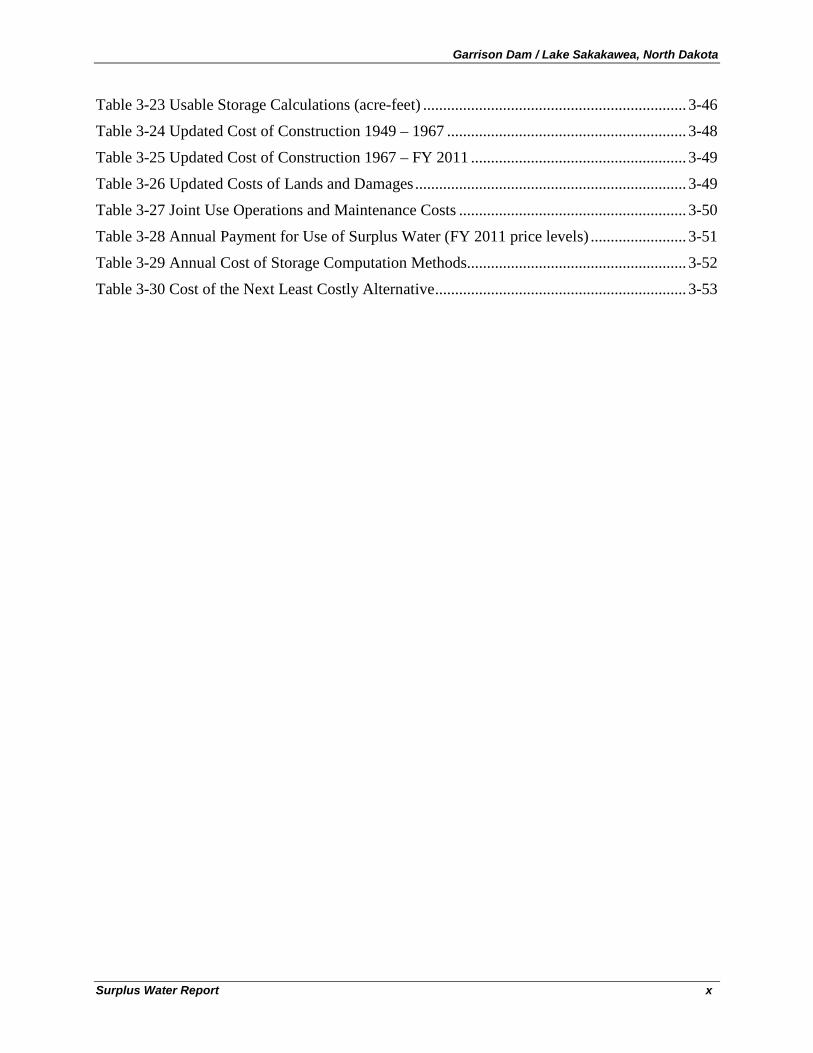
Table 3-23 Usable Storage Calculations (acre-feet) .................................................................. 3-46
Table 3-24 Updated Cost of Construction 1949 – 1967 ............................................................ 3-48
Table 3-25 Updated Cost of Construction 1967 – FY 2011 ...................................................... 3-49
Table 3-26 Updated Costs of Lands and Damages .................................................................... 3-49
Table 3-27 Joint Use Operations and Maintenance Costs ......................................................... 3-50
Table 3-28 Annual Payment for Use of Surplus Water (FY 2011 price levels) ........................ 3-51
Table 3-29 Annual Cost of Storage Computation Methods....................................................... 3-52
Table 3-30 Cost of the Next Least Costly Alternative ............................................................... 3-53
Garrison Dam / Lake Sakakawea, North Dakota
Surplus Water Report xi
LIST OF FIGURES
Figure 2-1 Omaha District Civil Works Boundary and Mainstem Projects ............................... 2-3
Figure 2-2 Garrison Dam / Lake Sakakawea Project................................................................... 2-5
Figure 2-3 Missouri River System Storage Zones ....................................................................... 2-7
Figure 2-4 Lake Sakakawea Study Area .................................................................................... 2-20
Figure 2-5 Water Use in the Lake Sakakawea Area by Type of Use ........................................ 2-22
Figure 2-6 Historic Water Use in the Lake Sakakawea Area by Type ...................................... 2-22
Figure 2-7 Average Annual Water Use by County (1989-2009) ............................................... 2-23
Figure 2-8 Annual Historic Water Use by County (1989-2009) ............................................... 2-24
Figure 2-9 Average Annual Water Use in the Lake Sakakawea Area by Source ...................... 2-24
Figure 3-1 Oil Production in the Lake Sakakawea Area, by County........................................... 3-4
Figure 3-2 Historic Trends in Drilling Rigs, Well Starts, and New Well Permits ...................... 3-7
Figure 3-3 Water Use by the 15 Largest Permit Holders for Surface Water within One Mile of Lake Sakakawea......................................................................................................................... 3-11
Figure 3-4 Rippl Diagram for Missouri River Reservoir System .............................................. 3-44
Garrison Dam / Lake Sakakawea, North Dakota
Surplus Water Report 1-1
GARRISON DAM / LAKE SAKAKAWEA, NORTH DAKOTA SURPLUS WATER REPORT
1. INTRODUCTION
1.1 S tudy P urpos e
The purpose of the Garrison Dam / Lake Sakakawea, ND, Surplus Water Report is to identify and quantify whether surplus water is available in the Project, as defined in Section 6 of the 1944 Flood Control Act that the Secretary of the Army can use to execute surplus water supply agreements with water users, and to determine whether use of surplus water is the most efficient method for meeting regional municipal and industrial (M&I) water needs.
This Surplus Water Report (Report) and attached Environmental Assessment (EA) investigate the engineering and economic feasibility and environmental effects of temporary use of up to 257,000 acre-feet of storage (100,000 acre-feet/year of yield) from the Garrison Dam / Lake Sakakawea Project to meet municipal and industrial (M&I) water supply needs in the region over the 10-year study period. This Report has been prepared by the Omaha District, U.S. Army Corps of Engineers (Corps) under the Operation & Maintenance Program. The water supply agreements derived from this process will be executed with potential easement applicants upon approval of this Report by the Assistant Secretary of the Army (Civil Works) and completion of required NEPA coordination. The term of the surplus water agreement is for a five (5) year period, renewable for an additional five (5) year period, subject to recalculation of reimbursement after the initial five (5) year period.
A 10-year study period has been established for this surplus water study. The length of the study period was selected for several reasons. First, surplus water agreements may be executed for a five (5) year period, renewable for an additional five (5) year period. Second, prior to the end of the 10-year study period, it is anticipated that reallocation studies of the six Federal reservoir projects within the Missouri River basin (including the Garrison Dam / Lake Sakakawea Project) will be completed, which will determine if changes to the permanent allocation of storage among the authorized project purposes and modifications to existing Federal water resource infrastructure may be warranted. Third, the primary water demand driving regional water needs at this time is the North Dakota oil and gas industry. Industry and state estimates indicate that demand from this industry is temporary and will decrease significantly after 10 years. The surplus water agreements executed upon the approval of this Report will serve as measures to address temporary water needs of the region during the 10-year study period.
The temporary use of a total of 257,000 acre-feet of storage (100,000 acre-feet/year of yield) being requested is in excess of the total amount for which easements have currently been requested, and was selected based on potential future demand over the 10-year study period. The amount in excess of intake easement requests received to date has been included for the purposes of efficiency and responsiveness, so that expected requests over the period of analysis can be evaluated and approved.
Garrison Dam / Lake Sakakawea, North Dakota
Surplus Water Report 1-2
1.2 S tudy Authority
The Garrison Dam / Lake Sakakawea, ND, Surplus Water Report study is being conducted under the authority of Section 6 of Public Law 78-534, the 1944 Flood Control Act. Under Section 6, the Secretary of the Army is authorized to enter into agreements for surplus water with states, municipalities, private concerns, or individuals at any reservoir under the control of the Department of the Army. Specifically, Section 6 states that:
“[T]he Secretary of War is authorized to make surplus water agreements with States, municipalities, private concerns, or individuals
ER 1105-2-100, paragraph 3-8a states:
, at such prices and on such terms as he may deem reasonable, for domestic and industrial uses for surplus water that may be available at any reservoir under the control of the War Department: Provided, That no surplus water agreements for such water shall adversely affect then existing lawful uses of such water. All moneys received from such surplus water agreements shall be deposited in the Treasury of the United States as miscellaneous receipts.”
“The Secretary of the Army can also enter into agreements with states, municipalities, private entities or individuals for the use of surplus water as defined in, and under the conditions described in, Paragraph 3-8b(4). Surplus water can also be used to respond to droughts and other emergencies affecting municipal and industrial water supplies.” ER 1105-2-100, paragraph 3-8b(4), entitled, “Surplus Water” states: “Under Section 6 of the Flood Control Act of 1944, the Secretary of the Army is authorized to make agreements with states, municipalities, private concerns, or individuals for surplus water that may be available at any reservoir under the control of the Department. These agreements may be for domestic, municipal, and industrial uses, but not for crop irrigation. ER 1105-2-100, paragraph E-57b(2) states: (2) Classification. (a) Surplus Water will be classified as either: (1) water stored in a Department of Army reservoir that is not required because the authorized use for the water never developed or the need was reduced by changes that occurred since authorization or construction; or (2) water that would be more beneficially used as a municipal and industrial water than for the authorized purpose and which, when withdrawn, would not significantly affect authorized purposes over some specified time period. (b) An Army General Counsel opinion of March 13, 1986, states that Section 6 of the 1944 Flood Control Act empowers the Secretary of the Army to make reasonable reallocations between different project purposes. Thus, water stored for purposes no longer necessary can be considered surplus. In addition, the Secretary may use his broad discretionary authority to reduce project outputs, envisioned at the time of authorization and construction, if it is believed that the municipal and industrial use of the water is a higher and more beneficial use….
Garrison Dam / Lake Sakakawea, North Dakota
Surplus Water Report 1-3
(3) Requirements and Restrictions. Surplus water declarations will only be made when related withdrawals would not significantly affect authorized purposes. Surplus water agreements shall be accompanied by a brief letter Report similar to reallocation Reports and shall include how and why the storage is determined surplus. Surplus water agreements will normally be for small amounts of water and/or for temporary use as opposed to storage reallocations and a permanent right to that storage. Normally, surplus water agreements will be limited to 5 year periods. Use of the Section 6 authority is allowed only where non-Federal sponsors do not want to buy storage because the need of the water is short term or the use is temporary pending the development of the authorized use. The views of the affected state(s) will be obtained, as appropriate, prior to entering into any agreement under Section 6. The annual price deemed reasonable for this use of surplus water is determined by the same procedure used to determine the annual payment for an equivalent amount of reallocated storage plus an estimated annual cost for operation and maintenance, repair, replacement, and rehabilitation. The total annual price is to be limited to the annual costs of the least cost alternative, but never less than the benefits foregone (in the case of hydropower, revenues forgone).
1.3 Need for S urplus Water
Identification of surplus water within the Garrison Dam / Lake Sakakawea Project would allow the Corps of Engineers to satisfy urgent temporary M&I water supply demands within the region while concurrently conducting permanent reallocation studies that will address the allocation of storage to the authorized project purposes within the Missouri River reservoir system. Approval of this Report is a necessary pre-condition to executing surplus water agreements with, and issuing easements to, applicants for withdrawal of surplus water from the Corps Project.
Temporary use of surplus water is not expected to cause significant adverse effects to existing authorized purposes and will not involve any structural changes to the project.
The draft Environmental Assessment (EA) is provided as Appendix A to this Report and further explains the needs, benefits and effects of this proposed use of surplus water in Lake Sakakawea. Descriptions of existing conditions are contained in the Environmental Assessment and incorporated into this Surplus Water Report by reference, in the interest of brevity.
1.4 R eport Organization
The Water Surplus Report summarizes the results of the technical investigations in support of a request for use of surplus water from the Garrison Dam / Lake Sakakawea Project. Report sections include:
Executive Summary
Section 1 – Introduction
Section 2 – Project Background
Section 3 – Plan Formulation
Section 4 – Plan Implementation
Section 5 – Conclusions
Section 6 - Recommendations
Garrison Dam / Lake Sakakawea, North Dakota
Surplus Water Report 1-4
Technical appendices, which present details of technical investigations and supporting documentation, are provided in separate volumes. Technical Appendices include:
Appendix A – Environmental Assessment / FONSI
Appendix B - Public and Agency Coordination and Letters / Views of Federal, State and Local Interests
Appendix C – Sample Water Storage Agreement
Appendix D – Sample Easement for Water Pipeline and Water Intake Structures
Garrison Dam / Lake Sakakawea, North Dakota
Surplus Water Report 2-1
2. PROJECT BACKGROUND
2.1 P rojec t L oc ation
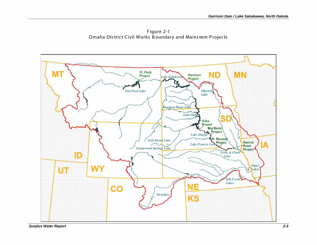
The Garrison Dam/Lake Sakakawea Project is a multi-purpose project on the Missouri River located at river mile (RM) 1390, 75 miles upstream from Bismarck in western North Dakota and 11 miles south of the town of Garrison, North Dakota (see Figure 2-1). The Garrison Dam/Lake Sakakawea Project is the largest of the six Missouri River mainstem- system projects. The other five Missouri River mainstem projects are also shown in Figure 2-1, and include: Fort Peck, Gavins Point, Fort Randall, Big Bend, and Oahe.
2.2 P rojec t Authorization
Garrison Dam was constructed as part of the Pick-Sloan Plan for development of the upper Missouri River Basin. Comprehensive development was proposed by the U.S. Army Corps of Engineers (Corps) in House Document 475 and by the Bureau of Reclamation (BOR) in Senate Document 191; the coordinated plan was presented to Congress in Senate Document 247 (all 78th Congress, 2nd session). Under this Act, the Corps was given the responsibility for development of projects on the main stem of the Missouri River. Tributary projects were made the responsibility of the Corps if the dominant purpose was flood control.
The Department of the Interior was designated as the marketing agent for all power, beyond project requirements, produced at Corps projects. The Department of the Interior subsequently designated the BOR as the marketing agent for power generated by the main stem projects.
The Garrison Dam/Lake Sakakawea Project was authorized by the Flood Control Act of 1944, Public Law (P.L.) 78-534, along with four other Missouri River mainstem projects: Gavins Point, Fort Randall, Big Bend, and Oahe. These five mainstem reservoirs are elements of the comprehensive development program in the Missouri River Basin, known as the Pick-Sloan Plan. This comprehensive plan became known as the Pick-Sloan Missouri Basin Program. Fort Peck Dam, located in northern Montana, was constructed prior to the Pick-Sloan Plan, but is operated as part of the Missouri River System.
2.3 P rojec t Des c ription
2.3.1 G arris on Dam
Construction on the $300 million1
1 Source: Annual Report on Civil Works Activities for Fiscal Year 2008, Assistant Secretary of the Army.
Garrison Dam project began in 1946 and closure of the embankment occurred in April 1953. Earthwork was completed in the fall of 1954 and the navigation and flood control functions of the project were placed in operation in 1955. At over two miles in length, Garrison Dam is one of the largest rolled earth-fill dams in the world and is the fifth largest dam in the United States. The dam is 210 feet high and 11,300 feet long. It provides five power units (three units rated at 121,600 kilowatts each and two units rated at 109,250 kilowatts each), three flood control tunnels, and a gated spillway. The first power unit of the project went on the line in January 1956, followed by the second and third units in March
Garrison Dam / Lake Sakakawea, North Dakota
Surplus Water Report 2-2
and August of the same year. Power units 4 and 5 were placed in operation in October 1960. Lake Sakakawea first reached its minimum operating level in late 1955. Due to drought conditions, the Carryover Multiple Use Zone was first filled ten years later, in 1965.
Garrison Dam / Lake Sakakawea, North Dakota
Surplus Water Report 2-3
F igure 2-1 Omaha Dis tric t C ivil Works B oundary and Mains tem P rojec ts
Garrison Dam / Lake Sakakawea, North Dakota
Surplus Water Report 2-4
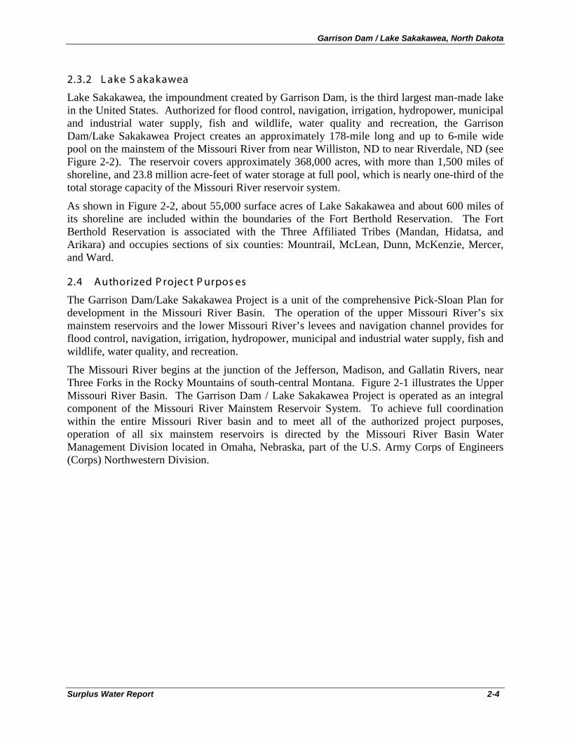
2.3.2 L ake S akakawea
Lake Sakakawea, the impoundment created by Garrison Dam, is the third largest man-made lake in the United States. Authorized for flood control, navigation, irrigation, hydropower, municipal and industrial water supply, fish and wildlife, water quality and recreation, the Garrison Dam/Lake Sakakawea Project creates an approximately 178-mile long and up to 6-mile wide pool on the mainstem of the Missouri River from near Williston, ND to near Riverdale, ND (see Figure 2-2). The reservoir covers approximately 368,000 acres, with more than 1,500 miles of shoreline, and 23.8 million acre-feet of water storage at full pool, which is nearly one-third of the total storage capacity of the Missouri River reservoir system.
As shown in Figure 2-2, about 55,000 surface acres of Lake Sakakawea and about 600 miles of its shoreline are included within the boundaries of the Fort Berthold Reservation. The Fort Berthold Reservation is associated with the Three Affiliated Tribes (Mandan, Hidatsa, and Arikara) and occupies sections of six counties: Mountrail, McLean, Dunn, McKenzie, Mercer, and Ward.
2.4 Authorized P rojec t P urpos es
The Garrison Dam/Lake Sakakawea Project is a unit of the comprehensive Pick-Sloan Plan for development in the Missouri River Basin. The operation of the upper Missouri River’s six mainstem reservoirs and the lower Missouri River’s levees and navigation channel provides for flood control, navigation, irrigation, hydropower, municipal and industrial water supply, fish and wildlife, water quality, and recreation.
The Missouri River begins at the junction of the Jefferson, Madison, and Gallatin Rivers, near Three Forks in the Rocky Mountains of south-central Montana. Figure 2-1 illustrates the Upper Missouri River Basin. The Garrison Dam / Lake Sakakawea Project is operated as an integral component of the Missouri River Mainstem Reservoir System. To achieve full coordination within the entire Missouri River basin and to meet all of the authorized project purposes, operation of all six mainstem reservoirs is directed by the Missouri River Basin Water Management Division located in Omaha, Nebraska, part of the U.S. Army Corps of Engineers (Corps) Northwestern Division.
Garrison Dam / Lake Sakakawea, North Dakota
Surplus Water Report 2-5
F igure 2-2 G arris on Dam / L ake S akakawea P rojec t
Garrison Dam / Lake Sakakawea, North Dakota
Surplus Water Report 2-6
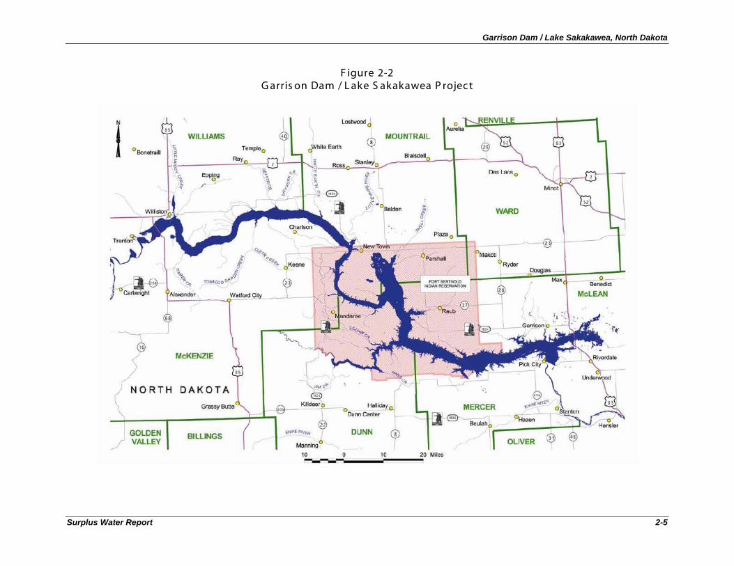
The six mainstem reservoirs operated by the Corps are listed in Table 2-1. Lake Sakakawea provides a significant storage contribution to the mainstem system of reservoirs. It is the largest of the six reservoirs, with a storage capacity of approximately 23.8 million acre-feet (MAF), which comprises nearly one third of the total 73.1 MAF storage capacity in the mainstem system.
T able 2-1 Mis s ouri R iver Mains tem R es ervoirs
Project (Dam and Reservoir)
Incremental Drainage Area (Square Miles)
Year of Closure
Annual Flood Control and Multiple Use
Storage in Acre-Feet (AF)
Total Storage in Acre-Feet (AF)
Fort Peck Dam/ Fort Peck Lake 57,500 1937 2,704,000 18,463,000
Garrison Dam/ Lake Sakakawea 123,900 1953 4,222,000 23,821,000
Oahe Dam/ Lake Oahe 62,090 1958 3,201,000 23,137,000
Big Bend Dam/ Lake Sharpe 5,840 1963 117,000 1,798,000
Fort Randall Dam/ Lake Francis Case 14,150 1952 1,309,000 5,418,000
Gavins Point Dam/ Lewis & Clark Lake 16,000 1955 90,000 470,000
2.5 Mis s ouri R iver S ys tem R es ervoir R egulation
The six Missouri River projects are operated as an integrated system by the U.S. Army Corps of Engineers, Missouri River Basin Water Management Division. Operations of the system are guided by the Missouri River Basin Mainstem Reservoir System Master Water Control Manual (Revised March 2006) (Master Manual). In order to achieve the multi-purpose benefits for which they were authorized and constructed, the six System reservoirs are operated as a hydraulically and electrically integrated system. The Master Manual describes the integrated operation of these six projects. The Master Manual serves as a guide to meeting the operational objectives of the System when regulating the six System reservoirs. The Master Manual also includes the integrated operation of both System and tributary reservoir water control plans so that an effective plan for flood control and conservation operations exists within the basin.
Each of the six mainstem projects, including the Garrison Dam / Lake Sakakawea Project, has its own Water Control Manual. Annual water management plans (Annual Operating Plans, or AOPs) are prepared each year, based on the water control criteria contained in the Master Manual, in order to detail reservoir regulation of the System for the current operating year.
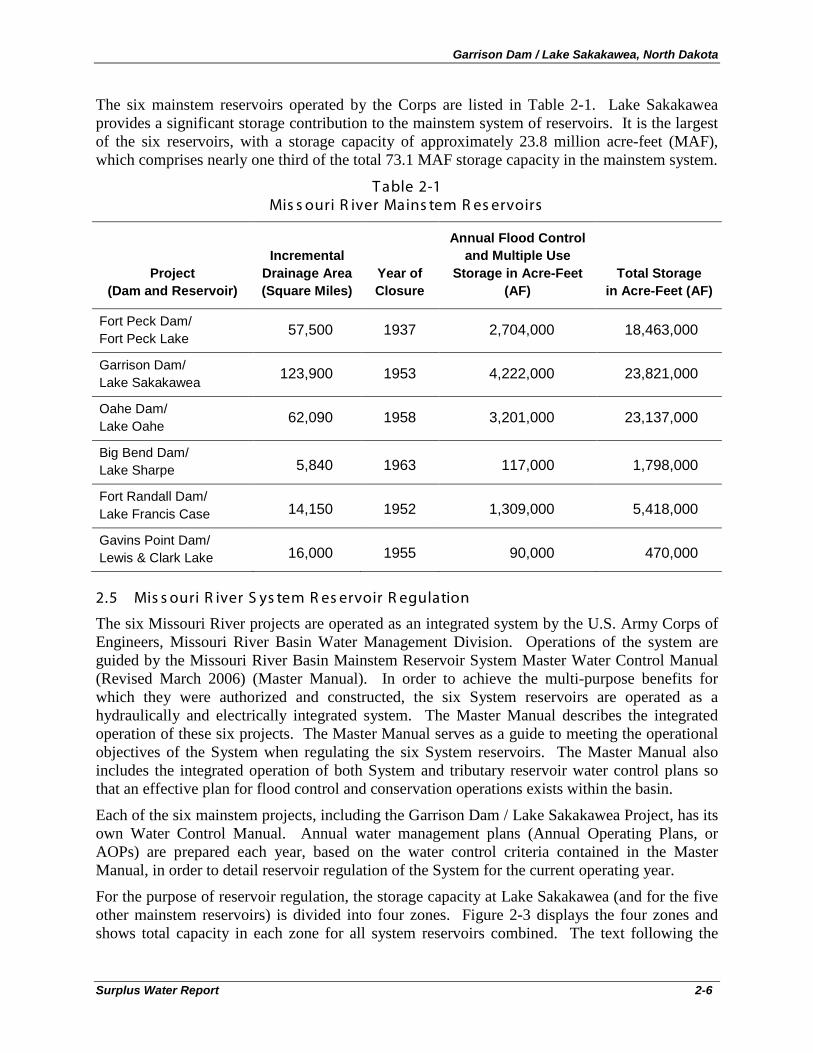
For the purpose of reservoir regulation, the storage capacity at Lake Sakakawea (and for the five other mainstem reservoirs) is divided into four zones. Figure 2-3 displays the four zones and shows total capacity in each zone for all system reservoirs combined. The text following the
Garrison Dam / Lake Sakakawea, North Dakota
Surplus Water Report 2-7
Figure describes the storage volumes in each zone just for the Garrison Dam / Lake Sakakawea Project.
F igure 2-3 Mis s ouri R iver S ys tem S torage Zones
For the Garrison Dam / Lake Sakakawea Project, starting at the bottom, there is the 5.0 million acre foot (MAF) permanent pool between elevations 1775.0 and 1673.0 feet mean sea level (msl). This zone provides minimum power head and sediment storage capacity and assures minimum levels for irrigation diversions from the reservoir. Above the permanent pool there is the 13.1 MAF carry-over multiple-use zone between elevations 1837.5 and 1775.0 feet msl. This intermediate zone provides a storage reserve for irrigation, navigation, power production, and other beneficial conservation uses. This zone also provides carry-over storage for maintaining downstream flows through a succession of years in which runoff is below normal. The next zone is the 4.2 MAF annual flood control and multiple use zone between elevations 1837.5 and 1850.0 feet msl. This is the desired operating zone. Water stored in this zone is normally evacuated by March 1 of each year to provide adequate storage capacity for the flood season. During the flood period, water is impounded in this space as required. Finally, the upper zone, or exclusive flood control zone, consists of 1.5 MAF of storage between elevations 1850.0 and 1854.0 feet msl. This zone is used only during periods of extreme floods and is evacuated as soon as downstream conditions permit.
Regulating the Missouri River Mainstem Reservoir System is essentially a repetitive annual cycle. Unless water conservation measures are being implemented, the reservoirs are evacuated
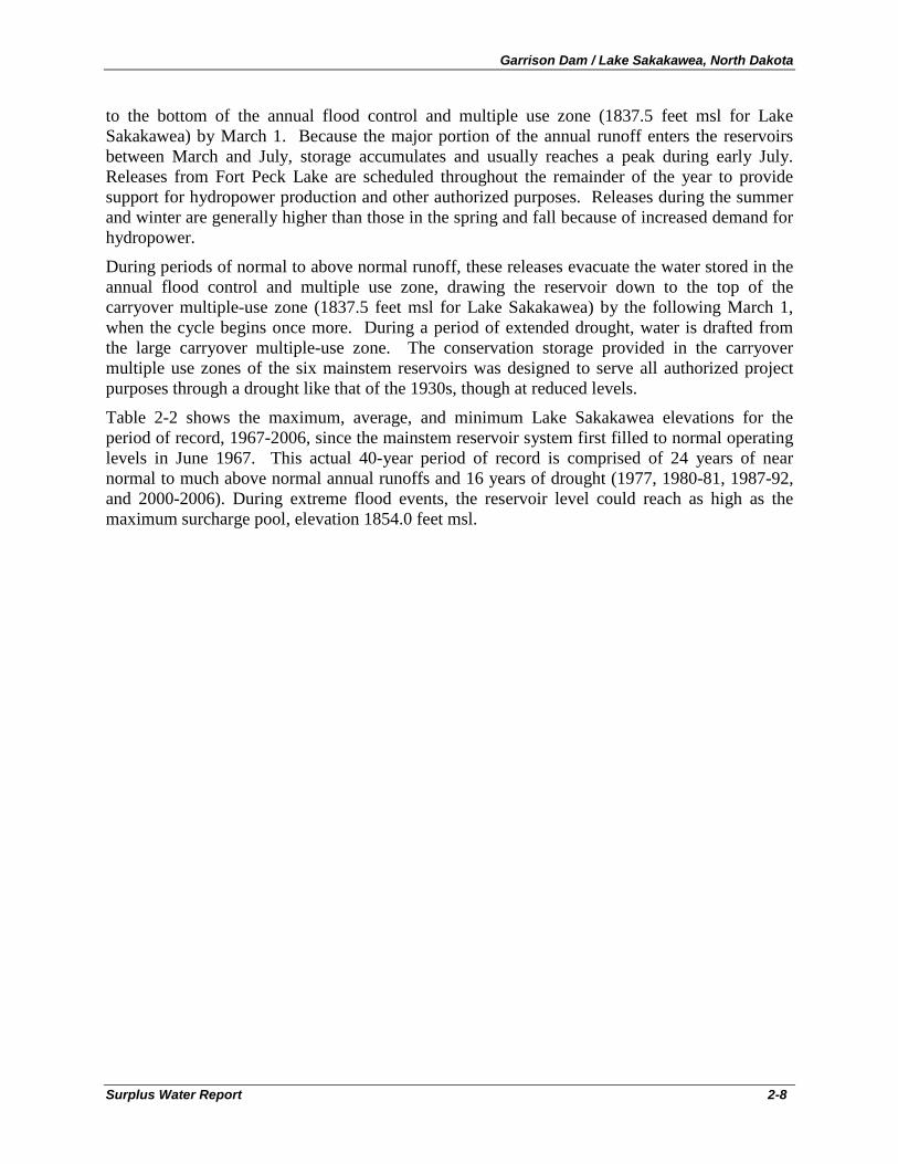
Garrison Dam / Lake Sakakawea, North Dakota
Surplus Water Report 2-8
to the bottom of the annual flood control and multiple use zone (1837.5 feet msl for Lake Sakakawea) by March 1. Because the major portion of the annual runoff enters the reservoirs between March and July, storage accumulates and usually reaches a peak during early July. Releases from Fort Peck Lake are scheduled throughout the remainder of the year to provide support for hydropower production and other authorized purposes. Releases during the summer and winter are generally higher than those in the spring and fall because of increased demand for hydropower.
During periods of normal to above normal runoff, these releases evacuate the water stored in the annual flood control and multiple use zone, drawing the reservoir down to the top of the carryover multiple-use zone (1837.5 feet msl for Lake Sakakawea) by the following March 1, when the cycle begins once more. During a period of extended drought, water is drafted from the large carryover multiple-use zone. The conservation storage provided in the carryover multiple use zones of the six mainstem reservoirs was designed to serve all authorized project purposes through a drought like that of the 1930s, though at reduced levels.
Table 2-2 shows the maximum, average, and minimum Lake Sakakawea elevations for the period of record, 1967-2006, since the mainstem reservoir system first filled to normal operating levels in June 1967. This actual 40-year period of record is comprised of 24 years of near normal to much above normal annual runoffs and 16 years of drought (1977, 1980-81, 1987-92, and 2000-2006). During extreme flood events, the reservoir level could reach as high as the maximum surcharge pool, elevation 1854.0 feet msl.
Garrison Dam / Lake Sakakawea, North Dakota
Surplus Water Report 2-9
T able 2-2 S ummary of L ake S akakawea P ool E levations and R eleas es , by Month
(J une 1967 - Dec ember 2006)
Month Pool Elevation (feet msl)
Daily Release (cfs)
Max Min Mean Max Min Mean
Jan 1845.3 1808.4 1833.6 34,200 12,500 23,200
Feb 1843.6 1808.2 1832.2 36,000 11,000 24,400
Mar 1847.9 1808.2 1832.3 37,800 4,100 19,700
Apr 1847.7 1806.6 1833.6 39,100 8,700 19,300
May 1848.0 1805.8 1834.2 41,200 9,100 21,400
Jun 1853.7 1809.1 1837.1 50,100 9,500 23,300
Jul 1854.8 1815.2 1840.0 65,200 9,500 24,700
Aug 1854.6 1811.9 1839.4 65,100 12,100 24,500
Sep 1851.3 1809.5 1837.7 50,100 6,000 20,900
Oct 1848.2 1809.3 1836.8 49,700 9,200 19,300
Nov 1847.4 1808.9 1836.0 50,100 9,300 20,200
Dec 1846.8 1807.8 1834.5 39,100 12,500 20,500
Annual 1854.8 1805.8 1835.5 65,200 4,100 21,700
Source: Garrison Dam/Lake Sakakawea Master Plan, December 14, 2007
2.5.1 F lood C ontrol
Lake Sakakawea, the second most upstream project in the mainstem system, is operated as part of the system to assist in the control of downstream flooding along the Missouri River. As described above, the system is operated to draw down the pool to the base of the flood control and multiple use zone (1837.5 feet msl for Lake Sakakawea) by March 1 of every year in order to prepare for the spring and summer flood seasons. Reservoir levels are lowered to provide maximum flood control storage levels during the high flood risk period, which is comprised of the plains snowmelt season (late February – April) and the mountain snowmelt period (May through July). Table 2-2 above shows that this operational target has been achieved at Lake Sakakawea over the 40-year period of record, with mean March monthly pool levels of 1832.3. A review of the minimum, maximum and mean daily releases during the months leading up to and including March is indicative of the wide range of flexibility in managing outflows to reach the target pool levels. The six Missouri River mainstem dams (including the Garrison Dam / Lake Sakakawea Project) have prevented over $37 billion in flood damages (at September 2009
Garrison Dam / Lake Sakakawea, North Dakota
Surplus Water Report 2-10
price levels) through September of 2005, of which $11.5 billion can be credited to the Garrison project.
2.5.2 Navigation
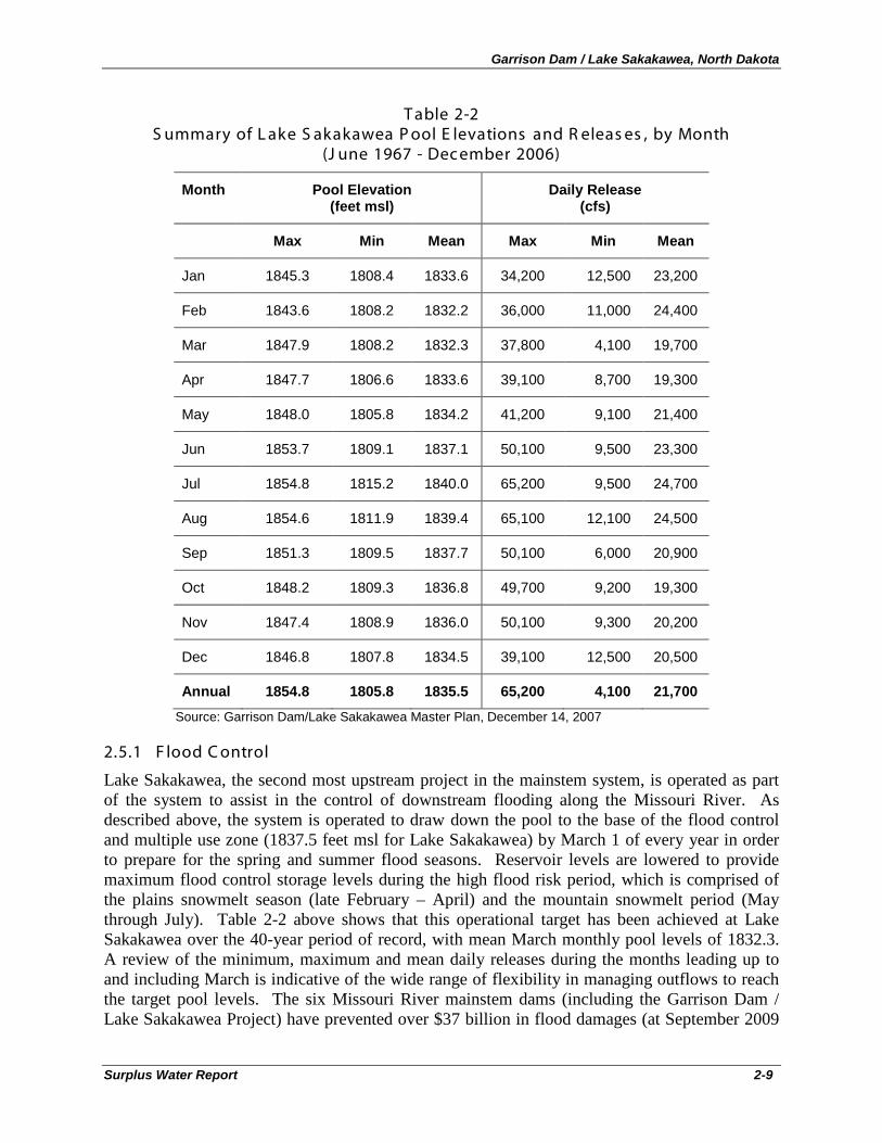
The Missouri River Reservoir System is operated in part to meet the needs of downstream navigation interests. The normal 8-month navigation season extends from April 1 through November 30. During this period, System releases are scheduled, in combination with downstream tributary flows, to meet downstream target flows. Daily releases from Gavins Point, commonly referred to as the System releases, fall into two classes. Open-water releases, generally in the range of 21,000 to 35,000 cfs, are made in support of Missouri River navigation and other downstream uses. Winter releases after the close of navigation season are much lower, and vary depending on the need to conserve or evacuate System storage while managing downstream river stages for water supply given ice conditions. In years with adequate water supply, System releases are scheduled to provide adequate flows for navigation at the target locations of Sioux City, Omaha, Nebraska City, and Kansas City (if navigation is occurring on the reaches associated with those targets). As described in the Master Manual, flow support for navigation and other downstream purposes is defined based on service level. A “full-service” level of 35,000 cfs results in target flows of 31,000 cfs at Sioux City and Omaha, 37,000 cfs at Nebraska City and 41,000 cfs at Kansas City. Similarly, a “minimum-service” level of 29,000 cfs results in target flow values of 6,000 cfs less than the full service levels.
The relation of System storage to navigation service level is presented in Table 2-3. Selection of the appropriate service level is based on the actual volume of System storage on March 15 and July 1st of each year. With the present level of streamflow depletions, inflows to the System are sufficient to support the minimum-service flow levels or higher for the full 8-month navigation season in 78 years of the 100-year record period (inflows from 1898 to 1997) and full-service flows or higher for the 8-month navigation season in 55 years of the 100-year period
T able 2-3 R elation of S ys tem S torage to Navigation S ervic e L evel
Date System Storage Navigation Service Level
March 15 54.5 MAF or more 35,000 cfs (full-service)
March 15 49.0 to 31 MAF 29,000 cfs (minimum-service)
March 15 31.0 MAF or less No navigation service
July 1 57.0 MAF or more 35,000 cfs (full-service)
July 1 50.5 MAF or less 29,000 cfs (minimum-service)
Although navigation on the Missouri River through North Dakota was critically important to the original settlement of the region, there is no commercial navigation in the North Dakota reach of the river today. Releases from mainstem reservoirs serve navigation interests downstream from Gavins Point Dam in the lower reaches of the Missouri River, to its confluence with the Mississippi River.
Garrison Dam / Lake Sakakawea, North Dakota
Surplus Water Report 2-11
Overall commercial navigation throughout the Missouri River has waned significantly over the past four decades, from 3,300,000 tons in 1977, to 1,300,000 tons in 2000, to 245,000 tons in 2009.
2.5.3 Irrigation
The original planning studies carried out by both the Bureau of Reclamation (Senate Document 78-191) and the Corps (House Document 78-475) anticipated that Federal irrigation projects would be supported for the Missouri River Basin Mainstem System. The Corps plans allowed for an irrigation withdrawal from the Garrison Project to provide for water supply into the Dakotas. The Bureau’s plans provided for over ninety new projects that would provide irrigation service to over 4,700,000 additional acres of land in the basin. Over half of these additional acres, or approximately 2,300,000 acres would be served by the existing Fort Peck project in Montana and three new mainstem projects. A key component of the Bureau’s plan was the proposed Oahe project which would hold almost 7 million more acre feet of water than the total of two projects that were planned by the Corps in the same area. Irrigation was also a primary component of the Corps cost allocations for the Mainstem System Projects. As an example, the Corps 1958 cost allocation report anticipated an average annual depletion from the mainstem system for irrigation of 6,387,000 acre feet of which 2,534,000 would be for irrigation from tributaries above Sioux City and 3,853,000 acre feet of depletion related to irrigation from main stem projects.
The Corps and Bureau’s combined plan for the mainstem system (Senate document 78-247), was incorporated by Congress into the 1944 Flood Control Act. The combined plan for the mainstem system provided for the Corps’ Garrison Project, the larger Oahe project that had been proposed by the Bureau, along with three smaller downstream projects, and the already constructed Ft. Peck Project in Montana. Thus, the mainstem projects as approved by Congress in the 1944 Flood Control Act included substantial capacity in the mainstem system which would be able to provide for the irrigation of 2,300,000 acres of land when fully developed.
Between 1944 and 1965, the Bureau of Reclamation carried out studies to assess the feasibility of irrigating lands planned for North Dakota by diversions from the Ft. Peck project. The studies indicated that the soil was not suitable for irrigation primarily because of glacial subsoil. The Bureau of Reclamation revised the diversion plan proposing to take water from the Garrison Dam to irrigate other lands to the east. With the new name “Garrison Diversion,“ the Bureau of Reclamation 1957 feasibility study on the redesigned project recommended irrigation of 1,007,000 acres and other water development in central and eastern North Dakota.
Because of changes to the Bureau’s original irrigation plans for the upper basin and language in a 1964 appropriations act requiring specific reauthorization for all units of the Bureau’s Pick-Sloan Missouri Basin Program, legislation was sought by the Bureau for the revised project plan. In 1965 Congress authorized the revised plan in the Garrison Diversion Unit Act and construction began in 1967. The GDU project was designed to divert Missouri River water to central and eastern North Dakota for municipal and industrial water, fish and wildlife development, recreation and flood control along with irrigation of 250,000 acres. The Snake Creek Pumping Plant, McClusky Canal, and New Rockford Canal are completed components of the authorized Principal Supply Works of the GDU. The 1986 Garrison Diversion Unit Reformulation Act reduced irrigation emphasis of the GDU and increased the emphasis on meeting municipal, rural, and industrial (MR&I) water needs throughout North Dakota. The Act authorized a Sheyenne
Garrison Dam / Lake Sakakawea, North Dakota
Surplus Water Report 2-12
River water supply and release feature and water treatment plant. Appraisal level studies were conducted from 1994 to 2000. The Dakota Water Resources Act of 2000 (P.L. 89-108) authorized the Secretary of the Interior to develop irrigation for 13,700 acres in the Turtle Lake service area, 10,000 acres in the McClusky Canal service area, 1,200 acres in the New Rockford Canal service area, 15,200 acres within the boundaries of the Fort Berthold Indian Reservation, and 2,380 acres within the Standing Rock Indian Reservation. In addition to the above projects, 31 agricultural irrigation water systems have intakes for withdrawing water from Lake Sakakawea.
Although the Bureau’s originally envisioned Federal mainstem irrigation projects have not developed as initially planned, numerous irrigators withdraw water directly from the reservoirs and downstream river reaches. Demand for this irrigation use is relatively small and minimum releases established for water quality control and other uses are usually ample to meet the needs of irrigators. However, low reservoir levels and low river stages can at times make access to the available water supply difficult or inconvenient to obtain for these users. When reasonably possible, the System is regulated to serve this authorized project purpose. However present use for irrigation is relatively minor and the full mainstem system capacity originally planned for irrigation has not yet developed.
2.5.4 Munic ipal and Indus trial (M& I) Water S upply
Minimum daily releases at Garrison (and also at Fort Peck, Fort Randall, and Gavins Point) are established as those necessary to supply water quality control and downstream water intake requirements. Numerous water intakes are located along the Missouri River both within and below the System. These intakes are primarily for the purposes of municipal water supplies, nuclear and thermal electric powerplant cooling, and irrigation supplies withdrawn directly from the Missouri River. Reduced releases during periods of extended drought contribute to access problems at several of these intakes; however, in all cases the problems have been a matter of restricted access to the river rather than insufficient water supply. In several river reaches, including near Sioux City and near Kansas City, channel degradation at low flows has impacted several water intakes. Other water supply problems can occur due to the formation of sandbars or sediment deposition, or due to ice jamming on the river during the winter months. Modifications have been required at some intakes to ensure operability over a wide range of river conditions.
The minimum daily flow requirements established for water supply are designed to prevent operational problems at municipal and thermal powerplant intakes to the extent reasonably possible. At Garrison, a minimum average daily release of 9,000 cfs has been established as a guide to provide for downstream intakes. Evaluations are continuing by appropriate state agencies in coordination with water plant operators to determine the minimum stage and flow requirement at each intake location for satisfactory hydraulic operation. During any non-navigation time period, releases will be made to ensure adequate flows to serve water supply in the river reaches downstream of the System and between the System dams to the extent reasonably possible.
Intakes for communities on the Fort Berthold Reservation are located at Four Bears, Mandaree, Twin Buttes, and White Shield. The Southwest Pipeline Project provides water to the city of Dickinson along with 27 other communities, 18 bulk users, and 3,089 rural water users in southwest North Dakota (Frink 2007a). The cities of Garrison, Parshall, Pick City and
Garrison Dam / Lake Sakakawea, North Dakota
Surplus Water Report 2-13
Riverdale, and three industrial water systems also obtain water from Lake Sakakawea or from Garrison Dam’s penstocks for municipal and industrial use. If the Northwest Area Water Supply (NAWS) Project is completed, it will provide up to 2 million gallons of Missouri River water per day to at least 63,000 water users (Frink 2007a). In addition, approximately 19 communities / subdivisions and 186 homes located close to the reservoir have intakes for withdrawing water from Lake Sakakawea for domestic consumption. There are also water intakes for public, domestic, and commercial uses at and downstream from Lake Sakakawea.
In regard to water supply provided by the Bureau of Reclamation from the Garrison Dam/Lake Sakakawea Project, the Dakota Water Resources Act of 2000 (P.L. 89-108) shifted the water supply emphasis from irrigation to municipal, rural, and industrial (MR&I) water supply. The Red River Valley Water Supply Project would divert water from Lake Sakakawea via GDU facilities and a pipeline to the Sheyenne River.
2.5.5 Hydropower
The six System dams support 36 hydropower units with a combined plant capacity of 2,501 megawatts (MW) of potential power generation. These units provide an average of 10 million megawatt-hours (MWh) of energy per year. The Garrison power plant houses five turbine and generator units with a combined plant capacity of 583 MW. The generators produce approximately 2.462 billion kilowatt-hours of energy each year. Garrison power generation is integrated with the generation provided from other five mainstem projects, as well as that generated from other public and private facilities throughout the power marketing area. All power generated is marketed by the Western Area Power Administration (Western).
Firm energy is marketed on both an annual and a seasonal basis, recognizing the seasonal pattern of releases made for navigation and required for flood control. During the navigation season, releases from the four uppermost reservoirs are varied in an effort to generate the greatest amount of energy at the times the power loads are the greatest. During the winter period, the most critical with respect to maintaining load requirements, releases from Fort Peck and Garrison are scheduled at relatively high rates to compensate for reduced power production at the downstream powerplants. The fall drawdown at Fort Randall makes available space for recapture of winter power releases from upstream reservoirs. In years of low energy generation due to downstream ice problems or low water availability, energy from other sources is obtained in the winter to help serve firm loads. Generally, the navigation season energy generation is adequate to meet firm load requirements; however, during periods of reduced System releases for downstream flood control or during extended drought periods, WAPA must also purchase large amounts of energy in the summer to serve firm loads.
The highest average power generation period extends from mid-April to mid-October, with high peaking loads during the winter heating season (mid-December to mid-February) and the summer air conditioning season (mid-June to mid-August). The major maintenance periods for the System hydropower facilities extend from March through mid-May and September through November, which normally are the lower demand and off-peak energy periods.
During the summer, releases at all projects other than Gavins Point are normally within the powerplant discharge capacity, the river channel downstream usually being more than adequate to carry such releases. Discharges from all projects will usually be made through the powerplant. At all projects except Gavins Point, hourly release rates may vary widely as
Garrison Dam / Lake Sakakawea, North Dakota
Surplus Water Report 2-14
necessary to meet fluctuating power loads. Unusually large inflows during any particular year may require significant releases that bypass the powerplants at any or all projects to evacuate flood waters and thereby maintain the future flood control capability of the System.
2.5.6 F is h and Wildlife
Fish and wildlife is considered a high priority project purpose on all project lands, regardless of the land use classification2
Construction of the System has been one of the most important contributions to sport fishing in the Missouri River basin. The large, popular reservoirs attract fishermen from many states to fish for trophy size northern pike, walleye, sauger, lake trout, and chinook salmon. The construction and regulation of the System has, however, altered the natural streamflow of the Missouri River. An early spring rise and a late spring-summer rise characterized the natural hydrograph. High flows resulted from the plains snowmelt, from spring and summer rains, and from the mountain snowmelt. Low flows typically occurred in late summer and fall. Regulation of flows by the System has reduced spring flows and has increased late summer, fall, and winter flows to varying degrees, depending on how far downstream from Gavins Point the reach is located, thus altering the habitat of native riverine fish species. River reaches between the reservoirs are now characterized by cooler water temperatures with widely fluctuating daily stages. In addition, the System is regulated to provide protection for the three ESA listed species: the threatened interior least tern, the endangered piping plover, and the endangered pallid sturgeon. A detailed discussion of the effects of System operations on fish and wildlife is provided in the attached Environmental Assessment.
. All areas classified as Project Operations or Recreation are developed and managed to benefit wildlife through a variety of different techniques, including vegetation management alternatives to enhance and benefit wildlife species. The remaining project lands are also managed to enhance and benefit wildlife species. The Lake Audubon and Lake Sakakawea General Plans, signed by the Corps, the Assistant Secretary for Fish and Wildlife and Parks of the U.S. Department of the Interior; and the North Dakota Game and Fish Department (NDGFD) in 1982 and 1983, identified 26,020 acres at Lake Audubon and 51,000 acres at Lake Sakakawea to be used primarily for the conservation and management of wildlife. These General Plans revised the original General Plan signed in 1955 so that the wildlife management areas in the General Plan would be consistent with those in the 1978 Master Plan. Minimum release restrictions and pool fluctuations for fish spawning management generally occur from April through June.
2.5.7 R ec reation
Recreational use of project lands is encouraged through public parks and recreation facilities. Mainstem projects are managed to provide a high quality outdoor-recreation experience and as much diversity as is practicable. Recreational planning and improvements are supportive of and compatible with the North Dakota Statewide Comprehensive Outdoor Recreation Plan (SCORP). Planning for development and use of recreational facilities is coordinated with Tribal, state, county, municipal, and local non-governmental entities, which lease and manage most of the intensively used recreation areas at Lake Sakakawea. There are 35 recreation areas around Lake
2 Garrison Dam/Lake Sakakawea Master Plan with Integrated Environmental Assessment, Design Memorandum MGR-107D, CENWO-DE, 14 December 2007.
Garrison Dam / Lake Sakakawea, North Dakota
Surplus Water Report 2-15
Sakakawea, including 14 facilities managed by the Corps of Engineers, and North Dakota state facilities at Lake Sakakawea State Park and Fort Stevenson State Park (for a full listing of recreation facilities, see the Environmental Assessment). Recreation activities include: fishing, boating, waterskiing, swimming, camping, hiking, hunting, picnicking, and nature-watching. Total annual visitation at Lake Sakakawea recreation facilities was estimated at 1,082,000 in 2006. In addition, significant amounts of river recreation take place downstream of the reservoir in Missouri River reaches affected by Garrison Dam releases.
Water levels are a key factor in recreational use of the reservoirs and river reaches. Pool levels at the upper three reservoirs, including Lake Sakakawea, vary widely in response to drought conditions. Although recreation may be affected by high reservoir levels and releases, periods of extended drought that result in significant lowering of reservoir levels and releases have a greater impact. At low reservoir levels, some boat ramps and recreational areas do not provide access to the reservoirs. Low releases may impact boat access and maneuverability between and below System dams. During the two major droughts since the System first filled, many boat ramps have been extended or relocated to maintain access. Shortening of the navigation season during droughts also has the effect of shortening the recreation season below the System due to the greatly reduced flows, and the shortening also results in an earlier drawdown for Fort Randall, impacting recreation access on that reservoir.
2.5.8 Water Quality
Water quality was specified as a project purpose in the authorizing documents in terms of silt control; soil-erosion prevention; pollution abatement; adequate and safe municipal water supplies; improving quality of water for irrigation; provision of water suitable for domestic, sanitary, and industrial purposes; and improving clarity of water for recreation and for fish and wildlife. Silt control was also expected to aid the navigation channel downstream. Water quality in Lake Sakakawea must comply with the State of North Dakota’s standards for a Class 1 lake.3
2.6 North Dakota Water P ermit P roc es s
As such, its water quality has to be suitable for a cold water fishery, aquatic life, and wildlife; swimming and other water-based recreation; stock watering; irrigation; and water supply for municipal, domestic, or industrial use after appropriate treatment.
Understanding the North Dakota water permit process is critical to the accurate assessment of both without and with project conditions, because all entities desiring water allocations in the State (other than on Tribal lands) must first obtain a water permit from the State, including those requesting water from the Federal project.
The North Dakota State Water Commission, through the Office of the State Engineer, regulates, administers and allocates water on behalf of the State (other than on Tribal lands). Water permits from the State are required for:
• irrigation of more than five acres,
• industrial use, municipal use, rural water systems, and
3 Garrison Dam/Lake Sakakawea Master Plan with Integrated Environmental Assessment, Design Memorandum MGR-107D, CENWO-DE, 14 December 2007.
Garrison Dam / Lake Sakakawea, North Dakota
Surplus Water Report 2-16
• storage of more than 12.5 acre-feet behind a dam. Water-use permits are not
Applications for water permits are considered if senior water rights are not unreasonably affected, water intake infrastructure is adequate, the use of water is deemed beneficial, and the proposed use is in the public interest. Established water rights have superiority over any water right with a later priority date. Priority date is established by the date the application is received by the Office of the State Engineer.
required for domestic, livestock, or fish and wildlife purposes, unless their annual water use exceeds 12.5 acre-feet.
Water permits for competing applications from the same source, where the source is insufficient to supply all applicants, are granted in the following priority order (if they have the same application date):
1. domestic, 2. municipal, 3. livestock, 4. irrigation, 5. industrial, 6. fish, wildlife, and other outdoor recreational uses.
Any applicant for a Corps of Engineers easement for water intake structures in Lake Sakakawea must first obtain a water permit from either the Three Affiliated Tribes or the State of North Dakota.4 5
2.7 C orps of E ngineers S urplus Water Agreements , E as ements , and P ermits
If the water permit is for withdrawal of water from Lake Sakakawea, then the permit holder must also subsequently enter into a water supply agreement, or surplus water agreement, with the Corps of Engineers and obtain a Corps easement and any required permits, as described in Section 2.7 below.
Surplus water agreements, easements, and any necessary permits will be required for any non-Federal entity requesting surplus water from the Garrison Dam / Lake Sakakawea Project. These are separate legal / regulatory instruments and are described individually below. As stated previously, the Corps of Engineers will not issue a surplus water agreement, water pipeline or water intake structure easement, or an accompanying permit with any non-Federal entity without their already having obtained a water allocation permit from either the State of North Dakota or the Three Affiliated Tribes.
2.7.1 S urplus Water Agreements
Surplus water agreements are negotiated agreements between the Army Corps of Engineers and a non-Federal entity for the authorized use of surplus water in a Corps project or facility. These agreements are executed under authority of the Water Supply Act of 1958, as amended (43 U.S.C. 390b) and Section 6 of the Flood Control Act of 1944 (33 U.S.C. 708). A sample Surplus Water Agreement is provided in Appendix C of this Report. Execution of a Surplus Water
4 Constitution of the State of North Dakota, Article XI 5 Title 61 (Chapters 61-01 and 61-04) of the North Dakota Century Code
Garrison Dam / Lake Sakakawea, North Dakota
Surplus Water Report 2-17
Agreement may be required from any entity requesting water from the Garrison Dam / Lake Sakakawea Project.
2.7.2 E as ements
Easements are required for water pipelines and water intake structures on Corps project lands. No easement that supports a water supply agreement will be issued prior to the water supply agreement being executed by all parties. A sample water pipeline easement is included in Appendix D of this Report. All future easements will contain an explicit reference to the surplus water agreement and provide an explicit provision for termination of the easement for noncompliance with any of the terms and conditions of the surplus water agreement.
2.7.3 R egulatory P ermits
Regulatory permits are required from the Corps of Engineers for any action potentially affecting navigable waters subject to federal laws and regulations including, but not limited to: Section 10 of the Rivers and Harbors Act, provisions (including Sections 401, 402 and 404) of the Clean Water Act, the National Environmental Protection Act (NEPA), the National Historical Preservation Act (NHPA), the Endangered Species Act (ESA), and several other laws, regulations and policies. The Missouri River system is navigable water, and any party intending to divert water from, and any action in or affecting the Missouri River within the State of North Dakota, whether free flowing or impounded, may also require a regulatory permit from the U.S. Army Corps of Engineers.
2.7.4 E xis ting Agreements , E as ements , and P ermits
There is not a one-to-one correlation between existing agreements, easements and permits. As of November 2010, the Corps has only one water supply agreement for Lake Sakakawea. That agreement is with the Basin-Electric Power Company (also known as the Dakota Gasification Company), for 54,390 acre-feet of storage, which allows for 21,000 acre-feet of water withdrawals (yield) in any given year.6
The Corps has also issued approximately 780 easements for use of Corps lands surrounding the Garrison Dam / Lake Sakakawea Project. Of these 780 easements, 142 are water intake easements (including Basin-Electric). The remaining 638 easements are for right-of-way easements not relevant to this analysis, such as power lines, oil pipelines, and cattle grazing. The total quantity of water being withdrawn through the 142 water intake easements (i.e., annual usage) is estimated to be approximately 30,000 acre-feet per year based on best available data, of which approximately 17,500 is withdrawn by Basin Electric. This is discussed in detail in section 3.2.2 Water Supply Demand: Existing Lake Sakakawea Users.
6 The storage-yield ratio of 2.59 for Basin Electric was calculated as the ratio between 39 million acre feet of carryover storage in the system needed to provide an annual system yield of 15.2 million (7.7 million acre feet of depletions and 7.4 million acre feet of flow at Sioux City, IA). Storage-yield relationship is defined (in this instance) as the storage in the reservoir (i.e., 54,390 acre-feet) required to supply a given yield (i.e., 21,000 acre-feet).
Garrison Dam / Lake Sakakawea, North Dakota
Surplus Water Report 2-18
2.7.5 P ending Agreements , E as ements , and P ermits
In response to the increase in demand for water in the oil and gas fields, a number of companies and individuals, and one state agency, have submitted recent applications for water intake easements from the Garrison Dam / Lake Sakakawea Project. The Corps has determined that nine of these applications are from applicants that have a reasonable chance of being granted, if all conditions are met. The nine applications are for seventeen different intake sites, with seven different representatives. Three separate applicants (Sakakawea Water Depot, Bernard Pease, and Continental Resources) have hired the same engineering firm, Element Solutions, to help them expedite the application process. Each of the nine applicants has proposed from one to six different intake sites, and from 600 to 8,000 acre-feet of annual water withdrawal. The nine applications currently being considered include requests for a combined total of 34,150 acre-feet of annual water withdrawals (yield).
While easement applications do not require that the applicant state the proposed use of the requested water, investigations conducted for this study have determined that all applications are intended to service the water needs of the oil and gas industry. However, the 34,150 acre-feet of requested withdrawals should not be considered a direct estimate of demand, for several reasons. First, as prospective providers to the oil and gas industry, applicants are in competition with each other to service industry demand and may over-estimate the market share they will be able to capture. Second, applicants may request more water than necessary to compensate for uncertainty as to when their applications will be approved, and for uncertainty as to which of their proposed intake sites will be approved (and at what level of water use). Timing and location is critically important for water haulers competing to service the oil and gas industry, since transportation distance and cost play heavily in determining their competitiveness in the industry. Third, the total amount of water needed to service the industry is uncertain as technological change in industry drilling practices has resulted in increasing water demand. Therefore easement applicants may conservatively over-estimate the market size and their market share, due to the time and cost to obtain an easement. An independent estimate of oil and gas industry demand is presented in Section 3.2, which indicates that the total acre-feet of intake easement requests likely over-estimates projected industry demand (34,150 acre-feet of easement requests – 27,000 acre-feet projected demand = 7,150 acre-feet of excess easement requests).
While all nine of these easement applications are credible and are considered in the water needs and demand analysis, only the three applications received prior to June of 2010 are being directly considered in the Environmental Assessment that accompanies this Surplus Water Report. The other six applications are also considered in the cumulative effect assessment of the accompanying EA, but will require separate NEPA actions to address their site specific environmental effects, since adequate information was not available for the remaining six applications at the time this study was initiated. A summary of the nine applications currently being considered in the demand analysis and cumulative effects assessment are provided in Table 2-4.
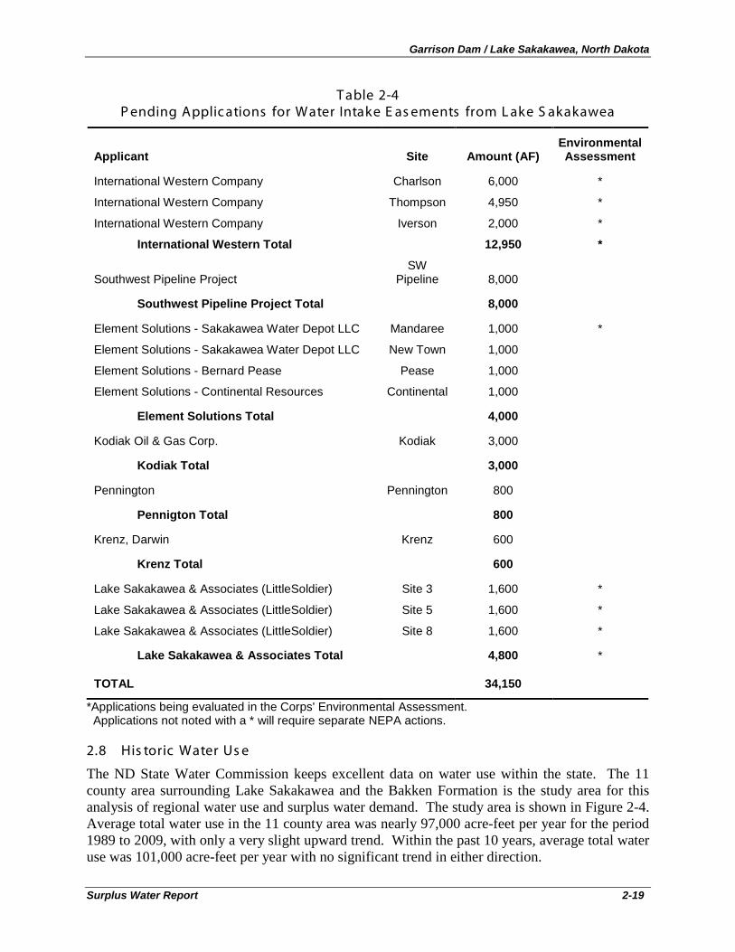
Garrison Dam / Lake Sakakawea, North Dakota
Surplus Water Report 2-19
T able 2-4 P ending Applic ations for Water Intake E as ements from L ake S akakawea
Applicant Site Amount (AF) Environmental Assessment
International Western Company Charlson 6,000 *
International Western Company Thompson 4,950 *
International Western Company Iverson 2,000 *
International Western Total 12,950 *
Southwest Pipeline Project SW
Pipeline 8,000
Southwest Pipeline Project Total 8,000
Element Solutions - Sakakawea Water Depot LLC Mandaree 1,000 *
Element Solutions - Sakakawea Water Depot LLC New Town 1,000
Element Solutions - Bernard Pease Pease 1,000
Element Solutions - Continental Resources Continental 1,000
Element Solutions Total 4,000
Kodiak Oil & Gas Corp. Kodiak 3,000
Kodiak Total 3,000
Pennington Pennington 800
Pennigton Total 800
Krenz, Darwin Krenz 600
Krenz Total 600
Lake Sakakawea & Associates (LittleSoldier) Site 3 1,600 *
Lake Sakakawea & Associates (LittleSoldier) Site 5 1,600 *
Lake Sakakawea & Associates (LittleSoldier) Site 8 1,600 *
Lake Sakakawea & Associates Total 4,800 *
TOTAL 34,150
*Applications being evaluated in the Corps' Environmental Assessment. Applications not noted with a * will require separate NEPA actions.
2.8 His toric Water Us e
The ND State Water Commission keeps excellent data on water use within the state. The 11 county area surrounding Lake Sakakawea and the Bakken Formation is the study area for this analysis of regional water use and surplus water demand. The study area is shown in Figure 2-4. Average total water use in the 11 county area was nearly 97,000 acre-feet per year for the period 1989 to 2009, with only a very slight upward trend. Within the past 10 years, average total water use was 101,000 acre-feet per year with no significant trend in either direction.
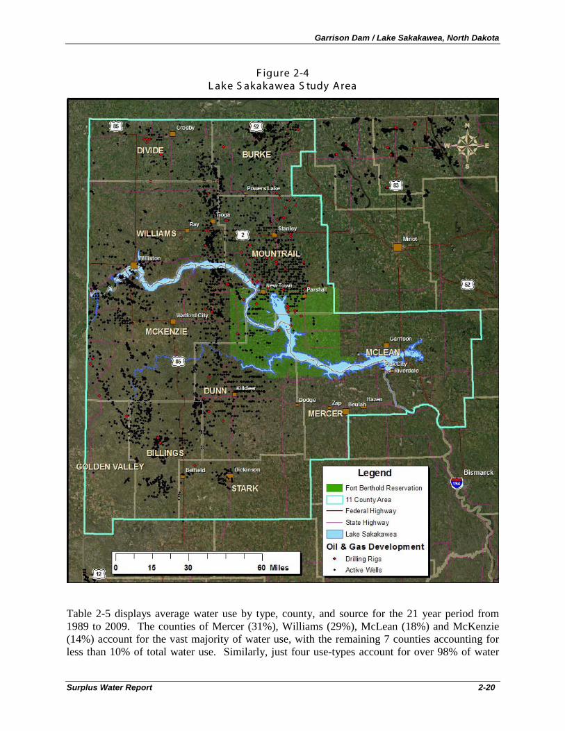
Garrison Dam / Lake Sakakawea, North Dakota
Surplus Water Report 2-20
F igure 2-4 L ake S akakawea S tudy Area
Table 2-5 displays average water use by type, county, and source for the 21 year period from 1989 to 2009. The counties of Mercer (31%), Williams (29%), McLean (18%) and McKenzie (14%) account for the vast majority of water use, with the remaining 7 counties accounting for less than 10% of total water use. Similarly, just four use-types account for over 98% of water
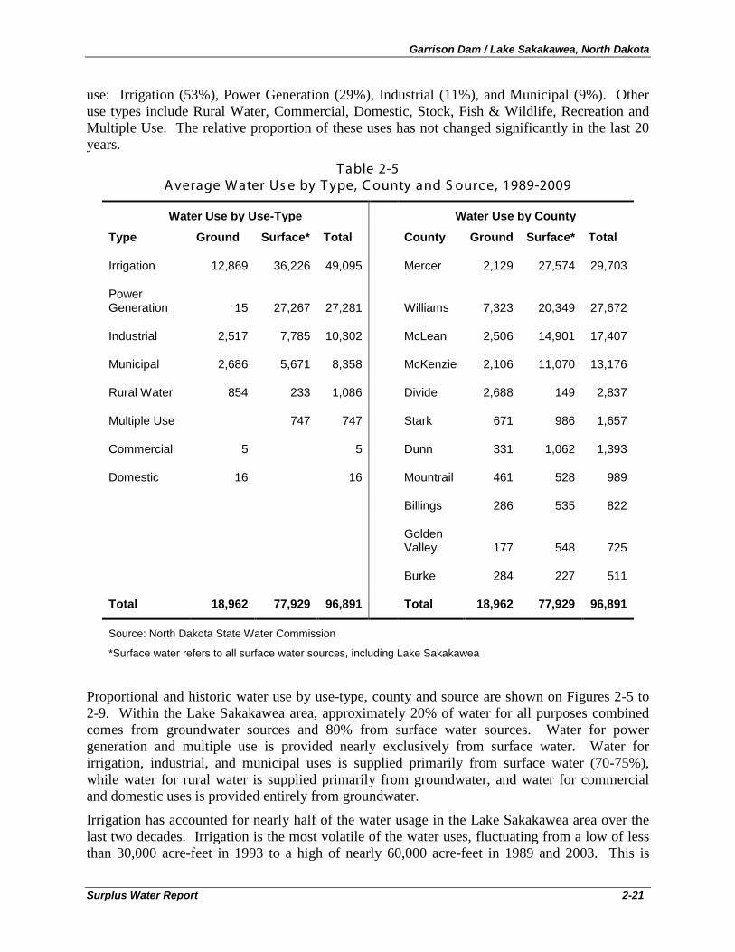
Garrison Dam / Lake Sakakawea, North Dakota
Surplus Water Report 2-21
use: Irrigation (53%), Power Generation (29%), Industrial (11%), and Municipal (9%). Other use types include Rural Water, Commercial, Domestic, Stock, Fish & Wildlife, Recreation and Multiple Use. The relative proportion of these uses has not changed significantly in the last 20 years.
T able 2-5 Average Water Us e by T ype, C ounty and S ourc e, 1989-2009
Water Use by Use-Type Water Use by County
Type Ground Surface* Total County Ground Surface* Total
Irrigation 12,869 36,226 49,095 Mercer 2,129 27,574 29,703
Power Generation 15 27,267 27,281 Williams 7,323 20,349 27,672
Industrial 2,517 7,785 10,302 McLean 2,506 14,901 17,407
Municipal 2,686 5,671 8,358 McKenzie 2,106 11,070 13,176
Rural Water 854 233 1,086 Divide 2,688 149 2,837
Multiple Use 747 747 Stark 671 986 1,657
Commercial 5 5 Dunn 331 1,062 1,393
Domestic 16 16 Mountrail 461 528 989
Billings 286 535 822
Golden Valley 177 548 725
Burke 284 227 511
Total 18,962 77,929 96,891 Total 18,962 77,929 96,891
Source: North Dakota State Water Commission
*Surface water refers to all surface water sources, including Lake Sakakawea
Proportional and historic water use by use-type, county and source are shown on Figures 2-5 to 2-9. Within the Lake Sakakawea area, approximately 20% of water for all purposes combined comes from groundwater sources and 80% from surface water sources. Water for power generation and multiple use is provided nearly exclusively from surface water. Water for irrigation, industrial, and municipal uses is supplied primarily from surface water (70-75%), while water for rural water is supplied primarily from groundwater, and water for commercial and domestic uses is provided entirely from groundwater.
Irrigation has accounted for nearly half of the water usage in the Lake Sakakawea area over the last two decades. Irrigation is the most volatile of the water uses, fluctuating from a low of less than 30,000 acre-feet in 1993 to a high of nearly 60,000 acre-feet in 1989 and 2003. This is
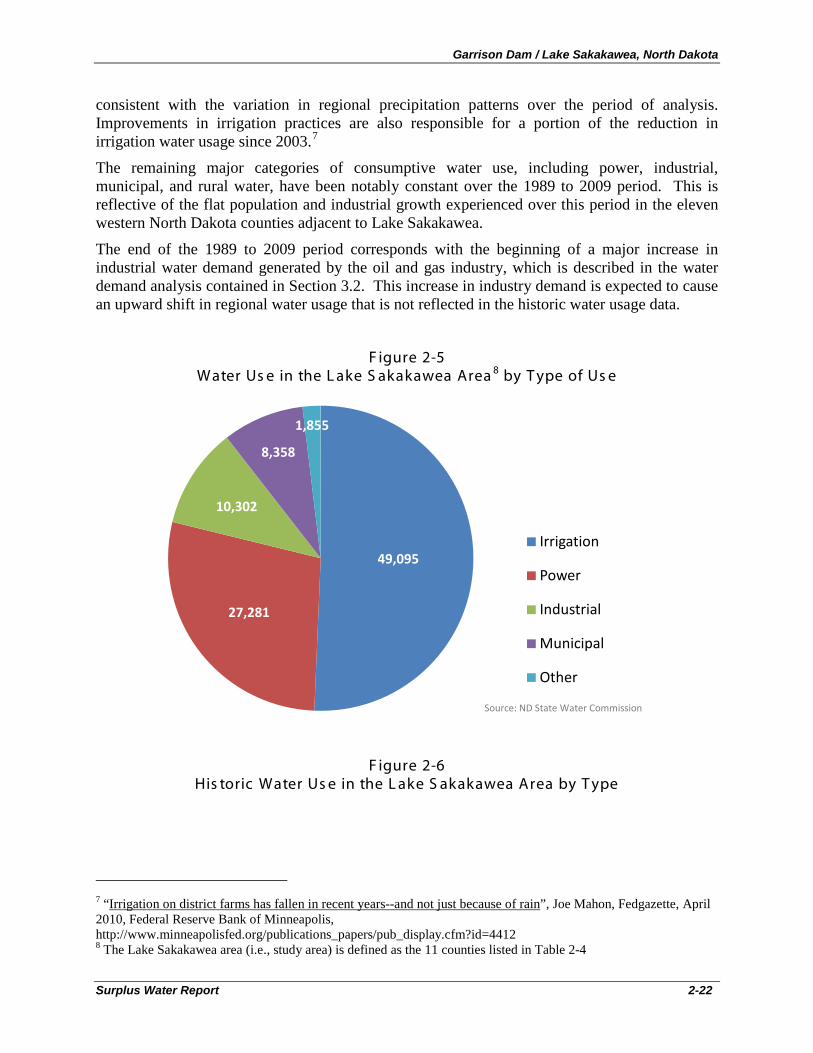
Garrison Dam / Lake Sakakawea, North Dakota
Surplus Water Report 2-22
consistent with the variation in regional precipitation patterns over the period of analysis. Improvements in irrigation practices are also responsible for a portion of the reduction in irrigation water usage since 2003.7
The remaining major categories of consumptive water use, including power, industrial, municipal, and rural water, have been notably constant over the 1989 to 2009 period. This is reflective of the flat population and industrial growth experienced over this period in the eleven western North Dakota counties adjacent to Lake Sakakawea.
The end of the 1989 to 2009 period corresponds with the beginning of a major increase in industrial water demand generated by the oil and gas industry, which is described in the water demand analysis contained in Section 3.2. This increase in industry demand is expected to cause an upward shift in regional water usage that is not reflected in the historic water usage data.
F igure 2-5 Water Us e in the L ake S akakawea Area 8
by T ype of Us e
F igure 2-6 His toric Water Us e in the L ake S akakawea Area by T ype
7 “Irrigation on district farms has fallen in recent years--and not just because of rain”, Joe Mahon, Fedgazette, April 2010, Federal Reserve Bank of Minneapolis, http://www.minneapolisfed.org/publications_papers/pub_display.cfm?id=4412 8 The Lake Sakakawea area (i.e., study area) is defined as the 11 counties listed in Table 2-4
49,095
27,281
10,302
8,358
1,855
Irrigation
Power
Industrial
Municipal
Other
Source: ND State Water Commission
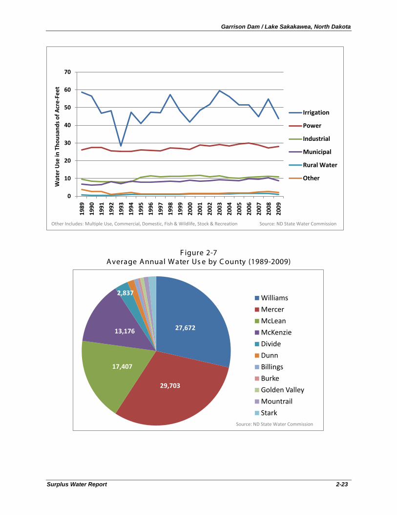
Garrison Dam / Lake Sakakawea, North Dakota
Surplus Water Report 2-23
F igure 2-7 Average Annual Water Us e by C ounty (1989-2009)
0
10
20
30
40
50
60
70
1989
1990
1991
1992
1993
1994
1995
1996
1997
1998
1999
2000
2001
2002
2003
2004
2005
2006
2007
2008
2009
Wat
er U
se in
Tho
usan
ds o
f Acr
e-Fe
et
Irrigation
Power
Industrial
Municipal
Rural Water
Other
Other Includes: Multiple Use, Commercial, Domestic, Fish & Wildlife, Stock & Recreation Source: ND State Water Commission
27,672
29,703
17,407
13,176
2,837Williams
Mercer
McLean
McKenzie
Divide
Dunn
Billings
Burke
Golden Valley
Mountrail
StarkSource: ND State Water Commission
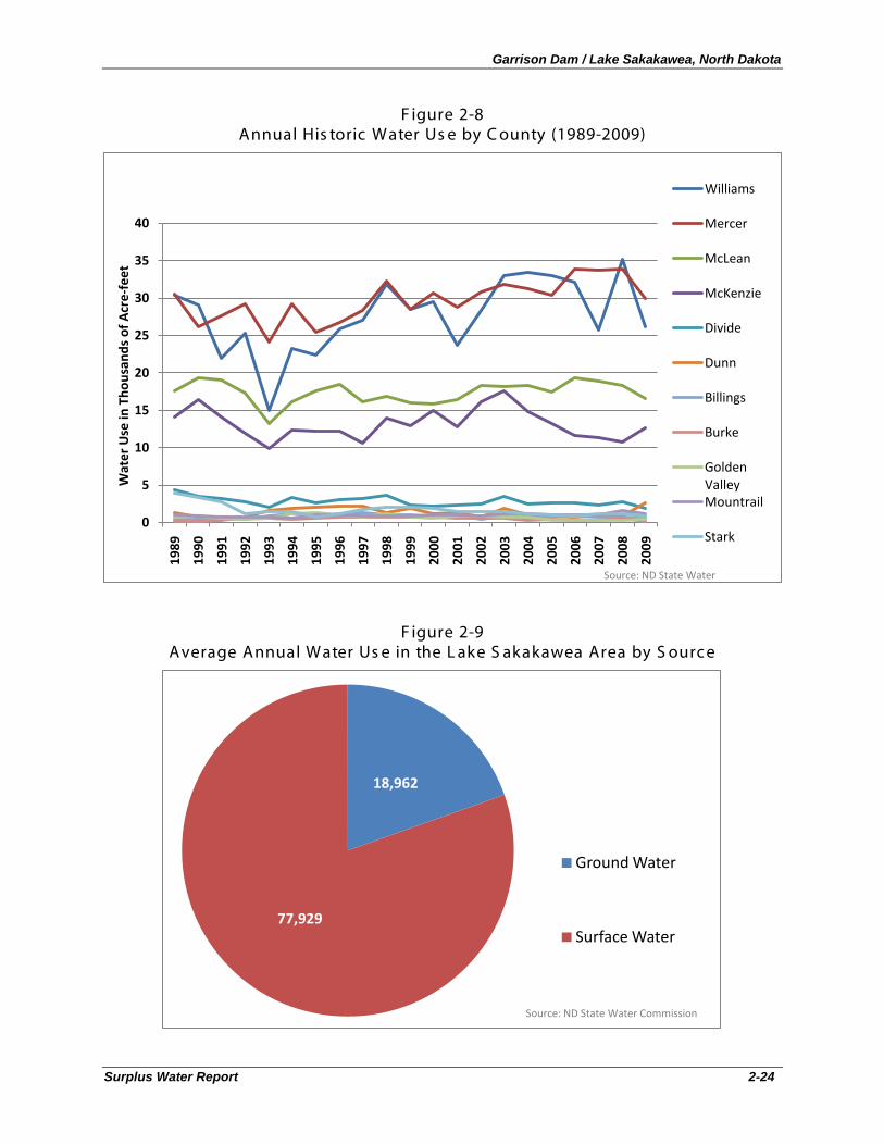
Garrison Dam / Lake Sakakawea, North Dakota
Surplus Water Report 2-24
F igure 2-8 Annual His toric Water Us e by C ounty (1989-2009)
F igure 2-9 Average Annual Water Us e in the L ake S akakawea Area by S ourc e
0
5
10
15
20
25
30
35
40
1989
1990
1991
1992
1993
1994
1995
1996
1997
1998
1999
2000
2001
2002
2003
2004
2005
2006
2007
2008
2009
Wat
er U
se in
Tho
usan
ds o
f Acr
e-fe
et
Williams
Mercer
McLean
McKenzie
Divide
Dunn
Billings
Burke
Golden ValleyMountrail
Stark
Source: ND State Water
18,962
77,929
Ground Water
Surface Water
Source: ND State Water Commission
Garrison Dam / Lake Sakakawea, North Dakota
Surplus Water Report 2-25
2.9 C orps S tudies and R eports by Others
Numerous documents and reports have been prepared describing the Garrison Dam / Lake Sakakawea Project, project operations, and operations of the Missouri River system. A more comprehensive listing of past reports is contained in the Environmental Assessment (Appendix A). Principal source documents for this analysis included the following Corps of Engineers reports:
• Missouri River Mainstem Reservoir System Master Water Control Manual Missouri River Basin, Reservoir Control Center U. S. Army Corps of Engineers Northwestern Division - Missouri River Basin Omaha, Nebraska, Revised March 2006
• Garrison Dam/Lake Sakakawea Master Plan with Integrated Programmatic Environmental Assessment, Missouri River, North Dakota, Update of Design Memorandum MGR-107D, December 14, 2007
• Water Appropriation Requirements, Current Water Use, & Water Availability for Energy Industries in North Dakota: A 2010 Summary, Response to House Bill 1322, Section 2 of the 61st Legislative Assembly of North Dakota prepared by W. M. Schuh Water Resources Investigation No. 49 North Dakota State Water Commission, August 2010.

Garrison Dam / Lake Sakakawea, North Dakota
Surplus Water Report 2-26
Garrison Dam / Lake Sakakawea, North Dakota
Surplus Water Report 3-1
3. PLAN FORMULATION Plan formulation for the Garrison Dam/Lake Sakakawea Surplus Water Study has been conducted in accordance with the six-step planning process described in Economic and Environmental Principles and Guidelines for Water and Related Land Resources Implementation Studies (1983) and the Planning Guidance Notebook (ER 1105-2-100, dated April 2000). The six steps in the iterative plan formulation process are:
1. Specify water and related land resources problems and opportunities; 2. Inventory and forecast existing conditions; 3. Formulate alternative plans; 4. Evaluate alternative plans; 5. Compare alternative plans; and 6. Select the recommended plan.
The basis for selection of the recommended plan for the study is fully documented below, including the rationale used in plan formulation and plan selection.
3.1 P roblems and Opportunities / Need for S urplus Water
As stated in Section 1.1, the purpose of this study is to identify and quantify whether surplus water is available in the Project, as defined in Section 6 of the 1944 Flood Control Act that the Secretary of the Army can use to execute surplus water supply agreements with water users, and to determine whether use of surplus water is the most efficient method for meeting regional municipal and industrial (M&I) water needs. The Omaha District, U.S. Army Corps of Engineers has received requests for nine new water supply easements from suppliers to the oil and gas industry. Three of the nine requested easements are addressed in the attached Environmental Assessment (Appendix A). Six of the nine easement requests have been received since this Surplus Water study has been initiated and are accounted for in the demand analysis and cumulative effects analysis of the EA, but will require separate NEPA actions because they were not ripe for action when this study was initiated. Based on Corps policy, none of the nine easement requests can be processed until a determination is made by the Secretary of the Army that surplus water is available in the Garrison Dam / Lake Sakakawea Project and that use of the surplus water will not significantly affect existing lawful uses of Lake Sakakawea water.
In addition to the water needs of the oil and gas industry, 110 of the 142 existing easements for water intakes at Garrison Dam / Lake Sakakawea will expire over the 10-year period of analysis, and may require surplus water agreements prior to renewal. Corps guidance states that “no easement that supports any type of water supply agreement will be executed prior to the water supply agreement being executed by all parties.”9
Because of uncertainty in the rate of oil and gas development, and resulting water demand over the 10-year planning period, temporary use of 257,000 acre-feet of storage (equivalent to a yield of 100,000 acre-feet/year of surplus water) is being evaluated (see Section 3.7.2.1 Storage-Yield
An analysis of total demand for surplus water storage at Garrison Dam / Lake Sakakawea over the 10-year planning period is provided below.
9 Real Estate Policy Guidance Letter No. 26 - Easements to Support Water Supply Storage Agreements and Surplus Water Agreements, 10 June 2008, CEMP-CR/CECC-R, paragraph 3
Garrison Dam / Lake Sakakawea, North Dakota
Surplus Water Report 3-2
Analysis). This is somewhat in excess of the amount of new easements requests and total estimated demand. The 100,000 acre-feet/year of surplus water was selected by the Omaha District based on the potential for growth in future M&I water demand over the 10-year planning period. Demand for water from Lake Sakakawea has grown rapidly just over the last 18 months, as exemplified by the fact that six new easement applications have been received just during the short period of time that this study has been underway. Therefore, a surplus water determination in excess of current easement applications received to date has been evaluated for the purposes of efficiency and responsiveness, so that the storage volume associated with all reasonably foreseeable future surplus water needs over the period of analysis could be evaluated and approved in one single action by the Assistant Secretary. Should resource impacts from temporary use of 100,000 acre-feet/year of surplus water (equivalent to 257,000 acre-feet of storage) prove significant, then lesser amounts could be evaluated.
The problem of cost effective municipal and industrial (M&I) water supply to support the oil and gas industry in North Dakota, and the need for surplus water from Garrison Dam / Lake Sakakawea Project to meet expected demand, is quantified in the following demand analysis.
3.2 Water S upply Demand Analys is
For this study, new water supply demand originates from two sources. The first is the rapidly expanding oil and gas industry in western North Dakota; the second is existing water intake easement holders in the Garrison Dam / Lake Sakakawea Project. These two sources of demand are described separately in the sections below.
3.2.1 Oil & G as Indus try Water S upply Demand
As described in Section 2.7, existing water usage in the study area was relatively stable for the 21 year period from 1989 through 2009, with the exception of irrigation water, which varies significantly according to annual precipitation. A major new source of water demand in western North Dakota, as described previously in this report, is due to the recent boom in oil and gas development in the Bakken Formation of western North Dakota. Figure 3-1 below depicts the rapid increase in oil production in the eleven county Lake Sakakawea study area. The following paragraphs describe the relationship between oil and gas development and increasing industrial water demand.
The boom in oil and gas exploration in western North Dakota is in large part due to the recent advancement of hydraulic fracturing (also known as hydro-fracing, or fracing) technology, which allows for cost-effective extraction of oil and gas from hydrocarbon-rich oil slate. This new technology is critically dependent on large volumes of high quality fresh water. Water, in combination with sand and proprietary chemical gelling mixtures, is forced into various locations along an oil-slate formation to fracture the slate and allow the oil and gas to travel through the fractures into the well. According to industry experts and state regulators, the quantity of water required to “frac” a well varies widely, and can range from less than 2-acre-feet to more than 12-acre-feet per well.
This wide disparity in the quantity of water required to frac an oil well is primarily explained by the variation in water requirements of vertical versus horizontal wells. As previously described, very recent advances in drilling technology now allow for wells to be drilled vertically for thousands of feet, then horizontally along the oil seam for even greater distances. Reported data for fracing water requirements in North Dakota are primarily based on previous vertical drilling
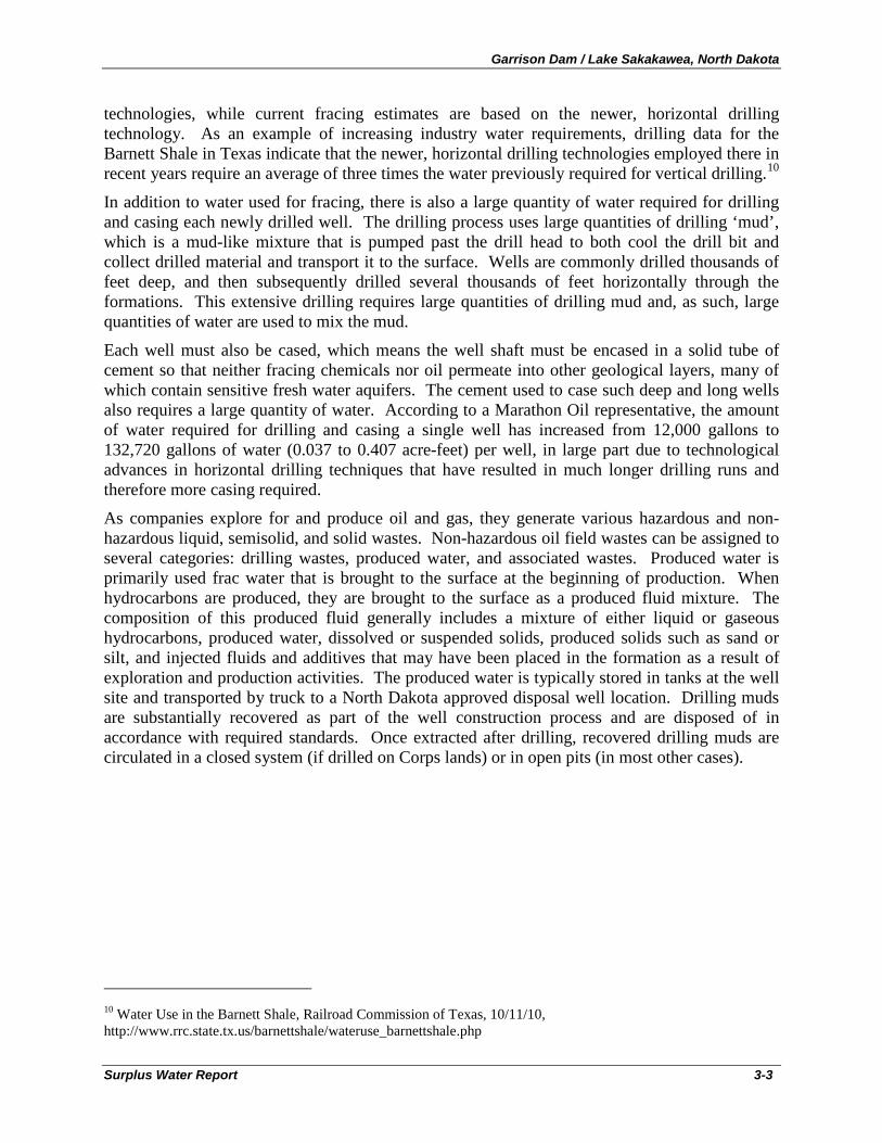
Garrison Dam / Lake Sakakawea, North Dakota
Surplus Water Report 3-3
technologies, while current fracing estimates are based on the newer, horizontal drilling technology. As an example of increasing industry water requirements, drilling data for the Barnett Shale in Texas indicate that the newer, horizontal drilling technologies employed there in recent years require an average of three times the water previously required for vertical drilling.10
In addition to water used for fracing, there is also a large quantity of water required for drilling and casing each newly drilled well. The drilling process uses large quantities of drilling ‘mud’, which is a mud-like mixture that is pumped past the drill head to both cool the drill bit and collect drilled material and transport it to the surface. Wells are commonly drilled thousands of feet deep, and then subsequently drilled several thousands of feet horizontally through the formations. This extensive drilling requires large quantities of drilling mud and, as such, large quantities of water are used to mix the mud.
Each well must also be cased, which means the well shaft must be encased in a solid tube of cement so that neither fracing chemicals nor oil permeate into other geological layers, many of which contain sensitive fresh water aquifers. The cement used to case such deep and long wells also requires a large quantity of water. According to a Marathon Oil representative, the amount of water required for drilling and casing a single well has increased from 12,000 gallons to 132,720 gallons of water (0.037 to 0.407 acre-feet) per well, in large part due to technological advances in horizontal drilling techniques that have resulted in much longer drilling runs and therefore more casing required.
As companies explore for and produce oil and gas, they generate various hazardous and non-hazardous liquid, semisolid, and solid wastes. Non-hazardous oil field wastes can be assigned to several categories: drilling wastes, produced water, and associated wastes. Produced water is primarily used frac water that is brought to the surface at the beginning of production. When hydrocarbons are produced, they are brought to the surface as a produced fluid mixture. The composition of this produced fluid generally includes a mixture of either liquid or gaseous hydrocarbons, produced water, dissolved or suspended solids, produced solids such as sand or silt, and injected fluids and additives that may have been placed in the formation as a result of exploration and production activities. The produced water is typically stored in tanks at the well site and transported by truck to a North Dakota approved disposal well location. Drilling muds are substantially recovered as part of the well construction process and are disposed of in accordance with required standards. Once extracted after drilling, recovered drilling muds are circulated in a closed system (if drilled on Corps lands) or in open pits (in most other cases).
10 Water Use in the Barnett Shale, Railroad Commission of Texas, 10/11/10, http://www.rrc.state.tx.us/barnettshale/wateruse_barnettshale.php
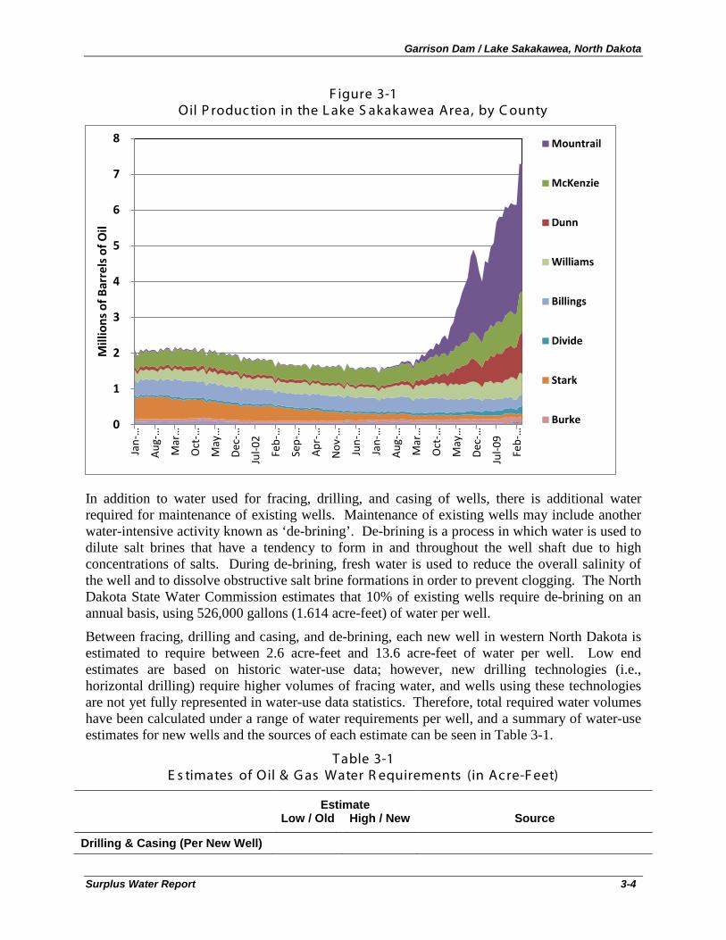
Garrison Dam / Lake Sakakawea, North Dakota
Surplus Water Report 3-4
F igure 3-1 Oil P roduc tion in the L ake S akakawea Area, by C ounty
In addition to water used for fracing, drilling, and casing of wells, there is additional water required for maintenance of existing wells. Maintenance of existing wells may include another water-intensive activity known as ‘de-brining’. De-brining is a process in which water is used to dilute salt brines that have a tendency to form in and throughout the well shaft due to high concentrations of salts. During de-brining, fresh water is used to reduce the overall salinity of the well and to dissolve obstructive salt brine formations in order to prevent clogging. The North Dakota State Water Commission estimates that 10% of existing wells require de-brining on an annual basis, using 526,000 gallons (1.614 acre-feet) of water per well.
Between fracing, drilling and casing, and de-brining, each new well in western North Dakota is estimated to require between 2.6 acre-feet and 13.6 acre-feet of water per well. Low end estimates are based on historic water-use data; however, new drilling technologies (i.e., horizontal drilling) require higher volumes of fracing water, and wells using these technologies are not yet fully represented in water-use data statistics. Therefore, total required water volumes have been calculated under a range of water requirements per well, and a summary of water-use estimates for new wells and the sources of each estimate can be seen in Table 3-1.
T able 3-1 E s timates of Oil & G as Water R equirements (in Ac re-F eet)
Estimate Low / Old High / New Source
Drilling & Casing (Per New Well)
0
1
2
3
4
5
6
7
8 Ja
n-…
Aug
-…
Mar
…
Oct
-…
May
…
Dec
-…
Jul-0
2
Feb-
…
Sep-
…
Apr
-…
Nov
-…
Jun-
…
Jan-
…
Aug
-…
Mar
…
Oct
-…
May
…
Dec
-…
Jul-0
9
Feb-
…
Mill
ions
of B
arre
ls o
f Oil
Mountrail
McKenzie
Dunn
Williams
Billings
Divide
Stark
Burke
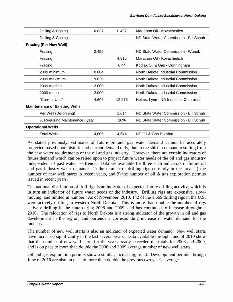
Garrison Dam / Lake Sakakawea, North Dakota
Surplus Water Report 3-5
Drilling & Casing 0.037 0.407 Marathon Oil - Kovachedich
Drilling & Casing 1 ND State Water Commission - Bill Schuh
Fracing (Per New Well)
Fracing 2.455 ND State Water Commission - Wanek
Fracing 4.910 Marathon Oil - Kovachedich
Fracing 6.44 Kodiak Oil & Gas - Cunningham
2009 minimum 0.004 North Dakota Industrial Commission
2009 maximum 9.820 North Dakota Industrial Commission
2009 median 2.000 North Dakota Industrial Commission
2009 mean 2.000 North Dakota Industrial Commission
"Current Use" 4.603 12.276 Helms, Lynn - ND Industrial Commission
Maintenance of Existing Wells
Per Well (De-brining) 1.614 ND State Water Commission - Bill Schuh
% Requiring Maintenance / year 10% ND State Water Commission - Bill Schuh
Operational Wells
Total Wells 4,606 4,644 ND Oil & Gas Division
As stated previously, estimates of future oil and gas water demand cannot be accurately projected based upon historic and current demand only, due to the shift in demand resulting from the new water requirements of the oil and gas industry. However, there are certain indicators of future demand which can be relied upon to project future water needs of the oil and gas industry independent of past water use trends. Data are available for three such indicators of future oil and gas industry water demand: 1) the number of drilling rigs currently in the area, 2) the number of new well starts in recent years, and 3) the number of oil & gas exploration permits issued in recent years.
The national distribution of drill rigs is an indicator of expected future drilling activity, which is in turn an indicator of future water needs of the industry. Drilling rigs are expensive, slow-moving, and limited in number. As of November, 2010, 142 of the 1,669 drilling rigs in the U.S. were actively drilling in western North Dakota. This is more than double the number of rigs actively drilling in the state during 2008 and 2009, and has continued to increase throughout 2010. The relocation of rigs to North Dakota is a strong indicator of the growth in oil and gas development in the region, and portends a corresponding increase in water demand for the industry.
The number of new well starts is also an indicator of expected water demand. New well starts have increased significantly in the last several years. Data available through June of 2010 show that the number of new well starts for the year already exceeded the totals for 2008 and 2009, and is on pace to more than double the 2008 and 2009 average number of new well starts.
Oil and gas exploration permits show a similar, increasing, trend. Development permits through June of 2010 are also on pace to more than double the previous two year’s average.
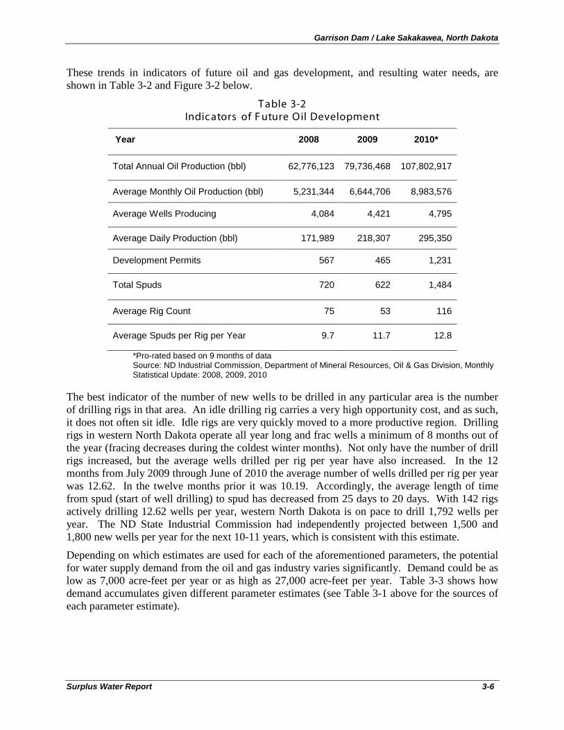
Garrison Dam / Lake Sakakawea, North Dakota
Surplus Water Report 3-6
These trends in indicators of future oil and gas development, and resulting water needs, are shown in Table 3-2 and Figure 3-2 below.
T able 3-2 Indic ators of F uture Oil Development
Year 2008 2009 2010*
Total Annual Oil Production (bbl) 62,776,123 79,736,468 107,802,917
Average Monthly Oil Production (bbl) 5,231,344 6,644,706 8,983,576
Average Wells Producing 4,084 4,421 4,795
Average Daily Production (bbl) 171,989 218,307 295,350
Development Permits 567 465 1,231
Total Spuds 720 622 1,484
Average Rig Count 75 53 116
Average Spuds per Rig per Year 9.7 11.7 12.8
*Pro-rated based on 9 months of data Source: ND Industrial Commission, Department of Mineral Resources, Oil & Gas Division, Monthly Statistical Update: 2008, 2009, 2010
The best indicator of the number of new wells to be drilled in any particular area is the number of drilling rigs in that area. An idle drilling rig carries a very high opportunity cost, and as such, it does not often sit idle. Idle rigs are very quickly moved to a more productive region. Drilling rigs in western North Dakota operate all year long and frac wells a minimum of 8 months out of the year (fracing decreases during the coldest winter months). Not only have the number of drill rigs increased, but the average wells drilled per rig per year have also increased. In the 12 months from July 2009 through June of 2010 the average number of wells drilled per rig per year was 12.62. In the twelve months prior it was 10.19. Accordingly, the average length of time from spud (start of well drilling) to spud has decreased from 25 days to 20 days. With 142 rigs actively drilling 12.62 wells per year, western North Dakota is on pace to drill 1,792 wells per year. The ND State Industrial Commission had independently projected between 1,500 and 1,800 new wells per year for the next 10-11 years, which is consistent with this estimate.
Depending on which estimates are used for each of the aforementioned parameters, the potential for water supply demand from the oil and gas industry varies significantly. Demand could be as low as 7,000 acre-feet per year or as high as 27,000 acre-feet per year. Table 3-3 shows how demand accumulates given different parameter estimates (see Table 3-1 above for the sources of each parameter estimate).
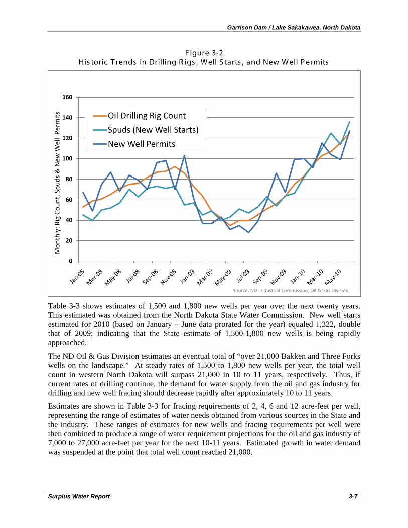
Garrison Dam / Lake Sakakawea, North Dakota
Surplus Water Report 3-7
F igure 3-2 His toric T rends in Drilling R igs , Well S tarts , and New Well P ermits
Table 3-3 shows estimates of 1,500 and 1,800 new wells per year over the next twenty years. This estimated was obtained from the North Dakota State Water Commission. New well starts estimated for 2010 (based on January – June data prorated for the year) equaled 1,322, double that of 2009; indicating that the State estimate of 1,500-1,800 new wells is being rapidly approached.
The ND Oil & Gas Division estimates an eventual total of “over 21,000 Bakken and Three Forks wells on the landscape.” At steady rates of 1,500 to 1,800 new wells per year, the total well count in western North Dakota will surpass 21,000 in 10 to 11 years, respectively. Thus, if current rates of drilling continue, the demand for water supply from the oil and gas industry for drilling and new well fracing should decrease rapidly after approximately 10 to 11 years.
Estimates are shown in Table 3-3 for fracing requirements of 2, 4, 6 and 12 acre-feet per well, representing the range of estimates of water needs obtained from various sources in the State and the industry. These ranges of estimates for new wells and fracing requirements per well were then combined to produce a range of water requirement projections for the oil and gas industry of 7,000 to 27,000 acre-feet per year for the next 10-11 years. Estimated growth in water demand was suspended at the point that total well count reached 21,000.
0
20
40
60
80
100
120
140
160
Mon
thly
: Rig
Cou
nt, S
puds
& N
ew W
ell
Perm
its Oil Drilling Rig Count
Spuds (New Well Starts)
New Well Permits
Source: ND Industrial Commission, Oil & Gas Division
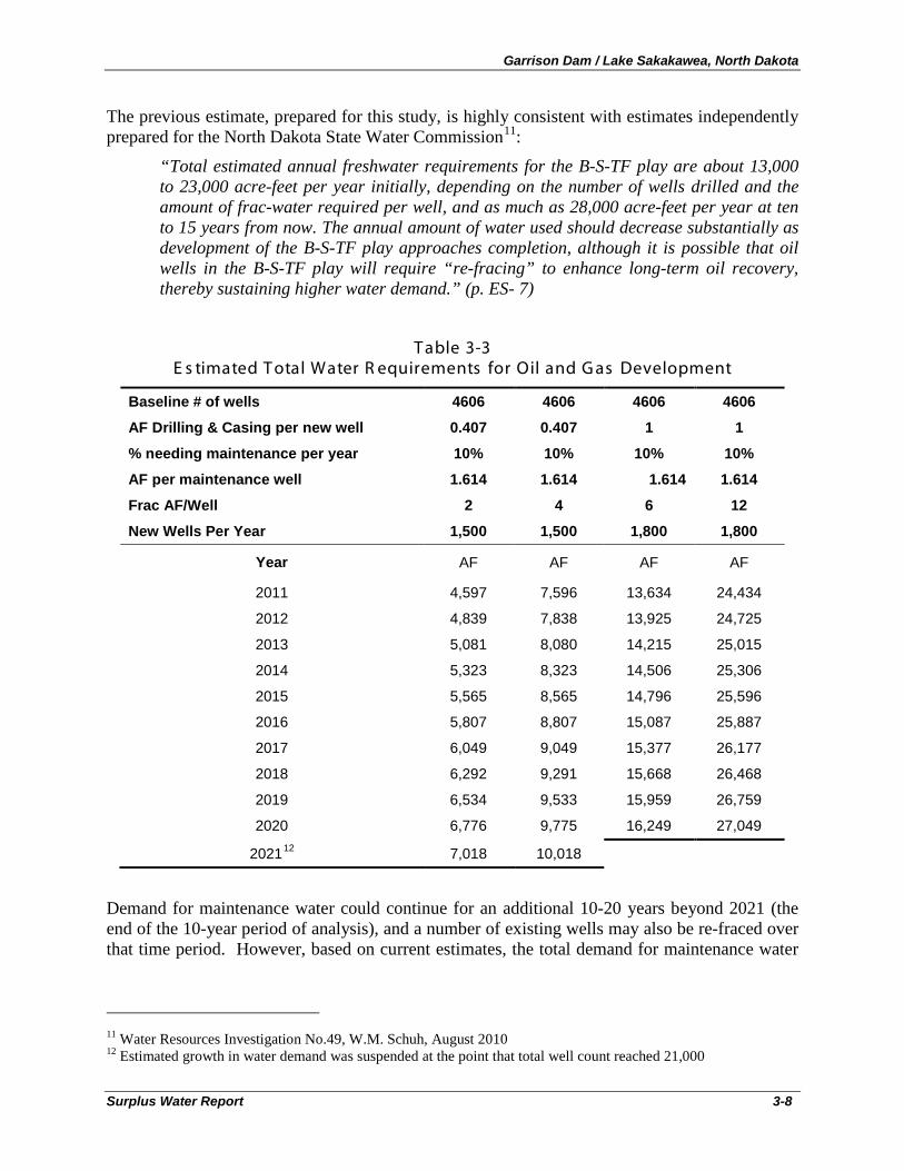
Garrison Dam / Lake Sakakawea, North Dakota
Surplus Water Report 3-8
The previous estimate, prepared for this study, is highly consistent with estimates independently prepared for the North Dakota State Water Commission11
“Total estimated annual freshwater requirements for the B-S-TF play are about 13,000 to 23,000 acre-feet per year initially, depending on the number of wells drilled and the amount of frac-water required per well, and as much as 28,000 acre-feet per year at ten to 15 years from now. The annual amount of water used should decrease substantially as development of the B-S-TF play approaches completion, although it is possible that oil wells in the B-S-TF play will require “re-fracing” to enhance long-term oil recovery, thereby sustaining higher water demand.” (p. ES- 7)
:
T able 3-3 E s timated T otal Water R equirements for Oil and G as Development
Baseline # of wells 4606 4606 4606 4606
AF Drilling & Casing per new well 0.407 0.407 1 1
% needing maintenance per year 10% 10% 10% 10%
AF per maintenance well 1.614 1.614 1.614 1.614
Frac AF/Well 2 4 6 12
New Wells Per Year 1,500 1,500 1,800 1,800
Year AF AF AF AF
2011 4,597 7,596 13,634 24,434
2012 4,839 7,838 13,925 24,725
2013 5,081 8,080 14,215 25,015
2014 5,323 8,323 14,506 25,306
2015 5,565 8,565 14,796 25,596
2016 5,807 8,807 15,087 25,887
2017 6,049 9,049 15,377 26,177
2018 6,292 9,291 15,668 26,468
2019 6,534 9,533 15,959 26,759
2020 6,776 9,775 16,249 27,049
202112 7,018 10,018
Demand for maintenance water could continue for an additional 10-20 years beyond 2021 (the end of the 10-year period of analysis), and a number of existing wells may also be re-fraced over that time period. However, based on current estimates, the total demand for maintenance water
11 Water Resources Investigation No.49, W.M. Schuh, August 2010 12 Estimated growth in water demand was suspended at the point that total well count reached 21,000
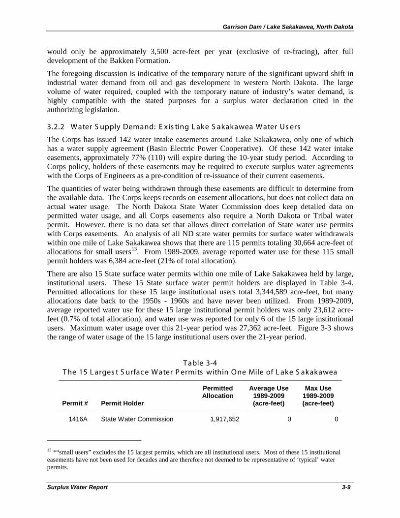
Garrison Dam / Lake Sakakawea, North Dakota
Surplus Water Report 3-9
would only be approximately 3,500 acre-feet per year (exclusive of re-fracing), after full development of the Bakken Formation.
The foregoing discussion is indicative of the temporary nature of the significant upward shift in industrial water demand from oil and gas development in western North Dakota. The large volume of water required, coupled with the temporary nature of industry’s water demand, is highly compatible with the stated purposes for a surplus water declaration cited in the authorizing legislation.
3.2.2 Water S upply Demand: E xis ting L ake S akakawea Water Us ers
The Corps has issued 142 water intake easements around Lake Sakakawea, only one of which has a water supply agreement (Basin Electric Power Cooperative). Of these 142 water intake easements, approximately 77% (110) will expire during the 10-year study period. According to Corps policy, holders of these easements may be required to execute surplus water agreements with the Corps of Engineers as a pre-condition of re-issuance of their current easements.
The quantities of water being withdrawn through these easements are difficult to determine from the available data. The Corps keeps records on easement allocations, but does not collect data on actual water usage. The North Dakota State Water Commission does keep detailed data on permitted water usage, and all Corps easements also require a North Dakota or Tribal water permit. However, there is no data set that allows direct correlation of State water use permits with Corps easements. An analysis of all ND state water permits for surface water withdrawals within one mile of Lake Sakakawea shows that there are 115 permits totaling 30,664 acre-feet of allocations for small users13
There are also 15 State surface water permits within one mile of Lake Sakakawea held by large, institutional users. These 15 State surface water permit holders are displayed in Table 3-4. Permitted allocations for these 15 large institutional users total 3,344,589 acre-feet, but many allocations date back to the 1950s - 1960s and have never been utilized. From 1989-2009, average reported water use for these 15 large institutional permit holders was only 23,612 acre-feet (0.7% of total allocation), and water use was reported for only 6 of the 15 large institutional users. Maximum water usage over this 21-year period was 27,362 acre-feet. Figure 3-3 shows the range of water usage of the 15 large institutional users over the 21-year period.
. From 1989-2009, average reported water use for these 115 small permit holders was 6,384 acre-feet (21% of total allocation).
T able 3-4 T he 15 L arges t S urfac e Water P ermits within One Mile of L ake S akakawea
Permit # Permit Holder
Permitted Allocation
Average Use 1989-2009 (acre-feet)
Max Use 1989-2009 (acre-feet)
1416A State Water Commission 1,917,652 0 0
13 *“small users” excludes the 15 largest permits, which are all institutional users. Most of these 15 institutional easements have not been used for decades and are therefore not deemed to be representative of ‘typical’ water permits.
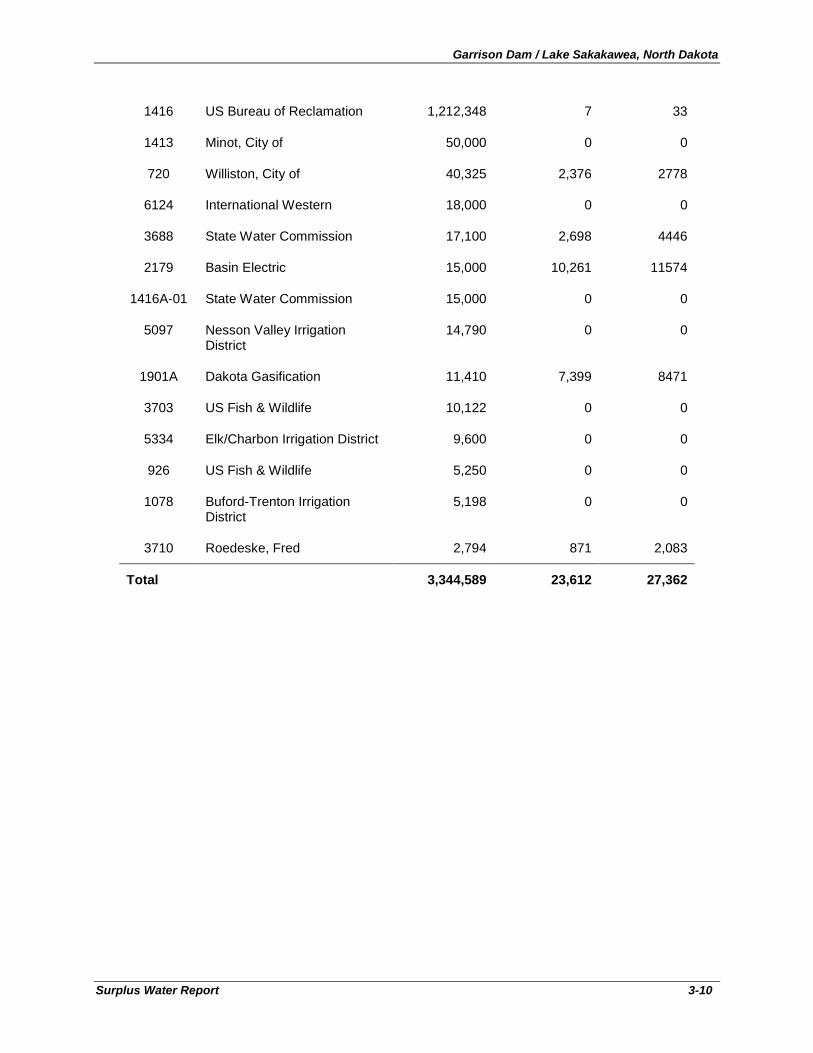
Garrison Dam / Lake Sakakawea, North Dakota
Surplus Water Report 3-10
1416 US Bureau of Reclamation 1,212,348 7 33
1413 Minot, City of 50,000 0 0
720 Williston, City of 40,325 2,376 2778
6124 International Western 18,000 0 0
3688 State Water Commission 17,100 2,698 4446
2179 Basin Electric 15,000 10,261 11574
1416A-01 State Water Commission 15,000 0 0
5097 Nesson Valley Irrigation District
14,790 0 0
1901A Dakota Gasification 11,410 7,399 8471
3703 US Fish & Wildlife 10,122 0 0
5334 Elk/Charbon Irrigation District 9,600 0 0
926 US Fish & Wildlife 5,250 0 0
1078 Buford-Trenton Irrigation District
5,198 0 0
3710 Roedeske, Fred 2,794 871 2,083
Total 3,344,589 23,612 27,362
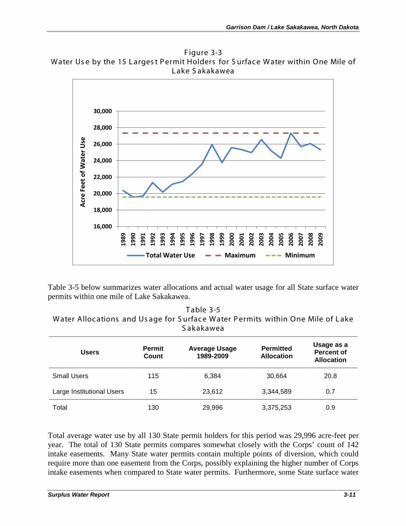
Garrison Dam / Lake Sakakawea, North Dakota
Surplus Water Report 3-11
F igure 3-3 Water Us e by the 15 L arges t P ermit Holders for S urface Water within One Mile of
L ake S akakawea
Table 3-5 below summarizes water allocations and actual water usage for all State surface water permits within one mile of Lake Sakakawea.
T able 3-5 Water Alloc ations and Us age for S urfac e Water P ermits within One Mile of L ake
S akakawea
Users Permit Count
Average Usage 1989-2009
Permitted Allocation
Usage as a Percent of Allocation
Small Users 115 6,384 30,664 20.8
Large Institutional Users 15 23,612 3,344,589 0.7
Total 130 29,996 3,375,253 0.9
Total average water use by all 130 State permit holders for this period was 29,996 acre-feet per year. The total of 130 State permits compares somewhat closely with the Corps’ count of 142 intake easements. Many State water permits contain multiple points of diversion, which could require more than one easement from the Corps, possibly explaining the higher number of Corps intake easements when compared to State water permits. Furthermore, some State surface water
16,000
18,000
20,000
22,000
24,000
26,000
28,000
30,000
1989
1990
1991
1992
1993
1994
1995
1996
1997
1998
1999
2000
2001
2002
2003
2004
2005
2006
2007
2008
2009
Acr
e Fe
et o
f Wat
er U
se
Total Water Use Maximum Minimum
Garrison Dam / Lake Sakakawea, North Dakota
Surplus Water Report 3-12
permits for water withdrawals from Lake Sakakawea may be mapped at the end of their pipeline, which could easily be more than 1 mile away from the reservoir, but would still require a Corps easement. These differences may account for some of the discrepancy between the 130 state permit count and the 142 Corps easement count.
Potential water demand for small water users was estimated as follows. Assuming 1) that the 30,664 acre-feet of State water permit allocations for small are distributed evenly across each permit, and 2) that 77% of the State permit holders hold Corps easements that will expire during the 10-year study period, then 23,754 permitted acre-feet of allocations for small users could require surplus water agreements with the Corps within the next ten years.
Actual water use can differ greatly from permitted allowance. Thus, if 77% of these users require new agreements with the Corps there could be 4,945 to 23,754 acre-feet of actual water demand from expiring small easements within the 10-year study period. Given State water policy (prior appropriations doctrine), it is conservatively assumed that expiring small easement holders would choose to exercise surplus water agreements for the full amount of their previous estimated allocations (23,754 acre-feet), rather than reduce their easement requests to more closely match actual water usage (4,945 acre-feet) and “give up” a portion of their water rights under State law. Therefore, 23,754 acre-feet is used as the estimate of future demand from current Lake Sakakawea small water intake easement holders during the 10-year study period.
Potential water demand for large institutional water users was estimated as follows. The large discrepancy between allocation and actual use for this category of users suggests that allocations are not a reliable basis on which to estimate future water use. Only six of the 15 large institutional easement holders have used any water from Lake Sakakawea in the last 21 years (1989-2009). Over this period, usage by these six large institutional easement holders has ranged from under 20,000 acre-feet to 27,362 acre-feet. Given that maximum usage was achieved very recently (2006), it is conservatively assumed that future water demand for large institutional easement holders over the 10-year planning period is 27,362 acre-feet.
3.2.3 T otal Water S upply Demand in the S tudy Area
Sections 2.7, 3.2.1, and 3.2.2 estimated demand from: 1) existing water users (Section 2.7), 2) the oil and gas industry (Section 3.2.1), and 3) existing Lake Sakakawea water intake easement holders (Section 3.2.2).
Existing water demand in the 11-county area surrounding Lake Sakakawea has been relatively steady over the 21 year period (with the exception of irrigation water) and is not expected to change significantly over the 10-year study period, resulting in no new net demand for the region.
Water demand from the oil and gas industry has developed at a rapid and accelerating pace since 2008 and is expected to result in an increase in demand ranging from 7,000 acre-feet to 27,000 acre-feet annually for the next 10-11 years, and then decrease abruptly thereafter as the Bakken Formation is fully developed. The upper range of the estimate 27,000 acre-feet annually, has been used in this estimate of surplus water needs for the 10-year study period.
Water demand represented by Lake Sakakawea water intake small easement holders whose easements will expire within the 10-year study period has been estimated to be approximately 23,754 acre-feet per year, and has been used in this estimate of surplus water demand for this group of users.
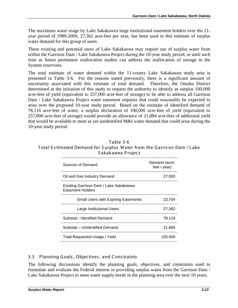
Garrison Dam / Lake Sakakawea, North Dakota
Surplus Water Report 3-13
The maximum water usage by Lake Sakakawea large institutional easement holders over the 21-year period of 1989-2009, 27,362 acre-feet per year, has been used in this estimate of surplus water demand for this group of users.
These existing and potential users of Lake Sakakawea may require use of surplus water from within the Garrison Dam / Lake Sakakawea Project during the 10-year study period, or until such time as future permanent reallocation studies can address the reallocation of storage in the System reservoirs.
The total estimate of water demand within the 11-county Lake Sakakawea study area is presented in Table 3-6. For the reasons stated previously, there is a significant amount of uncertainty associated with this estimate of total demand. Therefore, the Omaha District determined at the initiation of this study to request the authority to identify as surplus 100,000 acre-feet of yield (equivalent to 257,000 acre-feet of storage) to be able to address all Garrison Dam / Lake Sakakawea Project water easement requests that could reasonably be expected to arise over the proposed 10-year study period. Based on the estimate of identified demand of 78,116 acre-feet of water, a surplus declaration of 100,000 acre-feet of yield (equivalent to 257,000 acre-feet of storage) would provide an allowance of 21,884 acre-feet of additional yield that would be available to meet as yet unidentified M&I water demand that could arise during the 10-year study period.
T able 3-6 T otal E s timated Demand for S urplus Water from the G arris on Dam / L ake
S akakawea P rojec t
Sources of Demand Demand (acre-feet / year)
Oil and Gas Industry Demand 27,000
Existing Garrison Dam / Lake Sakakawea Easement Holders
Small Users with Expiring Easements 23,754
Large Institutional Users 27,362
Subtotal - Identified Demand 78,116
Subtotal – Unidentified Demand 21,884
Total Requested Usage / Yield 100,000
3.3 P lanning G oals , Objec tives , and C ons traints
The following discussions identify the planning goals, objectives, and constraints used to formulate and evaluate the Federal interest in providing surplus water from the Garrison Dam / Lake Sakakawea Project to meet water supply needs in the planning area over the next 10 years.
Garrison Dam / Lake Sakakawea, North Dakota
Surplus Water Report 3-14
3.3.1 P lanning G oals and Objec tives
The goal of the Surplus Water Report is to determine whether there is surplus water available in the Garrison Dam / Lake Sakakawea Project and to evaluate whether providing surplus water from the Project is the most cost effective means of meeting the near-term (10-year) water needs of the study area. The study area is defined as the 11-county area surrounding Lake Sakakawea in western North Dakota.
National water policy states that the primary responsibility for water supply rests with states and local entities, not the Federal government. However, the Corps can participate and cooperate with state and local entities in developing water supplies in connection with the construction, operation, or modification of Federal navigation, flood damage reduction, or multipurpose projects. Specifically, the Corps is authorized to provide storage in new or existing multipurpose reservoirs for municipal and industrial water supply. However, since water supply is a state and local responsibility, the cost of water supply storage and associated facilities in a Corps project must be paid for entirely by a non-Federal entity.
The Secretary of the Army is authorized to make agreements with states, municipalities and other non-Federal entities for the rights to utilize water supply storage in Corps reservoirs. The Secretary of the Army can enter into agreements with states, municipalities, private entities or individuals for the use of ‘surplus water’. Under Section 6 of the Flood Control Act of 1944, the Secretary of the Army is authorized to make agreements with states, municipalities, private concerns, or individuals for surplus water that may be available at any Corps reservoir. Surplus water agreements may be for domestic, municipal, and industrial uses.
Planning objectives for this study were developed to be consistent with Federal, State and local laws and policies, and technical, economic, environmental, regional, social, and institutional considerations. The planning objectives were used to help formulate and evaluate plans to avoid, minimize, and mitigate (if necessary), any adverse project impacts to the environment. Planning objectives also provide a decision framework to identify the least cost water supply alternative, avoid adverse social impacts, and meet local preferences to the fullest extent possible.
In pursuit of the project goal, the following Federal planning objectives were established:
• Determine if surplus water is available at the Garrison Dam / Lake Sakakawea Project and determine the storage amount to be evaluated for potential impacts, over the next 10 years
• Anticipate demand and requests for surplus water agreements at the Project over the 10-year study period, including requests identified within this report and a forecast of additional requests.
• Determine repayment unit costs to apply to surplus water agreements Also in pursuit of the project goal, the following regional planning objectives were established:
• Provide sufficient water to meet the needs of existing and prospective applicants for new surplus water agreements at Garrison Dam / Lake Sakakawea for the next 10 years by the most efficient means;
• Provide sufficient water to meet the needs of current Garrison Dam / Lake Sakakawea water supply users whose existing easements will expire within the next 10 years.
Garrison Dam / Lake Sakakawea, North Dakota
Surplus Water Report 3-15
This study develops and evaluates alternatives to determine how best to meet the easement applicants’ water needs within the constraints described below. The impacts of providing surplus water on other project purposes are assessed so that an optimal alternative that provides needed water supply and does not significantly impact other project purposes may be identified. The impacts assessed in this analysis include effects on: flood control, navigation, irrigation, hydropower, municipal and industrial water supply, fish and wildlife, recreation, water quality, and any associated environmental and economic effects.
3.3.2 P lanning C ons traints
Planning constraints related to reservoir operations include maintenance of the project’s ability to support currently authorized project purposes and to support other incidental uses. Currently authorized project purposes are: flood control, navigation, irrigation, hydropower, municipal and industrial (M&I) water supply, fish and wildlife, recreation, and water quality. Of these project purposes, only flood control has a specific amount of allocated storage in Lake Sakakawea.
A second planning constraint relates to the requirements of Section 6 of the Flood Control Act of 1944. Under Section 6, the Secretary of the Army is authorized to make agreements with states, municipalities, private concerns, or individuals for surplus water that may be available at any Corps reservoir. The formulation and evaluation of alternative plans is constrained by the limitations imposed by Congress and Corps policy for temporary reallocation of surplus water. These constraints/limitations include:
• No surplus water contract can adversely affect then existing lawful uses of such water; • No temporary surplus water agreement can be made for crop irrigation; • Surplus water agreements can only be granted if the Secretary can classify surplus water
as either: 1) water stored that is not required because the authorized use for the water was never developed or if the need for the authorized use was reduced or eliminated by changes in water demand that occurred since authorization or construction of the project; or 2) water that would be more beneficially used as municipal and industrial water than for the authorized project purposes and which, when withdrawn, would not significantly affect authorized purposes over some specified period of time; and
• Temporary surplus water reallocations are time limited and can only be granted fora period of up to 5 years, with a 5-year renewal option (for a total period of 10 years).
3.4 Management Meas ures
A management measure is a feature (i.e., a structural element that requires construction or assembly on-site), or an activity (i.e., a nonstructural action) that can either work alone or be combined with other management measures to form alternative plans. Management measures were developed to address study area problems and to capitalize upon study area opportunities. Management measures for this study were derived from a variety of sources including prior studies, agency and public input, and the project delivery team (PDT).
3.4.1 Identific ation of Management Meas ures
The following management measures were identified for initial consideration:
Structural Measures (Features)
Garrison Dam / Lake Sakakawea, North Dakota
Surplus Water Report 3-16
• Structural modifications to the project to increase storage capacity
• Provision of surplus water from the sediment storage portion of the carryover multiple use zone to M&I water supply for up to 10 years, including associated infrastructure (i.e., intakes, pipelines, storage and distribution facilities)
• Groundwater withdrawals, including associated infrastructure
• Surface water withdrawals from the Missouri River upstream of Lake Sakakawea, including associated infrastructure
• Conservation / incentive programs / regulations / public education / drought contingency planning
Non-Structural Measures (Activities)
• Water reuse / recycling
• Temporary State permits to convert irrigation water to industrial use
3.4.2 S c reening of Management Meas ures
The following sub-sections evaluate and screen each of the structural and non-structural measures identified above to determine which measures should be carried forward in the planning process and included in the formulation of alternatives. The Corps of Engineers Principles and Guidelines14
This is not to imply that some management measures that are screened out from further consideration may not be beneficial public policies or effective solutions to other legitimate problems of the study area. Rather, management measures are screened out from further consideration when it can be reasonably determined that they will not meaningfully contribute to meeting study goals and objectives or resolving the problems and needs that the study was initiated to address.
identifies four criteria to be used in the formulation and evaluation of alternative plans: completeness, effectiveness, efficiency, and acceptability. At this phase of the planning process, management measures are screened, using these four criteria, to determine whether they have the potential to make meaningful contributions to achieving the goals and objectives of the project. While none of these criteria are absolute, it is clearly reasonable to screen out from further consideration any management measure that: 1) does not contribute to meeting study goals and objectives to any significant extent (completeness), 2) is not effective in resolving study area problems and needs (effectiveness), 3) is not an efficient means of solving the problem when compared to other potential measures (efficiency), or 4) is not an acceptable solution to other Federal and non-Federal agencies and affected publics (acceptability).
3.4.2.1 S truc tural Meas ures
Four structural measures are considered below. Two structural measures are screened out from further consideration (i.e., structural modifications to the project and groundwater withdrawals). Two structural measures are carried forward into formulation of alternative plans: 1) temporary
14 Economic and Environmental Principles for Water and Related Land Resources Implementation Studies and The Economic and Environmental Guidelines for Water and Related Land Resources Implementation Studies, U.S. Water Resources Council, February 1983
Garrison Dam / Lake Sakakawea, North Dakota
Surplus Water Report 3-17
provision of surplus water from Lake Sakakawea, and 2) surface water withdrawals from free-flowing reaches of the Missouri River).
Corps of Engineers guidanceS truc tural Modific ations to the P rojec t to Inc reas e S torage C apac ity
15 states that existing Corps projects may be modified to add storage for municipal and industrial water supply. Structural measures to increase the storage capacity of an existing dam typically include: auxiliary spillways, lined overflow sections, raising the dam, modifications to the existing spillway, and combinations of these measures. Environmental criteria that must be assessed when considering structural measures to increase storage capacity include: avoiding adverse impacts to the environment, mitigating any unavoidable environmental impacts, maintaining water quality and ecosystem functions during and after the modification, and achieving no net loss in environmental values and functions.16
The advantages of structural measures to increase storage capacity is that the needs of municipal and industrial water supply can be met without the negative effects on project users associated with taking water storage away from other authorized project purposes. The disadvantages of structural measures to increase storage capacity is that the studies necessary to design such modifications are lengthy and costly; and construction activities are similarly costly, time consuming, and can have significant impacts on the physical and natural environment. As a result, structural modifications to increase storage capacity are typically only considered when municipal and industrial water needs are so significant relative to total existing storage capacity that the effects of providing surplus water from existing storage would render the project unable to meet its authorized project purposes, and where the environmental effects of surplus M&I water use would exceed the environmental effects of structural modifications.
These considerations indicate that structural modifications would not be an effective measure for the Garrison Dam / Lake Sakakawea Project. The amount of water being requested, 100,000 acre-feet/year, is only 0.7 percent of the net system yield of 15.2 million acre-feet. As described in Section 3.7.1, use of this small portion of total system yield will have negligible impacts on current authorized purposes and on environmental conditions at the project, or in upstream or downstream reaches of the Missouri River.
Structural measures to add additional storage at Garrison Dam / Lake Sakakawea are also not efficient given the temporary nature of the industrial water needs of the oil and gas industry. In order to meet Corps design criteria, structural measures would need to be designed and built to last for the remaining design life of the project, which is well in excess of the term of the temporary water needs of the industry.
Based on this assessment, structural measures involving modifications to the Garrison Dam / Lake Sakakawea Project to increase storage capacity have been eliminated from further consideration (screened out) for reasons of efficiency, effectiveness, and considerations of adverse effects on the environment.
15 ER 1105-2-100, Planning Guidance Notebook, 22 April 2000, Paragraph 3-8.a. 16 EM 1110-2-2300, General Design and Construction Considerations for Earth and Rock-Fill Dams, 30 July 2004
Garrison Dam / Lake Sakakawea, North Dakota
Surplus Water Report 3-18
Water users in North Dakota require a permit from the State for groundwater withdrawals in excess of 12.5 acre-feet for any purpose other than domestic or livestock use. In executing its permit decision making process, the State closely monitors water usage and impacts on aquifers to protect groundwater resources and avoid damage to critical aquifers. The State of North Dakota has recently completed a detailed study of state water resources that contains its assessment of the ability of groundwater resources to meet the water needs of the oil and gas industry in North Dakota (North Dakota State Water Commission, August 2010). The study is incorporated by reference and the summary conclusion of the assessment of groundwater resources is provided below:
G roundwater Withdrawals
“Groundwater supplies in western North Dakota are limited. Glaciofluvial and other shallow aquifers and the Fox Hills – Hell Creek bedrock aquifer are insufficient to supply the requirements of the B-S-TF play at the proposed rate of development. It is critical that ground-water supplies be conserved for the use and sustenance of towns, homes, local industries, and farms and ranches, after the completion of oil development. As of December of 2009 there were 28 water depots, for a total allocation of 2,340 acre-feet per year serving the oil industry in western North Dakota. Thirty more water permits for water depots are pending, for an additional 5,534 acre-feet per year. Not all of these will likely be approved. Even if all were approved, water supplies from groundwater would fall far short of needs for the B-S-TF play. The only plentiful and dependable supply of water for the oil industry in western North Dakota, at projected rates of extraction, is the Missouri River system, including Lake Sakakawea.” (p. ES-7) 17
Comparisons of total groundwater usage in western North Dakota provided previously in Section 2.7, Existing Water Uses, shows that existing groundwater withdrawals for all uses in the 11-county study area total less than 19,000 acre-feet annually, and are already being stressed beyond natural recharge rates. It is unreasonable to expect these limited and over-stressed groundwater resources to contribute meaningfully to meeting the water needs of the oil and gas industry, which are expected to exceed total existing groundwater use by over 50 percent (27,000 acre-feet).
Also, North Dakota state water law is based on the doctrine of prior appropriations, which allocates water rights according to the date they were approved (senior rights) and the priority of the water use as established by state law. New applications for significant quantities of groundwater for industrial purposes would be considered subordinate under state water law to more senior water rights. They would also be considered subordinate to higher priority uses, which include domestic, municipal, livestock, and irrigation – the purposes to which the vast majority of the limited groundwater resources of the study area are already committed.
Therefore, requests for groundwater permits for the oil and gas industry would only be granted in conditions where enough excess water was available that withdrawals would not affect senior
17 Water Appropriation Requirements, Current Water Use, & Water Availability for Energy Industries in North Dakota: A 2010 Summary, Response to House Bill 1322, Section 2 of the 61st Legislative Assembly of North Dakota prepared by W. M. Schuh Water Resources Investigation No. 49 North Dakota State Water Commission August 2010
Garrison Dam / Lake Sakakawea, North Dakota
Surplus Water Report 3-19
and higher priority appropriations. This is most certainly not the case with western North Dakota’s limited and stressed groundwater resources.
Based on this assessment, structural measures involving additional groundwater withdrawals have been eliminated from further consideration (screened out) for reasons of lack of completeness and lack of public acceptability.
Temporary use of surplus water in the sediment storage portion of the carryover multiple use zone of the Garrison Dam / Lake Sakakawea Project is considered a structural measure. In order to meet the completeness criterion, this measure includes the necessary investments by non-Federal entities to construct water intakes, pipelines, and water depots necessary to deliver the purchased water to the oil and gas industry.
T emporary Us e of S urplus Water
The selection of the sediment storage portion of the carryover multiple use zone as the source of surplus water is based on the following considerations. The four reservoir zones, as described in Section 2.5 and displayed in Figure 2-3, are: the permanent pool, the carryover multiple use zone, the annual flood control and multiple use zone, and the exclusive flood control zone.
As described previously, the 5.0 million acre foot (MAF) permanent pool provides minimum power head and sediment storage capacity and assures minimum levels for irrigation diversion of water from the reservoir. Storage within this zone is the minimum necessary to maintain project operations (sediment storage and irrigation diversion) and to meet minimum head requirements needed to support hydropower operations. For these reasons, surplus water is not available within the permanent pool.
Above the permanent pool is the 13.1 MAF carryover multiple use zone. This intermediate zone provides a storage reserve for irrigation, navigation, power production, and other beneficial conservation uses. This zone also provides carryover storage for maintaining downstream flows through a succession of years in which runoff is below normal. Storage originally reserved for the irrigation purpose has not been fully utilized since the project has was placed in operation, and releases for navigation from this zone are only required during drought years. Also, the portion of this zone reserved for sediment storage has not yet filled with sediment, and is not expected to be filled during the 10-year study period, based on sediment investigations. A total of 5,125,000 AF of sediment storage was planned over the effective life of the project. Based on the most recent area capacity calculation, approximately 1,470,000 AF of storage has been lost to sediment to date, which is less than 30% of the total available sediment storage. The rate of storage lost to sediment is approximately 25,900 AF per year, therefore a sufficient amount of storage planned for sediment is considered to be surplus and available for temporary municipal and industrial use. The third zone is the 4.2 MAF annual flood control and multiple use zone. This is the desired operating zone. Water stored in this zone is normally evacuated by March 1 of each year to provide adequate storage capacity for the flood season. During the flood period, water is impounded in this zone as required. Because of the annual operational fluctuations of water levels in this zone it is not considered a reliable source of water to meet M&I water needs on a consistent basis throughout the year.
Finally, the fourth zone, or exclusive flood control zone, consists of 1.5 MAF of storage between elevations 1850.0 and 1854.0 feet msl. This zone is used only during periods of extreme floods and is evacuated as soon as downstream conditions permit. For this reason, water is very
Garrison Dam / Lake Sakakawea, North Dakota
Surplus Water Report 3-20
infrequently stored in this zone and so does not contain surplus water except under the most extreme and infrequent, conditions.
The structural measure of temporary use of surplus water in the sediment storage portion of the carryover multiple use zone can be scaled to meet the entire water needs of the oil and gas industry, and so fully meets the effectiveness criterion.
The costs of surplus water to the industry will include the prorated share of updated project costs, plus the full cost of all necessary infrastructure investments on and off project lands. These costs, when compared to the costs of purchasing water from multiple locations that are more distant from the oil and gas industry, may prove to be the most cost effective means of achieving project objectives, and is therefore tentatively considered to meet the efficiency criterion, subject to more detailed analysis in the comparison of alternative plans.
Provision of surplus water from Lake Sakakawea is the preferred alternative of the State of North Dakota (as stated in public documents), the oil and gas industry (as evidenced by easement applications and state permit requests), and many members of the general public in North Dakota (as expressed in news publications). Therefore, it is tentatively considered to meet the criterion of acceptability, subject to further analysis.
Consistent with the criteria of completeness, effectiveness, efficiency, and acceptability, the structural measure of temporary use of surplus water in the Garrison Dam / Lake Sakakawea Project is carried forward for further consideration into the formulation of alternative plans.
Withdrawal of water from the surface waters of North Dakota to serve the needs of the oil and gas industry is a potentially viable structural measure. The State of North Dakota recognizes this potential in its analysis of water availability for the oil and gas industry
S urfac e Water Withdrawals F rom F ree-F lowing R eac hes Of T he Mis s ouri R iver
18
“Surface-Water Storage and Use :
Except for the Missouri River system, most of the state’s surface waters are heavily appropriated and are not good prospects for large-scale long-term sustainable water supplies. For many of the state’s rivers, however, there are seasonal flows that are not being captured and used. With appropriate capture and storage these waters could be retained and used. Possible storage techniques would include surface storage and aquifer recharge and recovery.” (p. ES-16)
A sovereign lands permit is required from the state for withdrawals from free-flowing reaches of the Missouri River. If channel alterations are necessary, then a regulatory permit must also be obtained from the Corps of Engineers. However, no surplus water agreement is required from the Corps of Engineers for water obtained from river reaches not contained within a Corps reservoir or on Corps project lands, provided the Corps does not operate the system to meet the needs of the intake. Water allocation decisions for free-flowing river reaches within North Dakota, depending on the scope of such a withdrawal, are generally under the purview of the State or the Three Affiliated Tribes. The State of North Dakota has identified the Missouri River as the best available source of water for the oil and gas industry (after Lake Sakakawea).
18 W. M. Shuh, op.cit.
Garrison Dam / Lake Sakakawea, North Dakota
Surplus Water Report 3-21
An example of a proposal to provide water from a free-flowing reach of the Missouri River upstream of Lake Sakakawea is collaboration of northwest North Dakota water stakeholders (including the BDW Rural Water District, the City of Crosby, the McKenzie County Commission, the McKenzie County Water Resources District, R&T Water Supply Association, the Williams Rural Water District, and the City of Williston). This group has developed a regional water development plan that proposes delivery of Missouri River water from the Williston Regional Water Treatment Plant to the northwest North Dakota region. This plan includes a series of water supply and transmission infrastructure projects which could provide up to 11,200 acre-feet of water for regional water demands, principally focusing on the water needs of the oil and gas industry.19
Evaluation of this proposal has determined that it includes all the necessary investments by non-Federal entities to construct water intakes, pipelines, and water depots necessary to deliver the purchased water to the oil and gas industry, and therefore meets the completeness criterion.
This measure can be scaled upwards to meet a significant portion of the water needs of the oil and gas industry, and so at least partially meets the effectiveness criterion.
The cost estimate presented in this collaborative proposal includes estimates of the full cost of all necessary infrastructure investments necessary to extract, transmit, store, and distribute water extracted from the Missouri River. These costs, when compared to the costs of surplus water from the Garrison Dam / Lake Sakakawea Project, may prove to be a cost effective means of achieving study objectives, and is therefore tentatively considered to meet the efficiency criterion, subject to more detailed analysis in the comparison of alternative plans.
Provision of water from the Missouri River is the second-most preferred alternative of the State of North Dakota (as stated in public documents) if temporary use of surplus water from Lake Sakakawea is not available. The oil and gas industry (as evidenced by easement applications and state permit requests) and many members of the public (as expressed in the referenced letter to the Governor of North Dakota) also consider this to be a potentially feasible alternative. Therefore, it is tentatively considered to meet the criterion of acceptability.
Consistent with the criteria of completeness, effectiveness, efficiency, and acceptability, the structural measure of withdrawal of surface waters from free-flowing reaches of the Missouri River is carried forward for further consideration into the formulation of alternative plans.
3.4.2.2 Non-S truc tural Meas ures (Ac tivities )
Three non-structural measures are considered below. Two non-structural measures are screened out from further consideration (i.e., conservation / incentive programs and water reuse / recycling). One non-structural measure is carried forward into formulation of alternative plans (i.e., temporary State permits to convert irrigation water to industrial use).
19 Letter to Honorable John Hoeven, Governor of North Dakota, RE: Northwest North Dakota Water Development & Management Plan, June 30, 2010, signed by the President, McKenzie County Water Resource District; President, R&T Water Supply Association; President, Williams Rural Water District; and Mayor, City of Williston.
Garrison Dam / Lake Sakakawea, North Dakota
Surplus Water Report 3-22
Water conservation, incentive programs, regulations, public education, and drought contingency planning are not viable options for reducing the water demands of the oil and gas industry in western North Dakota. Water reuse / recycling programs are being explored as water reducing options for the industry and are addressed in the next non-structural measure.
C ons ervation / Inc entive P rograms / R egulations / P ublic E duc ation / Drought C ontingenc y P lanning
As described previously, extracting oil from the Bakken Formation is an extremely water intensive activity, requiring between 2.6 and 13.2 acre-feet of water per well for hydrofracing, casing, de-brining and other maintenance activities. The cost of only the water required to develop a well ranges from over $400,000 to over $4.5 million per well20
Industry efforts to reduce water demands have focused on recycling and reuse efforts, since there is currently no practical conservation method for decreasing water use while still employing the hydrofracing technology that makes extraction of oil from the Bakken Formation economically viable. Incentives work in the opposite direction of increasing (not decreasing) water use, since new drilling technologies require more water per well (not less), and produce significantly greater economic returns, even considering the high cost of water needed for well production. Similarly, State regulatory efforts have been directed towards increasing, not decreasing, water availability to the oil and gas industry, through temporary State permits allowing industrial use of irrigation water (see temporary State water permits for industrial usage - the third non-structural measure described below).
. Even in the face of these extremely high water costs, the average water requirements per well have been increasing, rather than decreasing, due to new drilling technologies that allow for horizontal drilling that greatly increases the productivity of oil wells. The value of the increased oil production more than offsets the increased water (and other production) costs, resulting in increasing industry water demand.
The current estimate of the total water demands of the oil and gas industry (27,000 acre-feet) is nearly one third of the total water usage in the 11-county study area (97,000 acre-feet) and nearly three times the historic average of all industrial users (10,000 acre-feet). Given the significant amounts of industrial water required relative to total supply, water conservation, incentive programs, regulations, public education, and drought contingency planning measures simply cannot successfully reduce usage to any meaningful degree necessary to meet the effectiveness criterion.
The State of North Dakota recognizes the vital economic importance of the oil and gas industry to the State’s economy. A 2009 study21
20 Estimate based on range of reported sales costs by ND water providers of $0.50 - $1.05 per barrel, multiplied by 2.6 – 13.2 acre-feet of water per well (as estimated in Section 3.2.1).
of the economic impact of the oil and gas industry by the North Dakota Petroleum Council calculated that North Dakota’s oil and gas industry generated $8.22 billion in total business activity for 2007; $3.1 billion in direct impacts, and $5.1 billion in secondary impacts. The industry paid $520 million in state and local taxes and provided direct employment for 7,719 people and indirect employment for nearly 38,500 people, making it one of the state’s largest industries. According to a study by PricewaterhouseCoopers, the oil and gas industry directly and indirectly supported 5.7% of the State’s employment, contributed 7.6% of the
21 North Dakota Petroleum Council’s 2007 Economic Impact Study, Ron Ness, February 20, 2009
Garrison Dam / Lake Sakakawea, North Dakota
Surplus Water Report 3-23
State’s labor income, and represented 9.6% of the value added contribution to the State’s economy.22
For these reasons, any non-structural measure predicated on reducing water consumption by the industry (other than through water reuse / recycling) will also reduce industry productivity and the economic benefits the industry provides to the State of North Dakota. Therefore, this measure does not meet the acceptability criterion.
As a direct result of the oil and gas industry, North Dakota has one of the lowest unemployment rates in the U.S. (3% in September, 2010), and is one of the few states with a significant budget surplus ($800 million anticipated for 2010).
For reasons of lack of completeness, effectiveness, efficiency, and acceptability, water conservation, incentive programs, regulations, public education, and drought contingency planning measures are eliminated (screened out) from further consideration in the formulation of alternative plans.
The potential for water reuse / recycling in the oil and gas industry is being actively evaluated by the industry and government / public partnerships. The Energy & Environmental Research Center (EERC) of the University of North Dakota (Grand Forks) has entered into a partnership with the U.S. Department of Energy (DOE) and key energy-producing entities in the northern Great Plains to identify and evaluate opportunities for water reuse and recycling in the oil and gas industry. The purpose of the partnership is:
Water R eus e / R ec yc ling
“…to address issues related to water availability, reducing freshwater use, and minimizing the impacts of facility and industry operations on water quality. The key goals of this partnership, called the Northern Great Plains Water Consortium (NGPWC), are:
• To evaluate water demand and consumption from competing users in the northern Great Plains region, including energy production, agriculture, industry, and domestic/municipal users.
• To assess, develop, and demonstrate technologies and methodologies that minimize water use and reduce wastewater discharge from energy production and agricultural processing facilities.
• To identify nontraditional water supply sources and innovative options for water reuse.” 23
Potential opportunities for reuse or recycling in the oil and gas industry include using waste water from other industries as frac water in the drilling process, or alternatively recycling frac waste water (called ‘produced water’ or ‘flowback’ water) for use in other industries. Research is currently underway by the EERC, with sponsorship from U.S. DOE, the North Dakota Petroleum Council, and the North Dakota Industrial Commission Oil & Gas Research Council to assess the economic potential to recycle flowback water for reuse in the Bakken Formation
24
22 The Economic Impacts of the Oil and Natural Gas Industry on the U.S. Economy: Employment, Labor Income and Value Added, PricewaterhouseCoopers prepared for the American Petroleum Institute, September 8, 2009
.
23 EERC Fact Sheet BK32526.INDD, Final Draft 11/08, www.ndoil.org/image/cache/Water_Assessment.pdf 24 Bakken Water Opportunities Assessment, Northern Great Plains Water Consortium (NGPWC), Presentation by EERC to the North Dakota Petroleum Council Annual Meeting, September 2009
Garrison Dam / Lake Sakakawea, North Dakota
Surplus Water Report 3-24
Research activities include: inventorying industry freshwater use, assessing the water quality of flowback water, evaluating water handling costs, evaluating the technical and economic feasibility of recycling and reuse technologies, and making recommendations regarding potential recycling and reuse opportunities in the industry. Preliminary results to date indicate water recovery rates of flowback water of less than 50% in the first 10 days, with extremely high salinity levels, and lower but still significant levels of calcium, potassium, and sulfate. Preliminary study results show significant challenges to extensive application of recycling and reuse in the oil and gas industry due to slow flowback rates, low initial recovery volumes, extremely high dissolved salt levels, and challenging treatment technologies – all of which result in limited cost effectiveness for frac water recycling / reuse at this stage of treatment technology development.
Various pilot recycling projects for flowback water and recovering fracing fluids have been initiated in the Barnett Shale play in Texas25
A potentially more economically feasible recycling / reuse application at this phase of technological development could involve treatment and use of non-potable groundwater for well fracing (rather than recycling and reuse of frac / produced water). This alternative has perhaps greater near-term potential due to the relative abundance of non-potable groundwater and lack of competing demand. Its viability for use in oil and gas production requires additional analysis and research and will be in large part determined by the costs of pre-treatment (water for fracing must meet certain water quality standards to not damage well production equipment or cause difficulties in the oil extraction process), as well as the relative cost of other available sources of fracing water.
. To date, none of these pilot projects have proven to be economically feasible, and significant technical issues remain in ensuring the recycled water is reusable for future well fracing.
Unresolved issues related to the technological feasibility of recycling / reuse of flowback water renders it an incomplete solution to meeting the near-term water needs of the oil and gas industry.
Effectiveness is also suspect at this stage of technological development. Slow flowback rates and low initial recovery volumes limit the quantity of water that would be available for reuse, and therefore reduce its ability to meet a significant portion of industry water requirements.
The most significant factor limiting recycling / reuse as a viable non-structural measure at this time is effectiveness. None of the reported pilot projects have been found to be economically viable to date, and all have been abandoned after the initial pilot project (i.e., subsidized) stage. Use of non-potable groundwater may hold some future promise, but additional research is required to identify the conditions (water quality, location, pre-treatment requirements) necessary to determine whether - and to what extent - this measure could meet a significant portion of industry water needs.
Recycling / reuse meets the criteria of public acceptability, as government, various industry stakeholders, and the general public appear to strongly support efforts to reduce the competition of the oil and gas industry for scarce water resources through recycling and reuse of produced
25 Water Use in the Barnett Shale, Railroad Commission of Texas, 10/11/10, op. cit.
Garrison Dam / Lake Sakakawea, North Dakota
Surplus Water Report 3-25
water, as well as to minimize potential for environmental degradation by reducing the total volume of produced water in the waste stream.
Recycling / reuse of water as a non-structural measure to meet the water demands of the oil and gas industry does hold some future promise, but does not meet evaluation criteria for a technologically feasible and economically viable measure for meeting the near-term (10-11 year) water needs of the industry. Effectiveness (i.e., the extent of industry demand met by this measure) also cannot be demonstrated until technical and economic issues are better understood. For these reasons, recycling / reuse are eliminated (screened out) from further consideration in the formulation of alternative plans.
The North Dakota State Water Commission is currently granting temporary water permits to holders of existing irrigation water permits to use their water for industrial purposes, allowing farmers to sell their irrigation water to the oil and gas industry.
T emporary S tate P ermits to C onvert Irrigation Water to Indus trial Us e
“To facilitate more efficient distribution of water for the oil industry, the State Engineer has developed a new policy granting temporary authorization for holders of existing irrigation water permits to use water for industrial purposes...If significant problems persist with the efficient distribution of water for oil field use, the State Engineer will consider continuing this policy beyond 2011 on a year-by-year basis. 26
Unless the permit holder’s allocation is from the Missouri River or Lake Sakakawea, sale of irrigation water is currently limited to approximately 100% of the permit holder’s average annual use (not their total allocation), in order to guarantee no net increase in the quantity of the water withdrawn from groundwater or highly allocated surface water sources by the permit holder. State permit holders for irrigation withdrawals from Lake Sakakawea or the Missouri River may sell their entire allocation, irrespective of past use levels.
The average annual usage limit is applied to all non-Missouri River / Lake Sakakawea irrigation State permit holders in an effort to mitigate for potential losses of water from the overall aquifer system. This is because there is some percolation and aquifer recharge when water is used for irrigation. However, when that water is transferred from irrigation to industrial use, the percolation and aquifer recharge is eliminated, resulting in a net increase in water "use", or net decrease in aquifer water availability. The uncertainty regarding percolation and aquifer recharge is another factor that contributes to the tenuous estimate of the total volume of water from this measure that will be available for industrial use.
These temporary State permits to convert irrigation water to industrial use are only granted for the calendar year (January 1 – December 31) in which the permit is issued. No permanent industrial water right is created by the State’s issuance of a temporary water permit, and the temporary permits are not guaranteed to be reissued in the following year. All temporary State permits to convert irrigation water to industrial use require installation of meters on discharge pipes and annual reporting to the State of the quantity of irrigation water sold to industry by each permit holder.
26 Policy for Obtaining a Temporary Water Permit for Industrial Usage, In Lieu of Irrigation, North Dakota State Water Commission, September 2010
Garrison Dam / Lake Sakakawea, North Dakota
Surplus Water Report 3-26
It is difficult to estimate the total amount of oil and gas industry water demand that can be met over the next 10 years through this non-structural measure, because: temporary industrial water permit requests are initiated by the individual irrigation permit holder; this is a new State policy without historic usage data; and continuation of the program and reissuance of temporary State permits are not guaranteed from year to year. However, since this State program is underway and water is currently being sold from irrigation to industrial use, this non-structural measure meets the criteria of completeness.
Effectiveness (i.e., the proportion of the need that can be met through this measure) is very hard to determine this early in the implementation phase of the new State policy, but at this stage of the temporary program appears to be relatively low. A total of 391.7 acre-feet of State permits were approved by the State for irrigation to industrial water conversions for 2010 (1.5% of the 27,000 acre-feet of oil and gas industry requirements). A total of 526.6 acre-feet of State permits have been approved thus far for conversions for 2011 (2.0% of 27,000 acre-feet). Average State permit size for 2010/2011 is 106.35 acre-feet.
This measure appears to be efficient, as evidenced by the fact that water providers to the oil and gas industry are purchasing irrigation water from the temporary State permit holders in lieu of buying water from other available sources. State permit holders are not required to report the price at which they sell their water to the industry so only anecdotal information is available, which indicates a selling price of $0.02/gallon ($0.84/barrel). This compares favorably to the price of water purchased by the industry from water depots, which ranges from $0.50/barrel to $1.05/barrel, depending on the water depot and the purchaser.
This measure also appears to meet the criterion of acceptability, since there are willing sellers, willing buyers, State permit approvals, and a lack of public opposition within North Dakota to the practice thus far.
Temporary State permits to convert irrigation water to industrial use by the oil and gas industry is a non-structural measure that meets the criteria of completeness, efficiency, and acceptability, and to a much lesser (but somewhat unknown) degree, effectiveness. For these reasons, this non-structural measure is carried forward into the formulation of alternative plans. However, because of its low (and unreliable) effectiveness, it will only be considered in combination with other measures and cannot function as a stand-alone alternative.
3.5 Mos t L ikely F uture Without P rojec t C ondition
The most likely future without project condition (No Action) consists of a combination of the structural and non-structural measures that survived the screening process described above, with the exception of the proposed action (use of surplus water in the Garrison Dam / Lake Sakakawea Project). The future without project condition consists of a combination of the following measures anticipated to be used to meet existing water needs, as well as the growing municipal and industrial (M&I) water demands of the study area:
• surface water withdrawals from free-flowing reaches of the Missouri River up-stream of the Garrison Dam / Lake Sakakawea Project
• temporary State permits to convert irrigation water to industrial use, and • continuation of existing Garrison Dam / Lake Sakakawea intake easements.
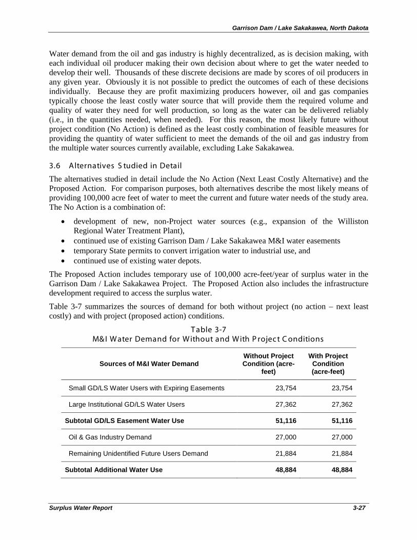
Garrison Dam / Lake Sakakawea, North Dakota
Surplus Water Report 3-27
Water demand from the oil and gas industry is highly decentralized, as is decision making, with each individual oil producer making their own decision about where to get the water needed to develop their well. Thousands of these discrete decisions are made by scores of oil producers in any given year. Obviously it is not possible to predict the outcomes of each of these decisions individually. Because they are profit maximizing producers however, oil and gas companies typically choose the least costly water source that will provide them the required volume and quality of water they need for well production, so long as the water can be delivered reliably (i.e., in the quantities needed, when needed). For this reason, the most likely future without project condition (No Action) is defined as the least costly combination of feasible measures for providing the quantity of water sufficient to meet the demands of the oil and gas industry from the multiple water sources currently available, excluding Lake Sakakawea.
3.6 Alternatives S tudied in Detail
The alternatives studied in detail include the No Action (Next Least Costly Alternative) and the Proposed Action. For comparison purposes, both alternatives describe the most likely means of providing 100,000 acre feet of water to meet the current and future water needs of the study area. The No Action is a combination of:
• development of new, non-Project water sources (e.g., expansion of the Williston Regional Water Treatment Plant),
• continued use of existing Garrison Dam / Lake Sakakawea M&I water easements • temporary State permits to convert irrigation water to industrial use, and • continued use of existing water depots.
The Proposed Action includes temporary use of 100,000 acre-feet/year of surplus water in the Garrison Dam / Lake Sakakawea Project. The Proposed Action also includes the infrastructure development required to access the surplus water.
Table 3-7 summarizes the sources of demand for both without project (no action – next least costly) and with project (proposed action) conditions.
T able 3-7 M& I Water Demand for Without and With P rojec t C onditions
Sources of M&I Water Demand Without Project Condition (acre-
feet)
With Project Condition (acre-feet)
Small GD/LS Water Users with Expiring Easements 23,754 23,754
Large Institutional GD/LS Water Users 27,362 27,362
Subtotal GD/LS Easement Water Use 51,116 51,116
Oil & Gas Industry Demand 27,000 27,000
Remaining Unidentified Future Users Demand 21,884 21,884
Subtotal Additional Water Use 48,884 48,884
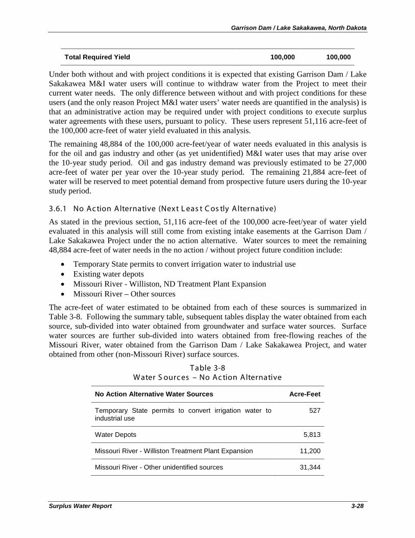
Garrison Dam / Lake Sakakawea, North Dakota
Surplus Water Report 3-28
Total Required Yield 100,000 100,000
Under both without and with project conditions it is expected that existing Garrison Dam / Lake Sakakawea M&I water users will continue to withdraw water from the Project to meet their current water needs. The only difference between without and with project conditions for these users (and the only reason Project M&I water users’ water needs are quantified in the analysis) is that an administrative action may be required under with project conditions to execute surplus water agreements with these users, pursuant to policy. These users represent 51,116 acre-feet of the 100,000 acre-feet of water yield evaluated in this analysis.
The remaining 48,884 of the 100,000 acre-feet/year of water needs evaluated in this analysis is for the oil and gas industry and other (as yet unidentified) M&I water uses that may arise over the 10-year study period. Oil and gas industry demand was previously estimated to be 27,000 acre-feet of water per year over the 10-year study period. The remaining 21,884 acre-feet of water will be reserved to meet potential demand from prospective future users during the 10-year study period.
3.6.1 No Ac tion Alternative (Next L eas t C os tly Alternative)
As stated in the previous section, 51,116 acre-feet of the 100,000 acre-feet/year of water yield evaluated in this analysis will still come from existing intake easements at the Garrison Dam / Lake Sakakawea Project under the no action alternative. Water sources to meet the remaining 48,884 acre-feet of water needs in the no action / without project future condition include:
• Temporary State permits to convert irrigation water to industrial use • Existing water depots • Missouri River - Williston, ND Treatment Plant Expansion • Missouri River – Other sources
The acre-feet of water estimated to be obtained from each of these sources is summarized in Table 3-8. Following the summary table, subsequent tables display the water obtained from each source, sub-divided into water obtained from groundwater and surface water sources. Surface water sources are further sub-divided into waters obtained from free-flowing reaches of the Missouri River, water obtained from the Garrison Dam / Lake Sakakawea Project, and water obtained from other (non-Missouri River) surface sources.
T able 3-8 Water S ourc es – No Ac tion Alternative
No Action Alternative Water Sources Acre-Feet
Temporary State permits to convert irrigation water to industrial use
527
Water Depots 5,813
Missouri River - Williston Treatment Plant Expansion 11,200
Missouri River - Other unidentified sources 31,344
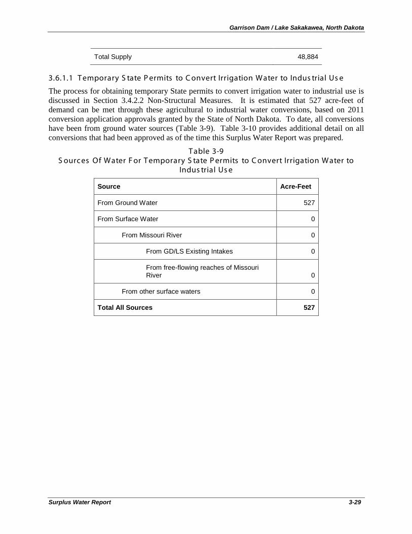
Garrison Dam / Lake Sakakawea, North Dakota
Surplus Water Report 3-29
Total Supply 48,884
3.6.1.1 T emporary S tate P ermits to C onvert Irrigation Water to Indus trial Us e
The process for obtaining temporary State permits to convert irrigation water to industrial use is discussed in Section 3.4.2.2 Non-Structural Measures. It is estimated that 527 acre-feet of demand can be met through these agricultural to industrial water conversions, based on 2011 conversion application approvals granted by the State of North Dakota. To date, all conversions have been from ground water sources (Table 3-9). Table 3-10 provides additional detail on all conversions that had been approved as of the time this Surplus Water Report was prepared.
T able 3-9 S ourc es Of Water F or T emporary S tate P ermits to C onvert Irrigation Water to
Indus trial Us e
Source Acre-Feet
From Ground Water 527
From Surface Water 0
From Missouri River 0
From GD/LS Existing Intakes 0
From free-flowing reaches of Missouri River 0
From other surface waters 0
Total All Sources 527
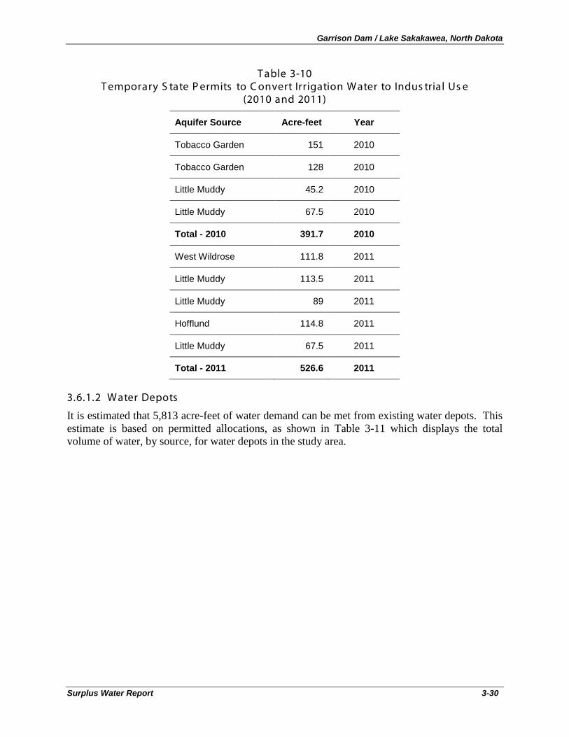
Garrison Dam / Lake Sakakawea, North Dakota
Surplus Water Report 3-30
T able 3-10 T emporary S tate P ermits to C onvert Irrigation Water to Indus trial Us e
(2010 and 2011)
Aquifer Source Acre-feet Year
Tobacco Garden 151 2010
Tobacco Garden 128 2010
Little Muddy 45.2 2010
Little Muddy 67.5 2010
Total - 2010 391.7 2010
West Wildrose 111.8 2011
Little Muddy 113.5 2011
Little Muddy 89 2011
Hofflund 114.8 2011
Little Muddy 67.5 2011
Total - 2011 526.6 2011
3.6.1.2 Water Depots
It is estimated that 5,813 acre-feet of water demand can be met from existing water depots. This estimate is based on permitted allocations, as shown in Table 3-11 which displays the total volume of water, by source, for water depots in the study area.
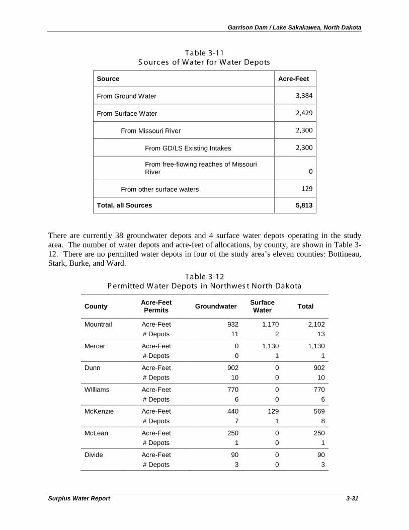
Garrison Dam / Lake Sakakawea, North Dakota
Surplus Water Report 3-31
T able 3-11 S ourc es of Water for Water Depots
Source Acre-Feet
From Ground Water 3,384
From Surface Water 2,429
From Missouri River 2,300
From GD/LS Existing Intakes 2,300
From free-flowing reaches of Missouri River 0
From other surface waters 129
Total, all Sources 5,813
There are currently 38 groundwater depots and 4 surface water depots operating in the study area. The number of water depots and acre-feet of allocations, by county, are shown in Table 3-12. There are no permitted water depots in four of the study area’s eleven counties: Bottineau, Stark, Burke, and Ward.
T able 3-12 P ermitted Water Depots in Northwes t North Dakota
County Acre-Feet Permits Groundwater Surface
Water Total
Mountrail Acre-Feet # Depots
932 11
1,170 2
2,102 13
Mercer Acre-Feet # Depots
0 0
1,130 1
1,130 1
Dunn Acre-Feet # Depots
902 10
0 0
902 10
Williams Acre-Feet # Depots
770 6
0 0
770 6
McKenzie Acre-Feet # Depots
440 7
129 1
569 8
McLean Acre-Feet # Depots
250 1
0 0
250 1
Divide Acre-Feet # Depots
90 3
0 0
90 3
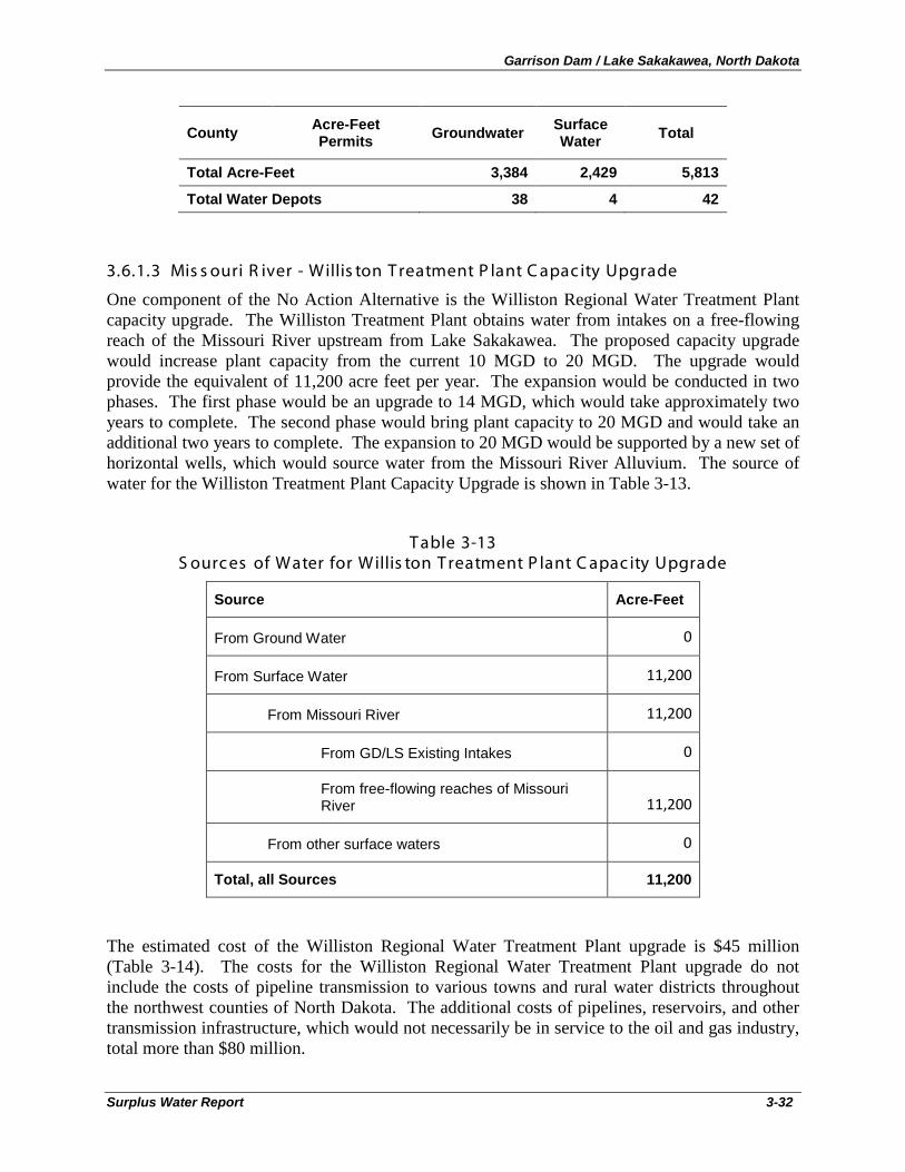
Garrison Dam / Lake Sakakawea, North Dakota
Surplus Water Report 3-32
County Acre-Feet Permits Groundwater Surface
Water Total
Total Acre-Feet 3,384 2,429 5,813
Total Water Depots 38 4 42
3.6.1.3 Mis s ouri R iver - Willis ton T reatment P lant C apac ity Upgrade
One component of the No Action Alternative is the Williston Regional Water Treatment Plant capacity upgrade. The Williston Treatment Plant obtains water from intakes on a free-flowing reach of the Missouri River upstream from Lake Sakakawea. The proposed capacity upgrade would increase plant capacity from the current 10 MGD to 20 MGD. The upgrade would provide the equivalent of 11,200 acre feet per year. The expansion would be conducted in two phases. The first phase would be an upgrade to 14 MGD, which would take approximately two years to complete. The second phase would bring plant capacity to 20 MGD and would take an additional two years to complete. The expansion to 20 MGD would be supported by a new set of horizontal wells, which would source water from the Missouri River Alluvium. The source of water for the Williston Treatment Plant Capacity Upgrade is shown in Table 3-13.
T able 3-13 S ourc es of Water for Willis ton T reatment P lant C apac ity Upgrade
Source Acre-Feet
From Ground Water 0
From Surface Water 11,200
From Missouri River 11,200
From GD/LS Existing Intakes 0
From free-flowing reaches of Missouri River 11,200
From other surface waters 0
Total, all Sources 11,200
The estimated cost of the Williston Regional Water Treatment Plant upgrade is $45 million (Table 3-14). The costs for the Williston Regional Water Treatment Plant upgrade do not include the costs of pipeline transmission to various towns and rural water districts throughout the northwest counties of North Dakota. The additional costs of pipelines, reservoirs, and other transmission infrastructure, which would not necessarily be in service to the oil and gas industry, total more than $80 million.
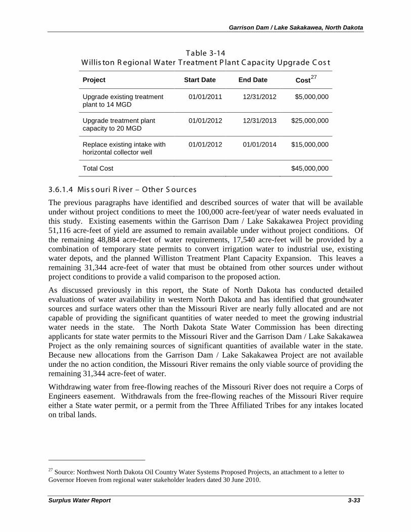
Garrison Dam / Lake Sakakawea, North Dakota
Surplus Water Report 3-33
T able 3-14 Willis ton R egional Water T reatment P lant C apac ity Upgrade C os t
Project Start Date End Date Cost27
Upgrade existing treatment plant to 14 MGD
01/01/2011 12/31/2012 $5,000,000
Upgrade treatment plant capacity to 20 MGD
01/01/2012 12/31/2013 $25,000,000
Replace existing intake with horizontal collector well
01/01/2012 01/01/2014 $15,000,000
Total Cost $45,000,000
3.6.1.4 Mis s ouri R iver – Other S ources
The previous paragraphs have identified and described sources of water that will be available under without project conditions to meet the 100,000 acre-feet/year of water needs evaluated in this study. Existing easements within the Garrison Dam / Lake Sakakawea Project providing 51,116 acre-feet of yield are assumed to remain available under without project conditions. Of the remaining 48,884 acre-feet of water requirements, 17,540 acre-feet will be provided by a combination of temporary state permits to convert irrigation water to industrial use, existing water depots, and the planned Williston Treatment Plant Capacity Expansion. This leaves a remaining 31,344 acre-feet of water that must be obtained from other sources under without project conditions to provide a valid comparison to the proposed action.
As discussed previously in this report, the State of North Dakota has conducted detailed evaluations of water availability in western North Dakota and has identified that groundwater sources and surface waters other than the Missouri River are nearly fully allocated and are not capable of providing the significant quantities of water needed to meet the growing industrial water needs in the state. The North Dakota State Water Commission has been directing applicants for state water permits to the Missouri River and the Garrison Dam / Lake Sakakawea Project as the only remaining sources of significant quantities of available water in the state. Because new allocations from the Garrison Dam / Lake Sakakawea Project are not available under the no action condition, the Missouri River remains the only viable source of providing the remaining 31,344 acre-feet of water.
Withdrawing water from free-flowing reaches of the Missouri River does not require a Corps of Engineers easement. Withdrawals from the free-flowing reaches of the Missouri River require either a State water permit, or a permit from the Three Affiliated Tribes for any intakes located on tribal lands.
27 Source: Northwest North Dakota Oil Country Water Systems Proposed Projects, an attachment to a letter to Governor Hoeven from regional water stakeholder leaders dated 30 June 2010.
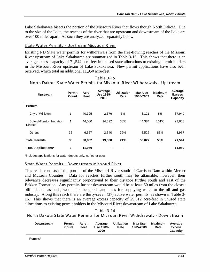
Garrison Dam / Lake Sakakawea, North Dakota
Surplus Water Report 3-34
Lake Sakakawea bisects the portion of the Missouri River that flows though North Dakota. Due to the size of the Lake, the reaches of the river that are upstream and downstream of the Lake are over 100 miles apart. As such they are analyzed separately below.
Existing ND State water permits for withdrawals from the free-flowing reaches of the Missouri River upstream of Lake Sakakawea are summarized in Table 3-15. This shows that there is an average excess capacity of 71,544 acre-feet in unused state allocations to existing permit holders in the Missouri River upstream of Lake Sakakawea. New permit applications have also been received, which total an additional 11,950 acre-feet.
S tate Water P ermits - Ups tream Mis s ouri R iver
T able 3-15 North Dakota S tate Water P ermits for Mis s ouri R iver Withdrawals - Ups tream
Upstream Permit Count
Acre-Feet
Average Use 1989-
2009 Utilization
Rate Max Use
1965-2009 Maximum
Rate Average Excess
Capacity
Permits
City of Williston 1 40,325 2,376 6% 3,121 8% 37,949
Buford-Trenton Irrigation District
1 44,000 14,392 33% 44,384 101% 29,608
Others 36 6,527 2,540 39% 5,522 85% 3,987
Total Permits 38 90,852 19,308 21% 53,027 58% 71,544
Total Applications* 3 11,950 - - - - 11,950
*Includes applications for water depots only, not other uses
This reach consists of the portion of the Missouri River south of Garrison Dam within Mercer and McLean Counties. Data for reaches further south may be attainable; however, their relevance decreases significantly proportional to their distance further south and east of the Bakken Formation. Any permits further downstream would be at least 50 miles from the closest oilfield, and as such, would not be good candidates for supplying water to the oil and gas industry. Along this reach there are thirty-seven (37) active water permits, as shown in Table 3-16. This shows that there is an average excess capacity of 29,612 acre-feet in unused state allocations to existing permit holders in the Missouri River downstream of Lake Sakakawea.
S tate Water P ermits - Downs tream Mis s ouri R iver
T able 3-16 North Dakota S tate Water P ermits for Mis s ouri R iver Withdrawals - Downs tream
Downstream Permit Count
Acre-Feet
Average Use 1989-
2009
Utilization Rate
Max Use 1965-2009
Maximum Rate
Average Excess
Capacity
Permits*
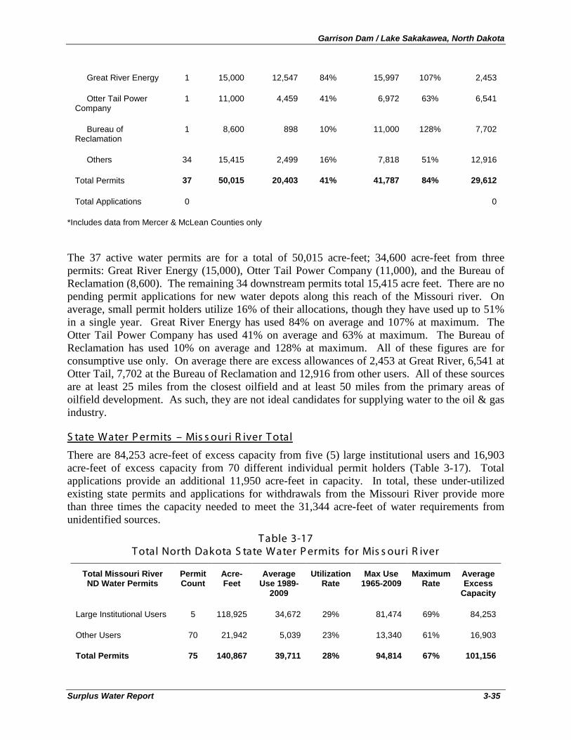
Garrison Dam / Lake Sakakawea, North Dakota
Surplus Water Report 3-35
Great River Energy 1 15,000 12,547 84% 15,997 107% 2,453
Otter Tail Power Company
1 11,000 4,459 41% 6,972 63% 6,541
Bureau of Reclamation
1 8,600 898 10% 11,000 128% 7,702
Others 34 15,415 2,499 16% 7,818 51% 12,916
Total Permits 37 50,015 20,403 41% 41,787 84% 29,612
Total Applications 0 0
*Includes data from Mercer & McLean Counties only
The 37 active water permits are for a total of 50,015 acre-feet; 34,600 acre-feet from three permits: Great River Energy (15,000), Otter Tail Power Company (11,000), and the Bureau of Reclamation (8,600). The remaining 34 downstream permits total 15,415 acre feet. There are no pending permit applications for new water depots along this reach of the Missouri river. On average, small permit holders utilize 16% of their allocations, though they have used up to 51% in a single year. Great River Energy has used 84% on average and 107% at maximum. The Otter Tail Power Company has used 41% on average and 63% at maximum. The Bureau of Reclamation has used 10% on average and 128% at maximum. All of these figures are for consumptive use only. On average there are excess allowances of 2,453 at Great River, 6,541 at Otter Tail, 7,702 at the Bureau of Reclamation and 12,916 from other users. All of these sources are at least 25 miles from the closest oilfield and at least 50 miles from the primary areas of oilfield development. As such, they are not ideal candidates for supplying water to the oil & gas industry.
There are 84,253 acre-feet of excess capacity from five (5) large institutional users and 16,903 acre-feet of excess capacity from 70 different individual permit holders (Table 3-17). Total applications provide an additional 11,950 acre-feet in capacity. In total, these under-utilized existing state permits and applications for withdrawals from the Missouri River provide more than three times the capacity needed to meet the 31,344 acre-feet of water requirements from unidentified sources.
S tate Water P ermits – Mis s ouri R iver T otal
T able 3-17 T otal North Dakota S tate Water P ermits for Mis s ouri R iver
Total Missouri River ND Water Permits
Permit Count
Acre-Feet
Average Use 1989-
2009
Utilization Rate
Max Use 1965-2009
Maximum Rate
Average Excess
Capacity
Large Institutional Users 5 118,925 34,672 29% 81,474 69% 84,253
Other Users 70 21,942 5,039 23% 13,340 61% 16,903
Total Permits 75 140,867 39,711 28% 94,814 67% 101,156
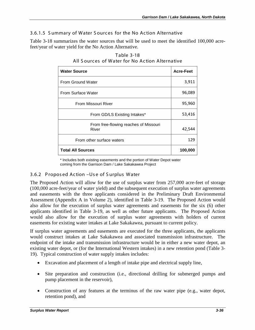
Garrison Dam / Lake Sakakawea, North Dakota
Surplus Water Report 3-36
3.6.1.5 S ummary of Water S ourc es for the No Ac tion Alternative
Table 3-18 summarizes the water sources that will be used to meet the identified 100,000 acre-feet/year of water yield for the No Action Alternative.
T able 3-18 All S ourc es of Water for No Ac tion Alternative
Water Source Acre-Feet
From Ground Water 3,911
From Surface Water 96,089
From Missouri River 95,960
From GD/LS Existing Intakes* 53,416
From free-flowing reaches of Missouri River 42,544
From other surface waters 129
Total All Sources 100,000
* Includes both existing easements and the portion of Water Depot water coming from the Garrison Dam / Lake Sakakawea Project
3.6.2 P ropos ed Ac tion –Us e of S urplus Water
The Proposed Action will allow for the use of surplus water from 257,000 acre-feet of storage (100,000 acre-feet/year of water yield) and the subsequent execution of surplus water agreements and easements with the three applicants considered in the Preliminary Draft Environmental Assessment (Appendix A in Volume 2), identified in Table 3-19. The Proposed Action would also allow for the execution of surplus water agreements and easements for the six (6) other applicants identified in Table 3-19, as well as other future applicants. The Proposed Action would also allow for the execution of surplus water agreements with holders of current easements for existing water intakes at Lake Sakakawea, pursuant to current policy.
If surplus water agreements and easements are executed for the three applicants, the applicants would construct intakes at Lake Sakakawea and associated transmission infrastructure. The endpoint of the intake and transmission infrastructure would be in either a new water depot, an existing water depot, or (for the International Western intakes) in a new retention pond (Table 3-19). Typical construction of water supply intakes includes:
• Excavation and placement of a length of intake pipe and electrical supply line,
• Site preparation and construction (i.e., directional drilling for submerged pumps and pump placement in the reservoir),
• Construction of any features at the terminus of the raw water pipe (e.g., water depot, retention pond), and
Garrison Dam / Lake Sakakawea, North Dakota
Surplus Water Report 3-37
• Re-establishing vegetation from ground-disturbing actions during the excavation and placement of pipe, utilities, intake, or pumps.
Typically, the proposed water depot site would consist of a 2-acre tract with a 24-foot roadway being constructed to each site for truck access.
From the water depot or retention pond, an 8" to 12" PVC pipe would be placed by typical surface excavation to approximately seven feet below grade from the terminus to approximately the high water mark of Lake Sakakawea (elevation 1854 msl). The length of this section of pipe would vary by intake from approximately 1,000 feet to more than five miles. Open trenching would typically be dug by tracked hoe, side casting the material, and backfilling in place when completed. Disturbances from the open trenching could consist of a 75-foot wide path from the high water mark to the terminus. To the extent feasible, the trenched water/utility line would be constructed adjacent to an existing utility or road corridor and all areas of soil disturbance would be stabilized and re-planted with native vegetation after construction.
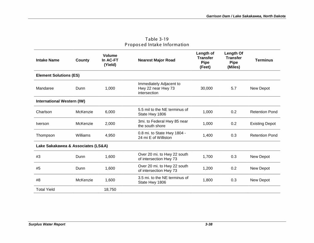
Garrison Dam / Lake Sakakawea, North Dakota
Surplus Water Report 3-38
T able 3-19
P ropos ed Intake Information
Intake Name County Volume In AC-FT (Yield)
Nearest Major Road
Length of Transfer
Pipe (Feet)
Length Of Transfer
Pipe (Miles)
Terminus
Element Solutions (ES)
Mandaree Dunn 1,000 Immediately Adjacent to Hwy 22 near Hwy 73 intersection
30,000 5.7 New Depot
International Western (IW)
Charlson McKenzie 6,000 5.5 mil to the NE terminus of State Hwy 1806 1,000 0.2 Retention Pond
Iverson McKenzie 2,000 3mi. to Federal Hwy 85 near the south shore 1,000 0.2 Existing Depot
Thompson Williams 4,950 0.8 mi. to State Hwy 1804 - 24 mi E of Williston 1,400 0.3 Retention Pond
Lake Sakakawea & Associates (LS&A)
#3 Dunn 1,600 Over 20 mi. to Hwy 22 south of intersection Hwy 73 1,700 0.3 New Depot
#5 Dunn 1,600 Over 20 mi. to Hwy 22 south of intersection Hwy 73 1,200 0.2 New Depot
#8 McKenzie 1,600 3.5 mi. to the NE terminus of State Hwy 1806 1,800 0.3 New Depot
Total Yield 18,750
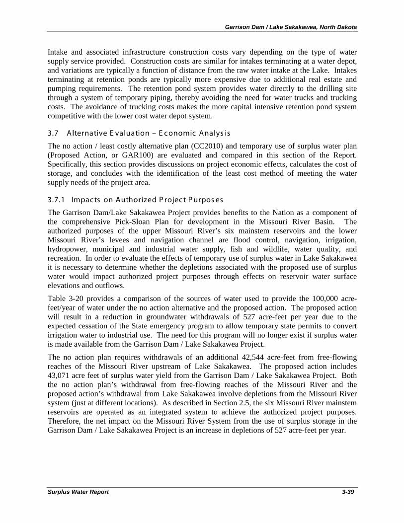
Garrison Dam / Lake Sakakawea, North Dakota
Surplus Water Report 3-39
Intake and associated infrastructure construction costs vary depending on the type of water supply service provided. Construction costs are similar for intakes terminating at a water depot, and variations are typically a function of distance from the raw water intake at the Lake. Intakes terminating at retention ponds are typically more expensive due to additional real estate and pumping requirements. The retention pond system provides water directly to the drilling site through a system of temporary piping, thereby avoiding the need for water trucks and trucking costs. The avoidance of trucking costs makes the more capital intensive retention pond system competitive with the lower cost water depot system.
3.7 Alternative E valuation – E c onomic Analys is
The no action / least costly alternative plan (CC2010) and temporary use of surplus water plan (Proposed Action, or GAR100) are evaluated and compared in this section of the Report. Specifically, this section provides discussions on project economic effects, calculates the cost of storage, and concludes with the identification of the least cost method of meeting the water supply needs of the project area.
3.7.1 Impac ts on Authorized P rojec t P urpos es
The Garrison Dam/Lake Sakakawea Project provides benefits to the Nation as a component of the comprehensive Pick-Sloan Plan for development in the Missouri River Basin. The authorized purposes of the upper Missouri River’s six mainstem reservoirs and the lower Missouri River’s levees and navigation channel are flood control, navigation, irrigation, hydropower, municipal and industrial water supply, fish and wildlife, water quality, and recreation. In order to evaluate the effects of temporary use of surplus water in Lake Sakakawea it is necessary to determine whether the depletions associated with the proposed use of surplus water would impact authorized project purposes through effects on reservoir water surface elevations and outflows.
Table 3-20 provides a comparison of the sources of water used to provide the 100,000 acre-feet/year of water under the no action alternative and the proposed action. The proposed action will result in a reduction in groundwater withdrawals of 527 acre-feet per year due to the expected cessation of the State emergency program to allow temporary state permits to convert irrigation water to industrial use. The need for this program will no longer exist if surplus water is made available from the Garrison Dam / Lake Sakakawea Project.
The no action plan requires withdrawals of an additional 42,544 acre-feet from free-flowing reaches of the Missouri River upstream of Lake Sakakawea. The proposed action includes 43,071 acre feet of surplus water yield from the Garrison Dam / Lake Sakakawea Project. Both the no action plan’s withdrawal from free-flowing reaches of the Missouri River and the proposed action’s withdrawal from Lake Sakakawea involve depletions from the Missouri River system (just at different locations). As described in Section 2.5, the six Missouri River mainstem reservoirs are operated as an integrated system to achieve the authorized project purposes. Therefore, the net impact on the Missouri River System from the use of surplus storage in the Garrison Dam / Lake Sakakawea Project is an increase in depletions of 527 acre-feet per year.
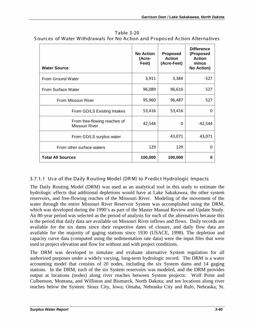
Garrison Dam / Lake Sakakawea, North Dakota
Surplus Water Report 3-40
T able 3-20 S ourc es of Water Withdrawals for No Ac tion and P ropos ed Ac tion Alternatives
Water Source
No Action (Acre-Feet)
Proposed Action
(Acre-Feet)
Difference (Proposed
Action minus
No Action)
From Ground Water 3,911 3,384 -527
From Surface Water 96,089 96,616 527
From Missouri River 95,960 96,487 527
From GD/LS Existing Intakes 53,416 53,416 0
From free-flowing reaches of Missouri River 42,544 0 -42,544
From GD/LS surplus water 43,071 43,071
From other surface waters 129 129 0
Total All Sources 100,000 100,000 0
3.7.1.1 Us e of the Daily R outing Model (DR M) to P redic t Hydrologic Impac ts
The Daily Routing Model (DRM) was used as an analytical tool in this study to estimate the hydrologic effects that additional depletions would have at Lake Sakakawea, the other system reservoirs, and free-flowing reaches of the Missouri River. Modeling of the movement of the water through the entire Missouri River Reservoir System was accomplished using the DRM, which was developed during the 1990’s as part of the Master Manual Review and Update Study. An 80-year period was selected as the period of analysis for each of the alternatives because this is the period that daily data are available on Missouri River inflows and flows. Daily records are available for the six dams since their respective dates of closure, and daily flow data are available for the majority of gaging stations since 1930 (USACE, 1998). The depletion and capacity curve data (computed using the sedimentation rate data) were the input files that were used to project elevation and flow for without and with project conditions.
The DRM was developed to simulate and evaluate alternative System regulation for all authorized purposes under a widely varying, long-term hydrologic record. The DRM is a water accounting model that consists of 20 nodes, including the six System dams and 14 gaging stations. In the DRM, each of the six System reservoirs was modeled, and the DRM provides output at locations (nodes) along river reaches between System projects: Wolf Point and Culbertson, Montana, and Williston and Bismarck, North Dakota; and ten locations along river reaches below the System: Sioux City, Iowa; Omaha, Nebraska City and Rulo, Nebraska; St.
Garrison Dam / Lake Sakakawea, North Dakota
Surplus Water Report 3-41
Joseph, Kansas City, Waverly, Boonville, and Hermann, Missouri on the Missouri River and St. Louis, Missouri on the Mississippi River.
The DRM performs a time-series analysis that simulates hydrologic output on a daily basis for each of the 80 years modeled from 1930 through 2009, assuming that the entire System was in place and fully operational for the full 80-year period. As the depletion and capacity curve data are varied between the evaluation years for this analysis (i.e., 2010 and 2020), the DRM computes System storage, reservoir elevation, reservoir release, reservoir evaporation, and river flow data for each day of the modeling period. Hydraulic impacts (changes to water surface elevations (WSE) in riverine reaches of the Missouri River) were estimated externally to the DRM model by combining DRM hydrologic output on streamflow with stage-discharge relationships provided at the DRM-modeled riverine nodes by the Omaha District (AECOM, 2010).
Each DRM run provides 29,220 simulated values (80 years of daily values) for each parameter (i.e., water surface elevation, reservoir volume, and streamflow) at the 20 locations/model nodes in the system. These data should not be considered as estimates of actual calendar day values, but rather as simulation output values under the full range of climatological conditions existing over the 80-year period. To evaluate differences between two alternatives, the differences between each of the 29,220 daily values were determined and then sorted to establish a frequency distribution of modeled values. The distributions of the differences from the current conditions (without the additional depletions) for various DRM outputs (water surface elevation, reservoir volume, and streamflow) were then examined. Comparing the data distributions in this manner provides insight as to how the increased depletion scenario impacts the likelihood of occurrence of a given water surface elevation, reservoir volume, and streamflow over the entire 80-year period. Similarly, it can provide an estimate of the likelihood of a given magnitude of change in each parameter between No Action and with project conditions.
To examine the effects of just the additional depletions directly from System reservoirs, the simulations for one study year (2010) were completed under three separate planning scenarios: 1) baseline depletions (without project current condition), 2) 527 acre-feet of depletions at Lake Sakakawea (with project condition), and 3) 50,527 acre-feet of depletions (including 527 acre-feet at Lake Sakakawea and 10,000 acre-feet each at the other five system reservoirs) to evaluate the cumulative effects of removing an additional 50,527 acre-feet of water from all six System reservoirs. The model assumes that the historic System inflow data, adjusted assuming the depletions associated with current development in the basin, occurred over the 80-year modeling period.
The source of the actual System inflow data is the U.S. Geological Survey, which began acquiring daily data beginning in late 1929. The DRM adjusts these inflow data by the difference for depletions that have been estimated to occur between each year and 2002. The Bureau of Reclamation provided the monthly depletions, and these monthly data were further separated to daily values for use in the DRM. Inflow and depletion data are available for each of the DRM modeling reaches (AECOM, 2010). The 2002 depletion data are assumed to remain constant through 2010 (assumes no change in system depletions from 2002 to 2010).
The required analyses were initially based on a comparison of the releases from four of the System dams (Fort Peck, Garrison, Oahe, and Gavins Point dams) and water surface elevations on the upper three, larger reservoirs (Fort Peck Lake, Lake Sakakawea, and Lake Oahe). Figures
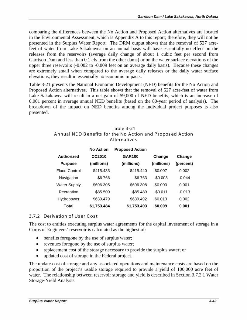
Garrison Dam / Lake Sakakawea, North Dakota
Surplus Water Report 3-42
comparing the differences between the No Action and Proposed Action alternatives are located in the Environmental Assessment, which is Appendix A to this report; therefore, they will not be presented in the Surplus Water Report. The DRM output shows that the removal of 527 acre-feet of water from Lake Sakakawea on an annual basis will have essentially no effect on the releases from the reservoirs (average daily change of about 1 cubic feet per second from Garrison Dam and less than 0.1 cfs from the other dams) or on the water surface elevations of the upper three reservoirs (-0.002 to -0.009 feet on an average daily basis). Because these changes are extremely small when compared to the average daily releases or the daily water surface elevations, they result in essentially no economic impacts.
Table 3-21 presents the National Economic Development (NED) benefits for the No Action and Proposed Action alternatives. This table shows that the removal of 527 acre-feet of water from Lake Sakakawea will result in a net gain of $9,000 of NED benefits, which is an increase of 0.001 percent in average annual NED benefits (based on the 80-year period of analysis). The breakdown of the impact on NED benefits among the individual project purposes is also presented.
T able 3-21 Annual NE D B enefits for the No Ac tion and P ropos ed Ac tion
Alternatives
No Action Proposed Action
Authorized CC2010 GAR100 Change Change
Purpose (millions) (millions) (millions) (percent)
Flood Control $415.433 $415.440 $0.007 0.002
Navigation $6.766 $6.763 -$0.003 -0.044
Water Supply $606.305 $606.308 $0.003 0.001
Recreation $85.500 $85.489 -$0.011 -0.013
Hydropower $639.479 $639.492 $0.013 0.002
Total $1,753.484 $1,753.493 $0.009 0.001
3.7.2 Derivation of Us er C os t
The cost to entities executing surplus water agreements for the capital investment of storage in a Corps of Engineers’ reservoir is calculated as the highest of:
• benefits foregone by the use of surplus water; • revenues foregone by the use of surplus water; • replacement cost of the storage necessary to provide the surplus water; or • updated cost of storage in the Federal project.
The update cost of storage and any associated operations and maintenance costs are based on the proportion of the project’s usable storage required to provide a yield of 100,000 acre feet of water. The relationship between reservoir storage and yield is described in Section 3.7.2.1 Water Storage-Yield Analysis.
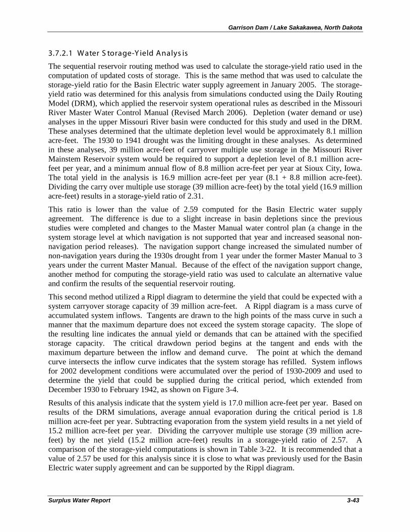
Garrison Dam / Lake Sakakawea, North Dakota
Surplus Water Report 3-43
3.7.2.1 Water S torage-Y ield Analys is
The sequential reservoir routing method was used to calculate the storage-yield ratio used in the computation of updated costs of storage. This is the same method that was used to calculate the storage-yield ratio for the Basin Electric water supply agreement in January 2005. The storage-yield ratio was determined for this analysis from simulations conducted using the Daily Routing Model (DRM), which applied the reservoir system operational rules as described in the Missouri River Master Water Control Manual (Revised March 2006). Depletion (water demand or use) analyses in the upper Missouri River basin were conducted for this study and used in the DRM. These analyses determined that the ultimate depletion level would be approximately 8.1 million acre-feet. The 1930 to 1941 drought was the limiting drought in these analyses. As determined in these analyses, 39 million acre-feet of carryover multiple use storage in the Missouri River Mainstem Reservoir system would be required to support a depletion level of 8.1 million acre-feet per year, and a minimum annual flow of 8.8 million acre-feet per year at Sioux City, Iowa. The total yield in the analysis is 16.9 million acre-feet per year (8.1 + 8.8 million acre-feet). Dividing the carry over multiple use storage (39 million acre-feet) by the total yield (16.9 million acre-feet) results in a storage-yield ratio of 2.31.
This ratio is lower than the value of 2.59 computed for the Basin Electric water supply agreement. The difference is due to a slight increase in basin depletions since the previous studies were completed and changes to the Master Manual water control plan (a change in the system storage level at which navigation is not supported that year and increased seasonal non-navigation period releases). The navigation support change increased the simulated number of non-navigation years during the 1930s drought from 1 year under the former Master Manual to 3 years under the current Master Manual. Because of the effect of the navigation support change, another method for computing the storage-yield ratio was used to calculate an alternative value and confirm the results of the sequential reservoir routing.
This second method utilized a Rippl diagram to determine the yield that could be expected with a system carryover storage capacity of 39 million acre-feet. A Rippl diagram is a mass curve of accumulated system inflows. Tangents are drawn to the high points of the mass curve in such a manner that the maximum departure does not exceed the system storage capacity. The slope of the resulting line indicates the annual yield or demands that can be attained with the specified storage capacity. The critical drawdown period begins at the tangent and ends with the maximum departure between the inflow and demand curve. The point at which the demand curve intersects the inflow curve indicates that the system storage has refilled. System inflows for 2002 development conditions were accumulated over the period of 1930-2009 and used to determine the yield that could be supplied during the critical period, which extended from December 1930 to February 1942, as shown on Figure 3-4.
Results of this analysis indicate that the system yield is 17.0 million acre-feet per year. Based on results of the DRM simulations, average annual evaporation during the critical period is 1.8 million acre-feet per year. Subtracting evaporation from the system yield results in a net yield of 15.2 million acre-feet per year. Dividing the carryover multiple use storage (39 million acre-feet) by the net yield (15.2 million acre-feet) results in a storage-yield ratio of 2.57. A comparison of the storage-yield computations is shown in Table 3-22. It is recommended that a value of 2.57 be used for this analysis since it is close to what was previously used for the Basin Electric water supply agreement and can be supported by the Rippl diagram.
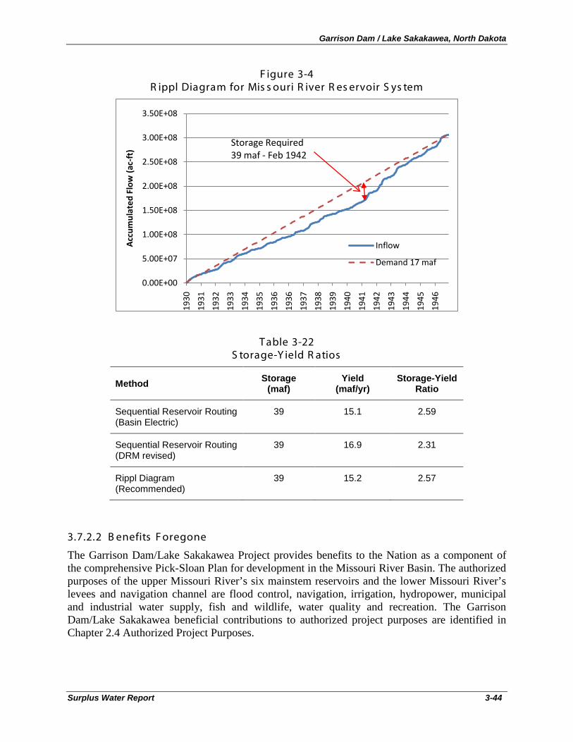
Garrison Dam / Lake Sakakawea, North Dakota
Surplus Water Report 3-44
F igure 3-4 R ippl Diagram for Mis s ouri R iver R es ervoir S ys tem
T able 3-22 S torage-Y ield R atios
Method Storage (maf)
Yield (maf/yr)
Storage-Yield Ratio
Sequential Reservoir Routing (Basin Electric)
39 15.1 2.59
Sequential Reservoir Routing (DRM revised)
39 16.9 2.31
Rippl Diagram (Recommended)
39 15.2 2.57
3.7.2.2 B enefits F oregone
The Garrison Dam/Lake Sakakawea Project provides benefits to the Nation as a component of the comprehensive Pick-Sloan Plan for development in the Missouri River Basin. The authorized purposes of the upper Missouri River’s six mainstem reservoirs and the lower Missouri River’s levees and navigation channel are flood control, navigation, irrigation, hydropower, municipal and industrial water supply, fish and wildlife, water quality and recreation. The Garrison Dam/Lake Sakakawea beneficial contributions to authorized project purposes are identified in Chapter 2.4 Authorized Project Purposes.
0.00E+00
5.00E+07
1.00E+08
1.50E+08
2.00E+08
2.50E+08
3.00E+08
3.50E+08
1930
1931
1932
1933
1934
1935
1936
1936
1937
1938
1939
1940
1941
1942
1943
1944
1945
1946
Acc
umul
ated
Flo
w (a
c-ft
)
Inflow
Demand 17 maf
Storage Required39 maf - Feb 1942
Garrison Dam / Lake Sakakawea, North Dakota
Surplus Water Report 3-45
Chapter 3.7.1 Impacts to Other Project Purposes identifies that use of 527 acre-feet of surplus water from the sediment pool portion of the carryover multiple use zone of Lake Sakakawea would result in a positive NED impact to authorized project purposes of $0.009 million per year.
Based on the 100,000 acre-feet/year of water yield for potential surplus water agreements (net change of 527 acre feet in System depletions) and the yield ratio of 2.57, 257,000 acre-feet of storage would be required for the proposed action. Because there is no net loss of NED benefits for the proposed action, the benefits foregone per acre-foot of storage would be $0.00.
3.7.2.3 R evenues F oregone
Revenues foregone are defined as the reduction in revenues accruing to the U.S. Treasury based upon any existing payment agreements related to the project. Revenues foregone to hydropower would be based upon the projected reduction in hydropower output due to depletions associated with the use of surplus water or modified release schedule. Hydropower generated at Garrison Dam is marketed through the Western Area Power Administration (Western), which is a Federal agency under the Department of Energy. Revenues from the sale of hydropower generated at the Garrison Dam are paid to the U.S. Treasury to recover the Federal investment in the power generating facilities (with interest) and other costs assigned to power for repayment, such as aid to irrigation development (Western Area Power Administration, Annual Report, 2009).
Western provided a spreadsheet for this analysis with its most recent economic values for what it pays on an average monthly basis for power it purchases to meet its firm commitments to its customers, and a corresponding value for the revenue it receives for the power marketed in excess of its firm commitments. The net difference in energy revenues for the 527 acre-feet of water to be removed on a temporary basis from Lake Sakakawea is $0.010 million. Using the 257,000 acre-feet of required storage for the 100,000 acre-feet/year, the corresponding value per acre-foot of storage is $0.010 million divided by 257,000 acre-feet, or $0.04 for the proposed action.
3.7.2.4 R eplac ement C os ts
Since there is storage space in Lake Sakakawea that is currently not being used to store sediment inflows that will enter in years to come, there is no need to provide replacement storage for the 257,000 acre-feet of storage space that will be needed from the carryover multiple use zone of the reservoir. Therefore, there are no replacement costs required for the proposed action.
3.7.2.5 Updated C os t of S torage
The surplus water identified for M&I use is surplus located within the sediment pool portion of the carryover multiple use zone of Lake Sakakawea. This zone of the reservoir is designed to serve all project purposes, though at reduced levels, through a severe drought like that of the 1930's. The updated cost of storage is calculated based on available capacity within all four system zones: permanent pool, carryover multiple use, annual flood control & multiple use, and exclusive flood control. In a permanent reallocation, the portion of the permanent pool assigned to sediment storage would be excluded from the available capacity in computing the updated cost of storage. However, for a surplus water study, it is appropriate to include this capacity if evaluation of sediment surveys indicate that the portion of the zone assigned to sediment storage will not be full during the 10-year study period.
Garrison Dam / Lake Sakakawea, North Dakota
Surplus Water Report 3-46
Sediment surveys are conducted periodically for each of the six reservoirs comprising the Missouri River system. As these surveys are completed, the sedimentation rates are available for various studies, including the system modeling. When sediments accumulate in each reservoir, the amount of storage available at a given water surface elevation diminishes. The water surface elevation versus storage volume capacity relationship in the system model is updated following the sediment survey of each reservoir.
The last two sediment surveys indicate that there is sufficient capacity within the carryover multiple use zone of Lake Sakakawea to provide 257,000 acre-feet of surplus water storage over the 10-year planning period. Sediment storage is an purpose of the project, so M&I use of the water identified as surplus to that purpose clearly fits within the existing policies for surplus water and is considered to be within the existing usable storage that can be used.
The 2009 – 2010 Annual Operating Plan (AOP) presents the storage allocations and capacities based on the latest available storage data
Us able S torage C alculations
28
T able 3-23 Us able S torage C alculations (ac re-feet)
. Surplus water would be obtained from the sediment storage portion of the carryover multiple use zone. Usable storage includes the exclusive flood control pool, the flood control and multiple use zone, the carryover multiple use zone, and the permanent pool (Table 3-23). Total usable storage is 23,821,000 acre-feet. The surplus water needs of 100,000 acre feet of yield requires 257,000 acre-feet of storage, which is 1.079% of total usable storage (257,000/23,821,000 = 1.079%)
Exclusive Flood Control 1,489,000
Flood Control & Multiple Use 4,222,000
Carryover Multiple Use 13,130,000
Permanent 4,980,000
Total 23,821,000
Net System Yield 15,200,000
Required Storage to Provide Surplus Water Yield of 100,000 acre-feet
257,000
Proportion of Usable Storage 1.079%
Construction costs were updated using the Engineering News Record (ENR) construction cost index and the Corps of Engineers Civil Works Construction Cost Index System (CWCCIS) as
Updated C ons truc tion C os t C alc ulations
28 See note 6 of Plate 2, AOP
Garrison Dam / Lake Sakakawea, North Dakota
Surplus Water Report 3-47
identified in EM 1110-2-1304, revised 31 March 2010. The value of lands is updated by the weighted average update of all other project features, as per the Water Supply Handbook, revised IWR Report 96-PS-4, December 1998. Since the CWCCIS dates back only to 1967, the ENR construction cost index was used to update project costs to 1967. The ENR construction cost index values are presented in the Water Supply Handbook.
The costs to be assigned to surplus M&I water use include joint use costs and are exclusive of specific costs. Examples of specific costs excluded from the updated cost of storage include the specific construction costs of:
• Recreation facilities; • Flood control outlet works; • Power intake works; • Powerhouse; • Turbines; and • Generators.
The period of expenditure for each project feature is 1946 – 1953 (mid-point 1949) as identified in the 2009 – 2010 AOP. Table 3-24 shows the cost update calculations from the mid-point of expenditures (1949) to 1967, using the ENR construction cost index. Note that interest during construction is not included in this updating procedure. Table 3-25 shows the cost update calculations from 1967 to the first quarter of Fiscal Year 2011 using the CWCCIS, revised 31 March 2010. Note that the cost of lands and damages (Table 3-26) are updated based on the ratio of total FY11 updated costs (excluding lands and damages) to the total original 1949 costs (excluding lands and damages), as per the Water Supply Handbook (page 4-10).
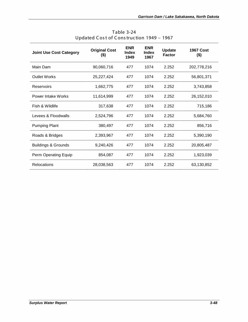
Garrison Dam / Lake Sakakawea, North Dakota
Surplus Water Report 3-48
T able 3-24 Updated C os t of C ons truc tion 1949 – 1967
Joint Use Cost Category Original Cost ($)
ENR Index 1949
ENR Index 1967
Update Factor
1967 Cost ($)
Main Dam 90,060,716 477 1074 2.252 202,778,216
Outlet Works 25,227,424 477 1074 2.252 56,801,371
Reservoirs 1,662,775 477 1074 2.252 3,743,858
Power Intake Works 11,614,999 477 1074 2.252 26,152,010
Fish & Wildlife 317,638 477 1074 2.252 715,186
Levees & Floodwalls 2,524,796 477 1074 2.252 5,684,760
Pumping Plant 380,497 477 1074 2.252 856,716
Roads & Bridges 2,393,967 477 1074 2.252 5,390,190
Buildings & Grounds 9,240,426 477 1074 2.252 20,805,487
Perm Operating Equip 854,087 477 1074 2.252 1,923,039
Relocations 28,038,563 477 1074 2.252 63,130,852
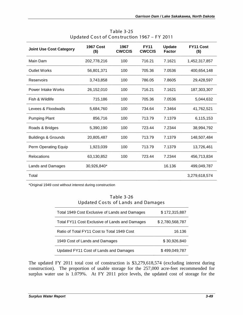
Garrison Dam / Lake Sakakawea, North Dakota
Surplus Water Report 3-49
T able 3-25 Updated C os t of C ons truc tion 1967 – F Y 2011
Joint Use Cost Category 1967 Cost ($)
1967 CWCCIS
FY11 CWCCIS
Update Factor
FY11 Cost ($)
Main Dam 202,778,216 100 716.21 7.1621 1,452,317,857
Outlet Works 56,801,371 100 705.36 7.0536 400,654,148
Reservoirs 3,743,858 100 786.05 7.8605 29,428,597
Power Intake Works 26,152,010 100 716.21 7.1621 187,303,307
Fish & Wildlife 715,186 100 705.36 7.0536 5,044,632
Levees & Floodwalls 5,684,760 100 734.64 7.3464 41,762,521
Pumping Plant 856,716 100 713.79 7.1379 6,115,153
Roads & Bridges 5,390,190 100 723.44 7.2344 38,994,792
Buildings & Grounds 20,805,487 100 713.79 7.1379 148,507,484
Perm Operating Equip 1,923,039 100 713.79 7.1379 13,726,461
Relocations 63,130,852 100 723.44 7.2344 456,713,834
Lands and Damages 30,926,840* 16.136 499,049,787
Total 3,279,618,574
*Original 1949 cost without interest during construction
T able 3-26 Updated C os ts of L ands and Damages
Total 1949 Cost Exclusive of Lands and Damages $ 172,315,887
Total FY11 Cost Exclusive of Lands and Damages $ 2,780,568,787
Ratio of Total FY11 Cost to Total 1949 Cost 16.136
1949 Cost of Lands and Damages $ 30,926,840
Updated FY11 Cost of Lands and Damages $ 499,049,787
The updated FY 2011 total cost of construction is $3,279,618,574 (excluding interest during construction). The proportion of usable storage for the 257,000 acre-feet recommended for surplus water use is 1.079%. At FY 2011 price levels, the updated cost of storage for the
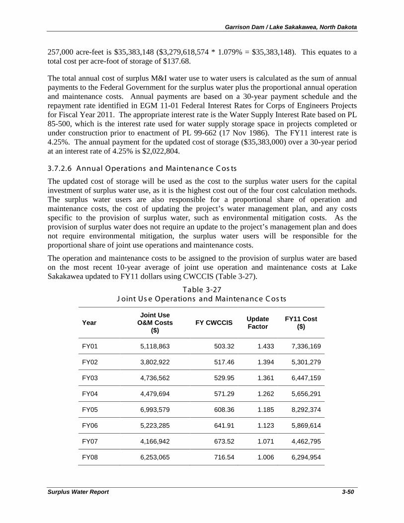
Garrison Dam / Lake Sakakawea, North Dakota
Surplus Water Report 3-50
257,000 acre-feet is $35,383,148 ($3,279,618,574 * 1.079% = $35,383,148). This equates to a total cost per acre-foot of storage of $137.68.
The total annual cost of surplus M&I water use to water users is calculated as the sum of annual payments to the Federal Government for the surplus water plus the proportional annual operation and maintenance costs. Annual payments are based on a 30-year payment schedule and the repayment rate identified in EGM 11-01 Federal Interest Rates for Corps of Engineers Projects for Fiscal Year 2011. The appropriate interest rate is the Water Supply Interest Rate based on PL 85-500, which is the interest rate used for water supply storage space in projects completed or under construction prior to enactment of PL 99-662 (17 Nov 1986). The FY11 interest rate is 4.25%. The annual payment for the updated cost of storage ($35,383,000) over a 30-year period at an interest rate of 4.25% is $2,022,804.
3.7.2.6 Annual Operations and Maintenanc e C os ts
The updated cost of storage will be used as the cost to the surplus water users for the capital investment of surplus water use, as it is the highest cost out of the four cost calculation methods. The surplus water users are also responsible for a proportional share of operation and maintenance costs, the cost of updating the project’s water management plan, and any costs specific to the provision of surplus water, such as environmental mitigation costs. As the provision of surplus water does not require an update to the project’s management plan and does not require environmental mitigation, the surplus water users will be responsible for the proportional share of joint use operations and maintenance costs.
The operation and maintenance costs to be assigned to the provision of surplus water are based on the most recent 10-year average of joint use operation and maintenance costs at Lake Sakakawea updated to FY11 dollars using CWCCIS (Table 3-27).
T able 3-27 J oint Us e Operations and Maintenance C os ts
Year Joint Use
O&M Costs ($)
FY CWCCIS Update Factor
FY11 Cost ($)
FY01 5,118,863 503.32 1.433 7,336,169
FY02 3,802,922 517.46 1.394 5,301,279
FY03 4,736,562 529.95 1.361 6,447,159
FY04 4,479,694 571.29 1.262 5,656,291
FY05 6,993,579 608.36 1.185 8,292,374
FY06 5,223,285 641.91 1.123 5,869,614
FY07 4,166,942 673.52 1.071 4,462,795
FY08 6,253,065 716.54 1.006 6,294,954
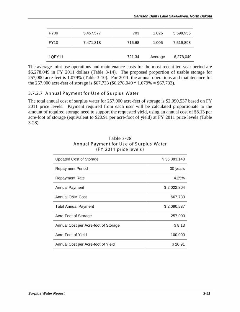
Garrison Dam / Lake Sakakawea, North Dakota
Surplus Water Report 3-51
FY09 5,457,577 703 1.026 5,599,955
FY10 7,471,318 716.68 1.006 7,519,898
1QFY11 721.34 Average 6,278,049
The average joint use operations and maintenance costs for the most recent ten-year period are $6,278,049 in FY 2011 dollars (Table 3-14). The proposed proportion of usable storage for 257,000 acre-feet is 1.079% (Table 3-10). For 2011, the annual operations and maintenance for the 257,000 acre-feet of storage is $67,733 ($6,278,049 * 1.079% = $67,733).
3.7.2.7 Annual P ayment for Us e of S urplus Water
The total annual cost of surplus water for 257,000 acre-feet of storage is $2,090,537 based on FY 2011 price levels. Payment required from each user will be calculated proportionate to the amount of required storage need to support the requested yield, using an annual cost of $8.13 per acre-foot of storage (equivalent to $20.91 per acre-foot of yield) at FY 2011 price levels (Table 3-28).
T able 3-28 Annual P ayment for Us e of S urplus Water
(F Y 2011 price levels )
Updated Cost of Storage $ 35,383,148
Repayment Period 30 years
Repayment Rate 4.25%
Annual Payment $ 2,022,804
Annual O&M Cost $67,733
Total Annual Payment $ 2,090,537
Acre-Feet of Storage 257,000
Annual Cost per Acre-foot of Storage $ 8.13
Acre-Feet of Yield 100,000
Annual Cost per Acre-foot of Yield $ 20.91
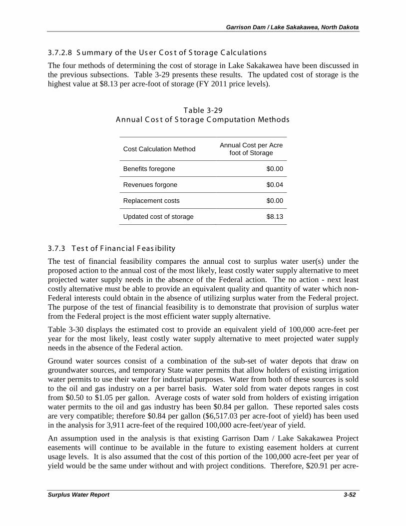
Garrison Dam / Lake Sakakawea, North Dakota
Surplus Water Report 3-52
3.7.2.8 S ummary of the Us er C os t of S torage C alculations
The four methods of determining the cost of storage in Lake Sakakawea have been discussed in the previous subsections. Table 3-29 presents these results. The updated cost of storage is the highest value at $8.13 per acre-foot of storage (FY 2011 price levels).
T able 3-29 Annual C os t of S torage C omputation Methods
Cost Calculation Method Annual Cost per Acre foot of Storage
Benefits foregone $0.00
Revenues forgone $0.04
Replacement costs $0.00
Updated cost of storage $8.13
3.7.3 T es t of F inanc ial F eas ibility
The test of financial feasibility compares the annual cost to surplus water user(s) under the proposed action to the annual cost of the most likely, least costly water supply alternative to meet projected water supply needs in the absence of the Federal action. The no action - next least costly alternative must be able to provide an equivalent quality and quantity of water which non-Federal interests could obtain in the absence of utilizing surplus water from the Federal project. The purpose of the test of financial feasibility is to demonstrate that provision of surplus water from the Federal project is the most efficient water supply alternative.
Table 3-30 displays the estimated cost to provide an equivalent yield of 100,000 acre-feet per year for the most likely, least costly water supply alternative to meet projected water supply needs in the absence of the Federal action.
Ground water sources consist of a combination of the sub-set of water depots that draw on groundwater sources, and temporary State water permits that allow holders of existing irrigation water permits to use their water for industrial purposes. Water from both of these sources is sold to the oil and gas industry on a per barrel basis. Water sold from water depots ranges in cost from $0.50 to $1.05 per gallon. Average costs of water sold from holders of existing irrigation water permits to the oil and gas industry has been $0.84 per gallon. These reported sales costs are very compatible; therefore $0.84 per gallon ($6,517.03 per acre-foot of yield) has been used in the analysis for 3,911 acre-feet of the required 100,000 acre-feet/year of yield.
An assumption used in the analysis is that existing Garrison Dam / Lake Sakakawea Project easements will continue to be available in the future to existing easement holders at current usage levels. It is also assumed that the cost of this portion of the 100,000 acre-feet per year of yield would be the same under without and with project conditions. Therefore, $20.91 per acre-
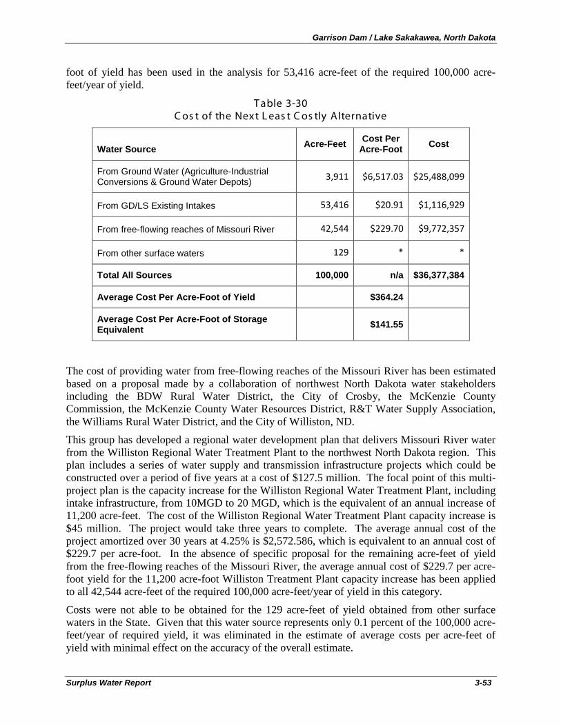
Garrison Dam / Lake Sakakawea, North Dakota
Surplus Water Report 3-53
foot of yield has been used in the analysis for 53,416 acre-feet of the required 100,000 acre-feet/year of yield.
T able 3-30 C os t of the Next L eas t C os tly Alternative
Water Source Acre-Feet Cost Per Acre-Foot Cost
From Ground Water (Agriculture-Industrial Conversions & Ground Water Depots) 3,911 $6,517.03 $25,488,099
From GD/LS Existing Intakes 53,416 $20.91 $1,116,929
From free-flowing reaches of Missouri River 42,544 $229.70 $9,772,357
From other surface waters 129 * *
Total All Sources 100,000 n/a $36,377,384
Average Cost Per Acre-Foot of Yield $364.24
Average Cost Per Acre-Foot of Storage Equivalent $141.55
The cost of providing water from free-flowing reaches of the Missouri River has been estimated based on a proposal made by a collaboration of northwest North Dakota water stakeholders including the BDW Rural Water District, the City of Crosby, the McKenzie County Commission, the McKenzie County Water Resources District, R&T Water Supply Association, the Williams Rural Water District, and the City of Williston, ND.
This group has developed a regional water development plan that delivers Missouri River water from the Williston Regional Water Treatment Plant to the northwest North Dakota region. This plan includes a series of water supply and transmission infrastructure projects which could be constructed over a period of five years at a cost of $127.5 million. The focal point of this multi-project plan is the capacity increase for the Williston Regional Water Treatment Plant, including intake infrastructure, from 10MGD to 20 MGD, which is the equivalent of an annual increase of 11,200 acre-feet. The cost of the Williston Regional Water Treatment Plant capacity increase is $45 million. The project would take three years to complete. The average annual cost of the project amortized over 30 years at 4.25% is $2,572.586, which is equivalent to an annual cost of $229.7 per acre-foot. In the absence of specific proposal for the remaining acre-feet of yield from the free-flowing reaches of the Missouri River, the average annual cost of $229.7 per acre-foot yield for the 11,200 acre-foot Williston Treatment Plant capacity increase has been applied to all 42,544 acre-feet of the required 100,000 acre-feet/year of yield in this category.
Costs were not able to be obtained for the 129 acre-feet of yield obtained from other surface waters in the State. Given that this water source represents only 0.1 percent of the 100,000 acre-feet/year of required yield, it was eliminated in the estimate of average costs per acre-feet of yield with minimal effect on the accuracy of the overall estimate.
Garrison Dam / Lake Sakakawea, North Dakota
Surplus Water Report 3-54
The weighted average of all of these sources results in an average cost per acre-foot of yield of $364.24. This was converted to an equivalent average cost per acre-foot of storage of $141.55 per acre-foot using the storage-yield ratio of 2.57 to allow for a valid comparison to the cost of the proposed action.
The average annual cost of surplus water from 257,000 acre-feet of storage in the Garrison Dam / Lake Sakakawea Project (required to provide 100,000 acre-feet/year of yield) is based on the updated cost of storage method and is $2,090,537, which is $8.13 per acre-foot of storage (equivalent to $20.91 per acre-foot of yield) (FY 2011 price levels). The test of financial feasibility, comparing the cost of the next least costly alternative ($141.55 per acre-foot of storage) to the cost of the proposed action ($8.13 per acre-foot of storage), clearly demonstrates that temporary provision of surplus water from the Garrison Dam / Lake Sakakawea Project is the most efficient water supply alternative.
3.8 E nvironmental C ons iderations
Because of the small magnitude of the predicted changes to discharges and water surface elevations of Lake Sakakawea, the remaining five System reservoirs, and the riverine reaches of the Upper Missouri River as a result of the Proposed Action, the following environmental resources (as discussed in Section 5.3 of the accompanying Environmental Assessment (Volume 2)) would not be expected to have any measurable change over the existing condition: soils, groundwater, water quality (including cold water habitat), air quality, demographics, socioeconomics, environmental justice, recreation, aesthetics, noise, cultural resources, vegetation and protected plants, fish and wildlife and protected animals. In addition, there would be no effects to project purposes anticipated (Section 3.7.1 Impacts on Project Purposes).
The Draft Environmental Assessment (Appendix A in Volume 2) identifies localized and temporary construction-related effects (noise, dust, minor earth-moving), which would be expected during construction at the new intake sites. Significant environmental and cultural resources of Lake Sakakawea would be avoided with good planning and continued coordination with resource agencies as designs are finalized. No significant effects would be expected in association with intake, transfer pipe, or depot/retention pond construction and operation. An increase in localized truck traffic (on access roads) would be expected leading to/from new water depots; however, there would likely be a cumulative beneficial effect from the concomitant decrease in total truck miles traveled for the water supply aspect of the oil/gas industry as a whole.
The expected environmental consequences of providing 100,000 acre-feet/year of surplus water from 257,000 acre-feet of storage (the Proposed Action) would not be expected to be significant and would not require the preparation of an Environmental Impact Statement.
Garrison Dam / Lake Sakakawea, North Dakota
Surplus Water Report 4-1
4. PLAN IMPLEMENTATION
4.1 P arties to S urplus Water Agreements
In accordance with ER 1105-2-100 (22 April 2000), the cost allocated to the surplus water user, i.e., the price to be charged for the capital investment for the storage required to provide the surplus water, will normally be established as the highest of the benefits or revenues foregone, the replacement cost, or the updated cost of storage in the federal project. As identified in Table 3-29 above, the costs to be assigned to M&I water supply storage are calculated as the updated cost of storage.
The repayment rate used to calculate annual payment for storage is the yield rate defined in Section 932 of the Water Resources Development Act of 1986. EGM 11-01 Federal Interest Rates for Corps of Engineers Projects for Fiscal Year 2011 identifies the appropriate interest rate as 4.25%. Payment amounts are recalculated based upon appropriate interest rate for the year an agreement or renewal is signed. The annual payment for the updated cost of storage is calculated over a 30-year period. The duration of the surplus water agreement shall be for a period not to exceed five (5) years. Upon expiration, the agreement may be extended for an additional period not to exceed five (5) years. Extensions shall be subject to recalculation of reimbursement. A surplus water agreement does not imply a permanent right to utilize the storage space.
4.2 Agenc y C oordination
Letters to each of the 29 tribes in the basin were sent on 24 August 2010 informing them of the Omaha District’s intent to prepare the Surplus Water Report and requesting their review once the draft Report had been completed. An Omaha District representative also made a presentation on the study at the Tribal Programmatic Agreement meeting in Pierre, SD on 18 November 2010.
Letters to the Governors of each of the affected States in the basin, and to State and Federal agencies within North Dakota, were sent on 21 September 2010 informing them of the Omaha District’s intent to prepare the Surplus Water Report and requesting their review once the draft Report had been completed.
On 29 September 2010, the Corps of Engineers hosted an Agency Coordination Meeting at the North Dakota State Water Commission’s- offices in Bismarck, ND. The purpose of the meeting was two-fold: to share information between the Corps of Engineers and the state/federal agencies and to receive input from the respective agencies regarding their concerns. The meeting was held to ensure transparency and understanding of current Corps of Engineers Surplus Water Supply Studies that are currently under way, with specific focus on Lake Sakakawea. Agencies and individuals that were in attendance include:
• U.S. Army Corps of Engineers-Omaha District;
• U.S. Army Corps of Engineers-Regulatory Office;
• U.S. Department of the Interior-Bureau of Reclamation;
• N.D. Department of Agriculture;
• N.D. Industrial Commission-Mineral Resources-Oil &Gas Division;
• N.D. State Water Commission;
Garrison Dam / Lake Sakakawea, North Dakota
Surplus Water Report 4-2
• N.D. State Historic Preservation Office;
• N.D. Game & Fish Department;
• N.D. Governor’s Office;
• N.D. Parks and Recreation Division; and
• S.D. Department of Environment and Natural Resources.
Garrison Dam / Lake Sakakawea, North Dakota
Surplus Water Report 5-1
5. CONCLUSIONS The purpose of the Garrison Dam / Lake Sakakawea, ND, Surplus Water Report is to identify and quantify whether surplus water is available in the Project, as defined in Section 6 of the 1944 Flood Control Act that the Secretary of the Army can use to execute surplus water supply agreements with water users, and to determine whether use of surplus water is the most efficient method for meeting regional municipal and industrial (M&I) water needs.
This Surplus Water Report and attached Environmental Assessment investigate the engineering and economic feasibility and environmental effects of providing surplus water from 257,000 acre-feet of storage (equivalent to 100,000 acre-feet/year of water yield) from the sediment portion of the carryover multiple use zone of the Garrison Dam / Lake Sakakawea Project to meet existing and projected near-term municipal and industrial (M&I) water supply needs in the region.
This report:
• identifies temporary surplus water in the Garrison Dam / Lake Sakakawea Project associated with storage originally planned for mainstem system irrigation that has not yet developed to its original capacity as well as available storage within the sediment storage area of the carryover multiple use zone;establishes the need for additional water supply in Northwest North Dakota based on increased industrial activity and limited groundwater and surface water resources;
• assesses structural and non-structural alternative water supply measures; • assesses potential impacts to project purposes using the DRM developed as part of the
Master Manual Review and Update Study; • assesses potential environmental impacts also using the DRM developed as part of the
Master Manual Review and Update Study; • uses the updated cost of storage method to calculate user costs; • conducts a test of financial feasibility indicating that provision of surplus water is the
least cost water supply alternative; and • identifies three prospective partners to engage in Surplus Water Agreements for the
temporary use of surplus water from the Garrison Dam / Lake Sakakawea Project.
The engineering and environmental analyses contained in this report indicate that there are no impacts to project purposes and no significant impacts to environmental resources due to the proposed action. The economic analysis of alternatives identifies the proposed action as the least cost water supply alternative.

Garrison Dam / Lake Sakakawea, North Dakota
Surplus Water Report 5-2
Garrison Dam / Lake Sakakawea, North Dakota
Surplus Water Report 6-1
6. RECOMMENDATIONS I have carefully reviewed the water supply problems of the study area and the proposed solution documented in this report. There is a current and future need for additional municipal and industrial water supply in western North Dakota. Furthermore, it is evident through the analysis conducted for this surplus water report that surplus water is available in the Garrison Dam / Lake Sakakawea Project that can meet these M&I water demands and increase the benefits provided by the Federal project.
Based on the findings of this study and the appended Environmental Assessment, it is recommended that surplus water associated with 257,000 acre-feet of storage (equivalent to 100,000 acre-feet/year of yield) in the Garrison Dam / Lake Sakakawea Project be made available for temporary use for municipal and industrial water supply and that authority be granted to execute surplus water agreements with easement applicants for a period of five (5) years, with an option to renew for an additional five (5) years.
The use of surplus water discussed in this report is economically justified and will not affect the authorized purposes of Garrison Dam / Lake Sakakawea Project.
Therefore, the Omaha District recommends that:
1. Use of surplus water from 257,000 acre-feet of storage (100,000 acre-feet/year of yield) by municipal and industrial water supply be approved for implementation; and
2. The annual payment for surplus water storage would be $8.13 per acre-foot of storage (equivalent to $20.91 per acre-foot of yield) at FY 2011 price levels. All cost figures are based on the WSA of 1958 interest rates and will need to be recalculated at the appropriate time, using the current Water Supply Interest Rate based on PL 99-662.
The recommendations contained herein reflect the information available at this time and current Departmental policies governing formulation of individual projects. They do not reflect program and budgeting priorities inherent in the formulation of a national Civil Works construction program nor the perspective of higher review levels within the Executive Branch. Consequently, the recommendations may be modified before they are transmitted to higher authority for approval.
Robert J. Ruch Colonel, Corps of Engineers District Engineer

Garrison Dam / Lake Sakakawea, North Dakota
Surplus Water Report 6-2

Garrison Dam / Lake Sakakawea, North Dakota
Surplus Water Report Appendix A
APPENDIX A ENVIRONMENTAL ASSESSMENT / FONSI
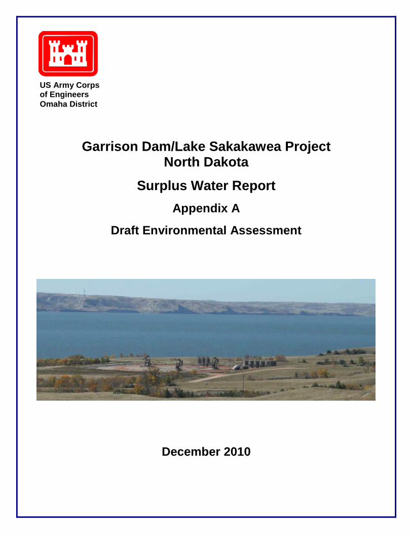
Garrison Dam/Lake Sakakawea Project North Dakota
Surplus Water Report Appendix A
Draft Environmental Assessment
December 2010
US Army Corps of Engineers Omaha District
Garrison Dam / Lake Sakakawea Project, North Dakota
Surplus Water Report Draft Environmental Assessment i
Table of Contents
1. Introduction ............................................................................................................................. 1
1.1. Purpose of the Surplus Water Report and Environmental Assessment .......................... 1
1.2. Authority for the Proposed Action .................................................................................. 2
1.3. Garrison Project Background and Overview .................................................................. 3
1.3.1. Project Location ...................................................................................................... 3
1.3.2. Project Authorization .............................................................................................. 3
1.3.3. Authorized Project Purposes ................................................................................... 6
1.4. Prior Reports and NEPA Documents .............................................................................. 7
2. Purpose and Need for the USACE Action .............................................................................. 9
2.1. Purpose and Need for the Surplus Water ........................................................................ 9
2.1.1. Oil and Gas Industry Water Supply Demand ......................................................... 9
2.1.2. Existing Lake Sakakawea Water Users ................................................................ 11
2.1.3. Total Water Supply Demand ................................................................................ 12
3. Alternatives Formulation ...................................................................................................... 12
3.1. Planning Goals and Objectives ..................................................................................... 12
3.2. Planning Constraints ..................................................................................................... 14
3.3. Management Measures ................................................................................................. 14
3.3.1. Identification of Management Measures .............................................................. 14
3.3.2. Screening of Management Measures .................................................................... 15
3.3.2.1. Structural Measures .......................................................................................... 16
3.3.2.2. Non-Structural Measures (Activities) ............................................................... 20
4. Alternatives Including the Proposed Action ......................................................................... 25
4.1. Most Likely Future Without Project Condition - No Action Alternative ..................... 25
4.2. Proposed Action ............................................................................................................ 26
4.2.1. Intake Site Selection ............................................................................................. 27
4.2.2. Description of Typical Intake, Pipeline, and Water Depot Construction ............. 30
4.2.3. Site-Specific Intake Easement Requests ............................................................... 32
4.2.4. Intake-Specific Information .................................................................................. 35
4.2.4.1. Element Solutions – Mandaree Intake .............................................................. 35
4.2.4.2. International Western - Charlson, Iverson, Thompson Intakes ........................ 36
4.2.4.3. Lake Sakakawea & Associates - Intakes #3, #5, and #8 ................................... 41
4.2.5. Typical USACE and NDG&F Conditions for Intake Easements ......................... 45
5. Scope of Analysis and Missouri System Overview .............................................................. 47
Garrison Dam / Lake Sakakawea Project, North Dakota
Surplus Water Report Draft Environmental Assessment ii
5.1. Scope of the Analysis.................................................................................................... 47
5.1.1. Context and Intensity ............................................................................................ 47
5.1.2. Indirect, Cumulative, and Growth-Inducing Effects............................................. 47
5.1.3. Scope of the Analysis............................................................................................ 48
5.1.4. 100,000 Acre-Feet in Context ............................................................................... 49
5.2. Missouri River System Description and Operation ...................................................... 50
5.2.1. Intrasystem Regulation ......................................................................................... 53
5.2.1.1. Seasonal Intrasystem Regulation Patterns. ....................................................... 54
5.2.1.2. Winter Release Patterns .................................................................................... 54
5.2.1.3. Balancing/Unbalancing the Upper Three Reservoirs ....................................... 54
5.2.1.4. Short Term Intrasystem Adjustments. .............................................................. 54
5.2.1.5. Hourly Fluctuation of Release Rates ................................................................ 55
6. Affected Environment and Environmental Consequences ................................................... 57
6.1. Topography ................................................................................................................... 65
6.1.1. Existing Condition ................................................................................................ 65
6.1.2. Environmental Consequences ............................................................................... 65
6.2. Geology, Stratigraphy, and Seismology ....................................................................... 66
6.2.1. Existing Condition ................................................................................................ 66
6.2.2. Environmental Consequences ............................................................................... 67
6.3. Soils............................................................................................................................... 67
6.3.1. Existing Condition ................................................................................................ 67
6.3.2. Environmental Consequences ............................................................................... 68
6.4. Groundwater ................................................................................................................. 69
6.4.1. Existing Condition ................................................................................................ 69
6.4.2. Environmental Consequences ............................................................................... 70
6.5. Water Quality ................................................................................................................ 72
6.5.1. Existing Condition ................................................................................................ 72
6.5.2. Environmental Consequences ............................................................................... 73
6.6. Air Quality .................................................................................................................... 75
6.6.1. Existing Condition ................................................................................................ 75
6.6.2. Environmental Consequences ............................................................................... 77
6.7. Oil and Natural Gas ...................................................................................................... 77
6.7.1. Existing Condition ................................................................................................ 77
6.7.2. Environmental Consequences ............................................................................... 78
6.8. Solid and Hazardous Waste .......................................................................................... 78
6.8.1. Existing Condition ................................................................................................ 78
Garrison Dam / Lake Sakakawea Project, North Dakota
Surplus Water Report Draft Environmental Assessment iii
6.8.2. Environmental Consequences ............................................................................... 79
6.9. Traffic, Truck Traffic, and Accidents ........................................................................... 82
6.9.1. Existing Condition ................................................................................................ 82
6.9.2. Environmental Consequences ............................................................................... 84
6.10. Demographics ............................................................................................................... 85
6.10.1. Existing Condition ................................................................................................ 85
6.10.2. Environmental Consequences ............................................................................... 89
6.11. Employment/Income ..................................................................................................... 89
6.11.1. Existing Condition ................................................................................................ 89
6.11.2. Environmental Consequences ............................................................................... 90
6.12. Environmental Justice ................................................................................................... 90
6.12.1. Existing Condition ................................................................................................ 90
6.12.2. Environmental Consequences ............................................................................... 92
6.13. Recreation ..................................................................................................................... 93
6.13.1. Existing Condition ................................................................................................ 93
6.13.2. Environmental Consequences ............................................................................... 95
6.14. Aesthetics and Visual Resources .................................................................................. 95
6.14.1. Existing Condition ................................................................................................ 95
6.14.2. Environmental Consequences ............................................................................... 96
6.15. Noise ............................................................................................................................. 97
6.15.1. Existing Condition ................................................................................................ 97
6.15.2. Environmental Consequences ............................................................................... 98
6.16. Cultural Resources ........................................................................................................ 98
6.16.1. Existing Condition ................................................................................................ 98
6.16.2. Environmental Consequences ............................................................................... 99
6.17. Vegetation and Listed Species ...................................................................................... 99
6.17.1. Existing Condition ................................................................................................ 99
6.17.2. Environmental Consequences ............................................................................. 102
6.18. Fish and Wildlife and Listed Species.......................................................................... 104
6.18.1. Existing Conditions ............................................................................................. 104
6.18.2. Environmental Consequences ............................................................................. 111
7. Cumulative Effects of the Proposed Action ........................................................................ 113
7.1. Effects of Surplus Water Determination ..................................................................... 113
7.2. Effects of Depletions................................................................................................... 114
7.3. Cumulative Effects of Improved Water Distribution .................................................. 117
Garrison Dam / Lake Sakakawea Project, North Dakota
Surplus Water Report Draft Environmental Assessment iv
8. Compliance with Environmental Laws and Regulations .................................................... 118
9. Summary of Environmental Effects .................................................................................... 125
10. Coordination, Consultation, and List of Preparers .......................................................... 127
10.1. List of Agencies and Persons Consulted ..................................................................... 127
10.2. Summary of 29 September 2010 Agency Meeting, Bismarck, ND ............................ 128
10.3. Additional Persons Consulted ..................................................................................... 130
10.4. Public Participation ..................................................................................................... 131
10.5. List of Preparers .......................................................................................................... 132
11. References ........................................................................................................................ 133
Appendices .................................................................................................................................. 141
Appendix A - Stratigraphy of the Williston Basin in Western North Dakota ......................... 141
Appendix B – Gubernatorial and Agency Correspondence .................................................... 151
Appendix C – North Dakota Natural Heritage Inventory ....................................................... 157
Garrison Dam / Lake Sakakawea Project, North Dakota
Surplus Water Report Draft Environmental Assessment v
List of Tables
Table 1 Missouri River Mainstem Flood Control Reservoirs ......................................................... 6
Table 2 M&I Water Demand for No Action and the Proposed Action ........................................ 25
Table 3 Proposed Intake Information ........................................................................................... 34
Table 4 Garrison Releases by Month, and Percent Change with 138.1 CFS Less From Release 50
Table 5 Reservoir Storage Zones .................................................................................................. 52
Table 6 Surface Waters on 303(d) TMDL List in the Project Area .............................................. 73
Table 7 Standard Error Estimation for Modeled Effects .............................................................. 75
Table 8 2007-2009 Changes in Regional Traffic on Selected Western North Dakota Routes ..... 83
Table 9 Traffic Fatalities in North Dakota By County ................................................................. 84
Table 10 Historical and Projected Population for Eight North Dakota Counties ......................... 85
Table 11 Population Data in 2000 ................................................................................................ 87
Table 12 Population Trends for Municipalities in the Lake Sakakawea Area ............................. 87
Table 13 Income Data for Lake Sakakawea Area of Influence and North Dakota (1999) ........... 89
Table 14 Percent Race by County ................................................................................................. 92
Table 15 Percent Race by Population Center ............................................................................... 92
Garrison Dam / Lake Sakakawea Project, North Dakota
Surplus Water Report Draft Environmental Assessment vi
List of Figures
Figure 1 Omaha District Civil Works Boundary and Mainstem Projects ...................................... 4
Figure 2 Garrison Dam/Lake Sakakawea Project, North Dakota .................................................. 5
Figure 3 Oil Production in the Lake Sakakawea Area, by County ............................................... 10
Figure 4 Coordination Index – Difficulty of Placing an Intake .................................................... 29
Figure 5 Water Depot Near Red Mike Hill, ND ........................................................................... 31
Figure 6 Existing Water Intake East of Whitetail Bay ................................................................. 32
Figure 7 Proposed Intake Locations on Lake Sakakawea ............................................................ 33
Figure 8 Element Solutions Proposed Mandaree Intakes ............................................................. 35
Figure 9 Retention Pond Near Killdeer, ND ................................................................................. 37
Figure 10 International Western’s Charlson Site .......................................................................... 38
Figure 11 International Western’s Iverson Site ........................................................................... 39
Figure 12 International Western’s Thompson Site ....................................................................... 40
Figure 13 Lake Sakakawea & Associates #3 ................................................................................ 42
Figure 14 Lake Sakakawea & Associates #5 ................................................................................ 43
Figure 15 Lake Sakakawea & Associates #8 ................................................................................ 44
Figure 16 Daily Stage Variation for a 31-Day Period Downstream of Garrison Dam ................ 56
Figure 17 Model Node Locations for the Daily Routing Model .................................................. 58
Figure 18 Fort Peck: Release-Difference Distribution - Proposed Action Minus No Action ...... 60
Figure 19 Garrison: Release-Difference Distribution - Proposed Action Minus No Action ........ 61
Figure 20 Oahe: Release-Difference Distribution - Proposed Action Minus No Action ............. 61
Figure 21 Fort Peck Lake: WSE Difference Distribution - Proposed Action Minus No Action .. 62
Figure 22 Garrison: WSE Difference Distribution - Proposed Action Minus No Action ............ 63
Figure 23 Garrison: WSE Difference Distribution - Proposed Action Minus No Action ............ 63
Garrison Dam / Lake Sakakawea Project, North Dakota
Surplus Water Report Draft Environmental Assessment vii
Figure 24 Gavins Point Dam: Release Difference Distribution - Proposed Action Minus No Action ............................................................................................................................................ 64
Figure 25 Surficial Aquifers in Western North Dakota ............................................................... 71
Figure 26 Produced Water Collection and Disposal Site South of Stanley, ND .......................... 81
Figure 27. Temporary Housing In Western North Dakota ........................................................... 88
Figure 28 Lewis & Clark State Park Boat Ramp and Marina 2006 .............................................. 94
Figure 29 Lewis & Clark State Park Boat Ramp and Marina 2010 .............................................. 94
Figure 30 Grassland Habitat of Lake Sakakawea ....................................................................... 100
Figure 31 Cumulative Lake Sakakawea WSE Difference Distribution ...................................... 115
Figure 32 Cumulative Garrison Dam Release Difference Distribution ...................................... 116
Figure 33 Cumulative Gavins Point Dam Release Difference Distribution ............................... 116
Garrison Dam / Lake Sakakawea Project, North Dakota
Surplus Water Report Draft Environmental Assessment viii
Garrison Dam / Lake Sakakawea Project, North Dakota
Surplus Water Report Draft Environmental Assessment 1
1. Introduction
1.1. Purpose of the Surplus Water Report and Environmental Assessment
The purpose of the Garrison Dam/Lake Sakakawea, ND, Surplus Water Report is to identify and quantify whether surplus water is available in the Project, as defined in Section 6 of the 1944 Flood Control Act, that the Secretary of the Army can use to execute surplus water supply agreements with water users, and to determine whether use of surplus water is the most efficient method for meeting regional municipal and industrial (M&I) water needs. This Draft Environmental Assessment presents and provides an evaluation of the direct, indirect, and cumulative environmental impacts of the proposed action and the “no action” alternatives pursuant to the requirements of the National Environmental Policy Act of 1969 (NEPA) as implemented by the Council on Environmental regulations (40 CFR 1500, et seq.).
This Surplus Water Report (Report) and this Environmental Assessment (EA) investigate the engineering and economic feasibility and environmental effects of temporary use of up to 257,000 acre-feet of storage (100,000 acre-feet of yield) from the Garrison Dam / Lake Sakakawea Project to meet municipal and industrial (M&I) water supply needs in the region over the 10-year study period. This Report has been prepared by the Omaha District, U.S. Army Corps of Engineers (Corps) under the Operation & Maintenance Program. The water supply agreements derived from this process would be executed with potential easement applicants upon approval of this Report by the Assistant Secretary of the Army (Civil Works) and completion of required NEPA coordination. The term of surplus water agreement is for a five (5) year period, renewable for an additional five (5) year period, subject to recalculation of reimbursement after the initial five (5) year period.
A 10-year study period has been established for the surplus water study and EA. The length of the study period was selected for several reasons. First, surplus water agreements may be executed for a five (5) year period, renewable for an additional five (5) year period. Second, prior to the end of the 10-year study period, it is anticipated that reallocation studies of the six Federal reservoir projects within the Missouri River basin (including the Garrison Dam/Lake Sakakawea Project) would be completed, which would determine if changes to the permanent allocation of storage among the authorized project purposes and modifications to existing Federal water resource infrastructure were warranted. Third, the primary water demand driving regional water needs at this time is the North Dakota oil and gas industry. Industry and state estimates indicate that demand from this industry is temporary and will decrease significantly after 10 years. The surplus water agreements executed upon the approval of the Report and EA serve as measures to address temporary water needs of the region during the 10-year study period.
The temporary use of a total of 257,000 acre-feet of storage (100,000 acre-feet of yield) being requested is in excess of the total amount for which easements have currently been requested, and was selected based on potential future demand over the 10-year study period. The amount in excess of intake easement requests received to date has been included for the purposes of efficiency and responsiveness and so that expected requests over the period of analysis can be evaluated and approved.
Garrison Dam / Lake Sakakawea Project, North Dakota
Surplus Water Report Draft Environmental Assessment 2
1.2. Authority for the Proposed Action The Garrison Dam / Lake Sakakawea, ND, Surplus Water Report study is being conducted under the authority of Section 6 of Public Law 78-534, the 1944 Flood Control Act. Under Section 6, the Secretary of the Army is authorized to enter into agreements for surplus water with states, municipalities, private concerns, or individuals at any reservoir under the control of the Department of the Army. Specifically, Section 6 states that:
“[T]he Secretary of War is authorized to make surplus water agreements with States, municipalities, private concerns, or individuals
ER 1105-2-100, paragraph 3-8a states:
, at such prices and on such terms as he may deem reasonable, for domestic and industrial uses for surplus water that may be available at any reservoir under the control of the War Department: Provided, That no surplus water agreements for such water shall adversely affect then existing lawful uses of such water. All moneys received from such surplus water agreements shall be deposited in the Treasury of the United States as miscellaneous receipts.”
“The Secretary of the Army can also enter into agreements with states, municipalities, private entities or individuals for the use of surplus water as defined in, and under the conditions described in, Paragraph 3-8b(4). Surplus water can also be used to respond to droughts and other emergencies affecting municipal and industrial water supplies.”
ER 1105-2-100, paragraph 3-8b(4), entitled, “Surplus Water” states: “Under Section 6 of the Flood Control Act of 1944, the Secretary of the Army is authorized to make agreements with states, municipalities, private concerns, or individuals for surplus water that may be available at any reservoir under the control of the Department. These agreements may be for domestic, municipal, and industrial uses, but not for crop irrigation. ER 1105-2-100, paragraph E-57b(2) states: (2) Classification. (a) Surplus Water will be classified as either: (1) water stored in a Department of Army reservoir that is not required because the authorized use for the water never developed or the need was reduced by changes that occurred since authorization or construction; or
(2) water that would be more beneficially used as a municipal and industrial water than for the authorized purpose and which, when withdrawn, would not significantly affect authorized purposes over some specified time period.
(b) An Army General Counsel opinion of March 13, 1986, states that Section 6 of the 1944 Flood Control Act empowers the Secretary of the Army to make reasonable reallocations between different project purposes. Thus, water stored for purposes no longer necessary can be considered surplus. In addition, the Secretary may use his broad discretionary authority to reduce project outputs, envisioned at the time of authorization
Garrison Dam / Lake Sakakawea Project, North Dakota
Surplus Water Report Draft Environmental Assessment 3
and construction, if it is believed that the municipal and industrial use of the water is a higher and more beneficial use….
(3) Requirements and Restrictions. Surplus water declarations will only be made when related withdrawals would not significantly affect authorized purposes. Surplus water agreements shall be accompanied by a brief letter Report similar to reallocation Reports and shall include how and why the storage is determined surplus. Surplus water agreements will normally be for small amounts of water and/or for temporary use as opposed to storage reallocations and a permanent right to that storage. Normally, surplus water agreements will be limited to 5 year periods. Use of the Section 6 authority is allowed only where non-Federal sponsors do not want to buy storage because the need of the water is short term or the use is temporary pending the development of the authorized use. The views of the affected state(s) will be obtained, as appropriate, prior to entering into any agreement under Section 6. The annual price deemed reasonable for this use of surplus water is determined by the same procedure used to determine the annual payment for an equivalent amount of reallocated storage plus an estimated annual cost for operation and maintenance, repair, replacement, and rehabilitation. The total annual price is to be limited to the annual costs of the least cost alternative, but never less than the benefits foregone (in the case of hydropower, revenues forgone).
1.3. Garrison Project Background and Overview
1.3.1. Project Location Garrison Dam and Lake Sakakawea, the impoundment created by Garrison Dam, is the third largest man-made lake in the United States. Authorized for flood control, navigation, irrigation, hydropower, municipal and industrial water supply, fish and wildlife, recreation and water quality, the Garrison Dam/Lake Sakakawea Project creates an approximately 178-mile long and up to 6-mile wide pool on the main stem of the Missouri River from near Williston, ND to near Riverdale, ND (see Figures 1 and 2). The reservoir covers approximately 368,000 acres, with more than 1,500 miles of shoreline, and 23.8 million acre-feet of water storage at full pool, which is nearly one-third of the total storage capacity of the Missouri River reservoir system. As shown in Figure 2, about 55,000 surface acres of Lake Sakakawea and about 600 miles of its shoreline are included within the boundaries of the Fort Berthold Reservation. The Fort Berthold Reservation is associated with the Three Affiliated Tribes (Mandan, Hidatsa, and Arikara) and occupies sections of six counties: Mountrail, McLean, Dunn, McKenzie, Mercer, and Ward.
1.3.2. Project Authorization The Garrison Dam/Lake Sakakawea project was authorized on December 22, 1944, by the Flood Control Act of 1944, Public Law (P.L.) 534, 78th Congress, 2nd session, along with four other Missouri River main stem projects -- Gavins Point, Fort Randall, Big Bend, and Oahe. These five main stem reservoirs are elements of the comprehensive development program in the Missouri River Basin, known as the Pick-Sloan Plan. This comprehensive plan became known as the Pick-Sloan Missouri Basin Program. Fort Peck Dam, located in northern Montana, was constructed before the Pick-Sloan Plan, but is operated as part of the Missouri River System.
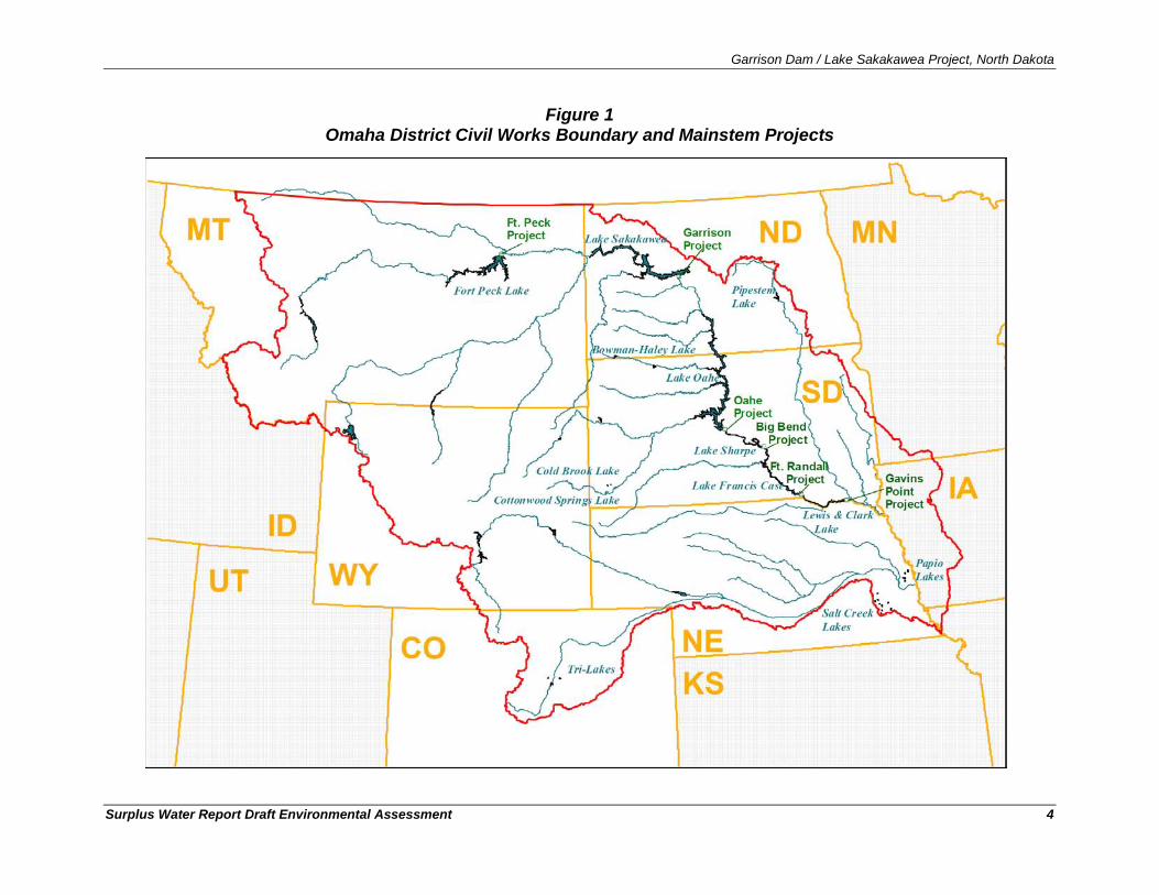
Garrison Dam / Lake Sakakawea Project, North Dakota
Surplus Water Report Draft Environmental Assessment 4
Figure 1 Omaha District Civil Works Boundary and Mainstem Projects
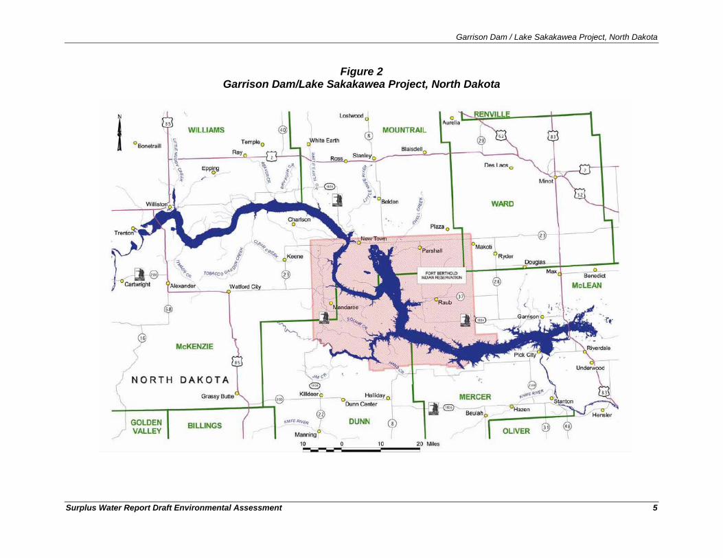
Garrison Dam / Lake Sakakawea Project, North Dakota
Surplus Water Report Draft Environmental Assessment 5
Figure 2 Garrison Dam/Lake Sakakawea Project, North Dakota
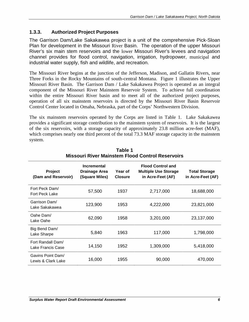
Garrison Dam / Lake Sakakawea Project, North Dakota
Surplus Water Report Draft Environmental Assessment 6
1.3.3. Authorized Project Purposes The Garrison Dam/Lake Sakakawea project is a unit of the comprehensive Pick-Sloan Plan for development in the Missouri River Basin. The operation of the upper Missouri River’s six main stem reservoirs and the lower Missouri River’s levees and navigation channel provides for flood control, navigation, irrigation, hydropower, municipal and industrial water supply, fish and wildlife, and recreation.
The Missouri River begins at the junction of the Jefferson, Madison, and Gallatin Rivers, near Three Forks in the Rocky Mountains of south-central Montana. Figure 1 illustrates the Upper Missouri River Basin. The Garrison Dam / Lake Sakakawea Project is operated as an integral component of the Missouri River Mainstem Reservoir System. To achieve full coordination within the entire Missouri River basin and to meet all of the authorized project purposes, operation of all six mainstem reservoirs is directed by the Missouri River Basin Reservoir Control Center located in Omaha, Nebraska, part of the Corps’ Northwestern Division.
The six mainstem reservoirs operated by the Corps are listed in Table 1. Lake Sakakawea provides a significant storage contribution to the mainstem system of reservoirs. It is the largest of the six reservoirs, with a storage capacity of approximately 23.8 million acre-feet (MAF), which comprises nearly one third percent of the total 73.3 MAF storage capacity in the mainstem system.
Table 1 Missouri River Mainstem Flood Control Reservoirs
Project (Dam and Reservoir)
Incremental Drainage Area (Square Miles)
Year of Closure
Flood Control and Multiple Use Storage
in Acre-Feet (AF) Total Storage
in Acre-Feet (AF)
Fort Peck Dam/ Fort Peck Lake 57,500 1937 2,717,000 18,688,000
Garrison Dam/ Lake Sakakawea 123,900 1953 4,222,000 23,821,000
Oahe Dam/ Lake Oahe 62,090 1958 3,201,000 23,137,000
Big Bend Dam/ Lake Sharpe 5,840 1963 117,000 1,798,000
Fort Randall Dam/ Lake Francis Case 14,150 1952 1,309,000 5,418,000
Gavins Point Dam/ Lewis & Clark Lake 16,000 1955 90,000 470,000
Garrison Dam / Lake Sakakawea Project, North Dakota
Surplus Water Report Draft Environmental Assessment 7
1.4. Prior Reports and NEPA Documents The Army Corps of Engineers and other federal and non-federal entities have prepared a number of documents on the upper Missouri River system. The previous federal and non-federal studies have established an extensive database on the environment in the upper Missouri River system. These references are listed below, and are hereby incorporated-by-reference (40 CFR 1502.21).
• In March 2003, the Kansas City District and the Omaha District published a Final Environmental Impact Statement entitled, “Final Supplemental Environmental Impact Statement for the Missouri River Fish and Wildlife Mitigation Project.” The project study area is located along 735 miles of the Missouri River from Sioux City, Iowa to the mouth of the river near St. Louis, Missouri. The purpose of this program was to restore fish and wildlife habitat losses resulting from construction, operation, and maintenance of the Missouri River Bank Stabilization and Navigation Project that provided a navigation channel from Sioux City to the mouth.
• In October 2003, the Omaha District published a Master Plan entitled, “Big Bend Dam/Lake Sharpe Master Plan with Integrated Programmatic Environmental Assessment Missouri River, South Dakota Update of Design Memorandum MB-90.” The document was prepared to describe the operational plan and existing environmental conditions for the Big Bend Project in South Dakota.
• In October 2003, the Omaha District published a Master Plan entitled, “Gavins Point Dam/Lewis and Clark Lake Master Plan Missouri River, Nebraska and South Dakota, Update of Design Memorandum MG-123.” The document was prepared to describe the operational plan and existing environmental conditions for the Gavins Point Dam/Lewis and Clark Lake in Nebraska and South Dakota.
• In December 2003, the U.S. Fish and Wildlife Service published an amendment to their 2000 Biological Opinion entitled “U.S. Fish and Wildlife Service Amendment to the 2000 Biological Opinion on the Operation of the Missouri River Main Stem Reservoir System, Operation and Maintenance of the Missouri River Bank Stabilization and Navigation Project, and Operation of the Kansas River Reservoir System.”
• In March 2004, the Northwestern Division of the Army Corps of Engineers published the Final Environmental Impact Statement for the Missouri River Master Water Control Manual entitled, “Missouri River Final Environmental Impact Statement, Master Water Control Manual Review and Update.”
• In February 2006, the Northwestern Division of the Army Corps of Engineers published an Environmental Assessment entitled, “Environmental Assessment for the Inclusion of Technical Criteria for Spring Pulse Releases from Gavins Point Dam.” The analysis in the document compares the impacts of the bimodal spring pulse technical criteria with the impacts of the spring pulse alternatives evaluated in the Master Water Control Manual FEIS (USACE, 2004).
Garrison Dam / Lake Sakakawea Project, North Dakota
Surplus Water Report Draft Environmental Assessment 8
• In December 2007, the Omaha District published the Master Plan and integrated Finding of No Significant Impact entitled, “Garrison Dam/Lake Sakakawea Master Plan with Integrated Programmatic Environmental Assessment Missouri River, North Dakota Update of Design Memorandum MGR-107D.” The document was prepared to evaluate the environmental impacts associated with management of the Garrison Project in North Dakota.
• In August 2008, the Omaha District published the Master Plan and integrated Finding of No Significant Impact entitled, “Fort Peck Dam/Fort Peck Lake Master Plan with Integrated Programmatic Environmental Assessment Missouri River, Montana Update of Design Memorandum MFP-105D.” The document was prepared to evaluate the environmental impacts associated with management of the Fort Peck Project in Montana.
• In September 2010, the Omaha District published the Final Master Plan and integrated Finding of No Significant Impact entitled, “Final Oahe Dam/Lake Oahe Master Plan Missouri River, South Dakota and North Dakota Design Memorandum MO-224.” The document was prepared to evaluate the environmental impacts associated with management of the Lake Oahe Project in North and South Dakota.
• In April 2010, the Omaha District published an Environmental Assessment entitled, “Missouri River Recovery Program, Emergent Sandbar Habitat Complexes in the Missouri River, Nebraska and South Dakota, Draft Project Implementation Report (PIR) With Integrated Environmental Assessment.” These actions are being undertaken to address endangered species needs and mitigate for the loss of habitat that resulted from construction, operation, and maintenance of the Missouri River Bank Stabilization and Navigation Project (BSNP).
• In September 2010, the Omaha District published document entitled, Missouri River Mainstem System, 2010-2011 Draft Annual Operating Plan. The Annual Operating Plan (AOP) presents pertinent information and plans for regulating the Missouri River Mainstem Reservoir System (System) through December 2011 under widely varying water supply conditions. It provides a framework for the development of detailed monthly, weekly, and daily regulation schedules for the System's six individual dams during the coming year to serve the Congressionally authorized project purposes.
• In October 2010, the Omaha District published an Environmental Impact Statement entitled, “Draft Programmatic Environmental Impact Statement for the Mechanical Creation and Maintenance of Emergent Sandbar Habitat in the Riverine Segments of the Upper Missouri River.” This Draft Programmatic Environmental Impact Statement (PEIS) evaluates the potential environmental consequences of implementing the Emergent Sandbar Habitat (ESH) program on the upper Missouri River.
Garrison Dam / Lake Sakakawea Project, North Dakota
Surplus Water Report Draft Environmental Assessment 9
2. Purpose and Need for the USACE Action
2.1. Purpose and Need for the Surplus Water As stated in Section 1, the purpose of this study is to identify whether there is a quantity of surplus water, as defined in Section 6 of the 1944 Flood Control Act, which the Secretary of the Army can make available to execute surplus water supply agreements with prospective Lake Sakakawea M&I water users. The Omaha District, U.S. Army Corps of Engineers has received requests for new water supply easements from suppliers to the oil and gas industry. Based on Corps policy, none of the easement requests can be processed until a determination is made by the Secretary of the Army that surplus water is available in the Garrison Dam/Lake Sakakawea Project and that use of the surplus water would not significantly affect existing lawful uses of Lake Sakakawea water.
In addition to the water needs of the oil and gas industry, 110 of the 142 existing easements for water intakes at Garrison Dam/Lake Sakakawea will expire over the 10-year period of analysis, and may require surplus water agreements prior to renewal. Corps guidance 1
Because of uncertainty in the rate of oil and gas development, and resulting water demand over the 10-year planning period, temporary use of 257,000 acre-feet of storage (equivalent to 100,000 acre-feet of surplus water) has been. This is somewhat in excess of the amount of new easements requests and total estimated demand. The 100,000 acre-feet of surplus water was selected by the Omaha District based on the potential for growth in future M&I water demand over the 10-year planning period. Demand for water from Lake Sakakawea has grown rapidly just over the last 18 months, as exemplified by the fact that six new easement applications have been received just during the short period of time that this study has been underway. Therefore, a surplus water determination in excess of current easement applications received to date has been evaluated for the purposes of efficiency and responsiveness, so that the storage volume associated with all reasonably foreseeable future surplus water needs over the period of analysis could be evaluated and approved in one single action by the Assistant Secretary. Should resource impacts from temporary use of 100,000 acre-feet of surplus water (equivalent to 257,000 acre-feet of storage) prove significant, then lesser amounts could be evaluated.
states “no easement that supports any type of water supply agreement will be executed prior to the water supply agreement being executed by all parties.” An analysis of total demand for surplus water storage at Garrison Dam / Lake Sakakawea over the 10-year planning period is provided below.
The problem of cost effective municipal and industrial (M&I) water supply to support the oil and gas industry in North Dakota, and the need for surplus water from Garrison Dam/Lake Sakakawea Project to meet expected demand is quantified in the following demand analysis.
2.1.1. Oil and Gas Industry Water Supply Demand A major new source of water demand in western North Dakota is due to the recent boom in oil and gas development in the region. Figure 3 depicts the rapid increase in oil production in oil-
1 Real Estate Policy Guidance Letter No. 26, Easements to Support Water Supply Storage Agreements and Surplus Water Agreements, 10 June 2008.
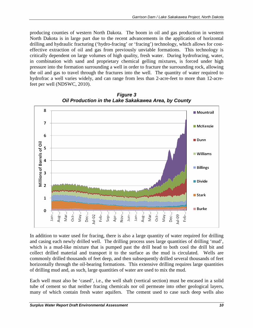
Garrison Dam / Lake Sakakawea Project, North Dakota
Surplus Water Report Draft Environmental Assessment 10
producing counties of western North Dakota. The boom in oil and gas production in western North Dakota is in large part due to the recent advancements in the application of horizontal drilling and hydraulic fracturing (‘hydro-fracing’ or ‘fracing’) technology, which allows for cost-effective extraction of oil and gas from previously unviable formations. This technology is critically dependent on large volumes of high quality, fresh water. During hydrofracing, water, in combination with sand and proprietary chemical gelling mixtures, is forced under high pressure into the formation surrounding a well in order to fracture the surrounding rock, allowing the oil and gas to travel through the fractures into the well. The quantity of water required to hydrofrac a well varies widely, and can range from less than 2-acre-feet to more than 12-acre-feet per well (NDSWC, 2010).
Figure 3 Oil Production in the Lake Sakakawea Area, by County
In addition to water used for fracing, there is also a large quantity of water required for drilling and casing each newly drilled well. The drilling process uses large quantities of drilling ‘mud’, which is a mud-like mixture that is pumped past the drill head to both cool the drill bit and collect drilled material and transport it to the surface as the mud is circulated. Wells are commonly drilled thousands of feet deep, and then subsequently drilled several thousands of feet horizontally through the oil-bearing formations. This extensive drilling requires large quantities of drilling mud and, as such, large quantities of water are used to mix the mud.
Each well must also be ‘cased’, i.e., the well shaft (vertical section) must be encased in a solid tube of cement so that neither fracing chemicals nor oil permeate into other geological layers, many of which contain fresh water aquifers. The cement used to case such deep wells also
Garrison Dam / Lake Sakakawea Project, North Dakota
Surplus Water Report Draft Environmental Assessment 11
requires a large quantity of water. The amount of water required for drilling and casing a single well has increased from approximately 0.04 of an acre-foot to 0.4 of an acre-foot (a 10-fold increase), in large part due to technological advances in horizontal drilling techniques that have resulted in much longer drilling runs and therefore more casing required (NDSWC, 2010).
In addition to water used for fracing, drilling, and casing of wells, there is additional water required for maintenance of existing wells. Maintenance of existing wells may include another water-intensive activity known as ‘de-brining’. De-brining is a process in which water is used to dilute salt brines that have a tendency to form in and throughout the well shaft due to high concentrations of salts. During de-brining, fresh water is used to reduce the overall salinity of the well and to dissolve obstructive salt brine formations in order to prevent clogging. The ND State Water Commission estimates that 10% of existing wells require de-brining on an annual basis, using approximately 1.6 acre-feet of water per well (NDSWC, 2010).
Between fracing, drilling and casing, and de-brining, each new well in western North Dakota is estimated to require between 2.6 acre-feet and 13.6 acre-feet of water per well. Low end estimates are based on reported water-use data; however new drilling technologies (i.e., horizontal drilling) requires higher volumes of fracing water, and wells using these technologies are not yet fully represented in water-use data statistics. Therefore, total required water volumes have been calculated under a range of water requirements per well. Depending on which estimates are used for each of the aforementioned parameters, the potential for water supply demand from the oil and gas industry varies significantly. Demand could be as low as 7,000 acre-feet per year or as high as 27,000 acre-feet per year (NDSE, 2010).
2.1.2. Existing Lake Sakakawea Water Users The Corps has issued 142 water intake easements around Lake Sakakawea, only one of which has a water supply agreement (Basin Electric Power Cooperative). Of these 142 water intake easements, approximately 77% (110) will expire during the 10-year study period. According to Corps policy, holders of these easements may be required to execute surplus water agreements with the Corps of Engineers as a pre-condition of re-issuance of their current easements.
The quantities of water being withdrawn through these easements are difficult to determine from the available data. The Corps keeps records on easement allocations, but does not collect data on actual water usage. The North Dakota State Water Commission does keep detailed data on permitted water usage, and all Corps easements also require a North Dakota or Tribal water permit. However, there is no data set that allows direct correlation of State water use permits with Corps easements. An analysis of all ND state water permits for surface water withdrawals within one mile of Lake Sakakawea shows that there are 115 permits totaling 30,664 acre-feet of allocations for small users2
2 Small users exclude the 15 largest permits, which are all institutional users. Most of these 15 institutional easements have not been used for decades and are therefore not deemed to be representative of ‘typical’ water permits.
. From 1989-2009, average reported water use for these 115 small permit holders was 6,384 acre-feet (21% of total allocation) in total.
Garrison Dam / Lake Sakakawea Project, North Dakota
Surplus Water Report Draft Environmental Assessment 12
There are also 15 State surface water permits within one mile of Lake Sakakawea held by large, institutional users. The permitted allocations for these 15 State surface water permit holders total 3,344,589 acre-feet, but many allocations date back to the 1950s - 1960s and have never been utilized. From 1989-2009, average reported water use for these 15 large institutional permit holders was only 23,612 acre-feet (0.7% of total allocation), and water use was reported for only 6 of the 15 large institutional users. Maximum water usage over this 21-year period was 27,362 acre-feet (see Section 3.2.2 of the Surplus Water Report, Volume 1).
2.1.3. Total Water Supply Demand Existing water demand in areas surrounding Lake Sakakawea has been relatively steady over the last 20 year period and is not expected to change significantly over the 10-year study period, resulting in no new net demand for the region. Water demand from the oil and gas industry has developed rapidly since 2008 and is expected to result in an increase in demand ranging from 7,000 acre-feet to 27,000 acre-feet annually for the next 10-11 years, and then decrease abruptly thereafter as the Bakken Formation is fully developed. The upper range of the estimate 27,000 acre-feet annually, has been used in this estimate of surplus water needs for the 10-year study period.
Water demand represented by Lake Sakakawea water intake small easement holders whose easements will expire within the 10-year study period has been estimated to be approximately 23,754 acre-feet per year, and has been used in this estimate of surplus water demand for this group of users. The maximum water usage by Lake Sakakawea large institutional easement holders over the 21-year period of 1989-2009, 27,362 acre-feet per year, has been used in this estimate of surplus water demand for this group of users. These existing and potential users of Lake Sakakawea may require use of surplus water from within the Garrison Dam/Lake Sakakawea Project during the 10-year study period, or until such time as future permanent reallocation studies can address the reallocation of storage in the System reservoirs.
For the reasons stated previously, there is a significant amount of uncertainty associated with this estimate of total demand. Therefore, the Omaha District determined at the initiation of this study to request the authority to identify as surplus 100,000 acre-feet of yield (equivalent to 257,000 acre-feet of storage) to be able to address Garrison Dam/Lake Sakakawea Project water intake easement requests that could reasonably be expected to arise over the proposed 10-year study period. Based the estimate of identified demand, a surplus declaration of 100,000 acre-feet of yield (equivalent to 257,000 acre-feet of storage) would provide an allowance of more than 20,000 acre-feet of additional yield that would be available to meet as yet unidentified M&I water demand that could arise during the 10-year study period.
3. Alternatives Formulation
3.1. Planning Goals and Objectives The goal of the Surplus Water Report is to determine whether there is surplus water available in the Garrison Dam / Lake Sakakawea Project and to evaluate whether providing surplus water from Project the is the most cost effective means of meeting the near-term (10-year) water needs of the study area. The study area is defined as the 11-county area surrounding Lake Sakakawea in western North Dakota.
Garrison Dam / Lake Sakakawea Project, North Dakota
Surplus Water Report Draft Environmental Assessment 13
National water policy states that the primary responsibility for water supply rests with states and local entities, not the Federal government. However, the Corps can participate and cooperate with state and local entities in developing water supplies in connection with the construction, operation, or modification of Federal navigation, flood damage reduction, or multipurpose projects. Specifically, the Corps is authorized to provide storage in new or existing multipurpose reservoirs for municipal and industrial water supply. However, since water supply is a state and local responsibility, the cost of water supply storage and associated facilities in a Corps project must be paid for entirely by a non-Federal entity.
The Secretary of the Army is authorized to make agreements with states, municipalities and other non-Federal entities for the rights to utilize water supply storage in Corps reservoirs. The Secretary of the Army can enter into agreements with states, municipalities, private entities or individuals for the use of ‘surplus water’. Under Section 6 of the Flood Control Act of 1944, the Secretary of the Army is authorized to make agreements with states, municipalities, private concerns, or individuals for surplus water that may be available at any Corps reservoir. Surplus agreements may be for domestic, municipal, and industrial uses.
Planning objectives for this study were developed to be consistent with Federal, State and local laws and policies, and technical, economic, environmental, regional, social, and institutional considerations. The planning objectives were used to help formulate and evaluate plans to avoid, minimize, and mitigate (if necessary), any adverse project impacts to the environment. Planning objectives also provide a decision framework to identify the least cost water supply alternative, avoid adverse social impacts, and meet local preferences to the fullest extent possible.
In pursuit of the project goal, the following Federal planning objectives were established:
• Determine if surplus water is available at the Garrison Dam / Lake Sakakawea Project and determine the storage amount to be evaluated for potential impacts, over the next 10 years
• Anticipate demand and requests for temporary surplus water agreements at the Project over the 10-year study period, including requests identified within this report and a forecast of additional requests.
• Determine repayment unit costs to apply to surplus water agreements Also in pursuit of the project goal, the following regional planning objectives were established:
• Provide sufficient water to meet the needs of existing and prospective applicants for new surplus water agreements at Garrison Dam / Lake Sakakawea for the next 10 years by the most efficient means;
• Provide sufficient water to meet the needs of current Garrison Dam / Lake Sakakawea water supply users whose existing easements will expire within the next 10 years.
This study develops and evaluates alternatives to determine how best to meet the easement applicants’ water needs within the constraints described below. The impacts of providing surplus water on other project purposes are assessed so that an optimal alternative that provides needed water supply and does not negatively impact other project purposes may be identified. The impacts assessed in this analysis include effects on: flood control, navigation, irrigation,
Garrison Dam / Lake Sakakawea Project, North Dakota
Surplus Water Report Draft Environmental Assessment 14
hydropower, municipal and industrial water supply, fish and wildlife, recreation, water quality, and any associated environmental and economic effects.
3.2. Planning Constraints Planning constraints related to reservoir operations include maintenance of the project’s ability to support currently authorized project purposes and to support other incidental uses. Currently authorized project purposes are: flood control, navigation, irrigation, hydropower, municipal and industrial (M&I) water supply, fish and wildlife, recreation, and water quality. Of these project purposes, only flood control has a specific amount of allocated storage in Lake Sakakawea.
A second planning constraint relates to the requirements of Section 6 of the Flood Control Act of 1944. Under Section 6, the Secretary of the Army is authorized to make agreements with states, municipalities, private concerns, or individuals for surplus water that may be available at any Corps reservoir. The formulation and evaluation of alternative plans is constrained by the limitations imposed by Congress and Corps policy for temporary reallocation of surplus water. These constraints/limitations include:
• No surplus water contract can adversely affect then existing lawful uses of such water; • No temporary surplus water agreement can be made for crop irrigation; • Surplus water agreements can only be granted if the Secretary can classify surplus water
as either: 1) water stored that is not required because the authorized use for the water was never developed or if the need for the authorized use was reduced or eliminated by changes in water demand that occurred since authorization or construction of the project; or 2) water that would be more beneficially used as municipal and industrial water than for the authorized project purposes and which, when withdrawn, would not significantly affect authorized purposes over some specified period of time; and
• Temporary surplus water reallocations are time limited and can only be granted for • A period of up to 5 years, with one 5-year renewal option (for a total period of 10 years).
3.3. Management Measures A management measure is a feature (i.e., a structural element that requires construction or assembly on-site), or an activity (i.e., a nonstructural action) that can either work alone or be combined with other management measures to form alternative plans. Management measures were developed to address study area problems and to capitalize upon study area opportunities. Management measures for this study were derived from a variety of sources including prior studies, agency and public input, and the project delivery team (PDT).
3.3.1. Identification of Management Measures The following management measures were identified for initial consideration:
• Structural modifications to the project to increase storage capacity
Structural Measures (Features)
Garrison Dam / Lake Sakakawea Project, North Dakota
Surplus Water Report Draft Environmental Assessment 15
• Provision of surplus water from the sediment storage portion of the carry-over multiple use zone to M&I water supply for up to 10 years, including associated infrastructure (i.e., intakes, pipelines, storage and distribution facilities)
• Groundwater withdrawals, including associated infrastructure
• Surface water withdrawals from the Missouri River upstream of Lake Sakakawea, including associated infrastructure
• Conservation / incentive programs / regulations / public education / drought contingency planning
Non-Structural Measures (Activities)
• Water reuse / recycling
• Temporary State permits to convert irrigation water to industrial use.
3.3.2. Screening of Management Measures The following sub-sections evaluate and screen each of the structural and non-structural measures identified above to determine which measures should be carried forward in the planning process and included in the formulation of alternatives. The Corps of Engineers Principles and Guidelines3
This is not to imply that some management measures that are screened out from further consideration may not be beneficial public policies or effective solutions to other legitimate problems of the study area. Rather, management measures are screened out from further consideration when it can be reasonably determined that they will not meaningfully contribute to meeting study goals and objectives or resolving the problems and needs that the study was initiated to address.
identifies four criteria to be used in the formulation and evaluation of alternative plans: completeness, effectiveness, efficiency, and acceptability. At this phase of the planning process, management measures are screened, using these four criteria, to determine whether they have the potential to make meaningful contributions to achieving the goals and objectives of the project. While none of these criteria are absolute, it is clearly reasonable to screen out from further consideration any management measure that: 1) does not contribute to meeting study goals and objectives to any significant extent (completeness), 2) is not effective in resolving study area problems and needs (effectiveness), 3) is not an efficient means of solving the problem when compared to other potential measures (efficiency), or 4) is not an acceptable solution to other Federal and non-Federal agencies and affected publics (acceptability).
3 Economic and Environmental Principles for Water and Related Land Resources Implementation Studies and The Economic and Environmental Guidelines for Water and Related Land Resources Implementation Studies, U.S. Water Resources Council, February 1983
Garrison Dam / Lake Sakakawea Project, North Dakota
Surplus Water Report Draft Environmental Assessment 16
3.3.2.1. Structural Measures Four structural measures are considered below. Two structural measures are screened out from further consideration (i.e., structural modifications to the project and groundwater withdrawals). Two structural measures are carried forward into formulation of alternative plans: 1) temporary provision of surplus water from Lake Sakakawea, and 2) surface water withdrawals from free-flowing reaches of the Missouri River).
Corps of Engineers guidance (USACE, 2000) states that existing Corps projects may be modified to add storage for municipal and industrial water supply. Structural measures to increase the storage capacity of an existing dam typically include: auxiliary spillways, lined overflow sections, raising the dam, modifications to the existing spillway, and combinations of these measures. Environmental criteria that must be assessed when considering structural measures to increase storage capacity include: avoiding adverse impacts to the environment, mitigating any unavoidable environmental impacts, maintaining water quality and ecosystem functions during and after the modification, and achieving no net loss in environmental values and functions (USACE, 2004c).
Structural Modifications to the Project to Increase Storage Capacity
The advantages of structural measures to increase storage capacity is that the needs of municipal and industrial water supply can be met without the negative effects on project users associated with taking water storage away from other authorized project purposes. The disadvantages of structural measures to increase storage capacity is that the studies necessary to design such modifications are lengthy and costly; and construction activities are similarly costly, time consuming, and can have significant impacts on the physical and natural environment. As a result, structural modifications to increase storage capacity are typically only considered when municipal and industrial water needs are so significant relative to total existing storage capacity that the effects of reallocating existing storage would render the project unable to meet its authorized project purposes, and where the environmental effects of surplus M&I water use would exceed the environmental effects of structural modifications.
These considerations indicate that structural modifications would not be an effective measure for the Garrison Dam / Lake Sakakawea Project. The amount of water being requested, 100,000 acre-feet, is only 0.7 percent of the net system yield of 15.2 million acre-feet. Use of this small portion of total system yield would have negligible impacts on current authorized purposes and on environmental conditions at the project, or in upstream or downstream reaches of the Missouri River.
Structural measures to add additional storage at Garrison Dam / Lake Sakakawea are also not efficient given the temporary nature of the industrial water needs of the oil and gas industry. In order to meet Corps design criteria, structural measures would need to be designed and built to last for the remaining design life of the project, which is well in excess of the term of the temporary water needs of the industry.
Based on this assessment, structural measures involving modifications to the Garrison Dam/Lake Sakakawea Project to increase storage capacity have been eliminated from further consideration
Garrison Dam / Lake Sakakawea Project, North Dakota
Surplus Water Report Draft Environmental Assessment 17
(screened out) for reasons of efficiency, effectiveness, and considerations of adverse effects on the environment.
Water users in North Dakota require a permit from the State for groundwater withdrawals in excess of 12.5 acre-feet for any purpose other than domestic or livestock use. In executing its permit decision making process, the State closely monitors water usage and impacts on aquifers to protect groundwater resources and avoid damage to critical aquifers. The State of North Dakota has recently completed a detailed study of state water resources that contains its assessment of the ability of groundwater resources to meet the water needs of the oil and gas industry in North Dakota (NDSWC, 2010). The study is incorporated by reference and the summary conclusion of the assessment of groundwater resources is provided below:
Groundwater Withdrawals
“Groundwater supplies in western North Dakota are limited. Glaciofluvial and other shallow aquifers and the Fox Hills – Hell Creek bedrock aquifer are insufficient to supply the requirements of the B-S-TF play at the proposed rate of development. It is critical that ground-water supplies be conserved for the use and sustenance of towns, homes, local industries, and farms and ranches, after the completion of oil development. As of December of 2009 there were 28 water depots, for a total allocation of 2,340 acre-feet per year serving the oil industry in western North Dakota. Thirty more water permits for water depots are pending, for an additional 5,534 acre-feet per year. Not all of these will likely be approved. Even if all were approved, water supplies from groundwater would fall far short of needs for the B-S-TF play. The only plentiful and dependable supply of water for the oil industry in western North Dakota, at projected rates of extraction, is the Missouri River system, including Lake Sakakawea.” (NDSWC, 2010)
Comparisons of total groundwater usage in western North Dakota shows that existing groundwater withdrawals for all uses in the study area total less than 19,000 acre-feet annually, and are already being stressed beyond natural recharge rates. It is unreasonable to expect these limited and over-stressed groundwater resources to contribute meaningfully to meeting the water needs of the oil and gas industry, which are projected to exceed total existing groundwater use by over 50 percent (27,000 acre-feet).
Also, North Dakota state water law is based on the doctrine of prior appropriations, which allocates water rights according to the date they were approved (senior rights) and the priority of the water use as established by state law. New applications for significant quantities of groundwater for industrial purposes would be considered subordinate under state water law to more senior water rights. They would also be considered subordinate to higher priority uses, which include domestic, municipal, livestock, and irrigation – the purposes to which the vast majority of the limited groundwater resources of the study area are already committed.
Therefore, requests for groundwater permits for the oil and gas industry would only be granted in conditions where enough excess water was available that withdrawals would not affect senior and higher priority appropriations. This is most certainly not the case with western North Dakota’s limited and stressed groundwater resources.
Garrison Dam / Lake Sakakawea Project, North Dakota
Surplus Water Report Draft Environmental Assessment 18
Based on this assessment, structural measures involving additional groundwater withdrawals have been eliminated from further consideration (screened out) for reasons of lack of completeness and lack of public acceptability.
Temporary use of surplus water in the sediment storage portion of the carryover multiple use zone of the Garrison Dam/Lake Sakakawea Project is considered a structural measure. In order to meet the completeness criterion, this measure includes the necessary investments by non-Federal entities to construct water intakes, pipelines, and water depots necessary to deliver the purchased water to the oil and gas industry.
Temporary Use of Surplus Water
The structural measure of temporary use of surplus water in the sediment storage portion of the carryover multiple use zone can be scaled to meet the entire water needs of the oil and gas industry, and so fully meets the effectiveness criterion.
The costs of surplus water to the industry would include the prorated share of updated project costs, plus the full cost of all necessary infrastructure investments on and off project lands. These costs, when compared to the costs of purchasing water from multiple locations that are more distant from the oil and gas industry needs, may prove to be the most cost effective means of achieving project objectives, and is therefore tentatively considered to meet the efficiency criterion, subject to more detailed analysis in the comparison of alternative plans.
Provision of surplus water from Lake Sakakawea is the preferred alternative of the State of North Dakota (as stated in public documents), the oil and gas industry (as evidenced by easement applications and state permit requests), and many members of the general public in North Dakota (as expressed in news publications). Therefore, it is tentatively considered to meet the criterion of acceptability, subject to further analysis.
Consistent with the criteria of completeness, effectiveness, efficiency, and acceptability, the structural measure of temporary use of surplus water in the Garrison Dam / Lake Sakakawea Project is carried forward for further consideration into the formulation of alternative plans.
Withdrawal of water from the surface waters of North Dakota to serve the needs of the oil and gas industry is a potentially viable structural measure. The State of North Dakota recognizes this potential in its analysis of water availability for the oil and gas industry (NDSWC, 2010):
Surface Water Withdrawals From Free-Flowing Reaches Of The Missouri River
“Surface-Water Storage and Use
Except for the Missouri River system, most of the state’s surface waters are heavily appropriated and are not good prospects for large-scale long-term sustainable water supplies. For many of the state’s rivers, however, there are seasonal flows that are not being captured and used. With appropriate capture and storage these waters could be retained and used. Possible storage techniques would include surface storage and aquifer recharge and recovery.” (p. ES-16)
Garrison Dam / Lake Sakakawea Project, North Dakota
Surplus Water Report Draft Environmental Assessment 19
A sovereign lands permit is required from the state for withdrawals from free-flowing reaches of the Missouri River. If channel alterations are necessary, then a regulatory permit must also be obtained from the Corps of Engineers. However, no water supply agreement or easement would be required from the Corps of Engineers for water obtained from river reaches not contained within a Corps reservoir or on Corps project lands, provided the Corps does not operate the system to meet the needs of an intake. Water allocation decisions for free-flowing river reaches, depending on the scope of such a withdrawal, are generally under the purview of the State or the Three Affiliated Tribes. The State of North Dakota has identified the free-flowing section of the Missouri River as the best available source of water for the oil and gas industry (after Lake Sakakawea).
An example of a proposal to provide water from a free-flowing reach of the Missouri River upstream of Lake Sakakawea is collaboration of northwest North Dakota water stakeholders (including the BDW Rural Water District, the City of Crosby, the McKenzie County Commission, the McKenzie County Water Resources District, R&T Water Supply Association, the Williams Rural Water District, and the City of Williston) (NNDWD&M, 2010). This group has developed a regional water development plan that proposes delivery of Missouri River water from the Williston Regional Water Treatment Plant to the northwest North Dakota region. This plan includes a series of water supply and transmission infrastructure projects that could provide up to 11,200 acre-feet of water for regional water demands, principally focusing on the water needs of the oil and gas industry (NNDWD&M, 2010).
Evaluation of this proposal has determined that it includes all the necessary investments by non-Federal entities to construct water intakes, pipelines, and water depots necessary to deliver the purchased water to the oil and gas industry, and therefore meets the completeness criterion.
This measure can be scaled upwards to meet a significant portion of the water needs of the oil and gas industry, and so at least partially meets the effectiveness criterion.
The cost estimate presented in this collaborative proposal includes estimates of the full cost of all necessary infrastructure investments necessary to extract, transmit, store, and distribute water extracted from the Missouri River. These costs, when compared to the costs of surplus water from the Garrison Dam / Lake Sakakawea Project, may prove to be a cost effective means of achieving study objectives, and is therefore tentatively considered to meet the efficiency criterion, subject to more detailed analysis in the comparison of alternative plans.
Provision of water from the Missouri River is the second-most preferred alternative of the State of North Dakota (as stated in public documents) if temporary use of surplus water from Lake Sakakawea is not available. The oil and gas industry (as evidenced by easement applications and state permit requests) and many members of the public (as expressed in the referenced letter to the Governor of North Dakota) also consider this to be a potentially feasible alternative. Therefore, it is tentatively considered to meet the criterion of acceptability.
Consistent with the criteria of completeness, effectiveness, efficiency, and acceptability, the structural measure of withdrawal of surface waters from free-flowing reaches of the Missouri River is carried forward for further consideration into the formulation of alternative plans.
Garrison Dam / Lake Sakakawea Project, North Dakota
Surplus Water Report Draft Environmental Assessment 20
3.3.2.2. Non-Structural Measures (Activities) Three non-structural measures are considered below. Two non-structural measures are screened out from further consideration (i.e., conservation/incentive programs and water reuse/recycling). One non-structural measure is carried forward into formulation of alternative plans (i.e., temporary water permits for industrial usage).
Water conservation, incentive programs, regulations, public education, and drought contingency planning are not viable options for reducing the water demands of the oil and gas industry in western North Dakota. Water reuse/recycling programs are being explored as water reducing options for the industry and are addressed in the next non-structural measure.
Conservation, Incentive Programs, Regulations, Public Education, Drought Contingency Planning
As described previously, extracting oil from the Bakken formation is an extremely water intensive activity requiring large quantities of water per well for hydrofracing, casing, de-brining and other maintenance activities. The cost of only the water required to develop a well ranges from over $400,000 to over $4.5 million each. Even in the face of these extremely high water costs, the average water requirements per well have been increasing, rather than decreasing, due to new drilling technologies that allow for horizontal drilling that greatly increases the productivity of oil wells. The value of the increased oil production more than offsets the increased water (and other production) costs, resulting in increasing industry water demand.
Industry efforts to reduce water demands have focused on recycling and reuse efforts, since there is no practical conservation method for decreasing water use and still employing the hydrofracing technology that makes extraction of oil economically viable. Incentives work in the opposite direction of increasing (not decreasing) water use, since new drilling technologies require more water per well (not less), and produce significantly greater economic returns, even considering the high cost of water needed for well production. Similarly, State regulatory efforts have been directed towards increasing, not decreasing, water availability to the oil and gas industry, through temporary State permits allowing industrial use of irrigation water (see temporary water permits for industrial usage - the third non-structural measure described below).
The current estimate of the total water demands of the oil and gas industry (27,000 acre-feet) is nearly one third of the total water usage in the 11-county study area (97,000 acre-feet) and nearly three times the historic average of all industrial users (10,000 acre-feet). Given the massive amounts of industrial water required relative to total supply, water conservation, incentive programs, regulations, public education, and drought contingency planning measures could not be expected to successfully reduce usage to any meaningful degree necessary to meet the effectiveness criterion.
The State of North Dakota recognizes the vital economic importance of the oil and gas industry to the State’s economy. A study of the economic impact of the oil and gas industry by the North Dakota Petroleum Council (NDPC, 2007) calculated that North Dakota’s oil and gas industry generated $8.22 billion in total business activity for 2007; $3.1 billion in direct impacts, and $5.1 billion in secondary impacts. The industry paid $520 million in state and local taxes and provided direct employment for 7,719 people and indirect employment for nearly 38,500 people, making it one
Garrison Dam / Lake Sakakawea Project, North Dakota
Surplus Water Report Draft Environmental Assessment 21
of the state’s largest industries. According to a study by PricewaterhouseCoopers, the oil and gas industry directly and indirectly supported 5.7% of the State’s employment, contributed 7.6% of the State’s labor income, and represented 9.6% of the value added contribution to the State’s economy (PWC, 2008). As a direct result of the oil and gas industry, North Dakota has the lowest unemployment rates in the U.S. and is one of the few states with a significant budget surplus ($800 million anticipated for 2010).
For these reasons, any non-structural measure predicated on reducing water consumption by the industry (other than through water reuse / recycling) would also reduce industry productivity and the economic benefits the industry provides to the State of North Dakota. Therefore, this measure does not pass the acceptability criterion.
In summary, for reasons of lack of completeness, effectiveness, efficiency, and acceptability, water conservation, incentive programs, regulations, public education, and drought contingency planning measures are eliminated (screened out) from further consideration in the formulation of alternative plans.
The potential for water reuse / recycling in the oil and gas industry is being actively evaluated by the industry and government / public partnerships. The Energy & Environmental Research Center (EERC) of the University of North Dakota (Grand Forks) has entered into a partnership with the U.S. Department of Energy (DOE) and key energy-producing entities in the northern Great Plains to identify and evaluate opportunities for water reuse and recycling in the oil and gas industry (NDIC, 2010a). The purpose of the partnership is:
Water Reuse/Recycling
“…to address issues related to water availability, reducing freshwater use, and minimizing the impacts of facility and industry operations on water quality. The key goals of this partnership, called the Northern Great Plains Water Consortium (NGPWC), are:
• To evaluate water demand and consumption from competing users in the northern Great Plains region, including energy production, agriculture, industry, and domestic/municipal users.
• To assess, develop, and demonstrate technologies and methodologies that minimize water use and reduce wastewater discharge from energy production and agricultural processing facilities.
• To identify nontraditional water supply sources and innovative options for water reuse” (NDIC, 2010a).
Potential opportunities for reuse or recycling in the oil and gas industry include using wastewater from other industries as frac water in the drilling process, or alternatively recycling frac wastewater (called ‘produced water’ or ‘flowback’ water) for use in other industries. Research is currently underway by the EERC, with sponsorship from U.S. DOE, the North Dakota Petroleum Council, and the North Dakota Industrial Commission Oil & Gas Research Council to assess the economic potential to recycle flowback water for reuse in the Bakken formation.
Research activities include: inventorying industry freshwater use, assessing the water quality of flowback water, evaluating water handling costs, evaluating the technical and economic
Garrison Dam / Lake Sakakawea Project, North Dakota
Surplus Water Report Draft Environmental Assessment 22
feasibility of recycling and reuse technologies, and making recommendations regarding potential recycling and reuse opportunities in the industry. Preliminary results to date indicate water recovery rates of flowback water of less than 50-percent in the first 10 days, with extremely high salinity levels, and lower but still significant levels of calcium, potassium, and sulfate. Preliminary study results show significant challenges to extensive application of recycling and reuse in the oil and gas industry due to slow flowback rates, low initial recovery volumes, extremely high dissolved salt levels, and challenging treatment technologies – all resulting in limited cost effectiveness for frac water recycling/reuse at this stage of treatment technology development.
Various pilot recycling projects for flowback water and recovering fracing fluids have been initiated in the Barnett Shale play in Texas. To date, none of these pilot projects have proven to be economically feasible, and significant technical issues remain in ensuring the recycled water is reusable for future well fracing.
A potentially more economically feasible recycling/reuse application at this phase of technological development could involve treatment and use of non-potable groundwater for well fracing (rather than recycling and reuse of frac / produced water). This alternative has perhaps greater near-term potential due to the relative abundance of non-potable groundwater and lack of competing demand. Its viability for use in oil and gas production requires additional analysis and research and will be in large part determined by the costs of pre-treatment (water for fracing must meet certain water quality standards to not damage well production equipment or cause difficulties in the oil extraction process), as well as the relative cost of other available sources of fracing water.
Unresolved issues related to the technological feasibility of recycling / reuse of flowback water renders it an incomplete solution to meeting the near-term water needs of the oil and gas industry. Effectiveness is also suspect at this stage of technological development. Slow flowback rates and low initial recovery volumes limit the quantity of water that would be available for reuse, and therefore reduce its ability to meet a significant portion of industry water requirements.
The most significant factor limiting recycling/reuse as a viable non-structural measure at this time is efficiency. None of the reported pilot projects have been found to be economically viable to date, and have been abandoned after the initial pilot project (i.e., subsidized) stage. Use of non-potable groundwater may hold some near-term future promise, but additional research is required to identify the conditions (water quality, location, pre-treatment requirements) necessary to determine whether - and to what extent - this measure could meet a significant portion of industry water needs.
Recycling/reuse definitely meets the criteria of public acceptability, as government, various industry stakeholders, and the general public appear to strongly support efforts to reduce the competition of the oil and gas industry for scarce water resources through recycling and reuse of produced water, as well as to minimize potential for environmental degradation by reducing the total volume of produced water in the waste stream.
Garrison Dam / Lake Sakakawea Project, North Dakota
Surplus Water Report Draft Environmental Assessment 23
Recycling/reuse of water as a non-structural measure to meet the water demands of the oil and gas industry does hold some future promise, but does not meet evaluation criteria for a technologically feasible and economically viable measure for meeting the near-term (10-year) water needs of the industry. Effectiveness (i.e., the extent of industry demand met by this measure) also cannot be demonstrated until technical and economic issues are better understood. For these reasons, recycling / reuse were eliminated (screened out) from further consideration in the formulation of alternative plans.
The North Dakota State Water Commission is currently granting temporary water permits to holders of existing irrigation water permits to use their water for industrial purposes – allowing farmers to sell their irrigation water to the oil and gas industry (NDSWC). 2010a).
Temporary Water Permits for Industrial Usage
“To facilitate more efficient distribution of water for the oil industry, the State Engineer has developed a new policy granting temporary authorization for holders of existing irrigation water permits to use water for industrial purposes...If significant problems persist with the efficient distribution of water for oil field use, the State Engineer will consider continuing this policy beyond 2011 on a year-by-year basis.”(NDSWC). 2010a)
Unless the permit holder’s allocation is from the Missouri River or Lake Sakakawea, sale of irrigation water is currently limited to approximately 100-percent of the permit holder’s average annual use (not their total allocation), in order to guarantee no net increase in the quantity of the water withdrawn from groundwater or highly allocated surface water sources by the permit holder. State permit holders in Lake Sakakawea or the Missouri River may sell their entire allocation irrespective of past use levels.
The average annual usage limit applied to all non- Missouri River/Lake Sakakawea irrigation State permit holders is an effort to avoid substantial increases in groundwater use from the overall aquifer system. This is because there is some percolation and aquifer recharge when water is used for irrigation. However, when that water is transferred from irrigation to industrial use, the percolation and aquifer recharge is eliminated, resulting in a net increase in water "use", or net decrease in aquifer water availability. The uncertainty regarding percolation and aquifer recharge is another factor that contributes to the tenuous estimate of the total volume of water from this measure that will be available for industrial use.
These temporary State permits are only granted for the calendar year (January 1 – December 31) in which the permit is issued. No permanent industrial water right is created by the State’s issuance of a temporary permit, and the temporary permits are not guaranteed to be reissued in the following year. All temporary State permits require installation of meters on discharge pipes and annual reporting to the State of the quantity of irrigation water sold to industry by each permit holder.
It is extremely difficult to estimate the total amount of oil and gas industry water demand that can be met over the next 10 years through this non-structural measure because: temporary industrial water permit requests are initiated by the individual irrigation permit holder, this is a new State policy without historic usage data, and continuation of the program and re-issuance of
Garrison Dam / Lake Sakakawea Project, North Dakota
Surplus Water Report Draft Environmental Assessment 24
temporary permits are not guaranteed from year to year. However, since this State program is actually underway and water is currently being sold from irrigation to industrial use, this non-structural measure meets the criteria of completeness.
Effectiveness (i.e., the proportion of the need that can be met through this measure) is very hard to determine this early in the implementation phase of the new State policy, but at this stage of the temporary program appears to be relatively low. A total of 391.7 acre-feet of State permits were approved by the State for irrigation to industrial water conversions for 2010 (1.5% of the 27,000 acre-feet of oil and gas industry requirements). A total of 526.6 acre-feet of State permits have been approved thus far for conversions for 2011 (2.0% of 27,000 acre-feet). Average State permit size for 2010/2011 is 106.35 acre-feet.
This measure appears to be efficient, as evidenced by the fact that water providers to the oil and gas industry are purchasing irrigation water from the temporary State permit holders in lieu of buying water from other available sources. State permit holders are not required to report the price at which they sell their water to the industry so only anecdotal information is available, which indicates a selling price of $0.02/gallon ($0.84/barrel). This compares favorably to the price of water purchased by the industry from water depots, which ranges from $0.50/barrel to $1.05/barrel, depending on the water depot and the purchaser.
This measure also appears to meet the criterion of acceptability, since there are willing sellers, willing buyers, State permit approvals, and a lack of public opposition within North Dakota to the practice thus far.
Temporary State permits to convert irrigation water to industrial use by the oil and gas industry is a non-structural measure that meets the criteria of completeness, efficiency, and acceptability, and to a much lesser (but somewhat unknown) degree, effectiveness. For these reasons, the non-structural measure, temporary permits for industrial water usage, is carried forward into the formulation of alternative plans. However, because of its low (and unreliable) effectiveness, it will only be considered in combination with other measures and cannot function as a stand-alone alternative.
Garrison Dam / Lake Sakakawea Project, North Dakota
Surplus Water Report Draft Environmental Assessment 25
4. Alternatives Including the Proposed Action The alternatives evaluated in detail within this Environmental Assessment include the No Action – Next Least Costly Alternative and the Proposed Action. For comparison purposes, both alternatives describe the most likely means of providing 100,000 acre feet of water to meet the current and future water needs of the study area. The Proposed Action would be the temporary use of up to 257,000 acre-feet of storage (100,000 acre-feet of yield) in the Garrison Dam/Lake Sakakawea Project, including the infrastructure development required to access the surplus water.
Because the only plentiful and dependable supply of water for M&I development in western North Dakota is the Missouri River system, including Lake Sakakawea, (NDSWC, 2010), the No Action alternative assumes a significant portion of the demand for water would be met by the Missouri River, but not within Garrison Dam/Lake Sakakawea Project. The other difference between the No Action and the Proposed Action is that the No Action alternative utilizes 527 AF of groundwater rather than surface water. The remainder of Section 4 provides additional detail on the No Action and Proposed Action alternatives.
Table 2 summarizes the sources of demand for both No Action and with Proposed Action.
Table 2 M&I Water Demand for No Action and the Proposed Action
Sources of M&I Water Demand No Action (acre-feet)
Proposed Action
(acre-feet)
Small GD/LS Water Users with Expiring Easements 23,754 23,754
Large Institutional GD/LS Water Users 27,362 27,362
Subtotal GD/LS Easement Water Use 51,116 51,116
Oil & Gas Industry Demand 27,000 27,000
Remaining Unidentified Future Users Demand 21,884 21,884
Subtotal Additional Water Use 48,884 48,884
Total Required Yield 100,000 100,000
4.1. Most Likely Future Without Project Condition - No Action Alternative
The most likely future without project condition consists of a combination of the structural and non-structural measures that survived the screening process described above, with the exception
Garrison Dam / Lake Sakakawea Project, North Dakota
Surplus Water Report Draft Environmental Assessment 26
of the proposed action (temporary use of surplus water in the Garrison Dam/Lake Sakakawea Project). The future without project condition would be a combination of the following measures anticipated to be used to meet existing water needs, as well as the growing municipal and industrial (M&I) water demands of the study area:
• Development of new water withdrawals from free-flowing reaches of the Missouri River up-stream of the Garrison Dam/Lake Sakakawea Project or other non-Garrison Project sources (e.g., expansion of the Williston Regional Water Treatment Plant),
• Continued use of existing Garrison Dam/Lake Sakakawea M&I water intakes,
• Temporary conversion of irrigation water permits to industrial usage (agricultural to M&I), and
• Continued use of all other available sources of existing water depots.
Water demand from the oil and gas industry is highly decentralized, as is decision making, with each individual oil producer making their own decision about where to get the water needed to develop their well. Thousands of these discrete decisions are made by scores of oil producers in any given year. Obviously it is not possible to predict the outcomes of each of these decisions individually. Because they are profit maximizing producers however, oil and gas companies typically choose the least costly water source that will provide them the required volume and quality of water they need for well production, so long as the water can be delivered reliably (i.e., in the quantities needed, when needed). For this reason, the most likely future without project condition is defined as the least costly combination of feasible measures for providing the quantity of water sufficient to meet the demands of the oil and gas industry from the multiple water sources currently available, excluding Lake Sakakawea.
4.2. Proposed Action The proposed action for the Army Corps of Engineers would include decision making associated with three different administrative actions:
1. Programmatic decision making to identify surplus water, as defined in Section 6 of the 1944 Flood Control Act, which the Secretary of the Army can make available to execute surplus water supply contracts with prospective M&I water users for up to of up to 257,000 acre-feet of storage (100,000 acre-feet of yield) from Lake Sakakawea,
2. Project level decision making to execute surplus water supply agreements with the three applicants and grant them new water supply easements and, and
3. Project level decision making to execute surplus water supply agreements with holders of current easements for existing water intakes at Lake Sakakawea if their current easements expire during the 10-year planning period.
Because these are administrative actions, USACE actions to implement them would not result in environmental effects. However, USACE decision making to implement the proposed actions are connected (40 CFR 1508.25(a)(1)) to other actions that would be reasonably foreseeable and are the focus of the environmental analysis.
Garrison Dam / Lake Sakakawea Project, North Dakota
Surplus Water Report Draft Environmental Assessment 27
4.2.1. Intake Site Selection As of 2010, there were more than 140 existing water intake easements across Corps land at Lake Sakakawea. The site selection, construction, operation, and monitoring of water intakes on Lake Sakakawea is an ongoing program addressed by multi-disciplinary consideration of environmental factors in planning the site selection and construction of intakes to avoid and minimize environmental consequences. None of the environmental evaluations for the existing intakes resulted in a determination that significant environmental impacts would occur, nor did the decision to grant any of the easements require the preparation of an Environmental Impact Statement. When recent drought-driven changes to water surface elevations necessitated modification of existing intakes; these actions were reviewed with an Environmental Assessment and resulted in a Finding of No Significant Impact (USACE, 2004b).
The existing environmental and cultural or historic resources at any proposed intake site affect the conditions for approval that would be required by the Corps regulatory or real estate review, North Dakota state sovereign lands permits, and/or coordination with resource agencies responsible for the protection of other resources would be expected to avoid significant resources. These conditions typically address specifications on methods of construction, placement of intakes, limitations on construction time, noise during operation, and limitations on pumping. All currently proposed intakes, or those that could be proposed in the future, require this detailed evaluation to address environmental approvals and regulatory considerations.
In an effort to improve the coordination and environmental evaluation of water intakes in Lake Sakakawea/Missouri River in North Dakota, the North Dakota State Water Commission developed a shapefile in GIS characterizing the shore of the Missouri River and its reservoirs in North Dakota for the level of “difficulty of access” as a preliminary indication of the possible difficulty and delays in obtaining permits. Departments consulted for map development and review included the Corps of Engineers (Both Lake Sakakawea and Lake Oahe Project Offices), the North Dakota State Water Commission, the North Dakota Department of Game and Fish, the North Dakota Historical Society, the U.S. Fish and Wildlife Service, and the North Dakota Department of Parks and Recreation. Both the Standing Rock Sioux and the Three Affiliated Tribes cultural offices were invited to participate, but declined.
The end product was a GIS shapefile of the Missouri River system. The Water Commission cautioned, “To avoid misinterpretation, it is important to understand how the map was derived, what it represents, and what it does not represent.” The map key content consists of three general groupings. These are:
(1) River system reaches, shorelines and near-shore areas where existing resources are most likely to cause prolonged or difficult delays in permitting (red);
(2) River reaches, shorelines and near-shore areas where existing resources are somewhat likely to cause delays in permitting (yellow);
(3) River reaches, shorelines and near-shore areas where critical resources are least likely to cause prolonged or difficult delays in permitting (green/no color).
Garrison Dam / Lake Sakakawea Project, North Dakota
Surplus Water Report Draft Environmental Assessment 28
The sole purpose of the map was to provide a “first cut” level of guidance for potential water users who were considering locations to propose an intake. Cultural, historical, park and recreation, and fish and wildlife resources are not differentiated on the map. Some resources, particularly fish and wildlife, are mobile and areas of concern may change. The U.S. Fish and Wildlife Service, in particular, considers that the locations of critical habitat for some endangered species may change with lake elevations and consider the entire Missouri River system to be “sensitive.”
The map was intended as an initial screening tool only and in all cases, regulatory agencies are charged with due diligence and must carefully examine proposed points of diversion and their impact. Designation as an area of least concern does not guarantee that a given location would be acceptable or that permits would be processed quickly – only that the chances are better. Designation as an area of highest concern does not guarantee that placement of an intake would be prohibited or excessively delayed – only that the chances of refusal or delay were higher. Figure 4 depicts the base map illustrating the seven proposed intakes and includes the Water Commission “difficulty of access” designations. Application of resource avoidance and best management practices during planning and construction would be expected to avoid potentially significant environmental effects from construction and operation of new intakes at the Garrison Project. As such, the Proposed Action would be not likely to affect listed species or critical habitat in association with construction and operation of the intakes.
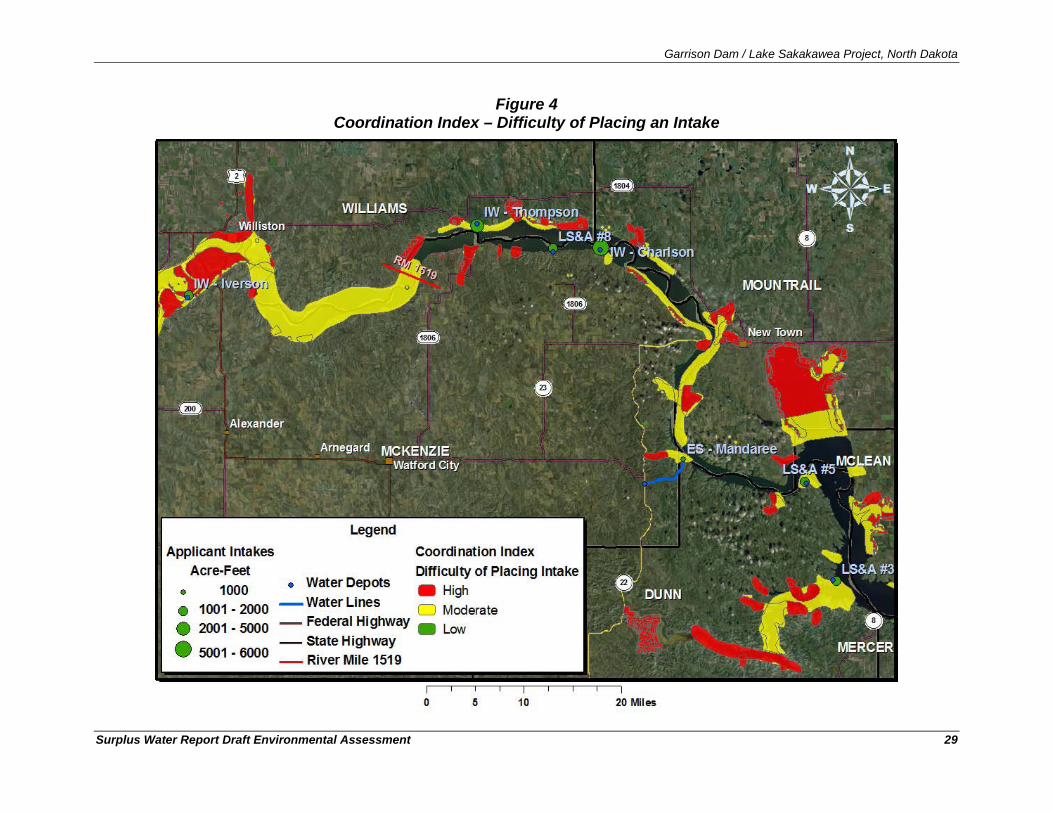
Garrison Dam / Lake Sakakawea Project, North Dakota
Surplus Water Report Draft Environmental Assessment 29
Figure 4 Coordination Index – Difficulty of Placing an Intake
Garrison Dam / Lake Sakakawea Project, North Dakota
Surplus Water Report Draft Environmental Assessment 30
4.2.2. Description of Typical Intake, Pipeline, and Water Depot Construction At the time of completion of this Environmental Assessment, engineering and design had not been completed for the proposed intakes, pipelines and water supply depots, and construction details were not finalized. Final specification of the engineering details (e.g., exact location of intake; size of pumps, pipes, utilities; method for trenching to bury the water line and power supply; etc.) of the proposed intake construction and operations had not been completed. As such, this analysis has been performed before final design review and approval and is based on concept level design and reasonable assumptions regarding the proposed actions. While the actions described in this evaluation are preliminary, the basic function of their features and the footprint for their construction should remain substantially the same as each of these proposed intakes proceed through the administrative and regulatory review and approval process. Future intakes proposed would be expected to also be substantially similar in design and construction.
Estimates of materials necessary to construct the project were developed from best professional judgment and analyses for similar, previously reviewed and approved intakes on Lake Sakakawea. As such, the features and associated descriptions developed were used to quantify the magnitude of the proposed actions and not to prescribe detailed materials, quantities, or final design specifications.
The estimated environmental impacts have been assessed to characterize an envelope of effects within which design may proceed without compromising the integrity of the assessment. As such, the description of the features does not represent any formal commitment to final design, equipment for use, vendors for supply of materials, or methods of construction, but gives an approximation of how the features could be constructed and the associated impacts thereof. Substantial changes to the proposed actions that could result in unforeseen impact to the natural or human environment would require the preparation of a supplemental NEPA analysis.
There are four typical activities associated with construction of water supply intakes:
• Excavation and placement of a length of intake pipe and electrical supply line,
• Site preparation and construction (i.e., directional drilling for submerged pumps and pump placement in the lake),
• Construction of any features at the terminus of the raw water pipe (e.g., water depot, retention pond), and
• Re-establishing vegetation from ground-disturbing actions during the excavation and placement of pipe, utilities, intake, or pumps.
The endpoint of the intake would be in either a new water depot or (for the International Western intakes) in a new retention pond. Typically, the proposed water depot site would consist of a 2-acre tract with a 24-foot roadway being constructed to each site for truck access. Figure 5 showing an existing water depot near Red Mike Hill, ND on the north side of Lake Sakakawea. At least one, but potentially more 20-foot x 20-foot building(s) would be constructed for distribution and to meter the water. The small white building in Figure H is a water depot.
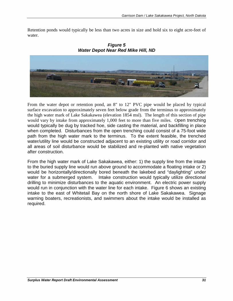
Garrison Dam / Lake Sakakawea Project, North Dakota
Surplus Water Report Draft Environmental Assessment 31
Retention ponds would typically be less than two acres in size and hold six to eight acre-feet of water.
Figure 5 Water Depot Near Red Mike Hill, ND
From the water depot or retention pond, an 8" to 12" PVC pipe would be placed by typical surface excavation to approximately seven feet below grade from the terminus to approximately the high water mark of Lake Sakakawea (elevation 1854 msl). The length of this section of pipe would vary by intake from approximately 1,000 feet to more than five miles. Open trenching would typically be dug by tracked hoe, side casting the material, and backfilling in place when completed. Disturbances from the open trenching could consist of a 75-foot wide path from the high water mark to the terminus. To the extent feasible, the trenched water/utility line would be constructed adjacent to an existing utility or road corridor and all areas of soil disturbance would be stabilized and re-planted with native vegetation after construction.
From the high water mark of Lake Sakakawea, either: 1) the supply line from the intake to the buried supply line would run above ground to accommodate a floating intake or 2) would be horizontally/directionally bored beneath the lakebed and “daylighting” under water for a submerged system. Intake construction would typically utilize directional drilling to minimize disturbances to the aquatic environment. An electric power supply would run in conjunction with the water line for each intake. Figure 6 shows an existing intake to the east of Whitetail Bay on the north shore of Lake Sakakawea. Signage warning boaters, recreationists, and swimmers about the intake would be installed as required.
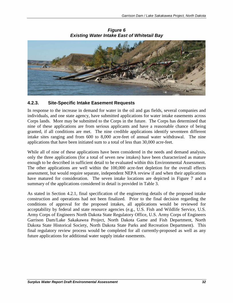
Garrison Dam / Lake Sakakawea Project, North Dakota
Surplus Water Report Draft Environmental Assessment 32
Figure 6 Existing Water Intake East of Whitetail Bay
4.2.3. Site-Specific Intake Easement Requests In response to the increase in demand for water in the oil and gas fields, several companies and individuals, and one state agency, have submitted applications for water intake easements across Corps lands. More may be submitted to the Corps in the future. The Corps has determined that nine of these applications are from serious applicants and have a reasonable chance of being granted, if all conditions are met. The nine credible applications identify seventeen different intake sites ranging and from 600 to 8,000 acre-feet of annual water withdrawal. The nine applications that have been initiated sum to a total of less than 30,000 acre-feet.
While all of nine of these applications have been considered in the needs and demand analysis, only the three applications (for a total of seven new intakes) have been characterized as mature enough to be described in sufficient detail to be evaluated within this Environmental Assessment. The other applications are well within the 100,000 acre-feet depletion for the overall effects assessment, but would require separate, independent NEPA review if and when their applications have matured for consideration. The seven intake locations are depicted in Figure 7 and a summary of the applications considered in detail is provided in Table 3.
As stated in Section 4.2.1, final specification of the engineering details of the proposed intake construction and operations had not been finalized. Prior to the final decision regarding the conditions of approval for the proposed intakes, all applications would be reviewed for acceptability by federal and state resource agencies (e.g., U.S. Fish and Wildlife Service, U.S. Army Corps of Engineers North Dakota State Regulatory Office, U.S. Army Corps of Engineers Garrison Dam/Lake Sakakawea Project, North Dakota Game and Fish Department, North Dakota State Historical Society, North Dakota State Parks and Recreation Department). This final regulatory review process would be completed for all currently-proposed as well as any future applications for additional water supply intake easements.
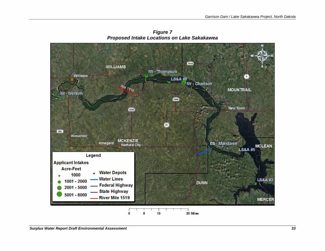
Garrison Dam / Lake Sakakawea Project, North Dakota
Surplus Water Report Draft Environmental Assessment 33
Figure 7 Proposed Intake Locations on Lake Sakakawea
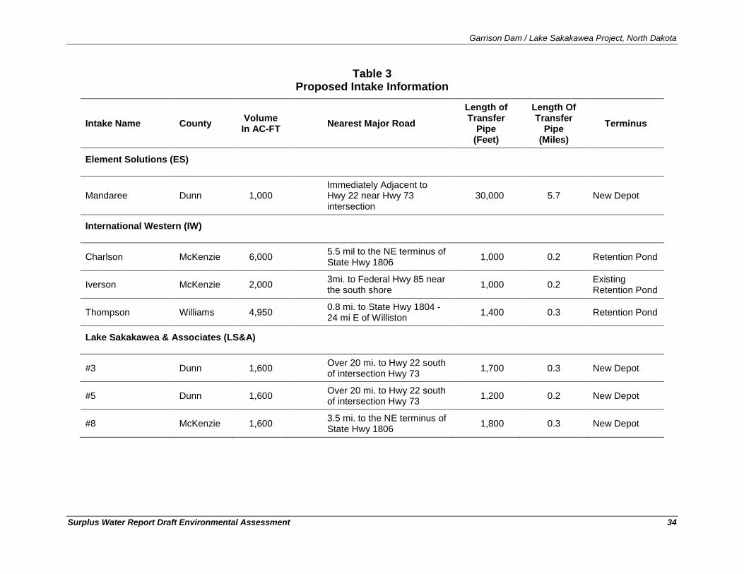
Garrison Dam / Lake Sakakawea Project, North Dakota
Surplus Water Report Draft Environmental Assessment 34
Table 3 Proposed Intake Information
Intake Name County Volume In AC-FT Nearest Major Road
Length of Transfer
Pipe (Feet)
Length Of Transfer
Pipe (Miles)
Terminus
Element Solutions (ES)
Mandaree Dunn 1,000 Immediately Adjacent to Hwy 22 near Hwy 73 intersection
30,000 5.7 New Depot
International Western (IW)
Charlson McKenzie 6,000 5.5 mil to the NE terminus of State Hwy 1806 1,000 0.2 Retention Pond
Iverson McKenzie 2,000 3mi. to Federal Hwy 85 near the south shore 1,000 0.2 Existing
Retention Pond
Thompson Williams 4,950 0.8 mi. to State Hwy 1804 - 24 mi E of Williston 1,400 0.3 Retention Pond
Lake Sakakawea & Associates (LS&A)
#3 Dunn 1,600 Over 20 mi. to Hwy 22 south of intersection Hwy 73 1,700 0.3 New Depot
#5 Dunn 1,600 Over 20 mi. to Hwy 22 south of intersection Hwy 73 1,200 0.2 New Depot
#8 McKenzie 1,600 3.5 mi. to the NE terminus of State Hwy 1806 1,800 0.3 New Depot
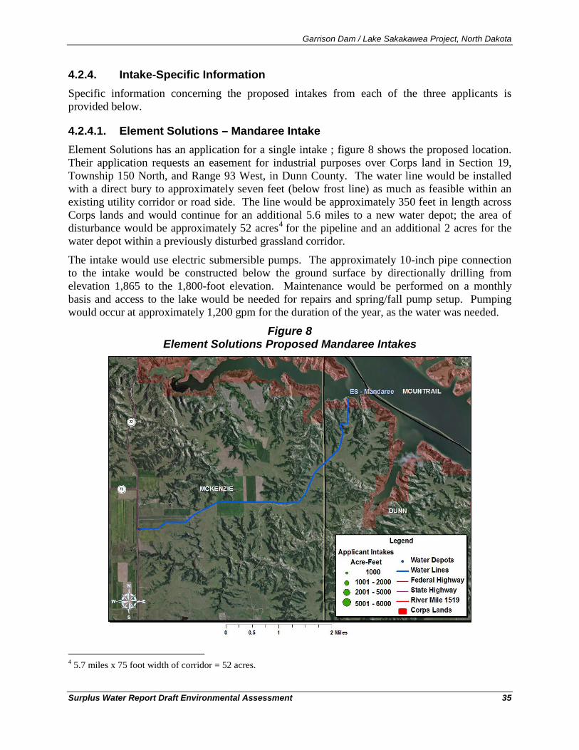
Garrison Dam / Lake Sakakawea Project, North Dakota
Surplus Water Report Draft Environmental Assessment 35
4.2.4. Intake-Specific Information Specific information concerning the proposed intakes from each of the three applicants is provided below.
4.2.4.1. Element Solutions – Mandaree Intake Element Solutions has an application for a single intake ; figure 8 shows the proposed location. Their application requests an easement for industrial purposes over Corps land in Section 19, Township 150 North, and Range 93 West, in Dunn County. The water line would be installed with a direct bury to approximately seven feet (below frost line) as much as feasible within an existing utility corridor or road side. The line would be approximately 350 feet in length across Corps lands and would continue for an additional 5.6 miles to a new water depot; the area of disturbance would be approximately 52 acres4
The intake would use electric submersible pumps. The approximately 10-inch pipe connection to the intake would be constructed below the ground surface by directionally drilling from elevation 1,865 to the 1,800-foot elevation. Maintenance would be performed on a monthly basis and access to the lake would be needed for repairs and spring/fall pump setup. Pumping would occur at approximately 1,200 gpm for the duration of the year, as the water was needed.
for the pipeline and an additional 2 acres for the water depot within a previously disturbed grassland corridor.
Figure 8 Element Solutions Proposed Mandaree Intakes
4 5.7 miles x 75 foot width of corridor = 52 acres.
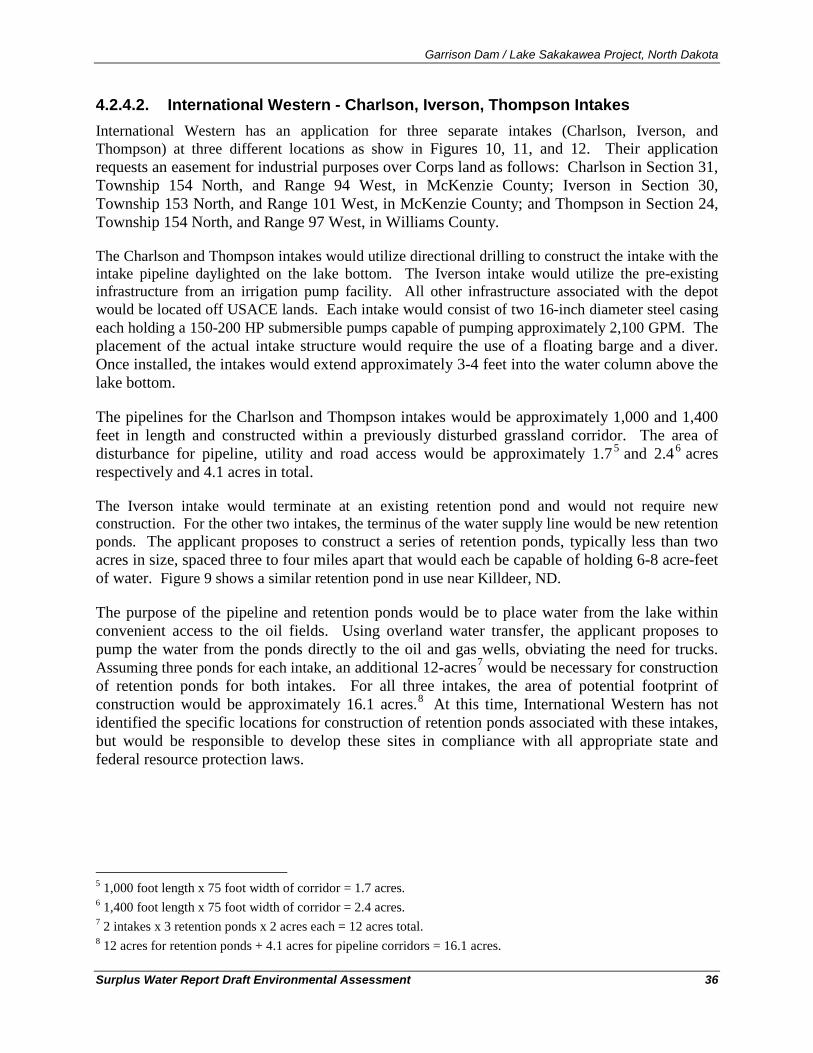
Garrison Dam / Lake Sakakawea Project, North Dakota
Surplus Water Report Draft Environmental Assessment 36
4.2.4.2. International Western - Charlson, Iverson, Thompson Intakes International Western has an application for three separate intakes (Charlson, Iverson, and Thompson) at three different locations as show in Figures 10, 11, and 12. Their application requests an easement for industrial purposes over Corps land as follows: Charlson in Section 31, Township 154 North, and Range 94 West, in McKenzie County; Iverson in Section 30, Township 153 North, and Range 101 West, in McKenzie County; and Thompson in Section 24, Township 154 North, and Range 97 West, in Williams County.
The Charlson and Thompson intakes would utilize directional drilling to construct the intake with the intake pipeline daylighted on the lake bottom. The Iverson intake would utilize the pre-existing infrastructure from an irrigation pump facility. All other infrastructure associated with the depot would be located off USACE lands. Each intake would consist of two 16-inch diameter steel casing each holding a 150-200 HP submersible pumps capable of pumping approximately 2,100 GPM. The placement of the actual intake structure would require the use of a floating barge and a diver. Once installed, the intakes would extend approximately 3-4 feet into the water column above the lake bottom.
The pipelines for the Charlson and Thompson intakes would be approximately 1,000 and 1,400 feet in length and constructed within a previously disturbed grassland corridor. The area of disturbance for pipeline, utility and road access would be approximately 1.75 and 2.46
The Iverson intake would terminate at an existing retention pond and would not require new construction. For the other two intakes, the terminus of the water supply line would be new retention ponds. The applicant proposes to construct a series of retention ponds, typically less than two acres in size, spaced three to four miles apart that would each be capable of holding 6-8 acre-feet of water. Figure 9 shows a similar retention pond in use near Killdeer, ND.
acres respectively and 4.1 acres in total.
The purpose of the pipeline and retention ponds would be to place water from the lake within convenient access to the oil fields. Using overland water transfer, the applicant proposes to pump the water from the ponds directly to the oil and gas wells, obviating the need for trucks. Assuming three ponds for each intake, an additional 12-acres7 would be necessary for construction of retention ponds for both intakes. For all three intakes, the area of potential footprint of construction would be approximately 16.1 acres.8
5 1,000 foot length x 75 foot width of corridor = 1.7 acres.
At this time, International Western has not identified the specific locations for construction of retention ponds associated with these intakes, but would be responsible to develop these sites in compliance with all appropriate state and federal resource protection laws.
6 1,400 foot length x 75 foot width of corridor = 2.4 acres. 7 2 intakes x 3 retention ponds x 2 acres each = 12 acres total. 8 12 acres for retention ponds + 4.1 acres for pipeline corridors = 16.1 acres.
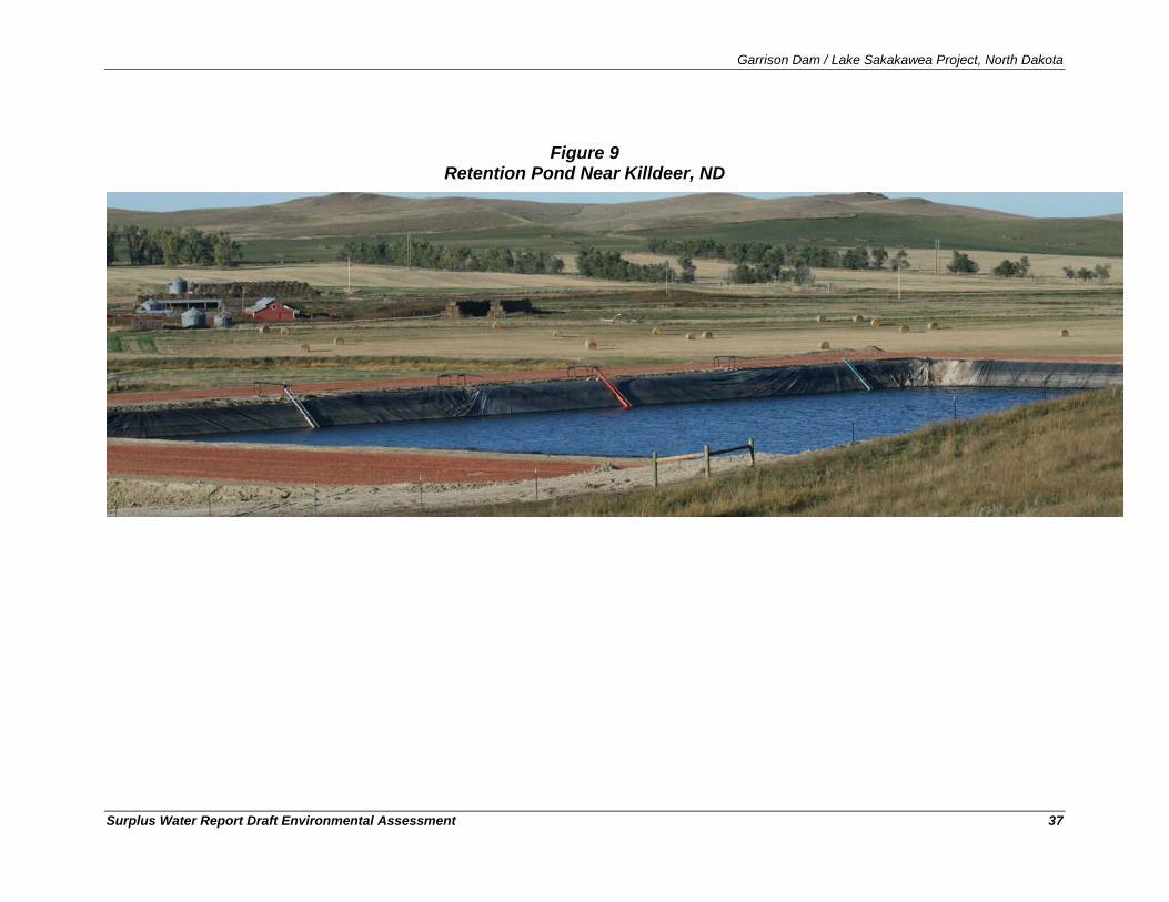
Garrison Dam / Lake Sakakawea Project, North Dakota
Surplus Water Report Draft Environmental Assessment 37
Figure 9 Retention Pond Near Killdeer, ND
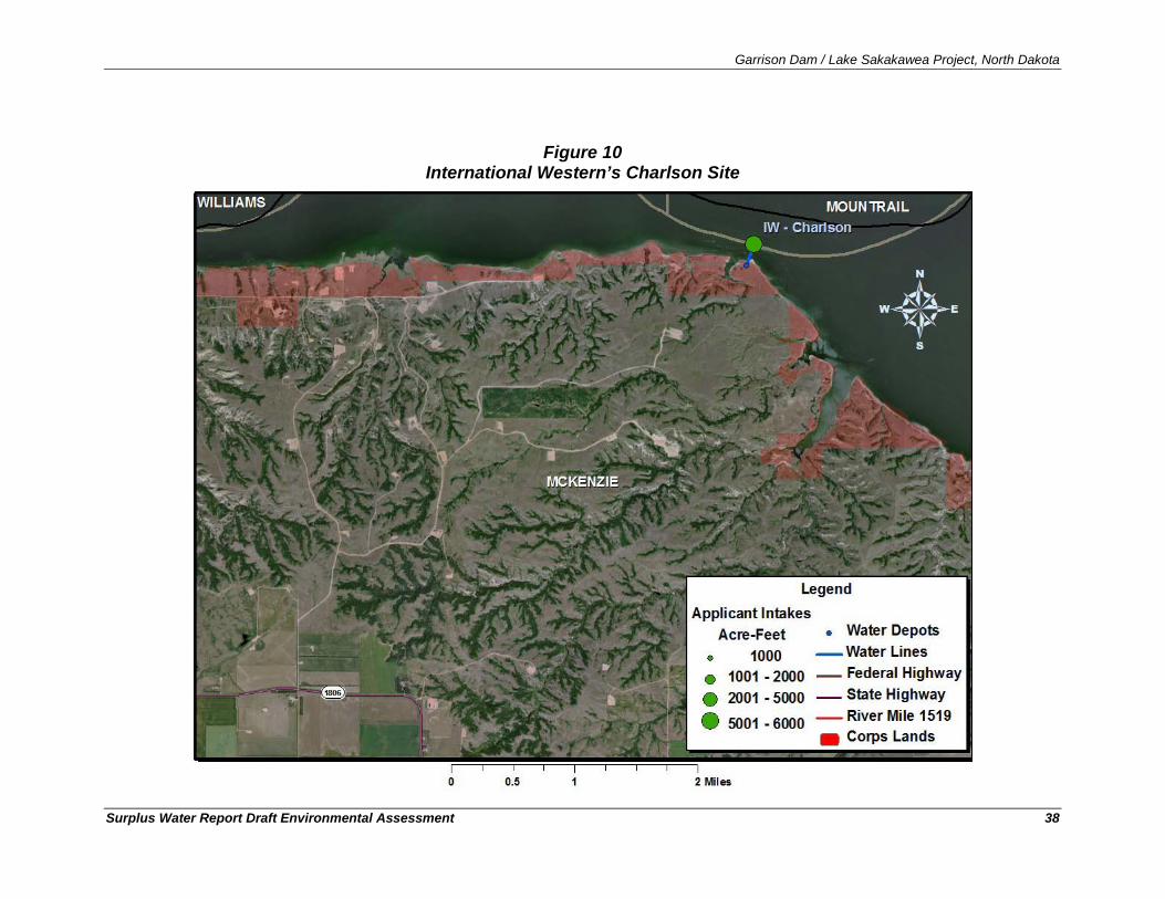
Garrison Dam / Lake Sakakawea Project, North Dakota
Surplus Water Report Draft Environmental Assessment 38
Figure 10 International Western’s Charlson Site
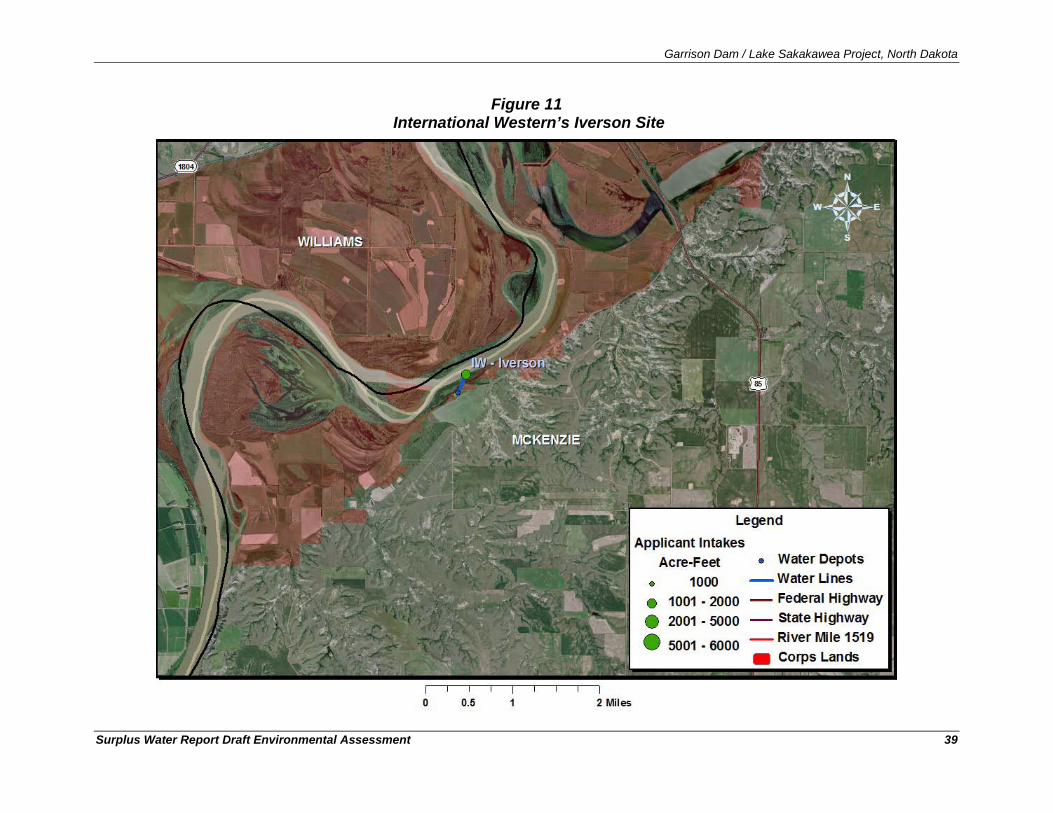
Garrison Dam / Lake Sakakawea Project, North Dakota
Surplus Water Report Draft Environmental Assessment 39
Figure 11 International Western’s Iverson Site
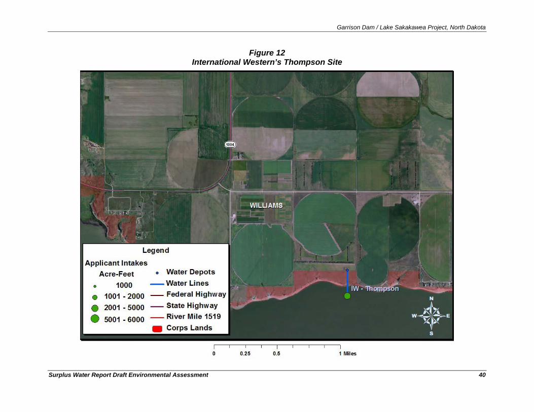
Garrison Dam / Lake Sakakawea Project, North Dakota
Surplus Water Report Draft Environmental Assessment 40
Figure 12 International Western’s Thompson Site
Garrison Dam / Lake Sakakawea Project, North Dakota
Surplus Water Report Draft Environmental Assessment 41
4.2.4.3. Lake Sakakawea & Associates - Intakes #3, #5, and #8 Lake Sakakawea and Associates has an application for three separate intakes (#3, #5, and #8) at three different locations as shown in Figures 13, 14, and 15. Their application requests an easement for industrial purposes over Corps land as follows: #3 in Section 20, Township 148 North, and Range 91 West, in Dunn County; #5 in Section 32, Township 150 North, and Range 91 West, in Dunn County; and #8 in Section 32, Township 154 North, and Range 95 West, in McKenzie County.
Road access to the intakes would be from established roads and would be constructed to the proposed sites. These newly constructed roadways to the intakes would be approximately 24 feet wide and constructed of available local materials, such as gravel, scoria, etc. Culverts would be installed where needed to facilitate runoff. The proposed water depots would be of typical design, with a 2-acre gravel pad and a 20-foot x 20-foot building for water distribution.
A buried 8" to 12" PVC pipe would be installed to a non-frost depth by open trench method, from the water depot to the high water mark (1854 msl) of Lake Sakakawea. Assuming a 75-foot width of disturbance, the pipelines for intakes #3, #5, and #8 would have areas of disturbance of approximately 2.9 9 , 2.1 10 , and 3.1 11
All proposed intakes would be submerged pump units. Intakes #5 and #8 would be submersible pumps while intake #3 would utilize a floating type pump that would be removed from the lake prior to freeze up and re-deployed each spring after ice-out. The 8 to 12-inch PVC pipe from the water depot would enter into a concrete manhole to be located above the high water mark. The concrete manhole would contain the pumps. Piping from the concrete manhole to the intake would be constructed by horizontal directional boring as described in the general overview. This construction method would minimize the physical disturbance below the high water mark.
acres respectively and sum to approximately 8.1 acres in total. Each of these intakes would terminate at new water depots requiring an additional two acres each for a total of approximately 14.1 acres of potential disturbance from the infrastructure associated with these intakes.
9 1,700 foot length x 75 foot width of corridor = 2.9 acres. 10 1,200 foot length x 75 foot width of corridor = 2.1 acres. 11 1,800 foot length x 75 foot width of corridor = 3.1 acres.
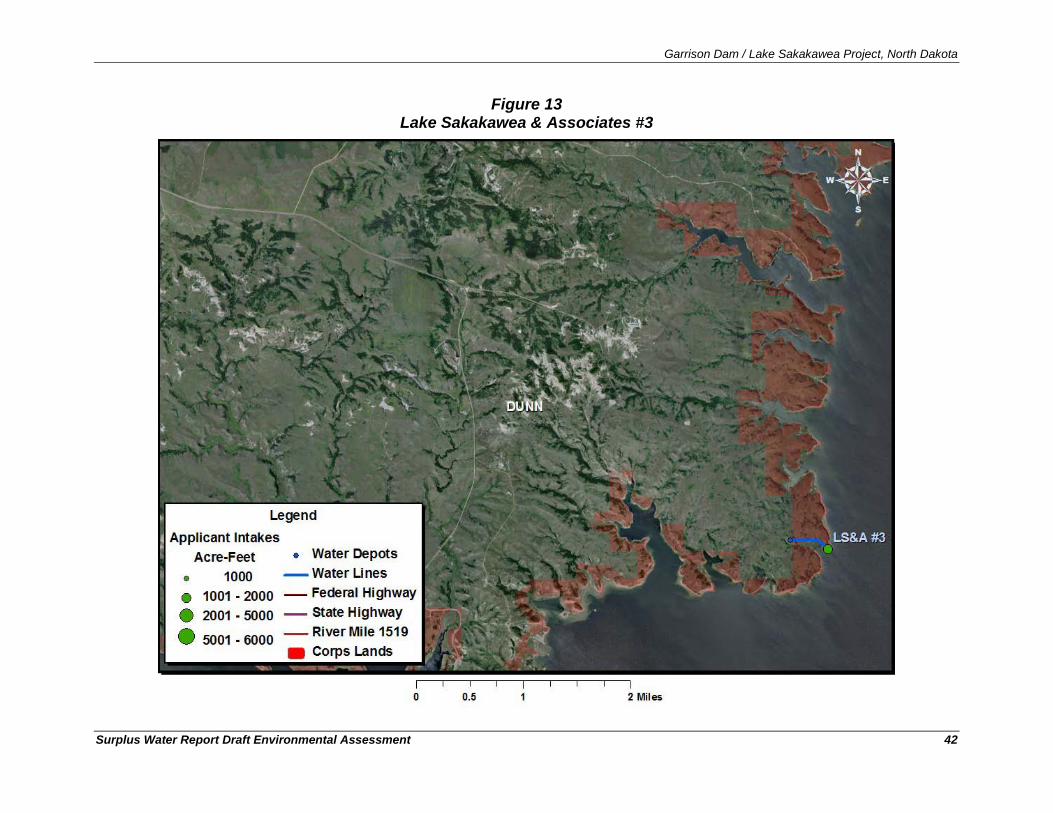
Garrison Dam / Lake Sakakawea Project, North Dakota
Surplus Water Report Draft Environmental Assessment 42
Figure 13 Lake Sakakawea & Associates #3
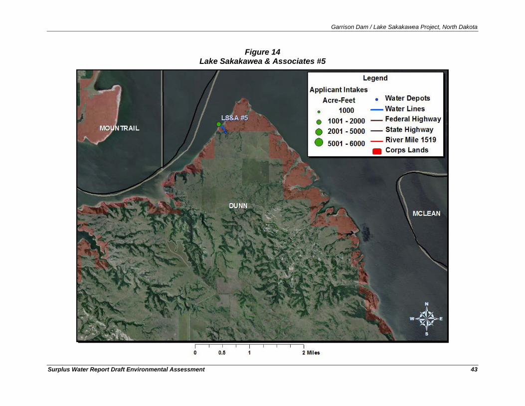
Garrison Dam / Lake Sakakawea Project, North Dakota
Surplus Water Report Draft Environmental Assessment 43
Figure 14 Lake Sakakawea & Associates #5
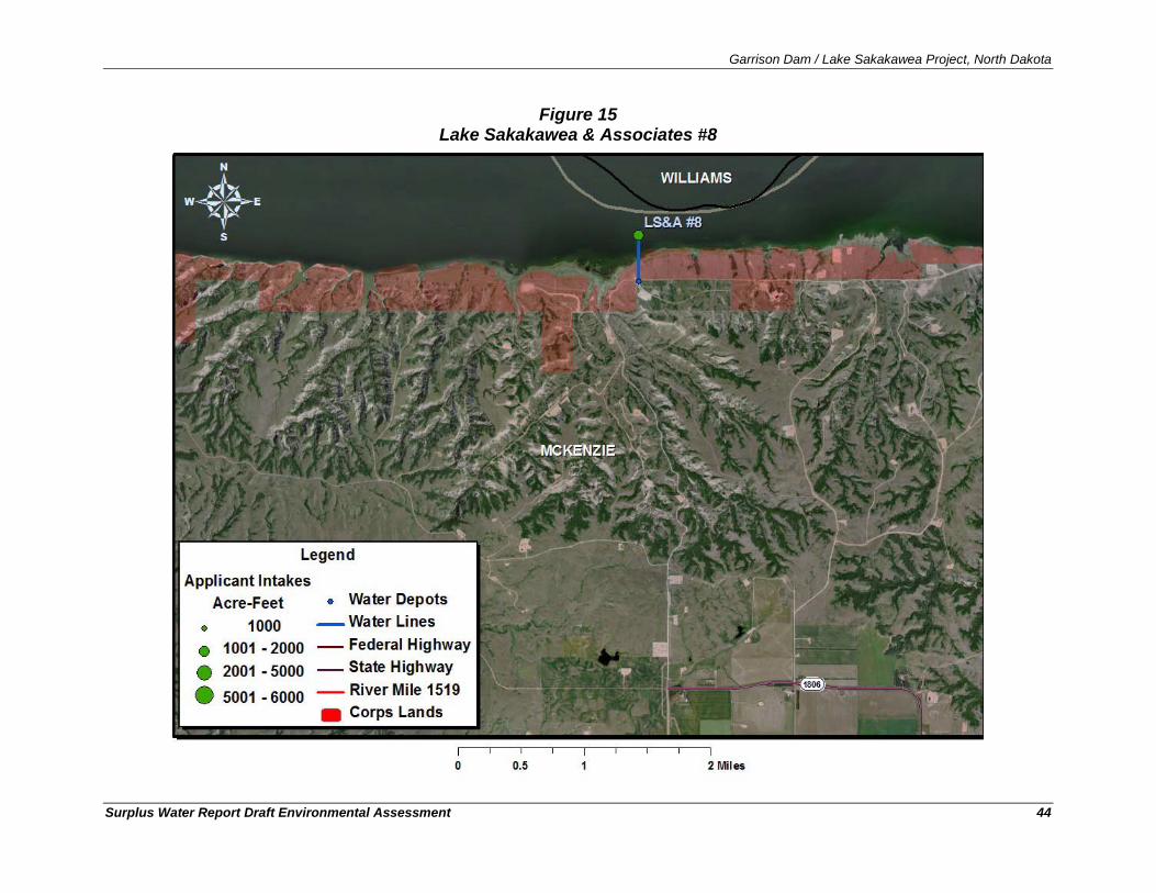
Garrison Dam / Lake Sakakawea Project, North Dakota
Surplus Water Report Draft Environmental Assessment 44
Figure 15 Lake Sakakawea & Associates #8
Garrison Dam / Lake Sakakawea Project, North Dakota
Surplus Water Report Draft Environmental Assessment 45
4.2.5. Typical USACE and NDG&F Conditions for Intake Easements The following provides a list of typical easement requirements stipulated in association with the final site selection, construction, and operation of a water intake. The first section lists typical USACE conditions for easements and the second section addresses recommendations by the North Dakota Game & Fish Department.
1. That the grantee shall not install erosion control devices around the intake of the system without prior written approval.
Typical USACE Easement Conditions
2. The grantee shall not remove, disturb, or cause or allow to be removed or disturbed, any historical, archeological, architectural, or other cultural artifacts, relics, vestiges, remains, or objects of antiquity. In the event such items are discovered on the premises, the grantee shall immediately notify the District Engineer, Omaha District, and the site and the material shall be protected by the grantee from further disturbance until a professional examination can be made or until clearance to proceed is authorized by the District Engineer.
3. That the grantee shall not discriminate against nor exclude from participation in its operations any person(s) on the basis of race, color, creed, national origin, sex, age, or handicap. The grantee furnishes as a part of this contract an assurance (Exhibit "D"), that it will comply with Title VI of the Civil Rights Act of 1964 (78 Stat. 241) as amended (42 U.S.C. 2000d) and Department of Defense Directive 5500.11 issued pursuant thereto and published in Part 300 of Title 32, Code of Federal Regulations, the Rehabilitation Act of 1973, as amended (29 U.S.C. 794), and the Age Discrimination Act of 1975 (42 U.S.C. 6102).
4. The grantee shall comply with all applicable Federal laws and regulations and with all applicable laws, and ordinances, and regulations of the state and county wherein the premises are located.
5. The water level of the Project will be maintained at elevations which the Government deems will best serve the authorized functions of the Project with a minimum pool level of 1854, and this easement shall not be construed as giving the grantee any rights to have the water level maintained at any elevation.
6. It is understood and agreed by the grantee that no right to use water from Lake Sakakawea is created or granted by this easement. It is further understood and agreed by the grantee that a water supply agreement will be required by the United States Government which may require, in addition to other things, the grantee to pay consideration for services and benefits which will, in the opinion of the United States Government, be provided to the grantee by the withdrawal of water from Lake Sakakawea. The grantee, by acceptance of this easement, agrees to enter into said water supply agreement. In the event that the grantee fails or refuses to enter into such a water supply agreement, the United States Government shall have the right to immediately terminate this easement.
7. That the grantee shall install, maintain, and operate all electrical services and equipment in accordance with the provisions of the National Electric Code (NFPA 70) and the

Garrison Dam / Lake Sakakawea Project, North Dakota
Surplus Water Report Draft Environmental Assessment 46
National Electric Safety Code (ANSI C2). If approved in writing, by the said officer, the grantee may follow other applicable electrical standards in lieu of the above-cited electrical codes.
8. Electrical service to electrical motors submerged under water or located above water shall be by means of a sealed, waterproof, multiple conductor cable with controls and switches located on land. The location of such motors and the electrical feeders shall be clearly marked so as to be visible to boaters and swimmers. Additionally, signs warning "DANGER - HIGH VOLTAGE - Unauthorized Access" shall be erected to be visible from the water and land approaches to the equipment.
9. Johnson-type intake screens would be allowed, provided the distance between wires was one-eighth (1/8) of an inch or less and the intakes were inspected to verify structural integrity seasonally.
North Dakota Game and Fish Department Recommendations for the Placement of Intakes in Lake Sakakawea.12
10. Intake screens with a mesh opening of ¼ inch or less shall be installed, inspected annually, and maintained,
11. Water velocity at the intake screen shall not exceed ½ foot per second,
12. Only floating intakes shall be installed above river mile 1519 in Williams and McKenzie Counties to minimize potential impacts to larval pallid sturgeon,
13. For floating intakes, they shall be installed over water with a minimum depth of 20 feet, but if the 20-foot depth is not attainable, the intake shall be located over the deepest water available. If the water depth falls below six feet, the intake shall be moved to deeper water or the maximum intake velocity shall be limited to ¼ foot per second.
14. Intakes below river mile 1519 shall be submerged, placed at least 20 vertical feet below the existing water level, with the intake elevated 2 to 4 feet off the bottom. If the 20-foot depth is not attainable, then the intake velocity shall be limited to ¼ foot per second, with intake placed at maximum practicable attainable depth.
15. Any work within the waterway shall not occur from April 15 to June 1 to protect the fishery resource.
16. Any disruption or displacement of the lakebed or banks must be restored to pre-project conditions.
17. Any unavoidable losses of native forest or riparian forest shall be replaced with similar species on a 2: 1 basis by incorporating a mitigation planting into the impacted forest to complement the existing woody vegetation.
18. Any disturbed area shall be reseeded to a native grass mixture.
19. Pumping plant sound levels shall not exceed 75 decibels at 50 feet, and
20. The project area shall be kept clean and free from discarded material.
12 Provided by Bruce Kreft, North Dakota Fish and Game Department
Garrison Dam / Lake Sakakawea Project, North Dakota
Surplus Water Report Draft Environmental Assessment 47
5. Scope of Analysis and Missouri System Overview
5.1. Scope of the Analysis
5.1.1. Context and Intensity The National Environmental Policy Act (NEPA) and the Council on Environmental Quality’s Implementing Regulations require that an Environmental Assessment identify the likely environmental effects of a proposed project and that the agency determine whether those impacts may be significant. The determination of whether an impact significantly affects the quality of the human environment must consider the context of an action and the intensity of the impacts (40 CFR 1508.27).
The term context refers to the affected environment in which the proposed action would take place and is based on the specific location of the proposed action, taking into account the entire affected region, the affected interests, and the locality. The term intensity refers to the magnitude of change that would result if the proposed action were implemented.
Determining whether an effect significantly affects the quality of the human environment also requires an examination of the relationship between context and intensity. In general, the more sensitive the context (i.e., the specific resource in the proposed action’s affected area), the less intense an impact needs to be in order for the action to be considered significant. Conversely, the less intense of an impact, the less scrutiny even sensitive resources need because of the overt inability of an action to effect change to the physical environment. The consideration of context and intensity also must account for the indirect and cumulative effects from a proposed action.
5.1.2. Indirect, Cumulative, and Growth-Inducing Effects Direct effects are caused by the action and occur at the same time and place (40 CFR 1508.8) (e.g., actions involving construction and operation of the new intakes and pipes). Indirect effects are caused by the action, but typically occur later in time or are farther removed in distance, but are still reasonably foreseeable (40 CFR 1508.8). For example, the indirect effect of the determination of surplus water in Lake Sakakawea would include the granting of easements for intake construction and the construction and use of water supply intakes. The indirect effect of these actions would include changes to the water surface elevation in Lake Sakakawea changes to the releases from the Garrison Dam. Indirect effects may also include growth-inducing effects and other effects related to induced changes in the pattern of land use, population density, or the growth rate of an industry.
A cumulative impact is defined as “the impact on the environment which results from the incremental impact of the action when added to other past, present, and reasonably foreseeable future actions regardless of what agency (Federal or non-Federal) or person undertakes such other actions” (40 CFR§1508.7). Cumulative impacts can result from individually minor, but collectively significant actions taking place over a period of time. These actions include on-site or off-site projects conducted by government agencies, businesses, or individuals that are affecting or would affect the same environmental resources as would be affected by the proposed action.
Garrison Dam / Lake Sakakawea Project, North Dakota
Surplus Water Report Draft Environmental Assessment 48
5.1.3. Scope of the Analysis The scope of the analysis in this EA evaluates the reasonably foreseeable direct, indirect, and cumulative effects of the proposed action. For the proposed action, the area of potential influence for the analysis of effects consists of:
• The proposed locations for new intakes and associated infrastructure with Garrison Dam / Lake Sakakawea Project lands;
• All mainstem Missouri River Reservoirs and the riverine reaches between the reservoirs, • Downstream of the mainstem Missouri River Reservoirs in the Missouri River, and • Western North Dakota, where the provision of water via new water supply could
influence the oil and gas industry.
From a practical standpoint, environmental effects could occur:
• Within the footprint of disturbance and area of influence where water intakes and associated infrastructure (e.g., pumps, pipelines, water depots, etc.) would be constructed, operated, and maintained;
• Where depletions from Lake Sakakawea would result in changes to the water surface elevation in Lake Sakakawea;
• Where depletions from Lake Sakakawea would result in changes to the releases from Garrison Dam;
• Where depletions from Lake Sakakawea would result in changes to the releases from, and water surface elevations in, the other Missouri River System reservoirs (Fort Peck, Oahe, Big Bend, Fort Randall, and Gavins Point);
• Where the depletions from Lake Sakakawea would result in changes to flow and water surface elevations in downstream reaches of the Missouri River; and
• Where the availability of water supply from Lake Sakakawea would change the location of water supply infrastructure and water transportation patterns for water delivery to the oil and gas industry in western North Dakota.
These represent the largest area of potential influence where effects might be observed. However, effects must be traceable through a chain-of-causation. Only effects that are reasonably foreseeable need be addressed in a NEPA analysis; impacts that are speculative and that depend on actions that are remote or hypothetical need not be considered.
The proposed action being evaluated in this EA is the identification of surplus water in the Garrison Dam/Lake Sakakawea project in order to provide surplus water to M&I users in western North Dakota. If this determination of surplus water markedly changed the rate at which the oil and gas industry grows, or facilitated an even more rapid increase in production, then the changes in the industry’s rate of growth and the associated environmental consequences would be an indirect effect of the Corps’ action and would need to be quantified in the EA. However, according to the Bruce Hicks, Assistant Director of the North Dakota Industrial Commission’s Department of Mineral Resources Oil and Gas Division, water supply--while necessary to oil and gas production--is not the limiting factor on the rate of drilling or hydrofracing in North Dakota. Rather, the availability of drill rigs and hydrofracing crews are the critical factors limiting the
Garrison Dam / Lake Sakakawea Project, North Dakota
Surplus Water Report Draft Environmental Assessment 49
rate at which industry grows within the region. This observation is supported by the growth of drilling and production in 2009-2010 without any Federal action affecting the availability of water by the Corps of Engineers (see Section 6.7.1). Additions to the supply of water for the industry from surplus water in Lake Sakakawea could affect the location of preferred water sources and how water is distributed and moved within the region; however, additional water availability is not expected to influence the rate of oil drilling or production.
Interviews with water-haulers and Wayne Biberdorf of the ND Petroleum Counsel’s Water Committee Subgroup indicate that when a company is preparing to hydrofrac a well, they will travel extreme distances, if necessary, to obtain sufficient quantities of water. Round-trip water truck travel distances of 200-miles are not uncommon. Suppliers interviewed concerning their operations indicated that they would prefer to haul water from sources less than 20-miles one-way, but limited access to water supplies frequently requires that the oil company acquire water from substantially greater distances.
This is because the cost to haul water great distances, while substantial, is still minor when compared to the cost of delaying production. There is typically a 2-month wait for a hydrofrac crew. If the water necessary to hydrofrac the well is not present when the crew arrives, the crew will move on to their next assignment and will need to be rescheduled, leading to significant and costly delays in the production process. The net effect of improving the availability and distribution of water in the region by identifying surplus water in Lake Sakakawea and allowing new intakes would not be to change the growth rate of the industry, but rather to diminish the distance of transporting the water needed to support the industry’s ongoing growth.
5.1.4. 100,000 Acre-Feet in Context The Proposed Action for this EA is the temporary use of up to 257,000 acre-feet of storage (100,000 acre-feet of yield) from the Garrison Dam/Lake Sakakawea Project to meet municipal and industrial (M&I) water supply needs in the region over a 5-10 year period. As illustrated in Section 4 and Table 2, the No Action alternative similarly would result in 100,000 acre-feet of depletions from the Missouri River upstream from Lake Sakakawea. In both cases, the vast majority of water to meet demand would be from the Missouri River System, the difference being where the water was removed. Under the Proposed Action water would be withdrawn from Lake Sakakawea from locations within the Garrison Project and in the case of the No Action alternative, the water would be withdrawn from the Missouri River upstream of the Garrison Project and not on Corps of Engineers land. The only differential between the alternatives involves 527 acre feet of water that under the Proposed Action would be removed from Lake Sakakawea and under the No Action alternative would be provided by continued conversion of agricultural permits to M&I under a State program.
This section is included to provide the reader with a context within which to understand the relative magnitude of the changes in the Missouri River and the Garrison Dam/Lake Sakakawea that are being proposed. The proposed temporary use of 100,000 acre-feet of water from Lake Sakakawea would be a total depletion allowance that the easement holders would be allowed to remove over the span of a year. Daily (and yearly) withdrawals from the various intakes would be extremely small relative to the total storage in the reservoir. To put 100,000 acre-feet of yield per year into a daily context, a withdrawal of 138.1 cubic feet per second, every day for an entire year, would yield 100,000 acre-feet of water. So, if water withdrawals were uniformly removed from Lake Sakakawea throughout the year, there would be 138.1 fewer cubic feet per second less
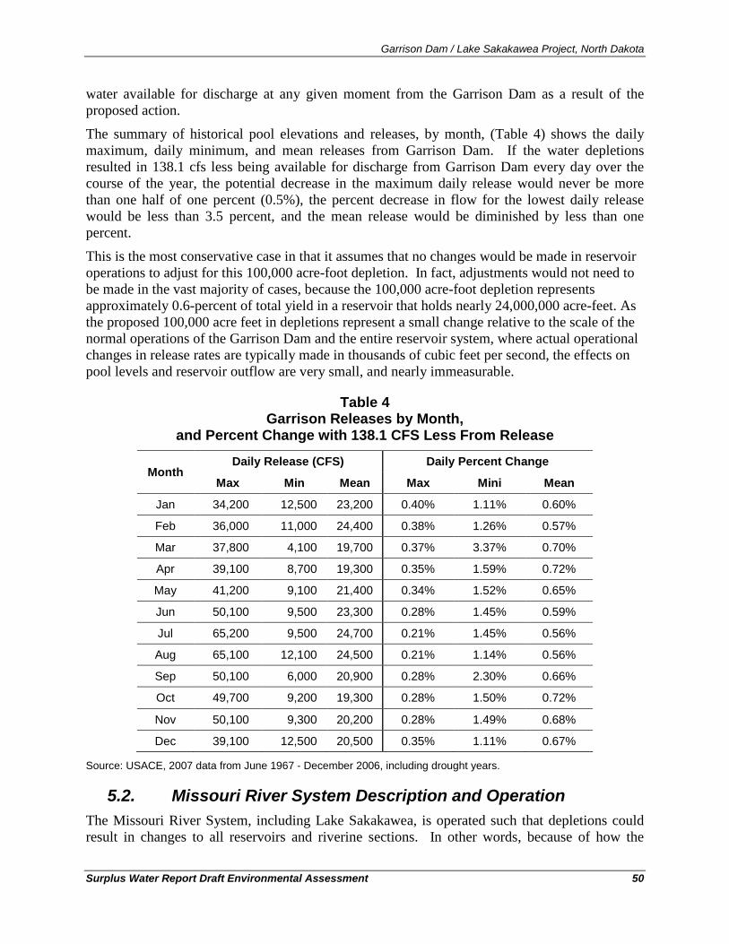
Garrison Dam / Lake Sakakawea Project, North Dakota
Surplus Water Report Draft Environmental Assessment 50
water available for discharge at any given moment from the Garrison Dam as a result of the proposed action.
The summary of historical pool elevations and releases, by month, (Table 4) shows the daily maximum, daily minimum, and mean releases from Garrison Dam. If the water depletions resulted in 138.1 cfs less being available for discharge from Garrison Dam every day over the course of the year, the potential decrease in the maximum daily release would never be more than one half of one percent (0.5%), the percent decrease in flow for the lowest daily release would be less than 3.5 percent, and the mean release would be diminished by less than one percent.
This is the most conservative case in that it assumes that no changes would be made in reservoir operations to adjust for this 100,000 acre-foot depletion. In fact, adjustments would not need to be made in the vast majority of cases, because the 100,000 acre-foot depletion represents approximately 0.6-percent of total yield in a reservoir that holds nearly 24,000,000 acre-feet. As the proposed 100,000 acre feet in depletions represent a small change relative to the scale of the normal operations of the Garrison Dam and the entire reservoir system, where actual operational changes in release rates are typically made in thousands of cubic feet per second, the effects on pool levels and reservoir outflow are very small, and nearly immeasurable.
Table 4 Garrison Releases by Month,
and Percent Change with 138.1 CFS Less From Release
Month Daily Release (CFS) Daily Percent Change
Max Min Mean Max Mini Mean
Jan 34,200 12,500 23,200 0.40% 1.11% 0.60%
Feb 36,000 11,000 24,400 0.38% 1.26% 0.57%
Mar 37,800 4,100 19,700 0.37% 3.37% 0.70%
Apr 39,100 8,700 19,300 0.35% 1.59% 0.72%
May 41,200 9,100 21,400 0.34% 1.52% 0.65%
Jun 50,100 9,500 23,300 0.28% 1.45% 0.59%
Jul 65,200 9,500 24,700 0.21% 1.45% 0.56%
Aug 65,100 12,100 24,500 0.21% 1.14% 0.56%
Sep 50,100 6,000 20,900 0.28% 2.30% 0.66%
Oct 49,700 9,200 19,300 0.28% 1.50% 0.72%
Nov 50,100 9,300 20,200 0.28% 1.49% 0.68%
Dec 39,100 12,500 20,500 0.35% 1.11% 0.67%
Source: USACE, 2007 data from June 1967 - December 2006, including drought years.
5.2. Missouri River System Description and Operation The Missouri River System, including Lake Sakakawea, is operated such that depletions could result in changes to all reservoirs and riverine sections. In other words, because of how the
Garrison Dam / Lake Sakakawea Project, North Dakota
Surplus Water Report Draft Environmental Assessment 51
system is managed, water withdrawn from Lake Sakakawea results in changes throughout the system. Understanding the routine aspects of System operation is important in order better understand the predicted effects from the removal of water from Lake Sakakawea. The rest of this section contains detailed information on the entire System and System operations. It has been included in order provide a basis for understanding how the system is operated so that the consequence assessment, where depletions from Lake Sakakawea have system-wide consequences, can be understood.
As originally shown in Figure 1, the six Corps dams spanning the Missouri River control runoff from approximately half of the basin. Those six dams, from the upper three giants of Fort Peck in eastern Montana, Garrison in central North Dakota and Oahe in central South Dakota, to the lower three smaller reservoirs of Big Bend and Fort Randall in South Dakota, and Gavins Point along the Nebraska-South Dakota border, comprise the largest system of reservoirs in the United States (USACE, 2007c).
As shown in Table 4, the storage capacity of the six reservoirs ranges from over 23 MAF at Garrison and Oahe, to less than 0.5 MAF at Gavins Point. The System is also unique in the fact that 88 percent of the combined storage capacity is in the upper three reservoirs of Fort Peck, Garrison, and Oahe (USACE, 2007c). The lower three projects, Big Bend, Fort Randall, and Gavins Point, are regulated in much the same manner year after year regardless of the runoff conditions (USACE, 2007c).
The entire System’s storage capacity is divided into four unique storage zones for regulation purposes; information on the unique storage zones for each of the six individual reservoirs is provided on Table 5. The bottom 25 percent of the total System storage capacity comprises the permanent pool designed for sediment storage, minimum fisheries, and minimum hydropower heads (USACE, 2007c). The largest zone, comprising 53 percent of the total storage capacity, is the carryover-multiple use zone which is designed to serve all project purposes, though at reduced levels, through a severe drought like that of the 1930's (USACE, 2007c).
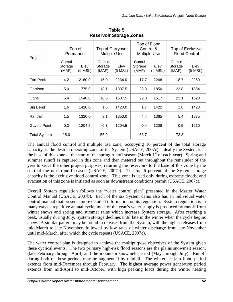
Garrison Dam / Lake Sakakawea Project, North Dakota
Surplus Water Report Draft Environmental Assessment 52
Table 5 Reservoir Storage Zones
Project
Top of Permanent
Top of Carryover Multiple Use
Top of Flood Control &
Multiple Use Top of Exclusive
Flood Control
Cumul Storage (MAF)
Elev (ft MSL)
Cumul Storage (MAF)
Elev (ft MSL)
Cumul Storage (MAF)
Elev (ft MSL)
Cumul Storage (MAF)
Elev (ft MSL)
Fort Peck 4.2 2160.0 15.0 2234.0 17.7 2246 18.7 2250
Garrison 5.0 1775.0 18.1 1837.5 22.3 1850 23.8 1854
Oahe 5.4 1540.0 18.8 1607.5 22.0 1617 23.1 1620
Big Bend 1.6 1420.0 1.6 1420.0 1.7 1422 1.8 1423
Randall 1.5 1320.0 3.1 1350.0 4.4 1365 5.4 1375
Gavins Point 0.3 1204.5 0.3 1204.5 0.4 1208 0.5 1210
Total System 18.0 56.9 68.7 73.3
The annual flood control and multiple use zone, occupying 16 percent of the total storage capacity, is the desired operating zone of the System (USACE, 2007c). Ideally the System is at the base of this zone at the start of the spring runoff season (March 1st of each year). Spring and summer runoff is captured in this zone and then metered out throughout the remainder of the year to serve the other project purposes, returning the reservoirs to the base of this zone by the start of the next runoff season (USACE, 2007c). The top 6 percent of the System storage capacity is the exclusive flood control zone. This zone is used only during extreme floods, and evacuation of this zone is initiated as soon as downstream conditions permit (USACE, 2007c).
Overall System regulation follows the “water control plan” presented in the Master Water Control Manual (USACE, 2007b). Each of the six System dams also has an individual water control manual that presents more detailed information on its regulation. System regulation is in many ways a repetitive annual cycle; most of the year’s water supply is produced by runoff from winter snows and spring and summer rains which increase System storage. After reaching a peak, usually during July, System storage declines until late in the winter when the cycle begins anew. A similar pattern may be found in releases from the System, with the higher releases from mid-March to late-November, followed by low rates of winter discharge from late-November until mid-March, after which the cycle repeats (USACE, 2007c).
The water control plan is designed to achieve the multipurpose objectives of the System given these cyclical events. The two primary high-risk flood seasons are the plains snowmelt season, (late February through April) and the mountain snowmelt period (May through July). Runoff during both of these periods may be augmented by rainfall. The winter ice-jam flood period extends from mid-December through February. The highest average power generation period extends from mid-April to mid-October, with high peaking loads during the winter heating
Garrison Dam / Lake Sakakawea Project, North Dakota
Surplus Water Report Draft Environmental Assessment 53
season (mid-December to mid-February) and the summer air conditioning season (mid-June to mid-August).
The major maintenance periods for the System hydropower facilities extend from March through mid-May and September through November, which normally are the lower demand and off-peak energy periods. The normal 8-month navigation season extends from April 1st through November 30th during which time System releases are scheduled, in combination with downstream tributary flows, to meet downstream target flows. Winter releases after the close of navigation season are much lower, and vary depending on the need to conserve or evacuate System storage while managing downstream river stages for water supply given ice conditions (USACE, 2007c). Minimum release restrictions and pool fluctuations for fish spawning management generally occur from April through June. Gavins Point spring pulses, which are designed to cue spawning of the endangered pallid sturgeon, are provided in March and May with the flow magnitude, duration, and timing based on System storage, runoff forecast, and other criteria (USACE, 2007c). Nesting of the two Federally protected bird species, the endangered interior least tern and the threatened piping plover, occurs from early May through mid-August.
Other factors may vary widely from year to year, such as the amount of water in storage and the magnitude and distribution of inflow received during the coming year. All of these factors affect the timing and magnitude of releases throughout the System. The gain or loss in the water stored at each reservoir must also be considered in scheduling the amount of water transferred between reservoirs to achieve the desired storage levels and to generate power. These items are continually reviewed as they occur and are appraised with respect to the expected range of operations (USACE, 2007c).
5.2.1. Intrasystem Regulation Intrasystem regulation is an important tool in the management of water in the System to meet the authorized purposes. It is used to regulate individual reservoir levels in the System to balance or unbalance the water in storage at each project, to smooth the annual System regulation by anticipating unusual snowmelt runoff, to maintain the seasonal capability of the hydropower system, and to improve conditions for the reservoir fish spawn and recruitment. It also can be used to maintain stages on the open river reaches between projects at desirable levels. Intrasystem adjustments may also be used to meet emergencies, including the protection of human health and safety, protection of significant historic and cultural properties, or to meet the provisions of applicable laws including the Endangered Species Act (USACE, 2007c). These adjustments are made to the extent reasonably possible after evaluating impacts to other System uses, are generally short term in nature, and continue only until the issue is resolved (USACE, 2007c).
The presence of large reservoirs in the System increases intrasystem regulation flexibility. A small reservoir such as Gavins Point with storage of less than one-half million acre-feet can only tolerate a large difference between inflow and release for less than a day. Big Bend is in this category as well. To a lesser extent, so is Fort Randall, although its carryover-multiple use and annual flood control and multiple use storage of nearly 3 MAF make possible significant storage transfers and flow differentials extending a month or more (USACE, 2007c). But it is the upper three large reservoirs of Fort Peck, Garrison, and Oahe, with their combined 37.4 MAF of
Garrison Dam / Lake Sakakawea Project, North Dakota
Surplus Water Report Draft Environmental Assessment 54
carryover multiple-use storage plus an additional 10.1 MAF of annual flood control multiple-use storage, that provide the flexibility to adjust intrasystem regulation to better serve authorized purposes (USACE, 2007c).
5.2.1.1. Seasonal Intrasystem Regulation Patterns. Intrasystem regulation to meet the needs of power generation follows a regular seasonal cycle. Releases from Gavins Point are generally at their highest during the navigation season when downstream flow requirements are highest. Since Gavins Point reservoir is small, these releases must be backed up with similar magnitude releases from Fort Randall, and Fort Randall, in turn, requires similar support flows from Oahe via Big Bend. Here the chain can be interrupted; Oahe is large enough to support high releases for extended periods without high inflows. Generation at Fort Peck and Garrison are held to lower levels during the summer to allow more winter hydropower production unless the evacuation of water accumulated in the flood control zones or the desire to balance or unbalance storage among the upper three projects becomes an overriding consideration (USACE, 2007c).
5.2.1.2. Winter Release Patterns With the onset of the non-navigation season, conditions are reversed. Gavins Point releases drop to about one-third to slightly greater than half of summer levels and the chain reaction proceeds upstream, curtailing daily average discharges from Fort Randall, Big Bend, and Oahe (USACE, 2007c). During the winter release pattern, Fort Peck and Garrison daily releases are usually maintained at relatively high levels (within the limits imposed by downstream ice cover) to partially compensate for the reduction of generation downstream where high winter releases could result in significant flood damages in urban areas when the formation of ice impedes the flow (USACE, 2007c).
5.2.1.3. Balancing/Unbalancing the Upper Three Reservoirs In the past, the volume of water stored in each of the upper three reservoirs was balanced by the first of March of every year (USACE, 2007c). However, intentionally unbalancing the water stored in the upper three reservoirs can benefit the reservoir fisheries and increase tern and plover habitat. All Annual Operating Plans since the 2000-2001 report have stated that unbalancing would be pursued during years when the reservoirs were at or near the base of their annual flood control pools on March 1st and when runoff forecasts were for median or greater annual runoff. However, drought conditions have prevented implementation of reservoir unbalancing to date (USACE, 2007c).
5.2.1.4. Short Term Intrasystem Adjustments. The interaction among projects described above, repeated as it is year after year, might make intrasystem regulation appear to be a routine and rigid procedure. However, routine regulation is often disrupted by the short-term extremes of nature. For example, heavy rains may raise river stages near the flood level, necessitating a release reduction at one project and a corresponding increase at others. Very hot or very cold weather may create sharp increases in the demand for power. Inflows for a week or for a season may concentrate disproportionately in one segment of the System, causing abrupt shifts in regulating objectives. In addition, short-term intrasystem adjustments are occasionally required to meet emergencies, including the protection of human
Garrison Dam / Lake Sakakawea Project, North Dakota
Surplus Water Report Draft Environmental Assessment 55
health and safety, protection of significant historic and cultural properties, or to meet the provisions of applicable laws, including the Endangered Species Act. These adjustments are made to the extent possible after evaluating impacts to other System uses, are generally short term in nature, and continue only until the issue is resolved (USACE, 2007c). However, meeting the needs for short term intrasystem adjustments lead to great variability in releases and pool elevations year-to-year.
5.2.1.5. Hourly Fluctuation of Release Rates With the exception of the Gavins Point Project, hourly release rates may vary widely as necessary to meet fluctuating power loads (USACE, 2007c) at all of the other projects (Fort Peck, Garrison, Oahe, Big Bend, and Fort Randall). Known as “power pulsing,” this daily practice for the upstream System reservoirs produces predictable, daily, and distinct changes to releases and the associated water surface elevations in the riverine reaches between power pulsed reservoirs. Figure 16 shows the daily stage variation at the Washburn, ND river gage, downstream of the Garrison Dam, for a one-month period between July 12 and August 12, 2007 (USACE, 2010). This figure shows the daily fluctuation in water surface elevation at the Washburn gage with daily highs around 10.7 feet and daily lows of approximately 9.5 feet. The daily effect to river stage of power pulsing at this gage shows a 1.2-foot up-and-down differential in the water surface elevation due to the changes to releases from Garrison Dam. The amplitude of these changes varies by reach, power pulsing result in substantial daily variation in both flow and water surface elevation in the riverine reaches.
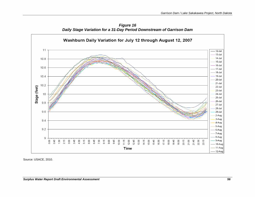
Garrison Dam / Lake Sakakawea Project, North Dakota
Surplus Water Report Draft Environmental Assessment 56
Figure 16 Daily Stage Variation for a 31-Day Period Downstream of Garrison Dam
Source: USACE, 2010.
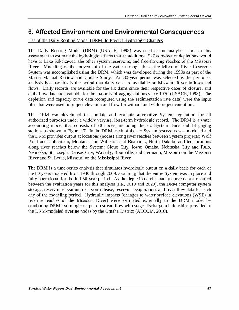
Garrison Dam / Lake Sakakawea Project, North Dakota
Surplus Water Report Draft Environmental Assessment 57
6. Affected Environment and Environmental Consequences
The Daily Routing Model (DRM) (USACE, 1998) was used as an analytical tool in this assessment to estimate the hydrologic effects that an additional 527 acre-feet of depletions would have at Lake Sakakawea, the other system reservoirs, and free-flowing reaches of the Missouri River. Modeling of the movement of the water through the entire Missouri River Reservoir System was accomplished using the DRM, which was developed during the 1990s as part of the Master Manual Review and Update Study. An 80-year period was selected as the period of analysis because this is the period that daily data are available on Missouri River inflows and flows. Daily records are available for the six dams since their respective dates of closure, and daily flow data are available for the majority of gaging stations since 1930 (USACE, 1998). The depletion and capacity curve data (computed using the sedimentation rate data) were the input files that were used to project elevation and flow for without and with project conditions.
Use of the Daily Routing Model (DRM) to Predict Hydrologic Changes
The DRM was developed to simulate and evaluate alternative System regulation for all authorized purposes under a widely varying, long-term hydrologic record. The DRM is a water accounting model that consists of 20 nodes, including the six System dams and 14 gaging stations as shown in Figure 17. In the DRM, each of the six System reservoirs was modeled and the DRM provides output at locations (nodes) along river reaches between System projects: Wolf Point and Culbertson, Montana, and Williston and Bismarck, North Dakota; and ten locations along river reaches below the System: Sioux City, Iowa; Omaha, Nebraska City and Rulo, Nebraska; St. Joseph, Kansas City, Waverly, Boonville, and Hermann, Missouri on the Missouri River and St. Louis, Missouri on the Mississippi River.
The DRM is a time-series analysis that simulates hydrologic output on a daily basis for each of the 80 years modeled from 1930 through 2009, assuming that the entire System was in place and fully operational for the full 80-year period. As the depletion and capacity curve data are varied between the evaluation years for this analysis (i.e., 2010 and 2020), the DRM computes system storage, reservoir elevation, reservoir release, reservoir evaporation, and river flow data for each day of the modeling period. Hydraulic impacts (changes to water surface elevations (WSE) in riverine reaches of the Missouri River) were estimated externally to the DRM model by combining DRM hydrologic output on streamflow with stage-discharge relationships provided at the DRM-modeled riverine nodes by the Omaha District (AECOM, 2010).
Garrison Dam / Lake Sakakawea Project, North Dakota
Surplus Water Report Draft Environmental Assessment 58
Figure 17
Model Node Locations for the Daily Routing Model
Garrison Dam / Lake Sakakawea Project, North Dakota
Surplus Water Report Draft Environmental Assessment 59
Each DRM run provides 29,220 simulated values (80 years of daily values) for each parameter (i.e., water surface elevation, reservoir volume, and streamflow) at the 20 locations/model nodes in the system. These data should not be considered as estimates of actual calendar day values, but rather as simulation output values under the full range of climatological conditions existing over the 80-year period.
To evaluate differences between two alternatives, the differences between each of the 29,220 daily values were determined and then sorted to establish a frequency distribution of modeled values. The distributions of the differences from the current conditions (without the additional depletions) for various DRM outputs (water surface elevation, reservoir volume, and streamflow) were then examined. Comparing the data distributions in this manner provides insight as to how the increased depletion scenario impacts the likelihood of occurrence of a given water surface elevation, reservoir volume, and streamflow over the entire 80-year period. Similarly, it can provide an estimate of the likelihood of a given magnitude of change in each parameter between No Action and with project conditions. It should be noted that the x axis on all of the distribution plots are percent of the days, where 10 percent represents 2,922 days of the full 29,220 days of the 80-year period of analysis.
To examine the effects of just the additional depletions directly from System reservoirs, the simulations for one study year (2010) were completed under three separate planning scenarios: 1) baseline depletions (without project current condition), 2) 527 acre-feet of depletions at Lake Sakakawea (with project condition), and 3) 50,527 acre-feet of depletions (including 527 acre-feet at Lake Sakakawea and 10,000 acre-feet each at the other five system reservoirs) to evaluate the cumulative effects of removing an additional 50,527 acre-feet of water from all six System reservoirs The model assumes that the historic System inflow data, adjusted assuming the depletions associated with current development in the basin, occurred over the 80-year modeling period.
The source of the actual System inflow data is the U.S. Geological Survey, which began acquiring daily data beginning in late 1929. The DRM adjusts these inflow data by the difference for depletions that have been estimated to occur between each year and 2002. The Bureau of Reclamation provided the monthly depletions, and these monthly data were further separated to daily values for use in the DRM. Inflow and depletion data are available for each of the DRM modeling reaches (AECOM, 2010). The 2002 depletion data are assumed to remain constant through 2010 (assumes no change from 2002 to 2010). The depletion data are adjusted upwards to 2020 by including other forecasted depletions (basin projects, population/M&I growth, and the Northwest Area Water Supply (NAWS) project). Simulations including these projected additional system depletions for 2020 were used in the assessment of cumulative effects analysis.
Because the Missouri River reservoirs are operated as an integrated system, 257,000 acre-feet of storage (100,000 acre-feet of yield) from Lake Sakakawea could conceivably reduce outflows and water surface elevations not just in Lake Sakakawea, but also in the other five System reservoirs. Changes in water surface elevations have the potential to affect environmental resources throughout the system and the magnitude of predicted environmental consequences is proportional to the predicted changes. However, as stated in Section 5.1.1, the determination of
Modeled Differences: Depletions from Lake Sakakawea
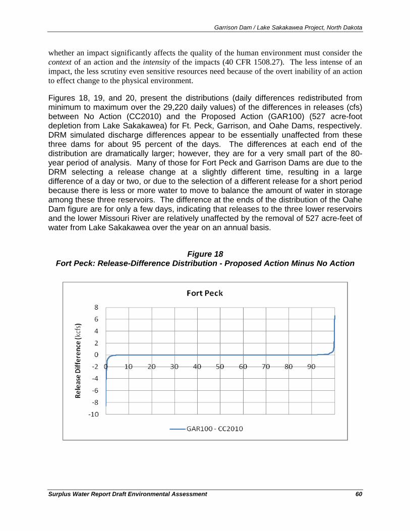
Garrison Dam / Lake Sakakawea Project, North Dakota
Surplus Water Report Draft Environmental Assessment 60
whether an impact significantly affects the quality of the human environment must consider the context of an action and the intensity of the impacts (40 CFR 1508.27). The less intense of an impact, the less scrutiny even sensitive resources need because of the overt inability of an action to effect change to the physical environment.
Figures 18, 19, and 20, present the distributions (daily differences redistributed from minimum to maximum over the 29,220 daily values) of the differences in releases (cfs) between No Action (CC2010) and the Proposed Action (GAR100) (527 acre-foot depletion from Lake Sakakawea) for Ft. Peck, Garrison, and Oahe Dams, respectively. DRM simulated discharge differences appear to be essentially unaffected from these three dams for about 95 percent of the days. The differences at each end of the distribution are dramatically larger; however, they are for a very small part of the 80-year period of analysis. Many of those for Fort Peck and Garrison Dams are due to the DRM selecting a release change at a slightly different time, resulting in a large difference of a day or two, or due to the selection of a different release for a short period because there is less or more water to move to balance the amount of water in storage among these three reservoirs. The difference at the ends of the distribution of the Oahe Dam figure are for only a few days, indicating that releases to the three lower reservoirs and the lower Missouri River are relatively unaffected by the removal of 527 acre-feet of water from Lake Sakakawea over the year on an annual basis.
Figure 18 Fort Peck: Release-Difference Distribution - Proposed Action Minus No Action
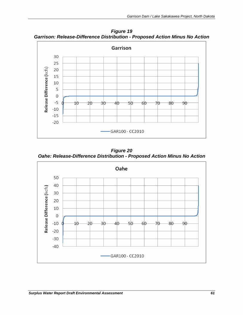
Garrison Dam / Lake Sakakawea Project, North Dakota
Surplus Water Report Draft Environmental Assessment 61
Figure 19 Garrison: Release-Difference Distribution - Proposed Action Minus No Action
Figure 20
Oahe: Release-Difference Distribution - Proposed Action Minus No Action
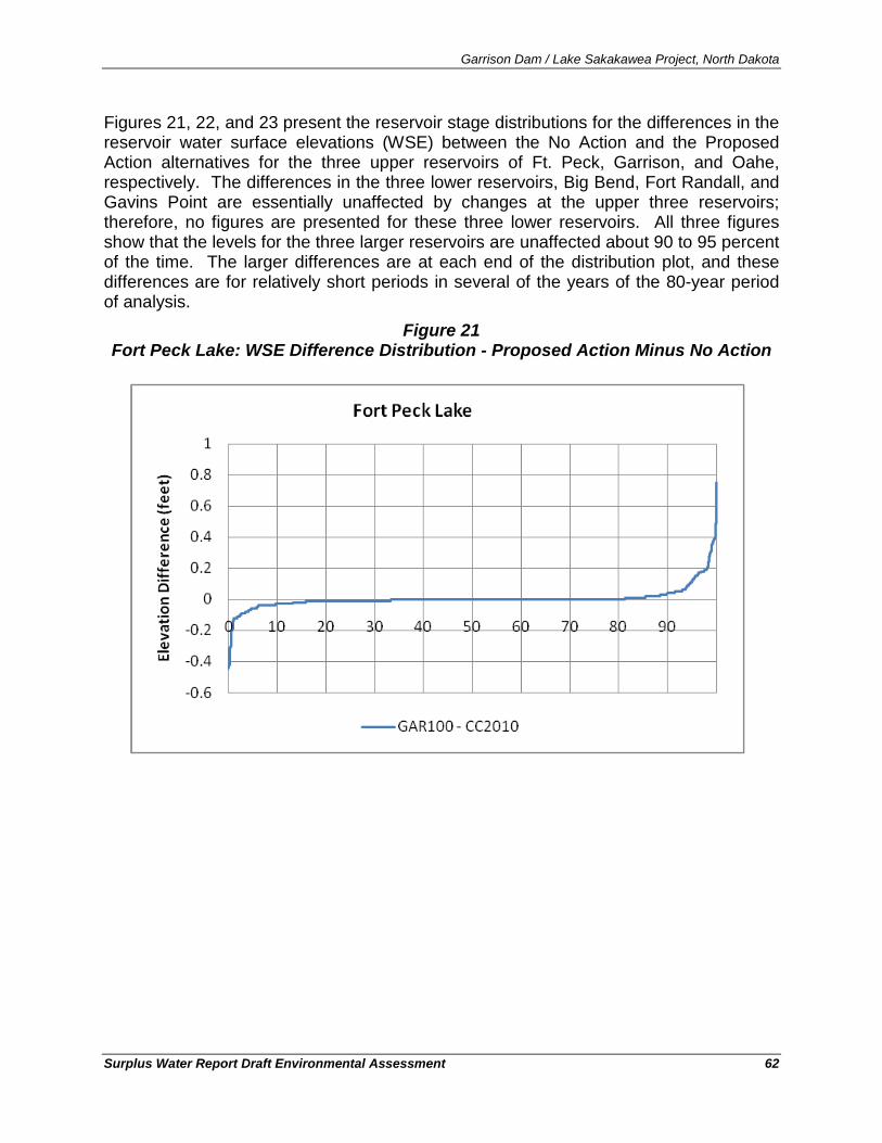
Garrison Dam / Lake Sakakawea Project, North Dakota
Surplus Water Report Draft Environmental Assessment 62
Figures 21, 22, and 23 present the reservoir stage distributions for the differences in the reservoir water surface elevations (WSE) between the No Action and the Proposed Action alternatives for the three upper reservoirs of Ft. Peck, Garrison, and Oahe, respectively. The differences in the three lower reservoirs, Big Bend, Fort Randall, and Gavins Point are essentially unaffected by changes at the upper three reservoirs; therefore, no figures are presented for these three lower reservoirs. All three figures show that the levels for the three larger reservoirs are unaffected about 90 to 95 percent of the time. The larger differences are at each end of the distribution plot, and these differences are for relatively short periods in several of the years of the 80-year period of analysis.
Figure 21 Fort Peck Lake: WSE Difference Distribution - Proposed Action Minus No Action
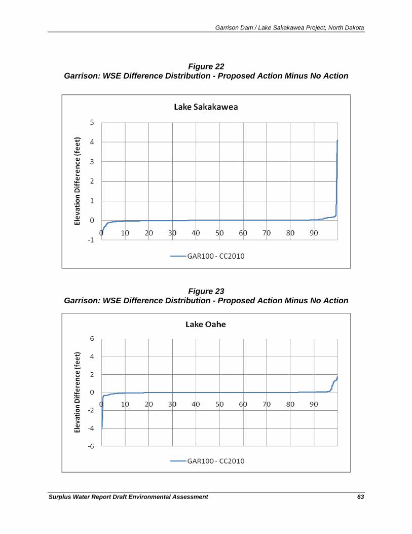
Garrison Dam / Lake Sakakawea Project, North Dakota
Surplus Water Report Draft Environmental Assessment 63
Figure 22
Garrison: WSE Difference Distribution - Proposed Action Minus No Action
Figure 23
Garrison: WSE Difference Distribution - Proposed Action Minus No Action
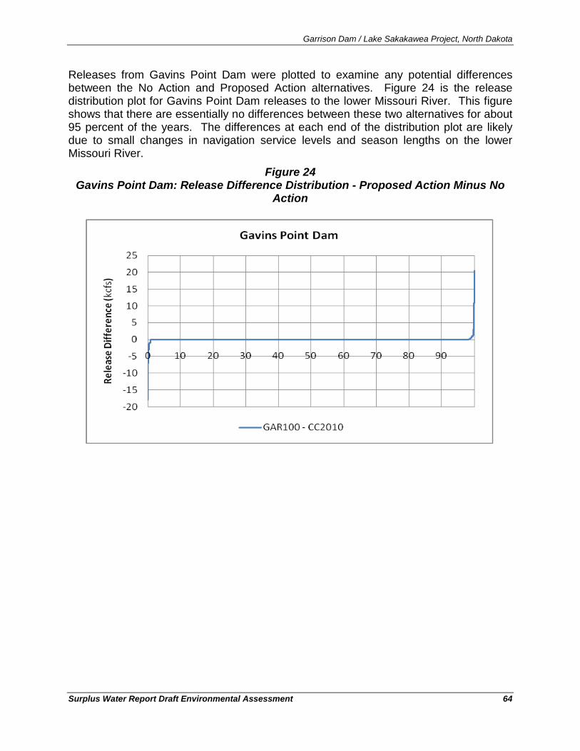
Garrison Dam / Lake Sakakawea Project, North Dakota
Surplus Water Report Draft Environmental Assessment 64
Releases from Gavins Point Dam were plotted to examine any potential differences between the No Action and Proposed Action alternatives. Figure 24 is the release distribution plot for Gavins Point Dam releases to the lower Missouri River. This figure shows that there are essentially no differences between these two alternatives for about 95 percent of the years. The differences at each end of the distribution plot are likely due to small changes in navigation service levels and season lengths on the lower Missouri River.
Figure 24 Gavins Point Dam: Release Difference Distribution - Proposed Action Minus No
Action
Garrison Dam / Lake Sakakawea Project, North Dakota
Surplus Water Report Draft Environmental Assessment 65
6.1. Topography
6.1.1. Existing Condition The topography of North Dakota defined by contrast with the Missouri River defining the boundary. The advance and retreat of the Laurentide Ice Sheet during last glacial period is largely responsible for the present terrain and drainage. The mile-wide Missouri River valley separates the Missouri Plateau of the west from the glaciated Missouri Coteau of eastern North Dakota. Most of western North Dakota is characterized by the Missouri Plateau of the Great Plains extending from the western side of the Missouri River valley down to north-central South Dakota. The topography of this area typifies the "American West" with its rolling wide-open spaces and shortgrass prairie. To the west of this plateau, the landscape transitions into the Little Missouri badlands where conical hills were formed when the Little Missouri River was displaced by Pleistocene glacial activity. Ephemeral streams that remove the soft silt and clays of the hills have further shaped the badlands. Overall, western North Dakota is characterized by its moderately dissected level topography, stream carved terrain, and rolling plains that are a patchwork of prairie, steppe, and grassland, interspersed with buttes and badlands. Elevations in western North Dakota range from 1,750 to 3,300 feet above sea level (NPWRC, 2010).
The topography surrounding Lake Sakakawea is an open, expansive, stream-dissected prairie. Lake Sakakawea is long and sinuous, with a highly serrated shoreline due to the inundation of valleys of tributaries to the Missouri River. Rugged topography due to stream downcutting (dissection) is most extensive near Lake Sakakawea and to the southwest, particularly along the Little Missouri River valley. Here, elevations often differ by more than 800 feet within a few miles, in areas where buttes, badlands, and large coulees (drainageways) formed in association with Pleistocene (ice age) glacial advances and retreats.
6.1.2. Environmental Consequences No Action
Under the No Action alternative, there would be none of the ground-disturbing effects associated with construction of the water depots, retention ponds, road access, utility lines, or the water supply intakes on lands surrounding Lake Sakakawea. However, under the No Action alternative, similar infrastructure to access the water from riverine reaches would likely be constructed upstream or downstream of Lake Sakakawea to meet the water demand. None of these actions under the No Action alternative would be expected to significantly affect topography.
Proposed Action
As described in Section 4.4.2, construction of water depots, retention ponds, utility lines and roadways for all of the water supply intakes would typically disturb a 75-foot width of disturbance from the high water mark to the terminus and water depots/retention ponds would be approximately two acres each. However, to the extent feasible, the trenched water/utility line and water depots/retention ponds would be constructed within or adjacent to an existing utility or road corridor thereby minimizing the changes to topography from the proposed actions.
Garrison Dam / Lake Sakakawea Project, North Dakota
Surplus Water Report Draft Environmental Assessment 66
6.2. Geology, Stratigraphy, and Seismology
6.2.1. Existing Condition
North Dakota is situated in the Northern Great Plains region and is geologically, one of the least complicated parts of North America. For most of the half billion years from 570 million until about 70 million years ago, the Great Plains was inundated by shallow seas. About 70 million years ago, the seas were displaced from the continental interior by slow uplift of the continent. The landscape that appeared, presently the Northern Great Plains, was the expansive, nearly flat, floor of the former sea. The many layers of sediments deposited onto the subsiding floor of the interior ocean, now consolidated into rock, rest on ancient Pre-Cambrian basement rocks (Trans-Hudson Orogenic Belt) of the North American Craton.
Geology
13
Within the North American Craton, the Williston Basin is a large, sedimentary basin covering approximately 300,000 square miles across parts of North and South Dakota, Montana, and the Canadian provinces of Manitoba and Saskatchewan. The geographic center of the basin lies about 16,000 feet below the ground surface near Williston, ND (Heck et al., 2007).
Overlying the geologic structures of the Williston Basin are poorly consolidated sediments and lignite (soft coal) beds of the Tertiary-age Fort Union Formation. This formation mainly consists of alternating beds of moderately to well compacted, gray to brown, stiff to hard clay shale, with moderately to well compacted silt and fine sand, and numerous lignite beds. Overlying the Fort Union Formation are Pleistocene glacial till and alluvial deposits (sands, gravels, and alluvial clays) that hold surficial groundwater aquifers.
Stratigraphy is the description of the sequence, spacing, composition, and spatial distribution of geologic formations of sedimentary deposits and rocks in a given area. The stratigraphic column, or layers of rock of the Williston Basin, spans a discontinuous sequence from weathered Precambrian crystalline basement rocks approximately 2.5 billion years old to Tertiary rocks deposited 2.5 million years ago. Unconsolidated glacial sediments of Quaternary age (2.5 million years ago to approximately 12,000 years ago) overly the consolidated basin strata. There are a large number of oil-bearing formations in the Williston Basin including the Bakken, Sanish, and Three-Forks Formations that are the focus of current oil and natural gas drilling activities in western North Dakota (NDSWC, 2010).
Stratigraphy
Most earthquakes that originate in North Dakota are likely related to deeply buried structures in the Precambrian basement (Bluemle, 2002). Most of the structural deformation during the Paleozoic Eon in North Dakota probably resulted from the subsidence of the Williston Basin. The main evidences of structural deformation in the basin are folding and faulting and the best evidence of folding in North Dakota is the anticlinal and synclinal structures that were formed.
Seismology
13 A craton is a stable part of the earth's continental crust that has not been deformed significantly for many millions or hundreds of millions of years.
Garrison Dam / Lake Sakakawea Project, North Dakota
Surplus Water Report Draft Environmental Assessment 67
In structural geology, an anticline is a fold that is convex up and has its oldest beds at its core and a syncline is is a downward-curving fold, with layers that dip toward the center of the structure. Anticlines are favored locations for oil and natural gas drilling because the low density of petroleum causes it to buoyantly migrate upward to the highest parts of the fold. In North Dakota, some of these structures, like the Nesson, Cedar Creek, Little Knife, and Billings anticlines, produce oil (Heck et al., 2007).
The Nesson Anticline is the most prominent surface structure in the North Dakota portion of the Williston Basin. It is a subterranean crustal flexure extending from Williams County and western Mountrail County generally southward for approximately 75 miles into McKenzie and Dunn counties.
6.2.2. Environmental Consequences No Action
Taking no action would not have any effect on the geology, stratigraphy, or seismology of the Garrison Project, Lake Sakakawea, or the region.
Proposed Action
Implementing the Proposed Action would not have any effect on the geology, stratigraphy, or seismology of the Garrison Project, Lake Sakakawea, or the region.
6.3. Soils
6.3.1. Existing Condition Soil in this region has been forming since the last glacier receded approximately 10,000 years ago. Residue was left from the last glacial period in the form of glacial till, outwash plains, alluvium, loess materials, or weathered bedrock. Soils were developed in a semiarid to subhumid, continental climate with hot summers, cold winters, and modest precipitation.
Western North Dakota soils are principally Mollisols of the dominant sub-order Udolls. Mollisols are characterized as dark mineral soils common to the subhumid to semiarid plains of North America. These soils are typically found in grasslands and are rich in organic materials making them very suitable for agriculture. Udolls specifically are predominant in the Great Plains region where they support tall grass prairie, cropland, pasture or rangeland.
The badlands of southwest North Dakota are characterized by Entisols of the dominant sub-order Orthents. These soils, which have little to no diagnostic horizons, are the result of erosional processes and glacial outwash. The lack of horizons indicates soils that exist on steep, eroding slopes where soil material does not stay long enough to develop distinct layers. Orthents typically support rangeland, pasture, and wildlife habitat (USACE, 2007).
Along the Missouri River, Aridisols and Inceptisols are also found; Aridisols are soils that are unable to hold onto moisture for long periods of time limiting the growth of vegetation and many contain salts as a result of high evapotranspiration. Inceptisols are widely varying soils that are generally found in active landscapes where deposition or erosion regularly occurs. As a result,
Garrison Dam / Lake Sakakawea Project, North Dakota
Surplus Water Report Draft Environmental Assessment 68
Inceptisols are often located on mountain slopes or along river valleys and many of the Inceptisols were a result of the late-Pleistocene glacial drift (USACE, 2007).
Within NEPA evaluations, the USACE must consider the protection of the nations’ significant/important agricultural lands from irreversible conversion to uses that result in their loss as an environmental or essential food production resource. The Farmland Protection Policy Act (FPPA), 7 USC 4201 et seq., and the U.S. Department of Agriculture’s (USDA) implementing procedures (7 CFR § 658) require Federal agencies to evaluate the adverse effects of their actions on prime and unique farmland, including farmland of statewide and local importance.
6.3.2. Environmental Consequences No Action
Under the No Action alternative, there would be no soil-disturbing activities for water depot, retention pond, water intake, utility, and access road construction on Garrison Project lands. However, taking No Action would likely require new water intake infrastructure be developed up-river from Lake Sakakawea that could require the conversion of Prime or Unique Farmland or farmland of statewide and local importance, depending on the intake location selected.
Proposed Action
Element Solutions:
Mandaree Site – proposed pipeline would be constructed within a previously disturbed corridor with current ground cover of grass adjacent to an existing roadway and an existing utility corridor. According to Figure 2.5.1 in the Garrison Dam/Lake Sakakawea Project Master Plan (USACE, 2007), the proposed area for pipeline, utility, and road construction has not been designated as prime farmland or farmland of statewide importance (USACE, 2007).
International Western:
Iverson Site – According to Figure 2.5.1 in the Garrison Dam/Lake Sakakawea Project Master Plan (USACE, 2007), the proposed area for pipeline, utility, and road construction has not been designated as prime farmland or farmland of statewide importance (USACE, 2007). In addition, this location would utilize an existing intake and existing storage pond and would not result in new construction. As such, there would be no concerns about affects to protected farmland.
Thompson Site – The proposed intake pipe would be constructed within a grassed area between access roads and the high-water mark. According to Figure 2.5.1 in the Garrison Dam/Lake Sakakawea Project Master Plan (USACE, 2007), the proposed area for pipeline, utility, and road construction has not been designated as prime farmland or farmland of statewide importance (USACE, 2007).
Charlson Site – The proposed intake pipe would be constructed within a grassed area between the existing two-track access roads and the high-water mark. According to Figure 2.5.1 in the Garrison Dam/Lake Sakakawea Project Master Plan (USACE, 2007), the proposed area for
Garrison Dam / Lake Sakakawea Project, North Dakota
Surplus Water Report Draft Environmental Assessment 69
pipeline, utility, and road construction has not been designated as prime farmland or farmland of statewide importance (USACE, 2007).
Lake Sakakawea & Associates:
#3 – The area for the proposed water depot and the pipeline from the water depot to the ordinary high water mark would be constructed within a predominantly grassed area with adjacent vegetated coulees. According to Figure 2.5.1 in the Garrison Dam/Lake Sakakawea Project Master Plan (USACE, 2007), the proposed area for the water depot, pipeline, utility, and road construction has not been designated as prime farmland or farmland of statewide importance (USACE, 2007).
#5 - The area for the proposed water depot and the pipeline to the ordinary high water mark would be constructed within a grassed area between access roads and the high-water mark. No trees or woody vegetation or wetlands are within the proposed access. According to Figure 2.5.1 in the Garrison Dam/Lake Sakakawea Project Master Plan (USACE, 2007), the proposed area for pipeline, utility, and road construction has not been designated as prime farmland or farmland of statewide importance (USACE, 2007).
#8 – The area for the proposed water depot and the pipeline to the ordinary high water mark would be constructed within a previously disturbed corridor with current ground cover of grass adjacent to an existing roadway and an existing utility corridor. According to Figure 2.5.1 in the Garrison Dam/Lake Sakakawea Project Master Plan (USACE, 2007), the proposed area for pipeline, utility, and road construction has not been designated as prime farmland or farmland of statewide importance (USACE, 2007).
6.4. Groundwater
6.4.1. Existing Condition Groundwater in western North Dakota occurs in two major geological strata: unconsolidated surficial (glacial) deposits and bedrock. The unconsolidated surficial deposits are glacial formations with loose beds of glacial outwash that are typically narrow (less than one mile in width) shallow (see Figure 25). Though they have a great capacity to transmit water, these limited formations are too small to store large capacities of water. As such, they are not a reliable water source for large-scale (i.e., industrial) water supply.
Most of the bedrock aquifers that flow through fractured rock and sandstone of western North Dakota have high concentrations of Total Dissolved Solids (TDS), resulting in diminished water quality. The notable exception is the Fox Hills aquifer that underlines western North Dakota and is the most consistently productive formation in the Great Plains aquifer system. Well yields in the Fox Hills aquifer can reach 200 gallons per minute, though recharge rates are low. In topographic low areas, such as along the Little Missouri, Knife and Missouri River valleys, wells in the Fox Hills aquifer flow above land surface (i.e., are artesian) and are important sources of water for stock uses. Water level monitoring over the last 30 years indicates pressure-head declines of 1-2 feet per year, which may cause existing wells to stop flowing if this trend persists another 60 to 90 years. Groundwater supplies approximately 60-percent of the population’s drinking water needs in North Dakota and 97-percent of the state's rural population use
Garrison Dam / Lake Sakakawea Project, North Dakota
Surplus Water Report Draft Environmental Assessment 70
groundwater for drinking water purposes (USACE, 2007). Because of the low recharge rates and head loss concerns, the North Dakota State Engineer has not allowed large-scale water use of the Fox Hills aquifer (Frink, 2010).
According to the North Dakota State Water Commission, glaciofluvial and other shallow aquifers and the Fox Hills bedrock aquifer are insufficient to supply the requirements of the oil and gas industry at the proposed rate of development (NDSWC, 2010). In addition, “it is critical that ground-water supplies be conserved for the use and sustenance of towns, homes, local industries, and farms and ranches, after the completion of oil development” (NDSWC, 2010). As of December of 2009 there were 28 groundwater-based water depots, for a total allocation of 2,340 acre-feet per year serving the oil industry in western North Dakota (NDSWC, 2010). Thirty more water permits for water depots are pending, for an additional 5,534 acre-feet per year, but not all of these would likely be approved (NDSWC, 2010). Even if all were approved, water supplies from ground water would fall far short of needs for the oil and gas industry and risk long-term effects from depleting the bedrock groundwater resources (NDSWC, 2010).
6.4.2. Environmental Consequences No Action
As described in Section 4.1, under the no action alternative, the Corps of Engineers would not make a determination of surplus water, there would be no change to the water supply, there would be no water supply agreements, and no new water supply intakes would be constructed. Without these new water supply intakes, there would be no new depletions from Lake Sakakawea from within Garrison Project lands. The majority of water to supply the industry’s needs would likely be provided by Missouri River water upstream or downstream of Lake Sakakawea. Groundwater resources (both surficial and bedrock sources) within the area are not sufficient to supply the quantity of water needed for M&I purposes.
Therefore, minimal effects to groundwater would be predicted as a consequence of taking No Action because groundwater resources are insufficient to supply the oil and gas industry and the State of North Dakota would not overexploit the groundwater resource. As quoted in Section 3.3.2.1, “Groundwater supplies in western North Dakota are limited. Glaciofluvial and other shallow aquifers and the Fox Hills – Hell Creek bedrock aquifer are insufficient to supply the requirements … at the proposed rate of development. It is critical that ground-water supplies be conserved for the use and sustenance of towns, homes, local industries, and farms and ranches, after the completion of oil development” (NDSWC, 2010).
Proposed Action
For the same reasons that implementing the No Action alternative would not be expected to have an effect on groundwater, implementing the Proposed Action would likewise not be expected to significantly affect groundwater resources. Implementing the proposed action could reduce the demand for groundwater sources, but as stated above, groundwater resources are insufficient to meet the industry’s needs and therefore would not be affected by implementing the Proposed Action.
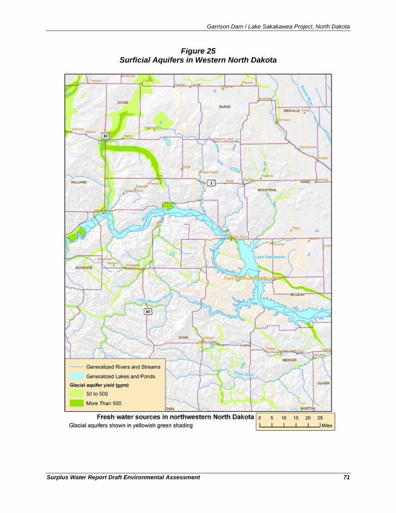
Garrison Dam / Lake Sakakawea Project, North Dakota
Surplus Water Report Draft Environmental Assessment 71
Figure 25 Surficial Aquifers in Western North Dakota
Garrison Dam / Lake Sakakawea Project, North Dakota
Surplus Water Report Draft Environmental Assessment 72
6.5. Water Quality
6.5.1. Existing Condition The Clean Water Act (CWA) requires states to report on the quality of their waters including Section 305(b) (State Water Quality Assessment Report) and Section 303(d) identifying a list of a state’s water quality-limited waters needing total maximum daily loads (TMDLs). The primary purpose of the Section 305(b) State Water Quality Assessment Report is to assess and report on the extent to which beneficial uses of the state’s rivers, streams, lakes, reservoirs and wetlands are met (NDDoH, 2010). The NDDoH’s Ambient Water Quality Monitoring Network for Rivers and Streams currently consists of 34 fixed-station ambient monitoring sites located on 19 rivers to provide data for trend analysis, general water quality characterization, and pollutant loading calculations (NDDoH, 2010).
Samples are collected and analyzed for water chemistry and bacteria at each of these sites every six weeks during the open-water period (generally from early April through November) and once during the winter under ice cover (generally in late January or early February). Parameters include major ions, trace elements, total suspended solids, total and dissolved nutrients (phosphorus, nitrogen, ammonia, nitrate-nitrite, Total Kjeldahl Nitrogen), total and dissolved organic carbon, and fecal coliform and E. coli bacteria (NDDoH, 2010).
Table 6 shows the designated use, impairment status, and the basis for listing for impaired waterbodies tributary to, and including, Lake Sakakawea in North Dakota. These classifications are based on the 2010 List of Section 303(d) TMDL Waters for the Missouri River Basin (NDDoH, 2010). The State of North Dakota has designated Lake Sakakawea as a Class I lake in the State’s water quality standards.14
Lake Sakakawea undergoes an annual water temperature cycle, based on the four seasons and the transition between seasons. During the summer, a thermocline becomes established in the deeper area of the reservoir towards the dam. Because the thickness of the upper (warm water) layer tends to remain the same from year to year due to mixing by wind, the higher the surface elevation of the lake, the farther upstream the boundary of the hypolimnion (and the coldwater fishery) extends. The shallower upper reaches of Lake Sakakawea do not vary much in temperature by depth during mid to late summer because wind action completely mixes the water (USACE, 2007).
As such, the lake is to be suitable for a coldwater fishery (e.g., salmonid fishes and associated aquatic life); swimming, boating, and other water recreation; irrigation; stock watering; wildlife; and water for municipal or domestic use after appropriate treatment.
14 www.legis.nd.gov/information/acdata/pdf/33-16-02.1.pdf

Garrison Dam / Lake Sakakawea Project, North Dakota
Surplus Water Report Draft Environmental Assessment 73
Table 6 Surface Waters on 303(d) TMDL List in the Project Area
Description Assessment Unit ID
Designated Use
Use Support Impairment
Lake Sakakawea ND-10110101-021_00
Fish Consumption
Not Supporting
Methyl mercury
Little Muddy River from East Fork Tributary to Lake Sakakawea
ND-10110102-001-S_00
Recreation Not Supporting
Fecal coliform
Little Missouri River from Little Beaver Creek to Lake Sakakawea
ND-10110203-003-S_00
Recreation Fully Supporting, but Threatened
Fecal coliform
Little Knife River from Stanley Reservoir to Lake Sakakawea
ND-10110101-080-S_00
Recreation Not Supporting
Fecal coliform
Dissolved oxygen concentrations in Lake Sakakawea vary in association with water depth because more oxygen can remain dissolved (and available for fish respiration) in cold water. Dissolved oxygen levels ≥ 5 mg/l (milligrams per liter) are required for fishery habitat. Maintaining summer pool levels above 1825 msl in Lake Sakakawea is considered necessary to maintain sufficiently oxygenated habitat (USACE, 2009).
The State of North Dakota “Standards of Quality for Waters of the State” (Chapter 33-16-02.1) defines Lake Sakakawea as a Class 1 Lake: cold water fishery capable of supporting growth of cold water fish species (e.g., salmonids) and associated biota. Water temperature and dissolved oxygen levels are primary water quality factors that determine the suitability of water for coldwater aquatic life. As such, the water quality standards applied to Lake Sakakawea are that the lake must maintain at least 500,000 acre-feet of water at all times with a temperature less than or equal to 15º C, and dissolved oxygen greater than or equal to 5 mg/l. The State of North Dakota has placed Lake Sakakawea on their 303(d) impaired waterbody list citing impairment to the coldwater fishery due to water temperature and dissolved oxygen concerns.
6.5.2. Environmental Consequences No Action
As described in Section 4.1, under the no action alternative, the Corps of Engineers would not make a determination of surplus water, there would be no change to the water supply, there would be no water supply agreements, and no new water supply intakes would be constructed. Without these new water supply intakes, there would be no new depletions from Lake Sakakawea from within Garrison Project lands. However, as a result of taking No Action, the majority of water to supply the industry’s needs would likely be provided by Missouri River water upstream or downstream of Lake Sakakawea. These depletions from the riverine reaches above Lake Sakakawea would effectively result in the same changes to water surface elevations and the quantity of water available for discharge as with the Proposed Action. The only difference would be where the water was withdrawn. Therefore, implementing the No Action
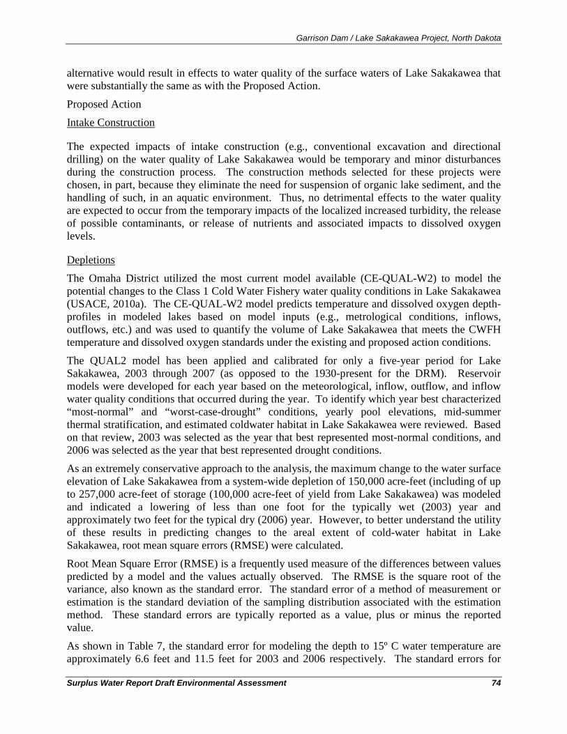
Garrison Dam / Lake Sakakawea Project, North Dakota
Surplus Water Report Draft Environmental Assessment 74
alternative would result in effects to water quality of the surface waters of Lake Sakakawea that were substantially the same as with the Proposed Action.
Proposed Action
The expected impacts of intake construction (e.g., conventional excavation and directional drilling) on the water quality of Lake Sakakawea would be temporary and minor disturbances during the construction process. The construction methods selected for these projects were chosen, in part, because they eliminate the need for suspension of organic lake sediment, and the handling of such, in an aquatic environment. Thus, no detrimental effects to the water quality are expected to occur from the temporary impacts of the localized increased turbidity, the release of possible contaminants, or release of nutrients and associated impacts to dissolved oxygen levels.
Intake Construction
The Omaha District utilized the most current model available (CE-QUAL-W2) to model the potential changes to the Class 1 Cold Water Fishery water quality conditions in Lake Sakakawea (USACE, 2010a). The CE-QUAL-W2 model predicts temperature and dissolved oxygen depth-profiles in modeled lakes based on model inputs (e.g., metrological conditions, inflows, outflows, etc.) and was used to quantify the volume of Lake Sakakawea that meets the CWFH temperature and dissolved oxygen standards under the existing and proposed action conditions.
Depletions
The QUAL2 model has been applied and calibrated for only a five-year period for Lake Sakakawea, 2003 through 2007 (as opposed to the 1930-present for the DRM). Reservoir models were developed for each year based on the meteorological, inflow, outflow, and inflow water quality conditions that occurred during the year. To identify which year best characterized “most-normal” and “worst-case-drought” conditions, yearly pool elevations, mid-summer thermal stratification, and estimated coldwater habitat in Lake Sakakawea were reviewed. Based on that review, 2003 was selected as the year that best represented most-normal conditions, and 2006 was selected as the year that best represented drought conditions.
As an extremely conservative approach to the analysis, the maximum change to the water surface elevation of Lake Sakakawea from a system-wide depletion of 150,000 acre-feet (including of up to 257,000 acre-feet of storage (100,000 acre-feet of yield from Lake Sakakawea) was modeled and indicated a lowering of less than one foot for the typically wet (2003) year and approximately two feet for the typical dry (2006) year. However, to better understand the utility of these results in predicting changes to the areal extent of cold-water habitat in Lake Sakakawea, root mean square errors (RMSE) were calculated.
Root Mean Square Error (RMSE) is a frequently used measure of the differences between values predicted by a model and the values actually observed. The RMSE is the square root of the variance, also known as the standard error. The standard error of a method of measurement or estimation is the standard deviation of the sampling distribution associated with the estimation method. These standard errors are typically reported as a value, plus or minus the reported value.
As shown in Table 7, the standard error for modeling the depth to 15º C water temperature are approximately 6.6 feet and 11.5 feet for 2003 and 2006 respectively. The standard errors for
Garrison Dam / Lake Sakakawea Project, North Dakota
Surplus Water Report Draft Environmental Assessment 75
modeling the depth to 5 mg/l dissolved oxygen were approximately 11 feet and 16 feet for 2003 and 2006 respectively. As such, the standard error associated with estimating the depths to the 15º C and 5 mg/l isopleths were appreciably larger than the predicted changes in Lake Sakakawea pool elevations (maximally two feet or less) from the extremely conservative assumptions used for modeled depletions. Thus, the uncertainty associated with the model predictions exceed the values predicted from the proposed action. These standard errors indicate that the model does not have the sensitivity to predict effects at the magnitude of the estimated pool elevation changes. Given the difference between the No Action and Proposed Action model results from DRM, there would be no significant effects to the cold water habitat predicted as a result of implementing the Proposed Action.
Table 7 Standard Error Estimation for Modeled Effects
Parameter
Standard Error +/- (Feet)
Typically Wet Year (2003)
Typically Dry Year (2006)
Change to Depth of 15-Degrees C 6.6 11.5
Change to Depth of 5 mg/l Dissolved Oxygen 11.1 16
6.6. Air Quality
6.6.1. Existing Condition The U.S. Environmental Protection Agency (USEPA) Office of Air Quality Planning and Standards has set National Ambient Air Quality Standards (NAAQS) for six principal pollutants, called “criteria” pollutants. They are carbon monoxide, nitrogen dioxide, ozone, lead, particulates of 10 microns or less in size (PM-10 and PM-2.5), and sulfur dioxide. Ozone is the only parameter not directly emitted into the air but forms in the atmosphere when three atoms of oxygen (03) are combined by a chemical reaction between oxides of nitrogen (NOx) and volatile organic compounds (VOC) in the presence of sunlight. Motor vehicle exhaust and industrial emissions, gasoline vapors, and chemical solvents are some of the major sources of NOx and VOC, also known as ozone precursors. Strong sunlight and hot weather can cause ground-level ozone to form in harmful concentrations in the air.
The Clean Air Act General Conformity Rule (58 FR 63214, November 30, 1993, Final Rule, Determining Conformity of General Federal Actions to State or Federal Implementation Plans) dictates that a conformity review be performed when a Federal action generates air pollutants in a region that has been designated a non-attainment or maintenance area for one or more NAAQS. A conformity assessment would require quantifying the direct and indirect emissions of criteria pollutants caused by the Federal action to determine whether the proposed action conforms to Clean Air Act requirements and any State Implementation Plan (SIP).
The general conformity rule was designed to ensure that Federal actions do not impede local efforts to control air pollution. It is called a conformity rule because Federal agencies are
Garrison Dam / Lake Sakakawea Project, North Dakota
Surplus Water Report Draft Environmental Assessment 76
required to demonstrate that their actions “conform with” (i.e., do not undermine) the approved State Implementation Plan (SIP) for their geographic area. The purpose of conformity is to (1) ensure Federal activities do not interfere with the air quality budgets in the SIPs; (2) ensure actions do not cause or contribute to new violations, and (3) ensure attainment and maintenance of the NAAQS. Federal agencies make this demonstration by performing a conformity review when the actions they are planning to carry out will be conducted in an area designated as a non-attainment or maintenance area for one of the criteria pollutants.
If one or more of the priority pollutants was not in attainment, then the proposed action would be subject to detailed conformity determinations unless these actions are clearly de minimus emissions. Use of the de minimus levels assures that the conformity rule covers only major Federal actions (USEPA, 1993). A conformity review requires consideration of both direct and indirect air emissions associated with the proposed action. Sources that would contribute to direct emissions from this project would include demolition or construction activities associated with the proposed action and equipment used to facilitate the action (e.g., construction vehicles). To be counted as an indirect emission, the Federal proponent for the action must have continuing control over the source of the indirect emissions. Sources of indirect emissions include commuter activity to and from the construction site (e.g., employee vehicle emissions). Both stationary and mobile sources must be included when calculating the total of direct and indirect emissions, but this project would involve only mobile sources.
For each of the counties of western North Dakota, all six criteria pollutants are in attainment of the air quality standards (USEPA, 2010). The Clean Air Act Amendments of 1977 state that national parks which exceed six thousand acres in size be classified as "Class I" areas. "Class I" areas have set restrictions on the allowable increase in emissions of particulate matter and sulfur dioxide beyond a baseline year. Theodore Roosevelt National Park, located in the badlands of western North Dakota, covers 70,467 acres of land, deeming it a "Class I" area (Clean Water Act). Sulfur dioxide levels have been monitored at the Park, but not at park boundary areas (NPS, 2010).
The North Dakota Department of Health is the state agency designated to administer and coordinate a statewide program of air pollution control, has general legal authority under North Dakota Century Code Sections 23-25-03 and 28-32-02 to adopt and enforce rules for visibility protection including regional haze visibility impairment. In February 2010, the state prepared a submittal to address the State Implementation Plan requirements for the State of North Dakota Regional Haze Program Requirements, of 40 CFR Part 51 Subpart P - Protection of Visibility (NDDOH, 2010a).
The evaluation identified seven steam electric generating units in North Dakota as being subject to the best available retrofit technology (BART) requirements of 40 CFR 51.308(e). The installation of BART on these sources will result in a reduction of 98,618 tons per year of sulfur dioxide emissions and a reduction of 21,137 tons per year of nitrogen oxides emissions from the 2000-2004 average emissions (NDDOH, 2010a). These reductions will significantly improve visibility in North Dakota’s Class I areas15
15 The Clean Air Act Amendments of 1977 state that national parks that exceed six thousand acres in size be classified as "Class I" areas. "Class I" areas have set restrictions on the allowable increase in emissions of particulate matter and sulfur dioxide beyond a baseline year.
as well as those in surrounding states (NDDOH, 2010a).

Garrison Dam / Lake Sakakawea Project, North Dakota
Surplus Water Report Draft Environmental Assessment 77
6.6.2. Environmental Consequences No Action
Under the No Action alternative, the Corps of Engineers would not make a determination of surplus water, there would be no change to the water supply, there would be no water supply agreements, and no new water supply intakes would be constructed. Without these new water supply intakes, there would be no new depletions from Lake Sakakawea from within Garrison Project lands. However, as a result of taking No Action, the majority of water to supply the industry’s needs would likely be provided by Missouri River water upstream or downstream of Lake Sakakawea.
Emissions and fugitive dust related to the construction of the water supply infrastructure would still be necessary, but these emissions and the associated effects would occur at locations upstream or downstream from Lake Sakakawea as opposed to within Garrison Project lands. Obtaining water up or down river from Lake Sakakawea would also lead to a substantial increase in water truck travel distance when compared to the Proposed Action. The associated diesel emissions and fugitive dust (i.e., road dust) would be greater than with the Proposed Action as well. Under the No Action alternative, the oil and gas industry would continue to obtain the necessary water to support the oil and gas industry and the regional effects to air quality, including visibility impairment, would not be predicted to change substantially from the existing conditions.
Proposed Action
Probable effects to air quality would include emissions from the operation of construction equipment for intake, roadway, water depot, retention pond, and pipeline installation. Emissions would be earthen particles (i.e., fugitive dust) as well as diesel emissions from equipment operation. These impacts would be localized and temporary. Other indirect effects to air quality would be from the emissions from transportation of personnel and equipment to and from the job sites on a daily basis until the completion of construction.
The other effect to air quality from implementing the Proposed Action would be associated with the decrease in total miles traveled to supply water from the source to the end users in the oil field. The No Action alternative would require longer per-trip travel than the Proposed Action, so implementing the Proposed Action would result in a decrease in diesel emissions associated with providing water to the oil and gas industry throughout the region.
6.7. Oil and Natural Gas
6.7.1. Existing Condition The recent U.S. Geological Service (USGS) Assessment for the Bakken Formation estimated mean undiscovered volumes of 3.65 billion barrels of oil, 1.85 trillion cubic feet of associated/dissolved natural gas, and 148 million barrels of natural gas liquids in the Williston Basin Province, Montana and North Dakota (USGS, 2008).
However, much of the Bakken Formation was considered a marginal to sub-marginal resource because the oil and gas were locked in a rock formation with a low permeability. Beginning in late-2008, successful wells were drilled into the Bakken Formation using a newly developed horizontal drilling technology and a long-used method of accessing the oil from the formation
Garrison Dam / Lake Sakakawea Project, North Dakota
Surplus Water Report Draft Environmental Assessment 78
called hydrofracing. The application of these techniques allowed access to significant oil reserves that had been previously inaccessible.
As a result, crude oil production in North Dakota has nearly doubled from approximately 45 million barrels in 2007 to just under 80 million barrels in 2009 (NDIC, 2010). The number of producing wells and the associated oil production continue to grow; data from June 2010 set new state records for the number of producing wells (4,979), oil production in a month (9,458,349 barrels), and total production in the first six months of 2010 equaled the entire 2009 production (Helms, 2010). The number of active drill rigs in North Dakota has nearly doubled during 2010; from 83 in January 2010, to 125 in June 2010, to 154 drill rigs active in November, to 162 in early December 2010 (NDIC, 2010).
6.7.2. Environmental Consequences No Action
Under the No Action alternative, the oil and gas industry would continue to obtain the water necessary to sustain the industry, but would not access the water from Lake Sakakawea within the Garrison Project. The water necessary for the industry would likely be accessed up or downstream of Lake Sakakawea. As such there would be no predicted change to the oil and gas industry as a result of implementing the No Action alternative.
Proposed Action
As stated in Section 5.1.3, water supply--while necessary to oil and gas production--is not
6.8. Solid and Hazardous Waste
the limiting factor on the rate of drilling or hydrofracing in North Dakota. Rather, the availability of drill rigs and hydrofracing crews are the critical factors limiting the rate at which industry grows within the region. This observation is supported by the growth of drilling and production in 2009-2010 without any Federal action affecting the availability of water by the Corps of Engineers. Additions to the supply of water for the industry from surplus water in Lake Sakakawea could affect the location of preferred water sources and how water is distributed and moved within the region; however, additional water availability is not expected to influence the rate of oil drilling or production.
6.8.1. Existing Condition As companies explore for and produce oil and gas, they generate various hazardous and non-hazardous liquid, semisolid, and solid wastes. Non-hazardous oil field wastes16
16 In the Solid Waste Disposal Act Amendments of 1980 (Pub. L. 94-580), Congress amended the Resource Conservation and Recovery Act (RCRA) to add sections 3001 (b)(2)(A), and 8002 (m). Section 3001(b)(2)(A) exempted drilling fluids, produced waters, and other wastes associated with exploration, development, and production of crude oil, natural gas and geothermal energy from regulation as hazardous wastes (58 FR 15284, 1993). Therefore, most oil field wastes that arise from, or are associated with, oil and gas exploration and production are considered nonhazardous because they are specifically exempted from federal hazardous waste requirements.
can be assigned to several categories: drilling wastes, produced water, and associated wastes. Produced water typically hydrofrac water that is brought to the surface at the beginning of production.
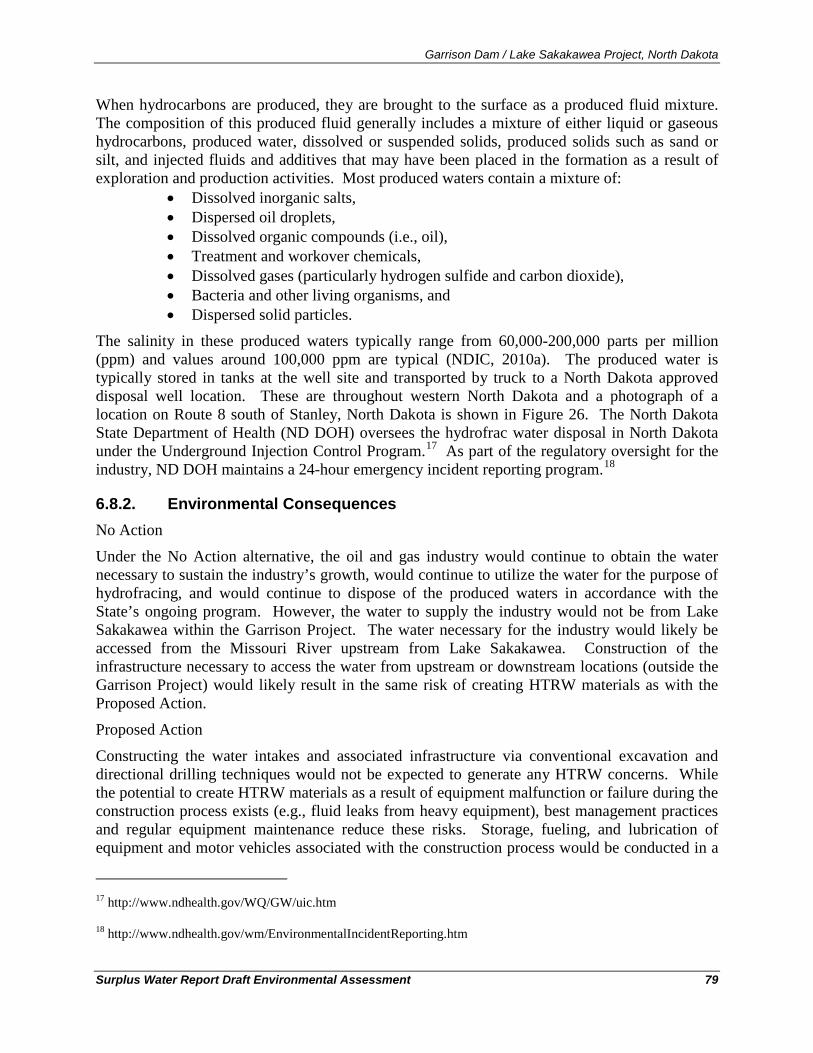
Garrison Dam / Lake Sakakawea Project, North Dakota
Surplus Water Report Draft Environmental Assessment 79
When hydrocarbons are produced, they are brought to the surface as a produced fluid mixture. The composition of this produced fluid generally includes a mixture of either liquid or gaseous hydrocarbons, produced water, dissolved or suspended solids, produced solids such as sand or silt, and injected fluids and additives that may have been placed in the formation as a result of exploration and production activities. Most produced waters contain a mixture of:
• Dissolved inorganic salts, • Dispersed oil droplets, • Dissolved organic compounds (i.e., oil), • Treatment and workover chemicals, • Dissolved gases (particularly hydrogen sulfide and carbon dioxide), • Bacteria and other living organisms, and • Dispersed solid particles.
The salinity in these produced waters typically range from 60,000-200,000 parts per million (ppm) and values around 100,000 ppm are typical (NDIC, 2010a). The produced water is typically stored in tanks at the well site and transported by truck to a North Dakota approved disposal well location. These are throughout western North Dakota and a photograph of a location on Route 8 south of Stanley, North Dakota is shown in Figure 26. The North Dakota State Department of Health (ND DOH) oversees the hydrofrac water disposal in North Dakota under the Underground Injection Control Program.17 As part of the regulatory oversight for the industry, ND DOH maintains a 24-hour emergency incident reporting program.18
6.8.2. Environmental Consequences
No Action
Under the No Action alternative, the oil and gas industry would continue to obtain the water necessary to sustain the industry’s growth, would continue to utilize the water for the purpose of hydrofracing, and would continue to dispose of the produced waters in accordance with the State’s ongoing program. However, the water to supply the industry would not be from Lake Sakakawea within the Garrison Project. The water necessary for the industry would likely be accessed from the Missouri River upstream from Lake Sakakawea. Construction of the infrastructure necessary to access the water from upstream or downstream locations (outside the Garrison Project) would likely result in the same risk of creating HTRW materials as with the Proposed Action.
Proposed Action
Constructing the water intakes and associated infrastructure via conventional excavation and directional drilling techniques would not be expected to generate any HTRW concerns. While the potential to create HTRW materials as a result of equipment malfunction or failure during the construction process exists (e.g., fluid leaks from heavy equipment), best management practices and regular equipment maintenance reduce these risks. Storage, fueling, and lubrication of equipment and motor vehicles associated with the construction process would be conducted in a
17 http://www.ndhealth.gov/WQ/GW/uic.htm
18 http://www.ndhealth.gov/wm/EnvironmentalIncidentReporting.htm
Garrison Dam / Lake Sakakawea Project, North Dakota
Surplus Water Report Draft Environmental Assessment 80
manner that affords the maximum protection against spill and evaporation. The construction methods selected for these projects were chosen, in part, because they eliminate the need for suspension of organic lake sediment, and the handling of such, in an aquatic environment.
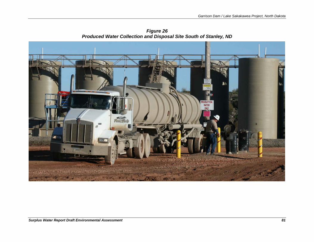
Garrison Dam / Lake Sakakawea Project, North Dakota
Surplus Water Report Draft Environmental Assessment 81
Figure 26 Produced Water Collection and Disposal Site South of Stanley, ND
Garrison Dam / Lake Sakakawea Project, North Dakota
Surplus Water Report Draft Environmental Assessment 82
6.9. Traffic, Truck Traffic, and Accidents
6.9.1. Existing Condition Two US highways, U.S. 83 and U.S. 85, and one interstate highway, Interstate 94, are the largest capacity roads in Western North Dakota. Interstate 94, proceeds east-west through southern North Dakota, connecting Fargo, Jamestown, Bismarck, and Dickinson. U.S. Highway 83 and 85 run north-south to the west and east of Lake Sakakawea respectively. To the north of Lake Sakakawea, U.S. 2 is an east-west road that connects U.S. 83 and 85. Similarly, to the south of Lake Sakakawea, State Route 200 is an east-west state road that connects U.S. 83 and 85. State Route 23 approximately bisects Lake Sakakawea via the Four Bears/New Town Bridge and is an east-west state road that connecting U.S. 83 and 85 midway between U.S. 2 and State Route 200. With so few bridge crossings, vehicles might have to drive up to 100 miles one-way to get from one side of the Lake Sakakawea to the other by road.
The area surrounding Lake Sakakawea is an extremely remote area of the United States, with associated low population densities and low levels of traffic. These smaller state and local roads provide access to the residences, ranches, and small communities within the region. The most recently published traffic count data from the North Dakota Department of traffic counter data provide an indication of the effect the booming oil and gas industry has had on traffic, especially the increase in truck traffic. Table 6 shows average daily traffic (AADT) and the number of vehicles within the AADT counts that were trucks. These data are collected from many locations within the state of North Dakota, but are reported here for select locations surrounding Lake Sakakawea from 2007 and 2009. A the locations for which data area presented, the increases in all traffic and truck traffic are noteworthy. Table 8 shows average increases in AADT of 23-percent and a larger percentage increase in the proportion of traffic from large trucks. The number of trucks per day at these locations had increased by between 16-percent and more than 80-percent between 2007 and 2009. The only location presented in Table 6 for which truck traffic declined is S.R. 1804 west of Williston, where truck traffic had declined approximately 19-percent between 2007 and 2009. The decrease in truck traffic seen at this location is more typical for many of roads outside the area of influence of the oil and gas industry during this three year period.
Table 9 shows the number of fatalities, by county, as a result of vehicle accidents in the area of influence in western North Dakota. In 2009, of the 169 vehicle crash fatalities in the State, 28 of them involved large trucks (e.g., Single Unit Trucks greater than 19,500 lbs GVWR, truck tractors, and medium/heavy pickup trucks) (FARS, 2010). For 2009, Mountrail, Ward, and McKenzie had the first, second, and fourth-most vehicle-related fatalities in North Dakota (NNDOT, 2009).
A study by the North Dakota Department of Transportation has shown that truck traffic in western counties impacted by oil development has grown by approximately 200 percent in one year (2008-09) (NDPC, 2010). Annual freshwater truckloads have grown from approximately 118,900 in 2008 to approximately 224,900 truckloads in 2009 (NDPC, 2010).
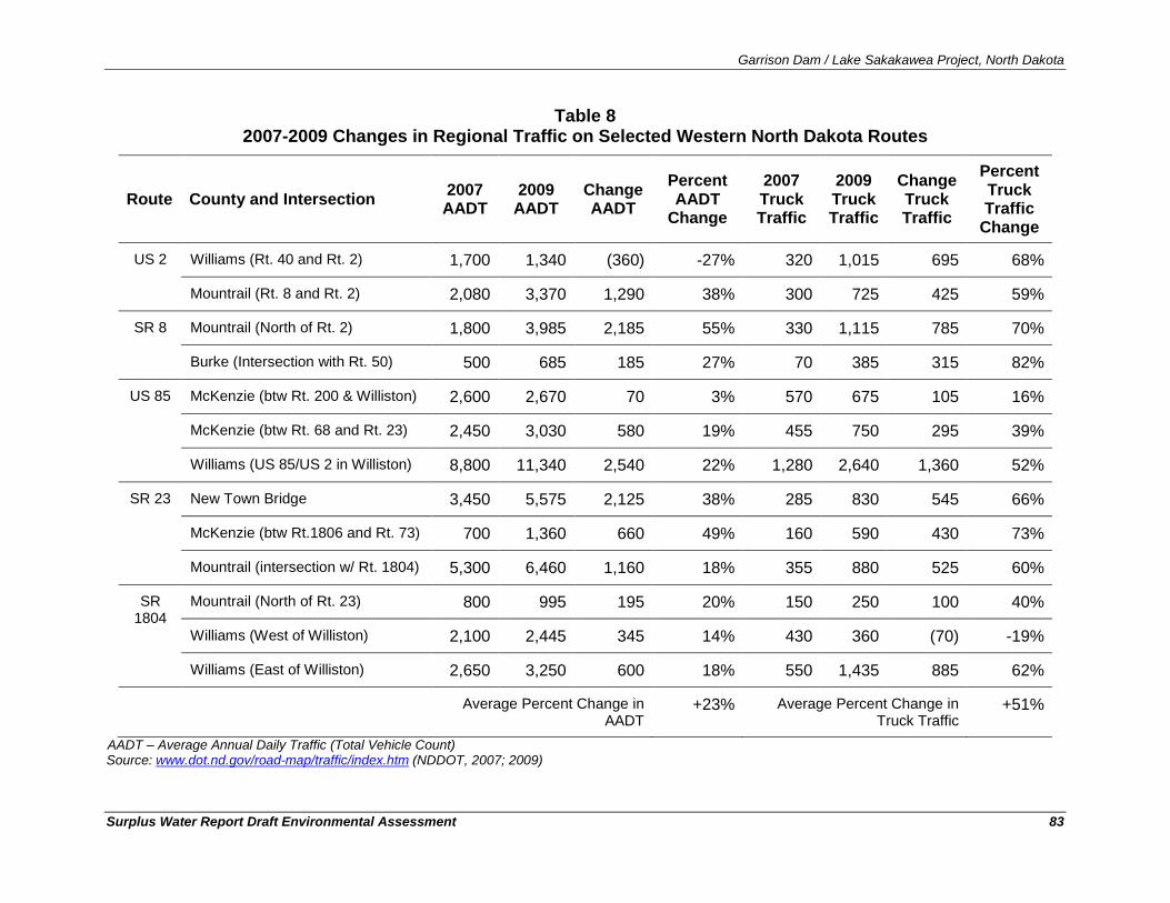
Garrison Dam / Lake Sakakawea Project, North Dakota
Surplus Water Report Draft Environmental Assessment 83
Table 8 2007-2009 Changes in Regional Traffic on Selected Western North Dakota Routes
Route County and Intersection 2007 AADT
2009 AADT
Change AADT
Percent AADT
Change
2007 Truck Traffic
2009 Truck Traffic
Change Truck Traffic
Percent Truck Traffic
Change
US 2 Williams (Rt. 40 and Rt. 2) 1,700 1,340 (360) -27% 320 1,015 695 68%
Mountrail (Rt. 8 and Rt. 2) 2,080 3,370 1,290 38% 300 725 425 59%
SR 8 Mountrail (North of Rt. 2) 1,800 3,985 2,185 55% 330 1,115 785 70%
Burke (Intersection with Rt. 50) 500 685 185 27% 70 385 315 82%
US 85 McKenzie (btw Rt. 200 & Williston) 2,600 2,670 70 3% 570 675 105 16%
McKenzie (btw Rt. 68 and Rt. 23) 2,450 3,030 580 19% 455 750 295 39%
Williams (US 85/US 2 in Williston) 8,800 11,340 2,540 22% 1,280 2,640 1,360 52%
SR 23 New Town Bridge 3,450 5,575 2,125 38% 285 830 545 66%
McKenzie (btw Rt.1806 and Rt. 73) 700 1,360 660 49% 160 590 430 73%
Mountrail (intersection w/ Rt. 1804) 5,300 6,460 1,160 18% 355 880 525 60%
SR 1804
Mountrail (North of Rt. 23) 800 995 195 20% 150 250 100 40%
Williams (West of Williston) 2,100 2,445 345 14% 430 360 (70) -19%
Williams (East of Williston) 2,650 3,250 600 18% 550 1,435 885 62%
Average Percent Change in AADT
+23% Average Percent Change in Truck Traffic
+51%
AADT – Average Annual Daily Traffic (Total Vehicle Count) Source: www.dot.nd.gov/road-map/traffic/index.htm (NDDOT, 2007; 2009)
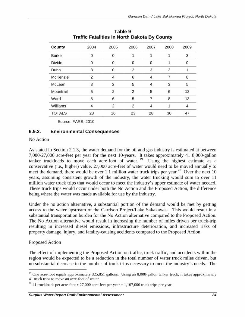
Garrison Dam / Lake Sakakawea Project, North Dakota
Surplus Water Report Draft Environmental Assessment 84
Table 9 Traffic Fatalities in North Dakota By County
County 2004 2005 2006 2007 2008 2009
Burke 0 0 1 1 1 3
Divide 0 0 0 0 1 0
Dunn 3 0 2 3 3 1
McKenzie 2 4 6 4 7 8
McLean 3 2 5 4 3 5
Mountrail 5 2 2 5 6 13
Ward 6 6 5 7 8 13
Williams 4 2 2 4 1 4
TOTALS 23 16 23 28 30 47
Source: FARS, 2010
6.9.2. Environmental Consequences No Action
As stated in Section 2.1.3, the water demand for the oil and gas industry is estimated at between 7,000-27,000 acre-feet per year for the next 10-years. It takes approximately 41 8,000-gallon tanker truckloads to move each acre-foot of water. 19 Using the highest estimate as a conservative (i.e., higher) value, 27,000 acre-feet of water would need to be moved annually to meet the demand, there would be over 1.1 million water truck trips per year.20
Under the no action alternative, a substantial portion of the demand would be met by getting access to the water upstream of the Garrison Project/Lake Sakakawea. This would result in a substantial transportation burden for the No Action alternative compared to the Proposed Action. The No Action alternative would result in increasing the number of miles driven per truck-trip resulting in increased diesel emissions, infrastructure deterioration, and increased risks of property damage, injury, and fatality-causing accidents compared to the Proposed Action.
Over the next 10 years, assuming consistent growth of the industry, the water trucking would sum to over 11 million water truck trips that would occur to meet the industry’s upper estimate of water needed. These truck trips would occur under both the No Action and the Proposed Action, the difference being where the water was made available for use by the industry.
Proposed Action
The effect of implementing the Proposed Action on traffic, truck traffic, and accidents within the region would be expected to be a reduction in the total number of water truck miles driven, but no substantial decrease in the number of truck trips necessary to meet the industry’s needs. The 19 One acre-foot equals approximately 325,851 gallons. Using an 8,000-gallon tanker truck, it takes approximately 41 truck trips to move an acre-foot of water. 20 41 truckloads per acre-foot x 27,000 acre-feet per year = 1,107,000 truck trips per year.
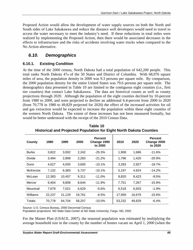
Garrison Dam / Lake Sakakawea Project, North Dakota
Surplus Water Report Draft Environmental Assessment 85
Proposed Action would allow the development of water supply sources on both the North and South sides of Lake Sakakawea and reduce the distance well developers would need to travel to access the water necessary to meet the industry’s need. If these reductions in total miles were realized by implementing the Proposed Action, then there would be associated decreases in the effects to infrastructure and the risks of accidents involving water trucks when compared to the No Action alternative.
6.10. Demographics
6.10.1. Existing Condition At the time of the 2000 census, North Dakota had a total population of 642,200 people. This total ranks North Dakota 47th of the 50 States and District of Columbia. With 68,976 square miles of area, the population density in 2000 was 9.3 persons per square mile. By comparison, the 2000 population density for the entire United States was 79.6 persons per square mile. The demographics data presented in Table 10 are limited to the contiguous eight counties (i.e., first tier counties) that contact Lake Sakakawea. The data are historical counts as well as county projections through 2020. Although the population of the eight counties declined by 10-percent from 1980 to 2000, and were projected to decline an additional 6.4-percent from 2000 to 2020 (from 70,778 in 1980 to 49,829 projected for 2020) the effect of the increased activities for oil and gas extraction would be expected to increase the population within these eight counties of the western North Dakota. The extent of these increases has not been measured formally, but would be better understood with the receipt of the 2010 Census Data.
Table 10 Historical and Projected Population for Eight North Dakota Counties
County 1980 1990 2000 Percent
Change 1990 to 2000
2010 2020 Percent
Change 2000 to 2020
Burke 3,822 3,002 2,242 -25.3% 1,908 1,686 -11.6%
Divide 3,494 2,899 2,283 -21.2% 1,796 1,420 -20.9%
Dunn 4,627 4,005 3,600 -10.1% 3,283 2,927 -18.7%
McKenzie 7,132 6,383 5,737 -10.1% 5,197 4,924 -14.2%
McLean 12,383 10,457 9,311 -11.0% 8,820 8,423 -9.5%
Mercer 9,404 9,808 8,644 -11.9% 7,751 7,267 -15.9%
Mountrail 7,679 7,021 6,629 -5.6% 6,518 6,503 -1.9%
Williams 22,237 21,129 19,761 -6.5% 17,959 16,679 -15.6%
Totals: 70,778 64,704 58,207 -10.0% 53,232 49,829 -6.4%
Source: U.S. Census Bureau, 2000 Decennial Census Population projections: ND State Data Center at ND State University, Fargo, ND, 2002
For the Master Plan (USACE, 2007), the seasonal population was estimated by multiplying the average household size in the county by the number of homes vacant on April 1, 2000 (when the
Garrison Dam / Lake Sakakawea Project, North Dakota
Surplus Water Report Draft Environmental Assessment 86
U.S. Census was taken) that were recorded as being for occasional, seasonal, or recreational use. Seasonal residents in the counties contiguous to Lake Sakakawea were assumed to not be permanent residents of these counties (USACE, 2007). The estimated seasonal population and total (permanent plus seasonal) population of the counties contiguous to Lake Sakakawea in 2000 are shown in Table 11.
In 2000, 55.8 percent of the North Dakota population was classified as urban, while 44.2 percent was classified as rural. This compares to an average of 79.0 percent classified as urban and 21.0 percent rural for the United States as a whole (USACE, 2007). Although nearly all the growth in North Dakota’s population has occurred in the largest cities, the cities are small by national standards. The two largest cities near the Garrison Project are Bismarck (approximately 70 miles south) with a 2000 Census population of 55,532, and Minot (approximately 60 miles north), with a population of 36,567. Table 12 shows the 20-year population trend (1980-2000) for several North Dakota municipalities close to Lake Sakakawea.
Efforts to quantify the extent of growth in population from the influx of oil field workers in western North Dakota are incomplete ahead of the 2010 census data. However, some municipalities facing strains to infrastructure have conducted independent estimates. For example, current estimates of Williston’s 2010 population are at 15,400 with the majority of the increase in the last three years (KXNet, 2010). This influx of workers has created a shortage of temporary and permanent housing throughout western North Dakota exemplified by the existence of temporary housing at various locations. These facilities provide temporary housing for workers that have come to the region seeking employment and examples are shown in Figure 27 from top to bottom: Williston, Stanley, Parshall, and Alexander, ND.
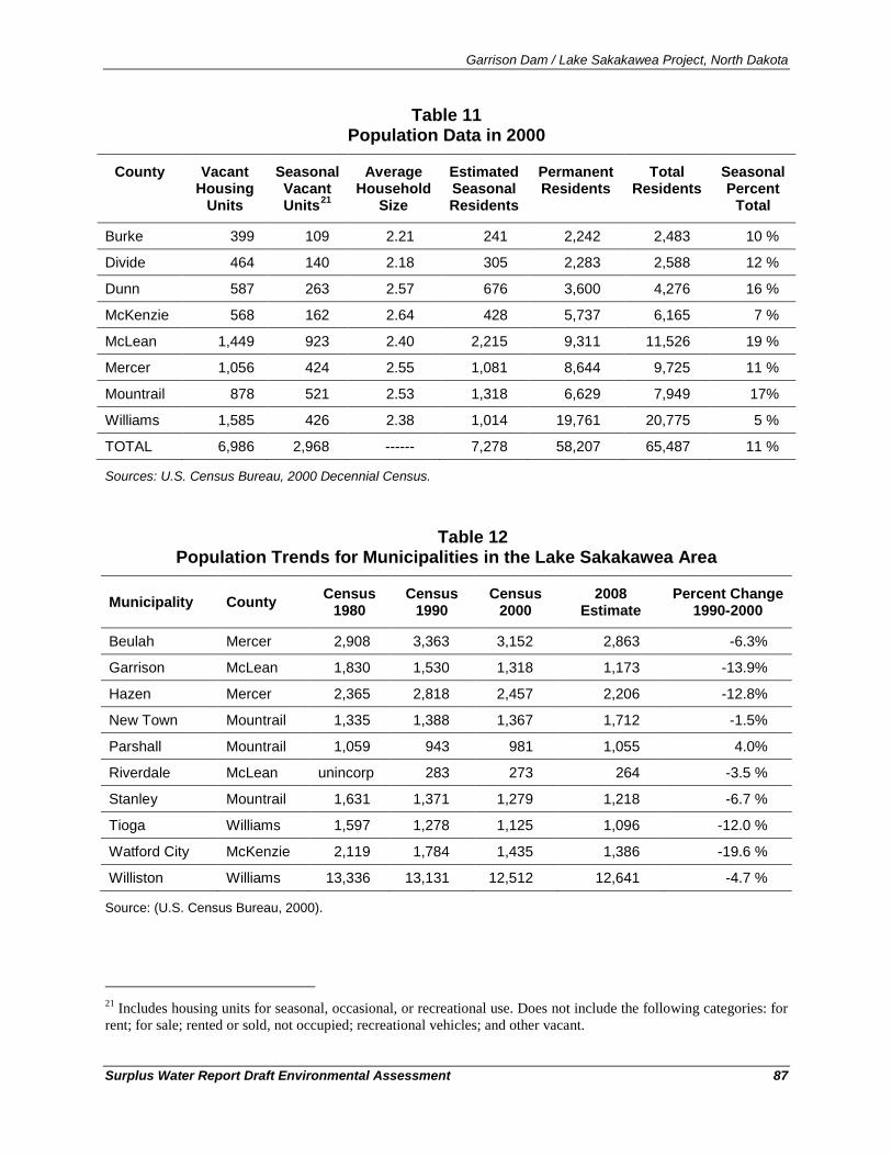
Garrison Dam / Lake Sakakawea Project, North Dakota
Surplus Water Report Draft Environmental Assessment 87
Table 11 Population Data in 2000
County Vacant Housing
Units
Seasonal Vacant Units21
Average Household
Size
Estimated Seasonal Residents
Permanent Residents
Total Residents
Seasonal Percent
Total
Burke 399 109 2.21 241 2,242 2,483 10 %
Divide 464 140 2.18 305 2,283 2,588 12 %
Dunn 587 263 2.57 676 3,600 4,276 16 %
McKenzie 568 162 2.64 428 5,737 6,165 7 %
McLean 1,449 923 2.40 2,215 9,311 11,526 19 %
Mercer 1,056 424 2.55 1,081 8,644 9,725 11 %
Mountrail 878 521 2.53 1,318 6,629 7,949 17%
Williams 1,585 426 2.38 1,014 19,761 20,775 5 %
TOTAL 6,986 2,968 ------ 7,278 58,207 65,487 11 %
Sources: U.S. Census Bureau, 2000 Decennial Census.
Table 12 Population Trends for Municipalities in the Lake Sakakawea Area
Municipality County Census 1980
Census 1990
Census 2000
2008 Estimate
Percent Change 1990-2000
Beulah Mercer 2,908 3,363 3,152 2,863 -6.3%
Garrison McLean 1,830 1,530 1,318 1,173 -13.9%
Hazen Mercer 2,365 2,818 2,457 2,206 -12.8%
New Town Mountrail 1,335 1,388 1,367 1,712 -1.5%
Parshall Mountrail 1,059 943 981 1,055 4.0%
Riverdale McLean unincorp 283 273 264 -3.5 %
Stanley Mountrail 1,631 1,371 1,279 1,218 -6.7 %
Tioga Williams 1,597 1,278 1,125 1,096 -12.0 %
Watford City McKenzie 2,119 1,784 1,435 1,386 -19.6 %
Williston Williams 13,336 13,131 12,512 12,641 -4.7 %
Source: (U.S. Census Bureau, 2000).
21 Includes housing units for seasonal, occasional, or recreational use. Does not include the following categories: for rent; for sale; rented or sold, not occupied; recreational vehicles; and other vacant.
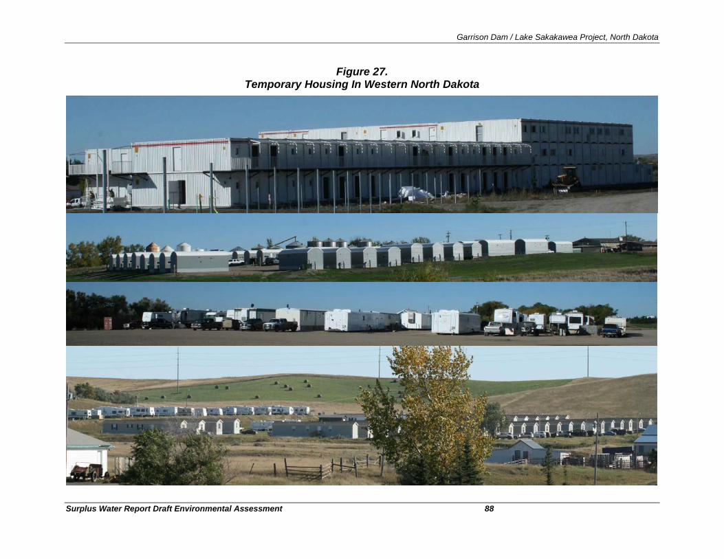
Garrison Dam / Lake Sakakawea Project, North Dakota
Surplus Water Report Draft Environmental Assessment 88
Figure 27. Temporary Housing In Western North Dakota
Garrison Dam / Lake Sakakawea Project, North Dakota
Surplus Water Report Draft Environmental Assessment 89
6.10.2. Environmental Consequences No Action
Under the No Action alternative, the trends of growth of population observed in the recent years in North Dakota would be expected to continue. The rate of growth of the oil and gas industry has not been controlled by the availability of water nor would it be expected change as a result of implementing the No Action alternative.
Proposed Action
The environmental consequences of implementing the Proposed Action on demographics of the regions would be minimal. The growth in population and associated stresses on the availability of housing seen in recent years in western North Dakota has occurred without any action on behalf of the Corps of Engineers and would be expected to remain controlled factors other than an improved availability of water associated with the Proposed Action.
6.11. Employment/Income
6.11.1. Existing Condition The most recent year for which the US Bureau of the Census has published comprehensive income data is 1999 and the aggregate income for North Dakota was $8.7 billion in that year. Table 13 shows the median household income, medium family income, and the per capita income reported by the 2000 Census (1999 data) for each of the eight first tier counties, the average of eight first tier counties, and the income figures for the state as a whole.
Table 13 Income Data for Lake Sakakawea Area of Influence and North Dakota (1999)
Area Median Household Income
Median Family Income
Per Capita Income
Burke County $25,330 $31,384 $14,026
Divide $30,089 $39,292 $16,225
Dunn County $30,015 $34,405 $14,624
McKenzie County $29,342 $34,091 $14,732
McLean County $32,337 $39,604 $16,220
Mercer County $42,269 $51,983 $18,256
Mountrail County $27,098 $31,064 $13,422
Williams County $31,491 $39,065 $16,763
North Dakota $34,604 $43,654 $17,769
Source: U.S. Census Bureau, 2000 Decennial Census.
North Dakota’s per capita income in 1999 was about 82-percent of the $21,587 per capita income for the entire United States. The economy of North Dakota is highly dependent on agriculture, so median income in North Dakota tends to vary with agricultural yields (which vary
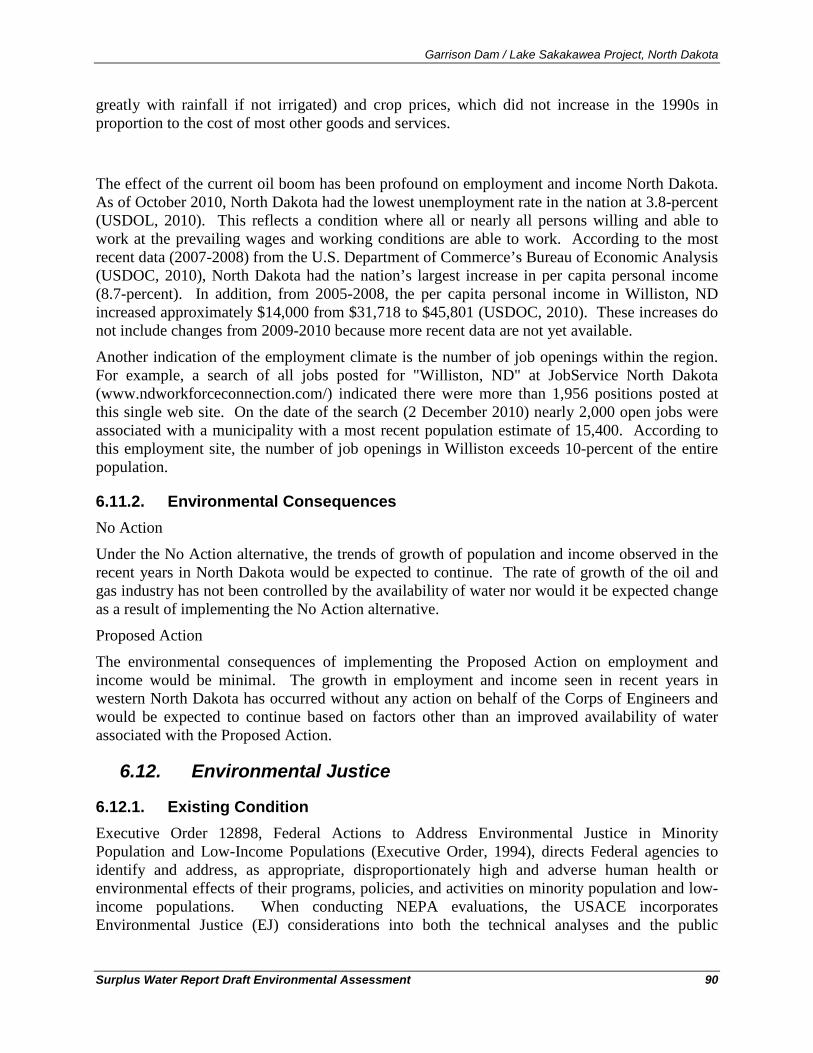
Garrison Dam / Lake Sakakawea Project, North Dakota
Surplus Water Report Draft Environmental Assessment 90
greatly with rainfall if not irrigated) and crop prices, which did not increase in the 1990s in proportion to the cost of most other goods and services.
The effect of the current oil boom has been profound on employment and income North Dakota. As of October 2010, North Dakota had the lowest unemployment rate in the nation at 3.8-percent (USDOL, 2010). This reflects a condition where all or nearly all persons willing and able to work at the prevailing wages and working conditions are able to work. According to the most recent data (2007-2008) from the U.S. Department of Commerce’s Bureau of Economic Analysis (USDOC, 2010), North Dakota had the nation’s largest increase in per capita personal income (8.7-percent). In addition, from 2005-2008, the per capita personal income in Williston, ND increased approximately $14,000 from $31,718 to $45,801 (USDOC, 2010). These increases do not include changes from 2009-2010 because more recent data are not yet available.
Another indication of the employment climate is the number of job openings within the region. For example, a search of all jobs posted for "Williston, ND" at JobService North Dakota (www.ndworkforceconnection.com/) indicated there were more than 1,956 positions posted at this single web site. On the date of the search (2 December 2010) nearly 2,000 open jobs were associated with a municipality with a most recent population estimate of 15,400. According to this employment site, the number of job openings in Williston exceeds 10-percent of the entire population.
6.11.2. Environmental Consequences No Action
Under the No Action alternative, the trends of growth of population and income observed in the recent years in North Dakota would be expected to continue. The rate of growth of the oil and gas industry has not been controlled by the availability of water nor would it be expected change as a result of implementing the No Action alternative.
Proposed Action
The environmental consequences of implementing the Proposed Action on employment and income would be minimal. The growth in employment and income seen in recent years in western North Dakota has occurred without any action on behalf of the Corps of Engineers and would be expected to continue based on factors other than an improved availability of water associated with the Proposed Action.
6.12. Environmental Justice
6.12.1. Existing Condition Executive Order 12898, Federal Actions to Address Environmental Justice in Minority Population and Low-Income Populations (Executive Order, 1994), directs Federal agencies to identify and address, as appropriate, disproportionately high and adverse human health or environmental effects of their programs, policies, and activities on minority population and low-income populations. When conducting NEPA evaluations, the USACE incorporates Environmental Justice (EJ) considerations into both the technical analyses and the public
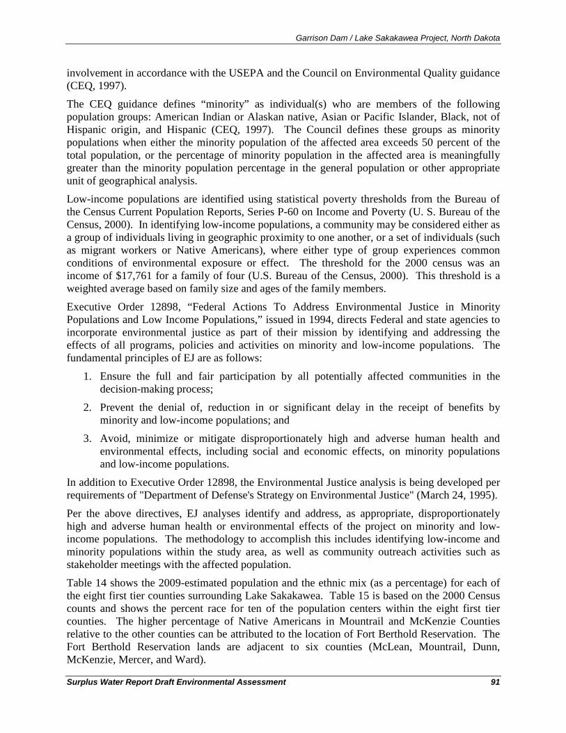
Garrison Dam / Lake Sakakawea Project, North Dakota
Surplus Water Report Draft Environmental Assessment 91
involvement in accordance with the USEPA and the Council on Environmental Quality guidance (CEQ, 1997).
The CEQ guidance defines “minority” as individual(s) who are members of the following population groups: American Indian or Alaskan native, Asian or Pacific Islander, Black, not of Hispanic origin, and Hispanic (CEQ, 1997). The Council defines these groups as minority populations when either the minority population of the affected area exceeds 50 percent of the total population, or the percentage of minority population in the affected area is meaningfully greater than the minority population percentage in the general population or other appropriate unit of geographical analysis.
Low-income populations are identified using statistical poverty thresholds from the Bureau of the Census Current Population Reports, Series P-60 on Income and Poverty (U. S. Bureau of the Census, 2000). In identifying low-income populations, a community may be considered either as a group of individuals living in geographic proximity to one another, or a set of individuals (such as migrant workers or Native Americans), where either type of group experiences common conditions of environmental exposure or effect. The threshold for the 2000 census was an income of $17,761 for a family of four (U.S. Bureau of the Census, 2000). This threshold is a weighted average based on family size and ages of the family members.
Executive Order 12898, “Federal Actions To Address Environmental Justice in Minority Populations and Low Income Populations,” issued in 1994, directs Federal and state agencies to incorporate environmental justice as part of their mission by identifying and addressing the effects of all programs, policies and activities on minority and low-income populations. The fundamental principles of EJ are as follows:
1. Ensure the full and fair participation by all potentially affected communities in the decision-making process;
2. Prevent the denial of, reduction in or significant delay in the receipt of benefits by minority and low-income populations; and
3. Avoid, minimize or mitigate disproportionately high and adverse human health and environmental effects, including social and economic effects, on minority populations and low-income populations.
In addition to Executive Order 12898, the Environmental Justice analysis is being developed per requirements of "Department of Defense's Strategy on Environmental Justice" (March 24, 1995).
Per the above directives, EJ analyses identify and address, as appropriate, disproportionately high and adverse human health or environmental effects of the project on minority and low-income populations. The methodology to accomplish this includes identifying low-income and minority populations within the study area, as well as community outreach activities such as stakeholder meetings with the affected population.
Table 14 shows the 2009-estimated population and the ethnic mix (as a percentage) for each of the eight first tier counties surrounding Lake Sakakawea. Table 15 is based on the 2000 Census counts and shows the percent race for ten of the population centers within the eight first tier counties. The higher percentage of Native Americans in Mountrail and McKenzie Counties relative to the other counties can be attributed to the location of Fort Berthold Reservation. The Fort Berthold Reservation lands are adjacent to six counties (McLean, Mountrail, Dunn, McKenzie, Mercer, and Ward).
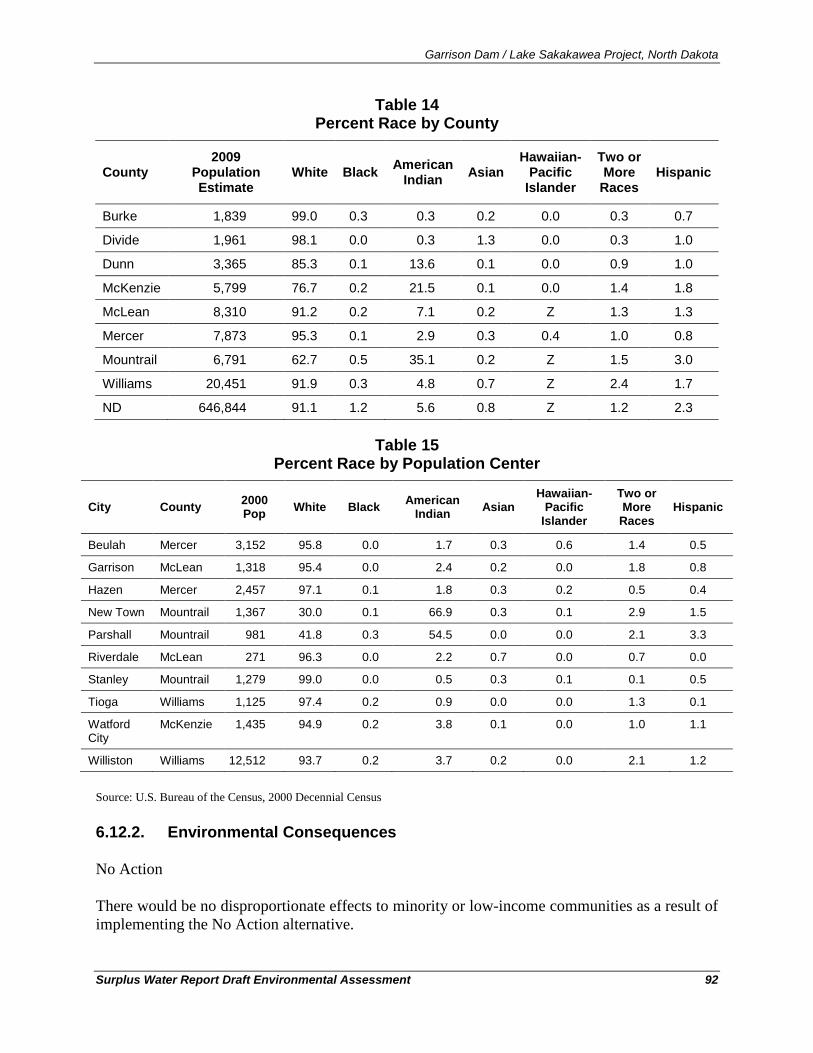
Garrison Dam / Lake Sakakawea Project, North Dakota
Surplus Water Report Draft Environmental Assessment 92
Table 14 Percent Race by County
County 2009
Population Estimate
White Black American Indian Asian
Hawaiian-Pacific
Islander
Two or More
Races Hispanic
Burke 1,839 99.0 0.3 0.3 0.2 0.0 0.3 0.7
Divide 1,961 98.1 0.0 0.3 1.3 0.0 0.3 1.0
Dunn 3,365 85.3 0.1 13.6 0.1 0.0 0.9 1.0
McKenzie 5,799 76.7 0.2 21.5 0.1 0.0 1.4 1.8
McLean 8,310 91.2 0.2 7.1 0.2 Z 1.3 1.3
Mercer 7,873 95.3 0.1 2.9 0.3 0.4 1.0 0.8
Mountrail 6,791 62.7 0.5 35.1 0.2 Z 1.5 3.0
Williams 20,451 91.9 0.3 4.8 0.7 Z 2.4 1.7
ND 646,844 91.1 1.2 5.6 0.8 Z 1.2 2.3
Table 15 Percent Race by Population Center
City County 2000 Pop White Black American
Indian Asian Hawaiian-
Pacific Islander
Two or More
Races Hispanic
Beulah Mercer 3,152 95.8 0.0 1.7 0.3 0.6 1.4 0.5
Garrison McLean 1,318 95.4 0.0 2.4 0.2 0.0 1.8 0.8
Hazen Mercer 2,457 97.1 0.1 1.8 0.3 0.2 0.5 0.4
New Town Mountrail 1,367 30.0 0.1 66.9 0.3 0.1 2.9 1.5
Parshall Mountrail 981 41.8 0.3 54.5 0.0 0.0 2.1 3.3
Riverdale McLean 271 96.3 0.0 2.2 0.7 0.0 0.7 0.0
Stanley Mountrail 1,279 99.0 0.0 0.5 0.3 0.1 0.1 0.5
Tioga Williams 1,125 97.4 0.2 0.9 0.0 0.0 1.3 0.1
Watford City
McKenzie 1,435 94.9 0.2 3.8 0.1 0.0 1.0 1.1
Williston Williams 12,512 93.7 0.2 3.7 0.2 0.0 2.1 1.2
Source: U.S. Bureau of the Census, 2000 Decennial Census
6.12.2. Environmental Consequences
No Action
There would be no disproportionate effects to minority or low-income communities as a result of implementing the No Action alternative.
Garrison Dam / Lake Sakakawea Project, North Dakota
Surplus Water Report Draft Environmental Assessment 93
Proposed Action
Compliance with Executive Order 12898 on Environmental Justice requires an evaluation of the nature of the proposed actions and the human context into which those actions would be undertaken. In order to have potential Environmental Justice impacts, a proposal must have potential for disproportionately high and adverse human health or environmental effects on low-income populations, minority populations, or Native American tribes. This action has been evaluated for potential disproportionately high environmental effects on minority or low-income populations and there would not be a high human health or environmental impact on minority or low-income populations. Implementation of the Proposed Action (including the construction of intakes as well as the subsequent depletions) would not result in measurable changes to environmental resources that individuals involved in subsistence fishing or hunting utilize. Also, construction and use of water supply intakes would not involve the release of hazardous, toxic, or radioactive materials to which minority or low-income populations could be exposed. As such, implementation of the Proposed Action would not create disproportionately high and adverse human health or environmental effects on low-income populations, minority populations, or Native American tribes.
6.13. Recreation
6.13.1. Existing Condition The Lake Sakakawea region has an abundance of natural and scenic resources that make resource-based outdoor recreation activities, such as hunting and fishing, possible and add to the enjoyment of other outdoor recreation activities. Outdoor recreation activities common at Lake Sakakawea include camping, fishing, hunting, boating, sailing, scuba diving, sightseeing, swimming, and bird watching. There are 37 public recreation facilities located around the lake that support a variety of outdoors recreation.
Water levels are a key factor in recreational use of the reservoirs, but pool levels vary widely in response to routine operations and extended drought conditions. Periods of extended drought that result in significant lowering of reservoir levels and releases have a greater negative impact on recreational usage than high stages. At low reservoir levels, some boat ramps and recreational areas may not provide access to the reservoirs. During the two major droughts since the System first filled, many facilities made modifications to infrastructure (e.g., extending boat ramps) in an effort to maintain access. Figures 28 and 29 provide an example of the contrast in pool elevation and the potential effect extended drought has on recreation infrastructure. Figure 28 is of the boat ramp and marina at Lake Sakakawea’s Lewis & Clark State Park taken in the summer of 2006 during extended drought conditions. The boatramp, marina, and entire bay are completely vegetated as an indication of how long these areas had been dry. For comparative purposes, Figure 29 shows a photograph of the same location taken in September 2010 when the pool elevations in Lake Sakakawea had returned to normal.
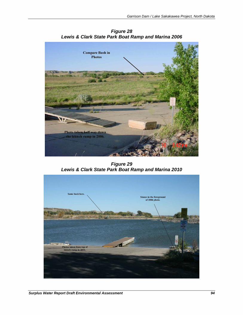
Garrison Dam / Lake Sakakawea Project, North Dakota
Surplus Water Report Draft Environmental Assessment 94
Figure 28 Lewis & Clark State Park Boat Ramp and Marina 2006
Figure 29 Lewis & Clark State Park Boat Ramp and Marina 2010
Garrison Dam / Lake Sakakawea Project, North Dakota
Surplus Water Report Draft Environmental Assessment 95
6.13.2. Environmental Consequences No Action
Under the No Action alternative, there would be no construction of infrastructure and new water supply intakes within the Garrison Project lands. However, under the No Action alternative, a substantial portion of the demand would be met by constructing water supply intake infrastructure upstream or downstream of the Garrison Project/Lake Sakakawea and removing the water from the system’s riverine reaches. This would result in little difference in the predicted depletions and associated changes to the water surface elevation from Lake Sakakawea between the Proposed Action and No Action.
Proposed Action
The expected effects to recreation from the construction and operation of the intakes would be related to the temporary and minor noise disturbances, emission releases, and land disturbance during construction. These temporary effects would be expected to have minimal effects on recreation. As described in Section 4.2.5, the electrical service to electrical motors submerged under water or located above water would be by means of a sealed, waterproof, multiple conductor cable with controls and switches located on land. The location of such motors and the electrical feeders would be clearly marked so as to be visible to boaters and swimmers. Additionally, signs warning "DANGER - HIGH VOLTAGE - Unauthorized Access" would be erected to be visible from the water and land approaches to the equipment to minimize the risk to recreational users.
Water levels are a key factor in recreational use of the reservoirs and river reaches. The modeled differences in water surface elevations between No Action and the Proposed Action in the DRM simulation output for Lake Sakakawea and all 18 model nodes were negligible. These modeled output show that at the 50th percent frequency (representing average conditions), all of the reservoirs would show virtually no difference in water surface elevation. In addition, the model predicted there would nearly immeasurable changes in stages at all riverine (non-reservoir) model nodes. All of these simulated stage reduction estimates are too small to be distinguishable from the No Action alternative. Therefore, the change in water surface elevations between No Action and the Proposed Action conditions would not result in discernable effects to recreation.
6.14. Aesthetics and Visual Resources
6.14.1. Existing Condition Visual qualities consist of natural and manmade features that give a particular environment its aesthetic qualities. Landscape character is evaluated to assess whether the project will appear compatible with the existing features or would contrast noticeably with the setting and appear out of place. Visual sensitivity includes public values, goals, awareness, and concerns regarding visual quality.
Garrison Dam / Lake Sakakawea Project, North Dakota
Surplus Water Report Draft Environmental Assessment 96
Western North Dakota is a rolling, hilly landscape of glaciated plains intersected by buttes, badlands and the Missouri River valley. This region supports grazing and farmland in addition to unique wildlife habitat. Manmade features that affect the natural aesthetics include the scattered presence of cattle and other livestock, utility and transportation infrastructure (e.g., roads, bridges, railroads), industrial infrastructure (e.g., mining operations and oil and gas wells, tanks, and pads), fences, and visible residential and commercial development (e.g., homes, businesses, and recreation areas).
The initial visual impression of the prairie landscape surrounding most of Lake Sakakawea is one of open rolling plains and undulating rises. The horizon, horizontal line, and the expansive sky are dominant landscape elements defined by the surrounding wide-open spaces. At the western end of the project, the badlands of North Dakota are composed of tiered and multicolor buttes, stratified canyons, and hoodoos (tall thin spires of rock that protrude from the bottom of arid basins and badlands). These features present an extensive pattern of dramatic and rugged terrain with a stark, but exceptional natural beauty. The badlands emerge near the confluence of the Little Missouri and the Missouri River and continue westward to the Montana border. The term "badlands" attests to the intricate, deeply dissected nature of the land, with gullies, buttes, and a maze of short, steep ridges that make travel through such areas difficult (USACE, 2007).
In addition to the aesthetic sensitivity during daylight hours, the large distances from municipalities provide very little light interference (i.e., light pollution) to affect the night sky. Western North Dakota has only a few cities outside its typically rural landscape. The general lack of major roads and large residential communities accentuates the visually open landscape of the Great Plains (USACE, 2007). A 2001 analysis modeling light pollution in the United States showed that large areas of pristine dark skies can be viewed in North Dakota (Albers and Duriscoe, 2001). On clear nights, the Milky Way, planets, stars, and many constellations are visible. Occasionally, the Northern Lights or aurora borealis, may be visible, adding color and movement to the night sky. Municipal growth and oil and gas development produce light that threatens the relative darkness and aesthetic value of the night sky (USACE, 2007).
6.14.2. Environmental Consequences No Action
Under the No Action alternative, there would be no construction of infrastructure and new water supply intakes within the Garrison Project lands. However, under the No Action alternative, a substantial portion of the demand would be met by constructing water supply intake infrastructure upstream or downstream of the Garrison Project/Lake Sakakawea and removing the water from the system’s riverine reaches. The aesthetic effects to viewsheds related to the construction of the water supply infrastructure would still occur, but these actions and the associated effects would occur at locations upstream or downstream from Lake Sakakawea as opposed to within Garrison Project lands. This would result in little difference in the predicted aesthetic effects between the Proposed Action and No Action.
Proposed Action
The expected impacts of intake construction would include minor land disturbance and a change to the viewsheds during and immediately after construction. Intake locations were identified to
Garrison Dam / Lake Sakakawea Project, North Dakota
Surplus Water Report Draft Environmental Assessment 97
(where possible) utilize existing roadway or utility corridors thereby diminishing the potential aesthetic effects as these areas had already been modified from undisturbed prairie. The construction methods selected for intake installation (e.g., directional drilling)) were chosen, in part, because they minimize the changes to the landscape below the normal high water mark and therefore minimize the aesthetic effect to the Lake Sakakawea shoreline.
The effects to aesthetics as a consequence of implementing the Proposed Action would be expected to be minimal. The explosive growth of the oil and gas industry in western North Dakota has occurred without any action on behalf of the Corps of Engineers. The associated effects on aesthetics as the panoramic vistas of western North Dakota now include extensive intrusion from the oil and gas industry’s activity (e.g., drill rigs, pads, natural gas flares, etc.) would be expected to continue based on factors other than an improved availability of water associated with the Proposed Action.
6.15. Noise
6.15.1. Existing Condition Western North Dakota contains very little residential, commercial, or recreational areas relative to the total area of undeveloped property. Other than in close proximity to recreation areas, municipalities, or major roadways, the characteristically wild, undeveloped landscape results in minimal background noise.
Changes in noise are typically measured and reported in units of dBA, a weighted measure of sound level. The primary sources of noise within the project area would include everyday vehicular traffic along roadways (typically between 50 and 60 dBA at 100 feet), maintenance of roadways, bridges, and the other structures (typically between 80 and 100 dBA at 50 feet), and seasonal recreational activities in Western North Dakota.
The U.S. Federal Transit Administration (FTA) has established noise impact criteria founded on well-documented research on community reaction to noise based on change in noise exposure using a sliding scale (USFTA, 1995). The FTA Noise Impact Criteria groups noise sensitive land uses into the following three categories:
• Category 1: Buildings or parks where quiet is an essential element of their purpose,
• Category 2: Residences and buildings where people normally sleep (e.g., residences, hospitals, and hotels with high nighttime sensitivity), and
• Category 3: Institutional buildings with primarily daytime and evening use (e.g., schools, libraries, and churches).
Even moderate noise caused by recreation activities such as picnicking and trail hiking can disturb nearby wildlife. Disturbance to wildlife can be reduced by vegetated buffer zones between recreation facilities and areas devoted to wildlife habitat, and by restrictions on vehicular use in portions of wildlife management areas.
Lake Sakakawea and the surrounding lands contain very little residential, commercial, or recreational areas relative to the total area of undeveloped property. Other than in close proximity to recreation areas, municipalities, or major roadways, the characteristically wild, undeveloped landscape results in minimal background noise.
Garrison Dam / Lake Sakakawea Project, North Dakota
Surplus Water Report Draft Environmental Assessment 98
Noise effects to the wildlife and human receptors within the project area are dominated by transportation sources such as trains, trucks, private vehicles, and recreational vehicles (e.g., boats, snowmobiles). Noise from occasional commercial aircraft crossing at high altitudes is typically indistinguishable from the natural background noise of the area. Noise ranging from about 10 dBA for the rustling of leaves to as much as 115 dBA (the upper limit for unprotected hearing exposure established by the Occupational Safety and Health Administration) is common in areas where there are sources of recreational activities, construction activities, and vehicular traffic.
6.15.2. Environmental Consequences No Action
Under the No Action alternative, the Corps of Engineers would not make a determination of surplus water, there would be no change to the water supply, there would be no water supply agreements, and no new water supply intakes would be constructed. Without these new water supply intakes, there would be no new depletions from Lake Sakakawea from within Garrison Project lands. However, as a result of taking No Action, the majority of water to supply the industry’s needs would likely be provided by Missouri River water upstream or downstream of Lake Sakakawea.
Noise related to the construction of the water supply infrastructure would still occur, but the noise and the associated disturbance would occur at locations upstream or downstream from Lake Sakakawea as opposed to within Garrison Project lands.
Proposed Action
Construction of the water supply intakes and associated infrastructure would require the use of heavy equipment (e.g., backhoe) and trucks to haul materials to and from the site. However, the distance between these proposed intake construction locations and Category 2 (residences) adjacent to these locations are not less than approximately 250 feet and are frequently much greater because these sites are so remote. The expected effects of conventional excavation and directional drilling for the construction of the water supply intakes and associated infrastructure would be considered a temporary and minor noise disturbance during the construction process. Once completed, operation of the intake pumps would not exceed 75 decibels at 50 feet therefore not resulting in any significant noise concerns.
6.16. Cultural Resources
6.16.1. Existing Condition The cultural history of western North Dakota is detailed in the Garrison Dam/Lake Sakakawea Master Plan (2007) and is herein incorporated-by-reference. Twelve large-scale cultural resource surveys have been conducted in the Lake Sakakawea/Garrison Dam project area (USACE, 2007). Five archaeological districts were defined during these investigations, with the strong possibility of more being defined as new surveys are conducted.
The Garrison Project lands contain 1,511 recorded cultural resource sites and 481 isolated finds including 1,493 archaeological sites and 18 historic architectural sites (USACE, 2007). Of these
Garrison Dam / Lake Sakakawea Project, North Dakota
Surplus Water Report Draft Environmental Assessment 99
sites, none are listed on the National Register of Historic Places (NRHP) or are classified as a contributing part of a National Register District. In addition, 17 historic properties are considered eligible for listing on the NRHP, and 1,244 remain unevaluated against the NRHP criteria; 242 sites have been determined not eligible. All un-evaluated sites are treated as potentially eligible for listing on the NRHP, and both eligible sites and unevaluated sites are taken into consideration when the Omaha District reviews undertakings.
6.16.2. Environmental Consequences No Action
Under the No Action alternative, the Corps of Engineers would not make a determination of surplus water, there would be no change to the water supply, there would be no water supply agreements, and no new water supply intakes would be constructed. Without these new water supply intakes, there would be no new depletions from Lake Sakakawea from within Garrison Project lands. However, as a result of taking No Action, the majority of water to supply the industry’s needs would likely be provided by Missouri River water upstream or downstream of Lake Sakakawea. The risk of disturbing cultural resources during the construction of water supply infrastructure upstream or downstream of Lake Sakakawea would be similar to the Proposed Action.
Proposed Action
No site-specific cultural resources investigations were performed at the proposed intake sites. However, the sites selected for proposed intakes were developed in coordination with Garrison Project staff with knowledge of existing cultural resources on project lands. The lack of sequential numbering for the Lake Sakakawea & Associates proposed intakes is an indication that many proposed locations were dismissed from consideration for a variety of environmental concerns, including the presence of or high likelihood of incurring cultural resources. Therefore, the sites selected for proposal were identified specifically to avoid the potential to affect known resources.
In addition, the construction methods selected for these projects were chosen, in part, because they minimize the area of surface disturbance thereby diminishing the risk of disturbing unknown cultural resources. Lastly, as described in Section 4.2.5, the easement grantee would not remove, disturb, or cause or allow to be removed or disturbed, any historical, archeological, architectural, or other cultural artifacts, relics, vestiges, remains, or objects of antiquity. In the event such items were discovered on the premises, the grantee would immediately notify the District Engineer, Omaha District, and the site and the material would be protected by the grantee from further disturbance until a professional examination could be made or until clearance to proceed was authorized by the District Engineer.
6.17. Vegetation and Listed Species
6.17.1. Existing Condition The vegetation communities of western North Dakota are described in detail in the Garrison Dam/Lake Sakakawea Master Plan (2007) and are herein incorporated-by-reference.
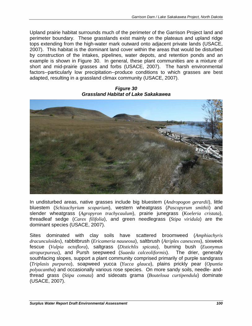
Garrison Dam / Lake Sakakawea Project, North Dakota
Surplus Water Report Draft Environmental Assessment 100
Upland prairie habitat surrounds much of the perimeter of the Garrison Project land and perimeter boundary. These grasslands exist mainly on the plateaus and upland ridge tops extending from the high-water mark outward onto adjacent private lands (USACE, 2007). This habitat is the dominant land cover within the areas that would be disturbed by construction of the intakes, pipelines, water depots, and retention ponds and an example is shown in Figure 30. In general, these plant communities are a mixture of short and mid-prairie grasses and forbs (USACE, 2007). The harsh environmental factors--particularly low precipitation--produce conditions to which grasses are best adapted, resulting in a grassland climax community (USACE, 2007).
Figure 30 Grassland Habitat of Lake Sakakawea
In undisturbed areas, native grasses include big bluestem (Andropogon gerardii), little bluestem (Schizachyrium scoparium), western wheatgrass (Pascopyrum smithii) and slender wheatgrass (Agropyron trachycaulum), prairie junegrass (Koeleria cristata), threadleaf sedge (Carex filifolia), and green needlegrass (Stipa viridula) are the dominant species (USACE, 2007).
Sites dominated with clay soils have scattered broomweed (Amphiachyris dracunculoides), rabbitbrush (Ericameria nauseosa), saltbrush (Atriplex canescens), sixweek fescue (Vulpia octoflora), saltgrass (Distichlis spicata), burning bush (Euonymus atropurpureus), and Pursh seepweed (Suaeda calceoliformis). The drier, generally southfacing slopes, support a plant community comprised primarily of purple sandgrass (Triplasis purpurea), soapweed yucca (Yucca glauca), plains prickly pear (Opuntia polyacantha) and occasionally various rose species. On more sandy soils, needle- and-thread grass (Stipa comata) and sideoats grama (Bouteloua curtipendula) dominate (USACE, 2007).
Garrison Dam / Lake Sakakawea Project, North Dakota
Surplus Water Report Draft Environmental Assessment 101
The areas identified for use to construct the proposed pipelines, utilities, road construction, were selected because they had been previously utilized by motor vehicles (either with actual roads or primitive two-track trails). In these disturbed areas, brome grass, various annual foxtail species, crested wheat grass, cheat grass and other exotics are commonly found these disturbed areas are of marginal value.
The Dakota wild buckwheat or Visher’s buckwheat (Eriogonum visheri) is found in the badlands of North and South Dakota and adjacent Montana. The plant is an annual (completes its life cycle in one year) and the Dakota wild buckwheat can occupy the constantly eroding badland habitat that otherwise provides unstable footing for longer-lived plants. Eriogonum visheri is rare to infrequent throughout its range. It appears to be concentrated in two areas, one primarily in the badlands of western South Dakota and a second from the Cheyenne River northward to just north of the Cannonball River area in south-central to western North Dakota.
Protected Plant Species: Dakota Wild Buckwheat (Visher’s Buckwheat)
The plant is a small, inconspicuous summer annual plant endemic to the badlands of North Dakota, South Dakota, and Montana. The Northern Region (Region 1) and the Rocky Mountain Region (Region 2) of the US Forest Service (USFS) have designated E. visheri a sensitive species. A USFS sensitive species is a plant or animal “species identified by a Regional Forester for which population viability is a concern, as evidenced by a significant current or predicted downward trend in population numbers or density [and/or] a significant current or predicted downward trends in habitat capability that would reduce a species’ existing distribution.”
Eriogonum visheri was designated a Category 2 candidate for listing as endangered or threatened under the federal Endangered Species Act (16 U.S.C. 1531 et seq.). However, it lost that status in 1996 when the USFWS eliminated the Category 2 designation; it remains a species of management concern for the USFWS. The species is designated between imperiled and vulnerable (S2S3) by the North Dakota Natural Heritage Inventory, and vulnerable (S3) by the South Dakota Natural Heritage Program. These state and global ranks indicate the rarity and vulnerability of a taxon, but they have no regulatory weight (Ladyman, 2006). Based on species’ existing distribution in North Dakota primarily being just north of the Cannonball River in south-central to western North Dakota, this species would not be expected at any of the proposed intake construction sites.
The western prairie fringed orchid (Platanthera praeclara) is a perennial which grows up to three feet high and is distinguished by large, white flowers that come from a single stem. The flowers are fringed on the margins giving them a feathery appearance.
Western Prairie Fringed Orchid
Historically, the orchid was found throughout the tall grass regions of North America, but tall grass prairie has been reduced to less than two-percent of its former range. North Dakota has the largest population of Western prairie fringed orchid left in the world numbering over 7,000 individuals and is located in the Sheyenne National Grasslands in the southeastern corner of the state (USFWS, 2008). The plant has not been observed on the Garrison Project lands or in Western North Dakota (USFWS, 2008) and would therefore not be expected to occur at any of the proposed intake construction sites.
Garrison Dam / Lake Sakakawea Project, North Dakota
Surplus Water Report Draft Environmental Assessment 102
6.17.2. Environmental Consequences
Under the No Action alternative, there would be no soil-disturbing activities for water depot, retention pond, water intake, utility, and access road construction on or immediately adjacent to Garrison Project lands. However, taking No Action would likely require new water intake infrastructure be developed up-river from Lake Sakakawea that could affect the terrestrial habitat depending on the intake location(s) selected.
No Action
The expected impacts of conventional excavation and directional drilling include temporary and minor land disturbance for utility line infrastructure installation and permanent loss of habitat for road installation. The areas identified for use to construct the proposed water depots, retention ponds, pipelines, utilities, and road construction, were selected because they had been previously utilized by motor vehicles (either with actual roads or primitive two-track trails) or were already utility corridors. The methods selected for the construction of the intakes and associated infrastructure were chosen, in part, because they minimize the disturbance of riparian, wetland, and shoreline areas surrounding the lake and therefore limit the effects on the terrestrial and aquatic environment to the upland areas. Site-specific habitat effects are summarized below for the three current applications and any future sites would likely be constructed in similar locations.
Proposed Action
In total, the footprint of disturbance from the three applicants and all seven of the proposed intakes and associated infrastructure (e.g., pipelines, utilities, roads, water depots, retention ponds) would be approximately 90 (88 acres) of disturbed upland prairie habitat. Of these 90 acres, 24 acres would be the footprint of construction of water depots and retention ponds and the remainder would be for pipelines, utilities, and roads to construct infrastructure from the intakes (approximately 66 acres).
Neither of the listed species identified in Section 6.17.1 would be likely to occur within the areas planned for construction and the effects to the small area of disturbed upland prairie within these areas of construction would not be considered significant.
Mandaree Site – The proposed pipeline would be constructed within a previously disturbed corridor of disturbed upland prairie habitat adjacent to an existing roadway and an existing utility corridor. As stated in Section 4.2.4.1, the footprint of disturbance would be approximately 350 feet in length across Corps lands and would continue for an additional 5.6 miles (total distance of 5.7 miles) to a new water depot. Assuming a 75-foot width of disturbance for all linear features being built, the area of disturbance would be approximately 52 acres
Element Solutions:
22
22 5.7 miles x 75 foot width of corridor = 51.65 acres.
plus an additional 2 acres for the water depot. In total, the Mandaree Site would be constructed over approximately 54 acres of previously disturbed upland prairie (i.e., grassland).
Garrison Dam / Lake Sakakawea Project, North Dakota
Surplus Water Report Draft Environmental Assessment 103
Iverson Site – As stated in Section 4.2.4.2, this location would utilize an existing intake and would terminate at an existing storage pond and would therefore not require new ground-disturbing construction. Assuming two additional retention ponds were constructed in association with this intake, then they would have a footprint of disturbance of approximately six acres total. At this time, International Western has not identified the specific locations for construction of any of the retention ponds associated with their application, but would be responsible to develop these sites in compliance with all appropriate state and federal resource protection laws.
International Western:
Thompson Site – As described in Section 4.2.4.2, the proposed intake pipe for this site would be constructed within an area of previously disturbed upland prairie between access roads and the high-water mark. The pipelines for the Thompson intake would be approximately 1,400 feet in length. The area of disturbance for pipeline, utility and road access would be approximately 2.423
Charlson Site – As described in Section 4.2.4.2, the intake pipe for this site would also be constructed within a previously disturbed upland prairie area between the existing two-track access roads and the high-water mark. The pipeline would be approximately 1,000 feet in length and the area of disturbance for pipeline, utility, and road access would be approximately 1.7
acres. Assuming three two-acre retention ponds would be eventually developed to support this intake, an additional 6-acres would be necessary for construction of retention ponds for both intakes. Therefore, the area of potential construction would be approximately 8.4 acres of previously disturbed upland prairie.
24 acres. Assuming three two-acre retention ponds would be eventually developed to support this intake, an additional 6-acres would be necessary for construction of retention ponds for both intakes. Therefore, the area of potential construction would be approximately 7.7 acres of previously disturbed upland prairie.
Lake Sakakawea & Associates #3 – As described in Section 4.2.4.3, the proposed area for construction of the proposed water depot and the pipeline from the water depot to the ordinary high water mark would be constructed within a predominantly grassed area with adjacent vegetated coulees. Assuming a 75-foot width of disturbance, the pipeline infrastructure (e.g., road, pipeline, utilities) for intake #3 would have areas of disturbance of approximately 2.925
#5 - – As described in Section 4.2.4.3, the area for the proposed water depot and the pipeline to the ordinary high water mark would be constructed within a grassed area between access roads and the high-water mark. Assuming a 75-foot width of disturbance, the infrastructure (e.g., road, pipeline, utilities) for intake #5 would have areas of disturbance of approximately 2.1
acres. The water depot would be an additional two acres for a total footprint of construction of approximately 4.9 acres of previously disturbed upland prairie.
26
23 1400 foot length x 75 foot width of corridor = 2.4 acres.
24 1,000 foot length x 75 foot width of corridor = 1.7 acres. 25 1,700 foot length x 75 foot width of corridor = 2.9 acres. 26 1,200 foot length x 75 foot width of corridor = 2.1 acres.
Garrison Dam / Lake Sakakawea Project, North Dakota
Surplus Water Report Draft Environmental Assessment 104
acres. The water depot would be an additional two acres for a total footprint of construction of approximately 4.1 acres of previously disturbed upland prairie.
#8 – As described in Section 4.2.4.3, the area for the proposed water depot and the pipeline to the ordinary high water mark would be constructed within a previously disturbed corridor with current ground cover of grass adjacent to an existing roadway and an existing utility corridor. Assuming a 75-foot width of disturbance, the infrastructure (e.g., road, pipeline, utilities) for intake #8 would have areas of disturbance of approximately 3.127
6.18. Fish and Wildlife and Listed Species
acres. The water depot would be an additional two acres for a total footprint of construction of approximately 5.1 acres of previously disturbed upland prairie.
The fish and wildlife of western North Dakota and the Garrison Project lands are detailed in the Garrison Dam/Lake Sakakawea Master Plan (2007) and are herein incorporated-by-reference.28
6.18.1. Existing Conditions
Large mammals that occupy project lands and surrounding lands include white-tailed deer (Odocoileus virginianus), mule deer (O. hemionus), moose (Alces alces americanus), and pronghorn antelope (Antilocapra americana) (USACE, 2007). Small mammals known to utilize project and surrounding lands include beaver (Castor canadensis), muskrat (Ondatra zibethicus), raccoon (Procyon lotor), badger (Taxidea taxus), mink (Mustela vison), least weasel (M. nivalis), red fox (Vulpes vulpes), striped skunk (Mephitis mephitis), coyote (Canis latrans), and bobcat (Felis rufus) (USACE, 2007)
The diverse habitat on the Garrison Project provides year-round and seasonal use by a large variety of birds. Although there is no Breeding Bird Atlas for North Dakota, approximately 245 different bird species have been recorded within the Garrison Project (USACE, 2007). About 15-percent of the 245 bird species are permanent residents at Lake Sakakawea and the remainder are summer residents, migrants, or visitants (USACE, 2007). Avian populations and species diversity at the Garrison Project vary significantly from season to season because of bird migration habits and patterns.
Lake Sakakawea supports various cold-water fish species (e.g., rainbow smelt, Osmerus mordax and Chinook salmon, Oncorhynchus tshawytscha) and is primarily managed for sport fishing (USACE, 2007). The river fishery persists at the upper, riverine end of the lake (USACE, 2007) and the delta at the upstream end of the reservoir provides a nursery area for many river fish. These areas include fish species preferring warmer water such as shovelnose sturgeon (Scaphirhynchus platorynchus), pallid sturgeon (S. albus), paddlefish (Polyodon spathula), northern pike, catfish (Ictalurus spp.), burbot (Lota lota), yellow perch (Perca flavescens), sauger (Sander canadense), and walleye (Sander vitreus) (USACE, 2007).
27 1,800 foot length x 75 foot width of corridor = 3.1 acres. 28 https://www.nwo.usace.army.mil/html/Lake_Proj/MasterPlan/GarrisonMP.pdf
Garrison Dam / Lake Sakakawea Project, North Dakota
Surplus Water Report Draft Environmental Assessment 105
Protected Species
Sturgeon (including the pallid sturgeon) and paddlefish are the only living descendants of an ancient group of Paleozoic fishes (USACE, 2007). The pallid sturgeon was listed as an endangered species in 1990 primarily due to the loss of habitat from alterations to the Missouri River and the construction of the extensive system of dams in the upper reaches (USACE, 2007). Commercial fishing may have also played a role in the pallid sturgeon's decline (USACE, 2007). These species are adapted to large, turbid, warm-water rivers and fishermen occasionally catch pallid sturgeon in the Yellowstone and Missouri rivers in North Dakota (USACE, 2007).
Pallid Sturgeon (Scaphirynchus albus)
Pallids spawning requirements are not well known, but spawning is believed to occur in May or June over gravel or other hard surfaces. Pallid sturgeon feed on aquatic insects, mollusks, and small fishes (USACE, 2007). Habitat requirements for the pallid sturgeon are still being determined; however, some clues to their habitat can be inferred from areas where most pallid sturgeon (and their close relative, the shovelnose sturgeon) have been captured, most often over a sandy substrate. Pallids have been captured most frequently in waters flowing with velocities between 0.33 and 0.98 feet per second in South Dakota (USACE, 2007) and between 1.3 and 2.9 feet per second in Montana (USACE, 2007).
Within the Missouri River basin, very few wild (naturally-occurring) pallid sturgeon persist (USACE, 2007). Population estimates are only available for existing pallid populations in a few reaches of the Missouri River. Approximately 35 adults are believed to exist in the Missouri River above Fort Peck Lake. About 180 adults are estimated to exist between the Fort Peck Dam and Lake Sakakawea, including the Yellowstone River up to approximately river mile 71.
A remnant population also exists in Lake Sharpe in South Dakota, but a reliable population estimate is not available. Between Fort Randall Dam and Gavins Point Dam, the wild population is believed to be nearly zero, although a wild pallid sturgeon was captured in this reach in November 2006 during standard Pallid Sturgeon Population Assessment sampling activities by the USFWS. From Gavins Point Dam to the mouth of the Missouri River, current data are inadequate for a reliable population estimate; however, the majority of pallid sturgeon captures are the result of stocking efforts since 2002. Pallid sturgeon captures are recorded in a permanent database by the USFWS in Bismarck, North Dakota.
The USFWS continues to improve the data regarding the distribution of pallid sturgeon in Lake Sakakawea through the Pallid Sturgeon Population Assessment sampling activities. Tracking efforts of radio-tagged pallid sturgeon indicate the presence of pallid sturgeon upriver from Lake Sakakawea and likely throughout Lake Sakakawea (Dixie Environmental Services, 2009). Best available information suggests that pallids stay in the remnant river thalweg, most likely responding to current (Dixie Environmental Services, 2009). As such, there is potential for the pallid sturgeon to be present within Lake Sakakawea when intakes were being constructed and during operations (Dixie Environmental Services, 2009).
Effective October 1, 2010, the USFWS has listed the shovelnose sturgeon (Scaphirhynchus platorynchus) as threatened under the Similarity of Appearance clause of the Endangered
Shovelnose Sturgeon (Scaphirhynchus platorynchus)
Garrison Dam / Lake Sakakawea Project, North Dakota
Surplus Water Report Draft Environmental Assessment 106
Species Act 29
Under this special rule, take of any shovelnose sturgeon, shovelnose-pallid sturgeon hybrids or the roe associated with or related to a commercial fishing activity is prohibited within the geographic areas set forth in the rule. The shovelnose and shovelnose-pallid sturgeon hybrid populations covered by the rule occur within Missouri River, including Lake Sakakawea, throughout all of North Dakota (USFWS, 2010).
based on similarity to the endangered pallid sturgeon (Scaphirynchus albus) (USFWS, 2010). The shovelnose sturgeon and the endangered pallid sturgeon are difficult to differentiate in the wild and inhabit overlapping portions of the Missouri and Mississippi River basins. Commercial harvest of shovelnose sturgeon in the four states where shovelnose and pallid sturgeon co-exist (IL, KY, MI, and TN) has resulted in the documented take of pallid sturgeon where the two species coexist and is a threat to the pallid sturgeon (USFWS, 2010).
Black-Footed Ferret
The black-footed ferret (Mustela nigripes) is one of the most endangered mammals in North America. The species was listed as endangered in 1967 under a precursor to the Endangered Species Act of 1973 (Volume 32 Federal Register [FR] 4001). Black-footed ferrets once ranged throughout the Great Plains. It has been calculated that if all suitable habitat had been used, as many as 5.6 million black-footed ferrets may have existed in the late 1800's (USFWS, 1995). Populations declined dramatically in the 1900's. The rapid decline of black-footed ferrets has been linked to the eradication of prairie dogs over a large portion of their historic range. Prairie dogs now occupy less than 1-percent of their historic range (USFWS, 1995). Threats to black-footed ferrets also include canine distemper. Black-footed ferrets are susceptible to predation by golden eagles, great-horned owls, and coyotes. They are also susceptible to road kills and trapping (USFWS, 1995). Of the reintroduction sites, only the Conata Basin site in South Dakota is considered to have a sizeable self-sustaining ferret population (USFWS, 2002).
(Mustela nigripes)
The counties bordering Lake Sakakawea on the south (McKenzie, Dunn and Mercer) are all within the historic range of the black-footed ferret but have had no known sightings of the ferrets. As such, the black-footed ferret would not be likely to occur within the areas planned for construction of the intakes and associated infrastructure.
Gray Wolf
The gray wolf (Canis lupus) was historically found throughout North America, with the exception of parts of the southwestern and southeastern United States. The gray wolf was historically present throughout North Dakota, where it was known as the Plains wolf, the buffalo wolf, or the lobo wolf (USFWS, 1995). As of September 2009, the listing status of the gray wolf was expanded to endangered throughout all of North Dakota (USFWS, 2009a).
(Canis lupus)
29 Section 4(e) of the Endangered Species Act and implementing regulations (50 CFR 17.50–17.52) authorize the Secretary of the Interior to treat a species as an endangered or threatened species even though it is not itself listed if: (a) The species so closely resembles in appearance a listed endangered or threatened species that law enforcement personnel would have substantial difficulty in attempting to differentiate between the listed and unlisted species; (b) the effect of this substantial difficulty is an additional threat to an endangered or threatened species; and (c) such treatment of an unlisted species will substantially facilitate the enforcement and further the purposes of the Act.
Garrison Dam / Lake Sakakawea Project, North Dakota
Surplus Water Report Draft Environmental Assessment 107
Given the density of roads in North Dakota and the large expanses of agricultural lands, wolves have not established any confirmed den sites in well over 20 years (USACE, 2007). Each year a small number of wolf sightings are reported by the public in North Dakota, and on average, the NDGFD, USDA’s Wildlife Services, and the USFWS confirm one to four sightings per year (USACE, 2007). As such, the gray wolf would not be likely to occur within the areas planned for construction of the intakes and associated infrastructure and effects to the gray wolf would be highly unlikely.
The whooping crane was listed as endangered in 1967 under a precursor to the Endangered Species Act of 1973 (Volume 32 Federal Register [FR] 4001). Unregulated hunting for sport and food combined with the loss of large expanses of wetlands habitat caused the massive decrease in numbers of whooping cranes. Breeding populations of the crane were extirpated from the U.S. portion of its historic breeding range by the early 1900’s.
Whooping Crane (Grus americana)
Because of intense conservation efforts and captive breeding programs, the whooping crane population now numbers more than 450 individuals. The whooping crane migrates through western and central counties of North Dakota during the spring (late April to mid-June) and the fall (late September to mid-October). Whooping cranes use open sand and gravel bars or very shallow water in rivers and lakes for nightly roosting. Cranes seen feeding during the migration are frequently within short flight distances of reservoirs, lakes, and large rivers that offer bare islands for nightly roosting (32 FR 4001). Whooping cranes do not readily tolerate disturbances to themselves or their habitat. A human on foot can quickly cause a crane to fly at distances of over a quarter mile (32 FR 4001).
Major food items for cranes during the migration period include insects, crayfish, frogs, small fish, and other small animals as well as some aquatic vegetation and some cereal crops in adjacent croplands (43 FR 36588). None of the designated critical habitat for whooping cranes is located at Lake Sakakawea (43 FR 36588). Most whooping crane sightings in North Dakota occur in the western two-thirds of the state, while the cranes are migrating from their winter home in and around Aransas National Wildlife Refuge on the Texas coast to their summer nesting grounds at Wood Buffalo National Park, which straddles the border between Alberta and the Northwest Territories in Canada. In 1988, a flock of eight whooping cranes was observed in a field in Mercer County just south of the project lands. In 2006, there were nine confirmed whooping crane sightings in North Dakota (USACE, 2007).
As such, other than a potential for brief stoppage during seasonal migration, the whooping crane would not be likely to occur within the areas planned for construction of the intakes and associated infrastructure.
The interior population of the least tern uses several major river systems of the United States including the upper Missouri River and Lake Sakakawea in North Dakota. The stabilization of these river systems for navigation, flood control, hydropower generation, and irrigation has led to a loss of much of the sandbar habitat the species requires and led to the degradation of the remaining habitat. Consequently, in 1985, the interior population of the least tern was listed as endangered by the USFWS (50 FR 21792).
Interior Least Tern (Sterna antillarum athalassos)
Garrison Dam / Lake Sakakawea Project, North Dakota
Surplus Water Report Draft Environmental Assessment 108
Least terns are migratory and arrive on Lake Sakakawea in late May and early June. The adults and juveniles depart the Lake Sakakawea breeding grounds by mid-August to migrate south to wintering grounds. Lake Sakakawea has never been a major nesting area for least terns on the Missouri River (USACE, 2007). In nearly 20 years (1988-2006) of adult least tern censuses conducted on Lake Sakakawea, the average number of adults counted has been 19 individuals annually (USACE, 2007). This represents less than three percent of the Missouri River system average of 655 adults counted in the adult census for the same time period (USACE, 2007). The number of adults counted at Lake Sakakawea has varied from a low of two adults in 1997 to a high of 48 adults in 2006.
Least tern nesting on Lake Sakakawea has been diffuse since surveys began in 1988. They favor coastal beaches and river sandbars for nesting and chick rearing; along Lake Sakakawea they nest in the sand and gravel shorelines above the water line. Some of the favored locations include Douglas Creek Bay, Elbowwoods Bay, Deepwater Bay, portions of the Van Hook Arm, Hofflund Bay, and Tobacco Garden Bay.
The piping plover is a shorebird that favors coastal beaches, alkali wetland, lakeshores, reservoir beaches, and riverine sandbars for nesting and chick rearing. In 1985, the USFWS listed the Northern Great Plains population as threatened (50 FR 50726). The Northern Great Plains population extends across three Canadian provinces and eight American states. The 2006 International Piping Plover Adult Census found about 4,700 adult plovers in the northern Great Plains (USACE, 2007). An important nesting area for piping plovers in the northern Great Plains is the Missouri River, where 1,311 adult plovers were counted in 2006. Piping plovers are migratory arriving on Lake Sakakawea as early as mid-April and continuing to arrive through May and into June. Favored habitat on the reservoir includes the shoreline beaches and islands. The typical plover nest is a shallow scrape in the sand that is lined with pebbles. Normally an adult pair will raise one brood of chicks during the nesting season and re-nesting commonly follows if a nest or a young brood is lost. The eggs will hatch after 27 to 31 days of incubation and the chicks fledge about 20 to 25 days after hatching. Piping plovers feed primarily on insects and aquatic invertebrates, and soon after hatching, the chicks begin foraging for themselves. After fledging, juveniles may remain in the nesting area around Lake Sakakawea for a time but begin their southward migration to the wintering grounds from early July to mid-August (USACE, 2007).
Piping Plover (Charadrius melodus) - Northern Great Plains population
Depending on the water level, Lake Sakakawea can be a major nesting area for piping plovers in the Missouri River system. A high water level eliminates virtually all of the shoreline beaches and inundates the islands, as was the case in 1997 when a record low of only three adults were counted on the lake. In contrast, drought-induced low water levels expose hundreds of miles of shoreline beaches and islands, providing plentiful habitat as in 2005, when a record 746 adults were counted. During the nearly 20 years (1988-2006) of adult census conducted on Lake Sakakawea, the average adult count was 241 piping plovers (USACE, 2007). This represents approximately one-third of the annual number of adult piping plovers counted on the upper Missouri River system (annual average of 708 piping plovers for the same period) (USACE, 2007).
Garrison Dam / Lake Sakakawea Project, North Dakota
Surplus Water Report Draft Environmental Assessment 109
Fledglings on Lake Sakakawea also represent a major proportion of the total number of fledglings in the Missouri River system. Productivity monitoring has been conducted on Lake Sakakawea for 15 years (1992-2006), with an average of 170 fledglings annually (USACE, 2007). This represents over 40-percent of the upper Missouri River System’s annual average of 409 fledglings for the same time (USACE, 2007). Piping plover fledgling numbers have varied from a low of zero in 1995 to a high of 552 in 2004 (USACE, 2007).
Piping plover nesting areas vary widely on Lake Sakakawea. Areas of major nesting concentrations include Douglas Creek Bay, Arikara Bay, Deepwater Bay, the Van Hook Arm including the Van Hook islands, Hofflund Bay, Little Egypt, Red Mike Bay, Renner Bay, and a counterclockwise arc from the northeast part of Mallard Island through DeTrobriand Bay. Minor plover nesting area concentrations include Elbowwoods Bay, Beacon Island, White Earth Bay, Tobacco Garden Bay, Beacon Point, Antelope Creek, Independence Point, and Beaver Creek Bay.
The USFWS designated critical habitat for the Northern Great Plains population of the piping plover (67 FR 57638), including the Missouri River, in September 2002. Designated areas of critical habitat include prairie alkali wetlands and surrounding shoreline; river channels and associated sandbars and islands; and reservoirs and inland lakes and their sparsely vegetated shorelines, peninsulas, and islands.
These areas provide primary courtship, nesting, foraging, sheltering, brood-rearing, and dispersal habitat for piping plovers. For the Garrison Project, all of the islands and shoreline of Lake Audubon were designated as critical habitat (USACE, 2007). On Lake Sakakawea, all of the islands and shoreline with the exception of the Little Missouri Arm from McKenzie Bay westward were designated as critical habitat (USACE, 2007).
A small portion of central ND is considered a breeding range for the bald eagle, including the river flood plains in southern McLean, Mercer, Oliver, Burleigh, and Morton counties (USACE, 2007). The bald eagle was de-listed (i.e., removed from the list of threatened and endangered species) on June 29, 2007. However, the U.S. Fish and Wildlife Service continues to work with state wildlife agencies to monitor eagles for at least five years, as required by the Endangered Species Act. If at any time it appears that the bald eagle again needs the Act’s protection, the U.S. Fish and Wildlife Service can propose to re-list the species.
Bald Eagle (Haliaeetus leucocephalus)
The bald eagle remains protected by the Bald and Golden Eagle Protection Act (BGEPA) and the Migratory Bird Treaty Act (MBTA). In July 2007, the National Bald Eagle Management Guidelines (the Guidelines) (72 FR 31156 31157) were released for public review to identify certain human-caused impacts to bald eagles that are still prohibited by law. Commercial and residential development, forestry practices, outdoor recreation, natural resource recovery operations, and other human activities can potentially interfere with bald eagles or permanently degrade or destroy bald eagle nesting, roosting, and foraging areas (USACE, 2007). In some cases, such impacts amount to violations of the provisions of the BGEPA or the MBTA that protect bald eagles.
The USFWS developed the Guidelines to advise landowners, land managers, and others who share public and private lands with bald eagles when and under what circumstances the protective provisions of the BGEPA may apply to them. The Guidelines were designed to
Garrison Dam / Lake Sakakawea Project, North Dakota
Surplus Water Report Draft Environmental Assessment 110
promote the continued conservation of the bald eagle following its removal from the Federal List of Endangered and Threatened Wildlife and Plants (protection under the ESA).
The Guidelines are intended to:
(1) Publicize the provisions of the BGEPA that continue to protect bald eagles, in order to reduce the possibility that people will violate the law;
(2) Advise landowners, land managers, and the general public of the potential for various human activities to disturb bald eagles; and
(3) Encourage land management practices that benefit bald eagles and their habitat.
During the critical nesting periods, construction activities and other forms of disturbance should not be permitted within ¼ mile of the active nest tree or perch trees if the activity is not visible from the nest (BLM, 2006). If the eagles have line-of-sight vision from these trees to the construction activities or other types of disturbance, the distance is one half (1/2) mile (USACE, 2007). The presence of human activity in this area would usually cause nesting disturbance.
The
Dakota Skipper (Hesperia dacotae)
Dakota skipper (Hesperia dacotae) is a small butterfly with a 1-inch wingspan. Like other skippers, they have a thick body and a faster and more powerful flight than most butterflies. The upper side of the male’s wings range from tawny-orange to brown with a prominent mark on the forewing; the lower surface is dusty yellow-orange. The upper side of the female’s wing is darker brown with tawny-orange spots and a few white spots on the margin of the forewing; the lower side is gray-brown with a faint white spotband across the middle of the wing. Dakota skipper pupae are reddish-brown and the larvae (caterpillars) are light brown with a black collar and dark brown head.
Dakota skippers are found in undisturbed native prairie containing a high diversity of wildflowers and grasses. Habitat includes two prairie types: 1) low (wet) prairie dominated by bluestem grasses, wood lily, harebell, and smooth camas; and 2) upland (dry) prairie on ridges and hillsides dominated by bluestem grasses, needlegrass, pale purple coneflower and upright coneflowers and blanketflower. Dakota skipper populations have declined historically due to widespread conversion of native prairie, but have been recorded in McKenzie, Dunn, Mountrail, and Ward counties (USGS, 2006).
The Dakota skipper is a candidate for listing under the Endangered Species Act. Candidate species are those for which U.S. Fish and Wildlife Service has sufficient information to list as threatened or endangered. To determine the order in which it proposes species for listing, the USFWS assigns listing priority numbers to candidate species based on the magnitude and immediacy of threats and the species' taxonomic distinctiveness. Listing priority numbers range from 1 (high priority) to 12 (low priority) and the Dakota skipper has a listing priority number of 11 (USFWS, 2009).
Candidate species receive no legal protection under the Endangered Species Act; that is, there are no legal prohibitions under the federal Endangered Species Act against taking candidate species. The Fish and Wildlife Service works to implement conservation actions for candidate species that may eliminate the need to list the species as threatened or endangered.
Garrison Dam / Lake Sakakawea Project, North Dakota
Surplus Water Report Draft Environmental Assessment 111
6.18.2. Environmental Consequences
Under the No Action alternative, there would be no construction activities for water depot, retention pond, water intake, utility, and access road construction on or immediately adjacent to Garrison Project lands. However, taking No Action would likely require new water intake infrastructure be developed up-river from Lake Sakakawea that could affect the fish and wildlife resources, including listed species, depending on the intake location(s) selected.
No Action
The expected effects from access, utility corridor, and intake construction associated with conventional excavation and directional drilling include temporary and minor noise disturbances, diesel emissions, and temporary and minor land disturbance that could have a temporary effect on the fish and wildlife resources in the immediate area. The construction methods selected for these projects (i.e., directional drilling) were chosen, in part, because they minimize the footprint of disturbance and eliminate the need for suspension of organic lake sediment, and the handling of such, in an aquatic environment. Thus, no significant effects to the aquatic or terrestrial biota would be expected to occur from the minor and temporary construction-related effects such as increased turbidity, or release of nutrients and associated impacts to dissolved oxygen levels. The predicted differences in water surface elevation within Lake Sakakawea between the No Action and the Proposed Action would be virtually indiscernible and would not lead to significant effects to fish and wildlife resources.
Proposed Action
Listed Species Effects Determinations
The physical limitations on intake screen size and maximum intake velocity identified in Section 4.2.5 (1/4 inch screen size and ½ foot per second velocity of intake flow) have been established in consultation with the USFWS and the NDG&FD to be protective of pallid sturgeon. However, the potential exists to have construction of water supply intakes affect pallid sturgeon during construction. As stated in Section 4.2.5, an environmental window would be established as a condition for approval for any construction within the waterway prohibiting work from April 15 to June 1 to protect the fishery resource.
Pallid Sturgeon (Scaphirynchus albus)
The finding is a determination of not likely to adversely affect or adversely modify the critical habitat for the pallid sturgeon.
Because this species is listed as threatened, but is not biologically threatened or endangered, no Biological Assessment or further Section 7 consultation under the Endangered Species Act would be required with the USFWS.
Shovelnose Sturgeon (Scaphirhynchus platorynchus)
The finding is a determination of no effect to the shovelnose sturgeon.
Black-Footed Ferret (Mustela nigripes)
Garrison Dam / Lake Sakakawea Project, North Dakota
Surplus Water Report Draft Environmental Assessment 112
The counties bordering Lake Sakakawea on the south (McKenzie, Dunn and Mercer) are all within the historic range of the black-footed ferret but have had no known sightings of the ferrets. As such, the black-footed ferret would not be likely to occur within the areas planned for construction of the intakes and associated infrastructure.
The finding is a determination of no effect to the black-footed ferret.
Given the extreme rarity of occurrence of the gray wolf near Lake Sakakawea, they would not be likely to occur within the areas planned for construction of the intakes and associated infrastructure and effects to the gray wolf would be highly unlikely.
Gray Wolf (Canis lupus)
The finding is a determination of no effect to the gray wolf.
Other than a potential for brief stoppage during seasonal migration, the whooping crane would not be likely to occur within the areas planned for construction of the intakes and associated infrastructure. Effects of the Proposed Action on the whooping crane would be highly unlikely.
Whooping Crane (Grus americana)
The finding is a determination of no effect to the whooping crane.
As described in Section 4.2, the methods selected for the construction of the intakes and associated infrastructure were chosen, in part, because they minimize the disturbance of these shoreline areas surrounding the lake and therefore limit the potential to disturb interior least tern habitat. The effect of the depletions associated with implementing the Proposed Action on interior least tern nesting area would be virtually identical to the effect of the No Action alternative. However, if the effect of the depletions were discernable, the action would create a small amount of additional shoreline, providing a small increase in potential nesting area.
Interior Least Tern (Sterna antillarum athalassos)
The finding is a determination of not likely to adversely affect or adversely modify the critical habitat for the interior least tern.
The ongoing nesting success of piping plover at Lake Sakakawea as well as the designation of all Lake Sakakawea shoreline habitat as critical habitat indicate that there is potential for the piping plover to be affected by the proposed construction of new water supply intakes as well as operation and maintenance of the intakes once completed.
Piping Plover (Charadrius melodus) - Northern Great Plains population
As described in Section 4.2, the methods selected for the construction of the intakes and associated infrastructure were chosen, in part, because they minimize the disturbance of critical habitat (i.e., shoreline) for the piping plover. The use of directional drilling from the high-water mark to daylight beneath the water surface limits the potential effects to piping plover habitat.
The effect of the depletions associated with implementing the Proposed Action on piping plover nesting area would be virtually identical to the effect of the No Action alternative. However, if the effect of the depletions were discernable, the action would create a small amount of additional shoreline, providing a small increase in potential nesting area.
Garrison Dam / Lake Sakakawea Project, North Dakota
Surplus Water Report Draft Environmental Assessment 113
The finding is a determination of not likely to adversely affect or adversely modify the critical habitat for the piping plover.
The period from initiation of nest selection to one month after hatching is considered an “extremely sensitive” period, in which activity in the nest site may cause eagles to desert the nest. As long as the recommended buffer distances to avoid nesting sites are observed during the critical times of nesting for the intake construction, no significant effects to the bald eagle would be expected.
Bald Eagle (Haliaeetus leucocephalus)
The finding is a determination of no effect to the bald eagle.
As described in Section 6.17.2, the areas identified for use to construct the proposed water depots, retention ponds, pipelines, utilities, and road construction, were selected because they had been previously utilized by motor vehicles (either with actual roads or primitive two-track trails) or were already utility corridors. The methods selected for the construction of the intakes and associated infrastructure were chosen, in part, because they minimize the disturbance of habitat surrounding the lake and therefore limit the effects on the surrounding upland areas
Dakota Skipper (Hesperia dacotae)
In total, the footprint of disturbance from the three applicants and all seven of the proposed intakes and associated infrastructure (e.g., pipelines, utilities, roads, water depots, retention ponds) would be approximately 90 acres. Of these 90 acres in total, 24 acres would be the footprint of construction of water depots and retention ponds; the area of disturbance for pipelines, utilities, and roads to construct infrastructure from the intakes to the water depots would be approximately 66 acres. Given the extent of previous disturbance along the corridors selected for construction, effects to Dakota skipper habitat from construction within these disturbed upland prairie areas would be possible, but unlikely.
The finding is a determination of not likely to adversely affect for the Dakota skipper.
7. Cumulative Effects of the Proposed Action
7.1. Effects of Surplus Water Determination Water supply--while necessary to oil and gas production--is not the limiting factor on the rate of drilling, hydrofracing or the industry’s rate of growth in North Dakota. Rather, the availability of drill rigs and hydrofracing crews are the critical factors limiting the rate at which industry grows within the region. This observation is supported by the growth of drilling and production in 2009-2010 without any Federal action affecting the availability of water by the Corps of Engineers (See Section 6.7). Additions to the supply of water for the industry from surplus water in Lake Sakakawea could affect the location of preferred water sources and how water is distributed and moved within the region, but changes in the rate of growth in the oil and gas industry as a consequence of implementing the Proposed Action, would not be expected.
Garrison Dam / Lake Sakakawea Project, North Dakota
Surplus Water Report Draft Environmental Assessment 114
7.2. Effects of Depletions As stated the beginning of Section 6, three separate planning scenarios were used to evaluate the magnitude of the predicted environmental effects. The indirect effects were evaluated based on the baseline depletions (No Action) and the 527 acre-feet of depletions at Lake Sakakawea (Proposed Action). In addition, a total of 50,527 acre-feet of depletions (including 527 acre-feet at Lake Sakakawea and 10,000 acre-feet each at the other five system reservoirs) was assessed to evaluate the cumulative effects of removing an additional 10,000 acre-feet of water from each of the other five system reservoirs. This section addresses these cumulative effects to System hydrology.
The source of the actual System inflow data is the U.S. Geological Survey, which began acquiring daily data beginning in late 1929. The DRM adjusts these inflow data by the difference for depletions that have been estimated to occur between each year and 2002. The Bureau of Reclamation provided the monthly depletions, and these monthly data were further separated to daily values for use in the DRM. Inflow and depletion data are available for each of the DRM modeling reaches (AECOM, 2010). The 2002 depletion data are assumed to remain constant through 2010 (assumes no change from 2002 to 2010). Because the Missouri River reservoirs are operated as an integrated system, 527 acre-feet in depletions from Lake Sakakawea and 10,000-acre feet in depletions in each of the other five System reservoirs (total of 50,527-acre feet in depletions) could conceivably reduce releases and water surface elevations throughout all six System reservoirs and the free-flowing reaches of the Missouri River. Reductions in reservoir releases and lake elevations have the potential effect on resources through these reductions in flows and water surface elevations. In all cases, the differences in the duration plots of the differences in daily values (comparing same day to same day) were relatively the same with only minor increases for the Lake Sakakawea elevation plot. Figures 31, 32, and 33 are the duration plots for the Lake Sakakawea water surface elevations, the Garrison Dam releases, and the Gavins Point Dam releases, respectively, with both the duration difference plots for the GAR100 and CUM10 minus the CC2010 alternatives
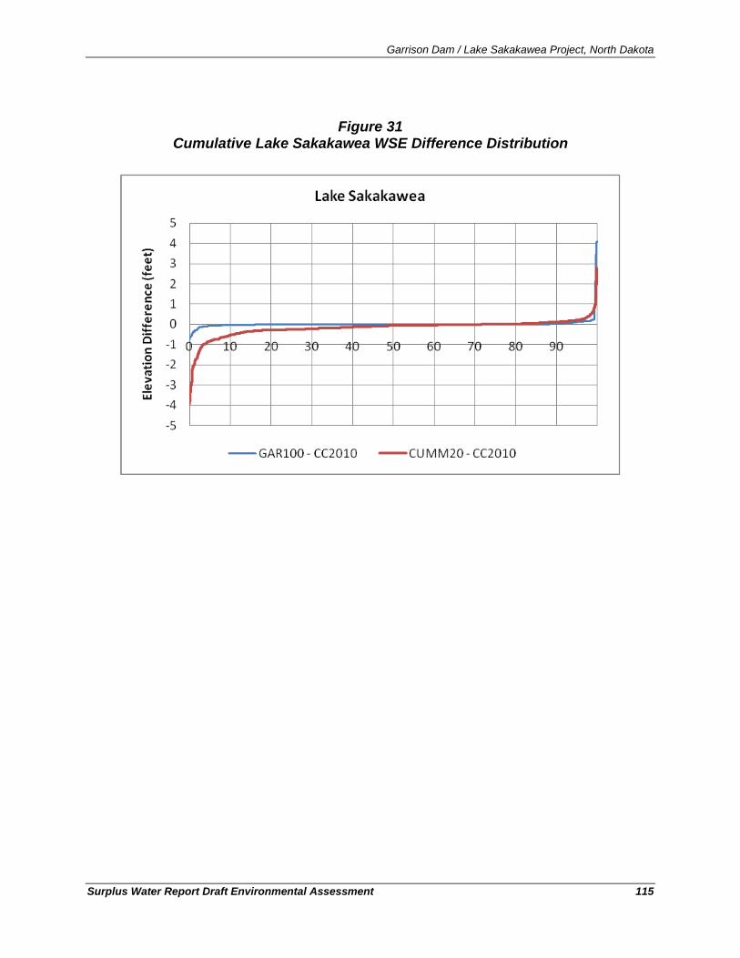
Garrison Dam / Lake Sakakawea Project, North Dakota
Surplus Water Report Draft Environmental Assessment 115
Figure 31 Cumulative Lake Sakakawea WSE Difference Distribution
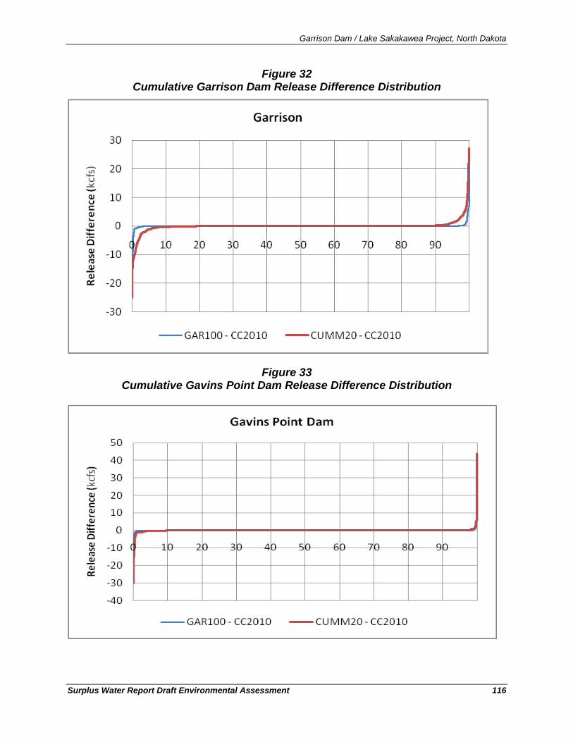
Garrison Dam / Lake Sakakawea Project, North Dakota
Surplus Water Report Draft Environmental Assessment 116
Figure 32 Cumulative Garrison Dam Release Difference Distribution
Figure 33 Cumulative Gavins Point Dam Release Difference Distribution
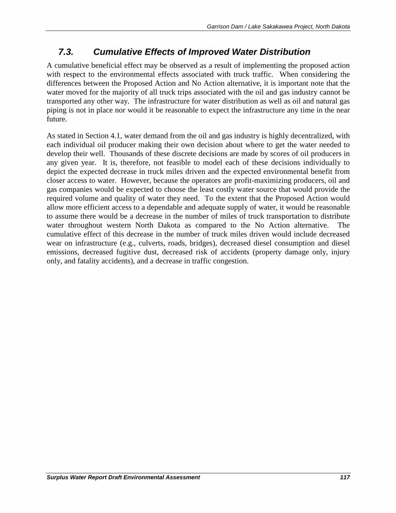
Garrison Dam / Lake Sakakawea Project, North Dakota
Surplus Water Report Draft Environmental Assessment 117
7.3. Cumulative Effects of Improved Water Distribution A cumulative beneficial effect may be observed as a result of implementing the proposed action with respect to the environmental effects associated with truck traffic. When considering the differences between the Proposed Action and No Action alternative, it is important note that the water moved for the majority of all truck trips associated with the oil and gas industry cannot be transported any other way. The infrastructure for water distribution as well as oil and natural gas piping is not in place nor would it be reasonable to expect the infrastructure any time in the near future.
As stated in Section 4.1, water demand from the oil and gas industry is highly decentralized, with each individual oil producer making their own decision about where to get the water needed to develop their well. Thousands of these discrete decisions are made by scores of oil producers in any given year. It is, therefore, not feasible to model each of these decisions individually to depict the expected decrease in truck miles driven and the expected environmental benefit from closer access to water. However, because the operators are profit-maximizing producers, oil and gas companies would be expected to choose the least costly water source that would provide the required volume and quality of water they need. To the extent that the Proposed Action would allow more efficient access to a dependable and adequate supply of water, it would be reasonable to assume there would be a decrease in the number of miles of truck transportation to distribute water throughout western North Dakota as compared to the No Action alternative. The cumulative effect of this decrease in the number of truck miles driven would include decreased wear on infrastructure (e.g., culverts, roads, bridges), decreased diesel consumption and diesel emissions, decreased fugitive dust, decreased risk of accidents (property damage only, injury only, and fatality accidents), and a decrease in traffic congestion.
Garrison Dam / Lake Sakakawea Project, North Dakota
Surplus Water Report Draft Environmental Assessment 118
8. Compliance with Environmental Laws and Regulations Making the surplus water determination and the subsequent construction of water intake and distribution infrastructure would not commence until the proposed action achieves environmental compliance with all applicable laws and regulations, as described below. Environmental compliance for the proposed action would be achieved upon coordination of this Environmental Assessment with appropriate agencies, organizations, and individuals for their review and comments.
In compliance.
American Indian Religious Freedom Act (AIRFA) of 1978, 42 U.S.C. 1996.
AIRFA protects the rights of Native Americans to exercise their traditional religions by ensuring access to sites, use and possession of sacred objects, and the freedom to worship through ceremonials and traditional rites. This project would not adversely affect the protections offered by this Act. Access to sacred sites by Tribal members would not be affected.
In compliance.
Bald Eagle Protection Act, 16 U.S.C. Sec. 668, 668 note, 668a-668d.
The Bald Eagle Protection Act contains requirements on Corps projects concerning bald eagles. This project would not adversely affect bald eagles or their habitat.
In compliance.
Clean Air Act, as amended, 42 U.S.C. 1857h-7, et seq.
The purpose of this Act is to protect public health and welfare by the control of air pollution at its source, and to set forth primary and secondary National Ambient Air Quality Standards to establish criteria for States to attain, or maintain. Some temporary emission releases may occur during construction activities; however, air quality would not be affected to any measurable degree.
Full compliance.
Clean Water Act, as amended, (Federal Water Pollution Control Act) 33 U.S.C. 1251, et seq.
The objective of this Act is to restore and maintain the chemical, physical and biological integrity of the Nation’s waters (33 U.S.C. 1251). The Corps regulates discharges of dredge or fill material into waters of the United States pursuant to Section 404 of the Clean Water Act. This permitting authority applies to all waters of the United States including navigable waters and wetlands. The Section 404 requires authorization to place dredged or fill material into water bodies or wetlands. If a section 404 authorization is required, a section 401-water quality certification from the state in which the discharge originates is also needed. The proposed projects consist of the installation of water intakes at various locations on the Lake Sakakawea shoreline including placement of the intake structure, pipeline, utility lines for power, access
Garrison Dam / Lake Sakakawea Project, North Dakota
Surplus Water Report Draft Environmental Assessment 119
road if necessary, and then the length of pipeline to the water depot or other terminus. The trenching and utility actions associated with the pump placement may be authorized by Nationwide Permit (NWP) #12. NWP #12 authorizes construction, maintenance and repair of utility lines including intakes provided the activity complies with all General and Regional conditions. A pre-construction notification (PCN) to the Corps of Engineers is required if a Section 10 permit is required; the Missouri River and Lake Sakakawea are regulated under Section 10. One PCN requirement requires the description of the proposed project's direct and indirect adverse environmental effects in sufficient detail for the district engineer to determine that adverse impacts will be minimal. Should the NWP not apply, activities could be reviewed under an Individual Permit.
Nationwide permit #12 is for activities required for the construction, maintenance, repair, and removal of utility lines and associated facilities in waters of the United States, provided the activity does not result in the loss of greater than ½ acre of waters of the United States; in no case would any of the intakes result in loss of greater than ½ acre of waters of the United States.
This NWP authorizes the construction, maintenance, or repair of utility lines, including outfall and intake structures, and the associated excavation, backfill, or bedding for the utility lines, in all waters of the United States, provided there is no change in pre-construction contours. A ``utility line'' is defined as any pipe or pipeline for the transportation of any gaseous, liquid, liquescent, or slurry substance, for any purpose, and any cable, line, or wire for the transmission for any purpose of electrical energy, telephone, and telegraph messages, and radio and television communication. The term ``utility line'' does not include activities that drain a water of the United States, such as drainage tile or French drains, but it does apply to pipes conveying drainage from another area.
Material resulting from trench excavation may be temporarily sidecast into waters of the United States for no more than three months, provided the material is not placed in such a manner that currents or other forces disperse it. T he district engineer may extend the period of temporary side casting for no more than a total of 180 days, where appropriate. In wetlands, the top 6 to 12 inches of the trench should normally be backfilled with topsoil from the trench. The trench cannot be constructed or backfilled in such a manner as to drain waters of the United States (e.g., backfilling with extensive gravel layers, creating a French drain effect). Any exposed slopes and stream banks must be stabilized immediately upon completion of the utility line crossing of each waterbody.
This NWP also authorizes the construction of access roads for the construction and maintenance of utility lines, including overhead power lines and utility line substations, in non-tidal waters of the United States, provided the total discharge from a single and complete project does not cause the loss of greater than 1/2-acre of non-tidal waters of the United States.
Although nationwide permits have gone through public review and been pre-approved for use for minor actions, permit # 12 still requires consideration of compliance with Section 401 of the
Garrison Dam / Lake Sakakawea Project, North Dakota
Surplus Water Report Draft Environmental Assessment 120
Clean Water Act, individual 401 Water Quality Certification from the State of North Dakota Department of Health. Because disposal of sediments from the trenching would not being discharged back into the lake, and would be placed above the ordinary high water mark of Lake Sakakawea, approval would not require individual section 404 authorization nor section 401 water quality certifications. Any disposal of excavated material would be negligible; therefore National Pollution Discharge Elimination System permit would not be required from the State of North Dakota. As described in the Nationwide Permit general conditions, appropriate measures would be taken to minimize erosion and stormwater discharges during and after construction. Each application for easements from the Corps of Engineers (including the three current applications as well as future applicants) would need to complete a regulatory review with the Corps of Engineers’ Regulatory Branch, Bismarck, ND and would be required to coordinate with Garrison Project staff to ensure compliance with the limitations of Nationwide Permit #12.
Not applicable.
Comprehensive Environmental Response, Compensation, and Liability Act of 1980.
Typically CERCLA is triggered by (1) the release or substantial threat of a release of a hazardous substance into the environment; or (2) the release or substantial threat of a release of any pollutant or contaminant into the environment that presents an imminent threat to the public health and welfare. To the extent such knowledge is available, 40 CFR Part 373 requires notification of CERCLA hazardous substances in a land transfer. This project would not involve any real estate transactions.
Partial compliance.
Endangered Species Act, as amended. 16 U.S.C. 1531, et seq.
Section 7 (16 U.S.C. 1536) states that all Federal departments and agencies shall, in consultation with and with the assistance of the Secretary of the Interior, insure that any actions authorized, funded, or carried out by them do not jeopardize the continued existence of any threatened or endangered (T&E) species, or result in the destruction or adverse modification of habitat of such species which is determined by the Secretary to be critical.
This Environmental Assessment represents the assessment and findings regarding the Proposed Action and serves as the Biological Assessment with a determination of no effect to the Dakota wild buckwheat, Western prairie fringed orchid, the black footed ferret, gray wolf, and the whooping crane. The findings also allow a determination of not likely to adversely affect the Dakota skipper and not likely to adversely affect and not be expected to adversely modify the critical habitat for the piping plover, interior least tern, and pallid sturgeon. A letter concurring that this project would have no effect on or would not likely adversely affect threatened and endangered species is expected from the USFWS.
In compliance.
Environmental Justice (E.O. 12898).
Federal agencies shall make achieving environmental justice part of its mission by identifying and addressing, as appropriate, disproportionately high and adverse human health or
Garrison Dam / Lake Sakakawea Project, North Dakota
Surplus Water Report Draft Environmental Assessment 121
environmental effects of its programs, policies, and activities on minority populations and low-income populations in the United States. The project does not disproportionately affect minority or low-income populations.
Not applicable.
Farmland Protection Policy Act (Subtitle I of Title XV of the Agriculture and Food Act of 1981), effective August 6, 1984.
This Act instructs the Department of Agriculture, in cooperation with other departments, agencies, independent commissions and other units of the Federal government, to develop criteria for identifying the effects of Federal programs on the conversion of farmland to nonagricultural uses. No farmland would be adversely impacted by the proposed project.
Not applicable.
Federal Water Project Recreation Act, as amended, 16 U.S.C. 460-1(12), et seq.
The Act establishes the policy that consideration be given to the opportunities for outdoor recreation and fish and wildlife enhancement in the investigating and planning of any Federal navigation, flood control, reclamation, hydroelectric or multi-purpose water resource project, whenever any such project can reasonably serve either or both purposes consistently. There is no opportunity to enhance recreational resources in conjunction with this project.
In compliance.
Fish and Wildlife Coordination Act, as amended, 16 U.S.C. 661, et seq.
The FWCA requires governmental agencies, including the Corps, to coordinate activities so that adverse effects on fish and wildlife would be minimized when water bodies are proposed for modification. Conversations with Jeff Towner of the U.S. Fish and Wildlife Service and Steve Dyke and Bruce Kreft of the North Dakota Game and Fish Department have related no concerns regarding fish and wildlife species. Bruce Kreft provided recommendations for the placement of intakes including: (1) intake screens with a mesh opening of ¼ inch or less shall be installed, inspected annually, and maintained, (2) water velocity at the intake screen shall not exceed ½ foot per second, (3) intakes located in Lake Sakakawea shall be submerged, (4) the intake shall be placed at least 20 vertical feet below the existing water level, (5) the intake shall be elevated 2 to 4 feet off the bottom, (6) if the 20 foot depth is not attainable, then the intake velocity shall be limited to ¼ foot per second, with intake placed at maximum practicable attainable depth.
These design considerations would protect juvenile and larval fish from entrainment into the water intake. Specific recommendations from these persons during the previous and current activity have prompted the Corps of Engineers to utilize construction methodologies that do not require in-lake dredging or excavation. The recommendations of the USFWS and NDGFD have been considered and were incorporated into the project plans.
Garrison Dam / Lake Sakakawea Project, North Dakota
Surplus Water Report Draft Environmental Assessment 122
Not applicable.
Land and Water Conservation Fund Act (LWCFA), as amended, 16 U.S.C. 4601-4601-11, et seq.
Planning for recreation development at Corps projects is coordinated with the appropriate states so that the plans are consistent with public needs as identified in the State Comprehensive Outdoor Recreation Plan (SCORP). The Corps must coordinate with the National Park Service (NPS) to insure that no property acquired or developed with assistance from this Act will be converted to other than outdoor recreation uses. If conversion is necessary, approval of NPS is required, and plans are developed to relocate or re-create affected recreational opportunities. No lands involved in the proposed project were acquired or developed with LWCFA funds.
Partial compliance.
Migratory Bird Treaty Act
The Migratory Bird Treaty Act of 1918 (MBTA) is the domestic law that affirms, or implements, the United States' commitment to four international conventions with Canada, Japan, Mexico and Russia for the protection of shared migratory bird resources. The MBTA governs the taking, killing, possession, transportation, and importation of migratory birds, their eggs, parts and nests. The take of all migratory birds is governed by the MBTA's regulation of taking migratory birds for educational, scientific, and recreational purposes and requiring harvest to be limited to levels that prevent over utilization. Executive Order 13186 (2001) directs executive agencies to take certain actions to implement the act. The Corps will be in consultation with the USFWS with regard to this activity’s potential effects on migratory birds.
Partial compliance.
National Historic Preservation Act, as amended, 16 U.S.C. 470a, et seq.
Federal agencies having direct or indirect jurisdiction over a proposed Federal or federally assisted undertaking would take into account the effect of the undertaking on any district, site, building, structure, or object that is included in or eligible for inclusion in the National Register of Historic Places. Discussions between the Corps and North Dakota SHPO are ongoing, and final coordination with regard to this law would be completed before construction. Discussion is included in the EA with respect to the requirements to this law. The Corps has made the determination that the proposed project does not have the potential to adversely impact cultural resource and SHPO concurrence is expected. Caution will be exercised during all phases of work in order to minimize any disturbance to deeply buried cultural resources. The contractor would be explicitly warned about this possibility and instructed that if any resources are found, they should stop work and contact the District Office immediately.
In compliance.
National Environmental Policy Act (NEPA), as amended, 42 U.S.C. 4321, et seq.
Garrison Dam / Lake Sakakawea Project, North Dakota
Surplus Water Report Draft Environmental Assessment 123
This draft environmental assessment (EA) has been prepared in accordance with the Council on Environmental Quality’s NEPA Implementing Regulations (40 CFR 1508.9)..
In compliance.
Noise Control Act of 1972, 42 U.S.C. Sec. 4901 to 4918.
This Act establishes a national policy to promote an environment for all Americans free from noise that jeopardizes their health and welfare. Federal agencies are required to limit noise emissions to within compliance levels. Noise emission levels at the project site would increase above current levels temporarily due to construction and the pumping plant sound levels would not exceed 75 dB at 50 feet. Appropriate measures would be taken to keep the noise level within the compliance levels.
Not applicable.
North American Wetlands Conservation Act, 16 U.S. C. Sec. 4401 et. seq.
This Act establishes the North American Wetlands Conservation Council (16 U.S.C.4403) (NAWCC) to recommend wetlands conservation projects to the Migratory Bird Conservation Commission (MBCC). Section 9 of the Act (16 U.S.C. 4408) addresses the restoration, management, and protection of wetlands and habitat for migratory birds on Federal lands. Federal agencies acquiring, managing, or disposing of Federal lands and waters are to cooperate with the Fish and Wildlife Service to restore, protect, and enhance wetland ecosystems and other habitats for migratory birds, fish and wildlife on their lands, to the extent consistent with their missions and statutory authorities. There will be no disposal of land with this project.
In compliance.
Section 10 of the Rivers and Harbors Act of 1899 (33 U.S.C. 403)
This law prohibits the unauthorized obstruction or alteration of any navigable water of the United States. This section provides that the construction of any structure in or over any navigable water of the United States, or the accomplishment of any other work affecting the course, location, condition, or physical capacity of such waters is unlawful unless the work has been recommended by the Chief of Engineers and authorized by the Secretary of the Army. The Secretary’s approval authority has since been delegated to the Chief of Engineers. Lake Sakakawea is considered a “navigable water of the United States, and placement of intakes will need to involve coordination with the North Dakota Regulatory office for a Section 10 permit.
Not applicable.
Watershed Protection and Flood Prevention Act, 16 U.S.C. 1101, et seq.
This Act authorizes the Secretary of Agriculture to cooperate with states and other public agencies in works for flood prevention and soil conservation, as well as the conservation, development, utilization, and disposal of water. This act imposes no requirements on Corps Civil Works projects.
Garrison Dam / Lake Sakakawea Project, North Dakota
Surplus Water Report Draft Environmental Assessment 124
In compliance.
Flood plain Management (E.O. 11988).
Section 1 requires each agency to provide leadership and take action to reduce the risk of flood loss, to minimize the impact of floods on human safety, health and welfare, and to restore and preserve the natural and beneficial values served by flood plains in carrying out its responsibilities for (1) acquiring, managing, and disposing of Federal lands and facilities; (2) providing Federally undertaken, financed, or assisted construction and improvements; and (3) conducting Federal activities and programs affecting land use, including but not limited to water and related land resources planning, regulating, and licensing activities. The proposed project would not affect the flood holding capacity or flood surface profiles of any stream. Spoil material from construction would not be placed within any floodway or within any regulating portion of the reservoir.
In compliance.
Protection of Wetlands (E.O. 11990).
Federal agencies shall take action to minimize the destruction, loss or degradation of wetlands, and to preserve and enhance the natural and beneficial values of wetlands in carrying out the agencies responsibilities. Each agency, to the extent permitted by law, shall avoid undertaking or providing assistance for new construction located in wetlands unless the head of the agency finds (1) that there is no practicable alternative to such construction, and (2) that the proposed action includes all practicable measures to minimize harm to wetlands, which may result from such use. In making this finding the head of the agency may take into account economic, environmental and other pertinent factors. Each agency shall also provide opportunity for early public review of any plans or proposals for new construction in wetlands. The nationwide permits planned for use in this project have already undergone public and agency review.
Not applicable.
CEQ Memorandum, August 10, 1980, Interagency Consultation to Avoid or Mitigate Adverse Effects on Rivers In the Nationwide Inventory.
This memorandum states that each Federal agency shall take care to avoid or mitigate adverse effects on rivers identified in the Nationwide Inventory (FR 1980). No portion of Lake Sakakawea is listed on the Nationwide Rivers Inventory.
In compliance.
Wild and Scenic Rivers Act, as amended, 16 U.S.C. 1271, et sq.
This act establishes that certain rivers of the Nation, with their immediate environments, possess outstandingly remarkable scenic, recreational, geologic, fish and wildlife, historic, cultural, or other similar values, shall be preserved in free-flowing condition, and that they and their immediate environments shall be protected for the benefit and enjoyment of present and future generations. The area in which the direct effects of the proposed activity would occur is not
Garrison Dam / Lake Sakakawea Project, North Dakota
Surplus Water Report Draft Environmental Assessment 125
designated as a wild or scenic river, nor is it on the National Inventory of Rivers potentially eligible for inclusion. The downstream indirect effects of the proposed action would be indiscernible from existing conditions within segments of the Missouri River designated as Wild and Scenic Rivers.
9. Summary of Environmental Effects Because of the small magnitude of the predicted changes to discharges and water surface elevations of Lake Sakakawea, the remaining five System reservoirs, and the riverine reaches of the Upper Missouri River as a result of the Proposed Action, the following environmental resources would not be expected to have any measurable change over the existing condition: soils, groundwater, water quality (including cold water habitat fishery of Lake Sakakawea), air quality, demographics, socioeconomics, environmental justice, recreation, aesthetics, noise, cultural resources, vegetation/terrestrial habitat and listed plants, fish and wildlife and listed animals. In addition, there would be no effects to project purposes anticipated (See Section 3.7.1 of the Surplus Water Report - Volume 1).
The expected impacts of conventional excavation and directional drilling include temporary and minor land disturbance for utility line infrastructure installation and permanent loss of habitat for road installation. The areas identified for use to construct the proposed water depots, retention ponds, pipelines, utilities, and road construction, were selected because they had been previously utilized by motor vehicles (either with actual roads or primitive two-track trails) or were already utility corridors. The methods selected for the construction of the intakes and associated infrastructure were chosen, in part, because they minimize the disturbance of riparian, wetland, and shoreline areas surrounding the lake and therefore limit the effects on the terrestrial and aquatic environment to the upland areas. Site-specific habitat effects any future applications for intakes would likely be constructed in similar locations.
In total, the footprint of disturbance from the three applicants and all seven of the proposed intakes and associated infrastructure (e.g., pipelines, utilities, roads, water depots, retention ponds) would be approximately 90 acres of disturbed upland prairie habitat. Of these 90 acres, 24 acres would be the footprint of construction of water depots and retention ponds and the remainder would be for pipelines, utilities, and roads to construct infrastructure from the intakes (approximately 66 acres).
Localized and temporary construction-related effects (diesel emissions, noise, fugitive dust, minor earth-moving) would be expected to construct new intake infrastructure. The planning and execution of water intake construction on Lake Sakakawea has been a routine practice. Sound planning methods, including the easement applicant’s coordination with resource agencies and Corps of Engineering Regulatory, and Garrison Project staff has been successful in avoiding the significant environmental and cultural resources of Lake Sakakawea. These practices of good planning, coordinated project reviews, and close regulatory and resource agency oversight would continue to the applications reviewed in detail within this EA as well as any future applicants. No significant effects would be expected in association with intake, transfer pipe, utility, roadway, or depot/retention pond construction and operation.
Garrison Dam / Lake Sakakawea Project, North Dakota
Surplus Water Report Draft Environmental Assessment 126
An increase in localized truck traffic (on water intake access roads) would be expected leading to/from new water depots; however, these intakes are in remote locations and are not in close proximity to municipalities. As a consequence of having sources of water closer to the areas needed for the oil and gas industry, there would likely be a cumulative beneficial effect from the concomitant decrease in total truck miles traveled for the water supply aspect of the oil/gas industry throughout the region. Industry practices routinely require water trucks to drive in excess of 100 miles one way to obtain the necessary water. Implementing the Proposed Action would not change the number of trips needed, but would decrease the total miles traveled.
This Environmental Assessment represents the assessment and findings regarding the Proposed Action and serves as the Biological Assessment with a determination of no effect to the Dakota wild buckwheat, Western prairie fringed orchid, black footed ferret, gray wolf, and the whooping crane, as well as a determination of not likely to adversely affect the Dakota skipper. The EA also serves as the basis for a determination of not likely to adversely affect or adversely modify the critical habitat to the piping plover, interior least tern, and pallid sturgeon.
The expected environmental consequences of implementing the three different actions identified as the Proposed Action (below), would not be expected to be significant and would not require the preparation of an Environmental Impact Statement.
1. Identify surplus water storage, as defined in Section 6 of the 1944 Flood Control Act, which the Secretary of the Army can make available to execute surplus water supply contracts with prospective M&I water users for up to of up to 257,000 acre-feet of storage (100,000 acre-feet of yield) of water from Lake Sakakawea,
2. Execute surplus water supply agreements with the three applicants and grant them new water supply easements and, and
3. Execute surplus water supply agreements with holders of current easements for existing water intakes at Lake Sakakawea.
Garrison Dam / Lake Sakakawea Project, North Dakota
Surplus Water Report Draft Environmental Assessment 127
10. Coordination, Consultation, and List of Preparers
10.1. List of Agencies and Persons Consulted In early September 2010, the Corps of Engineers formally notified Governors, state agencies, Tribes, of their intent to undertake the surplus water study and invited their representation at an informational meeting on 29 September 2010 in Bismarck, ND. The Governors included in the correspondence were: Honorable Dave Heineman, Governor of Nebraska; Honorable Brian Schweitzer, Governor of Montana, Montana State Capitol Building; Honorable Mike Rounds, Governor of South Dakota; Honorable John Hoeven; Governor of North Dakota; Honorable Chet Culver, Governor of Iowa; Honorable Jay Nixon; Governor of Missouri; and Honorable Mark Parkinson, Governor of Kansas. An example copy of one of these letters is attached in Appendix B.
A similar letter was provided to the following list of state agencies, tribes, and resource agencies similarly requesting participation in the 29 September 2010 meeting in Bismarck, ND.
Three Affiliated Tribes,
Chairman Marcus Levings
404 Frontage Rd., New Town, ND 58763
Tribal Energy Department Administrator Fred Fox Natural Resource Administrator Annette Young Bird
Bureau of Reclamation, Dakotas Area Office, 304 East Broadway Ave., Bismarck, ND 5850
Natural Resources Conservation Service, Federal Building, Room 270, Bismarck, ND 58501
U.S. Army Corps of Engineers, North Dakota State Regulatory Office – Bismarck, ND 58504
Bureau of Land Management, North Dakota Field Office, Dickinson, ND 58601
USDA Forest Service, McKenzie Ranger District, 1901 South Main Street, Watford City, ND
David Valenzuela
U.S. Fish and Wildlife, Ecological Services, Bismarck, ND 58501
USGS North Dakota Water Science Center, Bismarck, North Dakota 58503
EPA Region 8 (8EPR-N), Denver, CO 80202-1129
North Dakota Public Service Commission, Bismarck, ND 58505-0480
Federal Highway Administration, Bismarck, ND 58503-0567
Bureau of Indian Affairs, Fort Berthold Agency PO Box 370 New Town, ND 58763
Howard Bemer – Fort Berthold Superintendent
Garrison Dam / Lake Sakakawea Project, North Dakota
Surplus Water Report Draft Environmental Assessment 128
Bureau of Indian Affairs, Regional Director, Aberdeen, SD 57401
Alice Harwood
North Dakota Game and Fish, Bismarck, ND 58501-5095
North Dakota Department of Health, Environmental Health Section, Bismarck, ND 58501-
North Dakota State Water Commission, Bismarck, ND 58505-0850
North Dakota Department of Transportation, Bismarck, ND 58505-0700
North Dakota State Historical Society, Bismarck, ND 58505
North Dakota Indian Affairs Commission, State Capitol Building, Bismarck, ND 58505
North Dakota Geological Survey, Bismarck ND 58505-0840
North Dakota Parks & Recreation Department, Bismarck, ND 58503
North Dakota Petroleum Council, Bismarck, ND 58502-1395
North Dakota Industrial Commission, Bismarck, ND 58501
10.2. Summary of 29 September 2010 Agency Meeting, Bismarck, ND
On 29 September 2010, the Corps of Engineers hosted an Agency Coordination Meeting at the North Dakota State Water Commission’s- offices in Bismarck, ND. The purpose of the meeting was two-fold: to share information between the Corps of Engineers and the state/federal agencies and to receive input from the respective agencies regarding their concerns. The meeting was held to ensure transparency and understanding of current Corps of Engineers Surplus Water Supply Studies that are currently under way, with specific focus on Lake Sakakawea. Agencies and individuals that were in attendance at the meeting are listed below.
U.S. Department of the Interior-Bureau of Reclamation Alicia Waters Agency Individual
U.S. Department of the Interior-Bureau of Reclamation Greg Gere U. S. Fish and Wildlife Service Jeff Towner U.S. Army Corps of Engineers-Regulatory Office Toni Erhardt U.S. Army Corps of Engineers-Omaha District Tiffany Vanosdall U.S. Army Corps of Engineers-Omaha District Eric Laux U.S. Bureau of Indian Affaris Marietta Shortbull N.D. Department of Agriculture Jennifer Verleger N.D. Industrial Commission-Mineral Resources-Oil &Gas Division Bruce Hicks N.D. State Water Commission Todd Sando N.D. State Water Commission Robert White
Garrison Dam / Lake Sakakawea Project, North Dakota
Surplus Water Report Draft Environmental Assessment 129
N.D. State Water Commission Dan Farren N.D. State Water Commission William Schuh N.D. State Water Commission Kelly Casteel N.D. State Water Commission Patrick Fridgen N.D. State Water Commission Michelle Klose N.D. State Water Commission Tim Freije N.D. State Water Commission Bob Shaver N.D. State Water Commission Michael Hove N.D. State Historic Preservation Office Paul Picha N.D. State Historic Preservation Office Susan Quinnill N.D. Game & Fish Department Steve Dyke N.D. Governor’s Office Andrea Travnicek N.D. Governor’s Office Jason Nisbet N.D. Parks and Recreation Division Kathy Duttenhefner S.D. Department of Environment and Natural Resources Mark Rath At the conclusion of the briefing provided by the Corps of Engineers, Eric Laux requested that each agency have an opportunity to alert the Corps of Engineers to any concerns they had and provide additional information for the study and analyses. Individual comments are indicated below. • Jeff Towner of the USFWS stated that, if there were measurable effects from the proposed
depletions, they would probably lead to beneficial effects to interior least tern and piping plovers because of a potential increase in shoreline nesting area,
• Paul Picha of the SHPO’s office encourage the Corps of Engineers to make sure the purpose and need was concise and focused,
• Steve Dyke of the ND Game and Fish Department stated that his agency was working on a list of recommended conditions for easements and intakes into Lake Sakakawea and offered to provide the results of the planning effort,
• Kathy Duttenhefner of the N.D. State Parks and Recreation Division indicated that they would be very interested in seeing the potential changes in water surface elevation predicted because of the proposed depletions and their potential effects to marinas within their three state parks, and
• Bruce Hicks of the N.D. Industrial Commission, Department of Mineral Resources, Oil and Gas Division stated that:
o One inch of water on the surface of Lake Sakakawea would provide sufficient water for 5,000 wells,
o Lake Sakakawea water does not need to go through treatment plants as it can be taken from the intakes and used,
o That there is some seasonality to demand, but not significant, as progress would slow when severely cold, but operators heat the water needed to keep operations going, and
o Water was not controlling to the growth of the oil and gas industry in North Dakota. He offered to provide additional information to that effect.
Garrison Dam / Lake Sakakawea Project, North Dakota
Surplus Water Report Draft Environmental Assessment 130
10.3. Additional Persons Consulted NAME Rodney Aman Missouri Basin Well Services
AFFILIATION
Chris Anderson Western Company Chris Bader North Dakota State Water Commission, Director of Information
Technology Wayne Biberdorf North Dakota Petroleum Counsel’s Water Committee Subgroup Mark Bohrer North Dakota Industrial Commission Department of Mineral Resources
Oil and Gas Division, UIC Manager/Spill and Statistical Coordinator Don Canton North Dakota Industrial Commission, Communications Director and
Policy Advisor Darrell Casteel Element Solutions Alan Johnson Ward Williston Oil Company John Harju Energy & Environment Research Center, Associate Director for Research Jerome Helm Badland Powerfuels Lynn Helms North Dakota Industrial Commission Department of Mineral Resources
Oil and Gas Division, Director Bruce Hicks North Dakota Industrial Commission Department of Mineral Resources
Oil and Gas Division, Assistant Director Mike Hove North Dakota State Water Commission, Water Appropriations Dave Hvinden North Dakota Industrial Commission, Oil and Gas Division, Executive
Staff Officer Nathan Kirby North Dakota Industrial Commission, Oil and Gas Division, Engineering
Technologist Bob Kline International Western Company, Inc. Bethany Kurz Energy & Environment Research Center Megan Nelson Badland Powerfuels Jason Petryszyn Swenson, Hagen, & Co. Bob Shaver North Dakota State Water Commission, Water Appropriations Dan Stepan Energy & Environment Research Center Al Wanek North Dakota State Water Commission
Garrison Dam / Lake Sakakawea Project, North Dakota
Surplus Water Report Draft Environmental Assessment 131
10.4. Public Participation
Held For Comments On Draft Environmental Assessment That Will Be In The Final EA.
Garrison Dam / Lake Sakakawea Project, North Dakota
Surplus Water Report Draft Environmental Assessment 132
10.5. List of Preparers
Environmental Manager Eric Laux, CENWO
Project Manager Tiffany Vanosdall, CENWO
Review Catherine Grow, Office of Counsel, CENWO
DRM Assessment Modeler Roy F. McAllister, Jr., CENWO
Economist/Planner David Miller, David Miller & Associates, Inc.
NEPA Specialist Michael McGarry, David Miller & Associates, Inc.
Economist/Planner Dr. Jerry Diamantides, David Miller & Associates, Inc.
Economist/Planner Alex Hettinger, David Miller & Associates, Inc.
Environmental Planner Emma Brower, David Miller & Associates, Inc.
Garrison Dam / Lake Sakakawea Project, North Dakota
Surplus Water Report Draft Environmental Assessment 133
11. References AECOM. 2010. Analysis of Hydraulic Impacts for Lake Sakakawea Withdrawals. November 16, 2010.
Anderson, R. 2006. North Dakota Oil and Gas Leasing Considerations. NDSU Cooperative Extension Bulletin 29.
Bluemle, J.P. 2007. Earthquakes in North Dakota. North Dakota Geological Services. On line at: www.dmr.nd.gov/ndgs/NDNotes/Earthquakes/earthquakes.htm
Carlson, C.G., 1960, Stratigraphy of the Winnipeg and Deadwood Formations in North Dakota: North DakotaGeological Survey Bulletin 35, 145 p.
Code of Federal Regulations. Title 43, Volume 2, CHAPTER II, PART 3100 Sec. 3101.7. Revised as of October 1, 2002. From the U.S. Government Printing Office via GPO Access.
Council on Environmental Quality (CEQ). 1997. Environmental Justice Guidance Under the National Environmental Policy Act. Executive Office of the President. Washington, D.C.
Cowardin, M.L., V. Carter, F.C. Golet, E.T. LaRoe. 1979. Classifcation of Wetlands and Deepwater Habitats of the United States. U.S. Department of the Interior, Fish and Wildlife Service, Washington, D.C.
Dicken, C.L., Pimley, S.G., and Cannon, W.F., 2001, Precambrian basement map of the northern midcontinent, U.S.A. -- A digital representation of the 1990 P.K. Sims map: U.S. Geological Survey Open-File Report 01-021, available online only.
Dixie Environmental Services. 2009. Environmental Assessment, XTO Energy’s South Nesson Phase II 3-D. Prepared for XTO Energy, August 2009.
Executive Office of the President (Executive Order). 1994. Federal Actions to Address Environmental Justice in Minority Population and Low-Income Populations. Executive Order 12898, 59 Fed. Reg. 7629.
Fatality Analysis Reporting System Encyclopedia (FARS). 2010. National Highway Traffic Safety Administration, Data Resource Website, Vehicles Involved in Fatal Crashes, North Dakota. On Line at: www-fars.nhtsa.dot.gov/Vehicles/VehiclesAllVehicles.aspx
Federal Register Vol. 58, No. 53. 1993. Clarification of the Regulatory Determination for Wastes From the Exploration, Development and Production of Crude Oil, Natural Gas and Geothermal Energy, p 15284-15287.
Greer, P.L. and Olson, J.M. 1993. Site Suitablity Review of the Beulah Landfill; North Dakota Landfill Site Investigation 4. North Dakota Geological Survey and North Dakota State Water Commission, 47 p.
Grondahl, C. and Martin, K. 1997. North Dakota's Endangered and Threatened Species. North Dakota State Game and Fish Department's Nongame Program, Bismarck, ND. Northern Prairie Wildlife Research Center. On Line: www.npwrc.usgs.gov/resource/wildlife/endanger/index.htm
Halabura, S., Buatois, L., Angulo, S., and Piché, L. 2007. From source to trap: a review of the Bakken Petroleum System, Upper Devonian-Mississippian, Southeastern Saskatchewan; in Summary of Investigations 2007, Volume 1, Saskatchewan Geological Survey, Sask. Industry Resources, Misc. Rep. 2007-4.1, CD-ROM, Paper A-4, 8p.
Garrison Dam / Lake Sakakawea Project, North Dakota
Surplus Water Report Draft Environmental Assessment 134
Heck, T.J., LeFever, R., Fischer, D.W., and LeFever, J. 2007. Overview of the Petroleum Geology of the North Dakota Williston Basin.
Helms, L. 2010. Director’s Cut. North Dakota Industrial Commission, Dept of Mineral Resources. On Line at:www.dmr.nd.gov/oilgas/directorscut/directorscut-2010-08-25.pdf
www.state.nd.us/ndgs/resources/wbpetroleum.htm
KXNet. 2010. Williston Population Skyrocketing, November 18, 2010 News Article. On Line at: http://www.kxnet.com/t/williston-nd/669853.asp
Ladyman, J.A.R. 2006. Eriogonum visheri A. Nelson (Visher’s buckwheat): A Technical Conservation Assessment. USDA Forest Service, Rocky Mountain Region. On Line at: http://www.fs.fed.us/r2/projects/scp/assessments/eriogonumvisheri.pdf
LeFever, J. A., and Anderson, S.B., 1984, A little known carbonate reservoir within the Lower Lodgepole Formation, northwestern North Dakota: in Lorsong, J. A., and Wilson, M, eds., Oil and Gas in n Saskatchewan: Saskatchewan Geological Survey Special Publication 7, p. 31-44.
Murphy, E. C. 2009a. Mineral Resources of North Dakota: COAL. North Dakota Geological Survey, Bismarck, ND. On Line at: www.dmr.nd.gov/ndgs/Mineral/nd_coalnew.asp
Murphy, E.C. 2009. Lignite Activity Increases in North Dakota. NDGS Newsletter Vol. 28, No. 2. 3 p.
National Invasive Species Council (NISC). 2001. Meeting the Invasive Species Challenge: Management Plan. National Invasive Species Council. On Line at: www.invasivespecies.gov/main_nav/mn_NISC_ManagementPlan.html
National Invasive Species Council (NISC). 2008. 2008-2012 National Invasive Species Management Plan. On line at: www.invasivespecies.gov/home_documents/2008-2012%20National%20Invasive%20Species%20Management%20Plan.pdf
North Dakota Department of Health (NDDoH). 2010. North Dakota 2010 Integrated Section 305(b) Water Quality Assessment Report and Section 303(d) List of Waters Needing Total Maximum Daily Loads. ND Division of Water Quality, Bismarck, North Dakota. On Line at: www.ndhealth.gov/WQ/SW/Z7_Publications/IntegratedReports/2010_Final_IntegratedReport_20100324.pdf
North Dakota Department of Health (NDDoH). 2010a. North Dakota State Implementation Plan for Regional Haze, A Plan for Implementing the Regional Haze Program Requirements of Section 308 of 40 CFR Part 51, Subpart P- Protection of Visibility. Division of Air Quality. On Line at: www.ndhealth.gov/AQ/RegionalHaze/Regional%20Haze%20Link%20Documents/Main%20SIP%20Sections%201-12.pdf.
North Dakota Department of Transportation. 2009. Traffic Volume Map. Online at: http://www.dot.nd.gov/road-map/pdf/traffic/trafficstate_2009.pdf
North Dakota Industrial Commission (NDIC). 2010. Historical Annual Production Totals, Department of Mineral Resources, Oil and Gas Division. On-line at: www.dmr.nd.gov/oilgas/stats/statisticsvw.asp
Garrison Dam / Lake Sakakawea Project, North Dakota
Surplus Water Report Draft Environmental Assessment 135
North Dakota Industrial Commission (NDIC). 2010a. Bakken Water Opportunities Assessment – Phase I, Final Report Summary. Oil and Gas Research Council, Energy and Environmental Research Center. On-line at: www.nd.gov/ndic/ogrp/info/g-018-036-fi.pdf
North Dakota Game and Fish Department (NDGFD). 2006. Status of mountain lions (Puma concolor) in North Dakota. On line at: http://gf.nd.gov/pubs/docs/mtn-lion-report.pdf.
North Dakota Game and Fish Department (NDGFD). 2010. Mountain Lions in North Dakota. On line at: http://gf.nd.gov/multimedia/pubs/mtn-lion-bro.html
North Dakota Petroleum Council (NDPC). 2007 Economic Impact Study. Ron Ness, February 20, 2009
North Dakota Petroleum Council (NDPC). 2010. North Dakota Water Resources Report. The Harms Group. On Line at: www.swc.state.nd.us/4dlink9/4dcgi/GetContentPDF/PB-1889/ND%20Water%20Resources%20Report.pdf
North Dakota State Engineer (NDSE). 2004. Letter from A. Wanek, Hydrologist, to D.L. Frink, State Engineer through R. Shaver, Section Chief Ground Water Management and D. Ripely, Director Water Appropriations Division, Recommended Decision: Red Trail Energy, LLC Water Permit Application No. 5692.
North Dakota State Engineer (NDSE). 2009. Letter from A. Wanek, Hydrologist, to D.L. Frink, State Engineer through J. Patch, Section Chief Ground Water Management and R. Shaver, Director Water Appropriations Division, Recommended Decision: City of Alexander Water Permit Application No. 5990.
North Dakota State Engineer (NDSE). 2009a. Letter from A. Wanek, Hydrologist and A. Nygren, Hydrologist, to D.L. Frink, State Engineer through J. Patch, Section Chief Ground Water Management and R. Shaver, Director Water Appropriations Division, Recommended Decision: Killdeer Aquifer Water Permit Applications No. 5989, 6005, 6006, 6011, and 6043.
North Dakota State Engineer (NDSE). 2010. Letter From Dale L. Frink, State Engineer to Phillip H. Brown, Lake Manager Garrison Project, U.S. Army Corps of Engineers, Regarding Industrial Water Use from Lake Sakakawea. Dated February 23, 2010.
North Dakota State Water Commission (NDSWC). 2010. Water Appropriation Requirements, Current Water Use, & Water Availability for Energy Industries in North Dakota: A 2010 Summary. Water Resources Investigation No. 49. Prepared by W.M. Schuh, On Line at: www.swc.state.nd.us/4dlink9/4dcgi/GetContentPDF/PB-1800/W&E%20RPT%20FinalR.pdf
North Dakota State Water Commission (NDSWC). 2010a. Policy for Obtaining a Temporary Water Permit for Industrial Usage, In Lieu of Irrigation, North Dakota State Water Commission, September 2010.
Northwest North Dakota Water Development & Management Plan (NNDWD&M). 2010. Letter to Honorable John Hoeven, Governor of North Dakota, signed by the President, McKenzie County Water Resource District; President, R&T Water Supply Association; President, Williams Rural Water District; and Mayor, City of Williston, dated June 30, 2010.
Garrison Dam / Lake Sakakawea Project, North Dakota
Surplus Water Report Draft Environmental Assessment 136
Nuccio, V., 2000. Coalbed methane—potentials and concerns: U.S. Geological Survey Fact Sheet FS–123–00. http://pubs.usgs.gov/fs/fs123-00/fs123-00.pdf
Peterson, J.A. 1995. Williston Basin Province (031). National Oil and Gas Assessment. On line at: http://certmapper.cr.usgs.gov/data/noga95/prov31/text/prov31.pdf
Pollastro, R.M., Roberts, L.N.R., Cook, T.A., and Lewan, M.D., 2008. Assessment of undiscovered technically recoverable oil and gas resources of the Bakken Formation, Williston Basin, Montana and North Dakota, 2008: U.S. Geological Survey Open-File Report 2008–1353, 3 sheets.
PricewaterhouseCoopers (PWC). 2009. The Economic Impacts of the Oil and Natural Gas Industry on the U.S. Economy: Employment, Labor Income and Value Added. The American Petroleum Institute.
Ramirez, P. 2002. Oil Field Produced Water Discharges into Wetlands in Wyoming. U.S. Fish and Wildlife Service Environmental Contaminant Report Number: R6/718C /02.
Schmoker, J.W. and Klett, T.R. 1999. U.S. Geological Survey Assessment Model for Undiscovered Conventional Oil, Gas, and NGL Resources—The Seventh Approximation. Schmoker, J.W. 1997. Continuous Hydrocarbon Reservoirs. U.S. Geological Survey Energy Resource Surveys Program USGS Fact Sheet FS-024-97. On Line at: www.energy.usgs.gov/factsheets/Hydrocarbon/hydro.html
Sorensen, C. 2010. Personal Communication With Charles Sorensen, USACE Garrison Project Office, Natural Resource Specialist. Southwest Water Authority (SWA). 2009. Annual Operating Report. On Line at: http://swa.swc.state.nd.us/2009_annual_report.pdf U.S. Army Corps of Engineers (USACE). 1978. Master Plan, Garrison Dam – Lake Sakakawea,Missouri River. Design Memorandum No. MGR-107D. USACE, Omaha District, Omaha, NE. U.S. Army Corps of Engineers (USACE). 1985. Executive Order 12512 Survey Report, Garrison Dam/Lake Sakakawea Project, Missouri River Basin, North Dakota. Omaha District, USACE, Omaha, NE. Dated October 29, 1985. U.S. Army Corps of Engineers (USACE). 1998. Missouri River Master Water Control Manual Review & Update, Reservoir Regulation Studies Daily Routing Model, August 1998. Missouri River Region, Northwest Division. U.S. Army Corps of Engineers (USACE). 2000. ER 1105-2-100, Planning Guidance Notebook, 22 April 2000.
U.S. Army Corps of Engineers (USACE). 2004. Missouri River Master Water Control Manual Review and Update Final Environmental Impact Statement (FEIS). Northwest Division, Omaha District. U.S. Army Corps of Engineers (USACE). 2004a. Final Programmatic Agreement for the Operation and Management of the Missouri River Main Stem System for Compliance
Garrison Dam / Lake Sakakawea Project, North Dakota
Surplus Water Report Draft Environmental Assessment 137
with the National Historic Preservation Act, as amended. USACE, Omaha District, Omaha, NE. U.S. Army Corps of Engineers (USACE) 2004b. Environmental Assessment and Finding of No Significant Impact, Parshall, North Dakota Emergency Water Intake Extension, Garrison Dam/Lake Sakakawea. Public Law 84-99 – Emergency Water Assistance Due to Drought. Omaha District. U.S. Army Corps of Engineers (USACE) 2004c EM 1110-2-2300, General Design and Construction Considerations for Earth and Rock-Fill Dams, 30 July 2004
U.S. Army Corps of Engineers (USACE). 2005. Lake Sakakawea/Garrison Dam Boating and Recreation Guide. USACE, Omaha District, Omaha, NE. U.S. Army Corps of Engineers (USACE). 2006. Lake Sakakawea Cultural Resources Management Plan. USACE, Omaha District, Omaha, NE. April 2006. U.S. Army Corps of Engineers (USACE). 2007. Garrison Dam/Lake Sakakawea Master Plan with Integrated Programmatic Environmental Assessment Missouri River, North Dakota Update of Design Memorandum MGR-107D. USACE, Omaha District, Omaha, NE. December 2007. U.S. Army Corps of Engineers (USACE). 2007a. Water Quality Conditions in the Missouri River Mainstem System: 2006 Annual Report. Water Quality Unit, Water Control and Water Quality Section, Hydrologic Engineering Branch, Engineering Division, Omaha District, USACE, Omaha, NE. U.S. Army Corps of Engineers (USACE). 2007b. Missouri River Master Water Control Manual. Northwest Division, Omaha District. http://www.nwd-mr.usace.army.mil/rcc/reports/mmanual/MasterManual.pdf U.S. Army Corps of Engineers (USACE). 2007c. Missouri River Mainstem Reservoir System, System Description and Regulation, Missouri River Basin. Northwestern Division, Missouri River Basin, Water Management Division.
U.S. Army Corps of Engineers (USACE). 2007d. Missouri River Mainstem System, 2010-2011 Annual Operating Plan, Northwestern Division, Missouri River Basin, Water Management Division.
U.S. Army Corps of Engineers (USACE). 2008. Real Estate Policy Guidance Letter No. 26 – Easements to Support Water Supply Storage Agreements and Surplus Water Agreements. S. Whiteford, Acting Director of Real Estate, 10 June 2008.
U.S. Army Corps of Engineers (USACE). 2009. 2009 Status Report, Water Quality Management and Monitoring at the Garrison Project.
U.S. Army Corps of Engineers (USACE). 2010. Draft Programmatic Environmental Impact Statement for the Mechanical Creation and Maintenance of Emergent Sandbar Habitat in the Riverine Segments of the Upper Missouri River. On Line at: www.moriverrecovery.org/mrrp/f?p=136:1:709330460640206
U.S. Army Corps of Engineers (USACE). 2010a. Missouri River Mainstem Projects Water Supply Review, Water Quality. Omaha District.
Garrison Dam / Lake Sakakawea Project, North Dakota
Surplus Water Report Draft Environmental Assessment 138
U.S. Bureau of the Census. 2000. U.S. Poverty Thresholds in 2000. On-line at: www.census.gov/hhes/poverty/threshld/thresh00.html. U.S. Department of Agriculture, Natural Resource Conservation Service. 2008. Lake Sakakawea Hydrologic Unit Profile. Bismarck, ND. August 2008. U.S. Department of Commerce (USDOC). 2010. Bureau of Economic Analysis, Regional Economic Accounts, Local Area Personal Income, Per Capita Personal Income. On Line at: http://www.bea.gov/regional/reis/drill.cfm U.S. Department of Labor (USDOL). 2010. Local Area Unemployment Statistics, Unemployment Rates for States. On Line at: http://www.bls.gov/web/laus/laumstrk.htm. U.S. Environmental Protection Agency. 2000. Associated Waste Reports; Executive Summary. On Line at: www.epa.gov/waste/nonhaz/industrial/special/oil/execsum.pdf (accessed December 2009).
U.S. Environmental Protection Agency. Environmental Justice Definition. http://www.epa.gov/environmentaljustice/.
U.S. Environmental Protection Agency (USEPA). 2010. Nonattainment for Each County by Year (Green Book). On-line Resource at: http://www.epa.gov/oar/oaqps/greenbk/anay.html
U.S. Fish and Wildlife Service (USFWS). 1995. North Dakota's Federally Listed Endangered,Threatened, and Candidate Species – 1995.
U.S. Fish and Wildlife Service (USFWS). 2008. Western Prairie Fringed Orchid (Plantanthera praeclara). Mountain-Prairie Region, North Dakota Field Office. On Line at: www.fws.gov/northdakotafieldoffice/endspecies/species/western_prairie_fringed_orchid.htm
U.S. Fish and Wildlife Service (USFWS). 2009. Dakota Skipper (Hesperia dacotae) Fact Sheet. Mountain-Prairie Region, North Dakota Field Office. On Line at: http://www.fws.gov/midwest/Endangered/insects/dask.html
U.S. Fish and Wildlife Service (USFWS). 2009a. Reinstatement of Protections for the Gray Wolf in the Western Great Lakes in Compliance with Settlement Agreement and Court Order, Final Rule. Federal Register Vol. 74, No. 178, Page 47483-47488. On Line at: www.fws.gov/midwest/wolf/delisting/FRreinstatementof%20ESA16Sept2009pdf.pdf
U.S. Fish and Wildlife Service (USFWS). 2010. Threatened Status for Shovelnose Sturgeon Under the Similarity of Appearance Provisions of the Endangered Species Act, Final Rule. Federal Register, Vol. 75, No. 169, Page 53598-53606. On Line at: http://edocket.access.gpo.gov/2010/pdf/2010-21861.pdf
U.S. Geological Survey (USGS). 1996. HA 730-I Groundwater Atlas of the United States; Montana, North Dakota, South Dakota, Wyoming. On-line at:http://pubs.usgs.gov/ha/ha730/ch_i/index.html (accessed March 2010).
U.S. Geological Service (USGS). 2006. North Dakota’s Federally Listed Endangered, Threatened, and Candidate Species – 1995. On Line at: http://www.npwrc.usgs.gov/resource/wildlife/nddanger/species/hespdaco.htm
Garrison Dam / Lake Sakakawea Project, North Dakota
Surplus Water Report Draft Environmental Assessment 139
U.S. Geological Survey (USGS). 2009. Bulletin 2165. On-line at: http://greenwood.cr.usgs.gov/pub/bulletins/b2165/b2165.html (accessed December 2009). U.S. Geological Survey (USGS). 2010. North American Breeding Bird Atlas Explorer. On line at: http://www.pwrc.usgs.gov/bba/Veil, J.A. 1997. Oil Field Waste Disposal Costs at Commercial Facilities. Proceedings of:4th International Petroleum Environmental Conference San Antonio, TX.
Veil, J.A., Puder, M.G., Elcock, D., Redweik, R.J. Jr. 2004. A White Paper Describing Produced Water from Production of Crude Oil, Natural Gas, and Coal Bed Methane. Prepared for U.S. Department of Energy, National Energy Technology Laboratory under contract W-31-109-Eng-38.
Water Resources Council. 1983. Economic and Environmental Principles for Water and Related Land Resources Implementation Studies and The Economic and Environmental Guidelines for Water and Related Land Resources Implementation Studies, U.S. Water Resources Council.
Garrison Dam / Lake Sakakawea Project, North Dakota
Surplus Water Report Draft Environmental Assessment 140
Garrison Dam / Lake Sakakawea Project, North Dakota
Surplus Water Report Draft Environmental Assessment 141
Appendices
Appendix A - Stratigraphy of the Williston Basin in Western North Dakota

Garrison Dam / Lake Sakakawea Project, North Dakota
Surplus Water Report Draft Environmental Assessment 142

Garrison Dam / Lake Sakakawea Project, North Dakota
Surplus Water Report Draft Environmental Assessment 143
Basement Rocks (Precambrian) Basement is the crust of the earth extending from the base of sedimentary cover down to the Mohorovicic discontinuity, or all Precambrian rocks. The Precambrian is subdivided into two eons. The older is the Archean Era, from between 4 to 2.5 billion years while the younger, Proterozoic Era occurred between 2.5 to 0.670 billion years. Phanerozoic deposition in the Williston Basin began on a surface of weathered basement rocks. The geology of the Precambrian rocks underlying the Williston Basin is complex, consisting of many juxtaposed, fault-bounded lithostructural domains (USACE, 2007). In general, basement rocks do not produce oil in North Dakota.
The Sauk Sequence begins with the earliest records of sedimentation in the Williston Basin during the Phanerozoic Eon. The Upper Cambrian Deadwood Formations are the beginning of the Sauk Sequence in the Williston Basin (USACE, 2007). The Cambrian sea transgressed eastward into an embayment on the edge of the Cordilleran shelf and deposited siliciclastic sediments, sands and shales, as the dominant sediment type in North Dakota. During Lower Ordovician, carbonate sediments began to be deposited in the center of the basin, which was now formed and had begun to subside (LeFever et al., 1987). The Cambrian Deadwood Formation produces oil along the Nesson anticline, in eastern Williams and McKenzie counties, and in Newporte Field in Renville County.
Sauk Sequence (Cambrian-Lower Ordovician)
The Williston Basin began to be a slightly negative area during deposition of the Tippecanoe Sequence allowing epicontinental seas to invade from the south and east (USACE, 2007). Equivalent strata are thought to have covered a much greater area, once extending at least as far as Nebraska to the south and southeast, but later erosion has removed much of the strata. Deposition was continuous across the Ordovician-Silurian boundary and sedimentation continued at least until Middle Silurian. The top of the sequence is a major erosional unconformity that has removed an unknown amount of strata. Two major groups of formations comprise this sequence: the Winnipeg Group and the Bighorn Group.
Tippecanoe Sequence (Ordovician-Silurian)
Sedimentation in the Tippecanoe Sequence begins with the Winnipeg Group. The Black Island, Icebox, and Roughlock formations of the Winnipeg Group were deposited in marginal to shallow marine environments (Carlson, 1960). The Black Island Formation has two members; the lower member is comprised of two lithofacies, a lower red-bed lithofacies containing quartz arenites and "clayshales", and an upper green quartz wacke. The Icebox Formation, an organic rich green shale, is thought to be a source rock for Lower Paleozoic reservoirs. The Roughlock Formation is predominantly a nodular limestone and is transitional with the overlying Red River Formation (LeFever et al., 1987). The Winnipeg Group produces hydrocarbons on the Nesson anticline and at Richardton and Taylor fields, and on the Heart River anticline in eastern Stark County. In both areas, production is from Black Island sandstones and natural gas is the dominant hydrocarbon produced.
Winnipeg Group
Bighorn Group
Garrison Dam / Lake Sakakawea Project, North Dakota
Surplus Water Report Draft Environmental Assessment 144
The Big Horn Group is comprised of four formations: the Red River, Stony Mountain, Stonewall, and Interlake Formations. The Red River Formation is the basal unit of the Big Horn Group and the formation conformably overlies the Roughlock Formation of the Winnipeg Group.
The Red River Formation is predominantly limestone or dolomitic limestone with some evaporite beds. It is the second most important hydrocarbon-producing horizon in North Dakota and produces oil and gas in many fields across most of the western part of the state. Most Red River Formation production occurs west of the Nesson anticline, in the deepest parts of the basin, and is associated with structural closures. Red River production occurs mostly at depths from 8500 to 9500 ft (Heck et al., 2007).
The Stony Mountain Formation conformably overlies the Red River Formation and is comprised of interbedded calcareous shales and argillaceous30
The Stonewall Formation is the uppermost formation in the Big Horn Group and conformably overlies the Stony Mountain Formation. Continuous sedimentation occurred across the Ordovician-Silurian boundary and dolomites and limestones, with thin anhydrite beds near the basin center, were deposited. The Stonewall Formation produces oil and gas from several zones, usually associated with a Red River structure.
limestones. The Stony Mountain Formation is rarely productive for hydrocarbons, but where it is productive, it is always associated with a Red River Formation structure.
The Interlake Formation conformably overlies the Stonewall Formation and records latest Tippecanoe Sequence deposition. The formation was exposed from Late Silurian through Early Devonian when karst topography was formed. Interlake lithologies are dominated by dolomitic mudstones and dolomites. The upper Interlake Formation is commercially productive in structural traps along the Nesson Anticline (Carlson and Anderson, 1965). The middle Interlake Formation is productive in two fields in Stark County and the lower Interlake Formation produces from two porosity zones. Typically, oil with a significant volume of gas is produced from Interlake reservoirs (Heck et al., 2007).
The Kaskaskia Sequence is divided into two parts: upper and lower. Limestones dominate the Kaskaskia Sequence rock-record, but two major evaporate sections are preserved. Rocks of the lower cycle record a northwest connection into the Elk Point Basin while deposition in the upper cycle records a westward connection into the Central Montana Trough.
Kaskaskia Sequence (Devonian-Mississippian)
Lower Kaskaskia Sequence
The initial Kaskaskia Sequence transgression into the basin was from the northwest out of the Elk Point Basin. At the base of the sequence is the Ashern Formation with two members, a lower red dolostone and an upper gray dolostone. The lower member was deposited in a restricted marine environment, whereas the upper member records a change to a less restricted environment as marine transgression continued. Both nodular and bedded anhydrite is present
Elk Point Group
30 Containing, made of, or resembling clay.
Garrison Dam / Lake Sakakawea Project, North Dakota
Surplus Water Report Draft Environmental Assessment 145
throughout the Ashern, but is more common in the lower member. The Ashern Formation is non-productive for hydrocarbons in North Dakota. The Winnipegosis Formation conformably overlies the Ashern Formation and is dominantly a limestone. Commercial production of this formation has been established in North Dakota at Temple, Hamlet, and Round Prairie Fields. The Winnipegosis Formation produces oil and a large volume of natural gas.
After major reef building events of the early Winnipegosis, the basin became restricted and the evaporites of the Prairie Formation were deposited. With time, salt deposition spread from the basin onto the basin margins. The restriction continued until eventually, the reefs became encased in salt (Heck et al., 2007). Dissolution of the Prairie salt is an important local trapping mechanism in the Williston Basin. Beds draped across dissolution edges enhanced closure, as exhibited by Glenburn, Sherwood, and Wiley fields, while two stage salt dissolution formed the "Nisku Reefs" of northeastern Montana (Heck et al., 2007).
The Manitoba Group of formations (Dawson Bay and Souris River Formations) is characterized by deposition associated with the reopening of the northern seaway into North Dakota and unrestricted marine circulation. The Dawson Bay Formation was deposited on a stable, low relief shelf and consists of limestone and dolomitic limestone. Anhydrite beds in the upper Dawson Bay Formation record renewed restriction of the seaway into the Williston Basin.
Manitoba Group
The Dawson Bay Formation has produced oil in three North Dakota fields. Porous carbonates pinch out updip on a structural nose resulting in significant oil production at Dolphin and Temple fields (Heck et al., 2007). At Marmon Field, the trap is essentially the same as at Dolphin and Temple fields, but the volume of oil produced is insignificant. In western North Dakota, porosity in the Dawson Bay Formation is generally saltplugged. However, the localized dissolution of the pore-filling salt can form or enhance a stratigraphic trap as is the case in Dolphin Field. Dawson Bay production is primarily oil, but with a significant volume of associated natural gas.
The Souris River Formation conformably overlies the Dawson Bay Formation, and is lithologically similar. The formation's interbedded carbonates and evaporites are evidence that the marine restriction, begun during latest Dawson Bay deposition, continued into Souris River deposition. The Souris River Formation is not considered to be an important oil producing zone.
The Duperow Formation conformably overlies the Souris River Formation. The Duperow Formation produces hydrocarbons from stratigraphic traps in the central Williston Basin, from structural traps along the Nesson anticline, and from combination traps on the Billings anticline. The Duperow Formation also produces on the eastern flank of the Cedar Creek anticline. The Duperow Formation is the third largest oil-producing zone in the state, after the Madison Group and the Red River Formation, and produces a combination of oil and natural gas.
Jefferson Group
The Birdbear (Nisku) Formation conformably overlies the Duperow Formation and consists mainly of limestones that change upwards into anhydrites and dolomites (Carlson and Anderson, 1965). The Birdbear Formation is quite porous and produces oil and natural gas from a variety of traps. In North Dakota, the formation also produces from small structures on the Nesson Anticline.
Garrison Dam / Lake Sakakawea Project, North Dakota
Surplus Water Report Draft Environmental Assessment 146
The Three Forks Formation conformably overlies the Birdbear Formation and consists of shale, anhydrite, siltstone, and dolomite deposited in shallow marine to supratidal environments (Carlson and Anderson, 1965). A thin layer of sandstone, called the Sanish sandstone, can be developed at the top of the Three Forks Formation. The Sanish sandstone produces oil and gas in Antelope Field on the Nesson Anticline and is one of the largest oil pools in the state (Heck et al., 2007).
The Bakken Formation conformably overlies the Three Forks Formation in the basin center, and unconformably overlies it elsewhere (Heck et al., 2007). The Bakken Formation is expansive. Beneath approximately 200,000 square miles of the Williston Basin in North Dakota, Montana, Saskatchewan, and Manitoba, the Bakken Formation and is one of the largest contiguous deposits of oil and natural gas in the United States (Pollastro, 2008). It is an interbedded sequence of uniform, clastic, black shale, siltstone, and sandstone. The Bakken was deposited within the Williston Basin and is Late Devonian to Early Mississippian in age. The Bakken Formation consists of a lower shale member, a middle sandstone member, and an upper shale member.
Bakken Formation
The formation overlies truncated and weathered Upper Devonian Big Valley and Torquay formations in Saskatchewan, the Lyleton Formation in Manitoba, and Three Forks Formation in North Dakota and Montana (Smith et al., 1995; Christopher, 1961), and is conformably overlain by the Lodgepole Formation (Lower Mississippian) in North Dakota and Manitoba and the Souris Valley Beds in Saskatchewan (LeFever et al., 1991).
The lower Bakken member is an organic rich, black mudstone with an average 8-percent total organic carbon and a maximum of 20-percent TOC. The shale averages 10 feet in thickness over the Williston Basin and has a maximum thickness of 65 feet at the basin depocentre near the Nesson Anticline in North Dakota (Halabura et al., 2007).
The Lower Bakken Member
The middle Bakken member has been informally subdivided into three units, A, B, and C. Unit A consists of dark grey to greenish grey, intensely bioturbated, massive, calcareous, highly fossilferous siltstone. Unit B is consists of dark grey cross-bedded, calcareous coarse- to very fine-grained sandstone to siltstone. Unit C is a grey and green, massive, dolomitic, argillaceous, slightly bioturbated, fossilferous siltstone (Halabura et al., 2007).
The Middle Bakken Member
The Devonian-Mississippian boundary occurs at the contact between units A and B. The middle member contains on average less than 1-percent TOC with rare concentrations of up to 7-percent TOC in mudstone layers. For this reason, the middle Bakken is not considered to be a source rock, but rather the unit in which hydrocarbons have migrated and have been trapped under suitable conditions (Halabura et al., 2007).
The Middle Bakken member overlaps the depositional and/or erosional edge of the lower member. All units are at a maximum thickness near the centre of the Williston Basin in North Dakota and thin to zero toward its northern, southern, and eastern margins. The total thickness of the middle Bakken member averages 43 feet in the Williston Basin with a maximum of 65 feet just east of the Nesson Anticline in North Dakota. Areas of significant thinning include the basin margins and east-central Saskatchewan (Halabura et al., 2007).
Garrison Dam / Lake Sakakawea Project, North Dakota
Surplus Water Report Draft Environmental Assessment 147
The upper Bakken member consists of a dark grey to brownish-black to black fissile, noncalcareous, carbonaceous, and bituminous shale composed of illite and minor quartz, orthoclase feldspar, dolomite, and pyrite (Halabura et al., 2007). The upper member has an average basin wide thickness of 6-7 feet, but attains a maximum of 28 feet in North Dakota. The depocentre of the upper member is however, poorly defined. The upper Bakken member, by overlap of the middle Member, presents the largest surface area of the three Bakken members (Halabura et al., 2007).
The Upper Bakken Member
Deposition of the upper Kaskaskia Sequence began sometime after the middle Lodgepole deposition. At that time, the sedimentation in the basin records a change in sediment source from the Elk Point Basin to the Central Montana Trough (LeFever and Anderson, 1984). Two groups of formations, the Madison and Big Snowy Group comprise the Upper Kaskaskia Sequence. Within the Upper Kaskaskia Sequence, the Madison Group’s Mission Canyon Formation and Charles Formation produce the largest quantity of oil in North Dakota.
Upper Kaskaskia Sequence
The Madison Group is made up of three formations: the Lodgepole, Mission Canyon, and Charles. The Lodgepole Formation conformably overlies the Bakken Formation in the basin center, and unconformably onlaps Upper Devonian strata in both eastern North Dakota and along the Cedar Creek anticline. The formation consists of limestones and dolomites deposited in normal marine to restricted shelf environments (Heck et al., 1997). The Lodgepole Formation produces significant quantities of oil in North Dakota from the Dickinson Lodgepole pool. Lodgepole wells in this pool, and several nearby fields, are capable of producing several thousand barrels per day.
Madison Group
The Mission Canyon Formation consists primarily of limestones interbedded with anhydrites and dolomites. The Mission Canyon Formation is porous with structural traps. As a result, this formation has produced more oil than any other stratigraphic unit in the Williston Basin.
The Charles Formation overlies Mission Canyon. It consists of interbedded evaporites and limestones deposited in a restricted marine environment. The Charles Formation records a major marine regression during the upper Kaskaskia Sequence. Approximately 60-percent of the oil produced in North Dakota has come from the Charles and Mission Canyon formations.
Big Snowy Group
The Big Snowy Group overlies the Madison Group. Two formations: the Kibby and Otter formations comprise this group and both formations consist of interbedded sandstones, shales, and limestones.
The Kibbey Formation is productive for oil along the Weldon fault in Montana and from one well in Red Wing Creek Field, North Dakota. In central North Dakota, the unconformity at the top of the Kaskaskia Sequence truncated only the Otter Formation. Elsewhere, variable amounts of Kaskaskia Sequence strata are missing.
Garrison Dam / Lake Sakakawea Project, North Dakota
Surplus Water Report Draft Environmental Assessment 148
During Absaroka deposition, marine transgressions were from the southwest, and deposition was concurrent with tectonic activity southwest of the Williston Basin. As a result, this is sequence is made of interbedded, marginal marine evaporites and terrestrial rocks that record sedimentation within the basin. The Minnelusa Group makes up the formation of the Absaroka Sequence.
Absaroka Sequence (Pennsylvanian–Triassic)
Deposition of the Tyler Formation (Pennsylvanian) occurred in a slowly subsiding basin and recorded the beginning of the Absaroka Sequence. The Tyler Formation has a lower unit of interbedded shales, mudstones, and sandstones; and an upper unit of interbedded limestones, calcareous mudstones, and anhydrites. The Tyler Formation produces oil from the sandstones and is limited mostly to southwestern North Dakota. The source rocks for this oil are thought to be the shales within the Tyler and possibly the limestone beds.
Minnelusa Group
Zuni Sequence sedimentation marks a shallow marine transgressive event during the Jurassic. The top of the Jurassic is marked by marine regression and subareal exposure when a second and significant transgressive event occurred, and deposition continued in shallow marine conditions throughout most of the sequence. Sedimentation during the later portion of this second transgressive phase is marked by an increase in clastic deposition. The erosion of the Laramide Rockies sourced the clastics. The last marine sediments in the Williston Basin were deposited during early Paleocene in the late Zuni Sequence.
Zuni Sequence (Jurassic–Early Tertiary [Eocene])
Few lower Tejas sediments are present in the Williston Basin. Where present, these sediments consist of localized limestones and shaly sandstones that correlate to White River formation sediments elsewhere. Throughout much of the basin, glacial sedimentation defines the upper Tejas Sequence and thick glacial till and drift can be found throughout much of Manitoba, eastern Montana, Saskatchewan, and North Dakota.
Tejas Sequence (Tertiary to Quaternary)
Surficial Geology Poorly consolidated sediments and lignite (soft coal) beds of the Tertiary-age Fort Union Formation characterizes the surficial geology of the entire Lake Sakakawea project area. The Fort Union Formation mainly consists of alternating beds of moderately to well compacted, gray to brown, stiff to hard clay shale, with moderately to well compacted silt and fine sand, and numerous lignite beds. The lignite beds are jointed and frequently contain water. The bedding ranges from very thin to more than 15 feet thick. Thin limestone and sandstone beds and/or concretions occur infrequently. Overlying the Fort Union Formation are Pleistocene glacial till and alluvial deposits (sands, gravels, and alluvial clays). Because the Fort Union Formation and the overlying glacial till and alluvium are so highly erodible, when packed snow in gullies melts, it saturates, dissociates, and frequently collapses the unconsolidated sediment out from under any vegetative cap that may exist. Clumps of soil and turf then slough off into the gully and are eroded by surface runoff. This process is often initiated by piping, which is the process by which water percolating through the soil dissolves and carries away soil particles. Piping results in fissure-like channels in and beneath several feet of silt-clay soils and sediments. Rainfall-
Garrison Dam / Lake Sakakawea Project, North Dakota
Surplus Water Report Draft Environmental Assessment 149
generated gully erosion also probably delivers sediment down pre-existing gullies into embayments.
Because of such erosional mechanisms, unstable slopes created along Lake Sakakawea's shoreline may not stabilize for many years and may continue to erode back through adjacent land in the more actively eroding areas.

Garrison Dam / Lake Sakakawea Project, North Dakota
Surplus Water Report Draft Environmental Assessment 150
Garrison Dam / Lake Sakakawea Project, North Dakota
Surplus Water Report Draft Environmental Assessment 151
Appendix B – Gubernatorial and Agency Correspondence

Garrison Dam / Lake Sakakawea Project, North Dakota
Surplus Water Report Draft Environmental Assessment 152
Garrison Dam / Lake Sakakawea Project, North Dakota
Surplus Water Report Draft Environmental Assessment 153
Example Letter to the Governors
Garrison Dam / Lake Sakakawea Project, North Dakota
Surplus Water Report Draft Environmental Assessment 154
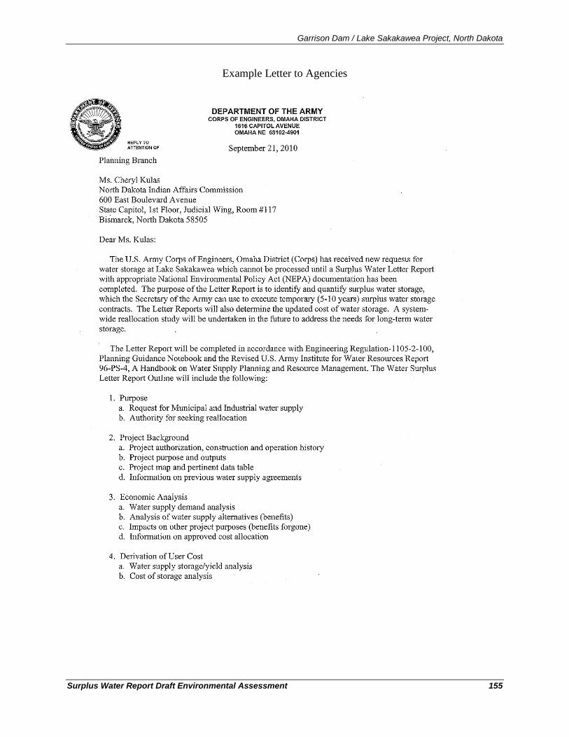
Garrison Dam / Lake Sakakawea Project, North Dakota
Surplus Water Report Draft Environmental Assessment 155
Example Letter to Agencies
Garrison Dam / Lake Sakakawea Project, North Dakota
Surplus Water Report Draft Environmental Assessment 156
Garrison Dam / Lake Sakakawea Project, North Dakota
Surplus Water Report Draft Environmental Assessment 157
Appendix C – North Dakota Natural Heritage Inventory

Garrison Dam / Lake Sakakawea Project, North Dakota
Surplus Water Report Draft Environmental Assessment 158
Garrison Dam / Lake Sakakawea Project, North Dakota
Surplus Water Report Draft Environmental Assessment 159
The North Dakota Natural Heritage Inventory provides a comprehensive system (Heritage System) for identifying and prioritizing ecologically significant natural features in the state including species of concern. A species of concern is not legally protected unless it is also listed on the Federal threatened and endangered species list. Each species of concern receives a state rank and global rank which indicates its status within the state and globally. Appendix C explains these ranks and lists all species of concern that have been recorded to occur within one of the six counties bordering Lake Sakakawea (Dunn, McLean, McKenzie, Mercer, Mountrail, and Williams).
The North Dakota Game and Fish Department (NDGFD) also maintain information about nongame wildlife in the state. In 2001, Congress approved legislation authorizing Federal dollars for States to use in developing programs to protect nongame wildlife, now called the State Wildlife Grants (SWG) program. In order to receive funds under the program, the NDGFD was required to develop a Comprehensive Wildlife Conservation Strategy, which included a list of 100 species of conservation priority (USACE, 2007). The species on the list are declining in the state of North Dakota or have stable populations in North Dakota but are declining elsewhere. Invertebrates were excluded from the list because of a lack of information on status and distribution of invertebrate species in the state, with the exception of mussels. Plants were excluded because the Comprehensive Wildlife Conservation Strategy applies only to animals. Species were classified as a Level I, Level II, or Level III species of conservation priority to determine their priority for SWG funding:
Level I species. These species are declining and currently receive little or no monetary support for conservation efforts. These species have a high level of conservation priority because of declining status either in North Dakota or across their range or have a high rate of occurrence in North Dakota, constituting the core of the species’ breeding range but are at-risk range wide.
Level II species. The NDGFD will use SWG funding to implement conservation actions to benefit these species if SWG funding for a Level I species is sufficient or conservation needs have been met. Level II species have a moderate level of conservation priority or a high level of conservation priority but a substantial amount of non-SWG funding is available to them.
Level III species. These species have a moderate level of conservation priority but are believed to be peripheral or non-breeding in North Dakota. Appendix D includes the table of species of conservation priority that occur in the eight counties bordering Lake Sakakawea. Because the NDNHP and NDGFD compiled their species of concern and species of conservation priority lists separately using different methodologies, some species may be on one list but not the other.
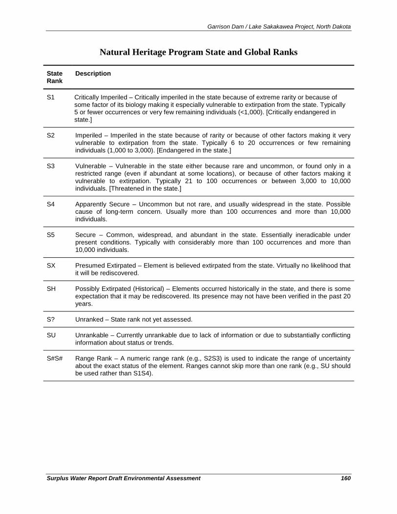
Garrison Dam / Lake Sakakawea Project, North Dakota
Surplus Water Report Draft Environmental Assessment 160
Natural Heritage Program State and Global Ranks
State Rank
Description
S1 Critically Imperiled – Critically imperiled in the state because of extreme rarity or because of some factor of its biology making it especially vulnerable to extirpation from the state. Typically 5 or fewer occurrences or very few remaining individuals (<1,000). [Critically endangered in state.]
S2 Imperiled – Imperiled in the state because of rarity or because of other factors making it very vulnerable to extirpation from the state. Typically 6 to 20 occurrences or few remaining individuals (1,000 to 3,000). [Endangered in the state.]
S3 Vulnerable – Vulnerable in the state either because rare and uncommon, or found only in a restricted range (even if abundant at some locations), or because of other factors making it vulnerable to extirpation. Typically 21 to 100 occurrences or between 3,000 to 10,000 individuals. [Threatened in the state.]
S4 Apparently Secure – Uncommon but not rare, and usually widespread in the state. Possible cause of long-term concern. Usually more than 100 occurrences and more than 10,000 individuals.
S5 Secure – Common, widespread, and abundant in the state. Essentially ineradicable under present conditions. Typically with considerably more than 100 occurrences and more than 10,000 individuals.
SX Presumed Extirpated – Element is believed extirpated from the state. Virtually no likelihood that it will be rediscovered.
SH Possibly Extirpated (Historical) – Elements occurred historically in the state, and there is some expectation that it may be rediscovered. Its presence may not have been verified in the past 20 years.
S? Unranked – State rank not yet assessed.
SU Unrankable – Currently unrankable due to lack of information or due to substantially conflicting information about status or trends.
S#S# Range Rank – A numeric range rank (e.g., S2S3) is used to indicate the range of uncertainty about the exact status of the element. Ranges cannot skip more than one rank (e.g., SU should be used rather than S1S4).
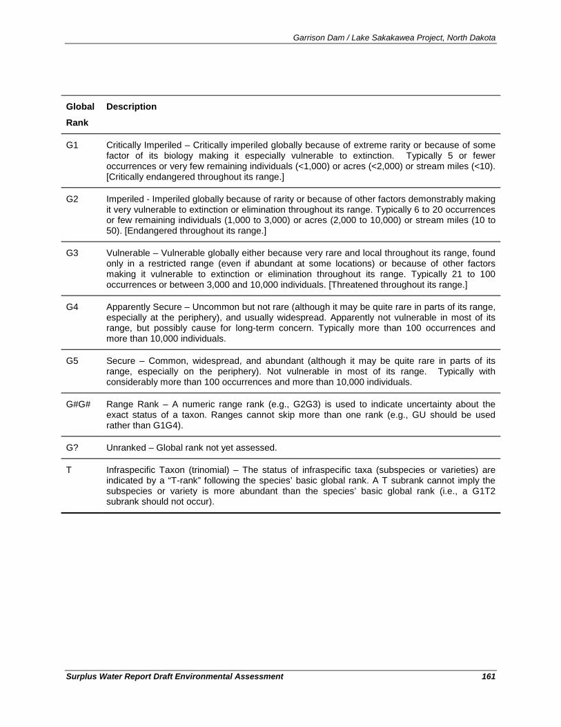
Garrison Dam / Lake Sakakawea Project, North Dakota
Surplus Water Report Draft Environmental Assessment 161
Global
Rank
Description
G1 Critically Imperiled – Critically imperiled globally because of extreme rarity or because of some factor of its biology making it especially vulnerable to extinction. Typically 5 or fewer occurrences or very few remaining individuals (<1,000) or acres (<2,000) or stream miles (<10). [Critically endangered throughout its range.]
G2 Imperiled - Imperiled globally because of rarity or because of other factors demonstrably making it very vulnerable to extinction or elimination throughout its range. Typically 6 to 20 occurrences or few remaining individuals (1,000 to 3,000) or acres (2,000 to 10,000) or stream miles (10 to 50). [Endangered throughout its range.]
G3 Vulnerable – Vulnerable globally either because very rare and local throughout its range, found only in a restricted range (even if abundant at some locations) or because of other factors making it vulnerable to extinction or elimination throughout its range. Typically 21 to 100 occurrences or between 3,000 and 10,000 individuals. [Threatened throughout its range.]
G4 Apparently Secure – Uncommon but not rare (although it may be quite rare in parts of its range, especially at the periphery), and usually widespread. Apparently not vulnerable in most of its range, but possibly cause for long-term concern. Typically more than 100 occurrences and more than 10,000 individuals.
G5 Secure – Common, widespread, and abundant (although it may be quite rare in parts of its range, especially on the periphery). Not vulnerable in most of its range. Typically with considerably more than 100 occurrences and more than 10,000 individuals.
G#G# Range Rank – A numeric range rank (e.g., G2G3) is used to indicate uncertainty about the exact status of a taxon. Ranges cannot skip more than one rank (e.g., GU should be used rather than G1G4).
G? Unranked – Global rank not yet assessed.
T Infraspecific Taxon (trinomial) – The status of infraspecific taxa (subspecies or varieties) are indicated by a “T-rank” following the species’ basic global rank. A T subrank cannot imply the subspecies or variety is more abundant than the species’ basic global rank (i.e., a G1T2 subrank should not occur).
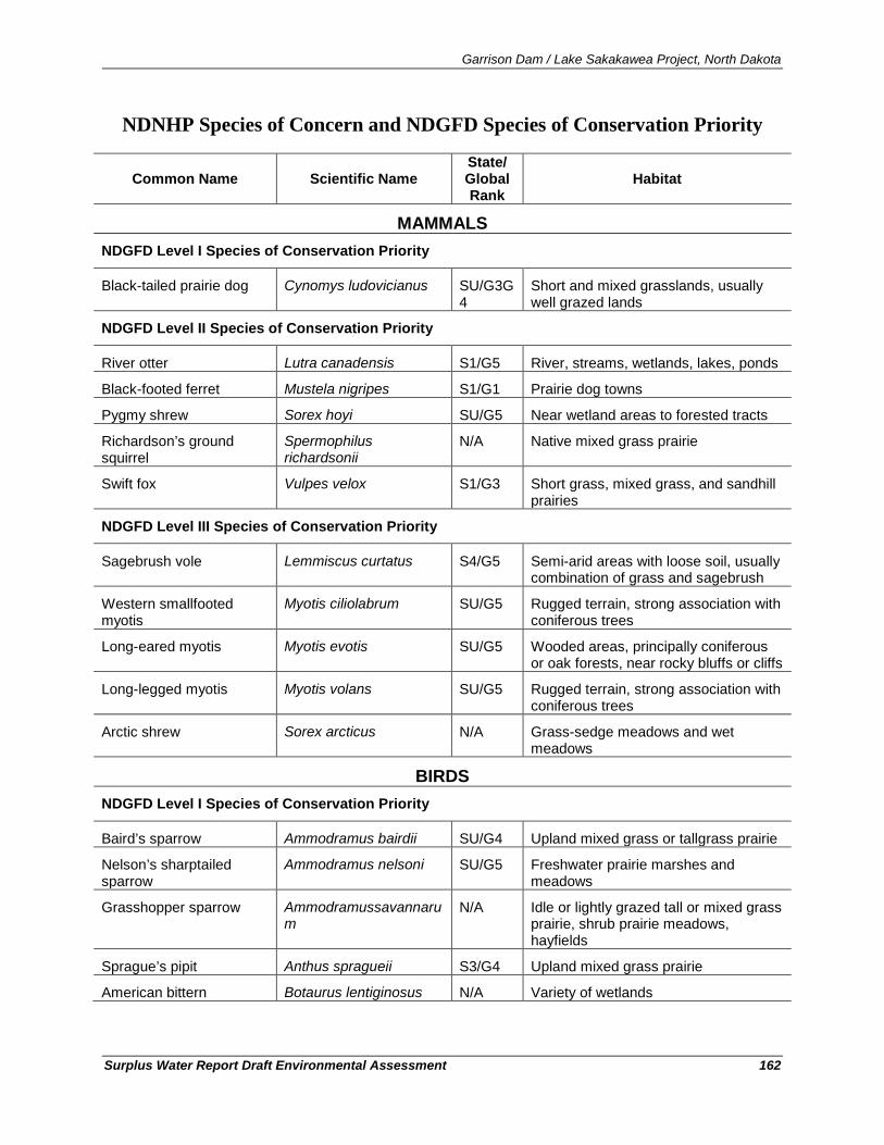
Garrison Dam / Lake Sakakawea Project, North Dakota
Surplus Water Report Draft Environmental Assessment 162
NDNHP Species of Concern and NDGFD Species of Conservation Priority
Common Name Scientific Name State/ Global Rank
Habitat
MAMMALS NDGFD Level I Species of Conservation Priority
Black-tailed prairie dog Cynomys ludovicianus SU/G3G4
Short and mixed grasslands, usually well grazed lands
NDGFD Level II Species of Conservation Priority
River otter Lutra canadensis S1/G5 River, streams, wetlands, lakes, ponds
Black-footed ferret Mustela nigripes S1/G1 Prairie dog towns
Pygmy shrew Sorex hoyi SU/G5 Near wetland areas to forested tracts
Richardson’s ground squirrel
Spermophilus richardsonii
N/A Native mixed grass prairie
Swift fox Vulpes velox S1/G3 Short grass, mixed grass, and sandhill prairies
NDGFD Level III Species of Conservation Priority
Sagebrush vole Lemmiscus curtatus S4/G5 Semi-arid areas with loose soil, usually combination of grass and sagebrush
Western smallfooted myotis
Myotis ciliolabrum SU/G5 Rugged terrain, strong association with coniferous trees
Long-eared myotis Myotis evotis SU/G5 Wooded areas, principally coniferous or oak forests, near rocky bluffs or cliffs
Long-legged myotis Myotis volans SU/G5 Rugged terrain, strong association with coniferous trees
Arctic shrew Sorex arcticus N/A Grass-sedge meadows and wet meadows
BIRDS NDGFD Level I Species of Conservation Priority
Baird’s sparrow Ammodramus bairdii SU/G4 Upland mixed grass or tallgrass prairie
Nelson’s sharptailed sparrow
Ammodramus nelsoni SU/G5 Freshwater prairie marshes and meadows
Grasshopper sparrow
Ammodramussavannarum
N/A Idle or lightly grazed tall or mixed grass prairie, shrub prairie meadows, hayfields
Sprague’s pipit Anthus spragueii S3/G4 Upland mixed grass prairie
American bittern Botaurus lentiginosus N/A Variety of wetlands
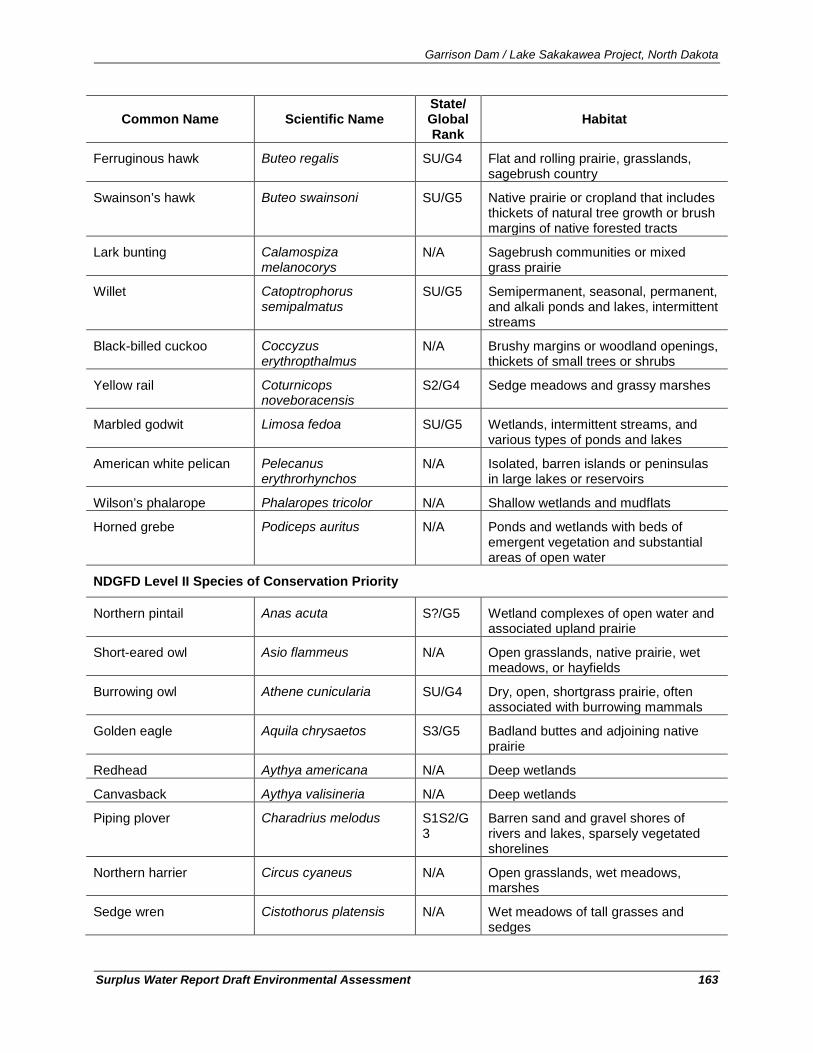
Garrison Dam / Lake Sakakawea Project, North Dakota
Surplus Water Report Draft Environmental Assessment 163
Common Name Scientific Name State/ Global Rank
Habitat
Ferruginous hawk Buteo regalis SU/G4 Flat and rolling prairie, grasslands, sagebrush country
Swainson’s hawk Buteo swainsoni SU/G5 Native prairie or cropland that includes thickets of natural tree growth or brush margins of native forested tracts
Lark bunting Calamospiza melanocorys
N/A Sagebrush communities or mixed grass prairie
Willet Catoptrophorus semipalmatus
SU/G5 Semipermanent, seasonal, permanent, and alkali ponds and lakes, intermittent streams
Black-billed cuckoo Coccyzus erythropthalmus
N/A Brushy margins or woodland openings, thickets of small trees or shrubs
Yellow rail Coturnicops noveboracensis
S2/G4 Sedge meadows and grassy marshes
Marbled godwit Limosa fedoa SU/G5 Wetlands, intermittent streams, and various types of ponds and lakes
American white pelican Pelecanus erythrorhynchos
N/A Isolated, barren islands or peninsulas in large lakes or reservoirs
Wilson’s phalarope Phalaropes tricolor N/A Shallow wetlands and mudflats
Horned grebe Podiceps auritus N/A Ponds and wetlands with beds of emergent vegetation and substantial areas of open water
NDGFD Level II Species of Conservation Priority
Northern pintail Anas acuta S?/G5 Wetland complexes of open water and associated upland prairie
Short-eared owl Asio flammeus N/A Open grasslands, native prairie, wet meadows, or hayfields
Burrowing owl Athene cunicularia SU/G4 Dry, open, shortgrass prairie, often associated with burrowing mammals
Golden eagle Aquila chrysaetos S3/G5 Badland buttes and adjoining native prairie
Redhead Aythya americana N/A Deep wetlands
Canvasback Aythya valisineria N/A Deep wetlands
Piping plover Charadrius melodus S1S2/G3
Barren sand and gravel shores of rivers and lakes, sparsely vegetated shorelines
Northern harrier Circus cyaneus N/A Open grasslands, wet meadows, marshes
Sedge wren Cistothorus platensis N/A Wet meadows of tall grasses and sedges
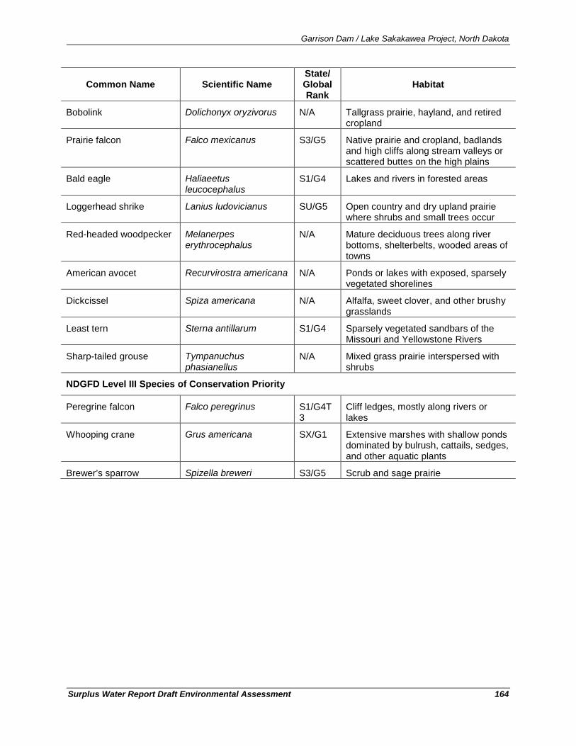
Garrison Dam / Lake Sakakawea Project, North Dakota
Surplus Water Report Draft Environmental Assessment 164
Common Name Scientific Name State/ Global Rank
Habitat
Bobolink Dolichonyx oryzivorus N/A Tallgrass prairie, hayland, and retired cropland
Prairie falcon Falco mexicanus S3/G5 Native prairie and cropland, badlands and high cliffs along stream valleys or scattered buttes on the high plains
Bald eagle Haliaeetus leucocephalus
S1/G4 Lakes and rivers in forested areas
Loggerhead shrike Lanius ludovicianus SU/G5 Open country and dry upland prairie where shrubs and small trees occur
Red-headed woodpecker Melanerpes erythrocephalus
N/A Mature deciduous trees along river bottoms, shelterbelts, wooded areas of towns
American avocet Recurvirostra americana N/A Ponds or lakes with exposed, sparsely vegetated shorelines
Dickcissel Spiza americana N/A Alfalfa, sweet clover, and other brushy grasslands
Least tern Sterna antillarum S1/G4 Sparsely vegetated sandbars of the Missouri and Yellowstone Rivers
Sharp-tailed grouse Tympanuchus phasianellus
N/A Mixed grass prairie interspersed with shrubs
NDGFD Level III Species of Conservation Priority
Peregrine falcon Falco peregrinus S1/G4T3
Cliff ledges, mostly along rivers or lakes
Whooping crane Grus americana SX/G1 Extensive marshes with shallow ponds dominated by bulrush, cattails, sedges, and other aquatic plants
Brewer’s sparrow Spizella breweri S3/G5 Scrub and sage prairie
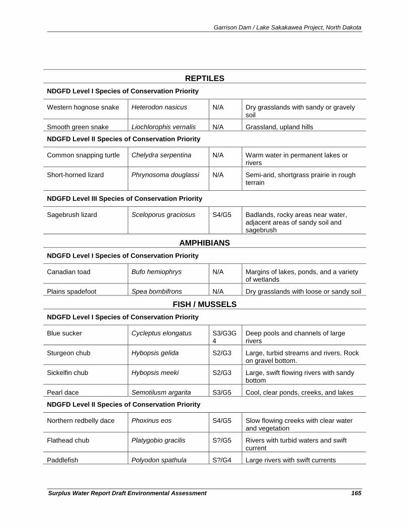
Garrison Dam / Lake Sakakawea Project, North Dakota
Surplus Water Report Draft Environmental Assessment 165
REPTILES NDGFD Level I Species of Conservation Priority
Western hognose snake Heterodon nasicus N/A Dry grasslands with sandy or gravely soil
Smooth green snake Liochlorophis vernalis N/A Grassland, upland hills
NDGFD Level II Species of Conservation Priority
Common snapping turtle Chelydra serpentina N/A Warm water in permanent lakes or rivers
Short-horned lizard Phrynosoma douglassi
N/A Semi-arid, shortgrass prairie in rough terrain
NDGFD Level III Species of Conservation Priority
Sagebrush lizard Sceloporus graciosus S4/G5 Badlands, rocky areas near water, adjacent areas of sandy soil and sagebrush
AMPHIBIANS NDGFD Level I Species of Conservation Priority
Canadian toad Bufo hemiophrys N/A Margins of lakes, ponds, and a variety of wetlands
Plains spadefoot Spea bombifrons N/A Dry grasslands with loose or sandy soil
FISH / MUSSELS NDGFD Level I Species of Conservation Priority
Blue sucker Cycleptus elongatus S3/G3G4
Deep pools and channels of large rivers
Sturgeon chub Hybopsis gelida S2/G3 Large, turbid streams and rivers. Rock on gravel bottom.
Sickelfin chub Hybopsis meeki S2/G3 Large, swift flowing rivers with sandy bottom
Pearl dace Semotilusm argarita S3/G5 Cool, clear ponds, creeks, and lakes
NDGFD Level II Species of Conservation Priority
Northern redbelly dace Phoxinus eos S4/G5 Slow flowing creeks with clear water and vegetation
Flathead chub Platygobio gracilis S?/G5 Rivers with turbid waters and swift current
Paddlefish Polyodon spathula S?/G4 Large rivers with swift currents
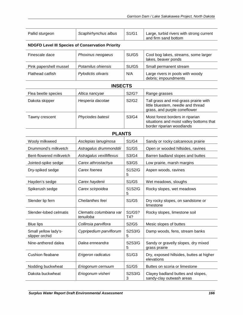
Garrison Dam / Lake Sakakawea Project, North Dakota
Surplus Water Report Draft Environmental Assessment 166
Pallid sturgeon Scaphirhynchus albus S1/G1 Large, turbid rivers with strong current and firm sand bottom
NDGFD Level III Species of Conservation Priority
Finescale dace Phoxinus neogaeus SU/G5 Cool bog lakes, streams, some larger lakes, beaver ponds
Pink papershell mussel Potamilus ohiensis SU/G5 Small permanent stream
Flathead catfish Pylodictis olivaris N/A Large rivers in pools with woody debris; impoundments
INSECTS Flea beetle species Altica nancyae S2/G? Range grasses
Dakota skipper Hesperia dacotae S2/G2 Tall grass and mid-grass prairie with little bluestem, needle and thread grass, and purple coneflower
Tawny crescent Phyciodes batesii S3/G4 Moist forest borders in riparian situations and moist valley bottoms that border riparian woodlands
PLANTS Wooly milkweed Asclepias lanuginosa S1/G4 Sandy or rocky calcareous prairie
Drummond’s milkvetch Astragalus drummonddii S1/G5 Open or wooded hillsides, ravines
Bent-flowered milkvetch Astragalus vexilliflexus S3/G4 Barren badland slopes and buttes
Jointed-spike sedge Carex athrostachya S3/G5 Low prairie, marsh margins
Dry-spiked sedge Carex foenea S1S2/G5
Aspen woods, ravines
Hayden’s sedge Carex haydenii S1/G5 Wet meadows, sloughs
Spikerush sedge Carex scirpoidea S1S2/G5
Rocky slopes, wet meadows
Slender lip fern Cheilanthes feei S1/G5 Dry rocky slopes, on sandstone or limestone
Slender-lobed celmatis Clematis columbiana var tenuiloba
S1/G5?T4?
Rocky slopes, limestone soil
Blue lips Collinsia parviflora S2/G5 Mesic slopes of buttes
Small yellow lady’s-slipper orchid
Cypripedium parviflorum S2S3/G5
Damp woods, fens, stream banks
Nine-anthered dalea Dalea enneandra S2S3/G5
Sandy or gravelly slopes, dry mixed grass prairie
Cushion fleabane Erigeron radicatus S1/G3 Dry, exposed hillsides, buttes at higher elevations
Nodding buckwheat Eriogonum cernuum S1/G5 Buttes on scoria or limestone
Dakota buckwheat Eriogonum visheri S2S3/G3
Clayey badland buttes and slopes, sandy-clay outwash areas
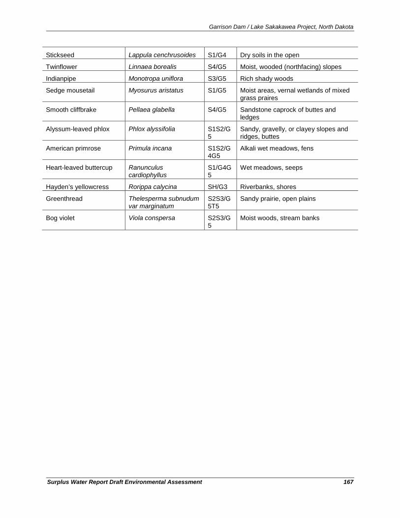
Garrison Dam / Lake Sakakawea Project, North Dakota
Surplus Water Report Draft Environmental Assessment 167
Stickseed Lappula cenchrusoides S1/G4 Dry soils in the open
Twinflower Linnaea borealis S4/G5 Moist, wooded (northfacing) slopes
Indianpipe Monotropa uniflora S3/G5 Rich shady woods
Sedge mousetail Myosurus aristatus S1/G5 Moist areas, vernal wetlands of mixed grass praires
Smooth cliffbrake Pellaea glabella S4/G5 Sandstone caprock of buttes and ledges
Alyssum-leaved phlox Phlox alyssifolia S1S2/G5
Sandy, gravelly, or clayey slopes and ridges, buttes
American primrose Primula incana S1S2/G4G5
Alkali wet meadows, fens
Heart-leaved buttercup Ranunculus cardiophyllus
S1/G4G5
Wet meadows, seeps
Hayden’s yellowcress Rorippa calycina SH/G3 Riverbanks, shores
Greenthread Thelesperma subnudum var marginatum
S2S3/G5T5
Sandy prairie, open plains
Bog violet Viola conspersa S2S3/G5
Moist woods, stream banks

Garrison Dam / Lake Sakakawea Project, North Dakota
Surplus Water Report Draft Environmental Assessment 168
Garrison Dam / Lake Sakakawea, North Dakota
Surplus Water Report Appendix B
APPENDIX B Public and Agency Coordination and Letters / Views of Federal, State
and Local Interests

March 2003 Draft Format for Surplus Water Agreements
2


![Garrison sharon[2]](https://img.pdfslide.us/doc/110x75/5566a3aed8b42acd288b4cda/garrison-sharon2.jpg)