Embed Size (px)
Citation preview
1
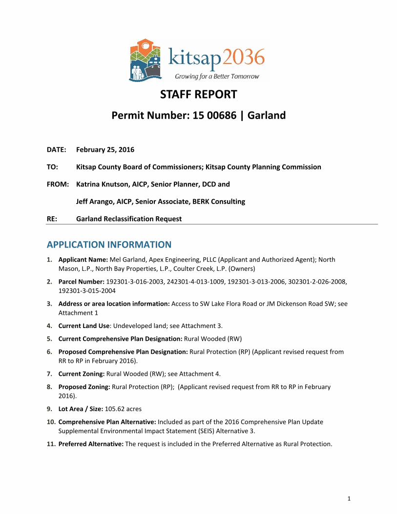
STAFF REPORT
Permit Number: 15 00686 | Garland
DATE: February 25, 2016
TO: Kitsap County Board of Commissioners; Kitsap County Planning Commission
FROM: Katrina Knutson, AICP, Senior Planner, DCD and
Jeff Arango, AICP, Senior Associate, BERK Consulting
RE: Garland Reclassification Request
APPLICATION INFORMATION 1. Applicant Name: Mel Garland, Apex Engineering, PLLC (Applicant and Authorized Agent); North
Mason, L.P., North Bay Properties, L.P., Coulter Creek, L.P. (Owners)
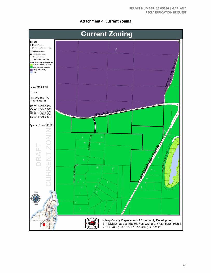
2. Parcel Number: 192301‐3‐016‐2003, 242301‐4‐013‐1009, 192301‐3‐013‐2006, 302301‐2‐026‐2008, 192301‐3‐015‐2004
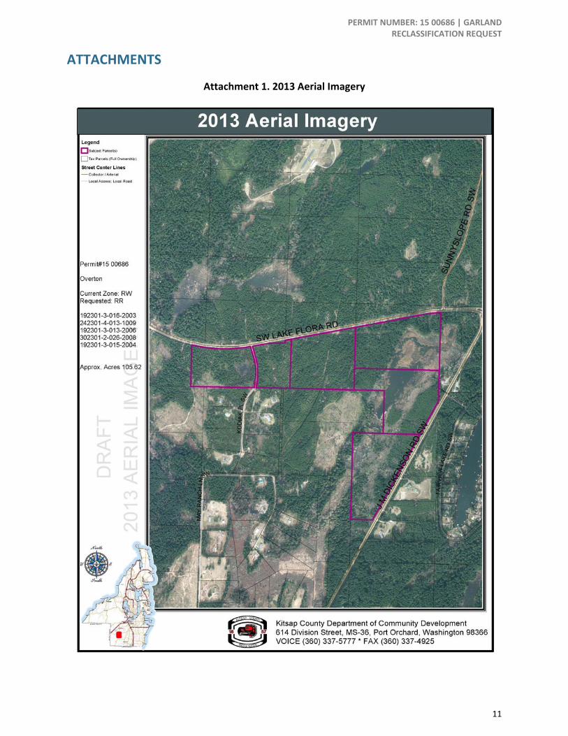
3. Address or area location information: Access to SW Lake Flora Road or JM Dickenson Road SW; see Attachment 1
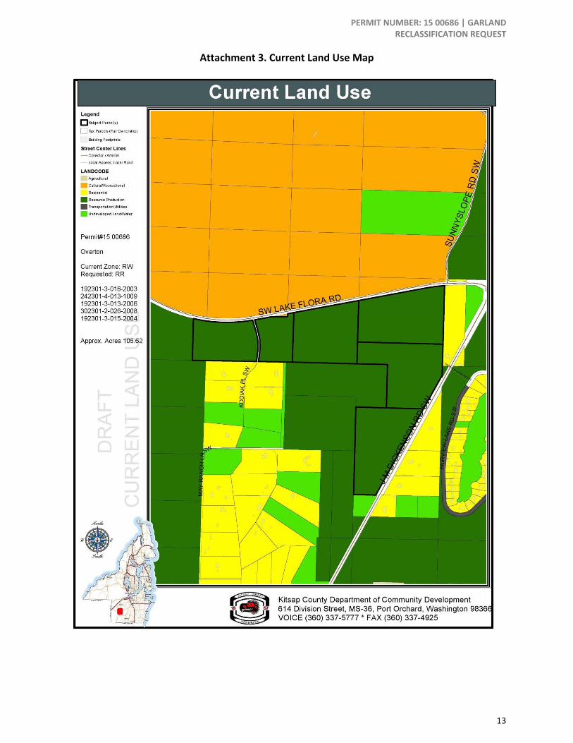
4. Current Land Use: Undeveloped land; see Attachment 3.
5. Current Comprehensive Plan Designation: Rural Wooded (RW)
6. Proposed Comprehensive Plan Designation: Rural Protection (RP) (Applicant revised request from RR to RP in February 2016).
7. Current Zoning: Rural Wooded (RW); see Attachment 4.
8. Proposed Zoning: Rural Protection (RP); (Applicant revised request from RR to RP in February 2016).
9. Lot Area / Size: 105.62 acres
10. Comprehensive Plan Alternative: Included as part of the 2016 Comprehensive Plan Update Supplemental Environmental Impact Statement (SEIS) Alternative 3.
11. Preferred Alternative: The request is included in the Preferred Alternative as Rural Protection.
PERMIT NUMBER: 15 00686 | GARLAND RECLASSIFICATION REQUEST
2
Submitted Application Materials • Project application
• Reclassification request amendment criteria
• Ownership Certification
• Environmental Checklist
Application Request The applicant seeks to reclassify and rezone five parcels from Rural Wooded (RW) to Rural Residential (RR).
BACKGROUND The 5 subject properties contain a total of approximately 105.62 acres and are classified by the Assessor as 880‐Designated Forest Land. The Assessor’s summary of this current use taxation classification is: A minimum of 20 contiguous acres, which must be primarily devoted to and used for growing and harvesting timber. Smaller parcels may qualify for timber land classification. If there is a residence on the parcel, a minimum 1‐acre building site is excluded from the classification. (Kitsap County Assessor 2010, http://www.kitsapgov.com/assr/forms/cu_assmt.pdf)
The subject sites currently do not have existing water, sewer, or electricity service. Well water and septic systems are proposed. The sites have access to JM Dickenson Road SW to the east and SW Lake Flora Road to the north.
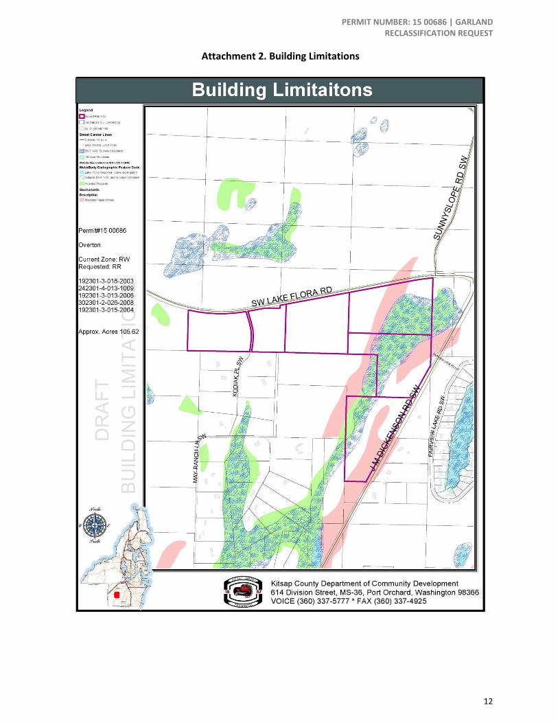
Additionally, three of the subject parcels contain wetlands, a fish‐bearing stream and moderate geologically hazardous areas as shown on County maps. (See Attachment 2).
In February 2016, the application changed the requested zoning to Rural Protection (RP) instead of Rural Residential (RR).
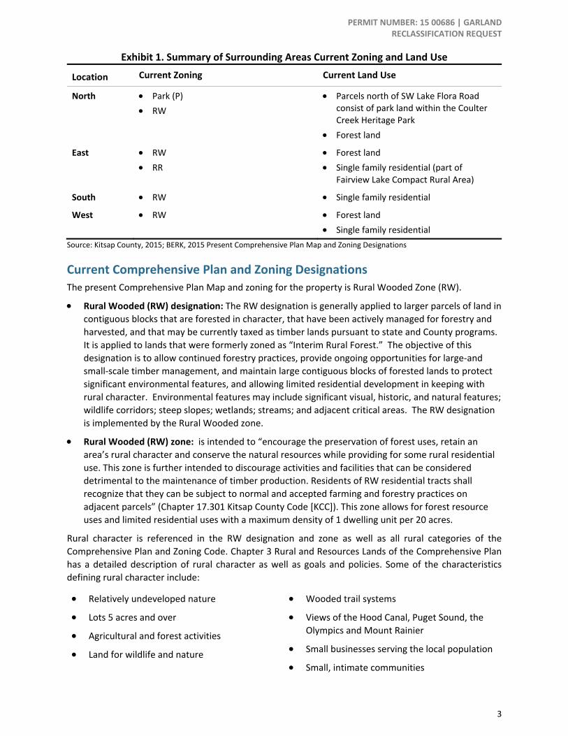
Surrounding Zoning and Land Use The subject properties are adjacent to parcels designated and zoned Rural Wooded or designated Public Facilities with Parks zoning and used as single family residential, parks, or forest land/resource production. See Exhibit 1. The subject property is part of a large contiguous area of land designated and zoned RW south of Bremerton and Port Orchard city boundaries.
The area around Fairview Lake to the east across JM Dickenson Road was mainly developed prior to 1990 when the Growth Management Act (GMA) was enacted, and contains lots smaller than one acre in size with a Rural Residential designation.
The surrounding lots are primarily sized between 5‐10 acres.
Comprehensive Plan Chapter 3 (Rural and Resource Lands) identifies the area immediately surrounding the lake as a “Compact Rural Area”, consisting of small residential lots at nearly 3 units per acre, with limited services.
PERMIT NUMBER: 15 00686 | GARLAND RECLASSIFICATION REQUEST
3
Exhibit 1. Summary of Surrounding Areas Current Zoning and Land Use
Location Current Zoning Current Land Use
North • Park (P) • RW
• Parcels north of SW Lake Flora Road consist of park land within the Coulter Creek Heritage Park
• Forest land
East • RW • RR
• Forest land • Single family residential (part of
Fairview Lake Compact Rural Area)
South • RW • Single family residential
West • RW • Forest land • Single family residential
Source: Kitsap County, 2015; BERK, 2015 Present Comprehensive Plan Map and Zoning Designations
Current Comprehensive Plan and Zoning Designations The present Comprehensive Plan Map and zoning for the property is Rural Wooded Zone (RW).
• Rural Wooded (RW) designation: The RW designation is generally applied to larger parcels of land in contiguous blocks that are forested in character, that have been actively managed for forestry and harvested, and that may be currently taxed as timber lands pursuant to state and County programs. It is applied to lands that were formerly zoned as “Interim Rural Forest.” The objective of this designation is to allow continued forestry practices, provide ongoing opportunities for large‐and small‐scale timber management, and maintain large contiguous blocks of forested lands to protect significant environmental features, and allowing limited residential development in keeping with rural character. Environmental features may include significant visual, historic, and natural features; wildlife corridors; steep slopes; wetlands; streams; and adjacent critical areas. The RW designation is implemented by the Rural Wooded zone.
• Rural Wooded (RW) zone: is intended to “encourage the preservation of forest uses, retain an area’s rural character and conserve the natural resources while providing for some rural residential use. This zone is further intended to discourage activities and facilities that can be considered detrimental to the maintenance of timber production. Residents of RW residential tracts shall recognize that they can be subject to normal and accepted farming and forestry practices on adjacent parcels” (Chapter 17.301 Kitsap County Code [KCC]). This zone allows for forest resource uses and limited residential uses with a maximum density of 1 dwelling unit per 20 acres.
Rural character is referenced in the RW designation and zone as well as all rural categories of the Comprehensive Plan and Zoning Code. Chapter 3 Rural and Resources Lands of the Comprehensive Plan has a detailed description of rural character as well as goals and policies. Some of the characteristics defining rural character include:
• Relatively undeveloped nature
• Lots 5 acres and over
• Agricultural and forest activities
• Land for wildlife and nature
• Wooded trail systems
• Views of the Hood Canal, Puget Sound, the Olympics and Mount Rainier
• Small businesses serving the local population
• Small, intimate communities
PERMIT NUMBER: 15 00686 | GARLAND RECLASSIFICATION REQUEST
4
• Personal open space for tranquility (enjoyment of personal property)
• Responsive public services, sense of being self‐sufficient
• Low population density
• Large forested areas
• Quiet two lane roads
Proposed Comprehensive Plan and Zoning Designations As described in the current Comprehensive Plan, the proposed Comprehensive Plan Map and zoning designation is RP. As described in Chapter 3 of the Comprehensive Plan and the Kitsap County Code this designation promotes “low‐density residential development consistent with rural character. It is applied to areas that are relatively unconstrained by environmentally sensitive areas or other significant landscape features. These areas are provided with limited public services” (Chapter 17.310 KCC). RR zoning has a maximum density of 1 dwelling unit per 5 acres. Under RR zoning, there are more permitted and conditional residential and commercial allowed uses than in the current RW zoning, such as a day care center, animal hospitals, golf course, and schools.
The following tables compare the existing and proposed zoning designations for selected allowed uses and development standards. See Exhibit 2 and Exhibit 3.
Exhibit 2. Selected Allowed Uses (KCC 17.381.040 E)
Selected Uses RP (proposed zoning)
RW (current zoning)
Residential Uses
• Single Family Attached C X
• Single Family Detached P P
• Manufactured Homes P X
• Mobile homes P P
Commercial/Business Uses
• Daycare Center P X
• Kennels, pet care C X
• Nursery C X
• Golf course C X
• School C X
Resource Land Uses
• Agricultural uses P P
• Forestry P P Legend: C = Conditional, P = Permitted, X = Prohibited
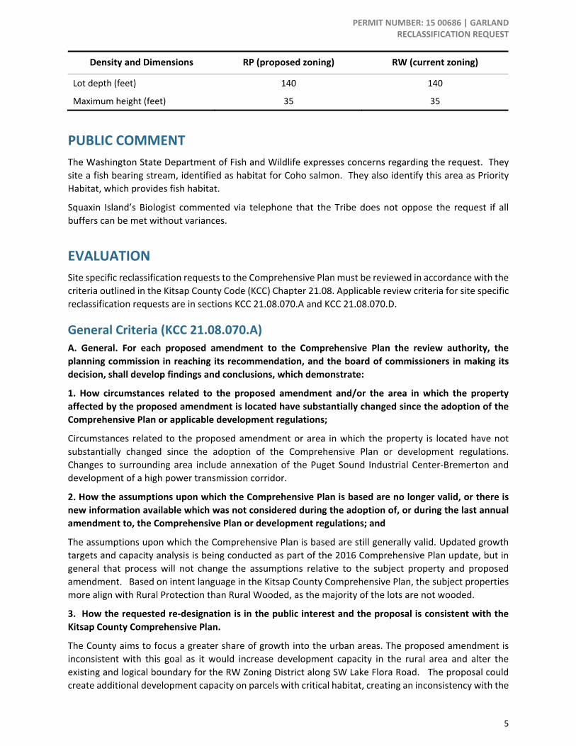
Exhibit 3. Selected Development Standards Comparison (KCC 17.382.100)
Density and Dimensions RP (proposed zoning) RW (current zoning)
Minimum lot size (acre) 5 20
Lot width (feet) 140 140
PERMIT NUMBER: 15 00686 | GARLAND RECLASSIFICATION REQUEST
5
Density and Dimensions RP (proposed zoning) RW (current zoning)
Lot depth (feet) 140 140
Maximum height (feet) 35 35
PUBLIC COMMENT The Washington State Department of Fish and Wildlife expresses concerns regarding the request. They site a fish bearing stream, identified as habitat for Coho salmon. They also identify this area as Priority Habitat, which provides fish habitat.
Squaxin Island’s Biologist commented via telephone that the Tribe does not oppose the request if all buffers can be met without variances.
EVALUATION Site specific reclassification requests to the Comprehensive Plan must be reviewed in accordance with the criteria outlined in the Kitsap County Code (KCC) Chapter 21.08. Applicable review criteria for site specific reclassification requests are in sections KCC 21.08.070.A and KCC 21.08.070.D.
General Criteria (KCC 21.08.070.A) A. General. For each proposed amendment to the Comprehensive Plan the review authority, the planning commission in reaching its recommendation, and the board of commissioners in making its decision, shall develop findings and conclusions, which demonstrate:
1. How circumstances related to the proposed amendment and/or the area in which the property affected by the proposed amendment is located have substantially changed since the adoption of the Comprehensive Plan or applicable development regulations;
Circumstances related to the proposed amendment or area in which the property is located have not substantially changed since the adoption of the Comprehensive Plan or development regulations. Changes to surrounding area include annexation of the Puget Sound Industrial Center‐Bremerton and development of a high power transmission corridor.
2. How the assumptions upon which the Comprehensive Plan is based are no longer valid, or there is new information available which was not considered during the adoption of, or during the last annual amendment to, the Comprehensive Plan or development regulations; and
The assumptions upon which the Comprehensive Plan is based are still generally valid. Updated growth targets and capacity analysis is being conducted as part of the 2016 Comprehensive Plan update, but in general that process will not change the assumptions relative to the subject property and proposed amendment. Based on intent language in the Kitsap County Comprehensive Plan, the subject properties more align with Rural Protection than Rural Wooded, as the majority of the lots are not wooded.
3. How the requested re‐designation is in the public interest and the proposal is consistent with the Kitsap County Comprehensive Plan.
The County aims to focus a greater share of growth into the urban areas. The proposed amendment is inconsistent with this goal as it would increase development capacity in the rural area and alter the existing and logical boundary for the RW Zoning District along SW Lake Flora Road. The proposal could create additional development capacity on parcels with critical habitat, creating an inconsistency with the
PERMIT NUMBER: 15 00686 | GARLAND RECLASSIFICATION REQUEST
6
Natural Systems Chapter. However, the redesignation better aligns with the Kitsap County Zoning code intent language.
Reclassification Request Criteria Evaluation (KCC 21.08.070.D) D. Site‐Specific Amendments. In addition to the findings and conclusions in subsection (A) of this section, a proposed site‐specific map amendment may be recommended for approval by the planning commission and may be approved by the board of commissioners if the following findings are made:
1. All Site‐Specific Amendment Requests. Each of the following requirements must be satisfied for a recommendation for approval.
a. The proposed amendment meets concurrency requirements for transportation, sewer and water, and will not result in significant adverse impacts on adopted level of service standards for other public facilities and services, such as police, fire and emergency medical services, park services, and general government services;
The parcels are currently undeveloped forest land and are not served by municipal water or sewer facilities. Well water is available, and septic systems are proposed. The sites are served by both SW Lake Flora Road and JM Dickenson Road SW. The proposed Comprehensive Plan map and zoning amendment would allow for up to 10 lots to be created at 10 acres per lot instead of 5 lots at 20 acres each. There are presently five lots under review in the application that are around 20 acres each and no new lots could be created under the RW zone. The 5 increased lots above existing lots could lead to an increase in the demand for police, fire and emergency medical services, as the number of new residences on the property would increase.
An increase in residential development on the subject properties could also create an incremental demand for transportation maintenance and services within this rural area to reach necessary services in the surrounding rural and urban communities.
b. The proposed amendment is consistent with the balance of the goals, policies and objectives of the current Kitsap County Comprehensive Plan and reflects the local circumstances of the County
Kitsap County Comprehensive Plan Chapter Vision Kitsap County’s Comprehensive Plan shows the relationship between chapter concepts and the comprehensive plan vision. See Exhibit 4.
Exhibit 4. County Vision for Rural and Urban Areas
Vision Rural Chapter Relationship to Vision Rural Areas. Rural areas and communities where unique historical characters, appearances, functions, and pioneering spirits are retained and enhanced. Natural resource activities, such as forestry, agriculture, and mining continue to contribute to the rural character and economy. Rural recreation opportunities are enhanced, including equestrian facilities, trails, and others.
• Maintain low residential densities in rural areas and provides policy guidance for development standards which help to preserve the County’s rural character. Foster small sustainable farms and agricultural enterprises that provide locally‐grown food and fiber for Kitsap citizens.
Urban Areas. Healthy urban areas that are the region's centers for diverse employment and housing opportunities, all levels of education, and civic and cultural activities.
• Support focused development in urban areas as centers for population, employment, and civic and cultural activities (See the Land Use chapter
PERMIT NUMBER: 15 00686 | GARLAND RECLASSIFICATION REQUEST
7
for further policy guidance affecting the urban area.)
Source: Kitsap County Comprehensive Plan (December 2012).
The proposed amendment would apply a designation that would provide for a rural character and allow development at rural densities, but it would be a pattern unlike those of abutting lands. Additionally, it would not support focusing development in urban areas.
Kitsap County Comprehensive Plan 2036 Goals and Policies The proposed zoning amendment partially supports the following current Comprehensive Plan Goals:
3A.2.1 Rural Lands
• Goal 1: Retain the rural character of the County outside of designated urban areas, as described in this chapter.
o Policy RL‐1 Limit the designated rural area to low residential densities that can be sustained by minimal infrastructure improvements, cause minimal environmental degradation, and that will not cumulatively create the future necessity or expectation of urban levels of service.
o Policy RL‐2 Provide a variety of densities in the rural areas to make more efficient use of land, maximize the return on public infrastructure investment, and provide for affordable housing opportunities.
o Policy RL‐3 Permit residential uses in rural areas consistent with the existing and planned rural character of the surrounding area.
The proposed RP designation would retain the rural character of the County at a rural density, but the proposal would increase the supply of land available for rural development when the County is looking to increase the percentage of growth that occurs in the urban areas.
o Policy RL‐4 Outside of the Type III LAMIRDs, limit development only to that which serves rural residential or resource needs and not draw people from UGAs.
The proposed RP designation/zoning is intended to place residents near the Puget Sound Industrial Area – Bremerton. It could increase the attractiveness of the rural area and set a precedent to reclassify land to RP in the area.
• Goal 19: Develop a long term strategy for addressing the future use of properties historically used for timber production, but currently designated as rural.
The amendment request, if approved, would not encourage the continuation of forest lands as it would increase the likelihood that the properties are developed for residential use though at rural densities. However, as noted in the application packet, the subject properties do not have commercially viable timber, and therefore should be removed from the RW designation.
c. The subject parcel(s) is suitable for the requested land use designation based upon, but not limited to, access, provision of utilities, consistency with existing and planned uses, environmental constraints and compatibility with the neighborhood;
The subject parcels are currently undeveloped land and currently lack provision of municipal water and sewer facilities. Although the proposed RP zoning is compatible with existing land use as forest resource is an allowed use, it would encourage a greater rural residential density than is currently allowed for RW zoning and with abutting lands. More intense residential development may result in conversion of forestry uses; however the sites are not classified as forest lands of long‐term commercial significance.
PERMIT NUMBER: 15 00686 | GARLAND RECLASSIFICATION REQUEST
8
While the proposed zoning change to RP would be compatible to some land use and zoning further to the north and east.
A significant wetland system containing a fish‐bearing stream occurs on the eastern subject parcels. The buffers associated with this system would limit the land available for future residential development on these subject parcels.
d. The proposed amendment does not materially affect the land uses and growth projections which are the basis for comprehensive planning, and reflects local circumstances in the county.
The requested zoning amendment would not substantially affect current growth projections, but it could establish a precedent of converting properties from RW to RP that cumulatively has the potential to substantially increase the residential growth capacity in the rural area.
e. The proposed amendment does not materially affect the adequacy or availability of urban facilities and services to the immediate area or the overall area of the urban growth area.
The requested zoning amendment does not affect availability of urban facilities and services as the property is in the rural area.
f. The proposed amendment is consistent with the GMA, Kitsap County‐wide Planning Policy, state and local laws and other applicable inter‐jurisdictional policies or agreements.
The following state and local policies and laws are applicable to the applicant’s zoning amendment request.
Growth Management Act Planning Goals (RCW 36.70a.020) 1) Urban growth. Encourage development in urban areas where adequate public facilities and services exist or can be provided in an efficient manner.
2) Reduce sprawl. Reduce the inappropriate conversion of undeveloped land into sprawling, low‐density development.
8) Natural resource industries. Maintain and enhance natural resource‐based industries, including productive timber, agricultural, and fisheries industries. Encourage the conservation of productive forest lands and productive agricultural lands, and discourage incompatible uses.
(9) Open space and recreation. Retain open space, enhance recreational opportunities, conserve fish and wildlife habitat, increase access to natural resource lands and water, and develop parks and recreation facilities.
(10) Environment. Protect the environment and enhance the state's high quality of life, including air and water quality, and the availability of water.
The proposed RP zoning would support these GMA goals. The subject property is currently undeveloped forest land. If RR zoning is allowed, it would allow 5 more rural residential dwellings in rural areas beyond the five units allowed.
Kitsap County‐wide Planning Policies Kitsap County‐wide Planning Policies, Element D contains planning policies for rural land uses and development patterns. Rural areas in Kitsap County are characterized as “having a variety of parcel sizes, with a diversity of land use activities.” These areas also contain significant amounts of complex natural systems. It is a high priority to preserve and enhance the rural character of these areas.”
D‐1. Preserving rural character and enhancing the natural environment.
PERMIT NUMBER: 15 00686 | GARLAND RECLASSIFICATION REQUEST
9
a. Preserve the character of identified rural areas by protecting and enhancing the natural environment, open spaces, recreational opportunities, and scenic and historic areas. Support small scale farming and working resource land, promote locally grown food, forestry, eco‐ and heritage‐tourism. Support low‐density residential living and cluster development that provides for a mix of housing types, rural levels of service, cultural activities, and employment that services the needs of rural areas at a size and scale that is compatible with long‐term character, productivity, and use of these lands.
A change to RP zoning would allow rural densities consistent with abutting properties. Future development would likely result in the removal of minor forest cover to a greater degree at 10‐acre lots than at 20‐acre lots; low impact development techniques may help reduce impacts.
The applicant indicates that the properties may be attractive as hobby farms; that would allow for small‐scale agricultural resource uses instead of forest resource use. The 10‐acre lots with hobby farms likely mean removal of trees beyond what is needed for homes, which could present problems for the stream and wetlands. These details will be analyzed at time of permit submittal.
b. The County's Comprehensive Plan policies shall promote clustering residential development and other techniques to protect and enhance significant open spaces, natural resources, cultural resources, and critical areas for more effective use of the land. Clustering should not increase residential housing units in the overall area designated as rural, consistent with designated rural densities. Development clusters shall be designed, scaled and sited in a manner consistent with rural character and the provision of rural levels of service.
The proponent indicates that the proposal would “facilitate transfer of development rights and conservation easements which are not currently feasible on the Property given its low density yield.” There is no specific development plan at this time and it is unknown what areas would be conserved other than the critical areas required for protection (the onsite high quality wetland).
4. Requests Within the Rural Area Not Pertaining to Commercial or Industrial Requests. If applicable, each of the following requirements must be satisfied for a recommendation of approval:
a. Any proposed amendments to rural and natural resource areas shall not substantially affect the rural/urban population balance
The proposed amendment does not substantially affect the rural/urban population balance. However, it encourages new residential development in sparsely developed wooded areas and could set a precedence for other land zoned RW to potentially change to RP and alter the current vicinity character which has larger lot rural patterns.
b. Any proposed change to land designated as natural resource land shall recognize that natural resource designations are intended to be long‐term designations and shall further be dependent on one or more of the following:
i. A substantial change in circumstances pertaining to the Comprehensive Plan or public policy; ii. A substantial change in circumstances beyond the control of the landowner pertaining to the subject property; iii. An error in initial designation; and/or iv. New information on natural resource land or critical area status
According to the County Assessor website, all applicant properties are currently taxed as designated forest land recognizing the present use rather than the standard assessed value. However, the subject property is not designated as forest land of long‐term commercial significance.
PERMIT NUMBER: 15 00686 | GARLAND RECLASSIFICATION REQUEST
10
Proposed Findings of Fact 1. The applicant, Apex Engineering, authorized agent/representative for the property owner,
submitted the zoning amendment application to Kitsap County on February 25, 2015. 2. The applicant seeks a Comprehensive Plan Amendment to change the land use map and
associated zoning of five properties totaling 105.6 acres from Rural Wooded (RW) to Rural Residential (RP).
3. The properties are located along SW Lake Flora Road in the rural area between Port Orchard and Bremerton in South Kitsap County.
4. The properties are currently undeveloped with no utility services. There are surveyed wetlands, a fish‐bearing stream and potential moderate geologically hazardous areas on the eastern subject parcels.
5. The eastern subject parcels have a substantial wetland according to County critical area maps. 6. The proposed RP zoning is consistent with the site. 7. The property is not contiguous to properties zoned RP. 8. The properties are in use for forestry purposes, but are not currently designated as resource lands
of long term commercial significance. 9. The properties are included in the Preferred Alternative as Rural Protection.
Conclusion of Law The revised Reclassification request does comply with all the provisions of the Washington State Growth Management Act, Kitsap County‐wide Planning Policies, and Kitsap County Comprehensive Plan.
Recommendation Based on the findings of fact and conclusion of law staff recommends approval of application #15 00686.
PERMIT NUMBER: 15 00686 | GARLAND RECLASSIFICATION REQUEST
11
ATTACHMENTS
Attachment 1. 2013 Aerial Imagery
PERMIT NUMBER: 15 00686 | GARLAND RECLASSIFICATION REQUEST
12
Attachment 2. Building Limitations
PERMIT NUMBER: 15 00686 | GARLAND RECLASSIFICATION REQUEST
13
Attachment 3. Current Land Use Map
PERMIT NUMBER: 15 00686 | GARLAND RECLASSIFICATION REQUEST
14
Attachment 4. Current Zoning
PERMIT NUMBER: 15 00686 | GARLAND RECLASSIFICATION REQUEST
15
Attachment 5. Proposed Zoning