Embed Size (px)
Citation preview

Geoscience Australia Community Metadata Profile of ISO 19115-1:2014
GEOSCIENCE AUSTRALIARECORD 2018/26
I.V. Bastrakova1
Editing:
A. Sedgmen1, M. F. M. Smith1
1 Geoscience Australia

Department of Industry, Innovation and ScienceMinister for Resources and Northern Australia: Senator the Hon Matthew CanavanSecretary: Dr Heather Smith PSM
Geoscience AustraliaChief Executive Officer: Dr James JohnsonThis paper is published with the permission of the CEO, Geoscience Australia
© Commonwealth of Australia (Geoscience Australia) 2018
With the exception of the Commonwealth Coat of Arms and where otherwise noted, this product is provided under a Creative Commons Attribution 4.0 International Licence. (http://creativecommons.org/licenses/by/4.0/legalcode)
Geoscience Australia has tried to make the information in this product as accurate as possible. However, it does not guarantee that the information is totally accurate or complete. Therefore, you should not solely rely on this information when making a commercial decision.
Geoscience Australia is committed to providing web accessible content wherever possible. If you are having difficulties with accessing this document please email [email protected].
ISBN 978-1-925297973 (PDF)
eCat: 122551
Bibliographic reference: Bastrakova, I.V. 2018. Geoscience Australia Community Metadata Profile of ISO 19115-1:2014. Record 2018/26. Geoscience Australia, Canberra. http://dx.doi.org/10.11636/Record.2018.026
Version: 2.0
Geoscience Australia Community Metadata Profile of ISO 19115-1:2014 i

Contents
Revision History...................................................................................................................................... 1
1 Overview.............................................................................................................................................. 21.1 Contact Details............................................................................................................................... 21.2 References..................................................................................................................................... 2
2 GA Community Metadata Profile Extension to the ISO 19115-1:2014.................................................32.1 Introduction.................................................................................................................................... 32.2 Metadata for geographic data........................................................................................................32.3 Metadata packages........................................................................................................................ 42.4 Package descriptions..................................................................................................................... 4
2.4.1 Metadata entity set information (MD_Metadata).......................................................................42.4.2 Identification information (MD_Identification)............................................................................52.4.3 Constraint information (MD_Constraints)..................................................................................62.4.4 Lineage information (LI_Lineage).............................................................................................62.4.5 Distribution information (MD_Distribution)................................................................................7
2.5 Core metadata for geographic resources.......................................................................................82.5.1 Unified Modelling Language (UML) diagrams...........................................................................9
2.6 Data dictionary............................................................................................................................... 92.7 Metadata extension information...................................................................................................10
2.7.1 Metadata extension for “metadataIdentifier”...........................................................................112.7.2 Metadata extension for “parentMetadata”...............................................................................112.7.3 Metadata extension for “identifier” (parent).............................................................................122.7.4 Metadata extension for “identifier” (resource).........................................................................122.7.5 Metadata extension for “reference”.........................................................................................132.7.6 Metadata extension for “metadataConstraints”.......................................................................132.7.7 Metadata extension for “pointOfContact”................................................................................142.7.8 Metadata extension for “resourceMaintenance”......................................................................142.7.9 Metadata extension for “maintenanceAndUpdateFrequency”.................................................152.7.10 Metadata extension for “resourceConstraints”......................................................................152.7.11 Metadata extension for “accessConstraints”.........................................................................162.7.12 Metadata extension for “useConstraints”..............................................................................162.7.13 Metadata extension for “topicCategory”................................................................................172.7.14 Metadata extension for “extent”............................................................................................172.7.15 Metadata extension for “referenceSystemInfo”.....................................................................182.7.16 Metadata extension for “descriptiveKeywords”.....................................................................182.7.17 Metadata extension for “resourceLineage”...........................................................................192.7.18 Metadata extension for “statement”......................................................................................192.7.19 Metadata extension for “resourceFormat”.............................................................................202.7.20 Metadata extension for “distributionFormat”.........................................................................20
Annex A : GA Profile Metadata Schemas (UML)..................................................................................21A.1 Metadata UML models.................................................................................................................21A.2 Metadata package UML diagrams...............................................................................................22
A.2.1 Metadata entity set information..............................................................................................22A.2.2 Identification information........................................................................................................24A.2.3 Constraint information............................................................................................................25
Geoscience Australia Community Metadata Profile of ISO 19115-1:2014 i

A.2.4 Lineage information................................................................................................................26A.2.5 Maintenance information........................................................................................................27A.2.6 Distribution information...........................................................................................................28A.2.7 Associate Type Code.............................................................................................................29
Annex B : GA Profile Data Dictionary...................................................................................................30B.1 Data Dictionary Overview............................................................................................................30
B.1.1 Introduction............................................................................................................................ 30B.1.2 Name/role name..................................................................................................................... 30B.1.3 ISO reference.........................................................................................................................31B.1.4 Definition................................................................................................................................ 31B.1.5 Obligation/Condition...............................................................................................................31
B.1.5.1 General............................................................................................................................. 31B.1.5.2 Mandatory.........................................................................................................................31B.1.5.3 Conditional........................................................................................................................ 31B.1.5.4 Optional............................................................................................................................ 31B.1.5.5 Maximum occurrence........................................................................................................32
B.2 Metadata package data dictionaries............................................................................................33B.2.1 Metadata entity set information..............................................................................................33B.2.2 Identification information........................................................................................................35
B.2.2.1 General............................................................................................................................. 35B.2.3 Constraint information............................................................................................................38B.2.4 Lineage information................................................................................................................40
B.2.4.1 General............................................................................................................................. 40B.2.5 Maintenance information........................................................................................................41
B.2.5.1 General............................................................................................................................. 41B.2.6 Distribution information...........................................................................................................42
B.2.6.1 General............................................................................................................................. 42B.3 Codelists and Enumerations........................................................................................................43
Annex C : Use of Metadata Hierarchy..................................................................................................48(informative)....................................................................................................................................... 48C.1 Background................................................................................................................................. 48
C.1.1 Definition by exception...........................................................................................................49C.1.2 Relational data stores and metadata hierarchy......................................................................49C.1.3 Catalogue implementations, CSW and ISO19115-3..............................................................49
Geoscience Australia Community Metadata Profile of ISO 19115-1:2014 ii

TABLES
Table 1: Relationship between packages of metadata and metadata entities........................................4
Table 2: Metadata entity set information (Table B.1)..............................................................................5
Table 3: Identification Entity Set Information..........................................................................................5
Table 4: Citation Entity Set Information..................................................................................................6
Table 5: Constraint Entity Set Information..............................................................................................6
Table 6: Legal Constraint Entity Set Information.....................................................................................6
Table 7: Lineage Entity Set Information..................................................................................................7
Table 8: Distribution Entity Set Information.............................................................................................7
Table 9: Core metadata for GA Community geographic datasets...........................................................8
Table 10: Listing of subsections for extended in the GA Metadata Profile v2.0 elements.....................10
FIGURES
Figure 1: Metadata schema classes.....................................................................................................22
Figure 2: Metadata on Metadata...........................................................................................................23
Figure 3: Identification information........................................................................................................24
Figure 4: Constraint information............................................................................................................25
Figure 5: Lineage information...............................................................................................................26
Figure 6: Maintenance information.......................................................................................................27
Figure 7: Distribution information..........................................................................................................28
Figure 8: Associated Type Code List....................................................................................................29
Figure 9: Proposed Metadata Hierarchy Model for GA.........................................................................48
Geoscience Australia Community Metadata Profile of ISO 19115-1:2014 iii

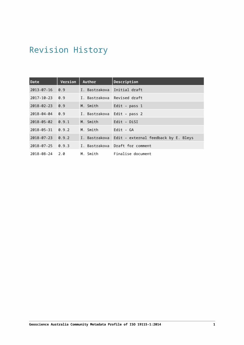
Revision History
Date Version Author Description2013-07-16 0.9 I. Bastrakova Initial draft
2017-10-23 0.9 I. Bastrakova Revised draft
2018-02-23 0.9 M. Smith Edit – pass 1
2018-04-04 0.9 I. Bastrakova Edit – pass 2
2018-05-02 0.9.1 M. Smith Edit – DiSI
2018-05-31 0.9.2 M. Smith Edit - GA
2018-07-23 0.9.2 I. Bastrakova Edit – external feedback by E. Bleys
2018-07-25 0.9.3 I. Bastrakova Draft for comment
2018-08-24 2.0 M. Smith Finalise document
Geoscience Australia Community Metadata Profile of ISO 19115-1:2014 1
1 Overview
The purpose of this document is to define a Geoscience Australia (GA) Metadata Profile Extension to the ISO 19115-1:2014, referred to as the GA Metadata Profile version 2.0, and to identify the metadata required to accurately describe GA resources. The GA Metadata Profile is designed to support the documentation and discovery of GA datasets and other resources, recognising the data management and sharing requirements within the agency. The GA Metadata Profile version 1.0 was developed in 2013 in accordance with the rules established by Information Management Section, Geoscience Australia. This version of the GA Profile was developed to reflect extensions Geoscience Australia has made to the new version of the international metadata standard: ISO 19115-1:2014. The GA Metadata Profile will facilitate interoperability between metadata of the GA datasets and make it easier to find, use and share GA data and other resources.
1.1 Contact DetailsThe GA Profile is maintained by the Digital Science and Information Division, Geoscience Australia.
1.2 ReferencesThe following normative documents contain important requisite references for the application of this profile.
AS/NZS ISO 19115.1:2015, Geographic information – Metadata {equivalent to ISO 19115-1:2014}
ISO 19115-1:2014, Geographic information – Metadata – Part 1: Fundamentals
ISO 19115-3:2016, Geographic information – Part 3: XML schema implementation for fundamental concepts
ISO 19119:2016, Geographic information –Services
ISO 19106:2004, Geographic Information – Profiles {reconfirmed 2018}
ISO/IEC 19501:2005, Information technology – Open Distributed Processing – Unified Modelling Language (UML) Version 1.4.2 {currently under review}
Geoscience Australia Community Metadata Profile of ISO 19115-1:2014 2

2 GA Community Metadata Profile Extension to the ISO 19115-1:2014
2.1 IntroductionThe International Standard ISO 19115-1:2014 (Geographic information – Metadata) defines more than 300 metadata elements, with most of these being listed as Optional. The ISO standard states that individual communities may develop a Profile of the International Standard. The conditionality of a select set of metadata elements may be raised but never reduced for a set of users – optional -> conditional or mandatory but never the other way. A community may also want to establish additional metadata elements that are not in the International Standard. A profile should establish domains for all metadata elements. The rules for creating profiles are described in the International Standard Geographic Information – Profiles (ISO 19106:2004).
ISO 19106 stipulates particular terminology that must be used when any variation is made to a Standard, namely referring to changes as an Extension.
It should be noted that there are no ‘new’ elements in the GA Metadata Profile. The obligation levels of 18 elements from ISO 19115-1:2014 have been changed, and according to ISO 19106, they form an ‘extension’ to ISO 19115-1:2014. Codelists for two elements have been extended with additional values, and two elements that are free text in the base ISO 19115-1:2014 standard have been constrained by new codelists.
This document highlights all mandatory and conditional packages/entities from ISO 19115-1:2014 necessary to fulfil GA business requirements.
All other entities and packages remain available and can be used as required to describe GA products and datasets.
The other entities and packages have to be used as defined by ISO 19115-1:2014.
2.2 Metadata for geographic dataISO 19115-1:2014 identifies the metadata required to describe digital geographic data. Metadata is applicable to independent datasets, aggregations of datasets, individual geographic features, and the various classes of objects that compose a feature. Metadata shall be provided for geographic datasets and may, optionally, be provided for aggregations of datasets, features and attributes of features.
Geoscience Australia Community Metadata Profile of ISO 19115-1:2014 3

2.3 Metadata packagesThe ISO 19115-1:2014 presents metadata for geographic information in UML Packages. Each package contains one or more entities (UML Classes), which can be specialised (subclassed) or generalised (superclassed). Entities contain elements (UML class attributes) which identify the discrete properties of metadata. Entities may be related to one or more other entities. Entities can be aggregated and repeated as necessary to meet: (1) the mandatory requirements stated in this Standard; (2) additional user requirements.
This document provides UML diagrams only for the packages containing variations to the ISO 19115-1:2014. The elements of the GA Metadata Profile are specified in the UML model diagrams and data dictionary for each package, which can be found in Annex A and Annex B respectively. If a discrepancy between the two annexes exists, Annex A shall be considered authoritative. The relationship between metadata packages and metadata entities is shown in the Table 1.
Table 1: Relationship between packages of metadata and metadata entities
Package Entity UML Diagram Data Dictionary (Dd)
Metadata entity set information MD_Metadata A.2.1 B.2.1
Identification information MD_Identification A.2.2 B.2.2
Constraint information MD_Constraints A.2.3 Error: Reference source not found
Lineage LI_Lineage A.2.4 B.2.4
Maintenance information MD_Meaintenance A.2.5 B.2.5
Distribution information MD_Distribution A.2.6 B.2.6
2.4 Package descriptionsThis subsection provides an overview of the packages containing properties whose constraints have been changed by this profile. Complete details of the changes can be found in section 2.7, Annex A and Annex B of this profile.
2.4.1 Metadata entity set information (MD_Metadata)
Metadata entity set information consists of the entity (UML class) MD_Metadata, which is mandatory. The MD_Metadata entity contains both mandatory and optional metadata elements (UML attributes). Table 2 defines properties of the MD_Metadata entity that have been changed by this profile.
Geoscience Australia Community Metadata Profile of ISO 19115-1:2014 4

Table 2: Metadata entity set information (Table B.1)
Dd # Name Definition Change from the ISO 19115-1
16 metadataIdentifier unique Identifier for this metadata record Optional Mandatory
18 parentMetadata identification of the parent metadata record Conditional Conditional (changed condition)
27 referenceSystemInfo description of the spatial and temporal reference systems used in the resource
Optional Conditional
34 metadataConstraints restrictions on the access and use of metadata
Optional Mandatory
37 resourceLineage information about the provenance, source(s), and/or the production process(es) applied to the resource
Optional Mandatory
2.4.2 Identification information (MD_Identification)
Identification information supports the provision of information to uniquely identify the resource. It includes information about the citation for the resource, an abstract, the purpose, credits, status of the resource and points of contact. The MD_Identification entity is mandatory. The MD_Identification entity MUST be specialised (subclassed) as MD_ServiceIdentification when used to describe services or MD_DataIdentification when used to identify other resources2.
Table 3 defines properties of the MD_Identification entity that have been changed by this profile.
Table 3: Identification Entity Set Information
Dd #
Name Definition Change from the ISO 19115-1
48 pointOfContact identification of, and means of communication with, person(s) and organization(s) associated with the resource(s)
Optional Mandatory
52 topicCategory main theme(s) of the resource Conditional Mandatory
56 Role name: resourceMaintenance
information about the frequency of resource updates, and the scope of those updates
Optional Mandatory
61 Role name: resourceConstraints
information about constraints which apply to the resource(s)
Optional Mandatory
59 rolename: descriptiveKeywords
category keywords, their type, and reference source
Optional Mandatory
Table 4 defines properties of the CI_Citation entity that have been changed by this profile.
2 For further information about “services” metadata refer to ISO 19119
Geoscience Australia Community Metadata Profile of ISO 19115-1:2014 5

Table 4: Citation Entity Set Information
Dd #
Name Definition Change from the ISO 19115-1
367 identifier value uniquely identifying an object within a namespace
Optional Mandatory
2.4.3 Constraint information (MD_Constraints)
Constraint information supports the provision of information concerning the legal and security constraints placed on data and metadata. The MD_Constraints entity is mandatory for both resource and metadata. Metadata constraints must be specified as MD_SecurityConstrants. Resource constraints must be specified as MD_SecurityConstraints and MD_LegalConstraints.
Table 5 defines properties of the MD_Constraints entity that have been changed by this profile.
Table 5: Constraint Entity Set Information
Dd# Name Definition Change from the ISO 19115-1102 reference citation for the limitation or constraint.
example: Copyright statement, licence agreement, etc.
Optional Mandatory
Table 6 defines properties of the MD_LegalConstraints entity that have been changed by this profile.
Table 6: Legal Constraint Entity Set Information
Dd# Name Definition Change from the ISO 19115
106 accessConstraints access constraints applied to assure the protection of privacy or intellectual property, and any special restrictions or limitations on obtaining the resource or metadata
Conditional Conditional (changed condition)
107 useConstraints constraints applied to assure the protection of privacy or intellectual property, and any special restrictions or limitations or warnings on using the resource or metadata
Conditional Conditional (changed condition)
2.4.4 Lineage information (LI_Lineage)
This package supports the provision of metadata concerning the production processes used in producing a resource. It is mandatory and contains a statement about the lineage information. The “statement” element is mandatory.
Table 7 defines properties of the LI_Lineage entity that have been changed by this profile.
Geoscience Australia Community Metadata Profile of ISO 19115-1:2014 6

Table 7: Lineage Entity Set Information
Dd# Name Definition Change from the ISO 19115119 statement general explanation of the data
producer’s knowledge about the lineage of a dataset
Optional Mandatory
2.4.5 Distribution information (MD_Distribution)
This package supports the provision of information about the distribution of and options for obtaining a resource. The “distributionFormat” class of MD_Distribution is mandatory if the entity is used.
Table 8 defines properties of the MD_Distribution entity that have been changed by this profile.
Table 8: Distribution Entity Set Information
Dd# Name Definition Change from the ISO 19115
239 Role name: distributionFormat
provides a description of the format of the data to be distributed
Optional Conditional
Geoscience Australia Community Metadata Profile of ISO 19115-1:2014 7

2.5 Core metadata for geographic resourcesISO 19115-1 defines an extensive set of metadata elements. The GA Metadata Profile prescribes only a subset of these elements, representing the minimum set of metadata elements recommended to identify and describe a GA resource, typically for cataloguing purposes. The resulting catalogue of records enable us to answer the following types of questions: “Does a dataset on a specific topic exist?” (‘what’), “For a specific place?” (‘where’), “For a specific date or period?” (‘when’) and “A point of contact to learn more about or order the dataset?” (‘who’). Using the recommended optional elements in addition to the mandatory elements will increase interoperability, allowing users to understand without ambiguity the data and the related metadata provided by either the producer or the distributor. The GA Profile includes the core metadata elements defined in ISO 19115-1. Table 9 lists elements that the GA Metadata Profile recognises as the best practice in describing geographic datasets.
Table 9: Core metadata for GA Community geographic datasets
Name ISO19115-1 Ref Num3
Obligation
Path
Metadata Identifier 16 M MD_Metadata.metadataIdentifier>MD_Identifier.code
Default Locale (Metadata)
17 C MD_Metadata.defaultLocale>PT_Locale
Parent Metadata 18 C MD_Metadata.parentMetadata>CI_Citation.identifier;MD_Metadata.parentMetadata>CI_Citation.title
Contact 19 M MD_Metadata.contact>CI_Responsibility
Date Info (Metadata) 20 M MD_Metadata.dateInfo>CI_Date
Metadata Standard 21 O MD_Metadata.metadataStandard>CI_Citation
Metadata Profile 22 O MD_Metadata.metadataProfile>CI_Citation
Metadata Constraints 34 M MD_Metadata.metadataConstraints>MD_Constraints
Resource Scope 40 M MD_Metadata.metadataScope>MD_MetadataScope.resourceScope
Title 362 M MD_Metadata.identificationInfo>MD_Identification.citation> CI_Citation.title
Date (Resource) 364 M MD_Metadata.identificationInfo>MD_Identification.citation> CI_Citation.date>CI_Date
Identifier (Resource) 367 M MD_Metadata.identificationInfo>MD_Identification.citation> CI_Citation.identifier
Abstract 44 M MD_Metadata.identificationInfo>MD_Identification.abstract
Resource Point of Contact
48 M MD_Metadata.identificationInfo>MD_Identification.pointOfContact> CI_Responsibility
Topic Category 52 M MD_Metadata.identificationInfo>MD_Identification.topicCategory>
3 This refers to the number used in the leading column of the definition tables within Table B.2 of the AS/NZS ISO19115:2015 standard
Geoscience Australia Community Metadata Profile of ISO 19115-1:2014 8

Name ISO19115-1 Ref Num
Obligation
Path
MD_TopicCategoryCode
Resource Maintenance
56, (140) M MD_Metadata.identificationInfo>MD_Identification.resourceMaintenance>MD_MaintenanceInformation.maintenanceAndUpdate Frequency
Resource Constraints
61 M MD_Metadata.identificationInfo>MD_Identification.resourceConstraints> MD_Constraints
Default Locale (Resource)
64 C MD_Metadata.identificationInfo>MD_DataIdentification.defaultLocale> PT_Locale
Descriptive Keywords
59 M MD_Metadata.identificationInfo>MD_Identification.descriptiveKeywords> MD_Keywords.keyword
Resource Lineage 119 M MD_Metadata.resourceLineage>LI_Lineage.statement
Reference System 180 C MD_Metadata.referenceSystemInfo> MD_ReferenceSystem.referenceSystemIdentifier>MD_Identifier
Geographic Extent 340 C MD_Metadata.identificationInfo>MD_Identification.extent> EX_Extent.geographicElement>EX_GeographicBoundingBox
Temporal Extent 351 C MD_Metadata.identificationInfo>MD_Identification.extent> EX_Extent.temporalElement>EX_TemporalExtent
Vertical Extent 356 C MD_Metadata.identificationInfo>MD_Identification.extent> EX_Extent.verticalExtent>EX_VerticalExtent
Resource Format 58 C MD_Metadata.identificationInfo>MD_Identification.resourceFormat> MD_Format
Distribution Format 239 Ca MD_Metadata.distributionInfo>MD_Distribution.distributionFormat> MD_Format
a distributionFormat: documented if the resource is intended for distribution and the MD_Distribution element is present
2.5.1 Unified Modelling Language (UML) diagrams
Annex A provides the metadata schemas in the form of Unified Modelling Language (UML) diagrams. These diagrams, in conjunction with the data dictionary presented in Annex B, serve to fully define the total abstract model for metadata.
2.6 Data dictionaryAnnex B contains the element and entity definitions for the metadata schemas. This dictionary, in conjunction with the diagrams presented in Annex A, serve to fully define the total abstract model for metadata.
2.7 Metadata extension informationThe tables in this subsection describe the GA Community Profile extensions to ISO 19115-1. Each table identifies the ISO 19115-1 element name and number for the element being extended, along with other associated properties.
Geoscience Australia Community Metadata Profile of ISO 19115-1:2014 9

Without exception, the extensions defined in this profile are based on changes to the obligation level of an existing ISO 19115-1 element. No new elements have been created by this profile. In all cases these changes have been made to further constrain rather than relax an obligation. In other words, a change has been made from “optional” to “mandatory” or “conditional”.
Content in the “Additional Information” section serves only as an informative addition and does not constitute part of the extended element information model.
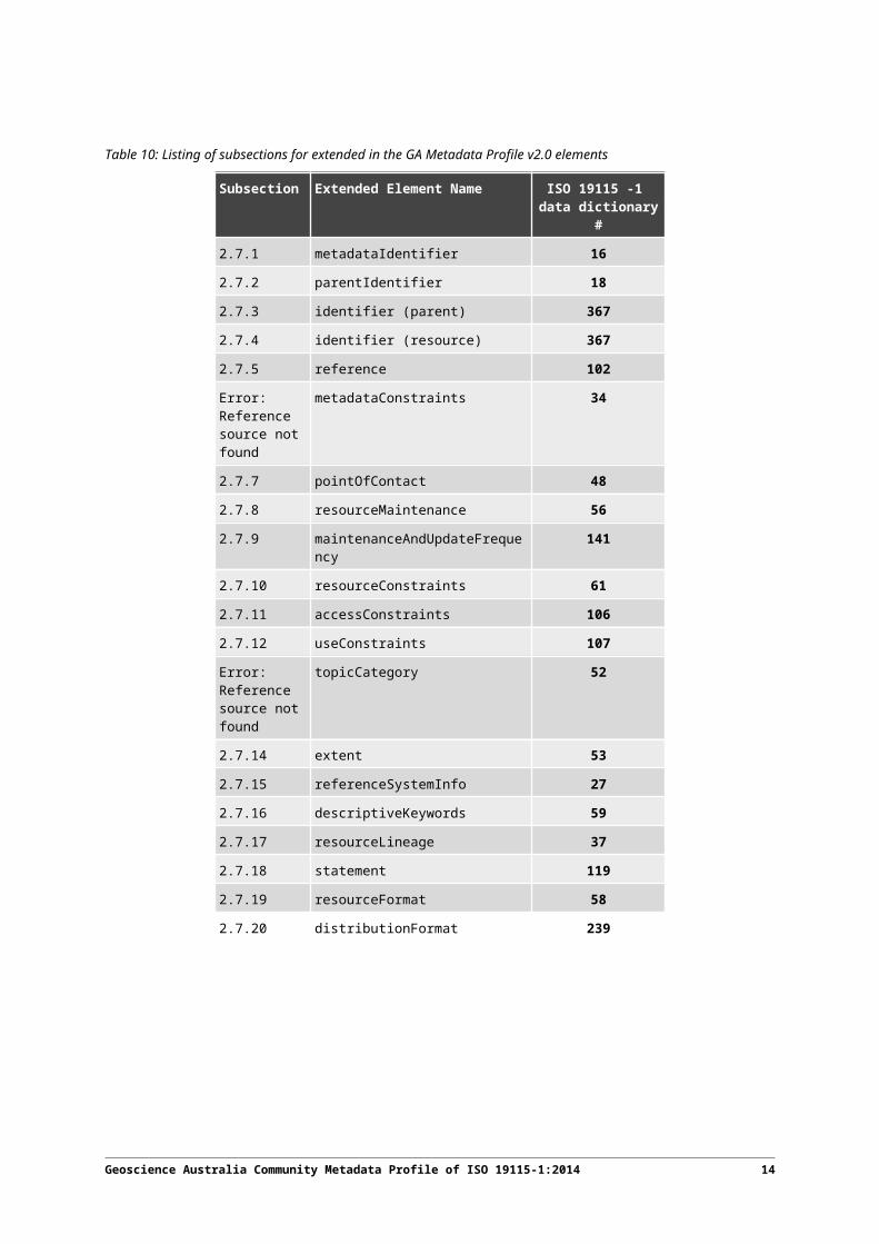
By way of reference table 9 identifies the subsections for each extended element.
Table 10: Listing of subsections for extended in the GA Metadata Profile v2.0 elements
Subsection Extended Element Name ISO 19115 -1 data dictionary
#2.7.1 metadataIdentifier 16
2.7.2 parentIdentifier 18
2.7.3 identifier (parent) 367
2.7.4 identifier (resource) 367
2.7.5 reference 102
Error: Reference source not found
metadataConstraints 34
2.7.7 pointOfContact 48
2.7.8 resourceMaintenance 56
2.7.9 maintenanceAndUpdateFrequency 141
2.7.10 resourceConstraints 61
2.7.11 accessConstraints 106
2.7.12 useConstraints 107
Error: Reference source not found
topicCategory 52
2.7.14 extent 53
2.7.15 referenceSystemInfo 27
2.7.16 descriptiveKeywords 59
2.7.17 resourceLineage 37
2.7.18 statement 119
2.7.19 resourceFormat 58
2.7.20 distributionFormat 239
Geoscience Australia Community Metadata Profile of ISO 19115-1:2014 10

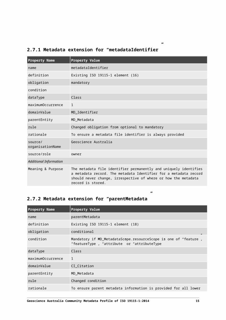
2.7.1 Metadata extension for “metadataIdentifier”
Property Name Property Valuename metadataIdentifier
definition Existing ISO 19115-1 element (16)
obligation mandatory
condition
dataType Class
maximumOccurrence 1
domainValue MD_Identifier
parentEntity MD_Metadata
rule Changed obligation from optional to mandatory
rationale To ensure a metadata file identifier is always provided
source/organisationName Geoscience Australia
source/role owner
Additional Information
Meaning & Purpose The metadata file identifier permanently and uniquely identifies a metadata record. The metadata Identifier for a metadata record should never change, irrespective of where or how the metadata record is stored.
2.7.2 Metadata extension for “parentMetadata”
Property Name Property Value
name parentMetadata
definition Existing ISO 19115-1 element (18)
obligation conditional
condition Mandatory if MD_MetadataScope.resourceScope is one of “feature”, “featureType”, “attribute” or “attributeType”
dataType Class
maximumOccurrence 1
domainValue CI_Citation
parentEntity MD_Metadata
rule Changed condition
rationale To ensure parent metadata information is provided for all lower level records.
source/organisationName Geoscience Australia
source/role owner
Additional Information
Meaning & Purpose Metadata records for resources with a scope that naturally has a parent resource Records describing “feature”, “featureType”, “attribute” and “attributeType”, must include
Geoscience Australia Community Metadata Profile of ISO 19115-1:2014 11

Property Name Property Valueinformation about the parent resource.
2.7.3 Metadata extension for “identifier” (parent)
Property Name Property Value
name identifier
definition Existing ISO 19115-1 element (367)
obligation conditional
condition Mandatory when CI_Citation (the parentEntity) is a property of the parentMetadata class
dataType Class
maximumOccurrence N
domainValue MD_Identifier
parentEntity parentMetadata.CI_Citation
rule Changed obligation from optional to conditional
rationale To ensure parent identifiers are provided for all lower level records
source/organisationName Geoscience Australia
source/role owner
Additional Information
Meaning & Purpose Identification (metadataIdentifier) of the parent metadata record
2.7.4 Metadata extension for “identifier” (resource)
Property Name Property Valuename identifier
definition Existing ISO 19115-1 element (367)
obligation mandatory
condition Mandatory for released resources
dataType Class
maximumOccurrence N
domainValue MD_Identifier
parentEntity .CI_Citation
rule Changed condition specifically under MD_Identification
rationale To ensure a persistent identifier (e.g. PID) is always provided for a released resource
source/organisationName Geoscience Australia
source/role owner
Additional Information
Geoscience Australia Community Metadata Profile of ISO 19115-1:2014 12

Property Name Property ValueMeaning & Purpose Value globally, persistently and uniquely identifying a resource. E.g. Digital Object
Identifier (DOI) is a short string that identifies a resource on the web or network: documents, images, downloadable files, services, electronic mailboxes, and other resources. DOI can make resources available under a variety of naming schemes and access methods such as HTTP, FTP, and Internet mail addressable in the same simple way.
2.7.5 Metadata extension for “reference”
Property Name Property Valuename reference
definition Existing ISO 19115-1 element (102)
obligation mandatory
condition
dataType Class
maximumOccurrence N
domainValue MD_Constraints
parentEntity MD_Metadata
rule Changed obligation from optional to mandatory to ensure link to the constraint reference
rationale To ensure that the metadataConstraint and resourceConstraint have reference properties for MD_SecurityConstraint and MD_LegalConstraint. [Reference property is a URL to the document describing the constraint, e.g. CC-By]
source/organisationName Geoscience Australia
source/role owner
Additional Information
Meaning & Purpose Reference to the document detailing access and usage constraint conditions (e.g. copyright description, licence agreement, security framework)
2.7.6 Metadata extension for “metadataConstraints”
Property Name Property Valuename metadataConstraints
definition Existing ISO 19115-1 element (34)
obligation mandatory
condition
dataType Association
maximumOccurrence N
domainValue MD_SecurityConstraints
parentEntity MD_Metadata
rule Changed obligation from optional to mandatory and to enforce at least one instance of the MD_SecurityConstraints child
Geoscience Australia Community Metadata Profile of ISO 19115-1:2014 13

Property Name Property Valuerationale This supports mandatory provision of security constraints for GA metadata records.
source/organisationName Geoscience Australia
source/role owner
Additional Information
Meaning & Purpose This element has been made mandatory in order to support mandatory provision of security constraints for GA metadata records.
2.7.7 Metadata extension for “pointOfContact”
Property Name Property Valuename pointOfContact
definition Existing ISO 19115-1 element (48)
obligation mandatory
condition
dataType Class
maximumOccurrence N
domainValue CI_Responsibility
parentEntity MD_Identification
rule Changed obligation from optional to mandatory
rationale To ensure point of contact information is always provided
source/organisationName Geoscience Australia
source/role owner
Additional Information
Meaning & Purpose The identification point of contact contains details about the organisation and/or position associated with the resource(s); it facilitates further enquiries about the resource(s)
2.7.8 Metadata extension for “resourceMaintenance”
Property Name Property Valuename resourceMaintenance
definition Existing ISO 19115-1 element (56)
obligation mandatory
condition
dataType Association
maximumOccurrence N
domainValue MD_MaintenanceInformation
parentEntity MD_Identification
rule Changed obligation from optional to mandatory
Geoscience Australia Community Metadata Profile of ISO 19115-1:2014 14
Property Name Property Valuerationale To ensure resource maintenance information is always provided. This supports
mandatory provision of update frequency information for the resource(s).
source/organisationName Geoscience Australia
source/role owner
Additional Information
Meaning & Purpose Information about the maintenance of the resource(s)
2.7.9 Metadata extension for “maintenanceAndUpdateFrequency”
Property Name Property Valuename maintenanceAndUpdateFrequency
definition Existing ISO 19115-1 element (141)
obligation mandatory
condition
dataType Class
maximumOccurrence 1
domainValue MD_MaintenanceFrequencyCode <<CodeList>>
parentEntity MD_MaintenanceInformation
rule Changed condition to enforce at least one instance of an MD_MaintenanceFrequencyCode descendant
rationale To ensure resource maintenance information always includes the maintenance frequency.
source/organisationName Geoscience Australia
source/role owner
Additional Information
Meaning & Purpose Information about the resource maintenance should include maintenance frequency.
2.7.10 Metadata extension for “resourceConstraints”
Property Name Property Value
name resourceConstraints
definition Existing ISO 19115 element (61)
obligation mandatory
condition
dataType Association
maximumOccurrence N
domainValue MD_SecurityConstraints
parentEntity MD_Identification
Geoscience Australia Community Metadata Profile of ISO 19115-1:2014 15
Property Name Property Valuerule Changed obligation from optional to mandatory and to enforce at least one instance of
each MD_LegalConstraints and MD_SecurityConstraints
rationale To ensure that security constraints for a resource are provided
source/organisationName Geoscience Australia
source/role owner
Additional Information
Meaning & Purpose Provision of reference is mandatory for the class MD_Constraints and its subclasses, MD_LegalConstraints and MD_SecurityConstraints.
2.7.11 Metadata extension for “accessConstraints”
Property Name Property Value
name accessConstraints
definition Existing ISO 19115-1 element (106)
obligation mandatory
condition
dataType Class
maximumOccurrence N
domainValue MD_RestrictionCode
parentEntity MD_LegalConstraints
rule Changed obligation from optional to mandatory
rationale To ensure that access constraints are always provided at the resource level
source/organisationName Geoscience Australia
source/role owner
Additional Information
Meaning & Purpose Assures the protection of privacy and intellectual property of a resource managed by GA.
2.7.12 Metadata extension for “useConstraints”
Property Name Property Valuename useConstraints
definition Existing ISO 19115-1 element (107)
obligation mandatory
condition
dataType Class
maximumOccurrence N
domainValue MD_RestrictionCode
parentEntity MD_LegalConstraints
Geoscience Australia Community Metadata Profile of ISO 19115-1:2014 16

Property Name Property Valuerule Changed obligation from optional to mandatory
rationale To ensure that use constraints are always provided at the resource level
source/organisationName Geoscience Australia
source/role owner
Additional Information
Meaning & Purpose Assures the protection of privacy and intellectual property of a resource managed by GA.
Geoscience Australia Community Metadata Profile of ISO 19115-1:2014 17

2.7.13 Metadata extension for “topicCategory”
Property Name Property Valuename topicCategory
definition Existing ISO 19115-1 element (52)
obligation mandatory
condition
dataType Class
maximumOccurrence N
domainValue MD_TopicCategoryCode
parentEntity MD_Identification
rule Changed obligation from optional to mandatory
rationale To ensure that a topic category is always provided
source/organisationName Geoscience Australia
source/role owner
Additional Information
Meaning & Purpose Topic categories represent the main theme(s) of the resource. Enforcing their provision allows a search to be restricted to a particular theme or topic. For example, "find all data resources to do with the environment". As topic category is an important element for searching, careful consideration and consistent use of the enumerated terms should be applied.
2.7.14 Metadata extension for “extent”
Property Name Property Value
name extent
definition Existing ISO 19115-1 element (53)
obligation conditional
condition Mandatory if resourceScope is equal to ”dataset”
dataType Class
maximumOccurrence N
domainValue EX_Extent
parentEntity MD_Identification
rule Changed condition
rationale To ensure that an extent is provided for dataset records
source/organisationName Geoscience Australia
source/role owner
Additional Information
Meaning & Purpose Spatial resources must have extent information that comprises at least one of
Geoscience Australia Community Metadata Profile of ISO 19115-1:2014 18

Property Name Property Value“geographicElement“ or “temporalElement“ or “verticalElement“. For datasets that contain dimensions of height or depth it is advised to use vertical extent (e.g. elevation data).
2.7.15 Metadata extension for “referenceSystemInfo”
Property Name Property Valuename referenceSystemInfo
definition Existing ISO 19115-1 element (27)
obligation conditional
condition mandatory if resourceScope is “dataset”
dataType Association
maximumOccurrence N
domainValue MD_ReferenceSystem
parentEntity MD_Metadata
rule Changed obligation from optional to conditional
rationale To ensure a reference system is always provided for “dataset” records
source/organisationName Geoscience Australia
source/role owner
Additional Information
Meaning & Purpose The reference system information is used to align the dataset in time (temporal) and space (horizontal and vertical)
2.7.16 Metadata extension for “descriptiveKeywords”
Property Name Property Valuename descriptiveKeywords
definition Existing ISO 19115-1 element (59)
obligation mandatory
condition
dataType Association
maximumOccurrence N
domainValue MD_Keywords
parentEntity MD_Identification
rule Obligation is changed to mandatory to ensure that at least one descriptive keyword is present.ABS Classification for a resource must be present.
rationale To ensure that resource information is tagged
source/organisationName Geoscience Australia
source/role owner
Geoscience Australia Community Metadata Profile of ISO 19115-1:2014 19

Property Name Property ValueAdditional Information
Meaning & Purpose Provides tags to briefly describe a resource. ABS Classification for a resource must be present
2.7.17 Metadata extension for “resourceLineage”
Property Name Property Valuename resourceLineage
definition Existing ISO 19115-1 element (37)
obligation mandatory
condition
dataType Association
maximumOccurrence N
domainValue LI_Lineage
parentEntity MD_Metadata
rule Changed obligation from conditional to mandatory
rationale To ensure that lineage information is always provided
source/organisationName Geoscience Australia
source/role owner
Additional Information
Meaning & Purpose The lineage element provides the structure that can contain a lineage statement and source description
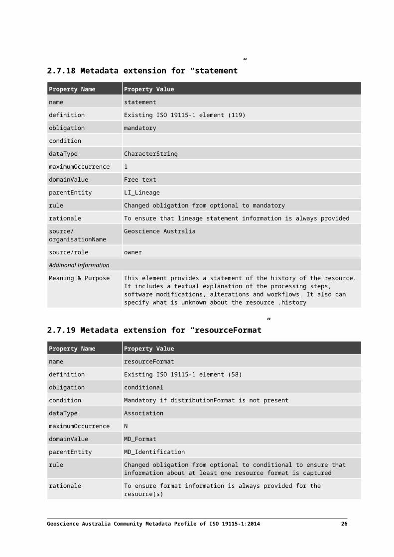
2.7.18 Metadata extension for “statement”
Property Name Property Valuename statement
definition Existing ISO 19115-1 element (119)
obligation mandatory
condition
dataType CharacterString
maximumOccurrence 1
domainValue Free text
parentEntity LI_Lineage
rule Changed obligation from optional to mandatory
rationale To ensure that lineage statement information is always provided
source/organisationName Geoscience Australia
source/role owner
Geoscience Australia Community Metadata Profile of ISO 19115-1:2014 20

Property Name Property ValueAdditional Information
Meaning & Purpose This element provides a statement of the history of the resource. It includes a textual explanation of the processing steps, software modifications, alterations and workflows. It also can specify what is unknown about the resource .history
2.7.19 Metadata extension for “resourceFormat”
Property Name Property Value
name resourceFormat
definition Existing ISO 19115-1 element (58)
obligation conditional
condition Mandatory if distributionFormat is not present
dataType Association
maximumOccurrence N
domainValue MD_Format
parentEntity MD_Identification
rule Changed obligation from optional to conditional to ensure that information about at least one resource format is captured
rationale To ensure format information is always provided for the resource(s)
source/organisationName Geoscience Australia
source/role owner
Additional Information
Meaning & Purpose Description of the resource format in its primary/authoritative storage location
2.7.20 Metadata extension for “distributionFormat”
Property Name Property Value
name distributionFormat
definition Existing ISO 19115-1 element (239)
obligation conditional
condition Mandatory if MD_Distribution is present.
dataType Class
maximumOccurrence N
domainValue MD_Format
parentEntity MD_Distribution
rule Obligation changed to conditional to ensure that distribution format is recorded for a resource where it is intended for distribution
rationale To ensure that distribution format information is always provided for appropriate resources
Geoscience Australia Community Metadata Profile of ISO 19115-1:2014 21

Property Name Property Valuesource/organisationName Geoscience Australia
source/role owner
Additional Information
Meaning & Purpose Provides a description of the resource for distribution.
Geoscience Australia Community Metadata Profile of ISO 19115-1:2014 22

Annex A : GA Profile Metadata Schemas (UML)
A.1 Metadata UML modelsMetadata for describing geographic data is defined using an abstract object model in the Unified Modelling Language (UML). The following diagrams provide “views,” which are portions of the total abstract model for metadata. Each diagram defines a metadata section (UML package) of related entities, elements, data types, and code lists. Related entities, which are defined in another diagram, are shown with elements suppressed and the defining package specified under the entity name in parenthesis. Throughout the following models, entities may have mandatory and/or optional elements and associations. In some cases, optional entities may have mandatory elements; those elements become mandatory only if the optional element is used.
The data dictionary for the UML class diagrams is listed in Annex B.
Geoscience Australia Community Metadata Profile of ISO 19115-1:2014 23

A.2 Metadata package UML diagrams
A.2.1 Metadata entity set information
The MD_Metadata class shows containment relationships with the other metadata classes which define metadata for geospatial data. Refer to B.2.1 for the data dictionary for this diagram.
class Metadata schema classes
From ISO 19157
«abstract»Identification information::MD_Identification
responsibilitiesCaution should be taken with regard to the use ofmultiple instances of MD_Identification. See Annex D.
Constraint information::MD_Constraints
MD_Metadata
Maintenance information::MD_MaintenanceInformation
Distribution information::MD_Distribution
Reference system information::MD_ReferenceSystem
«Abstract»Content information::
MD_ContentInformation
Metadata extension information::MD_MetadataExtensionInformation
Portrayal catalogue information::MD_PortrayalCatalogueReference
Application schema information::MD_ApplicationSchemaInformation
«Abstract»Spatial representation
information::MD_SpatialRepresentationLineage information::
LI_Lineage
DQ_Data quality: DQ_DataQuality
referenceSystemInfo must be recorded if resourceScope is equal to 'dataset'
+spatialRepresentationInfo0..*
+metadataMaintenance 0..1
+metadataExtensionInfo
0..*
+resourceLineage 1..*
+distributionInfo0..*
+metadataConstraints1..*
+applicationSchemaInfo 0..*
+portrayalCatalogueInfo 0..*
+identificationInfo 1..*
+referenceSystemInfo 0..*
+contentInfo
0..*
0..*dataQualityInfo
Figure 1: Metadata schema classes
Geoscience Australia Community Metadata Profile of ISO 19115-1:2014 24

The UML for identification information defines the metadata classes required to identify metadata itself. Refer to B.2.1 for the data dictionary for this diagram.
Figure 2: Metadata on Metadata
Geoscience Australia Community Metadata Profile of ISO 19115-1:2014 25
class Metadata on Metadata
MD_Metadata
+ metadataIdentifier: MD_Identifier+ defaultLocale: PT_Locale [0..1]+ parentMetadata: CI_Citation [0..1]+ contact: CI_Responsibil ity [1..*]+ dateInfo: CI_Date [1..*]+ metadataStandard: CI_Citation [0..*]+ alternativeMetadataReference: CI_Citation [0..*]+ metadataProfile: CI_Citation [0..*]+ otherLocale: PT_Locale [0..*]+ metadataLinkage: CI_OnlineResource [0..*]
constraints{defaultLocale documented if not defined by the encoding}{defaultLocale.PT_Locale.characterEncoding default value is UTF-8}{count (MD_Metadata.parentMetadata) > 0 when there is an higher level object}{count (MD_Metadata.parentMetadata) > 0 when resourceScope equal to “feature” or “featureType” or “attribute” or “attributeType“}{count(MD_Metadata.parentMetadata.CI_Citation.identifier.MD_Identifier.code) > 0 when count(MD_Metadata.parentMetadata) >0}{count (MD_Metadata.metadataScope) > 0 if MD_Metadata.metadataScope.MD_MetadataScope.resourceScope not equal to "dataset"}{count (MD_Metadata.dateInfo.CI_Date.dateType.CI_DateTypeCode="creation") > 0}
MD_MetadataScope
+ resourceScope: MD_ScopeCode = "dataset"+ name: CharacterString [0..1]
constraints{name is mandatory if resourceScope not equal to "dataset"}
+metadataScope 0..*

A.2.2 Identification information
The UML for identification information defines the metadata classes required to identify a resource. It also defines separate specialisation sub-classes for identifying data and services. Refer to B.2.2 for the data dictionary for this diagram.
class Identification information
«Union»MD_Resolution
+ equivalentScale: MD_RepresentativeFraction+ distance: Distance+ vertical: Distance+ angularDistance: Angle+ levelOfDetail: CharacterString
«DataType»MD_RepresentativeFraction
+ denominator: Integer
Constraint information::MD_Constraints
Distribution information::MD_Format
MD_Usage
+ specificUsage: CharacterString+ usageDateTime: TM_Primitive [0..*]+ userDeterminedLimitations: CharacterString [0..1]+ userContactInfo: CI_Responsibility [0..*]+ response: CharacterString [0..*]+ additionalDocumentation: CI_Citation [0..*]+ identifiedIssues: CI_Citation [0..1]
Common classes::MD_BrowseGraphic
+ fileName: CharacterString+ fileDescription: CharacterString [0..1]+ fileType: CharacterString [0..1]+ imageConstraints: MD_Constraints [0..*]+ linkage: CI_OnlineResource [0..*]
MD_AssociatedResource
+ name: CI_Citation [0..1]+ associationType: DS_AssociationTypeCode+ initiativeType: DS_InitiativeTypeCode [0..1]+ metadataReference: CI_Citation [0..1]
constraints{count of (name + metadataReference) > 0}
MD_Keywords
+ keyword: CharacterString [1..*]+ type: MD_KeywordTypeCode [0..1]+ thesaurusName: CI_Citation [0..1]
constraints{When the resource described is a service, one instance ofMD_Keyword shall refer to the service taxonomy defined in ISO19119}
Maintenance information::MD_MaintenanceInformation
Metadata Information::MD_Metadata
«abstract»MD_Identification
+ citation: CI_Citation+ abstract: CharacterString+ purpose: CharacterString [0..1]+ credit: CharacterString [0..*]+ status: MD_ProgressCode [0..*]+ pointOfContact: CI_Responsibility [1..*]+ spatialRepresentationType: MD_SpatialRepresentationTypeCode [0..*]+ spatialResolution: MD_Resolution [0..*]+ temporalResolution: TM_Duration [0..*]+ topicCategory: MD_TopicCategoryCode [1..*]+ extent: EX_Extent [0..*]+ additionalDocumentation: CI_Citation [0..*]+ processingLevel: MD_Identifier [0..1]
constraints{(MD_Metadata.metadataScope.MD_MetadataScope.resourceScope) = 'dataset' implies count(extent.geographicElement.EX_GeographicBoundingBox +extent.geographicElement.EX_GeographicDescription) >= 1}{(MD_Metadata.metadataScope.MD_Scope.resourceScope) = ('dataset' or 'series') implies topicCategory ismandatory}
MD_DataIdentification
+ defaultLocale: PT_Locale [0..1]+ otherLocale: PT_Locale [0..*]+ environmentDescription: CharacterString [0..1]+ supplementalInformation: CharacterString [0..1]
constraints{defaultLocale documented if resource includes textual information}{defaultLocale.PT_Locale.characterEncoding default value is UTF-8}
Service metadata information::SV_ServiceIdentification
A
MD_KeywordClass
+ className: CharacterString+ conceptIdentifier: URI [0..1]+ ontology: CI_Citation
+resourceConstraints 1..*
+associatedResource0..*
+operatesOn
0..*
+resourceMaintenance1..*
+descriptiveKeywords1..*
+keywordClass 0..1
+graphicOverview
0..*
+identificationInfo1..*
+resourceFormat
0..*
+resourceSpecificUsage
0..*
Figure 3: Identification information
Geoscience Australia Community Metadata Profile of ISO 19115-1:2014 26
A.2.3 Constraint informationThe UML class diagram for constraint information defines the metadata required for managing rights to information including restrictions on access and use. Refer to Error: Reference source not found for the data dictionary for this diagram.
class Constraint information
«CodeList»MD_RestrictionCode
+ copyright+ patent+ patentPending+ trademark+ licence+ intellectualPropertyRights+ restricted+ otherRestrictions+ unrestricted+ licenceUnrestricted+ licenceEndUser+ licenceDistributor+ private+ statutory+ confidential+ sensitiveButUnclassified+ in-confidence
Metadata Information::MD_Metadata
MD_Constraints
+ useLimitation: CharacterString [0..*]+ constraintApplicationScope: MD_Scope [0..1]+ graphic: MD_BrowseGraphic [0..*]+ reference: CI_Citation [1..*]+ releasability: MD_Releasability [0..1]+ responsibleParty: CI_Responsibility [0..*]
«abstract»Identification information::MD_Identification
«CodeList»MD_ClassificationCode
+ unclassified+ restricted+ confidential+ secret+ topSecret+ sensitiveButUnclassified+ forOfficialUseOnly+ protected+ limitedDistribution
MD_SecurityConstraints
+ classification: MD_ClassificationCode+ userNote: CharacterString [0..1]+ classificationSystem: CharacterString [0..1]+ handlingDescription: CharacterString [0..1]
MD_LegalConstraints
+ accessConstraints: MD_RestrictionCode [0..*]+ useConstraints: MD_RestrictionCode [0..*]+ otherConstraints: CharacterString [0..*]
constraints{If MD_LegalConstraints used then count of (accessConstraints +useConstraints + otherConstraints + useLimitation + releasability ) > 0}{otherConstraints: only documented if accessConstraints oruseConstraints = "otherRestrictions"}
MD_Releasability
+ addressee: CI_Responsibility [0..*]+ statement: CharacterString [0..1]+ disseminationConstraints: MD_RestrictionCode [0..*]
constraints{count (addressee + statement) > 0}
+resourceConstraints 1..* +metadataConstraints1..*
Geoscience Australia Community Metadata Profile of ISO 19115-1:2014 27

Figure 4: Constraint information
Geoscience Australia Community Metadata Profile of ISO 19115-1:2014 28

A.2.4 Lineage informationThis UML class diagram for lineage supports the provision of metadata concerning the sources and production processes used in producing a resource. Refer to B.2.4 for the data dictionary for this diagram.
class Lineage information
LI_Source
+ description: CharacterString+ sourceSpatialResolution: MD_Resolution [0..1]+ sourceReferenceSystem: MD_ReferenceSystem [0..1]+ sourceCitation: CI_Citation [0..1]+ sourceMetadata: CI_Citation [0..*]+ scope: MD_Scope [0..1]
constraints{"description" is mandatory if "sourceCitation" is not documented}{"sourceCitation" is mandatory if "description" is not documented}
LI_ProcessStep
+ description: CharacterString+ rationale: CharacterString [0..1]+ stepDateTime: TM_Primitive [0..1]+ processor: CI_Responsibility [0..*]+ reference: CI_Citation [0..*]+ scope: MD_Scope [0..1]
LI_Lineage
+ statement: CharacterString+ scope: MD_Scope [0..1]+ additionalDocumentation: CI_Citation [0..*]
constraints{"source" role is mandatory whenMD_Metadata.metadataScope.MD_MetadataScope.resourceSopeequal to “dataset” or “non-geographic dataset”}
MD_Metadata
+source 0..*
+resourceLineage1..*
+source
0..*+sourceStep
0..*
+processStep
0..*
Figure 5: Lineage information
Geoscience Australia Community Metadata Profile of ISO 19115-1:2014 29

A.2.5 Maintenance information
This UML class diagram supports the provision of metadata related to the scope and frequency of maintenance for a resource. Refer to B.2.4 for the data dictionary for this diagram.
class Maintenance information
MD_MaintenanceInformation
+ maintenanceAndUpdateFrequency: MD_MaintenanceFrequencyCode+ maintenanceDate: CI_Date [0..*]+ userDefinedMaintenanceFrequency: TM_PeriodDuration [0..1]+ maintenanceScope: MD_Scope [0..*]+ maintenanceNote: CharacterString [0..*]+ contact: CI_Responsibi lity [0..*]
constraints{count (maintenanceAndUpdateFrequency + userDefinedMaintenanceFrequency) >0}
«abstract»Identification information::
MD_Identification
Metadata Information::MD_Metadata
«CodeList»MD_MaintenanceFrequencyCode
+ continual+ daily+ weekly+ fortnightly+ monthly+ quarterly+ biannually+ annually+ asNeeded+ irregular+ notPlanned+ unknown+ periodic+ semimonthly+ biennially
+resourceMaintenance 1..* +metadataMaintenance 0..1
Figure 6: Maintenance information
Geoscience Australia Community Metadata Profile of ISO 19115-1:2014 30

A.2.6 Distribution information
This UML class diagram supports the provision of metadata about resource distribution, including information about the distribution formats, options for obtaining a resource and distributor. Refer to B.2.4 for the data dictionary for this diagram.
class Distribution information
«abstract»Identification information::
MD_Identification
MD_Format
+ formatSpecificationCitation: CI_Citation+ amendmentNumber: CharacterString [0..1]+ fileDecompressionTechnique: CharacterString [0..1]+ medium: MD_Medium [0..*]
MD_Distributor
+ distributorContact: CI_Responsibility
MD_Distribution
+ description: CharacterString [0..1]
MD_DigitalTransferOptions
+ unitsOfDistribution: CharacterString [0..1]+ transferSize: Real [0..1]+ onLine: CI_OnlineResource [0..*]+ offLine: MD_Medium [0..*]+ transferFrequency: TM_PeriodDuration [0..1]+ distributionFormat: MD_Format [0..*]
responsibilitiesunits of distribution applies to both onLine andoffLine distributions
MD_StandardOrderProcess
+ fees: CharacterString [0..1]+ plannedAvailableDateTime: DateTime [0..1]+ orderingInstructions: CharacterString [0..1]+ turnaround: CharacterString [0..1]+ orderOptionsType: RecordType [0..1]+ orderOptions: Record [0..1]
Metadata Information::MD_Metadata
«CodeList»MD_MediumFormatCode
+ cpio+ tar+ highSierra+ iso9660+ iso9660RockRidge+ iso9660AppleHFS+ udf
«DataType»MD_Medium
+ name: CI_Citation [0..1]+ density: Integer [0..1]+ densityUnits: CharacterString [0..1]+ volumes: Integer [0..1]+ mediumFormat: MD_MediumFormatCode
[0..*]+ mediumNote: CharacterString [0..1]+ identifier: MD_Identifier [0..1]
constraints{if density used then count (densityUnits) > 0}
+distributionOrderProcess 0..*
+distributor0..* +formatDistributor 0..*
+distributorFormat 0..*
+distributionFormat
1..*
+distributionInfo 0..*
+resourceFormat 0..*
+distributorTransferOptions
0..*
+transferOptions 0..*
Figure 7: Distribution information
Geoscience Australia Community Metadata Profile of ISO 19115-1:2014 31

A.2.7 Associate Type Code
This UML class diagram supports the provision of additional values for the Associated Type Code List. Refer to B.2.4 for the data dictionary for this diagram.
class Context Diagram: DS_Association...
«CodeList»DS_AssociationTypeCode
+ crossReference+ largerWorkCitation+ partOfSeamlessDatabase+ stereoMate+ isComposedOf+ col lectiveTitle+ series+ dependency+ revisionOf+ generated+ hadDerrivation+ operatedOnBy+ operatesOn+ wasDerrivedFrom+ wasGeneratedBy
Figure 8: Associated Type Code List
Geoscience Australia Community Metadata Profile of ISO 19115-1:2014 32

Annex B : GA Profile Data Dictionary
B.1 Data Dictionary Overview
B.1.1 Introduction
This data dictionary describes the characteristics of the metadata defined by the UML model in Annex A.
The dictionary is categorised into sections by UML model package diagram: Metadata Entity Set, Identification, Constraints, Data Quality, Lineage and Distribution. The clause titles of several of the tables have been expanded to reflect class specification within the respective diagram. Each model diagram from Annex A has a section within the data dictionary. In keeping with Annex A, this section only represents those entities whose content models have been changed by the GA profile. Entities not represented in this section remain unchanged from their definitions provided in ISO 19115-1:2014.
Each UML model class equates to a data dictionary entity. Each UML model class attribute equates to a data dictionary element. The shaded rows define entities. The reference to the ISO 19115-1:2014 entities and elements are shown as a number within brackets, e.g. (334). The symbol † is used to identify the attributes whose constraints have been modified by this profile.
In case of ambiguity between the data dictionary definitions and the UML class diagrams, the UML class diagrams should be treated as the authoritative source.
The term “dataset,” when used as part of a definition, is synonymous with all types of geographic data resources (aggregations of datasets, individual features and the various classes that compose a feature).
B.1.2 Name/role name
A label assigned to a metadata entity or to a metadata element. Metadata entity names start with an upper case letter. Spaces do not appear in a metadata entity name. Instead, multiple words are concatenated, with each new word starting with a capital letter (e.g. ExampleName). Metadata entity names are unique within the entire data dictionary of this standard. Metadata element names are unique within a metadata entity, not the entire data dictionary of this standard. Metadata element names are made unique, within an application, by the combination of the metadata entity and metadata element names (e.g. MD_Metadata.characterSet). Role names are used to identify metadata abstract model associations and are preceded by “Role name:” to distinguish them from other metadata elements. Names and role names may be in a language other than that used in this standard.
Geoscience Australia Community Metadata Profile of ISO 19115-1:2014 33

B.1.3 ISO reference
Those classes that are not CodeList or Enumeration stereotypes are provided with a Short Name for each element. A naming convention similar to that used to create the longer entity and element names was used to create the short names. The number in brackets after the short name is a reference to the ISO 19115 metadata entity or metadata element.
B.1.4 Definition
The metadata entity/element description
B.1.5 Obligation/Condition
B.1.5.1 General
This is a descriptor indicating whether a metadata entity or metadata element shall always be documented in the metadata or sometimes be documented (i.e. contains value(s)). This descriptor may have the following values: mandatory (M), conditional (C), or optional (O).
B.1.5.2 Mandatory
An indication that the metadata entity or metadata element must be documented
B.1.5.3 Conditional
Specifies an electronically manageable condition under which at least one metadata entity or a metadata element is mandatory. Conditional is used for one of the three following possibilities:
Expressing a choice between two or more options. At least one option is mandatory and must be documented
Documenting a metadata entity or a metadata element if another element has been documented
Documenting a metadata element if a specific value for another metadata element has been documented. To facilitate reading by humans, the specific value is used in plain text (e.g. table in Section B.2.1, row 3 “conditional / not defined by encoding”)
If the answer to the condition is positive, then the metadata entity or the metadata element shall be mandatory.
B.1.5.4 Optional
The metadata entity or the metadata element may be documented or may not be documented. Optional metadata entities and optional metadata elements have been defined to provide a guide to those looking to fully document their data. (Use of this common set of defined elements will help promote interoperability among geographic data users and producers world-wide.) If an optional entity is not used, the elements contained within that entity (including mandatory
Geoscience Australia Community Metadata Profile of ISO 19115-1:2014 34

elements) will also not be used. Optional entities may have mandatory elements; those elements only become mandatory if the optional entity is used.
B.1.5.5 Maximum occurrence
Specifies the maximum number of instances the metadata entity or the metadata element may have. Single occurrences are shown by “1”; repeating occurrences are represented by “N”.
Geoscience Australia Community Metadata Profile of ISO 19115-1:2014 35

B.2 Metadata package data dictionaries
B.2.1 Metadata entity set information
Name / Role name Definition Obligation / Condition
Maximum occurrence
Data type Domain
15 MD_Metadata root entity which defines metadata about a resource or resources
M 1 Class
16 metadataIdentifier† unique identifier for this metadata record
M 1 Class MD_Identifier
17 defaultLocale language and character set used for documenting metadata
C / not defined by encoding and UTF-8 not used?
1 Class PT_Locale
18 parentMetadata† identification of the parent metadata record
C /If there is an upper level object;C / resourceScope equal to ‘feature’ or ‘featureType’ or ‘attribute’ or ‘attributeType’
1 Class CI_Citation
19 contact party responsible for the metadata information
M N Class CI_Responsibility
20 dateInfo date(s) associated with the metadataNOTE: creation date must be provided, others can also be provided.
M N Class CI_Date
21 metadataStandard citation for the standard to which the metadata conformsNOTE: Metadata standard citations should include an identifier
O N Class CI_Citation
36 Geoscience Australia Community Metadata Profile of ISO 19115-1:2014

Name / Role name Definition Obligation / Condition
Maximum occurrence
Data type Domain
22 metadataProfile† citation for the profile(s) of the metadata standard to which the metadata conformsNOTE: Metadata profile citations should include an identifier
O N Class CI_Citation
23 alternativeMetadataReference
reference to alternative metadata, e.g. Dublin Core, FSDC, or metadata is a non-ISO standard for the same resource
O N Class CI_Citation
24 otherLocale provides information about alternatively used localised character strings
O N Class PT_Locale
25 metadataLinkage online location where metadata is available
O N Class CI_OnlineResource
26 Role name:spatialRepresentationInfo
digital representation of spatial information in the resource
O N Association MD_SpatialRepresentation
27 Role name:referenceSystemInfo†
description of the spatial and temporal reference systems used in the resource
C / resourceScope equal to “dataset”
N Association MD_ReferenceSystem
28 Role name:metadataExtensionInfo
information describing metadata extensions
O N Association MD_MetadataExtensionInformation
29 Role name:identificationInfo
basic information about the resource(s) to which the metadata applies
M N Association MD_Identification
30 Role name:contentInfo
information about feature and coverage characteristics
O N Association MD_ContentInformation
31 Role name:distributionInfo
information about the distributor of and options for obtaining the resource(s)
O N Association MD_Distribution
32 Role name:dataQualityInfo†
provides overall assessment of quality of a resource(s)
O N Association DQ_DataQuality (ISO 19157)
33 Role name:portrayalCatalogueInfo
information about the catalogue of rules defined for the portrayal of a resource(s)
O N Association MD_PortrayalCatalogueReference
Geoscience Australia Community Metadata Profile of ISO 19115-1:2014 37

Name / Role name Definition Obligation / Condition
Maximum occurrence
Data type Domain
34 Role name:metadataConstraints†
restrictions on the access and use of metadata
M N Association MD_Constraints
35 Role name:applicationSchemaInfo
information about the conceptual schema of a dataset
O N Association MD_ApplicationSchemaInformation
36 Role name:metadataMaintenance
information about the frequency of metadata updates, and the scope of those updates
O 1 Association MD_MaintenanceInformation
B.2.2 Identification information
B.2.2.1 General
Name / Role name Definition Obligation / Condition
Maximum occurrence
Data type Domain
42 MD_Identification basic information required to uniquely identify a resource or resources
Use obligation from referencing object
Use maximum occurrence from referencing object
Aggregated Class (MD_Metadata) <<Abstract>>
NOTE Caution regarding the use of multiple instances of this class. See Annex.E.in Standard
43 citation citation data for the resource(s) M 1 Class CI_Citation
44 abstract brief narrative summary of the content of the resource(s)
M 1 CharacterString Free text
45 purpose summary of the intentions with which the resource(s) was developed
O 1 CharacterString Free text
46 credit recognition of those who contributed to the resource(s)
O N CharacterString Free text
47 status status of the resource(s) O N Class MD_ProgressCode
48 pointOfContact† identification of, and means of communication with, person(s) and organisation(s) associated with the resource(s)
M N Class CI_Responsibility
49 spatialRepresentationType method used to spatially represent geographic information
O N Class MD_SpatialRepresentationTypeCode
38 Geoscience Australia Community Metadata Profile of ISO 19115-1:2014

Name / Role name Definition Obligation / Condition
Maximum occurrence
Data type Domain
50 spatialResolution factor which provides a general understanding of the density of spatial data in the dataset or describes the range of resolutions in which a digital resource may be usedNOTE: this element should be repeated when describing upper and lower range
O N Class MD_Resolution
51 temporalResolution smallest resolvable temporal period for a resource
O N Class TM_Duration
52 topicCategory† main theme(s) of the resource M 1 Class MD_TopicCategoryCode; Default value = “geoscientificInformation”
53 extent spatial and temporal extent of the resource
C / resourceScope is equal to ”dataset” or “series”
N Class EX_Extent
54 additionalInformation other documentation associated with the resource
O 1 CharacterString CI_Citation
55 processingLevel code that identifies the level of processing in the producers coding system of a resourceEXAMPLE: NOAA level 18
O 1 Class MD_Identifier (Data Type)
56 Role name:resourceMaintenance†
information about the frequency of resource updates, and the scope of those updates
M 1 Association MD_MaintenanceInformation
57 Role name:graphicOverview
graphic that illustrates the resource(s) (should include a legend for the graphic)
O N Association MD_BrowseGraphic
58 Role name:resourceFormat†
description of the format of the resource(s)
C / distributionFormat <!
N Association MD_Format
59 Role name:descriptiveKeywords†
category keywords, their type, and reference source
M N Association MD_Keywords
Geoscience Australia Community Metadata Profile of ISO 19115-1:2014 39

Name / Role name Definition Obligation / Condition
Maximum occurrence
Data type Domain
60 Role name:resourceSpecificUsage
basic information about specific application(s) for which the resource(s) have been or is being used by different users
O N Association MD_Usage
61 Role name:resourceConstraints†
information about constraints which apply to the resource(s)
M N Association MD_Constraints
62 Role name:associatedResource
associated resource information O N Association MD_AssociatedResource
63 MD_DataIdentification information required to identify a resource
Use obligation from referencing object
Use maximum occurrence from referencing object
Specified Class (MD_Identification)
64 defaultLocale language and character set used for documenting metadata
C / language used in resource
Class Class PT_Locale
65 otherLocale alternative localised language(s) and character set(s) used within resource
O N Class PT_Locale
66 environmentDescription description of the resource in the producer’s processing environment, including items such as the software, the computer operating system, file name, and size
O 1 CharacterString Free text
67 supplementalInformation any other descriptive information about the resource
O 1 CharacterString Free text
40 Geoscience Australia Community Metadata Profile of ISO 19115-1:2014

B.2.3 Constraint information
Name / Role name Definition Obligation / Condition
Maximum occurrence
Data type Domain
98 MD_Constraints restrictions on the access and use of a resource or metadata
Use obligation from referencing object
Use maximum occurrence from referencing object
Aggregated Class (MD_Metadata andMD_Identification)
99 useLimitation limitation affecting the fitness for use of the resource or metadata. Example: “Not to be used for navigation”.
O N CharacterString Free text
100 constraintApplicationScope spatial and/or temporal extent and or level of the application of the constraint restrictions
O 1 Class MD_Scope
101 graphic graphic /symbol indicating the constraint
EXAMPLE:
O N Class MD_BrowseGraphic
102 reference citation for the limitation or constraintEXAMPLE: copyright statement, licence agreement, etc.
M N Class CI_Citation
103 releasability information concerning the parties to whom the resource can or cannot be released
O 1 Class MD_Releasability
104 responsibleParty party responsible for the resource constraints
O N Class CI_Responsibility
105 MD_LegalConstraints restrictions and legal prerequisitesfor accessing and using the resource or metadata
Use obligation from referencing object
Use maximum occurrence from referencing object
Specialised Class (MD_Constraints)
Geoscience Australia Community Metadata Profile of ISO 19115-1:2014 41
Name / Role name Definition Obligation / Condition
Maximum occurrence
Data type Domain
106 accessConstraints† access constraints applied to assure the protection of privacy or intellectual property, and any special restrictions or limitations on obtaining the resource or metadata
C / resourceConstraint
N Class MD_RestrictionCode
107 useConstraints† constraints applied to assure the protection of privacy or intellectual property, and any special restrictions or limitations or warnings on using the resource or metadata
C / resourceConstraint
N Class MD_RestrictionCode
108 otherConstraints other restrictions and legal prerequisites for accessing and using the resource or metadata
C / accessConstraints or useConstraints or useLimitation or releasability not exist and accessConstraints or useConstraints = "otherRestrictions"?
N CharacterString Free text
109 MD_SecurityConstraints handling restrictions imposed on the resource or metadata for national security or similar security concerns
Use obligation from referencing object
Use maximum occurrence from referencing object
Specialised Class (MD_Constraints)
110 classification name of the handling restrictions on the resource or metadata
M 1 Class MD_ClassificationCode
111 userNote explanation of the application of the legal constraints or other restrictions and legal prerequisites for obtaining and using the resource or metadata
O 1 CharacterString Free text
112 classificationSystem name of the classification system O 1 CharacterString Free text
113 handlingDescription additional information about the restrictions on handling the resource or metadata
O 1 CharacterString Free text
42 Geoscience Australia Community Metadata Profile of ISO 19115-1:2014

Name / Role name Definition Obligation / Condition
Maximum occurrence
Data type Domain
114 MD_Releasability information about resource release constraints
Use obligation from referencing object
Use maximum occurrence from referencing object
Class
115 addressee party to which the release statement applies
C / statement not exist?
N Class CI_Responsibility
116 statement release statement C / addressee not exist?
1 CharacterString Free text
117 disseminationConstraints component in determining releasability
O N Class MD_RestrictionCode <<CodeList>>
B.2.4 Lineage information
B.2.4.1 General
Name / Role name Definition Obligation / Condition
Maximum occurrence
Data type Domain
118 LI_Lineage information about the events or source data used in constructing the data specified by the scope or lack of knowledge about lineage
M Use maximum occurrence from referencing object
Aggregated Class (MD_Metadata)
119 statement† general explanation of the data producer’s knowledge about the lineage of a dataset
M 1 CharacterString Free text
120 scope type of resource and/or extent to which the lineage information applies
O 1 Class MD_Scope
121 additionalDocumentation resourceEXAMPLE: a publication that describes the whole process to generate this resource (e.g. a dataset).
O N Class CI_Citation
Geoscience Australia Community Metadata Profile of ISO 19115-1:2014 43

Name / Role name Definition Obligation / Condition
Maximum occurrence
Data type Domain
122 Role name:processStep
information about events in the life of a dataset specified by the scope
C /LI_Lineage.statement and source role not documented?
N Association LI_ProcessStep
123 Role name:source†
information about the source data used in creating the data specified by the scope
O N Association LI_Source
B.2.5 Maintenance information
B.2.5.1 General
Name / Role name Definition Obligation / Condition
Maximum occurrence
Data type Domain
140 MD_MaintenanceInformationinformation about the scope and frequency of updating
Use obligation from referencing object
Use maximum occurrence from referencing object
Aggregated Class (MD_Metadata and MD_Identification) Lines 141-146
141maintenanceAndUpdateFrequency
frequency with which changes and additions are made to the resource after the initial resource is completed M 1 Class
MD_MaintenanceFrequencyCode <<CodeList>> (B.5.21)
142 maintenanceDatedate information associated with maintenance of resource O N Class CI_Date (B.3.2.6)
143userDefinedMaintenanceFrequency
maintenance period other than those defined O 1 Class
TM_PeriodDuration (B.4.4)
144 maintenanceScope
type of resource and/or extent to which the maintenance information applies O N Class MD_Scope (B.3.3.1)
145 maintenanceNote
information regarding specific requirements for maintaining the resource O N CharacterString Free text
44 Geoscience Australia Community Metadata Profile of ISO 19115-1:2014

Name / Role name Definition Obligation / Condition
Maximum occurrence
Data type Domain
146 contact
identification of, and means of communicating with, person(s) and organisation(s) with responsibility for maintaining the resource O N Class CI_Responsibility (B.3.2.2)
B.2.6 Distribution information
B.2.6.1 GeneralName / Role name Definition Obligation /
ConditionMaximum occurrence
Data type Domain
237 MD_Distribution information about the distributor of and options for obtaining the resource
Use obligation from referencing object
Use maximum occurrence from referencing object
Aggregated Class (MD_Metadata)
238 description brief description of a set of distribution options
O 1 CharacterString Free text
239 Role name:distributionFormat†
provides a description of the format of the data to be distributed
C/ distributionInfo present
1 Class MD_Format
240 Role name:distributor
provides information about the distributor
O N Class MD_Distributor
241 Role name:transferOptions
provides information about technical means and media by which a resource is obtained from the distributor
O N Class MD_DigitalTransferOptions
Geoscience Australia Community Metadata Profile of ISO 19115-1:2014 45

B.3 Codelists and EnumerationsThe GA profile requires extended code lists or enumerations listed below.
B.3.8 DS_AssociationTypeCode <<CodeList>>
Concept name Code Definition
1 crossReference crossReference reference from one resource to another
2 largerWorkCitation largerWorkCitation reference to a master resource of which this one is a part
3 partOfSeamlessDatabase partOfSeamlessDatabase part of same structured set of data held in a computer
4 StereoMate StereoMate part of a set of imagery that when used together, provides three-dimensional images
5 isComposedOf isComposedOf reference to resources that are parts of this resource
6 collectiveTitle collectiveTitle common title for a collection of resourcesNOTE: Title identifies elements of a series collectively, combined with information about what volumes are available at the source cite.
7 series series associated through a common heritage such as produced to a common product specification
8 dependency dependency associated through a common heritage such as produced to a common product specification
9 revisionOf revisionOf resource is a revision of associated resource
10 generated generated inverse of wasGeneratedBy where the domain resource generated the range resource implying that the domain resource is a temporal event, such as a data processing action, and the range resource is an entity
11 hadDerivation hadDerivation inverse of wasDerivedFrom where the range resource was derived from the domain resource
12 informed informed inverse of wasInformedBy
13 operatedOnBy operatedOnBy inverse of operatesOn where the domain resource is, or can be, operated on (queried, subsetted etc.) by the range resource which must be an agent (i.e. is something that bears some form of responsibility for the operation taking place)
14 operatesOn operatesOn an equivalent relationship to srv:operatesOn from a Service to a Dataset
15 wasDerivedFrom wasDerivedFrom the domain resource was derived from the range resource which must have been an entity
46 Geoscience Australia Community Metadata Profile of ISO 19115-1:2014

(i.e. not an actor with agency or a temporal event)
16 wasGeneratedBy wasGeneratedBy the domain resource was generated by the range resource which must have been a temporal event such as a data processing action or a field survey
17 wasInformedBy wasInformedBy The domain resource was informed by the range resource which must have been an Entity (i.e. not an Agent with agency or an Activity temporal event). This is a looser association than wasDerivedFrom and does not indicate direct derivation, as wasDerivedFrom does.
B.3.9 ProtocolType <<CodeList>>
Concept name (English) Code Definition
1 DB:ORACLE ESRDB:ORACLE ORACLE database table
2 DB:POSTGIS DB:POSTGIS PostGIS database table
3 ESRI:AIMS--http--configuration
ESRI:AIMS--http--configuration
ESRI's ArcIMS Map Service Configuration File written in ArcXML
4 ESRI:AIMS--http-get-feature ESRI:AIMS--http-get-feature
ESRI's ArcIMS Internet Feature Map Service
5 ESRI:AIMS--http-get-image ESRI:AIMS--http-get-image ESRI's ArcIMS Internet Image Map Service
6 ESRI:Geoprocessing-Service
ESRI:Geoprocessing-Service
ESRI's ArcGIS Geoprocessing Server
7 ESRI:Image-Service ESRI:Image-Service ESRI's ArcGIS Image Server
8 ESRI:Map-Service ESRI:Map-Service ESRI's ArcGIS Map Server
9 ESRI:Services-Directory-Page
ESRI:Services-Directory-Page
ESRI's ArcGIS Services Directory Page
10 FILE:GEO FILE:GEO File containing Geographic Information System (GIS) data
11 FILE:RASTER FILE:RASTER File containing raster data
12 GLG:KML-2.0-http-get-map GLG:KML-2.0-http-get-map Google Earth Keyhole Markup Language (KML) Service version 2.0
13 OGC:CSW OGC:CSW Open Geospatial Consortium's Catalogue Service for the Web
14 OGC:GML OGC:GML Open Geospatial Consortium's Geography Markup Language (GML)
15 OGC:KML OGC:KML Open Geospatial Consortium's Keyhole Markup Language (KML)
16 OGC:ODS OGC:ODS Open Geospatial Consortium's Location Service (OpenLS) Directory Service (ODS)
17 OGC:OGS OGC:OGS Open Geospatial Consortium's Location Service (OpenLS) Gateway Service (ODS)
18 OGC:OPS OGC:OPS Open Geospatial Consortium's Location Service (OpenLS) Presentation Service (ODS)
19 OGC:ORS OGC:ORS Open Geospatial Consortium's Location Service (OpenLS) Route Service (ODS)
20 OGC:OUS OGC:OUS Open Geospatial Consortium's Location Service
Geoscience Australia Community Metadata Profile of ISO 19115-1:2014 47

Concept name (English) Code Definition
(OpenLS) Utility Service (ODS)
21 OGC:SAS OGC:SAS Open Geospatial Consortium's Sensor Alert Service (SAS)
22 OGC:SOS OGC:SOS Open Geospatial Consortium's Sensor Observation Service (SOS)
23OGC:SOS-1.0.0-http-get-observation
OGC:SOS-1.0.0-http-get-observation
Open Geospatial Consortium's Sensor Observation Service (SOS) version 1.0.0 GetObservation operation
24OGC:SOS-1.0.0-http-post-observation
OGC:SOS-1.0.0-http-post-observation
Open Geospatial Consortium's Sensor Observation Service (SOS) version 1.0.0 GetObservation operation using POST
25 OGC:SPS OGC:SPS Open Geospatial Consortium's Sensor Planning Service (SPS)
26 OGC:WCS OGC:WCS Open Geospatial Consortium's Web Coverage Service (WCS)
27OGC:WCS-1.0.0-http-get-capabilities
OGC:WCS-1.0.0-http-get-capabilities
Open Geospatial Consortium's Web Coverage Service (WCS) version 1.0.0 GetCapabilities operation
28OGC:WCS-1.1.0-http-get-capabilities
OGC:WCS-1.1.0-http-get-capabilities
Open Geospatial Consortium's Web Coverage Service (WCS) version 1.1.0 GetCapabilities operation
29 OGC:WCTS OGC:WCTS Open Geospatial Consortium's Web Coordinate Transformation Service (WCTS)
30 OGC:WFS OGC:WFS Open Geospatial Consortium's Web Feature Service (WFS)
31OGC:WFS-1.0.0-http-get-capabilities
OGC:WFS-1.0.0-http-get-capabilities
Open Geospatial Consortium's Web Feature Service (WFS) version 1.0.0 GetCapabilities operation
32OGC:WFS-1.1.0-http-get-capabilities
OGC:WFS-1.1.0-http-get-capabilities
Open Geospatial Consortium's Web Feature Service (WFS) version 1.1.0 GetCapabilities operation
33 OGC:WFS-G OGC:WFS-G Open Geospatial Consortium's Web Feature Service Gazetteer Profile (WFS-G)
34OGC:WMC-1.1.0-http-get-capabilities
OGC:WMC-1.1.0-http-get-capabilities
Open Geospatial Consortium's Web Map Context (WMC) version 1.1 GetCapabilities operation
35 OGC:WMS OGC:WMS Open Geospatial Consortium's Web Map Service (WMS)
36OGC:WMS-1.1.1-http-get-capabilities
OGC:WMS-1.1.1-http-get-capabilities
Open Geospatial Consortium's Web Map Service (WMS) version 1.1.1 GetCapabilities operation
37 OGC:WMS-1.1.1-http-get-map
OGC:WMS-1.1.1-http-get-map
Open Geospatial Consortium's Web Map Service (WMS) version 1.1.1 GetMap operation
38OGC:WMS-1.3.0-http-get-capabilities
OGC:WMS-1.3.0-http-get-capabilities
Open Geospatial Consortium's Web Map Service (WMS) version 1.3.0 GetCapabilities operation
39 OGC:WMS-1.3.0-http-get-map
OGC:WMS-1.3.0-http-get-map
Open Geospatial Consortium's Web Map Service (WMS) version 1.3.0 GetMap operation
40OGC:WNS OGC:WNS Open Geospatial Consortium's Web Notification
Service (WNS)
41 OGC:WPS OGC:WPS Open Geospatial Consortium's Web Processing
48 Geoscience Australia Community Metadata Profile of ISO 19115-1:2014

Concept name (English) Code Definition
Service (WPS)
42 RBNB:DATATURBINE RBNB:DATATURBINE Ring Buffer Network Bus (RBNB) DataTurbine streaming
43 UKST UKST Unknown Service Type
44 URN:JETSTREAM-PROXY URN:JETSTREAM-PROXY
File for download through a Jetstream streaming proxy
45 WWW:LINK-1.0-http--ical WWW:LINK-1.0-http--ical iCalendar URL
46 WWW:LINK-1.0-http--link WWW:LINK-1.0-http--link Web address URL
47 WWW:LINK-1.0-http--opendap
WWW:LINK-1.0-http--opendap
Open-source Project for a Network Data Access Protocol (OPeNDAP) URL
48 WWW:LINK-1.0-http--partners
WWW:LINK-1.0-http--partners
Partner web address URL
49 WWW:LINK-1.0-http--related WWW:LINK-1.0-http--related
Related link URL
50 WWW:LINK-1.0-http--rss WWW:LINK-1.0-http--rss Rich Site Summary (RSS) News feed URL
51 WWW:LINK-1.0-http--samples
WWW:LINK-1.0-http--samples
Showcase product URL
B.3.10 OnLineFunctionCode <<CodeList>>
Concept name Code Definition1 browseGraphic browseGraphic browse graphic provided
2 browsing browsing online browsing provided
3 completeMetadata completeMetadata complete metadata provided
4 download download online instructions for transferring data from one storage device or system to another
5 fileAccess fileAccess online file access provided
6 information information online information about the resource
7 offlineAccess offlineAccess online instructions for requesting the resource from the provider
8 order order online order process for obtaining the resource
9 search search online search interface for seeking out information about the resource
10 upload upload online resource upload capability provided
11 provenanceQueryService
provenanceQueryService an online service that allows querying for provenance records about the resource. The provenance records delivered are conformant to the W3C's PROV Data Model
Geoscience Australia Community Metadata Profile of ISO 19115-1:2014 49

B.3.11 ServiceType <<CodeList>>
Concept name (English) Code Definition1 ESRI:ArcGIS:GPServer ESRI:ArcGIS:GPServer ESRI's ArcGIS Geoprocessing Server
2 ESRI:ArcGIS:ImageServer ESRI:ArcGIS:ImageServer ESRI's ArcGIS Image Server
3 ESRI:ArcGIS:MapServer ESRI:ArcGIS:MapServer ESRI's ArcGIS Map Server
4 ESRI:ArcIMS ESRI:ArcIMS ESRI's ArcIMS Service
5 OGC:CSW OGC:CSW Open Geospatial Consortium's Catalogue Service for the Web (CSW)
6 OGC:SOS OGC:SOS Open Geospatial Consortium's Sensor Observation Service
7 OGC:WCS OGC:WCS Open Geospatial Consortium's Web Coverage Service (WCS)
8 OGC:WFS OGC:WFS Open Geospatial Consortium's Web Feature Service (WFS)
9 OGC:WMS OGC:WMS Open Geospatial Consortium's Web Map Service (WMS)
10 OGC:WMTS OGC:WMTS Open Geospatial Consortium's Web Map Tile Service (WMTS)
11 OGC:WPS OGC:WPS Open Geospatial Consortium's Web Processing Service (WPS)
12 OPeNDAP:OPeNDAP OPeNDAP:OPeNDAP Open-source Project for a Network Data Access Protocol (OPeNDAP) root URL
13 REST REST Generic REST web service
14 UKST UKST Unknown service type
15 W3C:HTML:DOWNLOAD W3C:HTML:DOWNLOAD Download
16 W3C:HTML:INFORMATION
W3C:HTML:INFORMATION
HTML Information
17 W3C:SPARQL W3C:SPARQL W3C's SPARQL service
50 Geoscience Australia Community Metadata Profile of ISO 19115-1:2014

Annex C : Use of Metadata Hierarchy
(informative)
C.1 BackgroundAnnex G of ISO 19115-1:2014 provides information about the granularity of metadata entities and the potential use of hierarchy in metadata collections.
This hierarchy of metadata can be graphically represented as shown in Figure 9.
class GA Metadata Hierarchy Model
Data series
Dataset
Feature instance Attribute instanceFeature type Attribute type
Figure 9: Proposed Metadata Hierarchy Model for GA
Note that whilst attributes are conceptually the children of features, ISO19115 suggests that dataset parents be aggregates of features and attributes (both types and instances).
In practice this allows for ISO 19115-3 catalogue implementations to more easily answer questions about metadata relating to a specific dataset (at the cost of making it more difficult to query attributes types associated with a given feature).
Variations on the proposed aggregation or content model are possible as the normative content of ISO19115-1 imposes very few constraints on defining hierarchy and the associated information model. The proposed structure in Figure 9 will be used as a starting point within GA, and may evolve subject to its ability to meet our business requirements.
Geoscience Australia Community Metadata Profile of ISO 19115-1:2014 51
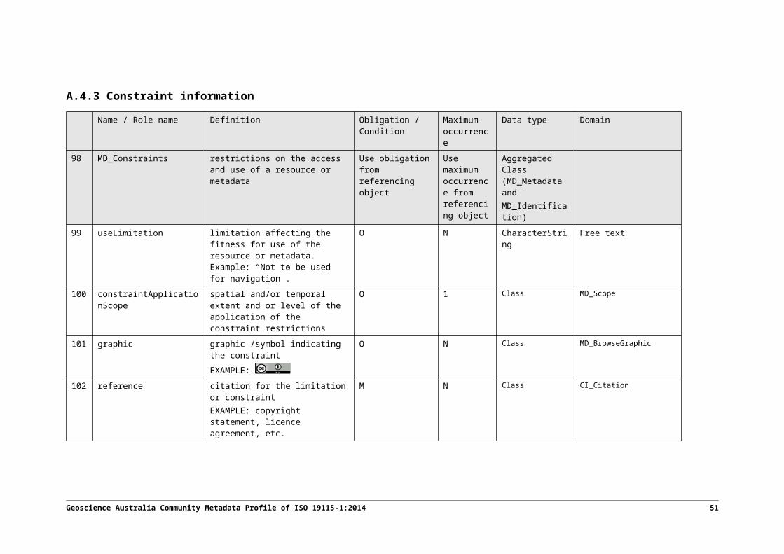
C.1.1 Definition by exception
The metadata hierarchy of ISO 19115-1 is designed to use the concept of “inheritance” associated with Object Oriented class modelling. Each child object inherits information from its parent and has the option to add or override individual fields. In other words, classes lower down in a hierarchy need only define content by exception.
Whilst a feature instance or attribute instance record might only define a small number of fields it is important to recognise it is the fully inherited content model that forms the basis of the record that aims to comply with the constraints of this profile.
C.1.2 Relational data stores and metadata hierarchy
The concept of “definition by exception” as described in the previous subsection is similar to the use of normalised form in relational data modelling.
It is anticipated that the “source of truth” location for most GA profile metadata records will be in corporate Oracle databases. Where possible these databases should use normalised form to represent the GA profile metadata model.
C.1.3 Catalogue implementations, CSW and ISO19115-3
Whilst the source of truth for most GA profile metadata records is likely to be in Oracle databases, catalogue implementations that collectively represent those records will most likely not be.
Catalogue implementations are required within GA to provide search services over collections of GA profile metadata records (and potentially other record types). They provide an OGC Catalogue Services for the Web (CSW) service interface allowing other applications to query the underlying metadata collections. Importantly they represent the underlying ISO 19115-1 records in XML format (ISO 19115-3).
Most CSW implementations, like GeoNetwork, require that metadata hierarchy be represented in denormalised form. The catalogue represents a collection of XML documents, each with its inherited hierarchy information duplicated into the individual record. The requirement for denormalised form in these catalogues does not imply a requirement for denormalisation in the source data tables or structures.
Catalogue databases (like those used by GeoNetwork) are typically inadequate for the purposes of long-term persistent storage and should not be considered the source location for the underlying metadata record data.
52 Geoscience Australia Community Metadata Profile of ISO 19115-1:2014