Embed Size (px)
Citation preview
HI OF C0y4, W 9mG_ VC
4rES Of
UNITED STATES DEPARTMENT OF COMMERCE
National Oceanic and Atmospheric Administration
NATIONAL MARINE FISHERIES SERVICESoutheast Regional Office
263 13th Avenue South
St. Petersburg, Florida 33701 -5505http: / /sero.nmfs. noaa. gov
APR 1 1 2014 F /SER31: JBH
Ms. Leslie CraigSupervisor, NOAA Restoration Center - Southeast Region
NOAA Fisheries -Office of Habitat Conservation
263 13th Avenue South
St. Petersburg, Florida 33701
Ref.: Deepwater Horizon -Early Restoration Plan Phase III Living Shoreline Projects
Dear Ms. Craig:
This document responds to 4 letters, received between January 13 and February 4, 2014, fromthe National Oceanic and Atmospheric Administration ( NOAA) Restoration Center, requestingNational Marine Fisheries Service ( NMFS) concurrence under Section 7 of the Endangered
Species Act ( ESA) with the project- effects determinations associated with living shorelineconstruction projects in the Gulf of Mexico. On February 5, 2014, we decided to batch theseprojects into a single consultation based on the similarity of the proposed activities. Youdetermined that the proposed activities may affect, but are not likely to adversely affect 5 seaturtle species ( green, hawksbill, Kemp' s ridley, leatherback, and loggerhead), Gulf sturgeon, smalltooth sawfish, and designated Gulf sturgeon critical habitat in Units 8, 9, and 13. NMFS
requested additional information via email on February 19, 2014. We received the response onMarch 13, 2014. We asked for clarification of that information via email on March 14, 2014.
We received clarification on March 19, 2014, and we initiated consultation that day. NMFS' sfindings on the projects' potential effects are based on the project descriptions in this response;
thus, any changes to the proposed actions may negate the findings of this consultation and mayrequire reinitiation of consultation with NMFS.
All of the applicants will use floating turbidity curtains around all in - water construction areasand will follow NMFS' s Sea Turtle and Smalltooth Sawfish Construction Conditions, dated
March 23, 2006; Measures for Reducing Entrapment Risk to Protected Species, revised May 22, 2012; and U. S. Fish and Wildlife Service' s ( USFWS) Standard Manatee Conditions for In-
Water Work, dated 2011. Each project is described in detail below and locations are shown in
the figures attached at the end of this consultation ( all project location datum are North AmericanDatum 1983).
1. The Hancock County Marsh Living Shoreline projects ( 3) are located in Hancock County, Mississippi. Action Area Bounding Coordinates (N- S -E -W): 30. 184 °N, 89. 53 °W; 30. 169 °N,
Applicant NMFS Number Location
1 MS Department of Environmental Quality SER- 2014 -12925 Hancock County, Mississippi2 NOAA Restoration Center — SE Office SER- 2014 -12926 Baldwin County, Alabama3 FL Department of Environmental Protection SER - 2014 -13016 Escambia County, Florida4 FL Department of Environmental Protection SER- 2014 -13083 Franklin County, Florida
Dear Ms. Craig:
This document responds to 4 letters, received between January 13 and February 4, 2014, fromthe National Oceanic and Atmospheric Administration ( NOAA) Restoration Center, requesting
National Marine Fisheries Service ( NMFS) concurrence under Section 7 of the Endangered
Species Act ( ESA) with the project- effects determinations associated with living shorelineconstruction projects in the Gulf of Mexico. On February 5, 2014, we decided to batch these
projects into a single consultation based on the similarity of the proposed activities. Youdetermined that the proposed activities may affect, but are not likely to adversely affect 5 sea
turtle species ( green, hawksbill, Kemp' s ridley, leatherback, and loggerhead), Gulf sturgeon, smalltooth sawfish, and designated Gulf sturgeon critical habitat in Units 8, 9, and 13. NMFS
requested additional information via email on February 19, 2014. We received the response onMarch 13, 2014. We asked for clarification of that information via email on March 14, 2014.
We received clarification on March 19, 2014, and we initiated consultation that day. NMFS' sfindings on the projects' potential effects are based on the project descriptions in this response;
thus, any changes to the proposed actions may negate the findings of this consultation and mayrequire reinitiation of consultation with NMFS.
All of the applicants will use floating turbidity curtains around all in - water construction areasand will follow NMFS' s Sea Turtle and Smalltooth Sawfish Construction Conditions, dated
March 23, 2006; Measures for Reducing Entrapment Risk to Protected Species, revised May 22, 2012; and U. S. Fish and Wildlife Service' s ( USFWS) Standard Manatee Conditions for In-
Water Work, dated 2011. Each project is described in detail below and locations are shown in
the figures attached at the end of this consultation ( all project location datum are North AmericanDatum 1983).
1. The Hancock County Marsh Living Shoreline projects ( 3) are located in Hancock County, Mississippi. Action Area Bounding Coordinates (N- S -E -W): 30. 184 °N, 89. 53 °W; 30. 169 °N,

89.462 °W; 30. 233 °N, 89.415 °W; 30. 184 °N, 89.530339 °W. The proposed projects consist of 3components: ( 1) use of breakwater materials to reduce shoreline erosion, (2) creation of 46 acres
of salt marsh, and ( 3) enhancement of 46 acres of oyster reef habitat that have historicallysupported oyster habitat (Figure 1). The-breakwater at St. Joseph' s Point (eastern reach) will be
approximately 4 miles long, have a crest width of 15 feet (ft), a total height of 4 ft, and includeopenings throughout to allow for tidal flow. The breakwater will have a footprint of
approximately 14.4 acres and will be placed on substrate of fine- grained sediment. It will becomposed of a riprap core covered by a 9- inch -thick layer ofbagged oyster shell. The PearlRiver to Heron Bay breakwater (western reach) will be constructed identical to the St. Joseph' sPoint breakwater, but will be 1. 9 miles long. The Pearl River to Heron Bay breakwater will havea footprint ofapproximately 5. 5 acres. Temporary flotation access channels will be used tofacilitate access for work barges into the work area. One channel will be excavated parallel tothe breakwaters and additional channels excavated perpendicular to provide access from theMississippi Sound (Figure 1). The excavated, dredged material will be cast on the seaward side
of the channels so they naturally fill back in after construction. The channels will be dredged to8 ft below mean lower low water (MLLW) to accommodate barge draft. The channels will beexcavated using standard, construction best management practices (BMPs) to minimizeenvironmental impacts. Permanent navigation signs will be installed in accordance with safetyrequirements.
A total of46 acres of marsh will be created behind the constructed breakwater at St. Joseph' sPoint. It will be backfilled with dredged material obtained from the Mississippi Beneficial
Sediment Use Program and allowed to re- vegetate by natural colonization of estuarine marshspecies. Sediment will be pumped through a floating pipeline from a hydraulic dredge until finalmarsh target elevations are achieved. Pumps and sediment controls will remain in place
throughout the dredging and filling process until initial settling has occurred. Once the entiremarsh area is constructed, the area would be monitored for natural re- vegetation.
Oyster cultch will be deployed over 46 acres in Heron Bay in areas that currently support orpreviously supported oyster production. Oyster cultch deployment will occur in water depths of
3 to - 5 ft MLLW and the limits of the cultch deployment areas will be marked with buoys orpoles. A barge - mounted crane with a clamshell bucket will deploy the cultch in a 6- to 9 -inch- thick layer of oyster shell or limestone. A material barge loaded with cultch will be moored to
the crane barge. As a construction alternative, water jetting of loose shell off of the materialbarge may be used in case of water -depth constraints. Construction is scheduled to take placefrom May- October to avoid potential impacts to migrating Gulf sturgeon.
2. The Swift Tract Living Shoreline project is located at 30. 335832°N, 87. 812745 °W, along theeastern portion of Bon Secour Bay, approximately 6 miles northwest of Gulf Shores in BaldwinCounty, Alabama (Figure 2). The Swift Tract breakwater will be 8, 500 ft long, have a crestwidth of 10 ft, and a total height of 3 ft. Calculated volumes of material are 15, 800 tons of riprapand 2, 200 cubic yards (yd3) of oyster shell. Approximately 2.9 acres of fine- grained sediment orsoft bottom will be covered with riprap and topped with bagged, oyster shell. One or more workbarges, with a long -reach backhoe, will be positioned along the seaward side of the breakwaterconstruction area. A material barge will be positioned seaward of the work barge. Additionally,
6 warning signs placed on 12- inch - diameter, treated posts will be installed adjacent to the
2

breakwaters. In an effort to reduce noise and turbidity effects, these posts will be pushed into thesediment rather than using a pile driver or jetting the piles into place. Construction is anticipatedto be completed within 6 months.
3. The Pensacola Bay Living Shoreline projects are located in Escambia County, Florida at30.410278°N, 87.202778 °W, Project Green Shores Site II (PGSII); and 30.3997220N,
87.232222 °W, Sanders Beach ( Figure 3). Construction activities at PGSII will include expansion
of an existing breakwater with a crest width of 100 ft and a total height of 3. 5 ft. The volume ofmaterial needed will be approximately 11, 000 tons of riprap and fossilized oyster shell coveringa footprint of 1. 9 acres of fine - grained sediment. Breakwaters constructed at Sanders Beach will
be 2,400 ft long, have a crest width of 30 ft, and a total height of 3. 5 ft. The volume ofmaterialneeded will be approximately 14, 000 tons of riprap and fossilized oyster shell, covering afootprint of 3. 15 acres of fine- grained sediment. A gap of 100 ft will be left between eachbreakwater to allow for tidal flow.
Work barges with a long -reach backhoe will be positioned along the seaward side of thebreakwaters and the material barge will be positioned seaward of the work barge. Additionally, 14 warning signs, placed on 12- inch - diameter posts, will be installed adjacent to the breakwaters. In an effort to reduce noise and turbidity effects, these posts will be pushed into the sedimentrather than using a pile driver or jetting the piles into place.
After the breakwaters have been constructed, selected landward areas will be filled with dredged
material obtained from one or more existing dredge disposal sites or navigational channelsadjacent to the project sites (Figures 5 and 6). Approximately 16 acres will be required toprovide the estimated 102, 000 cubic yd3 using the following criteria: ( 1) borrow source will befree of contaminants as described in the Inland Testing Manual (Evaluation ofDredged MaterialProposed For Discharge in Waters ofthe United States, ( U. S. Army Corps of Engineers, 1998); and ( 2) borrow areas in depths of 6 ft or less will be limited to excavated depths of 4 ft below the
sediment line and borrow areas in 6 ft or more of depth will be limited to excavated depths of 6 ftbelow the sediment line.
The marsh creation areas will be filled beginning at the most landward extent and filled untilfinal marsh elevations are achieved. Marsh elevations will be designed to meet the requirements
of native marsh plant species and to withstand normal wave heights for the project area. Based
on similar projects, it is estimated that approximately 6,000 yd3 of fill will be needed for PGSIIand approximately 96,000 yd3 of fill will be needed for Sanders Beach. To avoid potentialimpacts to protected species, the proposed project will use a hydraulic cutterhead pipeline dredge
rather than a hopper dredge. Floating turbidity screens will be used to control turbidity levelsand meet State of Florida requirements ( Chapter 62- 302.530 F.A.C.). Sediment controls will
remain in place throughout the dredging and filling process. Construction is anticipated to takebetween 6 -10 months for all elements, occurring between August- October 2015.
4. The Cat Point Living Shoreline project is located at 29.73093°N, 84.88433 °W, along an areajust off the Apalachicola National Estuarine Research Reserve Office Complex and Nature
Center in Eastpoint, Florida (Figure 4). Proposed activities include expanding an existingbreakwater structure by up to 0. 3 miles and creating 1 acre of salt marsh habitat. The extensions
3

to the existing breakwater will be added on the north end ( 689 ft) and south end ( 750 ft). Thestructure is approximately 30 ft from the shoreline, has a crest width of 5 ft, and a total height of2. 5 ft. The extensions will be similar in measurement. Gaps ranging in size from 3 -25 ft widewill be built into the breakwater to allow for tidal flow. Expansion of the breakwater will beundertaken during the winter season ( November through early March), when low tides in theproject area expose the tidal flats. Then materials can be placed from shore with a backhoe orcrane ( the area is too shallow to use a barge). Materials and equipment will be staged on state - owned lands adjacent to the road right -of -way, and will be accessed by an existing roadMillender Street). Native marsh plant species will be planted behind the breakwater structures,
along the shoreline, to create approximately 1 acre ofnew marsh. Marsh creation will involveplanting species on 2- to 3 -ft centers. This activity would commence once the constructedbreakwater extensions are complete and stabilized so the restored areas will be protected to thefullest extent possible.
We believe that sea turtles ( the endangered Kemp' s ridley; the threatened loggerhead,' and thethreatened/ endangered green2) and the threatened Gulf sturgeon may be present in the actionareas and may be affected by the projects. We believe leatherback and hawksbill sea turtles willnot be present, thus, they will not be affected, because their very - specific foraging and lifehistory requirements are not met in or near the action areas: leatherbacks are deepwater, pelagicspecies and hawksbills are associated with coral reefs. Smalltooth sawfish also are not likely tobe encountered at any of the project sites and therefore will not be affected. Their currentdistribution has contracted to peninsular Florida and, within that area, they can only be foundwith regularity off the extreme southern portion of Florida. Of the proposed projects, 3 fallwithin ESA - designated Gulf sturgeon critical habitat (Units 8, 9, and 13); Swift Tract is notlocated in designated critical habitat.
NMFS has identified the following potential effects to sea turtles and Gulf sturgeon and hasconcluded that the species are not likely to be adversely affected by the proposed actions forseveral reasons. Effects include the risks of being struck by transiting vessels, cutterhead andmechanical dredge - related activities, and deployment of material from the barges. Due to thespecies' mobility, natural avoidance behaviors, and the slow transit speed of the towed barges ( 5knots or less), the risk of injury will be discountable. Compliance with NMFS' s Sea Turtle andSmalltooth Sawfish Construction Conditions, dated March 23, 2006 ( enclosed), will furtherreduce the risk as it requires work to stop if a listed species is observed within 50 ft of operatingor moving machinery. NMFS believes that the temporary pipeline put in place to pump sedimentfrom the dredged material disposal site to the marsh creation area will not adversely affect or
impede the passage or transit of any of these species, as they can simply avoid it, or swim over, under, or around it; thus, any effects of pipeline presence are insignificant.
Sea turtles and Gulf sturgeon may be temporarily unable to use the sites for foraging or shelterhabitat due to avoidance of construction activities, related noise, and physical exclusion fromareas blocked by turbidity curtains. These effects will be temporary and insignificant, given theprojects' small footprints, short construction durations, and turbidity controls that will only
1 Northwest Atlantic Ocean distinct population segment (DPS) 2 Green turtles are listed as threatened except for the Florida and Pacific coast of Mexico breeding populations, which are listed as endangered.
4

enclose a small portion of the project sites and will be removed after construction. In addition,
the Hancock County, Swift Tract, and Pensacola Bay project activities will occur between Mayand October when Gulf sturgeon are found primarily in freshwater rivers. Activities at Cat Pointwill occur during the winter months when the tide is at its lowest so cranes can work from shore. Due to the shallow water depths, that particular project area provides poor foraging and refugehabitat for sturgeon. Gulf sturgeon are suction feeders, using their relatively narrow mouths tofunnel water and prey items. Because of their feeding morphology, they are usually found atslightly deeper depths ( greater than 6 ft) where there is lower wave energy. There is ampleavailable foraging and refuge habitat for Gulf sturgeon outside of, but adjacent to, the Cat Pointsite just offshore where the depths provide more suitable habitat to Gulf sturgeon.
The essential features for the conservation of Gulf sturgeon present in Units 8, 9, and 13 are: ( 1)
abundant prey items; ( 2) water quality and sediment quality necessary for normal behavior, growth, and viability of all life stages; and ( 3) safe and unobstructed migratory pathwaysnecessary for passage within and between riverine, estuarine, and marine habitats. Of theseessential features, NMFS believes prey abundance, water quality, and sediment quality may beaffected.
The prey abundance essential feature may be affected by burial or excavation of Gulf sturgeonforaging sites during marsh creation, flotation channel dredging, and oyster reef creation. Thetemporary loss of prey species within the project area will not appreciably decrease the preyavailable to Gulf sturgeon as there are abundant, similar, nearby foraging habitats. Any decreasein numbers of these prey species would be minimal in relation to their numbers across the entirecritical habitat units or nearby areas. Prey species can quickly recolonize the project areas afterconstruction; thus, effects to the prey abundance essential feature of critical habitat will beinsignificant. Furthermore, effects to the ecological functions and values of the critical habitat
units for Gulf sturgeon will be insignificant.
The marsh creation projects will likely have a beneficial impact on Gulf sturgeon by increasingprey abundance in adjacent areas. Partyka and Peterson ( 2008) found even the smallest patchesof marsh habitat supported a larger diversity of fauna than nearby areas. 3 Therefore, it is likelythat Gulf sturgeon prey species (e. g., amphipods, lancelets, polychaetes, gastropods, ghostshrimp, isopods, mollusks, and crustaceans) will benefit from the restoration of a marsh areawith native vegetation. While some of this enhanced prey abundance will remain in the marshand not be available to Gulf sturgeon for foraging, we believe that directly ( through spillover) orindirectly (through trophic movement) prey abundance will be increased in areas accessible toforaging Gulf sturgeon. This spillover effect is supported by Whaley and Minello' s ( 2002) findings of the strong trophic link between infauna and nekton near the marsh edge and the highfishery productivity derived from Gulf coast marshes. 4
Water quality will be temporarily affected by disturbance to the bottom sediments duringdredging activities. The effects are expected to be insignificant, given that increases in turbidity
3 Partyka, M.L. and M. S. Peterson. 2008. Habitat quality and salt -marsh assemblages along an anthropogenicestuarine shoreline. Journal of Coastal Research 24( 6): 1570 -1581.
4 Minello, T.J., K.W. Able, M.P. Weinstein, and C.G. Hays. 2003. Salt marshes as nurseries for nekton: testinghypotheses on density, growth, and survival through meta - analysis. Marine Ecology Progress Series 246: 39 -59.
5
will be temporary and minimized by the use of turbidity curtains. In addition, sediments willsettle out of the water column quickly, and/ or tidal currents will disperse the disturbed sedimentsto baseline conditions. We do not expect any adverse changes to the sediment quality from theproposed dredging, as the composition of the dredged materials to be replaced (put back into theflotation channels, post project construction) in critical habitat are from the same approximate
area in critical habitat, and therefore are expected to be similar or identical to those that are
currently present.
Finally, we concur with your project- effect determinations that the projects for which yourequested ESA consultations are not likely to adversely affect Kemp' s ridley, loggerhead, orgreen sea turtles, Gulf sturgeon, or Gulf sturgeon critical habitat in Units 8, 9, and 13.
This concludes the NOAA Restoration Center' s consultation responsibilities under the ESA forspecies under NMFS' s purview. Consultation must be reinitiated if a take occurs or new
information reveals effects of the action not previously considered, or the identified action issubsequently modified in a manner that causes an effect to the listed species or critical habitat ina manner or to an extent not previously considered, or if a new species is listed or critical habitatis designated that may be affected by the identified action.
We' ve enclosed additional relevant information for your review. We look forward to further
cooperation with you on other projects to ensure the conservation of our threatened and
endangered marine species and designated critical habitat. If you have any questions about thisconsultation, please contact Joyce Barkley -Hahn, Consultation Biologist, at ( 727) 551 -5741, orby email at joyce.barkley- [email protected].
Sincerely,
i\K-„flu„ cAA-t-14,1
t'l'` Roy E. Crabtree, Ph.D. Regional Administrator
Enc.: 1. Sea Turtle and Smalltooth Sawfish Construction Conditions (Revised March 23, 2006)
2. Measuresfor Reducing Entrapment Risk to Protected Species ( Revised May 22, 2012) 3. Standard Manatee Conditionsfor In -Water Work (Dated 2011).
File: 1514 -22C.
6

Conceptual Project Design — Features Ripresent Generalized Areas and are Subject to Refinement
N
LaFrance Manna.
LaFrance Trenaisse _
Canal
Pearl River to Heron BayLiving Shoreline (Breakwater)
Potential Oyster CultchlDeployment Locations
0 0. 65 1. 3
1. 95Miles
Heron Boy St. Joseph' s Point LivingShoreline (Breakwater)
LegendLmng ShorelineA Waterway Open Access Locations
Potential Marsh Creation Locations
Potential Oyster Conch Dep'oyment Locations
Potential Temporary Flotation Channel Locahono
Figure 1. Image showing Hancock County Marsh project locations ( ©2012 Google, TerraMetrics)
Figure 2. Image showing Swift Tract project location ( ©2012 Google, TerraMetrics)

cambia E.:.
2012 Google6.11 n,
Data SIO. ImaFigure 3. Image showing Pensacola BayNavy, NGA, GEBCO)
NOAA. U. S. Navy. NGA. GEBCOe 2012 TerraMetrics
project locations ( ©2012 Google, TerraMetrics, data SIO, NOAA, U. S.
rLCal Point Project
wl aask i ' 4tcw Oat' 1ais..1tYtA. iletet AV. 1 im or. ab;;kra+: r.: •twclS +.Y t.>•m} zlr • ;..,•^•: -
w ..,,- w+
Figure 4. Image showing Cat Point project locations ( ©ESRI, DigitalGlobe, GeoEye, 1- cubed, USDA, USGS, AEX, Getmapping, IGN, IGP, Swisstopo, GIS User Community)
8

Figure 5. Image showing existing dredge disposal sites at PGSII
Pensacola Bay
Living ShorelineProject Greenshores
Site 11
M
Legend
AlProposed Breakwaters
Proposed Marsh Arta
C- 3 busting ChannelsL. Etnbs( Dredge Disposal Sites
3 Arta of Potential Erect Bound,'
Pensacola Bay
Living ShorelineSanders Beach Site
legend
Proposed Breakwater
Proposed Marsh Ares
jExisting ChannelsExisting Dredge Disposal SitesArea of Potential Effect Boundary
kmnd Source
el 1011
NOAA 1014
Figure 6. Image showing existing dredge disposal sites at Sanders Beach

SEA TURTLE AND SMALLTOOTH SAWFISH CONSTRUCTION CONDITIONS
The permittee shall comply with the following protected species construction conditions:
a. The permittee shall instruct all personnel associated with the project of the potential presence
of these species and the need to avoid collisions with sea turtles and smalltooth sawfish. All
construction personnel are responsible for observing water - related activities for the presence ofthese species.
b. The permittee shall advise all construction personnel that there are civil and criminal penalties
for harming, harassing, or killing sea turtles or smalltooth sawfish, which are protected under theEndangered Species Act of 1973.
c. Siltation barriers shall be made of material in which a sea turtle or smalltooth sawfish cannot
become entangled, be properly secured, and be regularly monitored to avoid protected speciesentrapment. Barriers may not block sea turtle or smalltooth sawfish entry to or exit fromdesignated critical habitat without prior agreement from the National Marine Fisheries Service' s
Protected Resources Division, St. Petersburg, Florida.
d. All vessels associated with the construction project shall operate at " no wake/ idle" speeds at
all times while in the construction area and while in water depths where the draft of the vessel
provides less than a four -foot clearance from the bottom. All vessels will preferentially followdeep -water routes (e. g., marked channels) whenever possible.
e. If a sea turtle or smalltooth sawfish is seen within 100 yards of the active dailyconstruction/dredging operation or vessel movement, all appropriate precautions shall beimplemented to ensure its protection. These precautions shall include cessation of operation of anymoving equipment closer than 50 feet of a sea turtle or smalltooth sawfish. Operation of anymechanical construction equipment shall cease immediately if a sea turtle or smalltooth sawfish isseen within a 50 -ft radius of the equipment. Activities may not resume until the protected specieshas departed the project area of its own volition.
f. Any collision with and/ or injury to a sea turtle or smalltooth sawfish shall be reportedimmediately to the National Marine Fisheries Service' s Protected Resources Division (727 -824- 5312) and the local authorized sea turtle stranding/rescue organization.
g. Any special construction conditions, required of your specific project, outside thesegeneral conditions, if applicable, will be addressed in the primary consultation.
Revised: March 23, 2006

4, v.T PF
174113 of
UNITED STATES DEPARTMENT OF COMMERCE
National Oceanic and Atmospheric Administration
NATIONAL MARINE FISHERIES SERVICE
Southeast Regional Office
263 13t, Avenue South
St. Petersburg, Florida 33701 -5505727) 824 -5312: FAX ( 727) 824 -5309
http:// sero.nmfs. noaa. gov
Measures for Reducing Entrapment Risk to Protected Species
Bottlenose dolphins, sea turtles, and Gulf sturgeon (protected species) are known to inhabit
coastal waters of the northern Gulf of Mexico. Bottlenose dolphins are protected under the
Marine Mammal Protection Act (MMPA) and sea turtles and Gulf sturgeon are protected underthe Endangered Species Act (ESA). Because of the potential for these protected species to
become entrapped within coastal waters of construction sites along the northern Gulf coast, projects that enclose shallow open water areas for wetland creation or nourishment will use the
following measures to minimize the potential for entrapment:
1. Pre - construction planning. During project design, the Federal Action Agency orproject proponents must incorporate at least one escape route into the proposed retention
structure( s) to allow any protected species to exit the area( s) to be enclosed. Escaperoutes must lead directly to open water outside the construction site and must have aminimum width of 100 feet. Escape routes should also have a depth as deep as thedeepest natural entrance into the enclosure site and must remain open until a thorough
survey of the area, conducted immediately prior to complete enclosure, determines noProtected Species are present within the confines of the structure ( see item 5 below for
details).
2. Pre - construction compliance meeting. Prior to construction, the Federal ActionAgency, project proponents, the contracting officer representative, and constructionpersonnel should conduct a site visit and meeting to develop a project - specific approachto implementing these preventative measures.
3. Responsible parties. The Federal Action Agency will instruct all personnel associatedwith the project of the potential presence of protected species in the area and the need to
prevent entrapment of these animals. All construction personnel will be advised that
there are civil and criminal penalties for harming, harassing, or killing protected species. Construction personnel will be held responsible for any protected species harassed orkilled as a result of construction activities. All costs associated with monitoring andfinal clearance surveys are the responsibility of project proponents and must beincorporated in the construction plan.
4. Monitoring during retention structure construction. It is the responsibility ofconstruction personnel to monitor the area for protected species during dike or leveeconstruction. If protected species are regularly sighted over a 2 or 3 day period withinthe enclosure area during retention structure assembly, construction personnel mustnotify the Federal Action Agency. It is the responsibility of the Federal Action Agency

to then coordinate with the National Marine Fisheries Service ( NMFS) Marine Mammal
Health and Stranding Response team ( 1- 877 -WHALE HELP [ 1- 877 - 942 - 5343]) or theappropriate State Coordinator for the Sea Turtle Stranding and Salvage Network (seehttp: / /www.sefsc.noaa.gov/ species/ turtles /stranding_coordinators.htm) to determinewhat further actions may be required. Construction personnel may not attempt to scare, herd, disturb, or harass the protected species to encourage them to leave the area.
5. Pre - closure final clearance. Prior to completing any retention structure by closing theescape route, the Federal Action Agency will insure that the area to be enclosed isobserved for protected species. Surveys must be conducted by experienced marineobservers during daylight hours beginning the day prior to closure and continuing duringclosure. This is best . accomplished by small vessel or aerial surveys with 2 -3experienced marine observers per vehicle ( vessel/helicopter) scanning for protectedspecies. Large areas ( e. g. > 300 acres) will likely require.the use of more than one vesselor aerial survey to insure full coverage of the area. These surveys will occur in aBeaufort sea state ( BSS) of 3 feet or less, as protected species are difficult to sight in
choppy water. Escape routes may not be closed until the final clearance determines theabsence of protected species within the enclosure sight.
6. Post closure sightings. If protected species become entrapped in an enclosed area, the
Federal Action Agency and NMFS must be immediately notified. If observers noteentrapped animals are visually disturbed, stressed, or their health is compromised thenthe Action Agency may require any pumping activity to cease and the breaching ofretention structures so that the animals can either leave on their own or be moved underthe direction of NMFS.
a. In coordination with the local stranding networks and other experts, NMFS willconduct an initial assessment to determine the number of animals, their size, age ( in
the case of dolphins), body condition, behavior, habitat, environmental parameters, prey availability and overall risk.
b. If the animal(s) is /are not in imminent danger they will need to be monitored by theStranding Network for any significant changes in the above variables.
c. Construction personnel may not attempt to scare, herd, disturb, or harass theprotected species to encourage them to leave the area. Coordination by the FederalAction Agency with the NMFS SER Stranding Coordinator may result inauthorization for these actions.
d. NMFS may intervene (catch and release and/ or rehabilitate) if the protected speciesare in a situation that is life threatening and evidence suggests the animal is unlikelyto survive in its immediate surroundings.
e. Surveys will be conducted throughout the area at least twice or more in calmsurface conditions (BSS 3 feet or less), with experienced marine observers, to
determine whether protected species are no longer present in the area.
Revised: May 22, 2012
While NMFS recommends these best management practices to prevent the future takes of marine mammals by entrapment, use ofthese measures cannot guarantee a take will not occur. Following these measures does not constitute compliance with theMMPA' s Incidental Take requirements and take is not authorized.

STANDARD MANATEE CONDITIONS FOR IN -WATER WORK2011
The permittee shall comply with the following conditions intended to protect manatees fromdirect project effects:
a. All personnel associated with the project shall be instructed about the presence of
manatees and manatee speed zones, and the need to avoid collisions with and injury tomanatees. The permittee shall advise all construction personnel that there are civil and
criminal penalties for harming, harassing, or killing manatees which are protected underthe Marine Mammal Protection Act, the Endangered Species Act. and the Florida
Manatee Sanctuary Act.
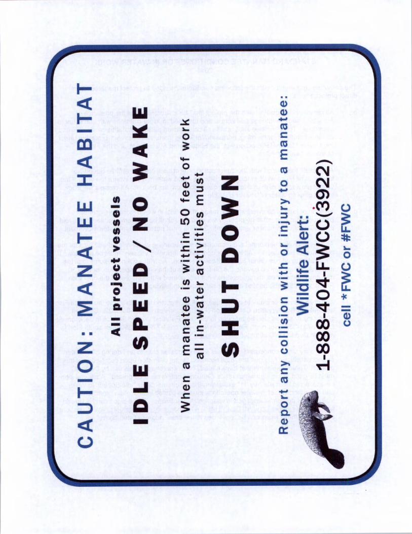
All vessels associated with the construction project shall operate at " Idle Speed /No
Wake" at all times while in the immediate area and while in water where the draft of the
vessel provides less than a four -foot clearance from the bottom. All vessels will follow
routes of deep water whenever possible.
c. Siltation or turbidity barriers shall be made of material in which manatees cannotbecome entangled, shall be properly secured, and shall be regularly monitored to avoidmanatee entanglement or entrapment. Barriers must not impede manatee movement.
d. All on -site project personnel are responsible for observing water - related activities for thepresence of manatee( s). All in -water operations, including vessels, must be shutdown ifa manatee( s) comes within 50 feet of the operation. Activities will not resume until the
manatee(s) has moved beyond the 50 -foot radius of the project operation, or until 30
minutes elapses if the manatee( s) has not reappeared within 50 feet of the operation.
Animals must not be herded away or harassed into leaving.
e. Any collision with or injury to a manatee shall be reported immediately to the Florida Fishand Wildlife Conservation Commission ( FWC) Hotline at 1- 888 - 404 -3922. Collision
and /or injury should also be reported to the U. S. Fish and Wildlife Service in Jacksonville1- 904 - 731 -3336) for north Florida or in Vero Beach ( 1- 772 - 562 -3909) for south Florida,
and emailed to FWC at ImperiledSpecies(cr myFWC. com.
Temporary signs concerning manatees shall be posted prior to and during all in -waterproject activities. All signs are to be removed by the permittee upon completion of theproject. Temporary signs that have already been approved for this use by the FWCmust be used. One sign which reads Caution: Boaters must be posted. A second sign
measuring at least 81/ 2 " by 11" explaining the requirements for " Idle Speed /No Wake" and the shut down of in -water operations must be posted in a location prominentlyvisible to all personnel engaged in water - related activities. These signs can be viewed
at http: / /www.myfwc.com/ WILDLIFEHABITATS /manatee sign vendors. htm. Questionsconcerning these signs can be forwarded to the email address listed above.
m
Qz
MANATEEz
AllprojectvesselsW
Q
0
z
0W
W
0.
y
0 WJ
0
Wm
0
a) 9-
0
AMMO
manateeisa)
1--
Q0
D
manatee: cts N
Z 0 N
E TOCM U
N.. •....
0 = ij.: V LL.
o 4tQ o
0u- V
03 -;V; v
CD1'' 1. 1111 so
CO MN UMNNI
00
Oco
a3c) 00
aco
00.
cc