Embed Size (px)
Citation preview

G-IV-A-068
Ashby Mine
Architectural Survey File
This is the architectural survey file for this MIHP record. The survey file is organized reverse-
chronological (that is, with the latest material on top). It contains all MIHP inventory forms, National
Register nomination forms, determinations of eligibility (DOE) forms, and accompanying documentation
such as photographs and maps.
Users should be aware that additional undigitized material about this property may be found in on-site
architectural reports, copies of HABS/HAER or other documentation, drawings, and the “vertical files” at
the MHT Library in Crownsville. The vertical files may include newspaper clippings, field notes, draft
versions of forms and architectural reports, photographs, maps, and drawings. Researchers who need a
thorough understanding of this property should plan to visit the MHT Library as part of their research
project; look at the MHT web site (mht.maryland.gov) for details about how to make an appointment.
All material is property of the Maryland Historical Trust.
Last Updated: 12-01-2003

-- G-IV-A-068 Ashby Mine Crellin Mine Road Crellin
The ruins of this mining complex lie about 1/2 mile south of the center of
the town of Crellin, south of Crellin Mine Road, north of Ashby Cemetery Road.
The Ashby Mine was a drift mine. A drift opening is a horizontal tunnel or
adit driven into the coal seam from the surface outcrop. This method was
employed in all of the basins wherever the coal outcropped. The openings
usually were supported by wooden mine props, consistent with the support
system in the mine workings. Many of these mine openings have collapsed and
eroded, leaving only traces of the mine entrance.
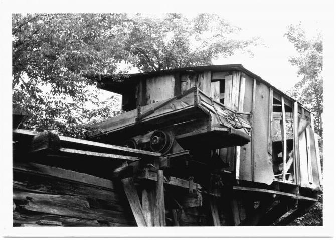
The complex also includes a tipple. A tipple (known in the anthracite and
other bituminous coal regions as a "breaker") is a structure in which coal from
the mine is processed for market and loaded into railroad cars or other transport
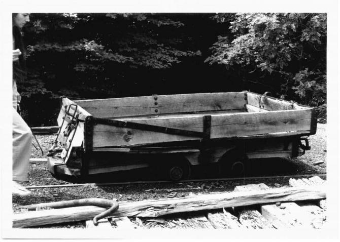
facilities. The tipple at the Ashby Mine was an end dump tipple, where the coal
was released from the mine car by tipping the mine car on end. Specifically, it
was a "half-tipple." With this type, the mine car was dumped when it struck
"horns" which tipped the car and discharged the coal. This is the simplest form
of tipple.
In addition to the mine opening itself, left on the site are a tram, hoist
house, tipple, and two mine cars.

~~
G-IV-A--068
ASHBY MINE
'.J U.S. 219 631 i 100 000 FEET (MD.) 632 27'30" 633
j by the Geological Survey
:ihs by multiplex methods =1eld check 1948
American datum land coordinate system
'tem, north zone
1oiled from 1946 photography ·1ain
· Mercator grid ticks. . --~d 1. ~ der1a r photographs
'. field checked
* MN j GN
\ e· I ,
~i.1·00· I' 1 18 MILS I I
I f
UTM GRID AND 1974 MAGNETIC NORTH DECLINATION AT CEN'ER OF SHEET
) f
634 (TABLE ROCK! 5162 IV SW
SCALE 1 24 000
635
CONTOUR INTERVAL 20 FEET NATIONAL GEODETIC VERTICAL DATUM OF 1929
THIS MAP COMPLIES WITH NATIONAL MAP ACCURACY s· FOR SALE BY U.S. GEOLOGICAL SURVEY. RESTON. VIRGI
A FOLDER DESCRIBING TOPOGRAPHIC MAPS AND SYMBOLS IS AVAIL•

G r · A 611 C:::,·/V-1'- O(o 8 .Wmu "wileeft osAay Hee Hine & Gem Garrett Co . , Md. c Crawford 8/81 Fuel Mine : Mine Car


en A 011• G-/V-"j-0~9 19-sAi~ A41't,e__ \fn11 Wilsen Ashby Hs • thne & Ce11t f , l c Crawford 8/81 . Fuel Mine: Tram, Hoist Hs. & Mine car , looking E.

~ IM=61+ 1':-{.V-M-::1; ~ ':! ~ S /, by A(i fie_ ~Rh Wilsen As I/ s •
c Crawford 8/~ & Tipple , . Ho is t Hs • Fuel Mine :
looking NW


G-/V-A-O~i 6-IV A 67i · L Gem A £ h b)l H 6; }fzne a Wm HihoA
C C1
rawford 8/8. 1 · l e Hs . & Tipp Fuel Mine : Hoist
looking W


8 H' A 07 l -Wm. Uile~e Garrett Co .
G-l'J-A -or.8· A9he, Ils . Mis& & C&m
C Crawford 8/81 looking w. Fuel Mine : Entrance