Embed Size (px)
Citation preview


i
Contents
Chapter Pages
1 The Oxford Transport Strategy The purpose of the strategy The area it covers
1
2 The Scale of the Challenge The transport impacts of growth What this means in the future The key challenges for the OTS
2-5
3 Objectives A vision for Oxford The OTS objectives
6
4 The strategy components An integrated approach
7
Mass Transit The existing situation Vision for mass transit Proposed network Supporting infrastructure Vehicle technology Smart mobility Implementation
8-19
Walking and Cycling The existing situation Vision for Walking & Cycling Enhancing the cycle network Encouraging walking Technology Implementation
20-25
Managing Traffic and Travel Demand Principle of demand management The Existing situation Vision for managing traffic and travel demand Future demand for travel Highway capacity improvements Workplace Parking Levy Traffic control points Road user charging Public Parking Freight / deliveries Role of taxis
26-31
Development management policy Implementation
5
Implementation The cost of improvement Funding the OTS The next steps
32-33

1
The purpose of the strategy
The Oxford Transport Strategy (OTS) sets out Oxfordshire County Council’s transport
vision and strategy for Oxford over the next 20 years, as part of the fourth Local
Transport Plan (LTP4). It identifies the current and future challenges for transport in the
city and sets out a strategy based on a combination of infrastructure projects and
supporting measures to enable economic and housing growth.
This strategy builds on a legacy of success in tackling Oxford’s transport challenges
through pioneering and innovative approaches which have enabled the city to grow and
develop without year on year rises in traffic levels. For instance, the city’s world first Park
& Ride system, which began in the 1970s, has not only proven successful in containing
traffic in the city, it has gone on to become a model subsequently adopted by cities
around the world to address their own congestion problems.
This strategy builds on the successes of the past, quantifies the scale of the future
challenges and proposes bold and innovative solutions.
The area it covers
Oxford’s influence on transport does not stop at the city boundary. The OTS has been
developed to cover the urban area of Oxford as well as the main transport corridors to
and from the city.
There are three locations which will be the focus for future employment, housing and
regeneration. These are:
the City Centre – the cultural and historic heart of Oxford;
the Eastern Arc – the largest employment area and most populated part of the
city (which includes Marston, Headington, Cowley and Littlemore); and
North Oxford – which includes Cutteslowe and Wolvercote and major corridors
into Oxford from north of the outer ring road.
.
1. The Oxford Transport Strategy
The future economic growth
and attractiveness of Oxford is
dependent on improving the
quality of the entire city as a
place
High quality and sustainable
transport access is essential to
accommodating growth and
changing travel demand within
the city’s physical and
environmental constraints
Pla
ce
Access

2
Transport impacts of growth
Oxford is an attractive, enterprising and dynamic city – a place that people from around the
world want to visit and increasingly want to live and work in.
Oxford’s population has grown at an unprecedented rate in recent years, with the number of
residents rising by 14% between 2001 and 2013 (from 135,500 to 154,800 people). Despite the
sizeable impacts of recession, overall job growth has been equally impressive, with 118,000
jobs in 2012, compared to 99,000 in 2001. Oxford has 33% more jobs per head of working age
population (aged 16-64) than the South East as a whole.1
The additional travel demand generated by this growth has been well-contained in Oxford:
overall, rises in traffic within the city have been avoided or minimised by the local authorities’
transport and planning policies and schemes.
But despite these successes, the trend of sustained growth has brought challenges.
As a medieval city, Oxford’s often narrow streets are, in many areas, unsuited to motorised
vehicles. Peak period congestion is a persistent problem, with traffic building at bottlenecks
which cannot realistically be entirely removed. Within the centre, cars, buses and delivery
vehicles compete for limited space with pedestrians and cyclists. These create an uneasy
tension between the demands for movement and access, and the desire to ensure the centre
offers a highly attractive and vibrant environment for people.
As more people have moved to Oxford, pressure has been added to the city’s housing stock,
helping to drive up house prices at a faster rate than other areas and intensifying population
density. Limited space for new development has contributed to a significant shortfall in
affordable housing (particularly around the centre), resulting in changes to where people are
able to live and accordingly how far and how they travel.
Oxfordshire has ambitious plans for growth, with proposals for 100,000 new homes and 85,000
new jobs to be created by 2031. The county has evolved into one of the UK’s major hubs for
knowledge-based industries, with Oxford at its heart.
1 Figures provided by the Office for National Statistics
A new Oxford Local Plan is being prepared, for submission in 2018. This will determine the
number and locations of new homes within the city to 2036.
Following the publication of the Strategic Housing Market Assessment for Oxfordshire, the
Oxfordshire councils have agreed a working assumption of 15,000 homes as the scale of
Oxford’s unmet need to be planned for outside the city.
Whilst the modal share for public transport for trips to the city has increased steadily in recent
years, travel by car remains the dominant form of transport to all destinations other than the
city centre. With existing congestion already requiring extensive engineering solutions to
junctions on the ring-road, the predicted growth of homes and jobs in Oxford and throughout
the county will only exacerbate the problem.
What this means in future
Growth on this kind of scale requires a transport strategy of comparable ambition. A
continuation of existing travel behaviour amongst new residents would threaten to over-burden
the transport network and in turn significantly compromise the character of Oxford and quality
of life of those living and working here.
It is estimated that job growth within
and outside Oxford, could result in
26,000 additional journeys within the
city boundary by 2031 – a 25%
increase from 2011. Initial estimates
suggest that, without improvements
to the transport network and
changes of travel behaviour, this
could result in approximately 13,000
more commuter car trips each day.
The graph on the right illustrates
what the impacts of growth could be on the number of commuter trips into and within Oxford if
2. The Scale of the Challenge

3
current preferred modes of travel remain unchanged. A 10% decrease in the car driver mode
share is needed to prevent traffic levels rising.
Even the current Local Plans’ pre-SHMA housing allocations in Oxfordshire are forecast to
result in a 16% increase in traffic on Oxford’s radial roads and 21% on the ring road in peak
hours. By 2031, the impact of the resulting congestion is forecast to result in a loss of around
£150 million from the economy of the city. Car journey times from the surrounding Oxfordshire
towns are anticipated to increase on average by 18% to the city centre and 14% to
Headington.
This increased demand for movement will also have significant adverse impacts on the
environment, quality of life and health of the city’s population.
More demand also means more buses, with the number of vehicles entering the city centre set
to grow by over 40% if left un-checked, putting substantial strain on the historic core. Increased
traffic will impact on local communities, and longer journey times will make it more difficult to
reach jobs and services.
Without a step change in the provision transport infrastructure and travel options, the city faces
serious consequences.
The key challenges for the OTS
The OTS has therefore been developed to correspond to the eight most crucial challenges for
transport in the city.
Challenge 1: Oxford’s economy is growing and changing
Oxford’s key economic strength lies in high-
skilled, knowledge-intense industries
(including science, research and
technology), building on the city’s
international renown as a centre of
excellence in education and research. These
sectors now account for the majority of jobs,
whilst the relative number of positions within
more traditional sectors (such as
manufacturing and retail) is declining (see
graph).
The city’s tourism industry also goes from strength to strength, with 9 million visitors each year,
and an estimated worth of £770 million for local businesses.
Oxford’s businesses typically function within a global marketplace making strategic transport
connections as important as local ones. High-skilled roles also frequently attract a more mobile
and affluent workforce, who are able and prepared to travel greater distances to work. This is
likely to be contributing to an increase in commuting into Oxford.
Key implications for the OTS: Congestion is a barrier to a competitive economy and future
growth requires a well-connected, reliable and efficient transport network. Capacity is needed,
but with space a key constraint, the on-going provision of more road space is not a long-
term option.
Challenge 2: Economic growth is happening in new locations
Economic growth is bringing changes to the location as
well as the nature of development. The Eastern Arc
now surpasses the centre as Oxford’s main area of
employment (with 43,600 jobs compared to 39,800
within central Oxford). As the city develops in future,
the largest proportion of new growth will occur outside
the centre.
Oxford’s transport networks have historically been
developed to provide access to the city centre. New
areas of growth require appropriate levels of access
and strengthened linkages. The growth of the
“Knowledge Spine” that includes the Eastern Arc,
North Oxford, Science Vale and Bicester will also increase the importance for strengthened
connectivity between these locations and good connections to strategic road and rail networks
– particularly to maintain access to and from London and Heathrow airport.
Key implications for the OTS: High quality and integrated public transport is needed to
support good connectivity across the city and to areas beyond traditional boundaries. This
needs to be accompanied with measures to manage growth in demand for car travel.
Challenge 3: Oxford is a tale of two cities
Employment in service related positions has
grown rapidly since 2001
Proposed employment
sites in Oxford

4
Whilst, overall, Oxford’s economy has thrived, not all
residents have been able to share in the city’s success.
Large pockets of inequality exist, with significant areas
of economic and social deprivation – particularly within
the Eastern Arc.
Persistent issues of unemployment, low income and health inequalities are most concentrated
within these locations, with a decline in low-skilled jobs leaving significant numbers of residents
mismatched to local employment opportunities. A shortage in housing availability has pushed
up the cost of accommodation relative to income, placing further pressure on the finances of
lower-income residents.
With these types of challenges, travel can be a contributing factor. If communities are not well
connected to employment or higher education and essential services and amenities, the
opportunities and overall quality of life of individuals can be compromised.
Key implications for the OTS: The OTS must support initiatives to overcome the inequalities
that continue to exist in Oxford. In particular, transport has an important role to play in
supporting regeneration by strengthening access and providing opportunities for reaching
employment, training, essential services and amenities.
Challenge 4: Oxford is experiencing rapid population growth and demographic change
Oxford’s rate of population growth is showing no sign of immediately abating as the city’s
universities and knowledge-based businesses continue to attract new residents.
With population growth comes increased
demand for travel, but also opportunity for
increased public transport. More densely
populated places are more likely to support
commercially viable public transport, supporting
opportunities to manage traffic growth.
Whilst the majority will remain of working age,
particular increases are predicted in those aged
14 or younger and 70 or older.
Key implications for the OTS: Managing the
impacts of an increased population will require a strategy that seeks to encourage trips by
walking, cycling or public transport over car travel. Changing demography means the OTS
must deliver high quality transport choices which are accessible to all (irrespective of age,
mobility level, or ethnic background).
Challenge 5: More people are travelling into Oxford each day and travel patterns are
changing
The journey to work remains the most significant challenge for the transport network, and
increasingly this involves people travelling in from outside the city. More jobs which require a
commutable journey in Oxford are now held by those living outside the city (45,750) than those
living within it (42,406).
Commuters who travel from outside of Oxford are typically far more car dependent and the
total number of car commuting trips rose by 9% between 2001 and 2011. Trips to work by
public transport have increased for those travelling from outside, but at far more modest levels.
People’s travel is also changing: it is now the Eastern Arc, rather than the centre, which is
home to more jobs than anywhere else in the city (43,600 compared to 39,800 within inner
Oxford). As the city’s growth plans are realised the transport network within the Eastern Arc is
set to become even more important to Oxford’s economic success.
Key implications for the OTS: A continuation of current commuting travel trends would
represent a significant challenge to Oxford’s growth. Congestion builds significantly at peak
periods on the Outer Ring Road and along the A34 and A40 creating delays and unreliability.
With more commuters travelling in, the only way that this future problem can be sustainably
addressed is through a step change in commuting behaviour towards public transport.
Challenge 6: Housing demand is not being met and there is a need for new high quality
neighbourhoods
There is a currently a large gap between housing demand and new house completions within
the Oxford area, contributing to a growing shortfall in supply. This is especially significant for
the availability of affordable homes.
House prices are accordingly rising quickly and the urban population density increasing, as
higher costs drive up occupancy levels (with 6.2% of houses considered to be overcrowded in
2013). The impact of increasing population density may be beneficial to making public transport
more commercially viable, but the housing gap is also resulting in more people commuting into
Oxford from other areas, adding to commuting traffic on the ring road and key radial routes.
Oxford’s population is projected to
exceed 161,000 people by 2021

5
Scattered small settlements and dispersed patterns of growth favour car travel and make
commercially viable public transport more difficult. Delivering housing at the volume and of the
type which is required in locations where travel demand can be largely accommodated through
public transport, walking and cycling will be crucial to managing future traffic growth. This is
particularly important in the context of declining budgets for subsidised bus services.
Key implications for the OTS: The OTS should be used to help ensure development is
located where it can be well served by public transport and where short-distance journeys can
be made by walking or cycling.
Challenge 7: There is a need to better balance different needs in the city centre
The historic city centre and its narrow streets are part of the charm of Oxford to millions of
visitors from around the world. But these streets also represent a challenge, with a public
realm which is not befitting of a global tourist destination. With many major transport routes
converging in the city centre, space for movement is at a premium.
Buses, coaches, cars, delivery and other motorised vehicles all need to gain access to the
centre. But with large numbers doing so, they increase potential conflict with pedestrians and
add traffic which impacts on Oxford’s character.
Key implications for the OTS: The OTS has to strike the right balance between enabling
efficient access to the city centre and providing a high quality place for people to enjoy once
they arrive. Dealing with the implications of future growth in bus use is vital. The OTS needs to
capitalise on current and committed public realm improvements and create a consistent
character and feel that permeates across the city centre.
Challenge 8: There are major challenges with the urban environment and air quality
With space at premium, creating spaces for people and public enjoyment without
compromising access becomes challenging.
Oxford provides an array of green areas, waterways and historic open spaces for outdoor
enjoyment. But the city is affected by notable problems with airborne pollution which are a
cause of health problems in some areas. Traffic noise affects some residential areas and
certain city centre streets with high traffic or bus flows.
A citywide Air Quality Management Area was declared in 2010, with targets set for keeping
Nitrogen Dioxide emissions at safe levels (below 45 µg/m3 by 2020) and reducing emissons of
Carbon Dioxide (by 35% by 2020 from 2005 levels), Nitrogen Oxide and Particulate Matter (a
50% reduction of both).
Motorised vehicles are a key contributor to noise and poor air quality and a lasting solution will
require a step-change in emission levels from vehicles within the built area. Without this, an
increasing number of residents and visitors may be affected.
Key implications for the OTS: The OTS will need to consider how to work towards the targets
for reducing transport-related noise and air pollution within the city. This will require measures
to reduce traffic and to promote quieter, lower emission vehicles.

6
A Vision for Oxford
By 2035 Oxford will have a progressive transport network, providing reliable and sustainable
methods of movement, enabling growth and comprehensively linking all communities. This
network will support:
a thriving knowledge-based economy, by enabling businesses to draw on a wide pool of
talented people, innovate and collectively grow through strong connections and
interactions and trade within global markets;
an enviable quality of life for Oxford’s people, by providing safe, inclusive, healthy and
convenient travel choices providing access for all to employment, services, retail and
leisure opportunities; and
Oxford as a city which best promotes its outstanding heritage through an attractive and
vibrant public realm which offers a highly attractive environment to live and work and a
visitor experience of global renown.
The OTS has been developed to complement the vision and goals of the Oxfordshire Local
Transport Plan. The objectives of the OTS therefore respond to these goals, identifying the
specific requirements for Oxford within the context of the LTP.
The OTS Objectives
LTP Goal OTS Challenge OTS objective
To support jobs and housing
growth and economic vitality
across Oxfordshire
Oxford’s economy is growing
and changing
Support the growth of Oxford’s economy by
providing access to appropriately skilled
employees and key markets.
Economic growth is
happening in new locations
and needs effective
connectivity
Ensure business sectors are well connected
to each other and are provided with effective
and reliable access to strategic networks
More people are travelling
into Oxford and travel
patterns are changing.
Provide effective travel choices for all
movements into and within the city
To support the transition to a
low carbon future
Oxford is experiencing rapid
population growth and
demographic change
Promote modes of travel and behaviours
which minimise traffic and congestion
Housing demand is not being
met and there is a need for
high quality new
neighbourhoods
Focus development in locations which
minimise the need to travel and encourage
trips by sustainable transport choices
including walking, cycling and Door to Door
travel (e.g. cycling or walking in combination
with public transport).
To support social inclusion
and equality of opportunity Oxford is a tale of two cities.
Provide a fully accessible transport network
which meets the needs of all users
To protect and, where
possible, enhance
Oxfordshire’s environment
and improve quality of life
We need to better balance
different needs in the city
centre.
Provide an accessible city centre which offers
a world class visitor experience
To improve public health,
safety and individual wellbeing
There are major challenges
with the urban environment
and air quality.
Tackle the causes of transport-related noise
and poor air quality within the city by
encouraging and enabling cycling, walking
and Door to Door travel
3. Objectives

7
An integrated approach
The strategy has three components: mass transit, walking and cycling, and managing
traffic and travel demand. There is no single solution to tackle Oxford’s long-term
challenges: all three components are needed in combination to deliver the objectives of the
OTS.
A new mass transit network for Oxford will be critical in meeting future connectivity needs in the
city. This will deliver a step-change in travel choices for diverse movements within and into the
city. A city-wide walking and cycling network will include continuous pedestrian and cycle
routes and high quality spaces for pedestrians in areas of high footfall. Mass transit and
walking and cycling improvements will be enabled and supported by an ambitious agenda of
road space reallocation, and a much stronger focus on reducing traffic demand in the city.
The OTS also includes detailed proposals for the city centre, Eastern Arc and north Oxford.
Within these areas, consideration has been given as to how each component (mass transit,
walking and cycling, and traffic management) can be integrated.
The OTS will not mean “business as usual” for transport in Oxford. The proposals described
will require a strong will for change from stakeholders, concerted leadership from the local
authorities, and major capital investment. However, the County Council considers that the
proposals in the OTS could be truly transformational and will provide an effective platform to
unlock the future growth of the city.
The OTS provides a “2035 vision” for each of the core components, showing how the
continuous, integrated transport networks will look once complete. Rather than detailing the
exact specifications of how every link or junction will work, the OTS provides the framework
and technical principles from which future studies and programmes and schemes can be
developed.
The OTS is an evolving strategy that will be adaptable to future challenges and new
technologies. It aims to serve the needs of Oxford’s growing population and economy, but also
provide a vital influence in decisions about where future housing should be located. It seeks, in
particular, to direct growth to places where sustainable travel options can be made more
attractive.
4. The strategy components

8
Mass transit in Oxford is currently made up of the network of bus and rail services that provides
strategic and local access to residents and visitors to the city. The anticipated growth of travel
demand in the next 20 years means that the need for mass transit in the city, and throughout
the county, will become increasing important because of its ability to move large numbers of
people efficiently, making the best use of available infrastructure and minimising environmental
impacts.
The existing situation
Mass transit in Oxford has been key to containing growth in traffic congestion in the city over
the past 10 to 20 years, both enabling movement around the city for residents and for those
entering the city from the wider county and beyond for work, retail and leisure.
In addition to dedicated city and inter-urban bus routes, the city’s five peripheral Park & Ride
sites provide excellent alternatives to the use of the private car in reaching the city, while
Oxford’s mainline rail station provides access
for 5% of commuters to the city centre.
Oxford’s position relative to other local
authorities which have comparative workday
populations, shows that the maturity of the
public transport market is matched by few
authorities outside of London (see the graph
to the left showing 2011 Census Data).
Limitations of the existing provision
Whilst the success of the bus network in the city has led to a continued rise in patronage, over
the last decade the proportion of commuters travelling by bus has remained relatively static,
particularly to areas such as Cowley and Blackbird Leys in the south-east of the city. At a city
level, this has been partly due to the beneficial increases in walking and cycling as a major
mode of travel for the city’s residents.
However there are still areas of major employment for which have there have been no
significant improvements to services to match the scale of growth. These include the area
around Cowley and Blackbird Leys, home to over 18,000 jobs, which has no direct connection
to a Park & Ride site and relatively poor connections to anywhere other than the city centre.
A drawback to the excellent bus service frequencies to the centre of Oxford (from a range of
destinations both locally and further afield) is that upwards of 190 buses and coaches enter the
city centre per hour at peak times, leading to noise, air pollution and substantial use of space in
city centre streets.
The experience and movement of shoppers, students, workers and visitors to the city’s
‘flagship destination’ is compromised by high
volumes of buses. These buses are not just
travelling through the centre, but also stopping and
laying over. Since mass transit (and buses in
particular) will be an even more important element
of the city’s transport system in future, it is vital that
these negative impacts of the current system are
recognised and addressed.
Oxford opened the world’s first Park & Ride site in
the 1970s. The Park & Ride system has grown
since to provide over 5,000 parking spaces, helping
to reduce traffic in the city centre by offering an
easy and attractive alternative for those entering
the city. All five sites are located close to the ring
road, and are a popular choice for longer-distance commuting movements. However, this is
exacerbating congestion on parts of the ring road, particularly around the junctions with the
A40 and A34 in north Oxford. This congestion delays all traffic, including buses coming into
the city. Traffic congestion is a serious issue affecting journey times and reliability of bus
services from all parts of the city and county, particularly when approaching and crossing the
ring road and on the radial routes into the city. Congestion also has a serious impact on public
4. Mass Transit

9
transport within the Eastern Arc, making journeys on the orbital routes longer and less reliable
(notably those which use the B4495).
Like many other cities of comparable size, Oxford’s rail mode share is limited. The major
commuter trip producers of Banbury, Didcot and Bicester are served by two or three direct
Oxford services within peak commuting hours, whilst the position of the city’s only station, to
the west of the city centre, makes the Eastern Arc relatively inaccessible by rail without
interchange onto local buses.
Future demand
Demand forecasts undertaken for Oxfordshire’s 2013 Rail Strategy suggest that trips to Oxford
Station could grow by as much as 70% by 2026, largely as a result of the improved
connections and infrastructure proposed by Network Rail and the operators. Catering for this
level of growth will require a marked improvement in access to the station from across the city,
as well as major improvements to Oxford Station itself.
The bus network is also predicted to witness substantial increases in demand by 2031. Were
travel to work patterns to remain as existing in terms of the main origins and destinations, over
4,500 new two-way bus trips would be made by commuters each day either into, within or out
of the city – the equivalent of an additional 70 bus loads. With most services routing through, or
terminating within the city centre, the additional congestion and conflict will only be
exacerbated without a strategy to address the pressures placed on the city centre.
Vision for mass transit
The aspiration for 2035 is that Oxford will provide its residents and visitors with a connected,
modern mass transit network which provides a cheaper, faster, and more reliable travel option
than the private car for the majority of journeys to and between destinations in the city.
Mass transit in Oxford will consist of three modes:
Rail;
Rapid Transit (RT); and
Buses and coaches.
In addition, we will seek to improve cycling and walking access to these modes by
providing secure cycle parking and signage for the hubs with the most potential for user
numbers
The rail network serving the city will be modernised and extended. Existing and new stations
will be integrated with the city’s other transport networks and will provide a first-class
passenger experience.
A new RT network will provide fast, high-capacity, zero emission transport on the city’s busiest
transport corridors, offering a tram-equivalent (or in future potentially tram) level of service and
passenger experience.
The conventional bus and coach network will continue to grow to complement the RT and rail
network, with more advanced vehicles and better infrastructure to improve journey speeds and
reliability.
The problems associated with the predicted high intensity of RT and bus operation in the city
centre will be tackled through a staged approach, culminating in the long term in the creation of
transit tunnels under the city centre to fully reconcile the objectives of place-making and
accessibility.
Proposed network
In combination with work on the Oxfordshire Science Transit and Oxfordshire Bus Strategy, the
OTS helps to define the strategic
transit network for the County
(shown in the schematic plan).
With Oxford as the central hub,
the network will improve transport
links within and beyond
Oxfordshire; improve access for
residents; and increase the
connectivity to locations of major
growth.
The OTS mass transit proposals
are shown in more detail below.
Further work and consultation is
required to develop the design
and implementation plan for mass
transit in the city. This will include

10
corridor studies of RT routes that will consider the design of facilities for mass transit alongside
the provision for conventional bus services, cycling and walking, as well consideration of where
routes should intersect.
Improvements to rail
If travel patterns and services remain unchanged, growth in Oxfordshire’s population would
increase patronage amongst commuters by 20% by 2031. However, due to the committed
improvements to the rail network and services by2020, this growth could be as much as 70% at
Oxford Station by 2026.
The following discussion considers the planned improvements of greatest significance to
Oxford.
Oxford Station Masterplan
The City and County Councils and Network Rail have produced a joint master plan for Oxford
Station (shown right). The master plan provides a bold vision and implementation strategy for
the comprehensive redevelopment and improvement of the station, including:
major rail capacity and passenger improvements;
a new transport interchange, including bus station, taxi area and car parking;
twice as much cycle parking as now, integrated into the station buildings;
widening of Botley Road under the railway bridge to provide wider pavements and
segregated cycle lanes; and
complementary development to help fund the improvements and make the station a
destination in its own right.
East-West Rail phase 1
Chiltern Railways have begun operating a new service from Oxford to London Marylebone,
operating via Bicester Village, initially from a new Oxford Parkway Station at Water Eaton.
These new links will provide Oxfordshire with new strategic rail connections (e.g. High
Wycombe and Aylesbury) and an alternative route to London.
East-West Rail phase 2
The second phase will involve the re-opening (and subsequently electrification) of the line
between Bicester Bletchley and Bedford/Milton Keynes, enabling passenger and freight trains
to connect between the south and west of England and the West Coast and Midland Main
Lines. This will place Oxford at the centre of this expanded network, with strategic connections
to the Milton Keynes growth area. A future phase will extend the line and services to
Cambridge and beyond
Great Western Modernisation
Network Rail are implementing the re-signalling and electrification of the main line from London
to Bristol, South Wales, Newbury and Oxford by 2019. This will include the introduction of new
Inter-city Express (IEP) trains.
Cowley Branch Line
The Cowley branch line is currently used only for
transporting freight by BMW. However, the line’s
proximity to the new and expanding employment
area of the southern Eastern Arc, suggests that it
could play a key role in future increased
transportation of both freight and passengers.
The County Council is currently working with
Chiltern Railways on their proposal to reopen the Cowley branch for passenger trains, creating
stations at Oxford Business Park and Oxford Science Park and served by an extension of the
London Marylebone to Oxford East-West Rail Phase 1 service. As an early phase, this would
provide a useful new connection to the Eastern Arc, intersecting RT Line 3 at Oxford Business
Park.
Longer-term, and as additional development comes forward, upgrades to the Cowley Branch
Line could allow for more and higher frequency services, with the potential to serve growth in
this part of the city.
Longer term
Other longer term rail priorities for Oxfordshire include:
Didcot-Oxford Capacity Enhancements – requirement for four tracking to accommodate
demand, enable new/extended services and fully realise rail potential as an alternative
to the A34 corridor;
Direct access to Heathrow Airport from Oxford/Didcot; and
Provision of an Enhanced East-West Rail service pattern.

11
Rapid Transit
At a more local level, the ease of movement within the city and from the nearby towns of
central Oxfordshire will be transformed by developing a level of prioritised road-based mass
transit well in advance of current conventional bus services.
In considering the available options for road based mass transit solutions, a number of major
constraints to delivery caused by the geography and urban form of the city have been
considered, including:
narrow road widths;
limited scope for dedication of entire corridors to mass transit due to the need for
access via all transport modes and a lack of diversion routes for alternative means of
access;
the need to ensure a quality of place in district centres on the radial routes; and
environmental constraints such as the flood-plain.
These constraints make the possibility of delivering a mass transit system that requires major
infrastructure and segregation extremely difficult without having a substantial disbenefit to all
other modes of transport, particularly other sustainable modes such as walking and cycling.
The table overleaf compares the strengths, weaknesses, opportunities and threats relating to
the different mass transit options.
In light of this comparison and in recognition of physical constraints (in additional to factors
such as cost, demand and network resilience) bus-based Rapid Transit is currently considered
the optimum solution for Oxford and is likely to remain so into the medium-term. Beyond this
point, and if demand reaches crucial thresholds through the long-term growth of the city, it may
be appropriate for the network to be developed to include trams on certain corridors.
System Conventional bus Guided Bus Bus-based Rapid Transit
Rail-based Rapid Transit / Tram
Strengths
Lowest cost of infrastructure and vehicle technology. Increases in capacity deliverable immediately. Vehicle size enables access throughout the road network.
High degree of priority on bus way sections. Can divert off the guided bus way if necessary. Outside of the city, space is available for widening and providing dedicated lanes.
Greater operating flexibility. Mixed running with traffic. Significantly lower capital and operating costs than rail or tram. Suited to dispersed urban form.
Permanence of infrastructure, vehicles and operations create confidence and aid long term locational decisions. High capacity services.
Weakness
High volumes of buses already add to congestion issues in the city centre and along the radial routes. The status quo is unlikely to encourage mode shift.
Sections of parallel guided kerb limit the scope for other traffic to cross the corridor. Width constraints make delivery within the ring road unfeasible. Shared use with cyclists not possible
Opportunities for additional priority over existing situation limited. Construction cost (£2m to £5m per km) is higher than standard bus prioritisation methods; Vehicles and technology are more expensive than conventional buses.
Space unavailable to allow complete segregation within ring road. On road operation with other traffic or roads would be closed to traffic. Inability to divert should problems be experienced on the road network.
Opportunity
Timed slot booking at stops will reduce bunching. Bus stop departure charges could raise revenue. Operators already implementing low emission technology.
High existing demand on radial routes within the city. Higher speeds from neighbouring towns would encourage modal shift.
Can be incrementally implemented - priority/stops/vehicles. Higher capacity vehicles to be introduced to reduce total volume of buses and deal with additional demand.
Connecting denser urban areas. High existing demand of corridors will be increased with growth.
Threat
Population and patronage growth are expected to be so high that excessive numbers of buses will add to congestion, noise and pollution
High construction cost. Ineffectual without RT-type solutions on most of the route (where guided track cannot be provided)
Increases in traffic flow caused by growth creates so much congestion that is not effective where road space is shared.
Very high construction cost (£20m+ per km of route), vehicle and operating cost. Failure to deliver necessary patronage will require subsidies. Technological advances could render scheme obsolete.
Bus-based Rapid Transit can offer significantly faster and more reliable journey times than
conventional bus services. Rather than simply being a bus route with a higher level of priority
over other traffic, bus-based Rapid Transit is an integrated system of facilities, services and
amenities that collectively improve the speed, reliability, comfort and image of bus transport.
Typical features may include: a high level of road priority up to full segregation; larger, modern-
looking, higher quality zero emisson vehicles; off-board ticket purchasing systems; faster
methods of passenger boarding and fare collection; high quality passenger waiting facilities;
real-time information systems; the extensive use of ‘Intelligent Transportation Systems’ in the
operating control system; and a unique and attractive public image and identity. Rapid transit
vehicles may be single or double-deck, depending on the operating conditions. With the large
population growth in Oxford and in its wider catchment area over the next 20 years, Rapid
Transit will be a vital component of Oxford’s transport network.

12
Oxford Rapid Transit routes
As shown on the plan on the next page, three RT lines have been identified for the city, linking
a network of new Park & Ride sites (see later discussion) with the major employment and
housing growth areas of the city centre, North Oxford and the Eastern Arc. All three lines are
close to significant resident and workplace populations (see table below). Lines 1 and 2 are
centred on existing corridors of significant bus patronage, serving as they do, the city centre,
key radial routes and three of the city’s Park & Ride sites.
Line Length
(km)
Catchment within 400m of proposed route
Resident Population Workplace Population
1 A44 Corridor P&R to Blackbird Leys 18.435 64,251 54,499
2 Thornhill P&R to A420 Corridor P&R 13.289 38,916 35,567
3a A40 Corridor P&R to A4074 Corridor P&R 23.248 45,022 32,091
3b A44 Corridor P&R to A34 South Corridor P&R 25.547 53,473 37,418
Line 3, which separates into two branches in both the north and south of the city, delivers an
orbital service, which has the potential to transform attitudes to travel both within and to the
Eastern Arc. This is likely to be the most challenging line to deliver since existing bus use on
this orbital route is relatively low, traffic congestion is substantial, and there are few existing
bus priority measures in place.
Providing segregation on all parts of the RT network will not be possible (for example, where
there is not sufficient space) or always necessary (particularly where congestion is not a
problem). Where space is limited access restrictions can be installed to provide an almost
traffic-free route, such as the one proposed on Hollow Way (see later discussion).
Providing direct RT access to the hospitals in Headington is also a major challenge, with
opportunities limited by the density of development within the surrounding area. Longer term
master planning of the John Radcliffe Hospital and Churchill Hospital sites may provide an
opportunity to consider alternative access arrangements.
13
The conventional bus network
In addition to the proposed RT routes serving the city, the use of conventional buses,
particularly as inter-urban connections will remain a vital part of Oxford’s mass transit network.
Whilst there will be clear benefits to many existing bus services as a result of partial sharing of
routes with the RT services, the County Council is committed to improving journey times and
reliability through prioritisation on the network whilst working with operators to ensure that
customer experience is maximised.
In line with the Oxfordshire Bus Strategy, bus corridors outside of the RT routes have been
divided into ‘Premium’ and ‘Connector’ routes.
Within the city, routes which continue to provide services to the Park & Ride sites (but which do
not follow the RT routes) will be classified as Premium routes, as will those which have service
frequencies higher than two per hour. All other routes are classified as Connector.
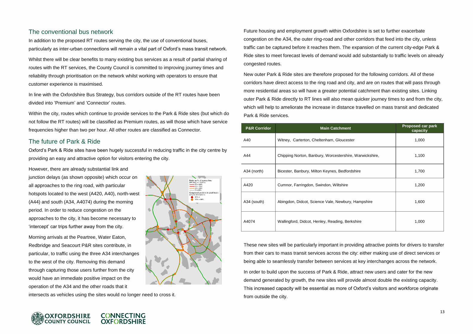
The future of Park & Ride
Oxford’s Park & Ride sites have been hugely successful in reducing traffic in the city centre by
providing an easy and attractive option for visitors entering the city.
However, there are already substantial link and
junction delays (as shown opposite) which occur on
all approaches to the ring road, with particular
hotspots located to the west (A420, A40), north-west
(A44) and south (A34, A4074) during the morning
period. In order to reduce congestion on the
approaches to the city, it has become necessary to
‘intercept’ car trips further away from the city.
Morning arrivals at the Peartree, Water Eaton,
Redbridge and Seacourt P&R sites contribute, in
particular, to traffic using the three A34 interchanges
to the west of the city. Removing this demand
through capturing those users further from the city
would have an immediate positive impact on the
operation of the A34 and the other roads that it
intersects as vehicles using the sites would no longer need to cross it.
Future housing and employment growth within Oxfordshire is set to further exacerbate
congestion on the A34, the outer ring-road and other corridors that feed into the city, unless
traffic can be captured before it reaches them. The expansion of the current city-edge Park &
Ride sites to meet forecast levels of demand would add substantially to traffic levels on already
congested routes.
New outer Park & Ride sites are therefore proposed for the following corridors. All of these
corridors have direct access to the ring road and city, and are on routes that will pass through
more residential areas so will have a greater potential catchment than existing sites. Linking
outer Park & Ride directly to RT lines will also mean quicker journey times to and from the city,
which will help to ameliorate the increase in distance travelled on mass transit and dedicated
Park & Ride services.
P&R Corridor Main Catchment Proposed car park
capacity
A40 Witney, Carterton, Cheltenham, Gloucester 1,000
A44 Chipping Norton, Banbury, Worcestershire, Warwickshire, 1,100
A34 (north) Bicester, Banbury, Milton Keynes, Bedfordshire 1,700
A420 Cumnor, Farringdon, Swindon, Wiltshire 1,200
A34 (south) Abingdon, Didcot, Science Vale, Newbury, Hampshire 1,600
A4074 Wallingford, Didcot, Henley, Reading, Berkshire 1,000
These new sites will be particularly important in providing attractive points for drivers to transfer
from their cars to mass transit services across the city: either making use of direct services or
being able to seamlessly transfer between services at key interchanges across the network.
In order to build upon the success of Park & Ride, attract new users and cater for the new
demand generated by growth, the new sites will provide almost double the existing capacity.
This increased capacity will be essential as more of Oxford’s visitors and workforce originate
from outside the city.

14
Facilities at the Park & Ride sites will fulfil the criteria required at high quality interchange hubs,
with the design and layout also enabling passing services to interchange seamlessly. Facilities
will need to include significant provision for those wishing to cycle for part of the journey,
whether that is from their point of origin to the bus service (Cycle & Ride), or from the Park &
Ride site to their destination (Park & Cycle).
The County Council has undertaken a study to understand the Park & Ride options available to
help meet the challenges in housing and jobs growth in Oxfordshire to 2031 and beyond. The
study assessed options for a new outer ring of Park & Ride sites and outlines a preferred
package of infrastructure requirements for the new sites, and potential phasing of when they
may come forward.
The future need at existing city-edge Park & Ride sites was considered as part of the study,
including whether these should be closed or reduced in size. The study concludes that
although there will be insufficient demand (based on weekday demand modelling) for inner
P&R sites to operate in their current form together with the proposed outer sites, further work is
needed to assess additional weekend and non-commuting travel demands in future, and to
consider alternative uses at existing P&R sites that allow them to be retained as transport
interchanges.
Given the need to reduce the amount of traffic approaching the city, and objectives to
encourage a greater share of travellers to use mass transit for their entire journey, expansion of
existing Park & Ride sites over the medium to long term is not supported. It is however
recognised that small scale expansion of some existing sites may be necessary on a temporary
interim basis as demand increases in the short term.
Supporting infrastructure
The classification of the road network will
be important to delivering the vision for
Rapid Transit, and in determining the
scope of infrastructural work that will need
to be implemented. Classifications need to
not just reflect the existing strategic value
of public transport on corridors throughout
the city, but also to recognise how future
demand will change and what the role of
each corridor is in enabling economic
growth.
Corridor prioritisation
RT and buses will be prioritised to enable
smooth, fast and reliable progress
through:
segregation (e.g. bus lanes);
selective vehicle detection and prioritisation at traffic signals;
traffic reduction;
traffic management (e.g. queue relocation); and
removal of obstacles such as loading and parking bays.
In turn, this will help to attract new users and, by reducing numbers of cars, will also help to
tackle congestion on these corridors.
For the RT lines in particular, the aim of the above measures will be to create a continuous
part-physical, part- virtual “track” for vehicles to make unimpeded progress. However, within
Mass transit corridor prioritisation
Rapid Transit lines
Full vehicle detection and prioritisation at traffic signals.
Dedicated or fully segregated lanes included where achievable.
Lanes extended to junction stop-lines.
Bus gates and access restrictions to reduce traffic levels.
Uncluttered low-traffic or traffic free streets in the city centre.
Strict kerbside controls and daytime loading bans.
Premium bus routes
Stricter kerbside control/ urban clearways.
Kerbside parking removed at pinch points.
Bus detection included at key junctions.
Bus lanes where achievable.
Connector bus routes
Some bus detection at signals.
Kerbside parking removed at pinch points.
Mass transit corridor classification
Rapid Transit lines
RT services will be prioritised through the application of the standard principles for Rapid Transit design. Services will be frequent, utilising higher-capacity and more advanced vehicles.
RT corridors are those which form the most strategic level network, connecting key destinations, business clusters and providing access for skilled employees and key markets.
RT corridors are those which have the highest levels of existing bus patronage or are expected to play critical roles in linking growth areas.
The interchange between standard bus services and modes of transport to allow ease of movement to all destinations will be a core element of a RT.
Premium Bus Route
Premium routes will be applied to corridors on which there are high levels of existing inter-urban or local patronage and which connect workers to employment destinations, and visitors to city centre.
Premium routes will interchange with RT at key destinations along their routes, providing users with an increased level of flexibility for how they complete their journeys.
Connector Bus Route
Connector routes will link local destinations within Oxford.
Service frequencies will be lower than on other routes.

15
the ring road, existing road space is at a premium along all corridors, particularly in the district
centres where speed of movement must be a secondary after the quality of place. In these
instances it will be necessary to have a greater emphasis on ensuring that public realm
provides excellent opportunities for stop and interchange facilities, and managing traffic,
loading and parking to minimise delays to mass transit
The level and type of prioritisation will therefore vary significantly by corridor. For example:
on the ring road and the approaches to the city, land is often available for widening to
include dedicated or segregated bus lanes, possibly including tidal bus lanes;
on Botley Road west of Binsey Lane there is sufficient highway land to provide a
continuous outbound bus lane whilst improving the quality of cycle infrastructure;
on Cowley Road, limited road width would be better allocated to improving the public
realm in the district centre and the prioritisation of buses will be provided by relocating or
rationalising kerbside parking and reducing traffic;
along much of the inner ring road, widening to provide segregation will not be an option;
instead, general traffic will be controlled through metering at traffic signals or restricted
through the implementation of access controls such as bus gates, and parking and
loading will be restricted.
along each corridor the potential to alter priority at junctions, include or improve bus
priority at traffic signals, and to extend bus lanes to stop lines will be assessed against
the related expense to general traffic.
Stops
Stops along the RT routes will be located and designed to create the best possible access and
environment for all users. Design features will include:
sufficient length to accommodate multiple services at once, and for higher capacity
multi-door vehicles in future which will enable free-flow boarding through multiple doors
and fixed, short dwell times at stops as at tram or light rail stops;
provision for level boarding - initially for existing low-floored vehicles but future proofed
to ensure that all boarding points on higher capacity vehicles are equally accessible;
off-board fare recognition;
real-time arrival and onward journey displays;
battery charging infrastructure for electric buses;
being safe and convenient, minimising conflict between those waiting and other road
users by allocating sufficient shelter capacity;
providing secure cycle parking at major stops, to enable Door to Door sustainable
journeys to be made (see Active & Healthy Travel Strategy), and
being inset from the main carriageway and offset to stops for services in the opposite
direction to minimise the opportunity for services blocking other vehicles.
Buses using RT corridors will also benefit from these facilities.
Corridor studies
Since the adoption of the OTS in September 2015, the county council has been working on a
number of corridor studies to develop further proposals for rapid transit, pedestrian and cycle
improvements on the city’s main transport corridors. The corridors considered so far are
Banbury Road, Woodstock Road and Botley Road, with further studies due to be completed in
2016/17.
Transit hubs
At strategic locations along the routes, such as the Park & Ride sites, rail stations and district
centres, high quality interchange hubs will facilitate seamless interchange between RT and
conventional bus services or onto an onward mode. Proposed hub locations are shown on the
network diagram on page 12. Whilst hubs will differ in scale from one location to another they
will offer all or most of the following elements:
waiting and off-board payment facilities will be well sheltered or enclosed;
accommodate high frequency services, and large flows of people, at peak times;
facilitate seamless, stress-free transfer across multiple modes of travel;
be situated in locations that are close to the strategic highway network, providing
maximum opportunity for park and ride and mode-shift from private car use;
maintain safe walk and cycle access by keeping people segregated from public
transport and vehicle movements;
have appropriate levels of convenient and secure cycle parking; and

16
become an integral part of the land-use mix to create vibrant centres of activity that
reduce ‘dead-time’ commonly associated with interchange between travel modes.
City centre
In the city centre, the key challenge is to cater for the forecast growth in conventional bus and
RT patronage over the next 20 years, whilst also improving the visitor experience. This requires
some radical thinking about how mass transit is accommodated, in terms of terminals, stops
and routeing.
In the short-term, it is possible that some conventional bus services could be rerouted away
from busy areas, including High Street, without impacting on service quality and access. This
may include services to south-east Oxford, which could be routed along Abingdon Road.
Further work is required with the bus operators to understand the potential for alternative
patterns of service and whether this would provide any additional capacity within the city
centre.
Similarly, further consideration of how longer distance scheduled coaches are routed and how
the access the city centre is required, including services to London and the airports. Options
may include relocating these to outer terminals and/or routing services through different parts
of the city.
Tourist coaches are important in bringing large numbers of visitors to the city throughout the
year but they can also cause congestion and other access issues with informal set down and
pick up in the city centre. With growing numbers of tourists coming to the city and with
increased restriction on vehicle access to the city centre proposed (see later discussion), more
suitable and adequate arrangements to set down and pick up passengers will be required. In
addition, the provision of adequate long stay off street coach parking is required. The
temporary relocation of long stay coach parking to Redbridge Park & Ride since the closure of
the Oxpens coach park, will be evaluated;the Redbridge area may be appropriate for a more
permanent solution. Other city-edge Park & Ride sites may also be appropriate.
The proposals for transit terminals in the city centre build up in phases (detailed in the table
and plans overleaf).
These will act as the termini for many of the existing services which currently require access
and layover facilities in the central core. Increasing the overall capacity of off-highway terminal
points, initially by developing surface level sites, will enable a better operating and passenger
environment and reduce conflicts with other road users in busy city centre streets.
The measures identified for 2020 and 2025 will lead to a significant reduction in the number of
buses in several key city centre streets. However, even with the 2025 proposals in place three
issues remain: very intensive mass transit operation in High Street and St Aldate’s; the
ambition for mass transit to have direct access through the city centre (only possible via the
pedestrianised Cornmarket Street and proposed pedestrianised Queen Street); and walking
distances between transit terminals and destinations (such as those experienced due to the
pedestrianisation of Cornmarket Street).
Phasing of city centre bus terminals and access
Terminal 2020 2025 2035
Oxford Rail station
The continued use of the
existing stops and stands in
the station forecourt and
Frideswide Square prior to the
completion of the Oxford
Station Masterplan
Relocated bus facility to the south
of Botley Road to include 13
stands on site and a further 5 on
Becket Street.
Continued operation of station
interchange, linked to transit
tunnel stop(s) nearby
Gloucester Green
Refurbishment of the existing
facility to improve passenger
experience and operation
Complete refurbishment and
expansion of the site to increase
the capacity make better use of
space including passenger
facilities
Closure of the bus facility and the
opportunity to redevelopment the
site. All stops relocated to transit
tunnels nearby.
Speedwell Street
Continued use and extension
of existing bus stands at the
Butterwyke Turn.
Closure of the on-street stands
and change of use of an identified
development site on Speedwell
Street such as the Telephone
Exchange.
Transit tunnels - - Terminals and stops within the
tunnels for the majority of services
Access
2020 2025 2035
Queen Street and George
Street closed to buses.
Magdalen Street, Park End Street,
New Road, Castle Street and
Norfolk Street closed to buses.
Services will route through Hythe
Bridge Street and Oxpens Rd/
Thames St/ Speedwell Street with
the benefit of traffic restrictions.
Majority of bus services in the city
centre will operate within the
tunnels, with limited surface
running only.

17
A potential longer-term option to address the challenges of providing increased capacity for
buses and RT within the city centre and preserving whilst also enhancing the centre’s historic
character, would be to tunnel beneath it, thereby removing the majority of the mass transit
operation from street level. New ‘stations’ would be constructed underground, close to the main
attractions in the city centre. RT and bus services could run with ease directly across the city
centre, without being impeded by other road users or using indirect routes. Interchanges
between north-south and east-west routes would be provided, solving several issues faced by
passengers and operators in the existing situation.
Whilst the construction cost would be very high (benchmarked costs for similar schemes
suggest a capital cost in excess of £500 million), the resulting positive impacts on the public
realm, conservation, safety and accessibility would be substantial.
A growing number of cities around the world are looking to this type of a solution as an
innovative and bold approach to reconciling what can be conflicting demands for space within
their centres. Examples include the North American cities of Boston and Seattle (which has a
tunnel and an underground terminal for both light rail and bus services) and Perth in Australia.
The technical or environmental feasibility of constructing transit tunnels has not yet been
considered in detail. Clearly, there would be very substantial construction works (and
construction risks) and environmental
impacts. Within the central core, parts of
commercial properties may need to be
purchased to allow for street-level
entrances to the tunnel stations.
Any business case for such a proposal
would need to consider the benefits to
passengers and reduced operating costs
for the service operator(s). Innovative
sources of financing would also need to
be considered, including financing of
borrowing costs through departure charges for all services (such as those often used to pay for
maintenance or renewal of bus stations).
Vehicle technology
As the resident and workforce populations of the city grow, there will be additional impetus on
providing capacity for passengers. To meet this challenge on the RT routes, it is proposed to
cater for the additional demand whilst mitigating the impacts of additional vehicles on the
network. Vehicles on the RT Lines will be:
higher capacity than existing buses;
capable of allowing free-flow boarding and alighting from multiple entrance points;
fitted with on-board technology to facilitate fare recognition; and
fully accessible from all stops along routes.

18
As bus-based RT becomes a standard convention in the provision of mass transit in cities,
technology is improving to provide high-capacity, zero-emission vehicles. A fleet of vehicles
(similar in style to the articulated Citea recently introduced in Cologne (pictured) are envisaged
to provide short/medium distance trips along all RT lines.
Through the application of a Traffic Regulation Condition, Oxford city centre is already a Low
Emission Zone and operators have made great efforts in delivering vehicles which met Euro V
emission standards, and are working on introducing even cleaner technologies in the near
future.
However, the ambition of the OTS is to start a city centre zero-emission zone for all vehicles by
2020, with the zone being gradually expanded over time as the required infrastructure and
technology develops. This will support objectives to improve air quality and targets to reduce
emissions from vehicles. Further private sector investment from operators on all routes will be
required, not just the short to medium range services, and be achieved through the deployment
of electric buses, advanced electric-diesel hybrid vehicles with an electric drive mode for
emission-free operation in built up areas, and routeing changes as outlined above.
As battery and induction charging
technology improves, vehicles will be able
to cross the whole city whilst on full
electric power, enabling the creation of a
city-wide zero-emission zone by 2035.
Vehicles which cannot comply with
specific emission standards will be
required to terminate at Park & Ride sites
outside of the city.
Smart mobility
The Science Transit Strategy is leading initiatives for public and private sector partnership in
the county to deliver cutting edge Smart Mobility Information in the form of digital data sources
that will be:
relevant to different user contexts and journey purposes at all journey stages;
available via multiple sources (web, smartphone app, digital TV);
updated in real-time, to provide the latest insights and intelligence; and
capable of providing comparative travel time and cost information for an individual’s
options.
For those without access to personalised digital data sources, all information will be linked to
displays at stops, hubs and on-board services.

19
Implementation
Phasing of capital investment
Future evolution of operator partnerships
From providing direct services from the Park & Ride initiative in the 1970s, the signing of a
voluntary Quality Bus Partnership in 2006 to provide a policy framework for improvements to
routes and corridors, to the creation of the city centre Low Emission Zone through the
introduction of a Traffic Regulation Condition, and a Qualifying Agreement to coordinate bus
timetables signed in 2011; OCC has a long tradition of working in partnership with bus
operators. This has been a key element in achieving a significant level of bus patronage
amongst residents and visitors of the city.
The Bus Strategy, completed in tandem with LTP4, proposes the continuation of this
partnership working, in association with the operators and with particular focus within Oxford
being on ensuring a quality of service and establishing the principles of RT operation:
o Greater time-based and geographic coverage of bus services based on evidence
of when and where people want to travel;
o Punctuality and reliability improvements through identifying the source of delays
to bus services and jointly developing evidence-based solutions;
o Operation on busy radials and within the city centre to be managed through
techniques such as Departure Slot Booking;
o Commercially appropriate consolidation and joint operation of services to further
reduce the number of buses entering the city centre;
o Further availability of inter-operator (and multi-modal) smart payment building on
the work in Oxford;
o Quality, capacity and environmental performance of vehicles; and;
o Interchange with other modes such as rail services and facilities for improving
onward journeys by foot and bicycle and for those will mobility impairments.

20
Walking and cycling are healthy, sustainable and enjoyable ways to travel and they are also
extremely efficient forms of movement over short distances in terms of road space and impact
on the highway network. Oxford is already one of the leading UK cities in terms of mode share
of walking and cycling, however the ambition is to continue enhancing this position. To do so
will require influencing further mode shift through encouraging and enabling people to walk
and cycle by making their journeys easier, safer and more cost and time efficient in comparison
to other modes.
The existing situation
A significant proportion of trips
within Oxford are made on foot
or by bicycle - 50% of commuter
trips made by residents of the
city. Investment in the transport
network, including local public
realm and cycle schemes, has
contributed to a 30% increase in
walking and cycling to work by
residents in the city between 2001 and 2011. Oxford now has one of the highest mode shares
for walking and cycling when compared to other local authorities (see graph of 2011 Census
data) with similar sized workforces, and is of a similar maturity to many inner London
authorities. Walking and cycling are also the favoured modes of the 30,000 full time students in
the city.
Limitations of the current network
Given the size of the city (with no two points within the ring road being more than 11 km apart),
Oxford should be able to challenge Cambridge as the city with the highest proportion of
residents walking or cycling to work.
In consultation for the OTS, cycling interest groups have suggested the biggest barriers to
further improving the cycling mode share are related to the lack of high quality routes which
provide continuous facilities, conforming to a specific standard. The piecemeal, location
specific approach is seen as discouraging new, inexperienced and safety-concerned cyclists
from choosing to cycle as a preferred mode of transport.
Public realm improvements and pedestrian route enhancements have been made, particularly
in the city centre and district centres. However, there is much more to do to make walking in
Oxford a better experience. Further details of our plans for walking can be found in the Active &
Healthy Travel section of LTP4.
The severance of walking and cycling routes is also a common issue at the edges of the city.
As Oxford has expanded to include significant residential and workplace populations on the
outside of the ring road, the dominance of motor vehicles in the transport hierarchy at junctions
has not been challenged. With the committed developments at Northern Gateway and Barton
Park likely to be added to in future, the issue of severance caused by the ring road will become
even more critical, even for short journeys between homes and workplaces.
Future demand
Walking is a key element of Oxford’s economy. A pleasant walking environment encourages
users to spend time in city centres and contribute to the economy. The main commercial
streets within the city centre already experience very high footfalls. In peak hours, Queen
Street has an hourly footfall of between 3,000 and 4,000 – comparable to that of the wider and
fully pedestrianised Cornmarket. Elsewhere in the centre, Broad Street and High Street can
see footfalls of up to 2,300 people per hour at peak times.
The redevelopment of the Westgate Centre is expected to result in a 54% increase in retail
space in the entire city centre and an increase in visitors to the Westgate Centre from 5 million
to 16 million per year.
Were travel to work patterns to remain as they are now, over 5,500 new two-way commuter
trips would be made by walking or cycling as the main mode each day within the city. It is also
expected that they will feature as the critical modes for onward journeys for the additional 5,400
commuters arriving by bus or train.
4. Walking and Cycling

21
Vision for walking & cycling
By 2035 Oxford will be a world-class cycling city that will be accessible to everyone, regardless
of age, background or cycling experience.
Walking in the city will be a pleasant, comfortable experience, with an outstanding public realm
in the city centre and district centres.
Cycling, walking and Door to Door travel (e.g. combining walking or cycling with bus/rail) will be
at the heart of continued and sustainable growth and contribute to a higher quality of life for its
residents and workers while maintaining its visitor appeal as a world renowned city of culture
and history. More details of our plans for active travel can be found in the Active & Healthy
Travel Strategy section.
Enhancing the cycle network
Cycle route enhancements are needed to provide safe and direct access to employment,
educational and commercial destinations, but also to extend coverage across residential areas.
Achieving this will require a combination of high quality routes providing access to key
destinations, better cycle parking and other measures which make cycling easier and more
attractive for short and medium-distance trips.
We propose a network based on a hierarchy of Cycle Super Routes and Premium Routes
(shown in the figure opposite) and Connector Routes linking major origins and destinations. As
with mass transit, particularly improvements are needed in the Eastern Arc, where 69% of
journeys to work are 5km or less, but only 44% of trips (made by Eastern Arc residents within
the city) are made by walking or cycling. The routes shown represent corridors - where
possible, the actual route will follow the main road highlighted, but in some cases a direct
parallel alternative may be necessary or more desirable.
Particular priorities for cycle route improvements are:
Links to the city centre, especially radial routes;
Orbital routes in the Eastern Arc; and
Links to and between Northern Gateway and Oxford Parkway.
Whilst it would be desirable to provide Cycle Super Routes on all major routes in the city, this is
not likely to be possible on all corridors, particularly where Rapid Transit facilities are proposed
(e.g. Banbury Road), or where there are busy shopping areas (e.g. Cowley Road). In these
cases a Cycle Super Route will be provided on a near-to-parallel alternative if possible (in the
above cases, on Woodstock Road and Iffley Road).

22
Those corridors considered appropriate for classification as Cycle Super Routes are:
The B4495 from Summertown in the north through to Abingdon Road in the south;
Woodstock Road and through the Science Area;
Abingdon Road;
Marston Road;
Iffley Road;
Botley Road; and
Routes within the city centre.
Other routes may be added to this list, but based on known constraints and the need to provide
RT infrastructure in other corridors this is considered a realistic starting point.
This long-term blueprint for cycling in Oxford can be implemented on a phased basis.
Measures will be designed to enable them to be enhanced to accommodate a significant
increase in future levels of cycling in the city.
Route treatment
The constraints of narrow roads, mature trees and street furniture are a challenge to providing
continuous fully segregated cycle lanes or paths on most of the roads in the city. In many
cases where full segregation is feasible, those schemes have already been implemented, albeit
that in some cases improvements are still required to those schemes to bring them up to a
higher standard. Where possible, every effort will be made to provide a similar level of
segregation, however in most instances the most achievable (and best) form of high quality
cycle provision on Cycle Super and Premium Routes will be on the carriageway.
In all cases, the reallocation of road space must consider other roads users and the built
environment, but providing cycle lanes - whether mandatory, semi-segregated or advisory - will
enable a far greater degree of continuity and uniform design than seen at present. As detailed
in the cycle corridor classification table, on-street lanes will be designed to an absolute
minimum width of 1.5 metre, with a recommended width of 2 metres on Cycle Super Routes.
To achieve these widths it will often be necessary to undertake reallocation measures such as
removing on-street parking, reducing footways to a minimum 1.8 metre width (in areas with a
low footfall) and removing road centre lines.
To improve safety for cyclists, when placed into shared lanes with buses and RT vehicles, lane
widths of 4 metres to 4.5 metres will be provided unless total road widths do not allow this. In
the longer-term, it may be justified in some areas for cycle facilities to replace bus lanes.
Oxford already has a good network of recommended quiet routes for cyclists but a lack of
signage and wayfinding information means they can be difficult to find or navigate. Essential to
the success of the network will be improvements to those roads and paths which serve the
purpose of connecting Super and Premium cycle routes to homes, workplaces and services
which do not fall on the main corridors. In most cases it will not be necessary to provide any
physical infrastructure beyond navigational aids, however work will be undertaken to provide
Cycle corridor classification
Cycle Super Route As a minimum requirement, there will be a high level of continuous and uniform provision for
cyclists travelling in both directions;
On some corridors, cyclists will share wide bus lanes in at least one direction;
Complete or semi-segregation will be provided wherever possible (otherwise mandatory cycle lane markings will be used);
Cycle lanes will be designed for a minimum width of 1.5m; however 2m will be considered the default width for the busiest sections;
Advanced Stop Lines, already present at many signalised junctions in Oxford, will be the default standard and will include 1.5m feed-in lanes. Cycle lanes will continue through junctions to reaffirm the position of the cyclist in the view of other road users;
Loading and parking bans or timed restrictions will be in place and enforced during peak times or throughout the day;
Where segregation is not possible or desirable (e.g. parts of the city centre or the narrow part of Hollow Way) , traffic levels and speeds will be reduced to create shared-use low or traffic free streets.
Premium Route Premium routes will also provide cyclists with uniform cycle lane provision in both directions.
However these are likely to be shared with bus lanes, and will in many cases be standard width;
Dedicated cycle lanes will be mandatory in places and should continue through junctions to reaffirm priority;
As a minimum requirement, premium routes will be free from obstruction;
Advanced Stop Lines will have at least some form of feed-in lane;
In future development sites, design guidance for internal roads should meet the premium route criteria.
Connector Routes Connector routes will be strategic quiet ways with a particular role in connecting Cycle Super
Routes and Premium Routes to residential areas;
It will not always be possible or necessary to provide a continuous physical features on a connector route because of the need to balance road space for other users, however clear and consistent signage will be present along the routes and will be accompanied by wayfinding totems at decision points;
One-way streets will, where possible, be upgraded to include marked or segregated contraflow cycle lanes.
Cycle network classification
23
contraflow cycle facilities on one-way streets, and will progress opportunities to create
additional crossings between the eastern and western halves of the city such as the Jackdaw
Lane Bridge.
Oxford’s waterways are an important part of the cycle and pedestrian network across the city,
providing traffic free, and some cases, more direct alternatives to on road routes. Funding has
already been secured to improve the Thames towpath and other connecting routes to the west
and south east of the city centre. Further opportunities will be taken to further enhance
waterway routes, including opportunities to provide a new cycle and pedestrian path as part of
the proposed Western Conveyance Channel in the city.
Oxonbike Cycle Hire Scheme
Since 2013, Oxford has had a cycle hire scheme. Initially funded by the Government’s Local
Sustainable Travel Fund and managed by Oxfordshire County Council, the scheme originally
linked Thornhill Park and Ride site with major employment destinations in Headington.
Currently managed by a partnership, led by Oxford University, it has now expanded to other
parts of the city and has the potential to increase cycling throughout the city. More details of
Oxonbike can be found in the Active & Healthy Travel section
Corridor studies
Since the adoption of the OTS in September 2015, the county council has been working on a
number of corridor studies to develop further proposals for rapid transit, pedestrian and cycle
improvements on the city’s main transport corridors. The corridors considered so far are
Banbury Road, Woodstock Road and Botley Road, with further studies due to be completed in
2016/17.
Junction treatment
In the 5 years between 2009 and 2014, 75% of all cycle casualties occurring within Oxford as a
result of traffic collisions, took place at or within 20m of a junction. Whilst improving the
continuity of the network will encourage more people to take up cycling, without improvements
to junction safety the casualty rate at junctions is likely to rise as flows increase.
A central concept of the Oxford Cycle Strategy is therefore to address key junctions with
segregation, priority or safer treatments for cyclists.
Many of the signalised junctions within the city have had Advanced Stop-Lines (ASLs) added in
recent years to provide priority for cyclists. It is proposed that these are added to the remaining
junctions, or to new signalised junctions as standard. In all instances cycle lanes should be
continuous providing a feed-in lane to the ASL. Where necessary this will require narrowing or
reducing vehicle lanes on the approaches to junctions. Other, innovative treatments such as
pre-signals for cyclist, two-stage right-turns, or cycle bypass-tracks will be considered in
improving safety at large signalised junctions.
A significant barrier to cycling to and from the communities and workplaces outside of the ring-
road is the lack of sufficient safe crossing opportunities. To reduce the severance caused by
the ring-road, crossings, both at street-level or grade-separated will be provided. The
signalisation plans for the Wolvercote and Cutteslowe roundabouts include toucan crossings
for this purpose, for example. A crossing of the A40 east of Headington roundabout (linking
Barton and Risinghurst) is also proposed, linked to future capacity improvements and bus
priority measures at Headington roundabout and on the A40.
Cycle lanes on Super or Premium cycle routes will be continued through junctions,
emphasising cyclists’ priority at side road junctions. Side road entry treatments with raised
tables and reduced corner radii to reduce vehicle speeds will further improve safety. On the
Connector network, contraflow routes will be designed with physical protection for cyclists at
entry points.
Cycle parking and signage
A significant increase in cycle use will require a substantial increase in secure cycle parking
provision. The demand for cycle parking in the city and district centres considerably exceeds
the formal provision in places and, at present, there is very little opportunity for substantial on-
street expansion in the locations where it is needed most. Public realm schemes, which include
rationalisation of on-street vehicle parking such as those for St Giles and Broad Street, will
provide opportunities for increasing cycle parking. However they are still unlikely to meet
demand as street level space is still scarce.
Throughout the city, innovative short-term approaches such as renting commercial premises
and conversion to cycle parking facilities will provide additional parking supply, however these
are likely to be expensive due to the limited supply of sites at the very centre of the city.
A longer term solution to providing significant quantities of cycle parking will be to provide
underground or basement cycle hubs. The underground cycle park in Tokyo provides an

24
example of how additional cycle parking spaces can be provided in a crowded city.
Opportunities to locate one or more in the city centre will be explored. The Oxford Station
masterplan includes 1200 spaces within two such facilities on either side of Botley Road.
Another example, which could be delivered in the short to medium term, is the conversion of
the existing Gloucester Green underground car park to a dedicated cycle hub. These could
become commercially operated cycle hubs which are run in partnership with private operators,
providing bike hire and bike maintenance facilities.
Signing to all primary and secondary destinations will be provided throughout the city. This will
be comprehensive and immediately recognisable along whole routes, and as a minimum each
sign will show Destination, Direction and Distance. Further information such as named or
branded routes, and whether a route is lit or unlit could also be provided. In conservation areas
signing will need to be sensitive to the surroundings, whereas on busier routes, such as Super
or Premium cycle routes, advanced and at junction signing will be required to enable cyclists to
adopt the correct road position. Consideration will also be given to the use of road markings
and other measures to avoid sign clutter. We will also seek to promote and enable Door to
Door travel by providing cycle parking at popular bus hubs and increasing cycle parking at rail
stations in the city.
Encouraging walking
Walking is the most sustainable travel option: it is feasible for the vast majority of the
population, it is relatively quick for short distances, and it is a practical way of introducing
physical activity into day-to-day life. Walking is already popular for many journeys in Oxford,
particularly for relatively short distance journeys to work; approximately 25% of journeys to
work for people who both live and work in the city are made on foot. However, 39% (over
17,500 trips) of all journeys to work within the city are under 2km in length, suggesting an
opportunity to improve the mode share.
The key challenge is to improve the quality of the walking experience in the city – not just for
existing pedestrians, but also to encourage more people to walk as a logical choice for short
trips in the city.
As part of the proposed mass transit and cycle enhancements, pedestrian improvements will
be implemented. There is a clear opportunity for local walking networks to integrate with the
city-wide cycling network, to ensure a coherent approach to the roles of walking and cycling on
quiet streets, and ensuring that pedestrians and cyclists can co-exist in the busier corridors,
sharing space where appropriate.
There is also a clear role for public realm improvements to be integrated with measures to
improve access on foot and transit stops and interchange hubs. The mass transit programme
should, in particular, be considered as an important opportunity to improve public realm and
simplify the local streetscape in Cowley, Headington and the Cowley Road. Public realm
improvements should be integrated into multi-modal access improvements in the centres of
Cowley and Headington, to improve pedestrian footfall, promote local shopping and stimulate
local regeneration.
There is a need for major improvements to public realm and ‘sense of place’ in the city centre.
In the short term, the pedestrianisation of George Street and Queen Street, as well as public
realm improvements to St Giles, Magdalen Street and Frideswide Square will greatly improve
the quality of public place within the city centre. By 2025, the establishment of the city
periphery transit terminals and traffic control measures will allow Park End Street, New Road,
Castle Street and Norfolk Street to become an extension of the low trafficked central core and
will provide an almost uninterrupted walking route from the station to the centre. In the longer
term, the ambitions for shifting bus movements underground will allow for more radical public
realm improvements on High Street and St Aldates where opportunities are currently limited
due to their key role as the only access to the centre from the east.
The walking improvements can be implemented on a phased basis, building on the
interventions that have already been identified. The reduction in traffic in the city centre and,
over the longer term, transformation of mass transit will enable an ambitious approach to
walking and public realm improvements. Additionally, further improvements will be made to
pedestrian crossing points within the centre (especially where side streets meet larger roads),
with particular emphasis on improving safety and convenience.
Technology
Journey planning information for walking and cycling, and the benefits to health and the
environment will be prioritised within the future intelligent mobility technology which is being
progressed as part of the Science Transit project. This will include real-time comparative
information for trips made by walking or cycling against other modes.
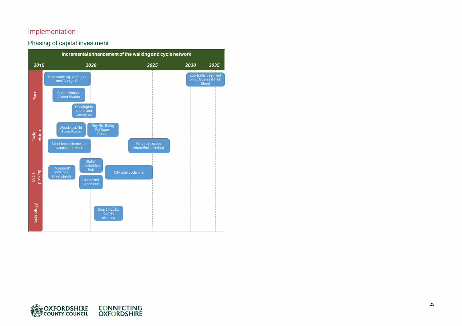
25
Implementation
Phasing of capital investment
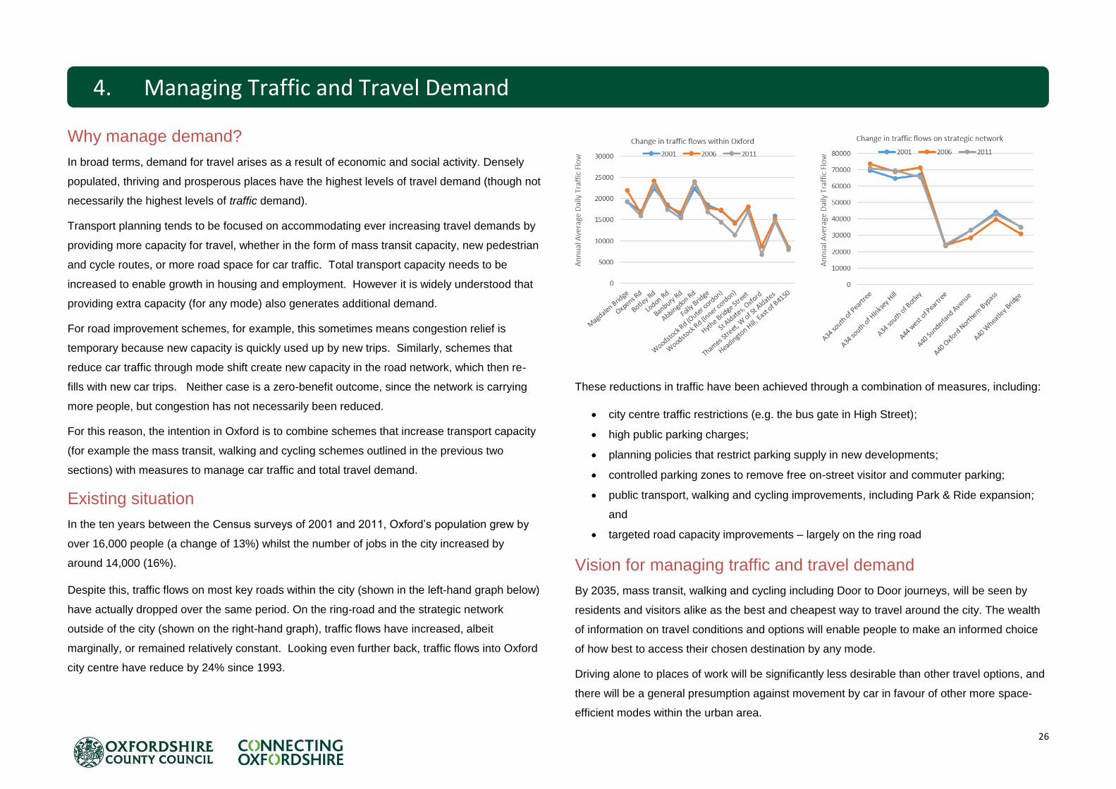
26
Why manage demand?
In broad terms, demand for travel arises as a result of economic and social activity. Densely
populated, thriving and prosperous places have the highest levels of travel demand (though not
necessarily the highest levels of traffic demand).
Transport planning tends to be focused on accommodating ever increasing travel demands by
providing more capacity for travel, whether in the form of mass transit capacity, new pedestrian
and cycle routes, or more road space for car traffic. Total transport capacity needs to be
increased to enable growth in housing and employment. However it is widely understood that
providing extra capacity (for any mode) also generates additional demand.
For road improvement schemes, for example, this sometimes means congestion relief is
temporary because new capacity is quickly used up by new trips. Similarly, schemes that
reduce car traffic through mode shift create new capacity in the road network, which then re-
fills with new car trips. Neither case is a zero-benefit outcome, since the network is carrying
more people, but congestion has not necessarily been reduced.
For this reason, the intention in Oxford is to combine schemes that increase transport capacity
(for example the mass transit, walking and cycling schemes outlined in the previous two
sections) with measures to manage car traffic and total travel demand.
Existing situation
In the ten years between the Census surveys of 2001 and 2011, Oxford’s population grew by
over 16,000 people (a change of 13%) whilst the number of jobs in the city increased by
around 14,000 (16%).
Despite this, traffic flows on most key roads within the city (shown in the left-hand graph below)
have actually dropped over the same period. On the ring-road and the strategic network
outside of the city (shown on the right-hand graph), traffic flows have increased, albeit
marginally, or remained relatively constant. Looking even further back, traffic flows into Oxford
city centre have reduce by 24% since 1993.
These reductions in traffic have been achieved through a combination of measures, including:
city centre traffic restrictions (e.g. the bus gate in High Street);
high public parking charges;
planning policies that restrict parking supply in new developments;
controlled parking zones to remove free on-street visitor and commuter parking;
public transport, walking and cycling improvements, including Park & Ride expansion;
and
targeted road capacity improvements – largely on the ring road
Vision for managing traffic and travel demand
By 2035, mass transit, walking and cycling including Door to Door journeys, will be seen by
residents and visitors alike as the best and cheapest way to travel around the city. The wealth
of information on travel conditions and options will enable people to make an informed choice
of how best to access their chosen destination by any mode.
Driving alone to places of work will be significantly less desirable than other travel options, and
there will be a general presumption against movement by car in favour of other more space-
efficient modes within the urban area.
4. Managing Traffic and Travel Demand

27
Learning from Oxford’s past successes, this will be achieved through a combination of
charging, traffic restrictions, planning policies, and targeted capacity improvements. Current
and emerging network management and journey planning technology will also be used.
Future demand for travel
Despite the relatively stable level of traffic flow since 2001, the Department for Transport
forecasts that the number of vehicle trips in Oxford during the peak hours will increase by 37%
between 2011 and 2035 (taken from the National Trip End Model forecast which is based on
the development growth outlined in the Local Plans).
Were travel to work patterns to remain as they are now, over 13,000 new two-way commuter
trips with an origin or destination within the city would be made by car as a result of the SHMA
related housing growth by 2035 (an increase of 27% against 2011).
With existing levels of congestion in and around the city already resulting in significant delays,
any increase in traffic, let alone at the levels predicted above, will present serious challenges to
enabling economic growth in Oxford.
Highway capacity improvements
The implementation of access restrictions in the city centre and Eastern Arc and reallocation of
road space to other modes will support the goals and objectives of the LTP4 and the OTS by
providing networks of sustainable travel options. This fundamental principle relies on the
general presumption against travel by car within the urban area.
However, it is acknowledged that access by car is still a necessity in a dynamic city, and the
outer ring road will be promoted as the primary route for all short-distance car trips.
The outer ring road will be increasingly important for cross-city movements because the OTS
proposes to reallocate road space and introduce traffic restrictions on some of the roads within
the city to enable mass transit, walking and cycling improvements,
The existing policy of improving the key ring road interchanges is consistent with the proposal
to remove trips from the ‘inner ring road’ (the B4495) and other inner city routes. This will be
continued in the short-term with the schemes at Cutteslowe and Wolvercote Roundabouts;
whilst longer term plans at the A34 Botley and Peartree interchanges are being considered by
Highways England, along with Intelligent Transport Systems (ITS) such as Variable Message
Signs and variable speed limits to be applied along the A34 corridor. The proposed ring road
improvements are shown on the plan opposite.

28
A direct highway link from Oxford’s northern bypass to the John Radcliffe Hospital is
considered inappropriate as environmental and planning constraints mean any solution is likely
to be prohibitively expensive. There is also concern that it would merely shift existing traffic and
environmental problems elsewhere. Reducing traffic on roads that serve the hospitals by
providing a step-change in mass transit and improved walking and cycling routes, and through
implementation of demand management measures, will improve access to all the hospital sites
for all users.
Workplace parking
Whilst the package of OTS measures already examined will contribute to an increase in the
share of trips made by non-car modes, the abundance of free workplace parking within the city
is a significant threat to achieving the step-change required to avoid the considerable negative
impacts of growth. The 2011 Census indicates that over 39,000 employees within the city use
the private car as their main mode of travel to work, with a quarter being residents of the city. In
common with most other towns and cities, parking charges levied by the local authorities in
Oxford currently target public parking – i.e. on-street parking and parking in public car parks.
This has been a useful tool in managing traffic, but given that a) there are many times more
workplace parking spaces in the city than public parking spaces and b) car trips to workplace
parking spaces are generally made at peak times, there would be clear benefits in being able
to influence the use of these spaces.
An Oxford workplace parking levy
In order to gain much needed control over the use of the private car as a means of travelling to
work within Oxford it is proposed, subject to further work and consultation, that a city-wide
Workplace parking levy (WPL) is introduced.
It is believed that a WPL would have three significant benefits for the city, which will be critical
to ensure growth is not limited by the constraints of traffic related congestion:
shift to use sustainable modes – as those staff who have parking charges passed down
by their employer will be incentivised to seek alternative methods of getting to work.
funds generated through the application of a WPL would be ring-fenced solely for the
reinvestment into the transport network (including operation of the WPL), improving
alternatives to the private car and thus further influencing mode choice; and
a charge will encourage employers to reduce their supply of private parking; saving the
employer money spent on maintenance but also presenting the opportunity to redevelop
land previously used for parking for employment or housing.
A similar overall approach to that used in Nottingham is proposed, but will need to be adapted
for Oxford and its employers. With minimal exceptions, the levy would apply to all employers
with a provision of employee parking over a certain threshold. Whilst the OTS proposes that
the whole city is subject to a WPL, differential rates will be examined across the city – for
example with a premium rate in the city centre and rates elsewhere which are dependent on
the level of accessibility by sustainable modes.
Controlled parking zones
Growth in the city, coupled with demand management measures – in particular WPL – will
mean further expansion of Controlled Parking Zones (CPZs) is required in the city to ensure
that parking is not just displaced to residential streets. Large parts of the city are already
covered by CPZs and where these have been implemented they have been extremely
successful in removing commuter parking. Further work will be required to understand where
additional CPZs are needed along with consultation with local residents. Over time is likely that
the majority of streets in the city will be covered by parking restrictions.
In some areas of the city, it will be necessary to restrict the number of permits issued to
existing properties and new developments to ensure parking pressure from residential parking
is managed.
Spaces will be provided in controlled parking zones and other areas for car clubs and electric
cars and car club vehicles, subject to local consultation.
Traffic control points
The implementation of the five city centre bus gates in 1999 marked a considerable
improvement in the control of traffic volumes within the city centre. During peak hours, vehicles
passing directly through the city centre only account for 15% to 20% of all trips entering the
area, with the majority of people accessing workplace, education or retail destinations. Most
users of the road network therefore already expect to use orbital traffic routes further out: either
the B4495 route through the Eastern Arc connecting Summertown with Abingdon Road, or the
A34/A40/A4144 ring road as the means of moving around the city.

29
Reducing city centre through trips
The ambition of maximising the city centre’s value as a shopping and tourist destination
depends on being able to vastly improve the public realm for pedestrians. There is also a risk
that a WPL could, by reducing traffic into the city centre, release capacity which would be filled
by through traffic. Therefore, it is proposed that traffic levels are reduced in the longer term by
placing further restrictions on through traffic (whilst allowing unimpeded bus movements) by
implementing access controls. These restriction points could be full or part-time closures –
similar to the existing bus gates – or road user charging points (see below). A permit based
system for those requiring access (residents, blue badge holders etc) will also be investigated.
These locations are shown on the map on the previous page and described below:
On Thames Street – allowing access to Westgate from the south or west only but
preventing or discouraging any through trips.
In the vicinity of Worcester Street or Frideswide Square – thus preventing or
discouraging trips from west to north but maintaining access close to the Oxford Rail
station; and
On St Cross Road, preventing or discouraging traffic from using the Science Area as a
city centre ring road.
Inner ring road
To provide the necessary service journey time improvement for RT Line 3, it will be necessary
to reduce the impact of congestion caused by high vehicle flows on the B4995. This will be
achieved in part through junction improvements and priorities, as described in the mass transit
section. In addition, traffic restrictions in the form of access restrictions (e.g. bus gates) or
charging points will be used to redistribute traffic to the outer-ring road. Two measures already
identified include:
A timed access restriction (e.g. bus gate) or road user charging point, on Hollow Way
Turning restrictions onto Banbury Road from Marston Ferry Road.
Road user charging
Road user charging could also be a potential option for reducing traffic levels on certain routes
without a complete closure. This could be implemented in conjunction with a WPL (with some
examples of where this could be applied listed above).
Despite the successful implementation of the London (2003) Congestion Charge schemes, no
other UK city has since implemented a similar scheme, and there are relatively few examples
in other European countries. This can be attributed to a lack of political will, but also as such
schemes require large capital investment costs for the infrastructure, payment mechanisms
and back-office equipment as well as significant operating costs - the 21km2 London CC zone
cost over £200 million to implement and requires an operating budget of £120 million per year.
Charging only for use of very specific “premium” road links in the city centre and Eastern Arc,
would enable start-up and operating costs to be minimised. Nevertheless, a road user charge
is unlikely to raise significant revenue and is best seen as a network and traffic management
tool rather than a means of generating funding for transport improvements.
Public parking
Public parking in Oxford is already very limited compared to other cities, particularly in the city
centre. In 2013, Oxford city centre had 1,670 public off-street car parking spaces, compared to
3300 in Cambridge city centre and 5,200 in the centre of Reading. Despite this, city centre
spaces are rarely fully occupied, though this is likely to change once the Westgate Centre is
redeveloped. Oxford’s economy, including the retail and leisure sectors, is not heavily
dependent on people driving into the city centre, largely because the Park & Ride, bus, walking
and cycling networks provide convenient alternatives.
In the district centres, which are less well served by alternative modes, public parking is
important to maintain the vitality of shops and services located close to residential areas.
City centre parking
In the city centre, levels of public parking will be maintained at approximately the same levels
as in 2014, albeit reorganised to make better use of land. Specific measures include:
consolidation of public parking into fewer locations, predominantly underground (e.g.
new Westgate car park), with existing surface car parks redeveloped for other uses and
on-street parking rationalised as part of public realm improvements (for example, St
Giles and Broad Street);
all parking to meet high standards of security and design to provide a welcoming
experience;
charges to encourage the efficient use of parking capacity throughout the day and year
– no half-empty car parks – and to discourage arrivals during network peaks;
30
charges should discourage or prevent long stay or commuter parking;
consider discounts for full cars (4 + occupants);
provide easy-to-use payment options, linked to retail/leisure discounts or other
incentives to encourage off-peak arrivals;
provide live parking space information from journey origin to parking space via journey
planner, apps, web, electronic signs, GPS devices and in car-park systems;
all public car park exits to be signal controlled with generous internal queuing space to
allow controlled discharge of traffic onto the road network; and
all car parks to provide for electric vehicle charging.
District centres
For district centres, the County Council’s approach is to:
Support the vitality of district centres (which offer local amenities in sustainable locations
close to residential areas) by maintaining a modest level of attractive, low cost and
easily accessible short stay parking;
Maintain current levels of public parking in all district centres, except Cowley primary
district centre which currently has substantial over-provision occupying land which could
be redeveloped for other uses;
Deck or build above car parks to make efficient use of land;
Discourage or prevent commuter or long stay use through pricing or fines.
Zone-based parking charges
It is proposed that a zonal parking charge system is adopted across the city, including Park &
Ride car parks. Classification of charging zones will be based partly on their level of
accessibility by other modes, so may change as and when the other OTS measures (such as a
RT or cycle super route connection) are introduced. The zonal system will be designed to
encourage alternatives, in priority order:
Parking charges will therefore be lowest at outer Park & Ride sites, but are unlikely to be free
because a) this could create an incentive to use Park & Ride even when another alternative is
available and b) the operators of Park & Ride car parks will need to cover their costs.
Freight/ deliveries
Demand forecasting for 2031 indicates that around 2,500 HGV trips will be made to, from and
within the city between 8am and 6pm per day, over a third of which would occur during the
morning peak hour. To reduce the impact of freight on congestion, noise and air quality, the
following measures will be developed:
delivery & Servicing Plans;
construction Logistics Plans;
out of hours deliveries;
freight will be expected to comply with increasing emissions requirements.
local consolidation points; and
freight consolidation centres for business, retail and construction.
Role of taxis
Taxis and private hire vehicles will continue to be an important part of Oxford’s integrated
transport network; perhaps even more so as further traffic controls and restrictions reduce the
attractiveness of the private car as a means of accessing the city centre. As the nature of the
city centre streetscape changes, with more streets becoming access only or closed to vehicles
at certain times, so will route management for taxis.
Given the importance of taxis throughout the city, it will be vital to ensure that a high level of
interchange is provided with the proposed RT routes at Park & Ride and major hubs, plus also
at Oxford and Oxford Parkway stations.
As part of the objective for a zero-emission Oxford city centre by 2020 (and city-wide by 2035),
taxi operators are being encouraged by Oxford City Council to invest in electric vehicles for
their fleets. Oxfordshire County Council will work in partnership with taxi and private hire
business to ensure that designs for RT transit hubs, Park & Ride sites, and other council run
public locations with taxi stands will have facilities for electric vehicle charging.
(City edge) (Outer)

31
Development management policy
Oxford City Council is preparing a new Local Plan, which is due to be adopted by 2019. The
county council will work closely with the city council to ensure the new Local Plan supports the
delivery of the OTS and vice-versa.
The evolution of policy will have a critical role to play in delivering growth without adding
unnecessary traffic.
Parking standards throughout the city will be seen as an absolute maximum, which are to be
applied only in exceptional circumstances, where accessibility by other modes is relatively
poor. Low-car and car-free developments will be encouraged, particularly in areas with very
good accessibility by non-car modes. Effective on-street parking controls are required in the
areas surrounding low-car and car-free developments to ensure parking does not merely shift
off site, and such developments will be required to contribute to the cost of introducing such
controls where necessary.
In planning new development, there is increasing evidence that neighbourhood design –
including housing density and layout of routes for public transport, walking and cycling – is a
strong influence on use of these modes by residents. Traditional densely populated areas
have lower overall travel demand and car ownership and higher use of sustainable modes than
newer suburban developments.
In addition the strategy will need to “nudge” people towards travelling less or choosing
sustainable modes, by promoting neighbourhood design that is based on research and best
practice from other cities. Developers of homes and workplaces will also be required to apply vastly
enhanced requirements to provide access and facilities for cyclists. Any new commercial operation will
be required to adhere to standards for the management of logistics.
Access to Parking on Public Highway for New Developments and Change of Use Developments
The county council will seek to restrict access to parking on the public highway for new developments
and change of use developments, such as Houses in Multiple Occupation (HMOs), to protect existing
residents' access to parking and reduce parking demand in Oxford.
Should the development rely on parking on the public highway, the county council will require the
following to be submitted with any planning application:
1. Scale and type of development;
2. The likely parking demand associated with the proposed development;
3. Sustainability of location / accessibility to sustainable transport modes and to amenities
4. Capacity for on-street parking in the vicinity of the site and surrounding area (this should
demonstrated by the applicant through an on-street parking survey, details of which must be
agreed with transport development control officers); and
5. The level of vehicular parking proposed on-site.
Taking the above into consideration, the county council may seek to exclude developments from
eligibility to parking permits if the site is located within a Controlled Parking Zone. Should the
development be located outside a Controlled Parking Zone or within a Controlled Parking Zone which
operates for only part of the day, the above consideration could result in the county council
recommending refusal of the development should it rely on parking on the public highway.
The role of the OTS in planning new development
A new Oxford Local Plan is being prepared, for submission in 2018. This will determine the
number and locations of new homes within the city to 2036.
Following the publication of the Strategic Housing Market Assessment for Oxfordshire, the
Oxfordshire councils have agreed a working assumption of 15,000 homes as the scale of
Oxford’s unmet need to be planned for outside the city.
The OTS has defined the optimum corridors for RT and cycle networks, extensions of which
should help to influence decisions about where future housing should be located.
To the south of the city, RT Lines 1 & 3 will provide a fast, high capacity transit service directly
into the City Centre and Eastern Arc, with both having potential to be extended towards
Abingdon and south of Grenoble Road. The future role for passenger services using the
Cowley Branch Line is particularly relevant here, with the potential for a rail spur to link to a
development south of Grenoble Road.
Similarly, to the north of Oxford, RT Lines 1 & 3 route through Kidlington and Eynsham,
opening up large areas with access to a direct RT service to Oxford city centre and growth
areas in the Eastern Arc.

32
5. Implementation of the OTS
Implementation
Phasing of capital investment – see overleaf
The cost of improvement
The OTS calls for a step change in transport investment within Oxford to preserve the vitality of
one of the most important centres to the economy of the South East. Investment needs to
33
reflect the scale of change needed to achieve the city’s vision for growth, but equally must be
achievable with a recognition of the need to deliver the best value for money from constrained
resources. This consideration is implicit with the principle of the incremental development of
mass transit, where networks will be developed on the basis of allowing for future expansion as
needed, not precluding this through fixed and inflexible infrastructure or technologies. Should
demand in future necessitate greater segregation, the potential cost should be considered now.
Detailed costing will be determined through more in-depth studies into the measures identified
within this strategy. However, initial estimates suggest that the implementation of the OTS will
require a total capital investment (including funded schemes) of around £1.2 billion. When
factored against the level of growth expected within the county in the next 20 years, this
equates to an investment of approximately £14,000 per additional job and home.
Approximately half of this figure would be required to fund the city centre transit tunnels alone
(which will require the most significant shift in the way transport infrastructure is currently
funded). The remaining c£600m of capital investment would represent an annual investment of
£30 million per year over the next 20 years, roughly double the County Council’s current annual
spend on transport infrastructure in Oxford.
The next steps
The transport improvements detailed within the OTS sets out a framework for progressive
transformation of the transport network within the city by 2035. However, many of the more
ambitious schemes will be developed incrementally, as and when the need for them to mitigate
for the planned growth is established, and when funding is secured.
The County Council’s 2 and 5 year capital investment programmes will see us deliver the
schemes for which committed funding has been secured, including utilising the £93 million City
Deal and Oxfordshire Growth Deal investments; developer funds and Community Infrastructure
Levy funding, and local authority funds. The design, consultation and implementation of many
of these short-term schemes are already underway.
The OTS provides a framework and context for future funding bids. Each corridor contains a
combination of interconnected transit, cycle, place and demand management elements. In
many cases, schemes will be developed and implemented on a whole corridor – rather than
mode-specific – basis.
The County Council has therefore begun to develop specific corridor studies for Botley Road,
and separately, the Woodstock Road and Banbury Road corridors. These studies will identify
schemes that combine concept proposals for Rapid Transit, pedestrian, cycle and public realm
improvements in order to deliver ambitions set out in the OTS. These studies will form the
basis of future funding bids.
The OTS has introduced the County Council’s ambitions for several high-profile schemes
which will enable radical changes in how people move around the city. At present, schemes
such as zero-emission RT and the Workplace Parking Levy are in the feasibility stage, and in
the next year work will be undertaken to develop the optimum solutions and funding
programmes through collaborative working with public transport operators, major employers
and other stakeholders.
We will look to utilise Oxford’s position as a home to a truly world-class research and
development sector to work with the university, college and science sectors to help take the
strategy forward, including the innovative Smart Mobility and technology proposals identified
under the County Council’s Science Transit Strategy.
Crucially, in light of the substantial potential housing and job growth within Oxford and the
wider county, the County Council will work closely with the City Council and district planning
authorities to implement the principles and infrastructure of the OTS.
Funding the OTS
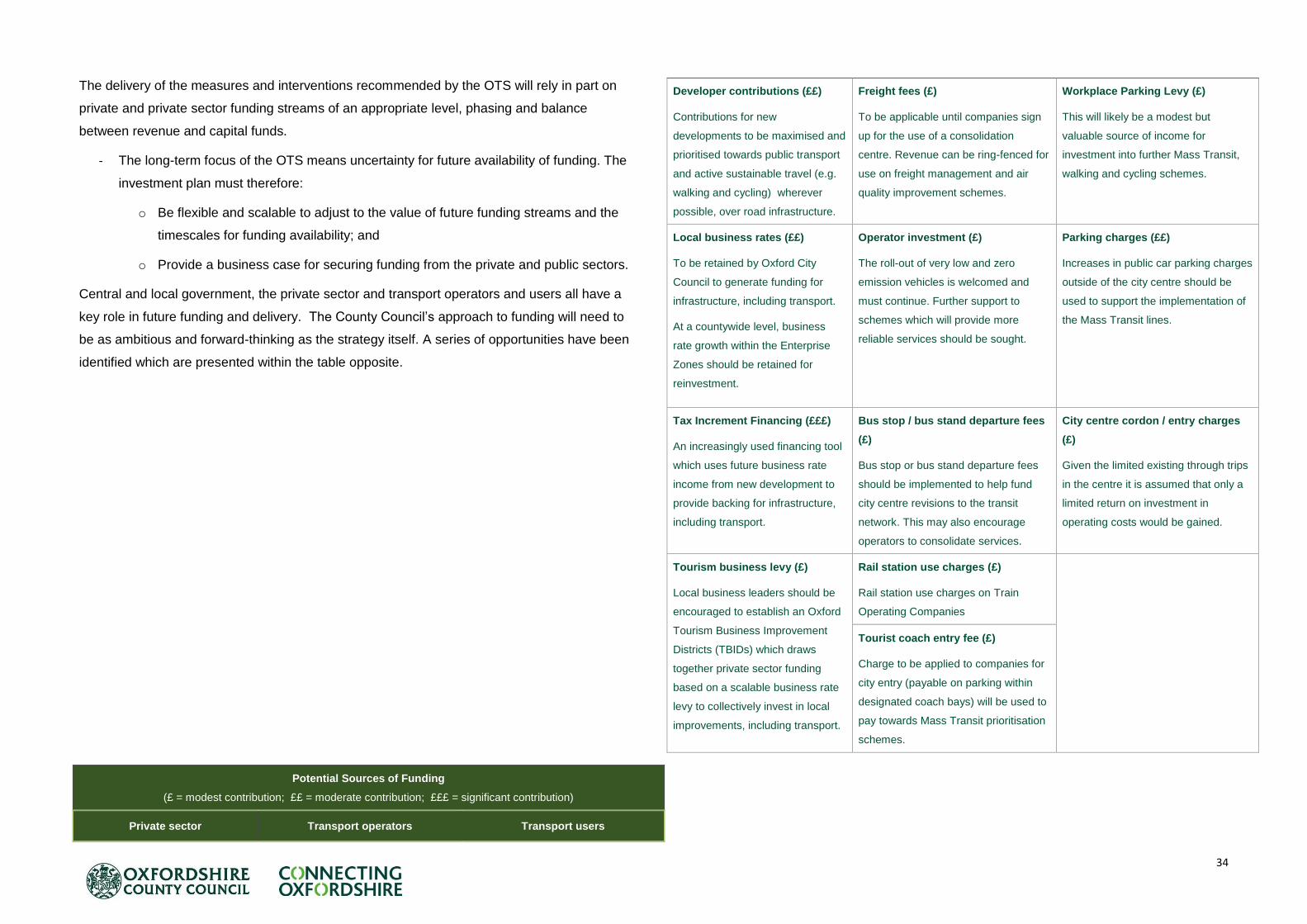
34
The delivery of the measures and interventions recommended by the OTS will rely in part on
private and private sector funding streams of an appropriate level, phasing and balance
between revenue and capital funds.
- The long-term focus of the OTS means uncertainty for future availability of funding. The
investment plan must therefore:
o Be flexible and scalable to adjust to the value of future funding streams and the
timescales for funding availability; and
o Provide a business case for securing funding from the private and public sectors.
Central and local government, the private sector and transport operators and users all have a
key role in future funding and delivery. The County Council’s approach to funding will need to
be as ambitious and forward-thinking as the strategy itself. A series of opportunities have been
identified which are presented within the table opposite.
Potential Sources of Funding
(£ = modest contribution; ££ = moderate contribution; £££ = significant contribution)
Private sector Transport operators Transport users
Developer contributions (££)
Contributions for new
developments to be maximised and
prioritised towards public transport
and active sustainable travel (e.g.
walking and cycling) wherever
possible, over road infrastructure.
Freight fees (£)
To be applicable until companies sign
up for the use of a consolidation
centre. Revenue can be ring-fenced for
use on freight management and air
quality improvement schemes.
Workplace Parking Levy (£)
This will likely be a modest but
valuable source of income for
investment into further Mass Transit,
walking and cycling schemes.
Local business rates (££)
To be retained by Oxford City
Council to generate funding for
infrastructure, including transport.
At a countywide level, business
rate growth within the Enterprise
Zones should be retained for
reinvestment.
Operator investment (£)
The roll-out of very low and zero
emission vehicles is welcomed and
must continue. Further support to
schemes which will provide more
reliable services should be sought.
Parking charges (££)
Increases in public car parking charges
outside of the city centre should be
used to support the implementation of
the Mass Transit lines.
Tax Increment Financing (£££)
An increasingly used financing tool
which uses future business rate
income from new development to
provide backing for infrastructure,
including transport.
Bus stop / bus stand departure fees
(£)
Bus stop or bus stand departure fees
should be implemented to help fund
city centre revisions to the transit
network. This may also encourage
operators to consolidate services.
City centre cordon / entry charges
(£)
Given the limited existing through trips
in the centre it is assumed that only a
limited return on investment in
operating costs would be gained.
Tourism business levy (£)
Local business leaders should be
encouraged to establish an Oxford
Tourism Business Improvement
Districts (TBIDs) which draws
together private sector funding
based on a scalable business rate
levy to collectively invest in local
improvements, including transport.
Rail station use charges (£)
Rail station use charges on Train
Operating Companies
Tourist coach entry fee (£)
Charge to be applied to companies for
city entry (payable on parking within
designated coach bays) will be used to
pay towards Mass Transit prioritisation
schemes.