Embed Size (px)
Citation preview
Further Regulation of the
Great Lakes
INTERNATIONAL JOINT COMMISSION

Further Regulation of the
Great Lakes
INTERNATIONAL JOINT COMMISSION CANADA AND UNITED STATES
1976

INTERNATIONAL JOINT COMMISSION CANADA AND UNITED STATES
COMMISSIONERS
MAXWELL COHEN, Chairman HENRY P. SMITH 111, Chairman BERNARD BEAUPR~:. CHARLES R. Ross
KEITH A. HENRY VICTOR L. SMITH
FORMER COMMISSIONERS WHO PARTICIPATED IN THE INQUIRY
EUGENE W. WEBER A. D. P. HEENEY D. M. STEVENS MATTHEW A. WELSH
A. D. SCOTT LOUIS J. ROBICHAUD RENB DUPUIS CHRISTIAN A. HERTER, JR.
ADVISERS
J. LLOYD MACCALLUM JOHN F. HENDRICKSON MURRAY W. THOMPSON STEWART H. FONDA, JR.
RICHARD M. BENNETT JAMES G. CHANDLER
SECRETARIES
DAVID G. CHANCE WILLIAM A. BULLARD
... I l l
Further Regulation of the Great Lakes
This report of the International Joint Commission is in response to a Reference from the Governments of Canada and the United States. It describes the Great Lakes Basin, explains the natural fluctuation of the lake levels and examines the effect of man’s interventions including the regulation of Lake Superior and Lake Ontario. The report briefly describes the technical investigation carried out for the Commis- sion by its International Great Lakes Levels Board between 1964 and 1974 and summarizes the testimony given at the twenty-two public hearings conducted by the Commission. Finally, the report outlines the essence of the Commission’s delibera- tions based on the investigations and hearings and presents its conclusions, declara- tions and recommendations.
V

Table of Contents
Chapter
I
I I
111
IV
V
V I
VI1
VI11
IX
SUMMARY . . . . . . . . . . . . . . . . . . . . . . . . . . . . . . . . . . . . . . . . . . . . . . . . . . . . . . . . . . . . . . . . . . . . . . . . . . . . . . . . . . . . . . . . . .
INTRODUCTION .............................................................................. Nature of the Problem .............................................................. Scope of the Inquiry ..................................................................
THE GREAT LAKES BASIN ..........................................................
NATURAL FLUCTUATION OF LAKE LEVELS ......................
Hydraulics of the Great Lakes ................................................ Hydrology of the Great Lakes ................................................ Fluctuations Due to Storms .................................................... Other Natural Fluctuations ....................................................
The Great Lakes System ..........................................................
MAN'S INTERVENTIONS .............................................................. Dredging .................................................................................... Diversions .................................................................................. Consumptive Use ...................................................................... Navigation Season Extension .................................................. Weather Modification ..............................................................
PRESENT REGULATION .............................................................. Lake Superior Regulation ........................................................ Lake Ontario Regulation ..........................................................
CHRONOLOGY OF EVENTS ........................................................
THE TECHNICAL INVESTIGATION .......................................... Organrzatlon .............................................................................. Considerations and Constraints ..............................................
. .
Method of Evaluating Lake Regulation Plans ...................... Development of Regulation Plans ............................................ Evaluation of Regulation Plans ..............................................
PUBLIC HEARINGS ........................................................................
The 1973 Hearings .................................................................... The 1974 Hearings .................................................................... Summation ................................................................................
The 1965 Hearings ....................................................................
vii
Page
1
5 5 6
7
11 11 12 13 15 15
21 21 22 23 23 23
25 25 28
33
37 37 37 38 40 41
49 49 51 52 5 5
Chapter Page
X THE COMMISSION’S CONSIDERATIONS AND CONCLUSIONS . . . . . . . . . . . . . . . . . . . . . . . . . . . . . . . . . . . . . . . . . . . . . . . . . . . . . . . . . . . . . . . . . . . . 57
Causes of Lake Level Fluctuation ....................................... 57 Possibility of Further Regulation .......................................... 58 Further Considerations ........................................................ 62
X I RECOMMENDATIONS . . . . . . . . . . . . . . . . . . . . . . . . . . . . . . . . . . . . . . . . . . . . . . . . 65
Appendices
A
B
C
D
E
F
G
H
I
J
Test of Reference . . . . . . . . . . . . . . . . . . . . . . . . . . . . . . . . . . . . . . . . . . . . . . . . . . . . . . . . .
Membership of the International Great Lakes Levels Board and its Committees ....................................................................................
Agencies Participating in the Investigation .....................................
Persons Presenting Briefs or Testimony at IJC Public Hearings ....
Text of Emergency Application .....................................................
Orders of Approval for Regulation of Lake Superior ........................
Orders of Approval for Regulation of Lake Ontario ......................
Exchange of Notes Relating to Early Development of the Great Lakes-St . Lawrence River Basin Project and Article I11 of the Niagara Treaty of 1950 .....................................................................
Decree Regarding Chicago Diversion ...............................................
Correspondence Regarding Further Studies ....................................
67
69
71
73
77
79
83
89
91
95
List of Figures
Figure
1 Great Lakes Basin .............................................................. Frontispiece
2 Great Lakes Data . . . . . . . . . . . . . . . . . . . . . . . . . . . . . . . . . . . . . . . . . . . . . . . . . . . . . . . . . . . . . . . . . . . . . . . 8
3 Hydrologic Factors Affecting Water Supplies to each of the Great Lakes . . . . . . . . . . . . . . . . . . . . . . . . . . . . . . . . . . . . . . . . . . . . . . . . . . . . . . . . . . . . . . . . . . . . . . . . . . . . . . . . . . . . . . . . . . . . . . . 14
4 Monthly Mean Water Levels of the Great Lakes
5 Monthly Mean Water Levels of the Great Lakes
... V l l l
1860-1917 . . . . . . . . 16
1918-1975 .......... 17
Figure
6
7
8
9
I O
1 1
12
13
Page
Storm Effects on Water Levels .......................................................... 18
Lake Superior Outlet . . . . . . . . . . . . . . . . . . . . . . . . . . . . . . . . . . . . . . . . . . . . . . . . . . . . . . . . . . . . . . . . . . . . . 26
Regulation of Lake Superior ................................................................ 27
International Section of the St . Lawrence River ................................ 29
Regulation of Lake Ontario .............................................................. 31
Lake Huron Outlet .............................................................................. 42
Sketch of Typical Regulatory Structure for St . Clair and Detroit Rivers . . . . . . . . . . . . . . . . . . . . . . . . . . . . . . . . . . . . . . . . . . . . . . . . . . . . . . . . . . . . . . . . . . . . . . . . . . . . . . . . . . . . . . . . . . . . . . . . . . . 43
Lake Erie Outlet .................................................................................... 45
List of Tables
Table
1 Monthly Net Basin Supplies 15
2 Effect of Artificial Factors on Water Levels ...................................... 21
3 Average Annual Economic Benefits of Plan SO-901 ........................ 46
4 Summary of Average Annual Benefits and Costs of Regulation Plans . . . . . . . . . . . . . . . . . . . . . . . . . . . . . . . . . . . . . . . . . . . . . . . . . . . . . . . . . . . . . . . . . . . . . . . . . . . . . . . . . . . . . . . . . . . . . . . . . . . . . . 47
5 Hydrologic Evaluation of Regulation Plans ...................................... 48
i x

Chapter I
Man’s activities in the Great Lakes Basin haccommodated to the fluctuations of the Grewater levels and their outflows. To make this dation easier, man has, for the last one hundrefifty years, endeavoured to bend the natural systemwhat he conceives to be his own advantageinterests of the dwellers in the Great Lakes not all the same. A homeowner on the waterfSt. Clair shores with water on his front lawhard put to understand the unwillingness oowner on Whitefish Bay in Lake Superior to slightly higher levels on his beach in order trelief to the Lake St. Clair man. A recreational boon Lake Erie may well curse the low water lerestrict the use of his boat, but those same levels provide expansive beaches for the enjobathers.
The proper balancing of benefits and detrimmade easier by the political division of the tween two sovereign nations, and the further division of the United States’ shoreline among eightstates.
The interests of the United States and Canawhole matter of water level control, are inextmingled and ad-hoc solutions to specific locaor particular advantageous developments oresources have become less and less successcontext of a total gain for the Basin.
The Great Lakes and their Connecting Chanbeen the key to the development of the hearNorth America offering transportation and pacting as a receptacle for wastes. The Basin isof a rich industrial empire producing one-thirdda’s and one-sixth of the United States’ nationThe economy of the Basin is basically Mining, agriculture, and forestry also contribeconomy. The attraction of sport fishing water-related recreational activities adds greatlydrawing power of the area, both for the inhathe Basin and for tourists from both countries.
A deep-draft waterway accessible to ofreighters reaching into the middle of the conaccelerated development of the Basin. The
SUMMARY
ave to be at Lakes
accommo- d and
to . But the Basin are
ront of the n may be f a resort
have o provide ater
vels which low water yment of
ents is not Basin be-
political
da, in the ricably l problems f natural ful in the
nels have tland of ower, and
the cradle of Cana- al income. industrial. ute to the and other to the
bitants of cean-going tinent has relatively
constant large flows of water through the Connecting Channels has made the hydro-electric developments at Niagara and the St. Lawrence among the world’s most efficient producers of electrical energy. Both countries are presently reviewing the possibilities of developing additional fossil-fueled and nuclear power generating complexes in the Basin which would take advantage of the availability of large quantities of cooling water.
In October 1964 the Governments of Canada and the United States, in response to low water conditions, referred the problem of fluctuations of the levels of all of the Great Lakes to the International Joint Commission. They requested the Commission to determine whether further regulation of the levels of the Great Lakes would be in the public interest of both countries.
The Commission appointed the International Great Lakes Levels Board, a panel of experts, to carry out the technical investigations. It also consulted the various agencies involved and held initial public hearings in 1965 to ascertain the views of concerned interests.
The International Great Lakes Levels Board in 1965 established working committees to carry out the techni- cal studies. The committees were charged with deter- mining whether the causes of lake level fluctuations were natural or man-made and also the effect of these level and flow fluctuations on the major interests. These interests include shore property, both private and public; fish, wildlife, and recreation; boating and navigation; and hydro-electric power production.
Methodologies were developed to estimate the effects of varying degrees of regulation on shoreline properties, the environment, navigation, and power. It was recog- nized that these interventions would have effects other than those readily quantifiable on an economic basis, such as the impact on the total ecology, on the aesthetic attractions, and on the social wellbeing of all the resi- dents of the Basin.
A wide array of possible regulation plans was exam- ined. These ranged from doing nothing to mobilizing all man’s technological skill and a vast amount of both countries’ construction resources to achieve complete control of the levels and flows in all the Great Lakes.
I
The Commission in 1968 furnished an interim report to the two Governments outlining progress of the inqui- ry . At the end of 1969 the Board presented the Commis- sion with detailed proposals for completing the study, which after lengthy discussion and some modification, were approved. These were carried out and the Board’s report was finally submitted to the Commission i n 1974.
I n 1973 record high water supplies to all of the Great Lakes except Superior exceeded anything previously recorded. At the special request of the Government of the United States, and the expressed concern of the Government of Canada, the Commission undertook to modify the method of regulation of Lake Superior in view of these unprecedented conditions and commenced to set outflows designed to provide relief for the Lower Great Lakes ,while maintaining satisfactory conditions on Lake Superior. At the same time it asked the Inter- national Great Lakes Levels Board for a report on the effects of continuing this policy. The Board in an interim report dated March 1973 stated that such a policy could bc carried out to the general public benefit. Public hearings on the interim report were held and in June 1973 the Commission transmitted a special report to the two Governments containing a recommendation that the previous policy of regulating Lake Superior to improve conditions on that lake and benefit power pro- duction be modified to a policy of regulating Lake Superior to achieve the optimum relief for all people on the shorelines of the Great Lakes with the least possible detriment to the people on Lake Superior.
Throughout this period of record high supplies, Lake Ontario was rlegulated in accordance with the Commis- sion’s Order of Approval to provide all possible relief to riparian owners on Lake Ontario and downstream on the St. Lawrence ]River.
The Board’s main report on its findings and conclu- sions was submitted to the Commission in March 1974, although not all of the supporting appendices were available until October 1974. The Commission distribut- ed these documents. During the last three months of 1974 it held thirteen public hearings to ascertain the public’s reacti’on to the findings of the Board’s study. At the hearing i n Cleveland the United States Corps of Engineers submitted a further proposal for the regula- tion of Lake Erie. This proposal awaits the result of additional studies.
The Commission, throughout 1975, deliberated on the evidence presented in the Board’s highly competent and comprehensive study, at the public hearings, and from additional sources. Based on this, the Commission has prepared the report contained in the following chapters.
In summary, the Commission has determined that the Great Lakes and their surrounding drainage area are one closely interrelated system. The total drainage area is 300,000 square miles and the five Great Lakes, Supe- rior, Huron, Michigan, Erie, and Ontario, cover 95,000 square miles. I n an average year the system pours out over fifty cubic miles of water through the St. Lawrence River. The annual precipitation averages thirty-two inches over the period of record and on the average there
is only a sllgnt variation trom month to month in the seasonal cycle. On the other hand, the annual precipita- tion has varied over twelve inches from low to high and the record discloses periods of several consecutive years of excessive or deficient water supplies. In addition the actual precipitation may vary by a factor of two or three from month to month.
The vast surface area of the Great Lakes combined with the natural restrictions of the Connecting Channels makes it possible for the Great Lakes System to cope with huge water supply variations while maintaining water level fluctuations of one to two feet in any one year. Moreover, depending on which lake one considers, the maximum range of water level fluctuations has only been four to seven feet in the 115 years since man has been recording them.
Levels in the Great Lakes have always fluctuated under the influence of natural forces. Over a period of hours, winds and differences in barometric pressure can tilt the surface of a lake until the elevation at one end is twelve feet higher than at the other. Persistent low precipitation, such as that in the mid-1960’s can lower levels by two to three feet, while a high precipitation period, such as the one experienced in the early 1970’s, can raise levels by a like amount. An unfortunate combi- nation of these variations may result in such disastrous experiences as occurred in the spring of 1973 when, with extremely high levels on the lakes, storms raised huge waves that caused damage to hundreds of miles of shoreline. On the other hand, pleasure craft owners and marina operators, as well as commercial shipping, can be severely handicapped when continued low precipita- tion, such as occurred in the early 1960’s, drops levels below those contemplated by designers of docks and channels from Duluth to Montrkal.
Nevertheless, it is essential to remember that the natural configuration of the Lakes and Connecting Channels does regulate the variations produced by cli- matic changes to about two feet in any year and to seven feet in recorded history. This is a markedly different picture to that of many North American coastal har- bours where tides rise and fall twenty feet twice a day or to rivers like the Missouri, Mississippi, or Columbia where annual cycles may cause a change of thirty feet.
Man’s earliest intervention in the Great Lakes, begin- ning in the early 19th century, was construction to improve the use of the outflow rivers for transportation. By 1921 control of outflows from Lake Superior was achieved. In the early 1900’s part of the potential power available at Niagara was harnessed. In the 1950’s the St. Lawrence Power Project was constructed along with the St. Lawrence Seawav. The dams and dredging pro- vide control of the outflows from Lake Ontario and the opportunity to regulate these outflows for the benefit of riparian owners and water users.
Throughout the past century a number of other less obvious, but nonetheless real, interventions in the natu- ral regime have been made by both Canada and the United States. At Chicago water has been diverted to the Mississippi system for sanitary purposes and trans-
2
portation. At Niagara water is used to operate the Welland Canal and, to a lesser extent, the New York State Barge Canal. In the early 1940’s Ontario Hydro constructed works to divert water from the Hudson Bay watershed through the Ogoki and Long Lac projects to Lake Superior. Dredging was carried out in the St. Clair and Detroit Rivers to improve navigation. All these interventions by man affect the water level regime of the Great Lakes System to some extent.
At the present time only the levels of Lake Superior and Lake Ontario are directly controlled by the works of man. The prescribed regulation plan for Lake Superior is such that the level regime is not greatly different from natural conditions. Due to critical water levels on Lakes Michigan and f-luron i n 1972-73, the Lake Superior operating plan was modified in 1973 to reduce outflows i n order to lower the levels on those lakes without causing undue damage on Lake Superior. On the other hand, a complex international Joint Commission operat- ing plan for Lake Ontario, made possible by enlarge- ment of the channel in the international Rapids Section of the St. Lawrence River and construction of suitable control works, has substantially reduced the range of levels of that Lake.
In summary, the international Joint Commission con- cludes that the fluctuations of the lakes are natural phenomena which have to date been only slightly modi- fied by man’s intervention, except insofar as Lake Ontario is concerned where considerable reduction in range of water levels has been achieved. The natural regulation effect of the lakes is very efficient and only limited further improvements can be achieved at accept- able environmental and financial costs.
With this assessment of the present conditions i n the Great Lakes, the Commission considered the further regulation of levels and flows. The Board evaluated many plans for regulation of levels in Lakes Michigan- Huron and Lake Erie. Their evaluation of these plans, in which the Commission concurs, indicates that, for the present a t least, complete control of all the lakes would not produce benefits commensurate with the high costs involved.
Regulation of Lake Michigan and Lake Huron by construction of works in the St. Clair and Detroit Rivers is much too expensive to warrant further consideration at this time. it also involves a major detriment to the ecology of the area. Further regulation possibilities in
Lake Erie will have to be considered i n the light of environmental effects, giving full weight to diversions into and out of the Basin and remembering that a rational examination of this possibility requircs con- sideration of the effect of such regulation downstream.
Notwithstanding the Commission’s opinion that con- struction of control works is not an acceptable answer to problems at the present time, the Commission has deter- mined that easily accomplished improvements for regu- lating Lake Superior would yield a small net benefit to the basin-wide system and should be continued. The Basin’s hydrological network should be improved to assist in lake level forecasting and to optimize the operational procedures.
There is already a degree of management of Great Lakes levels and flows inherent in the regulation of Lake Superior and Lake Ontario. Some management is de- veloping with respect to protection of the environment and of fisheries and more will be required to improve the Lakes to the quality desired. This emerging perception of parallelism between regulation of flows and levels and environmental management suggests that there is a new context within which to understand and plan for the optimum use of the entire Great Lakes Basin.
The Commission has concluded that within this new context and because of the interrelation of the Great Lakes and the bi-national nature of the problems, it is time to base the regulation of levels and flows on the concept of basin-wide benefits.
I n the opinion of the Commission, it is necessary to seek answers to the large problem of living in harmony with the Great Lakes. There are limits to the shaping of nature to man’s general benefit as he perceives it, and as he calculates the costs of structural solutions as well as the amount of environmental impact deemed acceptable. Environmental and economic constraints, however, may change over time and therefore periodic reassessments of the need for and desirability of further regulation of the Great Lakes will have to be made as the future dictates.
Finally, the Great Lakes are viewed by the Commis- sion as a massive ecological and economic centrepiece for the whole mid-continent, affecting its industry, its agriculture, its total lifestyle and character, and must be seen therefore as a whole, as a bi-national treasure and as a bi-national responsibility.
3

Chapter I1
INTRODUCTION
The Great Lakes, their Connecting Channels and the St. Lawrence River have been the key to the develop- ment of the industrial heartland of North America. The Great Lakes System has provided economical and effi- cient transportation, low cost hydro-electric power and a receptacle for municipal and industrial wastes. The Basin supports 29 million people in the United States and 6 million in Canada.
The Nature of the Problem Because the Great Lakes offer aesthetic attractions in
addition to power and transportation, many settlements have developed on the banks of the rivers and on the shorelines of the lakes over the years. For a number of reasons many of these communities have failed to com- prehend the threat inherent in the uncontrollable and unpredictable natural forces that dictate the behaviour of the Great Lakes System.
The levels of the Great Lakes are never constant. Wind and changes in precipitation cause large varia- tions. Since man cannot influence these natural forces, he must live in harmony with them. A better and more detailed understanding of the natural factors that con- trol the levels of the Great Lakes and the flows of their Connecting Channels is needed so that all can recognize the limitations of man’s interventions.
The high degree of natural regulation that exists in the Great Lakes has created undue reliance on a stable regime of water levels and has dulled the realization that the vagaries of nature, such as storms, flood and drought, will cause the levels to fluctuate. Since the irregular changes from extreme low to extreme high lake levels occur over a period seldom less than a decade, and often longer, it is not easy for the shoreline owner, with little knowledge of historic flucteation, to recognize the changes that will inevitably occur in the future. There is unfortunately a tendency among individuals and governmental agencies to ignore or forget published records.
Those interests affected by the inevitable variations in the levels of the Great Lakes fall into four general
5
categories: shore property, fish and wildlife, navigation and hydro-electric power. Shore property interests include port facilities, marinas, recreational develop- ments, home and cottage properties, industry and municipal facilities. Shore property interests would gen- erally benefit most by the stabilization of water levels and a reduction of the extremes of both high and low levels. Navigation is best served by higher lake levels while hydro-electric power interests prefer the mainte- nance of minimum flows as large as possible particularly during periods of high demands for power. Fish and wildlife interests are divided on stabilization of water levels. These divergent interests compound the difficul- ties associated with high and low water levels. The socio-economic effects caused by low levels, although less dramatic than the damage caused by storms during periods of high water levels, are also costly.
It is important to recognize that at a given location within the Great Lakes System a particular interest, such as shore property, may have regulation require- ments which conflict with those of the same interest at another location. For example, storage or release of water from an upstream lake to improve conditions there may have the opposite effect downstream. Prob- lems arise when the Great Lakes are considered individually rather than in a basin-wide concept.
The utilization and development of the resources of the Great Lakes has interfered with the natural regime. The earliest attempts were to improve transportation in the Connecting Channels by constructing canals for more efficient and cheaper transportation of raw ma- terials, fuel and manufactured goods. Hydro-electric power plants were constructed to meet the demands of an expanding industrial complex. Regulatory structures were built at the outlets of Lake Superior and Lake Ontario to manage their levels and discharges.
Extended periods of excessive or deficient precipita- tion are an inherent problem in water level control. It is ironic that this inquiry commenced when water levels were low and was completed when they were high. Regulation can only reduce the adverse effects of these periods, not eliminate them. A prime purpose of this
inquiry has been to bring about a better understanding of the possibilities and limitations of improved water control by means of regulation.
The Scope oj’the Inquiry
On October ’7, 1964, during a period of critically low levels, the Governments of Canada and the United States requested the International Joint Commission to study the various factors which affect the fluctuations of the levels of the Great Lakes. The two Governments also asked the Commission to determine i f it would be in the public interest to regulate further the levels of the Great Lakes or any one of them so as to reduce the extremes of stage which have been experienced. In the event that the Commission should find that changes in existing works or other measures within the Basin would be practicable, it was requested to indicate how various water users would be benefited or adversely affected, to estimate the costs and make an appraisal of the value of such meas- ures to the two countries, jointly and separately. The complete text of the Reference is in Appendix A.
The International Joint
Seldom has an international inquiry examined a simi- lar problem of such dimensions with the same thorough- ness. It is obvious that an inquiry of this magnitude involves complicated technical problems and affects a wide diversity of interests. This formidable task required a detailed examination of all possible combinations and permutations of regulating the Great Lakes and a detailed evaluation of the effects of possible regulation plans on the many interests. Funding and manpower problems delayed the completion of this crucial under- taking by several years.
The final report of the International Great Lakes Levels Board, combined with its seven detailed appen- dices which cover hydrology, channel hydraulics, lake regulation, shore property, fish, wildlife, recreation, commercial navigation, power and regulatory works, is a comprehensive and extensive compendium on the regu- lation of Great Lakes water levels. It is an integral part of the Commission’s inquiry into the matter. Those wishing to examine the technical details should study these reports.
Commission wishes to acknowledge with gratitude the valuable contribution of the members of the International Great Lakes Levels Board and of the members of the seven committees and ad-hoc groups which assisted the Board in its endeavours. Without their individual and collective assistance completion of the Commission’s inquiry would not have been possible. The Commission also wishes to acknowledge the support and cooperation of more thari twenty federal, state and provincial agencies who participated in the investigation.
6
Chapter I11
THE GREAT LAKES BASIN
The Great Lakes and their Connecting Channels have been the key to the development of the heartland of North America. The Lakes support a rich industrial empire and its accompanying dense population. Two sovereign nations, Canada and the United States, each have equal and similar rights in the use of these bound- ary waters and share the advantages they provide.
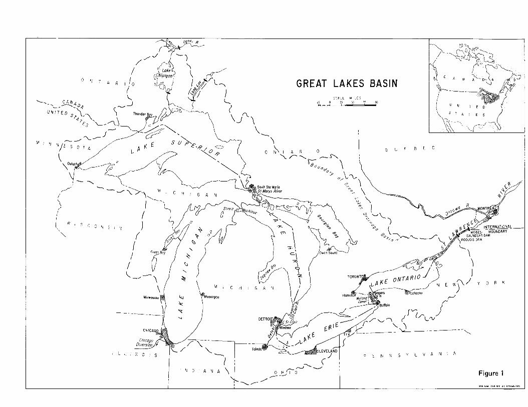
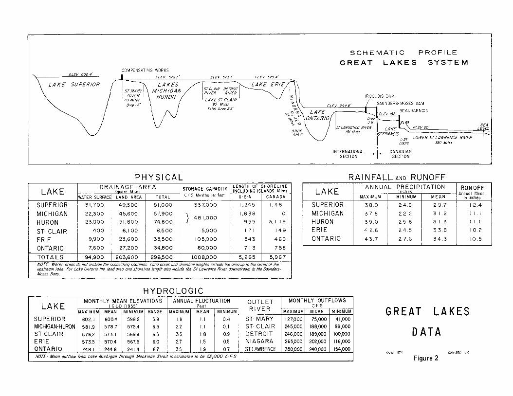
The Great Lakes-St. Lawrence River System extends from the Atlantic Ocean to nearly half-way across the North American continent. For the purpose of this inquiry the Great Lakes Basin extends from the down- stream end of the International Rapids Section of the St. Lawrence River to 50 miles west of Duluth on Lake Superior. The maximum dimensions of the Basin are approximately 740 miles, measured from north to south, and 940 miles, measured from east to west. The total area of the Great Lakes Basin, both land and water, is 298,500 square miles. The Basin is unique in that water covers approximately one-third of its total area, that the land areas which drain into the Lakes are only from 10 to 100 miles from the shoreline, and that it has no dominant tributary systems. Lake Michigan is complete- ly within the United States, while the Lower St. Law- rence River is wholly in Canada. A map of the Great Lakes Basin is shown in Figure I , the frontispiece.
The five Great Lakes - Superior, Huron, Michigan, Erie and Ontario-with their Connecting Channels and Lake St. Clair have a total water surface area of 94,900 square miles. The total length of the shoreline, including islands, is 11,200 miles. The Canadian shoreline of the Great Lakes and the International Section of the St. Lawrence River is entirely in the Province of Ontario. Eight States, Minnesota, Wisconsin, Illinois, Indiana, Michigan, Ohio, Pennsylvania and New York, border the Great Lakes.
The water from Lake Superior is discharged into Lakes Michigan-Huron through the St. Marys River. Lakes Michigan and Huron have virtually the same level because they are connected by the broad, deep Straits of Mackinac. Thus, hydraulically they are con- sidered as one lake. The water from Lakes Michigan- Huron discharges into Lake Erie through the St. Clair
and Detroit Rivers, and that from Lake Erie into Lake Ontario through the Niagara River.
The vast water surface areas of each of the Great Lakes account for the storage of enormous quantities of water. This unique natural feature absorbs the large variations in the precipitation falling directly on each lake and the runoff from land draining into each lake. Consequently the outflow from each lake is modulated so as to maintain a remarkably steady discharge to the next lower lake. A schematic profile of the Great Lakes System, physical data and the principal hydrologic fea- tures of the Great Lakes are presented in Figure 2.
All elevations in this report are based on the Interna- tional Great Lakes Datum-1955 (IGLD-1955). It measures the difference in elevation between the long- term mean sea level at Father Point, Qutbec, and any point in the Great Lakes-St. Lawrence River System. Since there is an extremely slow but positive differential vertical movement in the earth’s crust within the Great Lakes region, it is essential to show the year in which the datum elevations were assigned. With the passage of time it may be necessary to adjust the reference eleva- tion at a given place to allow for its movement with respect to sea level at Father Point during the interven- ing period. IGLD-1955 is the official datum for the Great Lakes region and is used by United States and Canadian agencies.
The original elevations used in the Commission’s Orders of Approval of May 26 and May 27, I9 I4 for Lake Superior, and Order of Approval of October 29, 1952, as amended on July 2, 1956 for Lake Ontario have been converted to IGLD-1955.
The Great Lakes Basin drains into Lake St. Francis, below the Moses-Saunders Powerhouse at the easterly end of the International Rapids Section of the St. Lawrence River. The remainder of the River, entirely within Canada, flows for 430 miles in a northeasterly direction to the Gulf of St. Lawrence and thence to the Atlantic Ocean.
Four major phases of glaciation have formed the relief and the drainage pattern of the Great Lakes Basin. The sediments that mantle the bedrock consist of the glacial
7
S C H E M A T I C PROFILE G R E A T L A K E S S Y S T E M
COMPENSATING WORKS ELEV 6004' I ELEV 5787' FIFV 5704'
L A KE SUPERIOR RIVER RIVER
IROOUOIS DAM
90 Mlles Total Drop 83'
ELEY 2448' / SAUNDERS-MOSES DAM BEAUHARNOIS
SEA LE VEL b LOWER STLAWRENCE RIVER i-
LOUIS 350 Miles
EL 69 E l E V 20'
IO/ Mrles
INTERNATIONAL SECTION + c!Fl!%v
P H Y S I C A L L A K E D R A I N A G E A R E A
INCLUDING ISLANDS Miles S uare M i les LENGTH OF S H O R E L I N E STORAGE 2 c F s Months per foot U . S . A 1 C A N A D A / HURON 23,000 5 1,800
ST. CLAIR
27,200 7,600 ONTARIO 23,600 9,900 ERIE
6, I 00 400
8 1,000
67,900 74,8 0 0
6,5 00
33,500
34,8 0 0
337,000
1 4 8 1,000
5,O 00
I05.000
80,000
1,245 1,481
1,638
I 7 1
7 58 71 3
4 60 543
I 4 9
T O T A L S I 94,900 I 203,600 1 298,500 1,008,000 I 5,265 I 5,967 NOTE. Water areas do not Include the connectmg channels Land areas and shorelme lengfhs Include fhe area up to the auflef of the
Moses Dam. upstream lake. For Lake Ontario the /and area and shoreline length also Include the St Lawrence River downstream to the Saunders-
L
R A I N F A L L AND R U N O F F INUAL PRECIPITATION
Inches M A X I M U M M I N I M U M
SUPERIOR MICHIGAN HURON 2 5 . 8 ERIE 4 2.6 2 4 . 5
ONTA R IO
H Y D R O L O G I C MONTHLY MEAN ELEVATIONS ANNUAL FLUCTUATION MONTHLY OUTFLOWS OUTLET LAKE I G LD (1955) C F S Fee t
MAXIMUM R I V E R MINIMUM M E A N MAXIMUM RANGE MINIMUM MEAN .MAXIMUM
154,000 240,000 350,000 STLAWRENCE 0.7 I .9 3.5 6.7 241.4 244.8 248.1 ONTARIO Il6,OOO 202,000 265,000 N IAGARA 0.5 I .5 2.1 6.0 567.5 570.4 573.5 ERIE 100,000 189,000 246,000 DETROIT 0.9 I .8 3.3 6.3 569.9 573.1 576.2 ST. CLAl R 99,000 188,000 245,000 ST. CLAIR 0. I I. I 2.2 6.5 575.4 578.7 581.9 MICHIGAN-HURON 41,000 75,000 127,000 ST. MARY 0.4 I. I 1.9 3.9 598 2 600.4 602.1 SUPERIOR
MINIMUN M E A N
I NOTE: Mean outflow from Lake Michigan through Mockinac Stralt IS estimated fa be 52,000 C FS
M E A N
2 9.7
3 I .2 3 I .3 3 3.8
3 4 . 3
r RUN OFF h n u a l M e a n
in Inches
12.4 1 1 . 1
1 1 . 1
10.2
10.5
G R E A T L A K E S D A T A
A J M 1974 CAN SEC I J C
Figure 2
drift deposited by the continental ice sheets, streams created by melting ice, stratified beds laid down in ancient glacial lakes, and dune sand consisting of glacial materials picked up and redeposited by the wind. These unconsolidated, readily erodible sediments have been partially reworked by post-glacial streams and deposited as alluvium in the Great Lakes, their flood plains and the Connecting Channels.
Most of the Great Lakes Basin is within two major physiographic regions. The areas north and west of Lake Superior and north of Lake Huron are in the Laurentian Uplands dominated by hills, a few low mountains, many lakes and numerous swamps. In general this forested region has a shallow overburden. The Central Lowlands cover most of the remainder of the Basin. The physio- graphic relief varies from gently rolling to relatively flat topography. The depth of the unconsolidated overburden varies up to 1100 feet. The Appalachian Plateau borders the southeastern portion of the Basin. It is characterized by a varied relief and prominent escarpments. The eastern limit of the Basin is in the foothills of the Adirondacks. The outlet is in the wide St. Lawrence Valley which is a relatively flat marine plain with local rock hills.
The climate of the Great Lakes Basin is moderated by the influence of the Lakes themselves on the continental air masses that pass through the region. The average temperature decreases by I O degrees from the Basin’s southern to northern extremities, a distance of 750 miles. The warm summers have frequent hot, humid, tropical periods caused by air movements from the Gulf of Mexico. Arctic air dominates the region during 1.he winter with mean daily temperatures below freezing from three to six months. The spring and fall months are characterized by the passage of storms through the Basin. Hurricane remnants can pass close to the Basin producing heavy rains and strong winds. The average annual precipitation ranges from 26 inches northwest of Lake Superior to 52 inches east of Lake Ontario. Varia- tion from month to month is slight. Snowfall accounts for 20 to 30 percent of the annual precipitation depend- ing on the location relative to the open lakes and also the latitude.
The population within the Great Lakes Basin was 35,000,000 in 1970. About 83 percent reside in l.he United States and 17 percent in Canada. One-seventh of the population of the United States lives in the Basin which includes four of the twelve largest cities in the United States, Chicago, Detroit, Cleveland and Mil- waukee. The relative importance in Canada is even greater because one-third of that country’s total popula- tion lives in the Ontario portion of the Basin. I f the wholly-Canadian portion of the St. Lawrence River Basin is added, the proportion of the total population rises to 60 percent.
The economy of the Basin is basically industrial. The United States portion of the Basin produces one-sixth of the national income and accounts for over one-fil‘th of the manufacturing employees and capital expenditure. In Canada the figures are more dramatic for the Basin
produces nearly one-third of the national income and accounts for over one-half of the manufacturing employees and capital expenditure. All this is due to the fact that the Great Lakes-St. Lawrence River System has had the advantage of economical and efficient trans- portation, access to vast deposits of natural resources, cheap power production, moderate climate and the capacity to receive the wastes from the population and industries it supports.
The region accounts for 40 percent of the United States iron and steel production and 80 percent of the Canadian output. The Great Lakes ports also serve a further one-third of the United States steel industry. Similarly, a high proportion of the chemical, paper, food products, machinery, transportation equipment and metal fabrication industries of both countries are in the Basin.
Agricultural production accounts for seven percent of all the United States output and 25 percent of the total Canadian output. There are 59,000 square miles of commercial forest in the United States portion of the Basin; over 70,000 square miles in the Canadian portion. The more important minerals produced are iron ore and limestone. The scenic shoreline of the Great Lakes, with its opportunities for water-related activities has attract- ed summer resorts and cottages. The value of the tourist industry i n 197 1 has been estimated to be $300 million annually i n the United States portion of the Basin and $500 million in the Canadian portion. Commercial fish- ing and sport fishing are also economically important.
Urban development of the shoreline predominates i n the southern portion of Lake Michigan and around Lakes Erie and Ontario. In Canada about one-half of the shoreline, and in the United States nearly all the shoreline, is privately-owned. Of the total shoreline length of I 1,200 miles, about 1700 miles are used for recreation, 700 for industrial and commercial purposes, 2000 for residences, 1600 for agriculture and 5200 miles of the shoreline are either forest or undeveloped.
The Great Lakes and their Connecting Channels and the St. Lawrence River provide a continuous 2400-mile deep-draft waterway that extends from the Atlantic Ocean into the heart of the North American continent. The System serves the eight Great Lakes states, eleven contiguous states and the Canadian provinces of Ontario, Manitoba and Saskatchewan. Water transpor- tation on the Great Lakes System is not only vital to the industrial economy of the Basin, but is the link between the agricultural regions of the West and the consuming areas of the East, as well as seaborne export markets.
Iron ore, coal, limestone and grain account for 85 percent of the 220 million tons of water-borne freight carried each year on the waterway. The remaining 15 percent includes overseas general cargo, petroleum prod- ucts, cement and chemicals. l.ake traffic movements i n the United States comprise shipments of iron ore from western Lake Superior to southern Lakc Michigan and to Lake Erie, shipments of coal from southern Lake Michigan and Lake Erie ports to power plants, munici- palities and industries at other United States and
9
Canadian ports, shipments of limestone from northern Lake Huron and western Lake Erie bound for the steel industrial centres, and shipments of grain from western Lake Superior, southern Lake Michigan and western Lake Erie to Buffalo, New York and Canadian ports on the St. Lawrence River. A large portion of the Canadian commercial transits are on the St. Lawrence Seaway to and from ports on the lower St. Lawrence River. Grain constitutes the principal cargo downstream and iron ore the principal cargo upstream. About one-half of the Canadian wheat exports and 18 percent of the United States grain exports pass through the Great Lakes ports.
The hydro-electric installations in the Great Lakes Basin produce much cheaper power than thermal plants using fossil or nuclear fuels. They produce far more energy than most other hydro-electric plants of the same installed capacity because the Great Lakes have the unique feature of an extremely high degree of natural regulation. The existing hydro-electric plants affected by regulation of the Great Lakes have a total installed capacity of nearly eight million kilowatts, of which almost five million are in Canada and over three million are in the United States. As the demand for electrical energy in the Basin continues to increase, the Great Lakes will become the principal source of cooling water for fossil and nuclear power plants.
The principal hydro-electric power producers are pub- licly-owned utilities. Ontario Hydro and the Power Au- thority of the State of New York generate electricity from the Canadian and United States shares of the Niagara River and St. Lawrence River flows. Hydro Qukbec’s Beauharnois-Cedars development in the Canadian portion of the St. Lawrence River utilizes the total flow of the River. In addition, there are three small hydro-electric plants on the St. Marys River with a total rated capacity of 8 1 thousand kilowatts. One is a United States Government plant, while the other two are pri- vate utilities, owned by United States and Canadian companies. Besides these installations, other public and private developments are either in place or underway.
Consideration of further regulation of the levels of the Great Lakes must give full weight to each of the princi- pal factors-shoreline use, the preservation of the eco- system, transportation and power generation. A balance must be maintained in any modification of the present natural regulation or in any changes to existing operat- ing procedures to ensure fair treatment for all people in the Basin as well as those outside it, who might be affected. Every effort must be made to understand as fully as possible the implication of proposed changes on each interest.
10
Chapter IV
NATURAL FLUCTUATION OF LAKE LEVELS
The vast water surface area of the Great Lakes, com- bined with the restricted capacities of their outflow channels, makes them the finest naturally regulated fresh water system in the world. The normal range of water levels from winter lows to summer highs seldom exceeds one and one-half feet. During periods of defi- cient or excessive precipitation lasting several years, the average monthly water level, depending on the size of the Lake, is from two to three feet below or above the long-term average. Such gradual, protracted changes are extremely small when they are compared to the fluctuation of water levels on rivers such as the Mac- Kenzie, Red and Colorado, tidal fluctuation of I O to 20 feet at many North American harbours, seasonal draw- downs of up to 100 feet on large man-made reservoirs, and lakes such as the Arrow Lakes in British Columbia, which had a range of 40 feet before regulation.
Maximum flows in the Connecting Channels of the Great Lakes are only two to three times their minimum. This too is remarkable when compared with other large North American waterways. The ratio of maximum and minimum flows of the Mississippi River is 30:1, for the Columbia River 35: I , and the Saskatchewan River 60: 1.
The Great Lakes System Lake Superior is the uppermost lake and with an area
of 3 1,700 square miles is the largest of the Great Lakes. Lake Nipigon, located within its basin, has a water surface area of I740 square miles and a drainage area of 9500 square miles. The St. Marys River, the outlet from Lake Superior, flows from Whitefish Bay at the east end of the Lake for 63 miles to Lake Huron. The river drops about 22 feet, of which 0.2 foot occurs in the upper 14 miles, 20 feet at the rapids at Sault Ste. Marie, and 2 feet in the lower 48 miles. The water levels at the foot of the St. Marys Rapids are affected by the water levels of Lake Huron. The discharge from Lake Superior is controlled by a gated dam at the head of the St. Marys Rapids which was built to permit power diversions around the rapids while maintaining the regime of water levels on Lake Superior and flow in the St. Marys River.
Lakes Michigan and Huron, insofar as their hydraulic characteristics are concerned, are treated as one lake.
1 1
Their combined water surface area of 45,300 square miles is six times that of Lake Ontario and one and one-half times that of Lake Superior. The St. Clair River, at the south end of Lake Huron is the natural outlet, although it has been altered by dredging. There are no controls that regulate the discharge from Lake Huron. The water from Lake Huron flows for 90 miles down the St. Clair River, through Lake St. Clair, thence down the Detroit River to Lake Erie. Total drop be- tween Lakes Huron and Erie is only eight feet. The water surface profile in the St. Clair and Detroit Rivers is relatively uniform and there are no rapids. Further- more, the water level of Lake Erie has a backwater effect on the level of and discharge from Lake Huron.
Lake St. Clair, midway between Lake Huron and Lake Erie, has a water surface area of 400 square miles. It is a shallow lake, characterized by a delta in the northern portion, a marshy shoreline and adjacent shore lands which are low-lying, flat and subject to inundation.
Lake Erie is the shallowest of the Great Lakes and has a water surface area of 9900 square miles. Its long, narrow shape and its orientation relative to the prevail- ing wind and storm patterns, results in frequent and dramatic short-term changes in the water levels of the Lake.
The uncontrolled, natural outlet from Lake Erie is the Niagara River. It flows north for 33 miles to Lake Ontario. The total drop is 326 feet. The River drops approximately 310 feet between the head of the Cas- cades, immediately upstream from the Niagara Falls and the Lower Rapids, six and one-half miles down- stream, with a sheer drop of 170 feet occurring at the Falls themselves.
Sixteen miles downstream from Lake Erie and immediately upstream from Niagara Falls is a gated structure which extends from the Canadian shoreline to the centre of the River. Its purpose is to maintain the natural levels of the Grass Island Pool and provide proper distribution of flow over the Horseshoe and American Falls, while allowing for the diversion of water to the hydro-electric power plants. This structure cannot regulate the levels of Lake Erie because the
natural bed rock weir at the head of the Niagara River controls the outflow from that Lake.
In addition to the flows over Niagara Falls, water from Lake Erie reaches Lake Ontario by way of power diversions from the Niagara River just above the Falls, the Welland Canal and New York State Barge Canal. The average llow of the Niagara River is 202,000 cfs. The Niagara Treaty of 1950 provides for a minimum flow of 100,000 cfs over the Niagara Falls during the daylight hours of the tourist season and a minimum flow of 50,000 cfs at all other times. All water i n excess of Treaty requirements is available for power production. An average flow of 7000 cfs is diverted through the Welland Canal for navigation and the generation of hydro-electricity at DeCew Falls. About 700 cfs is div- erted from thc Niagara River to the New York State Barge Canal ,and is returned to Lake Ontario at four locations.
Lake Ontario is the smallest of the Great Lakes. I t has a water surface area of 7600 square miles. Most of the shoreline :IS composed of unconsolidated sediments, deposited by retreating glaciers, although hard lime- stone formations characterize the northeastern portion.
The St. Lawrence River at the northeast end of Lake Ontario is the natural outlet for the Great Lakes. Numerous rocky islands and reefs dominate the broad channel of the River for the first 67 miles. This part of the International Rapids Section of the St. Lawrence River is known as the Thousand Islands. The River channel then narrows abruptly as it crosses the hard rock protusion of the Canadian Shield and flows down the International Rapids Section.
Approximately 100 miles downstream from Lake Ontario is the Moses-Saunders Powerhouse which util- izes the flow and the 80-foot drop into Lake St. Francis of the International Rapids Section of the St. Lawrence River. It is used to regulate the discharge from Lake Ontario. Nearby is Long Sault Dam which is used to pass excess river flows during periods of high water or a shut-down of turbines in the powerhouse. About 27 miles uppstream from the powerhouse is Iroquois Dam which may be used to moderate water level fluctuations on Lake St. Lawrence and assist in the formation of a stable ice cover.
The remainder of the St. Lawrence River is entirely in Canada. From Lake St. Francis it flows through the Beauharnois Power and Navigation Canal and also down the Coteau Rapids to Lake St. Louis, thence down the Lachine R,apids to the Laprairie Basin at Montreal, a distance of thirty-five miles, for a total drop of 132 feet. The River then flows through the St. Lawrence lowlands to Lake St. Peter and finally to the Gulf of St. Lawrence, a dilstance of 350 miles with a drop of only 20 feet.
The Hydraulics of the Great Lakes The natural outlets from Lakes Michigan-Huron and
Lake Erie are not regulated by any artificial devices. The discharge from Lake Huron is contro!led by the
level of that lake, the size and characteristics of its outlet channel, the St. Clair and Detroit Rivers, and the level of Lake Erie. The natural discharge from Lake Erie is controlled by its own level and the natural outlet at the head of the Niagara River.
The discharge from Lakes Huron and Erie increases as the water level at the entrance to their outlet channels rises. IHowever the physical dimensions of the Connect- ing Channels restrict their response to higher or lower water levels, thus limiting changes in the outflow to the lower lake. For example, the discharge through the St. Clair River is increased by only 6,000 cfs or three percent when the water level rises 0.4 foot. However, to create that 0.4 foot rise and 6,000 cfs increase in outflow, Lakes Michigan-Huron storage must be increased by an amount equivalent to the total volume of water discharged through the St. Clair River for one month at a continuous rate of 188,000 cfs which amounts of 3.4 cubic miles of water. This vividly illus- trates the regulating effect of the Connecting Channels.
The water supply from Lake Superior to Lakes Michigan-Huron is fairly uniform due to regulation. However, the precipitation combined with the evapora- tion in the Michigan-Huron Basin varies considerably. Consequently the local water supply to these Lakes has fluctuated tremendously from a maximum of 496,000 cfs for one month to a minimum of -193,000 cfs for one month, a range of 689,000 cfs. The negative minimum indicates that evaporation from the lake surface exceed- ;d the rainfall and local runoff to that lake.
In the face of these extreme local supply variations, should it be desired to maintain Lakes Huron and Michigan near a constant level, two canals the size of the Detroit River would be required in addition to the existing River to provide sufficient outflow capacity during periods of high supply. These canals would have to be equipped with control gates to reduce the outflow during periods of low supply. One canal would likely follow a route from Port Huron through the residential and industrial areas of Macomb and Wayne Counties in the LJnited States to Lake Erie, while the other might follow a route from Sarnia through the highly produc- tive Lambton and Kent Counties in Canada to Lake Erie. During periods of excessive precipitation, these canals would carry full flow while during times of deficient precipitation there would be no flow. Down- stream interests can be thankful that nature does not release the waters from Lake Huron in such a way as to maintain a constant lake level. Such regulation would at times flood the downstream inhabitants and at other times eliminate inflows to the lower lakes.
In striving to better the works of nature, man must recognize the full consequences of his acts and be pre- pared to control the forces he attempts to redirect.
The levels of Lake Superior and Lake Ontario are regulated within the limits of their controls and the capacities of their outlet channels. The outflows of these lakes are not unlimited. The outflow capacity from Lake Superior was increased by man so that it is now approxi- mately 130,000 cfs when the level of Lake Superior is at
12
its historical peak, when the diversions to hydro-electri- cal plants are at their maximum and when all gates of the compensating works are open. Similarly, it is not only the control works in the International Rapids Sec- tion of the St. Lawrence River that limit the maximum discharge from Lake Ontario but also the physical char- acteristics of the River and the level of Lake Ontario that dictates the maximum outflow.
As previously mentioned, the natural restrictions of the Connecting Channels combined with the vast water surface area of the Great Lakes tend to smooth out the erratic extremes of precipitation and evaporation and result in a naturally well-regulated outflow. The hydraulics of the Great Lakes System is such t h a t the change in flow to the next lower lake is small compared to the change i n storage and supply conditions. When either high or low water supplies occur for an extended period the corresponding extremes of water levels persist for several years after the climatic conditions have changed.
For example, it takes two and one-half years for only fifty percent of the full effect of change in water supply to Lake Huron to be realized in the outflows from Lake Ontario; and three and one-half years for sixty percent of the full effect to be realized. In other words, the Lower Lakes may suffer from abnormal low or high levels long after the Upper Lakes have returned to normal conditions. Regulation would be much more beneficial to all interests if reasonable water supply forecasts could be made, not for several months ahead, but for two or three years ahead. However, it is the present consensus of international weather experts that such long-range forecasts will not likely be available in the foreseeable future. Nevertheless a careful watch should be kept on the changing technology in this field.
Hydrology of the Great Lakes
The levels of each of the Great Lakes are the result of an integration of the hydraulic characteristics of the Connecting Channels and the St. Lawrence River and the total water supply received by each Lake. The total water supplies are the inflows from the upper lake, plus runoff from the land draining into that particular lake, plus precipitation falling directly on the water surface less the evaporation from that lake.
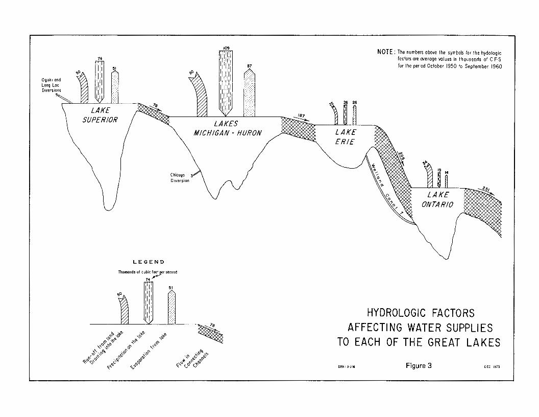
These hydrologic factors are the dominant cause of the protracted fluctuations in the levels of the Great Lakes. They are shown graphically in their proper pro- portions in Figure 3. The numbers are an average for a ten-year period which includes both high and normal water supplies.
The level of each of the Great Lakes depends on the balance between the total water supplies received by that lake and its discharge to the next lower lake. I f the water supplies received by the lake are greater than those discharged, its level gradually rises. Conversely, i f the water supplies are less than the discharge, the lake level slowly drops.
Precipitation in the form of rain and snow is the source of all water supplies to the Great Lakes. The low lake levels during the mid-1930’s and 1960’s were the result of abnormally low precipitation, while the high lake levels of the early 1950’s and 1970’s were caused by excessive precipitation.
The minimum and maximum average annual precipi- tation for each of the five drainage basins are shown on Figure 2 in Chapter 111. I t should be noted that the annual precipitation in the Lake Superior Basin has varied from 24.0 to 38.0 inches, Lake Michigan Basin 22.2 to 37.8 inches, Lake Huron Basin from 25.8 to 39.0 inches, Lake Erie Basin from 24.5 to 42.6 inches and in the Lake Ontario Basin the annual precipitation has varied from a low of 27.6 inches to a high of 43.7 inches.
Precipitation on the land surfaces moves through several storages. During freezing weather it accumulates as snow. Water from snowmelt or rain either seeps into soil as temporary groundwater storage or moves over the surface as runoff to streams, swamps and lakes. The land runoff to the Great Lakes is the highest during the spring snowmelt. The gradual recession of land runoff until fall or the next spring is due to the release of water temporarily stored in swamps, small lakes and the sub- surface which sustains stream flow during the drier weather of summer and fall.
The peak runoff occurs in May in Lake Superior, April on Lakes Michigan-Huron, March on Lake Erie and April on Lake Ontario. Lakes Erie and Ontario often have higher runoff from their basins during the fall and winter as a result of rainfall and snowmelt during these months when land evaporation and transpi- ration is least and when the subsoil is either saturated or frozen. Such was the case in 1972.
The higher levels of the Great Lakes in the spring and early summer and a gradual lowering of levels during the remainder of the year are due to the hydrologic characteristics of each basin. The seasonal fluctuation of lake levels reflects the variations of runoff to, and evaporation from, each basin. In any given year the variations from winter lows to summer highs are small, averaging about one foot on Lakes Superior, Michigan and Huron, one and one-half feet on Lake Erie and nearly two feet on Lake Ontario.
Evaporation from the land and water surfaces is dependent on solar radiation, temperature of the air mass and water, humidity and wind. On the long-term average over half of the precipitation on land surfaces is lost to the atmosphere through evaporation and transpi- ration. When the air above the lakes is warm and moist and the lakes are cold, as in the spring, evaporation is least. I n the fall and early winter, when the air above the lakes is dry and the lakes are relatively warm, evapora- tion is the greatest.
Evaporation is always reduced considerably during periods of excessive precipitation. This is caused by a marked reduction in solar radiation and cooler tempera- tures due to increased cloud cover and a resulting high humidity. These hydrologic characteristics accentuate
13
NOTE: The numbers above the symbols for the hydologtc factors ore overage volues in thousands of C F.S for the period October 1950 to September 1960 / l i l i ' i l
, 1 1 1 1 1 1 8,7
L E G E N D
Thousands of cublc feet per second 7d r*'
HYDROLOGIC FACTORS AFFECTING WATER SUPPLIES
TO EACH OF THE GREAT LAKES
D R N . A J M Figure 3 DEC 1973
the problem of high lake levels by reducing the amount of water lost to the atmosphere during a period of high precipitation and runoff. Conversely, evaporation is greater during drought conditions. These natural phenomena are the dominant causes of the long-term fluctuations of the Great Lakes. Their duration and recurrences cannot even be predicted, much less con- trolled by man.
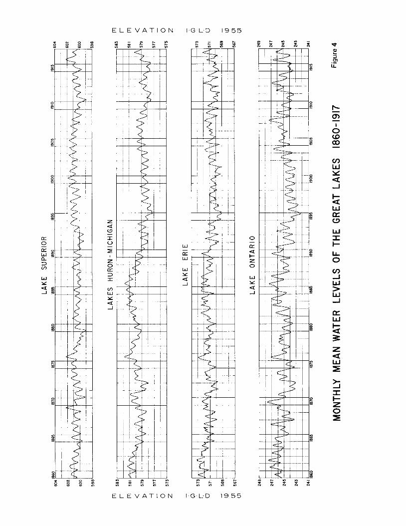
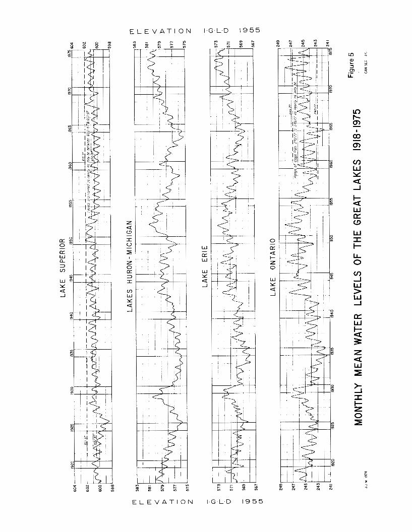
The mean monthly levels for each of the Great Lakes since 1860 are shown in Figures 4 and 5 . They record the long-term and annual fluctuations that have occurred in the last 1 16 years.
The amount of water furnished to a given lake from its own basin is the ultimate response to changes in precipitation and evaporation. The changes not only vary seasonally but also from year to year. Table 1 illustrates the magnitude of the variations of the month- ly net basin supplies. It should be noted that the net basin supplies do not include inflow from the upper lake or diversions into or out of that particular lake. A thousand cfs months is the volume of water that in one month flows past a point at the rate of 1,000 cubic feet per second. This is equivalent to the amount of water required by a city of 450,000 people for one year.
Table 1-MONTHLY NET BASIN SUPPLIES in cfs months
Lakc Avcrage Maximum Minimum Range
Supcrior 7 1,000 354,000 - 100,000* 454,000 Michigan-Huron 110,000 496,000 - 193,000* 689,000 Eric 2 1,000 182,000 - 73,000* 255,000 Ontario 34,000 164,000 - 22,000* 186,000
*Negative values indicate that the evaporation rate from the lake surface exceeds the amount of water
-
supplied to the lake.
The variations shown in Table 1 of the water supplies furnished by each basin to the Great Lakes System when compared to the long-term variations in water levels shown on Figures 4 and 5 demonstrate how nature has regulated its own erratic extremes. However, the high water supplies to any one of the Great Lakes can only be stored temporarily. Eventually all water is dis- charged to the next lower lake and augments its local supply. I t can take as long as 15 years for the full effect of supply changes to be realized in the lower lakes.
The long-term fluctuations in the levels of the Great Lakes are the direct result of a number of years of excessive or deficient precipitation. Their magnitude and duration is irregular and for this reason high and low water levels do not occur in any regular cycles. Superim- posed upon the hydro-electric fluctuations are the inevi- table annual fluctuations caused by seasonal variations in water supply. These tend to exaggerate the long-term fluctuations.
Fluctuations Due to Storms The most dramatic changes in water levels are the
short-term fluctuations caused by strong winds and by sharp differentials in barometric pressure. They usually are of short duration, lasting less than one day, and do not represent any changes in the volume of water in the lake.
The winds are caused by the passage of weather systems. The strong winds which cause most of the shoreline damage occur primarily in the spring and fall. Winds keep the water surface of the Great Lakes in constant motion and influence the littoral currents which build and destroy the beaches.
15
During periods of strong winds, deep water waves generated by the wind can reach a height in excess of 25 feet from trough to crest. It is the energy released by these waves as they break on the shore that causes erosion. When superimposed on high water levels, the damage caused by waves is increased. This is illustrated on Figure 6 .
Strong winds tend to build up the level at the down- wind shore and reduce the water level along the upwind shore. A sustained high wind along the southwesterly axis of Lake Erie has caused the water level at Buffalo to rise eight feet. Also, strong winds have caused a similar effect on Lake Ontario in the order of two feet. Movement of weather systems can produce local changes in atmospheric pressures which in turn cause sudden changes in water levels.
In summary, the principal cause of long-term fluctua- tions on the Great Lakes is extended periods of excessive or deficient precipitation. The regular annual fluctua- tion in levels are due to the seasonal variation in water supplies. The short-term fluctuations are the result of wind and meteorological disturbances. None of these natural factors can be controlled by works of man.
Other Natural Fluctuations A number of other natural phenomena cause fluctua-
tions in the water levels of the Great Lakes. Ice jams in the Connecting Channels and the St. Lawrence River have retarded the outflow from the lake immediately upstream. Similarly, aquatic weed growth in the outlet rivers has reduced their discharge. Crustal movement and tides cause a minor change in water levels.
E L E V A T I O N 1.G.L.D I 9 55
W [L: W
W Y
-1
-
a
c t
0 CT:
t- z 0
- a
W Y
-1 a
c m m - x x s t
E L E V A T I O N 1 .G .L .D I9 5 5
E L E V A T I O N
Ir) m Y)
E L E V A T I O N
W
CT W
-
W Y
-I a
1.G.L.D I9 5 5
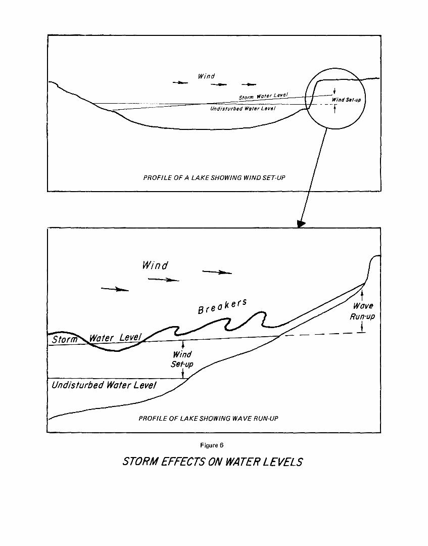
PROFILE OF A LAKE SHOWING WIND SET-UP
Win d f
1.
!/disturbed Wafer Level
Figure 6
STORM EFFECTS ON WATER LEVELS
The formation of an ice cover and ice jams materially reduce the flow in the outlet rivers during the period from January to March. The natural reduction in flow raises the level on the upstream lake and increases its storage. Thus the levels of the lakes are higher at the time of the spring breakup than they would be under ice-free conditions. Neither the timing or severity of ice conditions are predictable.
Historical data indicate that ice jams have reduced the outflow from Lakes Michigan-Huron by as much as fifty percent. The estimated average reduction in flow of the St. Clair River from January through March due to ice conditions is 19,000 cfs. The long-term effect of ice conditions has increased the average level of Lakes Michigan-Huron by 0.4 foot. Ice jams on the natural rock barrier at the outlet from Lake Erie have material- ly reduced the flow in the Niagara River. The average reduction during the winter months is estimated to be 4,000 cfs. A similar situation exists on the Upper St. Lawrence River. Its recorded minimum flow was the direct result of large ice jams caused by the breakup of the ice cover on the River.
The retardation of flow due to ice conditions on the Niagara River has been reduced since the installation of the Lake Erie-Niagara River ice boom commencing in the winter of 1964-65. The annual installation of ice booms in the Upper St. Lawrence River has significantly increased the winter discharge from Lake Ontario. This is particularly important during periods of high water levels. The ice booms are installed in the late fall and removed when the ice formations on Lake Erie and the St. Lawrence River dissipate. These ice booms acceler- ate and assist in the formation and maintenance of a stable ice cover. They have successfully reduced ice jams which cause shoreline damage and curtail the generation of electric power.
Aquatic growth in the rivers reduces the outflow from the lake immediately upstream. This in turn causes a small natural increase in the lake level. The retardation in discharge generally starts in May, reaches a max- imum in July, and becomes insignificant in November. The degree of retardation varies from river to river and from year to year. Retardation of flow in the Niagara due to aquatic growth has been under close observation. A comparison of discharge curves indicates that aquatic growths have reduced the outflow from Lake Erie by as much as 10,000 cfs.
Crustal movement has a minor but permanent effect on the levels of the Great Lakes. The weight of glaciers depressed the earth’s crust into the weaker layers below. As the glaciers retreated the earth’s crust began to rebound in a process somewhat similar to the rebound of a cushion following the removal of a weight. For thou- sands of years in the Great Lakes Basin there has been a continuous differential uplift of the earth’s crust. Geolo- gists have determined that an uplift of several hundred feet has occurred in some areas along the shorelines of the Great Lakes. It agpears that the land along the northern and eastern shores of the lakes is rising with respect to the southern and western shores.
Consequently the water levels along the shoreline situated to the west and south of the outlet from each lake are rising higher with respect to the water level at the outlet. For example, it has been estimated that the earth’s crust at the outlet from Lake Superior is rising twelve inches per century while the earth’s crust at Duluth is only rising four and one-half inches. At Thun- der Bay the estimated rise per century is fifteen inches. Therefore, the water level at Duluth is rising seven inches per century with respect to the outlet from Lake Superior, while the water level at Thunder Bay is drop- ping three inches per century. Similarly, the differential rise in the earth’s crust between Buffalo and Cleveland is three inches.
Also the earth’s crust at the outlet from Lake Ontario is estimated to be rising nine inches more per century than the earth’s crust at Hamilton and six inches more than the earth’s crust at Rochester. Therefore, the water level at Hamilton is rising nine inches per century with respect to the outlet from Lake Ontario while water level at Rochester is rising six inches per century. These minor but inevitable effects on water levels must be considered in locating permanent structures and in design of regulation plans.
The magnitude of both solar and lunar tides that occur on the Great Lakes is small. The spring tide which is a combination of the largest solar and largest lunar tide is reported to be less than two inches on Lake Superior, the largest of the Great Lakes.
Data are not available to estimate the quantity of groundwater flowing into or from any of the Great Lakes. However, it is believed that the effects are inconsequential.
19

Chapter V
MAN’S INTERVENTIONS
Throughout the last 150 years, man has progressively intervened in the natural regime of the Great Lakes System. The rapid economic growth in the Basin is a consequence of continuous improvement in the water- ways throughout the system, the development of hydro- electric potential and the availability of fresh water to meet all industrial and municipal requirements.
The regulation of Lake Superior and Lake Ontario is described in Chapter VI. This chapter discusses dredg-
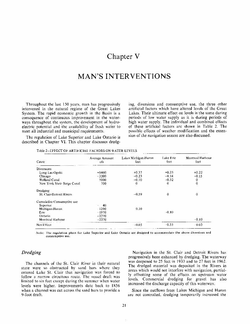
ing, diversions and consumptive use, the three other artificial factors which have altered levels of the Great Lakes. Their ultimate effect on levels is the same during periods of low water supply as it is during periods of high water supply. The individual and combined effects of these artificial factors are shown in Table 2. The possible effects of weather modification and the exten- sion of the navigation season are also discussed.
Table 2-EFFECT O F ARTIFICIAL FACTORS ON WATER LEVELS
Average Amount Lakes Michigan-Huron Lake Erie Montreal Harbour Cause cfs feet feet feet
- Diversions
Long Lac-Ogoki +5400 Chicago -3200 Welland Canal 7000 New York State Barge Canal 700
Drcdging St. Clair-Detroit Rivers
+0.3 7 +0.23 +0.22 -0.23 -0.14 -0.15 -0.10 -0.32 0 0 0 0
-0.59 0 0
Cumulative Consumptive use Superior - 40 Michigan-IIuron ~ 1290 -0.10 Erie - 1970 -0.10 Ontario -2270 Montreal Harbour -2270 -0.10
Net 1,;ffcct -0.65 -0.33 -0.03
Note: The regulation plans for Lake Superior and Lake Ontario are designed to accommodate the above diversions and consumptive use.
Dredging Navigation in the St. Clair and Detroit Rivers has progressively been enhanced by dredging. The waterway
The channels of the St. Clair River in their natural The dredged material was deposited in the Rivers in was deepened to 25 feet in 1933 and to 27 feet in 1962.
areas which would not interfere with navigation, partial- ly offsetting some of the effects on upstream water levels. Commercial dredging for gravel has also increased the discharge capacity of this waterway.
state were so obstructed by sand bars where they entered Lake St. Clair that navigation was forced to follow a narrow circuitous route. The vessel draft was limited to six feet except during the summer when water levels were higher. Improvements date back to 1856 when a channel was cut across the sand bars to provide a Since the outflows from Lakes Michigan and Huron 9-foot draft. are not controlled, dredging temporarily increased the
21
flow in the St. Clair and Detroit Rivers and permanently lowered the level of those Lakes. The temporary increase of outflow into Lake Erie caused a temporary rise in the levels of that Lake which in turn temporarily increased its outflow. The transitory effect on Lake Erie levels due to the dredging program became negligible by 1969.
Diversions
Works constructed by man have transferred a limited amount of water into and out of the Great Lakes Basin. The Ogoki and Long Lac Diversions slightly increase the natural supplies to Lake Superior, while the Chicago Diversion slightly reduces the water supply to Lakes Michigan and Huron. They only affect the water levels of Lakes Michigan, Huron and Erie because the Lake Superior and Lake Ontario regulation plans take account of these constant diversions. The Welland Canal through which some of the outflow from Lake Erie bypasses the Niagara River, slightly lowers the levels of the unregulated lakes. The New York State Barge Canal diversion, withdrawn from the Niagara River, has virtually no effect on the lakes.
The operation of the present Long Lac and Ogoki Diversions commenced in 1939 and 1943, respectively. They divert water into the Lake Superior Basin from the Albany River Basin, which under natural conditions would flow into the Hudson Bay. The sum of these diversions has averaged about 5400 cfs. This amount represents seven percent of the average outflow from Lake Superior and two and one-half percent of the outflow from Lake Erie. During the early years of World War 11, the United States agreed that Canada could utilize 5000 cfs of the water diverted from the Albany Basin at Niagara Falls. The notes exchanged between the two Governments in 1940 concerning this subject were confirmed in Article 111 of the Niagara Treaty of 1950, and are included in Appendix H of this report.
The Long Lac Diversion consists of a concrete over- flow dam on the Kenogami River which diverts the natural flow into Long Lac. From there it flows through a five-mile channel built across the continental divide to convey the water from Long Lac to the Aguasabon River, a tributary to Lake Superior. There is a concrete regulating dam at the south end of this channel. Since 1940 an average of 1400 cfs has been diverted into Lake Superior. The remainder of the water supply to Long Lac has been spilled down the Kenogami River to Hudson Bay. The diverted water is used to generate electricity at a power plant near the mouth of the Aguasabon River.
The Ogoki Diversion transfers water from the Ogoki River into Lake Nipigon which is within the Lake Superior Basin. It augments the natural water supply to Lake Nipigon. Waboose Dam on the Ogoki River raises the water level so that most of the flow is redirected across the summit, through a chain of small lakes to
Little Jackfish River, and thence into Lake Nipigon. A dam at the summit controls the amount of water that is diverted. The diversion has varied from zero to 16,000 cfs with a long-term average of 4000 cfs. For various reasons, the diversion has been closed or reduced over 25 times since it began operation in 1943.
Lake Nipigon has a water surface area of 1740 square miles and a prescribed operating range of nearly seven feet. The average local inflow into Lake Nipigon, excluding the diversion, is 8900 cfs. The outflow is controlled by a powerhouse at Pine Portage, the upper- most of three hydro-electric plants on the Nipigon River. A minimum outflow of 8000 cfs is required so that the Town of Nipigon, located on a wide reach of the Nipigon River, can obtain its water supply. Flows in excess of 20,000 cfs endanger the railway and highway bridges at Nipigon.
During the high water period of 1951-53, Ontario Hydro voluntarily reduced the quantity of water divert- ed from the Ogoki River. For several months in each of those years diversions were stopped. Ontario Hydro again reduced diversions during the high water supply period of 1972-74. The outflow from Lake Nipigon was limited to its natural local inflow. All of the water diverted from the Ogoki River was stored in Lake Nipigon to be released to Lake Superior at a later date. When its level reached the upper limit in 1974, the diversion from the Ogoki was stopped. An average of 13,000 cfs was directed to the north for three months.
The Chicago Diversion has transferred water from Lake Michigan into the Mississippi River Basin since 1848. Water is diverted at three locations: At Wilmette through the North Shore Channel into the north branch of the Chicago River; at Chicago through the Chicago River which is closed by a lock to prevent flow from the River entering Lake Michigan; and at Calumet Harbour through the Calumet River and the channel into the Sanitary and Ship Canal. The primary purpose of the diversion is to dilute the sewage effluent of the Chicago Sanitary District and divert it into the Mississippi River Basin. The Chicago Sanitary and Ship Canal is also used for navigation. The diverted water is used by hydro-electric plants at Lockport and Marseilles, Illinois.
Effective March I , 1970, by a decree of the United States Supreme Court dated June 12, 1967, the max- imum allowable diversion from Lake Michigan at Chi- cago is 3200 cfs, including domestic pumpage. A copy of the Decree is in Appendix I .
The original eight-foot Welland Canal was opened in 1829. I t was the first complete navigable link between Lakes Erie and Ontario. Since then the canal has under- gone several enlargements. The Welland Canal connects Lake Erie at Port Colborne, Ontario about 18 miles west of the head of the Niagara River, with Lake Ontario at Port Weller, Ontario. It presently diverts an average of 7000 cfs for navigation and for generation of power at DeCew Falls Power Plant on the Niagara Escarpment. By increasing the natural discharge from
22
Lake Erie, the Welland Canal has lowered the water level of Lake Erie and slightly lowered the levels of Lakes Michigan and Huron.
The New York State Barge Canal system diverts water from the Niagara River at Tonawanda, New York. The average diversion is about 700 cfs. Its pri- mary use is for the operation of the Erie Canal. The water is ultimately discharged into Lake Ontario through several tributary streams as far east as Oswego, New York.
Consumptive Use Consumptive use is that portion of the water, with-
drawn or withheld from the Great Lakes Basin, and not returned to it. Consumptive use includes water used by crops through irrigation, incorporated into manufac- tured products, lost by industrial processes and thermal power generation.
The consumptive use of water in any one lake basin not only reduces the net water supply to that lake, but also reduces the water supply to all the downstream lakes. Consumptive use of water is a direct result of increased evaporation and transpiration.
Water is needed for the production of thermal power. Of an estimated withdrawal of 33,700 cfs for cooling purposes, approximately 180 cfs is lost by evaporation. The consumptive use for irrigation is about 145 cfs. Industry withdraws about 16,500 cfs and consumptively uses 660 cfs. Withdrawal of water for municipal and rural use is about 7700 cfs. All but 1285 cfs is returned to the Great Lakes. The total present consumptive use of water in the Great Lakes Basin is estimated to be 2770 cfs. It is expected that the consumptive use of water will rise to 6000 cfs in the year 2000 and to 13,000 cfs by the year 2030. This will lower the levels of all the Great Lakes.
Navigation Season Extension Extension of the navigation season on the Great Lakes
may influence lake levels by affecting outflow through the Connecting Channels.
The frictional effect of winter ice cover causes a reduction in outflow. The ice cover, by insulating the flowing water from the frigid air, reduces the production of ice. Opening the channel in winter could increase winter outflows and therefore lower levels in the upper lake, and increase levels downstream. Conversely, ice broken by ship passages in the channel may create jams causing significant reduction in outflows with resulting higher levels upstream and lower levels downstream. Such changes can also seriously affect supplies to municipal and industrial intakes and to power plants.
The Commission cannot specify at present the exact effects that winter navigation may have, but it is con- cerned about the possible hazards.
Weather A4odiJi:cation Weather modification may in time affect the total
supplies of water to the Great Lakes Basin. It could do this by simply increasing the total precipitation within the Basin. It could also reduce the total precipitation by increasing precipitation outside the Basin before air masses enter the Basin. A different effect could arise within the Basin by increasing precipitation in the drain- age area of one lake either with or without a correspond- ing decrease in another drainage area.
The significance of the effect of such changes would depend on their timing and magnitude. At the present time, it is not considered likely that weather modifica- tion programs on a scale large enough to affect the flow and level patterns of the Great Lakes will be undertaken in the near future. Nevertheless a watch will be neces- sary to identify national or international programs which might have significant effects in this area.
23

Chapter VI
PRESENT REGULATION
Man has modified the outflows of Lake Superior and Lake Ontario by slightly altering the sequence and magnitude of their releases. Within limits he has attempted to control the levels of Lake Superior since 1921 and those of Lake Ontario since 1960.
The regulation of Lakes Superior and Ontario required an enlargement of their outlet channels to allow an increase in the discharge capacity and the provision of gated structures to allow reduction in out- flows. Since long-term weather forecasting techniques are not sufficiently advanced, one must rely on historical hydrological data to devise regulation rules and indices to estimate the probable water supply. The regulation o f Lake Superior and Lake Ontario requires the aplication of prescribed rules to manage the variable water supplies so as to meet the conditions set forth in the Commis- sion’s Orders of Approval.
The purpose of these rules is to provide levels and flows that result in generally beneficial conditions with- out unacceptable adverse effects on any one interest. Regulation rules which will achieve the maximum need of any one interest without infringing upon other estab- lished interests cannot be prescribed. The difficulties of devising regulation rules that provide beneficial condi- tions to all interests on all of the Great Lakes at all times are further compounded by unprecedented water supplies and severe storms. At the very best such rules may only partially achieve their objectives.
Lake Superior Regulation The natural regime of the St. Marys Rapids has
continually been changed since 1822 when the United States Army built a raceway and sawmill. The first ship canal was constructed by the State of Michigan in 1855. The United States Government in 187 I started enlarge- ment of the navigation canal, which became federal property in 1881. Improvements continued until there were four locks in operation. The International Railway Bridge was completed by 1887. The canal on the United States side of the rapids, now known as the United States Power Canal, was completed in 1893. The second United States canal. now known as the Edison Sault
Power Canal was completed in 1902. On the Canadian side the navigation canal and lock and the Great Lakes Power Canal began operation in 1895. The bridge pier and approaches and the navigation canals reduced the width of the rapids. However, the power canals increased the amount of water that could be discharged from Lake Superior. This increased flow capacity neces- sitated the construction of control works to compensate for the increased outflow capacity from Lake Superior through the power canals.
In 1914 the Algoma Steel Corporation Limited of the Province of Ontario and the Michigan Northern Power Company of the State of Michigan applied to this Commission for approval to build compensating works at the head of St. Marys Rapids. At that time four of the ten spans of the International Bridge were available for free flow, three spans were across the headrace of the United States power plant, one span had been replaced by a f i l l at the United States end of the bridge, and four gates of the compensating works had been constructed about 150 feet upstream from the bridge in front of two spans on the Canadian shoreline. In addi- tion there were the Great Lakes Power Canal, the Canadian and United States navigation canals and St. Marys Power Canal, now known as the Edison Sault Power Canal. The outflow from Lake Superior was at that time unregulated.
Construction and operation of the control structure just above the head of the St. Marys Rapids was approved by the International Joint Commission in its first Orders of Approval dated May 26 and 27, 1914. An office consolidation of these two Orders is in Appen- dix F. The control structure consisting of masonry piers and sixteen hand-operated Stoney sluice gates 52 feet wide. was completed in 1921.
The Commission’s Orders provide that the compen- sating works and power canals be operated so as to maintain the level of Lake Superior “as nearly as may be” between elevation 600.5 and 602.0 IGLD-1955 and in such a manner as not to interfere with navigation. To guard against unduly high stages of water in the lower St. Marys River, the Order required that the discharge from Lake Superior be restricted so that the elevation of
25
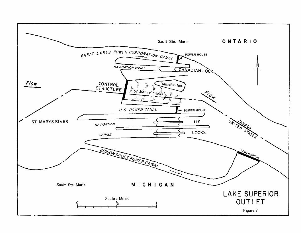
SauIt Ste. Marie O N T A R I O
U . S . POWER C A N A L ~ L POWER HOUSE \
Sault Ste. Marie M
9 Scale : Miles
12 I
N t t
LAKE SUPERIOR I OUTLET - -
Figure 7
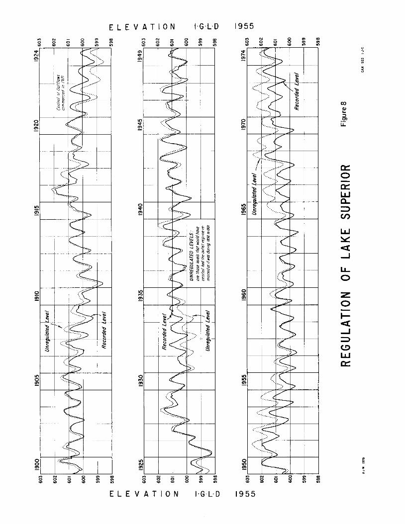
E L E V A T I O N 1.G.L.D N - o m w o o o m m W I D ( 0 Y ) u Y
N - m 2 3 8 s
E L E V A T I 0 N 1.G.L.D 1955
the water surface below the locks is not greater than 582.9 feet. The Commission established the Internation- al Lake Superior Board of Control to supervise the operation of all control works, canals, headgates and bypasses and to formulate rules for their operation. The existing control works at the head of the St. Marys Rapids are shown on Figure 7.
The regulation plans developed by the Lake Superior Board of Control for controlling the outflows have been modified several times to obtain improved results. The first plan, the Sabin Rule, was replaced by a plan designated as Rule P-5. The Rule of 1949 was subse- quently developed in recognition of the increased sup- plies to Lake Superior from the Long Lac-Ogoki Diversion.
The present regulation plan, the 1955 Modified Rule of 1949, has been in force since December 1955. The monthly regulated discharge is determined on the first of every month and is a function of the mean Lake Superior level for the previous month. During the winter months, usually from December 1 to April 30, the minimum allowable discharge is 55,000 cfs, while the maximum allowable is 85,000 cfs. The latter figure, based on experience with ice jams, was considered to be a “safe” maximum. The outflow for the winter months is fixed except for the rare instances when the mean lake level moves tlo or from the maximum or minimum range of 0.2 foot specified on the Rule Curve. It should be noted that a change of 15,000 cfs in outflow will only change the level of Lake Superior by one-tenth of one foot in two and one-half months.
During the summer months, usually from May 1 to November 30, the maximum outflow is all 16 gates open plus 65,000 c:fs through the power canals and navigation locks, or about 125,000 cfs. The minimum summer outflow is 58,000 cfs.
Lake Superior has been regulated since August 1921. The recorded1 mean monthly lake levels from 1900-1974 inclusive are shown on Figure 8. Superimposed on that chart are the: levels that would have occurred had there been no regulation and if the outlet regime had remained as it was from 1892 to 1901. These outlet conditions reflect the combined effect of the internation- al railway bridge, the navigation and power canals, and their associated fills as they existed at that time. During the ensuing 60 years the mean lake level was elevation 600.5, the lower limit set out in the Order.
During the winters of 1968-69 through 1971-72 the International Great Lakes Levels Board conducted a test program to determine if the St. Marys River could carry flows exceeding 85,000 cfs, and i f it was practical to change the gate settings in the winter months. Steam- heating equipment was installed for de-icing the gates of the compensating works. The ice and hydraulic condi- tions were continuously monitored and emergency procedures for quickly closing the gates in the event of an ice jam were developed. The tests were terminated after four winters. It was found that gate settings could be changed during the winter under fairly severe condi- tions and at a reasonable cost; flows of 95,000 cfs are
feasible after a stable ice cover has been established; and continuous monitoring is necessary to achieve adequate lead time to avert flooding caused by ice jams. It is also necessary during periods of higher winter outflows.
On January 26, 1973 during a period of critical high water in the lower Great Lakes, the Government of the United States presented an Emergency Application to the International Joint Commission. It requested the Commission to amend its Order of May 26, I914 and any other pertinent Orders and to undertake emergency action so as to reduce water releases through power canal facilities, operated under the authority and juris- diction of the United States to the extent necessary or feasible. The United States also requested the Commis- sion to suspend such of its Rules as may be required for immediate consideration of this Application. The full text of the Emergency Application is in Appendix E.
With the benefit of studies made by the International Great Lakes Levels Board, the Commission directed its International Lake Superior Board of Control to reduce the discharge through the United States power plants commencing February I , 1973 with the objective of improving levels downstream without undue detriment to Lake Superior interests. The upper limit of water levels specified by the Commission’s Orders has not been violated.
Lake Ontario Regulation
The natural regime of the outlet from Lake Ontario has undergone changes since 1825. By 1850 works in the St. Lawrence River provided a minimum channel depth of nine feet from the Atlantic to Lake Ontario. Between 1884 and 1905 a canal-building program undertaken by the Government of Canada enabled ships with a 14-foot draft to navigate from the Atlantic to Lake Superior. In 191 8 a submerged weir was built in the St. Lawrence River near Massena to facilitate the diversion of water for the generation of power.
The Moses-Saunders Dam and Powerhouse, the Long Sault Dam which is a spillway capable of passing the total flow of the St. Lawrence River, the Iroquois Dam and extensive channel enlargements were completed in August 1958. The control dams and channel enlarge- ments were designed to cope with the worst known floods and droughts in the 95 years which preceded 1955, including the record high levels of 1952 and the record low levels of 1934.
The St. Lawrence Seaway and Power Project enabled ships with a 25-foot draft to traverse the entire Great Lakes-St. Lawrence System, provided a hydro-electric installation of 1,824,000 kilowatts, and significantly increased the outflow capacity from Lake Ontario. A general map of the International Section of the St. Lawrence River is on Figure 9.
In 1952 the Governments of Canada and the United States applied to this Commission for approval to con- struct certain works for the development of power in the International Rapids Section of the St. Lawrence River.
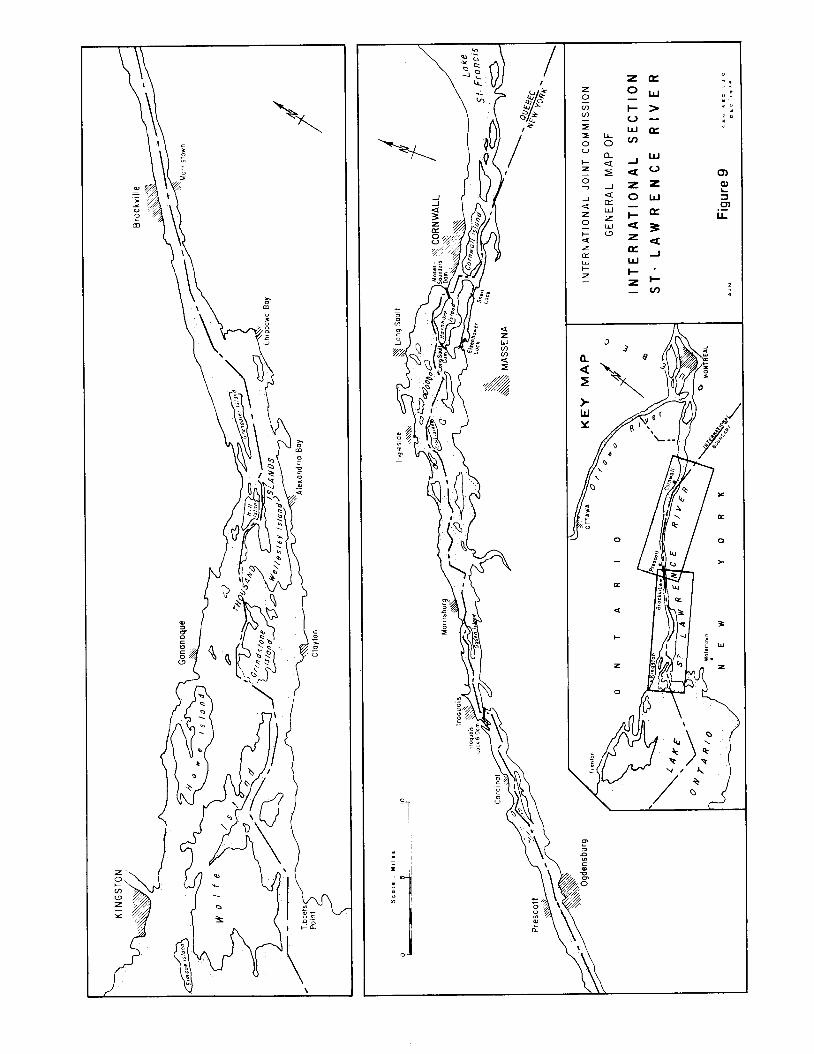
P n
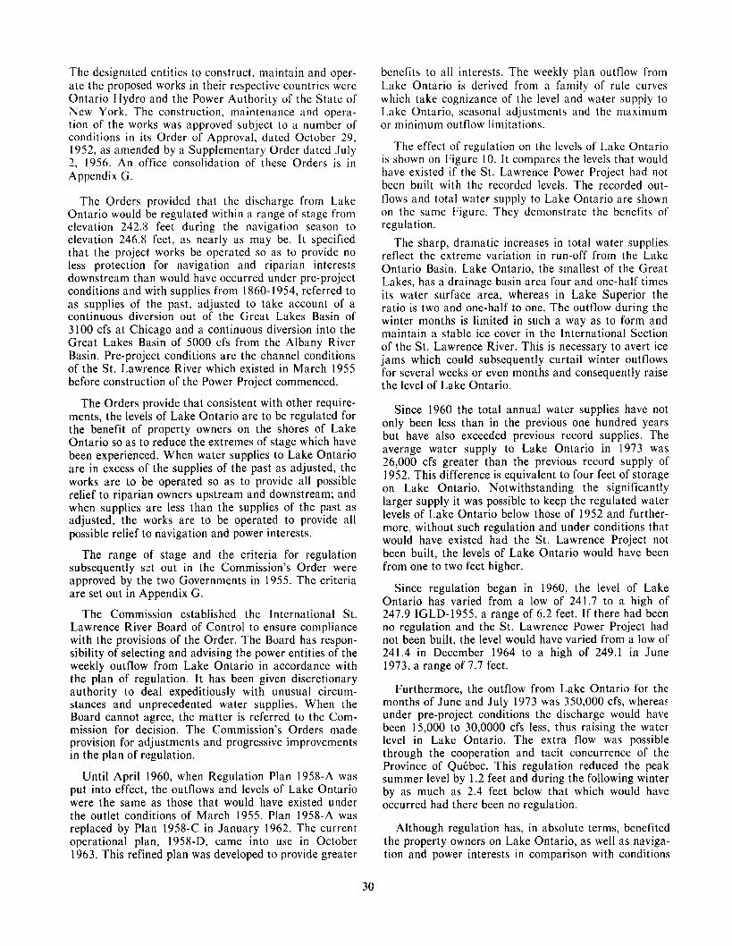
The designated entities to construct, maintain and oper- ate the proposed works in their respective countries were Ontario Hydro and the Power Authority of the State of New York. The construction, maintenance and opera- tion of the works was approved subject to a number of conditions in its Order of Approval, dated October 29, 1952, as amended by a Supplementary Order dated July 2, 1956. An office consolidation of these Orders is in Appendix G.
The Orders provided that the discharge from Lake Ontario would be regulated within a range of stage from elevation 242.13 feet during the navigation season to elevation 246.8 feet, as nearly as may be. I t specified that the project works be operated so as to provide no less protection for navigation and riparian interests downstream th(an would have occurred under pre-project conditions and with supplies from 1860- 1954, referred to as supplies of the past, adjusted to take account of a continuous divlersion out of the Great Lakes Basin of 3 100 cfs at Chicago and a continuous diversion into the Great Lakes Basin of 5000 cfs from the Albany River Basin. Pre-project conditions are the channel conditions of the St. Lawrence River which existed in March 1955 before construction of the Power Project commenced.
The Orders provide that consistent with other require- ments, the levels of Lake Ontario are to be regulated for the benefit of property owners on the shores of Lake Ontario so as to reduce the extremes of stage which have been experienced. When water supplies to Lake Ontario are in excess of the supplies of the past as adjusted, the works are to be operated so as to provide all possible relief to riparia.n owners upstream and downstream; and when supplies are less than the supplies of the past as adjusted, the works are to be operated to provide all possible relief to navigation and power interests.
The range of stage and the criteria for regulation subsequently set out in the Commission’s Order were approved by the two Governments in 1955. The criteria are set out in A.ppendix G.
The Commission established the International St. Lawrence River Board of Control to ensure compliance with the provisions of the Order. The Board has respon- sibility of selecting and advising the power entities of the weekly outflow from Lake Ontario in accordance with the plan of regulation. It has been given discretionary authority to deal expeditiously with unusual circum- stances and unprecedented water supplies. When the Board cannot agree, the matter is referred to the Com- mission for decision. The Commission’s Orders made provision for adjustments and progressive improvements in the plan of regulation.
Until April 1960, when Regulation Plan 1958-A was put into effect, the outflows and levels of Lake Ontario were the same as those that would have existed under the outlet conditions of March 1955. Plan 1958-A was replaced by Plan 1958-C in January 1962. The current operational plan, 1958-D, came into use in October 1963. This refined plan was developed to provide greater
benefits to all interests. The weekly plan outflow from Lake Ontario is derived from a family of rule curves which take cognizance of the level and water supply to Lake Ontario, seasonal adjustments and the maximum or minimum outflow limitations.
The effect of regulation on the levels of Lake Ontario is shown on Figure 10. It compares the levels that would have existed if the St. Lawrence Power Project had not been built with the recorded levels. The recorded out- flows and total water supply to Lake Ontario are shown on the same Figure. They demonstrate the benefits of regulation.
The sharp, dramatic increases in total water supplies reflect the extreme variation in run-off from the Lake Ontario Basin. Lake Ontario, the smallest of the Great Lakes, has a drainage basin area four and one-half times its water surface area, whereas in Lake Superior the ratio is two and one-half to one. The outflow during the winter months is limited in such a way as to form and maintain a stable ice cover in the International Section of the St. Lawrence River. This is necessary to avert ice jams which could subsequently curtail winter outflows for several weeks or even months and consequently raise the level of Lake Ontario.
Since 1960 the total annual water supplies have not only been less than in the previous one hundred years but have also exceeded previous record supplies. The average water supply to t a k e Ontario in 1973 was 26,000 cfs greater than the previous record supply of 1952. This difference is equivalent to four feet of storage on Lake Ontario. Notwithstanding the significantly larger supply it was possible to keep the regulated water levels of Lake Ontario below those of 1952 and further- more, without such regulation and under conditions that would have existed had the St. Lawrence Project not been built, the levels of Lake Ontario would have been from one to two feet higher.
Since regulation began in 1960, the level of Lake Ontario has varied from a low of 241.7 to a high of 247.9 IGLD-1955, a range of 6.2 feet. If there had been no regulation and the St. Lawrence Power Project had not been built, the level would have varied from a low of 241.4 in December 1964 to a high of 249.1 in June 1973, a range of 7.7 feet.
Furthermore, the outflow from Lake Ontario for the months of June and July 1973 was 350,000 cfs, whereas under pre-project conditions the discharge would have been 15,000 to 30,0000 cfs less, thus raising the water level in Lake Ontario. The extra flow was possible through the cooperation and tacit concurrence of the Province of QuCbec. This regulation reduced the peak summer level by 1.2 feet and during the following winter by as much as 2.4 feet below that which would have occurred had there been no regulation.
Although regulation has, in absolute terms, benefited the property owners on Lake Ontario, as well as naviga- tion and power interests in comparison with conditions
30
T H O U S A N D S O F C . F - S g m m r - w v ) P l o N x x x x x x : : N
d N
t
PC w a,
M PC
cu PC
- PC
0 PC
0, W
aD W
PC W
W W
In W
d- W
M W
cu W
- W
0 W a,
E L E V A T I O N 1.G.L.C 1955
E L E V A T I O N 1.G.L.D 1955

which would have prevailed under pre-project condi- tions, property owners at several public hearings expressed their view that their interests could have received more protection. The Commission is satisfied that the regulation carried out under its direction by its International !St. Lawrence River Board of Control has provided a good and judicial balance between the vari- ous interests and that none of the interests could have
received more protection without serious detriment to the others or to riparian interests downstream in the Canadian Section of the River.
It must be recognized that during periods of unprece- dented deficient or excessive precipitation, regulation can only alleviate, not entirely eliminate, the adverse conditions caused by the unpredictable and uncontrol- lable forces of nature.
32
Chapter VI1
CHRONOLOGY OF EVENTS
The Commission’s role in the Great Lakes Water Levels inquiry began with the receipt of the October 7, 1964 Reference from the United States and Canadian Governments. The studies required by the Reference and discussed in Chapter I1 involve consideration of complex technical problems and conflicting uses of the water of the Great Lakes.
I n late October and early November 1964, members of the Commission with United States and Canadian agency representatives toured affected areas of the United States and Canadian shoreline to view first-hand some of the problems associated with the then prevailing low water levels.
The Commission, on December 2, 1964, established the International Great Lakes Levels Board and appointed to it six experts, three from Canadian agen- cies and three from United States agencies. The Com- mission directed the Board to undertake the necessary investigations and studies and to advise the Commission on all matters which it must consider in reporting to the Governments on the Reference.
The Commission met with Provincial officials in Toronto on January 20, 1965 to receive their views concerning the Great Lakes levels study. Similarly, at a meeting in Detroit on February 24, 1965, comment was received from representatives of the eight Great Lakes States and the Great Lakes Commission.
I n order to provide this Commission with a feeling for the concerns and interests of the people in the Basin at the outset of the study, public hearings were conducted at Toronto on May 10, 1965, at Sault Ste. Marie,. Michigan on May 11, at Windsor on May 25, and at Chicago on May 26, 1965.
The Commission in its Directive to the Board request- ed an outline and a cost estimate of the proposed investigation as soon as possible. In September 1965 the Board submitted an outline for a five-year study costing over $2 million. The study outline did not include an estimate of time and funding for design and related field investigations for regulatory works which might subse- quently be proposed. The Board advised the Commission that it would report on this matter at a later date. The
Commission approved the Board’s initial study outline and cost estimate on October 7, 1965.
The Board’s study program was divided into two broad phases. The first phase, which extended to the spring of 1967, consisted of collection and compilation of data, development of procedures for evaluating the effects of lake level fluctuations on the users of Great Lakes waters and the development of preliminary ap- proaches to regulation. The Board briefed the Commis- sion on these activities at a two-day meeting in January 1967. In the second phase of the program the results of preliminary regulation studies, coupled with data col- lected on the effect of lake level fluctuation on the shore property, power and navigation interests, were used to establish criteria for the development of operable regula- tion plans and to evaluate the effect of these plans on the various interests. The views and participation of Great Lakes States and Provinces were actively sought in the studies.
The Board submitted to the Commission twenty semi- annual progress reports throughout the study and special reports on such other occasions as problems presented themselves.
In August 1968 because of the importance and mag- nitude of the inquiry the Commission furnished an Interim Report to the two Governments on the study progress to date. The Commission reported that the first phase of the investigation was virtually completed. Basic data on properties and installations along some 11,000 miles of shoreline, on all aspects of commercial naviga- tion and recreational boating, and on existing hydro- electric plants had been collected, compiled and evaluat- ed. Recorded data on levels and flows had been coor- dinated and adjusted to insure international agreement and compatibility. Computer programs had been used extensively to simulate hydrologic data and assist in development of regulation plans. The report noted that detailed investigation of regulatory works would be required if preliminary cost estimates were found to be compatible with preliminary estimates of economic benefits.
As mentioned earlier, the initial study outline did not contain schedule time or funds for design and related
33
field investigations for regulatory works which might subsequently be proposed. The Commission was advised by its Board i n the fall of 1968 that investigations indicated the probable need for detailed studies of regulatory works. Two years additional time would be required and total study costs would be about $4 million. The Board noted that the validity of the new schedule and cost estimate was dependent on receipt of appro- priations and availability of manpower in a timely manner. A year later the Board advised the Commission that the detailed studies of regulatory works were required. Because the levels of the Great Lakes during this period were about average and agencies had other national priorities, the Board further advised the Com- mission that it was unable to obtain the resources neces- sary to expedite these additional investigations and the study period would have to be extended to October 1973.
At a meeting in Cleveland in December 1969, the Commission was briefed by its International Great Lakes Levels EIoard on the study procedures and results to date and im particular, on the major assumptions utilized in the study. The Commission provided guid- ance to the Board on these matters and directed the Board to proceled with its revised schedule of studies.
At a meeting in Detroit in March 1971, the Commis- sion after being apprised of the results of the studies to date and the criteria and objectives being developed by the Board, advised the Board to proceed with the sched- uled detailed studies.
The studies continued essentially as scheduled throughout the remainder of the investigation. On Janu- ary 15, 1973 because of very high water levels on the Great Lakes, the Commission advised its International Great Lakes Llevels Board that, as a result of discussions with its International Lake Superior Board of Control, it was considering, as a matter of urgency, the possibility of operating the control works at Sault Ste. Marie in such a way a!$ to provide relief for the Lower Great Lakes and at tlhe same time maintain satisfactory condi- tions on Lake Superior. The Board was requested to report, prior to March 1, 1973, its interim findings and conclusions with respect to possible modified operations at Sault Ste. Marie. The Board on March 15, 1973 submitted an Interim Report on a plan to regulate Lakes Superior and Ontario.
Public hearings were held during May 1973 at Rochester, Toronto, Detroit, and Sault Ste. Marie and in Duluth in June to obtain public reaction to the Interim Report. After considering the information fur- nished in the Board’s Interim Report and the views expressed at the hearings, the Commission transmitted to the Governments in June 1973 its Special Interim Report on regulation of Lake Superior outflows to pro- vide relief frotn high water levels on the Lower Great Lakes.
In its Special Interim Report the Commission recom- mended that tlhe Government of the United States and the Government of Canada approve, as the objective for
regulating Lake Superior outflows in the future, the provision of benefits to interests throughout the Great Lakes System without undue detriment to Lake Supe- rior interests. To achieve this objective, all control works in the St. Marys River would be operated so as to keep the levels of Lake Superior and Lakes Michigan-Huron at the same relative position within their recorded ranges of stage and with respect to their mean monthly levels. Under such operation, the level of Lake Superior would be maintained, as nearly as may be, within its recorded range but below elevation 602.0 feet IGLD- 1955, the upper limit established pursuant to the Com- mission’s 191 4 Orders of Approval.
I t was also recommended that the two Governments jointly grant the Commission specific authority to: Amend its Orders of Approval, dated May 26 and 27, 1914; prescribe a plan of regulation for Lake Superior; direct the operation of all control works in the St. Marys River; and delegate its authority over regulation and operation to an International Board appointed by the Commission.
The Commission also recommended that the two Gov- ernments make provision for the disposition of claims for physical injury or damage to persons or property occur- ring in their respective territories and resulting from the maintenance and operation of the existing control works in the St. Marys River pursuant to the above objective and for the satisfaction of such claims as are valid.
In order to permit safe operation of these control works under winter conditions, the Commission recom- mended that the physical improvements to the control structure suggested by the Board be undertaken without delay. The Commission stated that unless otherwise instructed by Governments it would continue the course of action which it undertook on January 30, 1973, to direct regulation consistent with the above objective, until either the emergency situation eased downstream or Lake Superior conditions required reversion to the 1955 Modified Rule of 1949.
The Commission on June 29, 1973 directed the Inter- national Lake Superior Board of Control to regulate that lake in accordance with the stated objective using as a guide the regulation rules of Plan SO-901 as described in the International Great Lakes Levels Board’s interim report. The Commission has kept the water level situation in Lake Superior and the Lower Lakes under continuing review. In January 1974 the Commission pointed out to the two Governments its concern that it had not received further instructions in response to the Special Interim Report. The two Gov- ernments have not, as of this date, transmitted the requested instructions to the Commission.
The Commission received the Board’s main report in March 1974, an illustrated summary report during the summer, and all of the appendices by October 1974. The reports and appendices were given extensive public dis- tribution by the Commission as soon as they were received. Public hearings were held in thirteen cities around the Great Lakes to receive comments on the
34
Board’s report and further information from interested individuals, associations and governmental agencies.
The Commission in the course of its deliberations recognized that it could not fully answer all the ques- tions raised in the Reference. In a letter dated May 23, 1975 it informed the two Governments of the necessity for specific further studies and requested support for them. It was noted that the environmental aspects and the net benefits of Lake Erie regulation were not ade- quately covered in the Board’s report nor in the United States Corps of Engineers’ proposal for regulation of Lake Erie. Similarly, the Commission was of the opinion that further information is required to ascertain what measures would be practicable to accommodate increased flows in the St. Lawrence River with a view to improving the regulation of Lake Erie and Lake Ontario. Copies of the correspondence are in Appen- dix J .
It may appear surprising that the total time taken for the completion of the inquiry was over a decade. This, in the view of the Commission, is manifestly an unfortu- nate time span in the conduct of even so massive an investigation as the present one. There were many dif- ficulties arising from beginning an inquiry in one decade and completing it in another, even though there were incidental advantages in the present case. This investiga-
tion began at a time of low water while the Board’s report, ironically, was completed during a period of high water. Thus, both low and high water perspectives on lake levels and their regulation became available to the Board and to the Commission.
Nevertheless, the Commission believes that the inter- ests of both countries are better served by a more rapid completion of investigations, however extensive the study may be. I n this case, the chronology demonstrates that the delays were due to a mixture of problems in funding, problems of allocation of personnel and changes in personnel which interrupted sustained activ- ity by the Board, its Committees and the Commission itself. There are important lessons to be learned from this experience: First, in any reference funding must be assured and provided so as to prevent serious delays in the investigation; second, continuity of board and com- mittee personnel from the agencies involved is needed to ensure against frequent timetable difficulties.
The full story, therefore, of the Great Lakes levels inquiry should be seen in light of these causes for the delay, the possible gains from the double perception of high and low water, and the lessons taught by this experience for the benefit of both Governments and the Commission, with respect to future references, their funding and their allocation of manpower.
35

Chapter VI11
THE TECHNICAL INVESTIGATION
The International Great Lakes Levels Board, on receipt of its Directive from the Commission in Decem- ber 1964, proceeded with the preliminary planning necessary to undertake the investigations required by the Reference. The results of the Board’s studies are given in detail in its report to the Commission dated Decem- ber 1973, and the seven appendices attached thereto.
Organization
I n organizing for the studies under the Reference, the Commission fully utilized the offer of the two Federal Governments contained in the Reference to “upon request, make available to the Commission the services of engineers and other specially-qualified personnel of their governmental agencies and such information and technical data as may have been acquired or may be acquired by them in the course of the investigation.” This has provided the Commission and its Board with a broad range of professional talent, data and experience in the disciplines necessary to complete the Commis- sion’s extensive assignment. Nearly 150 experts from 22 agencies, supported by technical staffs, participated actively in the studies. These included engineers, econo- mists, biologists, ecologists and land-use planners.
The Board appointed a working committee on Janu- ary 6, 1965 to assemble the necessary data, organize the field activities and conduct the studies required by the Reference. In order to bring specialized talent to bear on specific study areas, the working committee initially appointed four subcommittees: Shore Property; Regula- tion; Navigation; and Power. The four categories include all of the interests identified in the Reference for which improved water level conditions should be investigated: Domestic water supply and sanitation, navigation, water for power and industry, flood control, agriculture, fish, wildlife and recreation. The Shore Property Subcommit- tee considered the effects of variations in water levels on flood control, domestic water supply and sanitation, water for industry, marine structures and fish, wildlife and recreation. Because of the special nature of the studies of fish, wildlife and recreation, the subcommittee prepared a separate appendix covering its activities in
these areas. Later in the Board’s studies, as the need became evident, the Regulatory Works Subcommittee and the Reports Subcommittee were formed. A number of short-lived, ad-hoc groups, such as the committees on economics and fisheries, were formed to investigate several areas requiring the short-term application of highly-specialized skills.
Considerations and Constraints
The needs of the diverse and often conflicting inter- ests who use the Great Lakes were taken into account. The Board found that the users fall into four general categories of interest-shore property; fish, wildlife and recreation; navigation; and power. The detailed investi- gations into methodology for evaluating the effects of water level fluctuations on the four interests are given in Appendix C-Shore Property, Appendix D-Fish, Wildlife and Recreation, Appendix G-Navigation, and Appendix F-Power, of the Board’s report. The factors to be taken into account with respect to each are dis- cussed below.
Shore Property Interests-This category of interest is concerned with the effects of water level variations on erosion and inundation of the shoreline, primarily a flood control problem; on the operation of water intakes and sewer outfalls, which relates to the question of domestic water supplies and sanitation and water for industry; and on marine structures such as marinas and commercial docks. Agricultural interests have been found to be affected primarily by loss of agricultural land or its use through erosion or inundation. Because of the seasonal variations and wind-induced waves which are superimposed on the long-term fluctuations, shore- line concerns are most pronounced when excessive pre- cipitation has significantly raised lake levels or when persistent drought has lowered levels. On the other hand some kinds of shore property damage can occur at both high and low lake levels. Damage due to high water may result from flooding, erosion of the shore or from the effect of wave action on shoreline structures. Erosion is a continuous process, the effects of which are most pronounced during periods of high water. During low
37
water periods, major economic damage results from the reduced depths available to recreational beaches, small boat harbours, and marinas. Damage also occurs in the lower reaches of tributary streams where the available depths are controlled by the level of the lake.
Many factors in combination with the lake level have a direct effect on shore property damage. These factors include wind, barometric pressure differentials, the time of year, and the geological formation of the area. There are almost unlimited variations in lake surface activities, shore characteristics and natural events which produce shore propert:y damage. As a general rule the shore property interests desire a reduction in the range and the frequency of extreme water levels although at any given time their interests may conflict with one another, depending on their geographic location.
Fish, Wildr’ife and Recreation-There are varying effects from water level fluctuations on fish and wildlife principally because of their effects on marsh areas and shallow spawning areas. It should be noted, however, that the entire: lake and river system plays a part in the development and maintenance of the existing ecosystem and that changes to any part of the system by regulation of water levels could affect the whole system, not just the marshlandls and shore areas. In addition some part of the long-term fluctuation and the seasonal variations is essential to the maintenance of the ecosystem. With respect to recreation, the effect of water level fluctuation is primarily .related to the quantity and quality of beaches and the availability of fish and game.
Navigation Interests-The commercial navigation system within the Great Lakes is maintained to accom- modate the present Great Lakes fleet and overseas traffic entering and leaving through the St. Lawrence Seaway. The advertised navigation depths in the system are related to an agreed level on each lake. This agreed level, which is called the low water datum plane, is the one below which the project depths for dredging of channels and harbours are measured. It is a low lake level. which is exceeded most of the time. ExDerience on
the daily, weekly or monthly mean flow and which would, in effect, increase the dependable flow available for power during peak load periods. I n the design of channel enlargements for power it is advantageous to power interests to have the lake levels as high as possible since these high levels help reduce the cost of excavating the channels.
It is also of importance to the power interests that the flows during the winter months be such to ensure the formation and retention of a stable ice cover on the outflow rivers. This would minimize ice jams in the rivers, clogging of turbine intakes, and make it possible to discharge flows to meet high load requirements during the winter season. Since seasonal load require- ments are generally greater during the winter months, the minimum flows during the winter should be greater than those for the summer.
A stable ice cover is also of prime concern to shore property owners. A serious ice jam in the International Rapids Section of the St. Lawrence River could cause involuntary storage of an extra foot of water on Lake Ontario. The seriousness of such an ice jam occurring in years of high water levels such as those of the early 1970’s cannot be overestimated. The stabilization of the Lake Erie ice cover at Buffalo by the Lake Erie-Niagara River ice boom has significantly reduced the shoreline ice damage in the Niagara River.
Because of the physical constraints inherent in the Great Lakes System, the wide variations in water supply from month to month and the diversity of interests involved, the Board’s studies indicated that it is not possible to make the dramatic changes by lake regula- tion which some people might like to see made. How- ever, it found that by considering the Great Lakes System as a whole, recognizing that what is done in the upper lakes has an effect on the lower lakes, improve- ments can be made in the regime of the water levels and outflows to benefit the users of the system.
the lakes over the past fifty years had demonitrated that ship owners take full advantage of all available depths in the channels and harbours. There are some vessels on
Methodology for Evaluating Lake Regulation
the Great Lakes of such characteristics that they can load to full dlraft only during periods of extreme high levels. Hence, navigation interests advocate maintaining relatively high minimum levels throughout the system during the navigation season to allow greater draft for vessels, as well as maintaining high minimum flows in the Connecting Channels during the same period to maintain the depths in those Channels. There is equal concern with the maximum levels which govern eleva- tions at the docks, and with the frequency and duration of high flows which affect river currents and velocities.
Power Intet-ests-In the long run, power interests desire flows to be as uniform as possible and, particular- ly, high minirnum flows to increase their firm power capacity. On a short-term basis they desire flexibility of operation which would permit short-period variations in
The Board developed and tested regulation plans to meet certain objectives and criteria, using water supplies which have occurred in the past, to determine the degree to which regulation can be accomplished and the cost of implementation. In the development of these plans, the Board made a number of basic assumptions concerning the system. These are discussed below.
Before undertaking to change a regime of water levels on a lake, one needs to know how such a change would affect the people using the lake. The effects can be translated into economic or dollar effects, environmental effects and hydrologic effects. All regulation plans which were examined in detail were evaluated with the same economic and hydrologic data to ensure a valid comparison.
38
Economic Effects of Regulation-Some effects are relatively easy to translate into dollar values of their commercial nature. Power and navigation interests are examples where well-established methods are available to translate water level and flow changes into dollar amounts for the purpose of project evaluation and jus- tification. With regard to the effect of a changed water level regime on recreational beaches and on shoreline property, a lack of basic data precludes as precise a conversion of the effects into dollar values as can be obtained for the power and navigation interests. As the available field data grows, and serious efforts are under- way in both countries to acquire such information, the precision of evaluating shoreline effects will increase. Furthermore, it is even more difficult to place an eco- nomic value on environmental effects of changed level regimes.
The methodology for evaluating the effects of regula- tion on navigation is based on a concept that ships that can take advantage of deeper water will load to the maximum safe draft available. Any increase or decrease in lake levels will change the cargo-carrying capacity of some vessels. Where regulation can provide greater depths in navigation channels and harbours, fewer vessel trips would be required. Conversely, where regulation provides lesser depths, more vessel trips would be required. The number of trips required, multiplied by the average number of hours for each trip for each of the various routes, multiplied by total vessel cost per hour was taken as the measure of cost for transporting the selected bulk commodities. The difference in cost of transporting the various bulk commodities under a new regulation plan as compared to the cost without the new plan is taken as the benefit or loss to navigation.
In making its assessment of the navigation system, the Board assumed that there would be no increase in the controlling depth of the Great Lakes navigation system beyond the present 27 feet. Thus the costs of any necessary channel dredging in the Connecting Channels and St. Lawrence River for regulation would not be chargeable to navigation.
Hydro-electric installations on the outlet rivers that could be affected by changes in the water level and flow regime of the system are those existing on the St. Marys River, Niagara River, the Welland Canal and St. Law- rence River. The potential benefits or losses to the ultimate power user would depend on how the overall costs of producing the power needed to service the expected system loads would be affected by further regulation of the Great Lakes. The capacity and energy available from power installations depends primarily upon the available flows and to a lesser extent on the net head. 'The increased or decreased system costs which would result from changes in the capacity and energy output occasioned by the changed level and flow regime under regulation provide a measure of the dollar effect on the power system.
Changes in the level regime on the Lakes and their Connecting Rivers affect the rate of erosion of the
shoreline and the time during which portions may be inundated. This results in changes in the rate of land loss and accretion, of structural damage or loss, and of flood damages. The Board developed water level-dam- age relationships, reach by reach, for the entire shoreline of the Great Lakes, some 11,200 miles. These relation- ships take into account the physical and hydraulic fac- tors present in each reach which effect damage. They include the nature of shore materials, exposure to onshore winds, configuration of the shoreline and the ability of the shoreline to absorb energy.
Since considerable data were available from surveys made along the United States shoreline during the high water levels in 1951-52, these data were utilized, as a basis for development of the water level-damage rela- tionships for the United States shoreline.
A complete survey of the Canadian shoreline of the Great Lakes and Connecting Rivers was made during 1966 and 1967. This survey included a detailed inven- tory of shore characteristics, land use, marine structures, long-term erosion rates and flood levels. Using the infor- mation derived from this survey, a mathematical model was developed to provide an estimate of damage that would occur for all months, for all reaches, and for any water level. The results were substantiated by compari- son with historical data.
Projections were made of future shoreline use and development and incorporated into the assessment. Future development of Great Lakes shoreline would be affected to some degree by land-use planning and zoning. Assuming that effective land-use controls can be achieved within a reasonable period, future damages can be limited essentially to existing structures and to loss of land through erosion.
The Board found that maintenance dredging of mari- nas needed to be considered. It determined the differ- ence in dredging costs with and without the proposed plan of regulation in operation, for the facilities estimat- ed to be in place during the project life. The difference between the two represents the effect of regulation on marina dredging costs.
Environmental Effects-The environment may be defined as the sum total of the physical and social factors which affect the existence of an organism. Important to the human environment are the factors of aesthetics, beauty and human sensitivity which provide an essential quality of life.
Determination of the environmental effects of further regulation involves the identification of the probable changes that would take place followed by an evaluation of whether such changes were beneficial or harmful. The Board classified the effects of such changes in four categories: ecological; hygienic; aesthetic, and the social well-being of people.
Many factors are involved in any assessment of an ecosystem. In the area of fishery the Board considered the effects of level and flow changes, changes in velocity, in turbidity and other physical changes brought about
39
by proposed regulation and the construction and opera- tion of works necessary to achieve regulation. The Board made a judgmental assessment of the effects of these changes on fishery. With respect to wildlife, the Board considered the reduction or increase in available wetland around the Lakes due to further regulation. These assessments were the indicators which the Board used to identify probable effect on the ecosystem.
The Board considered the effect of level and flow changes on the use of the Great Lakes water for domes- tic and sanitary purposes. In particular, the impact of changing water levels on existing water intakes and sewer outfalls, including industrial and storm water outfalls, was fully addressed in the study.
Assessment of aesthetic effect was concentrated on those changes that are clearly attributable to regulation and would produce a public reaction. These include changes i n appearance of the aquatic or land environ- ment, the taste of water, fish and wildlife and in bottom characteristics of streams.
Social well-being is defined in terms of general well- being of individuals and the viability of communities in which they reside. The assessment and evaluation of impacts on s'ocial well-being are hindered by the inabili- ty to assess quantitatively the values of many, i f not most, human experiences and needs. Physical changes such as displacement of individuals or groups of individuals, are obvious. But many of the emotional, intangible impacts that result from change, are not so obvious. A prime sociological concern is to preserve existing intra and inter-community relationships that are essential to community viability and integrity. Indicators used to measure change in social well-being include the conveniences to communities and individu- als, recreational and employment opportunities, disrup- tion of life styles, relocation of individuals, land-use changes, and general security of life and health. Assess- ment of effects on social well-being required full use of information generated in the assessment of ecological, hygienic, aesthetic, and economic effects
Hydrologic Effects of Regulation-Analysis of lake levels and outflows involves consideration of their max- imum, mean and minimum monthly values and their range, duration and seasonal distribution. Criteria were developed to measure the degree to which the purposes of regulation have been achieved.
Development of Regulation Plans A regulation plan for a lake is a predetermined set of
rules for changing the existing pattern of outflows from the lake in order to create a more favourable regimen of water levels and discharges. Regulatory works are required to provide the necessary control over outflows. They might consist of channel deepening in the outlet channel to increase flows, coupled with gated structures to reduce outflows below the capacity of the channels.
Past monthly levels and outflows of a lake reflect the manner in which past water supplies were routed by
nature through the then existing outflow channels. A regulation plan is a procedure for routing water supplies through the control works to achieve certain desirable objectives, such as a reduced range of water levels on the lake.
We do not have the ability to predict future water supplies. Such knowledge would permit an increase in outflow if we knew high supplies were coming. In the absence of such knowledge we must use past supplies as a gauge to estimate what will happen in the future and to test regulation plans. The Board buttressed this approach by creating simulated supplies of different magnitude and sequence to further test the regulation plans and to be assured that the plans would perform suitably under various supply regimens.
The Board developed plans for the coordinated regu- lation of Lakes Superior, Michigan, Huron, Erie and Ontario (SMHEO Plans); Lakes Superior, Michigan, Huron and Onatrio (SMHO Plans); Lakes Superior, Erie and Ontario (SEO Plans) and Lakes Superior and Ontario (SO Plans). Several hundred plans were tested.
A three-stage procedure was employed in the develop- ment of the regulation plans. In the first stage, a math- ematical procedure was employed to determine the abso- lute upper limit of total benefits that would possibly accrue to the three major interest groups under any system of regulation. These figures were then compared with order of magnitude cost estimates to give a prelim- inary assessment of economic feasibility. In the second stage a number of plans were tested; each was concerned with meeting a specific operating objective. These plans were developed to meet broad operating objectives such as maximum economic benefit for the system, no eco- nomic loss to any major interest, no change in mean lake level and satisfaction of existing regulation criteria. Results from the first stage were used to help identify means of meeting the various objectives. For example, it was apparent from these studies that maximum benefit from Lake Superior regulation could be realized by balancing storage between Lake Superior and Lakes Michigan-Huron.
The results of plans developed in the second stage, together with their corresponding objectives and criteria were reviewed, and final objectives and criteria adopted. The third stage consisted of the development of a plan to satisfy the adopted objectives and criteria. Detailed benefit evaluations, including economic, environmental and hydrologic analysis were then carried out. Concep- tual designs and cost estimates of the works required to provide regulation capability were then made.
Tabular summaries showing the benefits and costs and hydrologic effects of typical plans evaluated are Tables 4 and 5 at the end of this Chapter. A detailed breakdown of benefits and costs for each plan are given in the Board's report. A breakdown of the average annual benefits for only Plan SO-901 are shown in Table 3 of this Chapter.
40
Evaluation of Regulation Plans The Board selected for detailed benefit-cost evalua-
tion regulation plans for the four lake combinations--- SMHEO, SMHO, SEO and SO. The regulation plans are identified by using the first letter of the lake being regulated. The appended number identifies the plan selected to best meet particular criteria and objectives for the combination of lakes being regulated.
The evaluation is based on a comparison of the level and outflow regimes which would have existed in the period 1900 to 1967 inclusive, under both existing condi- tions and the proposed regulated conditions. The period 1900-1967 was used because earlier data were not suf- ficiently reliable for this investigation. Existing condi- tions reflect present diversions, channel capacities and operation of the present regulation plans for Lake Supe- rior and Lake Ontario. This is called the basis of comparison. It is the standard to which the proposed regulation plans were compared to determine the improvement achieved.
The Board in their economic evaluation used a project life of fifty years, an interest rate of seven percent, a common United States-Canada dollar, and 1971 price levels.
The basis of comparison adopted by the Board for evaluating plans for the SMHEO, SMHO and SEO lake combinations which would require construction of extensive regulatory works is based on the 1933 outlet conditions from Lake Huron. The 1933 outlet conditions are those that existed prior to the dredging of the 25-foot navigation channels in the St. Clair and Detroit Rivers. Those navigation channels were further deepened to 27 feet in 1962. The Board adopted the 1962 outlet condi- tions from Lake Huron for the SO and SEO plans which could be implemented with a minimum of new regulato- ry works.
The use of the 1933 Lake Huron outlet condition for plans involving extensive regulatory works recognized the exchange of Notes between the two Governments which indicated the intent of providing compensating works to return water levels to conditions which existed in 1933. In the event that the water level-flow relation- ship is not returned to 1933 conditions, additional dredg- ing would be required beyond that determined by the Board to meet the objective for the SMHEO and SMHO plans to provide a more beneficial range of stage with a minimal loss to any interest.
As the Board’s studies progressed, the results indicat- ed that the return of levels on Lakes Michigan-Huron to the higher water levels which would exist under 1933 conditions would result in an average annual damage of $12 million to shoreline property. The Board also estimated that $1.3 million in average annual benefits would accrue to navigation from higher levels.
S M H E O and S M H O Plans-Studies were made of plans for the regulation of all five lakes (SMHEO Plans) and of four lakes (SMHO Plans). Preliminary
estimates for these regulation plans indicated that the costs of implementing them would be several times the benefits which could be expected. Since the plans were not viable from an economic standpoint, the Board documented them only to the degree necessary to thor- oughly substantiate this conclusion.
Two plans, SMHEO-38 and SMHO- 1 1, were selected for detailed evaluation as to their effect on shore prop- erty, navigation and power. The hydrologic effects of these plans are given on Table 5 at the end of this Chapter. These plans were not economically feasible and therefore the Board did not undertake detailed environ- mental impact studies. It determined, however, that adverse effects could be expected on the fishery in the St. Clair River and Lake St. Clair because of construc- tion and operation of the necessary flow control struc- tures. It also found that, in general, there would be some adverse effects to wildlife due primarily to reduction of available wetlands and effects of construction and that possible increases in pollution in the stagnant water behind the dams in the St. Clair and Detroit Rivers might be expected. Both regulation plans require a capital investment of about $0.5 million to improve the control structure above the St. Marys Rapids for safe year-round operation.
Additional costs may be incurred to assure continued stability of the control works. Recently the International Lake Superior Board of Control reported the possibility of undermining of some pier foundations. A detailed investigation is necessary to verify this. It is imperative that the foundation investigations be undertaken as soon as practicable regardless of alternative plans to either modernize or redevelop.
Regulation of Lakes Michigan and Huron requires not only an increase in the capacity of the channels of the St. Clair and Detroit Rivers, but also the ability to restrict the outflows below the capacity of the channel. The Board recognized that works necessary to achieve such regulation must be designed to meet certain rather restrictive requirements. They should, in the interest of the shoreline owners, maintain the water surface profile in the St. Clair-Detroit River system; they should not be intolerably restrictive to commercial navigation; they should not inhibit fish movement unduly; they should result in minimum environmental impact; they must be compatible with the rivers’ ice regime and be operable year-round.
After investigating a number of possibilities, the Board concluded that additional dredging and a series of control structures would be required in the St. Clair and Detroit Rivers. Each set of regulatory structures include a combination of gated sections and training walls to control the flow and small boat passages. No locks would be required in this portion of the Great Lakes System. The location of the structures required for the four-lake plan, SMHO-11, are shown on Figure 11. The five-lake plan would require an additional structure at Fawn Island in the St. Clair River, and also dredging and a regulatory structure in the Niagara River. A
41
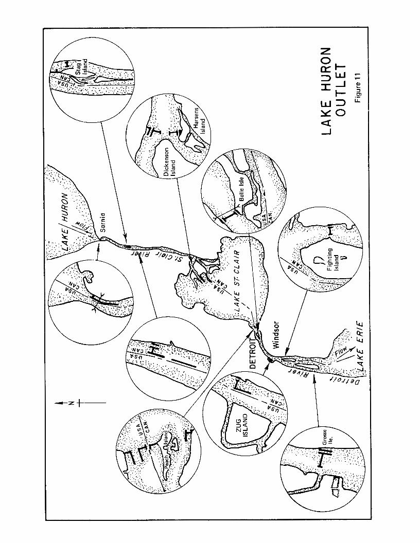
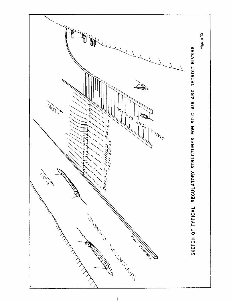
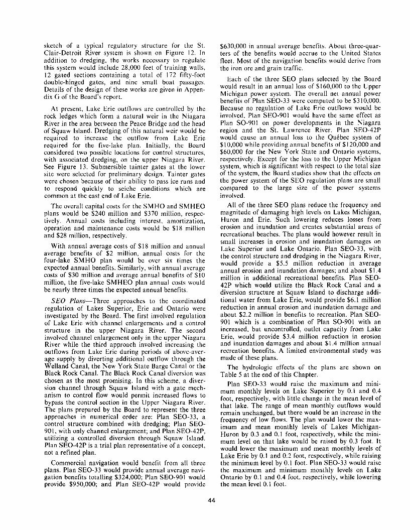
sketch of a typical regulatory structure for the St. Clair-Detroit River system is shown on Figure 12. I n addition to dredging, the works necessary to regulate this system would include 28,000 feet of training walls, 12 gated sections containing a total of 172 fifty-foot double-hinged gates, and nine small boat passages. Details of the design of these works are given in Appen- dix G of the Board’s report.
At present, Lake Erie outflows are controlled by the rock ledges which form a natural weir in the Niagara River in the area between the Peace Bridge and the head of Squaw Island. Dredging of this natural weir would be required to increase the outflow from Lake Erie required for the five-lake plan. Initially, the Board considered two possible locations for control structures, with associated dredging, on the upper Niagara River. See Figure 13. Submersible tainter gates at the lower site were selected for preliminary design. Tainter gates were chosen because of their ability to pass ice runs and to respond quickly to seiche conditions which are common at the east end of Lake Erie.
The overall capital costs for the SMHO and SMHEO plans would be $240 million and $370 million, respec- tively. Annual costs including interest, amortization, operation and maintenance costs would be $18 million and $28 million, respectively.
With annual average costs of $18 million and annual average benefits of $2 million, annual costs for the four-lake SMHO plan would be over six times the expected annual benefits. Similarly, with annual average costs of $30 million and average annual benefits of $10 million, the five-lake SMHEO plan annual costs would be nearly three times the expected annual benefits.
SEO Plans-Three approaches to the coordinated regulation of Lakes Superior, Erie and Ontario were investigated by the Board. The first involved regulation of Lake Erie: with channel enlargements and a control structure in the upper Niagara River. The second involved channel enlargement only in the upper Niagara River while the third approach involved increasing the outflows from Lake Erie during periods of above-aver- age supply by diverting additional outflow through the Welland Canal, the New York State Barge Canal or the Black Rock Canal. The Black Rock Canal diversion was chosen as the most promising. In this scheme, a diver- sion channel through Squaw Island with a gate mech- anism to control flow would permit increased flows to bypass the control section in the Upper Niagara River. The plans prepared by the Board to represent the three approaches nn numerical order are: Plan SEO-33, a control structure combined with dredging; Plan SEO- 901, with only channel enlargement; and Plan SEO-42P, utilizing a controlled diversion through Squaw Island. Plan SEO-42P is a trial plan representative of a concept, not a refined plan.
Commercial navigation would benefit from all three plans. Plan SEO-33 would provide annual average navi- gation benefits totalling $324,000; Plan SEO-901 would provide $950,000; and Plan SEO-42P would provide
$630,000 in annual average benefits. About three-quar- ters of the benefits would accrue to the United States fleet. Most of the navigation benefits would derive from the iron ore and grain traffic.
Each of the three SEO plans selected by the Board would result in an annual loss of $160,000 to the Upper Michigan power system. The overall net annual power benefits of Plan SEO-33 were computed to be $310,000. Because no regulation of Lake Erie outflows would be involved, Plan SEO-901 would have the same effect as Plan SO-901 on power developments in the Niagara region and the St. Lawrence River. Plan SEO-42P would cause an annual loss to the QuCbec system of $10,000 while providing annual benefits of $120,000 and $60,000 for the New York State and Ontario systems, respectively. Except for the loss to the Upper Michigan system, which is significant with respect to the total size of the system, the Board studies show that the effects on the power system of the SEO regulation plans are small compared to the large size of the power systems involved.
All of the three SEO plans reduce the frequency and magnitude of damaging high levels on Lakes Michigan, Huron and Erie. Such lowering reduces losses from erosion and inundation and creates substantial areas of recreational beaches. The plans would however result in small increases in erosion and inundation damages on Lake Superior and Lake Ontario. Plan SEO-33, with the control structure and dredging in the Niagara River, would provide a $5.5 million reduction in average annual erosion and inundation damages; and about $1.4 million in additional recreational benefits. Plan SEO- 42P which would utilize the Black Rock Canal and a diversion structure at Squaw Island to discharge addi- tional water from Lake Erie, would provide $6.1 million reduction in annual erosion and inundation damage and about $2.2 million in benefits to recreation. Plan SEO- 901 which is a combination of Plan SO-901 with an increased, but uncontrolled, outlet capacity from Lake Erie, would provide $3.4 million reduction in erosion and inundation damages and about $1.4 million annual recreation benefits. A limited environmental study was made of these plans.
The hydrologic effects of the plans are shown on Table 5 at the end of this Chapter.
Plan SEO-33 would raise the maximum and mini- mum monthly levels on Lake Superior by 0.1 and 0.4 foot, respectively, with little change in the mean level of that lake. The range of mean monthly outflows would remain unchanged, but there would be an increase in the frequency of low flows. The plan would lower the max- imum and mean monthly levels of Lakes Michigan- Huron by 0.3 and 0.1 foot, respectively, while the mini- mum level on that lake would be raised by 0.3 foot. It would lower the maximum and mean monthly levels of Lake Erie by 0.1 and 0.2 foot, respectively, while raising the minimum level by 0.1 foot. Plan SEO-33 would raise the maximum and minimum monthly levels on Lake Ontario by 0.1 and 0.4 foot, respectively, while lowering the mean level 0.1 foot.
44
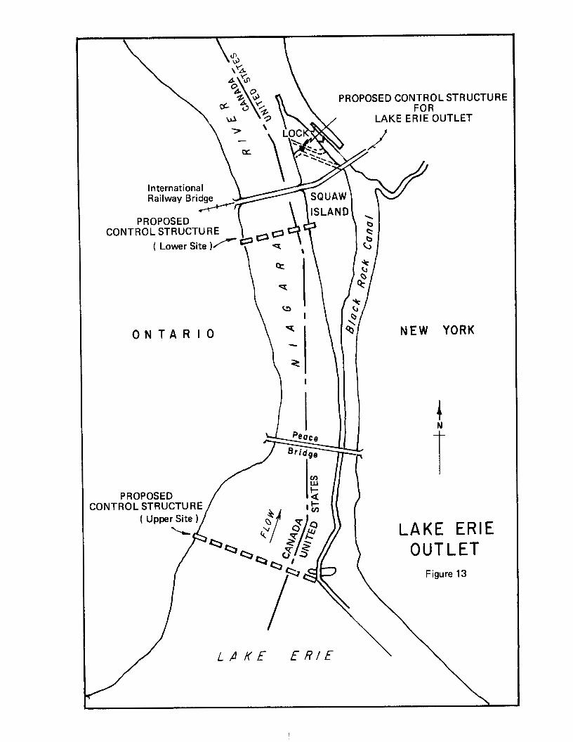
O N T A R I O NEW YORK
I
i LAKE ERIE
OUTLET Figure 13
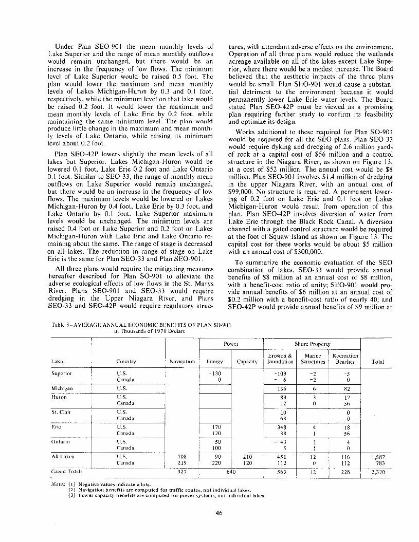
Under Plan SEO-901 the mean monthly levels of Lake Superior and the range of mean monthly outflows would remain unchanged, but there would be an increase in the frequency of low flows. The minimum level of Lake Superior would be raised 0.5 foot. The plan would lower the maximum and mean monthly levels of Lakes Michigan-Huron by 0.3 and 0.1 foot, respectively, while the minimum level on that lake would be raised 0.2 foot. I t would lower the maximum and mean monthly levels of Lake Erie by 0.2 foot, while maintaining the same minimum level. The plan would produce little change in the maximum and mean month- ly levels of Lake Ontario, while raising its minimum level about 0.2 foot.
Plan SEO-42P lowers slightly the mean levels of all lakes but Superior. Lakes Michigan-Huron would be lowered 0.1 foot, Lake Erie 0.2 foot and Lake Ontario 0.1 foot. Similar to SEO-33, the range of monthly mean outflows on Lake Superior would remain unchanged, but there would be an increase in the frequency of low flows. The maximum levels would be lowered on Lakes Michigan-Huron by 0.4 foot, Lake Erie by 0.3 foot, and Lake Ontario by 0.1 foot. Lake Superior maximum levels would be unchanged. The minimum levels are raised 0.4 foot on Lake Superior and 0.2 foot on Lakes Michigan-Huron with Lake Erie and Lake Ontario re- maining about the same. The range of stage is decreased on all lakes. The reduction in range of stage on Lake Erie is the same for Plan SEO-33 and Plan SEO-901.
All three plans would require the mitigating measures hereafter described for Plan SO-901 to alleviate the adverse ecological effects of low flows in the St. Marys River. Plans SEO-901 and SEO-33 would require dredging in the Upper Niagara River, and Plans SEO-33 and SEO-42P would require regulatory struc-
tures, with attendant adverse effects on the environment, Operation of all three plans would reduce the wetlands acreage available on all of the lakes except Lake Supe- rior, where there would be a modest increase. The Board believed that the aesthetic impacts of the three plans would be small. Plan SEO-901 would cause a substan- tial detriment to the environment because it would permanently lower Lake Erie water levels. The Board stated Plan SEO-42P must be viewed as a promising plan requiring further study to confirm its feasibility and optimize its design.
Works additional to those required for Plan SO-901 would be required for all the SEO plans. Plan SEO-33 would require dyking and dredging of 2.6 million yards of rock at a capital cost of $56 million and a control structure in the Niagara River, as shown on Figure 13, at a cost of $52 million. The annual cost would be $8 million. Plan SEO-90 1 involves $1.4 million of dredging in the upper Niagara River, with an annual cost of $99,000. No structure is required. A permanent lower- ing of 0.2 foot on Lake Erie and 0.1 foot on Lakes Michigan-Huron would result from operation of this plan. Plan SEO-42P involves diversion of water from Lake Erie through the Black Rock Canal. A diversion channel with a gated control structure would be required at the foot of Squaw Island as shown on Figure 13. The capital cost for these works would be about $5 million with an annual cost of $300,000.
To summarize the economic evaluation of the SEO combination of lakes, SEO-33 would provide annual benefits of $8 million at an annual cost of $8 million, with a benefit-cost ratio of unity; SEO-901 would pro- vide annual benefits of $6 million at an annual cost of $0.2 million with a benefit-cost ratio of nearly 40; and SEO-42P would provide annual benefits of $9 million at
Table 3LAVL:RAGE ANNUAL ECONOMIC BENEFITS OF PLAN SO-901 in Thousands of 1971 Dollars
Power Shore Property
Lake
-5 -2 0 Canada
- 109 -130 U.S. Superior
Total Beaches Structures Inundation Capacity Energy Navigation Country
- 6 -2 0 Michigan U.S. 156
17 3 89 U.S. Huron 82 6
Canada 12 0 56 St. Clair U S . 10 0
Canada 63
4 1 - 43 50 U S . Ontario 56 1 38 120 Canada 18 4 348 170 U.S. Eric 0
Erosion & Recreation Marine
Cdn ad a 0 1 5 100 All Lakes
Nofes (1 ) Negative values indicate a loss.
2,370 228 12 563 640 Grand Totals 927 783 112 0 112 120 220 2 19 Canada
1,587 116 12 45 1 2 10 Y O 708 U.S.
(2) Navigation benefits are computed for traffic routes, not individual lakes. (3 ) Power capacity benefits are computed for power systems, not individual lakes.
46
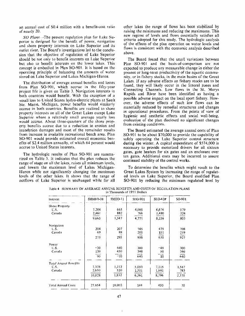
an annual cost of $0.4 million with a benefit-cost ratio of nearly 20.
SO Plans-The present regulation plan for Lake Su- perior is designed for the benefit of power, navigation and shore property interests on Lake Superior and its outlet river. The Board’s investigations led to the conclu- sion that the objective of regulation of Lake Superior should be not only to benefit interests on Lake Superior but also to benefit interests on the lower lakes. This concept is embodied in Plan SO-901. It is based on the operating principle of balancing the amounts of water stored on Lake Superior and Lakes Michigan-Huron.
The distribution of average annual benefits and losses from Plan SO-901, which accrue in the fifty-year project life is given on Table 3. Navigation interests in both countries would benefit. With the exception of a small loss to United States hydro-electric plants at Sault Ste. Marie, Michigan, powcr benefits would similarly accrue in both countries. Benefits are realized to shore property interests on all of the Great Lakes except Lake Superior where a relatively small average yearly loss would accrue. About three-quarters of the shore prop- erty benefits accrue due to a reduction in erosion and inundation damages and most of the remainder results from increase in available recreational beach area. Plan SO-901 would provide estimated overall economic ben- efits of $2.4 million annually, of which 64 percent would accrue to United States interests.
The hydrologic results of Plan SO-901 are summa- rized on Table 5. It indicates that the plan reduces the range of stage on all the lakes, raises all minimum levels, and lowers the maximum level of Lakes Michigan- Huron while not significantly changing the maximum levels of the other lakes. It shows that the range of outflows of Lake Superior is unchanged while for all
other lakes the range of flows has been stabilized by raising the minimums and reducing the maximums. This new regime of levels and flows essentially satisfies all criteria adopted for this study. The hydrologic analysis of the effects of the plan operation on water levels and flows is consistent with the economic analysis described above .
The Board found that the small variations between Plan SO-901 and the basis-of-comparison are not expected to produce any measurable change in either the present or long-term productivity of the aquatic commu- nity, or in fishery stocks, in the main basins of the Great Lakes. If any adverse effects on fishery stocks are to be found, they will likely occur in the littoral zones and Connecting Channels. Low flows in the St. Marys Rapids and River have been identified as having a possible adverse impact on the local sport fishery. How- ever, the adverse effects of such low flows can be materially reduced by remedial structures and changes in operational procedures. From the points of view of hygienic and aesthetic effects and social well-being, evaluation of the plan disclosed no significant changes from existing conditions.
The Board estimated the average annual costs of Plan SO-901 to be about $70,000 to provide the capability of safely operating the Lake Superior control structure during the winter. A capital expenditure of $574,000 is necessary to provide motorized drivers for all sixteen gates, gate heaters for six gates and an enclosure over ten gates. Additional costs may be incurred to assure continued stability of the control works.
To determine the benefits which might result to the Great Lakes System by increasing the range of regulat- ed levels on Lake Superior, the Board modified Plan SO-901 by reducing the minimum regulated level by
Table 4LSUMMARY OF AVERAGE ANNUAL BENEFITS AND COSTS OF REGULATION PLANS in Thousands of 1971 Dollars
Interest
Shore Property U.S. Canada
Navigation u s . Canada
Power U.S. Can ad a
Total Annual Bcncfits U.S. Canada
Total Annual Costs
SMHEO-38
7,204 2.46 1 9,665
204 69
273
-30 120 90 -
7,378 2,650
10,028
27,854
SMHO-11
665 882
1,547 ~
20 7 88
295
440 -450
-10 -
1,312 5 20
1,832
18,003
SEO-901 S E 0 4 2 P SO-90 1 -__
4,005 6,676 579 766 1,480 224
4,771 8,156 803 - - -
745 479 708 205 15 1 2 19 950 630 927 - - -
300 -40 300 340 50 340 640 10 640 - - -
5,050 7,115 1,587 1,311 1,681 783 6.361 8,796 2,370
70 _____
47
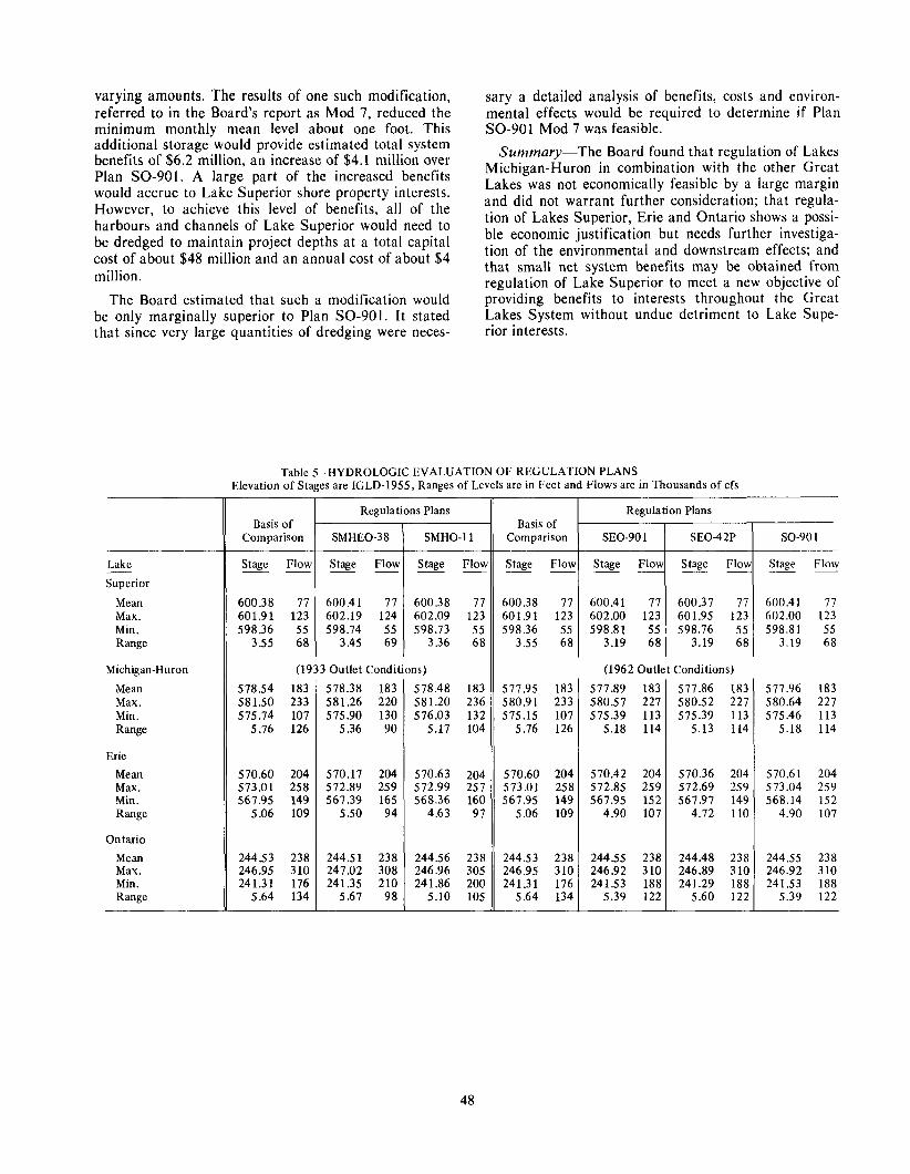
varying amounts. The results of one such modification, sary a detailed analysis of benefits, costs and environ- referred to in the Board's report as Mod 7, reduced the mental effects would be required to determine if Plan minimum monthly mean level about one foot. This SO-901 Mod 7 was feasible. additional storage-would provide estimated total system benefits of $6.2 million, an increase of $4.1 million over Michigan-Huron in with the other Great Summary-The Board found that regulation of Lakes
would accrue to Lake Superior shore property interests. However, to achieve this level of benefits, all of the and did not warrant further consideration; that regula- harbours and channels of Lake Superior would need to tion of Lakes Superior, Erie and Ontario shows a possi- be dredged to maintain project depths at a total capital ble economic justification but needs further investiga- cost of about $48 million and an annual cost of about $4 tion of the environmental and downstream effects; and
that small net system benefits may be obtained from million. regulation of Lake SuDerior to meet a new obiective of
'Ian A large part Of the increased benefits Lakes was not economically feasible by a large margin
The Board estimated that such a modification would prividing benefits to'interests throughout the Great be only marginally superior to Plan SO-901. It stated Lakes System without undue detriment to Lake Supe- that since very large quantities of dredging were neces- rior interests.
Table 5-HYDROLOGIC EVALUATION OF REGULATION PLANS Elevation of Stages are IGLD-1955, Ranges of Lcvcls are in Feet and Flows are in Thousands of cfs
__ Lake Superior
Mean Max. Min. Range
Michigan-Huron Mean Max. Min . Range
Erie
Mean Max. Min . Range
Ontario Mean Max. Mill. Range
Basis of
600.38 77 601.91 123 598.36 55
3.55 68
600.41 77 602.09 123 602.19 124 600.38 77
598.73 55 598.74 55 3.45 69 3.36 68
(1933 Outlet Conditions) 578.54 183 581.50 233 575.74 107
5.76 126
570.60 204 573.01 258 567.95 149
5.06 109
244.53 238 246.95 310 241.31 176
5.64 134
578.38 183 581.20 236 581.26 220 578.48 183
576.03 132 575.90 130 5.36 90 5.17 104
570.17 204 572.99 257 572.89 259 570.63 204
568.36 160 567.39 165 5.50 94 4.63 97
I
244.51 238 246.96 305 247.02 308 244.56 238
241.86 200 241.35 210 5.67 98 5.10 105 11
l- Basis of
Cornparison
Stage F l o ~ _ _ _ _
600.38 77 601.91 123 598.36 55
3.55 68
577.95 183 580.91 233 575.15 107
5.76 126
570.60 204 573.01 258 567.95 149
5.06 109
244.53 238 246.95 310 241.31 176
5.64 134
Regulation Plans
SEO-90 1 SEO-42P
600.41 77 602.00 123 598.81 55
3.19 68
600.37 77 601.95 123 598.76 55
3.19 68
(1962 Outlet Conditions) 577.89 183 580.57 227 575.39 113
5.18 114
570.42 204 572.85 259 567.95 152
4.90 107
244.55 238 246.92 310 241.53 188
5.39 122
517.86 183 580.52 227 575.39 113
5.13 114
570.36 204 572.69 259 567.91 149
4.72 110
244.48 238 246.89 310 241.29 188
5.60 122
SO-90 1
Stage Flow __
600.41 1 7 602.00 123 598.81 55
3.19 68
577.96 183 580.64 227 575.46 113
5.18 114
570.61 204 573.04 259 568.14 152
4.90 107
244.55 238 246.92 310 241.53 188
5.39 122
48
Chapter IX
PUBLIC HEARINGS
The twenty-two public hearings conducted by the Inter- national Joint Commission were an integral part of the inquiry. The purpose of these public hearings was to provide convenient opportunity for all those interested in the water levels of the Great Lakes to express their views and to convey relevant and factual information to the Commission.
Four initial public hearings were held in May 1965, a period of extreme low water levels, to obtain opinions and guidance in planning and investigation from con- cerned individuals, private organizations and public agencies. A set of five hearings were held in May and June of 1973, a period of extreme high water levels, to receive comments on the interim report of the Interna- tional Great Lakes Levels Board before the Commission prepared its own special interim report on the regulation of Lake Superior to provide relief from high water levels on the Lower Great Lakes. Following the distribution of the Board’s final report, the illustrated summary report and all appendices, the Commission conducted thirteen public hearings in October, November and December of 1974 to obtain comments on the Board’s report and further views of interested persons, associations and governmental agencies.
In accordance with the Commission’s Rules of Proce- dure, notices of all public hearings were published in the Canada Gazette, the United States Federal Register and local newspapers in both countries. In addition, notices and press releases were mailed to numerous individuals, know associations, elected representatives in the region, the mass media and governmental agencies.
At the twenty-two public hearings all those interested were given an opportunity to express their views orally or present documentary evidence. The Commission also accepted written submissions received subsequent to the respective hearings. Statements were made by elected representatives, private individuals, citizen groups, busi- ness and industrial representatives and officials from federal, state, provincial and municipal agencies. The names of t h e 397 persons who testif ied at the hearings are listed in Appendix D.
Verbatim transcripts of all hearings and all written submissions made at and subsequent to the hearings are
on file and available for examination at the offices of the Commission in Ottawa and Washington, D.C.
The Commission reviewed the 4404 pages of testimo- ny received at the twenty-two public hearings and all correspondence. As is inevitable in a series of hearings such as these, much of the evidence was necessarily repetitious. Many earnest but conflicting opinions were heard. A number of sincere concerns were based on misunderstandings of the hydrology and regulation of the Great Lakes System. The essence and salient points of the testimony and letters are summarized below.
The 1965 Hearings Initial hearings on the inquiry were held at Toronto,
Ontario on May 10; at Sault Ste. Marie, Michigan on May 11; at Windsor, Ontario on May 25; and at Chi- cago, Illinois on May 26, 1965.
The levels of the Great Lakes were at that time near record lows. Most of the testimony was related to the adverse effects of low water levels although some recalled previous high levels. The submissions are sum- marized and paraphrased in the following paragraphs:
Shore property owners testified that low water levels were a hardship because docks were high and dry and the only access to many cottages was by boat. They spoke of heavy weed growth in shallow water, excessive beach exposure and storm erosion. Adverse publicity about low water levels caused vacant cottages and loss of rental income as well as a drastic drop in property values. It was stated that develop- ment of shore property increased the taxes collected by the municipality while zoning low lying lands as flood plain provided no income. A witness compared the development of the flood plain with deliberate speculation sales of underwa- ter lots.
Operators of marinas and recreational facilities said low water levels caused economic hardships in that adverse publicity kept tourists away. Each dollar not spent by a boat owner is lost by the owner of a commercial enterprise whose livelihood depends upon that dollar. Also, low water condi- tions required expensive dredging and modification to ser- vice facilities such as docks, slips and launching ramps. Accidental collisions with underwater hazards increased the maritime damage claims by 30 percent. Park authorities
49
stated that low water levels necessitated heavy expenditures for shore maintenance, weed clearing operations and boat loading facilities.
Witnesses speaking on behalf of commercial navigation testified that low water levels restricted the tonnages and increased the operating costs of the Great Lakes fleet. They emphasized that efficient low cost navigation was essential to the economy of the region. Higher unit costs reduced the annual income of those industries which depend on commer- cial navigation. An eighteen-inch loss of draft on an ore carrier adds eighteen cents per ton to the cost of delivered Lake Superior ore. Low water levels increased the danger of striking underwater obstacles resulting in hull damage, grounding or sinking. Dockage difficulties during low water included gangplank alignment, pipe connections, bulk cargo booms, inadequate mooring and dock instability. Expensive dredging and dock extensions were qften required. Such investments were loss-recovery rather than revenue-generat- ing. Also low water levels accelerated dry-rot deterioration and ice damage to exposed timber piles and cribs.
These shipping interests further emphasized that over- draft ships were turned back at the St. Lawrence Seaway during periods of low water. Also there were line-ups for the deeper MacArthur Lock in the St. Marys River because the Davis and Sabin Locks had insufficient drafts. Lock delays cost $ 1 50-$200 per hour per ship and accounted for 25 percent of the voyage time. They stated that during periods of low water supply there was insufficient water to maintain adequate levels on Lake Ontario and in Montreal Harbour. Montreal interests said their loss of business resulted from water being held in Lake Ontario. They stressed the flow from Lake Ontario should be regulated to increase shipping benefits rather than hydro-electric generation because the Boundary Waters Treaty of 1909 gave navigation a higher priority. Navigation spokesmen recommended that all of the Great Lakes should be regulated to reduce high and low extremes and to achieve reasonable water level stability.
Several environmentalists stated that, while reasonable water level fluctuations were necessary to maintain the ecology of life in the marshes, extreme levels affect water- fowl by influencing food production, nesting sites, and the accessibility to natural predators and hunters. Water levels that were too low changed lagoons and ponds into mud holes and stagnant breeding grounds for mosquitos. One witness estimated that a six-inch drop in Lake Ontario levels would destroy or damage 25 to 50 percent of the 50,000 acres of marshland in New York. Low water levels not only reduce fish spawning but also fishing opportunities.
Spokesmen for the hydro-electric entities focused on the mutual benefits of regulated water levels. Although water level requirements of various users are often divergent and sometimes incompatible, a compromise can provide substan- tial benefits to all users. Regulating the levels of the upper lakes within a narrow band increases the extremes of high and low outflows and the probability of their occurrence. This accentuates the difficulties on the lower lakes if they are experiencing similar supply conditions. Compressing the range of water levels on any of the downstream lakes further magnifies the inflow extremes into successive bodies of water. Spokesmen for power entities stated that low water levels are the cumulative result of below-normal precipita- tion and above-normal evaporation. They explained that low lake levels reduced power production in two ways: A major reduction due to reduced flows; and a small reduction due to a lesser head. In 1964 hydro-electric power production was reduced by over four million megawatt hours which would
cost $15 million to replace by energy produced by thermal- electric plants.
Municipal and industrial representatives said that although high water causes erosion, flooding and structural damage, this was not as serious as the total effects of low water. The cost of structures is increased when provision must be made for large fluctuations in water levels. Low water levels a t municipal and industrial intakes reduce the intake capacity, increase the pumping head, and increase pump power consumption, as well as causing pump cavita- tion and icing problems. Low levels also increase the turbidi- ty, algae and weed growth and water temperature at water intakes. Sewer outfalls which become exposed by low water constitute a public nuisance and a health hazard. Severe problems such as inadequate draft for the delivery of coal and ore result from low levels. Extra dredging is required to offset this effect which in turn causes river bank slumping and dock instability.
Some witnesses emphasized the influence of man’s works as the cause of low water levels citing the constant diversion of water for city and industrial use, the St. Lawrence Seaway, the dredging of the St. Clair and Detroit Rivers, the Chicago diversion and deforestation.
Other witnesses stated that the emphasis on low lake levels should not obscure the flooding and erosion caused by high lake levels, and noted that high water and storm waves had eroded up to one-hundred feet of good productive land on the south shore of Lake Ontario. They recalled how bluffs and beaches had been eroded, how houses, roads and docks had been damaged and that the values of lakefront property had dropped sharply in times of high water.
A number of witnesses testified that although high water caused dramatic physical damage, the total economic impact of low water was greater. They said that losses due to low water were less tangible but nevertheless were far greater because of lost business, increased depreciation, reduced property values, and less tourism. Several witnesses stated that some reduction in the range of water level would be beneficial because most difficulties occurred at extreme high or low levels.
Nearly twenty schemes were proposed by witnesses and correspondents to correct the low water conditions for one or more of the Great Lakes. They included increasing t h e inflow from the Long Lac-Ogoki diver- sion, releasing Lake Superior water to raise t h e levels of Lakes Michigan and Huron, restricting the outflow from L a k e Huron by a series of dams and diverting the Mississippi River in the Uni ted S ta tes and the O t t awa River in Canada into Lake Michigan and Lake Huron , importing water from Western Canada, increasing the outlet capacity from each lake and installing control ga tes to reduce t h e flows when necessary, and construct- ing control works below Montreal Harbour to increase its water levels when Lake Ontar io outf lows are reduced.
In summary, tes t imony heard a t the 1965 hearings indicated that the low water supply situation then being encountered had resulted in extreme low water levels which were harmful t o all interests in the Great Lakes Basin. There was some recognition of the fact tha t extreme highs a t o ther t imes were also damaging bu t were more spectacular. The preponderance of public
50
opinion was in favour of alleviating the extreme low levels by construction and operation of control works and diversions.
The 1973 Hearings
During t h e course of the investigation the water levels of the Great Lakes re turned to normal and then in 1972 entered a period of extremely high levels. In January 1973, t h e Commission requested its International Great Lakes Levels Board to report on its interim findings and conclusions with respect to modifying the operation of the cont ro l works a t Saul t S te . Marie in such a way as to provide relief for the Lower G r e a t Lakes and a t t h e same time maintain satisfactory conditions on Lake Super ior . The Board submi t ted an in te r im repor t in March and after i ts wide distribution, the Commission conducted a series of public hearings to obtain public reaction before preparing its own special interim report.
These public hearings were held a t Rochester , New York on May 3; at Toronto, Ontar io on May 4; at Detroit, Michigan on M a y 8; a t Sau l t S t e . Mar i e , Ontar io , on May IO; and at Duluth, Minnesota on June 18, 1973. All were well at tended. Most of the testimony was related to the disastrous effects of the spring storms and high water levels. Many witnesses wanted immedi- ate lowering of water levels on their lake. In the main , public reaction to the plan proposed by t h e Board was influenced by the geographical location of the witnesses.
The testimony received at these five public hearings is summarized and paraphrased below:
Shore property owners testified that high water combined with storms had eroded -their shoreline and beaches, damaged breakwalls, docks, cottages and homes, and had flooded roads and drainage ditches. They recalled evacuat- ing their homes during a severe storm and described the futility of combating waves.
Several spokesmen said that regulation had limited the duration of low water periods and had severely reduced natural beach building thus depriving them of this natural protection against erosion.
Several Lake Ontario residents demanded that their excess water be flushed down the St. Lawrence River past Montreal. Many suggested that the Long Lac-Ogoki diver- sion be stopped and the Chicago diversion be increased. Others said more water could not be diverted down the Mississippi because 80 percent of one Mississippi Congres- sional District was at that time under water.
There was support for the concept of storing water in Lake Superior to benefit downstream riparians but a Lake Superior resident exclaimed that he felt like an Aztec maiden about to be sacrificed to the rain god. It was stated that Lake Superior residents were already suffering disas- trous high water levels to provide only marginal benefits to downstream dwellers and the point was made that confer- ring benefits on the majority by damaging a minority with- out compensation was not justice.
A QuCbec government representative pointed out that reducing water level fluctuations in the Great Lakes would produce greater fluctuations and flows in their section of the
St. Lawrence. He said that land owners in QuCbec wanted the same protection from high and low extremes as they would have had under pre-project conditions.
Many shoreline owners criticized the shoreline protective works as unsightly, prohibitive in cost and, in the long run, ineffective. Several suggested that the St. Lawrence River in Qutbec should be dyked because a river can be contained but not a lake. They could see no reason why United States citizens on the south shore of Lake Ontario should sustain any more damage due to natural causes than their Canadian neighbours.
In contrast one witness wondered how Lake Ontario residents would like to have excess water from Lake Erie dumped into Lake Ontario to relieve high water problems on Lake Erie. Several suggested that more water from Lake Erie could be released by dredging the rapids near Buffalo or by increasing the flow through the Black Rock Canal and Welland Canal.
Navigation representatives objected to the assumption that extreme water levels benefited navigation interests. Once there is sufficient water to provide the required draft, additional water is of no advantage. Over 85 percent of Great Lakes vessels have a draft less than 26.5 feet.
Marina and resort operators testified that high water levels and storms had damaged their dock installations, storage facilities, clubhouses, parking lots, seawalls, bath houses and sanitary facilities. They also pointed out that movement of ice due to wind, water level fluctuations or currents caused excessive maintenance costs.
Several environmentalists stated that they had observed detrimental effects from the rapid fluctuation of flows and levels in the St. Marys and St. Lawrence Rivers. This resulted in a reduction in the species, types and abundance of aquatic plants thereby adversely affecting the forage base and food chain.
It was stated that maintenance of the fishery in the St. Marys Rapids required a minimum of four gates open in the compensating dam and that a setting of one-half gate open was inadequate. Another concern was that winter operation of the gates and navigation caused ice runs which resulted in environmental and shore property damage. One witness said that if fish were wanted instead of power then people must be prepared to pay more for power. Some witnesses stated that the interim report did not give enough consideration to the environmental impact on wetlands and estuaries.
Municipal and industrial representatives testified that storms and high water washed out shorefront roads; exposed water, sewer and gas lines; affected the operation of sewage treatment plants, sanitary and storm sewers; flooded parking lots; and overworked sump pumps. High water caused con- siderable loss on properties which reduced their assessed value and tax revenue to municipalities. At Duluth witnesses complained that red clay turbidity caused water quality problems for the water treatment plants. Witnesses told of the damage to a salt refinery and grain elevators and said that two dry docks of the graving type were nearly over- topped during a 1972 summer storm.
A number of witnesses supported the concept of land-use zoning and structural setback regulations. This was opposed by others who said that zoning would not work because the shoreline was already developed. The point was made that those building near the shore have crowded closer and closer to the water’s edge and now cry out for flood control when
51
high levels occur, when they in fact are the element that is out of place and must be controlled. A contrary view was expressed that, to say people should move away from the shoreline was wrong, because they have rights. It was stated that land-use control can prevent unwise future develop- ments. Others asked how compensation could be made for existing developments. Others suggested that low-lying or marsh areas and unstable bluffs should be acquired for parks and nature areas. Land-use zoning is the most promis- ing measure to protect wetland areas and reduce shoreline damage. Structural setbacks are not always adequate because erosion reduces the setback zone so that eventually dwellings are again close to the water’s edge. It was stated that unfortunately there is a desire to rebuild in the same place after damage occurs only to have the buildings wash away again. Some witnesses commented that since regula- tion of the Great Lakes does not produce any tangible or significant effects the answer must be land-use planning and persuading people to face facts.
Over fifty individuals, groups and associations stated that Plan SO-901 was unacceptable to the majority of Lake Superior residents. They said the plan would aggravate flooding, accelerate erosion, increase red clay turbidity, and reduce power production at the Sault Ste. Marie Rapids, further depressing the local economy. The plan was further said to disregard the ecology of Lake Superior and the St. Marys Rapids and, in view of this, an environmental impact statement was required.
Lake Superior residents asked why they should suffer because those on the lower lakes had chosen to build in defiance of lake fluctuations and who has the right to trade off Lake Superior rights for downstream riparian, power and navigation interests? It was stated that attempts to solve problems on one lake or group of lakes at the expense of other lakes were not solutions at all. Others said it was better to damage a few Lake Superior residents on the sparsely-populated shoreline than damage heavily-developed industrial and urhan areas on the lower lakes. There should be compensation for damage suffered.
Representatives of hydro-electric installations on the Niagara and St. Lawrence Rivers and navigation associa- tions testified that Plan SO-901 would not adversely affect their operations. It was said that Edison Sault Electric should be subsidized for their decreased power generation because flow reductions were an infringement on their legal rights for the use of the water.
A number of witnesses testified that over-optimistic state- ments mislead people to expectations that cannot be fulfilled and that more homes are damaged because people are encouraged by promises of a controlled lake level. It is time that agencies educate the people that they are not going to get even minor relief from tinkering with the Great Lakes. Since newspapers have not been consistent in reporting proposed effects, the common person is unable to know what information is true. Some claimed to have been alienated by the unavailability of factual information and the availability of misinformation. It was suggested that lakefront property owners ought to have a representative on IJC Boards or the International Joint Commission itself.
Many witnesses stated that high precipitation contributed to high levels. But, several said that they could not accept that meteorologic factors alone caused high lake levels. Others said the flows in the St. Lawrence River have been restricted by darns. Several witnesses said that weather modification and cloud seeding were responsible for
increased precipitation and that weather modification should be the subject of intense research. Some said urban developments, drainage of swamps, stream channelization, deforestation, and changing agricultural practices cause a more rapid runoff and greater volume of water. Several witnesses said there was a lack of foresight in permitting flooding to occur. Others stated lake level fluctuations and storm-driven waves were natural processes that could not be controlled.
One witness stated that the question is not “How much does it cost to regulate water levels?”, but rather “How much does it cost not to regulate water levels?” Another wanted the high levels reduced by one foot. A few witnesses reminded the Commission to also remember previous lows in the mid-I920’s, 30’s and 60’s which had disrupted shipping, left marinas high and dry, destroyed fish and wildlife habi- tats and depressed shore property values.
In summary, the tes t imony heard in 1973 indicated that the high supply si tuation beginning in 1972 had resulted in extreme high water levels which were damag- ing to all interests in the Great Lakes Basin, some more clearly than others. The Commission’s interim action in modifying the regulation of Lake Superior was accepted by those on the lower lakes as a minor but welcome relief. M a n y people wanted much more to be done in the way of physical control works but some recognition was evident that the costs might be very high. The shore property owners on Lake Superior were universally opposed to any suggestion that that lake be used to s tore water to alleviate conditions downstream and one power company claimed to have been damaged by the modified opera t ion a t Saul t Ste. Marie . Shore property owners on Lake Ontar io were insis tent that much more could and should be done to lower high water levels there.
Many shoreline dwellers stressed that they did not want to live behind dykes or other unsightly shore protection works, nor did they want to have to rely on flood insurance or disaster assistance, neither did they want to be zoned away from the lakefront. Instead they requested tha t water levels be maintained within accept- able limits so they could use and enjoy their lakeshore property. Many property owners were insistent that high lake levels should be lowered at their location, regardless of the consequences elsewhere in the Basin.
The 1974 Hearings
At the conclus ion of the Internat ional Great Lakes Levels Board’s investigation, a year later, the water levels of t h e Great Lakes were still high. The final report of the Board and the appendices were given wide distribution as soon as they were available. The Board’s report contained the conclusion that the Great Lakes are a naturally well-regulated system in which only small improvements are practicable without exorbitant costs. The report described and compared several possible regulation plans, including a revised plan for regulating Lake Superior , and two prel iminary plans for combined regulation of Lakes Superior, Erie and Ontario. The Board concluded that regulation of all five lakes would
52
not provide benefits commensurate with costs, and t h a t the most promising measures for minimizing shoreline damages were non-structural alternatives.
In addition the Commission distributed over 20,000 copies of a summary of the Board’s report to encourage greater public participation in this inquiry. The Com- mission conducted public hearings on each of the Great Lakes and in both countries as well a s on the S t . Lawrence River to obtain comments on the Board’s report and the views of those concerned with the levels of the Great Lakes. The hear ings took place several months after the distribution of the reports and before the Commission commenced deliberations on its own report to the two Governments.
Public hearings were held at Detroit, Michigan, Octo- ber 21; a t Green Bay, Wisconsin, October 22; a t S a u l t S te . Mar ie , Ontar io , October 23 ; a t Thunder Bay , Ontar io , October 25; at Muskegon, Michigan, Novem- ber 6; at Milwaukee, Wisconsin, November 7; at Duluth, Minnesota, November 8; a t Cleveland, Ohio, November 18; a t Chicago, Illinois, November 19; a t Rochester, New York, November 20; a t Hami l ton , Ontar io , November 21; a t Owen Sound, Ontar io , November 22; and at Montreal, QuCbec on December 6, 1974.
Some hearings were held in the evenings as well as during the day. Most were very well at tended, with several sessions lasting until midnight. Much of the tes t imony was s imilar to the 1973 hear ings in that witnesses were still concerned with the effects of high water levels. Public reaction to fur ther regulation was again influenced by the geographical location of the hearing.
Testimony received at these thirteen public hearings is summarized and paraphrased below. The views and opinions of witnesses that were the same as those expressed in 1973 are not repeated in detail.
Shore property owners, as in 1973, repeatedly testified that high waters and pounding waves had inundated proper- ties, flooded basements, made septic tanks inoperative, accelerated shoreline erosion, increased sediment pollution, and destroyed dwellings, docks and protective works. Some witnesses said erosion was a natural process of encroach- ment, and never-ending because the shoreline is not yet stabilized. Others stated that breakwaters, groynes, piers, seawalls and dredging changed the littoral drift and accelerated erosion. Several testified that some of the damaged shoreline was reclaimed land. The point was made that since the public subsidizes dredging for the benefit of navigation, the public should also subsidize shore protection and regulation for the benefit of property owners.
A number of property owners said the Lakes were held high for the benefit of power and navigation, to which navigation spokesmen replied that no one has explained how it was done. Representatives of port authorities and naviga- tion interests repeatedly stressed that low cost water trans- port promoted land-based business, employment and a favourable balance of trade. They said that water transpor- tation on a ton-mile basis uses less energy, is more economi- cal, less inflationary, less polluting and has a lower environ- mental impact than any other form of transport. They also
stated that jobs and the economy of a port community depend on efficient competitive navigation and that there should be a 31 or 32-foot draft in the Connecting Channels to improve shipping. Several witnesses described storm damage to marine facilities.
Marina operators again complained of loss of business, inundation and storm damage to facilities. One operator even said that he preferred low water because it increased his sales of propellors and shear pins. Representatives of resort and campers’ associations said they lost business because high water had flooded beaches, eroded shorelines and caused high water tables. However, they said that extreme low water is also undesirable. It was stated that pleasure boaters, fishermen and waterfowl hunters would resent regulatory structures and locks on the St. Clair River.
Environmentalists said that both extreme high and low water levels were harmful to the lake ecology. They said that high water in 1952 had destroyed many marsh areas which had not recovered in the ensuing two decades, and that present high levels are again causing shore erosion, sedimentation and destruction of additional wetlands. Some ecologists suggested that a reduction of the extreme fluctua- tions would benefit fish and wildlife in the short run, but they did not define the long-term consequences of such reductions. The Commission was told that more concern was needed for the narrow sensitive zone of beach and shore waters where most ecosystem interplay occurs. A biologist said that shallow Lake Erie produces one-half of the Great Lakes fishery harvest, and suggested that protection and enhancement of its ecosystem should be a major factor in any future Lake Erie regulation plans.
A number of speakers supported a proposal for a rockfill dyke in the St. Marys Rapids which they said would reduce the adverse effects of flow fluctuations caused by operation of the compensating gates. The Commission was told that the dyke would prevent dewatering of biologically important sections in the rapids, and would protect and enhance the fishery there.
Municipal officials and citizens’ groups told that high water devalued lakeshore properties and reduced property tax revenues. They reiterated that high water had washed out public beaches, parks and roads and had caused prob- lems with sewage treatment and water treatment facilities.
Industrial representatives stated that Lake Superior papermills could not use the red turbid water to make fine quality white paper; that grain elevators had basements flooded and lost money due to spoiled grain and railway demurrage; and that a salt company lost a thousand tons of salt by wetting. A shipyard spokesman said that high water, but not too high, was an asset to shipbuilding, but extreme low water was a disaster.
A representative of a hydro-electric company again said that they had suffered losses as a result of modifying the regulation at Sault Ste. Marie and several witnesses suggest- ed that the company be compensated for its losses.
A spokesman for Great Lakes Power Corporation announced plans to build a generating station on Whitefish Island to replace their old powerhouse.
Many witnesses again blamed the Long Lac-Ogoki Diver- sion for their flooding and said it should be stopped A spokesman said that Ontario Hydro had voluntarily stopped diverting Ogoki water into Lake Superior for over a year.
A number of witnesses proposed increasing the Chicago Diversion. Other witnesses were opposed to this saying it
53
would cause flooding. Two of the many statistics quoted were that a diversion of 10,000 cfs would lower Lake Michigan only six inches in fifteen years, and that the sun evaporates more in one day than the diversion would take out. Several witnesses pointed out that the present diversion of 3200 cfs was specified by a Supreme Court Decree and it is outside of IJC jurisdiction.
One witness proposed a huge canal in Canada from Georgian Bay to Lake Ontario to manipulate the levels of Lake Michigan. Others proposed dredging the St. Clair and Detroit Rivers to let more water out of Lake Michigan and Lake Huron. Using the New York State Barge Canal to divert water out of Lake Erie was also suggested. Several witnesses stated that no additional regulation is required because the Great Lakes are remarkably well self-regulated.
At Cleveland the United States Army Corps of Engineers officially presented Plan SEO-I 7P, B modification of the Board’s Plan SEO-42P. This plan calls for construction of a controlled diversion channel across Squaw Island connecting the Black Rock Canal and the Niagara River. It also envisages that existing works on Lake Superior would be operated according to Plan SO-901 and those on Lake Ontario by the current Plan 1958-D. During years of high water supplies Plan SEO-17P would require an increased outflow from Lake Erie ranging up to 17,500 cfs which would at times necessitate an additional 10,000 cfs outflow from Lake Ontario. Compared to existing conditions, Plan SEO- 17P would have reduced the recent recorded maximum level of Lake Erie by 0.8 foot, Lakes Michigan-Huron by 0.6 foot and Lake Ontario by 0.1 foot. The Plan has a favourable benefit/cost ratio with the United States’ shore property owners receiving most of the benefits while power interests and the wetlands ecology would suffer damages. Several witnesses spoke in favour of the Corps’ Plan but a few said it would have a negative impact.
QuCbec representatives emphasized that the IJC Order of Approval guaranteed no less protection for QuCbec than would have occurred if the St. Lawrence Project had not been built. They stated that during 1972-74 Qutbec had received greater than preproject flows and as a consequence Lake Ontario residents benefited from regulation while QuCbec suffered damages. Qutbec spokesmen said that they have been most cooperative in the past and requested the same consideration, and that the same principles of fair play and concern for economic and environmental impact should be applied to the St. Lawrence System as to the Champlain- Richelieu System. It was pointed out that a discharge increment of 10,000 cfs for one week has practically no impact on Lake Ontario, but it raises the level of Lac St. Louis by one-half of one foot. They asked for prompt consideration of compensation for losses suffered to benefit Lake Ontario residents. Spokesmen for farmers said a short, high spring flood peak was better than a prolonged lower peak which flooded farms throughout the summer. Qutbec officials suggested that changes in regulation should be delayed until the Federal-Provincial studies on the St. Law- rence were completed and impacts of higher flows evaluated.
A number of Lake Ontario witnesses requested increasing the discharge in the St. Lawrence River.
The majority of Lake Superior witnesses continued to be strongly opposed to Plan SO-901 and the concept of storing water in Lake Superior to benefit downstream interests. Several stated that the emergency operation at Sault Ste. Marie is Plan SO-901 in actual operation.
Many Lake Michigan and Lake Huron witnesses spoke in favour of holding back water in Lake Superior.
Several witnesses testified that the Board’s report was deficient in ecological considerations. One environmentalist group stated that the Board’s report underestimated power needs and suggested that a policy of increasing hydro-elec- tric generation was a better national objective than subsidiz- ing navigation. A scientist said that the period 1900-1967 was a poor representation of the long-term climate and predicted a trend to greater weather variability with accen- tuated consequences but several others said that no one knew what the future held.
With regard to non-structural alternatives, several wit- nesses testified that setbacks are only temporary solutions because the lake continues to encroach. It was said that flood plain development during the low water period of the early 1960’s had resulted in damage when high water came in the 1970’s. Witnesses stated that zoning would be dif- ficult, time-consuming and expensive because it would have to be based on sound engineering and scientific data and be legally defensible and it is often cheaper to buy out erosion victims than it is to protect them. Numerous shore property owners opposed land-use zoning and setback requirements as infringements on their rights and because the shoreline was already developed. Others said it was the only viable solution because erosion will continue in spite of, and because of, shoreline works. They suggested acquisition of vulnerable areas and relocation of developments because there is no permanent protection for dwellings in such hazard areas. A spokeswoman suggested that relevant infor- mation on lake levels and potential damage should be required as part of real estate transactions and building permits. One witness stated that in 1972 the Wisconsin Supreme Court declared that “The public’s right to enjoy the State’s lakes and streams is more important than the right of a property owner to develop his land as he wishes.”
Some witnesses suggested flood insurance programs would be best, provided such funds would not be used to perpetuate inappropriate land-use in vulnerable areas. Others stated that wise flood insurance programs can help to prevent development in inappropriate areas. Still others said flood insurance programs would not prevent further encroachment. Several suggested that the federal govern- ments compute and provide compensation since lake levels management contributes to the overall public good. Others objected to spending public funds to protect private interests and those who foolishly build on flood plains. A witness said that the condominiums and motels which obtained variances in order to build contrary to by-laws or zoning ordinances should not be eligible for compensation because they were aware of the danger before they built. It was suggested that existing insurance programs should be modified to provide money for relocation rather than reconstruction and that compensation should be based on such principles as flowage easements, property values before and after inundation, erosion losses, scenic easements and the taking of tax title. A suggestion was made to increase the taxes on shoreline property to help pay for protection and damage compensation.
A number of witnesses stated that shoreline owners on Lake Superior should be compensated or the damages miti- gated. A witness observed that Lake Superior reaches its maximum high level in the late tall coinciding with the worst storms.
54
Witnesses complained that there was a lack of clear information on water levels. Others said they had not suffi- cient time to study the reports in detail. I t was suggested that a major public education program to inform people of the real problems and possible solutions should be imple- mented. Many complained that there are too many studies and not enough concrete work. Some witnesses stated that there should be citizen boards for each of the Great Lakes and a superboard for the whole Basin. Others stated that there should be riparian interest advisory boards or representation on the Board or the Commission. An Ontario official suggested that Ontario be represented on all Boards of Control because the Province is responsible for riparian lands. In summary, the testimony heard in 1974 was gener-
ally similar to that received in 1973. Many witnesses repeated the request that something be done to alleviate the high water conditions, particularly in the areas that affected them the most. However, there was also a growing interest in the use of non-structural alternatives such as land-use zoning, structural setbacks, flood insur- ance and compensation. The beginning of a trend towards recognizing the need to live in harmony with nature, rather than to endeavour to “subdue” nature, was observed.
Summation The public hearings conducted by the Commission in
1965, 1973 and again in 1974 were a vital part of the Commission’s basic data upon which its deliberations and judgement were based.
During the hearings it was evident that people were highly interested in the effects that Great Lakes water level fluctuations had on their lives. In 1965 the wit- nesses were primarily preoccupied with the negative effects of low water. It was this concern that inspired the Reference itself. Witnesses from all sectors of the econo- my recognized the adverse and damaging effects of low water on industry, shipping, power production, ecology and recreational shoreline use. A preponderance of the testimony supported the objective of the utilization of man’s technical resources to raise and regulate the extreme low lake levels during periods of reduced precipitation.
By contrast, the 1973 and 1974 hearings were held during a period when the lake levels were very high. Extreme high water levels, and associated damages, were a dominant interest of the witnesses. Again, a large portion of the testimony was directed towards the need for and the means of achieving regulation to reduce the high levels and raise the low levels.
However, within this framework of general unity of objectives, there was a wide disparity of opinion on how the objectives should be achieved. This is readily illus- trated by the views of Lake Superior shoreline property owners that Lake Superior should not be utilized as a reservoir in order to help downstream conditions. Those on Lakes Michigan, Huron and Erie felt that Lake Superior residents should accept some changes which were meant to achieve an overall benefit. Similarly, the Lake Ontario shoreline property owners indicated very strongly that the regulation of the outflow from that Lake should be modified to benefit them, even more than at present, from the adverse effect of high water supplies. On the other hand, those along the Canadian Section of the St. Lawrence River objected strenuously to such modification because they have, and would from time to time, suffer the damage of extended periods of high flows, higher than those that would have occurred if the St. Lawrence Power Project had not been built.
The principal direction of testimony by shoreline in- terests was a request for regulation of lake levels so as to reduce the frequency and magnitude of water level fluctuations consequently reducing shoreline damage. A large part of the testimony suggested the need to control diversions into and out of the Great Lakes Basin and between the Lakes. A number of suggestions were made for non-structural alternatives such as utilization of effective and compatible zoning regulations, flood plain planning, flood insurance and compensation.
Recreational interests were concerned with regulation of levels since their use along the shoreline often involves development of facilities affected by fluctuating levels. Environmental interests were concerned with achieving desirable water level fluctuation either by regulation or “laissez-faire”, depending on the desirable level for the particular species involved. Environmentalists generally suggested that zoning should be used to provide protec- tion from development for estuarine areas and wetlands to maintain wildlife habitat.
55

Chapter X
THE COMMISSION’S CONSIDERATIONS AND CONCLUSIONS
The Governments of Canada and the United States asked the Commission to resolve a number of basic questions concerning Great Lakes water levels. The Commission’s reply is based on its consideration of the report by its International Great Lakes Levels Board, the testimony received at the twenty-two public hear- ings, and other submissions to the Commission.
Causes of Lake Level Fluctuation The two Governments asked the Commission to study
first of all the various factors which affect the fluctua- tion of lake levels and to determine whether the water level fluctuation is primarily a natural process or due to man’s intervention.
Lake level fluctuations, be they over a century, a year, a day or part of a day, are primarily caused by nature. This is explained in Chapter IV. Man’s interventions, described in Chauters V and VI, have resulted in some modification of these fluctuations, but with the excep- tion of Lake Ontario, where significant improvements have been achieved, it is small relative to the natural variation.
Lake Erie is an example. Since 1860 its average monthly water levels, as a result of wide natural varia- tions in the water supply, have ranged over six feet from the lowest to the highest. During severe storms, winds blowing along the southwest-northeast axis of the L,ake have driven the surface water toward the opposite end of the Lake causing level differentials between Toledo and Buffalo of over twelve feet.
In contrast, man’s interventions have affected Lake Erie levels by only a few inches. The net effect of the principal diversions, the Long Lac-Ogoki diversion inflow, the Chicago diversion outflow, and the Welland Canal diversion from Lake Erie to Lake Ontario, is to lower Lake Erie by three inches. The consumptive use of water and the regulation of Lpke Superior, the only other human interventions, cause effects of a similar order. Dredging in the St. Clair and Detroit Rivers has caused a minor but transitory effect on Lake Erie water levels.
Thus, the water level changes on Lake Erie which affect shoreline interests are due primarily to natural factors: principally rain and snowfall; the attendant storm activity; and evaporation.
On the other hand, Lake Ontario is an example of the improvement, limited though it may be, that can be achieved by regulation. During the past three years high water levels have been held between one and two feet below that which would have occurred without regula- tion. This has significantly reduced the amount of damage that would have been suffered by shore property interests had the St. Lawrence Power Project not been built.
With respect to the regulation of Lake Superior, data indicate the range of levels has been compressed. Since 1973 the modified regulation of Lake Superior has raised the level a maximum of eight inches above what it would have been, but the Lake Superior levels remained below those that would have occurred under the regimen that existed prior to regulation and have not exceeded elevation 602.0. The modified regulation of Lake Supe- rior lowered the levels of Lakes Michigan and Huron by six inches and the levels of Lakes St. Clair and Erie by three inches during critical periods of record supply in 1973 and 1974.
Since 1933 dredging projects in the St. Clair-Detroit Rivers system to provide a deeper draft for commercial navigation have lowered the levels of Lakes Michigan and Huron. The dredging was undertaken in each case by the United States with the consent of Canada, fol- lowing exchanges of Notes between the two Govern- ments. The projects also contemplated the construction of compensating works to offset the effects of the chan- nel-deepening and maintain preproject water levels on the Lakes and in the St. Clair-Detroit Rivers system. Some compensation has been achieved, primarily in the Detroit River, by construction of dykes and placement of the dredged material. However, Lakes Michigan and Huron are about seven inches lower at the present time because of uncompensated dredging for navigation.
The International Great Lakes Levels Board’s studies show that if the additional compensating works are now
57
built and Lakes Michigan and Huron are thus returned to the 1933 level-outflow regime, the higher regimen of levels would result in a net annual average shoreline damage of about $12 million, offset only by about $1.3 million in annual navigation benefits. The two Govern- ments may wish to take this into account in considering the desirability of constructing the additional compen- sating works associated with these projects.
With respect to the Governments’ question about the causes of lake level fluctuation, the Commission has concluded that there are three factors which affect the levels of the Great Lakes:
(a) Long-term fluctuations of the levels of the Great Lakes are due primarily to persistent but irregular and unpredictable low or high precipitation within the Great Lakes Basin. The regular seasonal fluctuations are due to the annual hydrologic cycle which is characterized by higher supplies in the spring and early summer months and lower supplies for the remainder of the year. Short-term fluctuations usually lasting less than a day are due to the wind and differences in barometric pressures which together can cause an imbalance in water levels of as much as twelve feet along the longitudinal axis of Lake Erie. Superimposed upon these long-term, seasonal and short-period fluctuations are the wind-induced waves which cause most of the structural and erosion damage along the shoreline.
(b) Relatively small transitory effects on water levels are caused by other natural phenomena such as ice and weed retardation in the rivers, and extremely small tidal effects. Groundwater flows are inconse- quential. It is estimated that crustal movement of the earth will cause a slow rise in average levels in southwestern Lake Superior and southwestern Lake Ontario in the order of one foot per hundred years. At other locations lesser effects will occur. Any re-evaluation of regulation plans will have to take the change due to crustal movement into account.
(c) A number of artificial factors were identified as having variable but relatively minor effect on lake level fluctuations. These include diversions into and out of the Basin, channel dredging or other works in the Connecting Channels and consumptive use of Great Lakes water. Studies under the present Refer- ence considered diversions and navigation channel configurations as each presently exists. Consumptive use of water will reduce future net water supplies to the Basin and therefore will have a continuing, though small, reducing effect on future water levels. Regula- tion has changed the sequence and magnitude of releases from Lakes Superior and Ontario; on Lake Ontario significant reduction of the range of long- term fluctuation has been achieved; the best evidence to date indicates some compression of the range on Lake Superior has resulted, but ongoing studies will have to be completed to make certain this is so.
Possibility of Further Regulation
The second question posed by the Governments in the Reference is whether it is practicable and in the public interest to further regulate the levels of the Great Lakes to bring about a more beneficial range of stage for the varlous interests using the Lakes.
In the course of its studies, the Commission has concluded that the vast surface areas of the Great Lakes, which are equal to half of the contributing land areas, combined with the limited capacity of the outlet rivers, make the Great Lakes the best naturally self- regulating water system in the world which results in relatively constant outflow from the system. Man’s interference so far has been of relatively small conse- quence. Since the Great Lakes already possess a high degree of natural regulation, only a limited reduction in the range of water levels is practical. Major reduction in water level fluctuation in any one lake would result in much wider variations in outflows and would necessitate extremely costly regulatory works and remedial meas- ures and could cause serious effects upstream and downstream.
The Commission’s investigation into the feasibility of such limited regulation involved consideration of regula- tion plans for all of the five Great Lakes-Superior, Michigan, Huron, Erie and Ontario; a four-lake regula- tion plan for Lakes Superior, Michigan, Huron and Ontario; a three-lake regulation plan for Lakes Supe- rior, Erie and Ontario; and a two-lake regulation plan for Lakes Superior and Ontario.
In order to determine whether further regulation is economically viable, various techniques were developed to determine both the benefits and losses to the system, and the corresponding costs of providing such further regulation. The methods were given intense scrutiny by experts in the fields of economics and resource planning. They were in agreement that water level benefit or loss curves provide a basis for determining the relative improvement of one regulation plan over another, as well as in comparison with the present regime. Second- ary benefits from regulation, for example the effects on the labour force or the selling prices of commodities, could not be determined because of a lack of data and reliable computing methods, and thus are not incorpo- rated into the study.
The Board initiated shoreline surveys in 1965 to collect the basic data needed to correlate lake level fluctuation and shoreline effect. The data collection was essentially complete by the fall of 1967. Concurrent studies were underway to develop methods of regulating the Lakes and evaluating the effects that lake level regulation would have on all of the interests which use the Lakes. By the fall of 1968 procedures for the evaluation of effects were near completion and the preliminary regulation plans were being tested. A year later the Board had developed preliminary estimates of benefits from, and cost of, regulation.
58
From the beginning of its studies the Board addressed itself to the problem of determining the effect on the environment of changing the levels regimes on the Lakes. It brought to its study committees recognized experts on wetland management, fishery, ecology and the other disciplines necessary to a study of environmen- tal effects. I t asked for guidance from the International Joint Commission’s Water Quality Board concerning the effects of regulation on water quality. It solicited advice from experts in state and provincial agencies regarding environmental problems. I t cooperated closely with the International Great Lakes Fishery Commission and its committees in resolving particular regulation problems concerning the fishery. As a consequence of this joint effort, the Board was able to develop methods that would indicate the environmental effects of the changed water level regime.
The initial study outline approved by the Commission in October 1965 did not include an estimate of time and funding for regulatory works design. The Board reported that it would report on this at a later date when it could better assess the need for such works and the necessity of detailed studies. In the fall of 1968, the Board stated that there was a need for detailed studies of the regula- tory works. It estimated that two additional years would be required and that total study costs under the Refer- ence would be $4 million. It further stated that the validity of the revised study schedule would be depend- ent on availability of personnel and funding.
At a meeting with the Commisssion in December 1969, the Board briefed the Commission in detail on the met‘hods and assumptions used in the studies and the results to date. One of the major issues involved in the consideration of the program to complete the studies under the Reference was whether regulation of Lakes Michigan and Huron was feasible.
The Board advised the Commisssion at the briefing that it had considered a broad range of engineering alternatives with respect to works to regulate Lakes Michigan-Huron. These included three basic ap- proaches. The first involved a variety of schemes utiliz- ing canals or tunnels from Lake Huron to either Lake Erie or Lake Ontario; the second, a single control struc- ture at the head of the St. Clair River with the necessary dredging and navigation locks; and the third, a series of gated structures and dredging in the St. Clair and Detroit Rivers. The canal and tunnel schemes were rejected after preliminary investigation because of over- riding high cost. The single structure concept, which appeared quite attractive at first glance, was discarded since it could not maintain the water surface profile within the very restrictive limits imposed by the heavy industrial and residential development along the shore- line of the St. Clair and Detroit Rivers and Lake St. Clair. In addition, this plan would impose severe restric- tions on shipping because of reduced navigation depths and requirement for lockage of all vessels. The third approach would meet the basic requirement of protect- ing the shoreline residents of the St. Clair River, Lake St. Clair and the Detroit River and would not interfere
with commercial navigation. This approach was recom- mended by the Board for further study and subsequently approved by the Commission.
The Commission asked the Board whether detailed studies of regulatory works for the regulation plans involving Lakes Michigan and Huron were required. The Board said that it was reluctant to suggest curtail- ment of the studies. It stated that by taking into account the benefits in both countries and the possible cost savings through improved designs, the benefit-cost pic- ture appeared more favourable than in earlier reports. The Commission then authorized the Board to proceed with the studies in the depth necessary to assure reliable benefit and cost data.
The Commission agreed that the methodology devel- oped by the Board permitted a reasonable determination of the economic and environmental benefits and costs of further regulation. It accordingly approved the revised plan of study. The methodologies and the results of their application are described in Appendices C through G of the Board’s report.
The Board continued its studies. They were completed in late 1973. The Commission released the Board’s report as soon as sufficient quantities were available and held hearings to receive public comment.
After considering the Board’s appraisal of further regulation and the testimony given at the public hear- ings, the Commission has reached the following conclu- sions with respect to whether further regulation is prac- ticable and in the public interest:
Five- Lake Plan (Superior, Michigan, Huron, Erie and Ontario)-As shown in Table 4 of Chapter VIII, the average annual costs of $28 million would exceed the average annual benefits of regulation, $10 million, by a ratio of 3 to 1. There would likely be significant environ- mental impacts, particularly in the St. Clair-Detroit Rivers system, if the works attendant to this plan were constructed and operated.
The Commission accordingly concludes that the five- lake regulation plan employing the existing control works for Lakes Superior and Ontario and new works for Lakes Michigan-Huron and Lake Erie, would not provide benefits commensurate with the cost and there- fore is not at this time in the public interest of either country.
Four-Luke Plan (Superior, Michigan, Huron and Ontario)-The average annual costs of $18 million would exceed the average annual benefits of $2 million by a ratio of 9 to 1. This plan would have an environ- mental impact similar to the five-lake plan.
The Commission accordingly concludes that the four- lake regulation plan employing the existing control works for Lakes Superior and Ontario and new works for Lakes Michigan-Huron would not provide benefits commensurate with the cost and therefore is not at this time in the public interest of either country.
59
Three- Luke Plan (Superior, Erie and Ontario)-The Board developed three approaches to the control of Lake Erie water levels. The first approach would require a control structure and dredging in the Upper Niagara River; the second approach would require dredging only through the natural rock weir at the head of the River; and the third approach would require a diversion chan- nel through Squaw Island with a gate mechanism to control the additional outflows.
The benefit-cost ratio of the first approach would be less than unity. The latter two approaches exhibited favourable benefit-cost ratios. However, the Commission notes that the second approach would permanently lower the water levels of Lake Erie with unknown environmental consequences. The third approach, which the Board presented as Plan SEO-42P, appears to have merit, but requires additional study, particularly with regard to the environmental and downstream effects. In response to a request from the International Joint Com- mission, the Corps of Engineers prepared a more refined adaptation of the Squaw Island Diversion Plan which the Corps presented at the public hearing at Cleveland. This plan, SEO-l7P, appears to be an improvement over Plan SEO-421’. However Plan SEO-17P would require the same additional studies of environmental and down- stream effects as required for Plan SEO-42P.
The Commission, therefore, concludes that investiga- tion of all of the system constraints on the regulation of Lake Erie is required to assess alternative plans for three-lake regulation.
Two-Luke Plan (Lakes Superior and Ontario)-The Commission reported to the two Governments in its Special Interim report of June 1973 concerning its preliminary assessment of the regulation of Lake Supe- rior and Lake Ontario. It recommended that the two Governments approve a new objective for regulation of Lake Superior to provide benefits to interests through- out the Great Lakes System without undue detriment to Lake Superior interests. The Commission made a number of specific recommendations for actions to implement the new objective and requested instructions as to the modified regulation of Lake Superior, In January 1974 the Commission advised the Governments of its concern that instructions had not been received in response to the Interim Report. As of the date of this report, it still has not received the requested instructions. In the interval, because the levels of the lower lakes have remained critically high, the Commission has directed the regulation of Lake Superior to meet the new objective.
The new objective for regulating Lake Superior can be achieved by a number of economically feasible regu- lation plans. Some of the regulation plans would require extensive capital investment and considerable time to implement; other plans can be implemented at any time with a minimum improvement of the existing control works to achieve safer all-year operation.
The Commission believes that the regulation of Lake Superior to meet the new objective should continue. It
does not rule out use in the future of any regulation plan which will meet the new objective and is economically and environmentally sound.
The Commission therefore concludes that a two-lake regulation plan which provides improvement in the regu- lation of Lake Superior will yield small net benefits to the total Great Lakes System. The benefits will be the greatest for Lakes Erie and St. Clair; somewhat less for Lakes Michigan and Huron; and minimal for Lake Ontario. There may be some small periodic adverse effects on Lake Superior. To effect this improvement on a permanent basis, modification of the existing control works in the St. Marys River will be necessary to permit safe and satisfactory year-round operation. It will also be necessary to amend the existing Orders of Approval for the regulation of Lake Superior to reflect the objective of providing benefits to interests through- out the Great Lakes System without causing undue detriment to Lake Superior interests.
In its Special Interim Report of June 1973, the Com- mission noted that serious concern was expressed at the hearings regarding the adverse effects on the sports fishery of very low flows in the St. Marys Rapids. Such low flows occur under both existing and proposed regu- lation plans. The Commission asked its International Lake Superior Board of Control to investigate and report on this matter. That Board has recommended the construction of remedial works in the St. Marys Rapids to protect the sports fishery. Due to the uncertainty over construction in this area of a new hydro-electric plant which would affect the design of the remedial works, this matter is being held in abeyance pending resolution of the intention of the owner of the hydro-electric facility on the Canadian side, the Great Lakes Power Company.
The Commission concludes the adverse situation with respect to the sports fishery in the St. Marys Rapids should be corrected. If the proposed power redevelop- ment is carried out, the project should be designed so as to maintain adequate habitat for the sports fishery. If a decision on construction is not forthcoming this year, the remedial works which have been suggested by the International Lake Superior Board of Control, should be constructed immediately.
The water supplies to Lake Ontario in the 1970’s were beyond the range of supplies for which the present plan 1958-D was designed. That plan was developed on the basis of supplies for the period 1860-1954. With the unprecedented water supplies of the 1970’s, the plan could not maintain the regimen of levels and meet all of the criteria for regulation of Lake Ontario approved by the two Governments and set out in the Commission’s Order of Approval. When such a situation occurs, and it will occur again as the period of record lengthens, the regulation plan must be re-evaluated. With this in mind the range of stage and criteria must be modified so as to reflect the new possibilities under the existing operation and channel conditions, or the plan itself must be changed in concert with substantial physical improve-
60
ments to the existing channels to meet the range of stage social welfare of the people of both countries, it is and existing criteria, or some optimum combination of essential that the regulation of the Lakes be on a these two extremes must be developed. basin-wide basis, insofar as possible, irrespective of
In letters to the Governments in October 1973. the political boundaries. Commission noted that record high water supplies in 1972 and 1973 had demonstrated that it is not always possible to satisfy the approved criteria for the regula- tion of Lake Ontario with the physical constraints in the International Section of the St. Lawrence River and the Canadian Section of the St. Lawrence River down- stream of the International Boundary. The Commission suggested that a supplemental study be made of the potential costs and benefits of altering the physical constraints that affect regulation of Lake Ontario. The Government of Canada replied that the Reference as drafted limited the Commission’s responsibility to a study of measures which might be taken within the Great Lakes Basin to regulate levels of the Lakes and that it was not asked to consider measures which might be taken outside of the Basin such as in the Canadian portion of the St. Lawrence River.
The Government of Canada and the Government of QuCbec subsequently have undertaken a joint study of the Canadian Section of the St. Lawrence River. The Commission understands that the results will be made available upon completion of the study.
The Commission concludes that the regulation of Lake Ontario in accordance with this Commission’s Order of Approval has proven to be beneficial to all interests even though not everyone was completely satis- fied. During the extreme high supply period of 1972-76, it was necessary to use discretionary action pursuant to the Order of Approval to provide as much relief as possible to riparian owners upstream and downstream; and during the extreme low supply periods of 1962-64 to provide relief to navigation and power interests. The experience of these extreme supply periods should be incorporated into the design of future regulation plans for the Great Lakes System.
The Commission’s studies have shown that while there are economic and environmental barriers which limit the degree to which lake levels problems can be resolved, limited regulation of levels can provide ben- efits. The studies also have demonstrated that the max- imum benefit to the people of the Basin can be derived under a basin-wide concept of regulation. They have shown that outflows from Lake Superior affect not only the water levels of that lake, but those of the entire System downstream, and that consideration of the System effects of the water level changes is necessary to obtain optimum benefit from regulation.
Given the nature of the Great Lakes System, where the regulation of levels must take into consideration the protection of the environment and fisheries, it will be inevitable that an increasing degree of management of the System will appear necessary to both countries.
The Commission therefore concludes that, in light of the importance of the Great Lakes to the economic and
The Commission has had the benefit of extensive and intensive studies of many possible combinations of regu- lating two, three, four and all of the Great Lakes. These studies attempted to determine whether any of these various alternatives would provide a regulation plan that would lower the higher lake levels and prevent the lower levels from becoming too low. At the same time the Commission, during the course of its various public hearings, became aware that there existed an assump- tion to the effect that engineering skills with sufficient funding could provide all or most of the answers to the demand for better regulation of very high or very low water levels.
The Commission believes, however, that no amount of structural innovation, within the realm of economic feasibility, can bring about the dramatic compression of the range of lake levels that people seem to expect and demand. Indeed, the most extensively conceived pro- gram, which includes regulatory structures in the St. Clair, Detroit and Niagara Rivers would only lower the maximum level of Lakes Huron and Michigan by three inches and Lake Erie by two. Even this construction program, costing $3 10 million using 1971 prices, or almost one-half a billion dollars using 1976 prices, would not improve lake levels except for these minor changes.
In the opinion of the Commission, therefore, after a full review of the Board’s investigation and of the evi- dence submitted at the public hearings, and after further considerations on its own, there are really very few options available, if any, to further compress the levels of the Great Lakes. Even the most promising regulation plan developed by the Board which involves regulating Lakes Superior, Erie and Ontario, does not dramatically reduce the water levels of the Great Lakes. The max- imum water level of Lakes Michigan, Huron and Erie would be lessened by only four inches while the effect on Lakes Superior and Ontario would be minimal. This is because in a real sense the Great Lakes are already, by nature, superbly self-regulating and man can contribute only incrementally to nature’s system.
The Commission concludes that protection from high and low water levels cannot be achieved by lake regula- tion alone. I t will come from systematic management using all of the tools available. These tools include careful planning of residential, recreational and indus- trial activities along the shorelines to assure wise use of vulnerable areas; regulation of lake levels to the degree that is economically feasible; and better management of those factors of Basin water supply which are amenable to control. Such comprehensive management will serve to protect both present and future activities along the shorelines against the effect of inevitable high and low water levels that nature, not man, commands.
61
Further Considerations The Reference states that when the Commission’s
report is received the two Governments will consider whether any examination of further measures which might alleviate the problem should be carried out. In the course of the investigation and at the public hearings a number of measures were suggested as a means of providing a more beneficial range of water levels in the Great Lakes.
Two questions were frequently asked at the Commis- sion’s public hearings and in correspondence. The first was, “Why can’t the Chicago Diversion either be stopped or increased‘?” The second question was, “Why can’t the Ogoki-Long Lac Diversion be either stopped or increased’?” In both cases the thrust as to whether the diversions should be increased or stopped depended on the water levels at that time. In addition, questions were raised concerning the effects of various existing and future works of man in the Great Lakes and the Con- necting Channels which might affect water levels.
The Reference excluded consideration of diversions into, and out of the Great Lakes Basin. Study of the St. Lawrence River below Lake St. Francis was also exclud- ed. In addition, recent developments in programs to lengthen the navigation season in various parts of the Great Lakes System have indicated the possibility that the eight-month navigation season assumed for the stud- ies under the Reference may be extended. It would be in the interests of both Governments for this Commission to inquire into the socio-economic and physical effects of these factors on Great Lakes regulation.
Therefore, the Commission concludes that an investi- gation of diversions into, and out of the Basin and bypasses such as the Welland Canal is necessary. This inquiry would result in recommendations for a better coordination of these elements into the basin-wide system of operation.
The Commission further concludes that a number of other factors which could affect levels will require investigation from time to time. Such factors presently include construction of works in the Connecting Chan- nels and the St. Lawrence River, consumptive use of water, winter navigation and weather modification.
In the testimony given at the various public hearings, it was evident that, particularly during the times of extreme low or high water levels, there are basic con- flicts between the same interests in various parts of the Basin as well as between the different interests. In its approach to further regulation, the Commission and its Board sought to reduce these conflicts insofar as possible by providing benefits to all of the water users through- out the System without causing any appreciable loss to any major interest on any lake or outflow river. The Commission appreciates that this goal can only be par- tially achieved.
The Commission believes that a better understanding of the natural fluctuation of lake levels i s important to
those who wish to use the Great Lakes shoreline and such knowledge ought to be a significant element in proper consideration of future use of the shoreline. Improved and coordinated programs by responsible fed- eral, state, and local agencies are required to provide such information to shoreline owners and prospective owners. In this regard the Commission notes that coor- dinated programs are underway both in the United States and Canada to acquire sound shoreline data. Reliable lake level and flow data have been available for many years. The Commission urges that the agencies gathering and analyzing the data also assure that the analyzed data are made available to those who require it.
The Commission concludes that an extended and intensified network for collection of meteorologic, hydrologic and hydraulic data is required throughout the Great Lakes Basin. Use of modern telemetering devices and other improved communication and measur- ing equipment will allow significant improvement in the speed and accuracy of determining the hydrologic and hydraulic conditions in the Basin. Such improvements on a coordinated basin-wide approach will ensure that the best operating decisions can be made promptly with a knowledge of all the available facts.
Many questions have been raised by shore line owners concerning compensation for damage resulting from regulation. In June 1973, the Commission forwarded its Special Interim Report to Governments on “Regulation of Lake Superior Outflows to Provide Relief from High Water Levels on the Lower Great Lakes”. In this report the Commission recommended “that the government of Canada and the Government of the United States make provision for the disposition of claims for physical injury or damage to persons or property occurring in their respective territories and resulting from the maintenance and operation of the existing control works in the St. Marys River pursuant to the said objective and criteria and for the satisfaction of such claims as are valid”. The Commission has not changed its view on this issue.
The Commission considers that shoreline development is proceeding at an accelerating rate with little direction from federal, state, provincial and local governments and in most cases without sufficient attention to the specific erosion rate of the locality involved. Future damage can best be controlled by the enactment and enforcement of land use controls such as requirements for proper setback of new structures from the water’s edge wherever shoreline structural development is per- mitted. Furthermore, in its use of the shoreline each jurisdiction, local, state, provincial and federal, must recognize and accept the similar rights of others because of the constraints that such use may place on other shoreline users. Compatibility of land use regulation for shorelines throughout the Great Lakes Basin would be in the best interests of the citizens of both countries to avoid inconsistent uses and their economic conse- quences.
62
There is no general obligation on the Governments to provide compensation to riparian property owners for damage resulting from high water levels caused by persistent high precipitation. Similarly, neither naviga- tion and power interests nor any other interest is entitled to claim compensation for damage resulting from low levels or flows caused by persistent low precipitation. While there may be a moral or even legal justification for compensation to affected interests anywhere in the system for marginal damage resulting from the changes caused by improved regulation, it appears to be extreme- ly difficult to evaluate such damage.
The Commission therefore concludes that all such future damage claims can best be handled by flood and disaster aid and insurance programs in conjunction with land-use controls. For past events the Governments rnay wish to consider claims and make an ad-hoc appraisal of the marginal damage alleged to have been caused by changes in methods of regulation. The Commission wishes to point out that in anJ such ad-hoc appraisal, consideration ought to be given to benefits that may accrue to the alleged damaged victims at other points in the long-range cycle of levels.
In the public hearings conducted by the Commission a number of questions were frequently asked concerning who should be involved in determining the public inter- est in regulation matters. Shoreline property owners have asked to be represented on the International Joint Commission and its Boards. Numerous other groups and agencies have, from time to time, indicated a wish and claimed a right to be represented on the Commission’s Boards. In other instances, requests have been made for the formation of advisory groups to provide citizen input to the Commission and its Boards in controversial areas.
The Commission has given much thoughtful consider- ation to these suggestions. It recognizes the need to obtain the widest public input into important decisions. Not only the shoreline interests, but all interests need to be considered in the decision-making process. The Com- mission has instituted a continuing program to improve the two-way communication with people affected by its activities.
Commissioners are appointed by the President of the United States and by Order-in-Council in Canada. Since the Commission’s responsibilities under the Boundary Waters Treaty of 1909 span the entire United States-Canadian border and involve a host of differing problems concerning many interest groups, it is the Commission’s view that Commissioners should nol. be selected on the basis of “representing” any one group or area.
The Commission is of the view that, for its Boards to be effective in operating, the number of participants must be reasonably small and yet cover the interests of the people who would be affected by the Boards’ deci- sions. Since most of the functional responsibilities for board activities lie with state, provincial and federal agencies, board appointments are normally from among responsible persons within state, provincial and federal
agencies. These persons, however, do not “represent” their agencies. There appointments are on the basis of personal and professional competence and also on the basis of how they can best serve the variety of interests encompassed by their board’s responsibility. Where more agencies are involved than can reasonably be accommodated on a board, the input of agencies with specialized interests is accommodated by sub-groups formed by the board to resolve specific issues.
The Commission concludes that it will undertake to establish an experimental advisory panel to one of its Boards in the Great Lakes Basin. It will also encourage its Boards to seek new ways to provide for substantial public involvement in their activities.
A statement frequently made is that regulation is for the benefit of shipping and power interests. There is no doubt that these interests have received attention in the development of regulation plans. The Boundary Waters Treaty of 1909 requires that this be done. It is also true that other interests have been given attention as their needs became known. In the development of a regulation plan for Lake Ontario, the needs of shore property owners on Lake Ontario and the St. Lawrence River were translated by the Commission into a reduced range and frequency of extreme water levels on that lake and various criteria for the protection of downstream areas on the St. Lawrence River. For example, the plans for the regulation of Lake Ontario developed pursuant to the Commission’s Order of Approval, require that when water supplies in excess of the past occur, the control works in the International Section of the St. Lawrence River must be operated to provide all possible relief to riparian owners both upstream and downstream.
The Commission, in light of the conclusions previous- ly stated and desiring to keep all interests in the Great Lakes Basin currently informed of its intended actions, hereby declares that it will:
1. Continue to direct operation of the Lake Superior control works to provide benefits to interests throughout the Great Lakes System without undue detriment to Lake Superior interests.
2. Propose amendments to the 1914 Orders of Approval to reflect the philosophy set out in Paragraph 1 above, which will be the subject of public hearings.
Following the hearings the Orders will be amended if the evidence warrants.
3. Form a Great Lakes Regulation Board including one representative from each section of this Commis- sion’s International Lake Superior Board of Control, the International Niagara Board of Control, and the International St. Lawrence River Board of Control, which will make recommendations to the Commission for the coordination and implementation of basin-wide regulation. This Board will also be responsible for advising the Commission on matters which might affect system regulation such as proposed works in the Con- necting Channels, winter navigation, consumptive use of water and weather modification.
63

4. Continue the improvement of Lake Ontario regula- 5. Appoint an experimental advisory panel to its tion plans, taking into consideration the experience International St. Lawrence River Board of Control. acquired in 1962-64 and 1972-76 and including, when available, the findings of the Canada-QuCbec study on the St. Lawrence River.
64
Chapter XI
RECOMMENDATIONS
The Commission, in the light of the conclusions stated sary improvements and monitor the operation of the in this report and further to the actions it has declared it svstem. will
1.
2.
3.
take, recommends that: The Governments approve a study by the Interna- tional Joint Commission to determine the effects of limited regulation of Lake Erie with respect to: (a) The damage that can be alleviated; (b) The effect on levels and flows throughout the
whole System, including the International and Canadian Sections of the St. Lawrence River;
(c) The environmental impact throughout the System;
(d) The effects on navigation and power production;
(e) The effects on shore property interests; (f) The remedial measures and associated costs
The Commission be given a new reference for a study of the effects of existing or new diversions in or out of the Great Lakes Basin, or any proposed changes in such diversions and the effect of future consumptive use on Great Lakes water levels. The Commission be authorized to make a study of the meteorological, hydrologic and hydraulic net- work in the Great Lakes Basin, to design the neces-
that will be engendered.
&& Maxwell Cohen
Henry P. Smith 111
4. The Governments take steps to achieve the greatest possible degree of compatibility in shoreline land- use regulations in all federal, state, provincial and local jurisdictions.
5. The Governments encourage coordinated studies to determine the causes of erosion and the varying rates of erosion along the shorelines of the Great Lakes.
6. The Governments improve the existing control works on the St. Marys River as described in Chapter VI11 in order to permit safe operation, including operation under winter conditions.
7. That the Governments provide for the construction of remedial works which are required to maintain the sport fishery in the St. Marys Rapids.
Signed this 5th day of April 1976 as the International Joint Commission’s report to the Governments of Canada and the United States on the various factors which affect the fluctuations of the levels of the Great Lakes and its appraisal of the possibilities of their further regulation.
n
Bernard Beauprt
/- Keith A. Henry
d
Charles R. Ross
65
Victor L. Smith

Appendix A
TEXT OF REFERENCE TO THE INTERNATIONAL JOINT COMMISSION
O n O c t o b e r 7, 1964, the Secretary of State for External Affairs for the Government of Canada, and the Sccre- tary of State for the Government of the United States sent the following Reference to the International .Joint Commission, through identical letters addressed respec- t ively to the Canadian and United States Sections of t h e Commission:
I n order to determine whether measures within the Great Lakes Basin can be taken in the public interest to regulate further the levels of the Great Lakes or any of them and their connecting waters so as to reduce the extremes of stage which have been experienced, and for the beneficial effects in these waters described hereunder the Governments of Canada and the United States have agreed to refer the matter to the International Joint Commission for investiga- tion and report pursuant to Article IX of the Boundary Waters Treaty of 1909.
It is desired that the Commission study the various factors which affect the fluctuations of these water levels and determine whether in its judgement action would be practi- cable and in the public interest from the points of view of both Governments for the purposes of bringing about a more beneficial range of stage for, and improvement in: (a) domestic water supply and sanitation, (b) navigation, (c) water for power and industry, (d) flood control, (e) agriculture,
(f) fish and wildlife, (g) recreation, and (h) other beneficial public purposes.
In the event that the Commission should find that changes in existing works or that other measures would be practicable and in the public interest in light of the forego- ing purposes, it should indicate how the various interests on either side of the boundary would be benefited or adversely affected thereby. The Commission should estimate the cost of such changes in existing works or of such other measures and the cost of any remedial works that might be found to be necessary and make an appraisal of the value to the two countries, jointly and separately, of such measures. For the purpose of assisting the Commission in its investigations and otherwise in the performance of its duties under this Refer- ence the two Governments will upon request make available to the Commission the services of engineers and other specially qualified personnel of their governmental agencies and such information and technical data as may have been acquired or as may be acquired by them during the course of the investigation.
The two Governments have agreed that when the Com- mission’s report is received they will consider whether any examination of further measures which might alleviate the problem should be carried out, including extending the scope of the present Reference.
The Commission is requested to submit its report to the two Governments as soon as may be practicable.
67

Appendix B
MEMBERSHIP OF THE INTERNATIONAL GREAT LAKES LEVELS BOARD AND ITS COMMITTEES
The International Joint Commission appointed the International Great Lakes Levels Board on December 2, 1964. When the Board submitted its report to the Commission dated December 1973, the membership of the Board consisted of the following:
INTERNATIONAL GREAT LAKES LEVELS BOARD United States Section Maj. Gen. E. Graves, Jr., US. Army Corps of Engineers, Chicago,
Illinois, Chairman B.T. Jose, Department of Transportation, Massena, New York M. Abelson, Department of the Interior, San Francisco, California Canadian Section C.K. Hurst, Department of Public Works, Ottawa, Ontario, Chairman N.H. James, Department of the Environment, Ottawa R.H. Smith, Ministry of Transport, Ottawa
FORMER BOARD MEMBERS
Canada United States T.M. Patterson, Chairman H.C.C. Weinkauff, Chairman
L.G. Feil, Chairman D.C. Leavens H.P. Caulfield, Jr . H.C. Jordahl, Jr. C.H. Stoddard
As authorized by the Commission, the Board estab- lished a number of Committees and Subcommittees. When the Board submitted its report, the Committees consisted of the following members:
INTERNATIONAL GREAT LAKES LEVELS WORKING COMMITTEE
United States Canada Dr. L.H. Blakey, Corps of Engi- R.H. Clark, Department of Envi-
M. Abelson, Department o f the D.W. Quinlan, Department of
F.A. Blust, Department of C.J.R. Lawrie, Ministry of
J.H. Spellman, Federal Power
D. Robb, Department of Trans-
neers, Chairman ronment, Chairman
Interior Public Works
Commerce Transport
Commission
portation
KEGUL.A~IION SUBCOMMI'TTEE B.G. DeCooke, Corps of Engi- D.F. Witherspoon, Department
J.F. Miller, Department of Corn- T.L. Richards, Department of neers, Chairman of Environment, Chairman
merce Environment
69
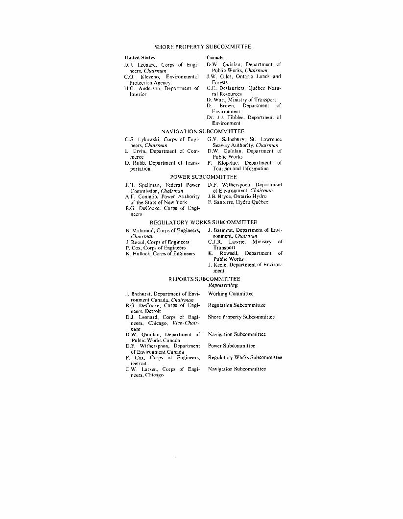
SHORE PROPERTY SUBCOMMITTEE
United States Canada D.J. Leonard, Corps of Engi- D.W. Quinlan, Department of
C.O. Kleveno, Environmental J.W. Giles, Ontario Lands and
H.G. Anderson, Department of C.E. Deslauriers, Qutbec Natu-
neers, Chairman Public Works, Chairman
Protection Agency Forests
Interior ral Resources D. Watt, Ministry of Transport D. Brown, Department of
Dr. J.J. Tibbles, Department of Environment
Environment NAVIGATION SUBCOMMITTEE
G.S. Lykowski, Corps of Engi- G.V. Sainsbury, St. Lawrence neers, Chairman Seaway Authority, Chairman
L. Ervin, Department of Com- D.W. Quinlan, Department of merce Public Works
D. Robb, Department of Trans- P. Klopchic, Department of portation Tourism and Information
POWER SUBCOMMITTEE J.H. Spellman, Federal Power D.F. Witherspoon, Department
Commission, Chairman of Environment, Chairman A.F. Coniglio, Power Authority J.B. Bryce, Ontario Hydro
of the State of New York F. Santerre, Hydro Qutbec B.G. DeCooke, Corps of Engi-
neers REGULATORY WORKS SUBCOMMITTEE
B. Malamud, Corps of Engineers, J. Bathurst, Department of Envi- Chairman ronment, Chairman
J . Raoul, Corps of Engineers C.J.R. Lawrie, Ministry of P. Cox, Corps of Engineers Transport K. Hallock, Corps of Engineers K. Rowsell, Department of
J . Keefe, Department of Environ- Public Works
ment REPORTS SUBCOMMITTEE
J . Bathurst, Department of Envi- ronment Canada, Chairman
B.G. DeCooke, Corps of Engi- neers, Detroit
D.J. Leonard, Corps of Engi- neers, Chicago, Vice-Chair-
D.W. Quinlan, Department of man
Public Works Canada D.F. Witherspoon, Department
of Environment Canada P. Cox, Corps of Engineers,
Detroit C.W. Larsen, Corps of Engi-
neers, Chicago
Representing: Working Committee
Regulation Subcommittee
Shore Property Subcommittee
Navigation Subcommittee
Power Subcommittee
Regulatory Works Subcommittee
Navigation Subcommittee
Appendix C
AGENCIES PARTICIPATING IN THE INVESTIGATION
Valuable and cooperative assistance was provided by the following agencies: In the United States Department of the Interior, Bureau of Mines Department of the Interior, Bureau of Outdoor Recreation Department of the Interior, Bureau of Sport Fisheries and Wildlife Corps of Engineers Department of Commerce Environmental Protection Agency Federal Power Commission National Oceanic and Atmospheric Administration, Lake Survey
National Oceanic and Atmospheric Administration, National Marine
National Oceanic and Atmospheric Administration, National Weath-
Power Authority of the State of New York Department of Transportation St . Lawrence Seaway Development Corporation In Canada Environment Canada Department of Public Works Ministry of Transport Ontario Department of Tourism and Information Ontario Ministry of Natural Resources QuCbec Department of Natural Resources Ontario Hydro Hydro Qutbec St . Lawrence Seaway Authority
Center
Fishery Service
er Service
71

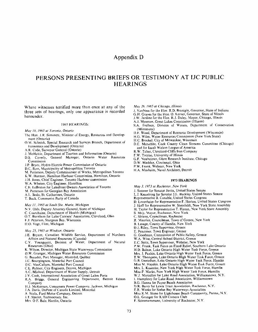
Appendix D
PERSONS PRESENTING BRIEFS OR TESTIMONY AT IJC PUBLIC HEARINGS
Where witnesses testified more than once at any of the May 26. I965 at Chicago, Illinois
hereunder. three sets of hearings, only one appearance is recorded J. VanNess for the Hon. R.D. Branigin, Governor, State of Indiana
G.H. Graves for the Hon. 0. Kerner, Governor, State of Illinois J.W. Jardine for the Hon. R.J. Daley, Mayor, Chicago, Illinois A.J. Meseraw, Great Lakes Commission (Illinois) S.A. Frellsen, Division of Waters, Department of Conservation 1965 HEARINGS:
May I O . I965 at Toronto. Ontario The Hon. J.R. Simonett, Minister of Energy, Resources and Develop-
O.M. Schnick, Special Research and Surveys Branch, Department of
A.R. Code, Surveyor General (Ontario) J . McHattie, Department of Tourism and Information (Ontario) D.S. Caverly, General Manager, Ontario Water Resources
J.P. Bryce, Hydro Electric Power Commission of Ontario D.C. Ross, Municipality of Metropolitan Toronto M . Patterson, Deputy Commissioner of Works, Metropolitan Toronto K.W. Harmer, Hamilton Harbour Commission, Hamilton, Ontario J .H. Jones, Chief Engineer, Toronto Harbour commission W.A. Wheten, City Engineer, Hamilton C.E. LeBreton for Lakefront Owners Association of Toronto M. Patterson for Georgian Bay Association A.L. Bodo, St. Catharines, Ontario T. Buck, Communist Party of Canada
May 1 1 , 1965 at Sault Ste. Marie, Michigan N.V. Olds, Deputy Attorney-General, State of Michigan C. Courchaine, Department of Health (Michigan) O.T. Burnham for Lake Carriers’ Association, Cleveland, Ohio F.J. Peterson, Sturgeon Bay, Wisconsin H.O. Vogt, Flint, Michigan
May 25, I965 at Windsor, Ontario J.E. Bryant, Canadian Wildlife Service, Department of Northern
C.V. Youngquist, Division of Water, Department of Natural
K. Wilson, Director, Michigan State Waterways Commission D.W. Granger, Michigan Water Resources Commission G. Beaudet, Port Manager, Montreal, Quebec J.C. Bourgingnon, Montreal Port Council D.C. MacCallum, Montreal Port Council C.L. Palmer, City Engineer, Detroit, Michigan A.C. Michael, Department of Water Supply, Detroit J.V. Cook, International Association of Great Lakes Ports R.A. Briggs, General Engineering Department, Detroit Edison
H.J. McKernan, Consumers Power Company, Jackson, Michigan J.A. Davis, DuPont of Canada Limited, Montreal A. Scala, Ford Motor Company, Detroit J.T. Spiclet, Technocracy, Inc. Mrs. O.F. Bale, Hardin, Ontario
ment (Ontario)
Economics and Development (Ontario)
Commission
Affairs and Natural Resources (Canada)
Resources (Ohio)
Company
(Minnesota) D.F. Wood, Department of Resource Development (Wisconsin) H.G. Wilm, Water Resources Commission (New York State) H.C. Brockel, City of Milwaukee, Wisconsin D.E. Matschke, Cook County Clean Streams Committee (Chicago)
and for Izaak Walton League of America R.W. Taber, Cleveland-Cliffs Iron Company F.W. Trezise, University of Illinois G.F. Nauheimer, Glare Research Institute, Chicago D.W. Maddux, Cincinnati, Ohio P.W. Frank, Webster, New York H.A. Mushaim, Naval Architect, Detroit
1973 HEARINGS
May 3, 1973 at Rochester. New York J. Sonmer for Senator Javits, United States Senate L.J. Kesselring for Senator J.L. Buckley, United States Senate Representative B. Conable, United States Congress D. Lovenheim for Representative F. Horton, United States Congress J . Hoff for Representative W. Steinfeldt, New York State Assembly H. Taylor for Representative T. Hanna, New York State Assembly S . May, Mayor, Rochester, New York C. Shiano, Councilman, Rochester R. Maurice, Councilman, Town of Greece, New York B. Lesage, County of Hamlin, New York D.J. Riley, Town Supervisor, Greece E. Penzimer, Town Engineer, Greece G. Goodman, Commission of Public Safety, Greece W.A. Wise, Central School District, Greece E.C. Seitz, Town Supervisor, Webster, New York P.W. Frank, Task Force on Flood Relief, Southern Lake Ontario H.D. Bolton, Lake Ontario High Water Task Force, Greece Mrs. J . Paxhia, Lake Ontario High Water Task Force, Greece T.W. Thompson, Lake Ontario High Water Task Force, Greece G.B. Gustafson, Lake Ontario High Water Task Force, Hamlin Miss M. Hayden, Lake Ontario High Water Task Force, Greece Mrs. L. Kusonisz, New York High Water Task Force, Hamlin Miss P. Marks, New York High Water Task Force, Hamilin W.J. Marcellus for Lake Road Association, Williamstown, N.Y. I. Humphrey for Lake Road Association, Williamstown B.G. Hanna for Payne Beach Association D.R. Barry for Lewis Tract Association, Rochester, N.Y. E.R. Weeks for Sodus Bay Waterways Association Miss K.M. Stone for Lighthouse Beach Community, Parma, N.Y. O.L. Granger for KAD Camera Club F. Sciremammano, University of Rochester, N.Y.
73
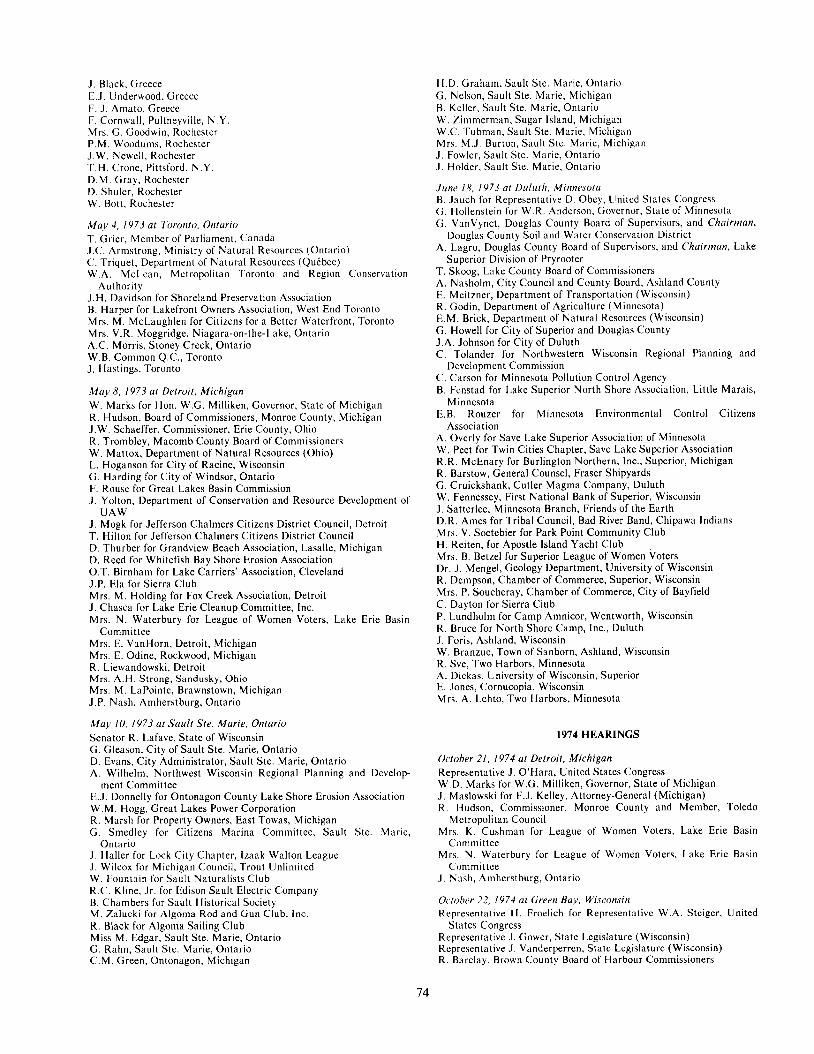
J . Black, Greece E.J. Underwood. Greece F. J . Amato, Greece F. Cornwall, Pultneyville. N.Y. Mrs. (3. Goodwin, Rochester P.M. Woodums. Rochcster J.W. Newell, Rochester T.H. Crone. Pittsford, N.Y. D.M. Gray. Rochester D. Shuler, Rochester W. Bott. Rochester
Mu,v 4, I973 ut Toronto. Ontario T. Grier, Member of Parliament, Canada J.C. Armstrong, Ministry of Natural Resources (Ontario) C. Triquet, Department of Natural Resources (Qukbcc) W.A. McLean, Metropolitan Toronto and Region Conservation
S.H. Davidson for Shoreland Preservation Association B. Harper for Lakefront Owners Association, West End Toronto Mrs. M. McLaughlen for Citizens for a Better Waterfront, Toronto Mrs. V.R. Moggridge, Niagara-on-the-Lake, Ontario A.C. Morris, Stoney Creek, Ontario W.B. Common Q.C., Toronto J . Hastings, Toronto
M a y 8, 1973 at Detroit. Michigan W. Marks for Hon. W.G. Milliken, Governor, State of Michigan R. Hudson, Board of Commissioners, Monroe County, Michigan J.W. Schaeffer, Commissioner, Erie County, Ohio R. Trombley, Macomb County Board of Commissioners W. Mattox, Department of Natural Resources (Ohio) L. Hoganson for City of Racine, Wisconsin G. Harding for City of Windsor, Ontario F. Rouse for Great Lakes Basin Commission J . Yolton, Department of Conservation and Resource Development of
J . Mogk for Jefferson Chalmers Citizens District Council, Detroit T. Hilton for Jefferson Chalmers Citizens District Council D. Thurber for Grandview Beach Association, Lasalle, Michigan D. Reed for Whitefish Bay Shore Erosion Association O.T. Birnham for Lake Carriers’ Association, Cleveland J.P. Ela for Sierra Club Mrs. M. Holding for Fox Creek Association, Detroit J . Chasca for Lake Erie Cleanup Committee, Inc. Mrs. N. Waterbury for League of Women Voters, Lake Erie Basin
Mrs. E. VanHorn, Detroit, Michigan Mrs. E. Odine, Rockwood, Michigan R. Liewandowski, Detroit Mrs. A . H . Strong, Sandusky, Ohio Mrs. M. LaPointe, Brawnstown, Michigan J.P. Nash, Amherstburg, Ontario
M a y IO. 1973 al Saul t Ste. Mar ie , Ontar io Senator R. Lafave, State of Wisconsin G. Gleason, City of Sault Ste. Marie, Ontario D. Evans, City Administrator, Sault Ste. Marie, Ontario A. Wilhelm, Northwest Wisconsin Regional Planning and Develop-
E.J. Donnelly for Ontonagon County Lake Shore Erosion Association W.M. Hogg, Great Lakes Power Corporation R. Marsh for Property Owners, East Towas, Michigan G . Smedley for Citizens Marina Committee, Sault Ste. Marie,
J . Haller for Lock City Chapter, lzaak Walton League J . Wilcox for Michigan Council, Trout Unlimited W. Fountain for Sault Naturalists Club R.C. Kline, Jr . for Edison Sault Electric Company B. Chambers for Sault Historical Society M. Zalucki for Algoma Rod and G u n Club, Inc. R. Black for Algoma Sailing Club Miss M. Edgar, Sault Ste. Marie, Ontario G. Rahn, Sault ;Ste. Marie, Ontario C.M. Green, Ontonagon, Michigan
Authority
UAW
Committee
ment Committee
Ontario
H.D. Graham, Sault Ste. Marie, Ontario G. Nelson, Sault Ste. Marie, Michigan B. Keller, Sault Ste. Marie, Ontario W. Zimmerman, Sugar Island, Michigan W.C. Tubman, Sault Ste. Marie, Michigan Mrs. M.J. Burton, Sault Ste. Marie, Michigan J . Fowler, Sault Ste. Marie, Ontario J . Holder, Sault Ste. Marie, Ontario
June 18, I973 at Duluth, Minnesota B. Jauch for Representative D. Obey, Unitcd States Congress G . Hollenstein for W.R. Anderson, Governor, State of Minnesota C;. VanVynct, Douglas County Board of Supervisors, and Chairman,
A. Lagro, Douglas County Board of Supervisors, and Chairman, Lake
T. Skoog, Lake County Board of Commissioners A. Nasholm, City Council and County Board, Ashland County E. Meitzner, Department of Transportation (Wisconsin) R. Godin, Department of Agriculture (Minnesota) E.M. Brick, Department of Natural Resources (Wisconsin) G. Howell for City of Superior and Douglas County J.A. Johnson for City of Duluth C. Tolander for Northwestern Wisconsin Regional Planning and
Development Commission C. Carson for Minnesota Pollution Control Agency B. Fenstad for Lake Superior North Shore Association, Little Marais,
E.B. Rouzer for Minnesota Environmental Control Citizens
A. Overly for Save Lake Superior Association of Minnesota W. Peet for Twin Cities Chapter, Save Lake Superior Association R.R. McEnary for Burlington Northern, Inc., Superior, Michigan R. Barstow, General Counsel, Fraser Shipyards G. Cruickshank, Cutler Magma Company, Duluth W. Fennessey, First National Bank of Superior, Wisconsin J. Satterlee, Minnesota Branch, Friends of the Earth D.R. Ames for Tribal Council, Bad River Band, Chipawa Indians Mrs. V. Soetebier for Park Point Community Club H. Reiten, for Apostle Island Yacht Club Mrs. B. Betzel for Superior League of Women Voters Dr. J . Mengel, Geology Department, University of Wisconsin R. Dempson, Chamber of Commerce, Superior, Wisconsin Mrs. P. Soucheray, Chamber of Commerce, City of Bayfield C. Dayton for Sierra Club P. Lundholm for Camp Amnicor, Wentworth, Wisconsin R. Bruce for North Shore Camp, lnc., Duluth J. Foris, Ashland, Wisconsin W. Branzue, Town of Sanborn, Ashland, Wisconsin R. Sve, Two Harbors, Minnesota A. Dickas. University of Wisconsin, Superior E. Jones, Cornucopia, Wisconsin Mrs. A. Lehto. Two Harbors, Minnesota
Douglas County Soil and Water Conservation District
Superior Division of Pryrooter
Minnesota
Association
1974 HEARINGS
October 21. 1974 at Detroit , Michigan Representative J. O’Hara, United States Congress W.D. Marks for W.G. Milliken, Governor, State of Michigan J . Maslowski for F.J. Kelley, Attorney-General (Michigan) R. Hudson, Commissioner, Monroe County and Member, Toledo
Mrs. K. Cushrnan for League of Women Voters, Lake Erie Basin
Mrs. N. Waterbury for League of Women Voters, Lake Erie Basin
.I. Nnsh, Amherstburg, Ontario
October 22, 1974 at Green Bay, Wisconsin Representative H. Froelich for Representative W.A. Steiger, United
Representative J. Cower, State Legislature (Wisconsin) Representative J . Vanderperren, State Legislature (Wisconsin) R. Barclay, Brown County Board of Harbour Commissioners
Metropolitan Council
Committee
Committee
States Congress
74
C. Crabb, Director Public Works, Green Bay C. Mason for Lakefront Property Owners Mrs. C. Schmitz for West Shore Association, Suamico, Wisconsin G . Kornetzke for UP Federation of Landowners, Inc., Escanaba,
D. Swaer, Schilling Fish Company, Green Bay G. Howlett, Jr., Cooperative Education Service Agency, Green Bay Mrs. C. Stencil, League of Women Voters, Green Bay C. Albers, Green Bay A. Kayser, Bailey’s Harbor, Wisconsin R. Ozanne, Madison, Wisconsin Ms Cheryl Warren, Sturgeon Bay, Wisconsin Ms T . DeGroot, Green Bay W. Sullivan, Oconto, Wisconsin F. Peterson, Sturgeon Bay K. Peters, Shiocton. Wisconsin
October 23, 1974 at Sault Ste. Marie, Ontario J. Porcaro for Representative Ruppe, United States Congress M. Stoll, Fish and Wildlife Service (United States) N. Conroy, Ministry of Environment, Northeastern Region (Ontario) A.A. Jackson, Chief Engineer, Sault Ste. Marie, Ontario J . Bouchard for Waterfront Development Task Force, Sault Ste.
A. L a m a for Great Lakes Fishery Committee Dr. J.J. Tibbles, Director, Sea Lamprey Control Centre G.A. Furkey for Point Louise Waterfront Association D.E. Reed for Whitefish Bay Shore Erosion Association W.H. Fountain for Sault Naturalists Club Mrs. M. Burton for League of Women Voters Dr. D. Gleason, Biologist and Environmental Consultant, Michigan R. Kline for Edison-Sault Electric Company W. Hogg for Great Lakes Power Company R.L. Frost, Sault Ste. Marie, Ontario .I. Holder, Sault Ste. Marie, Ontario
October 25, 1974 at Thunder Bay, Ontario G. DiGiagomo for P. McRae, Member of Provincial Legislature
J . Jessiman, Member for Provincial Legislature (Ontario) H. Styffe, Lake Harbour Commission, Thunder Bay R. Hartley for Hope Committee, Thunder Bay N . Richard for Thunder Bay District Labour Council F. Jeacock for West Green Bay Pebbly Beach Campers Association,
Mrs. D. Clarke for Silver Beach Campers Association, Township of
D. Willoughby. Thunder Bay, Ontario
November 6 . 1974 at Muskegon, Michigan J. Gibson for Representative G. VanderJagt, United States Congress F.O. Rouse for Great Lakes Basin Commission L. Crook for Great Lakes Basin Commission D. Spuller for Michigan Soil Conservation Branch, National Associa-
J. Hesselink for Haven Plat Association, West Olive, Michigan J. Dyer, Montague, Michigan 0. Carter, Fremont, Michigan Miss D. Dow, West Island, Michigan Mrs. W. Jamieson, Whitehall, Michigan
November 7 . 1974 at Milwaukee, Wisconsin J. Strohl for Representative L. Aspin, United States Congress T. Leslie, Mayor, City of Mequon, Wisconsin E. Brick, Wisconsin Department of Natural Resources, Madison J.L. Haskell, Board of Harbour Commissioners, Milwaukee F. Martin for East Holland Citizen League, Cedar Grove, Wisconsin Miss H. Jacobs for League of Women Voters of Greater Milwaukee C. Froemming, Milwaukee Mrs. S. Cota, Milwaukee P.J. Lucas. West Allis, Wisconsin F. Martin, Cedar Grove, Wisconsin M. Scriba, Milwaukee D. Broadland, Milwaukee Mrs. R. Baker, Milwaukee
Wisconsin
Marie, Ontario
(Ontario)
Thunder Bay
Shuniah
tion of Conservation Districts
November 8, 1974 at Duluth, Minnesota Representative J. Oberstar, United States Congress C . Hollenstein for Governor Anderson, State of Minnesota R. Hansen. Board of Supervisors, Ashland County K. Todd, Chairman, Board of Supervisors, Ashland County Mrs. I . Bromberg, Bayfield County Board, Washburn, Wisconsin H. Andresen, Board of Supervisors, Douglas County C.H. Landry, Mayor, City of Mellen, Minnesota J. Tumbera for Mayor Denewith, City of Superior, Michigan A. Nasholm, Common Council, City of Ashland J . LaVoy, Seaway Port Authority, Duluth G.J. Merritt, Minnesota Pollution Control Agency J . Pegors, Minnesota Pollution Control Agency R.T. Scott, Minnesota Delegation to the Great Lakes Commission R. Dusenbery, Regional Planning and Development Commission,
M. Pelletier, Minnesota Conservation Federation W. Pomeroy, Northern Environmental Council, Inc., Ashland,
Ms P. Knode for Madeline Island Association Mrs. B. Hetzel for League of Women Voters E. Anderson for Lakes Maritime Society, Superior, Wisconsin L. Wagner, United Northern Sportsmen of Duluth R. Jones for Lake Superior Steelhead Association L.R. Vienneau, Park Point Community Club J . Lavoy for Terminal Elevator Association Mrs. M. Winston for Madeline Island Ferry Line, Minneapolis Dr. M. Behr, University of Wisconsin, Superior A. Dickas, University of Wisconsin, Superior Mrs. B. Roubal, University of Wisconsin, Superior J.C. Knox, University of Wisconsin, Madison H. Evans, Cook County M. Sydor, Duluth B. Blackburn, Grand Marais, Minnesota R. Hill, Ashland, Wisconsin S. Lindquist, Duluth D. Ekstrom, Holland, Minnesota J . Allen, Bayfield County Mrs. S. Soucheray, LaPointe, Wisconsin W. Peet, St . Paul, Minnesota R. Flinsch, Minneapolis
November 18. I974 at Cleveland. Ohio Representative C.A. Mosher, United States Congress H.P. Reese, Mayor, City of Bay Village, Ohio J.F. Fritz, Mayor, City of Port Clinton, Ohio J. Green, Carroll Township Trustee, Oak Arbour, Ohio P.E. Smith, Ohio Department of Natural Resources, Columbus J. Wolfe, Chief Engineer, Cleveland Cuyahogo County Port Authority T. Morganti, Ottawa County Regional Planning Commission, Port
C.B. Hartley for Lower Lake Erie Association, Huron, Ohio W.B. Estep, Sr. for Cedar Point Property Owners Association Mrs. W. Monks for Huronia Beach Association, Huron P.G. Trimble for Lake Carriers Association, Cleveland Mrs. H. Kylin for League of Women Voters, Aurora, Ohio Mrs. J .H. Angel for Citizens for Land and Water Use, Cleveland S.H. Estill for lzaak Walton League, Ohio Division Mrs. C. Gantz for Lakeshore Erosion Committee, Cleveland J.F. LaPlante for PLEASE A. Vidra, Geologist, Kent State University
J. Rea, Rocky River, Ohio M. Scanlon, Rocky River, Ohio
W.J. Rankin, Eastlake, Ohio L. Gnagy, Richmond Heights, Ohio D. Balchae, Cleveland B.J. Leite, Toledo, Ohio G.C. Petry, Isle of St. George D.S. Connelly, Cleveland Heights, Ohio L. Pivato, Avon Lake, Ohio
November 19, I974 at Chicago. Illinois Senator R.W. Mitchler, Illinois State Senate for Water Pollution ana
Senator J.W. VanNess, Indiana State Senate
Northwestern Wisconsin
Wisconsin
Clinton, Ohio
Water Resources Commission
75
W.G. Swindal for Representative S.H. Young, United States Congress R.J. Geraci, Mayor, Highland Park, Illinois R.A. Pastrick, Mayor, East Chicago, Indiana K.W. Sain, Deputy Mayor, Chicago, Illinois Mrs. J .H. Alter, Trustee, Metropolitan Sanitary District of Greater
Mrs. L. Botts for Lake Michigan Federation Ms M.L. Strang for Lake Michigan Inter-League Group, League for
B. Tucker, Department of Transportation (Illinois) J.A. Smedile, Planning Commission, Northeastern Illinois D.G. Meinen, Tri-County Regional Planning Commission
November 20, 1974 at Rochester. New York D.A. Lovenheim for Representative Frank Horton, United States
T.R. Benton for Representative B. Conable, United States Congress Representative W. Steinfeldt, New York State Legislature J .F. Downing, Deputy Mayor, Buffalo, N.Y. I.H. King, Regional Director, Department of Environmental Conser-
G. Strong for Erie Niagara Regional Board, Buffalo D.F. Ketchum for Lake Ontario South Shore Council, Williamson,
W. Humphrey for Lake Road Association, Williamson P.F. Cox for Sodus Bay Waterways Association, Rochester, N.Y. E.P. Ratecki for Erie County Federation of Sportsmen, Buffalo C. Buell, for West Hilton Beach Assocation, Hilton, N.Y. P. Frank for Lake Bay Association Mrs. G. Gustafson for Hamlin High Water Task Force H.D. Bolton for Greece High Water Task Force E. Weeks for Lake Ontario South Shore Council and Sodus Bay
W. J . Marcellus, Williamson, N.Y. J. N. Schirano, Cape Vincent, N.Y. B. J . Monbouquette, Attorney, Pittsford, N.Y. representing Ms Eileen
W. Mayer, Webster, N.Y. D. Rook for Lake Ontario South Shore Council, Newark. N.J. P. Sciremammano, University of Rochester
November 21. 1974 at Hamilton, Ontario V. H. Copps, Mayor, Hamilton, Ontario S. B. Panting, Ministry of Natural Resources (Ontario) C. Jandzinski, Erie County Government, Buffalo, N.Y.
Chicago
Women Voters, Glenview, Illinois
Congress
vation (New York) Avon, N.Y.
N.Y.
Waterways Association
Dowling
Mrs. A. Jones, Chairman, Regional Municipality of Hamilton-Went-
J . Lizachek, Technical Department, Hamilton R. Hennessy, Hamilton Harbour Commission D. F. Melhorn for PLEASE, Inc., Toledo, Ohio D. M. Gorham for Shoreland Preservation Association Mrs. J . Mobridge for Shoreland Preservation Association Mrs. M. O’Rourke for Lakeshore Property Owners, Erie Beach B. Harper for Lakefront Owners Association L. VanNeck for Harwick Lakeshore Property Association, Kent
W. C. Stevens for Boating Writers International, St. Catharines,
H. G. McLeod for Shoreland Preservation Association, St. Catharines R. Irwin for Shoreland Preservation Association, Oakville, Ontario Mrs. L. Hurst, Selkirk, Ontario Mrs. M. McLaughlin, Toronto H. M. Rogers, St. Catharines
November 22, I 9 7 4 at Owen Sound, Ontario R. E. Rutherford, Mayor, Owen Sound, Ontario M. M. Campbell for Bruce County South Planning Board G. Harron for Township of Amabel W. J . Robertson for Ontario Marina Operators Association T. F. Simonato for Brophy Beach Ratepayers Association D. Strobridge, Port Dover, Ontario R. Holmes, Parry Sound, Ontario S. Douglas, Owen Sound, Ontario T. Hawkbridge, Owen Sound F. Freed, Owen Sound Miss 1. E. Grunsell, St. Catharines, Ontario
December 6 , 1974 at Montre‘al. Que‘bec B. Harvey for Province of Quebec P. Menard for UPA Ftdtration J . P. Lavallee for UPA Ftdtration C. de Quenneville for I’Association qutbtcoise des techniques de I’eau R. Perrier for I’Association qutbtcoise des techniques de I’eau J. Marcotte for la Communautt urbaine de Montrtal
worth
County
Ontario
In addition to the above, over 100 statements were submitted on behalf of individuals and organizations at the hearings. A similar amount was received by mail.
76

Appendix E
TEXT OF EMERGENCY APPLICATION BY THE GOVERNMENT OF THE UNITED STATES
On January 26, 1973 the Government of the United States presented the following application to the Com- mission requesting a reduction in water releases through the power canals or other facilities operated under the authority and jurisdiction of the United States.
The Government of the United States is gravely con- cerned by the critical high water levels in the lower Great Lakes and believes that immediate action is required in order to reduce the common dangers of additional damages to riparian interests by these extreme high water conditions.
Accordingly, the Government of the United States requests that the International Joint Commission amend its Order of May 26, 19 14, and any other pertinent orders, or take any other action necessary in the judgment of the Commission, to authorize and direct the United States to undertake the following emergency measures:
1. To reduce water releases for power generation through power canals or other facilities operated under the author- ity and jurisdiction of the United States in the St. Mary’s River to the extent necessary or feasible, in the judgment of the United States, to relieve the critical high water conditions on the lower Great Lakes, such reductions in flows in no event to be greater than the flows available for
power purposes on the United States side at the time of such reductions under the Order of May 26, 1914 and other applicable orders of the I.J.C. or of its boards.
2 . To restrict or prevent such flows for such periods as the United States may deem necessary, in no event longer than six months, or until the I.J.C. shall direct that such flows be restored. The United States requests that in light of the need for
rapid action to respond to this situation the Commission consider this Application as an emergency Application. The United States requests that the Commission suspend such of its Rules as may be required for immediate consideration of the Application, pursuant to Rule 9 of the I.J.C. Rules of Procedure. In particular, the United States requests that the Commission suspend such portions of Rules 12-25 as may, in the judgment of the Commission, pertain to the consider- ation of this application.
The Government of the United States agrees to deal with claims for losses resulting on either side of the border from the approval of this Application in accordance with appli- cable principles of United States law and international law, to the extent that such losses result from levels of Lake Superior above the maximum elevation specified in the I.J.C.’s Order of May 26, 1914.
77

Appendix F
ORDERS OF APPROVAL FOR REGULATION OF LAKE SUPERIOR
Office Consolidation
IN THE MATTER OF THE APPLICATIONS OF THE ALGOMA STEEL CORPORATION, LIMITED, AND OF THE MICHIGAN NORTHERN POWER COMPANY FOR APPROV- AL OF THE OBSTRUCTION, DIVERSION, AND USE OF THE WATERS OF THE ST. MARYS RIVER ON THE CANADIAN SIDE AND ON THE UNITED STATES SIDE RESPECTIVELY OF THE INTERNATIONAL BOUNDARY AT SAULT STE. MARIE, MICHIGAN AND ONTARIO. NOTE:
I . The wording common to both Orders is in Courier type. Wording applicable only to the Algoma Steel Corporation Order is in Light Italic type. Wording applicable only to the Michigan Northern Power Company Order is in Bold type.
2. The paragraph numbering in some instances is not identical with the Orders.
3. All elevations have been converted to International Great Lakes Datum (1955).
ORDERS OF APPROVAL May 26, 1914 and May 27, 1914
The above applications having come on for final hearing at the city of Detroit, in the State of Michigan, March 9 and 10, 19 14, and the hearing having been continued to and concluded at the city of Washington April 9, 1914, the commission, after hearing all the parties, examining the locus in quo, and carefully con- sidering the application and all the evidence presented, including the statements of engineer representatives of the United States and of the Dominion of Canada in respect thereto, finds as follows, viz:
1. Algoma Steel Corporation (Ltd.), a corporation duly organized and existing under the laws of the Province of Ontario, filed with the commission on October 7, 1913, an application for approval of the obstruction of the waters of the St. Marys River on the Canadian side of the boundary at Sault Ste. Marie. Ontario, as described therein.
1. The Michigan Northern Power Co. is a corporation duly organized and existing under the laws of the State of Michigan; it is the owner and successor in title and interest to all the property and to all the rights and privileges claimed and set forth by Clarence M. Brown, receiver for the Michigan Lake Superior Power Co., in its application for approval of the obstruction, diversion, and use of the waters of the St. Marys River on the United States side of the boundary at Sault Ste. Marie, Mich., filed June 30, 1913, as described therein; and by order of the commission entered at
Ottawa October 7, 1913, the said Michigan Northern Power Co. was duly substituted for said receiver of the said Michigan Lake Superior Power Co. as applicant.
2. Due and official notice of the filing of said application and of the time and place of the final hearing thereon was given to all parties interested in both countries; the right to appear and be heard on the final hearing was duly extended, under the rules of the commission, to all municipalities on both sides of the international boundary and to private corporations and to others, who appeared and were heard and participated in the examination of witnesses: and no application was made by anyone so appearing for additional protective works, or for any other relief on account of anticipated injury or damage in consequence of the construction, maintenance, and operation of the proposed works, upon said final hearing.
3. The compensating or remedial works mentioned and described in the said application as amended on the final hearing will, when constructed. be located wholly within the jurisdiction of and upon property situated within the Dominion of Canada, north of the international boundary, in the St. Marys River at Sault Ste. Marie, Ontario, and upon the upper side of the international bridge crossing the St. Marys River. The applicant has represented that it already owns certain compensating works in the bed of the St. Marys River, consisting of a crib and a rock-and-fill dam above the tenth span oJ the international bridge and four Stoney sluice gates about 50 feet in the clear operated between piers above the ninth span of said bridge, which said works are located on the Canadian side of the said river. The applicant proposes to construct additional compensating works in the bed of the St. Marys River extending southerly from the said above-mentioned works practi- cally to the international boundary. of similar construction to those above described. The character of the proposed additional compen- sating works is shown on plans filed in the present cause and numbered 953 and 954. The said plans were duly submitted to the Governor General in council, and approved by an order dated March 5. 1914, under certain conditions. viz:
i That the company shall furnish legal evidence that it has the right to use the site of the said works.
ii Full control of the works and the discharges on the Canadian side of the boundary line is t o be vested in the department of public works, or as directed by the International Joint Com- mission, and all expenses f o r upkeep. of the works are to be borne by the company.
iii That the works shall be completed on the Canadian side of the boundary line within three years from the date ofthe approval of the plans.
iv That the Government oJ the Dominion of Canada may take over the works on the Canadian side o f t h e boundary line, at any time, on terms to be arranged between the company and the Governmentn or by expropriation.
v That the provincial government of Onturio may, at any time, make such alterations and additions to the works on the Canadian side o f t h e boundary line, at its own cost. as may be
79
called f o r in connection with the development of power, as shown on the plan submitted with the statement in response on behalf of the Province of Ontario, dated November 3, 1913. which was filed with the International Joint Commission when the matter was before the commission.
3A. By an amendment to its application the applicant has prayed b)r the approval of the diversion, f o r power purposes, by itselJ its successors or assigns, or by the Province of Ontario, of primary or continuous water from St . Marys River, up to an aggregate max- imum, including the amount of water heretofore permitted. of 30,000 cubic feet per second. and in addition thereto a further /low of secondary water, that may be intermittently available f o r power purposes, up to an aggregate maximum of 5,000 cubic feet per second.
3. The compensating or remedial works mentioned and described in the said application as amended on the final hearing will, when constructed, he located wholly within the jurisdiction and upon property owned by the United States south of the international boundary line in the St. Marys River, at Sault Ste. Marie, Mich., and upon the upper side of the International Bridge crossing the St. Marys River. According to the plans therefor, as finally approved, said compensating works when completed will consist of a certain dike about 200 feet in length and 8 Stoney sluice gates about 50 feet in the clear, and are intended to obstruct and divert the waters of said river on the United States side thereof through a power canal. The Government of the United States in time will become the owner of said compensating works.
4. Said St. Marys River is the natural outlet of Lake Superior, and said river and lake are boundary waters as defined by the treaty of January 11, 1909, between Great Britain and the United States.
5. It is conceded by the applicant and both Governments that the construction and operation of the proposed works will affect the natural level and flow of the waters of said river and of Lake Superior on the other side of the line, and that the effect will therefore be international; and the interest of both Governments, as well as the interests of navigation and other public and private interests in both countries, will be suitably and adequately protected and indemnified by international or joint control of said works. Said compensating works when constructed according to the finally approved plans and under the conditions with respect to their construction and operation hereinafter prescribed will constitute a mechanically operated discharge cross section for the discharge of the waters of said lake on the Canadian (United States) side of the international boundary: which, with the existing power which, with the existing power canal of the applicant, which canal of the applicant, which has a discharge (capacity of has a discharge capacity of about 15.000 cubic feet per about 30,000 cubic feet per second. second, and the United States
power canal, known as the Chandler-Dunbar Canal, which has a discharge capacity of about 5,000 cubic feet per second,
will afford an aggregate discharge capacity ful ly equal to the existing discharge capacity of said river on the Canadian (United States) side of the international boundary, and the levels of Lake Superior under thest: conditions can be regulated within a more restricted range than is now possible under existing conditions of discharge.
6. From 1860 to 1913, or for a period of 54 years, the extreme range of levels of Lake Superior-that is, between the highest and the lowest monthly mean level-as shown by the United States official records thereof, was about 3.5 feet. From the evidence it would seem that i f the said compensating and other works of the applicant are constructed, maintained, and operated according to the said approved plans and the conditions hereinafter stated in respect to their construction and operation, the range of monthly mean levels of Lake Superior may be reasonably confined within 2.5 feet and ordinarily within the lesser range of 1.5 feet, between an elevation of 600.5 and 602.0 feet; and that under proper internation- al joint control the levels of said lake may be regulated so as to
benefit navigation and reasonably protect the propzrty and interests, public and private, in both countries above said works.
7. The equal division of the waters of said St. Marys River between the United States and Canada was conceded upon the hearing by their duly appointed representatives.
8. At the time and place of the final hearing, the applications of the Algoma Steel Corporation (Ltd.). a corporation organized and existing under the laws of the Province of Ontario, (and) of the Michigan Northern Power Co., a corporation organized and exist- ing under the laws of the State of Michigan, for approval of their proposed obstruction, diversion, and use of the waters of the said St. Marys River on the Canadian (United States) side of the Interna- tional boundary by constructing certain compensating or remedial and other works therein for that purpose, were finally heard and approved.
9. Said Algoma Steel Corporation (Ltd.) and Michigan Northern Power Co. are separate and distinct organizations; they are in no way related in interest, financially or otherwise, and they are not owned or in any way operated or controlled by the same interests, and have no working or other relations between them. Their several works are intended, planned, and will accomplish only the obstruc- tion and diversion of the waters on the respective sides of said river in Canada and the United States for power purposes, and each of said works will be constructed and can be operated independently of the other; when the said works are finally completed on both sides of the international boundary in said river, the interests of navigation and reasonable protection to public and private property on both sides of the international boundary will require that they be oper- ated under international ioint control as one complete work or project. Now, therefore, it is hereby ordered, that subject to the conditions of the order in council of March 5, 1914, hereinabove in part recited (except that the time f o r the completion of the said works, if extended by the Government of Canada, shall expire only on the day fixed by the said Gov- ernment), and to the conditions hereinafter stated in respect to the construction of said com- pensating or remedial works of said applicant, its successors, or assigns, and subject also to such conditions and rules as hereinafler stated and author- ized in respect to the control and operation of said works, the obstruction. diversion, and use of the waters of said river on the Canadian side of the international boundary f o r power purposes, as applied f o r as aforesaid, together with the plans therefor as finally approved by the Governor Gen- eral in council, March 5. 1914,
Now, therefore, it is hereby ordered, that subject to the conditions hereinafter stated in respect to the construction of said compensating or remedial works of said applicant, its successors or assigns, and sub- ject also to such conditions and rules as are hereinafter stated and authorized in respect to the control and operation of said works, the obstruction, diver- sion, and use of the waters of said river on the United States side of the international bound- ary for power purposes as prayed and found herein, and the construction and mainte- nance of said compensating works to he constructed for that purpose, together with the plans therefor as finally approved by the Secretary of War and the Chief of Engi- neers of the United States, April 6, 1914,
and submitted upon the final hearing, be and the same are all hereby, approved upon the conditions following as to their construc- tion, maintenance, and operation, and as to their control, which conditions with the said remedial, protective, or compensating works the commission deems to be and requires as suitable and adequate conditions for the protection and indemnity of all interests on both sides of the international boundary, and which conditions are hereby made a part of this order of approval.
CONDITIONS AS TO CONSTRUCTION (CANADA) I . The works to be built in St. Marys River at Sault Ste. Marie,
in the Province of Ontario, shall consist of certain Stoney sluice gates running parallel to the international bridge and about 150
X0
feet therefrom on its upstream side and extending from the existing Stoney sluice gates of the applicant southerly to the international boundary, each gate to be about 52 feet in the clear, the details as shown on plans Nos. 953 and 954 approved by the order of the Governor General in council hereinabove mentioned.
2. The sills of all Stoney sluice gates on the Canadian side shall not be higher than 588.6 feet , and the river bed both upstream and downstream from the works so to be built, to a distance to be determined by the Board of Control. shall be excavated at least one-half foot lower than the intervening sills.
3. All the detail plans of the works shall be approved by the Governor General in council or such officer as he may designate.
4. The order in which the works are to be proceeded with, subject to the approval of the Governor General in council or such officer as he may designate shall be- (a) The removal by the applicant within 60 days or within such
further time not exceeding 30 days as the Board of Control hereinafter authorized may direct of the dike, cofferdam, and all works appertaining I O the temporary structures used in connection with the construction of the existing four sluice gates. The gates shall thereafier be tested and put in effective working order. Should it be found that in order to secure the effective working of the sluices rock will have to be removed f r o m the bed of the river, the applicant shall forthwith remove such rock as may be necessary to render the discharge of the sluices effective.
(b) The necessary enlargement of the applicant’s power canal so as to provide for the carrying of 30,000 .second-feet of water at level 602.1 above said mean tide.
(c) The channel of the stream not to be closed at any time by more than one cofferdam of a sufficient size for the construction of a set of four Stoney sluice gates.
(d) The order of construction of the works thereafter to be deter- mined by Ihe Board of Control, with the approval of the Governor General in council.
4A. The Governor General in council or any oflicer duly desig- nated by him for that purpose may guard against undue rise of Lake Superior during the construction of the compensating works of the applicant by requiring said applicant to do such things f o r said purpose as in his judgment may be deemed necessary.
CONDITIONS AS TO CONSTRUCTION (USA) 1. The works to be built hereunder by the said Michigan North-
ern Power Co., its successors or assigns, shall consist of a dike about 200 feet long and eight Stoney sluice gates and their appurte- nances, each gate to be about 52 feet in the clear and located in said river, as described in said application and shown by the approved plans therefor.
2. The sills of said Stoney sluice gates shall not be higher than elevation 589.6 feet, and the river bed, both upstream and down- stream from said works, shall be excavated to an elevation of 589.1 feet or lower if required by the Secretary of War.
3. All the detail plans for the construction of said works by the said Michigan Northern Power Co., its successors or assigns, and the order in which they are to be built shall be subject to the approval of the Secretary of War of the United States or of any ofilcer duly designated by him for that purpose; and the Secretary of War or any officer designated by him shall guard against any undue rise of Lake Superior during the construction of the compen- sating works of the Michigan Northern Power Co. by requiring said company to do any and all things which, in his judgment, may be deemed necessary for that purpose: Provided, however, That at no time during the construction of any of said works shall there be more than one cofferdam in the whole width of the St. Marys River, and such cofferdam shall not be larger than is ample for the construction of four Stoney sluice gates of the dimensions above mentioned.
4. The said works shall be constructed by the applicant within such time and upon such further requirements as to the detail of construction as the Secretary of War may hereafter prescribe.
CONDITIONS AS TO CONTROL AND OPERATION
Ordered further, that as additional conditions of approval of said application, the said compensating works, power canal, head gates, and by-passes of the applicant, the Algoma Steel Corporation (Ltd.), (Michigan Northern Power Co.,) its successors or assigns, shall be maintained, operated, and controlled, whether operated independently or in connection with the works of the said Michigan Northern Power Co., (Algoma Steel Corporation Ltd.), its successors or assigns, or in connection with any other works in said river in accordance with the following provisions, viz:
5. All compensating works heretofore built and all such works built under this order of approval and all power canals, including their head gates and by-passes, shall be so operated as to maintain the level of Lake Superior as nearly as may be between the levels 600.5 and 602.0 and in such manner as not to interfere with navigation. The operation of all the said works, canals, head gates, and by-passes for the above purposes shall be under the direct control of the board hereinafter authorized, which board shall be known as “The board of control.”
6. The mean elevation of Lake Superior shall be ascertained by taking the mean of the readings of at least four automatic gauges, half the number to be maintained by the United States and half by Canada; these gauges to be located so that their combined readings will indicate as nearly as may be the mean or average condition of the whole lake. The records of these gauges shall be furnished to the board charged with the control of the compensating works referred to a t such intervals as it may require.
7. The officer of the Corps of Engineers charged with the improvement of the Falls of the St. Marys River on the American side and an officer appointed by the Canadian Government shall form said board, whose duty it shall be to formulate rules under which the compensating works and power canals and their head gates and by-passes shall be operated so as to secure as nearly as may be the regulation of Lake Superior as set forth herein. It shall be the further duty of said board to see that any rules or regulations now or hereafter made by proper authority for the control of said works are duly obeyed: Provided, That said board shall consist of the same persons who will be appointed under the order of approval of the works of the said Michigan Northern Power Co., and their powers and duties hereunder may be exercised jointly over the compensating and other works on either or both sides of the international boundary.
8. To guard against unduly high stages of water in Lake Superior the rules formulated by said board, when tested by the physical conditions which existed during any year of recorded high water in Lake Superior, when the monthly mean elevation of the lake exceeded 602.0, shall give no monthly mean level of the lake greater than the maximum monthly mean actually experienced in said year.
Marys River, the excess discharge at any time over and above that 9. To guard against unduly high stages of water in the lower St .
which would have occurred at a like stage of Lake Superior prior to 1887 shall be restricted so that the elevation of the water surface immediately below the locks shall not be greater than 582.9 feet.
(Amendment adopted Feb. 4. 1915, andfiled with both Governments) I O . Each power company shall keep continuous records satisfacto-
ry to said board which will show the quantity of water used by it, and shall furnish to the board when required full information from said records.
I I . At all times said board shall determine the amount of water available for power purposes. Said board will cause the amount of water so used to be reduced whenever, in its opinion, such reductions are necessary i n order to prevent unduly low stages of water in Lake Superior, and will fix the amounts of such reductions; provided, that whenever the monthly mean level of the lake is less than 600.5 feet, the total discharge permitted shall be no greater than that which it would have been at the prevailing stage and under the discharge conditions which obtained prior to 1887; provided further, before any flow of primary water on either side of the river is reduced, the use of all secondary water shall be discontinued.
12. I f the compensating works constructed in accordance with the plans hereby approved, together with those already constructed, and
81
the power canals, head gates, and by-passes can not be operated independently or in conjunction wi th similar works i n the St. Marys River on the American (Canadian) side of the international bound- ary so 21s to secure the regulation of the level of Lake Superior as provided herein, they may be altered so as to provide for a greater flow. and in a manner to be determined by the International Joint Commission upon the application of either or both Governments, or upon the application of any person or corporation, either public or private. transmitted to said commission through his or its Govern- ment: and any change or alterations i n said works or in the discharge cross-section area in said river at the outlet of Lake Superior ordered by this commission on such application shall be made i n accordance with said order by either or both of the owners of the compensating works i n said river, their successors or assigns. ;IS a further condition of approval herein. Whenever i t is required that the said works shall be altered, any greater flow desired shall be secured i n equal parts on each side of the boundary line. and the cost of securing such total greater flow shall be borne cqually by the owners of the two parts of the said works, or the cornmission may. on like application, make such other order as it may deem necessary.
13. Should ice interfere with navigation, due to the presence of the compensating works, the board shall take measures to obviate this difficulty, and may call upon the owners of said works to do any work necessary for this purpose.
14. Should currents which unduly interfere with navigation be developed by the operation of the powcr works on either side of the river, the power company operating said works shall alter them or construct such other works as its Government may deem necessary to remedy this condition and i n a manner approved by such Government.
15. The cost of maintaining all parts of the compensating works shall be borne by the respective owners thereof, and this work of maintenance shall be done i n a manner satisfactory to said board. The rules to be adopted by said board for the operation of the compensating works shall be framed so as to equalize the cost of maintenance between the owners of the component parts of the entire system as nearly as may be in proportion to the amount of primary water used for power development on each side of the international boundary.
16. Should the Government of the Dominion of Canada (the United States) or any corporation or municipality acquire title to
the said power canal, head gates, by-passes, and compensating works of the Algoma Steel Corporation (Lid.) (Michigan Northern Power Co.) already constructed, or the compensating works by this order approved, the approval of the construction and maintenance of all said works hereby given shall, subject to the conditions herein provided, inure to the benefit of such government or corporation, and all the powers, duties, and obligations hereby conferred or imposed upon the Algoma Steel Corporation (Lid.) (Michigan Northern Power Co.) shall apply to and are hereby conferred and imposed upon its successors or assigns.
17. In the event of a disagreement between the members of said board, in respect to anything required of said board herein or in respect to the duties or powers of said board or as to the exercise of such duties or powers, the question at issue shall upon the applica- tion of either Government be referred to this commission for its decision.
18. The approval herein granted is subject to all rights of naviga- tion in the St. Marys River now or hereafter existing.
19. Until the compensating works of the said Michigan Northern Power Co. (Algoma Sfeel Corporation L f d . ) , or any other compen- sating works of the like character and extent, are constructed in said river on the American (Canadian) side thereof the conditions herein not reasonably applicable to the control and operation of the compensating works and power works of the AIgoma Sfeel Corpo- ration (Lfd.) (Michigan Northern Power Co.), its successors or assigns, or that can not be complied with independently of said compensating works on the American (Canadian) side of the river, shall not be operative. but as to such conditions they shall become operative when said works on the American (Canadian) side of the boundary are constructed and i n operation: Provided, however, That this shall not be construed so as to render inoperative the conditions that said compensating works of said applicant, its successors or assigns, are to be operated under international joint control as herein provided and subject to any rules hereafter prescribed by said Board of Control for their operation.
20. “Primary water” as used herein shall be understood to mean the amount of water which is continually (continuously) available for use for power purposes. “Secondary water” shall be understood to mean an amount of water, over and above that designated as primary water, which is intermittently available for use for power purposes.
82
Appendix G
ORDERS OF APPROVAL FOR REGULATION OF LAKE ONTARIO
Office Consolidation IN THE MATTER OF THE APPLICATIONS OF THE GOV- ERNMENT OF CANADA AND THE GOVERNMENT OF THE UNITED STATES OF AMERICA FOR AN ORDER OF APPROVAL OF THE CONSTRUCTION OF CERTAIN WORKS FOR DEVELOPMENT OF POWER IN THE INTER- NATIONAL RAPIDS SECTION OF THE ST. LAWRENCE RIVER.
NOTE: 1, The amendments of July 2, 1956 are in Light Jtalic type. 2. All elevations have been converted to International Great Lakes
Datum (1955).
ORDERS OF APPROVAL October 29, 1952, as amended by a supplementary
Order dated July 2 , 1956 WHEREAS the Government of Canada and the Government
of the United States of America under date of 30 June, 1952, have submitted Applications to the International Joint Com- mission (hereinafter referred to as the “Commission”) for its approval of the construction, jointly by entities to be desig- nated by the respective Governments, of certain works for the development of power in the International Rapids Section of the St. Lawrence River, these being boundary waters within the meaning of the Preliminary Article of the Boundary Waters Treaty of 1 1 January, 1909 (hereinafter referred to as the “Treaty”), and of the construction, maintenance and oper- ation of such works subject to and under conditions specified in the Applications, and have requested that the Applications be considered by the Commission as in the nature of a joint application; and
WHEREAS pursuant to the aforementioned request of the two Governments, the Commission is considering the two Applica- tions as in the nature of a joint application; and
WHEREAS notices that the Applications had been filed were published in accordance with the Rules of Procedure of the Commission; and
WHEREAS Statements in Response to the Applications and Statements in Reply thereto by both Applicants were filed in accordance with the Rules of the Commission; and
WHEREAS pursuant to published notices, hearings were held by the Commission at Toronto, Ontario, on 23 July, 1952; at Ogdensburg, New York, on 24 July, 1952; at Cornwall, Ontario, on 25 July, 1952; at Albany, New York, on 3
September, 1952; at Montreal, Quebec, on 8 September, 1952; and at Washington, D.C. on 20 October, 1952; and
WHEREAS by reason of the said notices of the said applica- tions and hearings, all persons interested were afforded con- venient opportunities of presenting evidence to and being heard before the Commission; and
WHEREAS pursuant to the said Applications, the hearings before, the evidence given, and material filed with the Com- mission, the Commission is satisfied that the proposed works and uses of the waters of the International Rapids Section comply with the principles by which the Commission is gov- erned as adopted by the High Contracting Parties in Article VI11 of the Treaty; and
WHEREAS the Commission has been informed that the Gov- ernment of Canada has designated The Hydro-Electric Power Commission of Ontario as the entity to construct, maintain and operate the proposed works in Canada; and
WHEREAS the Commission has been informed that the President of the United States of America by Executive Order No. 10,500, dated 4 November 1953, designated the Power Authority of the State of New York as the United States entity to construct, maintain and operate the proposed works in the United States; and
WHEREAS the program of construction of the works, as proposed by the Applicants, includes the removal of Gut Dam from the International Rapids Section and the Government of Canada has informed the Commission that it is its intention to take steps for the early removal of Gut Dam as soon as the construction of the proposed works is approved and as soon as river conditions and the protection of down river and other interests that will be affected during its removal will permit, thereby advancing the time of removal of Gut Dam; and
WHEREAS the Commission finds that suitable and adequate provision is made by the laws in Canada and by the Constitu- tion and laws in the United States for the protection and indemnity of all interests on either side of the International Boundary which may be injured by reason of the construction, maintenance and operation of the works; and
WHEREAS the Commission finds that it has jurisdiction to hear and dispose of the Applications by approval thereof in the manner and subject to the conditions hereinafter set out; and
WHEREAS the Commission, by Order dated 29 October 1952 (Docket 68), approved the construction, maintenance and operation of the works; and Appendix A to the said Order describes the features of the works so approved and provides
83
that channel enlargements will be undertaken in specified areas; and
WHEREAS condition (i) of said Order provides that, upon completion of the works, the discharge of water from Lake Ontario and the flow of water through the International Rapids Section shall be regulated to meet the requirements of conditions (b), (c) and (d) thereof, and subject to possible modifications and changes to be recommended subsequently by the International St. Lawrence River Board of Control, in accordance with Method of Regulation No. 5, as prepared by the General Engineering Branch, Department of Transport, Canada, dated Ottawa, September 1940; and
WHEREAS, by the said Order of 29 October 1952, the Commission specifically retained jurisdiction to make such further Order or Orders relating to the subject matter of the Applications of the United States of America and Canada (Docket 68) as may be necessary in the judgment of the Commission; and
WHEREAS the Commission, as a result of its investigations under the Reference from the Governments of Canada and the United States of America, dated 25 June 1952, regarding the levels of Lake Ontario (Docket 67), has determined that it would not be practicable to base the regulation o f f lows f rom Lake Ontario on the said Method of Regulation No. 5; and
WHEREAS, pursuant to published notices, hearings were held by the Commission at Detroit, Michigan, on 4 June 1953, Rochester, New York, on 17 November 1953 and 12 April 1955, Hamilton, Ontario, on 18 November 1953, and Toronto, Ontario, on 14 April 1955, at which all persons interested were afforded convenient opportunity of presenting evidence to and being heard before the Commission; and at the said hearings held at Toronto and Rochester in April 1955 all interested persons were given convenient opportunity to express their views upon the criteria and range of stage which had been tentatively proposed by the Commission; and
WHEREAS the Commission, on 9 May 1955, by letters addressed to the Secretary of State for External Affairs of Canada and the Secretary of State of the United States of America, respectively, recommended adoption by the two Governments of the following:
(i)
(ii)
(iii)
A range of mean monthly elevations for Lake Ontario of 242.8 feet (navigation season) to 246.8 feet as nearly as may be; and Criteria for a method of regulation of outflows and levels of Lake Ontario applicable to the works in the International Rapids Section of the St. Lawrence River; and Plan of Regulation No. 12-A-9. subject to minor adjustments that may result from further detailed study and evaluation by the Commission; and
WHEREAS, by letters dated 3 December 1955, the Secretary of State for External Affairs of Canada and the Under Secretary of State of the United States of America advised the Commission that the Government of Canada and the Government of the United States of America, respectively, approved the range of mean monthly elevations for Lake Ontario and the criteria recommended in the Commission’s said letters of 9 May, 1955; and also approved Plan of Regulation No. I2 -A-9 f o r the purpose of calculating critical profiles and the design of channel excavations in the Interna- tional Rapids Section of the St. Lawrence River: and
WHEREAS, in the said letters dated 3 December 1955, the two Governments urged the Commission to continue its stud-
ies with a view to perfecting a plan of regulation so as best to meet the requirements of all interests both upstream and downstream, within the range of elevations and criteria there- in approved; and
WHEREBY, by letter dated 3 December 1955, the Secretary of State for External Affairs, on behalf of the Government of Canada, has informed the Commission of the arrangements that have been made for the redesign of a portion of the St. Lawrence Seaway Canal in the vicinity of Montreal, between Lake St. Louis and the Laprairie Basin; and
WHEREBY condition (i) of the said Order of Approval dated 29 October 1952 makes provision for adjustments and progressive improvements in the plan of regulation, subject to requirements and procedures specified therein;
NOW, THEREFORE, IT IS ORDERED that the construction, maintenance and operation jointly by The Hydro-Electric Power Commission of Ontario and the Power Authority of the State of New York of certain works (hereinafter called “the works”) in accordance with the “Controlled Single Stage Project (238-242)”, which was part of the joint report dated 3 January, 1941, of the Canadian Temporary Great Lakes-St. Lawrence Basin Committee and the United States St. Law- rence Advisory Committee, containing the features described in Appendix “A” to this Order and shown in Appendix “B” to this Order, be and the same are hereby approved subject to the conditions enumerated below, namely,
All interests on either side of the International Bound- ary which are injured by reason of the construction, maintenance and operation of the works shall be given suitable and adequate protection and indemnity in accordance with the laws in Canada or the Constitution and laws in the United States respectively, and in accordance with the requirements of Article VI11 of the Treaty. The works shall be so planned, located, constructed, maintained and operated as not to conflict with or restrain uses of the waters of the St. Lawrence River for purposes given preference over uses of water for power purposes by the Treaty, namely, uses for domes- tic and sanitary purposes and uses for navigation, including the service of canals for the purpose of navi- gation, and shall be so planned, located, constructed, maintained and operated as to give effect to the provi- sions of this Order. The works shall be constructed, maintained and oper- ated in such manner as to safeguard the rights and lawful interests of others engaged or to be engaged in the development of power in the St. Lawrence River below the International Rapids Section. The works shall be so designed, constructed, main- tained and operated as to safeguard so far as possible the rights of all interests affected by the levels of the St. Lawrence River upstream from the Iroquois regulatory structure and by the levels of Lake Ontario and the lower Niagara River; and any change in levels resulting from the works which injuriously affects such rights shall be subject to the requirements of paragraph (a) relating to protection and indemnification. The hydro-electric plants approved by this Order shall not be subjected to operating rules and procedures more rigorous than are necessary to comply with the provi- sions of the foregoing paragraphs (b), (c) and (d). Before the Hydro-Electric Power Commission of Ontario commences the construction of any part of the works, it shall submit to the Government of Canada,
84
and before the Power Authority of the State of New York commences the construction of any part of the works, it shall submit to the Government of the United States, for approval in writing, detailed plans and specifications of that part of the works located in their respective countries and details of the program of con- struction thereof or such details of such plans and specifications or programs of construction relating thereto as the respective Governments may require. If after any plan, specification or program has been so approved, The Hydro-Electric Power Commission of Ontario or the Power Authority of the State of New York wishes to make any change therein, it shall, before adopting such change, submit the changed plan, specification or program for approval in a like manner.
In accordance with the Applications, the establishment by the Governments of Canada and the United States of a Joint Board of Engineers to be known as the St. Lawrence River Joint Board of Engineers (hereinafter referred to as the “Joint Board of Engineers”) consist- ing of an equal number of representatives of Canada and the United States to be designated by the respec- tive Governments, is approved. The duties of the Joint Board of Engineers shall be to review and coordinate, and, i f both Governments so authorize, approve the plans and specifications of the works and the programs of construction thereof submitted for the approval of the respective Governments as specified above, and to assure the construction of the works in accordance therewith as approved. The Joint Board of Engineers shall consult with and keep the Board of Control, hereinafter referred to, currently informed on all mat- ters pertaining to the water levels of Lake Ontario and the International Rapids Section and the regulation of the discharge of water from Lake Ontario and the flow of water through the International Rapids Section, and shall give full consideration to any advice or recommen- dations received from the Board of Control with respect thereto. A Board of Control to be known as the International St. Lawrence River Board of Control (herein referred to as the “Board of Control”) consisting of an equal number of representatives of Canada and of the United States, shall be established by this Commission. The duties of the qoard of Control shall be to give effect to the instructions of the Commission as issued from time to time with respect to this Order. During construction of the works the duties of the Board of Control shall be to keep itself currently informed of the plans of the Joint Board of Engineers insofar as these plans relate to water levels and the regulation of the discharge of water from Lake Ontario and the flow of water through the International Rapids Section, and to consult with and advise the Joint Board of Engineers thereon. Upon completion of the works, the duties of the Board of Control shall be to ensure that the provisions of this Order relating to water levels and the regulation of the discharge of water from Lake Ontario and the flow of water throuJh the International Rapids Section as herein set out are complied with, and the Hydro-Elec- tric Power Commission of Ontario and the Power A u - thority of the State of New York shall duly observe any direction given them by the Board of Control for the purpose of ensuring such compliance. The Board of Control shall report to the Commission at such times as the Commission may determine. In the event of any
disagreement amongst the members of the Board of Control which they are unable to resolve, the matter shall be referred by them to the Commission for deci- sion. The Board of Control may, a t any time, make representations to the Commission in regard to any matter affecting or arising out of the terms of this Order with respect to water levels and the regulation of the said discharge and flow.
(i) Upon the completion of the works, the discharge of water from Lake Ontario and the flow of water through the International Rapids Section shall be regulated to meet the requirements of conditions (b), (c) and (d) hereof: shall be regulated within a range of stage f rom elevation 242.8 feet (navigation season) to elevation 246.8 feet, as nearly as may be; and shall be regulated in accordance with the criteria set forth in the Com- mission’s letters of 17 March 1955 to the Governments of Canada and the United States of America and approved by the said governments in their letters of 3 December I955 and qualified, by the terms of separate letters from the Government of Canada and the Gov- ernment of the United States of America dated I I April 1956 and 1 May 1956, respectively, to the extent that these letters agree that the criteria are intended t o establish standards which would be maintained with the minimum variation. The project works shall be operated in such a manner as to provide no less protection for navigation and riparian interests down- stream than would have occurred under pre-project conditions and with supplies of the past as adjusted, as defined in criterion (a) herein. The Commission will indicate in an appropriate fashion, as the occasion may require, the inter-relationship of the criteria, the range of elevations and the other requirements. The criteria are as follows: (a) The regulated outflow from Lake Ontario f rom I
April to 15 December shall be such as not to reduce the minimum level of Montreal Harbour below that which would have occurred in the past with the supplies to Lake Ontario since 1860 adjusted to a condition assuming a continuous diversion out of the Great Lakes Basin of 3,100 cubic feet per second at Chicago and a continuous diversion into the Great Lakes Basin of 5,000 cubic feet per second from the Albany River Basin (hereinafter called the ‘Supplies of the past as adjusted”).
(b) The regulated winter outflows from Lake Ontario f rom 15 December to 31 March shall be as large as feasible and shall be maintained so that the difficulties of winter power operation are minimized.
(c) The regulated outflow from Lake Ontario during the annual spring break-up in Montreal Harbour and in the river downstream shall not be greater than would have occurred assuming supplies of the past as adjusted.
(d) The regulated outflow from Lake Ontario during the annual flood discharge f r o m the Ottawa River shall not be greater than would have occurred assuming supplies of the past as adjusted.
(e) Consistent with other requirements, the minimum regulated monthly outflow from Lake Ontario shall be such as to secure the maximum depend- able f l ow f o r power.
85
Consistent with other requirements, the maximum regulated outflow from Lake Ontario shall be maintained as low as possible to reduce channel excavations to a minimum. Consistent with other requirements, the levels of Lake Ontario shall be regulated for the beneji:t of property owners on the shores of Lake Ontario in the United States and Canada so as to reduce the extremes of stage which have been experienced. The regulated monthly mean level of Lake Ontario shall not exceed elevation 246.8 with the supplies of the past as adjusted. Under regulation, the frequency of occurrences of monthly mean elevations of approximately 245.8 and higher on Lake Ontario shall be less than would have occurred in the past with the supplies of the past as adjusted and with present channel conditions in the Galops Rapids Section of the St. Lawrence River. (‘present channel conditions” refers to conditions as of March 1955.) The regulated level of Lake Ontario on I April shall not be lower than elevation 242.8. The regu- lated monthly mean level of the lake from 1 April to 30 November shall be maintained at or above elevation 242.8.
In the event of supplies in excess of the supplies of the past as adjusted, the works in the Internation- ul Rapids Section shall be operated to provide all possible relief to the riparian owners upstream and downstream. In the event of supplies less than the supplies of the past as adjusted, the works in the International Rapids Section shall be operated to provide all possible relief to navigation and power interests. flow of water through the International RaDids
Section in any period shallequal the discharge of water from Lake Ontario as determined for that period in accordance with a plan of regulation which, in the judgment of the Commission, satisfies the afore-men- tioned requirements, range of stage and criteria and when applied to the channels as determined in accord- ance with Appendix A hereto produces no more critical governing velocities than those specified in that appen- dix, nor more critical governing water surface profiles than those established by Plan of Regulation 12-A-9, when applied to the channels as determined in accord- ance with Appendix A hereto, and shall be maintained as uniformly as possible throughout that period. Subject to the requirements of conditions (b), (c) and (d) hereof, and of the range of stage, and criteria. above written,, the Board of Control, after obtaining the approval of the Commission, may temporarily modify or change the restrictions as to discharge of water from Lake Ontario and the flow of water through the International Rapids Section for the purpose of determining what modifications or changes in the plan of regulation may be advisable. The Board of Control shall report to the Commission the results of such experiments, together with its recommendations as to any changes or modifications in the plan of regulation. When the plan of regulation has been perfected so as best to meet the requirements of all interests, within the range of stage and criteria above defined. the Commission will recommend to the two Governments that it be made permanent and, i f the two Governments
thereafter agree, such plan of regulation shall be given effect as i f contained in this order.
(j) Subject as hereinafter provided, upon completion of the works, the works shall be operated initially for a test period of ten years, or such shorter period as may be approved by the Commission with the forebay water level at the power houses held at a maximum elevation of 236.8 feet. Subject to the requirements of para- graphs (b), (c) and (d) hereof, the Board of Control, after obtaining the approval of the Commission, may temporarily modify or change the said forebay water level in order to carry out experiments for the purpose o f determining whether it is advisable to increase the forebay water level at the power houses to a maximum elevation exceeding 236.8 feet.
I f the Board of Control, as a result of these experiments considers that operation during this test period at a maximum elevation exceeding 236.8 feet would be advisable, and so recommends, the Commission will consider authorizing operation during this test period at a maximum elevation exceeding 236.8 feet. At the end of this test period, the Commission will make such recommendations to the two Governments with respect to a permanent forebay water level as it deems advis- able or it may recommend an extension of the test period. Such of these recommendations as the two Governments thereafter agree to adopt shall be given effect as if contained in this Order.
(k) The Hydro-Electric Power Commission of Ontario and the Power Authority of the State of New York shall maintain and supply for the information of the Board of Control accurate records relating to water levels and the discharge of water through the works and the regulation of the flow of water through the Internation- a l Rapids Section, as the Board of Control may deter- mine to be suitable and necessary, and shall install such gauges, carry out such measurements, and perform such other services as the Board may deem necessary for these purposes.
( I ) The Board of Control shall report to the Commission as of 31 December each year on the effect, i f any, of the operation of the down-stream hydro-electric power plants and related structures on the tail-water eleva- tions at the hydro-electric power plants approved by this Order.
(m) The Government of Canada shall proceed forthwith to carry out its expressed intention to remove Gut Dam.
A N D IT IS FURTHER ORDERED that the allocation set out in Appendix “C” of the costs of constructing, maintaining and operating the works approved by this Order between The Hydro-Electric Power Commission of Ontario and the Power Authority of the State of New York be and the same is hereby approved but such approval shall not preclude the Applicants from submitting to the Commission for approval any variation in the said allocation that may be agreed upon between them as being appropriate or advisable.
A N D I T IS FURTHER ORDERED that the Commission retains jurisdiction over the subject matter of these Applications, and may, after giving such notice and opportunity to all interested parties to make representations as the Commission deems appropriate, make such further Order or Orders relating there- to as may be necessary in the judgment of the Commission.
X6
APPENDIX A FEATVKES OF THE WORKS APPROVED BY THIS ORDER:
(a) Channel Enlargements Channel enlargements will be undertaken from above
Chimney Point to below Lotus Island, designed to give a maximum mean velocity in any cross-section of the channel which will be used for navigation not exceeding four feel. per second at any time, also between Lotus Island and Iroquois Point and from above Point Three Points to below Ogden Island designed to give a maximum mean velocity in any cross-section not exceeding two and one-quarter feet per second with the flow and at the stage to be permitted on the first of January of any year, under regulation of outflow and levels of Lake Ontario in accordance wi th Plan of Kegula- tion No 12-A-9, as prepared by the International Lake Ontario Board of Engineers. dated 5 May 1955. Down- stream from the power houses channel enlargements will be carried out for the purpose of reducing the tail water level a t the power houses.
Final locations and cross-sections of these channel enlargements will be determined from further studies.
As approved by the Government of Canada und the Government of the United States of America in similar letters dated 3 December 1955, the said Plan of Kegulation No 12-A-9 shall be the basis f o r calculating critical pro- files and designing channel excavations.
(b) Control Facilities Adequate control facilities will be constructed for the
regulation of the outflow from Lake Ontario. (c) Power House Structures
The power house structures will be constructed in the north channel extending from the lower end of Barnhart Island to the Canadian shore, and so located that one structure will be on each side of the International Boundary. Each power house structure will include the main generating units to utilize economically the river flows available to it, with provision for ice handling and discharge sluices.
(d ) Dams and Associated Structures A control dam will be constructed extending from Iro-
quois Point on the Canadian side of the river in an easterly direction to the United States mainland above Point Rockway.
the head of Barnhart Island. A dam will be constructed in the Long Sault Rapids at
Dykes and associated works will be provided as may be necessary in both the Province of Ontario and the State of New York.
All the works in the pool below the control dam will be designed to provide for full Lake Ontario level.
(e) Highway Modifications In both the Province of Ontario and the State of New
York provincial and state highways, and other roads, wi l l be relocated in those portions subject to flooding, and recon- structed to standards at least equal to those now in existence.
(f) Railway Modifications Such railway relocations as may be required as a result of
thc works herein described will be made in the Province of
Ontario and the State of New York to standards at least equal to those now in existence.
(g) Navigation Facilities Provision will be made for the continuance of 14-foot
navigation throughout the International Rapids Section during the construction period.
(h) Flooded Areas Lands and buildings in both the Province of Ontario and
the State of New York will be acquired or rehabilitated as required. Inundated wooded areas will be cleared.
APPENDIX B General Plan showing major works of the Great Lake.v.9. Lawrence Basin Power Project are not included in the consolidation.
APPENDIX C I , The power development works under this Application are
those specified in Section 8 of the Application. 2. Total costs of the works described in Section 8 shall be
based on Canadian costs and United States costs and the total shall be equally divided between the two constructing entities.
experienced and audited expenses.
ing provisions apply:
3. The costs to be divided should be based on actually
4. In relation to the three principles above, the three follow-
The amount to be paid to Canada, as specified in the Agreement of December 3, 1951, between Canada and Ontario, in lieu of the construction by the power- developing entities of facilities required for the continu- ance of 14-foot navigation, shall be excluded from the total cost of the power project to be divided between the Canadian and United States power-developing entities, in consideration of the fact that actual replacement of 14-foot navigational facilities will be rendered unneces- sary by reason of the concurrent construction of the deep waterway in Canada. The Authority to be established pursuant to the provi- sions of the St. Lawrence Seaway Authority Act, Chap- ter 24 of the Status of Canada, 1951 (Second Session), shall contribute an agreed sum of money towards the cost of the channel enlargement which the power- developing entities must undertake in the St. Lawrence River, as set out in paragraph 4 of the Annex to the Canada-Ontario Agreement of December 3, 1951, and in section 8 of the Application to the International Joint Commission, in consideration of the benefits which will accrue to navigation from such channel enlargement. All costs for construction, maintenance and operation of the project except machinery and equipment in the respective power houses shall be borne equally by the two entities. All costs for construction, maintenance and operation of machinery and equipment in their respective power houses shall be paid by the respective entities and shall be deemed to satisfy the principle of an equal division between the two entities.
87

Appendix H
EXCHANGE OF NOTES RELATING TO EARLY DEVELOPMENT OF
AND ARTICLE 111 OF THE NIAGARA TREATY OF 1950 THE GREAT LAKES-ST. LAWRENCE RIVER BASIN PROJECT
On October 14, 1940 the Uni ted S ta tes Secre ta ry of S t a t e sent the fol lowing Note to the Canadian Minis ter in Washington:
I have the honor to refer to the conversations which have taken place recently between officials of the Governments of the United States and Canada in regard to the desirability of taking immediate steps looking to the early development of certain portions of the Great Lakes-St. Lawrence Basin project. These conversations have indicated that there is apprehension in both countries over the possibility of a power shortage; these apprehensions have been heightened by the necessity for increased supplies of power in conse- quence of Canada’s war effort and of the major national defense effort in the United States.
In the light of these considerations the Government of the United States proposes that each Government appoint forth- with a Temporary Great Lakes-St. Lawrence Basin Com- mittee consisting of not more than five members. These two Committees would co-operate in preliminary engineering and other investigations for that part of the project which is located in International Rapids Section of the St. Lawrence River, in order that the entire project may be undertaken without delay when final decision is reached by the two Governments. The Government of the United States is prepared to advance the necessary funds up to $1,000,000 to pay for these preliminary engineering and other investiga- tions, on the understanding that their cost shall ultimately be prorated by agreement between the two Governments.
Meanwhile, to assist in providing an adequate supply of power to meet Canadian defense needs and contingent upon the Province of Ontario’s agreeing to provide immediately for diversions into the Great Lakes System of waters from the Albany River Basin which normally flow into Hudson Bay, the Government of the United States will interpose no objection, pending the conclusion of a final Great Lakes-St. Lawrence Basin agreement between the two countries, to the immediate utilization for power at Niagara Falls by the Province of Ontario of additional waters equivalent in quan- tity to the diversions into the Great Lakes Basin above referred to.
I shall be glad i f you will let me know if your Government is in accord with the foregoing proposals.
On October 14, 1940 the Canadian Minister in Wash- ington sent Note No. 3 16 to the Uni ted S ta tes Secre ta ry of Sta te :
1 have the honour to refer to your note of October 14, in which you proposed that the Governments of Canada and the United States take immediate steps looking to the early development of certain portions of the Great Lakes-St. Lawrence Basin project.
I am instructed to inform you that the Canadian Govern- ment is in accord with the proposals which you have made.
On October 31, 1940 the Canadian Minis ter in Wash- ington sent Note No. 340 to the Uni ted S ta tes Secre ta ry of Sta te :
I have the honour to refer to the third paragraph of your note of October 14, concerning the Great Lakes-St. Law- rence Basin project, in which you state that to assist in providing an adequate supply of power to meet Canadian defence needs and contingent upon the Province of Ontario’s agreeing to provide immediately for diversions into the Great Lakes System of waters from the Albany River Basin which normally flow into Hudson Bay, the Government of the United States would interpose no objection, pending the conclusion of a final Great Lakes-St. Lawrence Basin Agreement between the two countries, to the immediate utilization for power at Niagara Falls by the Province of Ontario of additional waters equivalent in quantity to the diversions into the Great Lakes Basin above referred to.
I am instructed to inform you that the Canadian Govern- ment has received appropriate assurances that the Hydro- Electric Power Commission of Ontario is prepared to pro- ceed immediately with the Long Lac-Ogoki diversions and that this action has been approved by the Government of the Province.
The Canadian Government is therefore giving appropriate instructions to authorize the additional diversion of 5,000 cubic feet per second at Niagara by the Hydro-Electric Power Commission of Ontario.
On November 7, 1940 the United States Secretary of Sta te sen t the fo l lowing Note to the Canadian Minis te r in Washington:
I have the honor to acknowledge the receipt of your Note No. 340 of October 31 , 1940, stating that the Hydro-Elec- tric Power Commission of Ontario is prepared to proceed immediately with the Long Lac-Ogoki diversions of waters
89
from the Albany River Basin into the Great Lakes System I note also that the Canadian Government is giving and that this action has been approved by the Government appropriate instructions to authorize the additional diversion of the Province. of 5,000 cubic feet per second of water at Niagara Falls by
the Hydro-Electric Power Commission of Ontario.
T H E NIAGARA TREATY OF 1950
ARTICLE 111
The amount of water which shall be available for the purposes included in Articles IV and V of this Treaty shall be the total outflow from Lake Erie to the Welland Canal and the Niagara River (including the Black Rock Canal) less the amount of water used and necessary for domestic and sanitary purposes and for the service of canals for the purposes of navigation. Waters which are being diverted into the natural drainage of the Great Lakes System through the existing Long Lac-Ogoki works shall continue to be governed by the notes exchanged between the Government of the United States of America and the Government of Canada at Washington on October 14 and 3 1 and November 7, 1940, and shall not be included in the waters allocated under the provisions of this Treaty.
90
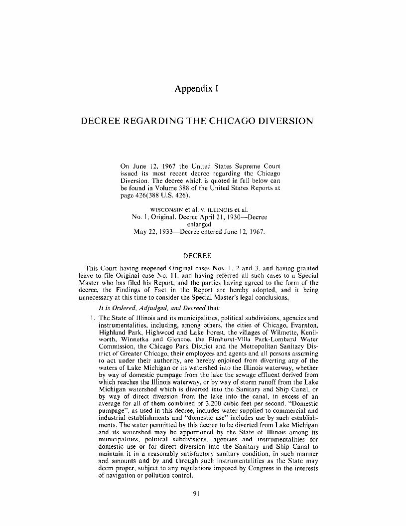
Appendix I
DECREE REGARDING THE CHICAGO DIVERSION
On June 12, 1967 the United States Supreme Court issued its most recent decree regarding the Chicago Diversion. The decree which is quoted in full below can be found in Volume 388 of the United States Reports at page 426(388 U.S. 426).
WISCONSIN et al. v. ILLINOIS et al. No. 1, Original. Decree April 21, 1930-Decree
enlarged May 22, 1933-Decree entered June 12, 1967.
DECREE
This Court having reopened Original cases Nos. 1, 2 and 3, and having granted leave to file Original case No. 1 I , and having referred all such cases to a Special Master who has filed his Report, and the parties having agreed to the form of the decree, the Findings of Fact in the Report are hereby adopted, and it being unnecessary at this time to consider the Special Master’s legal conclusions,
I t is Ordered, Adjudged, and Decreed that: 1. The State of Illinois and its municipalities, political subdivisions, agencies and
instrumentalities, including, among others, the cities of Chicago, Evanston, Highland Park, Highwood and Lake Forest, the villages of Wilmette, Kenil- worth, Winnetka and Glencoe, the Elmhurst-Villa Park-Lombard Water Commission, the Chicago Park District and the Metropolitan Sanitary Dis- trict of Greater Chicago, their employees and agents and all persons assuming to act under their authority, are hereby enjoined from diverting any of the waters of Lake Michigan or its watershed into the Illinois waterway, whether by way of domestic pumpage from the lake the sewage effluent derived from which reaches the Illinois waterway, or by way of storm runoff from the Lake Michigan watershed which is diverted into the Sanitary and Ship Canal, or by way of direct diversion from the lake into the canal, in excess of an average for all of them combined of 3,200 cubic feet per second. “Domestic pumpage”, as used in this decree, includes water supplied to commercial and industrial establishments and “domestic use” includes use by such establish- ments. The water permitted by this decree to be diverted from Lake Michigan and its watershed may be apportioned by the State of Illinois among its municipalities, political subdivisions, agencies and instrumentalities for domestic use or for direct diversion into the Sanitary and Ship Canal to maintain it in a reasonably satisfactory sanitary condition, in such manner and amounts and by and through such instrumentalities as the State may deem proper, subject to any regulations imposed by Congress in the interests of navigation or pollution control.
91
2. The amount of water diverted into the Sanitary and Ship Canal directly from Lake Michigan and as storm runoff from the Lake Michigan watershed shall be determined by deducting from the total flow in the canal at Lockport. (a) the total amount of domestic pumpage from Lake Michigan and from
ground sources in the Lake Michigan watershed, except to the extent that any such ground sources are supplied by infiltration from Lake Michigan, by the State of Illinois and its municipalities, political subdivi- sions, agencies and instrumentalities the sewage effluent derived from which reaches the canal,
(b) the total amount of domestic pumpage from ground and surface sources outside the Lake Michigan watershed the sewage effluent derived from which reaches the canal,
(c) the total estimated storm runoff from the upper Illinois River watershed reaching the canal,
(d) the total amount of domestic pumpage from all sources by municipalities and political subdivisions of the States of Indiana and Wisconsin the sewage effluent derived from which reaches the canal, and
(e) any water diverted by Illinois, with the consent of the United States, into Lake Michigan from any source outside the Lake Michigan watershed.
3. For the purpose of determining whether the total amount of water diverted from Lake Michigan by the State of Illinois and its municipalities, political subdivisions, agencies and instrumentalities is not in excess of the maximum amount permitted by this decree, the amounts of domestic pumpage from the lake by the State and its municipalities, political subdivisions, agencies and instrumentalities the sewage and sewage effluent derived from which reaches the Illinois waterway, either above or below Lockport, shall be added to the amount of direct diversion into the canal from the lake and storm runoff reaching the canal from the Lake Michigan watershed computed as provided in paragraph 2 of this decree. The accounting period shall consist of the period of 12 months terminating on the last day of February. A period of five years, consisting of the current annual accounting period and the previous four such periods (all after the effective date of this decree), shall be permitted, when necessary, for achieving an average diversion which is not in excess of the maximum permitted amount; provided, however, that the average diversion in any annual accounting period shall not exceed one hundred ten ( 1 10) per cent of the maximum amount permitted by this decree. The measurements and computations required by this decree shall be made by the appropriate officers, agencies or instrumentalities of the State of Illinois under the general supervision and direction of the Corps of Engineers of the United States Army.
4. The State of Illinois may make application for a modification of this decree so as to permit the diversion of additional water from Lake Michigan for domestic use when and if it appears that the reasonable needs of the Northeastern Illinois Metropolitan Region (comprising Cook, Du Page, Kane, Lake, McHenry and Will Counties) for water for such use cannot be met from the water resources available to the region, including both ground and surface water and the water permitted by this decree to be diverted from Lake Michigan, and if it further appears that all feasible means reasonably available to the State of Illinois and its municipalities, political subdivisions, agencies and instrumentalities, have been employed to improve the water quality of the Sanitary and Ship Canal and to conserve and manage the water resources of the region and the use of water therein in accordance with the best modern scientific knowledge and engineering practice.
5. This decree shall become effective on March 1, 1970, and shall thereupon supersede the decree entered by this Court in Nos. 1, 2 and 3, Original Docket, on April 21, 1930, as enlarged May 22, 1933, provided that for the period between January 1, 1970, and March 1, 1970, the amount of water diverted by Illinois into the Sanitary and Ship Canal (determined in accord-
92
ance with paragraph 2 of this decree) shall not exceed an average of 1500 cubic feet per second.
6. The complaint of the State of Illinois in No. 1 I , Original Docket, on behalf of its instrumentality, the Elmhurst-Villa Park-Lombard Water Commission, is hereby dismissed, without prejudice to that Commission sharing in the water permitted by this decree to be diverted from Lake Michigan.
7. Any of the parties hereto may apply at the foot of this decree for any other or further action or relief, and this Court retains jurisdiction of the suits in Nos. 1, 2 and 3, Original Docket, for the purpose of making any order or direction, or modification of this decree, or any supplemental decree, which it may deem at any time to be proper in relation to the subject matter in controversy.
8. All the parties to these proceedings shall bear their own costs. The costs and expenses of the Special Master shall be equally divided between the plaintiffs as a group and the defendants as a group in Nos. 1, 2 Original Docket. The costs and expenses thus imposed upon the plaintiffs and defendants shall be borne by the individual plaintiffs and defendants, respectively, in equal shares.
93

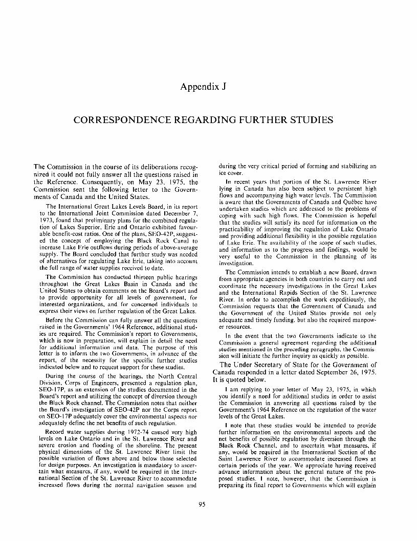
Appendix J
CORRESPONDENCE REGARDING FURTHER STUDIES
The Commission in t h e course of its deliberations recog- nized it could not fully answer all the questions raised in t h e Reference. Consequently, on May 23, 1975, t h e Commission sent the following letter to the Govern- ments of Canada and the United States .
The International Great Lakes Levels Board, in its report to the International Joint Commission dated December 7, 1973, found that preliminary plans for the combined regula- tion of Lakes Superior, Erie and Ontario exhibited favour- able benefit-cost ratios. One of the plans, SEO-42P, suggest- ed the concept of employing the Black Rock Canal to increase Lake Erie outflows during periods of above-average supply. The Board concluded that further study was needed of alternatives for regulating Lake Erie, taking into account the full range of water supplies received to date.
The Commission has conducted thirteen public hearings throughout the Great Lakes Basin in Canada and the United States to obtain comments on the Board’s report and to provide opportunity for all levels of government, for interested organizations, and for concerned individuals to express their views on further regulation of the Great Lakes.
Before the Commission can fully answer all the questions raised in the Governments’ 1964 Reference, additional stud- ies are required. The Commission’s report to Governments, which is now in preparation, will explain in detail the need for additional information and data. The purpose of this letter is to inform the two Governments, in advance of the report, of the necessity for the specific further studies indicated below and to request support for these studies.
During the course of the hearings, the North Central Division, Corps of Engineers, presented a regulation plan, SEO-17P, as an extension of the studies documented in the Board’s report and utilizing the concept of diversion through the Black Rock channel. The Commission notes that neither the Board’s investigation of SEO-42P nor the Corps report on SEO-17P adequately cover the environmental aspects nor adequately define the net benefits of such regulation.
Record water supplies during 1972-74 caused very high levels on Lake Ontario and in the St. Lawrence River and severe erosion and flooding of the shoreline. The present physical dimensions of the St. Lawrence River limit the possible variation of flows above and below those selected for design purposes. An investigation is mandatory to ascer- tain what measures, if any, would be required in the Inter- national Section of the St. Lawrence River to accommodate increased flows during the normal navigation season and
during the very critical period of forming and stabilizing an ice cover.
In recent years that portion of the St. Lawrence River lying in Canada has also been subject to persistent high flows and accompanying high water levels. The Commission is aware that the Governments of Canada and QuCbec have undertaken studies which are addressed to the problems of coping with such high flows. The Commission is hopeful that the studies will satisfy its need for information on the practicability of improving the regulation of Lake Ontario and providing additional flexibility in the possible regulation of Lake Erie. The availability of the scope of such studies, and information as to the progress and findings, would be very useful to the Commission in the planning of its investigation.
The Commission intends to establish a new Board, drawn from appropriate agencies in both countries to carry out and coordinate the necessary investigations in the Great Lakes and the International Rapids Section of the St. Lawrence River. In order to accomplish the work expeditiously, the Commission requests that the Government of Canada and the Government of the United States provide not only adequate and timely funding, but also the required manpow- er resources.
In the event that the two Governments indicate to the Commission a general agreement regarding the additional studies mentioned in the preceding paragraphs, the Commis- sion will initiate the further inquiry as quickly as possible. The Under Secretary of S t a t e for the Government of
Canada responded in a letter dated September 26, 1975. I t is quoted below.
I am replying to your letter of May 23, 1975, in which you identify a need for additional studies in order to assist the Commission in answering all questions raised by the Government’s 1964 Reference on the regulation of the water levels of the Great Lakes.
I note that these studies would be intended to provide further information on the environmental aspects and the net benefits of possible regulation by diversion through the Black Rock Channel, and to ascertain what measures, i f any, would be required in the International Section of the Saint Lawrence River to accommodate increased flows at certain periods of the year. We appreciate having received advance information about the general nature of the pro- posed studies. I note, however, that the Commission is preparing its final report to Governments which will explain
95
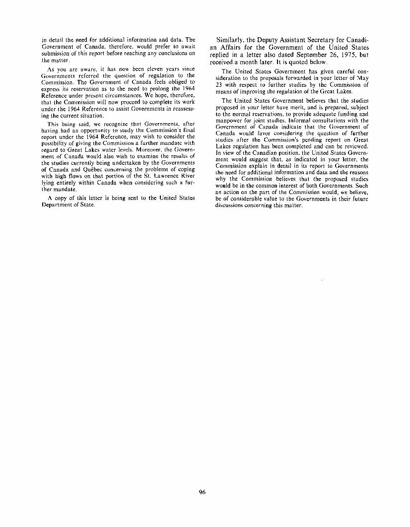
in detail the need for additional information and data. The Government of Canada, therefore, would prefer to await submission of this report before reaching any conclusions on the matter.
As you are aware, it has now been eleven years since Governments referred the question of regulation to the Commission. The Government of Canada feels obliged to express its reservation as to the need to prolong the 1964 Reference under present circumstances. We hope, therefore, that the Commission will now proceed to complete its work under the 1964 Reference to assist Governments in reassess- ing the current situation.
This being said, we recognize that Governments, after having had an opportunity to study the Commission’s final report under the 1964 Reference, may wish to consider the possibility of giving the Commission a further mandate with regard to Great Lakes water levels. Moreover, the Govern- ment of Canada would also wish to examine the results of the studies currently being undertaken by the Governments of Canada and QuCbec concerning the problems of coping with high flows on that portion of the St. Lawrence River lying entirely within Canada when considering such a fur- ther mandate.
A copy of this letter is being sent to the United States Department of State.
Similarly, the Deputy Assistant Secretary for Canadi- an Affairs for the Government of the United States replied in a le t ter a lso dated September 26, 1975, but received a month later. It is quoted below.
The United States Government has given careful con- sideration to the proposals forwarded in your letter of May 23 with respect to further studies by the Commission of means of improving the regulation of the Great Lakes.
The United States Government believes that the studies proposed in your letter have merit, and is prepared, subject to the normal reservations, to provide adequate funding and manpower for joint studies. lnformal consultations with the Government of Canada indicate that the Government of Canada would favor considering the question of further studies after the Commission’s pending report on Great Lakes regulation has been completed and can be reviewed. In view of the Canadian position, the United States Govern- ment would suggest that, as indicated in your letter, the Commission explain in detail in its report to Governments the need for additional information and data and the reasons why the Commission believes that the proposed studies would be in the common interest of both Governments. Such an action on the part of the Commission would, we believe, be of considerable value to the Governments in their future discussions concerning this matter.
96


![Production, regulation and ecophysiology of …...Production, regulation and ecophysiology of periphyton in shallow freshwater lakes PhD thesis Lone Liboriussen [Blank page] National](https://img.pdfslide.us/doc/110x75/5ea3d2341d42035db17a2b0e/production-regulation-and-ecophysiology-of-production-regulation-and-ecophysiology.jpg)