Embed Size (px)
Citation preview
American Geographical Society
Frost in the United StatesAuthor(s): Robert DeC. WardSource: Geographical Review, Vol. 7, No. 5 (May, 1919), pp. 339-344Published by: American Geographical SocietyStable URL: http://www.jstor.org/stable/207590 .
Accessed: 08/05/2014 19:05
Your use of the JSTOR archive indicates your acceptance of the Terms & Conditions of Use, available at .http://www.jstor.org/page/info/about/policies/terms.jsp
.JSTOR is a not-for-profit service that helps scholars, researchers, and students discover, use, and build upon a wide range ofcontent in a trusted digital archive. We use information technology and tools to increase productivity and facilitate new formsof scholarship. For more information about JSTOR, please contact [email protected].
.
American Geographical Society is collaborating with JSTOR to digitize, preserve and extend access toGeographical Review.
http://www.jstor.org
This content downloaded from 169.229.32.137 on Thu, 8 May 2014 19:05:24 PMAll use subject to JSTOR Terms and Conditions
FROST IN THE UNITED STATES
By ROBERT DeC. WARD Harvard University
PREVIOUS FROST MAPS OF THE UNITED STATES
There have been three general stages in the charting of our knowledge of frost occurrence in the United States. In the earlier maps the average dates of the first and the last killing frost were based on records obtained at regular Weather Bureau stations.1 In all these maps the lines of equal frost dates were left incomplete over much of the West, owing to lack of adequate information, but in the later maps of this first stage (1906) the average dates of the first and the last frost were entered at certain Weather Bureau stations over the Western plateau and on the Pacific Coast although the lines themselves were not drawn. The information given on all these maps was obviously based on very insufficient data. Observations at regular Weather Bureau stations, which are located chiefly in large cities, do not show actual conditions of frost occurrence over the rural farming districts and are too few in number for accurate generalization.
A second stage was reached when, in addition to the data obtained at the regular stations of the Weather Bureau, observations made by co- operative observers, widely scattered over the country, were also taken into account. By the inclusion of these additional data a much more accurate and more complete view of frost conditions was gained. Maps based on this larger series of observations, including those made at approximately 1,000 co-operative observers' stations having the longest records (usually about 10-30 years), were published in 1911.2 This investi- gation included maps of the average dates of the first and the last killing frost; of the earliest and latest dates on which killing frosts have occurred in autumn and spring respectively; and of the average length of the crop- growing season. This new set of maps brought out, much more clearly than had been done before, the influence of local conditions upon frost occurrence. Lines were drawn for the Eastern sections, while dates only were still used over the Western mountain and plateau districts and on the Pacific Slope.
THE NEW MAPS OF THE "ATLAS OF AMERICAN AGRICULTURE"
A third stage has been reached in the recent publication of the very valuable and comprehensive study of frost which forms Section 1 of
1 A. J. Henry: Climatology of the United States, U. S. Weather Bur. Bull. Q, Washington, D. C., 1906, text, pp. 33-34, Pls. XIX and XX. See also previous charts in A. W. Greely: American Weather New York, 1888, pp. 269-270, frontispiece and Chart XXIII. These maps were reproduced in F. Waldo: Elementary Meteorology, New York, 1896, pp. 333-335; Figs. 103 and 104.
2 P. C. Day: Frost Data of the United States and Length of the Crop-Growing Season. As Determined from the Average of the Latest and Earliest Dates of Killing Frost, U. S. Weather Bureau Bull. V, Wash- ington, D. C., 1911.
339
This content downloaded from 169.229.32.137 on Thu, 8 May 2014 19:05:24 PMAll use subject to JSTOR Terms and Conditions
THE GEOGRAPHICAL REVIEW
Part II of the "Atlas of American Agriculture."3 Frost records are now available from about 4,000 regular and co-operative stations of the Weather Bureau. About 600 cover a period of twenty years (1895-1914), which was adopted for most of the climatic material in the new atlas. About 1,800 cover over ten but less than twenty years, and the remaining 1,600 are for shorter periods, none less than five years. All of these data have been verified by experts familiar with the locations of the various stations and with the surrounding districts. The general author, William G. Reed, formerly Assistant in Agricultural Geography, Office of Farm Management, had the co-operation, in the preparation of some of the maps, of Dr. Charles F. Brooks and of Messrs. F. J. Marschner and H. R. Tolley. The publication presents the whole subject of frost with a detail not hitherto attained, so far as the present writer is aware, in any other area of equal size anywhere in the world. As a new and very important con- tribution to American climatology, it deserves more than a brief mention in the Geographical Review.
NATURE AND OCCURRENCE OF FROST
Frost is not a simple phenomenon. It appears in varying degrees of
severity ("light," "heavy," "killing"), and the line between these is not
easily drawn. A frost of a certain type of severity does not necessarily cause the same amount of injury to all kinds of vegetation. Temperatures low enough to injure plants often occur without any frost deposit. Again, frost is characteristically "patchy" in its occurrence. Given generally favorable weather conditions, its actual occurrence is largely a matter of
topography and of air drainage. Frosts in winter have little or no economic importance except in the South and the Southwest. In summer
they do not occur except in certain elevated areas. Thus it is that spring and autumn frosts are of such critical significance. For frost to occur, the general weather conditions must be favorable. These are now reason-
ably well understood, as the result of long experience in forecasting. Type maps, characteristic of frost weather, may be selected for the various sections of the country (Figs. 6-15 of the atlas). These are very useful for purposes of local frost study and in general teaching. Indeed, the investigation of frost, to be really useful, must be highly intensive and very local. Every area has, in a sense, its own special and peculiar frost conditions and needs its own special "thermal survey."
The traditional frost maps give the average dates of the last killing frost in spring and of the first killing frost in autumn. To these is usually added a chart showing the average length of the growing season, between the first and last frost dates. In the present monograph far more detail is included. By reference to the mean daily minimum temperatures for
3 W. G. Reed: Frost and the Growing Season, Pt. II, Sect. 1, Atlas of American Agriculture, prepared under the supervision of O. E. Baker, Office of Farm Management, U. S. Dept. of Agriculture, Advance Sheets, 2, issued July 15, 1918, 12 pp. folio.
340
This content downloaded from 169.229.32.137 on Thu, 8 May 2014 19:05:24 PMAll use subject to JSTOR Terms and Conditions
FROST IN THE UNITED STATES
any station it is easy to determine the date on which, in the general course of the seasonal decrease of temperature in autumn, this minimum falls below freezing. Similarly, in the spring, the average date on which the mean daily minimum rises above freezing may be determined. If first and last frosts came regularly on these dates, the whole frost problem would be perfectly simple. Frost, however, is characteristically variable in its dates of first and last occurrence. Cyclonic and anticyclonic spells of colder or warmer weather, coming irregularly and without much regard to the normal seasonal temperature curve, easily advance or retard the actual dates of the first and the last frost. Thus it is that there are likely to be considerable departures from the average dates, and a complete study of frost must include a consideration of these variations.
THE LAST KILLING FROST IN SPRING
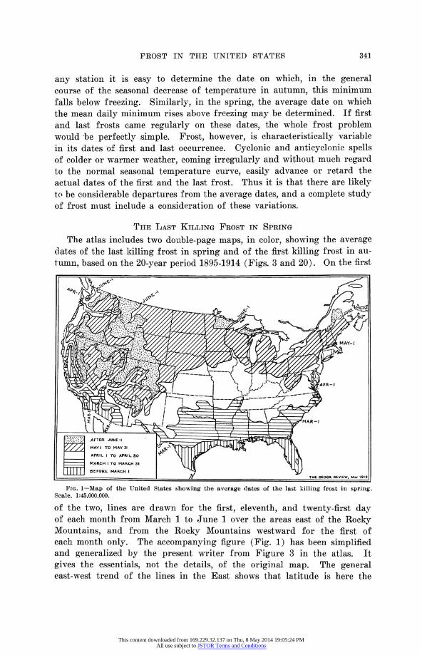
The atlas includes two double-page maps, in color, showing the average dates of the last killing frost in spring and of the first killing frost in au-
tumn, based on the 20-year period 1895-1914 (Figs. 3 and 20). On the first
4 'THE GEOGR. REVIEW, MAY 1919
FIG. 1-Map of the United States showing the average dates of the last killing frost in spring. Scale, 1:45,000,000.
of the two, lines are drawn for the first, eleventh, and twenty-first day of each month from March 1 to June 1 over the areas east of the Rocky Mountains, and from the Rocky Mountains westward for the first of each month only. The accompanying figure (Fig. 1) has been simplified and generalized by the present writer from Figure 3 in the atlas. It gives the essentials, not the details, of the original map. The general east-west trend of the lines in the East shows that latitude is here the
341
This content downloaded from 169.229.32.137 on Thu, 8 May 2014 19:05:24 PMAll use subject to JSTOR Terms and Conditions
THE GEOGRAPHICAL REVIEW
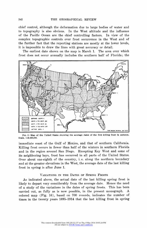
chief control, although the deformation due to large bodies of water and to topography is also obvious. In the West altitude and the influence of the Pacific Ocean are the chief controlling factors. In view of the complex topographic controls over frost occurrence in the West and of the further fact that the reporting stations are mostly at the lower levels, it is impossible to draw the lines with great accuracy or detail.
The earliest date shown on the map is March 1. The area over which frost does not occur annually includes the southern half of Florida; the
NOV -.Y~ .>N
// BFORe SEPTI I
| SEPT. I TO SEPT. 30 \ i OCT. I TO OCT. 31
NOV. I TO MOV. 30 \
Scale, 1:45,000,000.
immediate coast of the Gulf of Mexico and that of southern California. Killing frost occurs in fewer than half of the winters in southern Florida and in the region around San Diego. Excepting Key West and some of its neighboring keys, frost has occurred in all parts of the United States. Over about one-eighth of the country, i. e. along the northern boundary and at the greater elevations in the West, the average date of the last killing frost in spring is after June 1.
VARIATIONS IN THE DATES OF SPRING FROSTS
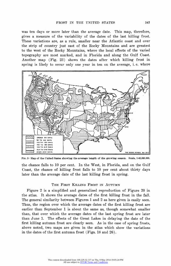
As indicated above, the actual date of the last killing spring frost is
likely to depart very considerably from the average date. Hence the need of a study of the variations in the dates of spring frosts. This has been carried out, as fully as is now possible, in the present monograph. A colored map (Fig. 16), based on 700 records, indicates the number of times in the twenty years 1895-1914 that the last killing frost in spring
lieyt eatveycnieal X~41~ ;... -':_ag :at.-}: 1 IIec 1h ~-~.:-
342
This content downloaded from 169.229.32.137 on Thu, 8 May 2014 19:05:24 PMAll use subject to JSTOR Terms and Conditions
FROST IN THE UNITED STATES
was ten days or more later than the average date. This map, therefore, gives a measure of the variability of the dates of the last killing frost. These variations are, as a rule, smaller near the Atlantic coast and over the strip of country just east of the Rocky Mountains and are greatest to the west of the Rocky Mountains, where the local effects of the varied
topography are most marked, and in Florida and along the Gulf Coast. Another map (Fig. 23) shows the dates after which killing frost in
spring is likely to occur only one year in ten on the average, i. e. where
Z////. UNDER 90 DAYS i 90 TO 120 DAYS ' '
-: 12 TO ISO DAYS 150 TO ISO DAYS\
I I i I O180 TO 210 DAYS 210 TO 240 DAYS
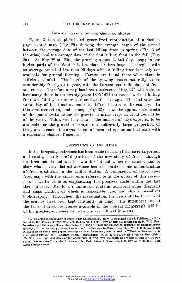
OVER 240 DAYS OVER ;240 DAY5 THE GEOGR, REVIEW, MAY 1919
FIG. 3-Map of the United States showing the average length of the growing season. Scale, 1:45,000,000.
the chance falls to 10 per cent. In the West, in Florida, and on the Gulf Coast, the chance of killing frost falls to 10 per cent about thirty days later than the average date of the last killing frost in spring.
THE FIRST KILLING FROST IN AUTUMN
Figure 2 is a simplified and generalized reproduction of Figure 20 in the atlas. It shows the average dates of the first killing frost in the fall. The general similarity between Figures 1 and 2 as here given is easily seen. Thus, the region over which the average dates of the first killing frost are earlier than September 1 is about the same as, though somewhat smaller than, that over which the average dates of the last spring frost are later than June 1. The effects of the Great Lakes in delaying the date of the first killing autumn frost are clearly seen. As in the case of spring frosts, above noted, two maps are given in the atlas which show the variations in the dates of the first autumn frost (Figs. 18 and 26).
343
This content downloaded from 169.229.32.137 on Thu, 8 May 2014 19:05:24 PMAll use subject to JSTOR Terms and Conditions
THE GEOGRAPHICAL REVIEW
AVERAGE LENGTH OF THE GROWING SEASON
Figure 3 is a simplified and generalized reproduction of a double- page colored map (Fig. 29) showing the average length of the period between the average date of the last killing frost in spring (Fig. 3 of the atlas) and the average date of the first killing frost in the fall (Fig. 20). At Key West, Fla., the growing season is 365 days long; in the higher parts of the West it is less than 90 days long. The region with an average period of less than 90 days without killing frost is mostly not available for general farming. Forests are found there when there is sufficient rainfall. The length of the growing season naturally varies considerably from year to year, with the fluctuations in the dates of frost occurrence. Therefore a map has been constructed (Fig. 27) which shows how many times in the twenty years 1895-1914 the season without killing frost was 15 days or more shorter than the average. This indicates the
variability of the frostless season in different parts of the country. In this same connection, another map (Fig. 32) shows the approximate length of the season available for the growth of many crops in about four-fifths of the years. This gives, in general, "the number of days expected to be available for the growth of crops in a sufficiently large proportion of the years to enable the organization of farm enterprises on that basis with a reasonable chance of success."
IMPORTANCE OF THE ATLAS
In the foregoing, reference has been made to some of the more important and most generally useful portions of the new study of frost. Enough has been said to indicate the wealth of detail which is included and to show what a very distinct advance has been made in our understanding of frost conditions in the United States. A comparison of these latest frost maps with the earlier ones referred to at the outset of this review is well worth while as emphasizing the progress made within the last three decades. Mr. Reed's discussion contains numerous other diagrams and maps mention of which is impossible here, and also an excellent
bibliography.4 Throughout the investigation, the needs of the farmers of the country have been kept constantly in mind. The intelligent use of the facts of frost occurrence available in the present monograph will be of the greatest economic value to our agricultural interests.
4 A "Selected Bibliography of Frost in the United States," by W. G. Reed and Cora L. Feldkamp, will be found in the Monthly Weather Rev., Vol. 43, 1915, pp. 512-517. Two additional recent papers by W. G. Reed have been published as follows: Outline for the Study of Frost and Protection against Frost Damage, Journ. oj Geogr., Vol. 14, 1915-16, pp. 54-55; Protection from Damage by Frost, Geogr. Rev., Vol. 1, 1916, pp. 110-122. A selection of books and papers bearing on frost forecasting was printed in "Weather Forecasting in the United States," U. S. Weather Bureau, Washington, D. C., 1916, pp. 357-358 (Weather Bur. [Pibl.] No. 583). An important study of the occurrence of frost over the earth as a whole is that of Otto Dor- scheid: Die mittlere Dauer des Frostes auf der Erde, Meteorol. Zeitschr., Vol. 42, 1907, pp. 11-24, 49-64 (with maps of frost dates).
344
This content downloaded from 169.229.32.137 on Thu, 8 May 2014 19:05:24 PMAll use subject to JSTOR Terms and Conditions