Embed Size (px)
Citation preview

Fredericksburg Area Congestion Relief Study: Evaluation of Conceptual Alternatives
December 4, 2013 Quintin D. Elliott Fredericksburg District Administrator

A TIMELINE OF EVENTS 1970s - First
concept of an eastern bypass. Later realized development concentrating to west.
FAMPO Interim 2015 CLRP included Outer Connector Study NW Quadrant (OC)
1994
EIS for NW OC begins. 129 Alternatives considered
1996
VDOT begins EIS for Spotsylvania Pkwy (SW Quadrant of OC) VDOT begins MIS for NE Quadrant of OC
1997
CTB selects Corridor 1 as preferred alt for NW OC (Res: 02.17.98) FHWA asks VDOT to conduct supplemental studies for EIS through 2001
1998
2001
CTB revises preferred alt of NW OC to Corridor 1B (Res: 10.17.01) Spotsylvania County pulls support for NW OC VDOT/FHWA cancel NW OC due to lack of local support
I-95 Access to CelebrateVA! via Welcome Center ramps proposal rejected by VDOT & FHWA based on policy.
2003
Spotsylvania County pulls support for Spotsylvania Pkwy (SW OC ) VDOT/FHWA cancel SW OC due to lack of local support
2004
I-95 Rappahannock Crossing Interchange Modification Request underway FAMPO localities recommend Conceptual Alternatives for today’s consideration
2013
Local Support for GWTR rescinded; thus VDOT puts project on hold.
2012
GWTR IJR approved by VDOT and FHWA
2011
VA General Assembly creates George Washington Toll Road Authority (GWTRA)
2010
12/04/13 Page 1

Conceptual Purpose and Need
• Evaluate Alts that reduce congestion in Fredericksburg Study Area
• Identify Alts that improve traffic operations and accommodate commerce along I-95, US 17, & Route 3 in study area
• Existing and future congestion, failing LOS, accidents, gridlock
• I-95 & US 17 are Corridors of Statewide Significance
Purpose Need
Not Necessarily a Bypass
12/04/13 Page 2

All Conceptual Alternatives
12/04/13 Page 3

Baseline Alt 1
UPC #101595. New I-95 CD Lanes & Bridges from Exit 130 (Rte 3) to Exit 133 US 17), plus Flyover & Ramp Improvements @ Exit 133. In addition, Baseline Alt 1 would include non-highway construction-related multi-modal initiatives to enhance alternative modes usage and efficiency. These multi-modal initiatives are still to be determined. Baseline Alt 1 is to be constructed, and as such, it is a part of all proposed alternatives that follow. Because it is part of the future, baseline condition, it will not be screened as part of this evaluation process.
VDOT
Alt 2ANew Slip-Ramp from I-95 Southbound (SB) via CD Roadway to Central Park/Celebrate Virginia I-95 southbound (SB) Exit Only. Includes Alt 1.
VDOT
Alt 2B New Alt 2A plus northbound (NB) Flyover Access to I-95. Includes Alt 1. VDOT
Alt 3New Connection from Celebrate VA North at Celebrate Virginia Pkwy to Celebrate Virginia south at Gordon Shelton Blvd. Includes Alt 1.
VDOT
Alt 4 New Stafford Parkway with access at Rte 1, I-95 (Exit 136), Centerport Pkwy, and Rte 17. Includes Alt 1.Portion of VDOT OC NWQ (2001) – Included in this study by VDOT
Alt 5New I-95 Interchange at Welcome Center (westbound travel only), plus New Connector Rd from New Interchange to Gordon Rd to Rte 3. Includes Alt 1.
VDOT IJR (2009) – Included in this study by VDOT
Alt 6New Outer Connector "Corridor 4B" with access at Rte 1, I-95 (Exit 136), Centerport Pkwy, Rte 17, and Rte 3. Includes Alt 1.
VDOT OC NWQ (2001) – Included in this study by VDOT
Alt 7New Spotsylvania County Bypass with access at Rte 3 near Westover Pkwy in Orange County, plus Alt 4 with access at Rte 1, I-95 (Exit 136), Centerport Pkwy, Rte 17, and Rte 3. Includes Alt 1.
Spotsylvania County/FAMPO (2013) – Introduced by Spotsy Co in this study (BOS resolution 09/24/13)
Alt 8A New Bypass with access at Rte 17 near Rte 649 (Richland Road) and Rte 3 near McLaws Drive. Includes Alt 1 and Alt 4.Stafford County/FAMPO (2013) – Introduced by Stafford County in this study (BOS resolution 10/15/13)
Alt 8B New Bypass with access at Rte 17 near Rte 649 (Richland Road) and Rte 3 at Rte 613 (Brock Rd). Includes Alt 1 and Alt 4.Stafford County/FAMPO (2013) Note: This Alt is a logical derivation of one of the Stafford Alts (BOS res 10/15/13)
Alt 8CFollowing existing roadways as much as possible, Alt 8C would provide an improved, 4-lane arterial with traffic signals and unlimited access. Includes Alt 8A and would connect to Alt 8A at Rte 3 near McLaws Drive and terminate at new I-95 interchange near Rte 607 (Guinea Station Rd). Includes Alt 1 and Alt 4.
Stafford County/FAMPO (2013) – Introduced by Stafford County in this study (BOS resolution 10/15/13)
Alt 8DFollowing existing roadways as much as possible, Alt 8D would provide an improved, 4-lane arterial with traffic signals and unlimited access. Includes Alt 8B and would connect to Alt 8B at Rte 3 near Rte 613 (Brock Rd) and terminate at a new I-95 interchange near Rte 607 (Guinea Station Rd). Includes Alt 1 and Alt 4.
Stafford County/FAMPO (2013) – Introduced by Stafford County in this study (BOS resolution 10/15/13)
Alt 9 Combination of Alt 5 and Alt 6. Includes Alt 1.FAMPO (2013) – Supported by FAMPO resolution 10/21/13
Alt. #1 Alternative Descriptions Source of Conceptual Alternative
Fredericksburg Area Congestion Relief Study: Conceptual Alternatives
12/04/13 Page 4

Alt. #1 Alternative Descriptions Source of Conceptual Alternative
Fredericksburg Area Congestion Relief Study: Conceptual Alternatives
Alt 10New Northeastern Quadrant of the Outer Connector, including Alt 4, with additional access at Rte 608 (Brooke Rd), Rte 218 (White Oak Road), Rte 3, and Rte 2. Includes Alt 1.
From VDOT Outer Connector NEQ Study (1997) – Supported by Stafford County in this study (BOS resolution 10/15/13)
Alt 11 Extension of Alt 1 CD roads to I-95 Exit 126, with new interchange at Rte 620 (Harrison Rd). Includes Alt. 1.Introduced by Spotsylvania County, modified by FAMPO (FAMPO Policy Committee 11/21/13)
Alt 12Includes Alt 11 with an extension of CD roads to I-95 Exit 126 with new interchange at Rte 620 (Harrison Rd), plus another new interchange at Rte 208 (Courthouse Rd). Includes Alt 1.
Introduced by Spotsylvania County, modified by FAMPO (FAMPO Policy Committee 11/21/13)
All Alternatives on new location are assumed to be four-lane, divided, limited access facility.
12/04/13 Page 5

Aver
age
Dai
ly
Traf
fic (A
DT)
Se
rved
by
Alt4
Ratio
of A
DT
to C
ost5
Trav
el T
ime
Savi
ngs6
Bene
fit to
Reg
iona
l Ve
hicl
e H
ours
of
Del
ay (V
HD
)7
Cons
iste
ncy
with
Lo
cal &
Reg
iona
l Pl
ans8
Fed
eral
App
rova
l of
Inte
rsta
te A
cces
s (F
HW
A)9
NPS
Par
k La
nd10
Civi
l War
Ba
ttle
field
s11
Cons
erva
tion
Ease
men
ts12
Scen
ic &
Re
crea
tiona
lRa
ppah
anno
ck &
Ra
pida
n Ri
vers
13
Relo
catio
ns -
Resi
dent
ial &
Bu
sine
ss14
Alt 2A 0.5 $18 Alt 2B 1.5 $37 Alt 3 1.6 $104 Alt 4 5.1 $235 Alt 5 5.8 $284 Alt 6 13.5 $562 Alt 7 18.1 $630
Alt 8A 12.8 $565 Alt 8B 14.4 $684 Alt 8C 27.5 $1,135 Alt 8D 32.1 $1,475 Alt 9 19.3 $846
Alt 10 16.6 $865 Alt 11 4.3 $341 Alt 12 4.3 $515
Legend
Neutral / Minimal / No Negative Impact or Resistance Neutral / Minimal / No Positive Impact
Low Negative Impact or Resistance Low Positive Impact
Medium Negative Impact or Resistance Medium Positive Impact
High Negative Impact or Resistance High Positive Impact
Positive ImpactsNegative Impacts
Fredericksburg Area Congestion Relief Study: 1st Screening of Conceptual AlternativesEnvironmental ImpactsPolicy Considerations
Length inMiles2
Conceptual Alt. #1
Traffic Impacts
2019 Planning Level Cost$Millions3
12/04/13 Page 6

No Negative Impact
Low Negative Impact
Medium Negative Impact
High Negative Impact
No Positive Impact
Low Positive Impact
Medium Positive Impact
High Positive Impact
1 Alt. #Sources of Alts include previous VDOT studies from 1980s to present, as well as suggestions provided by the City of Fredericksburg and Spotsylvania & Stafford Co at joint GWRC & FAMPO Meeting on 10/21/13.
2 Length in Miles Distance of conceptual alternative, in miles.
3Planning Level Cost (2019)
Preliminary estimates only. Estimates for purposes of screening. Pre-Scoping level cost estimates include PE, RW/UT, and CN costs. Cost presented is the average taken from the combined low and high cost estimates.
$0 $1 - $299 M $300 M - $599 M $600 M and Up
4Average Daily Traffic (ADT) Served by Alt
Potential maximum amount of average daily traffic served on new infrastructure. 0-14,999 15,000-29,999 30,000-59,999 > 60,000
5 Ratio of ADT to CostQuotient of ADT and planning level costs (Footnotes 4 and 3 above) with costs measured in $millions. Does not include Alt 4 costs for alternatives comprised of multiple alternatives for purposes of calculating this ratio.
0-50 51 to 100 101 to 250 251 and up
6 Travel Time Savings
6.Total Travel Time Savings for AM travel runs on the following routes when compared to Alternative 1: NB I-95 from Exit 126 to Exit 136, SB I-95 from Exit 136 to Exit 126, Route 3 at Andora Drive (Rte 626) to I-95 to Route 17 at Popular Road (Rte 616) and PM travel runs on the following routes when compared to Alternative 1: NB I-95 from Exit 126 to Exit 136, SB I-95 from Exit 136 to Exit 126, Route 17 at Popular Road (Rte 616) to I-95 to Route 3 at Andora Drive (Rte 616). Base total travel time for Alternative 1 is 164 minutes.
< 5 Minutes 5 - 15 Minutes 15 - 45 Minutes > 45 Minutes
7Benefit to Regional Vehicle Hours of Delay (VHD)
Percent reduction in vehicle hours of delay (VHD) at a regional level, when comparing the Alternative to the Baseline Alternative 1 condition. The region includes the localities within FAMPO.
Less than 2.0% 2.1% to 4.0% 4.1% to 8.0% Greater than 8.0%
8Consistency with Local & Regional Plans
Based on an Alt's inclusion in the locality's Comp Plan and/or FAMPO's CLRP.
No portion of Alt in locality's current Comprehensive
Plan (Needs Element) or FAMPO CLRP
Portion of Alt in locality's current Comprehensive
Plan (Needs Element) or FAMPO CLRP
Entire Alt in Locality's Current Comprehensive
Plan (Needs Element) or FAMPO CLRP
Entire Alt in Locality's Current
Comprehensive Plan (Needs Element) &
FAMPO CLRP
9Federal Approval of Interstate Access (FHWA)
Anticipated difficulty of reaching FHWA approval based on stated federal policy and past VDOT experience in similar situations across Virginia.
No FHWA Approval or Minimal FHWA Coordination or
Approval
IMR requiredFull new IJR
required (some previous vetting)
Full new IJR required (no
previous vetting)
No FHWA Approval or Minimal FHWA Coordination or
Approval
FHWA IJR Approval for Similar Alt in
Hand
FHWA IJR Approval in Hand
Range Definition
Footnote #
The categories chosen for the 1st Screening are those most often found to be challenging during project development. The human and natural resources identified have particularly protective regulations and equally as strong public sentiments regarding public perceptions of impacts. Additional criteria such as more detailed traffic, wetlands, and protected species are evaluatated in the 2nd Screening.
Fredericksburg Area Congestion Relief Study: 1st Screening Footnotes
Footnote Heading Explanation
12/04/13 Page 7

No Negative Impact
Low Negative Impact
Medium Negative Impact
High Negative Impact
No Positive Impact
Low Positive Impact
Medium Positive Impact
High Positive Impact
Range Definition
Footnote #
The categories chosen for the 1st Screening are those most often found to be challenging during project development. The human and natural resources identified have particularly protective regulations and equally as strong public sentiments regarding public perceptions of impacts. Additional criteria such as more detailed traffic, wetlands, and protected species are evaluatated in the 2nd Screening.
Fredericksburg Area Congestion Relief Study: 1st Screening Footnotes
Footnote Heading Explanation
10 NPS Park Lands
Based on a 500-foot wide planning corridor of each alternative. Actual right of way would be closer to 220 feet. The wider analysis area allows for flexibility to avoid and minimize potential impacts during design. Actual impacts would be much less than those identified within the 500-foot wide corridor. Based on acreage within lands admnistered by the National Park Service (NPS). If federal funding is used, this becomes a Section 4(f) issue in which avoidance alternatives must be considered. It must be demonstrated that there is no prudent and feasible alternative to the use of the NPS lands in order to use NPS lands as a part of this alternative.
No NPS Lands within Corridor
0.1 to 0.5 Acre 0.6 to 1 Acre 1.1 Acres and Up
11 Civil War Battlefields
Based on a 500-foot wide planning corridor of each alternative. Actual right of way would be closer to 220 feet. The wider analysis area allows for flexibility to avoid and minimize potential impacts during design. Actual impacts would be much less than those identified within the 500-foot wide corridor. Degree of impact is based on acreage within Civil War Battlefields. These battlefield boundaries were determined by the Dept. of Historic Resources (DHR) as being potentially eligible for the National Register of Historic Places (NRHP). If federal funds are used, this becomes a Section 4(f) issue, as noted in the footnote #5, and avoidance alternatives must be considered. In addition, these battlefield areas are protected under Section 106 of the National Historic Preservation Act. As such, any federal action, be it federal funding for construction or the issuance of a federal water quality permit from the Corps of Engineers, must take into consideration impacts to these resources. The Corps of Engineers is obligated to permit only the Least Environmentally Damaging Practicable Alternative (LEDPA) and it is unlikely that permits would be issued for this alternative given these impacts.
No Known, Potentially Eligible,
Civil War Battlefields within
Corridor
0.1 to 25 Acres 25.1 to 50 Acres 50.1 Acres and Up
12Lands with Conservation Easements
Based on a 500-foot wide planning corridor of each alternative. Actual right of way would be closer to 220 feet. The wider analysis area allows for flexibility to avoid and minimize potential impacts during design. Actual impacts would be much less than those identified within the 500-foot wide corridor. Degree of impact based on acreage within Conservation Easements from the Dept. of Conservation & Recreation (DCR), the Virginia Outdoor Foundation (VOF), the City of Fredericksburg, and The Nature Conservancy (TNC). This is a Section 4(f) resource, in addition to being subject to an Open Space Easement managed by the VOF.
No Conservation Lands
0.1 to 20 Acres 20.1 to 40 Acres 40.1 Acres and Up
13Scenic & Recreational Rappahannock / Rapidan Rivers
Based on a 500-foot wide planning corridor of each alternative. Actual right of way would be closer to 220 feet. The wider analysis area allows for flexibility to avoid and minimize potential impacts during design. Actual impacts would be much less than those identified within the 500-foot wide corridor. Any additional crossing not adjacent to the existing I-95 bridges is considered to have a high negative impact to scenic, recreational, and historic values of the Virginia Designated State Scenic Rappahannock River.
No new river crossings
New river crossing adjacent to existing
I-95 bridges
New river crossing not adjacent to
existing I-95 bridges
12/04/13 Page 8

No Negative Impact
Low Negative Impact
Medium Negative Impact
High Negative Impact
No Positive Impact
Low Positive Impact
Medium Positive Impact
High Positive Impact
Range Definition
Footnote #
The categories chosen for the 1st Screening are those most often found to be challenging during project development. The human and natural resources identified have particularly protective regulations and equally as strong public sentiments regarding public perceptions of impacts. Additional criteria such as more detailed traffic, wetlands, and protected species are evaluatated in the 2nd Screening.
Fredericksburg Area Congestion Relief Study: 1st Screening Footnotes
Footnote Heading Explanation
14Relocations (Residential & Business)
Based on a 500-foot wide planning corridor of each alternative. Actual right of way would be closer to 220 feet. The wider analysis area allows for flexibility to avoid and minimize potential impacts during design. Actual impacts would be much less than those identified within the 500-foot wide corridor. Based on number of structures within 500' wide corridor of each alternative.
No Residential or Commercial Relocations
1 to 49 Structures 50 to 99 Structures100 & Up Structures
12/04/13 Page 9

Aver
age
Dai
ly
Traf
fic (A
DT)
Se
rved
by
Alt4
Ratio
of A
DT
to C
ost5
Trav
el T
ime
Savi
ngs6
Bene
fit to
Reg
iona
l Ve
hicl
e H
ours
of
Del
ay (V
HD
)7
Cons
iste
ncy
with
Lo
cal &
Reg
iona
l Pl
ans8
Fed
eral
App
rova
l of
Inte
rsta
te A
cces
s (F
HW
A)9
NPS
Par
k La
nd10
Civi
l War
Ba
ttle
field
s11
Cons
erva
tion
Ease
men
ts12
Scen
ic &
Re
crea
tiona
lRa
ppah
anno
ck &
Ra
pida
n Ri
vers
13
Relo
catio
ns -
Resi
dent
ial &
Bu
sine
ss14
Alt 2B 1.5 $37
Alt 4 5.1 $235 Alt 5 5.8 $284 Alt 6 13.5 $562
Alt 9 19.3 $846 Alt 10 16.6 $865 Alt 11 4.3 $341
Legend
Neutral / Minimal / No Negative Impact or Resistance Neutral / Minimal / No Positive Impact
Low Negative Impact or Resistance Low Positive Impact
Medium Negative Impact or Resistance Medium Positive Impact
High Negative Impact or Resistance High Positive Impact
Positive ImpactsNegative Impacts
Fredericksburg Area Congestion Relief Study: 1st Screening Results
Conceptual Alt. #1
Length inMiles2
2019 Planning Level Cost$Millions3
Traffic Impacts Policy Considerations Environmental Impacts
12/04/13 Page 10

1st Screening Results
12/04/13 Page 11

Alt.
#1
Aver
age
Dai
ly T
raffi
c (A
DT)
Ser
ved
by A
lt4
Ratio
of A
DT
to C
ost5
Bene
fit to
Reg
iona
l Ve
hicl
e H
ours
of
Del
ay (V
HD
)6
Trav
el T
ime
Savi
ngs7
Bene
fit to
I-95
8
Bene
fit to
US
179
Bene
fit to
Rte
310
Cons
iste
ncy
with
Lo
cal &
Reg
iona
l Pl
ans11
Fede
ral A
ppro
val f
or
Inte
rsta
te A
cces
s (F
HW
A)12
Fede
ral A
ppro
val
(Env
. Per
mits
)13
NPS
Par
k La
nd14
Civi
l War
Ba
ttle
field
s15
Cons
erva
tion
Ease
men
ts16
Scen
ic &
Re
crea
tiona
l Ra
ppah
anno
ck &
Ra
pida
n Ri
vers
17
Prot
ecte
d Sp
ecie
s18
Wet
land
s19
Relo
catio
ns
Resi
dent
ial &
Bu
sine
ss20
Alt 2B 1.5 $37 Alt 4 5.1 $235 Alt 5 5.8 $284 Alt 6 13.5 $562 Alt 9 19.3 $846
Alt 10 16.6 $865 Alt 11 4.3 $341
Legend
Neutral / Minimal / No Negative Impact or Resistance Neutral / Minimal / No Positive Impact
Low Negative Impact or Resistance Low Positive Impact
Medium Negative Impact or Resistance Medium Positive Impact
High Negative Impact or Resistance High Positive Impact
Positive ImpactsNegative Impacts
Fredericksburg Area Congestion Relief Study: 2nd Screening of Conceptual AlternativesEnvironmental Impacts
2019
Pla
nnin
g Le
vel
Cost
$Mill
ions
3
Leng
th in
Mile
s2
Policy ConsiderationsTraffic Impacts

No Negative Impact
Low Negative Impact
Medium Negative Impact
High Negative Impact
No Positive Impact
Low Positive Impact
Medium Positive Impact
High Positive Impact
1 Alt. #Sources of Alternatives include previous VDOT studies from 1980s to present, as well as suggestions provided by the City of Fredericksburg and Spotsylvania & Stafford Co at joint GWRC & FAMPO Meeting on 10/21/13.
2 Length in Miles Distance of conceptual alternative, in miles.
3Planning Level Cost (2019)
Preliminary estimates only. Estimates for purposes of screening. Pre-Scoping level cost estimates include PE, RW/UT, and CN costs. Cost presented is the average taken from the combined low and high cost estimates.
$0 $1 - $299 M $300 M - $599 M $600 M and Up
4Average Daily Traffic (ADT) Served by Alt
Potential maximum amount of average daily traffic (ADT) served on new infrastructure. Includes summation of alternatives when alts are combinations of other alternatives (e.g., Alt 9 includes Alts 4 and 5).
0-14,999 15,000-29,999 30,000-59,999 > 60,000
5 Ratio of ADT to CostQuotient of ADT and planning level costs (Footnotes 4 and 3 above) with costs measured in $millions. Does not include Alt 4 costs for alternatives comprised of multiple alternatives for purposes of calculating this ratio.
0-50 51 to 100 101 to 250 251 and up
6Benefit to Regional Vehicle Hours of Delay (VHD)
Percent reduction in vehicle hours of delay (VHD) at a regional level, when comparing the Alternative to the Baseline Alternative 1 condition. The region includes the localities within FAMPO.
Less than 1.0% 1.1% to 6.0% 6.1% to 10.0% Greater than 10.0%
6 Travel Time Savings
Total Travel Time Savings for AM travel runs on the following routes when compared to Alternative 1: NB I-95 from Exit 126 to Exit 136, SB I-95 from Exit 136 to Exit 126, Route 3 at Andora Drive (Rte 626) to I-95 to Route 17 at Popular Road (Rte 616) and PM travel runs on the following routes when compared to Alternative 1: NB I-95 from Exit 126 to Exit 136, SB I-95 from Exit 136 to Exit 126, Route 17 at Popular Road (Rte 616) to I-95 to Route 3 at Andora Drive (Rte 616). Base total travel time for Alternative 1 is 164 minutes.
< 5 Minutes 5 - 15 Minutes 16 - 45 Minutes > 45 Minutes
8 Benefit to I-95Percent reduction in vehicle miles of travel (VMT) on I-95 between Exit 126 and Exit 136, when comparing the Alternative to the Baseline Alternative 1 condition. Less than 2.0% 2.1% to 4.0% 4.1% to 8.0% Greater than 8.0%
9 Benefit to US 17Percent reduction in vehicle miles of travel (VMT) on Route 17 between I-95 and proposed Stafford Parkway, when comparing the Alternative to the Baseline Alternative 1 condition.
Less than 1.0% 1.1% to 6.0% 6.1% to 10.0% Greater than 10.0%
10 Benefit to Rte 3Percent reduction in vehicle miles of travel (VMT) on Route 3 between I-95 and River Road, when comparing the Alternative to the Baseline Alternative 1 condition.
Less than 1.0% 1.1% to 6.0% 6.1% to 10.0% Greater than 10.0%
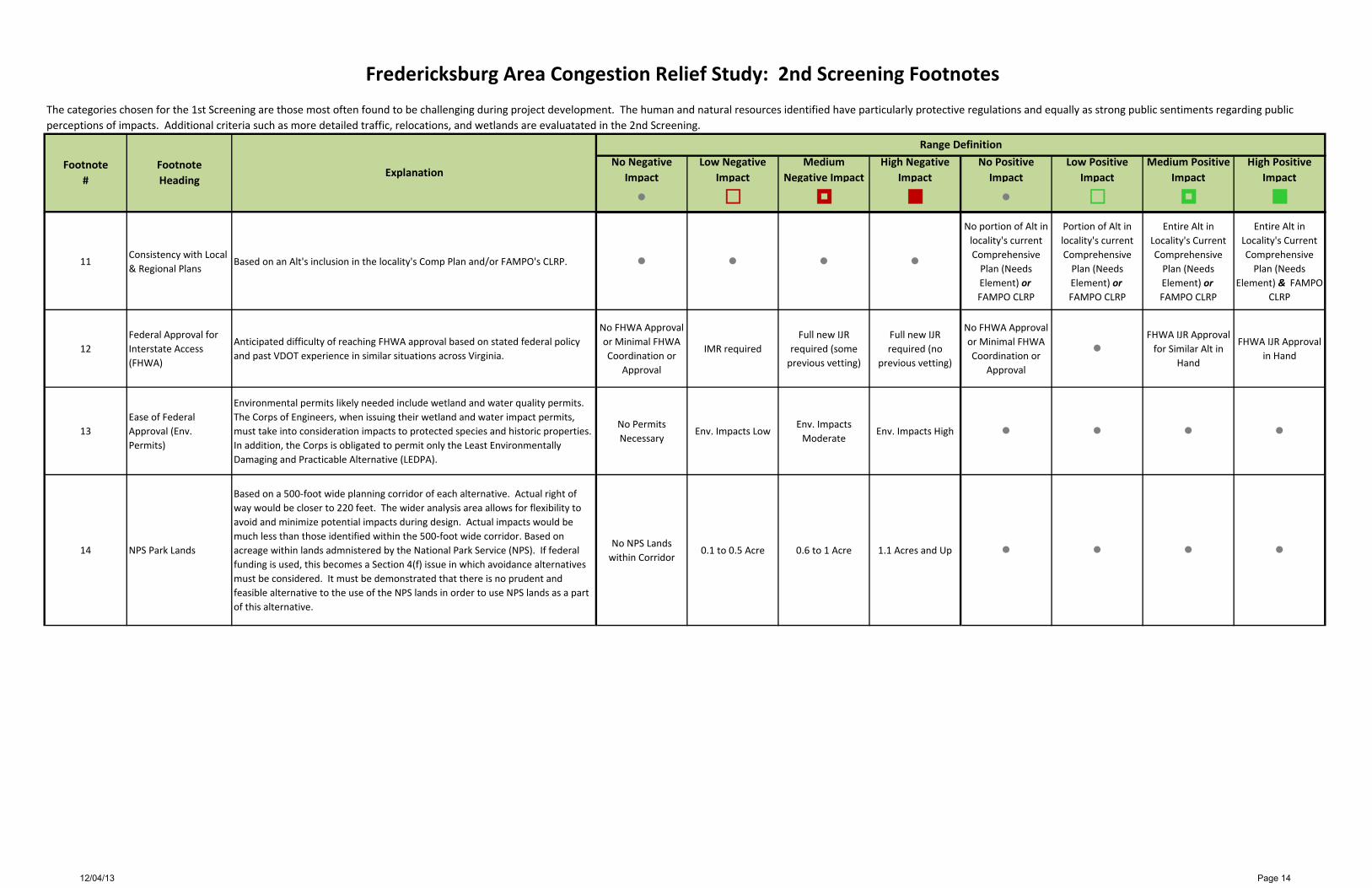
Fredericksburg Area Congestion Relief Study: 2nd Screening Footnotes
Footnote Heading
Range Definition
Footnote #
Explanation
The categories chosen for the 1st Screening are those most often found to be challenging during project development. The human and natural resources identified have particularly protective regulations and equally as strong public sentiments regarding public perceptions of impacts. Additional criteria such as more detailed traffic, relocations, and wetlands are evaluatated in the 2nd Screening.
12/04/13 Page 13
No Negative Impact
Low Negative Impact
Medium Negative Impact
High Negative Impact
No Positive Impact
Low Positive Impact
Medium Positive Impact
High Positive Impact
Fredericksburg Area Congestion Relief Study: 2nd Screening Footnotes
Footnote Heading
Range Definition
Footnote #
Explanation
The categories chosen for the 1st Screening are those most often found to be challenging during project development. The human and natural resources identified have particularly protective regulations and equally as strong public sentiments regarding public perceptions of impacts. Additional criteria such as more detailed traffic, relocations, and wetlands are evaluatated in the 2nd Screening.
11Consistency with Local & Regional Plans
Based on an Alt's inclusion in the locality's Comp Plan and/or FAMPO's CLRP.
No portion of Alt in locality's current Comprehensive
Plan (Needs Element) or FAMPO CLRP
Portion of Alt in locality's current Comprehensive
Plan (Needs Element) or FAMPO CLRP
Entire Alt in Locality's Current Comprehensive
Plan (Needs Element) or FAMPO CLRP
Entire Alt in Locality's Current Comprehensive
Plan (Needs Element) & FAMPO
CLRP
12Federal Approval for Interstate Access (FHWA)
Anticipated difficulty of reaching FHWA approval based on stated federal policy and past VDOT experience in similar situations across Virginia.
No FHWA Approval or Minimal FHWA Coordination or
Approval
IMR requiredFull new IJR
required (some previous vetting)
Full new IJR required (no
previous vetting)
No FHWA Approval or Minimal FHWA Coordination or
Approval
FHWA IJR Approval for Similar Alt in
Hand
FHWA IJR Approval in Hand
13Ease of Federal Approval (Env. Permits)
Environmental permits likely needed include wetland and water quality permits. The Corps of Engineers, when issuing their wetland and water impact permits, must take into consideration impacts to protected species and historic properties. In addition, the Corps is obligated to permit only the Least Environmentally Damaging and Practicable Alternative (LEDPA).
No Permits Necessary
Env. Impacts LowEnv. Impacts
ModerateEnv. Impacts High
14 NPS Park Lands
Based on a 500-foot wide planning corridor of each alternative. Actual right of way would be closer to 220 feet. The wider analysis area allows for flexibility to avoid and minimize potential impacts during design. Actual impacts would be much less than those identified within the 500-foot wide corridor. Based on acreage within lands admnistered by the National Park Service (NPS). If federal funding is used, this becomes a Section 4(f) issue in which avoidance alternatives must be considered. It must be demonstrated that there is no prudent and feasible alternative to the use of the NPS lands in order to use NPS lands as a part of this alternative.
No NPS Lands within Corridor
0.1 to 0.5 Acre 0.6 to 1 Acre 1.1 Acres and Up
12/04/13 Page 14

No Negative Impact
Low Negative Impact
Medium Negative Impact
High Negative Impact
No Positive Impact
Low Positive Impact
Medium Positive Impact
High Positive Impact
Fredericksburg Area Congestion Relief Study: 2nd Screening Footnotes
Footnote Heading
Range Definition
Footnote #
Explanation
The categories chosen for the 1st Screening are those most often found to be challenging during project development. The human and natural resources identified have particularly protective regulations and equally as strong public sentiments regarding public perceptions of impacts. Additional criteria such as more detailed traffic, relocations, and wetlands are evaluatated in the 2nd Screening.
15 Civil War Battlefields
Based on a 500-foot wide planning corridor of each alternative. Actual right of way would be closer to 220 feet. The wider analysis area allows for flexibility to avoid and minimize potential impacts during design. Actual impacts would be much less than those identified within the 500-foot wide corridor. Degree of impact is based on acreage within Civil War Battlefields. These battlefield boundaries were determined by the Dept. of Historic Resources (DHR) as being potentially eligible for the National Register of Historic Places (NRHP). If federal funds are used, this becomes a Section 4(f) issue, as noted in the footnote #5, and avoidance alternatives must be considered. In addition, these battlefield areas are protected under Section 106 of the National Historic Preservation Act. As such, any federal action, be it federal funding for construction or the issuance of a federal water quality permit from the Corps of Engineers, must take into consideration impacts to these resources.
No Known, Potentially Eligible,
Civil War Battlefields within
Corridor
0.1 to 25 Acres 25.1 to 50 Acres 50.1 Acres and Up
16Lands with Conservation Easements
Based on a 500-foot wide planning corridor of each alternative. Actual right of way would be closer to 220 feet. The wider analysis area allows for flexibility to avoid and minimize potential impacts during design. Actual impacts would be much less than those identified within the 500-foot wide corridor. Degree of impact based on acreage within Conservation Easements from the Dept. of Conservation & Recreation (DCR), the Virginia Outdoor Foundation (VOF), the City of Fredericksburg, and The Nature Conservancy (TNC). This is a Section 4(f) resource, in addition to being subject to an Open Space Easement managed by the VOF.
No Conservation Lands
0.1 to 20 Acres 20.1 to 40 Acres 40.1 Acres and Up
17Scenic & Recreational Rappahannock / Rapidan Rivers
Based on a 500-foot wide planning corridor of each alternative. Actual right of way would be closer to 220 feet. The wider analysis area allows for flexibility to avoid and minimize potential impacts during design. Actual impacts would be much less than those identified within the 500-foot wide corridor. Any additional crossing not adjacent to the existing I-95 bridges is considered to have a high negative impact to scenic, recreational, and historic values of the Virginia Designated State Scenic Rappahannock River.
No new river crossings
New river crossing adjacent to existing
I-95 bridges
New river crossing not adjacent to
existing I-95 bridges
18 Protected Species
Based on a 500-foot wide planning corridor of each alternative. Actual right of way would be closer to 220 feet. The wider analysis area allows for flexibility to avoid and minimize potential impacts during design. Actual impacts would be much less than those identified within the 500-foot wide corridor. Any corridor with known locations of state or federally protected species receives a high negative impact
No protected species Any protected
species present
12/04/13 Page 15

No Negative Impact
Low Negative Impact
Medium Negative Impact
High Negative Impact
No Positive Impact
Low Positive Impact
Medium Positive Impact
High Positive Impact
Fredericksburg Area Congestion Relief Study: 2nd Screening Footnotes
Footnote Heading
Range Definition
Footnote #
Explanation
The categories chosen for the 1st Screening are those most often found to be challenging during project development. The human and natural resources identified have particularly protective regulations and equally as strong public sentiments regarding public perceptions of impacts. Additional criteria such as more detailed traffic, relocations, and wetlands are evaluatated in the 2nd Screening.
19 Wetlands
Based on a 500-foot wide planning corridor of each alternative. Actual right of way would be closer to 220 feet. The wider analysis area allows for flexibility to avoid and minimize potential impacts during design. Actual impacts would be much less than those identified within the 500-foot wide corridor. Includes all wetland types (forested, scrub-shrub, emergent, etc.).
No Wetlands 0.1 to 10 acres 10.1 to 20 20.1 & up
20Relocations (Residential & Business)
Based on a 500-foot wide planning corridor of each alternative. Actual right of way would be closer to 220 feet. The wider analysis area allows for flexibility to avoid and minimize potential impacts during design. Actual impacts would be much less than those identified within the 500-foot wide corridor. Based on number of structures within 500' wide corridor of each alternative.
No Residential or Commercial Relocations
1 to 49 Structures 50 to 99 Structures100 & Up Structures
12/04/13 Page 16

Alt.
#1
Aver
age
Dai
ly T
raffi
c (A
DT)
Ser
ved
by A
lt4
Ratio
of A
DT
to C
ost5
Bene
fit to
Reg
iona
l Ve
hicl
e H
ours
of
Del
ay (V
HD
)6
Trav
el T
ime
Savi
ngs7
Bene
fit to
I-95
8
Bene
fit to
US
179
Bene
fit to
Rte
310
Cons
iste
ncy
with
Lo
cal &
Reg
iona
l Pl
ans11
Fede
ral A
ppro
val f
or
Inte
rsta
te A
cces
s (F
HW
A)12
Fede
ral A
ppro
val
(Env
. Per
mits
)13
NPS
Par
k La
nd14
Civi
l War
Ba
ttle
field
s15
Cons
erva
tion
Ease
men
ts16
Scen
ic &
Re
crea
tiona
l Ra
ppah
anno
ck &
Ra
pida
n Ri
vers
17
Prot
ecte
d Sp
ecie
s18
Wet
land
s19
Relo
catio
ns
Resi
dent
ial &
Bu
sine
ss20
Alt 5 5.8 $284 Alt 5B 10.9 $519 Alt 6 13.5 $562
Alt 2B 1.5 $37 Legend
Neutral / Minimal / No Negative Impact or Resistance Neutral / Minimal / No Positive Impact
Low Negative Impact or Resistance Low Positive Impact
Medium Negative Impact or Resistance Medium Positive Impact
High Negative Impact or Resistance High Positive Impact
Negative Impacts Positive Impacts
Traffic ImpactsFredericksburg Area Congestion Relief Study: 2nd Screening Results
Leng
th in
Mile
s2
2019
Pla
nnin
g Le
vel
Cost
$Mill
ions
3
Policy Considerations Environmental Impacts
12/04/13 Page 17

2nd Screening Results
12/04/13 Page 18

Recommendation #1
COST $192 M = Alt 1 $235 M = Alt 4 $284 M = Alt 5 $711 M
BENEFITS • Positive traffic impact • Good benefit to I-95, US
17, Rte 3 • Environmental impacts
likely avoided, minimized, mitigated
• Policy considerations good overall
12/04/13 Page 20

Recommendation #2
COST $192 M = Alt 1 $562 M = Alt 6 $754 M
BENEFITS • High positive traffic
impact • Excellent benefit to I-95,
US 17, Rte 3 • Environmental impacts
likely minimized or mitigated
12/04/13 Page 19

Recommendation #3
COST $192 M = Alt 1 $ 37 M = Alt 2B $229 M
BENEFITS • Ratio of average daily
traffic volume to cost is very positive
• Environmental impacts likely avoided, minimized, or mitigated
• Cost is in the low range
12/04/13 Page 21

Next Steps
VDOT seeks MPO endorsement
CTB to consider the project(s) for inclusion in the prioritization process for the Six Year Improvement Program
A Transit Component will be included as part of any and all recommendations
Determination of future phases of study for conceptual alternatives
12/04/13 Page 22