Embed Size (px)
Citation preview
FRANCE Météor

This project profile was compiled by the French OMEGA Team, Ecole Nationales Ponts et Chaussees & Universitè de Cergy-Pontoise, France. Please Note: This Project Profile has been prepared as art of the ongoing OMEGA Centre of Excellence work on Mega Urban Transport Projects. The information presented in the Profile is essentially a 'work in progress' and will be updated/amended as necessary as work proceeds. Readers are therefore advised to periodically check for any updates or revisions. The Centre and its collaborators/partners have obtained data from sources believed to be reliable and have made every reasonable effort to ensure its accuracy. However, the Centre and its collaborators/partners cannot assume responsibility for errors and omissions in the data nor in the documentation accompanying them.

CONTENTS A INTRODUCTION
Type of project Technical specification Principal transport nodes Major associated developments Location Current status
B PROJECT BACKGROUND
Principal project objectives Key enabling mechanisms Key enabling mechanisms timeline Main organisations involved
DREIF
Technocrats
Local authorities
Transport companies
Public works companies
Automatic operating system suppliers Planning and environmental regime
Planning legislation
Environmental statements Overview of public consultation Regeneration appraisal Complaints procedure Land acquisition
C PRINCIPAL PROJECT CHARACTERISTICS Description of route Main and intermediate travel nodes
Introduction
Planning context and proposed development Project costs Project delivery Main engineering features
Engineering
Construction
Evaluation of service quality Main contracts Architecture The automatic metro concept

4
D PROJECT TIMELINE
Project timeline key issues
Project financing & funding
Regional transport infrastructure planning
E PROJECT FUNDING/FINANCING Background to funding The State-Region Planning Contracts Predicted and actual revenues and role of traffic forecasts Actual revenue Key funding stages
F OPERATIONS
Traffic volume How traffic forecasts were formulated
G BIBLIOGRAPHY

5
List of figures Figure 1: Olympiades Station .............................................................................................................. 6
Figure 2: Météor line - with metro and express regional railway network connections ................ 7
Figure 3: Map of Paris Metro network ................................................................................................. 8
Figure 4: Map of the First Route Hypothesis (1987) ........................................................................ 10
Figure 5: Map of Eole (in blue), line D (in green) and Météor (in red) projects (1987) ................. 11
Figure 6: Map of the Second Route Hypothesis (1987) ................................................................... 11
Figure 7: Map of the Third Route Hypothesis (1988) ....................................................................... 12
Figure 8: ZAC Paris Rive Gauche - Renewal of the Great Mills of Paris ....................................... 20
Figure 9: ZAC Paris Rive Gauche. Avenue de France ..................................................................... 20
Figure 10: ZAC Bercy .......................................................................................................................... 21
Figure 11: ZAC Chalon ....................................................................................................................... 22
Figure 12: The Lighting shaft in Saint-Lazare Station ..................................................................... 26
Figure 13: Bibliothèque François Mitterrand Station ...................................................................... 26
Figure 14: Météor entrance (Saint Lazare station - the only entrance with a specific Météor
style) ..................................................................................................................................................... 27
Figure 15: Platforms with glass doors (Bibliothèque F. Mitterrand station) ................................. 28
Figure 16: Contractual structure of State-Region planning contract ............................................ 33
Figure 17: Contractual structure of State-region planning contract (construction financing
stage 2) ................................................................................................................................................. 33
Figure 18: share of financing between stakeholders (section 1) (EUR m current) ...................... 34
Figure 19: share of financing between stakeholders (section 2) (EUR m current) ...................... 34
Figure 20: share of predicted and actual revenue of RATP for running costs ............................. 36
Figure 21: Traffic growth 1998-2007 .................................................................................................. 37
Figure 22: Line A traffic 1990-2005 .................................................................................................... 38
List of tables Table 1: Predicted and actual infrastructure costs (stages 1 and 2) ............................................. 23
Table 2: real costs of infrastructure per year (stage 1) ................................................................... 23
Table 3: real costs of infrastructure per year (stage 2) ................................................................... 24
Table 4: Traffic forecasts.................................................................................................................... 35
Table 5: Key funding stages .............................................................................................................. 36

6
A INTRODUCTION
Type of project Météor (Métro est ouest rapide or fast east-west metro) is an automatic metro line which joins the Saint Lazare station (in the northwestern part of Paris) to the Olympiades station (southern Paris). The last section was opened on 25 June 2007. Technical specification Météor is an underground and automatic metro. It is operated with a remote control operation center, without drivers, and is the first of this type in the Ile-de-France Region. RATP is a public firm which studies and leads the building of transport infrastructure in the heart of the Paris region. It partially finances projects and operates the public transport network, and was responsible for the Météor project. Source: RATP Figure 1: Olympiades Station
(Source: E. Zembri)

7
Principal transport nodes The main stations are:
Saint-Lazare; Châtelet; Gare de Lyon;
Bibliothèque François Mitterrand. They are connected to the express regional railway network (RER) which serves the entire region.
Intermediate stations are Madeleine, Pyramides, Bercy and Cour Saint-Emilion. They are connected to one or two lines of the metro network, except Cour Saint-Emilion. Olympiades is the terminus in the south of Paris. There was a project to extend the line to Cité Universitaire in the 1990s, which has been abandoned. Currently there is a project to extend the line to the north from Saint-Lazare station to Saint-Ouen. The stakeholders are still debating the proposed route. Figure 2: Météor line - with metro and express regional railway network connections
Source: RATP
Major associated developments There are three major associated developments zones, all classed as urban development zones (ZAC or zones d’aménagement concerté):
ZAC Chalon (near Gare de Lyon station); ZAC Corbineau-Lachambeaudie (near Bercy station) – ZAC Bercy (around the Cour
Saint-Emilion station); ZAC Paris Seine Rive Gauche (around Bibliothèque F. Mitterrand station).
Location Météor is located in Paris (France). The line transported 450,000 passengers per day in 2007.

8
Figure 3: Map of Paris Metro network
Source: RATP
Current status In terms of construction, Météor was split into three principal sections:
Section 1: Madeleine - Bibliothèque François Mitterrand (completed in 1998, opened for use on 15 October 1998);
Section 2: Madeleine - Saint Lazare (completed in 2003, opened for use on 16 December 2003);
Section 3: Bibliothèque François Mitterrand - Olympiades (completed in 2007, opened for use on 25 June 2007).
The metro serves each station every 85 seconds (minimum). Source: RATP. Ligne 14, Direction générale adjointe transport, 15 January 2008
9
B PROJECT BACKGROUND Principal project objectives The schema de principe („framework scheme‟) of Météor summarizes the objectives of the project. In the mid-1980s, RATP1 observed an increase in traffic using the RER line A. This line links the eastern and western suburbs of Paris through the centre of Paris and the Central Business District (CBD) between Auber and La Défense. The traffic was 119m journeys per year in 1978 and 190m in 1987. The maximum flow has also jumped over the same interval from 26,000 passengers per hour to 51,000 (between Châtelet station and Auber station). The maximum capacity was 44,000 passengers per hour (with a density of four standing passengers per square metre and an interval of 2.5 minutes between two trains). Passenger numbers of 64,000 per hour were recorded in 1995 and 72,000 in 2005. The objectives of RATP were:
to offer alternative services to suburban passengers using line A by connecting it with Météor and other suburban railway lines with stops in Gare de Lyon station and in Châtelet station. Météor is considered as a good alternative for those wishing to travel to the business quarter of Saint-Lazare.
to motivate its employees with a new and innovative project.
to conceive, build and operate the first automatic metro in Ile-de-France.
The objectives of industrial companies (Matra, Alstom, Cegelec, etc) who conceived and produced the automatic train operating system were to use the project as a shop window to sell the system abroad. For example, the mayor of New York attended the grand opening of the line - Matra wanted to sell the operating system to the Metropolitan Transport Authority. The Municipality of Paris was interested in the Météor project presented by RATP if it served the south of the city. They want to build new residential and business quarters in this zone. Their first objective was to balance the number of jobs between the west and the southeast of the city. They created, in the mid-1980s, four new urban development zones (covering 150ha) in order to regenerate an area of old freight stations and warehouse areas. The Municipality's second objective is to increase the public transport service in these four zones. The success of the urban development is dependent on the construction of a transport infrastructure. The third and last objective was to increase the public transport service in the southern part of the 12th and 13th districts (arrondissements), between Bercy and the Porte d‟Italie quarters. These were previously served by bus only. The Gare area (near the new National Library) has seen the greatest increase in jobs. The objective of the region is to create new jobs in the western and southern suburbs. The RATP proposed to Paris and the Ile-de-France region to build the Météor line. This project had not been planned yet, and was not in the most recent Masterplan (SDAURIF, 1976). The first route was proposed in 1987. The plan follows a new route in the south, parallel to the RER line A between Gare de Lyon and Châtelet – Les Halles, from there to the Saint-Lazare quarter, and meets the line 13 near Place de Clichy in order to be continued by the northwestern branch of this very busy line.
1 See above for a description of the role of the RATP.

10
Figure 4: Map of the First Route Hypothesis (1987)
Source: RATP
At the same time the SNCF (national railway operator) submitted a proposal to the Ile de France Region, the City of Paris and the State to build another project (Eole) between the eastern suburbs, the gare du Nord quarter, then the Saint-Lazare area. This project was supported by numerous technocrats in the SNCF and in the Ministry of Transport. The route was in competition with Météor because it aims to relieve the RER line A of a part of its heavy traffic. The SNCF also wanted to connect the southern and the northern section of the RER line D of the express regional railway network between Gare de Lyon et Châtelet-les-Halles.

11
Figure 5: Map of Eole (in blue), line D (in green) and Météor (in red) projects (1987)
Source: RATP
In November 1987, the RATP decided to propose a second route (called Metéor 2) to these stakeholders, which goes from the south to the gare du Nord, to the gare de l‟Est and then to the business quarter to the west of Paris (Saint-Lazare and La Défense). Despite the projects ability to capture a significant part of the RER line A traffic, this project was abandoned in November 1988. Figure 6: Map of the Second Route Hypothesis (1987)
Source: RATP
12
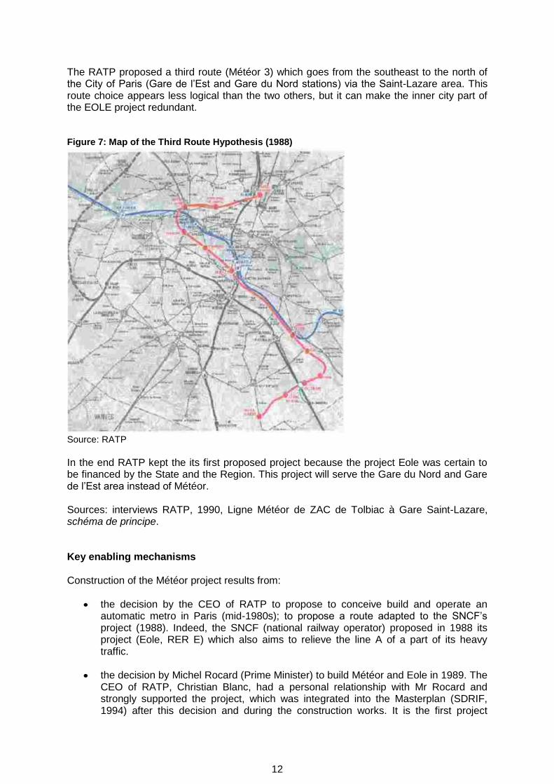
The RATP proposed a third route (Météor 3) which goes from the southeast to the north of the City of Paris (Gare de l‟Est and Gare du Nord stations) via the Saint-Lazare area. This route choice appears less logical than the two others, but it can make the inner city part of the EOLE project redundant. Figure 7: Map of the Third Route Hypothesis (1988)
Source: RATP
In the end RATP kept the its first proposed project because the project Eole was certain to be financed by the State and the Region. This project will serve the Gare du Nord and Gare de l‟Est area instead of Météor. Sources: interviews RATP, 1990, Ligne Météor de ZAC de Tolbiac à Gare Saint-Lazare, schéma de principe. Key enabling mechanisms Construction of the Météor project results from:
the decision by the CEO of RATP to propose to conceive build and operate an automatic metro in Paris (mid-1980s); to propose a route adapted to the SNCF‟s project (1988). Indeed, the SNCF (national railway operator) proposed in 1988 its project (Eole, RER E) which also aims to relieve the line A of a part of its heavy traffic.
the decision by Michel Rocard (Prime Minister) to build Météor and Eole in 1989. The
CEO of RATP, Christian Blanc, had a personal relationship with Mr Rocard and strongly supported the project, which was integrated into the Masterplan (SDRIF, 1994) after this decision and during the construction works. It is the first project

13
coming from the firm RATP rather than the State services. The SNCF project EOLE is in a similar situation. Eole, Météor and the completion of the line D have been very expensive for the public financing (as a result no other major project could be financed in the Region for ten years). Consequently the City of Paris proposed to pay FRF 450m (EUR 68m) for the construction of part of the first section. The common rule was that the city paid a large part of the running costs of public transport and the region while the State and the RATP paid the investment costs. However, the City of Paris planed four urban development zones (150ha) in southern Paris at the same time. Therefore this decision of the City accelerated the building of the project. The project was important for the State, which was building the new National Library in the Gare area, and because Paris is the shop window of France.
Source: interviews. Key enabling mechanisms timeline
Month Year Event
1987 The RATP proposes to the city of Paris and the Ile-de-France region to build the Météor line. It‟s the first automatic metro project in Ile-de-France region.
1987 The SNCF (national railway operator) proposes at the same time to the Ile de France Region, the city of Paris and the State to build another project (Eole) between the eastern suburbs, the Gare du Nord station, and Haussmann Saint-Lazare quarter. The route of this project competes with Météor to relieve the line A from a part of its heavy traffic.
1987-88 The RATP proposes two others routes for Météor project.
1988 The RATP keeps the first project (which doesn‟t serve Gare du Nord and Gare de l‟Est stations) because the project Eole will be certainly financed by the State and the Region.
1989 The Prime Minister, Michel Rocard, decides to build Eole and Météor.
May 1989 The first and the second stages (Saint-Lazare-Bibliothèque F. Mitterrand) are integrated into the State-Region planning contract for the period 1989-1993. The financial contribution of each stakeholder (State, Region, RATP, City of Paris) is indicated in the document.
August 1993 The State approves the project between Saint-Lazare station and Bibliothèque François Mitterrand station (déclaration d’utilité publique).
July 1994 The second stage is integrated into the State-Region planning contract for 1994-1998. The financing of stakeholders (only State, Region and RATP) is indicated in this document.
June 1998 The State approves the extension from Bibliothèque François Mitterrand station to Olympiades station (déclaration d’utilité publique).
February 2000 This third stage is included into the State-Region planning contracts of 1994-1999 (complementary part) and 2000-2006. The financing of stakeholders (State, Region, RATP) is indicated in this document.

14
Main organisations involved DREIF (direction régionale de l’Equipement de l’Ile-de-France) This state body is an „arm‟s length‟ service of the Ministry of Transport. Its principal responsibility in this project was to run traffic studies and to search for solutions to the congestion of line A. It did not have any opinion about Météor. Technocrats There are many public works technocrats (Ingénieurs des Ponts et Chaussées) in SNCF and in the Ministry of Transport. They represent an active pressure group in the Ministry. They are less numerous in RATP. They had supported the Eole project in the Ministry of Transport. Local authorities The Syndicat des transports parisiens (STP), known as the Syndicat des transports d’Ile-de-France (STIF) since 2001, is the regional public transport authority. Since 2006, it has taken decisions about the transport planning, the investments, the subventions and the tariffs in Ile-de-France region. The president of the Ile-de-France region has been the president of the STIF since 2006. The State had played this role before 2006. The STIF defines the offer of service (timetables, days of service, tariffs, etc). The tariffs are integration throughout the whole region which constitutes an exception in the French context. This system equalizes the receipts of fare collection between the different carriers and distributes the public subsidies. The main responsibility of the Region is to finance the project. The City of Paris supported the project because of the necessity for fast urban development of the south of the town. It therefore took the unusual decision to finance a part of the Météor project. The elected people transmitted the complaints from inhabitants concerning any inconveniences caused by the project, or any unfair decisions or actions taken during the building phase to RATP. The city played an active role because the project was important for town planning. The 150ha of residential and business zones planned in the south of Paris were at the time badly served by public transport. Source: interviews. Transport companies The RATP proposed the Météor project to the City of Paris in 1987. The project was conceived by the firm and not by the public authority. The RATP presented the project to public officials and tried to convince them of its viability. The SNCF played a similar role and proposed another project (Eole) to the Région, the City of Paris and the State. The route of the proposed line was in competition with Météor to serve the northern quarters of Paris. Both carriers tried to underestimate the cost of their respective projects in order to obtain more easily the public authorization to finance their project (source: interviews). RATP played an important early role in all aspects of the projects. It had to assure the design of the project, the building supervision, a part of financing and the operation. The RATP is the owner and the project manager. During the preparatory work, its key roles and responsibilities were:
To conceive the different study stages and produce reports (first studies, pre-project,

15
detailed pre-project, framework scheme). These reports examined the different routes, the costs, the technical aspects of the project, the operating process, tariffs, traffic forecasts, expected gains of time, gains of accessibility. The studies are more and more detailed.
To proceed to the expropriation of owners if necessary.
During the construction phase, the main responsibilities of RATP were:
To supervise the building contractors by planning the different stages of construction and the intervention of the public and underground works companies;
To supervise the construction planning;
To supervise the costs;
To assure the security of the building site for employees and inhabitants;
To assure the dialogue with the neighbourhood during the construction works about noise or environmental problems.
The post-realization responsibilities of the RATP are to operate the line with a specific remote control center and to guarantee the public service defined in the contract signed between the RATP and the STP/STIF. Public works companies Their key responsibilities are to respect the works contract they had signed with RATP (with respect to planning of work, costs, dialogue with inhabitants during the construction, respect of security measures for employees and inhabitants). Automatic operating system suppliers Matra was duty bound to supply a fully reliable system. There was no manual alternative in the Météor project. This aspect of the project was very important. There is also a technological jump which allowed automated and manual-driven metros to circulate on the same infrastructure for the first time. The project is important for Matra which hopes to sell the system abroad. Planning and environmental regime Planning legislation In 1987, the project was proposed by the RATP to the Region, the City of Paris, the State, etc. which was an unusual procedure. Usually the projects are taken into account in the regional master plan conceived by administrative and technical State and regional bodies, and then the decision to build them or not is taken, several years later. The life of a Masterplan is quite long: the 1976 version of the masterplan was replaced in 1994. Another unusual fact to emphasize is the speed of the decision-making process - it took only two years from the first idea to the final decision. May 1989: the first and the second stages (Saint-Lazare-Bibliothèque F. Mitterrand) were planned in the State-Region planning contract for the period 1989-1993. The financing of each stakeholder (State, Region, RATP, City of Paris) is indicated below.

16
August 1993: The State approved the project between Saint-Lazare station and Bibliothèque François Mitterrand station (déclaration d’utilité publique). The second stage was planned in the State-Region planning contract of 1994-1998. The financing of stakeholders (State, Region, RATP) is indicated below. 1994: Météor was taken into account by the regional master plan, which laid out the route and a list of projects. There are no details about the planning regime, financing, and so on in the document. Usually, this phase takes place before the integration of the project in the State-Region planning contract and the official approval by the State (déclaration d’utilité publique). February 2000: The third section was integrated into the State-Region planning contracts for 1994-1999 and 2000-2006. The financing of stakeholders (State, Region, RATP) is indicated below. Sources: Schéma directeur d‟aménagement et d‟urbanisme de la region Ile-de-France (SDAURIF), 1976 and Schéma directeur de la Région Ile-de-France (SDRIF), 1994. La vie du rail, “La saga de deux projets hors de prix”, 9 April 1997. (Source: Interviews). Environmental statements The framework scheme for the first and the second sections requires that Météor does not produce noise or vibration for the inhabitants because it is an underground line with guided trains running on tires. The temporary negative impacts are generated by the building sites and the evacuation of the rubble. As many of the building sites are underground, nuisance rarely occured. The tunnel had no impact on the ground water because the water flows at its depth are very rare. The document does not include a precise environmental statement because of the characteristics of the project. There is no economic evaluation of environmental impacts. Source: RATP, Ligne Météor de ZAC de Tolbiac à Gare Saint Lazare, schéma de principe, 1990. Overview of public consultation The public consultation began in May 1990. The RATP gave information about the project to the public and collected its remarks before the end of the studies and the start of the public inquiry. The first public inquiry was undertaken from 8 October to 16 November 1990. The public inquiry commission was favorable to the project. It indicated several remarks but without any significant impact on the project (17 December 1990). The State approved the project on 10 May 1991 and asked the RATP to plan a first phase of the construction between Madeleine and Bibliothèque F. Mitterrand stations. The project was then modified with part of the line from Bibliothèque to Cité Universitaire stations (south of Paris) abandoned. The new final objective was changed to Orly Airport. As a result the State cannot approve the southern part of the project between Bibliothèque F. Mitterrand station and Maison Blanche station. This route could be modified and is not yet financed by stakeholders. The second public inquiry was undertaken during January and February 1993 (segment between Saint-Lazare station and Bibliothèque François Mitterand station). The State approved this segment between Saint-Lazare station and Bibliothèque François Mitterrand station on 4 August 1993 (déclaration d’utilité publique). The State approved the segment between Bibliothèque François Mitterrand and Olympiades stations on 30 June 1998 (déclaration d’utilité publique).

17
Regeneration
Estimated jobs created 15,000 employees (ZAC Paris rive gauche only)
Office space created (m2) 934,000m
2 (partly under construction)
New shops (m2) 22,800m
2
New hotels) 9,000m2
New building for University Paris 7 (m2) 80,000m
2
Business buildings New national library (BNF)
250,000m2
200,000m2
New homes (number and type) 733,000m2 (partly under construction)
The Météor project is independent from the of urban regeneration projects which were begun in the early 1980s. Météor was an idea conceived by the RATP, and the regeneration in the south of Paris was led by the City of Paris. The mayor of the 13th arrondissement took the opportunity of using the Météor project to improve the public transport in the urban regeneration project area. Météor has no direct socio-economic effects on employment, building, and so on. It simply accelerated the planning of construction of the regeneration project. Appraisal
Before Construction During construction After Construction
Baseline Studies Six Not available (the RATP is not able to give this information)
Two - Security of operation - Evaluation of the socio-economic effects of the project (Bilan LOTI)
Monitoring environmental variables Risk analyses
None None
None None
None None
Complaints procedures Three complaint procedures were used:
The RATP consulted the public before the beginning of the construction to explain the project, the road traffic changes with the building sites, the organization of works, etc.
The public inquiry aimed to collect the opinion and the complaints. A final decision was taken by the State. It can be different from the conclusions of the commissaires enquêteurs. Only one person has complained about the first and second stages. More details available in December 2008.
The RATP conducted dialogues with the neighbourhood during the construction about the nuisances generated by works (noise, traffic restrictions, etc). The objective was to maintain any inconvenience to as low a level as possible. Some inhabitants complained about works nuisances. More details will be available in December, 2008.

18
Land acquisition Number and types of compulsory acquisitions:
Sections 1 and 2: less than five (only one significant one near Gare de Lyon station (a former hotel)).
Section 3: two compulsory acquisitions avenue d‟Italie. Source: RATP, Ligne Météor de ZAC de Tolbiac à Gare Saint Laschéma de principe, 1990. RATP, Avant projet création des ouvrages d‟arrière station pour l‟ouverture au public de la station Olympiades, Décembre 1999. According to French law, the owner of a building or area of land is also the owner everything underneath the property down to the center of the Earth. The RATP needed to expropriate the owners of the underground along the route of Météor line. It expropriated a few pieces of land and buildings to build the entrances of some stations. The compulsory purchase legislation provides the procedure to follow:
Public inquiry;
Official approval of the project by the State (déclaration d’utilité publique). This stage is necessary to expropriate the owners. They are indemnified. In the case of Météor, RATP can substitute for the State for expropriating the owners and indemnifying them.

19
C. PRINCIPAL PROJECT CHARACTERISTICS Description of route Saint Lazare station serves the second most important railway network in France. It is connected with the national railway network towards Normandy and the north-western part of the country, the regional railway network, the regional express railway network and the metro. Météor leaves Saint Lazare station and reaches Madeleine station and Pyramides station. These three stations serve the central business district of Paris. Météor then reaches Chatelet les Halles station, which is the major node of the public transport regional network. It is connected with the metro and three lines of the regional express railway network. This station serves a leisure, business and residential quarter. Météor then reaches Gare de Lyon station which is the third most important railway station in France. It is connected with the national railway network towards the south of France, the regional railway network, the regional express railway network (line D) and the metro. This station serves a business and residential quarter with recent urban development zones. Météor then reaches Bercy and Cour Saint-Emilion stations, surrounded by new residential, commercial and business quarters. The tunnel serves Bibliothèque François Mitterrand station by passing under the River Seine and reaches the terminus Olympiades station. It serves a very large new residential and business quarter of the south of Paris and the National Library. Bibliothèque François Mitterrand station is connected with the regional express railway network (line C) and an interchange with metro line 6 is available at Bercy. Two universities are served by the line: Paris 7 at Bibliothèque and Paris 1 at Olympiades. Main and intermediate travel nodes Introduction Paris and the State decided to build a new quarter in the 13th arrondissement (district) of the town at the end of the 1980s. This zone previously housed old mills and railway yards. The State financed the building of the new National Library (Bibliothèque nationale de France), and the City of Paris financed a part of the development of the zone (roads, public buildings, and so on). Property developers financed the building of new houses, business centers, etc. This project was independent of the building of the Météor line (the financing sources are different and the procedures of building are different). But, these projects have been studied together by architects and the RATP because the Météor line had to serve the new quarter. The route has been adapted to the urban development zone location by RATP in 1988. It would seem that the urban development zones projects accelerated Météor construction. Planning context and proposed development ZAC Paris Rive Gauche is served by Bibliothèque F. Mitterrand station. The project began in 1989. The quarter was an ancient industrial area of 30ha. It was characterized by an urban regeneration process. The city of Paris had several objectives of sustainable development since 2001 and:
increase social mix with more social houses and students houses;
develop the university (a new site has been opened);
develop jobs (in international firms and in local firms);
protect the old buildings (as the ancient Great Mills of Paris);
20
increase green areas;
housing - 153,500m2 houses completed, 366,500m2 yet to be built;
offices – 448,000m2 completed, 452,000m2 yet to be built;
business buildings – 63,800m2 completed, 196,200m2 yet to be built;
public equipment – 19,400m2 completed, 19,400m2 yet to be built. Figure 8: ZAC Paris Rive Gauche - Renewal of the Great Mills of Paris
Source: E Zembri
Figure 9: ZAC Paris Rive Gauche. Avenue de France
Source: E Zembri

21
ZAC Bercy is served by Cour Saint-Emilion station. The project (51ha) began in 1989. The area was in an ancient zone of wine warehousing. The objectives were:
to maintain the „wine culture‟ and the natural elements in the area (creation of a large park of 12.5 ha, preservation of a part of the former wine stores);
to mix business activities, social and private logement. Completed:
1,500 houses;
132,000m2 offices;
92,000m2 business buildings and shops;
park of 12.5ha;
public equipments. The business area (92,000m2) is more important than in the forecasts (7,800m2). This new quarter is dependent on the Météor project. It would seem that the numerous shops receipts depend on the passenger traffic generated by Météor. There was no public transport service before the Météor. Figure 10: ZAC Bercy
Source: E Zembri. The Bercy Park is just beyond the shore
ZAC Chalon is served by Gare de Lyon station. The project (10.5ha) began in 1983. The objectives of the city of Paris were:

22
to renew this damaged and dense quarter;
to improve the access to Gare de Lyon station ;
to protect the environment. This project was difficult and complex because it was necessary to undertake the urban project during important works in Gare de Lyon station. Completed:
27,000m2 offices;
5,900m2 business buildings;
586 houses;
public equipments.
Figure 11: ZAC Chalon
Source: E. Zembri
ZAC Corbineau-Lachambeaudie is served by Bercy station. The project (4ha) began in 1985. The objective of the city of Paris is to renewal this small zone with quality houses, shops and offices near two important new urban buildings: the Palais Omnisports de Paris-Bercy (where are famous concerts, sport meetings, etc) and the Ministry of Finances. Completed: 800 houses, 8,000m2 shops, 4,000m2 offices. Sources: http://www.parisrivegauche.com http://www.semaest.fr

23
Project costs Table 1: Predicted and actual infrastructure costs (stages 1 and 2)
Framework scheme
(schema de principe)
Official approval by
State (déclaration
d’utilité publique)
Pre-project Actual costs
EUR m 1989 EUR m 1992 1st stage
EUR m 1990
2nd
stage EUR m 1996
1st stage 2
nd stage
EUR m Current
548.8 935.3 758.4 130.8 943.5 133.4
EUR m 2004
719.6 1121.9 963.8 145.5 1071.0 140.2
Total stages 1 and 2 (EUR m 2004)
1109.3
1211.2
Source: RATP, DGA Transport, April 2008.
The difference (54%) of predicted costs between the framework scheme (EUR 719.6m) and the pre-projects (EUR 1109.3m) was generated by construction changes. The Syndicat des transports parisiens (transport regional authority) asked RATP for changes: escalators; widening of platforms up to six meters because of the decrease of the interval between two metros (the lowest interval is 85 seconds); creation of new entrances, etc; increase of public work prices because of new constraints generated by building sites. There are also differences in cost estimations between the framework scheme and the pre-projects which are more detailed. The State and the Ile-de-France Region decided in 1991 to develop the automatic system (first stage). The ground transportation department of the Ministry of Transport asked the RATP for an increase of the risks cost evaluation (FRF 135m or EUR 20.58m). The costs evaluation of the second phase was reduced by 7.6% in the pre-project. The under-evaluation of costs made it necessary to spread the investment over a longer period. This explains why the very short sections 2 and 3 have been put into service with a delay of several years (2003 and 2007) in relation to the first section (1998). The difference between the actual costs and the framework scheme predicted costs are +68.3%. The difference between the actual costs and the official approved predicted costs are +7.9%. The difference between the actual costs and the pre-project are +11.1% (first section), -3.6% (second section), the total is +9.2%. A difference of 5% is admitted between the predicted and the real costs in the State-Region planning contract (for stage 2). Table 2: real costs of infrastructure per year (stage 1) Total EUR 943.5m (current)
1990 1991 1992 1993 1994 1995 1996 1997 1998 1999 2000 2001 and afterwards
Costs 4 8.9 71.6 198.8 162.6 166.5 104.8 103.6 794 22.9 11.8 8.5
Source: RATP, DG Transport, April 2008

24
Table 3: real costs of infrastructure per year (stage 2) Total EUR 133.4m (current)
1999 and before
2000 2001 2002 2003 2004 and afterwards
Costs 32.4 18.1 18.8 16.8 20 27.3
Source: RATP, DG Transport, April 2008
Public works represent 61% of the total cost (stages 1 and 2).
Project delivery
Date
Decision to proceed 1989
Construction start 1993 (section 1) 1998 (section 2) 2000 (section 3)
Commencement of use 1998 (section 1) 2003 (section 2) 2007 (section 3)
Main engineering features Engineering The entire route is in tunnel (11.96km). A new twin-track tunnel has been built for this project:
minimum radius - 250m;
maximum commercial speed - 80km/h maximum;
declivity - 40mm/m;
internal diameter of tunnel - 7.5m;
width of immersed pre-manufactured casings - 7m (under the River Seine);
length of stations - 120m;
width of platforms - 6m;
gauge of track - 1.435m (normal gauge);
iron rail and concrete bands for tires;
length of the line: stage 1 – 8.6km; stage 2 - 511m; stage 3 - 677m;
number of stations – nine. Sources: RATP Construction (data only available for the segment Bastille-Madeleine).
Volume of earth excavated: 250,000m3
Concrete volume: 42,000m3;
Reinforcement weight: 3,500 tons
Slurry-type tunnel boring machine:
Maximum advance of the slurry-type tunnel-boring machine: 350 meters/month;
Shield diameter - 8.6m;

25
Total jack thrust – 6,000 tonnes;
Total installed power – 6,000KW;
Total shield back-up length - 82m;
Entire weight - 1000 tons. The tunnel lining consists of precast reinforced concrete segments, designed to keep the structure wartertight. The segments are erected by the tunnel–boring machine as it advances. The segments are produced in a precasting plant built by the contractors at Limay Harbour, downstream from Paris, and are then transported by river to the tunnel‟s access shaft (see the list of contractors below). Source: consortia of contractors, Météor Tronçon Bastille-Madeleine (1996) Evaluation of service quality
Criteria Metro network % Météor %
Waiting for trains 98.9 99.8
Availability of lifts and escalators
92.6 95.4
Cleanness of stations 89.7 93.4
Cleanness 92.1 100
Welcome at ticket office 88 93.8
Fraud 4.3 2
Main contracts
Matra: automatic system;
Consortium of public works companies: Bouygues, Dumez, Chantiers modernes, Perforex;
The RATP is the owner and the project manager;
Information about contracts is not available. Architecture Stations, corridors and interchange areas benefit from a special architecture. The security impression of passengers is reinforced by large and short corridors, lighting shafts where possible, and the walls are protected against graffiti and vandalism. The platforms are equipped with glass walls and glass doors along the railway to avoid passenger falls. Access for handicapped people is made easier by lifts - the deaf benefit from light signals at the opening and closing of metro door etc. The CEO of RATP and the stakeholders wanted to finance an exceptional project, with a careful architecture.

26
Figure 12: The Lighting shaft in Saint-Lazare Station
Source: E. Zembri Figure 13: Bibliothèque François Mitterrand Station
Source: E. Zembri

27
Figure 14: Météor entrance (Saint Lazare station - the only entrance with a specific Météor style)
Source: E. Zembri
The Automatic Metro Concept There were only two automatic metro lines in operation in Lille (VAL type2, produced by Matra) and Lyon (Line D, produced by Alstom) when the Météor project was decided. This type of metro is operated with a remote control center, without drivers. The type chosen for Météor is a mix of two others: the operating system and the use of platform doors come from the VAL type, the characteristics of the rolling stock are similar to the Lyons type, with longer and broader trains than the VAL. The total automation of Météor brings a high quality service. The interval between two trains is reduced to 85 seconds. The service is attractive all the day, in the morning and in the evening. The regularity of trains is very good. There is a high level of security. The automatic system is proven. The platforms are equipped with glass doors along the railway which open only when a train has stopped at the station. The remote control center is connected to the stations and to the trains by telephone line and by a remote security system all the time.
2 Automatic metro of medium capacity (trainsets of two short and relatively narrow carriages),
conceived for Lille in 1979, and also sold to Rennes, Toulouse, RAT or the Orlyval service, Taipei, Chicago (for internal service in O‟Hare Airport), Aéroports de Paris (for the same purpose in CDG Airport), Jacksonville (USA), Turin, etc.

28
Figure 15: Platforms with glass doors (Bibliothèque F. Mitterrand station)
Source: P.E. Zembri
This system can adapt very quickly to exceptional traffic situations. It also permits the circulation of trains with drivers. The operation of a part of the line is possible. This system can be adapted to lines with drivers without stopping the operation. The line 1 of Paris Metro will be progressively equipped with this system in the next years. The principle of automation has been accepted easily by drivers of RATP. The syndicates play usually a strong role in RATP, but they have accepted the change because it is a new line. The automation introduces changes in management. The employees are polyvalent (not usual in RATP). They can drive metros if necessary, they assure relationships with customers, they assure the respect of security measures if necessary, etc. Equipments - 324 platform doors in the stations, 26 lifts, 70 escalators, 220 interphones, 300 cameras. Source: RATP, Matra Transport, Interviews

29
D. PROJECT TIMELINE
Month Year Type of decision Key decision/event
mid- 1980s
Project initiation The RATP decided to study a solution for the increase of traffic on line A of the regional express railway network.
1987 Project initiation The RATP proposes to Paris and the Ile-de-France region to build the Météor line (automatic metro). This project is not part of the current Masterplan. The first route is proposed in 1987, from Cité Universitaire to the Port of Gennevilliers via Gare de Lyon and Gare Saint-Lazare. The City of Paris is interested by the project if it serves the south of the town. They want to build new residential and business quarters in this zone.
1987 Project initiation The SNCF (national railway operator) proposes at the same time to the Ile de France Region, the City of Paris and the State to build another project (Eole) between the eastern suburbs, Gare du Nord station, and Haussmann Saint-Lazare station. This project is supported by numerous technocrats of the SNCF and of the Ministry of Transport.
November 1987 Project initiation The RATP proposes a second route which goes from the south to the Gare du Nord, to the Gare de l‟Est and then to the business quarter of La Défense via Saint-Lazare.
November 1988 Project initiation This second project is abandoned.
1988 Project initiation The RATP proposes a third route which goes from the south to the north-west of Paris (Saint-Lazare), then to the north (Gare de l‟Est and Gare du Nord station).
1989 Project initiation Finally, the RATP moves back to the first project because the project Eole will be certainly financed by the State and the Region. This project will serve the Gare du Nord and Gare de l‟Est station instead of Météor.
1989 Decision making The Prime Minister, Michel Rocard, decides to build Eole and Météor.
May 1989 Project initiation The first and the second stages (Saint-Lazare – Bibliothèque F. Mitterrand) are integrated into the State-Region planning contract for 1989-1993. The financing of each stakeholder (State, Region, RATP, City of Paris) is indicated in this document.
October 1989 Project initiation The region Ile-de-France publishes a programme d’actions (program of actions) which contains the Météor project.
April 1990 Decision making The Syndicat des transports parisiens (transport authority) approves the schema de principe (framework scheme) proposed by the RATP (three stages).
October- November
1990 Project initiation First public inquiry in Paris (segment between Saint-Lazare station and Bibliothèque François Mitterand station).
December 1990 Project initiation The public inquiry commission is favorable to the project. It makes several remarks about the project but

30
Month Year Type of decision Key decision/event
these are not significant.
May 1991 Decision making Project initiation
Public approval by the State of the segment between Saint-Lazare station and Bibliothèque François Mitterrand station. The route of the project changes in the south of Paris.
October 1991 Project initiation The RATP and the Syndicat des transports parisiens (public transport authority) approves the pre-project of the first stage (Madeleine station to Bibliothèque F. Mitterrand station).
1993-1998
Implementation Duration of the works of the first section (Madeleine station – Bibliothèque F. Mitterrand station).
January-February
1993 Project initiation Second public inquiry (segment between Saint-Lazare station and Bibliothèque François Mitterand station).
August 1993 Decision making Déclaration d’utilité publique (final public approval) by the State of the segment between Saint-Lazare station and Bibliothèque François Mitterand station.
July 1994 Decision making The Syndicat des transports parisiens (regional transport authority) approves the pre-project of the second stage (Madeleine – Saint-Lazare). The second stage is included in the State-Region planning contract for 1994-1998.
1994 Project confirmation
Météor is taken into account in the regional master plan.
April 1997 Decision making The RATP publishes the second pre-project for the second stage (Madeleine – Saint-Lazare). The Syndicat des transports parisiens (public transport authority) approves this project. The project is delayed for five years because the stakeholders encounter difficulties to finance it.
June 2nd- July 3rd
1997 Project initiation Public inquiry of stage 3 (Bibliothèque F. Mitterrand Station – Olympiades station).
1998-2003
Implementation Duration of the works on stage 2 (Madeleine station - Saint Lazare station)
June 30th 1998 Decision making Déclaration d’utilité publique (final public approval) by the State of the segment between Bibliothèque François Mitterand station and Olympiades station.
October 1998 Implementation The first section Madeleine Bibliothèque F. Mitterrand is open to use.
2000-2007
Implementation Duration of the works stage 3 (Bibliothèque François- Mitterrand station - Olympiades station).
February 2000 Decision making The Syndicat des transports d’Ile-de-France (regional transport authority) approves the pre-project of the third stage (Bibliothèque François Mitterrand – Olympiades). The third stage is included in the State-Region planning contracts of 1994-1999 and 2000- 2006.
October 2000 Implementation The first section is connected to line C of the express regional railway network. The traffic jumps to 150,000 trips per working day.
February 2003 Implementation The tunnel of the segment Bibliothèque F. Mitterrand-

31
Month Year Type of decision Key decision/event
Olympiades (third stage) collapses under a primary school (during holidays). The RATP decides to stop the construction for six months and to study the reasons for the accident and the procedure to continue the work. The reconstruction of a new tunnel delays the project for an additional three months.
December 16th
2007 Implementation The second section Madeleine – Saint-Lazare is open to use. Traffic is now 310,000 trips per working day.
June 25th 2007 Implementation The section Bibliothèque F. Mitterrand – Olympiades is open to use, with a delay of six months. Traffic is 450,000 trips per working day
Sources: Ligne Météor de Saint Lazare à Maison Blanche, Dossier d‟enquête préalable à la DUP, Septembre 1990; Ministère de l‟Equipement, du Logement et des Transpor s, Syndicat des transports parisiens, Région d‟Ile-de-France, ville de Paris, Ligne Météor, Dossier d‟enquête alable à la DUP de la station Saint Lazare à la station ZAC de Tolbiac et à la délivrance du permis de construire des stations Madeleine, Chatelet, Gare de Lyon, Bercy, Dijon, et de l‟atelier d‟entretien. Novembre 1992; RATP, Avant projet, métro ligne 14, création des ouvra es d‟arrière station pour l‟ouverture au public de la station Olympiades, décembre 1999; RATP, Opération Météor de Saint Lazare à Maison Blanch avant projet, Documents généraux mai 1991. RATP, Opération Météor, Première phase Madeleine-ZAC de Tolbiac, Avant projet, Octobre 1991; RATP, Avant projet (projet météor) création des ouvrag s d‟arrière station pour l‟ouverture au public de la station Olympiades, décembre 1999; RATP, Ligne Météor de ZAC de Tolbiac à Gare Saint Lazare, schéma de principe, 1990; Syndicat des transports parisiens, Prolongement de Mét r de Madeleine à Saint Lazare, Avant projet rectificatif, conseil d‟administration 3 avril 1997; Syndicat des transports parisiens, conseil régional d‟Ile-de-France, Département de Paris, Dossier d‟enquête préalable à la DUP, Ligne Météor, Création des ouvrages d‟arrière station pour l‟ouverture au public de la station Tolbiac Nationale Paris, 13 ème arrondissement. Février 1997.

32
Project timeline key issues Project financing and funding From a relatively early stage, it seems that the project had financing difficulties because of the competition with Eole. Numerous articles in newspapers underline the expensive cost of Météor.
A new process of transport infrastructures financing emerged – the City of Paris wanted to finance the project in the 13th arrondissement, which is not common. Indeed, the City usually finances the running costs rather than the investment costs. It would seem that this choice can be seen as a will to accelerate the building of the project.
The decision of the State to build Eole and Météor at the same time stopped the possibility to build other projects in Ile-de-France for ten years. Available public funds were totally used up by these two projects.
The initiation of the first and the second stage of the project in the State-Region planning contract has been quick, and the financing was certain.
However, the Region needed transport infrastructures from suburbs to suburbs, where traffic was dramatically increasing (Neveu & Zembri, 1989). It could be seen as a mistake of financing choice in relation to the needs of users. Regional transport infrastructure planning The planning and construction process is fast in comparison with other projects in France. The problem of congestion on line A was taken into account by RATP and the Ministry of Transport in the mid-1980s. The project was decided in 1989. The first section was integrated into the State-Region planning contract in 1989, the second section in 1994 and the third section in 2000. The first and longest section was open to use in 1998 (nine years after public decision), the second section in 2003 and the third section in 2007. Météor was taken into account in the regional masterplan in 1994, after the integration of the first and second sections of the project in the State-region planning contract in 1989 and after the official approval by the State in 1993. It seems that Météor benefited from an accelerated process of funding and planning and many stakeholders agree to build it. The weak role of the State in the route choice process can be seen as the beginning of a new share of the competences of each public stakeholder in transport infrastructure planning in Ile-de-France region. The project is proposed and conceived by RATP in the 1980s. After the decentralisation process initiated in 1981 and completed in 2006 in the Ile-de-France region, the State has no more initiative. But, public-owned companies like SNCF and RATP can substitute for it. The Region and the municipalities are just beginning to play a new role, but they remain dependent from the expertise of the State bodies and of the main carriers.

33
E. PROJECT FUNDING/FINANCING Background to funding: the State-Region planning contracts Data concerning financing are available for the first and the second sections of the Météor only. The financing is based on a contract between public stakeholders. It is the common means of infrastructure construction financing in France. RATP conceives, supervises construction and operates, takes out public loans with Region as borrower, and public subsidies from the State and the Ile-de-France Region (stages 1 and 2). The City of Paris gives subsidies to RATP for the first time to support the project and accelerate its construction in the south of the town. The financing system is forecasted in the State Region planning contract. There is no difference between the forecasts and the investments paid by each stakeholder. Figure 16: Contractual structure of State-Region planning contract
Figure 17: Contractual structure of State-region planning contract (construction financing stage 2) State
State subsidies 19%
Region subsidies 61%
Loans 20%
RATP (conceives, supervises building, operates)
State subsidies 33%
City of Paris subsidies 8%
Loans 18%
RATP (conceives, supervises building, operates)
Region subsidies 41%

34
Figure 18: share of financing between stakeholders (section 1) (EUR m current)
Source: RATP, DG Transport 8
th April 2008/Graph: G Zembri
Figure 19: share of financing between stakeholders (section 2) (EUR m current)
Source: RATP, DG Transport 8
th April 2008/Graph: G Zembri

35
Predicted and actual revenue and role of traffic forecasts The framework scheme of 1990 presents a predicted financial account for 1996 (section 1 and 2). It is based on the following estimations:
traffic - increase of 1% per year between 1996 and 2005; tariffs - the tariffs of 1990 are taken into account. They increased 2% per year
(current money) until 2000; infrastructure financing - 80% subsidies of State, Region, and City of Paris; 20%
loans (rate: 7.5%; during 25 years); trains financing by RATP with a loan (interest rate - 9.5%); energy cost is constant (constant money);
inflation - 2.5% per year. estimation of operating costs (train operation, energy maintenance): FRF 51.4m
(value 1989). Table 4: Traffic forecasts
In 1991 In 1992
2,500 travellers/hour/direction to 25,500 travellers/hour/direction according to the stations.
25,000 travellers/hour/direction in each station (96 million travellers during the first year of operation).
The maximum capacity is 40,000 travellers/hour/direction (in each station).
The maximum capacity is 40,000 travellers/hour/direction (in each station).
The receipts are calculated in relation to new traffic generated by Météor (users of personal cars, users of line A, etc). The traffic generated by these transfers is 4.5% of the annual traffic. The receipts are estimated FRF 42.9m (1996) or EUR 6.54m and FRF 50.7m (2001) or EUR EUR 7.835m, according to the traffic evolution hypothesis and the receipts hypothesis. The forecasts show that RATP is in deficit in 1996 (FRF -8.5m or EUR 1.295m) and in 2001 (FRF -0.7m or EUR -106,000). The amortization (FRF 59m or EUR 9m) and loan interests (FRF 90.7m or EUR 13.82m) increase the deficit (FRF -132m or EUR -20.123m). This deficit is compensated by a subsidy of the transport regional authority (Syndicat Des Transports Siens). This subsidy was FRF 158m (or EUR 24m) in 1996 and FRF 109m in 2001 (or EUR 16.61m). Actual revenue It is impossible to distinguish year-by-year the predicted and actual revenue of this particular line from the other ones operated by the RATP. The share of predicted revenue and actual revenue for running costs between stakeholders is the same (see the graph below). The principle of public transport financing in Ile-de-France is that there are three equivalent sources:
the employers (through a specific tax called Versement Transport, applicable to all regional firms employing more than nine employees);
the public authorities (State, Region, Departements) - all the subsidies come through the STIF, which control the respect of the specifications imposed to the carriers;
and the customers (fare collection). The revenues of the season tickets sold for the entire network (Carte Orange, Carte Intégrale, etc) are redistributed among the

36
different carriers according to the number of validations by the STIF. Source: RATP, Ligne Météor de ZAC de Tolbiac à Gare Saint Lazare, schéma de principe, 1990. Figure 20: share of predicted and actual revenue of RATP for running costs
Key funding stages Table 5: Key funding stages
Month Year Event
February 1989 M. Rocard (1st Minister) presents the State-Region planning contract 1989-1993. FRF 1.5bn (EUR 228m) is dedicated to Eole and Météor.
May 1989 The first and the second stages (Saint-Lazare-Bibliothèque F. Mitterrand) are integrated into the State-Region planning contract for 1989-1993.
July 1994 The second stage is included in the State-Region planning contract of 1994-1998.
April 1997 The RATP publishes the second pre-project for the second stage (Madeleine-Saint-Lazare). The Syndicat des transports parisiens (public transport authority) approves this project. The project is delayed for five years because the stakeholders have difficulties to finance it.
October 2000 The third stage was included in the State-Region planning contracts for 1994-1999 and 2000-2006.
This funding system is classical in Ile-de-France region. The new element is the subsidy by the City of Paris. It would seem that RATP has easily found resources to finance the project. For example, the State-Region planning contract is signed before the project integrated into the regional master plan. This point is not usual.

37
F. OPERATIONS Traffic volume Figure 21: Traffic growth 1998-2007
Source: RATP, DGA Transport April 8 2008. Graph: G. Zembri
Traffic has increased substantially each year. The most important increases are in January 2004 (Saint Lazare station is open for use in December 2003) and in December 2007 (Olympiades station is open to use in July 2007). The line is successful because of the high level of quality of service. The users can use the line every day because problems of traffic regulation are very rare. Météor can be used on the strike days. It is important because strikes can reduce strongly or stop the traffic for several days. It is difficult to compare the traffic forecasts and the actual usage after opening because the data are different (number of travellers/hour/direction in 1992 and number of trips per working day from 1998 to 2007). How traffic forecasts were formulated Traffic forecasts were mainly formulated to study the possibilities to limit the congestion on line A, not to forecast revenue from traffic. Indeed, the Météor project was financed by the public sector and by the RATP (semi-public firm which is financed by subsidies and fare collection). The RATP used a global model of traffic. This model uses a very detailed representation:
of the service; of the demand (the traffic of each station is isolated, interchanges are precisely
described, Paris quarters are divided in small zones). This method can determine

38
precisely where passengers come from and where they go to; of the share of passengers between several types of users in relation of their modal
choice, the walking difficulty, and interchange difficulty. The share of passenger flows between competitive route is taken into account with these criteria. Indeed, the metro network is very dense. Line A traffic forecasts measured in 1990 are 63,000 to 65,000 passengers/hour in 1998 between Gare de Lyon station and Auber station. The traffic forecasts of Météor in 1991 predict 96 million passengers per year in 1998 between Saint Lazare station and Bibliothèque François Mitterrand station. One of the main objectives of the Météor project is to be attractive for passengers of line A. The traffic forecasts of 1990 precise that 27,000 passengers /hour between Châtelet-les Halles station and Auber station (line A) will be transferred to Météor. The traffic of line A increases strongly between 1990 (910,000 passengers/day) and 2005 (1,010,000 passengers/day). Figure 22: Line A traffic 1990-2005
Source: RATP, DGA Transport, April 8 2008. Graph: G. Zembri
Sources: RATP, Avant projet, métro ligne 14, création des ouvra es d‟arrière station pour l‟ouverture au public de la station Olympiades, décembre 1999; RATP, Ligne Météor de ZAC de Tolbiac à Gare Saint Laza e, schéma de principe, 1990.
39
G. BIBLIOGRAPHY General books and theses Comité régional pour l‟information économique et sociale, Les transports en Île-de-France; Actes du colloque du 18 décembre 1991, Paris, CRIES, 1992, 95 p. Marc Gaillard, Histoire des transports parisiens de Blaise Pascal à nos jours, Paris, Horvath, 1987, 175 p. Marc Gaillard, Du Madeleine-Bastille à Météor: histoire des transports parisiens, Amiens, Ed. Martelle, 1991, 223 p. Michel Margairaz, Analyse socio-historique de la RATP, Paris, RATP, Unité prospective, n° 23, février 1987, 67 p. Michel Margairaz, Histoire de la RATP: la singulière aventure des transports parisiens, Paris, Albin Michel, 1989, 173 p. Pierre Merlin, Les transports en région parisienne, Paris, La Documentation française, Coll. Notes et études documentaires, n° 5052, mai 1997, 202 p. Alain Neveu, Pierre Zembri, „Migrations alternantes, des comportements sociaux différenciés dans un espace polarisé‟, Données sociales Ile-de-France, Paris, INSEE, 1989, pp. 146-150. SERES, La constitution des réseaux de transports urbains; éléments pour une interprétation socio-politique (le cas de la région parisienne), Paris, SERES, 1978, 136 p. Institutional framework Louis Servant, Danielle Coupeaux, Le cadre institution et financier des transports de voyageurs en Île-de-France, Paris, I.A.U.R.I.F., 1991, 60 p. Louis Servant, Danielle Coupeaux, Le cadre institution et financier des transports de voyageurs en Île-de-France, 2nd édition, Paris, I.A.U.R.I.F., 1996, 52 p. Projet de loi relatif aux transports de voyageurs à l‟intérie r du périmètre des transports parisiens (...) présenté au nom de M. Raymond Barre, Premier ministre, par M. Joël Le Theule, ministre des transports, Paris, Imp.Ass.nat., 1979, 9 p. Syndicat des transports parisiens, Textes relatifs à l‟organisation des transports de voyageurs dans la région Île-de-France, Paris, S.T.P., 1992, 101 p. Regional planning Jean-François Allouche, Jean-Raymond Fradin, Élaboration du nouveau schéma directeur de l‟Îlede-France: rapport de la commission transports, Paris, S.T P., 1991, pag. diverses + cartes hors texte. Elisabeth Borne et al., L‟Île-de-France au futur: avant-projet du nouveau schéma directeur de l‟Îlede-France, Paris, D.R.E.I.F., 1991, 137 p.

40
Michel Boscher, Rapport général et propositions sur le schéma directeur d‟aménagement et d‟urbanisme de la région de Paris, Paris, District de égion de Paris, 1966, 2 vol. 301 p., 29 p. District de la région parisienne, Programme duodécennal 1964-1975; Transports en commun, Paris, District de la région de Paris, 1965, Pag. div. District de la région parisienne, Schéma directeur d‟aménagement et d‟urbanisme de la région de Paris, Paris, I.A.U.R.P., 1965, 221 p. + 2 cartes hors texte. District de la région parisienne, Schéma directeur d‟aménagement et d‟urbanisme de la région de Paris, Paris, La Documentation Française, 1966, 4 vol., 260 p., 210 p., 223 p., 236 p. (version incluant les avis et rapports du C.E.S.R., du Conseil d‟administration du District et du comité d‟aménagement de la région parisienne). D.R.E.I.F., A.P.U.R., I.A.U.R.I.F., Le livre blanc de Île-de-France. Document préalable à la révision du schéma directeur d‟aménagement et d‟urbanisme de la région Île-de-France, Paris, D.R.E.I.F., 1990, 95 p. D.R.E.I.F., Île-de-France 2015. Projet de schéma directeur, Paris, D.R.E. .F., 1992, 197 p. D.R.E.I.F., Schéma directeur de l‟Île-de-France, Paris, D.R.E.I.F., 1994, 207 p. I.A.U.R.I.F., Projet de S.D.A.U. de la région d‟Île-de-France, Paris, I.A.U.R.I.F., 1980, 151 p. + 15 cartes hors texte. Pierre-Charles Krieg, La charte de l‟Île-de-France: une ambition à l‟heure de l‟ouverture de l‟Europe. Synthèse du projet présenté par l‟exécutif régional, Paris, I.A.U.R.I.F., 1991, 39 p. Lucien Lanier, Présentation du projet de schéma directeur d‟aménagement et d‟urbanisme de la région d‟Île-de-France, Paris, Préfecture de la région Île-de-France, 1980, 2 vol.: 198 p. + pag.div. Lucien Lanier, Programme régional quinquennal des transports en région d‟Île-de-France 1981-1985, Paris, Préfecture de région, 1981, 19 p. Préfecture de la région parisienne, Schéma directeur d‟aménagement et d‟urbanisme de la région de Paris. Rapport sur les propositions de modifications et sur la mise en œuvre, Paris, I.A.U.R.P., janvier 1969, 98 p. + annexes + 1 carte hors-texte. Préfecture de la région parisienne, „Plan global transports‟, Bulletin d‟informations de la région parisienne, n° spécial, décembre 1972, 76 p. Préfecture de la région parisienne, „Schéma directeur d‟aménagement et d‟urbanisme de la région parisienne‟, Bull. d‟informations de la région parisienne, n° 17, mai 1975, p. 1-33. Préfecture de la région parisienne, Schéma directeur d‟aménagement et d‟urbanisme de la région parisienne, Paris, I.A.U.R.I.F., 1977, 1 dossier, 2 fasc. + cartes hors-texte. Préfecture de région, Ile-de-France Plan de Déplacements Urbains, avant-projet, La Documentation française, avril 1999, 119 pages. Région Île-de-France, D.R.E.I.F., Schéma directeur d‟aménagement et d‟urbanisme d‟Île-de-France : modifications 1982, Paris, D.R.E.I.F., 1982, 2 p. + 1 carte hors-texte. Charles Roscian, Roland Peylet, Le schéma directeur d‟aménagement et d‟urbanisme de la région parisienne. Mise à jour 1975, Paris, I.A.U.R.P. mbre 1974, 109 p. + cartes hors texte.

41
Lucien Vochel, Plan intérimaire des transports en région Île-de-France 1982-1983, Paris, Préfecture de région, 1981, 26 p. Grand Bassin parisien Conférence permanente des Présidents de régions du gra d Bassin parisien, Le scénario des 8: contribution à l‟aménagement du grand Bassin parisien et à l‟équilibre du territoire national, Amiens, CPPR, 1993, 38 p. Conférence permanente des Présidents de régions du grand Bassin parisien, Charte du Bassin parisien, Amiens, CPPR, 1994, 35 p. + 4 cartes hors texte. DATAR, Le Bassin parisien. Réflexions pour un livre blanc, Paris, DATAR, 1968, 36 p. + 1 carte. DATAR, Directives d‟aménagement pour le Bassin parisien, Paris, DATAR, 1970, 22 p. DATAR, Livre blanc du Bassin parisien, Paris, DATAR, 1992, 135 p. Groupe interministériel d‟aménagement du Bassin parisien, Contrat de plan interrégional du Bassin parisien 1994-1998, Paris, Mission Bassin parisien, 1994, 72 p. Geneviève Marotel et al., Travailler à Paris, vivre à ... 100 km: les migrants SNCF en grande région parisienne, Arcueil, I.R.T., 1983, 92 p. Danielle Navarre, François Grenet, Les déplacements au sein du Bassin parisien: propositions pour l‟amélioration des liaisons ferrées avec l‟Île-de-France, Paris, I.A.U.R.I.F., 1993, 155 p. + 2 annexes cartographiques non paginées. Public transport in Paris Jean Chouleur, Les déplacements vus par les usagers: t de la notion de déplacement sur la méthodologie d‟élaboration des projets de transports e commun en Île-de-France, Paris, FNAUT, 1991, 63 p. Fédération des comités d‟usagers des transports en commun de la région parisienne, Le livre noir des transports parisiens, Paris, F.C.U.T.C.R.P., 1970, 46 p. Robert Franc, Le scandale de Paris, Paris, Ed. Bernard Grasset, 1971, 268 p. Jean Macheras, „Quelle politique de déplacements en Î e-de-France?‟, Transports Urbains, n° 71 (avril-juin 1991), p. 19-24. Parti socialiste d‟Ile-de-France, Ile-de-France: pouvons-nous éviter le scénario catastrophe?, Colloque de Créteil des 9 et 10 février 1990, Paris, Economica, 1990, 284 p. Jean Poulit, Les enjeux transport du schéma directeur de l‟Île-de-France, Paris, D.R.E.I.F., 1992, 78 p. Émile Quinet, Jean-Pierre Fourcade, Pierre-Alain Jeanneney, „Problèmes de l‟Île-de-France‟, Commentaire, n° 51, septembre 1990, p. 493-507. Michel Vaillant, Les transports de personnes en Île-de-France, Paris, C.C.I.P., 1981, 35 p.

42
Isabelle Villemot, Daniel Martinelli, „Réflexions sur le SDAU d‟Île-de-France‟, Bulletin trimestriel du GARP, n° 96, janvier 1992, p. 13-23. General studies on transport in Ile-de-France Region and regional planning Brigitte Baccaïni, „L‟évolution récente des navettes en Île-de-France‟, L‟Espace Géographique, n° 1996/1, mars 1996, p. 37-52. Michel Barbier, „Réflexion sur l‟expérience de vingt ans dlanification des transports collectifs urbains en région parisienne‟, Cahiers Scientifiques du Transport, n° 11-12, 1985, p. 47-85. Jean-Marie Beauvais, Le coût social des transports parisiens, Paris, Economica, 1977, 191 p. Jean-Paul Coindet, Évolution du nombre de voyageurs x kilomètres quotidiens de 1990 à 2015, modes motorisés (V.P. et T.C.), Paris, D.R.E.I.F., 1991, 8 p. D.R.E.I.F., Réflexion sur la mise à jour du S.D.A.U.: transports en commun, Paris, D.R.E.I.F., 1980, 1 dossier + 2 cartes hors-texte. Jean-Guy Dufour et al., Étude transport préalable à un nouveau schéma directeur de la région Île-de-France: première contribution, Paris, D.R.E.I.F., 189 41 p. + planches hors-texte. Alain Farat, Jean-Paul Coindet, Les transports de voyageurs en Île-de-France, 1990, Paris, D.R.E.I.F., 1991, 99 p. Jean Gajer, „Les enjeux du nouveau schéma directeur d‟aménagement et d‟urbanisme de l‟Îlede-France‟, Espaces et Sociétés, n° 36-37, janvier-juin 1981, p. 121-134. Jean-Claude Galland et al., La desserte ferroviaire des sec eurs d‟Île-de-France situés hors banlieue parisienne, Paris, IAURIF, 1991, 2 vol., 33 p. + pag. div. Dominique Larroque, Michel Margairaz, Pierre Zembri, Paris et ses transports (19ème et 20 ème siècles): deux siècles de décision pour la ville région, Paris, édition La recherche, septembre 2002, 408 p. Catherine Montrade, „Analyse historique et prospective de la dialectique tutelle–RATP‟, Cahiers scientifiques du transport, n° 11-12, 1985, p. 257-268. Alain Neveu, Pierre Zembri, Les Migrations alternantes en Île-de-France: des comportements différenciés dans un espace polarisé, D.R.E.I.F., février 1988, 50 p. + 41 cartes. Lucien Sfez, „Portrait d‟une décision, le RER‟, Projet, n° 126, juin 1978, p. 680-690. Publications of public transport firms François Ascher et al., Quand les transports deviennenaire de la cité, parlons-en avec la RATP, La Tour d‟Aigues, Éditions de l‟Aube, 1999, 136 p. RATP, Une proposition à moyen terme de la RATP pour l‟amélioration des transports en ÎledeFrance ; Introduction au Plan d‟entreprise 1978-1982 de la RATP, Paris, RATP, 1977,

43
non paginé. RATP, Une proposition à moyen terme de la RATP pour l‟amélioration des transports en ÎledeFrance ; Introduction au Plan d‟entreprise 1979-1983 de la RATP, Paris, RATP, 1978, non paginé. RATP, Une proposition à moyen terme de la RATP pour l‟amélioration des transports en ÎledeFrance ; Introduction au Plan d‟entreprise 1980-1984 de la RATP, Paris, RATP, 1979, non paginé. RATP, Une proposition à moyen terme de la RATP pour l‟amélioration des transports en Île-de-France, Paris, RATP, 1980, non paginé (introduction au Plan d‟entreprise 1981-1985 à l‟attention SNCF Île-de-France, Orientations pour une proposition SNCF d‟opérations à inscrire au schéma directeur de la région Île-de-France, Paris, SNCF-D.I.F., 1990, 7 p. + carte hors texte. Institutional reports on transport policy A.P.T.R., Propositions pour la réforme des transports d‟Île-de-France, Versailles, A.P.T.R., 1994, 5p. Michel Giraud, La réforme de l‟organisation des transports parisiens, Paris, Conseil régional d‟Île-de-France, 1982, 14 p. Michel Giraud, Plan régional 1994-1998: partenariats et projets, Paris, Conseil régional d‟Île-de-France, 1994, 1 vol. non paginé + 6 vol. d‟annexes. Michel Hermelin, Christian Jacob, Schéma directeur des transports collectifs en site propre en région d‟Île-de-France, Paris, IAURIF, 1984, 23 p. + annexes. Jacques Rousset, Plan stratégique des déplacements; première synthèse des travaux, Paris, S.T.P., 1990, 24 p. Jacques Rousset, Plan stratégique des déplacements: report final, annexes, Paris, S.T.P., 1991, 2 vol., 64 p. + pag. div. Éole and Météor Chlastacz Michel, „Avec météor, le métro fait sa révolution‟, La vie du rail, 14 octobre 1998. Cour des Comptes, Rapport au président de la République 1995, Paris, éditions des journaux officiels, n° 4281, octobre 1995, p. 139-168. Pascal Grassart, Marc Fressoz, „Éole, Météor: la saga de deux projets hors de prix‟, La Vie du Rail, n° 2591, 9 avril 1997, p. 14-25. Lomazzi Marc et alii, „Les premiers pas de Météor‟, La vie du rail, 9 août 1995. Odile Plichon, „SNCF-RATP: duel ruineux dans le sous-sol parisien‟, Capital, n° 68, mai 1997, p. 126-129.

44
SNCF Île-de-France, EOLE, la future ligne E du RER, Paris, SNCF, 1991, 7 fiches + 3 cartes. Numéro spécial „Météor‟, Revue générale des Chemins de fer, juin 1996, 97 p. Numéro spécial „Éole‟, Revue générale des Chemins de fer, Août-septembre 1996, 88 p. Pascal Grassart et alii, „La sage de deux projets hors de prix‟, La vie du rail, 9 avril 1997. Institutional Reports on Météor project Avenant à la convention de financement de Météor à Saint-Lazare signée le 15 janvier 1999. Avenant à la convention, relatif à la réalisation d‟un ouvrage de correspondance entre les lignes 9 et 14. Convention entre l‟Etat, la région, et la RATP pour la réalisation de l‟opération Météor Madeleine Saint-Lazare. 15 janvier 1999 Convention régissant des rapports entre les signataire du CPER et le maître d‟ouvrage, relative à l‟opération Météor Madeleine Saint-Lazare. Avenant à la convention relatif à la réalisati n d‟un ouvrage de correspondance entre les lignes 9 et 14 du métro. 29 août 2000. Ligne Météor de Saint Lazare à Maison Blanche, Dossier d‟enquête préalable à la DUP, Septembre 1990. Ministère de l‟Equipement, du Logement et des Transpor Syndicat des transports parisiens, Région d‟Ile-de-France, ville de Paris, Ligne Météor, Dossier d‟enquêt préalable à la DUP de la station Saint Lazare à la station ZAC de Tolbiac et à délivrance du permis de construire des stations Madeleine, Chatelet, Gare de Lyon, Bercy, Dijon, et de l‟atelier d‟entretien. Novembre 1992 RATP, Avant projet, métro ligne 14, création des ouvra d‟arrière station pour l‟ouverture au public de la station Olympiades, décembre 1999. RATP, Opération Météor de Saint Lazare à Maison Blanch avant projet, Documents généraux mai 1991. RATP, Opération Météor, Première phase Madeleine-ZAC de Tolbiac, Avant projet, Octobre 1991. RATP, Avant projet (projet météor) création des ouvrages d‟arrière station pour l‟ouverture au public de la station Olympiades, décembre 1999. RATP, Ligne Météor de ZAC de Tolbiac à Gare Saint Lazare, schéma de principe, 1990. Syndicat des transports parisiens, Prolongement de Météor de Madeleine à Saint Lazare, Avant projet rectificatif, conseil d‟administration 3 avril 1997. Syndicat des transports parisiens, conseil régional d‟Ile-de-France, Département de Paris, Dossier d‟enquête préalable à la DUP, Ligne Météor, Création ouvrages d‟arrière station pour l‟ouverture au public de la station Tolbiac Nationale ris, 13ème arrondissement. Février 1997. Reform of the syndicat des transports parisiens (STP) Hasni Jéridi, Jean-Marc Offner, Histoire de la non-réforme du Syndicat des transports parisiens, Noisy-le-Grand, GDR „Réseaux‟ CNRS, juillet 1992, 36 p. + annexes.

45
Jean-Marc Offner, „Chronique d‟une réforme annoncée: le syndicat des transports parisiens‟, Pouvoirs locaux, n° 40, I/1999, p. 82-87. Conseil régional d‟Île-de-France, Réforme du Syndicat des Transports parisiens; la Région Île-de-France au conseil d‟administration, délibération n° CR 34-99 du 23 septembre 1999, 6 pages. Congestion of the line A of express regional railway network Jean-Guy Dufour, Saturation du RER A: faudra-t-il créer une nouvelle infrastructure? Quand? Laquelle? Étude réalisée avec le système de simulation des transpo ts de la DREIF, Paris, D.R.E.I.F., 1988, 30 p. Jean-Guy Dufour, Saturation du RER A: stratégies de création d‟infrastructures susceptibles d‟être déployées dans la période 1995-2010, Paris, D.R.E.I.F., 1988, 21 p.
Syndicat des transports parisiens, Propositions visant à décongestionner la ligne A du RER; Rapport du groupe de travail créé à la demande du secrétariat d‟État aux transports le 23 avril 1985, Paris, S.T.P., 1986, 14 p. + 3 p. Archives of the STIF 581 WR 1-104: Séances du Conseil d‟administration du S.T.P. 1960-1988 581 WR 122-143: Fixation des tarifs pour les transports de voyageurs (1967-1990) 581 WR 171-183: Gestion du domaine du S.T.P. (1969-1991) 581 WR 184-248: Relations avec la RATP (1960-1989) 581 WR 249-252: Relations avec la SNCF (1975-1987) 581 WR 253-256 : Relations avec l‟A.P.T.R. (1967-1988) 581 WR 257-264 : Études sur les transports (1950-1990) 581 WR 265-274 : chronos (1985-1990)