Embed Size (px)
Citation preview

Facilitating a connected multi-use trail system from the San Gabriel Mountains to the Sea
Urban and Regional Planning •California State Polytechnic University, PomonaCommunity Planning Studio URP 431/432 Summer/Fall Quarter 2008Professor Julianna Delgado, MArch, PhD, AICP
Framework Report

Golden Necklace ProjectTable of Contents
Urban and Regional Planning •California State Polytechnic University, PomonaCommunity Planning Studio URP 431/432 Fall Quarter 2008Professor Julianna Delgado, MArch, PhD, AICP
Executive Summary ..........................................................................................................................
River Histories ................................................................................................................................... Los Angeles River History ..................................................................................................... San Gabriel River History ......................................................................................................
Existing Conditions ........................................................................................................................... Los Angeles River Watershed ............................................................................................... Tujunga Wash ....................................................................................................................... Burbank Watershed ............................................................................................................... Verdugo Wash ....................................................................................................................... Arroyo Secco Watershed ...................................................................................................... North San Gabriel River ........................................................................................................ South San Gabriel River .......................................................................................................
Design Proposals .............................................................................................................................. Los Angeles River Design Proposals - 2008 Graduate Capstone Studio ............................. Long Beach Proposal ................................................................................................ City of Cudahy Proposal ........................................................................................... San Gabriel River Design Proposal - 2008 Graduate Capstone Studio ............................... BellflowerProposal.................................................................................................... Los Angeles River Design Proposals - 2008 Community Planning Studio .......................... Pasadena Proposal ................................................................................................... San Gabriel River Design Proposal - 2008 Community Planning Studio .............................. Cerritos Proposal ...................................................................................................... Santa Fe Springs Proposal ....................................................................................... Plant Palette ..........................................................................................................................
Appendix ........................................................................................................................................... Appendix A - References ....................................................................................................... Appendix B - Relevent Links ................................................................................................. Appendix C - List of Stakeholders .........................................................................................
ii
135
79172123252729
313335373941434345454749
51515963

Urban and Regional Planning California State Polytechnic University, Pomona
Gol
den
Nec
klac
e Pr
ojec
tEx
ecut
ive
Sum
mar
y
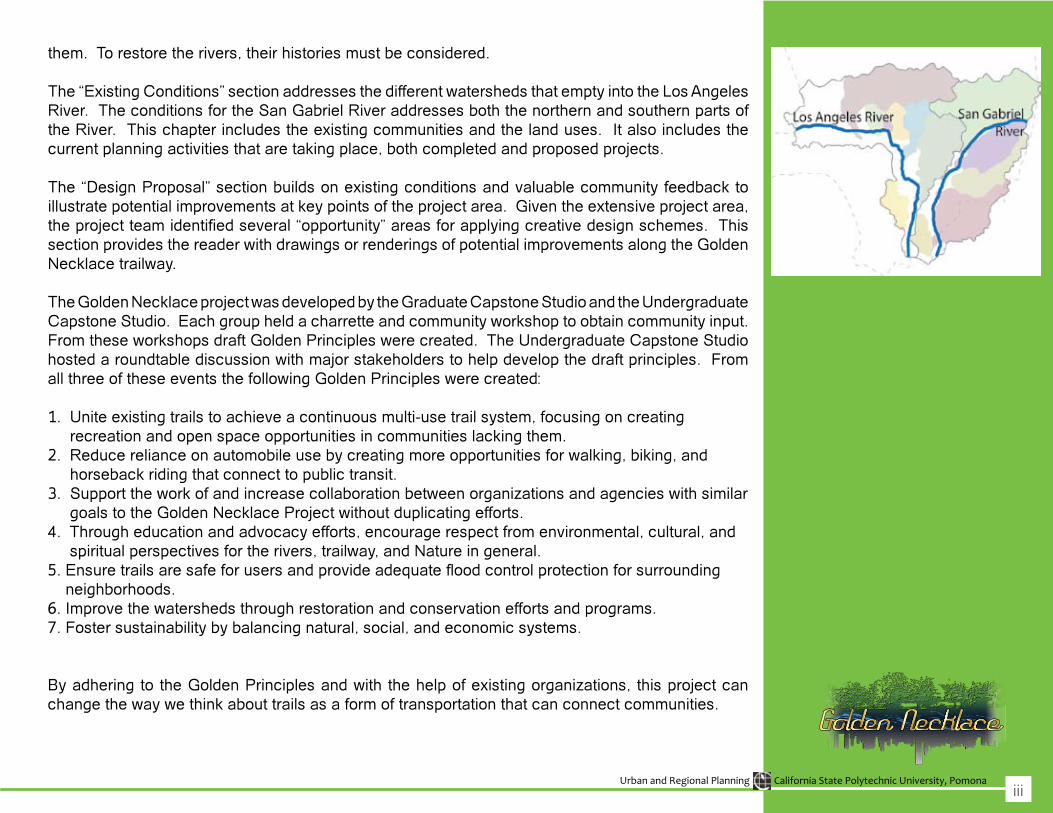
Cities across America are rediscovering their rivers. Los Angeles is no exception. Historically, rivers have served multiple purposes: recreation, food source, transportation, irrigation, etc. Over the decades,however,riverswereneglectedasindustrialusestookcontrolinmanycities.Today,withintenseindustrialactivitybeginningtowane,manycitiesarebeginningtorecognizethepotentialforeconomicandsocialrevitalizationalongtheirriverfrontsandareconfrontedwiththechallengingtaskofbalancingurbanredevelopmentwithecologicalrestoration.
TheGoldenNecklaceprojectproposestoreclaimportionsoftheunderutilizedrivercorridorsinthegreaterLosAngelesarea.TheGoldenNecklaceprojectmorespecificallyidentifiesandassessestheopportunities fora regional trail systemconnecting theSanGabrielMountains to thePacificOcean via primarily the Los Angeles and San Gabriel River corridors. The goal is to facilitate a connected multi-use trail system from the San Gabriel Mountains to the sea by serving as primarily an educational clearinghouse; providing coordination, outreach, policy recommendations, and advocacy;andproposingordevelopingspecificimplementationprojects,asneeded.
TheGoldenNecklaceFrameworkReportisbrokendownintothefollowingthreesections:
History of the Los Angeles River and San Gabriel RiverExisting ConditionsDesign Proposals
The “History of the Los Angeles River and San Gabriel River” section describes the transformations. BothriverscausedfloodsinseveralareasandtheArmyCorpsofEngineersrespondedbychannelizing
ii
Urban and Regional Planning California State Polytechnic University, Pomona
them. To restore the rivers, their histories must be considered.
The“ExistingConditions”sectionaddressesthedifferentwatershedsthatemptyintotheLosAngelesRiver. The conditions for the San Gabriel River addresses both the northern and southern parts of the River. This chapter includes the existing communities and the land uses. It also includes the current planning activities that are taking place, both completed and proposed projects.
The “Design Proposal” section builds on existing conditions and valuable community feedback to illustrate potential improvements at key points of the project area. Given the extensive project area, theprojectteamidentifiedseveral“opportunity”areasforapplyingcreativedesignschemes.ThissectionprovidesthereaderwithdrawingsorrenderingsofpotentialimprovementsalongtheGoldenNecklacetrailway.
TheGoldenNecklaceprojectwasdevelopedbytheGraduateCapstoneStudioandtheUndergraduateCapstoneStudio.Eachgroupheldacharretteandcommunityworkshoptoobtaincommunityinput.FromtheseworkshopsdraftGoldenPrincipleswerecreated.TheUndergraduateCapstoneStudiohostedaroundtablediscussionwithmajorstakeholderstohelpdevelopthedraftprinciples.FromallthreeoftheseeventsthefollowingGoldenPrincipleswerecreated:
1.Uniteexistingtrailstoachieveacontinuousmulti-usetrailsystem,focusingoncreating recreation and open space opportunities in communities lacking them.2.Reducerelianceonautomobileusebycreatingmoreopportunitiesforwalking,biking,and horseback riding that connect to public transit.3.SupporttheworkofandincreasecollaborationbetweenorganizationsandagencieswithsimilargoalstotheGoldenNecklaceProjectwithoutduplicatingefforts.4. Through education and advocacy efforts, encourage respect from environmental, cultural, and spiritualperspectivesfortherivers,trailway,andNatureingeneral.5.Ensuretrailsaresafeforusersandprovideadequatefloodcontrolprotectionforsurrounding neighborhoods.6.Improvethewatershedsthroughrestorationandconservationeffortsandprograms.7. Foster sustainability by balancing natural, social, and economic systems.
Byadheringto theGoldenPrinciplesandwiththehelpofexistingorganizations, thisprojectcanchangethewaywethinkabouttrailsasaformoftransportationthatcanconnectcommunities.
iii

Rive
r His
torie
s

Urban and Regional Planning California State Polytechnic University, Pomona
Los
Ang
eles
Riv
er H
isto
ry
The Los Angeles River helped support a rich diversity of plants, animals, and one of the largest concentrations of Native Americans. At the time of the European Conquest there wasbelieved to be 5,000 Gabrieleños, one of the most culturally advanced groupsintheSouthwest.Therewerealso settlements along the Cahuenga (Kawengna) Pass, Encino/Ventura(Suitcanga)andpresentDayElysianPark (Maungiia). The Gabrieleñosdid not need to engage in agriculture because of the abundance of edible plants (e.g. berries, gooseberries, blackberries,andcurrants).Theriverbecame very important in the social, cultural, and spiritual lives of these Native Americans.
In1781,drawnbyasteadysupplyofwater,SpainestablishedElPuebloDeLa Reina de Los Angeles. “The river, furthermore, would prove integral tothe transformation of that pueblo into the largest and most important city in the American West” (Gumprecht, 1999: 39). Settling along the LosAngeles River provided a readily availablesourceoffreshwaterforcropirrigation and every day needs. Indian labor helped Los Angeles become the most important agricultural settlement on the Pacific Coast by the early
1800s (Gumprecht,1999). “In1836,after receiving complaints that the volume of water in the Zanja Madrewas no longer sufficient, the towngovernment ordered that all drunken Indians be arrested to work on theditchesuntiltheamountofwatertheycarried was sufficient” (Gumprecht,1999: 47). The population of LosAngeles did not reach one thousand until several years after California had become the property of Mexico and the city had been made the territorial capital in 1835.
The lax regulation of the river resulted in the creation of various zanjas, small ditches, used to divert and capture water. Plenty of people bathed inthese zanjas and along the river, thus raising concern for the likely pollution of the water. Laws were passedto prohibit Natives from bathing in the river. In 1877, the city for the first time created a comprehensiveplan for development of the river’s resources, issuing $ 75,000 bonds to improve and expand the zanjas. “As thecityand regionsgrew,access towater often shaped the direction ofdevelopment. Land that did not border a river or a zanjawasoftendeemedworthless”(Gumprecht,1999:78).Asthe population of Los Angeles nearly doubledbetween1870and1880,dueto thearrival of theSouthernPacificrailroad, the city sought to strengthen its legal right to thewater in theLosAngeles River. The rapid growthincreased the demand for waterwhich led to its drying. The City ofLos Angeles initiated legal action to stop one hundred farmers in the San Fernando Valley from using the river’s waterforirrigation.
HISTORY OF THE FLOODS
The Los Angeles area was oncesubmerged in water and theformations of mountain ranges allowed forwhat iscurrently theSanFernando Valley and San Gabriel Valley. The unconstrained run-off that once poured into the LA basin formed a rich landscape of shrubs, forests,anddensewoods. TheSanGabriel Mountains, which contributethe greatest runoff to the Los Angeles River System, are composed primarily of igneous rock that is cut by numerous faults and is heavily fractured. Most of their slopes are very steep and very young. As a result, soils are thin and rocky. Vegetation, to control run-off, does not grow due to the shortperiod of rainfall. Some of the most concentrated rainfall ever recorded in theUnitedStateshasoccurredintheSan Gabriel Mountains (Gumprecht, 1999).
Before a comprehensive program of flood control was developed,more than 336 square miles weresubject to inundation. Floods weresocommon in theGlendaleNarrowsthat once fertile bottomlands along the river were eventually abandonedbecause of the heavy presence of sediment. Until 1825, the river isbelievedtohaveflowedwestfromthepueblo along the present course of the Ballona Creek. According to the Sepulveda family whose ancestorsfirst arrived in the 1700s, the riveronce flowed southwest through thepueblo not to its current endpoint of the Los Angeles Harbor. The firstrecorded shift in the course of the Los Angeles River occurred in 1815.
3
Urban and Regional Planning California State Polytechnic University, Pomona
In the midst of pounding rain for ten straightdays, theriveroverflowed itsbanks and ventured into neighboring communities and washed up awaysome properties.
Afterthe1862flood,when$25,000invaluewaslost,therewasalargepublicoutcry for the city to protect residents. In 1868, a poorly designed city dam wasbuiltandthenwashedaway.ThefloodsfromthiswinterresultedintheSanGabrielRivercuttinganewcourseto the sea (the present day course).The phenomenon of rivers changing course was a natural occurrence.Thepotentialdangeroftheriverwasdetailed by a report conducted by city surveyor Frank Lecourvreur whoseworkledtothelobbyofafloodcontrolfor the river. The river overflowedfive times from the 1870’s to the1880s (Gumprecht, 1999). Forty tofifty homes were destroyed in 1884.LeveesbuiltbytheCityin1872,werenomatchforthefloodsof1884.
CHANNELIZATION OF THE RIVER
Despite the river’s blighted state near downtown, the river upstream
remained an important source of waterfortheCityofLosAngelesevenafter the opening of the Los Angeles-OwensRiverAqueductin1913.Thewinterof1913-1914wasan“ElNino”seasonthatstruckwithavengeance.In some areas, like the San Gabriel Mountains, rain totaled more than nineteen inches. “The peak discharge oftheLosAngelesRiverwas31,400cubic feet per second, equal to the normalflowoftheColoradoRiverandfar more than the small channel could contain” (Gumprecht, 1999: 167).Floodwaters from the rivers dumpedfour million cubic yards of silt into Los Angeles and Long Beach Harbors, which were one of the busiest portsin the United States. One channelinLosAngelesHarborwas renderedunnavigable when flood waterdeposited silt to a depth of eighteen feet. The “Catastrophic Flood of 1914” was the catalyst for the first large-scalefloodcontrol investigationsandeventually the creation of the floodcontrol program (Grumprecht, 1999).Local taxpayers were unwilling toprovide the necessary funds, so in the 1930’stheU.S.governmenttookovertheprogramafterthedisastrousfloods.
DevelopmentgrewsofastintheSanFernando Valley that some areas flooded even in years with below-normal rainfall. The river at San Fernando Valley remained largely uncontrolled. A 1931 Comprehensive Flood Control Plan approved by the County would reinforce levees fromnear Glendale all the way to LongBeach. In 1934, the New Year’sDay Flood in La Canada Valley killed 49 people, destroyed 198 homes, and caused 6.1 million (73.4 million today) indamages. Thiswasthe flood that is believed to havebrought national attention to the floodhazards inSouthernCalifornia. The County was forced to solicitassistance from the federal government after its bond measure was narrowly defeated in 1934. InJuly of 1935, President Franklin D Roosevelt approved $13.9 million in WPA (Works Project Administration)fundstolinethechannelwithconcretefrom North Hollywood to FletcherDrive, and from Canoga Park to North Hollywood.Theriverwasdeepened,widened, and confined betweenconcrete banks from Lankershim Boulevard in North Hollywood toElysianPark. During thefirst twelvemonths of construction, more than twentymilliondollarshadbeenspentand 17,000 people were employed.
4
Clockwise from top: Historic aerial of the Los Angeles River. Floods in Long Beach. Construction of Los Angeles River Flood Control. Los Angeles River Floods

Urban and Regional Planning California State Polytechnic University, Pomona
San
Gab
riel R
iver
His
tory
The San Gabriel River is approximatelyseventy-fivemileslongand was named after the SpanishMissionSanGabrielArcangel,whichwas established by settlers in 1771(San Gabriel River Master Plan, 7).The mission era ended in 1834 (San Gabriel River Master Plan, 7) andRanchoswere establishedwhen theland was transferred to individualswithin the Valley. This was shortlivedduetofloodsanddroughts(SanGabriel River Master Plan, 8). TheSan Gabriel River became a major foundation for agricultural efforts whichbegan shortly after 1850 (SanGabrielRiverMasterPlan, 8).Someagricultural products of the valley were:citrus,grapes,walnuts,aswellas fertile lands for dairy and fieldcrops (San Gabriel River Master Plan, 8).TheSanGabrielRiver, like otherrivers in Los Angeles County wassusceptibletofloodingwhichposedadanger to residents and the economy. The1914and1916floods led to theestablishment of the Los Angeles County Flood Control District (San GabrielRiverMasterPlan,8).Dams,
debris basins, and channeling portions of the riverwithconcrete liningwereproposed solutions by LACFCD and the Army Corps of Engineers for the flooding and risks that it posed (SanGabrielRiverMasterPlan,8).
World War II also led to a more industrial effort. With industry, also cametheneedforhousing,whichgavewaytothecreationofsuburbia.AfterWorld War II, more families migrated to the South San Gabriel River region inhopesofnewopportunitiesandthedreamofpurchasingtheirownsingle-family homes. (San Gabriel River MasterPlan,8).
The northern portion of the San Gabriel River runs from the Angeles National Forest, through the cities of Duarte,Azusa, Irwindale, BaldwinPark,andElMonte.It intersectswithInterstate-210, Interstate-10, and StateRoute-60,whilerunningparallelto Interstate-605, conveniently named theSanGabrielRiverFreeway.
The first inhabitants of Duarte werethe Gabrielino Indians because of its meadows, wild grapevines andfresh water. Later Rancho Azusawasformedandgranted7,000acresof land in the upper San Gabriel Valley in 1841 (“City of Duarte: A CommunityWorkingTogether,”2001).The Gabrielino Indians utilized theSan Gabriel River often. The Tongva Indianswerehunterandgathersandrelied heavily on the use of the river for food and even as a means of transportationdowntothesea.Bythemid-1800s, high debts caused Andres Duartetogiveawaymostoftheland.A portionwas sold toDr.Nehemiah,
who founded the first section of thecity’s waterlines. The remainder ofthelandwasdividedandsoldas40-acre plots. Eventually the Hispanics and Japanese immigrants helped Duarte to strive as an agricultural community based on citrus production (“City of Duarte: A Community WorkingTogether,”2001).Duartewasincorporated in 1957 (City of Duarte, 2000). TheGabrielino Indians werethe first inhabitants of Azusa whichwas founded in 1887 and it becameincorporated on December 29,1898 (CityofAzusa,2000).Goldwasfoundin the nearby San Gabriel Canyon making the area of Azusa popularplace for those seeking fortune (“City of Azusa,2000). Further down thetrail is the City of Irwindale (City ofIrwindale, 2001). The first freewayschanged the city’s economics, by requiring vast quantities of crushed rockandgravel.Thiswealthattractedthe county’s interest and paved the way for Irwindale’s incorporation in
5

Urban and Regional Planning California State Polytechnic University, Pomona
1957 (City of Irwindale, 2001). SanGabrielRiver laterslopesdown fromIrwindaletoBaldwinParkwhichusedtobecattlegrazingland.BaldwinParkevolved to an agricultural community. Duetowatershortagefarmershadtouse the river as an alternativewatersource to seasonal rainfalls (“City of Baldwin Park”, 2006). Baldwin Parkwas incorporatedafterhalfacenturyin 1956, and became the forty-seventhGeneralLawCityinthestateof California (“City of Baldwin Park”,2006).ThefinalportionofthenorthernSan Gabriel River Trail leads to the City of El Monte. El Monte is located at the intersection of Interstate-605 and Interstate-10. (City of El Monte, 2006:3).
6
Clockwise from top: Historic view of San Gabriel Mountains. Workers diverting the San Gabriel River. View of River in its natural state. Fishing in the San Gabriel River. Fishing along the banks. Early Settlers.

Exis
ting
Cond
ition
s

Urban and Regional Planning California State Polytechnic University, Pomona
Wat
ersh
edLo
s A
ngel
es R
iver
Planning activities along the Los Angeles River is guided by the Los Angeles River Revitalization MasterPlan (LARRMP). In 2002, an AdHoc Committee was formed by theLos Angeles City Council, led by Ed Reyes with the intent on gainingcommunity involvement in the river’s revitalizationprocess.TheCommitteehas focused on major revitalizationissues, including opportunities for implementing projects, such as bridges, parks, bicycle paths, pedestrian trails, other recreational amenities, and programs to encourage public education, litter removal, job creation, community development, tourism, civic pride, and improved waterquality.In2005,MayorAntonioVillaraigosa formally endorsed the City Council’s recommendation to develop the LosAngeles River RevitalizationMaster Plan.
Canoga Park - Winnetka
These communities lie on the southwestern most boundary ofthe City of Los Angeles in the San Fernando Valley and are guided by the Canoga Park, Winnetka, Woodland Hills, and West Hills Community Plans. For this Community Plan’s boundaries, the Los Angeles River only crisscrosses the communities of Canoga Park and Winnetka. The channelizedLosAngelesRiverstartsin the community of Canoga Park, at the Arroyo Calabasas and Bell Creek confluence,nexttoCanogaParkHighSchool.
The zoning for the area immediatelynear the Arroyo Calabasas and Bell Creek confluence is predominatelycommercial and light industrial. In the area, as in other parts of Canoga Park, there is a lack of delineation or separation of industrial and residential uses.Thezoningalongtheriverthen
proceeds to become both multifamily residential (on the south side of the river)andsinglefamilyhousing(onthenorth side) until it reachesWinnetkawhere it becomes exclusively lowdensity on both sides. In summary, the majority of the land use immediately adjacent to Los Angeles River in this area is predominately residential.
In the Summer of 2005, Canoga Park became the first community in theCity of Los Angeles to be awardedthe All America City prize by theNational Civic League. This awardwas achieved through the rigorousinvestmentandrenewaleffortsledbycommunity groups, business entities, and the Community Redevelopment Agency of Los Angeles (CRA-LA) in Canoga Park’s Downtownarea. The Downtown area and/or main commercial corridor along Sherman Way is amongst CRA-LA’s thirty- two project areas targeted forredevelopment. The devastation and
9
Urban and Regional Planning California State Polytechnic University, Pomona
blight caused by the 1994 Northridge Earthquake in the West Valley resulted in CRA-LA targeting of Canoga Park’s Downtown area. Winnetka is undersimilar conditions with single andmulti-family residential on both sides of the river. Pierce College is also located less than half a mile south of the river.
Planning Activities
LosAngelesRevitalizationMasterPlanidentifiesCanogaParkasoneof thefiveopportunity areasdetailed in themasterplan.ThePlanconceptualizes
the creation of a community park and restoration of the River’s ecological function, including naturalization ofthe concrete channel, and a ponded area extending from Canoga Avenue to Owensmouth Avenue. Thefollowing map from the LARRMPshows this area of opportunity plus28otherpotentialprojectareaswithinand outside of the opportunity area.
10
Urban and Regional Planning California State Polytechnic University, Pomona
Wat
ersh
edLo
s A
ngel
es R
iver
Reseda - West Van Nuys
Similar to thepatternsof lowdensityresidential use along the LA River in Winnetka and Canoga Park, the adjacent uses along the river in Reseda is predominately residential. This area is served by the Reseda - West Van Nuys Community Plan. The areas southof therivercontain lowdensityhousing, while the areas north arelow mediummultiple family housing.The denser multifamily housing is clustered near Reseda Boulevard, a major commercial corridor that spans from north to south in the San Fernando Valley. Reseda Boulevard and Sherman Way Boulevard have been designated as the Central Business District for Reseda. The LA River intersects Reseda Boulevard approximately one mile from the CentralBusinessDistrictwhichisalsoa CRA-LA Redevelopment Project Area. At this point of intersection, Reseda Recreational Center Park (pictureontheleft)liesadjacenttotheLA River.
The land uses along Reseda Boulevard are predominately general and neighborhood commercial uses. Reseda is being targeted by CRA-LA for redevelopment investments. TheLARiver ineffect lieswithin theboundaries of this redevelopment
project area. Similar to the CRA-LA effortsinCanogaPark,thedowntownReseda area is also being targeted for storefront improvements, and other design guidelines and investments that improve/enhance the pedestrianexperience. The centerpiece of these redevelopment efforts is the adaptive reuse of the old dilapidated Reseda Theater. In addition to CRA’s commitment to pedestrian activity, the Community Plan for this community identifies a backbone bikewaysystem through Reseda - West Van Nuys. The plan specifically cites acommitment to encourage the funding and construction of bicycle routes connecting residential neighborhoods to schools, open space areas, and employment centers. In addition, it calls for a Class 1 Bike Path along the Los Angeles River.
11

Urban and Regional Planning California State Polytechnic University, Pomona
Planning Activities
The Los Angeles RevitalizationMaster Plan shows the intersectionof the River with Reseda Park asan opportunity area. It proposes a RegionalGateway intoapromenadealong the river or a recreational trail way. It also proposes a park at thecorner where Aliso Creek and theLos Angeles River meet. The project couldincludeanon-motorizedbridgetoconnecttheparkwiththeadjacentcommunity across Aliso Creek. A bike path along the south side of the river is also proposed.
Encino – Tarzana
The transverse of the LA River across the community of Encino takes place near an area of very low density residential uses and thelarge recreational Sepulveda Basin Recreational area. The recreational area consists of Balboa Sports Center, Hjelte Sports Center, Lake Balboa/Anthony C. Beilenson Park, Sepulveda Garden Center, Sherman Oaks Castle Park, Woodley Park, Encino Golf Course, Balboa Golf Course, and Woodley Lakes Golf Course. The
recreational area amounts to 2,031 acres of park space, a bike path, and a225acrewildlifereserve.Accordingto the Santa Monica Mountains Conservancy,overtwohundredtypesof birds have been seen in this basin. The bike path around the perimeter of the Sepulveda Basin Recreational Area totals nine miles. The northern boundary of the recreational area lies immediately adjacent to Metro’s Orange Line Busway which runs
Clockwise: Reseda park, Non-motor-ized bridge at Reseda Park.
12
Urban and Regional Planning California State Polytechnic University, Pomona
Wat
ersh
edLo
s A
ngel
es R
iver
AngelesRiverTheRevitalizationPlanenvisions more connectivity across the river through non-motorizedbridges as well as the creation ofwetlandparks.
Clockwise From the Right: Balboa Lake, Bull Creek which runs into the Los Angeles River, Hostile Environment under Balboa Boulevard, Concrete Banks along the LA River.
Sherman Oaks - North Sherman Oaks
In the north portion of Sherman Oaks, the community is predominately characterized by low densityresidential and multifamily uses north of the river, and commercial usage south of the river. The community plan for North Sherman Oaks notably calls
parallel to Victory Boulevard on the formerSouthernPacific rightofway.The River continues to be a barrier instead of a focal point despite this section having more natural features than other parts of the Los Angeles River. It still continues to be the back alley,thesewagesystemthatcarriesthe city’s garbage. Pedestrian access to the River is blocked off for the most part although some access points are available. These direct access points are located at the back and they do not provide the pleasant experience thatawalkbytheriverhastooffer.
Planning Activities
This area is the focus of the Army Corp of Engineers. The River Project, a non-profit organization“dedicated to planning for natural resource protection, conservation and enhancement in the Los Angeles County,” also focuses part of their efforts in this area. They have proposed to remove any concrete embarkment left along the river in the
Sepulveda Basin just east and westof Balboa Boulevard. The image belowshowstheconcretebankswithvegetation growing along the water.The Army Corps of Engineers is restoringBullCreekwhichisadjacentto Balboa Lake and north of the Los
13

Urban and Regional Planning California State Polytechnic University, Pomona
for the improvement or addition of parkspaceinthisarea,wherefeasibleand necessary. As stated, the area south of the LA River is predominately commercial, and this land use pattern ultimately accompanies the river as it snakes east of the San Fernando Valley towards Toluca Lake andthe City of Burbank. In this eastern part of the San Fernando Valley, the major commercial corridor of Ventura Boulevard runs parallel to the LA River within proximity of less thenahalf amile in some areas.
Planning Activities
As with other communities, most ofthe river is off limits to pedestrians. Ernie’s Walk is an improvement that allowspedestrianaccessnext to theriver. It is a landscaping improvement about 432 yards from Kester Ave. and Cedros Ave. This project wascompletedin2003,andwasproposed
by the Los Angeles County Department of Public Works, LA County Supervisor District 3, and the Sherman Oaks Homeowners Association. Theprojectprovidesapleasantwalkeventhough theVenturaFreewaybordersthe opposite side of the river. It is an example of what communities cando to create open spaces. Many of the previous communities mentioned have residences adjacent to the river thatwouldbenefitfromimprovementsalong the river. The RevitalizationMaster Plan also sees these strips of land along the river as opportunity areasforneighborhoodgreenways.Itidentifies various locations along theriver where neighborhood gatewayscan be built. As previously mentioned most of these areas are presently fenced off. Pictured on the previous page are Ernie’s Walk and its entrance.
14
Urban and Regional Planning California State Polytechnic University, Pomona
Wat
ersh
edLo
s A
ngel
es R
iver
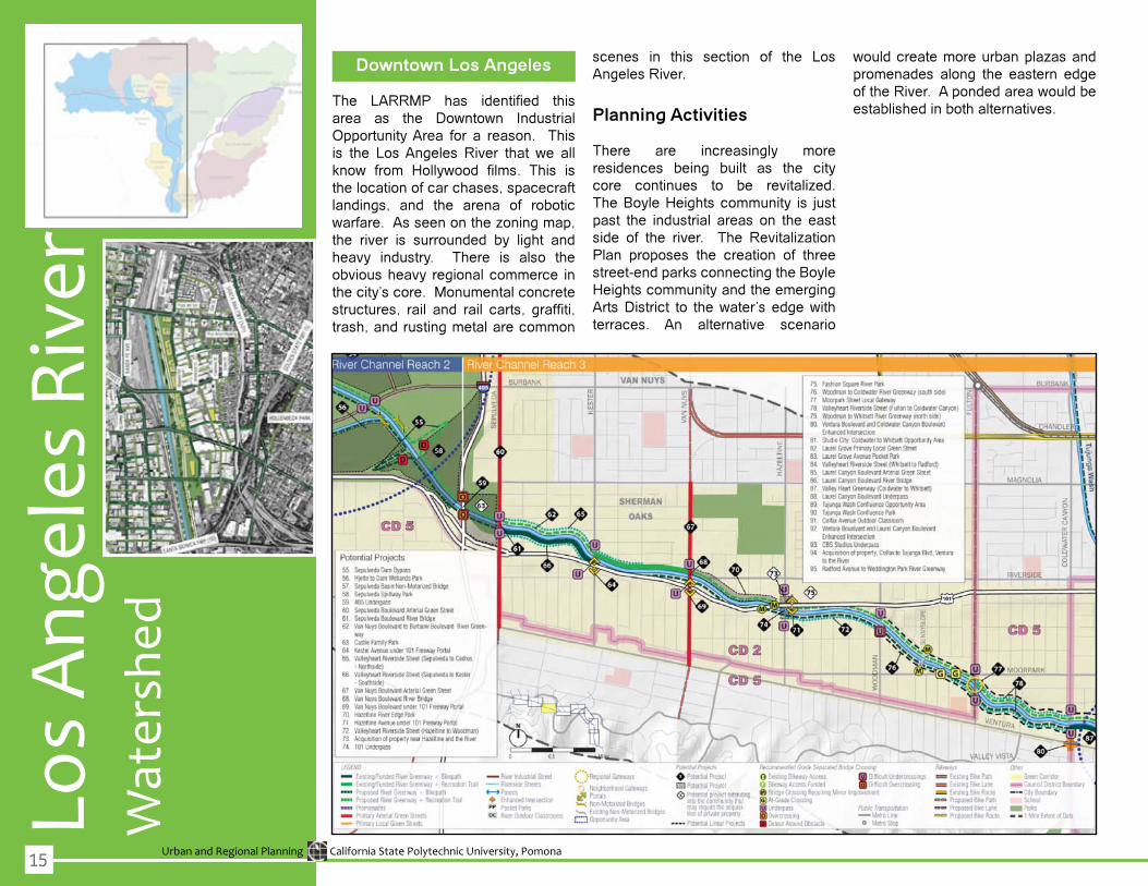
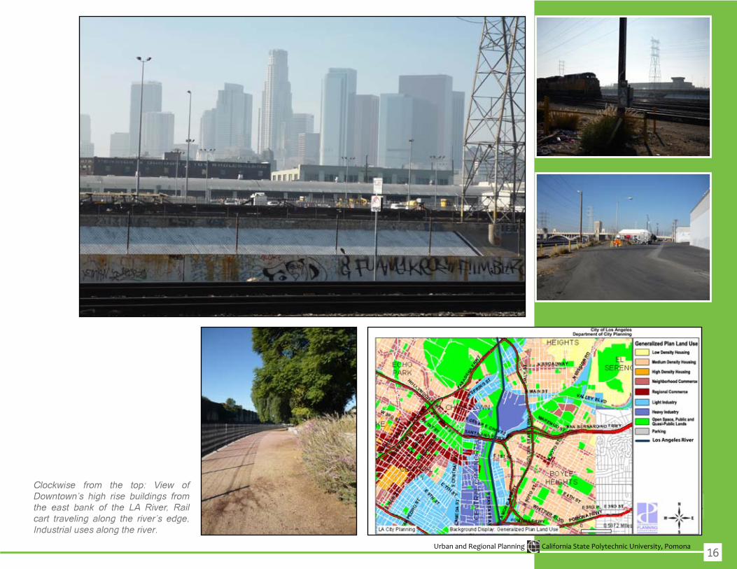
Downtown Los Angeles
The LARRMP has identified thisarea as the Downtown IndustrialOpportunity Area for a reason. This is the LosAngeles River that we allknow from Hollywood films. This isthe location of car chases, spacecraft landings, and the arena of robotic warfare.Asseenonthezoningmap,the river is surrounded by light and heavy industry. There is also the obvious heavy regional commerce in the city’s core. Monumental concrete structures, rail and rail carts, graffiti,trash, and rusting metal are common
scenes in this section of the Los Angeles River.
Planning Activities
There are increasingly more residences being built as the city core continues to be revitalized.The Boyle Heights community is just past the industrial areas on the east side of the river. The RevitalizationPlan proposes the creation of three street-end parks connecting the Boyle Heights community and the emerging ArtsDistrict to thewater’s edgewithterraces. An alternative scenario
wouldcreatemoreurbanplazasandpromenades along the eastern edge oftheRiver.Apondedareawouldbeestablished in both alternatives.
15
Urban and Regional Planning California State Polytechnic University, Pomona
Clockwise from the top: View of Downtown’s high rise buildings from the east bank of the LA River, Rail cart traveling along the river’s edge, Industrial uses along the river.
16
Urban and Regional Planning California State Polytechnic University, Pomona
Tuju
nga
Was
hLo
s A
ngel
es R
iver
Studio City
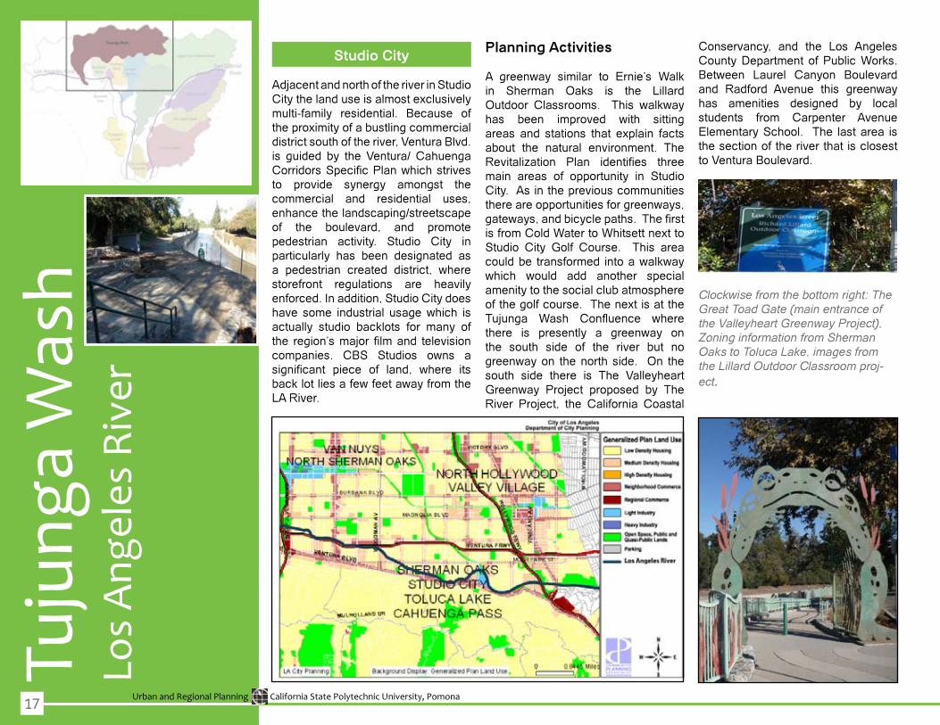
Adjacent and north of the river in Studio City the land use is almost exclusively multi-family residential. Because of the proximity of a bustling commercial district south of the river, Ventura Blvd. is guided by the Ventura/ CahuengaCorridorsSpecificPlanwhichstrivesto provide synergy amongst the commercial and residential uses, enhancethelandscaping/streetscapeof the boulevard, and promote pedestrian activity. Studio City in particularly has been designated as a pedestrian created district, wherestorefront regulations are heavily enforced. In addition, Studio City does have some industrial usagewhich isactually studio backlots for many of the region’smajorfilmand televisioncompanies. CBS Studios owns asignificant piece of land, where itsbacklotliesafewfeetawayfromtheLA River.
Planning Activities
A greenway similar to Ernie’s Walkin Sherman Oaks is the Lillard Outdoor Classrooms. This walkwayhas been improved with sittingareas and stations that explain facts about the natural environment. The Revitalization Plan identifies threemain areas of opportunity in Studio City. As in the previous communities thereareopportunitiesforgreenways,gateways,andbicyclepaths.Thefirstis from Cold Water to Whitsett next to Studio City Golf Course. This area couldbe transformed intoawalkwaywhich would add another specialamenity to the social club atmosphere of the golf course. The next is at the Tujunga Wash Confluence wherethere is presently a greenway onthe south side of the river but no greenwayon thenorthside. On thesouth side there is The Valleyheart Greenway Project proposed by TheRiver Project, the California Coastal
Conservancy, and the Los Angeles County Department of Public Works. Between Laurel Canyon Boulevardand Radford Avenue this greenwayhas amenities designed by local students from Carpenter Avenue Elementary School. The last area is the section of the river that is closest to Ventura Boulevard.
Clockwise from the bottom right: The Great Toad Gate (main entrance of the Valleyheart Greenway Project), Zoning information from Sherman Oaks to Toluca Lake, images from the Lillard Outdoor Classroom proj-ect.
17

Urban and Regional Planning California State Polytechnic University, Pomona
Counterclockwise from the top right: Tujunga Wash Confluence, potential greenway along the river near Tujunaga Confluence with multi-family residential behind the trees, potential project areas identified by the Los Angeles River Revitalization Master Plan.
18

Urban and Regional Planning California State Polytechnic University, Pomona
Tuju
nga
Was
hLo
s A
ngel
es R
iver
Toluca Lake
Thisaffluentarea,thehomeofseveralA-list Hollywood figures, enjoy anarray of open space opportunities. The Santa Monica Mountains alone, located south of the river, offer an incredible recreational opportunity for Toluca Lake’s residents. Adjacent to the river areUniversal Studios’ backlot on the south side and Lakeside Golf Course on the north. The river is virtually non-existent to the golf course. Trees line up along the north bankwhile industry comesupas faras possible on the south side. North of the golf course is Toluca Lake, which provides areas for swimming,boating,andfishing.Theothermajoropen space area is Weddington Park along the Hollywood Freeway. TheLosAngelesRiver,whichrunsstraightthrough the middle of the park, acts as an edge instead of a focal point. The park is surrounded by residential homesaswellasRioVistaElementarySchool.Thereisnodirectlinkbetween
both sides of the park. There is in fact no immediate access on to the land adjacenttotheriver.Onewouldhavetowalkatleast500yardstoLakershimBoulevard and another 500 back just to get from the north side to the south side. There are residential homes east of Lankershim and north of the golf course surrounding Toluca Lake.
Planning Activities
The Revitalization Plan seesWeddington Park as an opportunity area. It proposes a non-motorizedbridge to connect both sides of the park. Some of these bridges already exist along the river although very austere in appearance. With plenty of regional commercial areas it also proposes a promenade betweenWeddington Park and Lankershim. This would provide a transitionbetween the commercial district ofLankershim and the natural setting of the Weddington Park.
Clockwise from the bottom right: South Weddington Park looking from North Weddington Park, Industry on the southern bank, Golf Course on the northern bank, North Weddington Park with Santa Monica Mountains in the background, Downstream moving toward Griffith Park.
19

Urban and Regional Planning California State Polytechnic University, Pomona20
Urban and Regional Planning California State Polytechnic University, Pomona
Burb
ank
Los
Ang
eles
Riv
er
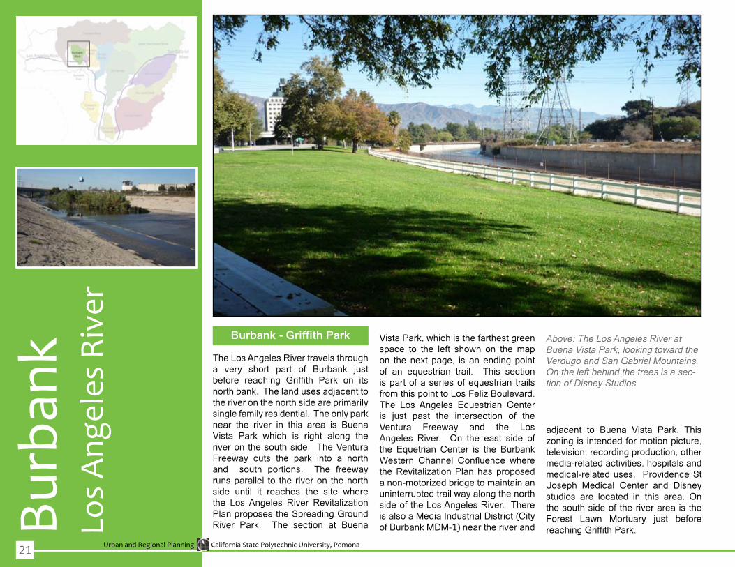
Burbank - Griffith Park
The Los Angeles River travels through a very short part of Burbank just before reaching Griffith Park on itsnorth bank. The land uses adjacent to the river on the north side are primarily single family residential. The only park near the river in this area is Buena Vista Park which is right along theriver on the south side. The Ventura Freeway cuts the park into a northand south portions. The freewayruns parallel to the river on the north side until it reaches the site wherethe LosAngeles River RevitalizationPlan proposes the Spreading Ground River Park. The section at Buena
VistaPark,whichisthefarthestgreenspace to the left shown on themapon the next page, is an ending point of an equestrian trail. This section is part of a series of equestrian trails fromthispointtoLosFelizBoulevard.The Los Angeles Equestrian Center is just past the intersection of the Ventura Freeway and the LosAngeles River. On the east side of the Equetrian Center is the Burbank Western Channel Confluence wheretheRevitalizationPlanhasproposedanon-motorizedbridgetomaintainanuninterruptedtrailwayalongthenorthside of the Los Angeles River. There is also a Media Industrial District (City ofBurbankMDM-1)neartheriverand
adjacent to Buena Vista Park. This zoningisintendedformotionpicture,television, recording production, other media-related activities, hospitals and medical-related uses. Providence St Joseph Medical Center and Disney studios are located in this area. On the south side of the river area is the Forest Lawn Mortuary just beforereachingGriffithPark.
Above: The Los Angeles River at Buena Vista Park, looking toward the Verdugo and San Gabriel Mountains. On the left behind the trees is a sec-tion of Disney Studios
21
Urban and Regional Planning California State Polytechnic University, Pomona
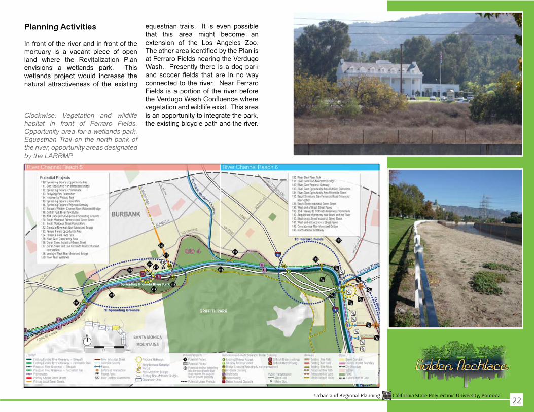
Clockwise: Vegetation and wildlife habitat in front of Ferraro Fields, Opportunity area for a wetlands park, Equestrian Trail on the north bank of the river, opportunity areas designated by the LARRMP.
Planning Activities
In front of the river and in front of the mortuary is a vacant piece of open land where the Revitalization Planenvisions a wetlands park. Thiswetlands project would increase thenatural attractiveness of the existing
equestrian trails. It is even possible that this area might become an extension of the Los Angeles Zoo.TheotherareaidentifiedbythePlanisat Ferraro Fields nearing the Verdugo Wash. Presently there is a dog park and soccer fields that are in nowayconnected to the river. Near Ferraro Fields is a portion of the river before theVerdugoWashConfluencewherevegetationandwildlifeexist.Thisareais an opportunity to integrate the park, the existing bicycle path and the river.
22
Urban and Regional Planning California State Polytechnic University, Pomona
Verd
ugo
Was
hLo
s A
ngel
es R
iver
Griffith Park - Atwater Village
This point is where the river turnssoutharoundGriffithPark,stretchingfrom the Verdugo Confluence toAtwater Village neighborhood to thesouth. As seen in the land use map, this area is a combination of light to heavyindustry,lowdensityresidentialwith strips of commercial and openspaces. The green open spaces are parks and golf courses along the river. A long section of the river in this area has been restored to a more natural state. On thewest sideof thebankisamajorgolfcourseaswellas theLosAngeles Zoo. The east bank isprimarily industrial as seen in the land usemap.ThePlanhasidentifiedthislocation as the River Glen opportunity area. Further south is the community of Atwater Village which is primarilylowdensityresidential.
Planning Activities
As previously mentioned, a great portion of the river has been restored to its natural state. The most noticeable improvements is the Los
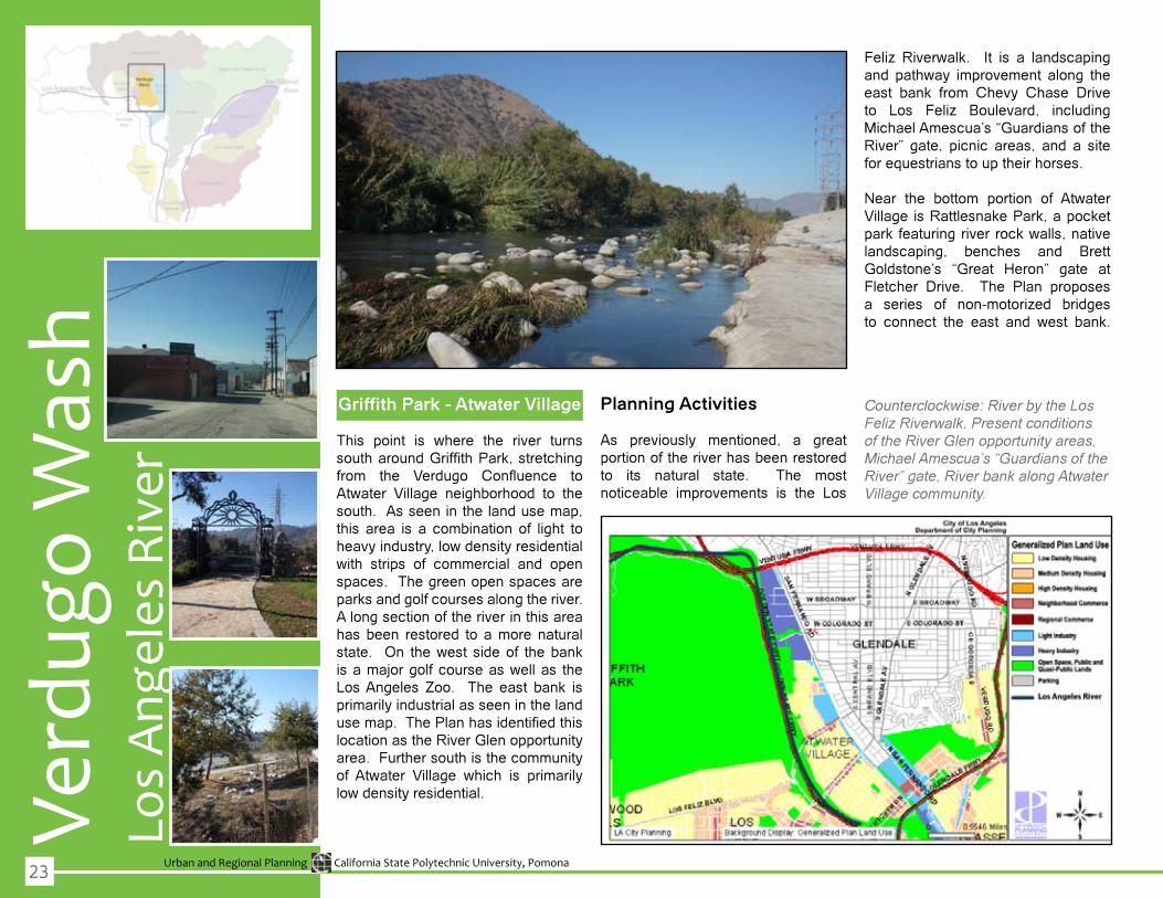
Feliz Riverwalk. It is a landscapingand pathway improvement along theeast bank from Chevy Chase Drive to Los Feliz Boulevard, includingMichael Amescua’s “Guardians of the River” gate, picnic areas, and a site for equestrians to up their horses.
Near the bottom portion of AtwaterVillage is Rattlesnake Park, a pocket park featuringriverrockwalls,nativelandscaping, benches and Brett Goldstone’s “Great Heron” gate at Fletcher Drive. The Plan proposes a series of non-motorized bridgesto connect the east and west bank.
Counterclockwise: River by the Los Feliz Riverwalk, Present conditions of the River Glen opportunity areas, Michael Amescua’s “Guardians of the River” gate, River bank along Atwater Village community.
23
Urban and Regional Planning California State Polytechnic University, Pomona
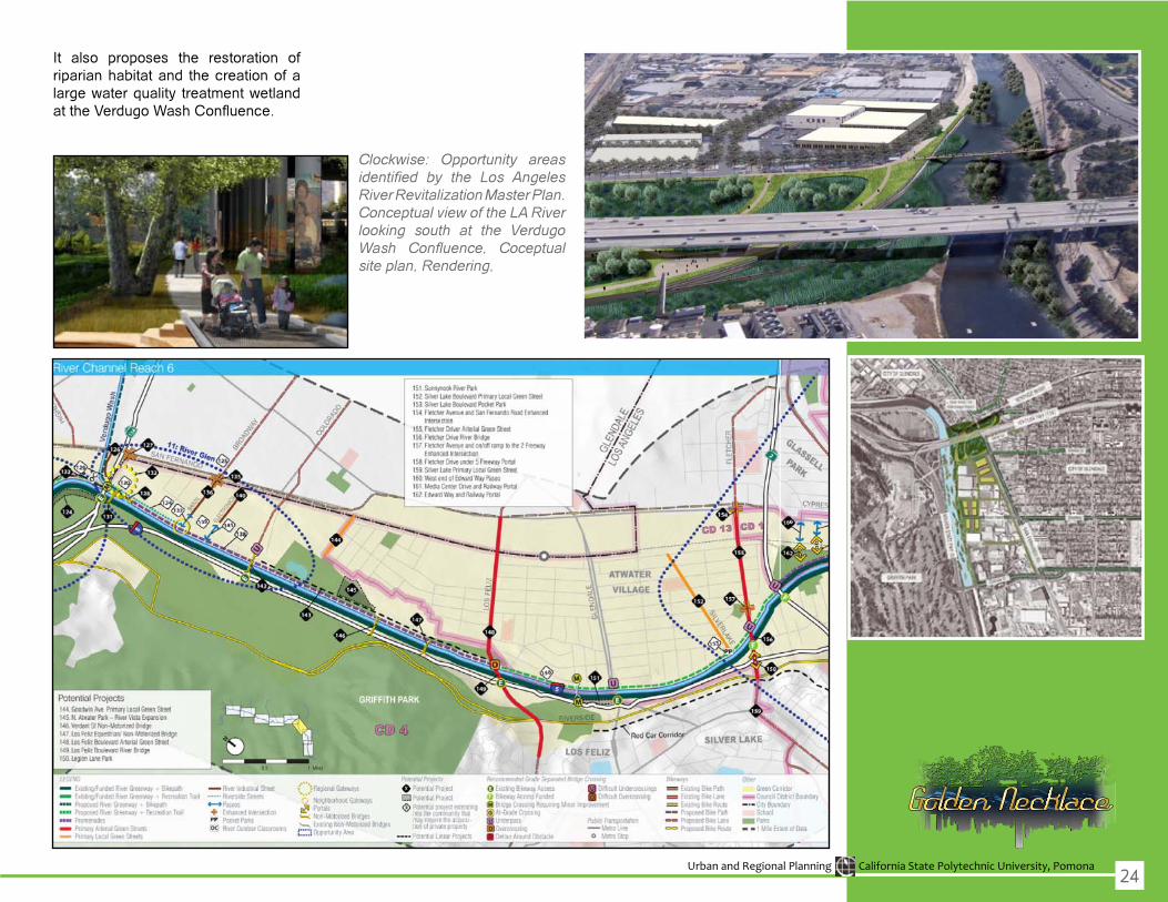
It also proposes the restoration of riparian habitat and the creation of a largewaterquality treatmentwetlandattheVerdugoWashConfluence.
Clockwise: Opportunity areas identified by the Los Angeles River Revitalization Master Plan. Conceptual view of the LA River looking south at the Verdugo Wash Confluence, Coceptual site plan, Rendering,
24
Urban and Regional Planning California State Polytechnic University, Pomona
Arr
oyo
Secc
oLo
s A
ngel
es R
iver
Elysian Valley - Chinatown/Cornfields
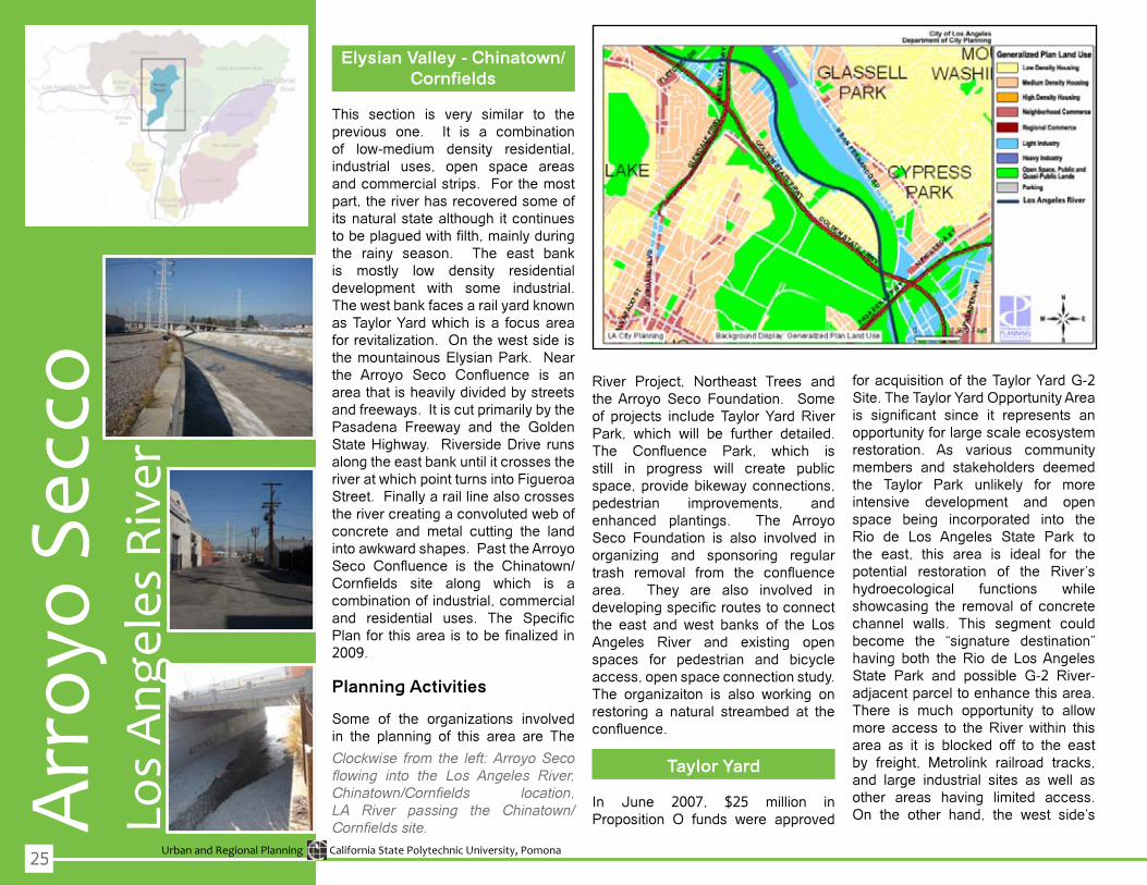
This section is very similar to the previous one. It is a combination of low-medium density residential,industrial uses, open space areas and commercial strips. For the most part, the river has recovered some of its natural state although it continues tobeplaguedwithfilth,mainlyduringthe rainy season. The east bank is mostly low density residentialdevelopment with some industrial.ThewestbankfacesarailyardknownasTaylorYardwhich isa focusareaforrevitalization.Onthewestsideisthe mountainous Elysian Park. Near the Arroyo Seco Confluence is anarea that is heavily divided by streets andfreeways.ItiscutprimarilybythePasadena Freeway and the GoldenStateHighway. RiversideDrive runsalong the east bank until it crosses the riveratwhichpointturnsintoFigueroaStreet. Finally a rail line also crosses therivercreatingaconvolutedwebofconcrete and metal cutting the land intoawkwardshapes.PasttheArroyoSeco Confluence is the Chinatown/Cornfields site along which is acombination of industrial, commercial and residential uses. The SpecificPlanforthisareaistobefinalizedin2009.
Planning Activities
Some of the organizations involvedin the planning of this area are The
Clockwise from the left: Arroyo Seco flowing into the Los Angeles River, Chinatown/Cornfields location, LA River passing the Chinatown/Cornfields site.
River Project, Northeast Trees and the Arroyo Seco Foundation. Some of projects includeTaylorYardRiverPark, which will be further detailed.The Confluence Park, which isstill in progress will create publicspace,providebikewayconnections,pedestrian improvements, and enhanced plantings. The Arroyo Seco Foundation is also involved in organizing and sponsoring regulartrash removal from the confluencearea. They are also involved in developingspecificroutestoconnectthe east and west banks of the LosAngeles River and existing open spaces for pedestrian and bicycle access, open space connection study. The organizaiton is also working onrestoring a natural streambed at the confluence.
Taylor Yard
In June 2007, $25 million in Proposition O funds were approved
foracquisitionof theTaylorYardG-2Site.TheTaylorYardOpportunityAreais significant since it represents anopportunity for large scale ecosystem restoration. As various community members and stakeholders deemed the Taylor Park unlikely for more intensive development and open space being incorporated into the Rio de Los Angeles State Park to the east, this area is ideal for the potential restoration of the River’s hydroecological functions whileshowcasing the removal of concretechannel walls. This segment couldbecome the “signature destination” having both the Rio de Los Angeles State Park and possible G-2 River-adjacent parcel to enhance this area. There is much opportunity to allowmore access to theRiverwithin thisarea as it is blocked off to the east by freight, Metrolink railroad tracks, and large industrial sites as well asother areas having limited access. On the other hand, the west side’s
25

Urban and Regional Planning California State Polytechnic University, Pomona
Elysian Valley has close connection totheriverasmosteast-weststreetsend with direct access to the River,including some River-themed pocket parks. There are plans underway tobuild a bicycle and pedestrian bridge in an existing City maintenance yard, across the River at the end of Dorris Place.Tayloryardwasformerlyoneofmany rail transportation nodes along the River and its condition stresses how the River has been viewed asthe back door of the City, yet it is experiencing a rebirth with the newRio de Los Angeles State Park and potential for major quality treatment wetlandswithintheG-2parcel.
ApreferredalternativeforTaylorYardisto excavate the heavily contaminated soils at the River’s edge and use it to form mounded sculptural landforms that support an upland meadow-like landscape. The excavated area wouldbecappedtopreventinfiltrationof contaminants and wetlandtreatments could be constructed overthecap.Hence,thisareawouldbecome an efficient regional watertreatmentfacilityinwhichtransportedstormwater runoffcouldbecaptured.The acquisition of the G-2 parcel would allow for the naturalization ofapproximately one mile of the River alongwiththeremovalofonemileofconcretewallontheeastbank.Thiswouldstrengthentheexistingriparianhabitat and a series of pools and rifflescouldprovidefordesirablefishspecies. Primarily seen as a preserve, this areawould have limited numberofboardwalksandpathwayswouldbeprovided so that birdwatchers couldenjoy without much disturbance ofbirds. This alternative recommended
in the Plan would respond to threemajor area-specific considerationsthat address major storm drains that discharge on the east edge of the site while providing a water qualitytreatment plant, cost–effective waysof using a contaminated site withoutfurther capping and soil importation, andtonaturalizeaportionoftheRiveras the concrete is removed. The G-2 parcelwouldalsoallowforthecreationof a premier natural River area in which=aRiverPromenadeandRiverTrails can connect the area’s open space linking the Arroyo Seco, Elysian Park, and Red Car Corridor trails. A RegionalGatewaycouldcelebratethe
connectionsoftrailsattheconfluenceoftheArroyoSecohavingfitnessandtransportation loops that shape the connections,alongwithmorebridges,bike paths, andequestrian trails.
26
Urban and Regional Planning California State Polytechnic University, Pomona
Nor
thSa
n G
abrie
l Riv
erNorth San Gabriel River
Existing Site Conditions
The San Gabriel River’s history dates back to the Gabrielino Indians. The land uses around this trail vary from residential to commercial.
Zoning
The adjacent land uses along the area of Encanto Parkway consist oflow density residential zones, whichare between five to eight dwellingsperacre.ThereareveryfewportionsalongEncantoParkwaywhichconsistof Multiple Residential zones.ThisareawithintheCityofDuarteconsistsoflowdensityandhighdensityunits;however,itlacksR-2zones,whicharethepropertiesthatwouldbeeligibleforsenior housing based on their General Plan. Similarly, Baldwin Park and ElMonte have single family residential zoneslocatedadjacenttothetrail.
Topography and Geography
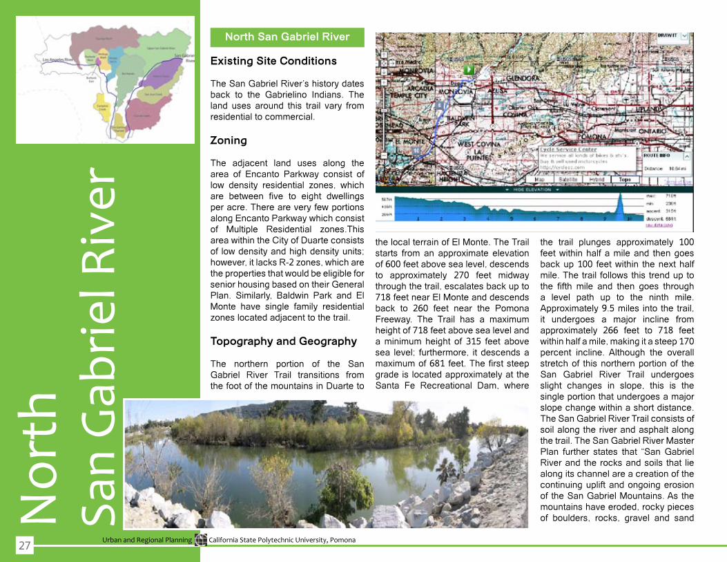
The northern portion of the San Gabriel River Trail transitions from the foot of the mountains in Duarte to
the local terrain of El Monte. The Trail starts from an approximate elevation of 600 feet above sea level, descends to approximately 270 feet midwaythrough the trail, escalates back up to 718 feet near El Monte and descends back to 260 feet near the Pomona Freeway. The Trail has a maximumheight of 718 feet above sea level and a minimum height of 315 feet above sea level; furthermore, it descends a maximumof681feet.Thefirststeepgrade is located approximately at the Santa Fe Recreational Dam, where
the trail plunges approximately 100 feetwithinhalfamileand thengoesbackup100 feetwithin thenexthalfmile.Thetrailfollowsthistrenduptothe fifth mile and then goes througha level path up to the ninth mile. Approximately 9.5 miles into the trail, it undergoes a major incline from approximately 266 feet to 718 feet withinhalfamile,makingitasteep170percent incline. Although the overall stretch of this northern portion of the San Gabriel River Trail undergoes slight changes in slope, this is the single portion that undergoes a major slopechangewithinashortdistance.The San Gabriel River Trail consists of soil along the river and asphalt along the trail. The San Gabriel River Master Plan further states that “San Gabriel River and the rocks and soils that lie along its channel are a creation of the continuing uplift and ongoing erosion of the San Gabriel Mountains. As the mountains have eroded, rocky pieces of boulders, rocks, gravel and sand
27

Urban and Regional Planning California State Polytechnic University, Pomona
(San Gabriel River Discovery Center Authority)10.
have flowed out of the mountainsand have been deposited by the river on top of the deep bedrock of the valley” (2-10, 2006).Theasphaltprovides accessibility to bicyclists and pedestrians using the trail. Dirt is also located along portions of the trail available for equestrian use.
Existing Planning Activities
San Gabriel River Corridor Master Plan: Los Angeles Department of Public WorksThe San Gabriel River Corridor Master Planwasinitiatedin1999whentheLosAngelesCounty Board of Supervisors directed the Public Works department to establish a plan for the river (San Gabriel River Master Plan, 2006).Theplanfocusesonfloodprotection,watersupply,habitat,recreation,openspace, and economic development (San Gabriel River Master Plan, 2006).Theprocessforthemasterplanhas been set up so that cities located along the river can join the County, other agencies, and stakeholders to participate in a cohesive effort to enact a shared vision of the river (San Gabriel River Master Plan, 2006). Adocument has been prepared by the Los Angeles Department of Public Works that provides much more detail
on the efforts and intentions of the master plans.
San Gabriel River Campaign: Angeles Chapter of the Sierra ClubThis effort was started by the SierraClub after the passing of State Bill 216whichestablished the riversandmountains conservancy (Angeles Chapter Sierra Club – Fact Sheet, 2006). The vision for this effort is to“create a greenbelt of public park space along the entire length of the river to serve the residents of Los Angeles County,” (Angeles Chapter Sierra Club – Fact Sheet, 2006). In2003, the Sierra Club created Amigos DeLosRios,anonprofitorganizationwhohasaided in theeffort tocreateparks to connectwith trails from theriver (Angeles Chapter Sierra Club – Fact,2006)9.
San Gabriel River Discovery Center AuthorityThe San Gabriel River Discovery Center is being proposed as a replacement to the currently existing WhittierNarrowsNatureCenter.Theintention of the Discovery Center is to, “present the story of the San Gabriel River Watershed, emphasize theimportance of water resources andthenaturalvaluesof thewatershed,”
This map demonstrated that parts of the study area overlatps with the EmeraldNecklace of Parks created by Amigos de losRios,anonprofitorganization
28

Urban and Regional Planning California State Polytechnic University, Pomona
Sout
hSa
n G
abrie
l Riv
erSouth San Gabriel River
The southern part of the San Gabriel River serves as a marker that defines city boundaries and floodingis easily controlled through the advent of manmade infrastructure (or concrete channeling). Throughthecanalizationprocess,bicycletrailpaths were created along the SanGabriel River. Although some multi-use trails currently exist along the San Gabriel River proposes a more comprehensive development of trails that are more pleasing for all types of recreational users.
Topography
The San Gabriel River Trail that runs through the region has a relatively flat topography that is not overlystrenuous on the physical condition of biker/walkers. According to thezoning maps made available by thecities in the South San Gabriel River, the general terrain has a relatively flat topography. In somecities suchas Cerritos, the variation in elevation isnomorethanafive(5) to ten(10)foot change. Other cities that have been fully developed, such as City of Industry, much of the exiting farmlands havebeenremovedtomakewayforindustrial development and railroad tracks. Much ofWhittier Narrows isbelow the 605 Freeway, in parts ofPico Rivera and nearby municipalities.
Existing Planning Activities
This section provides an overviewof how the cities in the South SanGabriel River region of the Golden Necklace approach open space programs and recreational activities. Although many cities do not have current trail ways, some do addressfuture developments.
Due to the City of Industry’s zoningregulations, not much is being addressed in the area of recreational activities. In fact, the only source for leisurewithinthecityisitstwobiggestcommercial resorts: the Puente Hills Mall and the Pacific Palms Resort.The latter includes an eighteen (18)golf course, conference center, hotel, equestrian center, Olympic-sizeswimmingpool,tennisfacilities,andaclubhouse.
The City of Whittier is currently working on preserving green spaceand creating more publicly-accessible trail ways for its residents. One ofsuch efforts is the Greenway Trail,which is a 5-mile rail-to-trail projectthat is currently being constructed. Upon completion, the GreenwayTrail will have certain parts that willbefullyconvertedintotrailwayswithenhancements through landscaping projects. In addition, its proximity to parks may increase further use of the trail. In terms of the existing trail conditions along the San Gabriel River, there are seventeen parks throughout the city, however, not allof them have direct access to the San
29
Urban and Regional Planning California State Polytechnic University, Pomona
Gabriel River Trail.
TheCity ofPicoRivera offers a fewrecreational open space programs. The biggest facility within the city isthe golf course. A number of parks dot the landscape, including Rivera Park on Shade Lane, Smith Park on Rosemead and Mines, Pico Park on Beverly Blvd, Rio Vista Park on Coffman and Pico Road, and Stream Land Park at the North end of Durfee Road. In addition, it has recently completedthe“PaseodelRio,”whichis a “bike path that connects the existing County LARIO trail with theCity’s bike lane along Mine Avenue” (CityofPicoRivera,2008).Thepathallows access to the San GabrielRiver at Whittier Blvd. As a result, the bikewaytrailwillbebeneficial for theconnection to the Golden Necklace trail.
The City of Bellflower has initiatedopen space programs. According to the City of Bellflower MunicipalCode (BMC Section 19-15), theOpen Space Zoning District (alsoknown as the Open Space ZoningordinanceorO-SZone)stipulatesthecity’s plan for implementing special overlay zoning districts designatedfor openspace. Inaccordancewiththe State and Regional Open Space Plans, the code section addresses the importance of open space as a limited commodity and valuable resource that must be conserved whereverpossible. In addition, Bellflower’sCity code emphasizes that openspace is deemed for the public health and safety without being limited toland management, water quality,and enhancement of air quality.
Moreover, the City has demonstrated its open space component through the following threemain parks: JohnS. Simms Park, T. Mayne Thompson Park, and Ruth R. Caruthers Park and BellflowerSkatePark.
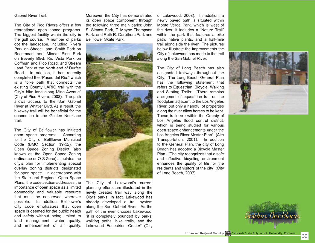
The City of Lakewood’s currentplanning efforts are illustrated in the newly created trail way along theCity’s parks. In fact, Lakewood hasalready developed a trail system along the San Gabriel River. As the path of the river crosses Lakewood,“it is completely bounded by parks, walking paths, bike trails, and theLakewood Equestrian Center” (City
of Lakewood, 2008). In addition, anewly paved path is situated withinMonte Verde Park, which is west ofthe river. It includes a “Nature Trail” within the park that features a bikepath, native plants, and a half-mile trail along side the river. The pictures belowillustratetheimprovementstheCityofLakewoodhasmadetothetrailalong the San Gabriel River.
The City of Long Beach has also designated trailways throughout theCity. The Long Beach General Plan has the following statement thatrefers to Equestrian, Bicycle, Walking and Skating Trails: “There remains a segment of equestrian trail on the floodplainadjacenttotheLosAngelesRiver, but only a handful of properties alongtheriverallowhorsestobekept.These trailsarewithin theCountyofLos Angeles flood control district,which is being studied for variousopen space enhancements under the Los Angeles River Master Plan” (Alta Transportation, 2001), In additionto the General Plan, the city of Long Beach has adopted a Bicycle Master Plan.“Thecityrecognizesthatasafeand effective bicycling environment enhances the quality of life for the residents and visitors of the city” (City ofLongBeach,2007).
30

Des
ign
Prop
osal
s
Urban and Regional Planning California State Polytechnic University, Pomona
Des
ign
Prop
osal
s
Los
Ang
eles
Riv
er20
08 G
radu
ate
Caps
tone
Stu
dio
OVERVIEW
SITE SELECTION
The initial process of site selection consisted of identifying two thatwould immensely benefit from trailrevitalization. Characteristics ofan ideal target site are areas that suffer fromunder-utilized landuses,which are located within or nearunderprivileged communities that may be subject to socio-economic hardship, and underserved communities that are limited in their accessibility to public open space which includesrecreational activities (passive or active). The renovation of the sitesthat are selected will enhance andimprove the physical environment, as well as the psychological reputationof deprived areas targeted by wayof enhanced environmental design.
In the long run, this revitalizationwill improve the image of deprivedcommunities which would resonateinto generating future economic development for urban slums.
CASE STUDIES IN SIMILAR CONDITIONS
The selected sites were comparedwith case studies of areas in similarconditions. In evaluating case studies, which have implemented masterplans and revitalization designs incommunities facing similar conditions of blight, broad assessments weremade in order to comparatively identify opportunities and assess constraints throughout the process. Prime examplesthatwerereferenced,withina regional context of Los Angeles County, were the LosAngeles RiverRevitalizationMasterPlan(LARRMP)as well as the San Gabriel RiverRevitalizationMasterPlan(SGRRMP).Research on national and international efforts was also conducted in orderto comprehensively grasp ideal design concepts and assess the accomplishments of innovative design solutions. These case studies also include the Tom McCall Waterfront Park;EastRiverStateParkwhichwonanawardfordesigningthemeadows- a sustainable concept in urban agricultureaswellasterracing;anEricLloyd Wright critique and suggestions to site features such as: amphitheater, lagoon, sycamore trees, libraries across from schools; Drake ChavezGreenbelt Community Meeting in Long Beach, California; Wetland Restoration; Dog Park; Toronto Port Lands Estuary: Remediation, Transportation Connectivity; balance
between urban and naturalization(eg. Urban prairie, meadows); andother photos (MVVA winning firm);Dayton Water Trails: Water Activities (eg. kayaking along the river); RenoPostOfficeRiverTerracing;StripMallExample:SantaMonicaPlace–NewDevelopment; Affordable Housing Example: The Village at Santa Monica; City Hall example: City of Orinda; Des Moines Riverfront Master Plan; and the Truckee River Flood Management and Protection Plan in Washoe County, California.
33

Urban and Regional Planning California State Polytechnic University, Pomona
Site EvaluationTo assess disparities or inequities among communities within the GoldenNecklace project area, an analysis was conducted to determine potentialopportunities within the underserved communities in relation to prominentcommunities that currently possess open space/ recreational elements, andreasonably implement equitable opportunities to correct inequities betweendifferingsocio-economicneighborhoods.Duringsitevisits,thefollowingitemswereevaluated:
PhysicalContext:Thedesignteam’sobjectivewastoassessexistinglocationsand determine feasible opportunities for recommending design concepts based on current natural and built conditions of the surrounding physical environment thatarelistedbelow.
After site visits were conducted, design parameters were established toimplementanyproposeddesignelementandanassessmentwasmadebasedon existing site conditions. The following are the design elements that areconsidered to enhance open spaces and recreational areas:
To implement design elements, the following guidelines and developmentstandards were referenced in accordance with existing communities/municipalities impacted by any proposed revitalization or enhancementopportunities.
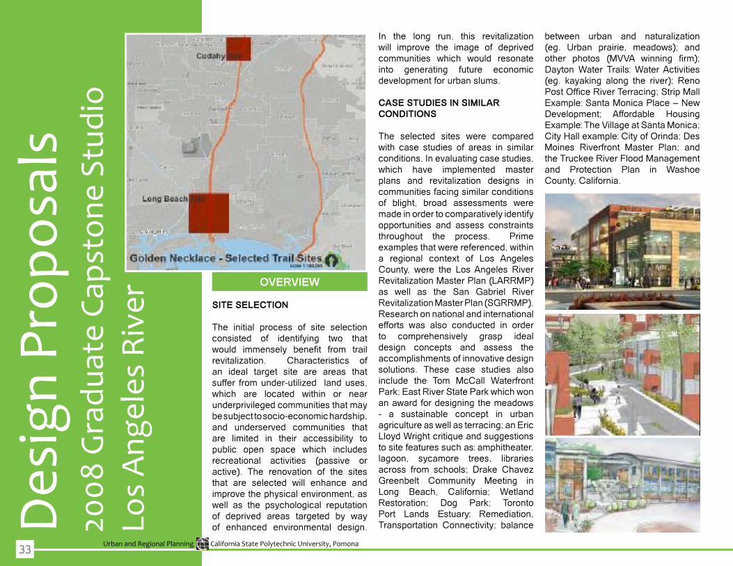
SELECTED SITES
City of Long Beach
City of Cudahy
34
Urban and Regional Planning California State Polytechnic University, Pomona
Long
Bea
ch P
ropo
sal
Los
Ang
eles
Riv
er20
08 G
radu
ate
Caps
tone
Stu
dio
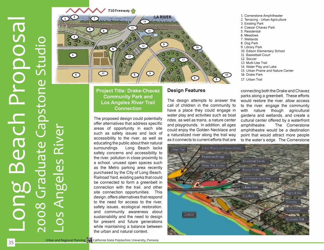
Project Title: Drake-Chavez Community Park and
Los Angeles River Trail Connection
The proposed design could potentially offeralternativesthataddressspecificareas of opportunity in each site such as safety issues and lack of accessibility to the river, as well aseducating the public about their natural surroundings. Long Beach lacks safety concerns and accessibility to the river, pollution in close proximity to a school, unused open spaces such as the Metro parking area recently purchased by the City of Long Beach, RailroadYard,existingparksthatcouldbe connected to form a greenbelt in connection with the trail, and othersite connection opportunities. This design, offers alternatives that respond to the need for access to the river, safety issues, ecological restoration, and community awareness aboutsustainability and the need to design for present and future generations whilemaintainingabalancebetweenthe urban and natural context.
Design Features
The design attempts to answer thecall of children in the community to have a place they could engage in waterplayandactivitiessuchasboatrides,aswellastrains,anaturecenterand playgrounds. In addition, all ages could enjoy the Golden Necklace and anaturalizedriveralongthetrailwayas it connects to current efforts that are
connectingboththeDrakeandChavezparks along a greenbelt. These efforts would restore the river,allowaccessto the river, engage the community with nature though agriculturalgardens andwetlands, and create aculturalcenterofferedbyawaterfrontamphitheatre. The Cornerstone amphitheatre would be a destinationpoint that would attractmore peopletothewater’sedge.TheCornerstone
1. Cornerstone Amphitheater2.Terracing-UrbanAgriculture3. Existing Park4.CaesarChavezPark5. Residential6.Meadows7. Wetlands8. Dog Park9. Library Park10. Edison Elementary School11. Basketball Court12. Soccer13.Multi-UseTrail14. Water Play and Lake15.UrbanPrairieandNatureCenter16. Drake Park
17.UrbanTrail
35

Urban and Regional Planning California State Polytechnic University, Pomona
the project should attempt to conserve energythroughnetzerobuildingsandinfrastructure meaning it would beself sustaining in its energy, as wellas water and waste managementsystems.
Topography
The land is relativelyflat in thisareaand the land slopes along the river with a bed of rock coming downtoward the edge of the river. Atopographic analysis is needed in order to determine the feasibility of the amphitheatre along the river paying closeattentiontotidalflowsandfloodhazards.
Landscaping
Native landscaping (xeriscaping),wetlands,andurbanagriculturealongthe trail is recommended. The purpose of the wetlands would be to restorethe flora and fauna along the river.Thesalinityof thewaterwill need tobe determined since it may affect the possibility of urban agriculture along theriver.Urbanagriculturalterracingwould otherwise be incorporated tothe “commons” area.
Safety
Recommendation for a safer trail would be to ensure lighting andredevelop areas that are mostly blighted and perceived unsafe by the community such as underneath the locomotive bridge in order to create a safer community for all. Hiring more parks and recreation personnel to be present around the park would alsocreate a safer environment.
amphitheaterwouldsitalongtheriveracross froma “commons” plaza thatwould have a fountain, playgrounds,a meadow with trails, a dog park tothe north, and active and passive play areas. Finally, the safety issues under the bridge along the existing trail would be remedied by creatingaplacewheretheriverconnectstoalagoon/manmadelakeinanattractiveway using the same rock alreadyexisting along the river so the mouth ofthelakewouldbeaplaceofnaturalbeauty as it empties out to the river under the bridge.
Materials
To restore natural habitats, the design proposal recommends native landscaping (xeriscaping), wetlands,andurbanagriculturethatreuseswaterthough water retention systems andpermeatedconcreteonanysidewalksand roads, if needed. The design also reuses non hazardous existingmaterials throughout the construction, brownfields redevelopment in areasthat are contaminated and to use clean technology in order make the trail way and its destinations healthyfor the surrounding community to live work and play. Recycled concreteshould also be used along withrecycled park furniture keeping in mindthelifecycleofwhatisusedtomake the open space least toxic (eg. not usingPVC) yetmost durable forfuture generations.
Lighting
Lighting is to be used through the trail and surrounding proposed areas to attract the community after hours yet
36

Urban and Regional Planning California State Polytechnic University, Pomona
City
of C
udah
y Pr
opos
al
Los
Ang
eles
Riv
er20
08 G
radu
ate
Caps
tone
Stu
dio
Project Title: City of Cudahy Urban Trail as a Connection
to the Los Angeles River
Thesecondsiteselectiondrewuponkey elements identified in the casestudies.Onekeyelementusedwithinthis second site is the enhancement of city features which have thepotential to become a major urban trail connection between the cityand the river. In creating a design network, various sites may be usedas destinations while parks, openspace(s), and their inter-connectionsto the river would promote trail usealong the LA River. Within the site, the primary sections for redesign focus on three (3) areas alreadyidentified as blighted in the projectarea and would greatly benefit fromredevelopment. First, the strip mall located in the northern area of the site
would require remodeling. Second,anewandmorerelevantbuildingforcityhallandlibrarywouldbeproposedin the mid-section of the project area. Third, an affordable housing element
located at the most southern part of the site would be proposed fordevelopment. Inter-connectedness within these three areas by way ofthe river trail are vital and would beenhanced with a redesigned (widerand more accessible) pedestrianbridgethatwouldserveastheprimarylinkbetweenthecityandtheriver.
Design Features
The desired activity is to encourage the residents of Cudahy to walkthrough their city in order to access the river or other commercial, cultural or residential properties that are being proposed in the project area. For events, the design team proposes that a small farmers market exist throughoutthetrailwiththehopethatresidentswouldbe involvedbyusingtheir porches to sell fresh goods once amonthweekly.Itisimportanttonotethat the river and its trail is not a “stand-alone element” of the city and should
37

Urban and Regional Planning California State Polytechnic University, Pomona
include more connections (in the future) within the project area whichwouldencourageawalk-ableaswellas accessible trail for enjoyment.“Urban Insertion” shall be definedas newelements introduced into theurban fabric which were identifiedin the plans for design proposal and focused on the areas that were under used. For example,the team focused on large parking lots, an old strip mall, or vacant lots. As a new element, an affordablehousing element was inserted withinthe surroundings of single family residential neighborhoods, and proposed the same zoning patternwithamodifieddensitythatwouldbenomorethantwostories.Enhancingthe community’s features into a more pleasant destination encourages
residents and community members to care more for the immediate public open space. Since the design team is notproposinganentirelynewlottheremaybelimitednotionsofNIMBY-ism;although; residents may not wantpeoplewalkinginfrontoftheirhouses,or close to their properties, yet the overallbenefitinthelongrunisthatapositive image is earned by the city as wellasthecommunity.
Materials
The existing concrete that serves as the river trail pathwould remain andthebridgeswouldbecomprisedaswellas constructed by natural materials. Forterraces,stainedlumberwouldbeused. Stairs and dirt for the trail along the river trail parts
Lighting
During the day, the project area is extremely bright due to a lack of trees during the day which provides littleor no opportunity for shading and only bridges serve to provide present shading areas. There is existing lighting on the trail. Since the area is limitedwith shading, the desire is tocreate new opportunities for shadingby planting trees.
Topography
The project area was predominantlyflat with dry vegetation in a desertenvironmentwithnaturallandscaping(i.e.“xeriscaping”).
Landscaping
The palette for this site is very earthy, sincetherivertrailwouldbebetweenbrownandgreenvegetationofdesertregions. In the case of Cudahy, the proposed landscape design should not introducenew faunabut there ishope in the near future that upon trail revitalization thatnewhabitatswouldbe created for other species to inhabit the project area.
Safety*
Recommendation for a safer trail would be to ensure lighting andredevelop areas that are mostly blighted and perceived unsafe by the community such as underneath the locomotive bridge in order to create a safer community for all. Hiring more parks and recreation personnel to be present around the park would also
38

Urban and Regional Planning California State Polytechnic University, Pomona
Des
ign
Prop
osal
s
San
Gab
riel R
iver
2008
Gra
duat
e Ca
psto
ne S
tudi
o
OVERVIEW
Site Selection
The urban design procedure employed is structured around a rational planning framework. The first stepinvolvedtheobjectivefordefiningtheproblem,whichwastocreateamulti-
use trail along the San Gabriel River. Then,goalswereset forestablishingthe sites that were problematic interms of visibility of blight and lack of recreational uses and connections. Inaddition, thegoalwas to renovatesites that would be beneficial for allneighboring communities, especially underprivileged areas that are left neglected. Thevalues thatweresetinclude the following: commitmentto environmental justice, respect for nature, replenish land, and encourage recreational lifestyles. From the set goals, evaluation criteria weredeveloped and alternatives wereestablished. The evaluation criteria were based on the following threestandards: sites that are physically uninviting, siteswith thepotential forconnection to other areas within thecities,andadesignthatwouldprovideadequate access for all nearby communities. The site selection also followedtheprocessofunderstanding
each site’s opportunities and constraints. Based on the set goals and evaluation criteria, the chosen sites in need to renovation are ZinnParkinBellflowerandtheSealBeach/Long Beach connection along the San Gabriel River. A wish list was established to setcriteriaforthetraildesign.Thewishlistused during the design processwasobtained from the Recreational Trail Design & Construction publication. This publication is a guide used to design and construct trails. The recommended standards used for this projectwerethefollowing:traillayouts,length,clearingwidth,clearingheight,treadwidth,trailsurfaceandfacilities(Rathke&Baughman,2008).
Topography
In comparisonwith theadjacentandproximal Santa Ana River and/or itswatershed, the San Gabriel River
39
Urban and Regional Planning California State Polytechnic University, Pomona
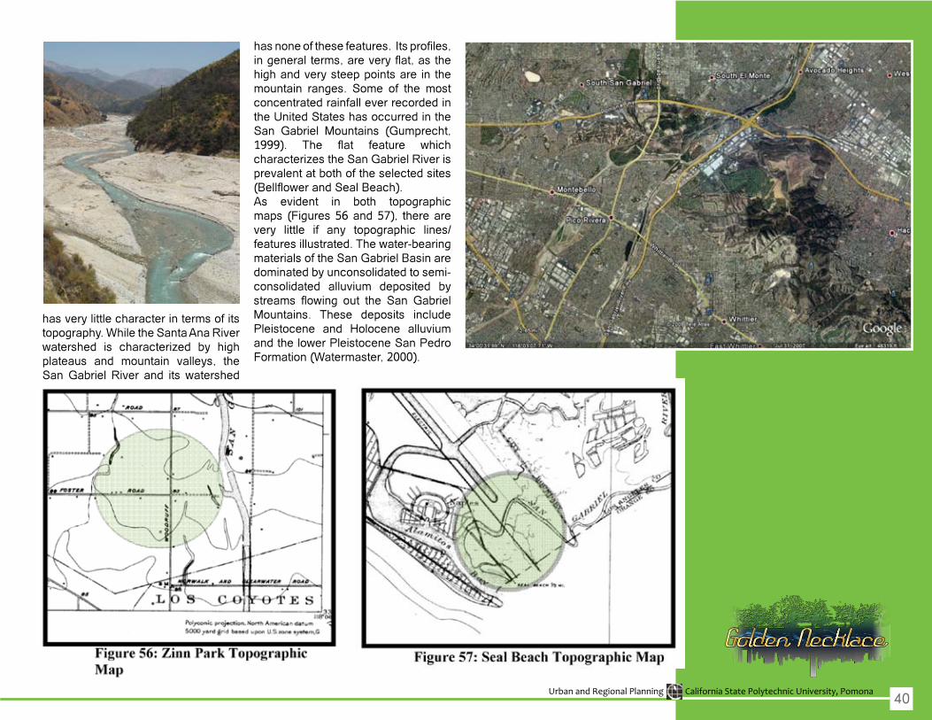
has very little character in terms of its topography. While the Santa Ana River watershed is characterized by highplateaus and mountain valleys, the SanGabrielRiver and itswatershed
hasnoneofthesefeatures.Itsprofiles,ingeneralterms,areveryflat,asthehigh and very steep points are in the mountain ranges. Some of the most concentrated rainfall ever recorded in theUnitedStateshasoccurredintheSan Gabriel Mountains (Gumprecht, 1999). The flat feature whichcharacterizestheSanGabrielRiverisprevalent at both of the selected sites (BellflowerandSealBeach).As evident in both topographic maps (Figures56and57), therearevery little if any topographic lines/featuresillustrated.Thewater-bearingmaterials of the San Gabriel Basin are dominated by unconsolidated to semi-consolidated alluvium deposited by streams flowing out the San GabrielMountains. These deposits include Pleistocene and Holocene alluvium andthelowerPleistoceneSanPedroFormation(Watermaster,2000).
40
Urban and Regional Planning California State Polytechnic University, Pomona
Bellflow
erProposal
San
Gab
riel R
iver
2008
Gra
duat
e Ca
psto
ne S
tudi
o
Project Title: Zinn Park in the City of Bellflower
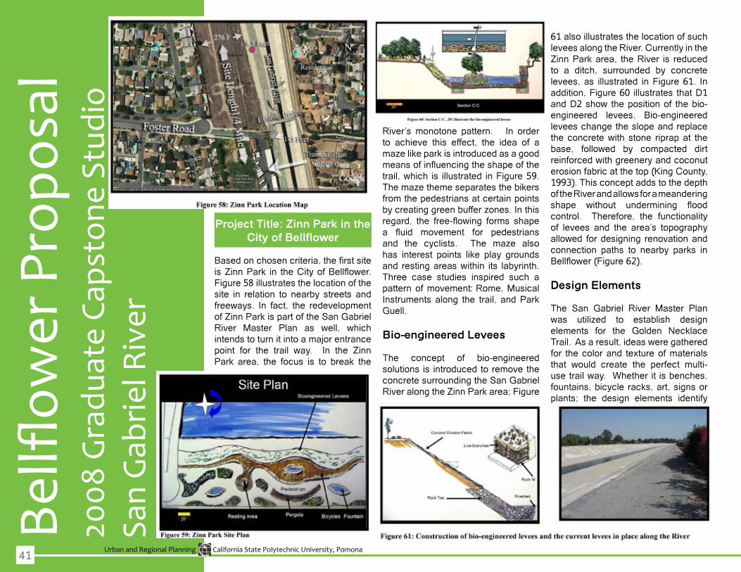
Basedonchosencriteria,thefirstsiteisZinnPark in theCityofBellflower.Figure 58 illustrates the location of the site in relation to nearby streets and freeways. In fact, the redevelopmentofZinnParkispartoftheSanGabrielRiver Master Plan as well, whichintends to turn it into a major entrance point for the trail way. In the ZinnPark area, the focus is to break the
River’s monotone pattern. In order to achieve this effect, the idea of a mazelikeparkisintroducedasagoodmeansofinfluencingtheshapeofthetrail,which is illustrated inFigure59.Themazethemeseparatesthebikersfrom the pedestrians at certain points bycreatinggreenbufferzones.Inthisregard, the free-flowing forms shapea fluid movement for pedestriansand the cyclists. The maze alsohas interest points like play grounds and restingareaswithin its labyrinth.Three case studies inspired such a pattern of movement: Rome, Musical Instruments along the trail, and Park Guell.
Bio-engineered Levees
The concept of bio-engineered solutions is introduced to remove the concrete surrounding the San Gabriel RiveralongtheZinnParkarea;Figure
61 also illustrates the location of such levees along the River. Currently in the ZinnParkarea, theRiver is reducedto a ditch, surrounded by concrete levees, as illustrated in Figure 61. In addition, Figure 60 illustrates that D1 andD2show thepositionof thebio-engineered levees. Bio-engineered levees change the slope and replace theconcretewith stone riprapat thebase, followed by compacted dirtreinforcedwithgreeneryandcoconuterosion fabric at the top (King County, 1993).ThisconceptaddstothedepthoftheRiverandallowsforameanderingshape without undermining floodcontrol. Therefore, the functionality of levees and the area’s topography allowed fordesigning renovationandconnection paths to nearby parks in Bellflower(Figure62).
Design Elements
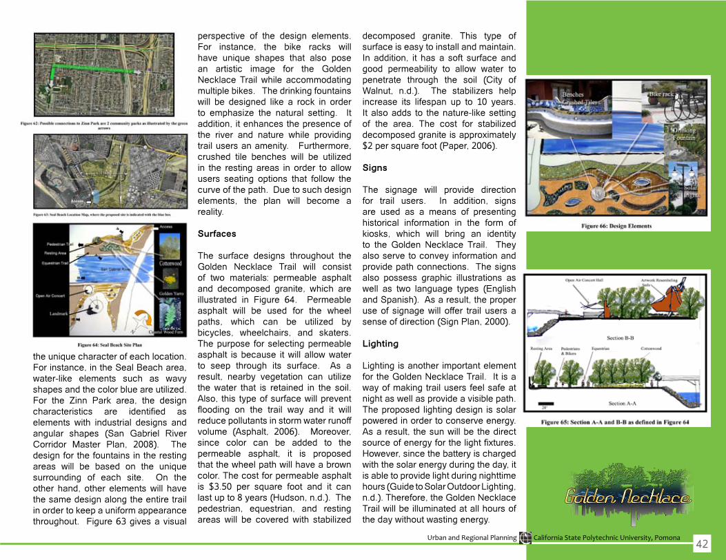
The San Gabriel River Master Plan was utilized to establish designelements for the Golden Necklace Trail.Asaresult,ideasweregatheredfor the color and texture of materials that would create the perfect multi-usetrailway.Whetheritisbenches,fountains, bicycle racks, art, signs or plants; the design elements identify
41
Urban and Regional Planning California State Polytechnic University, Pomona
the unique character of each location. For instance, in the Seal Beach area, water-like elements such as wavyshapesandthecolorblueareutilized.For the Zinn Park area, the designcharacteristics are identified aselements with industrial designs andangular shapes (San Gabriel River Corridor Master Plan, 2008). Thedesign for the fountains in the resting areas will be based on the uniquesurrounding of each site. On the other hand, other elementswill havethe same design along the entire trail in order to keep a uniform appearance throughout. Figure 63 gives a visual
perspective of the design elements. For instance, the bike racks willhave unique shapes that also pose an artistic image for the Golden NecklaceTrailwhile accommodatingmultiple bikes. The drinking fountains will be designed like a rock in orderto emphasize the natural setting. Itaddition, it enhances the presence of the river and nature while providingtrail users an amenity. Furthermore, crushed tile benches will be utilizedin the restingareas inorder toallowusers seating options that follow thecurve of the path. Due to such design elements, the plan will become areality.
Surfaces
The surface designs throughout the Golden Necklace Trail will consistof two materials: permeable asphaltand decomposed granite, which areillustrated in Figure 64. Permeable asphalt will be used for the wheelpaths, which can be utilized bybicycles, wheelchairs, and skaters.The purpose for selecting permeable asphalt isbecause itwillallowwaterto seep through its surface. As a result, nearby vegetation can utilizethewater that is retained in the soil.Also, thistypeofsurfacewillpreventflooding on the trail way and it willreducepollutantsinstormwaterrunoffvolume (Asphalt, 2006). Moreover,since color can be added to the permeable asphalt, it is proposed thatthewheelpathwillhaveabrowncolor. The cost for permeable asphalt is $3.50 per square foot and it can lastupto8years(Hudson,n.d.).Thepedestrian, equestrian, and resting areaswill be coveredwith stabilized
decomposed granite. This type of surface is easy to install and maintain. In addition, it has a soft surface and good permeability to allow water topenetrate through the soil (City of Walnut, n.d.). The stabilizers helpincrease its lifespan up to 10 years. It also adds to the nature-like setting of the area. The cost for stabilizeddecomposed granite is approximately $2persquarefoot(Paper,2006).
Signs
The signage will provide directionfor trail users. In addition, signs are used as a means of presenting historical information in the form of kiosks, which will bring an identityto the Golden Necklace Trail. They also serve to convey information and provide path connections. The signs also possess graphic illustrations as well as two language types (EnglishandSpanish).Asaresult,theproperuseof signagewill offer trail usersasenseofdirection(SignPlan,2000).
Lighting
Lighting is another important element for the Golden Necklace Trail. It is a wayofmakingtrailusersfeelsafeatnightaswellasprovideavisiblepath.The proposed lighting design is solar poweredinordertoconserveenergy.Asaresult, thesunwillbethedirectsourceofenergyforthelightfixtures.However,sincethebatteryischargedwiththesolarenergyduringtheday,itis able to provide light during nighttime hours (Guide to Solar Outdoor Lighting, n.d.).Therefore,theGoldenNecklaceTrailwillbeilluminatedatallhoursofthedaywithoutwastingenergy.
42

Urban and Regional Planning California State Polytechnic University, Pomona
Pasa
dena
Pro
posa
lLo
s A
ngel
es R
iver
2008
Com
mun
ity P
lann
ing
Stud
io
Project Title: Upper Arroyo Park Development
Site Overview
The Upper Arroyo park has manyqualities that could provide elements that will lead to a successfulimplementation of a revitalized trail.The front of the site is used as a
‘focus area’ due to its relatively flatterrain with more open space. It islocated adjacent to the golf course and a neighborhood on both sides of thepark. Itsentrance is facedwithaRosemont Ave. The Rosemont Ave. down to the Rose Bowl Trail on thesouth side of the Arroyo Park. The RoseBowlTrail isalsoprovidedwithparking. Further south of the Rose Bowl Trail is Brookside Park. The
Upper Arroyo Park is expected toattractusersfromboththeRoseBowlTrail and Brookside Park, especially theRoseBowlTrail. It begins at theRoseBowlStadiuminaloopupwardstotheUpperArroyoPark.PeoplewillbenaturallydrawntotheArroyoParkonceimprovedwithequipments. Site Plan
The site plan shows differentamenities that were placed into thearea including benches, restrooms, picnic tables, a playground, etc. The items presented in this site plan are scaledtoactualsizeandlocationofthe current area. The general climate of the park is extremely dry. Therefore, not that many trees were plantedbecause it would require exorbitantamounts of water and resources toartificially maintain them. There arehowever,existingtreesintheareaonthe hillside towards the East side ofthe park. The trail itself does not have any trees around it. It is exposed to the sun throughout the day and displays extremely unpleasant environment for trailusers.Therefore,afewtreeswereadded alongside the existing trail to provide a little more shade for users.
Zoning
The Zoning Perspective Viewrepresents an overall zoning view ofthe region. The red dot indicates the designed area. It is currently zonedas open space. Areas nearby are mostly residentially zoned, whichprovides an incentive for the design to be successfully implemented and used by residents. Three neighborhoods are within immediate
43
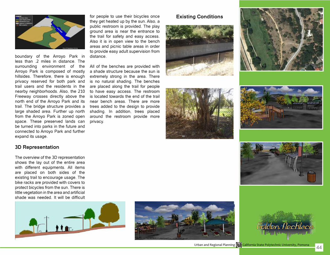
Urban and Regional Planning California State Polytechnic University, Pomona
boundary of the Arroyo Park in less than .2 miles in distance. The surrounding environment of the Arroyo Park is composed of mostly hillsides. Therefore, there is enough privacy reserved for both park and trail users and the residents in the nearby neighborhoods. Also, the 210 Freeway crosses directly above thenorth end of the Arroyo Park and its trail. The bridge structure provides a large shaded area. Further up north from theArroyo Park is zoned openspace. These preserved lands can be turned into parks in the future and connected to Arroyo Park and further expand its usage.
3D Representation
Theoverviewofthe3Drepresentationshows the lay out of the entire areawith different equipments. All itemsare placed on both sides of the existing trail to encourage usage. The bikeracksareprovidedwithcoverstoprotect bicycles from the sun. There is littlevegetationintheareaandartificialshadewasneeded. Itwill bedifficult
for people to use their bicycles once they get heated up by the sun. Also, a public restroom is provided. The play ground area is near the entrance to the trail for safety and easy access. Also it is in open view to the benchareas and picnic table areas in order to provide easy adult supervision from distance.
All of the benches are providedwitha shade structure because the sun is extremely strong in the area. There is no natural shading. The benches are placed along the trail for people to have easy access. The restroom islocatedtowardstheendofthetrailnear bench areas. There are more trees added to the design to provide shading. In addition, trees placed around the restroom provide more privacy.
Existing Conditions
44
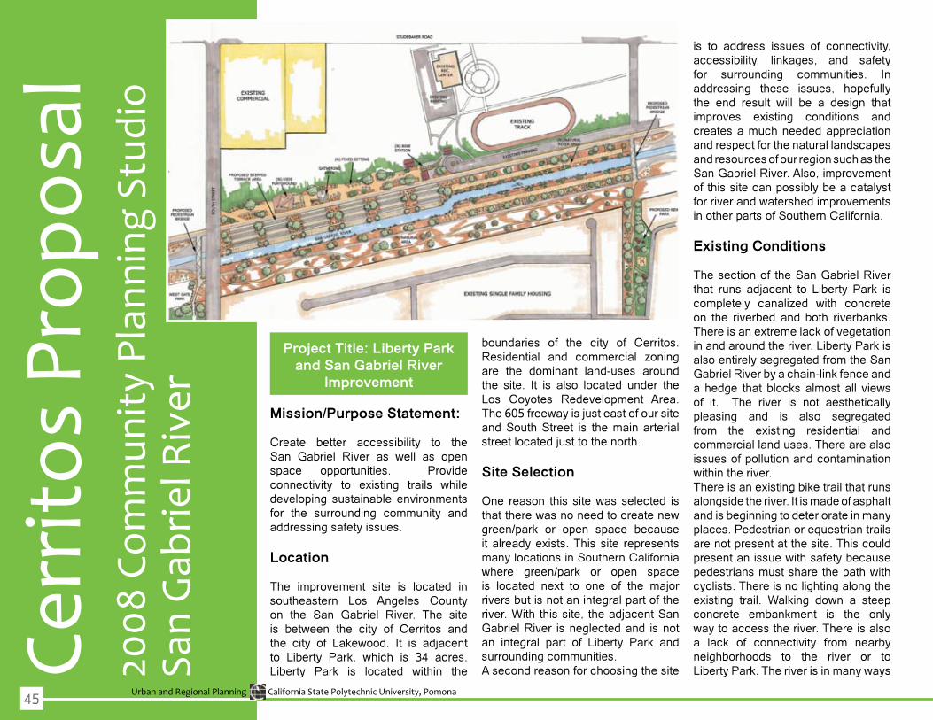
Urban and Regional Planning California State Polytechnic University, Pomona
Cerr
itos
Prop
osal
San
Gab
riel R
iver
2008
Com
mun
ity P
lann
ing
Stud
io
Project Title: Liberty Park and San Gabriel River
Improvement
Mission/Purpose Statement:
Create better accessibility to the San Gabriel River as well as openspace opportunities. Provide connectivity to existing trails whiledeveloping sustainable environments for the surrounding community and addressing safety issues.
Location
The improvement site is located in southeastern Los Angeles County on the San Gabriel River. The site is between the city of Cerritos andthe city of Lakewood. It is adjacentto Liberty Park, which is 34 acres.Liberty Park is located within the
boundaries of the city of Cerritos. Residential and commercial zoningare the dominant land-uses around the site. It is also located under the Los Coyotes Redevelopment Area. The605freewayisjusteastofoursiteand South Street is the main arterial street located just to the north. Site Selection
One reason this sitewasselected isthattherewasnoneedtocreatenewgreen/park or open space becauseit already exists. This site represents many locations in Southern California where green/park or open spaceis located next to one of the major rivers but is not an integral part of the river. With this site, the adjacent San Gabriel River is neglected and is not an integral part of Liberty Park and surrounding communities. A second reason for choosing the site
is to address issues of connectivity, accessibility, linkages, and safety for surrounding communities. In addressing these issues, hopefully the end result will be a design thatimproves existing conditions and creates a much needed appreciation and respect for the natural landscapes and resources of our region such as the San Gabriel River. Also, improvement of this site can possibly be a catalyst forriverandwatershedimprovementsin other parts of Southern California.
Existing Conditions
The section of the San Gabriel River that runs adjacent to Liberty Park is completely canalized with concreteon the riverbed and both riverbanks. There is an extreme lack of vegetation in and around the river. Liberty Park is also entirely segregated from the San Gabriel River by a chain-link fence and ahedge thatblocksalmostall viewsof it. The river is not aesthetically pleasing and is also segregated from the existing residential and commercial land uses. There are also issues of pollution and contamination withintheriver.There is an existing bike trail that runs alongside the river. It is made of asphalt and is beginning to deteriorate in many places. Pedestrian or equestrian trails are not present at the site. This could presentanissuewithsafetybecausepedestriansmustsharethepathwithcyclists. There is no lighting along the existing trail. Walking down a steepconcrete embankment is the only waytoaccesstheriver.Thereisalsoa lack of connectivity from nearby neighborhoods to the river or to LibertyPark.Theriverisinmanyways
45
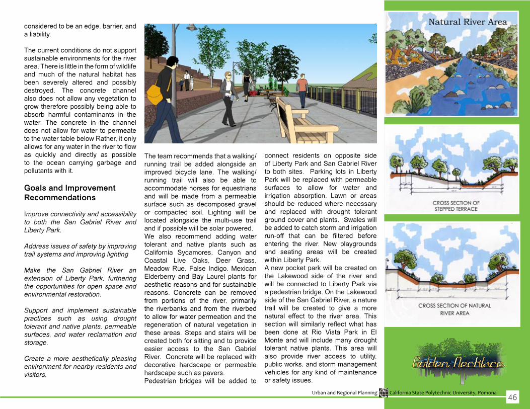
Urban and Regional Planning California State Polytechnic University, Pomona
considered to be an edge, barrier, and a liability.
The current conditions do not support sustainable environments for the river area.Thereislittleintheformofwildlifeand much of the natural habitat has been severely altered and possibly destroyed. The concrete channel alsodoesnotallowanyvegetationtogrowthereforepossiblybeingabletoabsorb harmful contaminants in the water. The concrete in the channeldoesnotallowforwater topermeatetothewatertablebelowRather,itonlyallowsforanywaterintherivertoflowas quickly and directly as possible to the ocean carrying garbage and pollutantswithit.
Goals and Improvement Recommendations
Improve connectivity and accessibility to both the San Gabriel River and Liberty Park.
Address issues of safety by improving trail systems and improving lighting
Make the San Gabriel River an extension of Liberty Park, furthering the opportunities for open space and environmental restoration.
Support and implement sustainable practices such as using drought tolerant and native plants, permeable surfaces, and water reclamation and storage.
Create a more aesthetically pleasing environment for nearby residents and visitors.
Theteamrecommendsthatawalking/running trail be added alongside an improved bicycle lane. The walking/running trail will also be able toaccommodate horses for equestrians and will be made from a permeablesurface such as decomposed gravel or compacted soil. Lighting will belocated alongside the multi-use trail andifpossiblewillbesolarpowered.We also recommend adding watertolerant and native plants such as California Sycamores, Canyon and Coastal Live Oaks, Deer Grass, MeadowRue,False Indigo,MexicanElderberry and Bay Laurel plants for aesthetic reasons and for sustainable reasons. Concrete can be removed from portions of the river, primarily the riverbanks and from the riverbed toallowforwaterpermeationandtheregeneration of natural vegetation in theseareas.Stepsandstairswill becreated both for sitting and to provide easier access to the San Gabriel River.Concretewillbereplacedwithdecorative hardscape or permeable hardscape such as pavers. Pedestrian bridges will be added to
connect residents on opposite side of Liberty Park and San Gabriel River to both sites. Parking lots in Liberty Parkwillbereplacedwithpermeablesurfaces to allow for water andirrigation absorption. Lawn or areasshould be reducedwhere necessaryand replaced with drought tolerantgroundcoverandplants.Swaleswillbe added to catch storm and irrigation run-off that can be filtered beforeentering the river. New playgroundsand seating areas will be createdwithinLibertyPark.Anewpocketparkwillbecreatedonthe Lakewood side of the river andwillbeconnected toLibertyParkviaapedestrianbridge.OntheLakewoodside of the San Gabriel River, a nature trail will be created to give a morenatural effect to the river area. This sectionwill similarly reflectwhat hasbeen done at Rio Vista Park in El Monteandwill includemanydroughttolerant native plants. This area willalso provide river access to utility, publicworks,andstormmanagementvehicles for any kind of maintenance or safety issues.
46

Urban and Regional Planning California State Polytechnic University, Pomona
Project Title: Rancho Santa Gertrudes Sections
Township and Range
Site Aerial View & Zoning
The proposed site along the San Gabriel River is listed under the Los Angeles Tax Assessor property boundary description as the Rancho Santa Gertrudes Sections Townshipand Range. It measures approximately 150,000 sq ft or roughly 3.5 acres. The site’s boundaries stretch from the SantaAna(5)Freewaytothenorth,toFlorence Avenue at its southern most point.
Topography & Climate
The land surrounding the site consists of relatively flat land. Originally, theclimate and geography consisted of ariddesertwhichexplains thesandysoil found throughout the river bed and surrounding spaces. The river bed throughout the site is found in a natural state(thusnotencasedwithconcrete)and opens up at approximately 500 ft throughout the proposed site running from Telegraph Rd to Florence Ave. The land slopes along the river witha dividing rock barrier on both sides of the river. In a natural state, it is ideal for marshes and wetlands topersist for longer periods of time. This is especially important as the given site provides for a natural setting and possible estuary for migrating birds. It also provides cooler temperatures during summer season and makes activities in and around the site much more pleasant.
Connectivity & Accessibility The Santa Ana 5 Freeway directlyexits onto Florence Avenue just feet from the off-street entrance leading to the parking lot of the site. This makes the site desirable and easy to visit for
those traveling distances greater than the given one-mile radius we haveimplemented in much our analysis. Both recreational connections at the SantaAna5Freewayaswellas theFlorence Ave overpass provide for a smooth transition from one area of the trail to the next. This is most desirable as walk-ability and bicycle use areperceivedasbeingmuchmorefluid.
Safety
The site does possess safety issues along the trail from either side of the park access including overpasses of the 5 Freeway and FlorenceAve.Along this particular area we find“blind spots” towhich proper lightingmust be considered for night activity. The site was also chosen in closeproximity to Florence Avenue as this gives policing the area an advantage as street access is no more than 50 ft from the site. This provides patrol units with quick access and detourspossible criminal activity. Proper lighting along the trail is non-existent andmustbeutilizedatalldarkareasand“blindspots”asshownhere: Aesthetic/Scenic Appeal
The views found throughout thesite are picturesque. The layout of seating and rest areas will capturethe essence of the Golden Necklace’s viewoftheSanGabrielMountainstothe north. At sunset, the golden hue dancing along the mountain range is evident.
Sant
a Fe
Spr
ings
Pro
posa
l
San
Gab
riel R
iver
2008
Com
mun
ity P
lann
ing
Stud
io
47
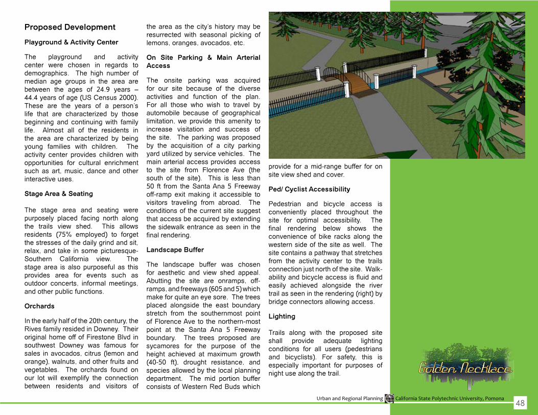
Urban and Regional Planning California State Polytechnic University, Pomona
Proposed Development
Playground & Activity Center
The playground and activity center were chosen in regards todemographics. The high number of median age groups in the area are between the ages of 24.9 years –44.4yearsofage(USCensus2000).These are the years of a person’s life that are characterized by thosebeginning and continuingwith familylife. Almost all of the residents in the area are characterized by beingyoung families with children. Theactivity center provides childrenwithopportunities for cultural enrichment such as art, music, dance and other interactive uses.
Stage Area & Seating
The stage area and seating werepurposely placed facing north along the trails view shed. This allowsresidents (75% employed) to forgetthe stresses of the daily grind and sit, relax, and take in some picturesque- Southern California view. Thestage area is also purposeful as this provides area for events such as outdoor concerts, informal meetings, and other public functions.
Orchards
In the early half of the 20th century, the RivesfamilyresidedinDowney.Theiroriginal home off of Firestone Blvd in southwest Downey was famous forsales in avocados, citrus (lemon and orange),walnuts,andotherfruitsandvegetables. The orchards found on our lot will exemplify the connectionbetween residents and visitors of
the area as the city’s history may be resurrected with seasonal picking oflemons, oranges, avocados, etc.
On Site Parking & Main Arterial Access
The onsite parking was acquiredfor our site because of the diverse activities and function of the plan. For all those who wish to travel byautomobile because of geographical limitation,weprovide this amenity toincrease visitation and success of the site. The parkingwas proposedby the acquisition of a city parking yardutilizedbyservicevehicles.Themain arterial access provides access to the site from Florence Ave (the south of the site). This is less than50 ft from theSantaAna 5Freewayoff-ramp exit making it accessible to visitors traveling from abroad. The conditions of the current site suggest that access be acquired by extending thesidewalkentranceasseeninthefinalrendering.
Landscape Buffer
The landscape buffer was chosenfor aesthetic and view shed appeal.Abutting the site are onramps, off-ramps,andfreeways(605and5)whichmake for quite an eye sore. The trees placed alongside the east boundary stretch from the southernmost point of Florence Ave to the northern-most point at the Santa Ana 5 Freewayboundary. The trees proposed are sycamores for the purpose of the height achieved at maximum growth(40-50 ft), drought resistance, andspeciesallowedbythelocalplanningdepartment. The mid portion buffer consistsofWesternRedBudswhich
provide for a mid-range buffer for on siteviewshedandcover.
Ped/ Cyclist Accessibility
Pedestrian and bicycle access is conveniently placed throughout the site for optimal accessibility. The final rendering below shows theconvenience of bike racks along the westernsideofthesiteaswell.Thesitecontainsapathwaythatstretchesfrom the activity center to the trails connection just north of the site. Walk-abilityandbicycleaccessisfluidandeasily achieved alongside the river trailasseenintherendering(right)bybridgeconnectorsallowingaccess.
Lighting
Trails along with the proposed siteshall provide adequate lighting conditions for all users (pedestrians and bicyclists). For safety, this isespecially important for purposes of night use along the trail.
48
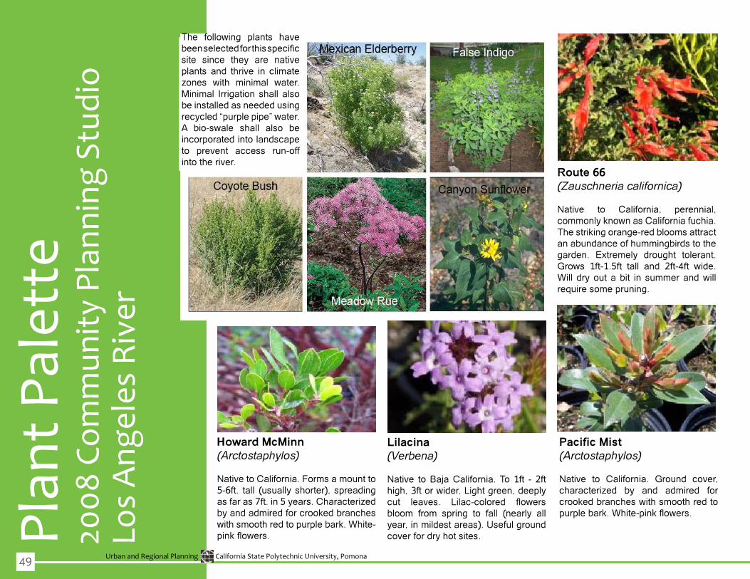
Urban and Regional Planning California State Polytechnic University, Pomona
Plan
t Pal
ette
Los
Ang
eles
Riv
er20
08 C
omm
unity
Pla
nnin
g St
udio
Howard McMinn (Arctostaphylos)
Native to California. Forms a mount to 5-6ft. tall (usually shorter), spreadingasfaras7ft.in5years.Characterizedby and admired for crooked branches withsmoothredtopurplebark.White-pinkflowers.
Pacific Mist(Arctostaphylos)
Native to California. Ground cover, characterized by and admired forcrookedbrancheswithsmoothredtopurplebark.White-pinkflowers.
Lilacina (Verbena)
Native to Baja California. To 1ft - 2ft high,3ftorwider.Lightgreen,deeplycut leaves. Lilac-colored flowersbloom from spring to fall (nearly all year,inmildestareas).Usefulgroundcover for dry hot sites.
Route 66 (Zauschneria californica)
Native to California, perennial, commonlyknownasCaliforniafuchia.The striking orange-red blooms attract an abundance of hummingbirds to the garden. Extremely drought tolerant. Grows 1ft-1.5ft tall and 2ft-4ft wide.Will dryout abit in summerandwillrequire some pruning.
The following plants havebeenselectedforthisspecificsite since they are native plants and thrive in climate zones with minimal water.Minimal Irrigation shall also be installed as needed using recycled“purplepipe”water.A bio-swale shall also beincorporated into landscape to prevent access run-off into the river.
49
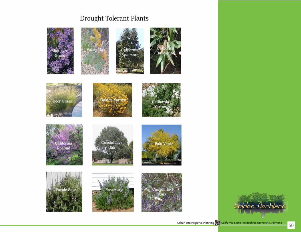
Urban and Regional Planning California State Polytechnic University, Pomona50

App
endi
x A
Urban and Regional Planning California State Polytechnic University, Pomona
Refe
renc
esAlta Transportation Company, Ryan Snyder & Associates, and Willdan & Associates, (2001,December11).CityofLongBeach.RetrievedFebruary19,2008,from BicycleMasterPlanWebsite:http://www.ci.long-beach.ca.us/gov/bmp.asp
AmigosdelosRios.(2008).RetrievedFebruary27,2008from: www.amigosdelosrios.org
AngelesChapterSierraClub–FactSheet.(2006).RetrievedFebruary23,2008from:http://angeles.sierraclub.org/pressroom/FS_SGRiver.asp
ArchitecturalStandards.(2007).Estero.RetrievedMay6,2008,from http://esterofl.org/Developers/architectural_standards.htm Asphalt.(2006).TheSustainablePavement.RetrievedMay1,2008,fromAsphaltPavementAlliance Website:http://www.pavegreen.com/water_quality.asp
“BaldwinPark”factfinder.census.gov.(5April2000).6March2008.http://factfinder.census.gov/servlet/SAFFFacts?_event=&geo_id=01000US&_ geoContext=&_street=&_county=baldwinpark&_cityTown=baldwinpark&_state=04000US06&_zip=&_lang=en&_ sse=on&ActiveGeoDiv=&_useEV=&pctxt=fph&pgsl=010&_submenuId=factsheet_1&ds_name=ACS_2006_SAFF&_ci_nbr=null&qr_ name=null®=&_keyword=&_industry=
California Department of Fish and Game http://www.dfg.ca.gov/
CaliforniaNativePlantSociety,SanGabrielMountainsChapter(CNPS).(2008).RetrievedMarch6,2008from:http://cnps-sgm.org/
CaliforniaPlantNames:LatinandGreekMeaningsandDerivations(CPN).(2007).RetrievedMarch6,2008from:http://calflora.net/
California State Parks http://www.parks.ca.gov/
Caltrans http://www.dot.ca.gov/
“CityofAzusa–General”(2000).CityofAzusa.RetrievedMarch1,2008from:http://www.ci.azusa.ca.us/general/history.asp
CerritosGeneralPlan.(2004).RetrievedFebruary19,2008from: http://www.rbfconsulting.com/us/cerritos/General_plan_final/general_plan_toc.html
“CityofBaldwinPark”(7June,2006).RetrievedMarch1,2008from:http://www.baldwinpark.com/index.php?option=com_ content&task=view&id=263
CityofBellflower.(2008).RetrievedFebruary27,2008,from http://www.bellflower.org/home/index.aspWebsite: http://www.bellflower.org/home/index.asp?page=2
CityofCerritos.(2008).RetrievedFebruary19,2008,from: http://www.ci.cerritos.ca.us/
CityofDowney.(2000).RetrievedFebruary28,2008,fromhttp://www.downeyca.org/ Website:http://www.downeyca.org/business_demographics.php
“CityofDuarte:ACommunityWorkingTogether,”(2001).RetrievedMarch4,2008from:http://www.sgvn.com/duarte.html
CityofIndustry.(2008).RetrievedFebruary27,2008,fromwww.cityofindustry.org
53

Urban and Regional Planning California State Polytechnic University, Pomona
“CityofIrwindale–QuickFacts”.RetrievedFebruary23,2008from:http://irwindale.ca.us/quick.html
CityofLakewood.(2008).RetrievedFebruary20,2008,from: http://www.lakewoodcity.org/
CityofLongBeach.(2007).February19,2008,from: http://www.ci.long-beach.ca.us/
CityofLosAngeles.TheLosAngelesRiverRevitalizationMasterPlan.ViewedonFebruary1,2008.http://www.lariverrmp.org/
Charters,M.L.(2008).PlantImages.InWildflowersandOtherPlantsofSouthernCalifornia.RetrievedMay10,2008,from:http://www.calflora.net/ bloomingplants/index.html
CityofNorwalk(2000).RetrievedFebruary27,2008,from: http://www.ci.norwalk.ca.us/norwalkinfo.asp
CityofPicoRivera.(2008).RetrievedFebruary21,2008,from: http://www.ci.pic/homepage.htmlo-rivera.ca.us
CityofSantaFeSprings.(2008).RetrievedFebruary21,2008,from www.santafesprings.org
CityofSealBeach.(2004).RetrievedFebruary23,from:http://www.ci.seal-beach.ca.us/
CityofWalnut.(n.d.).Constructionprojects.RetrievedMay18,2008,fromhttp://ci.walnut.ca.us/.asp?id=128
CityofWhittier.(2008).RetrievedFebruary22,2008,fromwww.whittierch.org
CoalAshforColoring.(2000,July27).RetrievedMay8,2008,fromTakenakaCorporationWebsite:http://www.takenaka.co.jp/takenaka_e/news_e/ pr0007/m0007_05.htm
County of Los Angeles Department of Public Works http://www.ladpw.org/wmd/watershed/LA/
Czerniak,Julia,andGeorgeHargraves.LargeParks.NewYork:PrinctonArchitectualPress,2007
DiscovertheWestSanGabrielRiverParkwayNatureTrail.(2003,June).CityofLakewoodCalifornia.RetrievedApril8,2008,from:http://www .lakewoodcity.org/emag/05_21_03_sgrp.asp
“Duarte”factfinder.census.gov.(5April2000).6March2008.http://factfinder.census.gov/servlet/SAFFFacts?_event=Search&geo_id= 16000US0622230&_geoContext=01000US%7C04000US06%7C16000US0622230&_street=&_county=duarte&_cityTown=duarte&_ state=04000US06&_zip=&_lang=en&_sse=on&ActiveGeoDiv=geoSelect&_useEV=&pctxt=fph&pgsl=160&_submenuId=factsheet_1&ds_ name=DEC_2000_SAFF&_ci_nbr=null&qr_name=null®=null%3Anull&_keyword=&_industry=
“DuarteHistoricalSociety”.RetrievedMarch3,2008from:http://duartehistory.org/index.htm
“ELMonte”factfinder.census.gov.(5April2000).6March2008.http://factfinder.census.gov/servlet/SAFFFacts?_event=ChangeGeoContext&geo_ id=16000US0622230&_geoContext=&_street=&_county=El+Monte&_cityTown=El+Monte&_state=04000US06&_zip=&_lang=en&_ sse=on&ActiveGeoDiv=geoSelect&_useEV=&pctxt=fph&pgsl=010&_submenuId=factsheet_1&ds_name=DEC_2000_SAFF&_ci_ nbr=null&qr_name=null®=null%3Anull&_keyword=&_industry=
FountainImage.(2007,August).Radified.RetrievedMay20,2008,from http://radified.com/Archives/august_2007.html
54
Urban and Regional Planning California State Polytechnic University, Pomona
GatewayCitiesCouncilofGovernments(BoardMembers) http://www.gatewaycog.org/boardmembers.html
GatewayCitiesCouncilofGovernments(StateandFederalLegislatorscanbefoundonthissite)http://www.gatewaycog.org/leadership.html
GeneralPlan.CityofAzusa.RetrievedFebruary24,2008from:http://www.ci.azusa.ca.us/Com_development/General%20Plan/Chapter%205.pdf
“GeneralPlanVision.”CityofElMonte(5April,2006).RetrievedMarch1,2008from:http://www.ci.el-monte.ca.us/envision/downloads/Vision.pdf
GuidetoSolarOutdoorLighting.(n.d.).SolInc.RetrievedMay5,2008,from http://www.solarlighting.com/?p0=1&p1=13&p2=23 Gumprecht,B.(2001).TheLosAngelesRiver:ItsLife,Death,andPossibleRebirth.Baltimore,MD:The JohnsHopkinsUniversityPress.
“History”CityofIrwindale.(2August,2001)Retrieved:March4,2008from:http://www.ci.irwindale.ca.us/history.html
Hudson,G.(n.d.).ALTAPlanning&Design.InWhat’sUnderFoot?Multi-useTrailSurfacingOptions.RetrievedMay8,2008,fromhttp://atfiles.org/ files/pdf/AltaTrailSurface.pdf
IronOxidePigment.(n.d.).TaesungChemical.RetrievedMay8,2008,fromTaesungChemicalCo.Website:http://www.tschemical.co.kr/eng/sub_ lron.htm
“Irwindale”factfinder.census.gov.(5April2000).6March2008.http://factfinder.census.gov/servlet/SAFFFacts?_event=Search&geo_ id=16000US0619990&_geoContext=01000US%7C04000US06%7C16000US0619990&_street=&_county=Irwindale&_ cityTown=Irwindale&_state=04000US06&_zip=&_lang=en&_sse=on&ActiveGeoDiv=geoSelect&_useEV=&pctxt=fph&pgsl=160&_ submenuId=factsheet_1&ds_name=DEC_2000_SAFF&_ci_nbr=null&qr_name=null®=null%3Anull&_keyword=&_industry=
JointAdvisory/Stakeholder/TaskForceCommitteeMeetingheldonDecember7,2007
KingCounty(1993,June5).DesignguidelinesretrievedMay3,2008,fromhttp://dnr.metrokc.gov/wlr/biostabl/PDF/9305BnkStbCh7.pdf
Kundurazieff,K.(2007).TheCyclingDude:Rolling,RollingontheRivers;SanGabriel River Bicycle Trail 2. Retrieved March 12, 2008, from The Cycling Dude Web siteWebsite:http://www.cyclingdude.com/2007/11/rolling-rolli-2.html
LandscapeGuidelinesandPlantPallets.(2004,January).RetrievedApril1,2008,fromSanGabrielRiverCorridorMasterPlanWebsite:http://ladpw. org/wmd/watershed/sg/mp/docs/guidelines.pdf
Lennard,SuzanneH.CrowhurstandHenryL.lennard.PublicLifeinUrbanPlaces.NewYork:GondolierPress,1984.
Los Angeles County http://lacounty.info/
LosAngelesCounty,6-MinuteSeries[Topographic]indexes.(2008).USGSTopographicMapsofCalifornia.RetrievedApril1,2008,fromUniversity ofCaliforniaRegentsSantaBarbaraWebsite:http://www.sdc.ucsb.edu/holdings/caltopo.html
Los Angeles County Parks and Recreation http://www.lacountyparks.org/
LowImpactDevelopmentFactSheet:PermeablePaving.(2003).MetropolitanAreaPlanningCouncil(MAPC).RetrievedMay4,2008,from http://www.mapc.org/regional_planning/LID/permeable_paving.htm
TheManyColorChoicesofAsphaltPaving.(2005).PaverSearch.RetrievedMay3,2008,fromPaverSearch,IncWebsite:http://www.paversearch. com/asphalt-paving-colors.htm
MooreIacofanoGoltsman,Inc.(2006,June).Acommonthreadrediscovered:San
55
Urban and Regional Planning California State Polytechnic University, Pomona
GabrielRivercorridormasterplan.InSanGabrielRiverMasterPlan.RetrievedApril5,2008,fromLosAngelesDepartmentofWaterandPower Website:http://ladpw.org/wmd/watershed/sg/mp/docs/SGR_MP.pdf
Paper,J.(2006,Spring).Stonefindsitsmelody.BuildingStoneMagazine.RetrievedMay18,2008,fromhttp://www.buildingstonemagazine.com/ spring-06/melody.html
“Planning”CityofIrwindale.(2August,2001)RetrievedMarch4,2008.from:http://www.ci.irwindale.ca.us/planning.html
QualityCodePublications.(1983).BellflowerMunicipalCode.RetrievedFebruary27, 2008,fromttp://qcode.usWebsite:http://qcode.us/codes/bellflower/
QualityCodePublishing.(2000).DowneyMunicipalCode.RetrievedFebruary27,2008, from:http://qcode.us/codes/downey/
QualityCodePublishing.(2000).NorwalkMunicipalCode.RetrievedFebruary27, 2008,fromhttp://www.qcode.us/codes/norwalk/Website: http://www.qcode.us/codes/norwalk/
Rathke,D.M.,&Baughman,M.J.(2008,).RecreationalTrailDesignandConstruction.RetrievedApril1,2008,fromRegentsoftheUniversityof MinnesotaWebsite:http://www.extension.umn.edu/distribution/naturalresources/DD6371.html#fig14
‘ReconnectingWiththeRiver.”(2000).CityofAzusa.RetrievedMarch3,2008from:http://ci.azusa.ca.us/general/river.asp
“Recreation–CityofBaldwinPark”RetrievedMarch2,2008from:http://baldwinpark.com/index.php?option=com_content&task=section&id=28&Ite mid=276
TheRiverProject(2002,July2).“LosAngelesRiverCommunityDesign:StudioCity.”RetrievedMay5,2008,fromhttp://www.theriverproject.org/ studio.pdf
SanGabriel&LowerLosAngelesRiversandMountainsConservancy http://www.rmc.ca.gov/about/intro.html
SanGabrielRiverCorridorMasterPlan.(2008,June.).RetrievedMarch1,2008,fromCountyofLosAngelesDepartmentofPublicWorksWebsite: http://ladpw.org/wmd/watershed/sg/mp/
SanGabrielRiverDiscoveryCenterAuthority.RetrievedMarch4,2008from:http://www.rmc.ca.gov/discovery/index.html
SanGabrielRiverMasterPlan,(2006).CountyofLosAngelesDepartmentofPublicWorks.RetrievedFebruary23,2008from:http://ladpw.org/wmd/ watershed/sg/mp/docs/SGR_MP.pdf
SanGabrielRiverWatermaster(SGRW).(2008,June2).RetrievedMay8,2008,fromThirty-sixthAnnualReportoftheSanGabrielRiver Watermasterfor1998-99Website:http://www.watermaster.org/index.html
SantaFeSpringsChamberofCommerce.(2008).RetrievedFebruary21,2008,from http://sfschamber.com/CITYOFSFS/citysfs_ovrview.html
SignPlan:ExistingSigns,ParkEntrances,andTrailIntersections.(2000,July14).FrinkPark/UpperLeschiParkConceptPlan.RetrievedMay13, 2008,fromSheldon&Associates,Inc.Website:http://www.frinkpark.org/conceptplan/section9.pdf Skelly,Dawn(1999,Feb5)“GeoTechnicalFabricsReport:Applications”www.alcoa.com.RetrievedMay1,2008,fromhttps://www.alcoa.com/ alcoageo/catalog/pdfs/lake_isabella_little_miami_river_ifai.pdf
56
Urban and Regional Planning California State Polytechnic University, Pomona
U.S.ArmyCorpsofEngineers http://www.usace.army.mil/cw/cecwo/reg/
USCensusBureau.(2006).AmericanFactfinder.RetrievedFebruary27,2008,from AmericanCommunitySurveyWebsite:http://factfinder.census.gov
USCensusBureau.(2006).census.gov.RetrievedFebruary27,2008,from http://www.census.gov/Website:http://factfinder.census.gov
USCensusBureau.(2006).USCensusBureau,AmericanFactfinder,American CommunitySurvey.RetrievedFebruary27,2008,fromhttp://www.census.gov/ Website:http://factfinder.census.gov
USCensusBureau.(2008).RetrievedFebruary27,2008,fromAmericanFactfinderWeb site:http://factfinder.census.gov/home/saff/main.html?_lang=en
U.S.FishandWildlifeService http://www.fws.gov/
Watershed&CoastalResourceDivision.(2008).RetrievedFebruary27,2008,from: http://www.ocwatersheds.com/Watersheds/coyotecreek.asp
57
Urban and Regional Planning California State Polytechnic University, Pomona58

App
endi
x B

Urban and Regional Planning California State Polytechnic University, Pomona
Rele
vant
Lin
ks1. Tom McCall Waterfront Park a. Links: i.http://bikeportland.org/2006/11/16/imagine-the-central-eastside-minus-that-pesky-freeway
2. East River State Park a. Links: i.WinningDesign–meadows,sustainableconcept,urbanagriculture,terracing 1.http://addyourmarktothewaterfront.org/AYMTTW_Design.pdf ii. Article 1.http://curbed.com/archives/2008/03/21/could_east_river_state_park_eventually_lose_the_ spare_look.php?o=6
3. Eric Lloyd Wright critique a. Suggestions to site i. Amphitheatre ii. Lagoon iii. Sycamore trees in rip rap iv. Library across from schools
4.DrakeChavezGreenbeltCommunityMeeting a. Links: i. Existing Conditions 1.http://www.ci.long-beach.ca.us/news/displaynews.asp?NewsID=3088&targetid=36 ii. Wetland Restoration 1.http://www.ci.long-beach.ca.us/news/displaynews.asp?NewsID=1768&targetid=54 iii. Dog Park 1.http://clblegistar.longbeach.gov/attachments/1b982ae2-4431-48db-a1d9-8fe575b19ea4.pdf
5. Toronto Port Lands Estuary a. Remediation, Transportation Connectivity i.http://waterfrontoronto.ca/dynamic.php?first=43fa75b221b08&second=4637868526923&third=45abd 9e029036&fourth=461fa1c548c13 b.Balancebetweenurbanandnaturalization(eg.Urbanprairie,meadows) i.http://waterfrontoronto.ca/dynamic.php?first=43fa75b221b08&second=4637868526923&third=45abd 9e029036&fourth=461fa1c548c13 c.Otherphotos(MVVAwinningfirm) i.http://www.mvvainc.com/#/PROJECTS/7/94/
6. Dayton Water Trails a.WaterActivities(eg.kayakingalongtheriver) i.http://fortheloveofdayton.files.wordpress.com/2007/08/wwparkcrowd_2.jpg ii.http://fortheloveofdayton.wordpress.com/tag/outdoors/
61
Urban and Regional Planning California State Polytechnic University, Pomona
7.RenoPostOfficeRiverTerracing a. Image i.http://www.downtownmakeover.com/downtown_reno/images/reno_post_office/Post_Office_River_ Terrace_-th.jpg b. Terracing i.http://www.downtownmakeover.com/
8.StripMallExample:SantaMonicaPlace–NewDevelopment(http://www.santamonicaplace.com/splash.html)
9.AffordableHousingExample:TheVillageSantaMonica(http://www.kearch.com/)
10.CityHallexample:CityofOrinda(http://www.ci.orinda.ca.us/whatsnew/newoffices.html)
11.DesMoinesRiverfrontMasterPlan:http://www.wrtdesign.com/project-Des-Moines-Riverfront-Master-Plan-103.html
12.TruckeeRiverFloodManagementandProtectionPlan,WashoeCounty,CA:http://www.migcom.com/projects/view/128
62

App
endi
x C

Urban and Regional Planning California State Polytechnic University, Pomona
City of Arcadia
City of Arcadia240 West Huntington Dr. Arcadia, CA 91066(626)574-5423http://www.ci.arcadia.ca.us/home/index.asp
City of Azusa
City Council Joseph Rocha, MayorKeith Hanks, Mayor Pro TemAngel Carrillo, CouncilmemberUrielMacias,CouncilmemberRobertGonzales,Councilmember
Planning DepartmentDepartment of Economic and Community DevelopmentPlanning DivisionCity Hall West Wing213 E. Foothill Blvd.Azusa,CA91702
Parks and RecreationAzusaRecreation&FamilyServicesDepartment Recreation DivisionMemorial Park320 N. Orange Avenue(626)812-5280
Redevelopment AgencyEconomicDevelopment/Redevelopment Division at City Hall West Wing213 E. Foothill Blvd.Azusa,CA91702(626)812-5299
School DistrictAzusaUnifiedSchoolDistrict546 South Citrus AvenueAzusa,CA91702
Phone(626)967-6211Fax(626)858-6123
City of Baldwin Park
City CouncilManuelLozano,MayorAnthony Bejarano, Mayor Pro TemMarlen Garcia, CouncilmemberMonica Garcia, CouncilmemberRicardo Pachecco, Councilmember
Planning DepartmentCityofBaldwinParkPlanning Department14403E.PacificAvenue,2ndfloorBaldwinPark,CA91706
Parks and RecreationCityofBaldwinPark14403EastPacificAvenueBaldwinPark,CA91706(626)214-1601
Redevelopment AgencyMelecioPicazo,ActingRedevelopment Manager14403EastPacificAvenueBaldwinPark,CA91706
School DistrictBaldwinParkUnifiedSchoolDistrict3699 N. Holly Avenue BaldwinPark,CA91706(626)962-3311|Fax(626)856-4901
City of Bellflower
City CouncilScott A. Larsen, [email protected] R. King, Mayor Pro [email protected] Bomgaars, Council MemberLi
st o
f Sta
keho
lder
[email protected] Dunton, Council [email protected] T. Smith, Council Member [email protected]
City of Bradbury
City of Bradbury600 Winston Ave.Bradbury, CA 91008(626)358-3218http://cityofbradbury.org/index.htm
City of Cerritos
City CouncilLaura Lee, MayorTelephone:(562)926-9860JimEdwards,MayorProTemTelephone:(562)924-6582BruceW.BarrowsTelephone:(562)860-6644Dr. Joseph Cho Telephone:(562)547-4434
Planning CommissionCarol Chen CindyYenChen,Heung Sik “Nick” Kim Larry Sagert Naresh Solanki
Parks and Recreation CommissionAlon Barlevy, Ph.D. LewGentiluomoGail GrossmanJack Reidy MarkRuiz.
Community Safety Committee Telephone:(562)916-1266
65

Urban and Regional Planning California State Polytechnic University, Pomona
City of Duarte
City Council http://www.accessduarte.com/
Phil Reyes, MayorJohn Fasana, Mayor Pro TemMargaret Finlay, CouncilmemberTzeitelParasCaracci,CouncilmemberLois Gaston, Councilmember
Planning Department City of Duarte1600 Huntington DriveDuarte, CA 91010(626)357-7931
Parks and RecreationCity of Duarte1600 Huntington DriveDuarte, CA 91010(626)357-7931
Redevelopment AgencyCity of Duarte1600 Huntington DriveDuarte, CA 91010(626)357-7931
School DistrictDuarteUnifiedSchoolDistrict1620 Huntington DrDuarte, CA 91010 Phone:(626)358-1191
City of Downey
City CouncilDavidGafin,MayorDeacon Mario A. Guerra, Mayor Pro [email protected] Rick [email protected]
Anne Marie [email protected]@downeyca.orgDirector of Recreation & Community Services [email protected]
City of El Monte
City CouncilErnestGutierrez,MayorJuventinoGomez,MayorProTemArt Barrios, CouncilmemberEmily Ishigaki, CouncilmemberPatricia Wallach, Councilmember
Planning DepartmentCity of El MonteCity Hall West 11333 Valley Boulevard,El Monte, CA. 91731-3293Telephone: 626 258-8626Fax: 626-258-8628
Parks and RecreationEl Monte Community Center3130 N. Tyler AveEl Monte, CA 91731-3293Telephone: 626 580-2200Fax: 626 580-2237
Redevelopment AgencyCity Hall West, 2nd Floor11333 Valley BoulevardEl Monte, CA. 91731-3293Telephone: 626 580-2249
School DistrictsEl Monte City School District3540 N. Lexington Ave., El Monte, CA 91731 Phone:(626)453-3700
City of Industry
City CouncilDavidPerez,MayorPhil Iriate, City ManagerKevin Radecki, Assistant City Manager Victoria Gallo, CFO Mike Kissell, Planning Director
Planning Commission:ManuelPerezRoy Haber Charles MaschioMark RadeckiBert Spivey
City of Irwindale
City CouncilLarry Burrola, MayorManual Garcia, Mayor Pro TemMark Breceda, CouncilmemberDavid Fuentes, CouncilmemberManualOrtiz,Councilmember
Planning DepartmentCityofIrwindalePlanning Secretary 626-430-22085050NorthIrwindaleAvenueIrwindale,CA91706
Parks and RecreationIrwindaleRecreationDepartment16053 Calle de PaseoIrwindale,CA91706626-430-2224
Redevelopment AgencyEconomicDevelopment/Redevelopment Division at 5050NorthIrwindaleAvenueIrwindale,CA91706
66
Urban and Regional Planning California State Polytechnic University, Pomona
School DistrictCovinaValleyUnifiedSchoolDistrict519 E. Badillo St., Covina(626)974-7000
City of Lakewood
City CouncilLarry Van NostranMayor Diane DuBoisVice Mayor Steve CroftJoseph EsquivelTodd Rogers
Long BeachCity CouncilBob Foster, [email protected](ViceMayor)[email protected]@longbeach.govGary [email protected] O’[email protected] [email protected]@[email protected] [email protected] Lerch [email protected]
Parks and Recreation Commission http://www.ci.long-beach.ca.us/park/commissions/parks_rec.aspHarrySaltzgaver,PresidentDrewSatariano,VicePresidentSimon GeorgeAlbert GuerraBob Livingstone
Sarah Tong SangmeisterBrettWaterfield
Panning Commission Members Leslie Gentile, Chair Philip Saumur, Vice-Chair Charles Durnin Charles Greenberg Melani Smith
Los Angeles County
Los Angeles CountyLos Angeles County Parks and Recreation Department
Public Works headquarters (LA COUNTY)900 S. Fremont Ave.Alhambra, CA 91803
Department of Regional PlanningHallofRecords(13thFloor)320 West Temple StreetLos Angeles, CA 90012Telephone:(213)974-6411Fax:(213)626-0434
City of Monrovia
City of Monrovia415 South Ivy Ave.Monrovia, CA 91016(626)932-5565http://www.ci.monrovia.ca.us/
City of Norwalk
Planning [email protected]@ci.norwalk.ca.usMichaelMendez,[email protected]
Cheri [email protected] M. [email protected] Stefenhagen [email protected]
City of Pasadena
City of Pasadena100N.GarfieldAve.Pasadena, CA 91101(626)744-4009http://www.ci.pasadena.ca.us/
City of Pico Rivera
City CouncilRon Beilke, MayorGracie Gallegos-Smith, Mayor pro TemBob Archuleta David W. ArmentaGregory Salcido
Planning Commission:EstherCeliz,Chairperson John Garcia, Vice-ChairpersonTommyElisaldez Ruben Garcia
City of San Gabriel
City of San Gabriel425 S. Mission DriveSan Gabriel, CA 91776(626)308-2806http://www.sangabrielcity.com/
67
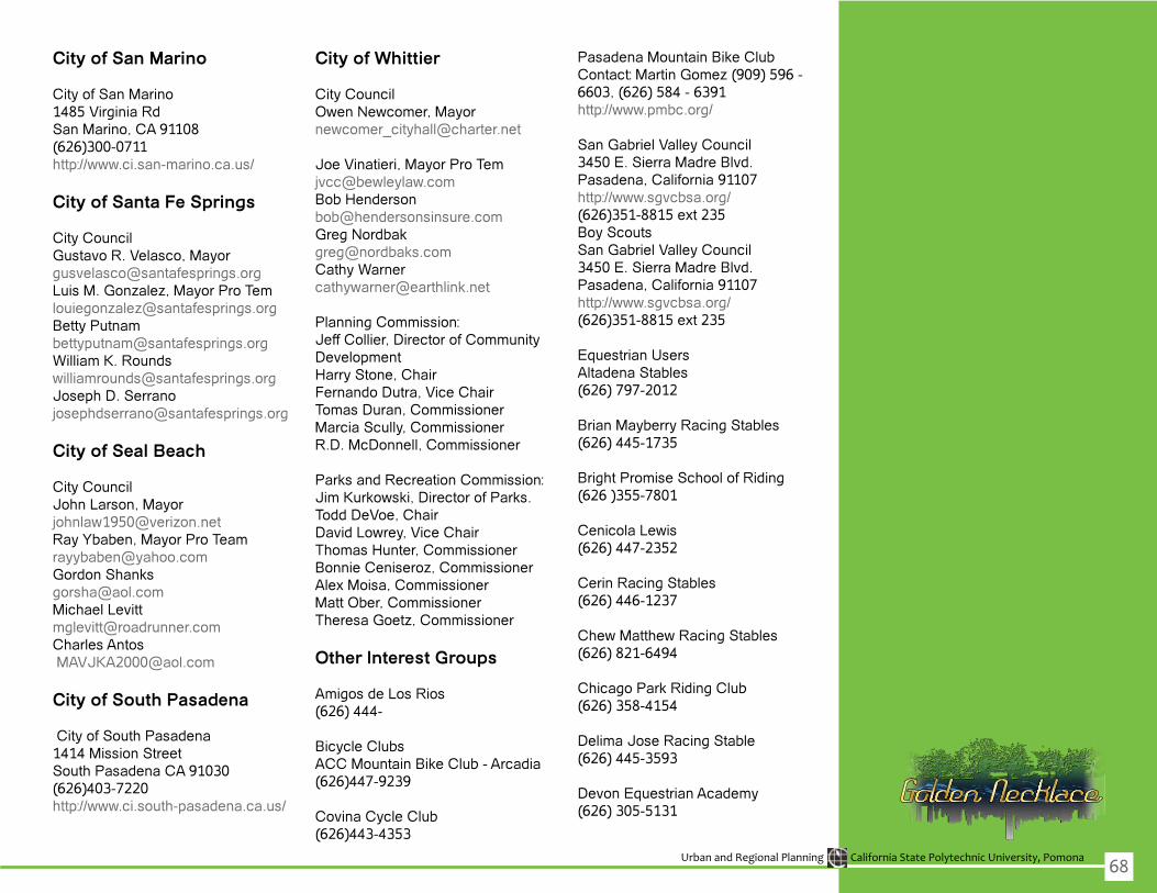
Urban and Regional Planning California State Polytechnic University, Pomona
City of San Marino
City of San Marino1485 Virginia RdSan Marino, CA 91108(626)300-0711http://www.ci.san-marino.ca.us/
City of Santa Fe Springs
City CouncilGustavo R. Velasco, [email protected],[email protected] [email protected] K. [email protected] D. Serrano [email protected]
City of Seal Beach
City CouncilJohn Larson, [email protected],[email protected] [email protected] [email protected] Antos [email protected]
City of South Pasadena
City of South Pasadena1414 Mission Street South Pasadena CA 91030(626)403-7220http://www.ci.south-pasadena.ca.us/
City of Whittier
City CouncilOwenNewcomer,[email protected]
Joe Vinatieri, Mayor Pro [email protected] [email protected] [email protected] Warner [email protected]
Planning Commission:Jeff Collier, Director of Community DevelopmentHarry Stone, ChairFernando Dutra, Vice ChairTomas Duran, CommissionerMarcia Scully, CommissionerR.D. McDonnell, Commissioner
Parks and Recreation Commission:JimKurkowski,DirectorofParks.Todd DeVoe, ChairDavidLowrey,ViceChairThomas Hunter, CommissionerBonnieCeniseroz,CommissionerAlex Moisa, CommissionerMatt Ober, CommissionerTheresaGoetz,Commissioner
Other Interest Groups
Amigos de Los Rios(626)444-
Bicycle ClubsACC Mountain Bike Club - Arcadia(626)447-9239
Covina Cycle Club(626)443-4353
Pasadena Mountain Bike ClubContact:MartinGomez(909)596-6603,(626)584-6391http://www.pmbc.org/
San Gabriel Valley Council3450 E. Sierra Madre Blvd.Pasadena, California 91107http://www.sgvcbsa.org/(626)351-8815ext235Boy ScoutsSan Gabriel Valley Council3450 E. Sierra Madre Blvd.Pasadena, California 91107http://www.sgvcbsa.org/(626)351-8815ext235
EquestrianUsersAltadena Stables(626)797-2012
Brian Mayberry Racing Stables(626)445-1735
Bright Promise School of Riding(626)355-7801
CenicolaLewis(626)447-2352
Cerin Racing Stables(626)446-1237
ChewMatthewRacingStables(626)821-6494
Chicago Park Riding Club(626)358-4154
Delima Jose Racing Stable(626)445-3593
Devon Equestrian Academy(626)305-5131
68

Urban and Regional Planning California State Polytechnic University, Pomona
DominguezRacingStable(626)446-8325
Eaton Dam Stables(626)791-5960Ehg Racing Stables Llc(626)294-0314
Ellis Ron Racing Stable(626)446-5006
Encanto Equestrian Center(626)358-8855
Eskay Creek Farm(626)303-2182
Hobsons Saddlery(626)447-8637
Hofmanf David(818)429-7963
HowardZuckerRacingStables(626)294-9414
Kathy Walsh Racing Stables(626)574-0084
Lou Carno Stables(626)462-0213
Martin & Martin Tack Shop(626)821-9743
Oak Ridge Ranch(626)303-4746
Patrick Gallagher Racing(626)445-2852
QuarterCreekFarms&Stables(626)357-4402
Rafael Becerra Racing Stable(626)447-7705
RoseBowlRiders(818)790-8341
Sahadi Jenine Racing Stable(626)574-0242
San Pascual Stables(323)258-3999
VelasquezRacingStables(626)445-5015
Walsh Kathy Racing Stables(626)574-0084
Williams Marcia Stables(323)255-5822
Windgate Saddlery(626)599-9400
FriendsoftheLARiver(FORLA)(323)223-0585
GatewayCitiesCouncilofGovernments (http://www.gatewayog.org/overview.html)
La Historia Society(626)279-1954
Los Angeles River Project(818)980-9660
SanGabriel&LowerLosAngelesRivers and Mountains Conservancy http://www.rmc.ca.gov/about/intro.html
SantaAnaRiverTrail(SART)(951)354-4220
Santa Ana Watershed Project Authority(SAWPA)http://www.sawpa.org/about/about_sawpa.htm
SeniorCitizenGroupsArcadia Royale(626)353–5337
The Fair Oaks by Regency Park(866)353-5337
The Gables(626)353-5337The Retreat at The Oaks of Pasadena(626)353-5337
Royal Oaks Manor(626)305-2433
Westminster Gardens(626)358-2569
Sierra ClubNational Headquarters(415)977-5500
Transit GroupsThe Transit Coalition13867FoothillBlvd.#104Sylmar, CA 91342-3038(818)367-1661http://thetransitcoalition.us/
69

Urban and Regional Planning California State Polytechnic University, Pomona70
This report was prepared for the Golden Necklace project by team VisCom in collaboration with LQ Designs
Creative Director: Loretta Quach [email protected]
Graphic Design Specialist: Anthony Ballon [email protected]
Graphic Design Specialist: Juan Luna [email protected]
Research Specialist: Nell Mardirosian [email protected]
Research Specialist: Candice Bowcock [email protected]
Senior Graphic Web Designer: Michael [email protected]
Q