Embed Size (px)
Citation preview

Framework and Publication ofFramework and Publication ofArc MarineArc Marine
Dawn Wright, Oregon StateDawn Wright, Oregon State
Michael Blongewicz, DHI EnvironmentMichael Blongewicz, DHI Environment
Pat Halpin, Duke UniversityPat Halpin, Duke University
Joe Breman, ESRIJoe Breman, ESRI

Arc Marine PurposeArc Marine Purpose
• YourYour Geodatabase Template Geodatabase Template– Data collection at sea/shore … to final geoprocessing, analysisData collection at sea/shore … to final geoprocessing, analysis
• Control of required data fields, common data structureControl of required data fields, common data structure– Simplify enterprise GIS project implementation Simplify enterprise GIS project implementation
• E.g., cruises, MPA networks, habitat mappingE.g., cruises, MPA networks, habitat mapping
• Program Coding/Application DevelopmentProgram Coding/Application Development– Common/shared tool developmentCommon/shared tool development– Rapid prototypingRapid prototyping– Linkage to processing modelsLinkage to processing models
• Data Sharing/NetworkingData Sharing/Networking• ““Schooling” in the GdbSchooling” in the Gdb

Arc Marine Design StrategyArc Marine Design Strategy
Image modified from original by P. Halpin, Duke

Implementation ProcessImplementation Process
DraftLogical Design
DraftConceptual Design
Prototype
UpdatedConceptual Design
UpdatedLogical Design
Pilot Project
UpdatedConceptual Design
UpdatedLogical Design
Production
Design Engineering
Database Engineering
Deployment/Rollout
• Since Oct 2001: 3 workshops, 3 ESRI UC sessionsSince Oct 2001: 3 workshops, 3 ESRI UC sessions• ArcMarine Interest List: over 320 people, 32 countriesArcMarine Interest List: over 320 people, 32 countries• Approaching final UML: feature classes, attributes, rules/behaviorsApproaching final UML: feature classes, attributes, rules/behaviors• Case studies/tool development in 2005Case studies/tool development in 2005• ESRI Press Book in early 2007ESRI Press Book in early 2007• More info at dusk.geo.orst.edu/djl/arcgis/about.htmlMore info at dusk.geo.orst.edu/djl/arcgis/about.html

Arc Marine: GIS for a Blue PlanetArc Marine: GIS for a Blue Planet
• ESRI Press, 2007ESRI Press, 2007– By Wright, Blongewicz, Halpin, BremanBy Wright, Blongewicz, Halpin, Breman
• Full background documentation with 13 case Full background documentation with 13 case studiesstudies
• Chapter 1Chapter 1 - Introduction (Conceptual - Introduction (Conceptual Framework, Why Arc Marine?) - Wright, BremanFramework, Why Arc Marine?) - Wright, Breman
• Chapter 2Chapter 2 - Common Marine Data Types - - Common Marine Data Types - Halpin, WrightHalpin, Wright


Arc Marine Thematic LayersArc Marine Thematic Layers

Arc Marine Thematic LayersArc Marine Thematic Layers

Marine Marine Marine
Arc Marine …Chapters 3-6
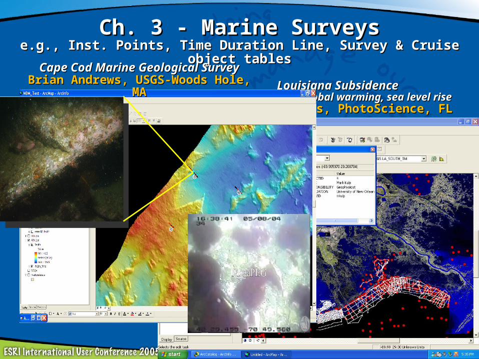
Ch. 3 - Marine SurveysCh. 3 - Marine Surveyse.g., Inst. Points, Time Duration Line, Survey & Cruise object tablese.g., Inst. Points, Time Duration Line, Survey & Cruise object tables
Louisiana SubsidenceLouisiana SubsidenceImplications of global warming, sea level riseImplications of global warming, sea level rise
Heather Mounts, PhotoScience, FLHeather Mounts, PhotoScience, FL
Cape Cod Marine Geological SurveyCape Cod Marine Geological SurveyBrian Andrews, USGS-Woods Hole, MABrian Andrews, USGS-Woods Hole, MA

Source: http://www.po.gso.uri.edu/SST/
Sea Turtle Tracks (Caretta caretta)Sea Surface Temperature (warm core rings)
Source: http://obis.env.duke.edu/datasets/ (Read & McClellan2004)
Ocean Biogeographic Information System, Ocean Biogeographic Information System, Pat Halpin et al., Duke U.Pat Halpin et al., Duke U.
Ch. 4 - Marine Animal TrackingCh. 4 - Marine Animal Trackinge.g., Location Series Points, Time Duration Lines and Areas, e.g., Location Series Points, Time Duration Lines and Areas,
object tables and rastersobject tables and rasters

Ch. 5 - Time Series & MeasurementsCh. 5 - Time Series & Measurementse.g., TimeSeriesPoints, ProfileLine, Time Series/Meas object tablese.g., TimeSeriesPoints, ProfileLine, Time Series/Meas object tables
Marine Institute’s Marine Data RepositoryMarine Institute’s Marine Data RepositoryNorth Sea / Irish SeaNorth Sea / Irish Sea
Martina Hennesey et al., Marine Institute, Galway, IRELANDMartina Hennesey et al., Marine Institute, Galway, IRELANDEamonn Doyle et al., ESRI-IRELANDEamonn Doyle et al., ESRI-IRELAND
“90% of Ireland is undeveloped, undiscovered, and … underwater.”

Ch. 6 - Nearshore & Coastal AnalysisCh. 6 - Nearshore & Coastal Analysise.g., Shorelines, ProfileLines, Marine Areas, object tablese.g., Shorelines, ProfileLines, Marine Areas, object tables
Martin County, FL Artificial Reefs, Hurricane TrackingMartin County, FL Artificial Reefs, Hurricane TrackingRob Hudson, PhotoScience; Kathy Fitzpatrick et al., Martin County Govt.Rob Hudson, PhotoScience; Kathy Fitzpatrick et al., Martin County Govt.

Ch. 6 - Nearshore & Coastal AnalysisCh. 6 - Nearshore & Coastal Analysise.g., Shorelines, ProfileLines, Marine Areas, object tablese.g., Shorelines, ProfileLines, Marine Areas, object tables
Hawaiian Reef Fish and Marine Protected AreasHawaiian Reef Fish and Marine Protected AreasAlyssa Aaby, UH; Dawn Wright, OSUAlyssa Aaby, UH; Dawn Wright, OSU
Sediment Transport, Coastal EvolutionSediment Transport, Coastal EvolutionMichael Blongewicz et al., DHIMichael Blongewicz et al., DHI
Conservation of Pacific Corals, Conservation of Pacific Corals, National Park ServiceNational Park Service
Lisa Wedding et al., NPSLisa Wedding et al., NPS

Ch. 7 - Model MeshesCh. 7 - Model Meshese.g., finite element Mesh Points, Mesh Elements, Scientific Meshe.g., finite element Mesh Points, Mesh Elements, Scientific Mesh
Michael Blongewicz, DHIMichael Blongewicz, DHI Juergen Schulz-Olberg, BSHJuergen Schulz-Olberg, BSH
(Federal Maritime & Hydrographic Agency of Germany)(Federal Maritime & Hydrographic Agency of Germany)
Ch. 8 - Multidimensional GISCh. 8 - Multidimensional GIS2-D time series, netCDF, 3-D interpolation, visualizations2-D time series, netCDF, 3-D interpolation, visualizations
Joe Breman, ESRI; Dawn Wright, OSU; Michael Blongewicz, DHIJoe Breman, ESRI; Dawn Wright, OSU; Michael Blongewicz, DHI

Ch. 9 - Afterword/EpilogueCh. 9 - Afterword/EpilogueReview/wrap-up, importance of common tools in future (tools for Review/wrap-up, importance of common tools in future (tools for
data import, filter, extraction, synching, modeling, software data import, filter, extraction, synching, modeling, software dependencies, etc.)dependencies, etc.)
data models as they relate to generic web services, specific IMSs such OBIS-SEAMAP data models as they relate to generic web services, specific IMSs such OBIS-SEAMAP projects, streaming data into the ArcMarine gdb structureprojects, streaming data into the ArcMarine gdb structure
Interoperability - linking ArcMarine with Arc Hydro and other DMs,Interoperability - linking ArcMarine with Arc Hydro and other DMs,generic discussion that points to web resources generic discussion that points to web resources
All 4 authorsAll 4 authors
Accompanying Web Site:Accompanying Web Site:ArcMarine Poster, Tutorial, UML/XMI, Tool SuiteArcMarine Poster, Tutorial, UML/XMI, Tool Suite

Arc Marine: GIS for a Blue PlanetArc Marine: GIS for a Blue Planet
• Foreword by Jane LubchencoForeword by Jane Lubchenco - - Distinguished professor of Distinguished professor of zoology/marine ecology at OSU, member of National Science Board zoology/marine ecology at OSU, member of National Science Board (governing body of NSF), National Academy of Sciences(governing body of NSF), National Academy of Sciences
• Back cover quotes:Back cover quotes:– Margaret DavidsonMargaret Davidson, NOAA CSC, NOAA CSC– Nancy TostaNancy Tosta, VP of Ross & Associates, VP of Ross & Associates– Modeling community rep. (DHI)Modeling community rep. (DHI)– IOOS/Ocean.us angle - Lee Dantzler?IOOS/Ocean.us angle - Lee Dantzler?– Carl Safina, Blue Ocean InstituteCarl Safina, Blue Ocean Institute– The Nature Conservancy/SCGIS angle - Dick Cameron? Frank Biasi? The Nature Conservancy/SCGIS angle - Dick Cameron? Frank Biasi?
Larry Sugerbaker? (Nature Serve)Larry Sugerbaker? (Nature Serve)– Others?Others?
• External reviews (and more from intl. review team)External reviews (and more from intl. review team)

More informationMore information
dusk.geo.orst.edu/djl/arcgisdusk.geo.orst.edu/djl/arcgisincludes downloads, new tutorialincludes downloads, new tutorial
support.esri.com/datamodelssupport.esri.com/datamodels