Embed Size (px)
Citation preview

1618
The 1 st International Applied Geological Congress, Department of Geology, Islamic Azad University - Mashad Branch, Iran, 26-28 April 2010
Fractures determination of Khami reservoir in Chilingar oil field, using FMS image log, cores and microscopic thin sections studies
Mousavi Jazayeri Narges *, Soleimani Bahman, Chitforoosh Ahmad
Corresponding author: Petroleum Geology Group of Shahid Chamran university, Iran. E-mail address: [email protected].
Abstract Oil production from carbonate reservoirs which form the main carbonate reservoirs of the south and southwest of Iran are mainly depended on open fractures in carbonate rocks with low porosity. Fracture study and understanding on how the fractures positioned and developed throughout the reservoir, can be helpful to field development plan and determination of suitable locations of new wells. Thus, the following objectives of this study are: determination of the exact fractures number, location searching for broken zones to getting more benefits from these zones, and also, introducing the tensions forces acting on the Khami Group formations of Chilingar oil field. The Chilingar oil field is located at 30km of the Gachsaran City with the general trend of the Zagros. In this investigation, FMS tool data, core samples of wells number 3, 4 and 7 and 700 microscopic thin sections were studied. Open fractures in upper Khami formations (Fahliyan, Gadvan and Dariyan) divided into two major groups: (1) transverse fractures with 60-78 degree slope toward N-10NW, and (2) shear fractures with a 55-82 degree slope toward N-45W. Minimum horizontal stresses enforced on borehole in Dariyan, Gadvan, Fahliyan and Surmeh in wells 3 and 7, along with NW-SE. also, indicated that the most horizontal stresses acting on borehole is in NE-SW direction that conforms with the general stress trend of the Zagros Basin (N20E). In well 4, except upper part of Gadvan Formation, Open fractures exist on all intervals Dariyan, Fahliyan and Gadvan were spread in well 4. In this reservoir, development of fractures system has not had significant effect on total porosity, but resulted to increasing of reservoir productivity. Keywords: Chilingar oil field; Khami Formation; FMS image log; Fracture; 1. Introduction In all of reservoirs in south west of Iran, fractures play a main role in petroleum production and therefore the recognition of their pattern and distribution are vitally important in exploration, production and development of the oil fields [1]. Fractures are a fundamental property of most reservoirs [2]. Natural fractures are defined as macroscopic planar discontinuities occurring naturally in the rock mass as a result of stresses in excess of the rupture strength of the rock or physical diagenetic processes [3],[4]. There are two methods exist for fractures study: direct and indirect. Direct method consists of cores study and indirect method consist of electrical log and dynamic information of the reservoir [5]. In use of electrical method, resistivity of borehole wall is converted into high resolution resistivity image of wall. Resistivity image is acquired by pad base imager tool [6], and the purpose of using these two methods together is integrate the data from cores and different imaging tools for validate image interpretation [7]. The following objectives of this study are to determine the exact fractures number, density and fractures

1619
The 1 st International Applied Geological Congress, Department of Geology, Islamic Azad University - Mashad Branch, Iran, 26-28 April 2010
development in the various layers, location of broken zones to getting more information from these zones, and also, introducing the tensions forces acting on the Khami Group Formations (Surmeh, Hith, Fahliyan, Gadvan and Dariyan) of Chilingar oil field. The results of this study provide a reliable source of data that could be used in the fracture modeling. 2. Geological setting The Chilingar oil field is located at 30km SE of the Gachsaran City and in the end of Dezful Embyment basin. This oil field is asymmetry and between Gachsaran in north, Bibi Hakimeh in south and Garangan in west. Chilingar as a block is surrounded by 2 thrust faults with linear trend across NW-SE (General trend of Zagros) (Fig. 1) [8]. Khami reservoir of this oil field divided into two parts, upper (Dariyan, Gadvan and Fahliyan) and lower (Hith and Surmeh). These parts are consisted of 8 and 7 zones, respectively. 2.1. Specification of the studied well The studied wells are located near the crest of chilingar anticline (Fig. 2). The field is asymmetrical anticline with the axis oriented approximately northwest to southeast. These wells were drilled by water base mud and the imager tool used was the full-bore formation micro scanner (FMS). The quality of FMS image log is well generally. 3. Methods In this investigation, FMS image log of well no.4 and 7 were processed. These results correlated with cores data from well no. 4 and 7 (Due to very low efficiency of well no.3 cores, just macroscopic study was done and some open fractures with oil stain were observed). Also, 700 microscopic thin sections of well no.4 and 7 in order to determine microscopic fractures were studied and their results were correlated with FMS image log. 4. Results and Discussion This study is executed in five phases; core study, interpretation of image log, thin sections study, correlation and analysis of data and finally interpretation of results. Structural features were divided into two main parts; fracturing and compactional features. Open and filled fractures, were fracturing subcategory while structural and compactional stylolites and solution seams, were compactional subcategories [1][10]. The main aim of image log interpretation was identification of these two major parts of structural features. In this study compactional features weren't included (only for certification of the FMS log) and only the fractures were taken into account. For reservoir engineers open fractures are more interesting than other types of fractures, so recognition of open fracture's exact depth and characteristics are the most attractive. Also for studying fracture patterns, open and filled fracture in Khami group, were separated. The orientation of possible open and filled fracture sets and bedding plane of each formation studied separately.
1620
The 1 st International Applied Geological Congress, Department of Geology, Islamic Azad University - Mashad Branch, Iran, 26-28 April 2010
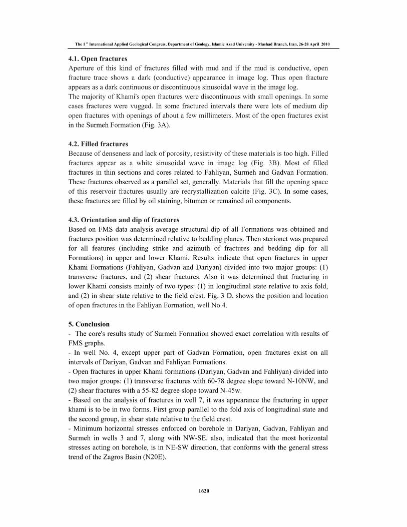
4.1. Open fractures Aperture of this kind of fractures filled with mud and if the mud is conductive, open fracture trace shows a dark (conductive) appearance in image log. Thus open fracture appears as a dark continuous or discontinuous sinusoidal wave in the image log. The majority of Khami's open fractures were discontinuous with small openings. In some cases fractures were vugged. In some fractured intervals there were lots of medium dip open fractures with openings of about a few millimeters. Most of the open fractures exist in the Surmeh Formation (Fig. 3A). 4.2. Filled fractures Because of denseness and lack of porosity, resistivity of these materials is too high. Filled fractures appear as a white sinusoidal wave in image log (Fig. 3B). Most of filled fractures in thin sections and cores related to Fahliyan, Surmeh and Gadvan Formation. These fractures observed as a parallel set, generally. Materials that fill the opening space of this reservoir fractures usually are recrystallization calcite (Fig. 3C). In some cases, these fractures are filled by oil staining, bitumen or remained oil components. 4.3. Orientation and dip of fractures Based on FMS data analysis average structural dip of all Formations was obtained and fractures position was determined relative to bedding planes. Then sterionet was prepared for all features (including strike and azimuth of fractures and bedding dip for all Formations) in upper and lower Khami. Results indicate that open fractures in upper Khami Formations (Fahliyan, Gadvan and Dariyan) divided into two major groups: (1) transverse fractures, and (2) shear fractures. Also it was determined that fracturing in lower Khami consists mainly of two types: (1) in longitudinal state relative to axis fold, and (2) in shear state relative to the field crest. Fig. 3 D. shows the position and location of open fractures in the Fahliyan Formation, well No.4. 5. Conclusion - The core's results study of Surmeh Formation showed exact correlation with results of FMS graphs. - In well No. 4, except upper part of Gadvan Formation, open fractures exist on all intervals of Dariyan, Gadvan and Fahliyan Formations. - Open fractures in upper Khami formations (Dariyan, Gadvan and Fahliyan) divided into two major groups: (1) transverse fractures with 60-78 degree slope toward N-10NW, and (2) shear fractures with a 55-82 degree slope toward N-45w. - Based on the analysis of fractures in well 7, it was appearance the fracturing in upper khami is to be in two forms. First group parallel to the fold axis of longitudinal state and the second group, in shear state relative to the field crest. - Minimum horizontal stresses enforced on borehole in Dariyan, Gadvan, Fahliyan and Surmeh in wells 3 and 7, along with NW-SE. also, indicated that the most horizontal stresses acting on borehole, is in NE-SW direction, that conforms with the general stress trend of the Zagros Basin (N20E).

1621
The 1 st International Applied Geological Congress, Department of Geology, Islamic Azad University - Mashad Branch, Iran, 26-28 April 2010
- according to our Interpretation from the FMS, seems that Khami reservoir of Chilingar field is broken, and the fractures are expanded over the whole Khami reservoir. - In this reservoir, development of fractures system has not have a significant effect on total porosity, but resulted to increasing of reservoir productivity. 6. References
[1] Khoshbakht, F., Memarian, H., and Mohammadnia, M., Comparison of Asmari, Pabdeh and Gurpi formation's fractures, derived from image log, Journal of Petroleum Science and Engineering, v.67, p.65-74, (2009).
[2] Bunge, R.J., Reservoir fractures characterization using integrated well and seismic data, Weyburn field, AAPG annual meeting, Denver, Colorado, (2001).
[3] Vikramaditya, S., Coupled Flow and Geomechanical Modeling of Compacting Hydrocarbon Reservoirs, Master of science thesis, Department of Chemical and Petroleum engineering, university of Calgary, (2009).
[4] Nelson, R.A., Geological Analysis of Naturally Fractured Reservoirs, second Edition, Gulf Professional Publishing, (2001).
[5] Davatzes, N., and Hickman, S., Comparision of acoustic and electrical image logs from the Coso geothermal field,ca, 13th Workshop on geothermal reservoir engineering, U.S. Geological Survey, (2005).
[6] Serra, O., Formation MicroScanner Image Interpretation, Schlumberger Education Services, (1989).
[7] Rezaie, A.H., Nogole-Sadat, M.A., Fracture modeling in Asmari reservoir of Rag-e Sefid oil field by using Multiwell Image Log (FMS/FMI). Iran. Int. J. Sci. 5 (1),107�121, (2004). [8] Taghavipoor, Sh., Study of Chilingar oil field (Khami Group), NISCO, report No. P- 4810, (2002).
[9] NISCO electrical document, and http://www.petroleum.ir.
[10] Bunge, R.J., Midale reservoir fractures characterization using integrated well and seismic data, Weyburn field, Saskatchewan, M.Sc. Thesis, Colorado school of mines, Golden, CO, 218p.
Fig. 1- Study area in SW Iran, Khuzestan, Dezful Embayment.[9]

1622
The 1 st International Applied Geological Congress, Department of Geology, Islamic Azad University - Mashad Branch, Iran, 26-28 April 2010
Fig. 3- A)The correlation of open fractures in FMS image log and core analysis data in the Surmeh Formation, well No.7 ; B) filled fracture in the Fahliyan Formation, well No. 4. ; C) Hair form closed fractures (filled by calcite) in thin sections of Fahliyan Formation and FMS image log, well No.4. And D) The position and location of open fractures in the Fahliyan Formation, well No.4.
C D
BA
Open fractures
Fig. 2- Understudy wells location in UGC map (Top of Dariyan).[8]