Embed Size (px)
Citation preview

FRA 2015
Implementation Plan
december, 2012
Forest resources Assessment Working Paper 181

FOOD AND AGRICULTURE ORGANIZATION OF THE UNITED NATIONSRome, 2012
FRA 2015 ImplementatIon plan
Forest Resources Assessment Working Paper 181

The designations employed and the presentation of material in this information product do not imply the expression of any opinion whatsoever on the part of the Food and Agriculture Organization of the United Nations (FAO) concerning the legal or development status of any country, territory, city or area or of its authorities, or concerning the delimitation of its frontiers or boundaries. The mention of specific companies or products of manufacturers, whether or not these have been patented, does not imply that these have been endorsed or recommended by FAO in preference to others of a similar nature that are not mentioned.
All rights reserved. FAO encourages the reproduction and dissemination of material in this information product. Non-commercial uses will be authorized free of charge, upon request. Reproduction for resale or other commercial purposes, including educational purposes, may incur fees. Applications for permission to reproduce or disseminate FAO copyright materials, and all queries concerning rights and licences, should be addressed by e-mail to [email protected] or to the Chief, Publishing Policy and Support Branch, Office of Knowledge Exchange, Research and Extension, FAO, Viale delle Terme di Caracalla, 00153 Rome, Italy.

Contents
Summary 1
Implementing the FRA Long-Term Strategy 2
Reducing the reporting burden 3
Improving data quality 5Capacity building to support the FRA 2015 reporting process 5
General objective 5Scope 5Activities 5
Capacity building for completion of FRA 2015 reports 5Capacity building at national level to promote the incorporation of remote sensing into the FRA 2015 country reports 6Capacity building to strengthen national networks for the FRA 2015 reporting process, to enhance awareness, data availability and dissemination 7
Key milestones 9
Country reporting to FRA 2015 10Reference documents 10
Remote sensing 11FRA 2015 Global Systematic Survey 11Incorporation of global MODIS data science products at the national scale 11
Burned area 11Accessible forest area 12Forest canopy cover reduction 12Aboveground biomass estimated from space-based LIDAR 12
Forest Futures: Global forest resources towards 2030/2050 14Scope 14Methodology 14Cross-cutting collaborations 15
Planned analytical and report preparation process 16
Communications strategy 17
ANNEx 1 Generic template for the capacity building activities 19
ANNEx 2 Topics, Questions and variables included in FRA 2015 24
ANNEx 3 List of planned publications 28


FRA 2015 – Implementation Plan
1
Summary
This implementation plan seeks to describe the actions to be taken from late 2012 through November 2015 to implement the Global Forest Resources Assessment (FRA) 2015. It is presented as an online document only and will be periodically adjusted. The plan follows approval by the FAO 21st Session of the Committee on Forestry (COFO) in Rome, September 2012 of the FRA Long-Term Strategy (LTS) and the request for FAO to proceed with implementation of FRA 2015.
Actions to begin implementation of the LTS fall primarily into the following categories:
• Reducing the reporting burden and increasing harmonization of forest definitions• Improving data quality• Enhancing presentation and communication results
This Implementation Plan is being produced as a FRA Working Paper, but will be updated periodically to reflect changing circumstances and new information. Each revision will retain the same Working Paper number, but will include a new Version number. All versions of the Plan will be provided primarily through the FRA webpage http://www.fao.org/forestry/fra/76871/en/.
FRA 2015 – Implementation Plan
2
Implementing the FRA Long-Term Strategy
To promote a Global Forest Resources Assessment that meets long-term global needs, COFO in its twentieth session (2010), requested FAO to prepare a long-term strategy for the FRA programme consistent with prospects for sustainable funding. COFO in its twenty-first session (2012) endorsed this strategy and the implementation of FRA 2015 as a first step.
Exactly how FRA can contribute to increasing the area and quality of sustainably managed forest has not always been clearly stated, yet it is essential if the assessment is to target those users who contribute meeting the challenges of forest management in the 21st century. FRA can help shape both policy making processes, inform and encourage forest-related investment decisions by a wide range of actors, including governments, private companies, NGOs and donor organizations. FRA must also be able to adapt to meet different needs of the diverse global forest data users: governments, non-governmental organizations, the media, intergovernmental agencies, academia, research institutions and the private sector. Understanding and meeting these diverse client needs is an important on-going challenge and an important element in this strategy. Implementation of the LTS will begin as described throughout this Implementation Plan.

FRA 2015 – Implementation Plan
3
Reducing the reporting burden
Demands for additional reporting come from many sources, but often end up increasing the workload of national reporting teams. In order to continually improve data quality, it will be important to manage the quantity of data collected to ensure practicality, importance and application of the data collected. A robust online reporting system using current technology will be produced and maintained to increase the efficiency of country reporting. Likewise, the principle of “collect once, use many times” will be used to ensure that the data collected by countries are utilized to the greatest extent possible, including through shared data collection, analysis and reporting by regional partner organizations.
Specific actions to reduce country reporting burden includes:
1. Introduction of the Collaborative Forest Resource Questionnaire (CFRQ)The CFRQ is an initiative developed with our regional data collection partners to jointly collect, analyse and report forest data at the regional and international scales. Data collected through the CFRQ (there are about 60 variables) will be collected once and used many times – primarily by the CFRQ partner organizations. There are six partners working to make theCFRQ work for 2015 reporting: FAO Forestry (FRA), The International Tropical Timber Organization (ITTO), Forest Europe, United Nations Economic Commission for Europe (UNECE), the Observatory of Central African Forests (OFAC) and the Montréal Process. The CFRQ is the successful result of the joint commitment of the partner organizations to simplify and harmonize forest-related reporting and at the same time reduce the reporting burden that countries face in responding to various reporting commitments.
The CFRQ contains a sub-set of the FRA 2015 variables which are in common with at least one of the partner organizations. The questionnaire is complementary to the FRA country reporting template – and does not overlap with the FRA. The CRFQ will be bundled as a package with other sections from FAO and other partners who wish to add their own questions that are not addressed in the common CFRQ set. The plan is to send out a Forest Data Reporting Package that is tailored to each of 103 countries. Attachment 2 shows the structure of the CFRQ and FRA submission – other sections may be added by other organizations by the late December 2012 deadline. Countries which report to more than one of these organizations and/or processes will provide the CFRQ variables just once – rather than several times as in the past. This will substantially reduce the reporting burden on these countries and at the same time contribute to improving data consistency among the partner organizations.
2. Pre-filled reportsIn order to reduce the reporting burden, the FRA secretariat has pre-filled the FRA and CFRQ templates with information submitted to FRA 2010 as well as data from external data sources1. Reports are only partially pre-filled and will need to be reviewed and amended by
1 a) Forest area certified under the international certification schemes: Forest Stewardship Council (FSC) and the Programme for the Endorsement of Forest Certification (PEFC)b) Forest fire data from remote sensingc) Reduction in forest canopy data from remote sensingd) Forestry contribution to Gross Domestic Product (GDP)e) Removals (FAOSTAT)

FRA 2015 – Implementation Plan
4
National Correspondents as necessary. In cases where no information is available (e.g. newly independent states or new FRA questions/variables), countries will receive an empty report template or section of the template.
When the pre-filled information in a reporting table corresponds to the most recent and best available data, the table should be completed by just making the forecast for year 2015. Should a country prefer to start from the beginning with their country report without using the pre-filled report provided, an empty country report template can be used.
3. Increased use of remote sensing and other data sourcesAs noted elsewhere in this plan, remote sensing will be used to pre-fill for variables such as area burned, area of accessible forest, and area of forest with reduced forest canopy. This will reduce reporting burden by providing an independent remotely sensed source of data at the country level that National Correspondents can review and choose to accept or modify.
4. Online reporting optionAn online reporting system is in advanced stages of preparation and should be available for those countries that are interested. Announcements will be sent out for National Correspondents to express interest by mid-December 2012. The online system will be voluntary and will be pre-filled with the same data that would otherwise be provided via email.

FRA 2015 – Implementation Plan
5
Improving data quality
Identifying relative levels of confidence in reported values. Because data come from sources ranging from recent national forest inventories, to expert opinion it is often difficult for readers to know and understand the reliability of the data. FRA must continue to evolve methods of data collection that clearly identify the source and make this information available to FRA users, enabling users to readily understand the relative level of confidence of the reported data.
Data accuracy/quality control. Finding ways to make country reports relevant and usable first at the national level with global reporting as a secondary benefit is an example of how to ensure that those who produce data used by the FRA programme have as much return on time invested as possible from their work. This increases incentives to ensure that data sources are identified and that quality is as high as possible. Integration of remote sensing and country reporting will be a crucial step in helping improve the reporting process in many countries.
CAPACITy buILDInG TO SuPPORT The FRA 2015 RePORTInG PROCeSSGeneral objective To improve quality and consistency of international, regional and national forest reporting for FRA 2015.
ScopeThe FRA 2015 aims to reinforce national capacities through three main activities:
• capacity building for completion of the FRA 2015 reports;• capacity building at the national level to promote the incorporation of remote sensing into
the FRA 2015 country reports;• capacity building to strengthen national networks for the FRA 2015 reporting process, to
enhance awareness, data availability and dissemination.
In addition to these three main categories of effort, FAO will also organize a global meeting of FRA National Correspondents and CFRQ partners to share data collection approaches and address questions on FRA 2015 data collection. The meeting will take place the week 6-10 May 2013 in Chiang Mai, Thailand and will consist of presentations in plenary, working group sessions and a field trip (see Appendix x for draft agenda).
The Royal Forest Department (RFD) of Thailand has agreed to co-sponsor with the collaboration of the FAO Regional office for Asia and the Pacific (RAPA).
ActivitiesCapacity building for completion of FRA 2015 reportsObjectives
• Evaluate the progress made in preparing the country reports of FRA 2015 and providetechnical assistance and guidance to the FRA National Correspondents in order to ensure consistency and high-quality of the country reports.
• Identify and address any obstacles such as: information gaps, interpretation of definitions,application of tiers, etc that National Correspondents may find when completing the FRA 2015 country reports and Collaborative Forest Resources Questionnaire (CFRQ).

FRA 2015 – Implementation Plan
6
• Create a space for dialogue to strengthen the network of FRA National Correspondents aswell as with other regional key partner organizations.
• Address all questions related to FRA 2015 data collection.
ScopeSix regions have been identified: Latin America and the Caribbean, Africa, Asia and Pacific, Europe, Russian speaking countries and North America. To the extent that funding allows, regional workshops will be organized in each of these regions. Other relevant partner at international and regional level will also be invited, including the CFRQ Partners (ITTO, Forest Europe, Montreal Process, OFAC and UN/ECE).
LocationsIn consultation with the FAO Regional Offices (FAO RO); the following possible locations have been identified according to accessibility and cost.
Region Language Location optionsLatin America and Caribbean Spanish and English Chile, PanamaAsia and Pacific English JapanAfrica English and French Ethiopia, Cameroon, BeninRussian speaking countries Russian Russia
FAO Staff participationThe organization of each workshop will be coordinated by Ms. Leticia Pina (FAO Forestry Officer) with the expectation that at least two FRA/FAO staff will be involved in each regional workshop. Some suggestions are given in the table below (additional staff).
Capacity building at national level to promote the incorporation of remote sensing into the FRA 2015 country reportsObjectivesTo improve FRA 2015 country reports in selected countries through the coordinated integration of remote sensing
ScopePriority will be given to countries whose forest inventory or remote sensing forest area data are out of date. Interventions will be carried out in close collaboration with the UN REDD Program, the NFMA, the FAO FIN program and other initiatives taken place at national level.
Specific activitiesThe activities will be coordinated in close collaboration with the FRA National Correspondents and with the remote sensing focal points. Depending on the countries’ needs; the following specific activities are considered to be carried out:
• Strengthening of the coordination/collaboration between the FRA National Correspondents, other Multilateral Environmental Agreements (MEAs) focal points and the remotesensing focal point.
• Identification of opportunities for coordination and harmonization between remotesensing-based forest statistics generated for national level estimates and accepted bygoverning institutions.
• Enhancement of FRA 2015 variables at national level through the use of remotely senseddata and analysis.
• Transfer of remote sensing tools and methodologies, where possible/desired, to countryexperts for continued assessment of national level forest-related statistics.

FRA 2015 – Implementation Plan
7
LocationsAs mentioned above a list will be established according to the criteria. It is intended to carry out interventions in at least 10 countries.
FAO staff participationRemote sensing specialists from the FRA team will work with a small group of individual countries to improve their capacity to use remotely sensed data for forest area and change reporting. Landsat satellite data will be provided to the countries as well as software tools and methods to produce new or improved national forestry statistics suitable for inclusion in the FRA 2015 report. Assisting countries that currently experience difficulty in implementing forest reporting based on remote sensing will enhance the consistency of FRA reports into the future (see Capacity Building section within this document for additional RS capacity development).
Capacity building to strengthen national networks for the FRA 2015 reporting process, to enhance awareness, data availability and disseminationObjectiveTo enhance the FRA reporting process at national level through the involvement of key stakeholders and the promotion of a support network Specific objectives
• The scope of the FRA process and awareness at country level are enhanced.• The distribution and the use of the country reports is improved.
ScopeInterventions are expected to be carried out in about 10 selected countries. Priority will be given to countries whose data is not up to date besides, other criteria will also be considered as:
• country`s request for support;• country needs assessment;• regional and global representation.
Specific activitiesTo achieve the objectives it is intended to carry out activities at national level. One workshop in each selected country is envisaged.
The organization of the workshops will be coordinated in close collaboration with the FRA National Correspondent and with the remote sensing focal point. Depending on the countries’ needs; the following specific activities are considered to be carried out during the workshops:
• Identification of stakeholders (government, private sector, civil society and academia) withrelevant national perspectives involved in forest-environment related process, as well astheir roles, potentialities and constrains to contribute to the FRA 2015 reporting process.
• Identification of the information/data overlaps and links among the different forest-environment reporting processes carried out at the country level.
• Exploration of opportunities to coordinate and/or collaborate among the differentrelevant stakeholders, including the focal points, to streamline country reports at countrylevel.
• Identification of links between the country information/data needed to establish countrystrategic priorities and the data/information generated by the FRA.
• Identification of concrete options to further use and disseminate the data/informationgathered through the FRA process at country level.
• Identification of country information management systems and the flows of information.

FRA 2015 – Implementation Plan
8
LocationsAs mentioned above a list will be established according to the criteria.
FAO Staff participationThe activities will be carried out by the FRA Forestry Officer responsible of capacity building in close collaboration with the FRA Forestry Officer responsible of remote sensing.
Estimated timing of capacity building eventsActivities 2013
J F M A M J J A S O N D
Global Meeting, Thailand M
Six regional workshops
1.Latin America and the Caribbean J
2.Asia and Pacific S
3. Africa J A
4. Russian speaking countries A S
5.Europe (*) S
6.North American countries (*) O
Incorporation of remote sensing into the FRA 2015 country reports F M A M J J A S
National networks for the FRA 2015 reporting process F M A M J J A S
N. American countries (*) O
(*) it is most likely that European and North American countries will carry out their own process; FRA staff would participate.

FRA 2015 – Implementation Plan
9
Key milestones
Planned FRA 2015 milestonesAction Deadline/schedule
FRA Newsletter 2012 16-Nov-12
Collaborative Forest Resources Questionnaire logistics, analysis and reporting plan completed 08-Dec-12
15-Dec-12
21-Dec-12
31-Dec-12
31-Jan-13
03-Feb-13
10-Apr-13
10-Apr-13
15-Apr-13
15-Apr-13
6-10 May 2013
15-Jun-13
01-Jul-13
01-Jul-13
15-Jul-13
01-Oct-13
01-Dec-13
04-Nov-13
Forest Futures methodology paper finalized
Country-Report pre-filling completed
Global fire analysis completed
FRA and CFRQ 2015 questionnaires despatched by FAO
FRA Newsletter 2013 - Issue 1
Global forest canopy reduction analysis completed and results distributed to countries
Final 2012 fire data analysis distributed to countries
Pilot country reports submitted
Forest Futures results distributed for review and discussion
Global FRA 2015 meeting in Chiang Mai, Thailand
Distribution of forest sector employment and contribution to GDP to countries
First deadline for completed country reports
Analysis of 2010 time step in 1990-2010 landuse change analysis completed
FRA Newsletter 2013 - Issue 2
Final deadline for completed/revised country reports
Forest Futures final results available online
FRA Newsletter 2013 - Issue 3
CFRQ Partners meeting for data review and analysis
FRA Newsletter 2014 - Issue 1
FRA Newsletter 2014 - Issue 2
FRA AG and CFRQ Partners meeting
FRA Newsletter 2014 - Issue 3
FRA Newsletter 2015 - Issue 1
Specialized joint reporting
FRA Newsletter 2015 - Issue 2
Release of FRA 2015 report and online database
TBD - early 2014
03-Mar-14
01-Jul-14
Nov-14
01-Dec-14
30-Mar-15
TBD
29-Jun-15
26-Sep-15
FRA 2015 – Implementation Plan
10
Country reporting to FRA 2015
The preparation of the country reports for FRA and CFRQ is an important task as it serves as a foundation for FRA 2015 analyses. Country reports will also be made publicly available on the Internet. The data provided in the reports will be compiled and published by FAO and our collaborative partner organizations2. The information will be widely used as a reference regarding the world’s forests.
The country reports should be written in English, French or Spanish and submitted to FAO. As noted in the analysis section below, reviewers will go over each report and may ask for clarifications and amendments if needed. Once the review is completed, countries will be asked for an official validation before the reports are published.
It should be noted that the questions FRA 2015 set out to answer are comprehensive, and in many cases it will be necessary to form a multidisciplinary team in order to cover all aspects of the report. It may also take some time to identify and locate national data; it is therefore recommended that National Correspondents carry out the necessary steps for getting started with the process as soon as possible in order not to delay the submission of the country report.
The National Correspondents will be encouraged to submit their reports well in advance of the deadline. This gives more time for the review and for making adjustments or amendments to the reports where necessary. Countries are strongly encouraged to submit a partial draft report at an early stage for a first review of the key sections by the FRA-team. This approach may save time when compiling the report as many of the questions build on each other.
ReFeRenCe DOCuMenTSTwo reference documents will be sent out together with the pre-filled country reports in order to facilitate the preparation of the FRA 2015 country reports and the CFRQ.
1. Guide to reporting: Explains the methodology to be applied when compiling the reports in order to ensure complete, consistent and transparent reports where all reported figures can be traced back to the original data and data source. The guide also contains, frequently asked questions as well as reference information on the IPCC guidelines and other helpful material.
2. Terms and definitions: A technical document containing all the definitions and explanatory notes for all the variables to be reported on.
2 FAO/UNECE, Forest Europe, ITTO, Montréal Process, OFAC/COMIFAC.

FRA 2015 – Implementation Plan
11
Remote sensing
The incorporation of remote sensing information into FRA 2015 will take three forms: (1) data from the year 2010 will be added to the global systematic grid already established, (2) globally consistent data from the Moderate Resolution Imaging Spectroradiometer (MODIS) sensor will be incorporated into country data to provide national estimates of annual burned area, forest canopy reduction and area of accessible forest, (3) space-based light detection and ranging (lidar) data from the Geoscience Laser Altimeter System (GLAS) will be used in conjunction with available field data to produce consistently derived estimates of aboveground biomass at the national level and, finally (4) a small group of selected countries will receive intensive training in remote sensing for forest cover assessment to improve their national estimates of forest cover and changes as reported to FRA. The following section describes each of these actions in more detail.
FRA 2015 GLObAL SySTeMATIC SuRvey The global remote sensing survey will be incorporated into the main body of the FRA report in 2015. The previous survey, completed as a separate but complementary exercise to FRA 2010, consisted of a global systematic sample of Landsat satellite imagery subsets (30 meter spatial resolution, 10 x 10km in size) from 1990, 2000 and 2005 located at every integer intersection of latitude and longitude. The results generated by this study were useful in estimating the areal extent of tree cover, forest land use and changes over time at the regional, climatic domain and global levels. For 2015, year 2010 satellite imagery will be added to the existing time series (4 time-steps total) and the analyses at the regional, climatic domain and global levels repeated.
An important component of the previous survey was the review and revision of the land cover and land use classification by national experts. The addition of the 2010 time-step in the analysis for 2015 will not require the intensive schedule of review and revision workshops as before. Instead, on-line tools are in development that will allow national experts to either (1) ownload the sample sites for their countries and work individually to review and approve the classification or (2) work through an online geo-database to review and revise the classification via internet.
InCORPORATIOn OF GLObAL MODIS DATA SCIenCe PRODuCTS AT The nATIOnAL SCALeGlobally consistent data from remote sensing satellites will be used to provide national scale information on burned area, forest accessibility and forest canopy reduction. The MODIS sensor of the United States National Aeronautics and Space Administration (NASA) is a coarse spatial resolution sensor (250 meter pixel size) that obtains nearly global coverage on a daily basis. The fine temporal resolution of the sensor make the MODIS satellite valuable for collecting time-series data in a consistent and comparable fashion globally. The information provided in these analyses for FRA 2015 will serve as a consistent, comparable baseline from which countries can incorporate improvements or additions, if they exist.
burned areaFire is a dynamic natural phenomenon with potentially significant impacts on ecosystem resilience, biodiversity and atmospheric carbon flux. Areas affected by fires, or burned areas, have unique characteristics that affect the surface reflectance (e.g. charcoal, removal of vegetation and changes in vegetation structure) and, in this way, can be detected by satellite

FRA 2015 – Implementation Plan
12
sensors like MODIS. The MODIS burned area product maps the spatial extent of recent fires on a monthly time-step and is available from year 2000 to current day. There is a time-lag of several months before the product is available for use. The burned area product is created by analysing the time-series of surface reflectance data collected by the MODIS sensor and detecting anomalies in the time-series that signify vegetation surface reflectance changes due to fire. The product has limited utility in dense forest canopy as surface fires that do not affect the forest canopy may go undetected.
The FRA 2015 report will include a global summary of burned area by vegetation type at the national, regional and climatic domain levels at yearly and 5-year average intervals.
Accessible forest areaThe amount of forest directly accessible by road or navigable watercourse is a key parameter to assess both economic opportunities of and potential threats to forest resources. The amount of accessible forest was first collected as a FRA variable in the World Forest Inventory of 1953. Since that time, the global road network and human population pressure have increased dramatically, with subsequent increases in demands on the forest resource.
The FRA 2015 will combine data on global forest areal extent derived from the MODIS Vegetation Continuous Fields (VCF) science data product with a global map of accessibility that predicts the travel time to any point on the earth using land or water based travel. The VCF is a global percent tree canopy cover product with a 250 meter pixel size. For FRA 2015, summaries of accessible forest area will be produced on national, regional, climatic domain and global levels.
Forest canopy cover reductionForest degradation is a critical parameter to measure and monitor for its impacts on biodiversity, atmospheric carbon flux and as a pre-cursor to potential deforestation or alteration of forest environmental services such as water cycling and amelioration of land surface temperature. However, forest degradation has many definitions to many different stakeholders and, as such, cannot be used succinctly as a single attribute to measure or monitor. Nevertheless, it is important to provide some kind of information that may assist the effort to characterize forest degradation where it is occurring.
FRA 2015 will include a globally consistent approach and estimate of partial canopy cover reduction from 2000-2010 at the national, climatic domain and global scales. Partial canopy cover reduction that does not meet the definition of deforestation, or nearly complete canopy cover removal, is a potentially valuable proxy variable capable of capturing one of the most notable aspects of forest degradation. Time-series MODIS VCF data with a pixel size of 250 meters will be analyzed for indications of partial canopy removal by calculating the slope of the line formed by the annual percent tree cover estimates and absolute range of percent tree cover measurements over time. Since the pixel size is coarse, only those areas with relatively large amounts of partial canopy cover removal can be detected. The global Intact Forest Landscapes and Global Wetland Map will be used as ancillary datasets to decrease the risk of false detections where forest degradation is unlikely.
Aboveground biomass estimated from space-based LIDARFRA historically includes statistics on national-level storage of biomass across the world’s forests. In order to provide a more consistent baseline for this information and upon which countries can improve if possible, the FRA team will work with lead researchers from the United States Forest Service, NASA, Colorado State University and Weber State University to assist in the development of a carbon monitoring system (CMS) satellite-based global carbon

FRA 2015 – Implementation Plan
13
inventory to produce national level estimates of aboveground live biomass. Methods for this inventory were developed during the CMS pilot phase and have been published. Discrete full waveform lidar footprints from the GLAS (Geoscience Laser Altimeter System aboard ICESat) are strongly correlated with aboveground tree biomass, and the theory behind this global inventory is that discrete GLAS “shots” can be used in a sample framework (as opposed to a synoptic map) to produce national-level biomass estimates in a manner similar to the way FIA uses ground plots. FAO FRA involvement is limited to providing opportunities for using limited ground plot data provided by willing countries through FRA regional workshops and in providing optical remote sensing analyses to the research consortium.

FRA 2015 – Implementation Plan
14
Forest Futures: Global forest resources towards 2030/2050
FRA users surveyed in 2012 indicated they are keenly interested in forest area and forest area change. Specifically they are keen to understand natural forest and planted forest areas, both for production and conservation. There is strong interest in not only understanding past forest change, but also having an informed view of what changes are likely to occur in forest area and what the impacts of these changes will be on production forestry and forest conservation.
For a well informed view on future forest resources, one has to have a good understanding of processes affecting forest area and a substantiated forward looking frame of how these processes will unfold in the future. The pressures on forest come predominantly from the agriculture sector, which in its turn has been increasingly influenced by the energy sector over the past decade notably through the use of agricultural output as feedstock for biofuels. The increase in forest area comes mainly from large-scale afforestation established in anticipation of increased demand for forest products. Forest Futures will combine the projected global needs for food, feed, renewable energy and timber to envision their impact on forest resources and identify where competition for land will likely take place in the future.
ScopeForest Futures will contribute to FRA’s overall objective by providing a series of plausible scenarios of future forest resources to help identify emerging opportunities and challenges for sustainable forest management. A historical trend analysis combining state-of-the-art knowledge from various disciplines will give a better understanding of the direct and indirect causes of deforestation and where it is expected, while the scenarios give insight on how it can be affected.
MethodologyThe exploration of plausible forest resource scenarios will be based on a participatory approach backed-up by some high quality model inputs. It will build on existing outlook processes within FAO and partner organizations, such as the regional forestry sector outlook studies and world agriculture towards 2030/2050. The shaping of scenarios will be a result of an FAO inter-departmental collaboration with external modeling expert contributions. Given the importance of stakeholder involvement in the process for the uptake of results (FAO 2005), the creation of scenarios will be an iterative process where (modeling) experts and stakeholders in the forestry sector (many of which national correspondents) exchange knowledge and perspectives. The first scenario iterations are envisioned at the national correspondent meeting in Chiang Mai, May 2013, followed by regional meetings in Africa and Latin-America (dates to be posted on the FRA 2015 website).
The Shared Socio-Economic Pathway (SSP) structure will be used to frame the Forest Futures narratives. The SSPs represent new storylines elaborated by an international community of climate change modelers replacing the outdated IPCC-SRES scenarios. The SSPs can be characterized along a gradient of increasing challenges for adaptation and for mitigation, where SSP2 is the storyline in the middle coming with intermediate challenges. SSP2 was selected by an inter-disciplinary team of experts at a collaborative workshop in Florida (August 2012) as a baseline for Forest Futures. Due to the vast (human) resources

FRA 2015 – Implementation Plan
15
needed to calculate the implications of each SSP storyline, only one SSP around which scenarios will be sketched was selected as baseline. For FRA 2020 the inclusion of several SSPs should be considered.
Cross-cutting collaborationsIntegrated assessment models combine knowledge from several disciplines into a single framework. They are used to gain a better understanding of complex environmental problems which are not explained by knowledge from a single sector. Given agriculture is responsible for most of forest loss, any future vision of forest resources is largely determined by a vision on future agricultural expansion. The global perspective studies unit of FAO’s Economic and Social Development Department provide such a vision through their World Food Model. They find global crop production will have to increase with 66% and global livestock production with 76% to feed 9 billion people in 2050 (Conforti 2011). UNECE/FAO analyzes structural developments in the forest sector and produces regional studies of the long term outlook on demand for wood. Forest Futures will combine FAO projections on agriculture production, FAO-UNECE projections on timber demand and energy needs forecasted by the International Energy Agency to create plausible future development pathways for global forest resources. Forest Futures is working through a Letter of Agreement with the Clark University Dept. of Geography to prepare data and map potential conversion of forest land using a spatial allocation model, GEOMOD, which combines biophysical and socio-economic factors. Given the importance of agriculture this analysis will use the Global Agro-Ecological Zones (GAEZ) agricultural assessment (Fischer et al. 2010), a recently released land resources database combining geo-referenced global climate, soil and terrain data at a 5 arc-minute resolution. The World Database on Protected Areas (WDPA) will be used to identify protected forests located on competition hotspots and therefore likely most vulnerable to future degradation.
Conforti, P. (2011). Looking ahead in world food and agriculture: Perspectives to 2050. Rome: FAO. Retrieved from http://www.fao.org/docrep/014/i2280e/i2280e.pdf
FAO. (2005). Auto-evaluation of forestry sector outlook studies. Rome. Retrieved from http://www.fao.org/docrep/009/af305e/af305e00.htm
Fischer, G., Nachtergaele, F. O., Prieler, S., Teixeira, E., Tóth, G., Velthuizen, H. van, Verelst, L., et al. (2010). Global Agro-ecological Zones: Model Documentation.

FRA 2015 – Implementation Plan
16
Planned analytical and report preparation process
While not yet planned in detail, the following categories of work will take place from 2013-2015:
•Review of country submissions. The data collection period for the FRA will extend through most of 2013 for some countries. During this period FAO and CFRQ partners will work to review submissions to check for consistency with standards and internal consistency. This work will begin by mid-2013 and will continue through completion in early 2014. It is planned that the review work will be done through the use of a reviewer function in the planned online data entry system that is similar to that commonly used for academic journal reviews. Three types of reviews will be solicited:
- General country report reviews. Reviewer reads through the entire country report and notes questions or comments. Not expected to be an in-depth review on any particular topic nor one done by a country specialist reviewer.
- Specialist reviews. These reviews will be done by a subject matter specialist who will have access primarily to the online sections dealing with their review topic area by country. Reviewers will be asked to check to ensure that the values make sense and are within reasonable ranges.
- Country specialist reviews. These will be done by experienced experts who know a country or group of countries well. These reviewers will help ensure that data sources that may apply at the national level are considered for inclusion in the final country report and to provide insights that can best come from independent review by knowledgeable experts.
•Analysis of regional and global results. Once the data set is complete (by early 2014) analysis and summary will begin. Statistical and experimental analysis will be performed on quantitative data, summarized and evaluated by FRA staff, CFRQ partner staff and by members of the FRA Advisory Group. An important milestone will be to complete most analyses by mid-2014 so that consultation can begin on key messages by approximately November 2014. Having a document ready for distribution in English, Spanish and French by March 2015 will require general agreement on the most important outcomes from these global and regional analyses.
• Interpretation and reporting. Two sets of reporting will be planned in greater detail. The key messages reporting which will be prepared for release by March 2015 and the full release of FRA/CFRQ findings by late September 2015 at the World Forestry Congress. This final reporting will most likely be in the form of an extensive, well-designed, spatially-linked data base that provides access to all FRA data – both tabular and spatial. This data portal will include the ability to fully manipulate the data as an expert or to access pre-prepared reports targeted to specific audience needs. Printed documents may focus on a desktop reference that provides key country data and a highly synthetic 40-50 page report that focuses on key indicators and change as well as special reports on individual topics.

FRA 2015 – Implementation Plan
17
Communications strategy
The FRA Long-term Strategy by putting special emphasis on the communication and outreach, highlighted the importance to improve data access and communication, to keep up with rapidly evolving communications technologies and to develop tailored products able to serve specific users needs.
Communications technologies are rapidly evolving and it is essential that FRA communications and outreach keep up in order to improve data access to those with good access to broadband internet services and those who have limited or no internet access. It is assumed that the trend of less reliance on paper versions of the FRA outputs will continue and as a result, while paper versions of some reports will continue to be needed, the primary emphasis will be to prepare online versions that meet future expectations.
The Expert Consultation on the FRA Long-term Strategy, held in September 2011, and the FRA 2015 technical meeting, held in March 2012, endorsed the recommendations from the Long-term Strategy and, as part of the preparatory process for FRA 2015, encouraged the undertaking of the FRA users and potential users Survey. The recommendations from the FRA 2015 Long-term Strategy, inputs from the consultation processes and results of the FRA user survey provide the basis for the FRA 2015 Communication Strategy.
Building on the analysis of challenges and opportunities, the FRA 2105 Communication Strategy delineates main strategic directions for FRA 2015 related to the format, content and promotion of FRA products, through well defined implementation phases. The implementation of the Communication Strategy will be crucial for positioning FRA 2015 as the world’s definitive assessment of global forests and forestry, able to provide the most current and comprehensive assessment of the world’s forests and to include a comparative snapshot of past and future trends.
Main challenges for FRA 2015, identified in the Communication Strategy, are data quality and data accessibility, while main opportunities are the global scope of the assessment together with a strong and consolidated partnership with other international organizations.
Based on the analysis of challenges and opportunities, the Strategy delineates the following strategic directions:
• Enhance on-line accessibility and visibility of FRA 2015: the FRA Main Report will remain a printed publication but will be supported by on-line tools and technologies to facilitate research and analysis for each user. Special emphasis will be given to selected topics (sustainable forest management, remote sensing, future projections).
• Increase the understanding of data quality by clearly identifying data sources and ranking them in reliability classes (tiers).
•Optimize opportunities to promote FRA 2015 through the network of partnerships.
The Communication Strategy envisions FRA 2015 as a web resource, supported by printed documents and it also recommends the adoption of an open online database where data can be easily extracted and analyzed in a flexible and dynamic way. The Communication Strategy also suggests to produce standardized and web-based guides on selected topics.

FRA 2015 – Implementation Plan
18
The Strategy further delineates three phases for the implementation.
The first, to take place in 2013 aims to inform potential users about FRA 2015 preparatory processes through exchange of emails, newsletter, meetings and website updates.
In 2014, the second phase of the Communication Strategy will focus on refining the definition of specific print and web-based outputs from the FRA database. This will include more work on getting pre-packaged outputs defined from the database for specific users.
The third implementation phase will be in 2015 with emphasis on the launch of the FRA 2015 results, promotion of the website and conferences presentations.
The Strategy also emphasizes the importance of securing appropriate necessary funding for the communication and outreach activities, through promotion and strengthening of partnership, and recommends the adoption of social medias to broaden the knowledge/dissemination of FRA results and to improve data accessibility.
FRA 2015 – Implementation Plan
19
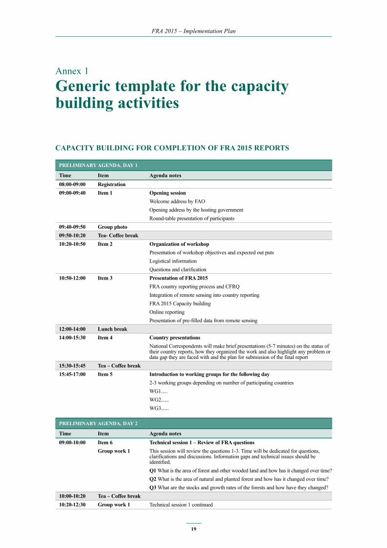
Annex 1
Generic template for the capacity building activities
CAPACITy buILDInG FOR COMPLeTIOn OF FRA 2015 RePORTS
PReLIMInARy AGenDA, DAy 1
Time Item Agenda notes08:00-09:00 Registration09:00-09:40 Item 1 Opening session
Welcome address by FAOOpening address by the hosting governmentRound-table presentation of participants
09:40-09:50 Group photo09:50-10:20 Tea- Coffee break10:20-10:50 Item 2 Organization of workshop
Presentation of workshop objectives and expected out putsLogistical informationQuestions and clarification
10:50-12:00 Item 3 Presentation of FRA 2015FRA country reporting process and CFRQIntegration of remote sensing into country reportingFRA 2015 Capacity building Online reporting Presentation of pre-filled data from remote sensing
12:00-14:00 Lunch break14:00-15:30 Item 4 Country presentations
National Correspondents will make brief presentations (5-7 minutes) on the status of their country reports, how they organized the work and also highlight any problem or data gap they are faced with and the plan for submission of the final report
15:30-15:45 Tea – Coffee break15:45-17:00 Item 5 Introduction to working groups for the following day
2-3 working groups depending on number of participating countriesWG1.....WG2......WG3......
PReLIMInARy AGenDA, DAy 2
Time Item Agenda notes09:00-10:00 Item 6
Group work 1Technical session 1 – Review of FRA questionsThis session will review the questions 1-3. Time will be dedicated for questions, clarifications and discussions. Information gaps and technical issues should be identified.Q1 What is the area of forest and other wooded land and how has it changed over time?Q2 What is the area of natural and planted forest and how has it changed over time?Q3 What are the stocks and growth rates of the forests and how have they changed?
10:00-10:20 Tea – Coffee break10:20-12:30 Group work 1 Technical session 1 continued

FRA 2015 – Implementation Plan
20
12:30-14:00 Lunch break14:00-15:00 Item 7
Group work 2Technical session 2 –Review of FRA questionsThis session will review of questions 4-8. Time will be dedicated for questions, clarifications and discussions. Information gaps and technical issues should be identified.Q4 What is the status of forest production and how has it changed over time?Q5 How much forest area is managed for protection of soil and water and ecosystem services?Q6 How much forest area is protected and designated for the conservation of biodiversity and how has it changed over time?Q7 What is the area of forest affected by woody invasive species?Q8 How much forest area is damaged each year?
15:00-15:15 Tea – Coffee break15:15-17:30 Group work 2 Technical session 2 continued.
PReLIMInARy AGenDA, DAy 3
Time Item Agenda notes09:00-10:00 Item 8
Group work 3Technical session 3 –Review of FRA questionsThis session will review of questions 10-16. Time will be dedicated for questions, clarifications and discussions. Information gaps and technical issues should be identified.Measuring progress toward Sustainable Forest Management (SFM)Part A: National-scale enabling environment for SFMQ10-Q13Part B: Operational scale progress toward SFMQ14-16
10:00-10:20 Tea – Coffee break10:20-12:30 Group work 3 Technical session 3 continued.12:30-14:00 Lunch break14:00-15:30 Item 9
Group work 4Technical session 4 –Review of FRA questionsThis session will review of questions 17-21. Time will be dedicated for questions, clarifications and discussions. Information gaps and technical issues should be identified.Q17 How much money do governments collect from and spend on forests?Q18 Who owns and manages the forests and how has this changed?Q19 How many people are directly employed in forestry?Q20 What is the contribution of forestry to Gross Domestic Product (GDP)?Q21 What is forest area likely to be in the future?
15:30-15:45 Tea- Coffee break15:45-17:30 Item 10 Workshop closing
Concluding discussionDevelop a timetable for country submission of national reportsSummary of outcome and findings of the workshopWorkshop closure

FRA 2015 – Implementation Plan
21
CAPACITy buILDInG AT nATIOnAL LeveL TO PROMOTe The InCORPORATIOn OF ReMOTe SenSInG InTO The FRA 2015 COunTRy RePORTS
The purposes of the workshops are:
• To provide intensive remote sensing data, processing methods and tools. • To generate up-to-date results of forest area (and if possible of forest change) at the
national level that will be included in the FRA 2015 national report.• To enhance the FRA reporting process at national level through the promotion of a support
network.
By the end of the workshops, the remote sensing focal point and the national correspondent should be able to have a joint comprehension of key elements required to improve RS integration, build a better, consistent baseline of forestry statistics and place FRA 2015 prominently in the evaluation of global forestry statistics and analyses.
On the technical side, attendees should be able to:
• install and use the Open Foris toolkit on their working OS environment;• perform autonomously the different exercises learned during the technical sessions;• use the JRC validation tool to revise and validate optical imagery classification;• generate reliable statistics on the forest cover and change at the national level.
FAO will provide Landsat satellite data for processing (if not already present in the country), software and methods for processing the data, software for review and revision of the results.
National participants will be expected to provide national datasets of plantation areas (if available), agricultural zones (if available) and any other source of geographic information or knowledge that can assist in classifying land use or land cover.
PReLIMInARy AGenDA, DAy 1
Time Item Agenda notes09:00-09:30 Item 1 Opening session
Welcome address by FAOOpening address by the hosting government or institutionRound-table presentation of participants
09:30-10:30 Item 2 Purpose of workshop / introduction to RSPresentation of workshop objectives and expected out putsIntroduction to RS data, methods and tools
10:30-11:30 Tea- Coffee break11:30-12:30 Item 3 Introduction to RS (cont.)
Introduction to RS data, methods and tools12:30-14:00 Lunch break14:00-15:30 Item 4 Processing exercises
Openforis processing of national data15:30-16:00 Tea – Coffee break16:00-17:30 Item 5 Processing exercises
Openforis processing of national data

FRA 2015 – Implementation Plan
22
PReLIMInARy AGenDA, DAy 2-4
Time Item Agenda notes09:00-09:30 Item 1 Processing exercises
Openforis processing of national data09:30-10:30 Item 2 Processing exercises
Openforis processing of national data10:30-11:00 Tea- Coffee break11:00-12:30 Item 3 Processing exercises
Openforis processing of national data 12:30-14:00 Lunch break14:30-15:30 Item 4 Processing exercises
Openforis processing of national data15:30-16:00 Tea – Coffee break16:00-17:30 Item 5 Processing exercises
Openforis processing of national data
PReLIMInARy AGenDA, DAy 5
Time Item Agenda notes09:00-09:30 Item 1 Processing exercises
Openforis processing of national data and/or results compilation09:30-10:30 Item 2 Processing exercises
Openforis processing of national data and/or results compilation10:30-11:00 Tea – Coffee break11:00-12:30 Item 3 Processing exercises
Openforis processing of national data and/or results compilation 12:30-14:00 Lunch break14:00-15:30 Item 4 Processing exercises
Openforis processing of national data and/or results compilation15:30-16:00 Tea – Coffee break16:00-17:30 Item 5 Workshop closing
Wrap-up, questions and steps for future
CAPACITy buILDInG TO STRenGThen nATIOnAL neTWORKS FOR The FRA 2015 RePORTInG PROCeSS, TO enhAnCe AWAReneSS, DATA AvAILAbILITy AnD DISSeMInATIOn
PReLIMInARy AGenDA, DAy 1
Time Item Agenda notes08:00-09:00 Registration09:00-09:40 Item 1 Opening session
Welcome address by FAO Opening address by the hosting governmentRound-table presentation of participants
09:40-09:50 Group photo09:50-10:10 Tea- Coffee break

FRA 2015 – Implementation Plan
23
10:10-10:30 Item 2 Organization of workshopPresentation of workshop objectives and expected out putsLogistical informationQuestions and clarification
10:30-12:00 Item 3 General presentation of FRA FRA process and FRA Long Term StrategyCountry reporting processRemote sensing to support national forest resources assessment and reportingHarmonization of reportingData availability and dissemination
12:00-14:00 Lunch break14:00-16:00 Item 4 Presentation of the different forest-environment related reporting processes
at country level (FRA 2015, ITTO, unFF, CbD, unCCC, etc)Focal points of the different reporting processes will make brief presentations (5-7 minutes) of the processes, highlighting the template, frequency of reporting, sources of data collection and the challenges face when gathering the data for completion of national reports
16:00-16:20 Tea – Coffee break16:20-17:30 Item 5 Working groups (approach to be defined)
WG1: Identification of main stakeholders involved in forest-environment related processes: roles, potentialities and constrains WG2: Identification of information/data overlaps and links among the different forest-environment reporting processes WG3: Exploration of opportunities to coordinate and/or collaborate among the different relevant stakeholders to streamline country reportsWG4: Identification of links between the country information/data needed to establish country strategic priorities and the data/information generated by the FRAWG5: Identification of concrete options to further use and disseminate the FRA country report & identification of country information management systems and the flows of information
PReLIMInARy AGenDA, DAy 2
Time Item Agenda notes09:00-09:50 Item 1 Working groups continue
A delegated of each WG explains the results of the WG while participants move around to discuss the different results and contribute. The delegate is responsible of consolidating the final information
09:50-10:10 Tea- Coffee break10:10-12:00 Item 2 Presentation of the results of the WGs
WG1, WG2, WG3, WG4 and WG512:00-14:00 Lunch break14:00-16:00 Item 3 Presentation continues
Conclusions16:00-16:20 Tea – Coffee break16:20-17:00 Item 4 Workshop closing
Wrap-up, questions and steps for future

FRA 2015 – Implementation Plan
24
Annex 2
Topics, Questions and variables included in FRA 2015
CFRQ FRA-
Topic I: FOReST AReA AnD FOReST ChARACTeRISTICS
Question 1: What is the area of forest and other wooded land and how has it changed over time?variables 1.1 Forest area X
1.2 Area of other wooded land X
1.3 Area of other land X
1.3.1 …of which with tree cover X
1.4 Inland water bodies X
1.5 Total country area X
1.6 Forest expansion X
1.6.1 ...of which afforestation X
1.6.2 ...of which natural expansion of forest X
1.7 Deforestation X
1.7.1 ...of which human induced X
1.8 Reforestation X
1.8.1 ...of which artificial X
Question 2: What is the area of natural and planted forest and how has it changed over time?variables 2.1 Primary forest X
2.2. Other naturally regenerated forest X
2.2.1 ...of which introduced species X
2.3 Planted forest X
2.3.1...of which introduced species X
2.4 Area of mangrove forest X
2.4.1 ...of which planted X
2.5 Primary forest transition matrix X

FRA 2015 – Implementation Plan
25
CFRQ FRA-
Topic II: PRODuCTIOn
Question 3: What are the stocks and growth rates of the forests and how have they changed?variables 3.1 Total forest growing stock X
3.1.1 ...of which coniferous X
3.1.2 ...of which broadleaved X
3.2 Total other wooded land growing stock X
3.2.1 ...of which coniferous X
3.2.2 ...of which broadleaved X
3.3 Net annual increment X
3.3.1 ...of which coniferous X
3.3.2 ...of which broadleaved X
3.4 Volume of top ten species X
3.5 Above-ground biomass X
3.6 Below-ground biomass X
3.7 Dead wood X
3.8 Carbon in above-ground biomass X
3.9 Carbon in below-ground biomass X
3.10 Carbon in dead wood X
3.11 Carbon in litter X
3.12 Soil carbon X
Question 4: What is the status of forest production and how has it changed over time?variables 4.1 Production forest X
4.2 Multiple use forest X
4.3 Forest area available for wood supply X
4.4 Value of most important commercial NWFP X
Topic III: PROTeCTIve FunCTIOnS AnD SeLeCTIve eCOSySTeM SeRvICeS
Question 5: how much forest area is managed for protection of soil and water and ecosystem services?variables 5.1 Protection of soil and water X
5.1.1…of which production of clean water X
5.1.2…of which coastal stabilization X
5.1.3… of which desertification control X
5.1.4… of which avalanche control X
5.1.5…of which erosion, flood protection or reducing flood risk X
5.1.6…of which other X
5.2 Ecosystem services, cultural or spiritual values X
5.2.1… of which public recreation X
5.2.2… of which carbon storage or sequestration X
5.2.3… of which spiritual or cultural services X
5.2.4… of which other X
Topic Iv: bIODIveRSITy/ COnSeRvATIOn
Question 6: how much forest area is protected and designated for the conservation of biodiversity and how has it changed over time?variables 6.1 Conservation of biodiversity X
6.2 Forest area within protected areas X
Question 7: What is the forest area affected by woody invasive species?variables 7.1 List of woody invasive species X
7.2 Area of forest affected by woody invasive species X

FRA 2015 – Implementation Plan
26
CFRQ FRA-
Topic v: DISTuRbAnCe AnD FOReST DeGRADATIOn
Question 8: how much forest is damaged each year?variables 8.1 Total land area burned X
8.1.1. ...of which forest area burned X
8.2 Number of fires X
8.2.1 ...of which forest fires X
8.3 Area of forest damaged by outbreak of: insects, diseases and severe weather events
X
Question 9: What is the forest area with reduced canopy cover?
variables 9.1 Area of forest with reduced canopy cover X
Topic vI: MeASuRInG PROGReSS TOWARD SFM
i. national-scale enabling environment for SFM
Question 10: What forest policy and regulatory framework exists to support implementation of SFM?variables 10.1 Policies supporting sustainable forest management X
10.1.1 ...of which in publicly owned forests X
10.1.2 ...of which in privately owned forests X
10.2 Legislation and regulations supporting sustainable forest management X
10.2.1 ...of which in publicly owned forests X
10.2.2 ...of which in privately owned forests X
Question 11: Is there a national platform that promotes stakeholder participation in forest policy development?variables 11.1 National stakeholder platform X
Question 12: What is the forest area intended to be in permanent forest land use and how has it changed over time?variables 12.1 Forest area intended to be in permanent forest land use X
12.1.1 ...of which permanent forest estate X
Question 13: how does your country measure and report progress toward SFM at the national level?variables 13.1 Forest area monitored under a national forest monitoring framework X
13.2 Types of forest reporting progress used at national scale X
13.2.1 Criteria and indicators reporting X
13.2.2 Periodic national state of the forest reporting X
13.2.3 Other (please document) X
13.2.4 None X
ii. Operational scale progress toward SFM
Question 14: What is the area of forest under a forest management plan and how is this monitored?variables 14.1 Forest area with management plan X
14.1.1 ...of which for production X
14.1.2 ...of which for conservation X
14.2 Monitoring of forest management plans X
14.2.1 Soil and water management X
14.2.2 High conservation value forest delineation X
14.2.3 Social consideration/community involvement X
14.3 Percent of area under forest management plan that is monitored annually X
Question 15: how are stakeholders involved in the management decision making for publicly owned forests?variables 15.1 Type of stakeholder inputs X
15.1.1 Planning phase X
15.1.2 Operations phase X
15.1.3 Review of operations X

FRA 2015 – Implementation Plan
27
CFRQ FRA-
Question 16: What is the area of forest under an independently verified forest management certification scheme?variables 16.1 Area of forest certified under an international scheme X
16.1.1 ...of which for FSC X
16.1.2 ...of which for PEFC X
16.2 Domestic forest management certification X
Topic VII: ECONOMICS/ LIVELIHOODS
Question 17: how much money do governments collect from and spend on forests?variables 17.1 Forest revenue X
17.2 Public expenditures on forests X
Question 18: Who owns and manages the forest and how has this changed?variables 18.1 Public ownership X
18.1.1 ...of which owned by the state at national scale X
18.1.2 ...of which owned by the state at the sub-national government scale X
18.2 Private ownership X
18.2.1 ...of which owned by individuals X
18.2.2 ...of which owned by private business entities and institutions X
18.2.3 ... of which owned by local, tribal and indigenous communities X
18.3 Unknown ownership X
18.4 Holder of management rights of public forests X
18.5 Public administration X
18.6 Individuals X
18.7 Private companies X
18.8 Communities X
18.9 Other X
Question 19: how many people are directly employed in forestry?variables 19.1 Employment in forestry X
19.1.1 ...of which female X
Question 20: What is the contribution of forestry to Gross Domestic Product (GDP)?variables 20.1 Gross value added from forestry X
Topic vIII: LOOKInG FORWARD
Question 21: What is forest area likely to be in the future?variables 21.1 Government targets/aspirations for forest area in 2020 and 2030 X
21.2 Forest area earmarked for conversion X

FRA 2015 – Implementation Plan
28
Attachment 3
List of planned publications
Working Title Publication type expected month of publication
Landuse change 1990-2005 Forestry Paper November 2012FRA 2015 Implementation Plan Working Paper December 2012FRA 2015 Terms and Definitions Working Paper November 2012Global Ecological Zones: 2010 Working Paper November 2012Forest Futures Methodology Working Paper December 2012A Guide to Completing FRA and CFRQ 2015 Country Reporting Working Paper February 2013Forest Futures Final Report To be determined December 2013Global land use and land cover To be determined Late 2013FRA Newsletter 2013 – Issue 1 Newsletter 03-Feb-13Global estimates of partial tree cover canopy removal To be determinedFRA Newsletter 2013 - Issue 2 Newsletter 29-Jun-13FRA Newsletter 2013 - Issue 3 Newsletter 04-Nov-13Summary of national burned area from 2000-2012 To be determinedFRA Newsletter 2014 - Issue 1 Newsletter 03-Mar-14FRA Newsletter 2014 - Issue 2 Newsletter 01-Jul-14FRA Newsletter 2014 - Issue 3 Newsletter 01-Dec-14FRA Newsletter 2015 - Issue 1 Newsletter 30-Mar-15FRA Newsletter 2015 - Issue 2 Newsletter 15-Jul-15FRA Newsletter 2015 - Issue 3 Newsletter 28 Sept 15
FRA 2015 Desk Reference and accompanying synthesis Two-volume final report September 2015
FRA 2015 topic specific reports To be determined September 2015

FRA 2015
Terms and Definitons
december, 2012
Forest resources Assessment Working Paper 180