Embed Size (px)
Citation preview
Jacksonville State University Jacksonville State University
JSU Digital Commons JSU Digital Commons
Research, Publications & Creative Work Faculty Scholarship & Creative Work
6-2021
Four Decades of Understanding Martian Geomorphology: Four Decades of Understanding Martian Geomorphology:
Revisiting Baker's "The Geomorphology of Mars" Revisiting Baker's "The Geomorphology of Mars"
Anshuman Bhardwaj University of Aberdeen
Lydia Sam University of Aberdeen
Saeideh Gharehchahi Jacksonville State University, [email protected]
Follow this and additional works at: https://digitalcommons.jsu.edu/fac_res
Part of the Geomorphology Commons
Recommended Citation Recommended Citation Bhardwaj, A., Sam, L. and Gharehchahi, S. (2021). Four decades of understanding Martian geomorphology: Revisiting Baker’s ‘The geomorphology of Mars’. Progress in Physical Geography, https://doi.org/10.1177/03091333211026215
This Article is brought to you for free and open access by the Faculty Scholarship & Creative Work at JSU Digital Commons. It has been accepted for inclusion in Research, Publications & Creative Work by an authorized administrator of JSU Digital Commons. For more information, please contact [email protected].
1
Four decades of understanding Martian geomorphology: Revisiting Baker’s “The 1
geomorphology of Mars” 2
Anshuman Bhardwaj1*, Lydia Sam1, Saeideh Gharehchahi2 3
1School of Geosciences, University of Aberdeen, Meston Building, King’s College, Aberdeen 4
AB24 3UE, UK 5
2Department of Chemistry and Geosciences, Jacksonville State University, Jacksonville, AL 6
36265, USA 7
*Corresponding author 8
Abstract: Owing to multiple successful orbiter and rover missions in the past two and half 9
decades, our understanding of the Martian atmosphere, terrain, and subsurface has 10
continuously evolved. This prompts the need to revisit the first holistic review of Martian 11
geomorphology based on useful images from Viking Mission orbiters, authored by Prof. Victor 12
R. Baker. Several of the remote sensing-based interpretations and recommendations in Baker’s 13
(1981) paper are as valid even today as they were four decades back. With an unprecedented 14
focus on Mars exploration in the coming decades, it is important to briefly revisit the advances 15
and prospects in Martian geomorphology research. 16
Keywords: Mars, geomorphology, Viking Mission, planetary exploration, remote sensing 17
I Introduction 18
In our solar system, Mars is the planet with the highest Earth similarity and relative planetary 19
habitability indices, based on various physical and physicochemical determinants (Schulze‐20
Makuch et al., 2011). Being terrestrial planets, the structural and compositional similarities 21
between Earth and Mars are further apparent from the relative geological and 22
geomorphological interpretations (Baker, 1981). The Martian regolith contains minerals and 23
the temperatures are within an acceptable range for the existence of life (as we know it). The 24
2
moderate Martian gravity can enable future colonization, and the Martian obliquity and the day 25
length are also comparable to Earth, giving the red planet its distinct seasons. Thus, it is not a 26
surprise that the leading space agencies and space companies are investing significant resources 27
in enabling further Mars exploration within the next couple of decades. However, while 28
technological advancements in engineering and computing have certainly bolstered this 29
confidence, the contribution from the vast influx of orbiter and rover observations, in the past 30
two and half decades in facilitating our understanding of the Martian atmosphere, terrain, and 31
subsurface, cannot be ignored (Bhardwaj et al., 2019a). 32
This prompts the need to revisit the first holistic and comprehensive account of Viking 33
Mission-based interpretations of Martian geomorphology, titled “The geomorphology of Mars” 34
and authored by Prof. Victor R. Baker in 1981. Undoubtedly there have been considerable 35
developments in the discipline since the publication of Baker’s (1981) paper; thus, revisiting 36
this work will clearly highlight the impacts of evolving techniques and tools on planetary 37
geomorphological interpretations. Although the short format of this “classics revisited” paper 38
does not allow for a detailed analysis of all the advances made in Martian geomorphology 39
research, we have provided key references throughout this article which the interested readers 40
can further explore. Instead, here we focus on key facets of Baker’s (1981) work to highlight 41
the status of our understanding of the Martian geomorphology in the Viking Mission era and 42
the considerable advancements since then. It is interesting to identify and suitable to 43
acknowledge, how many of Baker’s (1981) viewpoints still hold relevance, across several 44
themes within the discipline of Martian geomorphology. 45
II. Planetary geomorphology through terrestrial analogy 46
Baker starts his paper with an interesting example of the Chief Geologist for the US Geological 47
Survey, G.K. Gilbert, who had to abandon planned fieldworks after 1892 congressional budget 48
3
cuts to the Survey. Gilbert channelised this to an opportunity by utilising his time in studying 49
the moon through the naval observatory telescope in Washington, and thus, publishing one of 50
the most detailed accounts of contemporary lunar geomorphology (Gilbert, 1893). This 51
highlights how a scientist trained in terrestrial geomorphology can contribute significantly to 52
planetary geomorphology. Baker gives some more contemporary examples (e.g., Mutch, 1979; 53
Sharp 1980) discussing the relevance of analogy-based planetary exploration using remote 54
sensing images. Starting from the best available spatial resolution of ~10 m/pixel for the Viking 55
images to as high as ~25 cm/pixel High Resolution Imaging Science Experiment (HiRISE) 56
camera resolution for Mars today, over these past decades, we have seen numerous similar 57
analogous interpretations (e.g., Edgett et al., 2003; Irwin et al., 2004; Tsibulskaya et al., 2020; 58
Wood, 2006) advancing our knowledge of Martian landforms. Interestingly, while mentioning 59
the ~10 m/pixel resolution Viking images, Baker (1981) writes, “this is better resolution than 60
is available for portions of Earth”. Coming to the present scenario, the ~25 cm/pixel resolution 61
provided by the HiRISE camera for Mars is in public domain and we cannot expect such freely 62
available dataset for parts of Earth. Although the advent of unmanned aerial vehicles (UAVs) 63
(Bhardwaj et al., 2016; Gaffey and Bhardwaj, 2020) has led to an option of acquiring images, 64
comparable to HiRISE-resolutions, for Mars analogue research on Earth (e.g., Bhardwaj et al., 65
2019b; Sam et al., 2020a; Sam et al., 2020b), the applications of this technique are still limited, 66
owing to the generally inaccessible nature of the analogue sites. In the subsequent sections, 67
various relevant references are provided which can be taken as examples of some remarkable 68
approaches where the knowledge of terrestrial geomorphology was comprehensively 69
extrapolated to Mars. 70
III. Geomorphic map of Mars 71
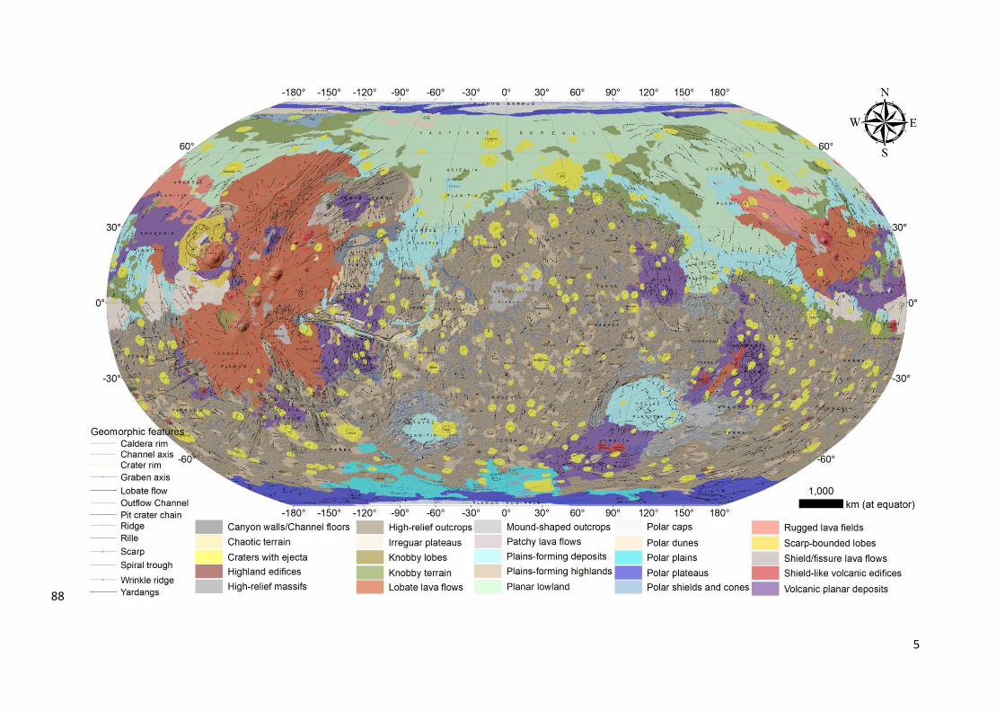
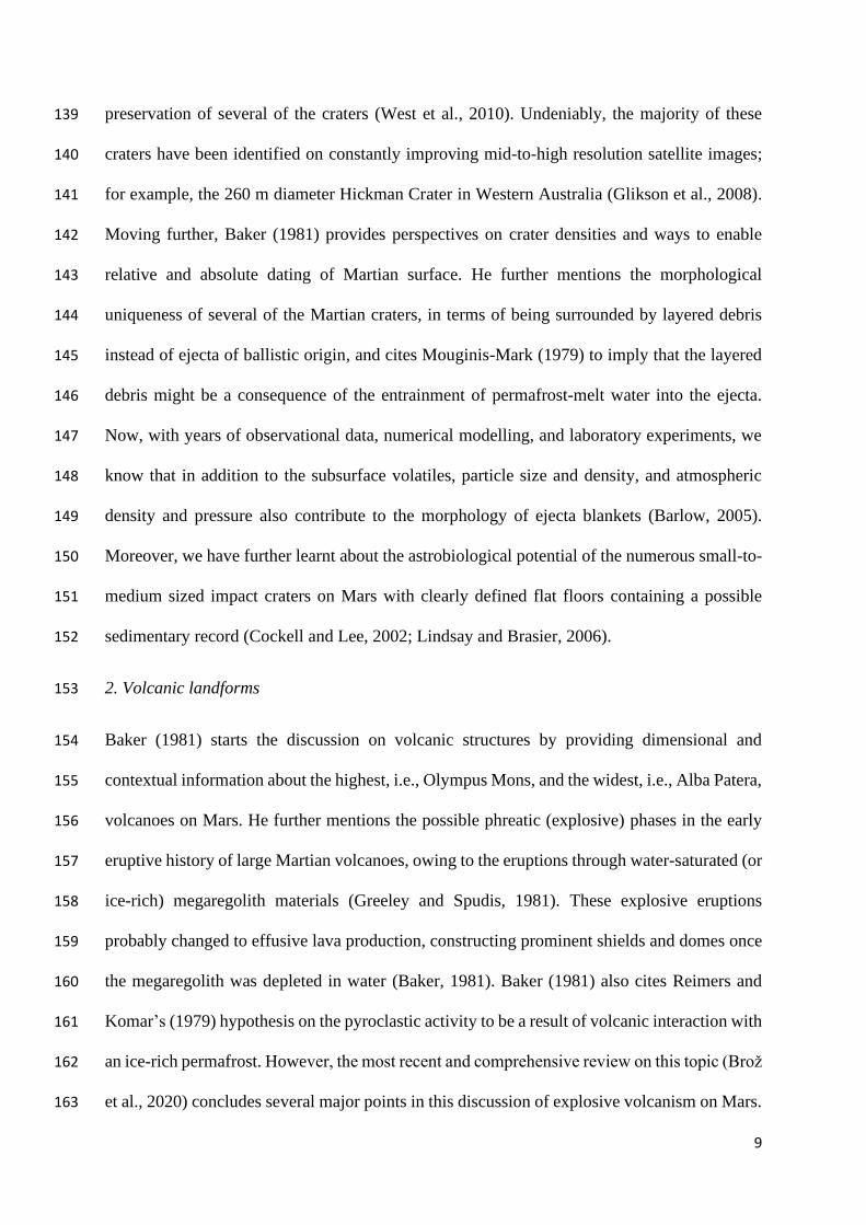
As an important contribution, Baker’s (1981) Figure 1 provides a holistic geomorphic map of 72
Mars, representing global distribution of various physiographic features. This map was 73
4
modified from the geological map by Scott and Carr (1978), issued as a US Geological Survey 74
publication. Baker (1981) classified the heavily cratered equatorial and southern highlands as 75
cratered uplands, and ejecta and uplifted blocks of ancient terrain caused by large impacts as 76
mountainous terrain. He further characterised the fretted uplands and isolated mesas along the 77
boundary between heavily cratered uplands and northern plains as knobby terrain. He also 78
highlighted three chronological volcanic plains, with Tharsis being the younger lava flows, the 79
rolling plains constituting the majority of Elysium Planitia as the intermediate age lava flows, 80
and ridged plains as the older lava plains. Baker (1981) further classified the northern plains as 81
a “complex lowland showing extensive evidence of ice-contact volcanism, permafrost features, 82
and aeolian modification”. Chaotic terrain or fractured terrain and valleys were also key 83
components of Baker’s (1981) Martian geomorphic map. Although with volumes of new 84
multisensory and higher resolution datasets, the mapping scale has improved severalfold, 85
undoubtedly, all the major geomorphic units, as presented by Baker (1981), are equally relevant 86
even today. 87
5
88
6
Figure 1. Global geomorphic map of Mars. This map is modified from the geological map by Tanaka et al. (2014). Data Source: http://pubs.usgs.gov/sim/3292.89
7
As an interesting exercise, we adopted the similar approach as Baker’s (1981) and compiled a 90
geomorphic map of major physiographic regions on Mars (Figure 1) using the data modified 91
from the most recent and complete geological map of Mars (Tanaka et al., 2014), available 92
from the US Geological Survey. This global dataset is a derived product of unprecedented 93
diversity (spectral, topographic, thermophysical, and subsurface), quality (high spatial and 94
spectral resolutions), and volume of remotely sensed data acquired since the Viking Orbiters. 95
In particular, the inclusion of precise topographic data such as Mars Global Surveyor (MGS) 96
Mars Orbiter Laser Altimeter (MOLA) digital elevation model (DEM) (463 m/pixel resolution 97
at lower latitudes to 115 m/pixel near the poles) (Smith and others, 2001) and the Mars Odyssey 98
(ODY) Thermal Emission Imaging System (THEMIS) daytime infrared (IR) image mosaic 99
(100 m/pixel) (Christensen and others, 2004) aided the visual interpretations greatly by 100
providing 3D terrain and infrared multispectral information (Tanaka et al., 2014). As 101
mentioned above, the map in Figure 1 is more detailed, understandably owing to the vastness 102
of the input data, but the close resemblance of the major physiographic classes with the ones 103
presented in Figure 1 of Baker (1981) are undeniable. 104
IV. Involvement of geomorphologists in planetary sciences 105
Baker’s (1981) paper was the first review that discussed a very vital contemporary issue (on 106
Page 476 of Baker, 1981); “Why then have so few geomorphologists become involved in the 107
study of the fascinating landscapes of Mars?” With inclusion of the first two tables in his article, 108
Baker (1981) provided two main reasons for this: (1) the limited distribution of journals and 109
government documents publishing the planetary science papers, and (2) the lack of access to 110
the planetary surface images which could enable geomorphic interpretations. Baker (1981) 111
argued how increased involvement of geomorphologists could be great in promoting planetary 112
sciences as a discipline. There is no denying that in the past four decades, comparative 113
planetology has advanced as a science and the role of the geomorphological approaches in this 114
8
advancement has been undisputed. Not only the important themes mentioned by Baker (1981), 115
such as catastrophic flooding (e.g., Rodríguez et al., 2014), volcanism (e.g., Brož et al., 2020), 116
impact cratering (e.g., Palumbo and Head, 2018), aeolian erosion (e.g., Williams et al., 2020), 117
sapping (e.g., Goldspiel and Squyres, 2000), thermokarst (e.g., Dundas et al., 2015), and large-118
scale landslides (e.g., Magnarini et al., 2019), have been greatly explored, but also, our 119
understanding of the effects of reduced gravity (e.g., Jacobsen and Burr, 2016), catastrophism 120
(Pacifici et al., 2009), and atmospheric processes (e.g., Matsubara et al., 2018) on Martian 121
landscape evolution has considerably improved. Nevertheless, the internet revolution leading 122
to digital information dissemination (Feldman, 2002) played a significant role in solving the 123
two aforementioned issues highlighted by Baker (1981). The online platform not only led to 124
the increase in the number of planetary journals, but also to the distribution of articles to an 125
interested reader. Moreover, the World Wide Web and the evolution in computing systems and 126
geographic information system software enabled easy and efficient data transfers, processing, 127
and interpretations. 128
V. Major geomorphic features on Mars and conceptual advances 129
Baker (1981) compiled the information on the geomorphic features on Mars and in the 130
following sub-sections, we revisit each of them briefly, providing some recent references to 131
assess the major conceptual advances. 132
1. Impact craters 133
Baker (1981) highlights how active resurfacing processes on Earth have erased the majority of 134
the ancient impact craters, making them relatively rare terrestrial landforms to perform 135
comparative planetology. Nevertheless, in past decades, several terrestrial craters have been 136
proposed and explored as Mars analogue sites around the globe. For example, Australia's arid 137
climate, coupled with the low-relief and tectonically stable terrain, has ensured best 138
9
preservation of several of the craters (West et al., 2010). Undeniably, the majority of these 139
craters have been identified on constantly improving mid-to-high resolution satellite images; 140
for example, the 260 m diameter Hickman Crater in Western Australia (Glikson et al., 2008). 141
Moving further, Baker (1981) provides perspectives on crater densities and ways to enable 142
relative and absolute dating of Martian surface. He further mentions the morphological 143
uniqueness of several of the Martian craters, in terms of being surrounded by layered debris 144
instead of ejecta of ballistic origin, and cites Mouginis-Mark (1979) to imply that the layered 145
debris might be a consequence of the entrainment of permafrost-melt water into the ejecta. 146
Now, with years of observational data, numerical modelling, and laboratory experiments, we 147
know that in addition to the subsurface volatiles, particle size and density, and atmospheric 148
density and pressure also contribute to the morphology of ejecta blankets (Barlow, 2005). 149
Moreover, we have further learnt about the astrobiological potential of the numerous small-to-150
medium sized impact craters on Mars with clearly defined flat floors containing a possible 151
sedimentary record (Cockell and Lee, 2002; Lindsay and Brasier, 2006). 152
2. Volcanic landforms 153
Baker (1981) starts the discussion on volcanic structures by providing dimensional and 154
contextual information about the highest, i.e., Olympus Mons, and the widest, i.e., Alba Patera, 155
volcanoes on Mars. He further mentions the possible phreatic (explosive) phases in the early 156
eruptive history of large Martian volcanoes, owing to the eruptions through water-saturated (or 157
ice-rich) megaregolith materials (Greeley and Spudis, 1981). These explosive eruptions 158
probably changed to effusive lava production, constructing prominent shields and domes once 159
the megaregolith was depleted in water (Baker, 1981). Baker (1981) also cites Reimers and 160
Komar’s (1979) hypothesis on the pyroclastic activity to be a result of volcanic interaction with 161
an ice-rich permafrost. However, the most recent and comprehensive review on this topic (Brož 162
et al., 2020) concludes several major points in this discussion of explosive volcanism on Mars. 163
10
Brož et al. (2020) concur that although, the indications of explosive volcanism have been 164
identified at various locations on Mars, the evidence is still less common than for effusive 165
activity. Brož et al. (2020) also infer that the possible explosive eruptions on Mars would have 166
behaved differently from those on Earth, since the observed edifices are often different in 167
shapes from their terrestrial counterparts. Baker (1981) mentions the presence of pseudocraters 168
and pedestal craters in the northern plains of Mars. There still is an uncertainty on the exact 169
formation mechanism of these landforms. The pseudocraters are now categorised as rootless 170
cones and both igneous and mud volcano hypotheses are proposed as their formation 171
mechanism (Czechowski et al., 2020; Dapremont and Wray, 2021). Similarly, the pedestal 172
craters, even today, are believed to be a result of presence of ice-rich layers during their 173
formation, when the ejecta formed an erosion-resistant layer shielding the surroundings 174
(Kenkmann and Wulf, 2018). Baker (1981) cites Hodges and Moore (1979) in proposing the 175
table mountains of Iceland as a possible analogue for the Martian pedestal craters. 176
3. Aeolian landforms 177
Aeolian landforms are one of those surficial features on Mars which highlight the effect of 178
improvement in spatial resolution of the imaging camera on advancing our geomorphic 179
knowledge. During the 1970s, available coarser resolution images, captured by Mariner 9 180
(McCauley et al., 1972) and Viking Orbiters (Cutts et al., 1976), revealed large, low albedo 181
dune masses, now known as large dark dunes (LDDs). Baker (1981) mentions these huge dark-182
coloured dunes surrounding the northern polar cap of Mars. With the advent of high-resolution 183
imagers, such as the Mars Orbiter Camera (MOC) (Malin and Edgett, 2001), High Resolution 184
Stereo Camera (Neukum and Jaumann, 2004), Context (CTX) camera (Malin et al., 2007), and 185
HiRISE (McEwen et al., 2007), during the 1990s and 2000s, the captured m-to-cm resolution 186
images made it possible to observe and study smaller aeolian landforms such as wind ripples, 187
granule ripples, yardangs, dust devils, ventifacts, and transverse aeolian ridges (TARs) 188
11
(Bhardwaj et al., 2019c). An updated account of aeolian landforms on Mars can be read in 189
Bridges et al. (2013). 190
4. Hillslopes and mass movement 191
In his comprehensive and interesting review, Brunsden (1993) appropriately highlighted the 192
complexity involved in discussing mass movement as an isolated discipline. Studying mass 193
movements mandatorily needs an interdisciplinary approach involving geomorphology, 194
geology, hydrology, geophysics, and soil mechanics (Brunsden, 1993). This makes 195
understanding the nature of mass movements even more complex for the places (e.g., Mars) 196
where sufficient multidisciplinary data are unavailable. Nevertheless, Baker (1981) relatively 197
effectively uses published contemporary examples of the Valles Marineris system (e.g., 198
Lucchitta, 1979; Sharp, 1973) to highlight the typical “spur-and-gully topography” (Lucchitta, 199
1978) defining numerous steep escarpments and hillslopes on Mars. Such complex topography 200
is prone to produce an immense array of mass movement features (Baker, 1981), some of which 201
are difficult to interpret and characterise even today (e.g., Bhardwaj et al., 2019a; Bhardwaj et 202
al., 2019d). Undeniably, the unavailability of high-resolution multisource datasets for the 203
majority of the Martian terrain makes the interpretations even more speculative. Baker (1981) 204
also compiled published examples to emphasise the relatively massive dimensions of mass 205
movements on Mars, undetected on Earth. 206
Interestingly, one of the possible mass movement features, which Baker (1981) refers to as 207
lobate debris deposits and discusses towards the end of this section, are extensively investigated 208
in the past two decades. These lobate debris deposits resemble terrestrial glaciers, with valleys 209
filled with debris, in some instances originating from cirque-like heads, and locally marked by 210
prominent longitudinal ridges. Squyres (1978; 1979) correlated the lobate debris deposits with 211
regions of probable high frost deposition and proposed their possible analogy with terrestrial 212
12
rock glaciers (Baker, 1981). All these glacial-type formations on Mars, displaying evidence of 213
viscous flow, are now characterised within an umbrella term called Viscous flow feature (VFF) 214
(Souness et al., 2012). Four major types of VFFs are identified and studied (Hubbard et al., 215
2011; Souness et al., 2012; Squyres, 1978, Squyres, 1979; Squyres and Carr, 1986): (1) lobate 216
debris aprons (LDA), (2) lineated valley fill (LVF), (3) concentric crater fill (CCF), and (4) 217
glacier-like forms (GLF). Interested reader can find an updated account of VFFs in Berman et 218
al. (2021). Koutnik and Pathare (2021) recently presented an informative and updated account 219
of LDA and GLF in terms of their analogy with terrestrial debris-covered glaciers. Their review 220
can be helpful in providing a holistic account of analogy between debris-covered glaciers on 221
Earth and dust and debris-covered ice on Mars. 222
5. Periglacial and permafrost features 223
Although morphologically, VFFs qualify to be characterised as permafrost landforms often 224
observed in periglacial landscape on Earth, Baker (1981) at the very onset of this section, 225
defines “periglacial” as a geomorphic environment categorised by very low annual 226
temperatures, freeze-thaw episodes, and strong wind action. Baker (1981) further defines the 227
term “permafrost” as used in comparative planetology. Although “permafrost” refers to frozen 228
ground, irrespective of its water content, in planetology, the term is often used as a synonym 229
for “ground ice” (Baker, 1981). Baker (1981) starts by discussing polygonal fracture patterns 230
which are typical of permafrost terrain. For the initially observed fractures in Martian northern 231
plains, the two most probable proposed mechanisms were permafrost ice wedging, and cooling-232
contraction cracking in lava flows. However, the massive dimensions of these cracks (hundreds 233
of metres wide with average spacings of 5-10 km) put constraint on both these hypotheses. 234
Terrestrial ice-wedge polygons generally vary from 1-100 m in diameter (Baker, 1981), and 235
with HiRISE images, today many regions on Mars have been identified with polygons 236
comparable in dimensions to their terrestrial counterparts (Soare et al., 2021). Baker (1981) 237
13
further discusses thermokarst landforms and scalloped terrain on Mars and highlights the 238
contemporary views of thermokarst landforms being a result of melting ground ice. However, 239
in the past couple of decades, both sublimation (e.g., Dundas et al., 2015) and melting (e.g., 240
Soare et al., 2008), have been investigated as the formation mechanisms for these thermokarst 241
landforms on Mars. 242
6. Polar terrains 243
Baker (1981) starts this section with describing Mariner and Viking observations of Martian 244
polar caps. Based on the temperatures observed by the infrared radiometers of the Viking 245
orbiters, Baker (1981) asserts that the “northern cap must be water ice”. Subsequent 246
multisensory observations have validated the residual ice caps to be primarily consisting of 247
water ice. A recent paper (Ojha et al., 2019) placed compositional constraint on the polar 248
silicate‐rich basal unit below the ice‐rich north polar layered deposit, by modelling its gravity 249
signature in both spatial and spectral domains. These estimates suggest that even the silicate‐250
rich basal unit below the polar layered deposits may contain 55±25% water ice, corresponding 251
to ~1.5 m global water equivalent, making it one of the largest reservoirs of water‐ice on Mars 252
(Ojha et al., 2019). 253
7. Channels and valleys 254
Baker (1981) starts this section by highlighting the excitement that was linked with the 255
discovery of channels, valleys, and related features of possible aqueous origin on Mars. 256
However, like any other hypothesis of possible liquid water on Mars, this discovery was also 257
not without controversies, and soon, in addition to water, lava flow, wind, glacial ice, 258
liquefaction of crustal materials, debris flows, liquid carbon dioxide, and liquid alkanes were 259
suggested as other possible channel-carving agents (Baker, 1981). To characterise the widely 260
variable channel morphologies, Masursky (1973) adopted a broader context and proposed four 261
14
classes: (1) broad large-sized channels originating from chaotic terrain, (2) narrow 262
intermediate-sized channels, (3) small valleys across the heavily cratered terrain, and (4) 263
volcanic channels (Baker, 1981). Sharp and Malin (1975) proposed an additional category 264
called fretted channels, in addition to Masursky’s categories (Baker, 1981). Using high-265
resolution MOC images of channels and valleys, Malin and Edgett (2003) provided 266
geomorphic evidence for aqueous sedimentation on early Mars. Mangold et al. (2004) 267
interpreted the geomorphic characteristics, especially the high degree of branching, of the 268
valleys in Valles Marineris region, to propose atmospheric precipitation during 2.9 to 3.4 269
billion years as their formation mechanism. However, a recent paper (Galofre et al., 2020), puts 270
a constraint on entirely precipitation and surface water runoff-based hypotheses for valley 271
formations on Mars and proposes subglacial and fluvial erosion as the predominant 272
mechanisms. 273
VI. Summary 274
As evident from revisiting Baker’s (1981) paper, the relevance and impact of geomorphology 275
as a discipline in progressing comparative planetology in general, and Mars landscape research 276
in particular, are indisputable. The timely compilation and survey of contemporary literature 277
following Viking Missions, and raising the awareness of geomorphology community on Mars 278
exploration, are the highpoints of this first holistic review of Martian geomorphology presented 279
by Baker (1981). With nearly the entire Martian terrain covered at ~6 m/pixel CTX resolution, 280
and continuously increasing volume of submeter HiRISE data, undoubtedly, the prospects for 281
performing comprehensive local-scale geomorphic analyses have considerably improved. 282
Moreover, the operational rovers on Mars are also providing stereoscopic and multispectral 283
images. In fact, the perceived success of the first unmanned aerial vehicle on Mars, in the form 284
of a mini-helicopter named Ingenuity onboard the recently landed Perseverance Rover, as an 285
15
image capture platform can really transform the next stage of exploring Martian 286
geomorphology. 287
Declaration of conflicting interests 288
The author(s) declared no potential conflicts of interest with respect to the research, authorship, 289
and/or publication of this article. 290
Acknowledgement 291
The authors acknowledge the encouragement, helpful suggestions, and support from Prof. 292
David R. Butler. 293
References 294
Baker, V. R. (1981). The geomorphology of Mars. Progress in Physical Geography, 5(4), 473-295
513. 296
Barlow, N. G. (2005). A review of Martian impact crater ejecta structures and their implications 297
for target properties. Large meteorite impacts III, Geological Society of America Special Paper, 298
384, 433-442. 299
Berman, D. C., Chuang, F. C., Smith, I. B., & Crown, D. A. (2021). Ice-rich landforms of the 300
southern mid-latitudes of Mars: A case study in Nereidum Montes. Icarus, 355, 114170. 301
Bhardwaj, A., Sam, L., Akanksha, Martín-Torres, F. J., & Kumar, R. (2016). UAVs as remote 302
sensing platform in glaciology: Present applications and future prospects. Remote sensing of 303
environment, 175, 196-204. 304
Bhardwaj, A., Sam, L., Martín‐Torres, F. J., & Zorzano, M. P. (2019a). Are Slope Streaks 305
Indicative of Global‐Scale Aqueous Processes on Contemporary Mars?. Reviews of 306
Geophysics, 57(1), 48-77. 307
16
Bhardwaj, A., Sam, L., Martin-Torres, F. J., & Zorzano, M. P. (2019c). Distribution and 308
morphologies of transverse Aeolian ridges in ExoMars 2020 Rover landing site. Remote 309
Sensing, 11(8), 912. 310
Bhardwaj, A., Sam, L., Martin-Torres, J., & Mier, M. P. Z. (2019d). Revisiting Enigmatic 311
Martian Slope Streaks. Earth and Space Science, 100, 100. 312
Bhardwaj, A., Sam, L., Martín-Torres, F. J., Zorzano, M. P., & Ramírez Luque, J. A. (2019b). 313
UAV imaging of a Martian brine analogue environment in a fluvio-aeolian setting. Remote 314
Sensing, 11(18), 2104. 315
Bridges, N., Geissler, P., Silvestro, S., & Banks, M. (2013). Bedform migration on Mars: 316
Current results and future plans. Aeolian Research, 9, 133-151. 317
Brož, P., Bernhardt, H., Conway, S. J., & Parekh, R. (2020). An overview of explosive 318
volcanism on Mars. Journal of Volcanology and Geothermal Research, 107125. 319
Brunsden, D. (1993). Mass movement; the research frontier and beyond: a geomorphological 320
approach. Geomorphology, 7(1-3), 85-128. 321
Christensen, P.R., Jakosky, B.M., Kieffer, H.H., and 8 others, 2004, The Thermal Emission 322
Imaging System (THEMIS) for the Mars 2001 Odyssey mission: Space Science Reviews, v. 323
110, p. 85–130. 324
Cockell, C. S., & Lee, P. (2002). The biology of impact craters—a review. Biological Reviews, 325
77(3), 279-310. 326
Cutts, J.A.; Blasius, K.R.; Briggs, G.A.; Carr, M.H.; Greeley, R.; Masursky, H. North polar 327
region of Mars: Imaging results from Viking 2. Science1976,194, 1329–1337 328
17
Czechowski, L., Zalewska, N., Zambrowska, A., Ciazela, M., Witek, P., & Kotlarz, J. (2020, 329
September). Mechanism of Origin of Chains of Cones in Cryse PLanitia. In European Planetary 330
Science Congress (pp. EPSC2020-895). 331
Dapremont, A. M., & Wray, J. J. (2021). Igneous or Mud Volcanism on Mars? The Case Study 332
of Hephaestus Fossae. Journal of Geophysical Research: Planets, 126(2), e2020JE006390. 333
Dundas, C. M., Byrne, S., & McEwen, A. S. (2015). Modeling the development of Martian 334
sublimation thermokarst landforms. Icarus, 262, 154-169. 335
Edgett, K. S., Williams, R. M., Malin, M. C., Cantor, B. A., & Thomas, P. C. (2003). Mars 336
landscape evolution: Influence of stratigraphy on geomorphology in the north polar region. 337
Geomorphology, 52(3-4), 289-297. 338
Feldman, M. P. (2002). The Internet revolution and the geography of innovation. International 339
Social Science Journal, 54(171), 47-56. 340
Gaffey, C., & Bhardwaj, A. (2020). Applications of unmanned aerial vehicles in cryosphere: 341
Latest advances and prospects. Remote Sensing, 12(6), 948. 342
Galofre, A. G., Jellinek, A. M., & Osinski, G. R. (2020). Valley formation on early Mars by 343
subglacial and fluvial erosion. Nature Geoscience, 13(10), 663-668. 344
Gilbert, G.K. (1893) The moon’s face: a study of the origin of its features. Philosophical 345
Society of Washington Bulletin 12, 241-92. 346
Glikson, A. Y., Hickman, A. H., & Vickers, J. (2008). Hickman Crater, Ophthalmia Range, 347
Western Australia: evidence supporting a meteorite impact origin. Australian Journal of Earth 348
Sciences, 55(8), 1107-1117. 349
Goldspiel, J. M., & Squyres, S. W. (2000). Groundwater sapping and valley formation on Mars. 350
Icarus, 148(1), 176-192. 351
18
Greeley, R. and Spudis, P.D. 1981: Volcanism on Mars. Reviews of Geophysics and Space 352
Physics 19, 13-41. 353
Hodges, C.A. and Moore, H.J. 1979: The subglacial birth of Olympus Mons and its aureoles. 354
Journal of Geophysical Research 84, 8061-74. 355
Hubbard, B., Milliken, R.E., Kargel, J.S., Limaye, A., Souness, C., 2011. Geomorphologi-cal 356
characterisation and interpretation of a mid-latitude glacier-like form: Hellas Planitia, Mars. 357
Icarus211 (1), 330–346. 358
Irwin III, R. P., Howard, A. D., & Maxwell, T. A. (2004). Geomorphology of Ma'adim Vallis, 359
Mars, and associated paleolake basins. Journal of Geophysical Research: Planets, 109(E12). 360
Jacobsen, R. E., & Burr, D. M. (2016). Greater contrast in Martian hydrological history from 361
more accurate estimates of paleodischarge. Geophysical Research Letters, 43(17), 8903-8911. 362
Kenkmann, T., & Wulf, G. (2018). Impact Cratering. In Planetary Geology (pp. 123-145). 363
Springer, Cham. 364
Koutnik, M.R. and Pathare, A.V., 2021. Contextualizing lobate debris aprons and glacier-like 365
forms on Mars with debris-covered glaciers on Earth. Progress in Physical Geography: Earth 366
and Environment 45: 130-186. 367
Lindsay, J., & Brasier, M. (2006). Impact craters as biospheric microenvironments, Lawn Hill 368
structure, northern Australia. Astrobiology, 6(2), 348-363. 369
Lucchitta, B.K. (1978). Morphology of chasma walls, Mars. Journal of Research of the United 370
States Geological Survey 6, 651-62. 371
Lucchitta, B.K. (1979). Landslides in Valles Marineris, Mars. Journal of Geophysical Research 372
84, 8097-8113. 373
19
Magnarini, G., Mitchell, T. M., Grindrod, P. M., Goren, L., & Schmitt, H. H. (2019). 374
Longitudinal ridges imparted by high-speed granular flow mechanisms in martian landslides. 375
Nature communications, 10(1), 1-7. 376
Malin, M.C.; Bell, J.F.; Cantor, B.A.; Caplinger, M.A.; Calvin, W.M.; Clancy, R.T.; Edgett, 377
K.S.; Edwards, L.; Haberle, R.M.; James, P.B.; et al. Context Camera Investigation on board 378
the Mars Reconnaissance Orbiter. J. Geophys. Res. Planets 2007,112. 379
Malin, M.C.; Edgett, K.S. Mars Global Surveyor Mars Orbiter Camera: Interplanetary cruise 380
through primary mission. J. Geophys. Res. 2001,106, 23429–23570. 381
Malin, M. C., & Edgett, K. S. (2003). Evidence for persistent flow and aqueous sedimentation 382
on early Mars. Science, 302(5652), 1931-1934. 383
Mangold, N., Quantin, C., Ansan, V., Delacourt, C., & Allemand, P. (2004). Evidence for 384
precipitation on Mars from dendritic valleys in the Valles Marineris area. Science, 305(5680), 385
78-81. 386
Masursky, H. 1973: An overview of geological results from Mariner 9. Journal of Geophysical 387
Research 78, 4009-30. 388
Matsubara, Y., Howard, A. D., & Irwin III, R. P. (2018). Constraints on the Noachian 389
paleoclimate of the Martian highlands from landscape evolution modeling. Journal of 390
Geophysical Research: Planets, 123(11), 2958-2979. 391
McCauley, J.F.; Carr, M.H.; Cutts, J.A.; Hartmann, W.K.; Masursky, H.; Milton, D.J.; Sharp, 392
R.P.; Wilhelms, D.E. Preliminary Mariner 9 report on the geology of Mars. Icarus1972,17, 393
289–327. 394
McEwen, A.S.; Eliason, E.M.; Bergstrom, J.W.; Bridges, N.T.; Hansen, C.J.; Delamere, W.A.; 395
Grant, J.A.; Gulick, V.C.; Herkenhoff, K.E.; Keszthelyi, L.; et al. Mars reconnaissance 396
20
orbiter’s high resolution imaging science experiment (HiRISE). J. Geophys. Res. Planets 397
2007,112. 398
Mouginis-Mark, P.J. 1979: Martian fluidized crater morphology: variations with crater size, 399
latitude, altitude, and target material. Journal of Geophysical Research 84, 8011-22. 400
Mutch, T.A. (1979). Planetary surfaces. Reviews of Geophysics and Space Physics 17, 1694-401
1722. 402
Neukum, G.; Jaumann, R. HRSC: The High Resolution Stereo Camera of Mars Express, Mars 403
Express: The Scientific Payload; Wilson, A., Chicarro, A., Eds.; ESA Publications Division: 404
Noordwijk, The Netherlands, 2004; pp. 17–35, ISBN 92-9092-556-6. 405
Ojha, L., Nerozzi, S., & Lewis, K. (2019). Compositional constraints on the north polar cap of 406
Mars from gravity and topography. Geophysical Research Letters, 46(15), 8671-8679. 407
Pacifici, A., Komatsu, G., & Pondrelli, M. (2009). Geological evolution of Ares Vallis on Mars: 408
Formation by multiple events of catastrophic flooding, glacial and periglacial processes. Icarus, 409
202(1), 60-77. 410
Palumbo, A. M., & Head, J. W. (2018). Impact cratering as a cause of climate change, surface 411
alteration, and resurfacing during the early history of Mars. Meteoritics & Planetary Science, 412
53(4), 687-725. 413
Riemers, C.E. and Komar, P.D. 1979: Evidence for explosive volcanic density currents on 414
certain Martian volcanoes. Icarus 39, 88-110. 415
Rodríguez, J.A.P., Gulick, V.C., Baker, V.R., Platz, T., Fairén, A.G., Miyamoto, H., Kargel, 416
J.S., Rice, J.W. and Glines, N., 2014. Evidence for Middle Amazonian catastrophic flooding 417
and glaciation on Mars. Icarus, 242, pp.202-210. 418
21
Sam, L., Bhardwaj, A., Singh, S., & Martin-Torres, F. J. (2020a). UAV Imaging of Small Caves 419
in Icelandic Lava Field as Possible Mars Analogues. In 3rd International Planetary Caves 420
Conference (Vol. 2197, p. 1053). 421
Sam, L., Bhardwaj, A., Singh, S., Martin-Torres, F. J., Zorzano, M. P., & Ramírez Luque, J. 422
A. (2020b). Small lava caves as possible exploratory targets on Mars: Analogies drawn from 423
UAV imaging of an Icelandic lava field. Remote Sensing, 12(12), 1970. 424
Schulze‐Makuch, D., Méndez, A., Fairén, A. G., von Paris, P., Turse, C., Boyer, G., Davila, A. 425
F., de Sousa Antonio, M. R., Catling, D., & Irwin, L. N. (2011). A two‐tiered approach to 426
assessing the habitability of exoplanets. Astrobiology, 11(10), 1041–1052. 427
Scott, D.H. and Carr, M.H. 1978: Geologic map of Mars. United States Geological Survey 428
Miscellaneous Geologic Investigations Map I-1083. 429
Sharp, R.P. (1973): Mars: troughed terrain. Journal of Geophysical Research 78, 4063-72. 430
Sharp, R.P. (1980). Geomorphological processes on terrestrial planetary surfaces. Annual 431
Reviews of Earth and Planetary Sciences 8, 231-61. 432
Sharp, R.P. and Malin, M.C. 1975: Channels on Mars. Geological Society of America Bulletin 433
86, 593-609. 434
Smith, D.E., Zuber, M.T., Frey, H.V., and 21 others, 2001, Mars Orbiter Laser Altimeter—435
Experiment summary after the first year of global mapping of Mars: Journal of Geophysical 436
Research, v. 106, no. E10, p.23,689–23,722. 437
Soare, R. J., Conway, S. J., Williams, J. P., Philippe, M., Mc Keown, L. E., Godin, E., & 438
Hawkswell, J. (2021). Possible ice-wedge polygonisation in Utopia Planitia, Mars and its 439
latitudinal gradient of distribution. Icarus, 358, 114208. 440
22
Soare, R. J., Osinski, G. R., & Roehm, C. L. (2008). Thermokarst lakes and ponds on Mars in 441
the very recent (late Amazonian) past. Earth and Planetary Science Letters, 272(1-2), 382-393. 442
Souness, C., Hubbard, B., Milliken, R. E., & Quincey, D. (2012). An inventory and population-443
scale analysis of martian glacier-like forms. Icarus, 217(1), 243-255. 444
Squyres, S.W. 1978: Martian fretted terrain: flow of erosional debris. Icarus 34, 600-613. 445
Squyres, S.W. 1979: The distribution of lobate debris aprons and similar flows on Mars. 446
Journal of Geophysical Research 84, 8087-96. 447
Squyres S. W. and Carr M. H. (1986) Geomorphic evidence for the distribution of ground ice 448
on Mars. Science, 231, 249-252. 449
Tanaka, K.L., J.A. Skinner, Jr., J.M. Dohm, R.P. Irwin, III, E.J. Kolb, C.M. Fortezzo, Thomas 450
Platz, G.G. Michael, and T.M. Hare, 2014, Geologic Map of Mars, Scale 1:20,000,000, U.S. 451
Geological Survey Scientific Investigations Map SIM 3292. URL: 452
http://pubs.usgs.gov/sim/3292 453
Tsibulskaya, V., Hepburn, A. J., Hubbard, B., & Holt, T. (2020). Surficial geology and 454
geomorphology of Greg crater, Promethei Terra, Mars. Journal of Maps, 16(2), 524-533. 455
West, M. D., Clarke, J. D., Thomas, M., Pain, C. F., & Walter, M. R. (2010). The geology of 456
Australian Mars analogue sites. Planetary and Space Science, 58(4), 447-458. 457
Williams, J., Day, M., Chojnacki, M., & Rice, M. (2020). Scarp orientation in regions of active 458
aeolian erosion on Mars. Icarus, 335, 113384. 459
Wood, L. J. (2006). Quantitative geomorphology of the Mars Eberswalde delta. Geological 460
Society of America Bulletin, 118(5-6), 557-566. 461