Embed Size (px)
Citation preview
American Journal of Civil Engineering 2018; 6(1): 34-38
http://www.sciencepublishinggroup.com/j/ajce
doi: 10.11648/j.ajce.20180601.16
ISSN: 2330-8729 (Print); ISSN: 2330-8737 (Online)
Foundation Investigations for the Bhaunrat Dam Project – A Case Study
Shahid Noor*, Rajaretnam Chitra, Manish Gupta, Amardeep Singh
Central Soil and Materials Research Station, Ministry of Water Resources, River Development and Ganga Rejuvenation, Government of
India, New Delhi, India
Email address:
[email protected] (S. Noor) *Corresponding author
To cite this article: Shahid Noor, Rajaretnam Chitra, Manish Gupta, Amardeep Singh. Foundation Investigations for the Bhaunrat Dam Project – A Case Study.
American Journal of Civil Engineering. Vol. 6, No. 1, 2018, pp. 34-38. doi: 10.11648/j.ajce.20180601.16
Received: November 28, 2017; Accepted: December 18, 2017; Published: January 5, 2018
Abstract: The geotechnical investigations play an important role in economic viability and structural stability of a dam
project. The geotechnical investigation for dam project involves the borrow area investigations and foundation investigations.
The borrow area locations and characteristics decide the economic viability of earthen dam project. Borrow area investigations
characterizes the construction material in the vicinity of dam site, depth of construction material, extent of construction
material. The foundation investigation is carried out to evaluate the compactness for foundation and abutments for the dam
project, treatment to be given to foundation and depth of excavation of foundation. The extent of foundation investigation
depends upon the site conditions but it provide the information regarding type of the soil or rock strata in the foundation or
abutment at dam site, depth of rock, water table and locations of buried channels, seams, joints and fissures etc. The foundation
investigations decide the structural safety of a dam project. The present paper presents the foundation investigations carried out
for construction of Bhaunrat Dam Project, Uttar Pradesh.
Keywords: Earthen Dam, Foundation Investigations, Trial Pits, Insitu Density, Shear, Consolidation
1. Introduction
Bhaunrat Dam Project
The Proposed Bhaunrat Dam Project, Uttar Pradesh is
planned across the river Jamuni (Batwa Basin) in Mahrauni
Tehsil of Lalitpur District in Uttar Pradesh with 24 35’10’N
latitude and 78 40’00’’ E longitudes. The main purpose of
dam is to provide the irrigation facilities of 16,000 hectare in
the drought prone area of Bundelkhand region of Uttar
Pradesh. The project envisages the construction of 22 m high
earthen dam on the river Jamuni with a gross storage capacity
of 45.08 MCM. The total length of dam is 4.2 km. The
geotechnical investigations involves the foundation
investigations to assess the compactness of the foundation.
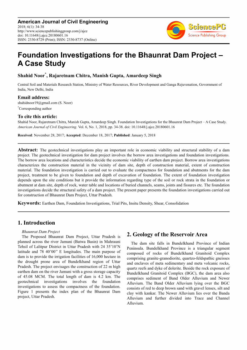
Figure 1 presents the index plan of the Bhaunrat Dam
project, Uttar Pradesh.
2. Geology of the Reservoir Area
The dam site falls in Bundelkhand Province of Indian
Peninsula. Bundelkhand Province is a triangular segment
composed of rocks of Bundelkhand Granitoid Complex
comprising granite-granodiorite, quartzo-feldspathic gneisses
and enclaves of meta sedimentary and meta volcanic rocks,
quartz reefs and dyke of dolerite. Beside the rock exposure of
Bundelkhand Granitoid Complex (BGC), the dam area also
comprises sediment of Band Older Alluvium and Newer
Alluvium. The Band Older Alluvium lying over the BGC
consists of red to deep brown sand with gravel lenses, silt and
clay with kankar. The Newer Alluvium lies over the Banda
Alluvium and further divided into Trace and Channel
Alluvium.
American Journal of Civil Engineering 2018; 6(1): 34-38 35
Figure 1. Index Plan of Bhaunrat Dam.
3. Field Investigations
Foundation investigations includes assessment the
compactness of the foundation conditions along the dam axis.
It was observed from the geological report that a total of 14
bore holes. were drilled along the dam axis and the bed rock
level varies between 0.00 m to 9.00 m below ground level
with an average depth of 3.50 m. However the fresh rock
level varies from 3.0 m to 17.6 m. During the present
geotechnical investigations for the foundation condition
assessment, a total of 10 foundation pits were excavated, 5
each on the right bank and left bank and a total of 10
undisturbed soil samples were collected from the foundation
pits for laboratory investigation on foundation material to
assess the condition of foundation. The samples were
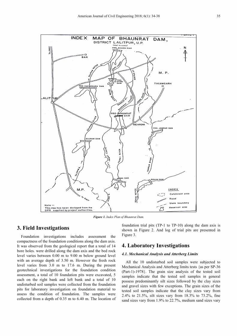
collected from a depth of 0.35 m to 6.40 m. The location of
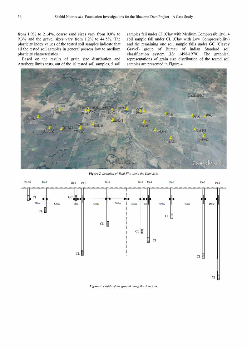
foundation trial pits (TP-1 to TP-10) along the dam axis is
shown in Figure 2. And log of trial pits are presented in
Figure 3.
4. Laboratory Investigations
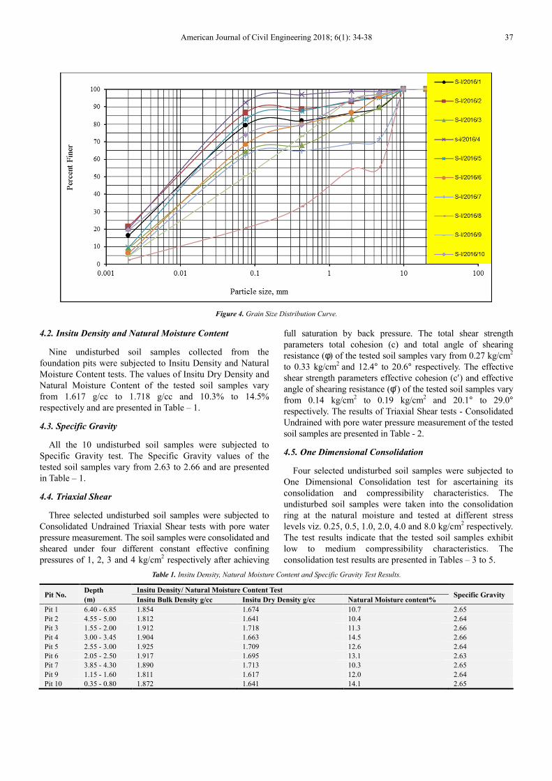
4.1. Mechanical Analysis and Atterberg Limits
All the 10 undisturbed soil samples were subjected to
Mechanical Analysis and Atterberg limits tests {as per SP-36
(Part-1)-1978}. The grain size analysis of the tested soil
samples indicate that the tested soil samples in general
possess predominantly silt sizes followed by the clay sizes
and gravel sizes with few exceptions. The grain sizes of the
tested soil samples indicate that the clay sizes vary from
2.4% to 21.5%, silt sizes vary from 18.3% to 73.2%, fine
sand sizes vary from 1.9% to 22.7%, medium sand sizes vary
36 Shahid Noor et al.: Foundation Investigations for the Bhaunrat Dam Project – A Case Study
from 1.9% to 21.4%, coarse sand sizes vary from 0.0% to
9.3% and the gravel sizes vary from 1.2% to 44.5%. The
plasticity index values of the tested soil samples indicate that
all the tested soil samples in general possess low to medium
plasticity characteristics.
Based on the results of grain size distribution and
Atterberg limits tests, out of the 10 tested soil samples, 5 soil
samples fall under CI (Clay with Medium Compressibility), 4
soil sample fall under CL (Clay with Low Compressibility)
and the remaining one soil sample falls under GC (Clayey
Gravel) group of Bureau of Indian Standard soil
classification system (IS: 1498-1970). The graphical
representations of grain size distribution of the tested soil
samples are presented in Figure 4.
Figure 2. Location of Trial Pits along the Dam Axis.
Figure 3. Profile of the ground along the dam Axis.
American Journal of Civil Engineering 2018; 6(1): 34-38 37
Figure 4. Grain Size Distribution Curve.
4.2. Insitu Density and Natural Moisture Content
Nine undisturbed soil samples collected from the
foundation pits were subjected to Insitu Density and Natural
Moisture Content tests. The values of Insitu Dry Density and
Natural Moisture Content of the tested soil samples vary
from 1.617 g/cc to 1.718 g/cc and 10.3% to 14.5%
respectively and are presented in Table – 1.
4.3. Specific Gravity
All the 10 undisturbed soil samples were subjected to
Specific Gravity test. The Specific Gravity values of the
tested soil samples vary from 2.63 to 2.66 and are presented
in Table – 1.
4.4. Triaxial Shear
Three selected undisturbed soil samples were subjected to
Consolidated Undrained Triaxial Shear tests with pore water
pressure measurement. The soil samples were consolidated and
sheared under four different constant effective confining
pressures of 1, 2, 3 and 4 kg/cm2 respectively after achieving
full saturation by back pressure. The total shear strength
parameters total cohesion (c) and total angle of shearing
resistance (φ) of the tested soil samples vary from 0.27 kg/cm2
to 0.33 kg/cm2
and 12.4° to 20.6° respectively. The effective
shear strength parameters effective cohesion (c′) and effective
angle of shearing resistance (φ′) of the tested soil samples vary
from 0.14 kg/cm2 to 0.19 kg/cm
2 and 20.1° to 29.0°
respectively. The results of Triaxial Shear tests - Consolidated
Undrained with pore water pressure measurement of the tested
soil samples are presented in Table - 2.
4.5. One Dimensional Consolidation
Four selected undisturbed soil samples were subjected to
One Dimensional Consolidation test for ascertaining its
consolidation and compressibility characteristics. The
undisturbed soil samples were taken into the consolidation
ring at the natural moisture and tested at different stress
levels viz. 0.25, 0.5, 1.0, 2.0, 4.0 and 8.0 kg/cm2 respectively.
The test results indicate that the tested soil samples exhibit
low to medium compressibility characteristics. The
consolidation test results are presented in Tables – 3 to 5.
Table 1. Insitu Density, Natural Moisture Content and Specific Gravity Test Results.
Pit No. Depth
(m)
Insitu Density/ Natural Moisture Content Test Specific Gravity
Insitu Bulk Density g/cc Insitu Dry Density g/cc Natural Moisture content%
Pit 1 6.40 - 6.85 1.854 1.674 10.7 2.65
Pit 2 4.55 - 5.00 1.812 1.641 10.4 2.64
Pit 3 1.55 - 2.00 1.912 1.718 11.3 2.66
Pit 4 3.00 - 3.45 1.904 1.663 14.5 2.66
Pit 5 2.55 - 3.00 1.925 1.709 12.6 2.64
Pit 6 2.05 - 2.50 1.917 1.695 13.1 2.63
Pit 7 3.85 - 4.30 1.890 1.713 10.3 2.65
Pit 9 1.15 - 1.60 1.811 1.617 12.0 2.64
Pit 10 0.35 - 0.80 1.872 1.641 14.1 2.65
38 Shahid Noor et al.: Foundation Investigations for the Bhaunrat Dam Project – A Case Study
Table 2. Triaxial Shear Test Results.
Sample No.
Triaxial Shear Test
Total shear parameter Effective shear parameter
c
kg/cm2
φφφφ
Degrees
c′′′′ kg/cm2
φφφφ′′′′ Degrees
S-III/2016/2 0.33 12.4° 0.19 20.1°
S-III/2016/4 0.31 15.3° 0.16 21.2°
S-III/2016/6 0.27 20.6° 0.14 29.0°
Table 3. Consolidation Test Results, Cv.
Sample No.
Coefficient of Consolidation, Cv × 10-4 cm2/kg
Stress level, kg/cm2
0.25-0.50 0.50-1.0 1.0-2.0 2.0-4.0 4.0-8.0
S-III/2016/2 10.69 6.86 3.21 1.44 0.89
S-III/2016/4 12.80 8.79 5.23 3.70 2.50
S-III/2016/6 12.69 7.60 4.07 2.61 1.95
S-III/2016/7 14.46 8.95 6.37 4.40 2.97
4.6. Chemical Analysis
Three selected soil samples were subjected to chemical
analysis with particular reference to PH, CaCO3, Total
Soluble Solids, Water Soluble Sulphates, Water Soluble
Chloride and Organic Matter. The test results of chemical
analysis indicate the normal behavior of soil.
Table 4. Consolidation Test Results, mv.
Sample No.
Coefficient of Volume Compressibility, mv × 102 cm2/kg
Stress level, kg/cm2
0.25-0.50 0.50-1.0 1.0-2.0 2.0-4.0 4.0-8.0
S-III/2016/2 5.23 4.89 4.18 3.08 2.08
S-III/2016/4 5.51 4.90 4.31 2.89 2.04
S-III/2016/6 6.78 5.17 3.83 2.31 1.57
S-III/2016/7 7.49 5.05 3.41 2.29 1.47
Table 5. Consolidation Test Results, Cc & Cs.
Sample No. Compression Index, Cc Swelling Index, Cs
S-III/2016/2 0.2152 0.0264
S-III/2016/4 0.2230 0.0276
S-III/2016/6 0.1892 0.0198
S-III/2016/7 0.1619 0.0185
5. Conclusions
Based on the findings of the foundation investigations
carried out for the Proposed Bhaunrat Dam Project, Uttar
Pradesh, the following conclusions have been arrived at:
The grain size analysis of the tested soil samples indicate
that the tested soil samples possess predominantly silt sizes
followed by the clay sizes and gravel sizes with few
exceptions. The plasticity index values of the tested soil
samples indicate that all the soil samples in general possess
low to medium plasticity characteristics.
Based on the results of grain size distribution and
Atterberg’s limits tests, out of the 10 tested soil samples, 5
soil samples fall under CI (Clay with Medium
Compressibility), 4 soil sample fall under CL (Clay with Low
Compressibility) and the remaining 1 soil sample falls under
GC (Clayey Gravel) group of Bureau of Indian Standard soil
classification system. The values of Insitu Dry Density and
Natural Moisture Content of the tested soil samples vary
from 1.617 g/cc to 1.718 g/cc and 10.3% to 14.5%
respectively. Based on the Insitu Density test, it is inferred
that the foundation strata possess good compactness.
The total shear strength parameters total cohesion (c) and
total angle of shearing resistance (φ) of the tested soil samples
vary from 0.27 kg/cm2 to 0.33kg/cm2 and 12.4° to 20.6°
respectively. The effective shear strength parameters effective
cohesion (c′) and effective angle of shearing resistance (φ′) of
the tested soil samples vary from 0.14 kg/cm2 to 0.19 kg/cm2
and 20.1° to 29.0° respectively. Based on the results of Triaxial
Shear tests conducted on the soil samples, it is inferred that the
tested soil samples are likely to exhibit good shear strength
characteristics. Based on the one dimensional consolidation
test conducted on the soil samples, it is inferred that borrow
area materials are likely to undergo low to medium
compressibility depending upon the imposed loads.
Disclaimer
The views expressed in this paper are strictly individual
views of the authors and do not, in any way, represent the
views of the department/organization where they are
presently working.
References
[1] Alam Singh, (1981), “Soil Engineering in Theory and Practice (Vol. 1)”, Asia Publishing House, Bombay.
[2] B. M. Das (1994), “Principles of Soil Engineering” third Edition, PWS Publishers, Boston.
[3] CSMRS Report (2016). “Report on the Foundation Investigations for the Proposed Bhaunrat Dam Project, Uttar Pradesh”, Report No. 02/Soil-III/SM/CSMRS/E/12/2016, December 2016.
[4] CSMRS Report (2016). “Report On Laboratory Investigations On Soil Samples Collected From The Borrow Areas For The Proposed Bhaunrat Dam Project, Uttar Pradesh”, Report No. 01/Soil-III/SM/CSMRS/E/12/2016, December 2016.
[5] Geological Survey of India report on “Geotechnical Investigations for the Bhaunrat Dam Project, District Lalitpur, Uttar Pradesh”.
[6] EM 1110-2-2300, (1982), Earth manual, Publication of United States Bureau of Reclamation.
[7] Fell, R., Macgregor, P., & Stapledon, D. (1992), Geotechnical Engineering of Embankment dams.
[8] IS: 12169-1987: Criteria for Design of Small Embankments Dams.
[9] IS 1498-1970: Classification and Identifications of Soils for General Enginee [ring Purposes].
[10] SP-36 (Part-1)-1978: Standard Publication on Soil Testing in laboratory, Bureau of Indian Standards.