Embed Size (px)
Citation preview
FOSTER JOSEPH SAYERS DAM and RESERVOIR MASTER PLAN BALD EAGLE CREEK, CENTRE COUNTY, PENNSYLVANIA JULY 2020

This page intentionally left blank

Foster Joseph Sayers Dam and Reservoir FONSI-i Draft Master Plan Update Environmental Assesment
DRAFT FINDING OF NO SIGNIFICANT IMPACT Environmental Assessment for the Foster Joseph Sayers Dam and Reservoir Master Plan
Bald Eagle Creek, Pennsylvania In accordance with the National Environmental Policy Act of 1969 (NEPA), including guidelines in 33 Code of Federal Regulations (CFR) Part 230 (Procedures for Implementing NEPA), the Baltimore District of the U.S. Army Corps of Engineers (USACE) has assessed the potential impacts of the 2020 Foster Joseph Sayers Dam and Reservoir Master Plan (2020 Master Plan). Foster Joseph Sayers Dam and Reservoir was authorized and constructed for the primary purposes of managing flood risk in the Upper Susquehanna River Basin. Implementation of the Foster Joseph Sayers Dam and Reservoir Master Plan and proposed land classification changes must recognize and be compatible with the authorized purpose of flood risk management and the USACE Environmental Operating Principles. The 2020 Master Plan will provide guidance for stewardship of natural resources and management for long- term public access to, and use of, the natural resources of Foster Joseph Sayers Dam and Reservoir, including the land classification of the USACE-managed lands. USACE manages project lands in accordance with land classifications that have been determined in the Master Plan for the project lands. Thus, land classifications are fundamental to project lands management. Land use classifications (see Table S-1) provide for development and resource management consistent with authorized purposes and other Federal laws. The 2020 Master Plan provides a comprehensive description of Foster Joseph Sayers Dam and Reservoir (the Project), a discussion of factors influencing resource management and development, new resource management objectives, a synopsis of public involvement and input into the planning process, descriptions of existing development, and consideration of future development activities. Under the No Action Alternative, the USACE would take no action, which means no new resource analysis or land use reclassifications would occur. The operation and management of Foster Joseph Sayers Dam and Reservoir would continue as outlined in the 1974 Master Plan. The Proposed Action includes adopting the 2020 Master Plan to reflect changes in land management and land uses, USACE regulations and guidance that have occurred since the 1974 Master Plan, and coordination with the public. The 2020 Master Plan refines land classifications to meet authorized project purposes and current resource objectives. This includes a mix of natural resource and recreation management objectives that are compatible with Chesapeake Bay Program watershed goals established by stakeholders and USACE during the master planning process, recognize outdoor recreation trends, and are responsive to public comments. The purpose of the Proposed Action is to ensure that the conservation and sustainability of the land, water, and recreational resources at Foster Joseph Sayers Dam and Reservoir comply with applicable environmental laws and regulations and to maintain quality land for future use, including the 2014 Chesapeake Bay Agreement goals and management strategies for restoring and maintaining the health of the watershed. The 2020 Master Plan is intended to serve as a comprehensive land and recreation management plan for the next 15 to 25 years, which reflects changes that have occurred since 1974 in outdoor recreation trends, regional land use, population, legislative requirements, USACE management policy, and wildlife habitat at Foster Joseph Sayers Dam and Reservoir. The Proposed Action is needed to update the Foster Joseph Sayers Dam and Reservoir Master Plan in accordance with January 2013 updates to the Engineer Regulation (ER) and Engineering Pamphlet (EP) 1130-2-550.
Foster Joseph Sayers Dam and Reservoir FONSI-ii Draft Master Plan Update Environmental Assesment
Table S-1 identifies the required land and water surface classification changes associated with the Proposed Action.
Table S-1. Proposed Changes to Land Use Classifications at Foster Joseph Sayers Dam and Reservoir Prior Land Classifications (1974) Acres New Land Classification Acres
Project Operations 494 Project Operations 494
Recreation-Intensive 1,017 High Density Recreation 1,260
Recreation-Medium Density 1,069 Multiple Resource Managed Lands-Low Density Recreation 2,910
Recreation-Low Density 2,084
Wildlife Management 1,030 Multiple Resource Managed Lands-Wildlife Management 1,030
Historical Interpretation 150 Environmentally Sensitive Areas 150
Summer Pool Acreage - Restricted 630 Water Surface - Restricted 15
Summer Pool Acreage - Unrestricted 1,100 Water Surface - No Wake Zone 200 Water Surface - Open Recreation 1,515
Total 7,574 Total 7,574
USACE chose the Proposed Action because it would meet Chesapeake Bay Program watershed goals associated with good stewardship of land and water resources, meet regional recreation goals, and allow for continued use and development of project lands without violating national policies or public laws. USACE used the Environmental Assessment (EA) and comments received from other agencies to determine whether the Proposed Action requires the preparation of an Environmental Impact Statement (EIS). This included assessment of all environmental, social, and economic factors that are relevant to the recommended alternative considered in this assessment. The EA determined that no or negligible impacts would occur to the following resources: air quality, greenhouse gases and climate, geology and topography, water resources, soils and prime farmland, noise, land use and recreation, cultural resources, utilities, hazardous materials and waste, socioeconomics and environmental justice, and traffic and transportation (see Section 3.1 of the EA). Negligible and beneficial impacts are anticipated to biological resources as a result of the proposed action. Current low density recreation, wildlife management, and environmentally sensitive areas land classifications would not change existing land uses at Foster Joseph Sayers Dam and Reservoir and as a result current wildlife management practices would be preserved that is ultimately beneficial to biological resources. Conclusion
Based on the summary of effects evaluated in the EA, I have determined that the Proposed Action will not have a significant effect on the natural and human environment. For this reason, no Environmental Impact Statement is required.
__________________________ ________________________________ Date John T. Litz Colonel, U.S. Army Commander and District Engineer
TOC-i Foster Joseph Sayers Dam and Reservoir DRAFT Master Plan
Table of Contents Executive Summary ........................................................................................................................ ES-i
Purpose ................................................................................................................................................. ES-i Public Input ........................................................................................................................................... ES-i Recommendations ............................................................................................................................... ES-ii Plan Organization ................................................................................................................................. ES-ii
Chapter 1 – Introduction ....................................................................................................................1
1.1 Project Authorization .......................................................................................................................... 1 1.2 Project Purpose ................................................................................................................................... 1 1.3 Purpose and Scope of Master Plan ..................................................................................................... 1 1.4 Description of Watershed and Project ................................................................................................ 2
1.4.1 Project Access .............................................................................................................................. 2 1.5 Prior Design Memoranda .................................................................................................................... 2 1.6 Pertinent Project Information ............................................................................................................. 2
1.6.1 Pool Acreages ............................................................................................................................... 2 1.7 Real Estate ........................................................................................................................................... 5
1.7.1 Real Estate Outgrants .................................................................................................................. 5
Chapter 2 – Project Setting and Factors Influencing Management and Development ...........................7
2.1 Description of the Dam and Reservoir ................................................................................................ 7 2.2 Hydrology and Groundwater .............................................................................................................. 7 2.3 Water Quality ...................................................................................................................................... 8 2.4 Climate ................................................................................................................................................ 9 2.5 Topography, Geology, and Soils .......................................................................................................... 9
2.5.1 Topography .................................................................................................................................. 9 2.5.2 Geology ...................................................................................................................................... 10 2.5.3 Soils ............................................................................................................................................ 10
2.6 Resource Analysis .............................................................................................................................. 12 2.6.1 Fish Habitat and Aquatic Species ............................................................................................... 12 2.6.2 Wildlife and Migratory Birds ...................................................................................................... 13 2.6.3 Vegetative Resources ................................................................................................................. 14 2.6.4 Federally-listed Threatened and Endangered Species ............................................................... 15 2.6.5 Invasive Species ......................................................................................................................... 16 2.6.6 Ecological Setting and Ecoregions .............................................................................................. 17 2.6.7 Wetlands .................................................................................................................................... 18
2.7 Cultural Resources ............................................................................................................................ 18 2.7.1 Archaeological Investigations and Features .............................................................................. 19 2.7.2 Historical Cultural Resources ..................................................................................................... 20 2.7.2.1 Cemeteries .............................................................................................................................. 21 2.7.3 Cultural History Sequence .......................................................................................................... 21
2.8 Demographics ................................................................................................................................... 23 2.8.1 Population .................................................................................................................................. 23 2.8.2 Education and Employment ....................................................................................................... 24 2.8.3 Households and Income ............................................................................................................. 27
2.9 Recreation Facilities, Activities, and Needs ...................................................................................... 27 2.9.1 Zones of Influence ...................................................................................................................... 29
TOC-ii Foster Joseph Sayers Dam and Reservoir DRAFT Master Plan
2.9.2 Visitation Profile ......................................................................................................................... 30 2.9.3 Recreation Analysis .................................................................................................................... 30 2.9.4 Recreation Carrying Capacity ..................................................................................................... 31
2.10 Pertinent Public Laws ...................................................................................................................... 32
Chapter 3 – Resource Objectives ...................................................................................................... 39
3.1 Resource Goals and Objectives ......................................................................................................... 39 3.1.1 Wildlife and Fisheries Management .......................................................................................... 39 3.1.2 Recreation .................................................................................................................................. 40 3.1.3 Project-Wide Resource Objectives............................................................................................. 41
Chapter 4 – Land Allocation, Land Classification, Water Surface, and Project Easement Lands ............ 43
4.1 Land Allocation .................................................................................................................................. 43 4.2 Land Classification ............................................................................................................................. 43
4.2.1 Project Operations ..................................................................................................................... 43 4.2.2 High Density Recreation ............................................................................................................. 43 4.2.3 Environmentally Sensitive Areas ................................................................................................ 43 4.2.4 Multiple Resource Management Lands ..................................................................................... 44 4.2.5 Mitigation ................................................................................................................................... 45 4.2.6 Water Surface ............................................................................................................................ 45
4.3 Project Easement Lands .................................................................................................................... 45 4.3.1 Operations Easement ................................................................................................................. 45 4.3.2 Flowage Easement ..................................................................................................................... 46 4.3.3 Conservation Easement ............................................................................................................. 46
Chapter 5 – Resource Plan ................................................................................................................ 47
5.1 Management by Classification .......................................................................................................... 47 5.1.1 Project Operations ..................................................................................................................... 47 5.1.2 High Density Recreation ............................................................................................................. 47 5.1.3 Environmentally Sensitive Areas ................................................................................................ 48 5.1.4 Multiple Resource Management Lands ..................................................................................... 48 5.1.5 Water Surface ............................................................................................................................ 50
Chapter 6 – Special Topics/Issues/Considerations ............................................................................. 51
6.1 Competing Interests on the Natural Resources ................................................................................ 51 6.2 Mineral Exploration and Production Activities ................................................................................. 51 6.3 Chesapeake Bay Total Daily Maximum Load and Watershed Implementation Plan ........................ 51
Chapter 7 – Public Agency and Coordination ..................................................................................... 53
7.1 Public Agency and Coordination ....................................................................................................... 53
Chapter 8 – Summary of Recommendations ..................................................................................... 55
8.1 Summary Overview ........................................................................................................................... 55 8.2 Land Reclassification Proposals ........................................................................................................ 55
Chapter 9 – References .................................................................................................................... 57
Appendix A – Location, Land Classifications, Soils, Wetlands, and Recreation Maps ......................... A-1
Appendix B – National Environmental Policy Act (NEPA) Documentation ......................................... B-1
TOC-iii Foster Joseph Sayers Dam and Reservoir DRAFT Master Plan
List of Tables Table ES.0.1: Change from Prior Land Classification to New Land Classification ................................ ES-ii Table 1.1: Design Memoranda .................................................................................................................. 3 Table 1.2: Reservoir Storage Capacity ...................................................................................................... 4 Table 1.3: Drainage Areas and Discharge (Q) Controlled ......................................................................... 4 Table 1.4: Current Utilization from REMIS ................................................................................................ 5 Table 2.1: Stream Gages ........................................................................................................................... 8 Table 2.2: Historical Monthly Climate Data – Williamsport, PA ............................................................... 9 Table 2.3: Soils Types at FJS .................................................................................................................... 10 Table 2.4: Fish Species Commonly Found in FJS Reservoir ..................................................................... 12 Table 2.5: Threatened and Endangered Species Tracked by USFWS at FJS ............................................ 16 Table 2.6: 2014 Population Estimate and 2040 Projections Estimate .................................................... 23 Table 2.7: 2014 Percent of Population Estimate by Gender ................................................................... 23 Table 2.8: 2014 Population Estimate by Age Group ............................................................................... 24 Table 2.9: 2014 Population Estimate by Race and Origin ....................................................................... 25 Table 2.10: 2014 Population Estimate by Highest Level of Educational Attainment ............................. 25 Table 2.11: 2014 Population Employment by Sector .............................................................................. 26 Table 2.12: 2014 Population Labor Force, Employment, and Unemployed ........................................... 27 Table 2.13: 2014 Median Household and Per Capita Income................................................................. 27 Table 2.14: Recreation Facilities at Bald Eagle State Park ...................................................................... 28 Table 2.15: Visitation Profile ................................................................................................................... 30 Table 2.16: Bald Eagle State Park Revenue ............................................................................................. 31 Table 2.17: Pertinent Public Laws ........................................................................................................... 32 Table 3.1: Bald Eagle State Park Resource Objectives ............................................................................ 40 Table 4.1: Existing Land Classifications from the 1974 Master Plan ....................................................... 43 Table 4.2: Proposed Land Classifications ................................................................................................ 44 Table 8.1: Land Reclassification Proposals .............................................................................................. 55
List of Figures
Figure 2.1: Dam and Spillway .................................................................................................................... 7 Figure 2.2: Stream Gage Locations ........................................................................................................... 8 Figure 2.3: Vegetative Communities at FJS ............................................................................................. 14 Figure 2.4: White Oak at FJS ................................................................................................................... 15 Figure 2.5: Invasive Species at FJS........................................................................................................... 17 Figure 2.6: Ecoregions Map ..................................................................................................................... 18 Figure 2.7: Word Cloud of VUM Survey Results...................................................................................... 30
TOC-iv Foster Joseph Sayers Dam and Reservoir DRAFT Master Plan
Acronyms
CFR Code of Federal Regulations
cfs cubic feet per second
DCNR Pennsylvania Department of Conservation and Natural Resources
DM Design Memoranda
EA Environmental Assessment
EM Engineering Manual
EO Executive Order
EP Engineering Pamphlet
ER Engineering Regulation
⁰F fahrenheit
FEMA Federal Emergency Management Agency
FJS Foster Joeseph Sayers Dam and Reservoir
ICRMP Integrated Cultural Resources Management Plan
MOA memorandum of Agreement
MOU Memorandum of Understanding
mph miles per hour
NAVD88 North American Vertical Datum of 1988
NEPA National Environmental Policy Act
NGVD29 National Geodetic Vertical Datum of 1929
NHPA National Historic Preservation Act
NOAA National Oceanic and Atmospheric Administration
NRCS Natural Resources Conservation Service
NRHP National Register of Historic Places
NWS National Weather Service
OMP Operational Management Plan
PA Pennsylvania
PCD Project Construction Datum
PDT Project Delivery Team
PFBC Pennsylvania Fish and Boat Commission
PGC Pennsylvania Game Commission
pH potential hydrogen
REMIS Real Estate Management Information System SCORP Pennsylvania’s Statewide Comprehensive Recreation Plan
SGL State Game Land
SHPO State Historic Preservation Office
USACE United States Army Corps of Engineers
USFWS United States Fish and Wildlife Service
USGS United States Geological Survey
VUM Pennsylvania State Park Visitor Use Monitoring Survey
ES-i Foster Joseph Sayers Dam and Reservoir DRAFT Master Plan
Executive Summary Foster Joseph Sayers Dam and Reservoir Master Plan
U.S. Army Corps of Engineers Baltimore District - Operations Division
Purpose The revision of the 1974 Foster Joseph Sayers Dam and Reservoir Master Plan (hereafter Master Plan or Plan)
is a framework built collaboratively to guide appropriate stewardship of U.S. Army Corps of Engineers
(USACE)-administered resources at Foster Joseph Sayers (FJS) Dam and Reservoir over the next 25 years. The
FJS Dam and Reservoir, located on Bald Eagle Creek in Centre County, Pennsylvania, is operated and
maintained by the Baltimore District, USACE. This update to the FJS Master Plan is required according to
January 2013 updates to the Engineering Regulation (ER) and Engineering Pamphlet (EP) 1130-2-550. USACE
is also required to prepare the appropriate National Environmental Policy Act (NEPA) documentation to
support the Master Plan, which is included as an appendix of this document. The original Master Plan was
prepared in October 1974 in accordance with the requirements of Engineer Regulation 1120-2-400 of
November 1, 1971. The regulation at the time set forth provisions for the progressive and orderly husbandry
of the resources of the project and its development for recreation and public use.
The 1974 Master Plan has served well past its intended 25-year planning horizon. The lake and dam’s primary
purpose is flood risk management. In addition to this primary mission, USACE has an inherent mission of
environmental stewardship of project lands and requires USACE to work closely with the Pennsylvania,
Department of Conservation and Natural Resources (DCNR), Borough of Howard, the Pennsylvania Fish and
Game Commission (PFBC), and Pennsylvania Game Commission (PGC) to provide regionally important
outdoor recreation opportunities.
This Master Plan and supporting documentation provides an inventory, analysis, goals, objectives, and
recommendations for USACE lands and waters at FJS. The FJS Master Plan is dynamic and flexible based on
changing conditions, and does not address the specifics of regional water quality, shoreline management,
water level management, or the operation and maintenance of project operation facilities.
Public Input To ensure a balance between operational, environmental, and recreational outcomes, public and agency
input toward the Master Plan was obtained. An Environmental Assessment (EA) was completed in
conjunction with the Master Plan to evaluate the impacts of alternatives (Appendix B).
In February 2016, USACE held a kick-off meeting to initiate early stakeholder coordination for the project. In
June 2016, USACE also sent a scoping letter to local governments, agencies, organizations, and tribes to
initiate the public involvement process associated with Master Plan update and subsequent EA. In March
2019, an update on the Draft Master Plan status was provided during the Borough of Howard council
meeting. Approximately 15 Borough residents were in attendance (including Council members). Verbal
comments were provided by members of the public for the Master Plan and additional comments were
provided by email and documented in Chapter 7 of the Master Plan.
The final draft Master Plan with the EA was made available to the public on 20 July 2020. A virtual public
meeting was held on 6 August 2020, within the 30-day public comment period. TBD persons participated
ES-ii Foster Joseph Sayers Dam and Reservoir DRAFT Master Plan
the meeting and TBD comments were received. All comments and USACE responses will be recorded in
Chapter 7 of the Plan.
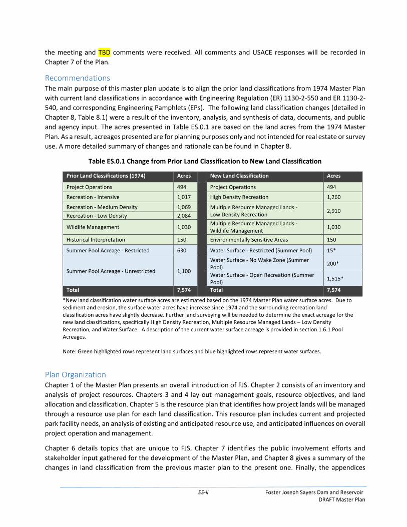
Recommendations The main purpose of this master plan update is to align the prior land classifications from 1974 Master Plan
with current land classifications in accordance with Engineering Regulation (ER) 1130-2-550 and ER 1130-2-
540, and corresponding Engineering Pamphlets (EPs). The following land classification changes (detailed in
Chapter 8, Table 8.1) were a result of the inventory, analysis, and synthesis of data, documents, and public
and agency input. The acres presented in Table ES.0.1 are based on the land acres from the 1974 Master
Plan. As a result, acreages presented are for planning purposes only and not intended for real estate or survey
use. A more detailed summary of changes and rationale can be found in Chapter 8.
Table ES.0.1 Change from Prior Land Classification to New Land Classification
Prior Land Classifications (1974) Acres New Land Classification Acres
Project Operations 494 Project Operations 494
Recreation - Intensive 1,017 High Density Recreation 1,260
Recreation - Medium Density 1,069 Multiple Resource Managed Lands - Low Density Recreation
2,910 Recreation - Low Density 2,084
Wildlife Management 1,030 Multiple Resource Managed Lands - Wildlife Management
1,030
Historical Interpretation 150 Environmentally Sensitive Areas 150
Summer Pool Acreage - Restricted 630 Water Surface - Restricted (Summer Pool) 15*
Summer Pool Acreage - Unrestricted 1,100
Water Surface - No Wake Zone (Summer Pool)
200*
Water Surface - Open Recreation (Summer Pool)
1,515*
Total 7,574 Total 7,574
*New land classification water surface acres are estimated based on the 1974 Master Plan water surface acres. Due to sediment and erosion, the surface water acres have increase since 1974 and the surrounding recreation land classification acres have slightly decrease. Further land surveying will be needed to determine the exact acreage for the new land classifications, specifically High Density Recreation, Multiple Resource Managed Lands – Low Density Recreation, and Water Surface. A description of the current water surface acreage is provided in section 1.6.1 Pool Acreages. Note: Green highlighted rows represent land surfaces and blue highlighted rows represent water surfaces.
Plan Organization Chapter 1 of the Master Plan presents an overall introduction of FJS. Chapter 2 consists of an inventory and
analysis of project resources. Chapters 3 and 4 lay out management goals, resource objectives, and land
allocation and classification. Chapter 5 is the resource plan that identifies how project lands will be managed
through a resource use plan for each land classification. This resource plan includes current and projected
park facility needs, an analysis of existing and anticipated resource use, and anticipated influences on overall
project operation and management.
Chapter 6 details topics that are unique to FJS. Chapter 7 identifies the public involvement efforts and
stakeholder input gathered for the development of the Master Plan, and Chapter 8 gives a summary of the
changes in land classification from the previous master plan to the present one. Finally, the appendices
ES-iii Foster Joseph Sayers Dam and Reservoir DRAFT Master Plan
include information and supporting documents for this Master Plan revision, including Land Classification
and Maps (Appendix A).
An EA analyzed alternative scenarios for FJS and has been prepared in accordance with the National
Environmental Policy Act (NEPA) of 1969, as amended; regulations of the Council on Environmental Quality
(CEQ); and USACE regulations, including Engineer Regulation 200-2-2: Procedures for Implementing NEPA.
The EA evaluated two alternatives as follows: 1) No Action Alternative, and 2) Proposed Action. The EA
analyzed the potential impact these alternatives would have on the natural, cultural, and human
environments. The EA is a separate document that informs this Master Plan and can be found in its entirety
in Appendix B. The Master Plan is conceptual and broad in nature, and any action proposed in the plan that
would result in significant disturbance to natural resources or result in significant public interest would
require additional NEPA documentation at the time the action takes place.

ES-iv Foster Joseph Sayers Dam and Reservoir DRAFT Master Plan
This page intentionally left blank
1 Foster Joseph Sayers Dam and Reservoir DRAFT Master Plan
Chapter 1 – Introduction
1.1 Project Authorization The Foster Joseph Sayers Dam and Reservoir (hereafter FJS) project was authorized as the Blanchard Dam
and Reservoir project by the Flood Control Act of 1954 (Public Law 780, 83rd Congress, 2nd Session, in
accordance with House of Representatives Document No. 29, 84th Congress, 1st Session). The dam and
lake were renamed by act of Congress, Public Law 90-46, in memory of Private First Class Foster Joseph
Sayers, a former resident of Centre County, Pennsylvania, who was awarded the Congressional Medal of
Honor for heroic service in World War II.
The FJS project was originally presented in the report of the Chief of Engineers dated June 25, 1954. The
Chief’s report recommended construction of three dam and reservoir projects: Curwensville, Alvin R.
Bush, and Blanchard dams. These three dams were constructed and are operated as a system along the
West Branch Susquehanna River (in conjunction with the George B. Stevenson Dam constructed by the
Commonwealth of Pennsylvania) for flood risk management purposes. The four dams collectively formed
a part of a comprehensive plan for flood risk management and water resource development in the West
Branch Susquehanna River watershed. FJS was operationally completed in August 1969 with the
construction of the Federal portion of the recreational facilities completed in the fall of 1971.
1.2 Project Purpose The primary purpose of the project is to provide flood risk management for downstream reaches of Bald
Eagle Creek and the West Branch Susquehanna River below Lock Haven, PA. Additionally, the project is
used to provide recreational opportunities and improve downstream water quality (USACE, 1996). One of
the main in-lake objectives for water quality management at FJS is to maintain a warm water fishery
managed jointly by the Pennsylvania Fish and Boat Commission and the Pennsylvania Bureau of State
Parks (USACE, 2017a). A major benefit of reservoir regulation on downstream water quality is the ability
to release naturally occurring in-lake alkaline water to moderate the effects of acid mine drainage (USACE,
1996).
1.3 Purpose and Scope of Master Plan This revised master plan replaces the 1974 Master Plan for FJS. In accordance with Engineering Regulation
(ER) 1130-2-550 and ER 1130-2-540, and corresponding Engineering Pamphlets (EPs), this Master Plan
describes in conceptual detail how all project lands, water surface, and recreational programs will be
conserved, enhanced, developed, and managed throughout the life of the project.
The Master Plan is a vital tool for responsible stewardship and sustainability of the project’s resources for
the benefit of present and future generations. The Master Plan guides and articulates USACE
responsibilities pursuant to federal laws to preserve, conserve, restore, maintain, manage, and develop
the land, water surface, and associated resources. The Master Plan is dynamic and flexible based on
changing conditions. The Master Plan does not address the specifics of regional water quality, shoreline
management, water level management, or the operation and maintenance of project operation facilities.
The Master Plan delineates how FJS will be conserved, managed and enhanced when appropriate.
Implementation of this master plan must recognize and be compatible with the primary project missions
of flood risk management. Recreational facility development proposed in this plan is dependent on
2 Foster Joseph Sayers Dam and Reservoir DRAFT Master Plan
availability of appropriated funds, but may also be achieved through partnerships, donations, and
volunteer efforts. This master plan does not propose the acquisition of additional land.
Details of design, management, administration, and implementation of the project are addressed in the
Foster Joseph Sayers Dam Operational Management Plan (OMP) as well as the development plans
prepared by DCNR for Bald Eagle State Park.
A map showing the boundaries of the FJS is located in Appendix A-1. Additional information regarding
environmental impacts to existing environmental and cultural resources as a result of the Master Plan are
presented in the environmental assessment for the Foster Joseph Sayers Dam and Reservoir.
1.4 Description of Watershed and Project Approximately 38 miles west-southwest of the City of Williamsport, FJS is located in north-central
Pennsylvania within Centre County along Bald Eagle Creek, a tributary to the West Branch Susquehanna
River. The watershed consists of forests, wetlands, agricultural land, and low density residential areas,
with some smaller towns or boroughs. The Commonwealth of Pennsylvania, Department of Conservation
and Natural Resources’ (DCNR) Bald Eagle State Park encompasses a portion of the FJS watershed. The
Bald Eagle State Park includes two campgrounds, boating, fishing, swimming, the Nature Inn, and diverse
habitats that are excellent for wildlife watching (DCNR, 2016). The drainage area upstream of the project
is approximately 339 square miles. The reservoir pool, when full (elevation 657 feet NGVD29), extends
upstream for 10.0 miles. Aerial imagery of the project area is located in Appendix A-2.
1.4.1 Project Access FJS is located northwest of Harrisburg, along PA 150 between Milesburg and Lock Haven. Access to PA
150 is available using either I-80 west, I-80 east to US 220 north, or I-99 to US 220-ALT.
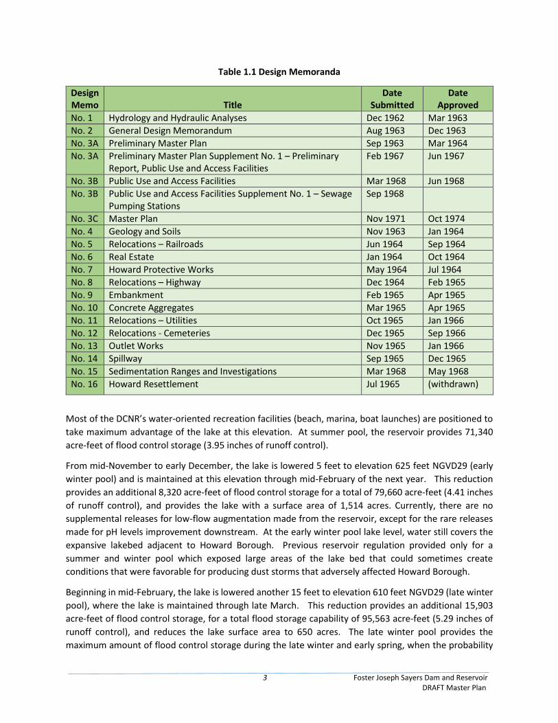
1.5 Prior Design Memoranda Development of the project began after it was authorized in the passage of the Flood Control Act of
1944, which granted the Corp of Engineers authority to provide recreation facilities. In October 1974,
a Master Plan for recreation development at FJS, Design Memoranda (DM) 3C, was prepared and
approved for implementation. Table 1.1 presents the prior design memoranda for the FJS project.
1.6 Pertinent Project Information
1.6.1 Pool Acreages The FJS Master Manual for Reservoir Regulation is used to manage the reservoir’s pool levels throughout
the year. Typically, the reservoir is maintained at elevation 630 feet NGVD29 (summer pool) for flood
control and recreational uses from mid-May until mid-November. At this elevation, the lake has a surface
area of 1,823 acres, a maximum depth of 42 feet, an average depth of 16 feet, and a shoreline length of
23.4 miles. Based on the 1974 Master Plan, the summer pool elevation yielded a surface area of 1,730
acres, which is lower than the current summer pool surface acreage that consist of 1,823 acres that was
recently established through an updated sedimentation study. Until a detail land survey is completed to
determine the impact (i.e., reduction of acres) to the surrounding recreational land classification, this
Master Plan update will maintain the acres from the 1974 Master Plan for the following land
classifications: 1) High Density Recreation; 2) Multiple Resource Managed Lands – Low Density Recreation;
and 3) Water Surface.
3 Foster Joseph Sayers Dam and Reservoir DRAFT Master Plan
Table 1.1 Design Memoranda
Design Memo
Title
Date Submitted
Date Approved
No. 1 Hydrology and Hydraulic Analyses Dec 1962 Mar 1963
No. 2 General Design Memorandum Aug 1963 Dec 1963
No. 3A Preliminary Master Plan Sep 1963 Mar 1964
No. 3A Preliminary Master Plan Supplement No. 1 – Preliminary Report, Public Use and Access Facilities
Feb 1967 Jun 1967
No. 3B Public Use and Access Facilities Mar 1968 Jun 1968
No. 3B Public Use and Access Facilities Supplement No. 1 – Sewage Pumping Stations
Sep 1968
No. 3C Master Plan Nov 1971 Oct 1974
No. 4 Geology and Soils Nov 1963 Jan 1964
No. 5 Relocations – Railroads Jun 1964 Sep 1964
No. 6 Real Estate Jan 1964 Oct 1964
No. 7 Howard Protective Works May 1964 Jul 1964
No. 8 Relocations – Highway Dec 1964 Feb 1965
No. 9 Embankment Feb 1965 Apr 1965
No. 10 Concrete Aggregates Mar 1965 Apr 1965
No. 11 Relocations – Utilities Oct 1965 Jan 1966
No. 12 Relocations - Cemeteries Dec 1965 Sep 1966
No. 13 Outlet Works Nov 1965 Jan 1966
No. 14 Spillway Sep 1965 Dec 1965
No. 15 Sedimentation Ranges and Investigations Mar 1968 May 1968
No. 16 Howard Resettlement Jul 1965 (withdrawn)
Most of the DCNR’s water-oriented recreation facilities (beach, marina, boat launches) are positioned to
take maximum advantage of the lake at this elevation. At summer pool, the reservoir provides 71,340
acre-feet of flood control storage (3.95 inches of runoff control).
From mid-November to early December, the lake is lowered 5 feet to elevation 625 feet NGVD29 (early
winter pool) and is maintained at this elevation through mid-February of the next year. This reduction
provides an additional 8,320 acre-feet of flood control storage for a total of 79,660 acre-feet (4.41 inches
of runoff control), and provides the lake with a surface area of 1,514 acres. Currently, there are no
supplemental releases for low-flow augmentation made from the reservoir, except for the rare releases
made for pH levels improvement downstream. At the early winter pool lake level, water still covers the
expansive lakebed adjacent to Howard Borough. Previous reservoir regulation provided only for a
summer and winter pool which exposed large areas of the lake bed that could sometimes create
conditions that were favorable for producing dust storms that adversely affected Howard Borough.
Beginning in mid-February, the lake is lowered another 15 feet to elevation 610 feet NGVD29 (late winter
pool), where the lake is maintained through late March. This reduction provides an additional 15,903
acre-feet of flood control storage, for a total flood storage capability of 95,563 acre-feet (5.29 inches of
runoff control), and reduces the lake surface area to 650 acres. The late winter pool provides the
maximum amount of flood control storage during the late winter and early spring, when the probability
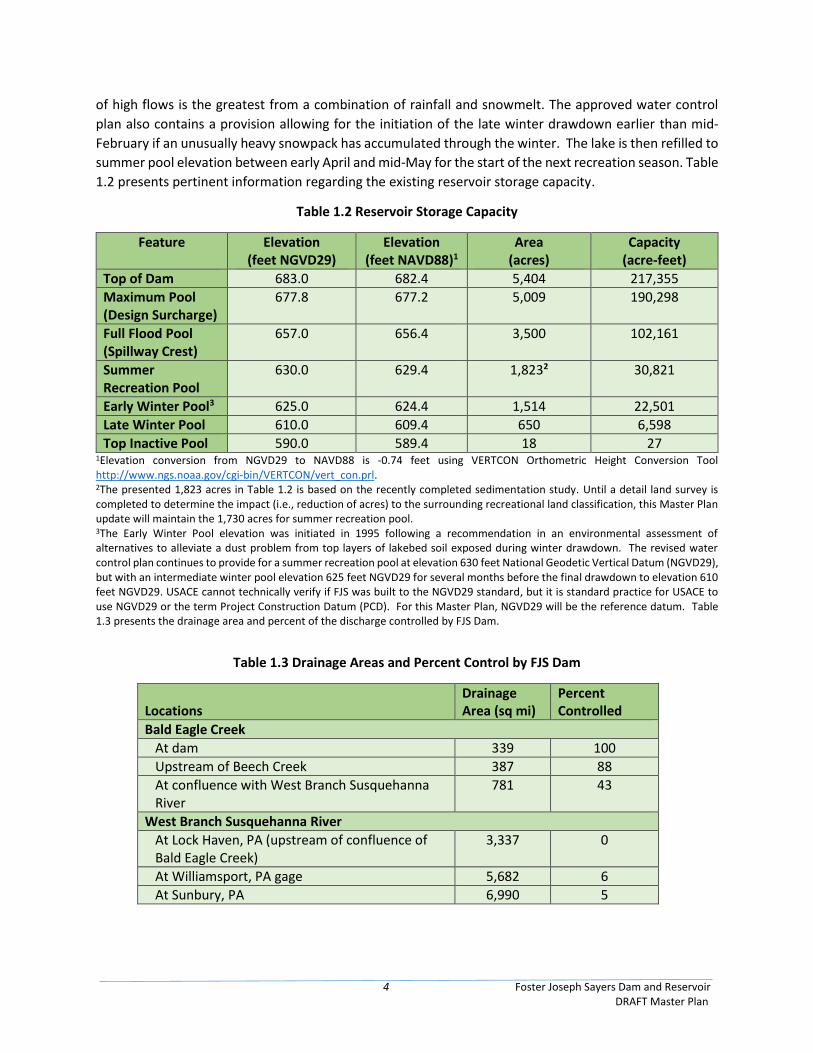
4 Foster Joseph Sayers Dam and Reservoir DRAFT Master Plan
of high flows is the greatest from a combination of rainfall and snowmelt. The approved water control
plan also contains a provision allowing for the initiation of the late winter drawdown earlier than mid-
February if an unusually heavy snowpack has accumulated through the winter. The lake is then refilled to
summer pool elevation between early April and mid-May for the start of the next recreation season. Table
1.2 presents pertinent information regarding the existing reservoir storage capacity.
Table 1.2 Reservoir Storage Capacity
Feature Elevation (feet NGVD29)
Elevation (feet NAVD88)1
Area (acres)
Capacity (acre-feet)
Top of Dam 683.0 682.4 5,404 217,355
Maximum Pool (Design Surcharge)
677.8 677.2 5,009 190,298
Full Flood Pool (Spillway Crest)
657.0 656.4 3,500 102,161
Summer Recreation Pool
630.0 629.4 1,8232 30,821
Early Winter Pool3 625.0 624.4 1,514 22,501
Late Winter Pool 610.0 609.4 650 6,598
Top Inactive Pool 590.0 589.4 18 27 1Elevation conversion from NGVD29 to NAVD88 is -0.74 feet using VERTCON Orthometric Height Conversion Tool http://www.ngs.noaa.gov/cgi-bin/VERTCON/vert_con.prl. 2The presented 1,823 acres in Table 1.2 is based on the recently completed sedimentation study. Until a detail land survey is completed to determine the impact (i.e., reduction of acres) to the surrounding recreational land classification, this Master Plan update will maintain the 1,730 acres for summer recreation pool. 3The Early Winter Pool elevation was initiated in 1995 following a recommendation in an environmental assessment of alternatives to alleviate a dust problem from top layers of lakebed soil exposed during winter drawdown. The revised water control plan continues to provide for a summer recreation pool at elevation 630 feet National Geodetic Vertical Datum (NGVD29), but with an intermediate winter pool elevation 625 feet NGVD29 for several months before the final drawdown to elevation 610 feet NGVD29. USACE cannot technically verify if FJS was built to the NGVD29 standard, but it is standard practice for USACE to use NGVD29 or the term Project Construction Datum (PCD). For this Master Plan, NGVD29 will be the reference datum. Table 1.3 presents the drainage area and percent of the discharge controlled by FJS Dam.
Table 1.3 Drainage Areas and Percent Control by FJS Dam
Locations
Drainage Area (sq mi)
Percent Controlled
Bald Eagle Creek
At dam 339 100
Upstream of Beech Creek 387 88
At confluence with West Branch Susquehanna River
781 43
West Branch Susquehanna River
At Lock Haven, PA (upstream of confluence of Bald Eagle Creek)
3,337 0
At Williamsport, PA gage 5,682 6
At Sunbury, PA 6,990 5
5 Foster Joseph Sayers Dam and Reservoir DRAFT Master Plan
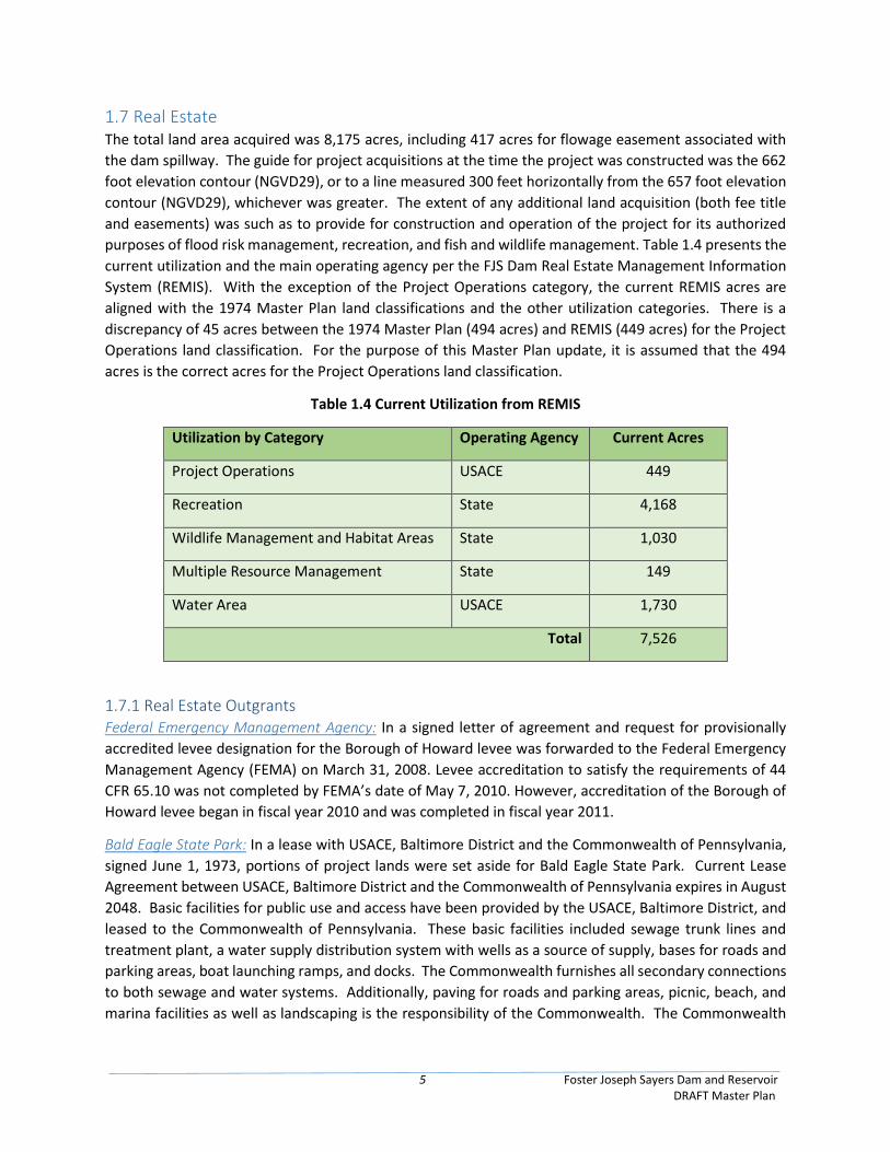
1.7 Real Estate The total land area acquired was 8,175 acres, including 417 acres for flowage easement associated with
the dam spillway. The guide for project acquisitions at the time the project was constructed was the 662
foot elevation contour (NGVD29), or to a line measured 300 feet horizontally from the 657 foot elevation
contour (NGVD29), whichever was greater. The extent of any additional land acquisition (both fee title
and easements) was such as to provide for construction and operation of the project for its authorized
purposes of flood risk management, recreation, and fish and wildlife management. Table 1.4 presents the
current utilization and the main operating agency per the FJS Dam Real Estate Management Information
System (REMIS). With the exception of the Project Operations category, the current REMIS acres are
aligned with the 1974 Master Plan land classifications and the other utilization categories. There is a
discrepancy of 45 acres between the 1974 Master Plan (494 acres) and REMIS (449 acres) for the Project
Operations land classification. For the purpose of this Master Plan update, it is assumed that the 494
acres is the correct acres for the Project Operations land classification.
Table 1.4 Current Utilization from REMIS
Utilization by Category Operating Agency Current Acres
Project Operations USACE 449
Recreation State 4,168
Wildlife Management and Habitat Areas State 1,030
Multiple Resource Management State 149
Water Area USACE 1,730
Total 7,526
1.7.1 Real Estate Outgrants Federal Emergency Management Agency: In a signed letter of agreement and request for provisionally
accredited levee designation for the Borough of Howard levee was forwarded to the Federal Emergency
Management Agency (FEMA) on March 31, 2008. Levee accreditation to satisfy the requirements of 44
CFR 65.10 was not completed by FEMA’s date of May 7, 2010. However, accreditation of the Borough of
Howard levee began in fiscal year 2010 and was completed in fiscal year 2011.
Bald Eagle State Park: In a lease with USACE, Baltimore District and the Commonwealth of Pennsylvania,
signed June 1, 1973, portions of project lands were set aside for Bald Eagle State Park. Current Lease
Agreement between USACE, Baltimore District and the Commonwealth of Pennsylvania expires in August
2048. Basic facilities for public use and access have been provided by the USACE, Baltimore District, and
leased to the Commonwealth of Pennsylvania. These basic facilities included sewage trunk lines and
treatment plant, a water supply distribution system with wells as a source of supply, bases for roads and
parking areas, boat launching ramps, and docks. The Commonwealth furnishes all secondary connections
to both sewage and water systems. Additionally, paving for roads and parking areas, picnic, beach, and
marina facilities as well as landscaping is the responsibility of the Commonwealth. The Commonwealth
6 Foster Joseph Sayers Dam and Reservoir DRAFT Master Plan
will operate Bald Eagle State Park and the sewage treatment plant, in addition to maintaining the areas
within the Park.
Howard Community Parks: Two leases signed by the USACE, Baltimore District and the Borough of Howard
were signed on June 12, 1972, and August 14, 1973 and provided for the leasing of 40.5 and 5 acres,
respectively. In addition to leasing of the land, the basic sanitary facilities include a comfort station, a bath
house, water mains, roads, and parking areas on the 40.5 acre site. The Borough of Howard agreed to
provide all secondary sanitary fixtures, swimming, boating facilities and future expansion of the park
under a long term master plan, included in design memorandum No. 3B – Public Use and Access Facilities.
Wildlife Management Areas: On September 14, 1973, USACE, Baltimore District signed a license with the
PGC to set aside portions of project lands for wildlife management. A new license was signed on January
22, 1999 extending the partnership with the PGC for an additional 25 years. Additionally, four
Supplemental Agreements have been signed and executed between the Commonwealth of Pennsylvania
and USACE that have extended the current Lease Agreement until August 2048. Additionally,
Supplemental Agreement #4 added 1.25 acres and two previously USACE designated buildings in the dam
operations area to the Lease for Bald Eagle State Park use. Basic facilities for public use and access are
provided by the PGC.
Eagle Ironworks: USACE, Baltimore District, signed a lease with the Pennsylvania Historical and Museum
Commission, dated March 13, 1972, to set aside a parcel of project lands for the development of a
historical site in the vicinity of the old Eagle Ironworks near the upstream end of the reservoir. Curtin
Village at Eagle Ironworks Historical Site is owned by the Pennsylvania Historical and Museum Commission
and managed by the Roland Curtin Foundation.
Tri-Party and Tetra-Party Agreements: A document known as the Tri-Party Agreement between the
Federal Government, the Commonwealth of Pennsylvania, and the Borough of Howard, dated
November 8, 1968, agreed upon participation in a program for the construction, operation, and
maintenance of a sewage treatment system with a treatment plant. This agreement is included in design
memorandum No. 3B – Public Use and Access Facilities. This agreement was superseded by the Tetra-
Party Agreement of 1977. The Tetra-Party Agreement is the current governing document that the Bald
Eagle State Park, USACE, the Howard Borough and Liberty Township operate under for wastewater
treatment plant operations.
7 Foster Joseph Sayers Dam and Reservoir DRAFT Master Plan
Chapter 2 – Project Setting and Factors Influencing Management and
Development
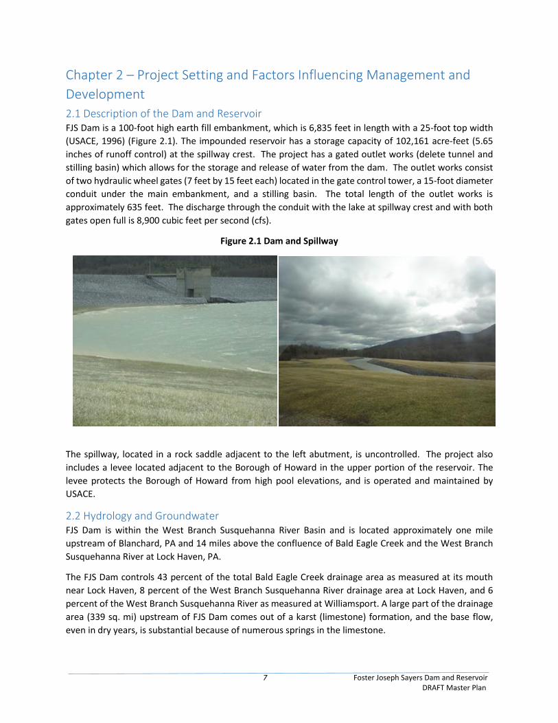
2.1 Description of the Dam and Reservoir FJS Dam is a 100-foot high earth fill embankment, which is 6,835 feet in length with a 25-foot top width
(USACE, 1996) (Figure 2.1). The impounded reservoir has a storage capacity of 102,161 acre-feet (5.65
inches of runoff control) at the spillway crest. The project has a gated outlet works (delete tunnel and
stilling basin) which allows for the storage and release of water from the dam. The outlet works consist
of two hydraulic wheel gates (7 feet by 15 feet each) located in the gate control tower, a 15-foot diameter
conduit under the main embankment, and a stilling basin. The total length of the outlet works is
approximately 635 feet. The discharge through the conduit with the lake at spillway crest and with both
gates open full is 8,900 cubic feet per second (cfs).
Figure 2.1 Dam and Spillway
The spillway, located in a rock saddle adjacent to the left abutment, is uncontrolled. The project also
includes a levee located adjacent to the Borough of Howard in the upper portion of the reservoir. The
levee protects the Borough of Howard from high pool elevations, and is operated and maintained by
USACE.
2.2 Hydrology and Groundwater FJS Dam is within the West Branch Susquehanna River Basin and is located approximately one mile
upstream of Blanchard, PA and 14 miles above the confluence of Bald Eagle Creek and the West Branch
Susquehanna River at Lock Haven, PA.
The FJS Dam controls 43 percent of the total Bald Eagle Creek drainage area as measured at its mouth
near Lock Haven, 8 percent of the West Branch Susquehanna River drainage area at Lock Haven, and 6
percent of the West Branch Susquehanna River as measured at Williamsport. A large part of the drainage
area (339 sq. mi) upstream of FJS Dam comes out of a karst (limestone) formation, and the base flow,
even in dry years, is substantial because of numerous springs in the limestone.
8 Foster Joseph Sayers Dam and Reservoir DRAFT Master Plan
Inflow during the driest summers typically ranges from 100 to 150 cubic feet per second (cfs) measured
at the Milesburg stream gage (01547200). The minimum outflow target from FJS Dam and Reservoir is in
the 120-140 cfs range measured at Blanchard stream gage (01547500). Stream gage data and locations
are shown in Table 2.1 and Figure 2.2.
Table 2.1 Stream Gages
Gage
Number
Gage Name Period of Record Drainage Area
(sq mi) Unregulated Regulated
01547200 Bald Eagle Creek Below Spring Creek at Milesburg, PA
1955-2018 NA 265
01547500 Bald Eagle Creek at Blanchard, PA 1954-1969 1969-Present
339
01548005 Bald Eagle Creek Near Beech Creek Station, PA
1910-1969 1969-Present
562
Figure 2.2 Stream Gage Locations
2.3 Water Quality Both point and nonpoint inflow source pollution affect the quality of water. Agricultural runoff and
sewage effluents increase the nutrient levels that are conducive to algae growth. The algae creates a
seasonal problem, which creates an unattractive scum on the lake and greatly reduces underwater oxygen
levels that have resulted in limited fish kills and eutrophic lake conditions. The industrial contaminant,
Kepone, has reached the lake from tributary streams. It has been found in fish taken from the lake;
however, it is below levels considered harmful. The carbonate geology of the region produces high
alkalinity within the lake that can easily buffer potential hydrogen (pH) changes. The swimming area is
tested for total fecal coliform on a weekly basis during the summer months.
9 Foster Joseph Sayers Dam and Reservoir DRAFT Master Plan
2.4 Climate The climate of central Pennsylvania (including FJS project lands) is a composite of relatively dry mid-
western continental climate and the more humid climate characteristic of the eastern seaboard.
Prevailing westerly winds carry weather disturbances from the interior of the country into the area.
Coastal storms occasionally affect the day-to-day weather as they move northeastward, but generally, the
Atlantic Ocean has a limited influence on the county.
The region surrounding FJS exhibited an average daytime high temperature of 62°F in the past year, with
occasional temperatures above 90°F in July and September. January and February are known as the
coldest months with the average low of 30°F and occasional temperatures in the single digits. Average
snowfall across the area is about 36 inches. Average annual precipitation across the FJS area is 41.4 inches.
The average wind speed over the area is 6 MPH. Table 2.2 shows average monthly temperatures and
precipitation from historical records for the nearby city of Williamsport, PA.
Table 2.2 Historical Monthly Climate Data – Williamsport, PA
Months Average Max Temp (°F)
Average Min Temp (°F)
Average Precipitation (inches)
Average Snowfall (inches)
Jan 34.2 19.3 2.7 10.5
Feb 38.2 21.6 2.4 9.1
Mar 47.9 28.6 3.0 6.9
Apr 61.0 39.0 3.2 1.1
May 71.5 47.9 3.7 0.0
Jun 79.8 57.7 3.9 0.0
Jul 83.8 61.9 4.3 0.0
Aug 81.6 60.8 3.9 0.0
Sep 73.5 53.1 4.2 0.0
Oct 62.1 41.6 3.4 0.1
Nov 49.9 33.3 3.7 1.7
Dec 38.2 24.3 2.9 6.9
Monthly Average Totals 41.4 36.3 Source: NOAA, NWS, 2019. Climate Records for Williamsport, PA.
2.5 Topography, Geology, and Soils
2.5.1 Topography FJS is located within Bald Eagle Valley. The reservoir is a prominent topographic feature formed by
damming Bald Eagle Creek. The topography of the Bald Eagle Creek watershed consists of three major
landforms: the generally flat valley floor (0- to 15-percent slope), the ridges and slopes to the northwest
(15- to 30-percent slope), and Bald Eagle Mountain (slopes 30-percent and greater) (USACE, 1996).
Elevations in the Bald Eagle Creek watershed range from as high as 2,420 feet NGVD along the northern
ridge of the watershed to 583 feet NGVD in the channel at the dam location to about 535 feet NGVD in
the channel and its confluence with West Branch Susquehanna River near Lock Haven, PA.
10 Foster Joseph Sayers Dam and Reservoir DRAFT Master Plan
2.5.2 Geology Bald Eagle Valley is in the western part of the Ridge and Valley of the Appalachian Mountains. The oldest
rock layers from deep within the eroded mountain are now exposed on the east side of the Bald Eagle
ridge. Younger rocks from the outer layers of the arch are exposed in the Bald Eagle Valley, with the
youngest at the foot of the Allegheny Front.
The geology of the Bald Eagle Valley consists primarily of resistant sandstone forming ridges and limestone
and dolomite underlying the valleys. Tuscarora quartzite, a Silurian formation, and Bald Eagle sandstone,
laid down during the Ordovician, form Bald Eagle Mountain, the northernmost ridge of the Ridge and
Valley Province.
Bedrock of the northwest facing slope of Bald Eagle Mountain, the Bald Eagle Valley, and Plateau foothills
is formed from a series of Devonian and Upper Silurian deposits of limestone, shale, siltstone, and
sandstone. The valley floor is a part of the Harrisburg peneplain.
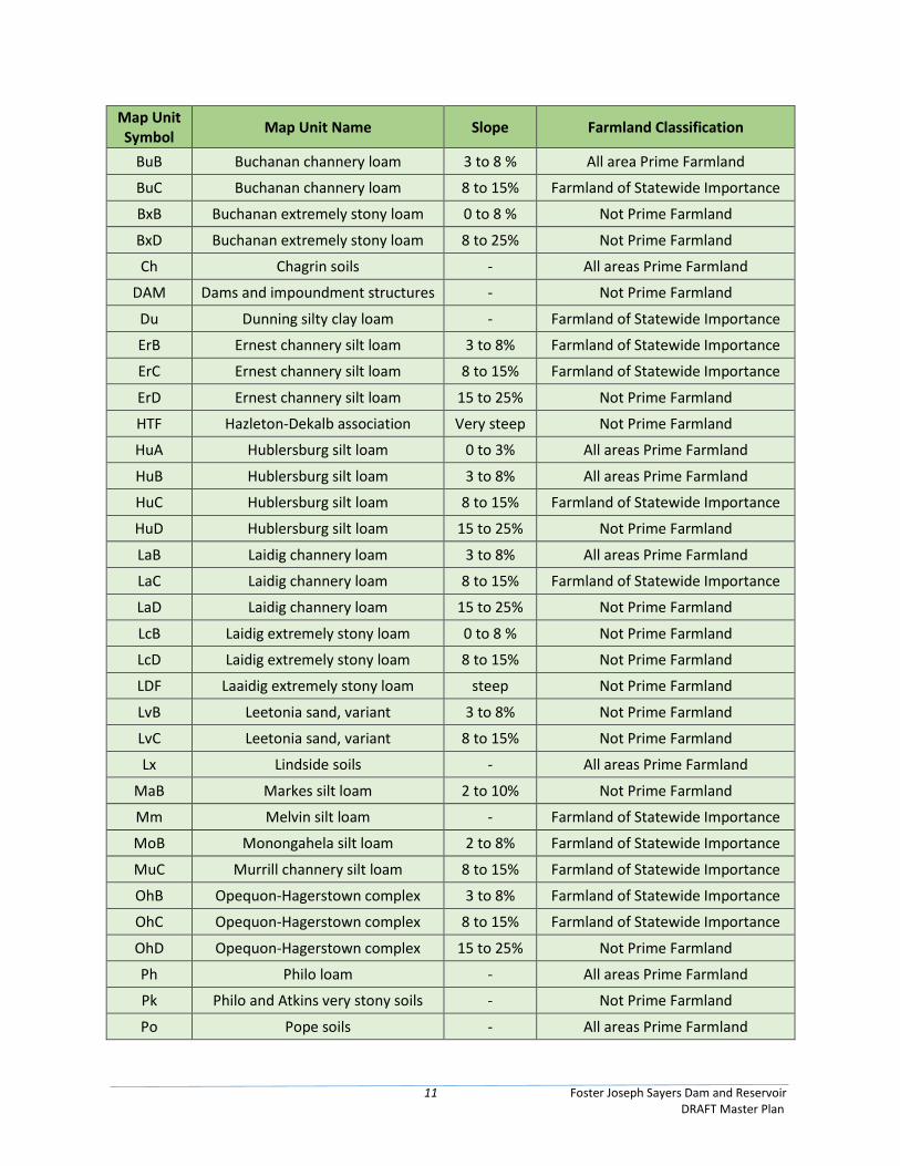
2.5.3 Soils Soils in the vicinity of the reservoir (Table 2.3) are primarily silty loam (43%), sandy loam (10%) and mixed
variations of stony loam (26%) with mixed clay, shales and rubble making up the remaining textures. The
most frequently found soil types include Andover, Berks, Brinkerton, Laidig and Hazelton. These soils are
generally deep to very deep in profile and are generally comprised of residuum of shale, siltstone, and
sandstone. The amount of clay and stones present in the soil will retard or promote drainage. Nearly
75% of the soils in the adjacent uplands are not prime farmland. Only 9% are categorized as Prime and
an additional 16% as Farmland of Statewide Importance (USDA, 2019). See Figure A-5 for a map of soil
types at FJS.
Table 2.3 Soil Types at FJS
Map Unit Symbol
Map Unit Name Slope Farmland Classification
AlB Allegheny silt loam 2 to 8% All Areas Prime Farmland
AnB Andover channery silt loam 0 to 8% Not Prime Farmland
AoB Andover very stony loam 0 to 8 % Not Prime Farmland
AoC Andover very stony loam 8 to 15% Not Prime Farmland
At Atkins silt loam - Farmland of Statewide Importance
Ba Basher Loam - All areas Prime Farmland
BkB Berks channery silt loam 3 to 8 % Farmland of Statewide Importance
BkC Berks channery silt loam 8 to 15% Farmland of Statewide Importance
BkD Berks channery silt loam 15 to 25% Not Prime Farmland
BMF Berks and Weikert soils steep Not Prime Farmland
BrA Brinkerton silt loam 0 to 3% Not Prime Farmland
BrB Brinkerton silt loam 3 to 8% Not Prime Farmland
BrC Brinkerton silt loam 8 to 15% Not Prime Farmland
BsB Brinkerton very stony silt loam 0 to 8 % Not Prime Farmland
11 Foster Joseph Sayers Dam and Reservoir DRAFT Master Plan
Map Unit Symbol
Map Unit Name Slope Farmland Classification
BuB Buchanan channery loam 3 to 8 % All area Prime Farmland
BuC Buchanan channery loam 8 to 15% Farmland of Statewide Importance
BxB Buchanan extremely stony loam 0 to 8 % Not Prime Farmland
BxD Buchanan extremely stony loam 8 to 25% Not Prime Farmland
Ch Chagrin soils - All areas Prime Farmland
DAM Dams and impoundment structures - Not Prime Farmland
Du Dunning silty clay loam - Farmland of Statewide Importance
ErB Ernest channery silt loam 3 to 8% Farmland of Statewide Importance
ErC Ernest channery silt loam 8 to 15% Farmland of Statewide Importance
ErD Ernest channery silt loam 15 to 25% Not Prime Farmland
HTF Hazleton-Dekalb association Very steep Not Prime Farmland
HuA Hublersburg silt loam 0 to 3% All areas Prime Farmland
HuB Hublersburg silt loam 3 to 8% All areas Prime Farmland
HuC Hublersburg silt loam 8 to 15% Farmland of Statewide Importance
HuD Hublersburg silt loam 15 to 25% Not Prime Farmland
LaB Laidig channery loam 3 to 8% All areas Prime Farmland
LaC Laidig channery loam 8 to 15% Farmland of Statewide Importance
LaD Laidig channery loam 15 to 25% Not Prime Farmland
LcB Laidig extremely stony loam 0 to 8 % Not Prime Farmland
LcD Laidig extremely stony loam 8 to 15% Not Prime Farmland
LDF Laaidig extremely stony loam steep Not Prime Farmland
LvB Leetonia sand, variant 3 to 8% Not Prime Farmland
LvC Leetonia sand, variant 8 to 15% Not Prime Farmland
Lx Lindside soils - All areas Prime Farmland
MaB Markes silt loam 2 to 10% Not Prime Farmland
Mm Melvin silt loam - Farmland of Statewide Importance
MoB Monongahela silt loam 2 to 8% Farmland of Statewide Importance
MuC Murrill channery silt loam 8 to 15% Farmland of Statewide Importance
OhB Opequon-Hagerstown complex 3 to 8% Farmland of Statewide Importance
OhC Opequon-Hagerstown complex 8 to 15% Farmland of Statewide Importance
OhD Opequon-Hagerstown complex 15 to 25% Not Prime Farmland
Ph Philo loam - All areas Prime Farmland
Pk Philo and Atkins very stony soils - Not Prime Farmland
Po Pope soils - All areas Prime Farmland
12 Foster Joseph Sayers Dam and Reservoir DRAFT Master Plan
Map Unit Symbol
Map Unit Name Slope Farmland Classification
Pu Purdy silt loam - Not Prime Farmland
QU Quarry - Not Prime Farmland
Ru Rubble land - Not Prime Farmland
Ty Tyler silt loam - Farmland of Statewide Importance
URB Urban land- Hagerstown complex Gently Not Prime Farmland
VaC Vanderlip loamy sand 5 to 20% Not Prime Farmland
WeC Weikert shaly silt loam 5 to 15% Not Prime Farmland
WeD Weikert channery silt loam 15 to 25% Not Prime Farmland
WhB Wharton silt loam 3 to 8% All areas Prime Farmland
WhC Wharton silt loam 8 to 15% Farmland of Statewide Importance
Source: USDA, 2019 - Natural Resources Conservation Service (NRCS) Soil Survey, Centre County, PA
2.6 Resource Analysis
2.6.1 Fish Habitat and Aquatic Species FJS Reservoir is a 1,730-acre warm water fish habitat. Many of the fish species present are a result of a
stocking program instituted by the PFBC. Common fish species are listed in Table 2.4 below.
Table 2.4 Fish Species Commonly Found in FJS Reservoir
Scientific Name
Common Name
Poxoxis Black Crappie
Perca flavescens Yellow Perch
Esox masquinongy Tiger Muskellunge
Ictalurus punctatus Channel Catfish
Micropterus salmoides Largemouth Bass
Lepomis gibbosus Pumpkinseed
Lepomis macrochirus Bluegill
Ameiurus nebulosus Brown Bullhead
Source: PFBC 2015.
Many fish species, particularly centrarchids (i.e. sunfish, bass), use relatively shallow nearshore habitats
for foraging and reproduction. Fish communities upstream of the lake include more cyprinid species that
are found in cool, fast-flowing waters. Minnows, darters and brown trout have been found upstream in
riffles and runs. Downstream of the lake, more ictalurid and centrarchid species are present which favor
cool, slow-flowing waters. Species observed downstream include common shiner (Luxilus cornutus),
swallow tail shiner (Notropis procne), fallfish (Semotilus corporalis), yellow bullhead (Ameiurus natalis),
brown bullhead, pumpkinseed, bluegill, black crappie, yellow perch and white sucker (Catostomus
commersonii) (USGS 1997). Many of these species are associated with stream pools and aquatic
vegetation.
13 Foster Joseph Sayers Dam and Reservoir DRAFT Master Plan
Multiple year classes of wild Brown Trout (Salmo trutta) have been found in Bald Eagle Creek on the
stretch between downstream of the dam until the confluence with Masden Run. The PFBC has
determined that the limits for wild trout management in Bald Eagle Creek extend from the headwaters
downstream to the confluence with Harvey’s Run. Bald Eagle Creek is one of the largest streams in
Pennsylvania that supports wild trout and benefits from the limestone geology, springs and coldwater
tributary streams that flow throughout its length (PFBC 2015).
American Eel populations (Anguilla rostrate) have declined along the Atlantic coast and especially in
streams and rivers with dams. Eels frequently serve as a host for common freshwater mussels and as one
population expands so will commensal organisms. An eel stocking effort was conducted by U.S. Fish and
Wildlife Service (USFWS) from 2010 – 2013 in the Susquehanna River. Monitoring of common freshwater
mussels conducted in 2014 indicated expanded recruitment and widespread distribution. The presence
of healthy mussel beds provide streambed stability, water filtration and increase macroinvertebrate
biodiversity (USFWS). Stream macroinvertebrate sampling by the Susquehanna River Basin Commission
in 2009 found similar numbers of genera upstream (32) and downstream (28).
2.6.2 Wildlife and Migratory Birds The PGC and PFBC have the authority and responsibility to preserve and manage all resident fish and
wildlife species. Both the PGC and the PFBC work closely with the USFWS to provide conservation and
management of all migratory species. USACE, as the land owner, cooperates with these agencies through
formal agreements that includes memorandums of understanding (MOUs) and agreements (MOAs) and
outgrants. These agreements include components that charge USACE with responsibilities to restore,
improve and preserve fish and wildlife through habitat development and conservation practices.
Terrestrial wildlife management practices are established for FJS project lands to benefit all species.
However, specific enhancements are in place for species that afford recreation opportunities such as
hunting and wildlife viewing. These species include Northern Bobwhite Quail (Colinus virginianus), Ruffed
Grouse (Bonasa umbellus), Ring-Necked Pheasant (Phasianus colchicus), American Woodcock (Scolopax
minor), Snow Goose (Chen caerulescens), White-tailed deer (Odocoileus virginianus), Black Bear (Ursus
americanus), Wild Turkey (Meleagris gallopavo) and Elk (Cervus canadensis).
As discussed above, USFWS administers wildlife practices within project lands associated with the Centre
Wildlife Care. This area is managed primarily for migratory waterfowl including a significant concentration
of snow geese. Although management practices are in place to enhance migratory water fowl populations,
there are a number of other species that are known to benefit from this area as well. At Bald Eagle Ridge,
bald eagles are common and a few pair nest year-round in the area. Other species known to winter within
this area include northern shrike (Lanius excubitor), northern mockingbird (Mimus polyglottos) and song
sparrows (Melospiza melodia).
In summer months, other species have been observed nesting and feeding in this area. Summer species
include great blue herons (Ardea herodias) and fish crows (Corvus ossifragus). In the fall common bird
species that are known to benefit from this area include red-eyed vireo (Vireo olivaceus), scarlet tanager
(Piranga olivacea), ovenbird (Seiurus aurocapilla), wood duck (Aix sponsa), green herons (Butorides
virescens), eastern bluebirds (Sialia sialis), and American woodcock (Scolopax minor).
14 Foster Joseph Sayers Dam and Reservoir DRAFT Master Plan
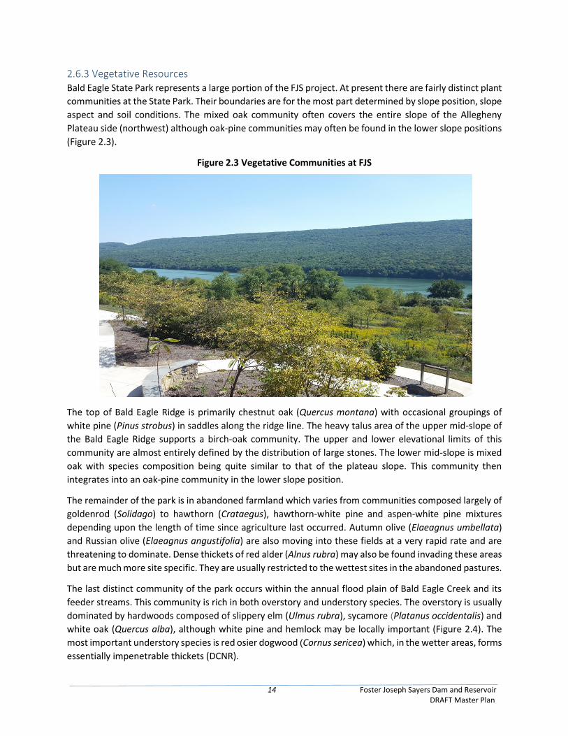
2.6.3 Vegetative Resources Bald Eagle State Park represents a large portion of the FJS project. At present there are fairly distinct plant
communities at the State Park. Their boundaries are for the most part determined by slope position, slope
aspect and soil conditions. The mixed oak community often covers the entire slope of the Allegheny
Plateau side (northwest) although oak-pine communities may often be found in the lower slope positions
(Figure 2.3).
Figure 2.3 Vegetative Communities at FJS
The top of Bald Eagle Ridge is primarily chestnut oak (Quercus montana) with occasional groupings of
white pine (Pinus strobus) in saddles along the ridge line. The heavy talus area of the upper mid-slope of
the Bald Eagle Ridge supports a birch-oak community. The upper and lower elevational limits of this
community are almost entirely defined by the distribution of large stones. The lower mid-slope is mixed
oak with species composition being quite similar to that of the plateau slope. This community then
integrates into an oak-pine community in the lower slope position.
The remainder of the park is in abandoned farmland which varies from communities composed largely of
goldenrod (Solidago) to hawthorn (Crataegus), hawthorn-white pine and aspen-white pine mixtures
depending upon the length of time since agriculture last occurred. Autumn olive (Elaeagnus umbellata)
and Russian olive (Elaeagnus angustifolia) are also moving into these fields at a very rapid rate and are
threatening to dominate. Dense thickets of red alder (Alnus rubra) may also be found invading these areas
but are much more site specific. They are usually restricted to the wettest sites in the abandoned pastures.
The last distinct community of the park occurs within the annual flood plain of Bald Eagle Creek and its
feeder streams. This community is rich in both overstory and understory species. The overstory is usually
dominated by hardwoods composed of slippery elm (Ulmus rubra), sycamore (Platanus occidentalis) and
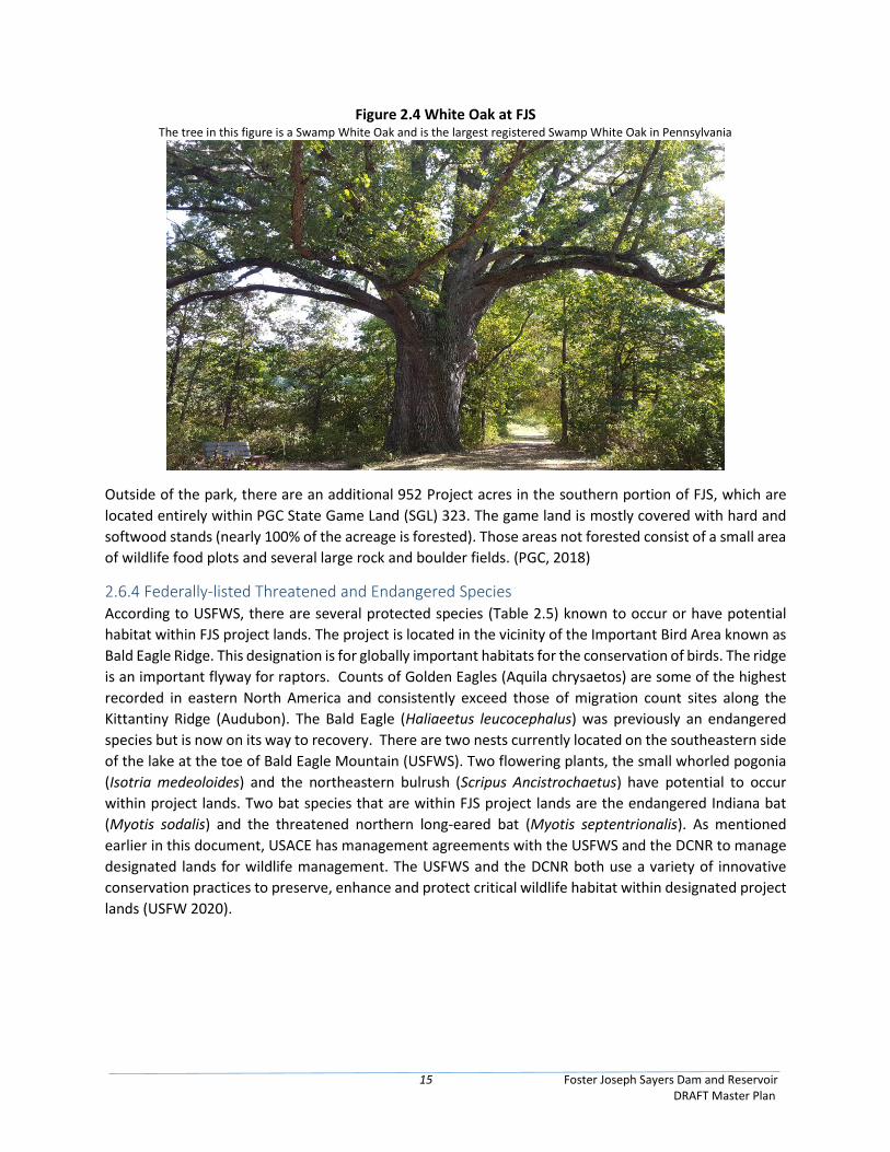
white oak (Quercus alba), although white pine and hemlock may be locally important (Figure 2.4). The
most important understory species is red osier dogwood (Cornus sericea) which, in the wetter areas, forms
essentially impenetrable thickets (DCNR).
15 Foster Joseph Sayers Dam and Reservoir DRAFT Master Plan
Figure 2.4 White Oak at FJS The tree in this figure is a Swamp White Oak and is the largest registered Swamp White Oak in Pennsylvania
Outside of the park, there are an additional 952 Project acres in the southern portion of FJS, which are
located entirely within PGC State Game Land (SGL) 323. The game land is mostly covered with hard and
softwood stands (nearly 100% of the acreage is forested). Those areas not forested consist of a small area
of wildlife food plots and several large rock and boulder fields. (PGC, 2018)
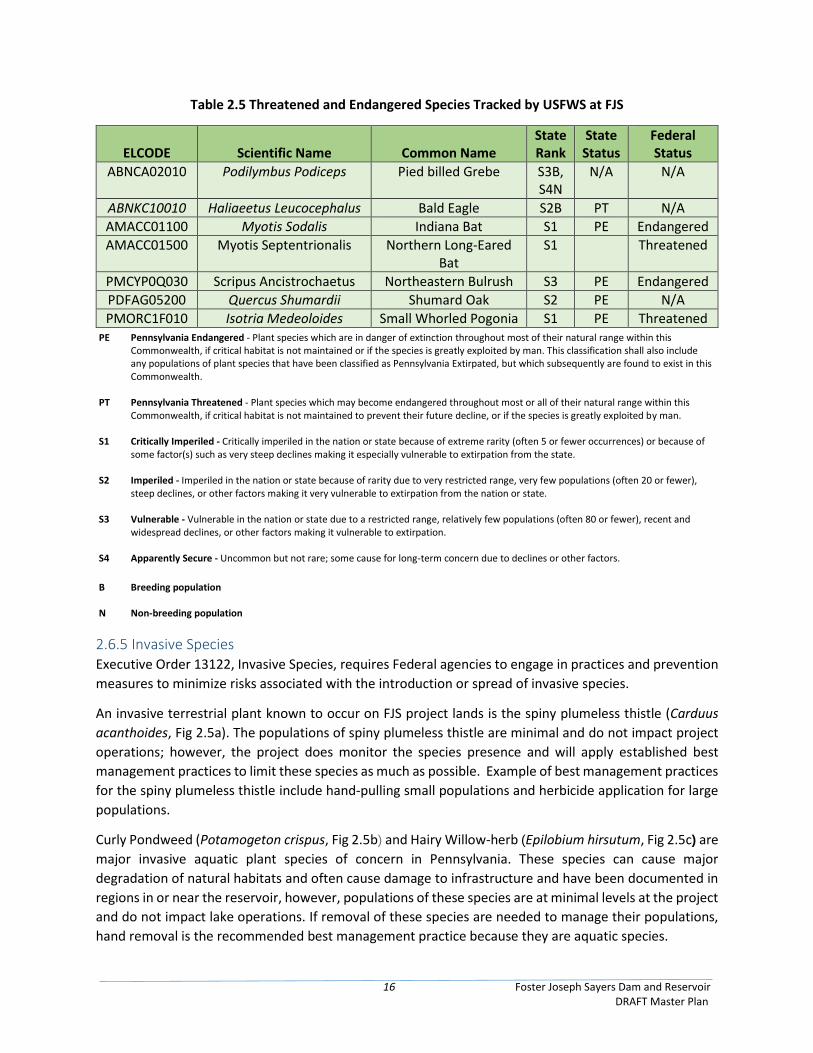
2.6.4 Federally-listed Threatened and Endangered Species According to USFWS, there are several protected species (Table 2.5) known to occur or have potential
habitat within FJS project lands. The project is located in the vicinity of the Important Bird Area known as
Bald Eagle Ridge. This designation is for globally important habitats for the conservation of birds. The ridge
is an important flyway for raptors. Counts of Golden Eagles (Aquila chrysaetos) are some of the highest
recorded in eastern North America and consistently exceed those of migration count sites along the
Kittantiny Ridge (Audubon). The Bald Eagle (Haliaeetus leucocephalus) was previously an endangered
species but is now on its way to recovery. There are two nests currently located on the southeastern side
of the lake at the toe of Bald Eagle Mountain (USFWS). Two flowering plants, the small whorled pogonia
(Isotria medeoloides) and the northeastern bulrush (Scripus Ancistrochaetus) have potential to occur
within project lands. Two bat species that are within FJS project lands are the endangered Indiana bat
(Myotis sodalis) and the threatened northern long-eared bat (Myotis septentrionalis). As mentioned
earlier in this document, USACE has management agreements with the USFWS and the DCNR to manage
designated lands for wildlife management. The USFWS and the DCNR both use a variety of innovative
conservation practices to preserve, enhance and protect critical wildlife habitat within designated project
lands (USFW 2020).
16 Foster Joseph Sayers Dam and Reservoir DRAFT Master Plan
Table 2.5 Threatened and Endangered Species Tracked by USFWS at FJS
ELCODE Scientific Name Common Name State Rank
State Status
Federal Status
ABNCA02010 Podilymbus Podiceps Pied billed Grebe S3B, S4N
N/A N/A
ABNKC10010 Haliaeetus Leucocephalus Bald Eagle S2B PT N/A
AMACC01100 Myotis Sodalis Indiana Bat S1 PE Endangered
AMACC01500 Myotis Septentrionalis Northern Long-Eared Bat
S1 Threatened
PMCYP0Q030 Scripus Ancistrochaetus Northeastern Bulrush S3 PE Endangered
PDFAG05200 Quercus Shumardii Shumard Oak S2 PE N/A
PMORC1F010 Isotria Medeoloides Small Whorled Pogonia S1 PE Threatened PE Pennsylvania Endangered - Plant species which are in danger of extinction throughout most of their natural range within this
Commonwealth, if critical habitat is not maintained or if the species is greatly exploited by man. This classification shall also include any populations of plant species that have been classified as Pennsylvania Extirpated, but which subsequently are found to exist in this Commonwealth.
PT Pennsylvania Threatened - Plant species which may become endangered throughout most or all of their natural range within this Commonwealth, if critical habitat is not maintained to prevent their future decline, or if the species is greatly exploited by man.
S1 Critically Imperiled - Critically imperiled in the nation or state because of extreme rarity (often 5 or fewer occurrences) or because of some factor(s) such as very steep declines making it especially vulnerable to extirpation from the state.
S2 Imperiled - Imperiled in the nation or state because of rarity due to very restricted range, very few populations (often 20 or fewer), steep declines, or other factors making it very vulnerable to extirpation from the nation or state.
S3 Vulnerable - Vulnerable in the nation or state due to a restricted range, relatively few populations (often 80 or fewer), recent and widespread declines, or other factors making it vulnerable to extirpation.
S4 Apparently Secure - Uncommon but not rare; some cause for long-term concern due to declines or other factors.
B Breeding population
N Non-breeding population
2.6.5 Invasive Species Executive Order 13122, Invasive Species, requires Federal agencies to engage in practices and prevention
measures to minimize risks associated with the introduction or spread of invasive species.
An invasive terrestrial plant known to occur on FJS project lands is the spiny plumeless thistle (Carduus
acanthoides, Fig 2.5a). The populations of spiny plumeless thistle are minimal and do not impact project
operations; however, the project does monitor the species presence and will apply established best
management practices to limit these species as much as possible. Example of best management practices
for the spiny plumeless thistle include hand-pulling small populations and herbicide application for large
populations.
Curly Pondweed (Potamogeton crispus, Fig 2.5b) and Hairy Willow-herb (Epilobium hirsutum, Fig 2.5c) are
major invasive aquatic plant species of concern in Pennsylvania. These species can cause major
degradation of natural habitats and often cause damage to infrastructure and have been documented in
regions in or near the reservoir, however, populations of these species are at minimal levels at the project
and do not impact lake operations. If removal of these species are needed to manage their populations,
hand removal is the recommended best management practice because they are aquatic species.
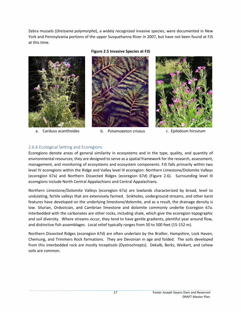
17 Foster Joseph Sayers Dam and Reservoir DRAFT Master Plan
Zebra mussels (Dreissena polymorpha), a widely recognized invasive species, were documented in New
York and Pennsylvania portions of the upper Susquehanna River in 2007, but have not been found at FJS
at this time.
Figure 2.5 Invasive Species at FJS
2.6.6 Ecological Setting and Ecoregions Ecoregions denote areas of general similarity in ecosystems and in the type, quality, and quantity of
environmental resources; they are designed to serve as a spatial framework for the research, assessment,
management, and monitoring of ecosystems and ecosystem components. FJS falls primarily within two
level IV ecoregions within the Ridge and Valley level III ecoregion: Northern Limestone/Dolomite Valleys
(ecoregion 67a) and Northern Dissected Ridges (ecoregion 67d) (Figure 2.6). Surrounding level III
ecoregions include North Central Appalachians and Central Appalachians.
Northern Limestone/Dolomite Valleys (ecoregion 67a) are lowlands characterized by broad, level to
undulating, fertile valleys that are extensively farmed. Sinkholes, underground streams, and other karst
features have developed on the underlying limestone/dolomite, and as a result, the drainage density is
low. Silurian, Ordovician, and Cambrian limestone and dolomite commonly underlie Ecoregion 67a.
Interbedded with the carbonates are other rocks, including shale, which give the ecoregion topographic
and soil diversity. Where streams occur, they tend to have gentle gradients, plentiful year around flow,
and distinctive fish assemblages. Local relief typically ranges from 50 to 500 feet (15-152 m).
Northern Dissected Ridges (ecoregion 67d) are often underlain by the Brallier, Hampshire, Lock Haven,
Chemung, and Trimmers Rock formations. They are Devonian in age and folded. The soils developed
from this interbedded rock are mostly Inceptisols (Dystrochrepts). Dekalb, Berks, Weikert, and Lehew
soils are common.
a. Carduus acanthoides b. Potamogeton crispus c. Epilobium hirsutum
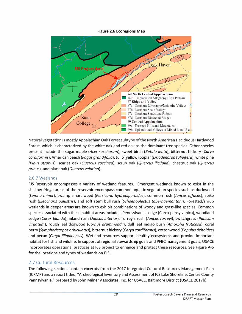
18 Foster Joseph Sayers Dam and Reservoir DRAFT Master Plan
Figure 2.6 Ecoregions Map
Natural vegetation is mostly Appalachian Oak Forest subtype of the North American Deciduous Hardwood
Forest, which is characterized by the white oak and red oak as the dominant tree species. Other species
present include the sugar maple (Acer saccharum), sweet birch (Betula lenta), bitternut hickory (Carya
cordiformis), American beech (Fagus grandifolia), tulip (yellow) poplar (Liriodendron tulipifera), white pine
(Pinus strobus), scarlet oak (Quercus coccinea), scrub oak (Quercus ilicifolia), chestnut oak (Quercus
prinus), and black oak (Quercus velutina).
2.6.7 Wetlands FJS Reservoir encompasses a variety of wetland features. Emergent wetlands known to exist in the
shallow fringe areas of the reservoir encompass common aquatic vegetation species such as duckweed
(Lemna minor), swamp smart weed (Persicaria hydropiperoides), common rush (Juncus effusus), spike
rush (Eleocharis palustris), and soft stem bull rush (Schoenoplectus tabernaemontani). Forested/shrub
wetlands in deeper areas are known to exhibit combinations of woody and grass-like species. Common
species associated with these habitat areas include a Pennsylvania sedge (Carex pensylvanica), woodland
sedge (Carex blanda), inland rush (Juncus interior), Torrey’s rush (Juncus torreyi), switchgrass (Panicum
virgatum), rough leaf dogwood (Cornus drummondii), dull leaf indigo bush (Amorpha fruticosa), coral
berry (Symphoricarpos orbiculatus), bitternut hickory (Carya cordiformis), cottonwood (Populus deltoides)
and pecan (Carya illinoinensis). Wetland resources support healthy ecosystems and provide important
habitat for fish and wildlife. In support of regional stewardship goals and PFBC management goals, USACE
incorporates operational practices at FJS project to enhance and protect these resources. See Figure A-6
for the locations and types of wetlands on FJS.
2.7 Cultural Resources The following sections contain excerpts from the 2017 Integrated Cultural Resources Management Plan
(ICRMP) and a report titled, “Archeological Inventory and Assessment of FJS Lake Shoreline, Centre County
Pennsylvania,” prepared by John Milner Associates, Inc. for USACE, Baltimore District (USACE 2017b).
FJS Project Area
19 Foster Joseph Sayers Dam and Reservoir DRAFT Master Plan
2.7.1 Archaeological Investigations and Features A minimal amount of archeological survey work was conducted within and around FJS Reservoir due to
its construction occurring before passage of the National Historic Preservation Act of 1966. The lake was
completed in 1969, before any amendments to the original act were enacted. However, in 1966
archeologist Jacob Gruber, Ph.D., now a professor emeritus in the Department of Anthropology at Temple
University, completed a general overview report for the National Park Service on FJS and the associated
archeological investigations conducted in the vicinity, in which he documented the presence of large Late
Woodland village sites at the headwaters and mouth of Bald Eagle Creek, southwest and northeast of the
current project area. Before and since that date, local artifact collectors have found diagnostic prehistoric
artifacts dating to the Archaic and Early Woodland periods in agricultural fields along the creek.
In the late 1980s, a Phase I archeological survey was conducted on a 74-acre (30 hectares) site prior to
the construction of the Russell P. Letterman Campground within Bald Eagle State Park, along the north
side of the lake in Liberty Township. The survey entailed systematic shovel testing and resulted in the
identification of one archeological site with a historical domestic component (36CE374), which was
determined not to warrant Phase II archeological evaluation (Miller and Boyko 1989). The Army Corps of
Engineers, Baltimore District completed a Phase I archeological survey of a proposed wetland-mitigation
site in 1992, which was built to mitigate the effects of the Lock Haven Local Flood Protection project. No
prehistoric or historical cultural resources were identified.
In January 2008, human skeletal remains were discovered by a visitor to FJS. The remains were exposed
within the winter drawdown zone east of the borough of Howard, and upon further investigation by a
Mercyhurst College physical anthropologist, they appeared to be the bundle burial of two individuals
contained within separate, shallow pits. Based on physical characteristics, a prehistoric Native American
ethnic identity is indicated. Later in 2008, letters were sent out to Tribes notifying them of the
unanticipated discovery, per the Native American Graves and Repatriation Act (NAGPRA). Though no one
has made a claim on the remains to date, the Baltimore District shall continue to reach out and engage
with Tribes on the long term disposition of these remains, which are currently being stored at Mercyhurst
College. Subsequent pedestrian reconnaissance by Baltimore District staff in the vicinity of the burials
resulted in the observation that several bone fragments remained in the larger, eastern pit. The remainder
of the soil within this pit was excavated and screened to recover all of these fragments. The burial location,
which was assigned an archeological site number of 36CE524, was determined to have undergone severe
wind and water erosion, which has occurred around substantial portions of the lake edge and has resulted
in a deflated landscape. This erosion is accelerated by the annual winter drawdown of the lake level, which
exposes the supersaturated, un-vegetated shoreline sediments and subjects them, upon drying out, to
wind-induced erosion. In the greater vicinity of the burials were a number of prehistoric artifacts,
including nine projectile points (5 rhyolite and 2 argillite broadspears, 2 chert Lehigh/Snook Kill), lithic
debitage (52 rhyolite, 26 chert, unknown quantity of jasper), and two grooved axes manufactured from
sandstone. However, due to the highly disturbed context, none of these artifacts could be clearly
associated with the burials.
The remnants of a wall and a circular silo foundation, both of poured concrete, were noted during the
pedestrian reconnaissance about 30 m (100 ft.) south of the burial site. These probable twentieth-century
features, with an associated surface scatter of historical ceramics and glass that likely date to the early
portion of that century, are apparently part of a farmstead that Herbert S. Schenck owned as of 1965, as
plotted on a Corps map prepared that year; a total of eight structure are depicted at the location. Also in
20 Foster Joseph Sayers Dam and Reservoir DRAFT Master Plan
2008, a Phase I cultural resources investigation was conducted at the proposed site of the Nature Inn at
Bald Eagle State Park. There was no evidence of any cultural activity occurring on the site.
Prior to 2010, thirty-one archeological sites had been previously recorded either within the current
bounds of the lake or along its periphery. Of these, 16 are recorded as completely (100%) destroyed
(36CE31, 73–81, 84–88, 524), occurring within the limits of the lake, while 1 site, located above the dam,
is described as 90–100 percent intact (36CE82). All of the sites except for the previously noted 36CE374,
the historical domestic site, are identified as having yielded exclusively prehistoric artifacts. The most-
common such components, occurring at eight sites apiece, are unspecified Archaic (36CE81, 85–87, 345,
346, 349, 350), Late Archaic (36CE76, 77, 377–380, 383, 384), and undetermined prehistoric (36CE31, 73–
75, 78–80, 82). Seven sites have produced artifacts dated to the Terminal Archaic period (36CE76, 88, 347,
348, 378–380), while six sites have documented Late Woodland components (36CE76, 84, 350, 378, 382,
384). The remaining identified cultural/temporal affiliations (Early Archaic, Middle Archaic, Early
Woodland, Middle Woodland, unspecified Woodland, Historic) have been recognized at one or two sites
each.
In 2010, the pool level at Sayers was drawn down by USACE to approximately 620.5 feet NGVD29 to
facilitate a survey, carried out by John Milner Associates, Inc. for USACE, resulting in a 1,100-acre project
area. The 2010 survey is the only professional archaeological investigation conducted in the drawdown
zone, but the survey only included the area between elevations 630.0 and 625.5 feet NGVD29, and not
the area between 625.5 feet NGVD29 and the normal winter drawdown elevation of 610.0 feet NGVD29.
The 2010 survey also did not include the entire circumference of the drawdown zone. Of 31 previously
recorded sites in the Corps fee-title land, 4 were resurveyed, though no artifacts were observed at two
locations. Also, 21 new sites were identified. The total includes 19 historic sites, 1 exclusively prehistoric
site, 3 sites with both prehistoric and historic components, and 2 sites where no artifacts were observed.
Artifacts were not collected from the sites during this survey, but a sample of in situ artifacts were
photographed. Site dimensions and locations were recorded using a portable GPS unit. No additional
human remains were identified.
The 2010 report on the surface inspection of the drawdown zone contained a preliminary
recommendation that all of the archaeological sites in the drawdown zone have been disturbed by one or
more of the natural and human processes described above, and no longer retain enough of their integrity
to be historically significant. However, this recommendation was made in the absence of any subsurface
testing that could confirm the disturbed nature of the archaeological resources, and it was not
coordinated with or agreed to by the Pennsylvania State Historic Preservation Office (SHPO).
None of the known archaeological sites in the 1,100 acre project site of the 2010 surveys have been
evaluated for eligibility for the National Register of Historic Places (NRHP), though as noted in the 2010
survey report, those sites located within the drawdown zone have likely been disturbed by natural or
human processes and no longer retain their integrity.
2.7.2 Historical Cultural Resources Regarding above ground historical cultural resources, several significant architectural properties have
been documented, including Curtin Village/Eagle Iron Works in Boggs Township (listed in 1971), which is
on the National Register of Historic Places. The majority of this resource is located above the elevation of
the spillway crest, although portions occur below the guide taking line, i.e., the contour line used as a
21 Foster Joseph Sayers Dam and Reservoir DRAFT Master Plan
guide for land acquisition in the lake or reservoir area. The Eagle Iron Works was in operation from 1810–
1921 and evidently was one of the last if not the last cold-blast charcoal furnaces to remain in business in
the United States. The complex, which consists of the furnace stack, the mansion house, and nearly all of
the other buildings that composed the original plantation-type mill community, is considered to be well
preserved.
2.7.2.1 Cemeteries
Prior to the completion of the dam in 1969, several historic period cemeteries were relocated out of the area. USACE contracted a mortuary company to relocate the burials from four cemeteries in 1965, including the Schenck, Neff, a portion of the Sandhill, and Rupert Cemeteries. The Schenck Cemetery is located in Lower Green's Run area and is an in holding owned and maintained by the Schenck's Cemetery Association. Sand Hill Cemetery is the other Cemetery and is located at the west end of Green's Run LDA Management Unit and is approximately 110' by 144' (.36 acres).
The Schenck, Neff, and portion of the Sandhill Cemeteries were relocated because they were below the
662 feet NGVD29 line originally planned as the pool elevation for the completed reservoir project. The
Rupert Cemetery was above the projected pool, but the access road would be inundated when flood
waters reached 630 msl, and therefore USACE determined the burials would also be relocated. It was
contracted that a total of 1,189 burials would be excavated and the remains reinterred in the New Schenck
Cemetery, constructed for the relocation project and future interments. The relocation resulted in the
removal and reinternment of 1,182 burials, of which 1,159 were interred in the New Schenck Cemetery
and 23 interred at other cemeteries at the request of the next of kin. The work was completed by August
1966.
The Rupert Family Cemetery, a 0.06 acre tract of property, is located on land once belonging to Charles
N. Schenck, and deeded to Lester E. Fickes on March 13, 1951. The cemetery contained 25 known burials.
The interments date from 1814 to 1908, and included the remains of John Rupert (1791-1855), John K
Rupert (1813-1867), Barnard Rupert (1819-1887) and William Rupert (1844-1891). The interments
suggest a close association of this property with the Rupert family throughout the 19th century, although
none of the available historic maps for this part of Centre County show any buildings near the cemetery
site, nor are there any properties in the vicinity that are identified with the Rupert family. The 25 known
interments in this cemetery were removed and relocated to the New Schenck Cemetery in 1966, as a part
of the construction of Sayers.
In October 2008, USACE re-investigated the former location of the Ruppert Cemetery, because of a
proposal to construct an inn on the former cemetery’s footprint by the Pennsylvania DCNR. USACE,
assisted by DCNR, stripped the topsoil from the site, and then troweled the site to identify grave shafts. It
was found that while the burials had been removed, the work did not retrieve all of the casket hardware
or bone fragments, though it appeared that the disinterment contractor had made a good faith effort.
One previously unknown burial was discovered, but it did not contain human remains. Because the grave
was unmarked, there is no conclusive way to identify the burial with any specific family member.
2.7.3 Cultural History Sequence Native Americans- Delaware, Iroquois, Mingo, and Shawnee - flourished in the early years of the project site and Centre County, with place names (typonyms) reflective of that heritage. As an example, a Delaware village that was named in honor of Chief Woapalanne (translating to "bald eagle") resulted in
22 Foster Joseph Sayers Dam and Reservoir DRAFT Master Plan
the naming of a number of local landmarks that include Bald Eagle Creek, Bald Eagle Mountain, Bald Eagle State Park, and Bald Eagle Valley.
In 1779, the village of Bald Eagle’s Nest spanned along the east river banks at of the confluence of Bald
Eagle and Spring creeks north of Bellefonte and at the current site of Milesburg, and is the nearest
historically documented Native American settlement to the project area.
During the American Revolution (1775–1781), settlers gradually moved into Bald Eagle and Penns valleys,
although at this time hostilities between the Euroamerican inhabitants and the local Indians increased
significantly, leading to the construction of a series of blockhouses by the settlers to provide protection.
However, because of the lack of available military aid for these colonists during the war years, many of
them resettled farther east.
Farming was the predominant occupational pursuit in the region during the last quarter of the eighteenth
century, but several years prior to the turn of the nineteenth century, iron-rich ore deposits were
discovered in the Centre County area, which attracted the attention of businessmen and miners alike. Iron
production rapidly increased in importance during the 1790s, with Chester County iron master Philip
Brenner establishing an iron plant near present-day Bellefonte. Brenner was joined by John Potter in 1792,
who started a blast furnace, and their ironworks soon gained the interest of other Pennsylvanian iron
manufacturers, which spurred the influx of many immigrants in search of employment in the emerging
local iron industry.
Upon its formation in 1800, Centre County’s (name derives from its centrally located geographic position)
population stood at 2075, by which time several iron plants as well as gristmills, sawmills, and other water
powered industries were in operation. The increasing importance and extent of iron production required
better transportation in the area, and new, improved roads were constructed, soon followed by the
construction of canals and then railroads.
During the second half of the nineteenth century in Centre County in general, those inhabitants engaged
in agriculture remained predominant, with residents employed in the trades and industry comprising
smaller percentages of the total.
The area including Howard Township, in which over half the length of FJS is located, was settled as early
as 1769 and was part of the original Centre Township for the first decade of Centre County’s existence,
until its formation in January 1810. It was named for philanthropist John Howard and includes the borough
of Howard and the village of Mount Eagle. Liberty Township, in which the northeastern portion of F. J.
Sayers, including the dam, is located, was also part of the original Centre Township and was erected from
Howard Township in August 1845. The villages of Eagleville, Blanchard, and Monument occur within its
boundaries.
On Walling’s 1861 map of Centre County, several people with the surname of Pletcher lived in the vicinity
of Bald Eagle Creek near Howard within Howard Township, and many were enumerated in the township
in the 1860 U.S. federal census (U.S. Bureau of the Census 1860). In adjoining Liberty Township, the map
shows relatively fewer names associated with residences along the creek.
Thirteen years later, Beach Nichols’s maps of the two townships in his Atlas of Centre County,
Pennsylvania (Nichols 1874) shows several houses and other buildings in proximity to the creek, with
names including Pletcher, Shank, Schenck, Askey, Butler, Pifer, Woodward, Long, and Hall in Howard
23 Foster Joseph Sayers Dam and Reservoir DRAFT Master Plan
Township (Figure 2-5), and Pletcher, Allison, Shank, Riggle, and Weedy above (southwest of) to just below
the current location of the Sayers project area in Liberty Township. Outside of the borough of Howard,
the early Howard, PA. and Centre Hall, PA. 15-minute topographic quadrangle maps depict sparse
buildings within proximity to Bald Eagle Creek between the Hunter Run confluence, at the approximate
location of the Sayers Lake dam at the northeast end of the lake (and the Bullit Run confluence in proximity
to the southwestern end of the lake; nearly all of these buildings have been removed).
2.8 Demographics
2.8.1 Population FJS is a regional resource, with a large portion of its lake, parks and trails visitors coming from the central
Pennsylvania region. The zone of influence for the socio-economical analysis is comprised of four
Pennsylvania counties. The counties include Centre County, where the lake lies and the nearby counties
of Blair, Clinton, and Huntingdon. Table 2.6 shows the total population for the zone of interest is 368,509.
Almost 34 percent of the zone of interest total population is in Blair County, 42 percent in Centre County,
11 percent in Clinton County, and 13 percent in Huntingdon County. From 2014 to 2040, the population
in the zone of interest is expected to increase to 421,163, an annual growth rate of 0.6 percent per year.
The distribution of the population among gender (Table 2.7) is approximately 50 percent male and 50
percent female in geographical areas within the zone of interest.
Table 2.6 2014 Population Estimate and 2040 Projection Estimate
Geographical Area 2014 Population Estimate 2040 Projection Estimate
Pennsylvania 12,758,729 14,132,588
Blair County, PA 126,708 130,036
Centre County, PA 156,240 188,564
Clinton County, PA 39,611 48,164
Huntingdon County, PA 45,950 54,399
Zone of Interest Total 368,509 421,163
Source: U.S. Bureau of the Census, American Fact Finder (2014 Estimate); PA State Data Center (2040
Projections for PA)
Table 2.7 2014 Percent of Population Estimate by Gender
Geographical Area Male percent Female percent
Pennsylvania 48.8 51.2
Blair County, PA 48.8 51.2
Centre County, PA 52.1 47.9
Clinton County, PA 48.7 51.3
Huntingdon County, PA 52.7 47.3
Zone of Interest Average 50.6 49.4
Source: U.S. Bureau of the Census, American Fact Finder (2014 Estimate)
24 Foster Joseph Sayers Dam and Reservoir DRAFT Master Plan
Table 2.8 shows the population by age group. The distribution by age group is similar among the counties,
zone of interest and the state overall. Within the zone of interest, the largest age group is the 45 to 64,
with the exception of Centre County where the largest age group is 25 to 44. Blair County has the most
children under the age of 9 and the most people over the age of 75.
Table 2.8 2014 Population Estimate by Age Group
Geographical Area
Age Group (Years)
<5 5 to 9 10 to
14 15 to
19 20 to
24 25 to 44 45 to 64 65 to 74
75 to 84
>85
Pennsylvania 715,084 739,683 768,028 835,704 868,803 3,152,939 3,572,447 1,152,669 650,623 331,229
Blair County, PA
6,958 7,167 7,409 7,493 8,062 28,959 35,547 12,884 7,649 3,827
Centre County, PA
6,526 6,785 6,876 15,669 29,932 38,082 35,113 10,893 6,111 2,755
Clinton County, PA
2,192 2,253 2,263 3,308 4,412 8,520 9,948 3,697 2,199 953
Huntingdon County, PA
2,079 2,449 2,510 2,895 3,069 11,328 12,855 4,881 2,620 1,064
Total Zone of Interest
17,755 18,654 19,058 29,365 45,475 86,889 93,463 32,355 18,579 8,599
Source: U.S. Bureau of the Census, American Fact Finder (2014 Estimate)
Population by Race and Origin is displayed in Table 2.9. For the zone of interest, 91 percent of the
population is White, 0.1 percent American Indian or Native Alaskan, 1 percent two or more races, 2
percent Hispanic, and 3 percent Black. The remainder of the races makes up less than 3 percent each.
2.8.2 Education and Employment Within the zone of interest, 43 percent of the population of people 25 years and older have a high school
diploma or equivalent; 15 percent have a Bachelor’s degree; 14 percent have some college, but no degree;
11 percent received a Graduate or professional degree; 8 percent received an Associate degree; 7 percent
finished 9th thru 12th grade without receiving a diploma; 3 percent have less than nine years of education.
Within the zone of interest, 67 percent of the population that received a Graduate or professional degree
were from Centre County (Table 2.10).
Employment by sector is presented in Table 2.11. In the zone of interest, approximately 35 percent of the
workforce were employed in management, business, science and art occupations; 31 percent in
educational services, health care and social assistance sector; 23 percent in sales and office occupations;
19 percent in service occupations; 14 percent in production, transportation and material moving
occupations; 12 percent in retail trade, 11 percent in manufacturing; 10 percent in arts, entertainment,
25 Foster Joseph Sayers Dam and Reservoir DRAFT Master Plan
recreation and accommodation. Less than 10 percent of the people within the zone of interest worked in
natural resources, construction and maintenance occupations, agriculture, forestry, fishing and hunting,
Table 2.9 2014 Population Estimate by Race and Origin
Geographical Area
Race Group
White Black
American Indian and
Alaskan Native alone
Asian alone
Native Hawaiian
and Pacific Islander
alone
Some other race
alone
Two or more races
Hispanic or
Latino
Pennsylvania 10,449,680 1,395,718 22,951 374,994 3,740 259,758 259,758 784,562
Blair County, PA
121,835 2,041 67 970 0 5 1,585 1,350
Centre County, PA
138,722 5,524 314 8,466 65 176 2,029 4,150
Clinton County, PA
38,161 607 31 195 10 16 489 499
Huntingdon County, PA 42,559 2,439 22 214 0 29 481 790
Total Zone of Interest
341,277 10,611 434 9,845 75 226 4,584 6,789
Source: U.S. Bureau of the Census, American Fact Finder (2014 Estimate)
Table 2.10 2014 Population Estimate by Highest Level of Educational Attainment
Source: U.S. Bureau of the Census, American Fact Finder (2014 Estimate)
Geographical Area
Highest Level of Educational Attainment
Population: 25 years
and older
Less than 9th
grade
9th to 12th
grade, no
diploma
High school graduate (includes
equivalency)
Some college,
no degree
Associate's degree
Bachelor's degree
Graduate or professional
degree
Pennsylvania 8,764,740 315,745 651,043 3,221,188 1,436,713 677,250 1,502,205 960,596
Blair County, PA
88,648 2,441 6,164 43,326 13,117 7,115 11,084 5,401
Centre County, PA
88,514 2,133 4,159 28,312 11,184 6,927 18,456 17,343
Clinton County, PA
25,099 979 2,317 11,622 3,679 2,187 2,816 1,499
Huntingdon County, PA
32,658 1,172 2,858 16,796 4,916 2,245 2,933 1,738
Total Zone of Interest
234,919 6,725 15,498 100,056 32,896 18,474 35,289 25,981
26 Foster Joseph Sayers Dam and Reservoir DRAFT Master Plan
Table 2.11 2014 Population Employment by Sector
Source: U.S. Bureau of the Census, American Fact Finder (2014 Estimate)
and mining, construction, wholesale trade, transportation and warehousing and utilities, information,
finance and insurance and real estate and rental and leasing, professional, scientific, and management,
and administrative and waste management, other services, except public administration, and public
administration.
As shown in Table 2.12, the unemployment rate is slightly higher in the zone of interest at 6.3 percent,
than the 5.9 percent unemployment rate in Pennsylvania. Both Clinton and Huntingdon Counties have
the higher unemployment rate above 7 percent.
Occupation
Geographical Area Zone of Interest Pennsylvania
Blair County, PA
Centre County,
PA
Clinton County,
PA
Huntingdon County, PA
Civilian Employed Population 16 years and older
5,946,480 57,590 73,751 17,459 18,616 167,416
Management, business, science, and arts occupations
2,168,039 17,353 32,338 4,255 5,318 59,264
Service Occupations 1,042,444 11,357 13,548 3,914 3,475 32,294 Sales and Office Occupations 1,445,252 14,374 15,765 3,883 3,953 37,975 Natural Resources, Construction and Maintenance Occupations 492,477 5,324 5,034 2,184 2,589 15,131
Production, Transportation, and Material Moving Occupations 798,268 9,182 7,066 3,223 3,281 22,752
Industry
Geographical Area
Zone of Interest Pennsylvania
Blair County, PA
Centre County,
PA
Clinton County,
PA
Huntingdon County, PA
Agriculture, Forestry, Fishing and Hunting, and Mining
85,917 901 1,388 699 643 3,631
Construction 339,420 3,099 3,575 1,286 1,789 9,749
Manufacturing 725,132 6,803 5,615 2,690 2,510 17,618
Wholesale Trade 166,806 1,683 1,077 330 382 3,472
Retail Trade 699,680 8,441 7,792 2,299 2,114 20,646
Transportation and Warehousing and Utilities
301,443 3,574 2,354 928 1,028 7,884
Information 103,669 1,008 1,105 148 236 2,497
Finance and Insurance and Real Estate and Rental and Leasing
381,790 2,115 3,371 579 620 6,685
Professional, Scientific, and Management, and Administrative and Waste Management
580,495 3,965 6,026 1,106 994 12,091
Educational services, and health care and social assistance
1,544,371 15,023 28,050 3,848 5,195 52,116
Arts, entertainment, and recreation, and accommodation and food services
494,546 5,598 8,423 1,801 1,147 16,969
Other services, except public administration
276,619 2,828 2,603 876 638 6,945
Public Administration 246,592 2,552 2,372 869 1,320 7,113
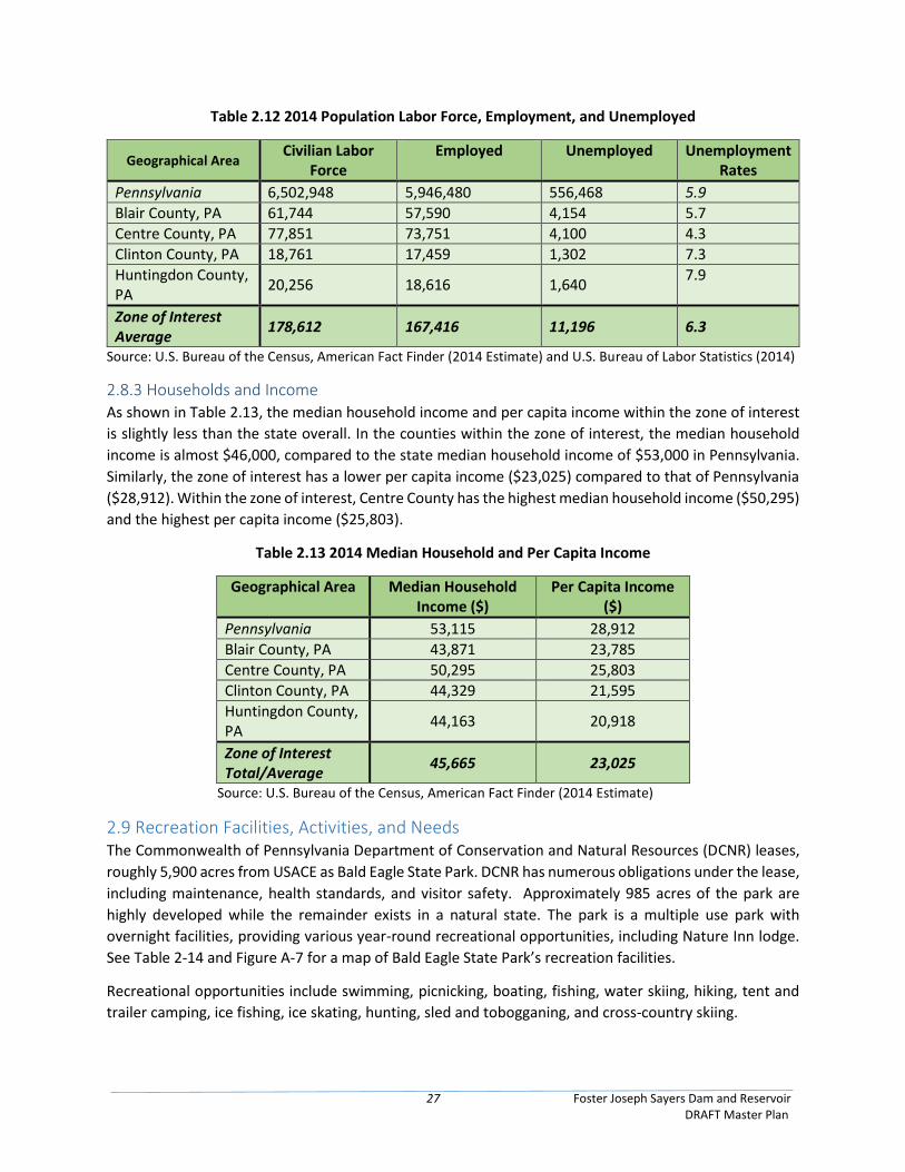
27 Foster Joseph Sayers Dam and Reservoir DRAFT Master Plan
Table 2.12 2014 Population Labor Force, Employment, and Unemployed
Geographical Area Civilian Labor
Force Employed Unemployed Unemployment
Rates
Pennsylvania 6,502,948 5,946,480 556,468 5.9
Blair County, PA 61,744 57,590 4,154 5.7
Centre County, PA 77,851 73,751 4,100 4.3
Clinton County, PA 18,761 17,459 1,302 7.3
Huntingdon County, PA
20,256 18,616 1,640 7.9
Zone of Interest Average
178,612 167,416 11,196 6.3
Source: U.S. Bureau of the Census, American Fact Finder (2014 Estimate) and U.S. Bureau of Labor Statistics (2014)
2.8.3 Households and Income As shown in Table 2.13, the median household income and per capita income within the zone of interest
is slightly less than the state overall. In the counties within the zone of interest, the median household
income is almost $46,000, compared to the state median household income of $53,000 in Pennsylvania.
Similarly, the zone of interest has a lower per capita income ($23,025) compared to that of Pennsylvania
($28,912). Within the zone of interest, Centre County has the highest median household income ($50,295)
and the highest per capita income ($25,803).
Table 2.13 2014 Median Household and Per Capita Income
Geographical Area Median Household Income ($)
Per Capita Income ($)
Pennsylvania 53,115 28,912
Blair County, PA 43,871 23,785
Centre County, PA 50,295 25,803
Clinton County, PA 44,329 21,595
Huntingdon County, PA
44,163 20,918
Zone of Interest Total/Average
45,665 23,025
Source: U.S. Bureau of the Census, American Fact Finder (2014 Estimate)
2.9 Recreation Facilities, Activities, and Needs The Commonwealth of Pennsylvania Department of Conservation and Natural Resources (DCNR) leases,
roughly 5,900 acres from USACE as Bald Eagle State Park. DCNR has numerous obligations under the lease,
including maintenance, health standards, and visitor safety. Approximately 985 acres of the park are
highly developed while the remainder exists in a natural state. The park is a multiple use park with
overnight facilities, providing various year-round recreational opportunities, including Nature Inn lodge.
See Table 2-14 and Figure A-7 for a map of Bald Eagle State Park’s recreation facilities.
Recreational opportunities include swimming, picnicking, boating, fishing, water skiing, hiking, tent and
trailer camping, ice fishing, ice skating, hunting, sled and tobogganing, and cross-country skiing.
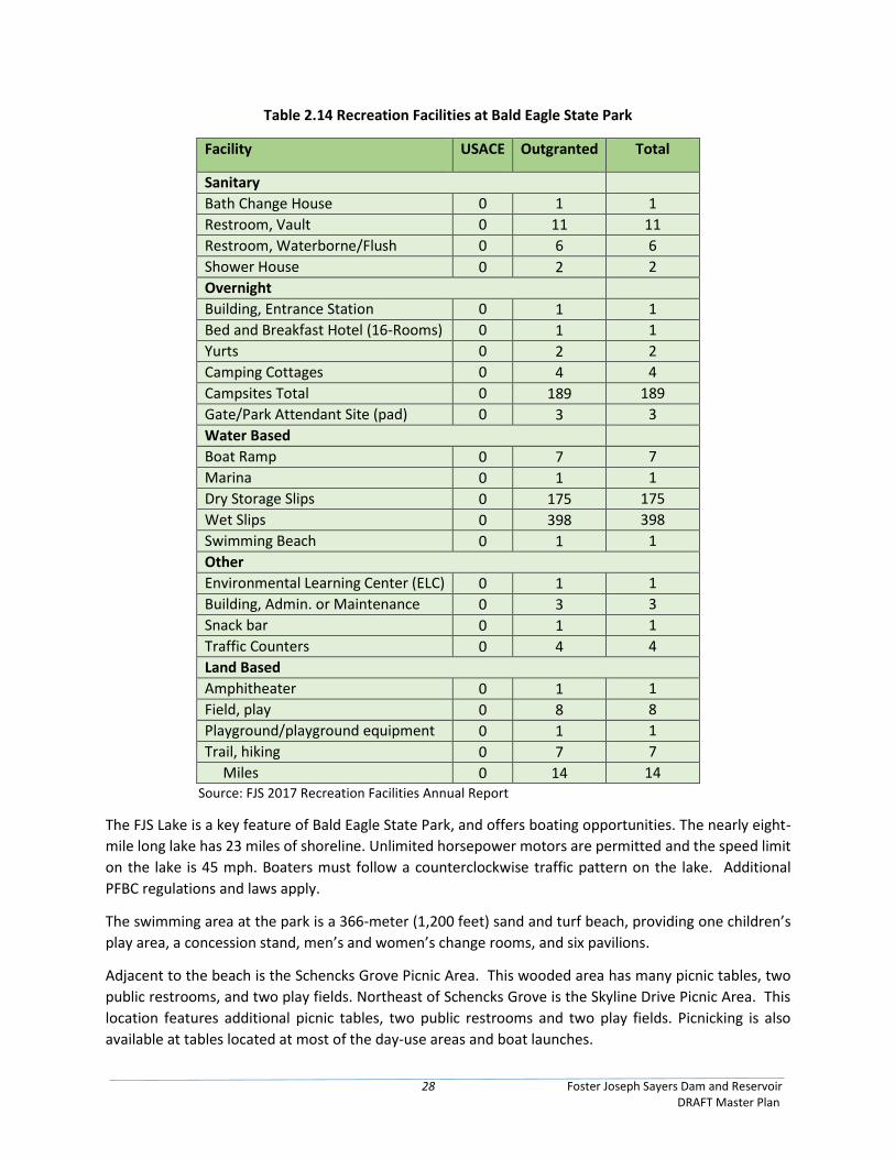
28 Foster Joseph Sayers Dam and Reservoir DRAFT Master Plan
Table 2.14 Recreation Facilities at Bald Eagle State Park
Facility USACE Outgranted Total
Sanitary
Bath Change House 0 1 1
Restroom, Vault 0 11 11
Restroom, Waterborne/Flush 0 6 6
Shower House 0 2 2
Overnight
Building, Entrance Station 0 1 1
Bed and Breakfast Hotel (16-Rooms) 0 1 1
Yurts 0 2 2
Camping Cottages 0 4 4
Campsites Total 0 189 189
Gate/Park Attendant Site (pad) 0 3 3
Water Based
Boat Ramp 0 7 7
Marina 0 1 1
Dry Storage Slips 0 175 175
Wet Slips 0 398 398
Swimming Beach 0 1 1
Other
Environmental Learning Center (ELC) 0 1 1
Building, Admin. or Maintenance 0 3 3
Snack bar 0 1 1
Traffic Counters 0 4 4
Land Based
Amphitheater 0 1 1
Field, play 0 8 8
Playground/playground equipment 0 1 1
Trail, hiking MiMiles
0 7 7
Miles 0 14 14 Source: FJS 2017 Recreation Facilities Annual Report
The FJS Lake is a key feature of Bald Eagle State Park, and offers boating opportunities. The nearly eight-
mile long lake has 23 miles of shoreline. Unlimited horsepower motors are permitted and the speed limit
on the lake is 45 mph. Boaters must follow a counterclockwise traffic pattern on the lake. Additional
PFBC regulations and laws apply.
The swimming area at the park is a 366-meter (1,200 feet) sand and turf beach, providing one children’s
play area, a concession stand, men’s and women’s change rooms, and six pavilions.
Adjacent to the beach is the Schencks Grove Picnic Area. This wooded area has many picnic tables, two
public restrooms, and two play fields. Northeast of Schencks Grove is the Skyline Drive Picnic Area. This
location features additional picnic tables, two public restrooms and two play fields. Picnicking is also
available at tables located at most of the day-use areas and boat launches.
29 Foster Joseph Sayers Dam and Reservoir DRAFT Master Plan
Seven boat launch ramps are available for use in the park. Two of these, the Bald Eagle Launch Area
(lighted) and the Lower Greens Run Launch, are open 24 hours to provide continuous fishing access. Three
hundred and sixty nine marina slips are available for rent on a seasonal basis in the Marina Area. This
area also provides winter boat and trailer storage. The marina also provides twenty nine transient slips,
boat rental, boating and fishing supply sales, gasoline sales and boat and motor sales and service.
The PFBC manages the lake’s fisheries, enforces fishing regulations and stocks fish. The entire lake (except
for the beach area) and tributary streams are open for fishing. Crappies, bass, and northern pike are the
dominant game fish; the lake also includes muskies, chain pickerel, catfish and sunfish.
There are 14 miles of developed hiking trails in the park. Near the camping area the Lake Side Trail follows
the southeast shore for 5.63 km (3.5 mi.).
The primitive campground at Bald Eagle State Park provides 35 tent sites and 35 camping vehicle sites.
The tent sites are approximately 46 m (150 ft.) from the road and 76 m (250 ft.) apart. Two restrooms
and a sanitary dump station are provided at the campground. The Russell P. Letterman campground, the
modern campground, provides an additional ninety-seven campsites with an additional twenty-two
currently under design.
During the winter the park provides ice fishing, an ice skating area, 27 km (17 mi.) of snowmobile trail, a
sledding and tobogganing hillside, and trails for cross-country skiing (DCNR, 2012).
The purpose of the state park is to conserve natural, aesthetic, cultural, and historic resources; provide
opportunities for enjoying healthful outdoor recreation; and to serve as outdoor classrooms for
environmental, cultural, and historic resources education; and to conserve these areas for future
generations (DCNR, 2011). A full list of recreation facilities in Bald Eagle State Park is compiled below.
According to the 2014-2019 Pennsylvania’s Statewide Comprehensive Recreation Plan (SCORP),
maintenance of existing park and recreation areas continues to be the top concern and priority for both
citizens and recreation providers. This is further presented in the 2013 Pennsylvania State Park Visitor
Use Monitoring Survey (VUM) Study (Figure 2.7). As part of the multi-year study, visitors were provided
with a survey that allowed them to provide open ended suggestions for improving park management. For
Bald Eagle State Park, many recommendations were for improvement of road conditions, campground
and beach enhancements, and other various facility repairs/improvements. The word-cloud below (Figure
2.7) compiles the 147 recommendations and concerns listed by the visitors.
2.9.1 Zones of Influence The primary area of economic influence for Bald Eagle State Park and FJS consists of Blair, Centre, Clinton
and Huntingdon counties in Bald Eagle Creek, Pennsylvania. Major population centers include State
College, Lock Haven, Jersey Shore, Williamsport, and Sunbury. The Commonwealth of Pennsylvania notes
a demand of its citizenry for outdoor recreation and recreational use of natural resources. DCNR manages
the state park system, including 121 state parks, including one state park within 25 miles of nearly every
Pennsylvanian (DCNR, 2016b).
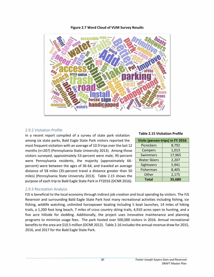
30 Foster Joseph Sayers Dam and Reservoir DRAFT Master Plan
Figure 2.7 Word Cloud of VUM Survey Results
2.9.2 Visitation Profile In a recent report compiled of a survey of state park visitation
among six state parks, Bald Eagle State Park visitors reported the
most frequent visitation with an average of 10.9 trips over the last 12
months (n=207) (Pennsylvania State University 2013). Among those
visitors surveyed, approximately 53-percent were male, 95-percent
were Pennsylvania residents, the majority (approximately 66-
percent) were between the ages of 36-64, and traveled an average
distance of 58 miles (35-percent travel a distance greater than 50
miles) (Pennsylvania State University 2013). Table 2.15 shows the
purpose of each trip to Bald Eagle State Park in FY2016 (DCNR 2016).
2.9.3 Recreation Analysis FJS is beneficial to the local economy through indirect job creation and local spending by visitors. The FJS
Reservoir and surrounding Bald Eagle State Park host many recreational activities including fishing, ice
fishing, wildlife watching, unlimited horsepower boating including 5 boat launches, 14 miles of hiking
trails, a 1,200 foot long beach, 7 miles of cross country skiing trails, 4,910 acres open to hunting, and a
five acre hillside for sledding. Additionally, the project uses innovative maintenance and planning
programs to minimize usage fees. The park hosted over 500,000 visitors in 2016. Annual recreational
benefits to the area are $10.5 million (DCNR 2012). Table 2.16 includes the annual revenue draw for 2015,
2016, and 2017 for the Bald Eagle State Park.
Visits (person-trips) in FY 2016
Picnickers 8,792
Campers 1,013
Swimmers 17,965
Water Skiers 2,207
Sightseers 5,941
Fisherman 8,405
Other 2,175
Total 35,680
Table 2.15 Visitation Profile
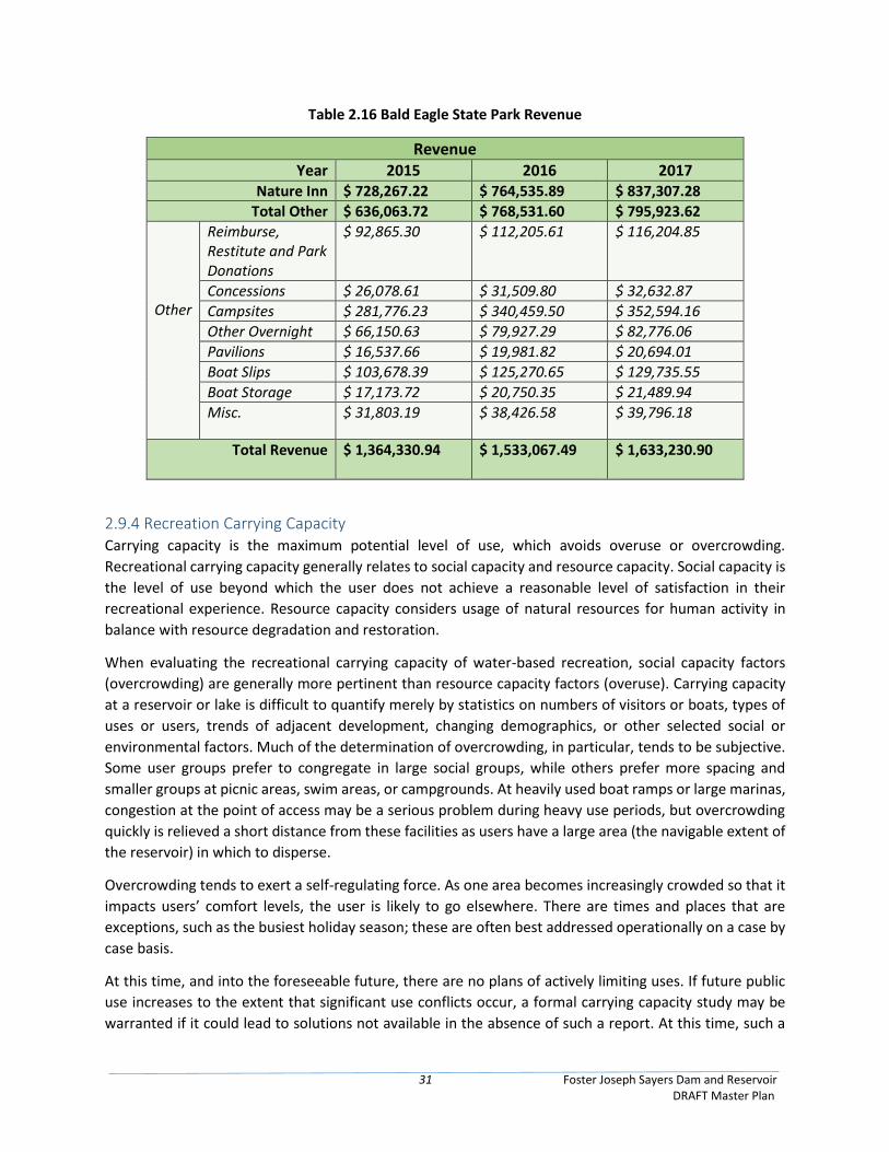
31 Foster Joseph Sayers Dam and Reservoir DRAFT Master Plan
Table 2.16 Bald Eagle State Park Revenue
Revenue
Year 2015 2016 2017 Nature Inn $ 728,267.22 $ 764,535.89 $ 837,307.28
Total Other $ 636,063.72 $ 768,531.60 $ 795,923.62
Other
Reimburse, Restitute and Park Donations
$ 92,865.30
$ 112,205.61 $ 116,204.85
Concessions $ 26,078.61 $ 31,509.80 $ 32,632.87
Campsites $ 281,776.23 $ 340,459.50 $ 352,594.16
Other Overnight $ 66,150.63 $ 79,927.29 $ 82,776.06
Pavilions $ 16,537.66 $ 19,981.82 $ 20,694.01
Boat Slips $ 103,678.39 $ 125,270.65 $ 129,735.55
Boat Storage $ 17,173.72 $ 20,750.35 $ 21,489.94
Misc. $ 31,803.19 $ 38,426.58 $ 39,796.18
Total Revenue $ 1,364,330.94
$ 1,533,067.49
$ 1,633,230.90
2.9.4 Recreation Carrying Capacity Carrying capacity is the maximum potential level of use, which avoids overuse or overcrowding.
Recreational carrying capacity generally relates to social capacity and resource capacity. Social capacity is
the level of use beyond which the user does not achieve a reasonable level of satisfaction in their
recreational experience. Resource capacity considers usage of natural resources for human activity in
balance with resource degradation and restoration.
When evaluating the recreational carrying capacity of water-based recreation, social capacity factors
(overcrowding) are generally more pertinent than resource capacity factors (overuse). Carrying capacity
at a reservoir or lake is difficult to quantify merely by statistics on numbers of visitors or boats, types of
uses or users, trends of adjacent development, changing demographics, or other selected social or
environmental factors. Much of the determination of overcrowding, in particular, tends to be subjective.
Some user groups prefer to congregate in large social groups, while others prefer more spacing and
smaller groups at picnic areas, swim areas, or campgrounds. At heavily used boat ramps or large marinas,
congestion at the point of access may be a serious problem during heavy use periods, but overcrowding
quickly is relieved a short distance from these facilities as users have a large area (the navigable extent of
the reservoir) in which to disperse.
Overcrowding tends to exert a self-regulating force. As one area becomes increasingly crowded so that it
impacts users’ comfort levels, the user is likely to go elsewhere. There are times and places that are
exceptions, such as the busiest holiday season; these are often best addressed operationally on a case by
case basis.
At this time, and into the foreseeable future, there are no plans of actively limiting uses. If future public
use increases to the extent that significant use conflicts occur, a formal carrying capacity study may be
warranted if it could lead to solutions not available in the absence of such a report. At this time, such a
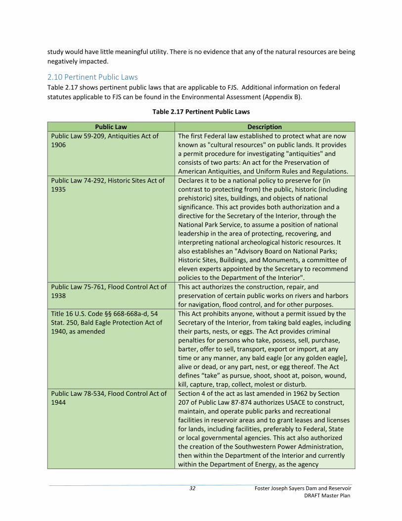
32 Foster Joseph Sayers Dam and Reservoir DRAFT Master Plan
study would have little meaningful utility. There is no evidence that any of the natural resources are being
negatively impacted.
2.10 Pertinent Public Laws Table 2.17 shows pertinent public laws that are applicable to FJS. Additional information on federal
statutes applicable to FJS can be found in the Environmental Assessment (Appendix B).
Table 2.17 Pertinent Public Laws
Public Law Description
Public Law 59-209, Antiquities Act of 1906
The first Federal law established to protect what are now known as "cultural resources" on public lands. It provides a permit procedure for investigating "antiquities" and consists of two parts: An act for the Preservation of American Antiquities, and Uniform Rules and Regulations.
Public Law 74-292, Historic Sites Act of 1935
Declares it to be a national policy to preserve for (in contrast to protecting from) the public, historic (including prehistoric) sites, buildings, and objects of national significance. This act provides both authorization and a directive for the Secretary of the Interior, through the National Park Service, to assume a position of national leadership in the area of protecting, recovering, and interpreting national archeological historic resources. It also establishes an "Advisory Board on National Parks; Historic Sites, Buildings, and Monuments, a committee of eleven experts appointed by the Secretary to recommend policies to the Department of the Interior".
Public Law 75-761, Flood Control Act of 1938
This act authorizes the construction, repair, and preservation of certain public works on rivers and harbors for navigation, flood control, and for other purposes.
Title 16 U.S. Code §§ 668-668a-d, 54 Stat. 250, Bald Eagle Protection Act of 1940, as amended
This Act prohibits anyone, without a permit issued by the Secretary of the Interior, from taking bald eagles, including their parts, nests, or eggs. The Act provides criminal penalties for persons who take, possess, sell, purchase, barter, offer to sell, transport, export or import, at any time or any manner, any bald eagle [or any golden eagle], alive or dead, or any part, nest, or egg thereof. The Act defines “take” as pursue, shoot, shoot at, poison, wound, kill, capture, trap, collect, molest or disturb.
Public Law 78-534, Flood Control Act of 1944
Section 4 of the act as last amended in 1962 by Section 207 of Public Law 87-874 authorizes USACE to construct, maintain, and operate public parks and recreational facilities in reservoir areas and to grant leases and licenses for lands, including facilities, preferably to Federal, State or local governmental agencies. This act also authorized the creation of the Southwestern Power Administration, then within the Department of the Interior and currently within the Department of Energy, as the agency
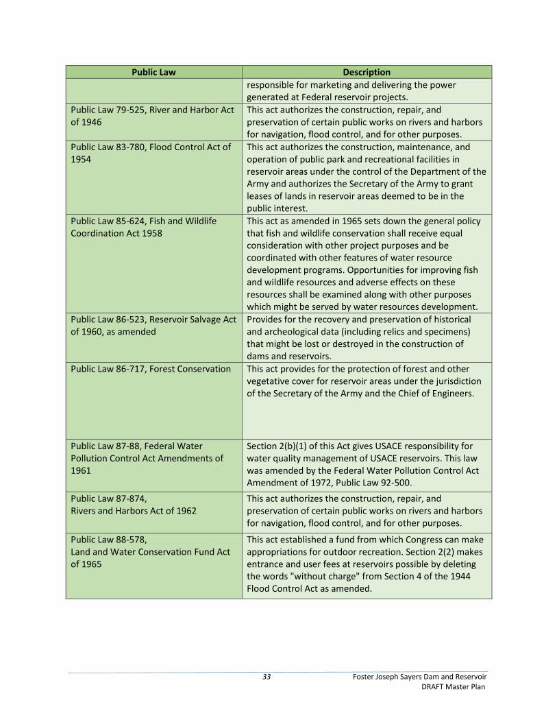
33 Foster Joseph Sayers Dam and Reservoir DRAFT Master Plan
Public Law Description
responsible for marketing and delivering the power generated at Federal reservoir projects.
Public Law 79-525, River and Harbor Act of 1946
This act authorizes the construction, repair, and preservation of certain public works on rivers and harbors for navigation, flood control, and for other purposes.
Public Law 83-780, Flood Control Act of 1954
This act authorizes the construction, maintenance, and operation of public park and recreational facilities in reservoir areas under the control of the Department of the Army and authorizes the Secretary of the Army to grant leases of lands in reservoir areas deemed to be in the public interest.
Public Law 85-624, Fish and Wildlife Coordination Act 1958
This act as amended in 1965 sets down the general policy that fish and wildlife conservation shall receive equal consideration with other project purposes and be coordinated with other features of water resource development programs. Opportunities for improving fish and wildlife resources and adverse effects on these resources shall be examined along with other purposes which might be served by water resources development.
Public Law 86-523, Reservoir Salvage Act of 1960, as amended
Provides for the recovery and preservation of historical and archeological data (including relics and specimens) that might be lost or destroyed in the construction of dams and reservoirs.
Public Law 86-717, Forest Conservation This act provides for the protection of forest and other vegetative cover for reservoir areas under the jurisdiction of the Secretary of the Army and the Chief of Engineers.
Public Law 87-88, Federal Water Pollution Control Act Amendments of 1961
Section 2(b)(1) of this Act gives USACE responsibility for water quality management of USACE reservoirs. This law was amended by the Federal Water Pollution Control Act Amendment of 1972, Public Law 92-500.
Public Law 87-874, Rivers and Harbors Act of 1962
This act authorizes the construction, repair, and preservation of certain public works on rivers and harbors for navigation, flood control, and for other purposes.
Public Law 88-578, Land and Water Conservation Fund Act of 1965
This act established a fund from which Congress can make appropriations for outdoor recreation. Section 2(2) makes entrance and user fees at reservoirs possible by deleting the words "without charge" from Section 4 of the 1944 Flood Control Act as amended.
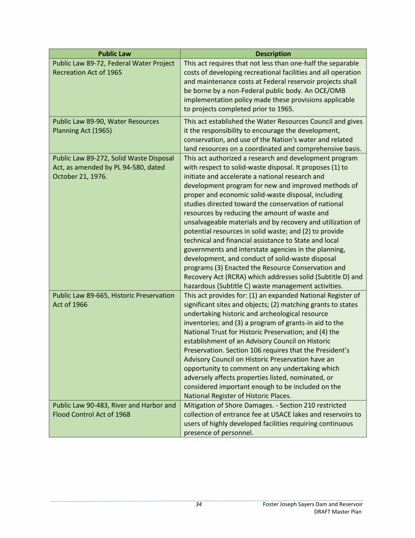
34 Foster Joseph Sayers Dam and Reservoir DRAFT Master Plan
Public Law Description
Public Law 89-72, Federal Water Project Recreation Act of 1965
This act requires that not less than one-half the separable costs of developing recreational facilities and all operation and maintenance costs at Federal reservoir projects shall be borne by a non-Federal public body. An OCE/OMB implementation policy made these provisions applicable to projects completed prior to 1965.
Public Law 89-90, Water Resources Planning Act (1965)
This act established the Water Resources Council and gives it the responsibility to encourage the development, conservation, and use of the Nation's water and related land resources on a coordinated and comprehensive basis.
Public Law 89-272, Solid Waste Disposal Act, as amended by PL 94-580, dated October 21, 1976.
This act authorized a research and development program with respect to solid-waste disposal. It proposes (1) to initiate and accelerate a national research and development program for new and improved methods of proper and economic solid-waste disposal, including studies directed toward the conservation of national resources by reducing the amount of waste and unsalvageable materials and by recovery and utilization of potential resources in solid waste; and (2) to provide technical and financial assistance to State and local governments and interstate agencies in the planning, development, and conduct of solid-waste disposal programs (3) Enacted the Resource Conservation and Recovery Act (RCRA) which addresses solid (Subtitle D) and hazardous (Subtitle C) waste management activities.
Public Law 89-665, Historic Preservation Act of 1966
This act provides for: (1) an expanded National Register of significant sites and objects; (2) matching grants to states undertaking historic and archeological resource inventories; and (3) a program of grants-in aid to the National Trust for Historic Preservation; and (4) the establishment of an Advisory Council on Historic Preservation. Section 106 requires that the President’s Advisory Council on Historic Preservation have an opportunity to comment on any undertaking which adversely affects properties listed, nominated, or considered important enough to be included on the National Register of Historic Places.
Public Law 90-483, River and Harbor and Flood Control Act of 1968
Mitigation of Shore Damages. - Section 210 restricted collection of entrance fee at USACE lakes and reservoirs to users of highly developed facilities requiring continuous presence of personnel.
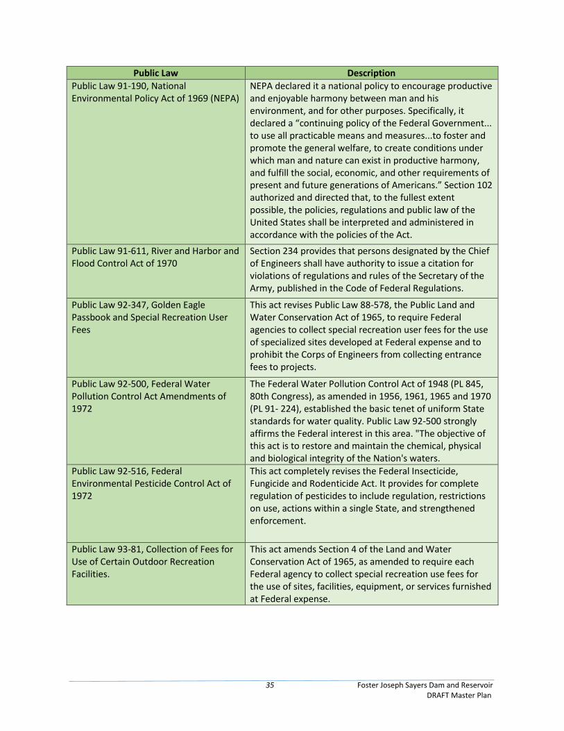
35 Foster Joseph Sayers Dam and Reservoir DRAFT Master Plan
Public Law Description
Public Law 91-190, National Environmental Policy Act of 1969 (NEPA)
NEPA declared it a national policy to encourage productive and enjoyable harmony between man and his environment, and for other purposes. Specifically, it declared a “continuing policy of the Federal Government... to use all practicable means and measures...to foster and promote the general welfare, to create conditions under which man and nature can exist in productive harmony, and fulfill the social, economic, and other requirements of present and future generations of Americans.” Section 102 authorized and directed that, to the fullest extent possible, the policies, regulations and public law of the United States shall be interpreted and administered in accordance with the policies of the Act.
Public Law 91-611, River and Harbor and Flood Control Act of 1970
Section 234 provides that persons designated by the Chief of Engineers shall have authority to issue a citation for violations of regulations and rules of the Secretary of the Army, published in the Code of Federal Regulations.
Public Law 92-347, Golden Eagle Passbook and Special Recreation User Fees
This act revises Public Law 88-578, the Public Land and Water Conservation Act of 1965, to require Federal agencies to collect special recreation user fees for the use of specialized sites developed at Federal expense and to prohibit the Corps of Engineers from collecting entrance fees to projects.
Public Law 92-500, Federal Water Pollution Control Act Amendments of 1972
The Federal Water Pollution Control Act of 1948 (PL 845, 80th Congress), as amended in 1956, 1961, 1965 and 1970 (PL 91- 224), established the basic tenet of uniform State standards for water quality. Public Law 92-500 strongly affirms the Federal interest in this area. "The objective of this act is to restore and maintain the chemical, physical and biological integrity of the Nation's waters.
Public Law 92-516, Federal Environmental Pesticide Control Act of 1972
This act completely revises the Federal Insecticide, Fungicide and Rodenticide Act. It provides for complete regulation of pesticides to include regulation, restrictions on use, actions within a single State, and strengthened enforcement.
Public Law 93-81, Collection of Fees for Use of Certain Outdoor Recreation Facilities.
This act amends Section 4 of the Land and Water Conservation Act of 1965, as amended to require each Federal agency to collect special recreation use fees for the use of sites, facilities, equipment, or services furnished at Federal expense.
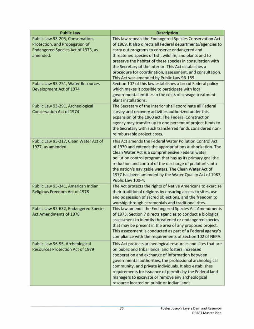
36 Foster Joseph Sayers Dam and Reservoir DRAFT Master Plan
Public Law Description
Public Law 93-205, Conservation, Protection, and Propagation of Endangered Species Act of 1973, as amended.
This law repeals the Endangered Species Conservation Act of 1969. It also directs all Federal departments/agencies to carry out programs to conserve endangered and threatened species of fish, wildlife, and plants and to preserve the habitat of these species in consultation with the Secretary of the Interior. This Act establishes a procedure for coordination, assessment, and consultation. This Act was amended by Public Law 96-159.
Public Law 93-251, Water Resources Development Act of 1974
Section 107 of this law establishes a broad Federal policy which makes it possible to participate with local governmental entities in the costs of sewage treatment plant installations.
Public Law 93-291, Archeological Conservation Act of 1974
The Secretary of the Interior shall coordinate all Federal survey and recovery activities authorized under this expansion of the 1960 act. The Federal Construction agency may transfer up to one percent of project funds to the Secretary with such transferred funds considered non- reimbursable project costs.
Public Law 95-217, Clean Water Act of 1977, as amended
This Act amends the Federal Water Pollution Control Act of 1970 and extends the appropriations authorization. The Clean Water Act is a comprehensive Federal water pollution control program that has as its primary goal the reduction and control of the discharge of pollutants into the nation’s navigable waters. The Clean Water Act of 1977 has been amended by the Water Quality Act of 1987, Public Law 100-4.
Public Law 95-341, American Indian Religious Freedom Act of 1978
The Act protects the rights of Native Americans to exercise their traditional religions by ensuring access to sites, use and possession of sacred objections, and the freedom to worship through ceremonials and traditional rites.
Public Law 95-632, Endangered Species Act Amendments of 1978
This law amends the Endangered Species Act Amendments of 1973. Section 7 directs agencies to conduct a biological assessment to identify threatened or endangered species that may be present in the area of any proposed project. This assessment is conducted as part of a Federal agency’s compliance with the requirements of Section 102 of NEPA.
Public Law 96-95, Archeological Resources Protection Act of 1979
This Act protects archeological resources and sites that are on public and tribal lands, and fosters increased cooperation and exchange of information between governmental authorities, the professional archeological community, and private individuals. It also establishes requirements for issuance of permits by the Federal land managers to excavate or remove any archeological resource located on public or Indian lands.
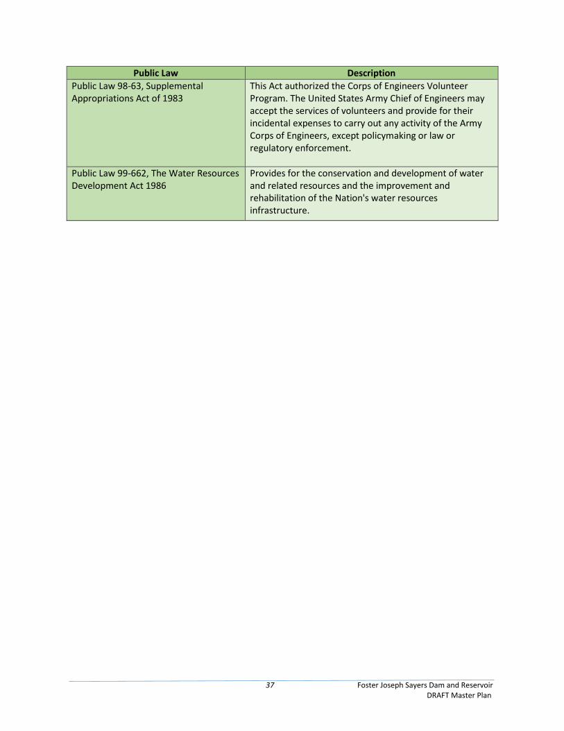
37 Foster Joseph Sayers Dam and Reservoir DRAFT Master Plan
Public Law Description
Public Law 98-63, Supplemental Appropriations Act of 1983
This Act authorized the Corps of Engineers Volunteer Program. The United States Army Chief of Engineers may accept the services of volunteers and provide for their incidental expenses to carry out any activity of the Army Corps of Engineers, except policymaking or law or regulatory enforcement.
Public Law 99-662, The Water Resources Development Act 1986
Provides for the conservation and development of water and related resources and the improvement and rehabilitation of the Nation's water resources infrastructure.

38 Foster Joseph Sayers Dam and Reservoir DRAFT Master Plan
This page intentionally left blank
39 Foster Joseph Sayers Dam and Reservoir DRAFT Master Plan
Chapter 3 – Resource Objectives
3.1 Resource Goals and Objectives Resource considerations at FJS exist primarily due to user demands on the project. Multiple user types
have interests in the project lands, recreation facilities, and waters, and such demands regularly create
conflicts. USACE is also obligated to manage these resources for the overall interest of the public and not
just for a select group of individuals. It is the responsibility of USACE to attempt to provide an
environmentally sound balance of these demands. Impacts on the environment will be assessed during
the decision making process prior to any change to management plans or strategies. The following goals
are the priorities for consideration when determining management objectives and development activities.
• To increase the value of all project lands and waters for recreation, fisheries, and wildlife, while
maintaining the flood risk management mission.
• Manage the existing natural resources and recreation facilities in compliance with all pertinent
laws, regulations and policies.
• Develop and manage the area for maximum enjoyment of the recreating public.
• Protect and preserve the existing native wildlife species and improve wildlife habitat for now
and in the future.
• To inform the public, through programs and personal contacts, about the project and resource
management purposes and objectives.
• Integrate fish and wildlife management practices with other natural resource management
practices while working closely with state and local natural resource agencies.
• Identify safety hazards or unsafe conditions to ensure public and employee safety. Correct
infractions and implement safety standards in accordance with Engineering Manual (EM) 385-1-
1.
• Encourage non-consumptive use of project lands.
Implementation of these goals is based upon time, manpower, and budget. The objectives provided in
this chapter are established to provide high levels of stewardship to USACE managed lands and resources
while still providing a high level of public service. These objectives will be pursued through the use of a
variety of mechanisms such as: assistance from volunteer efforts, hired labor, contract labor, permit
conditions, remediation, and special lease conditions. It is the intention of FJS staff to provide a realistic
approach to the management of all resources.
The natural resource elements within the identified objectives come in several different categories of
work at FJS. They can be broken into fisheries, game, and non-game. Management objectives for these
categories are dependent on the individual resource, location, and lead agency.
3.1.1 Wildlife and Fisheries Management Due to the underlying limestone geology in the watershed, the reservoir is productive and provides very
popular fisheries for black bass and panfish. The PFBC performs fish habitat improvements in the lake
with the installation of a variety of fish habitat structures annually. Reduction in the lake elevation during
40 Foster Joseph Sayers Dam and Reservoir DRAFT Master Plan
the winter drawdown and fluctuations in reservoir elevations are of primary concern to the PFBC.
However, FJS Reservoir provides limited flood storage capacity and the winter drawdown is required to
provide sufficient flood storage in anticipation of snow melt and heavier rains during the spring season.
Therefore, providing a permanent year-round lake pool elevation to provide improved fish habitat would
conflict with the project purpose of flood control and is not a viable option.
3.1.2 Recreation Recreation falls within two categories and can be identified as either land or water based recreation.
Management objectives for each type vary depending on the location and the intensity of use. Recreation
is out granted to the DCNR through Bald Eagle State Park. Table 3.1 below presents the DCNR resource
management objectives found in the 2011 Bald Eagle State Park Management Plan.
Table 3.1 Bald Eagle State Park Resource Objectives
To manage recreational areas in ways that avoid over-use problems such as soil compaction, vegetative damage, and soil erosion and to rehabilitate those areas that exhibit degradation from over-use.
To maintain an atmosphere of a variety of different stages of vegetative succession throughout the park. The different stages would be open fields, primary and secondary succession areas and mature forests.
To reclaim areas that have been used as borrow areas over previous years.
To manage park water and sewer lines as needed for access.
To improve wildlife habitat and diversity by maintaining fields and early successional habitat areas as such by mechanical removal with a woods mower, follow-up herbicide application and prescribed burning.
To manage old field areas and improve grassland habitat.
To maintain the Foster Joseph Sayers Memorial.
To protect and preserve Sand Hill Cemetery.
To maintain healthy turf areas in all developed use areas of the park.
To encourage utilization of the park resource by local schools in programs such as the county and state envirothons to supplement their environmental programs.
To provide an unlimited horsepower boating opportunity for the area.
To monitor Sewage Treatment Plant Operation and Municipal agreements.
To maintain a habitat of flood plain species over the major portion of the beach and marina areas that can withstand periodic flooding.
To establish a type of grass cover with deep root structure to prevent erosion.
To re-establish boundary lines with assistance of USACE staff and maintain on a two year cycle.
To maintain park roads and parking areas in a manner in which proper drainage is achieved and sight distances are maintained for the safety of visitors.
To control poison ivy and other noxious plants in the day-use areas of the park, particularly along hiking trails.
To control invasive exotic species.
To manage the Canada goose problem and continue participating in the “Goose-Away Program”.
To enhance the habitat of Foster Joseph Sayers Lake with artificial fish habitat structures.
To install additional underground utility lines in the park.
To enhance the native bird population by maintaining a bluebird trail.
41 Foster Joseph Sayers Dam and Reservoir DRAFT Master Plan
3.1.3 Project-Wide Resource Objectives The purpose of the USACE Master Plan is to establish the guidelines for sustainable stewardship of natural
and recreational resources managed directly and indirectly on USACE fee lands. The project-wide resource
management objectives involve the long-term development and management goals of project resources
to guide proposed future actions for the public benefit, consistent with resource capabilities within the
framework of the USACE Environmental Operation Principles.
Resource objectives are attainable goals for development, conservation, and management of natural,
cultural, and manmade resources at a project in collaboration with FJS’s flood risk management mission.
They are guidelines for obtaining maximum public benefits while minimizing adverse impacts to the
environment and are developed in accordance with: 1) authorized project purposes, 2) applicable laws
and regulations, 3) resource capabilities and suitability, 4) regional needs, 5) other governmental plans
and programs, and 6) expressed public desires.
The project-wide resource objectives for FJS, not in priority order, are listed below:
• To give priority to the preservation and improvement of wild land values in public use planning,
design, development, and management activities.
• To preserve and protect important paleontological, archeological, ecological, and esthetic
resources.
• To manage habitat for threatened and endangered species and to support a diversity of fish and
wildlife, and recreation use.
• To prevent the introduction of invasive species and aquatic nuisance species (ANS), detect and
respond rapidly to and control populations of such species in a cost-effective and environmentally
sound manner, monitor invasive species and ANS populations accurately and reliably, and provide
for restoration of native species and habitat conditions in ecosystems that have been invaded.
• To manage and develop project lands to accommodate periodic fluctuations in lake elevations
with minimal impacts.
• To develop and manage project resources to support types and levels of recreation activities
indicated by visitor demand and consistent with carrying capacities and aesthetic, cultural, and
ecological values.
• To manage identified recreational lands in ways that enhance benefits to wildlife.
• To provide access by Tribal members to any cultural resources, sacred sites, or other Traditional
Cultural Properties.
• To preserve and protect cultural resources sites in compliance with existing federal statutes and
regulations.
• To expand public outreach and education about the history of the area, project resources, and
the USACE’s role in developing and managing these resources.
• To foster stewardship by minimizing encroachments and other non-allowed uses.

42 Foster Joseph Sayers Dam and Reservoir DRAFT Master Plan
• To develop and manage lands in cooperation and coordination with other management
agencies and appropriate entities in the private sector.
• To maintain and manage project lands and waters to support regional management programs.
• Manage project lands and recreational programs to advance broad national climate change
mitigation goals, including but not limited to climate change resilience and carbon sequestration.
Execution of resource objectives at a multi-purpose project such as FJS is difficult. It is a delicate balance
between items that often compete for funds, time, and other resources. Priority will be given to those
items required by law with an attempt to provide continued public use of Government land.
43 Foster Joseph Sayers Dam and Reservoir DRAFT Master Plan
Chapter 4 – Land Allocation, Land Classification, Water Surface, and
Project Easement Lands
4.1 Land Allocation Land allocation categories identify the congressionally authorized purposes for which project lands were
acquired by fee simple purchase or through other means. The four categories of land allocation applicable
to project lands include the following: operations, recreation, fish and wildlife, and mitigation.
4.2 Land Classification Land Classification indicates the primary use for which project lands are managed. Changes to the existing
land classifications were made to reflect current authorized project purposes and resource objectives that
address a mix of natural resource and recreation management objectives that would be compatible with
regional goals.
The previous 1974 Master Plan utilizes an obsolete classification scheme (Table 4.1) that has been rectified
in this document (Table 4.2) to meet current standards and requirements. The current six categories of
land classification are identified as: 1) Project Operations; 2) High Density Recreation; 3) Environmentally
Sensitive Areas; 4) Multiple Resource Management Lands; 5) Mitigation; and 6) Water Surface. See Figure
A-3 and Figure A-4 to reference the locations of the existing and proposed land classifications.
Table 4.1: Existing Land Classifications from the 1974 Master Plan
Classification Existing Acres*
Project Operations 494
Recreation – Intensive 1,017
Recreation – Medium Density 1,069
Recreation – Low Density 2,084
Wildlife Management and Habitat Areas 1,030
Historical Interpretation 150
Water Pool Acreage – Unrestricted and Restricted (Summer) 1,730
Total 7,574 *Per the 1974 Master Plan, percentages and totals are subject to rounding errors.
4.2.1 Project Operations These are lands required for the dam, spillway, offices, and other areas used solely for the operation of
the reservoir. There are approximately 494 acres of land classified for project operations at FJS.
4.2.2 High Density Recreation These are lands developed for intensive recreational activities for the visiting public including day use
areas, campgrounds, and concession areas. According to the 1974 Master Plan, there are approximately
1,017 acres of land classified for high density recreation at FJS. However, after accounting for the Rustic
Campground, which was previously classified under 1974 Master Plan as low density, the new high density
recreation has increased to 1,260 acres.
4.2.3 Environmentally Sensitive Areas These are areas where scientific, ecological, cultural, and aesthetic features have been identified. There
are 150 acres classified as Environmentally Sensitive Area at FJS.
44 Foster Joseph Sayers Dam and Reservoir DRAFT Master Plan
Table 4.2: Proposed Land Classifications
Classification Proposed Acres*
Project Operations 494
High Density Recreation 1,260
Multiple Resource Managed Lands-Low Density Recreation 2,910
Multiple Resource Managed Lands-Wildlife Management 1,030
Environmentally Sensitive Areas 150
Water Surface-Open Recreation (Summer Pool) 1,515
Water Surface-Restricted (Summer Pool) 15
Water Surface-No Wake Zones (Summer Pool) 200
Total 7,574
*Note: Rounded to nearest whole number. Acres represent approximate areal extent of the land classifications. Data to be used for planning purposes only.
4.2.4 Multiple Resource Management Lands This classification is divided into four sub-classifications identified as: Low Density Recreation, Wildlife
Management, Vegetative Management, and Future/Inactive Recreation Areas. A given tract of land may
be classified using one or more of these sub-classifications. There are 4,183 acres of lands that are under
this classification at FJS. The following identifies the amount contained in each sub-classification of this
land classification.
• Low Density Recreation
These are lands with minimal development or infrastructure that support passive public
recreational use (e.g., fishing, hunting, wildlife viewing, shoreline use, hiking, etc.). They were
lands purchased for recreation and classified for low density recreation. The intention of these
classified lands is to assure available lands for low density recreation between areas classified as
recreation intensive use and wildlife management. There are approximately 2,910 acres under
this classification at FJS. This accounts for the reduction of acres associated with the conversion
of land from low density to high density for the Rustic Campground.
• Wildlife Management
These are lands designated for the stewardship of fish and wildlife resources. There are
approximately 1,030 acres of land under this classification at FJS.
• Vegetative Management
These are lands designated for stewardship of forest, prairie, and other native vegetative cover.
There are no acreages under this classification at FJS.
• Future or Inactive Recreation
These are lands with site characteristics compatible with potential future recreation
development or recreation areas that are closed or open but no longer maintained. These areas
will be managed as multiple resource land until there is an opportunity to develop or reopen
these areas. There are no acres under this classification at FJS.
45 Foster Joseph Sayers Dam and Reservoir DRAFT Master Plan
4.2.5 Mitigation This classification is only used for the lands allocated for mitigation for the purpose of offsetting losses
associated with the development of the project. There are no lands classified as mitigation since this land
allocation was not included in congressional authorization language for FJS.
4.2.6 Water Surface Approximately 1,730 acres of surface water are maintained during the summer. This area is known as the
Summer Pool. FJS has a surface water management program that designates the following three water
surface classifications: Restricted, Designated No-Wake, and Open Recreation.
• Restricted
These are water areas restricted for project operations, safety and security purposes. This would
include the waters directly adjacent to the FJS Dam as well as areas near designated swimming
beaches. There is approximately 15 acres of restricted surface water area associated with the FJS
dam.
• Designated No-Wake
Water areas designated to protect environmentally sensitive shoreline areas, recreational water
access areas from disturbance and for public safety. Typically these areas are located around
Commercial Marinas, riverports, public boat ramps and some narrow overpasses. There is
approximately 200 surface acres of designated no-wake classification.
• Open Recreation
All water surface that is not included in the three categories above are, by default, considered
“Open Recreation”. There is no specific zoning for these areas, but there is a buoy system in
place to help aid in public safety around the beach area. There is approximately 1,515 surface
acres of designated open recreation classification.
Fish and Wildlife Sanctuary is another water surface classification. These areas are managed with annual or seasonal restrictions to protect fish and wildlife species during periods of migration, resting, feeding, nesting, and/or spawning. FJS does not have surface water designated for this purpose; however, there are two bald eagle nests on the southeastern side of the lake at the toe of mountain. The bald eagles built the nest on the rugged, more remote, south area of the lake. Bald eagles nests and habitat are managed through the PA Game Commission’s Bald Eagle Management Plan.
4.3 Project Easement Lands These are lands on which easement interests were acquired. Fee title was not acquired on these lands but
the easement interests convey to the Federal government certain rights to use and or restrict the use of
the land for specific purposes. Easement lands are typically classified as Operations Easement, Flowage
Easement, and/or Conservation Easement. Easements do not have a land classification.
4.3.1 Operations Easement These are easements USACE purchased for the purpose of project operations. There are zero acres of
operations easement at FJS.

46 Foster Joseph Sayers Dam and Reservoir DRAFT Master Plan
4.3.2 Flowage Easement These are easements purchased by USACE giving the right to temporarily flood private land during flood
risk management operations. There are 306 acres of flowage easement lands located at FJS. See Figure
A-3 and Figure A-4 to reference the locations of the flowage easement at FJS.
4.3.3 Conservation Easement These are easements purchased by USACE for the purpose of protecting wildlife, fisheries, recreation,
vegetation, archeological, threatened and endangered species, or other environmental benefits. There
are no conservation easements at FJS.
47 Foster Joseph Sayers Dam and Reservoir DRAFT Master Plan
Chapter 5 – Resource Plan
5.1 Management by Classification This chapter describes the management plans for each area of classification within the Master Plan. The
classifications which exist at FJS are; Project Operations, High Density Recreation, Multiple Resource
Lands-Low Density Recreation, Wildlife Management, and Environmentally Sensitive. The management
plans identified are in broad terms of how these project lands will be managed. A more descriptive plan
for managing these lands can be found in the Foster Joseph Sayers Dam and Reservoir OMP and Bald Eagle
State Park Management Plan.
5.1.1 Project Operations This is land associated with the dam, spillway, offices, and other areas solely used for the operation of the
reservoir. The management goal for these areas is to ensure effective flood risk management. There are
494 acres of lands under this classification which are managed by the USACE.
5.1.2 High Density Recreation Areas included in this classification are developed and managed for intensive recreational activities
including campgrounds, day use/recreation areas, secondary access areas (i.e. boat ramps and overlooks),
commercial marinas and state parks. High Density Recreation areas may be managed and operated by the
USACE or outgranted to another agency or private entity for management.
There are 1,260 total acres currently classified as high density recreation which are leased to other
organizations for high density recreation purposes. These high density recreation areas include lands
leased to the DCNR at Bald Eagle State Park and the 40.5 and 5 acre community parks leased to the
Borough of Howard (Appendix A). USACE does not provide any maintenance within any of these locations
but there are times when support is provided to the managing agency. USACE has to provide review of
requests for the development of these areas and make sure they are in accordance with applicable laws
and regulations for the proposed activity within an area zoned high density recreation. The goal for these
areas is to work with USACE partners to assure recreation areas are being managed in accordance with
resource objectives identified in Chapter 3.
• Bald Eagle State Park
The DCNR, leases approximately 5,900 acres of land and water from the USACE at FJS for park and
recreational purposes. Bald Eagle State Park offers a variety of recreation activities for Centre
County and the surrounding region. Bald Eagle State Park is designed to accommodate active and
passive recreation on a year-round basis. Recreation opportunities include boating, water skiing,
picnicking, hunting, fishing, swimming, hiking, overnight camping, ice fishing, ice skating, sledding,
and cross country skiing.
Central to the park facilities are the beach and swimming areas, surrounded by picnic pavilions, a
comfort and first aid station, open space and playgrounds.
• Borough of Howard Parks
The 40.5 acre area is located behind the Howard Levee on the reservoir just south of the Borough.
The five acre area is located just inside the levee at the northern end. USACE provided a
bathhouse and a comfort station with water and sewage connections for the 40.5 acre site. The
Borough will provide all furnishings, plumbing fixtures, and required lighting for both leased areas.
48 Foster Joseph Sayers Dam and Reservoir DRAFT Master Plan
Park roads, parking areas and certain pathways to accommodate maintenance vehicles have been
graded and furnished with a sub-base. Base course and surfacing was placed by the Borough,
except for one access road which was provided by USACE.
Detailed development and management plans of the parks are included in Design Memorandum
No. 3B. A launching area and docks were constructed during the summer of 1973 by the Howard
Boat Club. This area has been subleased to the club subject to their ability to maintain the area in
a manner which provides no physical hazards and is visually compatible with surrounding project
lands.
The five acre site is used primarily as a little league/softball field and a picnic area. Picnic tables,
fire pits, and some small play equipment along with a comfort station are also located at the five
acre site.
5.1.3 Environmentally Sensitive Areas These are areas where scientific, ecological, cultural, and aesthetic features have been identified.
Designation of these lands is not limited to just lands that are otherwise protected by laws such as the
Endangered Species Act, the National Historic Preservation Act (NHPA), or applicable State statues. These
areas must be considered by management to ensure they are not adversely impacted. Typically, limited
or no development of public use is allowed on these lands. No agricultural or grazing uses are permitted
on these lands unless necessary for a specific resource management benefit, such as prairie restoration.
There are 150 acres of land under this classification that for all intents and purposes encompasses Curtin
Village and Eagle Iron Works. The Eagle Ironworks and Curtin Village are listed in the National Register of
Historic Places and is leased by the Pennsylvania Historical and Museum Commission and managed by the
Roland Curtin Foundation. The Eagle Ironworks, in operation from 1810 to 1921, is reputed to be one of
the last of its type to operate in the United States. The iron works is well-preserved and consists of the
furnace stack, the mansion house, and almost every building which made up the original iron plantation-
type community. The mansion house was once the home of Andrew Gregg Curtin, who served as governor
of Pennsylvania from 1861 to 1867.
There is also an abundance of cultural resources located around and within FJS situated in various land
classifications. Special consideration should be given to any activity that may have a negative impact on
cultural resources. Any action found to have negative impact must be coordinated with USACE and the
State Historic Preservation Office and/or the appropriate tribal entity before authorization of work is
granted.
5.1.4 Multiple Resource Management Lands These are areas where predominant use is low density recreation, wildlife management, vegetative
management, or future/inactive recreation areas. However, there are other compatible uses which may
occur on these lands without impacting the predominant use. These lands can be divided into four sub-
categories for the purposes of this Master Plan. These categories are; Low Density Recreation, Wildlife
Management, Vegetative Management, and Future/Inactive Recreation Areas. The following is a
description of each sub-category’s resource objectives, acreages, and description of use.
49 Foster Joseph Sayers Dam and Reservoir DRAFT Master Plan
• Low Density Recreation
These are lands with minimal development or infrastructure that support passive public use.
There are 2,910 acres zoned Low Density Recreation. Most of these are restricted to the slopes of
Bald Eagle Ridge, and the upper slopes of the ridge northwest of the reservoir. These lands are
almost exclusively pine-hardwood forests with the exception of several abandoned fields located
on the southeastern edge of the reservoir above Howard Causeway. Green’s Run Recreation Area
located in the south west portion of the lake and land adjacent to the northwestern edge of US
Route 220 comprise the remainder of this acreage. Low Density Recreation lands are areas where
USACE has determined that limited recreation that generates minimal impacts can occur. These
activities typically involve hiking, hunting, fishing and bird watching on fee owned land. The
objectives for this land classification are continued recreation of a low impact and assure no
degradation of the natural resources occurs within the zone.
• Wildlife Management.
These are lands designated for the management of wildlife resources. Wildlife management is
conducted by the PGC through a license with PGC and USACE. These 952 acres are primarily
located in the southern portion of FJS and within PGS SGL 323. SGL 323 is located in Boggs,
Howard, Marion, and Spring Townships, on the Bald Eagle Mt., entirely within Centre County. SGL
323 is forested and mountainous, bounded on the east and west by agricultural and residential
lands, and on the north and south by contiguous forested tracts. The game land is mostly covered
with hard and softwood stands (nearly 100% of the acreage is forested). Those areas not forested
consist of a small area of wildlife food plots and several large rock and boulder fields. These
mountainside forests represent home to many forest dependent birds and mammals which
provide excellent hunting and fur taking opportunities for the license buying public. The Game
Lands are also rife with spring seeps and drainages to the valley, supporting the clean waters of
Bald Eagle creek and FJS Reservoir.
Topography varies with very gentle slopes to very steep side hills. The highest elevation of about
1,647 feet is on the ridge top in Compartment 1. The lowest elevation of 700 feet is along State
Route 1006 in Compartment 2. The principle species hunted on all compartments are whitetailed
deer, eastern wild turkey, ruffed grouse and black bear. Gray squirrel (Sciurus carolinensisare) are
hunted to a lesser extent where appropriate habitat exists. Small game hunting is mainly
restricted to low lying terrain on these lands. Furbearer trapping opportunities include bobcat
(Lynx rufus), eastern coyote (Canis latrans var.), gray fox (Urocyon cinereoargenteus), mink
(Neovison vison), fisher (Pekania pennanti), opossum (Didelphis virginiana), raccoon (Procyon
lotor), red fox (Vulpes vulpes), and striped skunk (Mephitis mephitis).
Hunting pressure is not excessive due to the relative inaccessibility and steep terrain of most of
the game lands. Hiking, bird watching, horseback riding, and mountain biking are lawful non-
consumptive recreational activities that occur occasionally. This game land is relatively small in
size and is not a major attraction for these activities. SGL 323 has limited access. State Route 1006
provides access to Compartment 2 in the middle of the northern side where a gated road provides
PGC administrative access. This road is open to the public during the hunting seasons (PGC, 2018).
The approximately 950 acres of leased USACE land on SGL 323 managed directly by PGC will
continue being managed in a fashion to enhance the existing environment and benefit both game
50 Foster Joseph Sayers Dam and Reservoir DRAFT Master Plan
and non-game wildlife. A priority will be given to accomplishing the objectives identified in
Chapter 3.
5.1.5 Water Surface The surface water acreage designated as the Summer Pool is approximately 1,730 acres and is the body
of water which is maintained during normal operations of the dam between May and October. FJS dam
and reservoir is owned, operated and maintained by the USACE and therefore USACE has the
responsibility of making all reservoir regulation decisions to accomplish the purposes of the project to
include flood damage reduction, water quality and to provide recreational opportunities. Lake levels vary
throughout the year in order to benefit these purposes. Boating and use of the marina is managed and
regulated by the DCNR and PFBC. Overall, boating speed is limited to 45 miles per hours and it is unlawful
to operate boats equipped with inboard engines with over-the-transom or straight stack type exhausts.
Waterskiing is also prohibited in Hunters Run Cove (PFBC, 2018).
• Restricted
There is an area restricted to boat traffic which is demarcated by a buoy line that spans the
entire width of the reservoir near the dam. The buoy line is approximately 500 feet from the
tower intake and the shoreline along the breast of the dam.
• Designated No-Wake
According to PFBC, boats are limited to slow no wake speed in the following areas:
- Hunters Run Cove inlet.
- The southern end of Hunters Run Cove in the vicinity of boat launching areas.
- The northern end of Hunters Run Cove from the inlet to the dam.
- Within 100 feet of either side of the Route 26 highway bridge.
- From approximately 2,000 feet west of the Upper Greens Run launch ramp through
the backwaters of the lake.
• Open Recreation
The remainder of the surface water (approximately 1,515 acres) is designated as open recreation.
• Fish and Wildlife Sanctuary
These areas are managed with annual or seasonal restrictions to protect fish and wildlife species
during periods of migration, resting, feeding, nesting, and/or spawning. FJS does not have surface
water designated for this purpose. Additionally, there are no recreation restrictions associated
with the bald eagle nests at FJS; however, any proposed construction activities at FJS would need
to be coordinated with Pennsylvania (multiple agencies) and the USFWS to determine potential
restriction to ensure there are no impacts to the bald eagle nests. In general, there are two
restriction zones for new construction activities near active bald eagle nests: 1) 330 feet linear
feet – anytime of year; and 2) 660 feet linear feet – 1 January through 31 July.
51 Foster Joseph Sayers Dam and Reservoir DRAFT Master Plan
Chapter 6 – Special Topics/Issues/Considerations
6.1 Competing Interests on the Natural Resources FJS is comparatively small for the population served within the zone of interest. The net result is
competing interests for the utilization of federal lands. It is a challenge to balance these interests to
satisfy public needs while ensuring adverse environmental impacts are minimized per USACE
environmental stewardship mission. The intention of this document is to outline a plan that serves the
public interest, provides customer service and guides appropriate, ecosystem-based natural resource
management.
6.2 Mineral Exploration and Production Activities Within a 50 mile radius of FJS there are coal strip mining activities by a variety of companies. There are
2,833 acres fee and 1.5 acres easement on the project, under which the government does not own the
coal mining rights. Effective control of mineral extraction activities, particularly when USACE does not own
the necessary estates in real property to control development within close proximity of dams and other
structures, requires close coordination among district offices, especially Operations, Real Estate,
Engineering, and Office of Counsel. Operations personnel are often the first USACE employees to become
aware of new or proposed mineral extraction activities in close proximity to USACE projects. Mineral
extraction activities can include exploration operations, mining operations, drilling operations, production
operations, reworking operations (including hydraulic fracturing), and high pressure pipeline operations.
Real Estate personnel must investigate the location of the activities and determine the federal real
property interests in the location. Engineering personnel must evaluate any new or proposed activities in
order to make a determination whether said activity is compatible with the structural integrity of the dam
and other major structures. Office of Counsel must review applicable laws and ordinances that may affect
the site of the activities and advise as to what legal actions can be taken to prevent harm to USACE
structures and put appropriate authorities on notice of the potential danger.
6.3 Chesapeake Bay Total Daily Maximum Load and Watershed Implementation Plan USACE is required to meet Total Daily Maximum Load (TMDL) requirements set by the EPA and handed
down to states within the Chesapeake Bay Watershed. Though the USACE Chesapeake Bay Program,
USACE initiated in the summer of 2020 a project to review all potential stormwater management
opportunities at multiple USACE project sites, including FJS, to support the Chesapeake Bay TMDL
compliance requirements detailed in the Pennsylvania Phase 3 Watershed Implementation Plan (WIP).
Any potential to improve or implement stormwater management best management practices at FJS will
documented in this effort and if necessary coordinate with Bald Eagle State Park. This project will be
complete in FY21.

52 Foster Joseph Sayers Dam and Reservoir DRAFT Master Plan
This page intentionally left blank
53 Foster Joseph Sayers Dam and Reservoir DRAFT Master Plan
Chapter 7 – Public Agency and Coordination
7.1 Public Agency and Coordination In February 2016, USACE held a kick-off meeting to initiate early stakeholder coordination for the Master
Plan update. In June 2016, the USACE also sent a scoping letter to local governments, agencies,
organizations and tribes to initiate the public involvement process associated with Master Plan update
and subsequent Environmental Assessment (EA). The initial comments were incorporated into the draft
EA and Master Plan prior to posting for public comment. These comments are included in the EA under
Appendix A.

54 Foster Joseph Sayers Dam and Reservoir DRAFT Master Plan
This page intentionally left blank
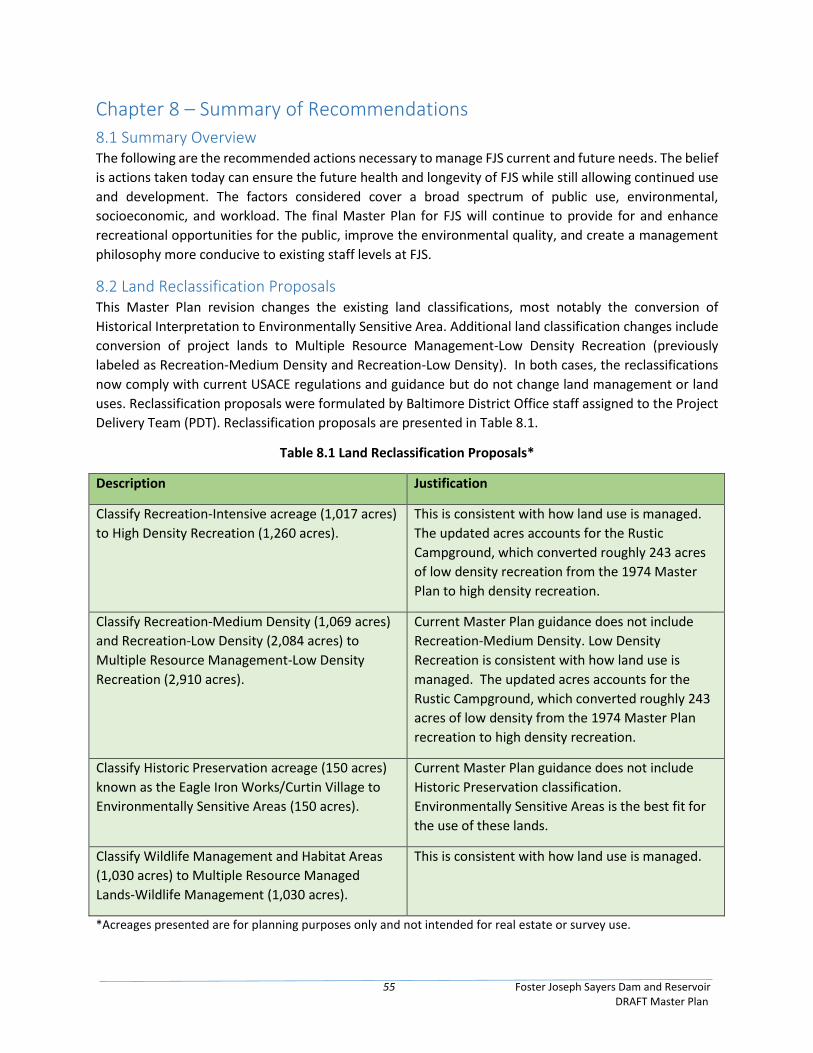
55 Foster Joseph Sayers Dam and Reservoir DRAFT Master Plan
Chapter 8 – Summary of Recommendations
8.1 Summary Overview The following are the recommended actions necessary to manage FJS current and future needs. The belief
is actions taken today can ensure the future health and longevity of FJS while still allowing continued use
and development. The factors considered cover a broad spectrum of public use, environmental,
socioeconomic, and workload. The final Master Plan for FJS will continue to provide for and enhance
recreational opportunities for the public, improve the environmental quality, and create a management
philosophy more conducive to existing staff levels at FJS.
8.2 Land Reclassification Proposals This Master Plan revision changes the existing land classifications, most notably the conversion of
Historical Interpretation to Environmentally Sensitive Area. Additional land classification changes include
conversion of project lands to Multiple Resource Management-Low Density Recreation (previously
labeled as Recreation-Medium Density and Recreation-Low Density). In both cases, the reclassifications
now comply with current USACE regulations and guidance but do not change land management or land
uses. Reclassification proposals were formulated by Baltimore District Office staff assigned to the Project
Delivery Team (PDT). Reclassification proposals are presented in Table 8.1.
Table 8.1 Land Reclassification Proposals*
Description Justification
Classify Recreation-Intensive acreage (1,017 acres)
to High Density Recreation (1,260 acres).
This is consistent with how land use is managed.
The updated acres accounts for the Rustic
Campground, which converted roughly 243 acres
of low density recreation from the 1974 Master
Plan to high density recreation.
Classify Recreation-Medium Density (1,069 acres)
and Recreation-Low Density (2,084 acres) to
Multiple Resource Management-Low Density
Recreation (2,910 acres).
Current Master Plan guidance does not include
Recreation-Medium Density. Low Density
Recreation is consistent with how land use is
managed. The updated acres accounts for the
Rustic Campground, which converted roughly 243
acres of low density from the 1974 Master Plan
recreation to high density recreation.
Classify Historic Preservation acreage (150 acres)
known as the Eagle Iron Works/Curtin Village to
Environmentally Sensitive Areas (150 acres).
Current Master Plan guidance does not include
Historic Preservation classification.
Environmentally Sensitive Areas is the best fit for
the use of these lands.
Classify Wildlife Management and Habitat Areas
(1,030 acres) to Multiple Resource Managed
Lands-Wildlife Management (1,030 acres).
This is consistent with how land use is managed.
*Acreages presented are for planning purposes only and not intended for real estate or survey use.

56 Foster Joseph Sayers Dam and Reservoir DRAFT Master Plan
This page intentionally left blank
57 Foster Joseph Sayers Dam and Reservoir DRAFT Master Plan
Chapter 9 – References Audubon. Important Bird Areas, Bald Eagle Ridge. Accessed on August 22, 2017, at
http://www.audubon.org/important-bird-areas/bald-eagle-ridge
Centre County History. Accessed on August 1, 2017, at http://www.centrehistory.org/centre-county-
overview/
Pennsylvania Department of Conservation and Natural Resources (DCNR), 2011. Bald Eagle State Park:
Park Management Plan. July 2011.
DCNR, 2012. The Economic Significance and Impact of Pennsylvania Parks: An Updated Assessment of
2010 Park Visitor Spending on the State and Local Economy.
DCNR, 2016a. Bald Eagle State Park. Accessed on March 1, 2016, at
http://www.dcnr.state.pa.us/stateparks/findapark/baldeagle/.
DCNR, 2016b. Pennsylvania Department of Conservation and Natural Resources: Bureaus. Accessed on
June 14, 2016, at http://www.dcnr.state.pa.us/discoverdcnr/ataglance/bureaus/index.htm.
Miller and Boyko, 1989. Phase I Archaeological Survey Report, Bald Eagle State Park Campground
Development, Liberty and Howard Townships, Centre County, Pennsylvania. Archaeological and
Historical Consultants, Inc.
Pennsylvania Fish & Boat Commission, 2015. Fisheries Management Report, Bald Eagle Creek, Sections
05 and 06. Bureau of Fisheries, Fisheries Management Division.
Pennsylvania Game Commission, 2018. State Game Lands PDF. Available online at
https://www.pgc.pa.gov/HuntTrap/StateGameLands/Documents/SGL%20Maps/SGL__323.pdf.
Pennsylvania State Data Center, 2018. Available online at https://pasdc.hbg.psu.edu/
Pennsylvania State University, 2013. Pennsylvania State Parks Visitor Use Monitoring Study – Year 1
Survey Results. November 1, 2013. Available online at
http://www.dcnr.state.pa.us/cs/groups/public/documents/document/dcnr_20029194.pdf.
United States Department of the Army, Baltimore District Army Corps of Engineers (USACE), 1974.
Foster Joseph Sayers Dam and Reservoir Master Plan.
USACE, 1996. Foster Joseph Sayers Dam and Reservoir, Pennsylvania. Master Manual for Reservoir
Regulation, Susquehanna River Basin.
USACE, 2011. Archeological Inventory and Assessment of the Foster Joseph Sayers Lake Shoreline,
Centre County, Pennsylvania. Prepared by John Milner Associates, Inc.
USACE, 2017a. U.S. Army Corps of Engineers, Baltimore District, Water Quality Program Annual Report,
FY2017.
USACE, 2017b. Draft Integrated Cultural Resources Management Plan for Foster Joseph Sayers Project
Centre County, Pennsylvania, 2017-2021.

58 Foster Joseph Sayers Dam and Reservoir DRAFT Master Plan
U.S. Bureau of the Census, 2014. American Fact Finder. Available online at
https://factfinder.census.gov/faces/nav/jsf/pages/index.xhtml
U.S. Bureau of Labor Statistics, 2014. Available online at https://www.bls.gov/
United States Department of Agricultural (USDA), 2019. Natural Resources Conservation Service (NRCS)
Soil Survey, Centre County, PA – Version 19.
United States Department of the Interior, Fish and Wildlife Service (USFWS), 2020. Consultation Letter.
Subject: List of threatened and endangered species that may occur in your proposed project location,
and/or may be affected by your proposed project. Dated: 14 February 2020.
USFWS, 2014. Experimental Stocking of American eels in the Susquehanna River Watershed.
USFWS, 2017. Chart and Table of Bald Eagle Breeding Pairs in the Lower 48 States. Retrieved August 17,
2017.
United States Department of the Interior, Geological Survey (USGS), 1997. Fish Community Composition
in Bald Eagle Creek Upstream and Downstream of Foster Joseph Sayers Dam, Centre County,
Pennsylvania.
United States National Oceanic and Atmospheric Administration (NOAA), National Weather Service
(NWS), 2019. Climate Records for Williamsport, PA. Accessed on November 21, 2019 at
https://www.weather.gov/ctp/climateRecordsWilliamsport

Appendix A – Location, Land Classifications, Soils, Wetlands, and
Recreation Maps

This page intentionally left blank
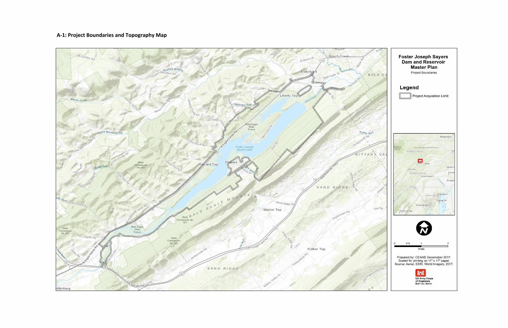
A-1: Project Boundaries and Topography Map
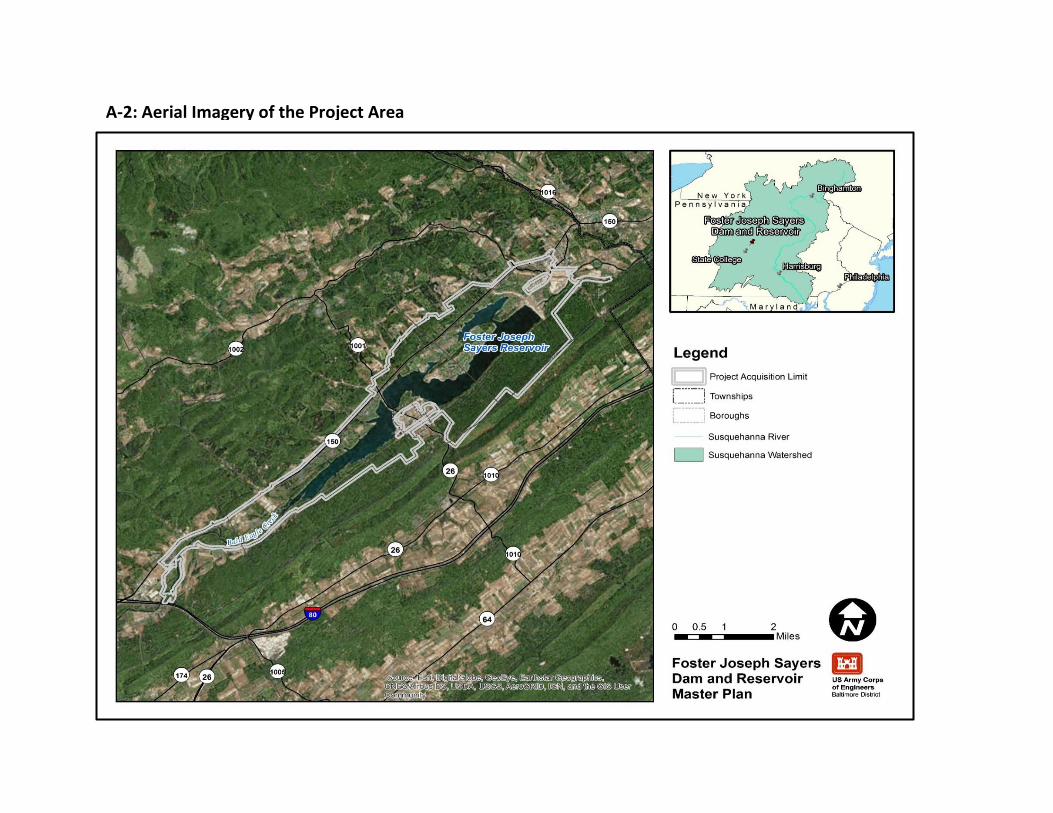
A-2: Aerial Imagery of the Project Area
A-3: Existing Land Classifications from the 1974 Master Plan
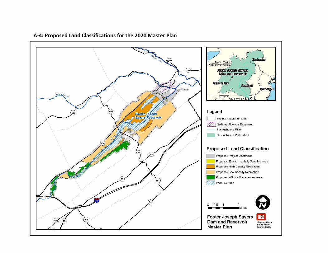
A-4: Proposed Land Classifications for the 2020 Master Plan
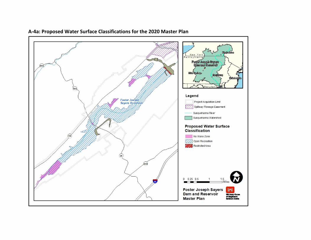
A-4a: Proposed Water Surface Classifications for the 2020 Master Plan
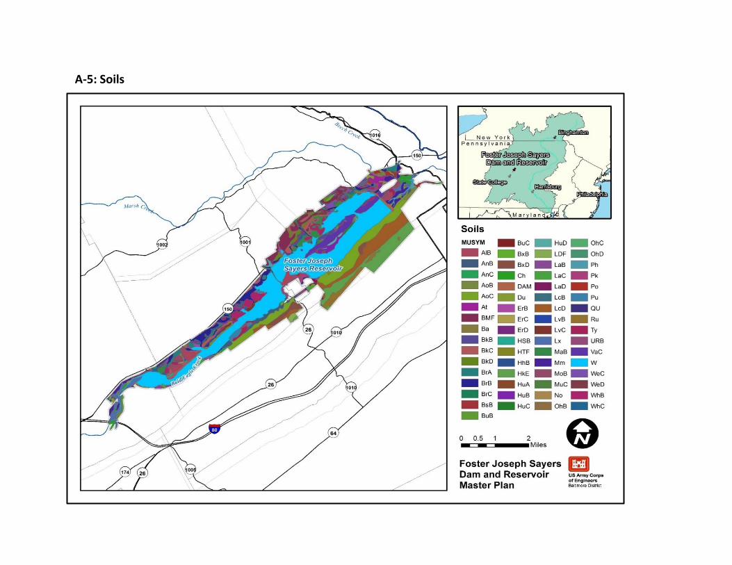
A-5: Soils
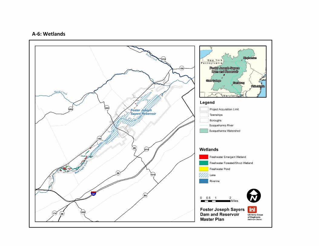
A-6: Wetlands
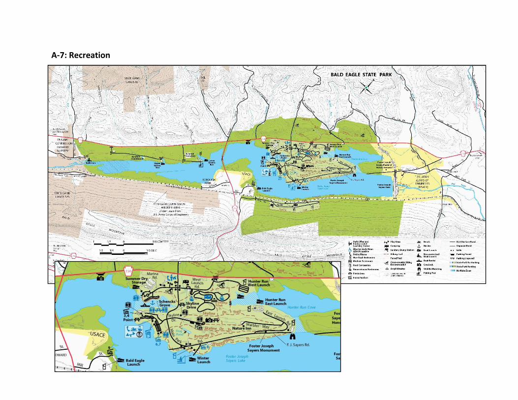
A-7: Recreation

Appendix B – National Environmental Policy Act (NEPA) Documentation

This page intentionally left blank
Draft Environmental Assessment for the FOSTER JOSEPH SAYERS DAM and RESERVOIR MASTER PLAN Bald Eagle Creek, Centre County, Pennsylvania
July 2020

DRAFT ENVIRONMENTAL ASSESSMENT
FOSTER JOSEPH SAYERS DAM AND RESERVOIR MASTER PLAN
BALD EAGLE CREEK/FOSTER JOSEPH SAYERS LAKE
CENTRE COUNTY, PENNSYLVANIA
Prepared by:
U.S. Army Corps of Engineers
Baltimore District
2 Hopkins Plaza
Baltimore, Maryland 21201
July 2020

Foster Joseph Sayers Dam and Reservoir FONSI-i Draft Master Plan Update Environmental Assesment
DRAFT FINDING OF NO SIGNIFICANT IMPACT Environmental Assessment for the Foster Joseph Sayers Dam and Reservoir Master Plan
Bald Eagle Creek, Pennsylvania In accordance with the National Environmental Policy Act of 1969 (NEPA), including guidelines in 33 Code of Federal Regulations (CFR) Part 230 (Procedures for Implementing NEPA), the Baltimore District of the U.S. Army Corps of Engineers (USACE) has assessed the potential impacts of the 2020 Foster Joseph Sayers Dam and Reservoir Master Plan (2020 Master Plan). Foster Joseph Sayers Dam and Reservoir was authorized and constructed for the primary purposes of managing flood risk in the Upper Susquehanna River Basin. Implementation of the Foster Joseph Sayers Dam and Reservoir Master Plan and proposed land classification changes must recognize and be compatible with the authorized purpose of flood risk management and the USACE Environmental Operating Principles. The 2020 Master Plan will provide guidance for stewardship of natural resources and management for long- term public access to, and use of, the natural resources of Foster Joseph Sayers Dam and Reservoir, including the land classification of the USACE-managed lands. USACE manages project lands in accordance with land classifications that have been determined in the Master Plan for the project lands. Thus, land classifications are fundamental to project lands management. Land use classifications (see Table S-1) provide for development and resource management consistent with authorized purposes and other Federal laws. The 2020 Master Plan provides a comprehensive description of Foster Joseph Sayers Dam and Reservoir (the Project), a discussion of factors influencing resource management and development, new resource management objectives, a synopsis of public involvement and input into the planning process, descriptions of existing development, and consideration of future development activities. Under the No Action Alternative, the USACE would take no action, which means no new resource analysis or land use reclassifications would occur. The operation and management of Foster Joseph Sayers Dam and Reservoir would continue as outlined in the 1974 Master Plan. The Proposed Action includes adopting the 2020 Master Plan to reflect changes in land management and land uses, USACE regulations and guidance that have occurred since the 1974 Master Plan, and coordination with the public. The 2020 Master Plan refines land classifications to meet authorized project purposes and current resource objectives. This includes a mix of natural resource and recreation management objectives that are compatible with Chesapeake Bay Program watershed goals established by stakeholders and USACE during the master planning process, recognize outdoor recreation trends, and are responsive to public comments. The purpose of the Proposed Action is to ensure that the conservation and sustainability of the land, water, and recreational resources at Foster Joseph Sayers Dam and Reservoir comply with applicable environmental laws and regulations and to maintain quality land for future use, including the 2014 Chesapeake Bay Agreement goals and management strategies for restoring and maintaining the health of the watershed. The 2020 Master Plan is intended to serve as a comprehensive land and recreation management plan for the next 15 to 25 years, which reflects changes that have occurred since 1974 in outdoor recreation trends, regional land use, population, legislative requirements, USACE management policy, and wildlife habitat at Foster Joseph Sayers Dam and Reservoir. The Proposed Action is needed to update the Foster Joseph Sayers Dam and Reservoir Master Plan in accordance with January 2013 updates to the Engineer Regulation (ER) and Engineering Pamphlet (EP) 1130-2-550.

Foster Joseph Sayers Dam and Reservoir FONSI-ii Draft Master Plan Update Environmental Assesment
Table S-1 identifies the required land and water surface classification changes associated with the Proposed Action.
Table S-1. Proposed Changes to Land Use Classifications at Foster Joseph Sayers Dam and Reservoir Prior Land Classifications (1974) Acres New Land Classification Acres
Project Operations 494 Project Operations 494
Recreation-Intensive 1,017 High Density Recreation 1,260
Recreation-Medium Density 1,069 Multiple Resource Managed Lands-Low Density Recreation 2,910
Recreation-Low Density 2,084
Wildlife Management 1,030 Multiple Resource Managed Lands-Wildlife Management 1,030
Historical Interpretation 150 Environmentally Sensitive Areas 150
Summer Pool Acreage - Restricted 630 Water Surface - Restricted 15
Summer Pool Acreage - Unrestricted 1,100 Water Surface - No Wake Zone 200 Water Surface - Open Recreation 1,515
Total 7,574 Total 7,574
USACE chose the Proposed Action because it would meet Chesapeake Bay Program watershed goals associated with good stewardship of land and water resources, meet regional recreation goals, and allow for continued use and development of project lands without violating national policies or public laws. USACE used the Environmental Assessment (EA) and comments received from other agencies to determine whether the Proposed Action requires the preparation of an Environmental Impact Statement (EIS). This included assessment of all environmental, social, and economic factors that are relevant to the recommended alternative considered in this assessment. The EA determined that no or negligible impacts would occur to the following resources: air quality, greenhouse gases and climate, geology and topography, water resources, soils and prime farmland, noise, land use and recreation, cultural resources, utilities, hazardous materials and waste, socioeconomics and environmental justice, and traffic and transportation (see Section 3.1 of the EA). Negligible and beneficial impacts are anticipated to biological resources as a result of the proposed action. Current low density recreation, wildlife management, and environmentally sensitive areas land classifications would not change existing land uses at Foster Joseph Sayers Dam and Reservoir and as a result current wildlife management practices would be preserved that is ultimately beneficial to biological resources. Conclusion
Based on the summary of effects evaluated in the EA, I have determined that the Proposed Action will not have a significant effect on the natural and human environment. For this reason, no Environmental Impact Statement is required.
__________________________ ________________________________ Date John T. Litz Colonel, U.S. Army Commander and District Engineer
Foster Joseph Sayers Dam and Reservoir TOC-i Draft Master Plan Update Environmental Assesment
(Cover image credit to Pennsylvania Department of Conservation and Natural Resources available online at http://www.dcnr.state.pa.us/stateparks/findapark/baldeagle/)
Table of Contents Section 1 – Introduction, Purpose, Need, and Scope ................................................................................... 1
1.1 Overview and Document Organization ......................................................................................... 1
1.2 Project Location and Setting ......................................................................................................... 2
1.3 Project Background ....................................................................................................................... 2
1.4 Purpose and Need for the Action ................................................................................................. 2
1.5 Scope of the EA ............................................................................................................................. 3
1.6 Public and Agency Involvement .................................................................................................... 3
1.6.1 Public Review ............................................................................................................................... 3
1.6.2 Agency Coordination .................................................................................................................... 3
Section 2 – Proposed Action and Alternatives .............................................................................................. 5
2.1 Master Planning Process ..................................................................................................................... 5
2.2 Screening Criteria ................................................................................................................................ 5
2.3 No-Action Alternative ......................................................................................................................... 6
2.4 Proposed Action (Preferred Alternative) ............................................................................................ 6
Section 3 – Environment Setting and Environmental Consequences ........................................................... 9
3.1 Introduction ........................................................................................................................................ 9
3.1.1 Description of Baseline Data and Data Sources ........................................................................... 9
3.1.2 Approach for Analyzing Impacts .................................................................................................. 9
3.2 Water Resources ............................................................................................................................... 13
3.2.1 Affected Environment ................................................................................................................ 13
3.2.2 No Action – Environmental Consequences ................................................................................ 14
3.2.3 Proposed Action – Environmental Consequences ..................................................................... 14
3.3 Soils and Prime Farmland.................................................................................................................. 14
3.3.1 Affected Environment ................................................................................................................ 14
3.3.2 No Action – Environmental Consequences ................................................................................ 15
3.3.3 Proposed Action – Environmental Consequences ..................................................................... 16
3.4 Biological Resources .......................................................................................................................... 17
3.4.1 Affected Environment ................................................................................................................ 17
3.4.2 No Action – Environmental Consequences ................................................................................ 20
3.4.3 Proposed Action – Environmental Consequences ..................................................................... 20
Foster Joseph Sayers Dam and Reservoir TOC-ii Draft Master Plan Update Environmental Assesment
Section 3.5 Cumulative Impacts .............................................................................................................. 21
3.5.1 Current and Reasonably Foreseeable Projects Within and Near the ROI ................................. 22
3.5.2 Analysis of Cumulative Impacts ................................................................................................. 22
Section 4 – Compliance with Environmental Laws ..................................................................................... 23
Section 5 – Irretrievable and Irreversible Commitment of Resources ....................................................... 27
Section 6 – Summary of Environmental Consequences ............................................................................. 29
Section 7 – References ................................................................................................................................ 31
List of Tables Table 2.1 – Description of Current and Proposed Land Classification Changes ........................................... 7
Table 2.2 – Summary of Proposed Land Use Classification Changes ............................................................ 7
Table 3.1 – Environmental Resource Area Assessment Criteria and Level of Assessment ........................ 10
Table 3.2 – Potential Soil Resource Impacts from Changes to Land Classifications ................................... 15
Table 3.3 – Potential Soil Resource Impacts from Changes to Land Classifications ................................... 16
Table 3.4 – Fish species commonly found in Foster Joseph Sayers Lake .................................................... 18
Table 3.5 – Threatened and Endangered Species Tracked by U.S. Fish and Wildlife Services within Foster Joseph Sayers Reservoir grounds ................................................................................................................ 20
Table 3.6 – Potential Biological Resource Impacts from Changes to Land Classifications ......................... 21
Table 4.1 – Executive Orders, Memoranda, and Chesapeake Bay Restoration Goals ................................ 25
Table 6.1 – Summary of Potential Environmental Effects .......................................................................... 29
Foster Joseph Sayers Dam and Reservoir TOC-iii Draft Master Plan Update Environmental Assesment
List of Acronyms AHPA Archeological and Historic Preservation Act CEQ Council on Environmental Quality CFR Code of Federal Regulations DCNR Pennsylvania Department of Conservation and Natural Resources EA Environmental Assessment EIS Environmental Impact Statement EO Executive Order EP Engineering Pamphlet ER Engineering Regulation ESA Endangered Species Act FEMA Federal Emergency Management Agency FIRM Flood Insurance Rate Map FJS Foster Joeseph Sayers Dam and Reservoir FPPA Farmland Protection Policy Act GIS Geographical Information Systems IBA Important Bird Area ICRMP Integrated Cultural Resources Management Plan MBTA Migratory Bird Treaty Act NEPA National Environmental Policy Act NFIP National Flood Insurance Program NGVD29 National Geodetic Vertical Datum of 1929 NHPA National Historic Preservation Act NRCS Natural Resources Conservation Service PA Pennsylvania PDEP Pennsylvania Department of Protection PFBC Pennsylvania Fish and Boat Commission PGC Pennsylvania Game Commission PNHP Pennsylvania Natural Heritage Program ROI Region of Influence SHPO State Historic Preservation Office USACE United States Army Corps of Engineers USDA United States Department of Agricultural USEPA United States Environmental Protection Agency USGS United States Geological Survey

Foster Joseph Sayers Dam and Reservoir TOC-iv Draft Master Plan Update Environmental Assesment
Page Intentionally Left Blank
Foster Joseph Sayers Dam and Reservoir 1 Draft Master Plan Update Environmental Assesment
Section 1 – Introduction, Purpose, Need, and Scope 1.1 Overview and Document Organization The Master Plan is the strategic land use management document that guides the comprehensive management and development actions related to all project recreational, natural, and cultural resources throughout the life of the project. Specific to this Environmental Assessment (EA), Foster Joseph Sayers Dam and Reservoir (also referred to as the Project or FJS) which was authorized and constructed for the primary purposes of managing flood risks and a secondary use of the project lands and waters for recreation. Implementation of the FJS Master Plan and proposed land classification changes must recognize and be compatible with the authorized purpose of flood risk management. The U.S. Army Corps of Engineers (USACE) produces and uses the Master Plan to guide the responsible stewardship of USACE-administered lands and resources for the benefit of present and future generations. The Master Plan presents an inventory and analysis of land resources, resource management objectives, land use classifications, resource use plans for each land use classification, current and projected park facility needs, an analysis of existing and anticipated resource use, and anticipated influences on overall project operation and management. The Master Plan is guided by Engineer Regulation (ER) and Engineering Pamphlet (EP) 1130-2-550. USACE land use classifications provide for development and resource management consistent with authorized purposes and other Federal laws. This EA considers the potential impacts to the natural and human environment from implementation of the 2020 FJS Lake Master Plan (herein referred to as the “2020 Master Plan”). This EA includes the following sections:
Section 1 INTRODUCTION, PURPOSE, NEED, AND SCOPE summarizes the purpose and need for the Proposed Action (the implementation of the 2020 Master Plan for FJS), provides relevant background information, and describes the scope of the EA. This Section also includes public involvement and agency coordination efforts conducted during the preparation of the EA.
Section 2 ALTERNATIVES INCLUDING PROPOSED ACTION examines alternatives for implementing the Proposed Action and describes the recommended action.
Section 3 ENVIRONMENTAL SETTING AND CONSEQUENCES describes the existing natural and human environments, and identifies the potential effects of implementing the Proposed Action and alternatives.
Section 4 COMPLIANCE WITH ENVIRONMENTAL LAWS provides a listing of environmental protection statutes and other environmental requirements.
Section 5 IRRETRIEVABLE AND IRREVERSIBLE COMMITMENT OF RESOURCES identifies any irreversible and irretrievable commitments of resources that would be involved in the Proposed Action should it be implemented.
Section 6 SUMMARY OF ENVIRONMENTAL CONSEQUENCES summarizes the potential environmental consequences of implementing the Proposed Action and alternatives.
Section 7 REFERENCES provides bibliographical information for cited sources.
Foster Joseph Sayers Dam and Reservoir 2 Draft Master Plan Update Environmental Assesment
Appendix A PUBLIC AND AGENCY CORRESPONDENCE provides relevant documentation of correspondence with the public and agencies.
1.2 Project Location and Setting Approximately 38 miles west-southwest of the City of Williamsport, FJS is located in north-central Pennsylvania within Centre County, along Bald Eagle Creek, a tributary to the West Branch Susquehanna River. A map showing the boundaries of the FJS is located in the 2020 Master Plan under Appendix A. The watershed consists of forests, wetlands, agriculture, and low density residential land uses, with some smaller towns or boroughs. The project is situated within the Bald Eagle State Park, and includes two campgrounds, boating, fishing, swimming, the Nature Inn, and diverse habitats that are excellent for wildlife watching (Department of Conservation and Natural Resources (DNCR) 2020). The drainage area upstream of the project is approximately 339 square miles. The reservoir pool when full extends upstream for 10.0 miles. Aerial imagery of the FJS is located in the 2020 Master Plan under Appendix A. FJS is located northwest of Harrisburg, along PA 150 between Milesburg and Lock Haven. Access to PA 150 is available using either I-80 west, I-80 east to US 220 north, or I-99 to US 220-ALT.
1.3 Project Background FJS was authorized as the Blanchard Dam and Reservoir project by the Flood Control Act of 1954 (Public Law 780, 83rd Congress, 2nd Session, in accordance with House of Representatives Document No. 29, 84th Congress, 1st Session). The dam and lake by act of Congress, Public Law 90-46, was renamed in memory of Private First Class Foster Joseph Sayers, a former resident of Centre County, Pennsylvania, who was posthumously awarded the Congressional Medal of Honor for heroic service in World War II.
FJS was originally presented in the report of the Chief of Engineers dated June 25, 1954. The Chief’s report recommended construction of three dam and reservoir projects: Curwensville, Alvin R. Bush, and Blanchard dams. These three dams were constructed and are operated as a system along the West Branch Susquehanna River (in conjunction with the George B. Stevenson Dam – constructed by the Commonwealth of Pennsylvania) for flood risk management purposes. The four dams collectively formed a part of a comprehensive plan for flood risk management and water resource development in the West Branch Susquehanna River watershed. FJS was operationally completed in August 1969 with the construction of the Federal portion of the recreational facilities completed in the fall of 1971 (USACE 1974).
1.4 Purpose and Need for the Action The purpose of the Proposed Action is to ensure that the conservation and sustainability of the land, water, and recreational resources at FJS comply with applicable environmental laws and regulations and to maintain quality land for future use, including the Chesapeake Bay Agreement goals and management strategies for restoring and maintaining the health of the watershed. The 2020 Master Plan is intended to serve as a comprehensive land management plan for the next 15 to 25 years, which reflects changes that have occurred since the 1974 in outdoor recreation trends, regional land use, population, legislative requirements, USACE management policy, and wildlife habitat at FJS.
The need for the Proposed Action is to update the 1974 FJS Master Plan in accordance with January 2013 updates to the Engineer Regulation (ER) and Engineer Pamphlet (EP) 1130-2-550.
Foster Joseph Sayers Dam and Reservoir 3 Draft Master Plan Update Environmental Assesment
1.5 Scope of the EA The USACE prepared this EA pursuant to the National Environmental Policy Act (NEPA), Council on Environmental Quality (CEQ) regulations (40 Code of Federal Regulations [CFR] 1500–1517), and the USACE implementing regulations, Policy and Procedures for Implementing NEPA, ER 200-2-2 (USACE 1988) to evaluate existing conditions and potential impacts of implementing the 2020 FJS Master Plan. NEPA requires federal agencies to review potential environmental effects of federal actions which includes the adoption of formal plans, such as master plans, approved by federal agencies upon which future agency actions will be based.
Alternatives considered within this EA focus on the proposed land use classifications as presented in the 2020 Master Plan. The EA does not consider implementation of any specific future projects at FJS. In accordance with the above regulations, the USACE intends to use this EA to meet USACE’s regulatory requirements under NEPA and provide USACE with the information needed to make an informed decision about the potential effects to the natural and human environment from implementing the Proposed Action.
1.6 Public and Agency Involvement The USACE invites public participation in the NEPA process. Consideration of the views of and information provided by all interested persons and stakeholders promotes open communication and enables better decision-making. USACE coordinated with agencies, organizations, and members of the public with a potential interest in the Proposed Action during development of the 2020 Master Plan and in preparation of this EA. A Public Meeting was held in March 2019 to provide a status of the Master Plan and to obtain public input. Stakeholders contacted to date for the 2020 Master Plan have included state and local governments and agencies, organizations, and tribes.
1.6.1 Public Review The EA process includes a 30-day public review period. A notice of availability was published in the Centre Daily Times regarding the availability of the Draft EA. A hard copy of the Draft EA was available at the Centre County and Ross Libraries and the lobby of the Bald Eagle State Park. The Draft EA was also placed for review on the Project’s website at the following URL address: https://www.nab.usace.army.mil/Foster-Joseph-Sayers-Dam-Master-Plan-Revision/. In addition, a virtual public meeting on the Draft 2020 Master Plan and findings of the Draft EA was held on 6 August 2020. INSERT NUMBER (TBD) comments from the public were received during the Draft EA review period which primarily involved …. INSERT DISCUSSION OF COMMENTS. Public comments received during the 30-day public comment period (INSERT START AND END DATES) were considered in preparation of the Final EA and have been made part of the Administrative Record.
1.6.2 Agency Coordination USACE Distributed the Draft EA to the U.S. Fish and Wildlife Service (USFWS) – Region 5 and Commonwealth of Pennsylvania. Also, USACE specifically coordinated with the Pennsylvania State Historic Preservation Office (SHPO), Pennsylvania Department of Environmental Protection (PDEP), Pennsylvania Fish and Boat Commission (PFBC), and the USFWS – Pennsylvania Field Office. Copies of these coordination are located in Appendix A – Agency Coordination.

Foster Joseph Sayers Dam and Reservoir 4 Draft Master Plan Update Environmental Assesment
Page Intentionally Left Blank
Foster Joseph Sayers Dam and Reservoir 5 Draft Master Plan Update Environmental Assesment
Section 2 – Proposed Action and Alternatives USACE identified alternatives considered within this EA as part of the master planning process. This Chapter describes the master planning process, screening criteria for alternative development, and the alternatives carried forth for detailed analysis in this EA.
2.1 Master Planning Process USACE guidance recommends the establishment of resource goals and objectives for the purposes of development, conservation, and management of natural, cultural, and human-made resources at a project location. Goals describe the desired end state of overall management efforts, whereas objectives are concise statements describing measurable and attainable management activities that support the stated goals. Goals and objectives are guidelines for obtaining maximum public benefits while minimizing adverse impacts on the environment and are developed in accordance with 1) authorized project purposes, 2) applicable laws and regulations, 3) resource capabilities and suitability, 4) regional needs, 5) other governmental plans and programs, and 6) expressed public desires. Chapter 3 of the 2020 Master Plan provides a description of the various goals and objectives that have been established to address the missions of FJS.
2.2 Screening Criteria For an alternative to be considered viable, it must be compatible with the primary project missions of flood risk management at FJS. Additionally, the project is used to provide recreational opportunities and improve downstream water quality. The alternative must meet management goal objectives and USACE-wide Environmental Operating Principles as described in Chapter 3 of the 2020 Master Plan. The following is a list of the FJS resource objectives that were considered throughout the development of potential land reclassification alternatives:
• To give priority to the preservation and improvement of wild land values in public use planning, design, development, and management activities.
• To preserve and protect important paleontological, archeological, ecological, and esthetic resources.
• To manage habitat for threatened and endangered species and to support a diversity of fish and wildlife, and recreation use.
• To prevent the introduction of invasive species and aquatic nuisance species (ANS), detect and respond rapidly to and control populations of such species in a cost-effective and environmentally sound manner, monitor invasive species and ANS populations accurately and reliably, and provide for restoration of native species and habitat conditions in ecosystems that have been invaded.
• To manage and develop project lands to accommodate periodic fluctuations in lake elevations with minimal impacts.
• To develop and manage project resources to support types and levels of recreation activities indicated by visitor demand and consistent with carrying capacities and aesthetic, cultural, and ecological values.
• To manage identified recreational lands in ways that enhance benefits to wildlife.
• To provide access by Tribal members to any cultural resources, sacred sites, or other Traditional Cultural Properties.
Foster Joseph Sayers Dam and Reservoir 6 Draft Master Plan Update Environmental Assesment
• To preserve and protect cultural resources sites in compliance with existing federal statutes and regulations.
• To expand public outreach and education about the history of the area, project resources, and the USACE’s role in developing and managing these resources.
• To foster stewardship by minimizing encroachments and other non-allowed uses.
• To develop and manage lands in cooperation and coordination with other management agencies and appropriate entities in the private sector.
• To maintain and manage project lands and waters to support regional management programs.
• Manage project lands and recreational programs to advance broad national climate change mitigation goals, including but not limited to climate change resilience and carbon sequestration.
Based on the objectives and criteria, this EA evaluates the No Action Alternative (Section 2.3) and the Proposed Action Alternative (Section 2.4).
2.3 No-Action Alternative The No Action Alternative serves as a basis for comparison to the anticipated effects of the other action alternatives. Under the No Action Alternative, USACE would take no action and work not adopt the 2020 Master Plan. The operation and management of FJS would continue as outlines in the 1974 Master Plan, which currently does not meet current USACE guidance and regulations. No new land use classification would occur at FJS.
2.4 Proposed Action (Preferred Alternative) Under the Proposed Action, the Master Plan would be revised to comply with current USACE regulations and guidance. Specifically, the main purpose of the 2020 Master Plan update is to align the prior land classifications from 1974 Master Plan with current land classifications as outlined in accordance with Engineering Regulation (ER) 1130-2-550 and ER 1130-2-540, and corresponding Engineering Pamphlets (EPs). The following land classification changes (Table 2.1 and 2.2) were a result of the inventory, analysis, and synthesis of data, documents, and public and agency input. The acres presented in Table 2.2 are based on the land acres from the 1974 Master Plan. As a result, the acreages presented are for planning purposes only and not intended for real estate or survey use.
Updating the land classifications would meet regional goals associated with good stewardship of land and water resources, would meet regional recreation goals, and would allow for continued use and development of project lands without violating national policies or pubic laws. Therefore, this alternative will carry forward as the Proposed Action.
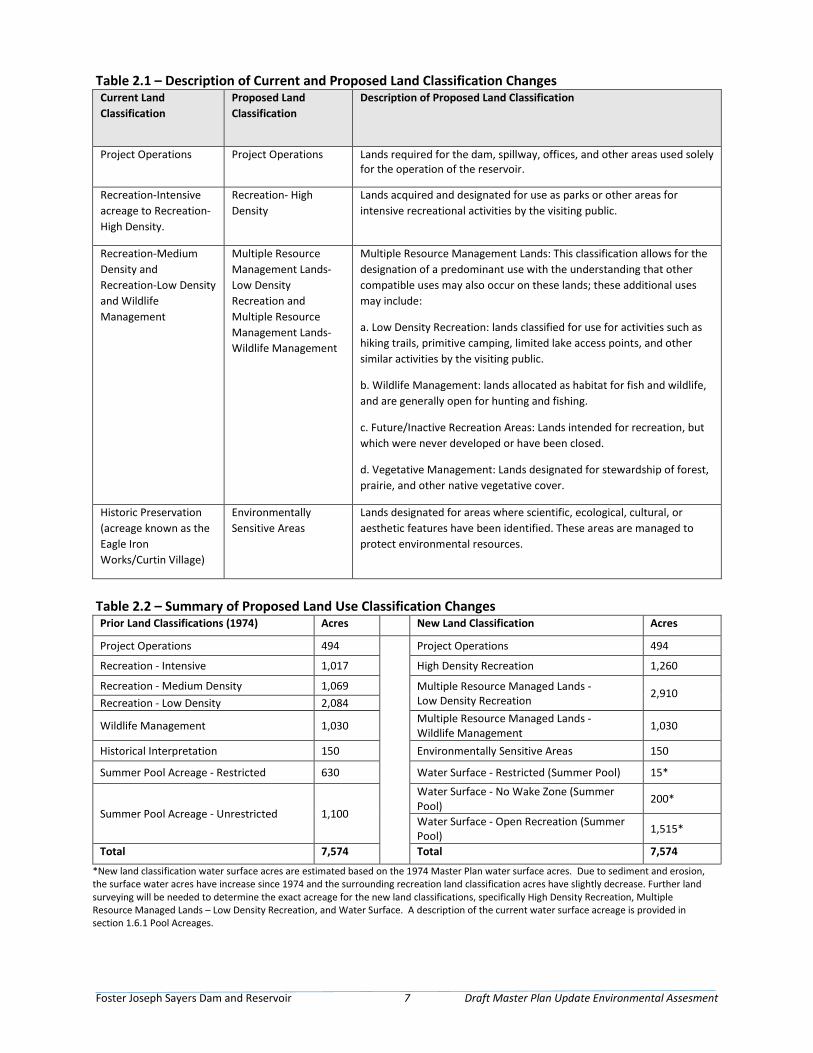
Foster Joseph Sayers Dam and Reservoir 7 Draft Master Plan Update Environmental Assesment
Table 2.1 – Description of Current and Proposed Land Classification Changes Current Land Classification
Proposed Land Classification
Description of Proposed Land Classification
Project Operations Project Operations Lands required for the dam, spillway, offices, and other areas used solely for the operation of the reservoir.
Recreation-Intensive acreage to Recreation-High Density.
Recreation- High Density
Lands acquired and designated for use as parks or other areas for intensive recreational activities by the visiting public.
Recreation-Medium Density and Recreation-Low Density and Wildlife Management
Multiple Resource Management Lands-Low Density Recreation and Multiple Resource Management Lands-Wildlife Management
Multiple Resource Management Lands: This classification allows for the designation of a predominant use with the understanding that other compatible uses may also occur on these lands; these additional uses may include:
a. Low Density Recreation: lands classified for use for activities such as hiking trails, primitive camping, limited lake access points, and other similar activities by the visiting public.
b. Wildlife Management: lands allocated as habitat for fish and wildlife, and are generally open for hunting and fishing.
c. Future/Inactive Recreation Areas: Lands intended for recreation, but which were never developed or have been closed.
d. Vegetative Management: Lands designated for stewardship of forest, prairie, and other native vegetative cover.
Historic Preservation (acreage known as the Eagle Iron Works/Curtin Village)
Environmentally Sensitive Areas
Lands designated for areas where scientific, ecological, cultural, or aesthetic features have been identified. These areas are managed to protect environmental resources.
Table 2.2 – Summary of Proposed Land Use Classification Changes Prior Land Classifications (1974) Acres New Land Classification Acres
Project Operations 494 Project Operations 494
Recreation - Intensive 1,017 High Density Recreation 1,260
Recreation - Medium Density 1,069 Multiple Resource Managed Lands - Low Density Recreation 2,910
Recreation - Low Density 2,084
Wildlife Management 1,030 Multiple Resource Managed Lands - Wildlife Management 1,030
Historical Interpretation 150 Environmentally Sensitive Areas 150
Summer Pool Acreage - Restricted 630 Water Surface - Restricted (Summer Pool) 15*
Summer Pool Acreage - Unrestricted 1,100
Water Surface - No Wake Zone (Summer Pool) 200*
Water Surface - Open Recreation (Summer Pool) 1,515*
Total 7,574 Total 7,574
*New land classification water surface acres are estimated based on the 1974 Master Plan water surface acres. Due to sediment and erosion, the surface water acres have increase since 1974 and the surrounding recreation land classification acres have slightly decrease. Further land surveying will be needed to determine the exact acreage for the new land classifications, specifically High Density Recreation, Multiple Resource Managed Lands – Low Density Recreation, and Water Surface. A description of the current water surface acreage is provided in section 1.6.1 Pool Acreages.

Foster Joseph Sayers Dam and Reservoir 8 Draft Master Plan Update Environmental Assesment
Page Intentionally Left Blank
Foster Joseph Sayers Dam and Reservoir 9 Draft Master Plan Update Environmental Assesment
Section 3 – Environment Setting and Environmental Consequences 3.1 Introduction This Section describes the natural and human environments that exist at the Project and the potential impacts of the No Action Alternative and Proposed Action (Preferred Alternative), outlined in Section 2. The description of baseline data sources and an approach for analyzing impacts are discussed in Sections 3.1.1 and 3.1.2, respectively.
3.1.1 Description of Baseline Data and Data Sources The EA used the following types of data to characterize the affected environment of the Project:
• Geographical Information System (GIS), including waters and wetlands inventory, floodplain mapping, and vegetation
• Aerial photography: U.S. Department of Agriculture (USDA), National Agriculture Imagery Program
• Regional and local reports: including Natural Resources Conservation Service (NRCS) Soil and the various sources from the Commonwealth of Pennsylvania
• Surveys and previous studies conducted at FJS
• Agency databases including the USFWS and the U.S. Environmental Protection Agency (USEPA)
• Information presented within the 2020 Master Plan
• Agency consultation
3.1.2 Approach for Analyzing Impacts Impacts (consequence or effect) can be either beneficial or adverse and can be either directly related to the action or indirectly caused by the action. Direct effects are caused by the action and occur at the same time and place (40 CFR 1508.8[a]). Indirect effects are caused by the action and are later in time or further removed in distance, but are still reasonably foreseeable (40 CFR 1508.8[b]). As discussed in this Section, the alternatives may create temporary (less than 1 year), short-term (up to 3 years), long-term (3 to 10 years following the Master Plan), or permanent effects.
Whether an impact is significant depends on the context in which the impact occurs and the intensity of the impact (40 CFR 1508.27). The context refers to the setting in which the impact occurs and may include society as a whole, the affected region, the affected interests, and the locality. Impacts on each resource can vary in degree or magnitude from a slightly noticeable change to a total change in the environment. This analysis classifies the intensity of impacts as beneficial, negligible, minor, moderate, or significant. The intensity thresholds are defined as follows:
• Beneficial – Impacts would improve or enhance the resource.
• Negligible – A resource would not be affected, or the effects would be at or below the level of detection, and changes would not be of any measurable or perceptible consequence.
• Minor – Effects on a resource would be detectable, although the effects would be localized, small, and of little consequence to the sustainability of the resource. Mitigation measures, if needed to offset adverse effects, would be simple and achievable.
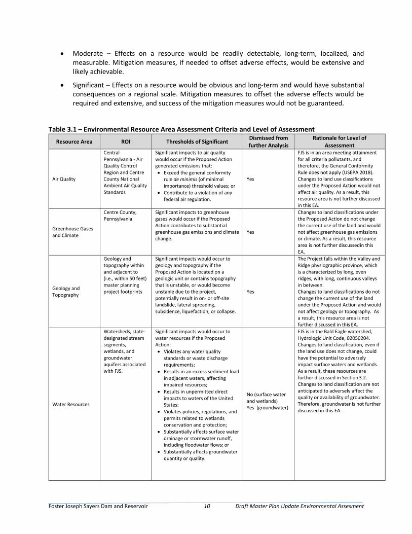
Foster Joseph Sayers Dam and Reservoir 10 Draft Master Plan Update Environmental Assesment
• Moderate – Effects on a resource would be readily detectable, long-term, localized, and measurable. Mitigation measures, if needed to offset adverse effects, would be extensive and likely achievable.
• Significant – Effects on a resource would be obvious and long-term and would have substantial consequences on a regional scale. Mitigation measures to offset the adverse effects would be required and extensive, and success of the mitigation measures would not be guaranteed.
Table 3.1 – Environmental Resource Area Assessment Criteria and Level of Assessment
Resource Area ROI Thresholds of Significant Dismissed from further Analysis
Rationale for Level of Assessment
Air Quality
Central Pennsylvania - Air Quality Control Region and Centre County National Ambient Air Quality Standards
Significant impacts to air quality would occur if the Proposed Action generated emissions that: • Exceed the general conformity
rule de minimis (of minimal importance) threshold values; or
• Contribute to a violation of any federal air regulation.
Yes
FJS is in an area meeting attainment for all criteria pollutants, and therefore, the General Conformity Rule does not apply (USEPA 2018). Changes to land use classifications under the Proposed Action would not affect air quality. As a result, this resource area is not further discussed in this EA.
Greenhouse Gases and Climate
Centre County, Pennsylvania
Significant impacts to greenhouse gases would occur if the Proposed Action contributes to substantial greenhouse gas emissions and climate change.
Yes
Changes to land classifications under the Proposed Action do not change the current use of the land and would not affect greenhouse gas emissions or climate. As a result, this resource area is not further discussed in this EA.
Geology and Topography
Geology and topography within and adjacent to (i.e., within 50 feet) master planning project footprints
Significant impacts would occur to geology and topography if the Proposed Action is located on a geologic unit or contains topography that is unstable, or would become unstable due to the project, potentially result in on- or off-site landslide, lateral spreading, subsidence, liquefaction, or collapse.
Yes
The Project falls within the Valley and Ridge physiographic province, which is a characterized by long, even ridges, with long, continuous valleys in between. Changes to land classifications do not change the current use of the land under the Proposed Action and would not affect geology or topography. As a result, this resource area is not further discussed in this EA.
Water Resources
Watersheds, state- designated stream segments, wetlands, and groundwater aquifers associated with FJS.
Significant impacts would occur to water resources if the Proposed Action: • Violates any water quality
standards or waste discharge requirements;
• Results in an excess sediment load in adjacent waters, affecting impaired resources;
• Results in unpermitted direct impacts to waters of the United States;
• Violates policies, regulations, and permits related to wetlands conservation and protection;
• Substantially affects surface water drainage or stormwater runoff, including floodwater flows; or
• Substantially affects groundwater quantity or quality.
No (surface water and wetlands) Yes (groundwater)
FJS is in the Bald Eagle watershed, Hydrologic Unit Code, 02050204. Changes to land classification, even if the land use does not change, could have the potential to adversely impact surface waters and wetlands. As a result, these resources are further discussed in Section 3.2. Changes to land classification are not anticipated to adversely affect the quality or availability of groundwater. Therefore, groundwater is not further discussed in this EA.
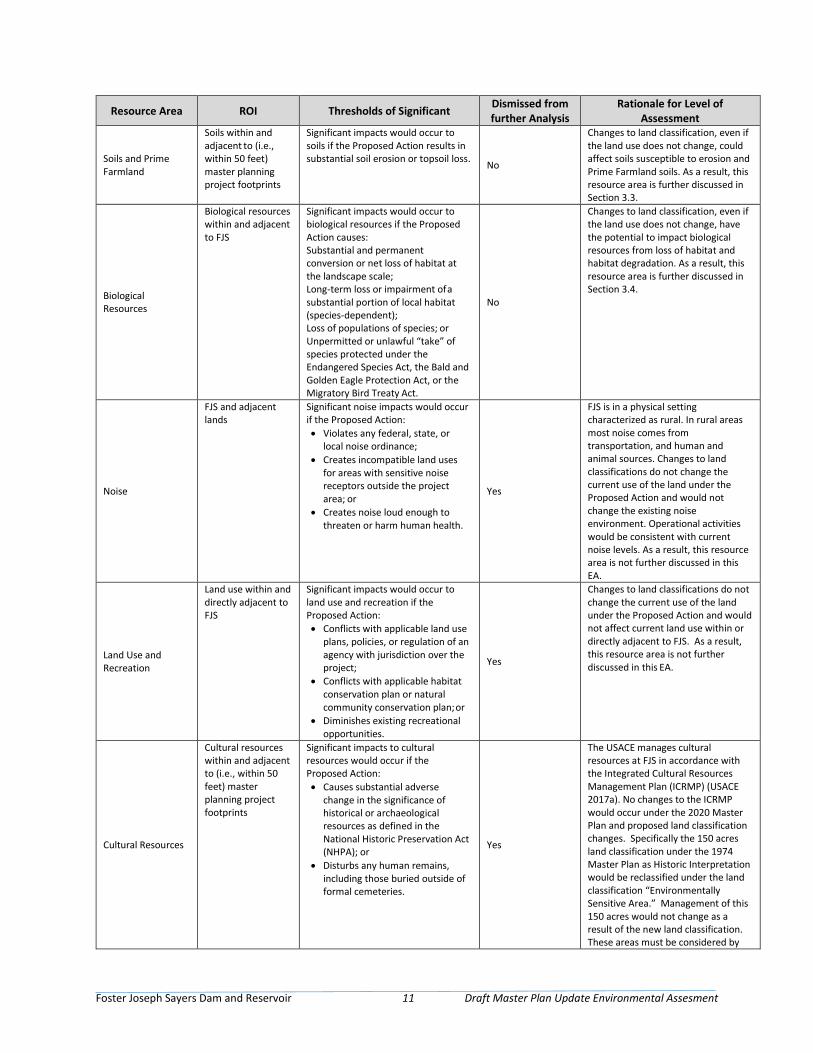
Foster Joseph Sayers Dam and Reservoir 11 Draft Master Plan Update Environmental Assesment
Resource Area ROI Thresholds of Significant Dismissed from further Analysis
Rationale for Level of Assessment
Soils and Prime Farmland
Soils within and adjacent to (i.e., within 50 feet) master planning project footprints
Significant impacts would occur to soils if the Proposed Action results in substantial soil erosion or topsoil loss. No
Changes to land classification, even if the land use does not change, could affect soils susceptible to erosion and Prime Farmland soils. As a result, this resource area is further discussed in Section 3.3.
Biological Resources
Biological resources within and adjacent to FJS
Significant impacts would occur to biological resources if the Proposed Action causes: Substantial and permanent conversion or net loss of habitat at the landscape scale; Long-term loss or impairment of a substantial portion of local habitat (species-dependent); Loss of populations of species; or Unpermitted or unlawful “take” of species protected under the Endangered Species Act, the Bald and Golden Eagle Protection Act, or the Migratory Bird Treaty Act.
No
Changes to land classification, even if the land use does not change, have the potential to impact biological resources from loss of habitat and habitat degradation. As a result, this resource area is further discussed in Section 3.4.
Noise
FJS and adjacent lands
Significant noise impacts would occur if the Proposed Action: • Violates any federal, state, or
local noise ordinance; • Creates incompatible land uses
for areas with sensitive noise receptors outside the project area; or
• Creates noise loud enough to threaten or harm human health.
Yes
FJS is in a physical setting characterized as rural. In rural areas most noise comes from transportation, and human and animal sources. Changes to land classifications do not change the current use of the land under the Proposed Action and would not change the existing noise environment. Operational activities would be consistent with current noise levels. As a result, this resource area is not further discussed in this EA.
Land Use and Recreation
Land use within and directly adjacent to FJS
Significant impacts would occur to land use and recreation if the Proposed Action: • Conflicts with applicable land use
plans, policies, or regulation of an agency with jurisdiction over the project;
• Conflicts with applicable habitat conservation plan or natural community conservation plan; or
• Diminishes existing recreational opportunities.
Yes
Changes to land classifications do not change the current use of the land under the Proposed Action and would not affect current land use within or directly adjacent to FJS. As a result, this resource area is not further discussed in this EA.
Cultural Resources
Cultural resources within and adjacent to (i.e., within 50 feet) master planning project footprints
Significant impacts to cultural resources would occur if the Proposed Action: • Causes substantial adverse
change in the significance of historical or archaeological resources as defined in the National Historic Preservation Act (NHPA); or
• Disturbs any human remains, including those buried outside of formal cemeteries.
Yes
The USACE manages cultural resources at FJS in accordance with the Integrated Cultural Resources Management Plan (ICRMP) (USACE 2017a). No changes to the ICRMP would occur under the 2020 Master Plan and proposed land classification changes. Specifically the 150 acres land classification under the 1974 Master Plan as Historic Interpretation would be reclassified under the land classification “Environmentally Sensitive Area.” Management of this 150 acres would not change as a result of the new land classification. These areas must be considered by
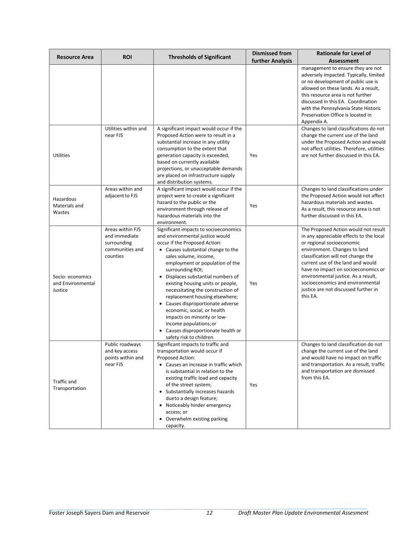
Foster Joseph Sayers Dam and Reservoir 12 Draft Master Plan Update Environmental Assesment
Resource Area ROI Thresholds of Significant Dismissed from further Analysis
Rationale for Level of Assessment
management to ensure they are not adversely impacted. Typically, limited or no development of public use is allowed on these lands. As a result, this resource area is not further discussed in this EA. Coordination with the Pennsylvania State Historic Preservation Office is located in Appendix A.
Utilities
Utilities within and near FJS
A significant impact would occur if the Proposed Action were to result in a substantial increase in any utility consumption to the extent that generation capacity is exceeded, based on currently available projections, or unacceptable demands are placed on infrastructure supply and distribution systems.
Yes
Changes to land classifications do not change the current use of the land under the Proposed Action and would not affect utilities. Therefore, utilities are not further discussed in this EA.
Hazardous Materials and Wastes
Areas within and adjacent to FJS
A significant impact would occur if the project were to create a significant hazard to the public or the environment through release of hazardous materials into the environment.
Yes
Changes to land classifications under the Proposed Action would not affect hazardous materials and wastes. As a result, this resource area is not further discussed in this EA.
Socio- economics and Environmental Justice
Areas within FJS and immediate surrounding communities and counties
Significant impacts to socioeconomics and environmental justice would occur if the Proposed Action: • Causes substantial change to the
sales volume, income, employment or population of the surrounding ROI;
• Displaces substantial numbers of existing housing units or people, necessitating the construction of replacement housing elsewhere;
• Causes disproportionate adverse economic, social, or health impacts on minority or low-income populations; or
• Causes disproportionate health or safety risk to children.
Yes
The Proposed Action would not result in any appreciable effects to the local or regional socioeconomic environment. Changes to land classification will not change the current use of the land and would have no impact on socioeconomics or environmental justice. As a result, socioeconomics and environmental justice are not discussed further in this EA.
Traffic and Transportation
Public roadways and key access points within and near FJS
Significant impacts to traffic and transportation would occur if Proposed Action: • Causes an increase in traffic which
is substantial in relation to the existing traffic load and capacity of the street system;
• Substantially increases hazards due to a design feature;
• Noticeably hinder emergency access; or
• Overwhelm existing parking capacity.
Yes
Changes to land classification do not change the current use of the land and would have no impact on traffic and transportation. As a result, traffic and transportation are dismissed from this EA.
Foster Joseph Sayers Dam and Reservoir 13 Draft Master Plan Update Environmental Assesment
3.2 Water Resources 3.2.1 Affected Environment Surface Waters FJS is located along the Bald Eagle Creek, which is part of the West Branch Susquehanna River Basin. The dam controls 43 percent of the total Bald Eagle Creek drainage area as measured at its mouth near Lock Haven, 8 percent of the West Branch Susquehanna River drainage area at Lock Haven, and 6 percent of the West Branch Susquehanna River as measured at Williamsport, Pennsylvania. The FJS Master Manual for Reservoir Regulation is used to manage the reservoir’s pool levels throughout the year. Typically, the reservoir is maintained at elevation 630 feet NGVD29 (summer pool) for flood control and recreational uses from mid-May until mid-November. At this elevation, the lake has a surface area of 1,823 acres, a maximum depth of 42 feet, an average depth of 16 feet, and a shoreline length of 23.4 miles (USACE 1996).
Wetlands FJS Reservoir encompasses a variety of wetland features. Emergent wetlands known to exist in the shallow fringe areas of the reservoir encompass common aquatic vegetation species such as duckweed (Lemna minor), swamp smart weed (Persicaria hydropiperoides), common rush (Juncus effusus), spike rush (Eleocharis palustris), and soft stem bull rush (Schoenoplectus tabernaemontani). Forested/shrub wetlands in deeper areas are known to exhibit combinations of woody and grass-like species. Common species associated with these habitat areas include a Pennsylvania sedge (Carex pensylvanica), woodland sedge (Carex blanda), inland rush (Juncus interior), Torrey’s rush (Juncus torreyi), switchgrass (Panicum virgatum), rough leaf dogwood (Cornus drummondii), dull leaf indigo bush (Amorpha fruticosa), coral berry (Symphoricarpos orbiculatus), bitternut hickory (Carya cordiformis), cottonwood (Populus deltoides) and pecan (Carya illinoinensis). Wetland resources support healthy ecosystems and provide important habitat for fish and wildlife. In support of regional stewardship goals and PFBC management goals, USACE incorporates operational practices at FJS project to enhance and protect these resources. See Figure A-6 in the 2020 Master Plan for the locations and types of wetlands on FJS.
Water Quality Both point and nonpoint inflow source pollution affect the quality of water at FJS. Agricultural runoff and sewage effluents increase the nutrient levels that are conducive to algae growth. The algae creates a seasonal problem, which creates an unattractive scum on the lake and greatly reduces underwater oxygen levels that have resulted in limited fish kills and eutrophic lake conditions. The industrial contaminant, Kepone, has reached the lake from tributary streams. It has been found in fish taken from the lake; however, it is below levels considered harmful. The carbonate geology of the region produces high alkalinity within the lake that can easily buffer pH changes. The swimming area is tested for total fecal coliform on a weekly basis during the summer months (USACE 2017b).
Floodplains Floodplains are areas of land adjacent to rivers and streams that convey overflows during flood events. The Federal Emergency Management Agency (FEMA) defines a floodplain as being any land area susceptible to being inundated by water from any source. FEMA prepares Flood Insurance Rate Maps (FIRMs) that delineate flood hazard areas, such as floodplains, for communities. These maps are used to administer floodplain regulations and to reduce flood damage. Typically, these maps indicate the locations of 100-year floodplains, which are areas with a 1 percent chance of flooding occurring in any single year.
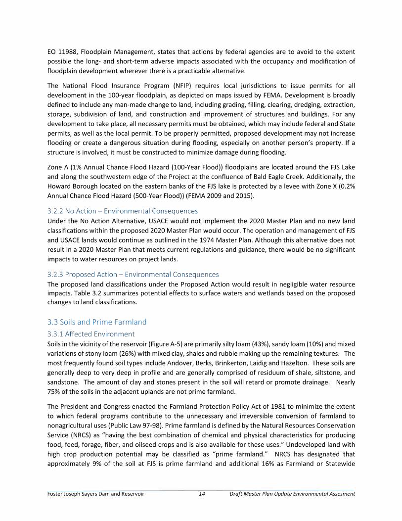
Foster Joseph Sayers Dam and Reservoir 14 Draft Master Plan Update Environmental Assesment
EO 11988, Floodplain Management, states that actions by federal agencies are to avoid to the extent possible the long- and short-term adverse impacts associated with the occupancy and modification of floodplain development wherever there is a practicable alternative.
The National Flood Insurance Program (NFIP) requires local jurisdictions to issue permits for all development in the 100-year floodplain, as depicted on maps issued by FEMA. Development is broadly defined to include any man-made change to land, including grading, filling, clearing, dredging, extraction, storage, subdivision of land, and construction and improvement of structures and buildings. For any development to take place, all necessary permits must be obtained, which may include federal and State permits, as well as the local permit. To be properly permitted, proposed development may not increase flooding or create a dangerous situation during flooding, especially on another person’s property. If a structure is involved, it must be constructed to minimize damage during flooding.
Zone A (1% Annual Chance Flood Hazard (100-Year Flood)) floodplains are located around the FJS Lake and along the southwestern edge of the Project at the confluence of Bald Eagle Creek. Additionally, the Howard Borough located on the eastern banks of the FJS lake is protected by a levee with Zone X (0.2% Annual Chance Flood Hazard (500-Year Flood)) (FEMA 2009 and 2015).
3.2.2 No Action – Environmental Consequences Under the No Action Alternative, USACE would not implement the 2020 Master Plan and no new land classifications within the proposed 2020 Master Plan would occur. The operation and management of FJS and USACE lands would continue as outlined in the 1974 Master Plan. Although this alternative does not result in a 2020 Master Plan that meets current regulations and guidance, there would be no significant impacts to water resources on project lands.
3.2.3 Proposed Action – Environmental Consequences The proposed land classifications under the Proposed Action would result in negligible water resource impacts. Table 3.2 summarizes potential effects to surface waters and wetlands based on the proposed changes to land classifications.
3.3 Soils and Prime Farmland 3.3.1 Affected Environment Soils in the vicinity of the reservoir (Figure A-5) are primarily silty loam (43%), sandy loam (10%) and mixed variations of stony loam (26%) with mixed clay, shales and rubble making up the remaining textures. The most frequently found soil types include Andover, Berks, Brinkerton, Laidig and Hazelton. These soils are generally deep to very deep in profile and are generally comprised of residuum of shale, siltstone, and sandstone. The amount of clay and stones present in the soil will retard or promote drainage. Nearly 75% of the soils in the adjacent uplands are not prime farmland.
The President and Congress enacted the Farmland Protection Policy Act of 1981 to minimize the extent to which federal programs contribute to the unnecessary and irreversible conversion of farmland to nonagricultural uses (Public Law 97-98). Prime farmland is defined by the Natural Resources Conservation Service (NRCS) as “having the best combination of chemical and physical characteristics for producing food, feed, forage, fiber, and oilseed crops and is also available for these uses.” Undeveloped land with high crop production potential may be classified as “prime farmland.” NRCS has designated that approximately 9% of the soil at FJS is prime farmland and additional 16% as Farmland or Statewide
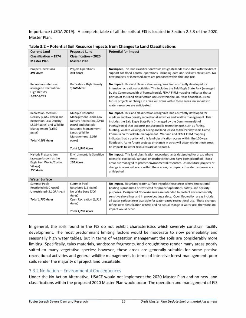
Foster Joseph Sayers Dam and Reservoir 15 Draft Master Plan Update Environmental Assesment
Importance (USDA 2019). A complete table of all the soils at FJS is located in Section 2.5.3 of the 2020 Master Plan.
Table 3.2 – Potential Soil Resource Impacts from Changes to Land Classifications Current Land Classification – 1974 Master Plan
Proposed Land Classification – 2020 Master Plan
Potential for Impact
Project Operations 494 Acres
Project Operations 494 Acres
No Impact. This land classification would designate lands associated with the direct support for flood control operations, including dam and spillway structures. No new projects or increased acres are proposed within this land use.
Recreation-Intensive acreage to Recreation-High Density 1,017 Acres
Recreation- High Density 1,260 Acres
No Impact. This land classification recognizes lands currently developed for intensive recreational activities. This includes the Bald Eagle State Park (managed by the Commonwealth of Pennsylvania). FEMA FIRM mapping indicates that a portion of this land classification occurs within the 100-year floodplain. As no future projects or change in acres will occur within these areas, no impacts to water resources are anticipated.
Recreation-Medium Density (1,069 acres) and Recreation-Low Density (2,084 acres) and Wildlife Management (1,030 acres) Total 4,183 Acres
Multiple Resource Management Lands-Low Density Recreation (2,910 acres) and Multiple Resource Management Lands-Wildlife Management (1,030 acres) Total 3,940 Acres
No Impact. This land classification recognizes lands currently developed for medium and low density recreational activities and wildlife management. This includes the Bald Eagle State Park (managed by the Commonwealth of Pennsylvania) that supports passive public recreation use, such as fishing, hunting, wildlife viewing, or hiking and land leased to the Pennsylvania Game Commission for wildlife management. Wetland and FEMA FIRM mapping indicates that a portion of this land classification occurs within the 100-year floodplain. As no future projects or change in acres will occur within these areas, no impacts to water resources are anticipated.
Historic Preservation (acreage known as the Eagle Iron Works/Curtin Village) 150 Acres
Environmentally Sensitive Areas 150 Acres
No Impact. This land classification recognizes lands designated for areas where scientific, ecological, cultural, or aesthetic features have been identified. These areas are managed to protect environmental resources. As no future projects or change in acres will occur within these areas, no impacts to water resources are anticipated.
Water Surface Summer Pool: Restricted (630 Acres) Unrestricted (1,100 Acres) Total 1,730 Acres
Summer Pool: Restricted (15 Acres) No Wake Zone (200 Acres) Open Recreation (1,515 Acres) Total 1,730 Acres
No Impact. Restricted water surface includes those areas where recreational boating is prohibited or restricted for project operations, safety, and security purposes. Designated No-Wake areas are intended to protect environmentally sensitive shorelines and improve boating safety. Open Recreation areas include all water surface areas available for water-based recreational use. These changes reflect new classification criteria and no actual change in water use, therefore, no impact would occur.
In general, the soils found in the FJS do not exhibit characteristics which severely constrain facility development. The most predominant limiting factors would be moderate to slow permeability and seasonally high water tables, but in terms of vegetation management the soils are considerably more limiting. Specifically, talus materials, sandstone fragments, and droughtiness render many areas poorly suited to many vegetative species; however, these areas are generally suitable for some passive recreational activities and general wildlife management. In terms of intensive forest management, poor soils render the majority of project land unsuitable.
3.3.2 No Action – Environmental Consequences Under the No Action Alternative, USACE would not implement the 2020 Master Plan and no new land classifications within the proposed 2020 Master Plan would occur. The operation and management of FJS
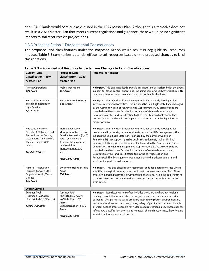
Foster Joseph Sayers Dam and Reservoir 16 Draft Master Plan Update Environmental Assesment
and USACE lands would continue as outlined in the 1974 Master Plan. Although this alternative does not result in a 2020 Master Plan that meets current regulations and guidance, there would be no significant impacts to soil resources on project lands.
3.3.3 Proposed Action – Environmental Consequences The proposed land classifications under the Proposed Action would result in negligible soil resources impacts. Table 3.3 summarizes potential effects to soil resources based on the proposed changes to land classifications. Table 3.3 – Potential Soil Resource Impacts from Changes to Land Classifications Current Land Classification – 1974 Master Plan
Proposed Land Classification – 2020 Master Plan
Potential for Impact
Project Operations 494 Acres
Project Operations 494 Acres
No Impact. This land classification would designate lands associated with the direct support for flood control operations, including dam and spillway structures. No new projects or increased acres are proposed within this land use.
Recreation-Intensive acreage to Recreation-High Density 1,017 Acres
Recreation-High Density 1,260 Acres
No Impact. This land classification recognizes lands currently developed for intensive recreational activities. This includes the Bald Eagle State Park (managed by the Commonwealth of Pennsylvania). Approximately 130 acres of soils are classified as either prime farmland or farmland of statewide importance. Designation of this land classification to High Density would not change the existing land use and would not impact the soil resources in this high density recreation area.
Recreation-Medium Density (1,069 acres) and Recreation-Low Density (2,084 acres) and Wildlife Management (1,030 acres) Total 4,183 Acres
Multiple Resource Management Lands-Low Density Recreation (2,910 acres) and Multiple Resource Management Lands-Wildlife Management (1,030 acres) Total 3,940 Acres
No Impact. This land classification recognizes lands currently developed for medium and low density recreational activities and wildlife management. This includes the Bald Eagle State Park (managed by the Commonwealth of Pennsylvania) that supports passive public recreation use, such as fishing, hunting, wildlife viewing, or hiking and land leased to the Pennsylvania Game Commission for wildlife management. Approximately 1,100 acres of soils are classified as either prime farmland or farmland of statewide importance. Designation of this land classification to Low Density Recreation and Resource/Wildlife Management would not change the existing land use and would not impact the soil resources.
Historic Preservation (acreage known as the Eagle Iron Works/Curtin Village) 150 Acres
Environmentally Sensitive Areas 150 Acres
No Impact. This land classification recognizes lands designated for areas where scientific, ecological, cultural, or aesthetic features have been identified. These areas are managed to protect environmental resources. As no future projects or change in acres will occur within these areas, no impacts to soil resources are anticipated.
Water Surface Summer Pool: Restricted (630 Acres) Unrestricted (1,100 Acres) Total 1,730 Acres
Summer Pool: Restricted (15 Acres) No Wake Zone (200 Acres) Open Recreation (1,515 Acres) Total 1,730 Acres
No Impact. Restricted water surface includes those areas where recreational boating is prohibited or restricted for project operations, safety, and security purposes. Designated No-Wake areas are intended to protect environmentally sensitive shorelines and improve boating safety. Open Recreation areas include all water surface areas available for water-based recreational use. These changes reflect new classification criteria and no actual change in water use, therefore, no impact to soil resources would occur.
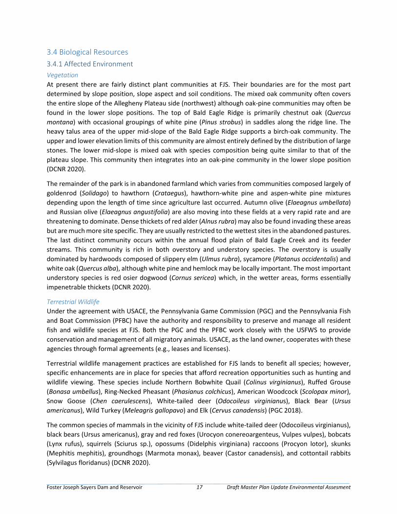
Foster Joseph Sayers Dam and Reservoir 17 Draft Master Plan Update Environmental Assesment
3.4 Biological Resources 3.4.1 Affected Environment Vegetation At present there are fairly distinct plant communities at FJS. Their boundaries are for the most part determined by slope position, slope aspect and soil conditions. The mixed oak community often covers the entire slope of the Allegheny Plateau side (northwest) although oak-pine communities may often be found in the lower slope positions. The top of Bald Eagle Ridge is primarily chestnut oak (Quercus montana) with occasional groupings of white pine (Pinus strobus) in saddles along the ridge line. The heavy talus area of the upper mid-slope of the Bald Eagle Ridge supports a birch-oak community. The upper and lower elevation limits of this community are almost entirely defined by the distribution of large stones. The lower mid-slope is mixed oak with species composition being quite similar to that of the plateau slope. This community then integrates into an oak-pine community in the lower slope position (DCNR 2020).
The remainder of the park is in abandoned farmland which varies from communities composed largely of goldenrod (Solidago) to hawthorn (Crataegus), hawthorn-white pine and aspen-white pine mixtures depending upon the length of time since agriculture last occurred. Autumn olive (Elaeagnus umbellata) and Russian olive (Elaeagnus angustifolia) are also moving into these fields at a very rapid rate and are threatening to dominate. Dense thickets of red alder (Alnus rubra) may also be found invading these areas but are much more site specific. They are usually restricted to the wettest sites in the abandoned pastures. The last distinct community occurs within the annual flood plain of Bald Eagle Creek and its feeder streams. This community is rich in both overstory and understory species. The overstory is usually dominated by hardwoods composed of slippery elm (Ulmus rubra), sycamore (Platanus occidentalis) and white oak (Quercus alba), although white pine and hemlock may be locally important. The most important understory species is red osier dogwood (Cornus sericea) which, in the wetter areas, forms essentially impenetrable thickets (DCNR 2020).
Terrestrial Wildlife Under the agreement with USACE, the Pennsylvania Game Commission (PGC) and the Pennsylvania Fish and Boat Commission (PFBC) have the authority and responsibility to preserve and manage all resident fish and wildlife species at FJS. Both the PGC and the PFBC work closely with the USFWS to provide conservation and management of all migratory animals. USACE, as the land owner, cooperates with these agencies through formal agreements (e.g., leases and licenses).
Terrestrial wildlife management practices are established for FJS lands to benefit all species; however, specific enhancements are in place for species that afford recreation opportunities such as hunting and wildlife viewing. These species include Northern Bobwhite Quail (Colinus virginianus), Ruffed Grouse (Bonasa umbellus), Ring-Necked Pheasant (Phasianus colchicus), American Woodcock (Scolopax minor), Snow Goose (Chen caerulescens), White-tailed deer (Odocoileus virginianus), Black Bear (Ursus americanus), Wild Turkey (Meleagris gallopavo) and Elk (Cervus canadensis) (PGC 2018).
The common species of mammals in the vicinity of FJS include white-tailed deer (Odocoileus virginianus), black bears (Ursus americanus), gray and red foxes (Urocyon conereoargenteus, Vulpes vulpes), bobcats (Lynx rufus), squirrels (Sciurus sp.), opossums (Didelphis virginiana) raccoons (Procyon lotor), skunks (Mephitis mephitis), groundhogs (Marmota monax), beaver (Castor canadensis), and cottontail rabbits (Sylvilagus floridanus) (DCNR 2020).
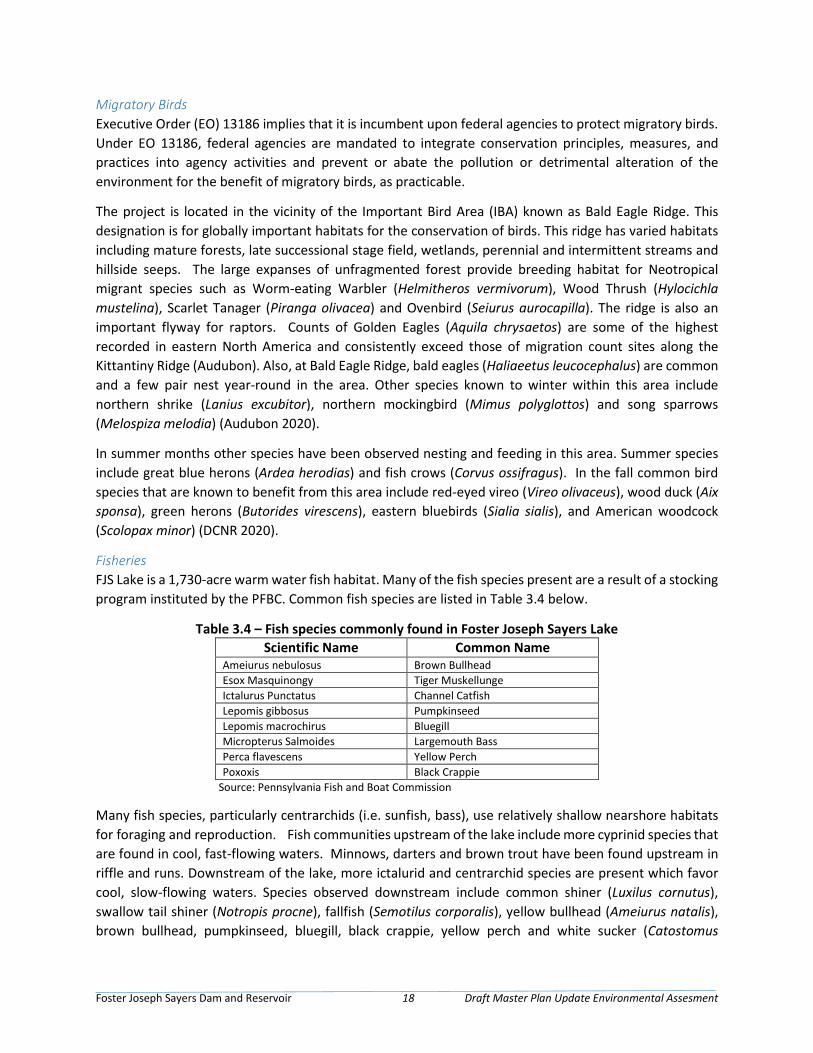
Foster Joseph Sayers Dam and Reservoir 18 Draft Master Plan Update Environmental Assesment
Migratory Birds Executive Order (EO) 13186 implies that it is incumbent upon federal agencies to protect migratory birds. Under EO 13186, federal agencies are mandated to integrate conservation principles, measures, and practices into agency activities and prevent or abate the pollution or detrimental alteration of the environment for the benefit of migratory birds, as practicable.
The project is located in the vicinity of the Important Bird Area (IBA) known as Bald Eagle Ridge. This designation is for globally important habitats for the conservation of birds. This ridge has varied habitats including mature forests, late successional stage field, wetlands, perennial and intermittent streams and hillside seeps. The large expanses of unfragmented forest provide breeding habitat for Neotropical migrant species such as Worm-eating Warbler (Helmitheros vermivorum), Wood Thrush (Hylocichla mustelina), Scarlet Tanager (Piranga olivacea) and Ovenbird (Seiurus aurocapilla). The ridge is also an important flyway for raptors. Counts of Golden Eagles (Aquila chrysaetos) are some of the highest recorded in eastern North America and consistently exceed those of migration count sites along the Kittantiny Ridge (Audubon). Also, at Bald Eagle Ridge, bald eagles (Haliaeetus leucocephalus) are common and a few pair nest year-round in the area. Other species known to winter within this area include northern shrike (Lanius excubitor), northern mockingbird (Mimus polyglottos) and song sparrows (Melospiza melodia) (Audubon 2020).
In summer months other species have been observed nesting and feeding in this area. Summer species include great blue herons (Ardea herodias) and fish crows (Corvus ossifragus). In the fall common bird species that are known to benefit from this area include red-eyed vireo (Vireo olivaceus), wood duck (Aix sponsa), green herons (Butorides virescens), eastern bluebirds (Sialia sialis), and American woodcock (Scolopax minor) (DCNR 2020).
Fisheries FJS Lake is a 1,730-acre warm water fish habitat. Many of the fish species present are a result of a stocking program instituted by the PFBC. Common fish species are listed in Table 3.4 below.
Table 3.4 – Fish species commonly found in Foster Joseph Sayers Lake Scientific Name Common Name
Ameiurus nebulosus Brown Bullhead Esox Masquinongy Tiger Muskellunge Ictalurus Punctatus Channel Catfish Lepomis gibbosus Pumpkinseed Lepomis macrochirus Bluegill Micropterus Salmoides Largemouth Bass Perca flavescens Yellow Perch Poxoxis Black Crappie
Source: Pennsylvania Fish and Boat Commission
Many fish species, particularly centrarchids (i.e. sunfish, bass), use relatively shallow nearshore habitats for foraging and reproduction. Fish communities upstream of the lake include more cyprinid species that are found in cool, fast-flowing waters. Minnows, darters and brown trout have been found upstream in riffle and runs. Downstream of the lake, more ictalurid and centrarchid species are present which favor cool, slow-flowing waters. Species observed downstream include common shiner (Luxilus cornutus), swallow tail shiner (Notropis procne), fallfish (Semotilus corporalis), yellow bullhead (Ameiurus natalis), brown bullhead, pumpkinseed, bluegill, black crappie, yellow perch and white sucker (Catostomus

Foster Joseph Sayers Dam and Reservoir 19 Draft Master Plan Update Environmental Assesment
commersonii) (USGS 1997). Many of these species are associated with stream pools and aquatic vegetation.
Multiple year classes of wild Brown Trout (Salmo trutta) have been found in Bald Eagle Creek between the reservoir outfall and Masden Run. The PFBC has recommended that the limits for wild trout management in Bald Eagle Creek extend from the headwaters downstream to the confluence with Harvey’s Run. Bald Eagle Creek is one of the largest streams in Pennsylvania that supports wild trout and benefits from the limestone geology, springs and coldwater tributary streams that flow throughout its length (PFBC 2015).
American Eel populations (Anguilla rostrate) have declined along the Atlantic coast and especially in streams and rivers with dams. Eels frequently serve as a host for common freshwater mussels and as one population expands so will commensal organisms. An eel stocking effort was conducted by USFWS from 2010 – 2013 in the Susquehanna River. Monitoring of common freshwater mussels conducted in 2014 indicated expanded recruitment and widespread distribution. The presence of healthy mussel beds provide streambed stability, water filtration and increase macroinvertebrate biodiversity (USFWS). Stream macroinvertebrate sampling by SRBC in 2009 found similar numbers of genera upstream (32) and downstream (28).
Threatened and Endangered Species According to the USFWS, there are several protected species (Table 3.5) known to occur or have potential habitat within FJS project lands.
The Bald Eagle (Haliaeetus leucocephalus) was previously an endangered species but is now on its way to recovery. Two flowering plants, the small whorled pogonia (Isotria medeoloides) and the northeastern bulrush (Scripus ancistrochaetus) has potential to occur within project lands. Two bat species that are within Foster Joseph Sayers project lands, the endangered Indiana bat (Myotis sodalis) and the threatened northern long-eared bat (Myotis septentrionalis).
Three Natural Heritage Areas have been identified as critical habitat for species or natural communities of concern. These areas are prioritized based upon their ecological qualities and provided with management recommendations and protection (DCNR).
• Fairpoint Swamp – a variety of wetland habitats including water willow shrub wetland and buttonbush wetlands communities within old channel scares and on an oxbow lake along Bald Eagle Creek.
• Mt. Logan Lower Slope – a long, narrow patch of maturing second growth tulip tree-beech-maple forest on the north facing slope of the Bald Eagle Ridge.
• Snyders Swamp – This area along Bald Eagle Creek contains a cattail marsh community and represents an uncommon habitat in Clinton County.
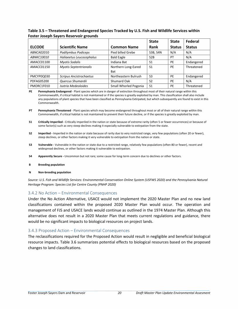
Foster Joseph Sayers Dam and Reservoir 20 Draft Master Plan Update Environmental Assesment
Table 3.5 – Threatened and Endangered Species Tracked by U.S. Fish and Wildlife Services within Foster Joseph Sayers Reservoir grounds
ELCODE Scientific Name Common Name State Rank
State Status
Federal Status
ABNCA02010 Podilymbus Podiceps Pied billed Grebe S3B, S4N N/A N/A ABNKC10010 Haliaeetus Leucocephalus Bald Eagle S2B PT N/A AMACC01100 Myotis Sodalis Indiana Bat S1 PE Endangered AMACC01150 Myotis Septentrionalis Northern Long-Eared
Bat S1 PE Threatened
PMCYP0Q030 Scripus Ancistrochaetus Northeastern Bulrush S3 PE Endangered PDFAG05200 Quercus Shumardii Shumard Oak S2 PE N/A PMORC1F010 Isotria Medeoloides Small Whorled Pogonia S1 PE Threatened
PE Pennsylvania Endangered - Plant species which are in danger of extinction throughout most of their natural range within this Commonwealth, if critical habitat is not maintained or if the species is greatly exploited by man. This classification shall also include any populations of plant species that have been classified as Pennsylvania Extirpated, but which subsequently are found to exist in this Commonwealth.
PT Pennsylvania Threatened - Plant species which may become endangered throughout most or all of their natural range within this Commonwealth, if critical habitat is not maintained to prevent their future decline, or if the species is greatly exploited by man.
S1 Critically Imperiled - Critically imperiled in the nation or state because of extreme rarity (often 5 or fewer occurrences) or because of some factor(s) such as very steep declines making it especially vulnerable to extirpation from the state.
S2 Imperiled - Imperiled in the nation or state because of rarity due to very restricted range, very few populations (often 20 or fewer), steep declines, or other factors making it very vulnerable to extirpation from the nation or state.
S3 Vulnerable - Vulnerable in the nation or state due to a restricted range, relatively few populations (often 80 or fewer), recent and widespread declines, or other factors making it vulnerable to extirpation.
S4 Apparently Secure - Uncommon but not rare; some cause for long-term concern due to declines or other factors.
B Breeding population
N Non-breeding population
Source: U.S. Fish and Wildlife Services: Environmental Conservation Online System (USFWS 2020) and the Pennsylvania Natural Heritage Program: Species List for Centre County (PNHP 2020)
3.4.2 No Action – Environmental Consequences Under the No Action Alternative, USACE would not implement the 2020 Master Plan and no new land classifications contained within the proposed 2020 Master Plan would occur. The operation and management of FJS and USACE lands would continue as outlined in the 1974 Master Plan. Although this alternative does not result in a 2020 Master Plan that meets current regulations and guidance, there would be no significant impacts to biological resources on project lands.
3.4.3 Proposed Action – Environmental Consequences The reclassifications required for the Proposed Action would result in negligible and beneficial biological resource impacts. Table 3.6 summarizes potential effects to biological resources based on the proposed changes to land classifications.
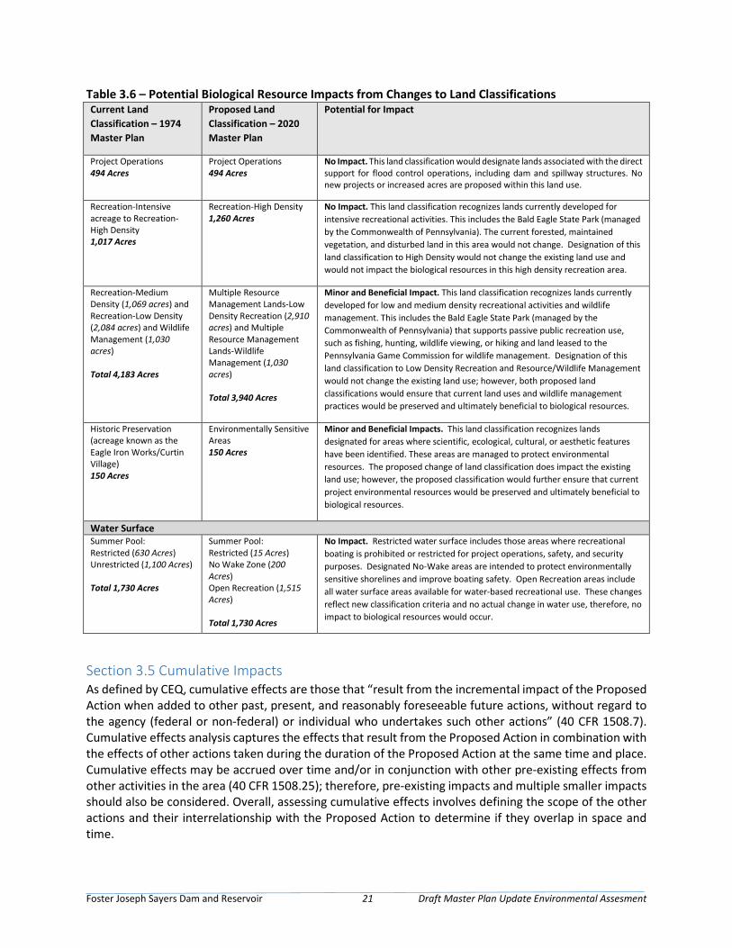
Foster Joseph Sayers Dam and Reservoir 21 Draft Master Plan Update Environmental Assesment
Table 3.6 – Potential Biological Resource Impacts from Changes to Land Classifications Current Land Classification – 1974 Master Plan
Proposed Land Classification – 2020 Master Plan
Potential for Impact
Project Operations 494 Acres
Project Operations 494 Acres
No Impact. This land classification would designate lands associated with the direct support for flood control operations, including dam and spillway structures. No new projects or increased acres are proposed within this land use.
Recreation-Intensive acreage to Recreation-High Density 1,017 Acres
Recreation-High Density 1,260 Acres
No Impact. This land classification recognizes lands currently developed for intensive recreational activities. This includes the Bald Eagle State Park (managed by the Commonwealth of Pennsylvania). The current forested, maintained vegetation, and disturbed land in this area would not change. Designation of this land classification to High Density would not change the existing land use and would not impact the biological resources in this high density recreation area.
Recreation-Medium Density (1,069 acres) and Recreation-Low Density (2,084 acres) and Wildlife Management (1,030 acres) Total 4,183 Acres
Multiple Resource Management Lands-Low Density Recreation (2,910 acres) and Multiple Resource Management Lands-Wildlife Management (1,030 acres) Total 3,940 Acres
Minor and Beneficial Impact. This land classification recognizes lands currently developed for low and medium density recreational activities and wildlife management. This includes the Bald Eagle State Park (managed by the Commonwealth of Pennsylvania) that supports passive public recreation use, such as fishing, hunting, wildlife viewing, or hiking and land leased to the Pennsylvania Game Commission for wildlife management. Designation of this land classification to Low Density Recreation and Resource/Wildlife Management would not change the existing land use; however, both proposed land classifications would ensure that current land uses and wildlife management practices would be preserved and ultimately beneficial to biological resources.
Historic Preservation (acreage known as the Eagle Iron Works/Curtin Village) 150 Acres
Environmentally Sensitive Areas 150 Acres
Minor and Beneficial Impacts. This land classification recognizes lands designated for areas where scientific, ecological, cultural, or aesthetic features have been identified. These areas are managed to protect environmental resources. The proposed change of land classification does impact the existing land use; however, the proposed classification would further ensure that current project environmental resources would be preserved and ultimately beneficial to biological resources.
Water Surface Summer Pool: Restricted (630 Acres) Unrestricted (1,100 Acres) Total 1,730 Acres
Summer Pool: Restricted (15 Acres) No Wake Zone (200 Acres) Open Recreation (1,515 Acres) Total 1,730 Acres
No Impact. Restricted water surface includes those areas where recreational boating is prohibited or restricted for project operations, safety, and security purposes. Designated No-Wake areas are intended to protect environmentally sensitive shorelines and improve boating safety. Open Recreation areas include all water surface areas available for water-based recreational use. These changes reflect new classification criteria and no actual change in water use, therefore, no impact to biological resources would occur.
Section 3.5 Cumulative Impacts As defined by CEQ, cumulative effects are those that “result from the incremental impact of the Proposed Action when added to other past, present, and reasonably foreseeable future actions, without regard to the agency (federal or non-federal) or individual who undertakes such other actions” (40 CFR 1508.7). Cumulative effects analysis captures the effects that result from the Proposed Action in combination with the effects of other actions taken during the duration of the Proposed Action at the same time and place. Cumulative effects may be accrued over time and/or in conjunction with other pre-existing effects from other activities in the area (40 CFR 1508.25); therefore, pre-existing impacts and multiple smaller impacts should also be considered. Overall, assessing cumulative effects involves defining the scope of the other actions and their interrelationship with the Proposed Action to determine if they overlap in space and time.
Foster Joseph Sayers Dam and Reservoir 22 Draft Master Plan Update Environmental Assesment
The NEPA and CEQ regulations require the analysis of cumulative environmental effects of a Proposed Action on resources that may often manifest only at the cumulative level. Cumulative effects can result from individually minor, but collectively significant, actions taking place at the same time, over time. As noted above, cumulative effects are most likely to arise when a Proposed Action is related to other actions that could occur in the same location and at a similar time. 3.5.1 Current and Reasonably Foreseeable Projects Within and Near the ROI This section identifies reasonably foreseeable projects that may have cumulative, incremental impacts in conjunction with the Proposed Action. Beyond the proposed land reclassifications, which will not change the current land uses at FJS, in the 2020 Master Plan, there are no other projects identified in the region of influence (ROI) associated with FJS. This would include any significant projects being proposed by the Borough of Howard, Centre County, or the Commonwealth of Pennsylvania – specifically at Bald Eagle State Park.
3.5.2 Analysis of Cumulative Impacts As discussed above, no growth and development was identified near FJS and cumulative adverse impacts on resources would not be expected when added to the impacts of activities associated with the Proposed Action or No Action Alternative.
Foster Joseph Sayers Dam and Reservoir 23 Draft Master Plan Update Environmental Assesment
Section 4 – Compliance with Environmental Laws This EA has been prepared to satisfy the requirements of all applicable environmental laws and regulations, and has been prepared in accordance with the CEQ’s implementing regulations for NEPA, 40 CFR 1500 – 1508, and the USACE ER 200-2-2, Environmental Quality: Procedures for Implementing NEPA. The 2020 Master Plan is consistent with the USACE’s Environmental Operating Principles. The following is a list of applicable environmental laws and regulations considered and the status of compliance with each (also see Table 5-1 for a summary):
• Anadromous Fish Conservation Act of 1965, as amended – The 2020 Master Plan would not affect anadromous fish populations or interfere with measures to conserve, develop, and enhance anadromous fish resources.
• Archeological and Historic Preservation Act (AHPA) of 1974 – USACE would evaluate future projects using the 2020 Master Plan and for compliance with the AHPA on an individual basis during the design process as projects become funded.
• Clean Air Act of 1977 – The USEPA established nationwide air quality standards to protect public health and welfare. Existing operation and management of the Project is compliant with the Clean Air Act and would not change with the 2020 Master Plan.
• Clean Water Act of 1977 – The Proposed Action complies with all state and federal Clean Water Act regulations and requirements. A state water quality certification pursuant to Section 401 of the Clean Water Act is not required for the 2020 Master Plan land use reclassifications. There would be no change in the existing management of the reservoir that would impact water quality. None of the proposed land use classifications would adversely impact water quality; erosion and sediment BMPs would be used to prevent sedimentation.
• Endangered Species Act (ESA) of 1973, as amended – Current lists of threatened or endangered species were compiled for the EA. There would be no adverse impact on threatened or endangered species resulting from the 2020 Master Plan.
• Farmland Protection Policy Act (FPPA) of 1980 and 1995 – The FPPA’s purpose is to minimize the extent to which federal programs contribute to the unnecessary and irreversible conversion of farmland to non-agricultural uses. The implementation of the 2020 Master Plan would not adversely affect prime farmland soils.
• Fish and Wildlife Coordination Act of 1958, as amended – Information provided by USFWS and state agencies on fish and wildlife resources has been utilized in the development of this assessment.
• Migratory Bird Treaty Act (MBTA) – The MBTA of 1918 extends federal protection to migratory bird species. The nonregulated “take” of migratory birds is prohibited under this act in a manner similar to the prohibition of “take” of threatened and endangered species under the ESA. The timing of resource management activities and construction of future master planning projects would be coordinated to avoid impacts on migratory and nesting birds.
• National Environmental Policy Act of 1969 – This EA analyzes the potential impacts of implementing the 2020 Master Plan, fulfilling the requirements of the Act. This included public and agency involvement and a 30-day review of the Draft EA.
Foster Joseph Sayers Dam and Reservoir 24 Draft Master Plan Update Environmental Assesment
• National Historic Preservation Act (NHPA) of 1966, as amended – USACE would evaluate future projects using the 2020 Master Plan and for compliance with the NHPA on an individual basis during the design process as projects become funded.
• Noise Control Act of 1972 – Changes to land classifications in the 2020 Master Plan would not change the existing noise environment.
• Watershed Protection and Flood Prevention Act – The 2020 Master Plan would serve to further prevent erosion, floodwater, and sediment damages in the watersheds. Implementation would not increase overall erosion and sediment within waters and no impacts would occur to floodwaters controlled by the Project.
• EO 11514 (Protection and Enhancement of Environmental Quality) – EO 11514 requires federal agencies provide leadership in protecting and enhancing the quality of the Nation's environment to sustain and enrich human life. The 2020 Master Plan would improve natural resource management and recreational opportunities.
• EO 11593 (Protection and Enhancement of Cultural Environment) – EO 11593 requires federal agencies to administer the cultural properties under their control in a spirit of stewardship and trusteeship for future generations. USACE would evaluate future projects using the 2020 Master Plan and for compliance with the NHPA on an individual basis during the design process as projects become funded.
• EO 11990, Protection of Wetlands – EO 11990 requires federal agencies to minimize the destruction, loss, or degradation of wetlands, and to preserve and enhance the natural and beneficial values of wetlands in executing federal projects. The Proposed Action complies with EO 11990. None of the proposed land classifications would adversely impact wetlands; erosion and sediment BMPs would continue to be used to prevent sedimentation into wetland areas.
• EO 11988, Floodplain Management – This EO directs federal agencies to evaluate the potential impacts of proposed actions in floodplains. The operation and management of the existing project complies with EO 11988. Proposed land classifications would comply with EO 11988.
• EO 12898, Environmental Justice – This EO directs federal agencies to achieve environmental justice to the greatest extent practicable and permitted by law, and consistent with the principles set forth in the report on the National Performance Review. Agencies are required to identify and address, as appropriate, disproportionately high and adverse human health or environmental effects of its programs, policies, and activities on minority populations and low-income populations. The 2020 Master Plan would not result in a disproportionate adverse impact on minority or low-income population groups.
• EO 13045, Protection of Children from Health Risks & Safety Risks – This EO directs federal agencies to evaluate environmental health or safety risks that may disproportionately affect children. The 2020 Master Plan would not result in environmental health or safety risks to children.
• EO 13175, Consultation and Coordination with Indian Tribal Governments – This EO reaffirms the federal government's commitment to tribal sovereignty, self-determination, and self- government by ensuring agencies consult with Indian tribes and respect tribal sovereignty as they develop policy on issues that impact Indian communities. Future projects would be
Foster Joseph Sayers Dam and Reservoir 25 Draft Master Plan Update Environmental Assesment
managed per the facility’s ICRMP which includes coordination with tribes listed in Appendix B of the ICRMP.
• EO 13112, Invasive Species – This EO directs federal agencies to evaluate the occurrence of invasive species, the prevention for the introduction of invasive species, and measures for their control to minimize the economic, ecological, and human health impacts. The 2020 Master Plan would not result in an introduction or increase of invasive species. Land classification would serve for management of vegetation and high-use areas more prone to invasive species.
• EO 13186, Migratory Bird Habitat Protection – Sections 3a and 3e of EO 13186 direct federal agencies to evaluate the impacts of their actions on migratory birds, with emphasis on species of concern, and inform the USFWS of potential negative impacts on migratory birds. The 2020 Master Plan would not result in adverse impacts on migratory bird habitat.
• EO 13508, Chesapeake Bay Protection and Restoration – This EO directs federal agencies to protect and restore the health, heritage, natural resources, and social and economic value of the Chesapeake Bay. The 2020 Master Plan would not adversely affect the resources within the Chesapeake Bay region.
• 2014 Chesapeake Bay Agreement – This Agreement directs federal agencies to implement best management practices to restore and maintain the health of the Chesapeake Bay.
• CEQ Memorandum dated August 11, 1980, Prime or Unique Farmlands – Prime Farmland is land that has the best combination of physical and chemical characteristics for producing food, feed, forage, fiber, and oilseed crops, and is also available for these uses. None of the future master planning projects would adversely affect prime farmland soils.
Table 4.1 – Executive Orders, Memoranda, and Chesapeake Bay Restoration Goals
Federal Statutes Level of Compliance* Anadromous Fish Conservation Act Full
Archeological and Historic Preservation Act Full
Clean Air Act Full
Clean Water Act Full
Coastal Barrier Resources Act N/A
Coastal Zone Management Act N/A
Comprehensive Environmental Response, Compensation and Liability Act N/A
Endangered Species Act Full
Estuary Protection Act N/A
Farmland Protection Policy Act Full
Federal Water Project Recreation Act Full
Fish and Wildlife Coordination Act Full
Land and Water Conservation Fund Act N/A
Magnuson-Stevens Act N/A
Marine Mammal Protection Act N/A
Marine Protection, Research and Sanctuaries Act N/A

Foster Joseph Sayers Dam and Reservoir 26 Draft Master Plan Update Environmental Assesment
Migratory Bird Treaty Act Full
National Environmental Policy Act Full
National Historic Preservation Act Full
Noise Control Act Full
Resource Conservation and Recovery Act N/A
Rivers and Harbors Act N/A
Safe Drinking Water Act N/A
Solid Waste Disposal Act N/A
Toxic Substances Control Act N/A
Water Resources Planning Act N/A
Watershed Protection and Flood Prevention Act Full
Wetlands Conservation Act N/A
Wild and Scenic Rivers Act N/A
Executive Orders, Memoranda, etc.
Protection and Enhancement of Environmental Quality (EO 11514) Full
Protection and Enhancement of Cultural Environment (EO 11593) Full
Floodplain Management (EO 11988) Full
Protection of Wetlands (EO 11990) Full
Environmental Justice in Minority and Low-Income Populations (EO 12898) Full
Protection of Children from Health Risks & Safety Risks (EO 13045) Full
Consultation and Coordination with Indian Tribal Governments (EO 13175) Full
Indian Sacred Sites (EO 13007) N/A
Invasive Species (EO 13112) Full
Migratory Bird (EO 13186) Full
Facilitation of Cooperative Conservation (EO 13352) N/A
Chesapeake Bay Protection and Restoration (EO 13508) Full
Stewardship of the Oceans, Our Coasts and the Great Lakes (EO 13547) N/A
Streamlining Service Delivery and Improving Customer Service (EO 13571) N/A
Prime and Unique Farmlands (CEQ Memorandum, 11 Aug 80) Full
Chesapeake Bay Restoration Goals
Chesapeake Bay Agreement 2014 Full *Level of Compliance: Full Compliance (Full): Having met all requirements of the statute, EO, or other environmental requirements for the current stage of planning Non-Compliance (NC): Violation of a requirement of the statute, EO, or other environmental requirement. Not Applicable (N/A): No requirements for the statue, EO, or other environmental requirement for the current stage of planning.
Foster Joseph Sayers Dam and Reservoir 27 Draft Master Plan Update Environmental Assesment
Section 5 – Irretrievable and Irreversible Commitment of Resources NEPA requires that federal agencies identify “any irreversible and irretrievable commitments of resources which would be involved in the Proposed Action should it be implemented” (42 U.S. Code § 4332). An irreversible commitment of resources occurs when the primary or secondary impacts of an action result in the loss of future options for a resource. Usually, this is when the action affects the use of a nonrenewable resource or it affects a renewable resource that takes a long time to renew. The impacts for this project from the reclassification of land or future master planning projects centered on recreation enhancement and development would not be considered an irreversible commitment because much of the land could be converted back to prior use at a future date. An irretrievable commitment of resources is typically associated with the loss of productivity or use of a natural resource (e.g., loss of production or harvest). No irreversible or irretrievable impacts on federally protected species or their habitat is anticipated from implementing the 2020 Master Plan.

Foster Joseph Sayers Dam and Reservoir 28 Draft Master Plan Update Environmental Assesment
Page Intentionally Left Blank
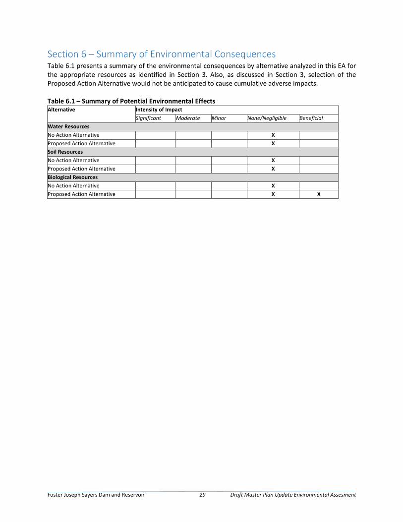
Foster Joseph Sayers Dam and Reservoir 29 Draft Master Plan Update Environmental Assesment
Section 6 – Summary of Environmental Consequences Table 6.1 presents a summary of the environmental consequences by alternative analyzed in this EA for the appropriate resources as identified in Section 3. Also, as discussed in Section 3, selection of the Proposed Action Alternative would not be anticipated to cause cumulative adverse impacts. Table 6.1 – Summary of Potential Environmental Effects Alternative Intensity of Impact
Significant Moderate Minor None/Negligible Beneficial Water Resources No Action Alternative X Proposed Action Alternative X Soil Resources No Action Alternative X Proposed Action Alternative X Biological Resources No Action Alternative X Proposed Action Alternative X X

Foster Joseph Sayers Dam and Reservoir 30 Draft Master Plan Update Environmental Assesment
Page Intentionally Left Blank
Foster Joseph Sayers Dam and Reservoir 31 Draft Master Plan Update Environmental Assesment
Section 7 – References Audubon, 2020. Important Bird Areas, Bald Eagle Ridge. Accessed on February 14, 2020, at http://www.audubon.org/important-bird-areas/bald-eagle-ridge
DCNR, 2020. Pennsylvania Department of Conservation and Natural Resources: Bureaus. Accessed on February 14, 2020, at http://www.dcnr.state.pa.us/discoverdcnr/ataglance/bureaus/index.htm.
Federal Emergency Management Agency (FEMA), 2009. Flood Insurance Rate Map: 42027C0380F Township of Howard. Effective 4 May 2009.
FEMA, 2009. Flood Insurance Rate Map: 42027C0190F Township of Howard. Effective 4 May 2009.
FEMA, 2009. Flood Insurance Rate Map: 42027C0195F Township of Liberty. Effective 4 May 2009.
FEMA, 2009. Flood Insurance Rate Map: 42027C0215F Township of Liberty. Effective 4 May 2009.
FEMA, 2009. Flood Insurance Rate Map: 42027C0385F Township of Marion. Effective 4 May 2009.
FEMA, 2015. Flood Insurance Rate Map: 42027C0193G Township of Howard. Effective 16 January 2015.
FEMA, 2015. Flood Insurance Rate Map: 42027C0194G Township of Howard. Effective 16 January 2015.
Pennsylvania Fish & Boat Commission (PFBC), 2015. Fisheries Management Report, Bald Eagle Creek, Sections 05 and 06. Bureau of Fisheries, Fisheries Management Division.
Pennsylvania Game Commission (PGC), 2018. State Game Lands PDF. Available online at https://www.pgc.pa.gov/HuntTrap/StateGameLands/Documents/SGL%20Maps/SGL__323.pdf.
Pennsylvania Natural Heritage Program (PNHP), 2020. Accessed on February 14, 2020, at http://www.naturalheritage.state.pa.us/CNAI_PDFs/Centre%20County%20NHI%202002-WEB.pdf
United States Department of the Army, Baltimore District Army Corps of Engineers (USACE), 1974. Foster Joseph Sayers Dam and Reservoir Master Plan.
USACE, 1996. Foster Joseph Sayers Dam and Reservoir, Pennsylvania. Master Manual for Reservoir Regulation, Susquehanna River Basin.
USACE, 2008. Investigation of the Former Location of the Rupert Family Cemetery at F.J. Sayers Lake, Bald Eagle State Park, Centre County, Pennsylvania.
USACE, 2011. Archeological Inventory and Assessment of the Foster Joseph Sayers Lake Shoreline, Centre County, Pennsylvania. Prepared by John Milner Associates, Inc.
USACE, 2017a. Integrated Cultural Resources Management Plan for Foster Joseph Sayers Project Centre County, Pennsylvania, 2017-2021.
USACE, 2017b. U.S. Army Corps of Engineers, Baltimore District, Water Quality Program Annual Report, FY2017.
United States Department of Agricultural (USDA), 2019. Natural Resources Conservation Service (NRCS) Soil Survey, Centre County, PA – Version 19.

Foster Joseph Sayers Dam and Reservoir 32 Draft Master Plan Update Environmental Assesment
United States Department of the Interior, Fish and Wildlife Service (USFWS), 2020. Consultation Letter. Subject: List of threatened and endangered species that may occur in your proposed project location, and/or may be affected by your proposed project. Dated: 14 February 2020.
United States Department of the Interior, Geological Survey (USGS), 1997. Fish Community Composition in Bald Eagle Creek Upstream and Downstream of Foster Joseph Sayers Dam, Centre County, Pennsylvania.
Foster Joseph Sayers Dam and Reservoir 33 Draft Master Plan Update Environmental Assesment
Appendix A – Public and Agency Correspondence
The following Agency Coordination Letter was sent to the below agencies:
• Chamber of Business & Industry of Centre County • PA Game Commission • Centre County Conservation District • Clinton County Economic Partnership • PA Fish and Boat Commission – Regional Manager, Northcentral Region • PA Fish and Boat Commission – Division of Environmental Services • U.S. Fish and Wildlife Service • PA Department of Environmental Protection • Bald Eagle State Park • Bureau of State Parks • PA Historic and Museum Commission – State Historic Preservation Officer
Responses were received from the following agencies:
• PA Historic and Museum Commission – State Historic Preservation Officer (July 12, 2016) • PA Department of Environmental Protection (June 21, 2016) • PA Fish and Boat Commission (July 27, 2016) • U.S. Fish and Wildlife Service (June 24, 2016)

Page Intentionally Left Blank

February 14, 2020
United States Department of the InteriorFISH AND WILDLIFE SERVICE
Pennsylvania Ecological Services Field Office110 Radnor Road Suite 101
State College, PA 16801-7987Phone: (814) 234-4090 Fax: (814) 234-0748
http://www.fws.gov/northeast/pafo/
In Reply Refer To: Consultation Code: 05E2PA00-2020-SLI-0636 Event Code: 05E2PA00-2020-E-02752 Project Name: Foster Joseph Sayers Master Plan Environmental Assessment Subject: List of threatened and endangered species that may occur in your proposed project
location, and/or may be affected by your proposed project
To Whom It May Concern:
The enclosed species list identifies threatened, endangered, proposed and candidate species, as well as proposed and final designated critical habitat, that may occur within the boundary of your proposed project and/or may be affected by your proposed project. The species list fulfills the requirements of the U.S. Fish and Wildlife Service (Service) under section 7(c) of the Endangered Species Act (Act) of 1973, as amended (16 U.S.C. 1531 et seq.).
New information based on updated surveys, changes in the abundance and distribution of species, changed habitat conditions, or other factors could change this list. Please feel free to contact us if you need more current information or assistance regarding the potential impacts to federally proposed, listed, and candidate species and federally designated and proposed critical habitat. Please note that under 50 CFR 402.12(e) of the regulations implementing section 7 of the Act, the accuracy of this species list should be verified after 90 days. This verification can be completed formally or informally as desired. The Service recommends that verification be completed by visiting the ECOS-IPaC website at regular intervals during project planning and implementation for updates to species lists and information. An updated list may be requested through the ECOS-IPaC system by completing the same process used to receive the enclosed list.
The purpose of the Act is to provide a means whereby threatened and endangered species and the ecosystems upon which they depend may be conserved. Under sections 7(a)(1) and 7(a)(2) of the Act and its implementing regulations (50 CFR 402 et seq.), Federal agencies are required to utilize their authorities to carry out programs for the conservation of threatened and endangered species and to determine whether projects may affect threatened and endangered species and/or designated critical habitat.
02/14/2020 Event Code: 05E2PA00-2020-E-02752 2
▪▪
A Biological Assessment is required for construction projects (or other undertakings having similar physical impacts) that are major Federal actions significantly affecting the quality of the human environment as defined in the National Environmental Policy Act (42 U.S.C. 4332(2) (c)). For projects other than major construction activities, the Service suggests that a biological evaluation similar to a Biological Assessment be prepared to determine whether the project may affect listed or proposed species and/or designated or proposed critical habitat. Recommended contents of a Biological Assessment are described at 50 CFR 402.12.
If a Federal agency determines, based on the Biological Assessment or biological evaluation, that listed species and/or designated critical habitat may be affected by the proposed project, the agency is required to consult with the Service pursuant to 50 CFR 402. In addition, the Service recommends that candidate species, proposed species and proposed critical habitat be addressed within the consultation. More information on the regulations and procedures for section 7 consultation, including the role of permit or license applicants, can be found in the "Endangered Species Consultation Handbook" at:
http://www.fws.gov/endangered/esa-library/pdf/TOC-GLOS.PDF
Please be aware that bald and golden eagles are protected under the Bald and Golden Eagle Protection Act (16 U.S.C. 668 et seq.), and projects affecting these species may require development of an eagle conservation plan (http://www.fws.gov/windenergy/ eagle_guidance.html). Additionally, wind energy projects should follow the wind energy guidelines (http://www.fws.gov/windenergy/) for minimizing impacts to migratory birds and bats.
Guidance for minimizing impacts to migratory birds for projects including communications towers (e.g., cellular, digital television, radio, and emergency broadcast) can be found at: http:// www.fws.gov/migratorybirds/CurrentBirdIssues/Hazards/towers/towers.htm; http:// www.towerkill.com; and http://www.fws.gov/migratorybirds/CurrentBirdIssues/Hazards/towers/ comtow.html.
Any activity proposed on National Wildlife Refuge lands must undergo a "Compatibility Determination' conducted by the Refuge. Please contact the individual Refuge to discuss any questions or concerns.
We appreciate your concern for threatened and endangered species. The Service encourages Federal agencies to include conservation of threatened and endangered species into their project planning to further the purposes of the Act. Please include the Consultation Tracking Number in the header of this letter with any request for consultation or correspondence about your project that you submit to our office.
Attachment(s):
Official Species ListUSFWS National Wildlife Refuges and Fish Hatcheries

02/14/2020 Event Code: 05E2PA00-2020-E-02752 1
Official Species ListThis list is provided pursuant to Section 7 of the Endangered Species Act, and fulfills the requirement for Federal agencies to "request of the Secretary of the Interior information whether any species which is listed or proposed to be listed may be present in the area of a proposed action".
This species list is provided by:
Pennsylvania Ecological Services Field Office110 Radnor Road Suite 101State College, PA 16801-7987(814) 234-4090
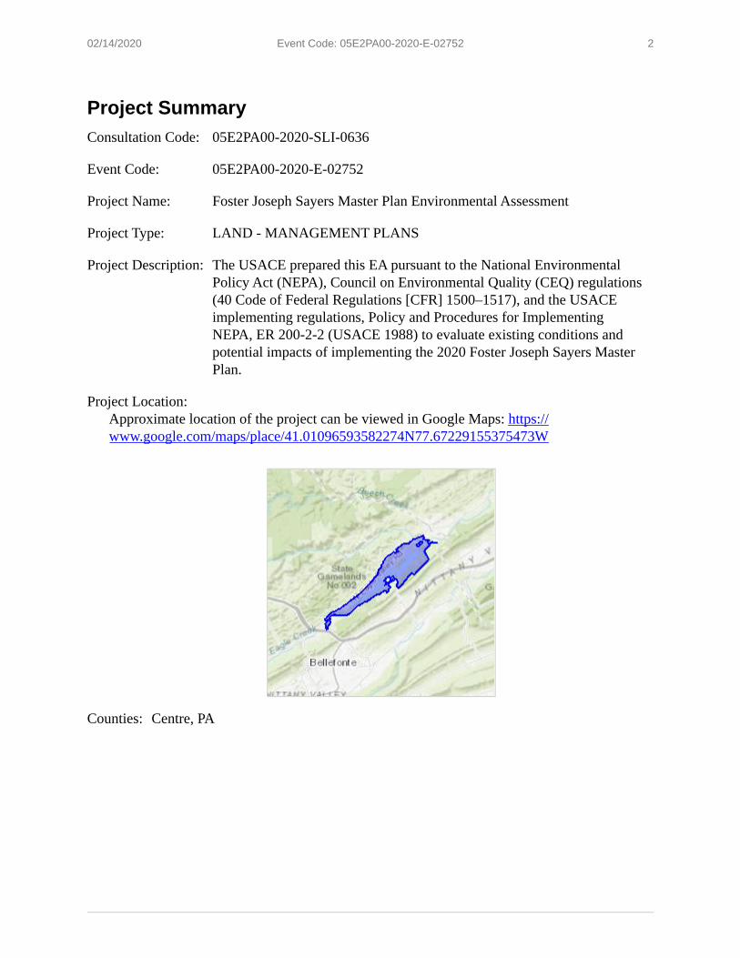
02/14/2020 Event Code: 05E2PA00-2020-E-02752 2
Project SummaryConsultation Code: 05E2PA00-2020-SLI-0636
Event Code: 05E2PA00-2020-E-02752
Project Name: Foster Joseph Sayers Master Plan Environmental Assessment
Project Type: LAND - MANAGEMENT PLANS
Project Description: The USACE prepared this EA pursuant to the National Environmental Policy Act (NEPA), Council on Environmental Quality (CEQ) regulations (40 Code of Federal Regulations [CFR] 1500–1517), and the USACE implementing regulations, Policy and Procedures for Implementing NEPA, ER 200-2-2 (USACE 1988) to evaluate existing conditions and potential impacts of implementing the 2020 Foster Joseph Sayers Master Plan.
Project Location:Approximate location of the project can be viewed in Google Maps: https:// www.google.com/maps/place/41.01096593582274N77.67229155375473W
Counties: Centre, PA
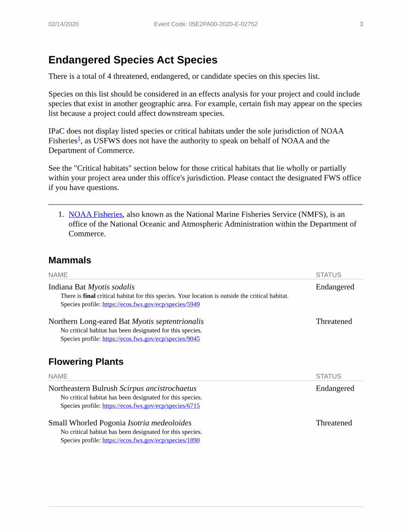
02/14/2020 Event Code: 05E2PA00-2020-E-02752 3
1.
Endangered Species Act SpeciesThere is a total of 4 threatened, endangered, or candidate species on this species list.
Species on this list should be considered in an effects analysis for your project and could include species that exist in another geographic area. For example, certain fish may appear on the species list because a project could affect downstream species.
IPaC does not display listed species or critical habitats under the sole jurisdiction of NOAA Fisheries , as USFWS does not have the authority to speak on behalf of NOAA and the Department of Commerce.
See the "Critical habitats" section below for those critical habitats that lie wholly or partially within your project area under this office's jurisdiction. Please contact the designated FWS office if you have questions.
NOAA Fisheries, also known as the National Marine Fisheries Service (NMFS), is an office of the National Oceanic and Atmospheric Administration within the Department of Commerce.
MammalsNAME STATUS
Indiana Bat Myotis sodalisThere is final critical habitat for this species. Your location is outside the critical habitat.Species profile: https://ecos.fws.gov/ecp/species/5949
Endangered
Northern Long-eared Bat Myotis septentrionalisNo critical habitat has been designated for this species.Species profile: https://ecos.fws.gov/ecp/species/9045
Threatened
Flowering PlantsNAME STATUS
Northeastern Bulrush Scirpus ancistrochaetusNo critical habitat has been designated for this species.Species profile: https://ecos.fws.gov/ecp/species/6715
Endangered
Small Whorled Pogonia Isotria medeoloidesNo critical habitat has been designated for this species.Species profile: https://ecos.fws.gov/ecp/species/1890
Threatened
1

02/14/2020 Event Code: 05E2PA00-2020-E-02752 4
Critical habitatsTHERE ARE NO CRITICAL HABITATS WITHIN YOUR PROJECT AREA UNDER THIS OFFICE'S JURISDICTION.
02/14/2020 Event Code: 05E2PA00-2020-E-02752 1
USFWS National Wildlife Refuge Lands And Fish HatcheriesAny activity proposed on lands managed by the National Wildlife Refuge system must undergo a 'Compatibility Determination' conducted by the Refuge. Please contact the individual Refuges to discuss any questions or concerns.
THERE ARE NO REFUGE LANDS OR FISH HATCHERIES WITHIN YOUR PROJECT AREA.