Embed Size (px)
Citation preview
DOCKET0500027505000323
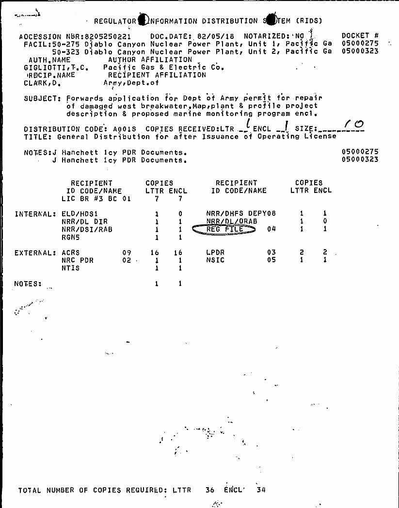
~lREGULATOR NFORMATION DISTRIBUTION EM (RIDS)
AOCE'8 SION NBR: 8205250221 DOC ~ DATE e 82/05/18 NOTARIZED: 'OFACIL:50"275 Diablo Canyon Nuclear Power Plantr Unit 1i Pacif,c Ga
50-323 Diablo Canyon Nuclear Power Plantg Unit 2r Pacific Ga
AUTHoNAME AUTHOR AFFILIATIONGIGLIOTTI~T.C. Pacific Gas 8 Electric Co ~
~REjCIP ~ NAME RECIPIENT AFFILIATIONCLA'RKgD, Army~Dept.of
1
SUBJFCT: For wards application for Dept of Army permit for repairof damaged west breakwater Map~plant 8 pr o file proJectdescription 8 proposed marine monitoring program
encl'ISTRIBUTION
CODE: A001S COPIES RECEIVED:LTR, ENCL „SIZEo, rnTITLE: General Distribution for after Issuance of Operating License
NOTES:J Hanchett 1cy POR Documents'Hanchett icy PDR Documents.
0500027505000323
RECIPIENTID CODE/NAME
LIC BR 03 BC 01
INTERNAL: ELD/HDS1NRR/DL D IRNRR/DSI/RABRGN5
COPIESLTTR ENCL
7 7
1 0
1 1
1 1
1 1
RECIPIENTID CODE/NAME
NRR/DHFS DEPY08NRR D4 ORABREG F1L 04
COPIESLTTR ENCL
1 1
1 01 1
EXTERN''AL: ACRSNRC PDRNTIS
NOTES:
0902
16 161 1
1 1
LPDRNSIC
0305
2 21 1
\d~ d
v,4
TOTAL NUMBER OF COPIES REQUIRED: LTTR 36 ENCi.'0d ~
;j M hM
IIM' ''q~.hhf y
V
hh
, t
IP lF ~ ( h
h
M
h
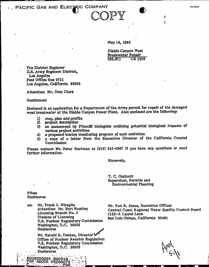
PACIFIC GAS AND ELEC IC COMPANY
COPY
May 18, 1982
Diablo Canyon WestBreakwater Re air025.811 CE 1208
The District EngineerU.S. Army Engineer District,
Lcs AngelesPost Office Box 2V11Los Angeles, California 90053
Attentfont Mr. Dick Clark
Gentlemen
Enclosed fs an application for a Dep'artment of the Army permit for repair of the damagedwest breakwater at the Diablo Canyon Power Plant. Also enclosed are the follovrinfp
1) map, plan and profile2) pro)ect description3) an assessment by POandE biologists outlining potential biological impacts of
various pro)ect activities4) a proposed marine monitorfng program of such activities5) a copy of a letter from the Executive Director of the Calffornia Coastal
Commission
Please contact Mr. Peter Hartman at (415) 541-5S8V if you have any questions or needfurther information.
Sincerely,
P HissEnclosures
7. C, GigliottfSupervisor, Permits and
Environmental Planning
ccrc Mr. Prank J. h'ffragliaAttentionc Mr. Bart-BuckleyLicensing Branch No. 3Division of LicensingU.S. Nuclear Regulatory CommissionWashington, D.C. 20565Enclosures
Mr. Harold R. Denton, DirectorOffice of'uclear Reactor RegulationU.S. Nuclear Regulatory CommissionWashington, D.C. 20655Enclosures
,8205250221 " 820518 .";,.',"'',
- PDR 'ADOCK 05000275 ", - ',
';.,""'r.
Ken R. Jones, Executive OfficerCentral Coast Regional Water Quality Control Board1122-A Laurel LaneSan Luis Obfspo, California 93401
o4Cyg

C
1, r. ~
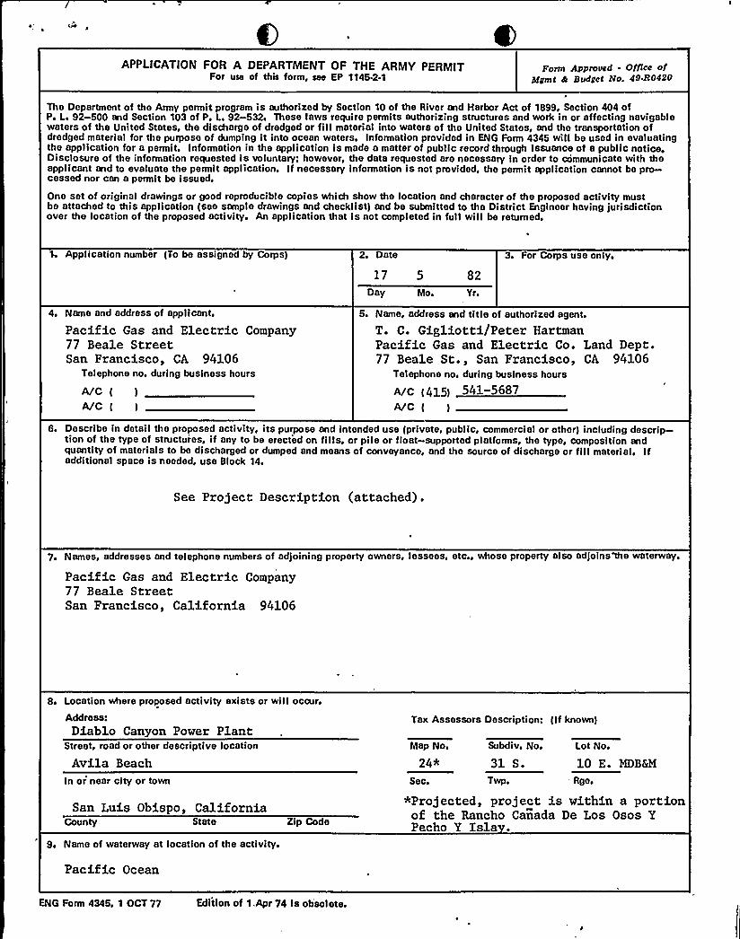
APPLICATION FOR A DEPARTMENT OF THE ARMY PERMITFor use of this form, see EP 1145-2-1
Ponn Approved - Office ofNgmt h Budget No. 49-R0420
The Department of the Army permit program is authorized by Section 10 of the River and Harbor Act of 1899 Section 404 ofP. Li 92-500 and Section 103 of P. L. 92-532. These laws require permits authorizing structures and work in or affecting navigablewaters of the United States, the discharge of dredged or fillmaterial into waters of the United States, and the transportation ofdredged material for the purpose of dumping it into ocean waters, Information provided in ENG Form 4345 will be used in evaluatingthe application for a permit. Information in the application is made a matter of public record through issuance ot a public notice.Disclosure of the information requested is voluntary: however, the data requested are necessary in order to communicate with theapplicant and to evaluate the permit application. If necessary information is not provided, the permit application cannot be pro-cessed nor can a permit be issued.
One set of original drawings or good reproducible copies which show the location and character of the proposed activity mustbe attached to this application (see sample drawings and checklist) and be submitted to the District Engineer having jurisdictionover the location of the proposed activity. An application that is not completed in full will be returne.
Application number (To be assigned by Corps) 2. Date
17 5 82
Day Mo. Yr.
3. For Corps use only.
4. Name and address of applicant.
Pacific Gas and Electric Company77 Beale StreetSan Francisco, CA 94106
Telephone no. during business hours
wc( )
A/C ( )
5. Name, address and title of authorized agent.
T. C. Gigliotti/Peter HartmanPacific Gas and Electric Co. Land Dept.77 Beale St., San Francisco, CA 94106
Telephone no. during business hours
~c (415) 541-5687wc( )
6. Describe in detail the proposed activity, its purpose and intended use (private, public, commercial or other) including descrip-tion of the type of structuies, if any to be erected on fills. or pile or float-supported platforms, the type, composition andquantity of materials to be discharged or dumped and means of conveyance, and the source of discharge or fillmaterial. Ifadditional space is needed, use Block 14.
See Project Description (attached).
7. Names, addresses and telephone numbers of adjoining property owners, lessees, etc., whose property also adjoins the waterway.
Pacific Gas and Electric Company77 Beale StreetSan Francisco, California 94106
8. Location where proposed activity exists or will occur.
Address:Diablo Canyon Power Plant
Tax Assessors Description: (If known)
Street, road or other descriptive location
Avila BeachMap No.
24*Subdiv. No. Lot No.
31 S. 10 E. MDB&M
In or'near city or town Sec. Twp. 'geq
San Luis Obispo, CaliforniaCounty State
9. Name of waterway at location of the activity.
Zip Code
*Projected, project is within a portionof the Rancho Canada De Los Osos YPecho Y Isla .
Pacific Ocean
ENG Form 4345, 1 OCT 77 Edition of 1.Apr 74 is obsolete.

4

10. Date activity is proposed to convnence. June, 1982
Date activity is expected to be completed
11 ~ Is any portion of the activity for which authorization is sought now complete? Q YES +X NO
If answer is "yes" give reasons in the remark section. Month and year the activity was completed~ Indicate the existing work on the drawings.
12. List all approvals or certifications required by other federal, interstate, state or local agencies for any structures. construc-tion, discharges, deposits or other activities described in this application.
Issuing Agency T e roval Identification No. Date of Application Date of Approval
Calif. Coastal Comm. Non'e required, per letter of Michael Fisher, Executive Director,dated March 9, 1982, attached.
13. Has any agency denied approval for the activity described herein or for any activity directly related to the activitydescribed herein?
Q Yes g No (If "yes" explain in remarks)
14. Remarks or additional information.
15. Application is hereby made for a permit or permits to authorize the activities described herein. I certify that I an familiarwith the information contained in this application, and that to the best of my knowledge and belief such information is true,complete. and accurate. I further certify that I possess the authority to undertake the proposed activities.
Paci c G a d Electric Company
Signature of Applic t or Authorized AgentT. C. Gigliot iSupervisor, Permits and Environmental Planning
The application must be signed by the applicant; however, it may be signed by a duly authorized agent (naned in Item 5)if this form is accompanied by a statement by the applinnt designating the agent and agreeing to furnish'upon request,supplemental information in support of the application.
18 U. S. C. Section 1001 provides that: Whoever. in any manner within the jurisdiction of any department or agencyof The United States knowingly and willfullyfalsifies, conceals, or covers up by any trick. scheme, or device a material factor makes any false, fictitious or fraudulent statements or reprosentations or makes or uses any false writing or documentknowing sane to contain any false fictitious or fraudulent statement or entry, shall be fined not more than 810,000 orimprisioned not more than five years. or both. Do not send a permit processing fee with this application, The appropriatefee will be assessed when a permit is issued.

( A~
~
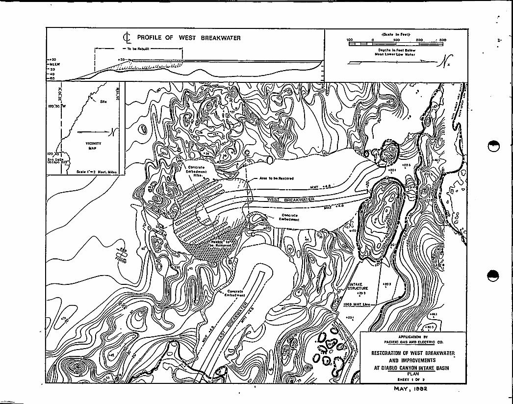
t20MLLW2040$0
PROFILE OF WEST BREAKWATER
-- To bo Rtbuut
020-
I+V g~rVgg der IlwVAIji
~(Seel ~ In Feet).0 100 200 " 200
Depths In Feet SolowMesn Lower Lnw Water
120'
NIca
RI Sile
VICINITYMAP
Scelo I w2 Neet. Mi4s
0
g~ t,r'O'4
'tcO III
@, o.-I
ConcreteEmbodmonl
tt
R'b'etAres to bo I4storod
MHT 04.0
I
0td I
4201
4~ gfjf
4 ~
4
Ct'
00
WEST eIIEAKWATER
~MHT4
g /,
/ oo4
0 400000400000'4040ao0o
so
o400�'ao4 0 4 0 4
. RobbintO4400'oooo
00000000+eoooeoeoeoeeao 04 4'ooooeooe
ooeooooooe00444ooeoooeao00044040040000 8,~I
ConcreteEmbedmont
srtO
sb
0 Or
etta
ConcreteEmbedment
Aco pg+ +
//
~AD
INTAKESTRVCTIIRE
ttO 2
1000 MHT Llrm
atO r
otO I
osis
0 sos
APPUCATIDN SY
PACIFIC DAS AND ElECTRIC CD.
<o 0QRESTORATION OF WEST BREAKWATER
AND IMPROVEMENTS
AT DIABlO CANYON INTAKE BASIN
SHEET 1 DF 2
IrtaY, IS8R

II
e20'onc.CepLbr
e.op
rIonce
Coi ~ Stoii ~
MHTe4S'Iv
TERMINUSSECTION A Typic ~ I Secuon ot
Conciet ~ Srnpedinent ot Trlpere
IS.T'—eso
Cep
MHT+4.4'EA
xitpeyon
SS S Stone
Coi ~ SIoiiese.
i s Fr/pePon
roee
CHANNEL
TERMINUS
SECTION 8-8
SEA
~ ~ 1I
iviero ooe
s s
Is 1
'~—+ 20Cep
Coi ~ Stone
ssPo
Poo lo 'roo
ee
MHT 44.S
BASIN
TRUNKSECTION C.C
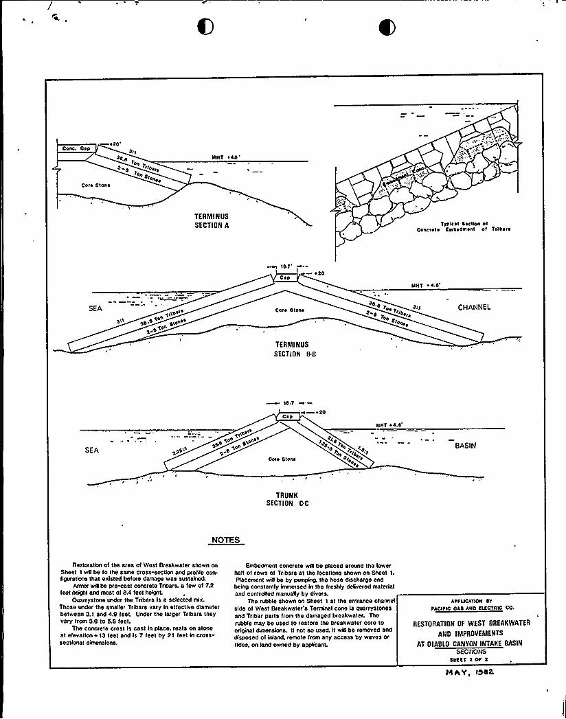
NOTES
Restoration of the area of West Breakwater shown onSheet I wflbe to the same cross-section and profile con-figurations that existed before damage was sustained.
Armor wilbe pi~st concrete Tnbars. a few of 7.2feet height arxl most of 8.4 feet height.
auarrystone under the Tribars Is s selected mix.Those under the smaller Tribars vary in effective diameterbetween 3.1 end 4.8 feet. Under the larger Tribars theyvary from 3.8 to 8.8 test.
The concrete crest is cast in place. rests on stoneat elevation+13 feet snd is y feet by 21 feet In cross-sectional dimensions.
Embedment concrete will be placed around the lowerhalt of rows of Tribars et lhe localiona Shown on Sheet 1.Placement will be by pumping. Ihe hose discharge end
being constantly immersed in tho freshly delivered materialand controlled manually by divers.
The rubble shown on Sheet I at Ihe entrance channelside of West Breakwater's Terminal cone ls quarrystonesand Tribar parts born the damaged breakwater. Thefoible may be used to restore Ihe breakwater coro looriginal chmensions. II not so used. it wis be removed anddisposed of inlaixk remote from any access by waves ortidea. On land Owned by SppliCant.
APPLICATIOH evIIACIFIC OAS AHO ELECTRIC Co.
RESTORATION OF WEST BREAKWATER
ANO IMPROVEMENTS
AT OIABLO CANYON INTAKE BASIN
SECTIONSSHSCT 2 OF 2
HAYI ISIS

P
Project Description
The breakwaters at Diablo Canyon are privately owned structures that serve to protectthe Diablo Canyon Power Plant cooling water intake structure and equipment from wavedamage and excessive wave surge. The west breakwater was damaged by severe stormwaves in January and November, 1981. More than 200 feet of the seaward end of thebreakwater were eroded to the low-water level with damage extending to the minus 10foot contour. Rubble from the damage, consisting of broken concrete Tribars and quarrystone, is deposited in the basin inlet channel on the leeward slope of the breakwater.
The breakwater is a rubble mound-type structure with a rock fillcore protected by largerbase stone and precast concrete Tribar armor units. A massive concrete cap protects thetop of the structure from overtopping waves. The breakwater was initially completed in19?2 (authorized by Department of the Army Permit dated the 10th of June, 1969) and hasserved its function without incident except for some overtopping damage to the insideface of the east breakwater in December, 1974 which was subsequently repaired in 1975(authorized by Department of the Army Permit No. 75-144 dated the 1st of August, 1975).
PGandE proposes to repair the current damage during the 1982 summer and fall seasonwhen wave conditions will be favorable for ocean construction. The breakwater wiQ berestored to its original design dimensions. Approximately six hundred 37-ton and fifty21.5-ton Tribars willbe used to replace the original 21.5-ton Tribars which were displacedby the storms. A mobile crane willbe used on the breakwater to reshape eroded core rockand place approximately 15,000 cubic yards of new stone and the new Tribars onto thebreakwater. Approximately 12,000 cubic yards of concrete will be pumped at selectedlocations (see map attached) where model studies have indicated wave damage is likely toinitiate in order to limit or prevent the future occurrence of damage. This technique wasused in the repair of the east breakwater and has been successful in preventing furtherdamage there. Some minor blasting may be required to reduce the displaced concrete capblocks to pieces of a size that can be used in the core fiQ or removed by the avaQableequipment. The cap blocks willbe reconstructed using approximately 1,200 cubic yards ofconcrete. Rock materials required for the repair willbe trucked overland to the worksitefrom the Santa Marguarita Quarry (Kaiser) in San Luis Obispo County. A barge-mountedor land-based crane rig with a clamshell or similar bucket will be used to clearapproximately 15,000 cubic yards of concrete and rock rubble from the inlet channeLRubble not reused for the repair work will be stored temporarily on adjacent PGandEupland property until removed to an approved upland disposal site.yet to be deter mined.

Assessment of Potential Biological Impacts
A team of PGandE Department of Engineering Research biologists surveyed the damagedarea of the west breakwater on April 20, 1982 to assess current biological productivityand define areas with sediment buildup. Their assessment is given below. Thisinformation was used to develop the recommended marine monitoring program for areasof potential impact during breakwater repair. The construction activities which couldpotentially impact marine ecology are blasting, clamshell dredging, and underwaterconcrete placement.
The biological assemblage associated with the damaged submarine section of breakwaterdoes not correspond with assemblages at the same depths on the intact sections. Duringthe storm damage to the breakwater, many shallow subtidal species, both algal andinvertebrate, were carried with displaced tribars to depths up to 50 feet. The newlyexposed surfaces of toppled and broken tribars developed a floral and faunal composition
Igred algae make up a rich flora which is becoming established on tribars and tribarfragments in the damaged area.
The algal habitat supplies food and protection for a community of fish which include perch(black, striped, and kelp), blue rockfish, cabezon, lingcod, greenlings and many smaller,more cryptic species such as sculpins, kelpfish, and blennies. Juvenile rockfish and perchare common beneath the kelp canopy and can be expected to increase in abundancebeginning in May and continuing through summer. Blasting in the area could have someimpact on schooling species but such an effect would not be expected to have ameasurable impact on the population. Since there is no feasible method to exclude fishfrom the area, blasting effects should be monitored by divers to estimate actual fish loss,if any. It is not expected that other construction activities would impact fish. Rather,displacement of fish during habitat modification would be temporary.
At the base of the stone core on the protected side of the breakwater is an accumulationof fine sediments typical of the intake cove. A thin veneer of sediment is also foundassociated with the stone and tribars below approximately 25 feet. Removal of the coreand tribar fragments at the base of the core will resuspend these sediments which canaffect several communities adversely. Pirst, the benthic infauna can be smothered byexcessive sedimentation. Second, a coating of sediments on the blades of algae inhibitsutilization of incident light and thus decreases growth. Third, a veneer of sediment onhard substrate can prevent settling of invertebrate larvae and algal spores and sporo-phytes. Lastly, an increased water column sediment load decreases light penetration,thereby decreasing algal growth. These effects would be most pronounced in the lowenergy environment within the cove and on the lee side of the breakwater. However,water column sediment load would cease with construction activity. Other effects wouldbe short term and not unlike normal embayment sedimentation. Benthic infauna wouldtolerate moderate sedimentation and would recover by recolonization if heavy sedimen-tation occurred.
Turbidity and sedimentation resulting from construction activity can be monitored inseveral ways. Photographs from an appropriate vantage point would visually define thelimits of any turbidity plume. Measurements at various locations with appropriateinstrumentation would give an indication of light attenuation compared to unaffectedareas. Sediment stakes and chambers could be used to measure accretion and deposition,and qualitative and/or quantitative observations could determine sediment buildup onalgae and hard surfaces.


Concreting the base of the reconstructed breakwater would not impact the unrecolonizedsubstrate. However, concrete intrusion and deposition on the native substrate couldimpact organisms and should be avoided where possible. In addition, turbidity and theassociated sediment veneer would have similar effects as those already described.Subtidal monitoring during the concreting phase could be used to assess any measurablechanges.
All potential impacts would be short term, although effects would persist for a longertime in the low energy habitats. The reconstructed breakwater willagain offer a varietyof ecological habitats that will recolonize and through succession, willreturn to a speciesassemblage consistent with the association found before the breakwater damage. Theproximity to established populations associated with the intact breakwaters will expeditethat recolonization.
3-

c >
Marine Monitoring Program
1. To the extent fe'asible salvageable macro-invertebrates, including abalone, will beremoved prior to construction and transplanted to suitable substrate in a non-impacted area.
2. Diver observations will supplement surface observations during blasting. Anassessment of any fish loss willbe made.
3. Photographs will be taken during construction activities to record visual limits ofany turbidity plume.
4. Measurements of subsurface light attenuation willbe made at selected stations dailyduring turbidity-associated construction activities.
5. Several permanent transects will be established from the water surface to thebottom along both sides of both breakwaters. The deep ends wiQ terminate withsediment stakes and sediment collection chambers to monitor deposition rates.Permanent quadrats willbe established along each transect for qualitative observa-tions and if appropriate, quantitative measurements of sedimentation on substrateand algae.
6. Diver observations will be made during concreting to assess any incidental effectson benthic communities. Quantitative evaluation of those communities willbe madeto define any impact ifqualitative observations indicate observable changes.
V. Biological surveys by divers will follow construction to document reestablishment offlora and fauna on and around the reconstructed breakwater section. These surveyswill continue until community structure resembles that of comparable unaffectedbreakwater areas.

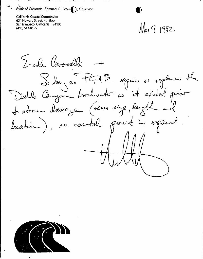
L~' State of California, Edmund G. Bro, Gouernor
California Coastal Commission631 Howard Street, 4th floorSan Francisco, California 94105(415) 543-8555

A tkg
pE ~
t