Embed Size (px)
Citation preview
FORT CLINCH STATE PARK
UNIT MANAGEMENT PLAN
APPROVED
STATE OF FLORIDA DEPARTMENT OF ENVIRONMENTAL PROTECTION
Division of Recreation and Parks
SEPTEMBER 1, 2004

Department of Environmental Protection
Jeb Bush Governor
Marjorie Stoneman Douglas Building 3900 Commonwealth Boulevard, MS 140
Tallahassee, Florida 32399-3000
Colleen M. Castille Secretary
“More Protection, Less Process”
Printed on recycled paper.
September 1, 2004 Ms. BryAnne White Office of Park Planning Division of Recreation and Parks 3900 Commonwealth Blvd.; M.S. 525 Tallahassee, Florida 32399 Re: Fort Clinch State ParkLease # 3366 Ms. White: On August 20, 2004, the Acquisition and Restoration Council recommended approval of the Fort Clinch State Park management plan. On September1, 2004, the Office of Environmental Services, acting as agent for the Board of Trustees of the Internal Improvement Trust Fund, approved the management plan for Fort Clinch State Park. Pursuant to Section 253.034, Florida Statutes, and Chapter 18-2, Florida Administrative Code this plan’s ten-year update will be due on September 1, 2014. Approval of this land management plan does not waive the authority or jurisdiction of any governmental entity that may have an interest in this project. Implementation of any upland activities proposed by this management plan may require a permit or other authorization from federal and state agencies having regulatory jurisdiction over those particular activities. Please forward copies of all permits to this office upon issuance.
Sincerely,
Paula L. Allen Paula L. Allen Office of Environmental Services Division of State Lands Department of Environmental Protection
i
TABLE OF CONTENTS
INTRODUCTION 1
PURPOSE AND SCOPE OF PLAN 1
MANAGEMENT PROGRAM OVERVIEW 3
Management Authority And Responsibility 3
Park Goals And Objectives 4
Management Coordination 7
Public Participation 8
Other Designations 8
RESOURCE MANAGEMENT COMPONENT
INTRODUCTION 9
RESOURCE DESCRIPTION AND ASSESSMENT 9
Natural Resources 9
Cultural Resources 21
RESOURCE MANAGEMENT PROGRAM 23
Special Management Considerations 23
Management Needs And Problems 24
Management Objectives 26
Management Measures For Natural Resources 28
Management Measures For Cultural Resources 30
Research Needs 31
Resource Management Schedule 32
Land Management Review 32
ii
LAND USE COMPONENT
INTRODUCTION 35
EXTERNAL CONDITIONS 35
Existing Use Of Adjacent Lands 35
Planned Use Of Adjacent Lands 36
PROPERTY ANALYSIS 36
Recreation Resource Elements 36
Assessment Of Use 38
CONCEPTUAL LAND USE PLAN 41
Potential Uses And Proposed Facilities 41
Facilities Development 45
Existing Use And Optimum Carrying Capacity 45
Optimum Boundary 45
TABLE
TABLE 1 - Existing Use And Optimum Carrying Capacity 46
LIST OF ADDENDA
ADDENDUM 1
Acquisition History and Advisory Group Information A 1 - 1
ADDENDUM 2
References Cited A 2 - 1
ADDENDUM 3
Soil Descriptions A 3 - 1
ADDENDUM 4
Plant And Animal List A 4 - 1
iii
ADDENDUM 5
Designated Species List A 5 - 1
ADDENDUM 6
Priority Schedule and Cost Estimates A 6 - 1
MAPS
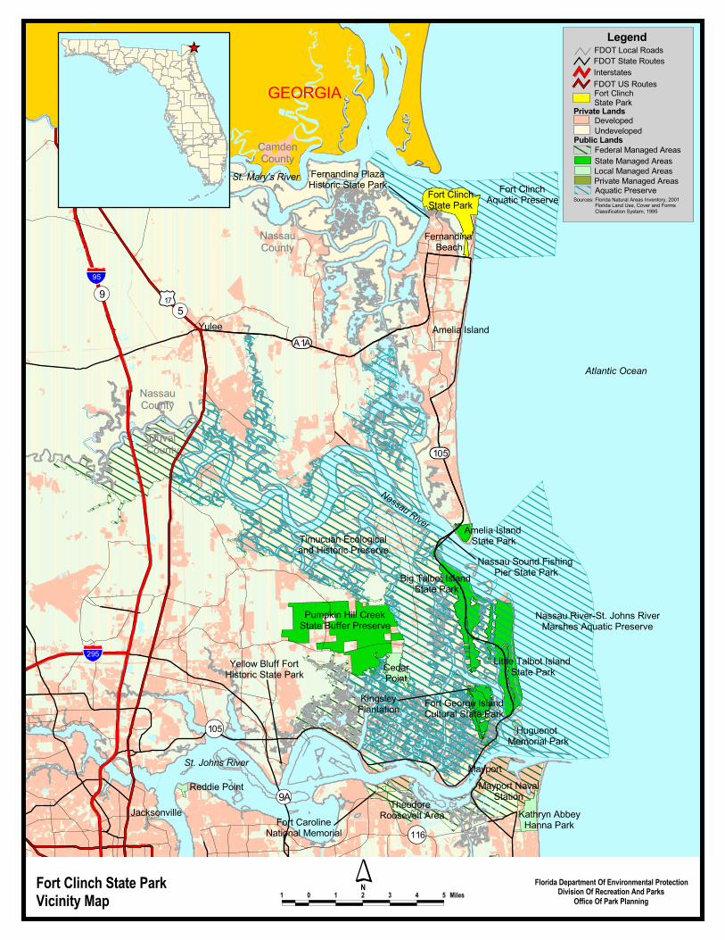
Vicinity Map 2
Soils Map 13
Natural Communities Map 17
Base Map 39
Conceptual Land Use Plan 42—43
Optimum Boundary Map 47

1
INTRODUCTION Fort Clinch State Park is located in Nassau County within the city limits of Fernandina Beach (see Vicinity Map). Access to the park is from State Road A1A in Fernandina Beach, also known as Atlantic Avenue. State Road A1A extends along the coast north from Mayport through Amelia Island to Fernandina Beach, and thence west to Interstate Highway 95 in Yulee, Florida. The vicinity map also reflects significant land and water resources existing near the park. At Fort Clinch State Park, public outdoor recreation and conservation is the designated single use of the property (see Addendum 1). There are no legislative or executive directives that constrain the use of this property. Currently the park contains approximately 1,360 acres. Park acreage has been calculated on the composition of natural communities, in addition to ruderal and developed areas. PURPOSE AND SCOPE OF THE PLAN This plan serves as the basic statement of policy and direction for the management of Fort Clinch State Park as a unit of Florida's state park system. It identifies the objectives, criteria and standards that guide each aspect of park administration, and sets forth the specific measures that will be implemented to meet management objectives. The plan is intended to meet the requirements of Sections 253.034 and 259.032, Florida Statutes, Chapter 18-2, Florida Administrative Code, and intended to be consistent with the State Lands Management Plan. With approval, this management plan will replace the February 23, 1998 approved plan. All development and resource alteration encompassed in this plan is subject to the granting of appropriate permits; easements, licenses, and other required legal instruments. Approval of the management plan does not constitute an exemption from complying with the appropriate local, state, or federal agencies. This plan is also intended to meet the requirements for beach and shore preservation, as defined in Chapter 161, Florida Statutes, and Chapters 62B-33, 62B-36 and 62R-49, Florida Administrative Code. The plan consists of two interrelated components. Each component corresponds to a particular aspect of the administration of the park. The resource management component provides a detailed inventory and assessment of the natural and cultural resources of the park. Resource management problems and needs are identified, and specific management objectives are established for each resource type. This component provides guidance on the application of such measures as prescribed burning, exotic species removal, and restoration of natural conditions. The land use component is the recreational resource allocation plan for the unit. Based on considerations such as access, population, and adjacent land uses, an optimum allocation of the physical space of the park is made, locating use areas and proposing types of facilities and volume of use to be provided. In the development of this plan, the potential of the park to accommodate secondary management purposes (“multiple uses”) was analyzed. These secondary purposes were considered within the context of the Division’s statutory responsibilities and an analysis of the resource needs and values of the park. This analysis considered the park natural and cultural resources, management needs, aesthetic values, visitation, and visitor experiences. For this park, it was determined that no secondary purposes could be accommodated in a manner that would not interfere with the primary purpose of resource-based outdoor recreation and conservation. Uses such as water resource development projects, water supply projects, stormwater management projects, linear facilities and sustainable agriculture and forestry (other than those forest management activities specifically identified in this plan) are not
�������
����� ����
������� ����
� �������������������
� �������������������������
���������������
������������� �!��� ��������������
������������
���"#��$%��"��#
���$�
��$&#
����������������������
��'����!�����������������((�����������
������������)��*�+ ���������,�����������������������
�������� ���������-������������������-�.��/ ��������
����������
0������.��/ ������������������
� ����� �-��������������������������
.��������� � -�������!��� ������������
���1"#
2��������//��!���������
������ ���
+���� ������
���� ���������
��"�
��$$3
��$&#
�����������
���������������
����� ���
������� ����
4����� ����
������������
!�-��� ��,� ���������
2��-������������ �
,��' ������������� �.�� ���
� ������������ ������ �������� ����,� ����
5��� 6����((�� ��!��� ��������������
5����
,��' ��
������������ ���� ���������� � � � � � � � � �����
� ������ ���� ������ !�"#������ ������������#����� !�$��� ����%��� ���
!!��� !�� ����� �&
�������,���-�������������,���-�������
� �������������������
�4�.�7��� ����
0 ����,���-�������
����������
� ��������
7����� '�4���� '�
�����
�����������
� �����8��� ������������������������ ��9�1&&$����������������� ����0���7��9�� �������� �����������������������(����� �������9�$""#
������������������������,���-�������
�4�.�0 ����� ���4�.�������� ����
��

3
consistent with this plan or the management purposes of the park. The potential for generating revenue to enhance management was also analyzed. Visitor fees and charges are the principal source of revenue generated by the park. It was determined that multiple-use management activities would not be appropriate as a means of generating revenues for land management. Instead, techniques such as entrance fees, concessions, and similar measures will be employed on a case-by-case basis as a means of supplementing park management funding. The use of private land managers to facilitate restoration and management of this unit was also analyzed. Decisions regarding this type of management (such as outsourcing, contracting with the private sector, use of volunteers, etc.) will be made on a case-by-case basis as necessity dictates. MANAGEMENT PROGRAM OVERVIEW
Management Authority and Responsibility In accordance with Chapter 258, Florida Statutes, and Chapter 62D-2, Florida Administrative Code, the Division of Recreation and Parks (Division) is charged with the responsibility of developing and operating Florida's recreation and parks system. These are administered in accordance with the following policy:
It shall be the policy of the Division of Recreation and Parks to promote the state park system for the use, enjoyment, and benefit of the people of Florida and visitors; to acquire typical portions of the original domain of the state which will be accessible to all of the people, and of such character as to emblemize the state's natural values; conserve these natural values for all time; administer the development, use and maintenance of these lands and render such public service in so doing, in such a manner as to enable the people of Florida and visitors to enjoy these values without depleting them; to contribute materially to the development of a strong mental, moral, and physical fiber in the people; to provide for perpetual preservation of historic sites and memorials of statewide significance and interpretation of their history to the people; to contribute to the tourist appeal of Florida.
The Trustees have also granted management authority of certain sovereign-submerged lands to the Division under Management Agreement MA 68-086 (as amended January 19, 1988). The management area includes a 400-foot zone from the edge of mean high water where a park boundary borders sovereign submerged lands fronting beaches, bays, estuarine areas, rivers or streams. Where emergent wetland vegetation exists, the zone extends waterward 400 feet beyond the vegetation. The agreement is intended to provide additional protection to resources of the park and nearshore areas and to provide authority to manage activities that could adversely impact public recreational uses. Many operating procedures are standard system wide and are set by policy. These procedures are outlined in the Division’s HOperations Procedures Manual (OPM) that covers such areas as personnel management, uniforms and personal appearance, training, signs, communications, fiscal procedures, interpretation, concessions, camping regulations, resource management, law enforcement, protection, safety and maintenance. In the management of Fort Clinch State Park, a balance is sought between the goals of maintaining and enhancing natural conditions and providing various recreational opportunities. Natural resource management activities are aimed at management of natural systems. Development in the park is directed toward providing public access to and within the
4
park, and to providing recreational facilities, in a reasonable balance, that are both convenient and safe. Program emphasis is on interpretation on the park's natural, aesthetic, and educational attributes.
Park Goals and Objectives The following park goals and objectives express the Division long-term intent in managing the state park. At the beginning of the process to update this management plan, the Division reviewed the goals and objectives of the previous plan to determine if they remain meaningful and practical and should be included in the updated plan. This process ensures that the goals and objectives for the park remain relevant over time. Estimates are developed for the funding and staff resources needed to implement the management plan based on these goals, objectives and priority management activities. Funding priorities for all state park management and development activities are reviewed each year as part of the Division legislative budget process. The Division prepares an annual legislative budget request based on the priorities established for the entire state park system. The Division also aggressively pursues a wide range of other funds and staffing resources, such as grants, volunteers, and partnerships with agencies, local governments and the private sector, for supplementing normal legislative appropriations to address unmet needs. The ability of the Division to implement the specific goals, objectives and priority actions identified in this plan will be determined by the availability of funding resources for these purposes. Natural and Cultural Resources 1. Continue to mitigate coastal erosion at Fort Clinch State Park.
A. Seek funding to conduct necessary periodic maintenance of the groin structures. B. Coordinate with appropriate agencies to secure beach sand for periodic nourishment of
the inlet shoreline at Fort Clinch, including the groin field. C. Continue to evaluate the St. Marys Entrance Inlet Management Study and support
recommendations that would benefit Fort Clinch and Amelia Island State Parks. D. Continue to monitor beach erosion throughout the park according to an established
schedule, preferably using GPS to map the high tide line on the beaches. E. Strive to control beach erosion before it becomes excessive, and restore significantly
eroded areas as needed. F. In dune areas, minimize human-induced erosion by continuing to restrict foot traffic to
boardwalks and by constructing additional barriers as needed to prevent visitors from crossing either active or stabilized dunes.
2. Restore natural communities in the park. A. Research historical alterations of ruderal areas such as the long, linear deposit north of
the beach access road. Determine if restoration would be appropriate and develop practical restoration measures.
B. Eliminate signs of previous human disturbance in natural areas, with the exception of historical and archaeological resources. Human disturbances would include unnecessary roads and old dumpsites.
C. Seek funds for research to determine the impacts of mosquito control ditches on the hydrology and ecology of natural communities in the park.
3. Continue to monitor and protect designated species. A. Continue to participate in the Index Nesting Beach program for marine turtles.
Conduct daily beach surveys during marine turtle nesting season. B. Continue to monitor shorebird nesting while conducting daily beach surveys for
marine turtles. Document locations of shorebird nests along beaches and in beach

5
dunes. C. Continue to exclude domestic dogs and cats from park beach and dune areas to protect
nesting/resting shorebirds and nesting marine turtles. D. Survey Willow Pond and the borrow-pit pond for nesting herons and egrets during
breeding season. 4. Protect remaining natural areas in the park from unacceptable levels of human impact.
A. Protect the old maritime hammock west of the 1880s shoreline from additional development impacts.
B. Prohibit the public from accessing the unstable beach dune community in the interior of the park east of the park drive.
C. Concentrate future development in previously developed or disturbed areas of the park.
D. Continue to conduct annual surveys of painted buntings within the park along established transects during breeding season.
E. Monitor public use of natural areas to protect natural communities from unacceptable disturbance or damage.
5. Continue to monitor activities outside the park that may affect land or water resources within the park, and increase public awareness of the wealth of natural and cultural resources contained within the park.
A. Monitor properties contained within the designated “greenline” of Fort Clinch State Park for proposed changes in land use and for development permit applications.
B. Monitor aquatic resources in vicinity of the park for unsuitable development or other inappropriate activities. Report unauthorized dumping of wastes and other pollution to appropriate governmental agencies.
C. Maintain active public relations and environmental education programs to increase public awareness of and support for the resource management objectives of the park.
D. Educate park neighbors about the severity of impact that exotic plants and free ranging domestic pets have on park resources.
6. Continue to identify, document, and catalog cultural resources in the park, and synthesize a comprehensive overview.
A. Survey the entire park, and record cultural resources. B. Continue to document park cultural resources. C. Synthesize a comprehensive overview of the history and prehistory of the park, based
on survey and documentary research. 7. Continue to protect cultural resources of the park from deterioration caused by natural
or human forces. A. Review uses of cultural resources and revise as appropriate. B. Track maintenance/repair demands of cultural resources. C. Develop and implement cyclical maintenance programs.
8. Expand opportunities for park staff to receive training relating to management of cultural resources.
9. Interpret park cultural resources and encourage visitors to treat them as significant and valuable legacies from the past.
A. Encourage commemorative activities relating to the Civilian Conservation Corps, and refer to CCC activities in public information releases for other events, such as fishing tournaments.
Recreation 10. Continue to provide park visitors with quality, resource-based, outdoor recreational and
educational programs and facilities. A. Pursue funding for upgrades to existing service facilities to assure compliance with the

6
Americans with Disabilities Act. B. Continue to implement a comprehensive, routine maintenance plan for service
facilities that assures clean, comfortable accommodations and reduces long-term maintenance costs.
C. Pursue funding for corrective maintenance of existing facilities; pursue funding for new recreational facilities consistent with this plan.
D. Pursue funding to renovate the park Visitor Center and exhibit areas. E. Pursue expansion of park concession facilities in order to provide an appropriate level
of visitor service. F. Continue to work with area educational institutions to provide outdoor classroom
experiences. 11. Interpret the park’s natural and cultural history.
A. Continue to conduct interpretive activities in accordance with the established Statement of Interpretation.
B. Continue to provide trained interpretive staff on a daily basis to interpret the significance and history of Fort Clinch.
C. Continue to expand interpretive opportunities within Fort Clinch through development of additional interpretive rooms.
D. Pursue funding to adapt the CCC latrine in the River Campground as an interpretive center.
E. Pursue funding to develop a marsh and lighthouse overlook as an ADA-accessible interpretive trail.
F. Provide static interpretive displays at various locations throughout the park to interpret natural systems, environmental education themes, cultural resources, and special features.
G. Adapt existing programs and provide special interpretive opportunities consistent with the intent and mandate of the Americans with Disabilities Act.
H. Train staff appropriately to assure they are capable of providing visitors with frequent, impromptu interpretive experiences, as opportunities arise.
I. Schedule and conduct special interpretive programs, both within the park and offsite. J. Provide the public with well-researched, informative interpretive literature.
Park Administration/Operations 12. Promote the park as a significant tourist destination, both locally and nationally.
A. Maintain ties with the Amelia Island Tourist Advisory Council and the Greater Jacksonville Visitors and Convention Bureau as a source of national publicity and local support.
B. Participate in local and regional festivals and events; publicize and conduct special events to promote park awareness and to highlight services and facilities.
C. Encourage efforts to publicize the region by supporting travel writing tours and other media events.
D. Cultivate a close working relationship with local and regional media; develop and maintain press packets to promote the park through media; utilize free public service announcements.
E. Participate in destination packages and develop partnerships with other destination locations in the region to promote eco-tourism.
13. Enhance operational resources to assure efficient use of public allocations. A. Pursue funding upgrades to assure that an appropriate level of cleanliness, corrective
maintenance, visitor protection, resource management, and visitor service is attained in the park.
B. Continue to enhance the park’s volunteer program in accordance with guidelines in the
7
�HOperations Procedures Manual. C. Promote the growth of the Citizen’s Support Organization and encourage activities
that enhance fundraising efforts, grants administration, volunteerism, local support and public awareness.
D. Seek alternative funding sources through grant programs, corporate sponsorship, and private donations of goods and services.
E. Maintain a relationship with local probation and parole agencies to provide a venue for court-ordered community service work.
F. Promote the Florida Department of Education/Florida Park Service Parknership Program to accomplish projects and to enhance student understanding and appreciation of Fort Clinch State Park.
G. Develop partnerships with local governments, community service organizations, and others to promote common goals and share resources as appropriate.
H. Identify the most efficient utilization of limited staff resources and pursue funding to outsource appropriate tasks.
I. Provide curatorial and historic preservation support in managing the park’s collections and cultural resources.
J. Pursue outsourcing of the park gift shop and concession operations. 14. Ensure the continuation of standard FPS operations such as protection of park resources
and facilities, management of natural and cultural resources, maintenance of park facilities, provision of visitor services, and adherence to fiscal and administrative requirements.
A. Assure compliance with state and federal safety guidelines for: use and disposal of hazardous wastes, blood-borne pathogens policy, hazardous communications plans, safety training and development of Emergency Action Plans and Park Protection Plans as required by the �HOperations Procedures Manual.
B. Conduct regular inspections of facilities to determine cleanliness and maintenance needs.
C. Continue to conduct routine safety inspections of facilities and public areas, and correct deficiencies as needed.
D. Monitor activities outside the park that may impact park lands; promote public awareness of neighbors’ impacts on parks and the potential threats to park resources.
E. Pursue funding to fence and post park boundaries, and patrol boundaries to discourage trespassing or encroachment of private landowner activities on park property.
F. Continue to ensure that the park’s CSO (Friends of Fort Clinch, Inc.) meets and works within established guidelines of the Division of Recreation and Parks and the Department of State Not for Profit Corporations.
Management Coordination The park is managed in accordance with all applicable Florida Statutes and administrative rules. Agencies having a major or direct role in the management of the park are discussed in this plan. The Department of Agriculture and Consumer Services, Division of Forestry (DOF), assists Division staff in the development of wildfire emergency plans and provides the authorization required for prescribed burning. The Florida Fish and Wildlife Conservation Commission (FFWCC), assists staff in the enforcement of state laws pertaining to wildlife, freshwater fish and other aquatic life existing within park boundaries. In addition, the FFWCC aids the Division with wildlife management programs, including the development and management of Watchable Wildlife programs. The Department of State, Division of Historical Resources (DHR) assists staff to assure protection of archaeological and historical sites. The Department
8
of Environmental Protection (DEP), Office of Coastal and Aquatic Managed Areas (CAMA) aids staff in aquatic preserves management programs. The DEP, Bureau of Beaches and Wetland Resources aids staff in planning and construction activities seaward of the Coastal Construction Line. In addition, the Bureau of Beaches and Wetland Resources aid the staff in the development of erosion control projects. Emphasis is placed on protection of existing resources as well as the promotion of compatible outdoor recreational uses. Current ongoing management coordination activities at Fort Clinch State Park include work with the US Army Corps of Engineers on monitoring and maintenance of shoreline protection groins in the park and maintenance of the Corps' pipeline easement. The park has security and weather monitoring agreements with the US Navy related to the submarine channel that lies directly offshore from the park. Park staff coordinate with the US Fish and Wildlife Service and the Florida Fish and Wildlife Commission in managing and protecting sea turtle and listed shorebird nesting areas. The Division and the St. Johns River Water Management District are currently holding discussions regarding potential installation of SJRWMD monitoring wells on the park. Given the wealth of cultural resources encompassed by this park, Division staff frequently request technical advice and assistance from the Division of Historic Resources. Park staff also conduct routine coordination and cooperative management activities with the DEP Office of Coastal and Aquatic Managed Areas, the City of Fernandina Beach and the Florida Park Patrol.
Public Participation The Division provided an opportunity for public input by conducting a public workshop and an advisory group meeting. A public workshop was held on August 28, 2003. The purpose of this meeting was to present this draft management plan to the public. An Advisory Group meeting was held on August 29, 2003. The purpose of this meeting was to provide the Advisory Group members the opportunity to discuss this draft management plan.
Other Designations Fort Clinch State Park is not within an Area of Critical State Concern as defined in section 380.05, Florida Statutes. Currently it is not under study for such designation. The park is a component of the Florida Greenways and Trails System. All waters within the unit have been designated as Outstanding Florida Waters, pursuant to Chapter 62-302 Florida Administrative Code. Surface waters in this unit are also classified as Class III waters by DEP. This unit is adjacent to Fort Clinch State Park Aquatic Preserve as designated under the Florida Aquatic Preserve Act of 1975 (section 258.35, Florida Statutes).
9
RESOURCE MANAGEMENT COMPONENT INTRODUCTION The Division of Recreation and Parks has implemented resource management programs for preserving for all time the representative examples of natural and cultural resources of statewide significance under its administration. This component of the unit plan describes the natural and cultural resources of the park and identifies the methods that will be used to manage them. The stated management measures in this plan are consistent with the Department’s overall mission in ecosystem management. Cited references are contained in Addendum 2. The Division’s philosophy of resource management is natural systems management. Primary emphasis is on restoring and maintaining, to the degree practicable, the natural processes that shape the structure, function and species composition of Florida’s diverse natural communities as they occurred in the original domain. Single species management may be implemented when the recovery or persistence of a species is problematic provided it is compatible with natural systems management. The management goal of cultural resources is to preserve sites and objects that represent all of Florida’s cultural periods as well as significant historic events or persons. This goal may entail active measures to stabilize, reconstruct or restore resources, or to rehabilitate them for appropriate public use. Because park units are often components of larger ecosystems, their proper management is often affected by conditions and occurrences beyond park boundaries. Ecosystem management is implemented through a resource management evaluation program (to assess resource conditions, evaluate management activities, and refine management actions), review of local comprehensive plans, and review of permit applications for park/ecosystem impacts. RESOURCE DESCRIPTION AND ASSESSMENT
Natural Resources Topography Fort Clinch State Park is located at the northern tip of Amelia Island, which is the northernmost island along the Atlantic coast of Florida. Physiographers place Amelia Island within the Lagoons and Barrier Chain of the Atlantic Coastal Ridge, part of the Atlantic Coast Lowlands (Puri and Vernon, 1959). Amelia Island is a southern representative of the Sea Island chain that extends for 112 miles from Bulls Island, South Carolina to Little Talbot Island, Florida. Sea Islands characteristically are short, curved barrier islands that are separated from each other by river entrances or sounds and from the mainland by well-developed marshes or estuaries (Raichle, Bodge, and Olsen, 1997). Amelia Island is approximately 13.5 miles long and has a maximum width of three miles. The island is oriented parallel to the mainland. The Fort Clinch part of the island is bounded on the east by the Atlantic Ocean, on the north by St. Marys Entrance, and on the west by salt marshes and the Amelia River. To the north across St. Marys Entrance lies Cumberland Island. The land area of Amelia Island totals about 11,600 acres, with 1,363.303 acres comprising Fort Clinch State Park. Elevations at Fort Clinch State Park range from sea level to 40 feet mean sea level (msl). The highest elevations occur along a ridge of old barrier dunes that extends in an arc from St. Marys Entrance southward through the center of the park. Consistent with barrier island topography, undulating ridges alternate with swales throughout the system. On the eastern shoreline of the park, dune ridges as high as 15 feet run parallel to the Atlantic Ocean. In

10
contrast, dunes in the northwestern portion of the park are truncated. They generally run in an east to west direction, paralleling the St. Marys Entrance. These dune ridges are 10-15 feet in height, with an occasional dune reaching 20 feet. The recent geomorphologic history of Amelia Island has been dramatic. A United States Coastal Survey Map from 1875 depicts the north end of Amelia Island as substantially slimmer than at present (Parchure, 1982). Extensive shoals such as Kingsley Bank and Pelican Shoals existed at the entrance to the St. Marys River, however. These deposits were the result of a net southerly transport of sediments in the Cumberland Island region (Raichle, Bodge, and Olsen, 1997). Depths of 7.5 - 9 feet were plotted for the main entrance channel at that time. A secondary channel that hugged the coast of Cumberland Island also existed. An emerging island called North Breakers was forming along the north side of Pelican Shoals. Although St. Marys Entrance is known to have remained navigable since at least the mid-1500s, the main entrance channel has tended to be migratory in nature due to the shoaling described above. The U.S. Congress, seeking to guarantee and improve access to the Port of Fernandina, in 1879 authorized construction of two large stone jetties at the St. Marys Entrance. Jetty construction finished in 1904. One jetty, extending 19,150 feet, is located at the south end of Cumberland Island; the other jetty, 11,200 feet long, is at the north tip of Amelia Island. Major topographic changes have taken place on the island in response to the jetty construction (Raichle, Bodge, and Olsen, 1997). Even before construction of the jetties, the U.S. Army Corps of Engineers (USACE) had noted a problem with erosion along the shoreline of the inlet fronting Fort Clinch. The counterscarp wall of the fort, described in 1843 as being hundreds of feet from the high-water mark, was observed in 1880 to be impacted by every high tide (Raichle, Bodge, and Olsen, 1997). Attempts to stabilize the site began in 1881 with the construction of five spur groins; two additional groins were completed in 1883. Construction of the north and south jetties exacerbated the erosion problem at the base of the fort. What had previously been a very broad inlet with two navigable channels was transformed into a constricted single inlet with all flow confined between the jetties (Parchure, 1982). An increase in the inlet flow rate (both quantity and velocity) resulted. Scouring forces of currents in St. Marys Entrance increased significantly. The forces were greatest at the narrowest point of the inlet, which happened to be opposite the fort. Another by-product of jetty construction was the removal of the capacity of shoals at the mouth of the inlet to buffer the north tip of Amelia Island from incident wave energy. The vulnerability of both the island and the fort to erosional forces increased. By 1899, a significant amount of shoreline east of the fort had been lost. It became apparent to engineers that the fort was beginning to act as a headland projecting into the inlet, thereby interrupting littoral drift of sand from east to west and starving the beaches west of the fort. In an attempt to resolve the problem, six more groins were constructed in 1899 along the shoreline just west of the fort (Olsen, 1995). Among the more recent efforts to stabilize the shoreline in front of the fort was work done by the Civilian Conservation Corps (CCC) between 1937 and 1939. A 1937 survey by the National Park Service had recommended the placement of nine groins in the area. At least five of the original groins were still in existence then, albeit in need of repair. Consequently, the CCC project must have been a combination of new construction and rehabilitation of old structures, including restoration of an old seawall of undetermined age in front of the fort. After Hurricane Dora caused significant damage to the groins at the base of the fort in 1964, erosion accelerated. The response was to construct a rock revetment along the beach as a
11
temporary protective structure. Despite recommendations by the USACE, no further action took place until 1992 when a groin restoration project commenced. For a variety of reasons, especially lack of funding, the project did not fulfill design specifications. The groins in front of the fort received beach renourishment materials of 158,000 cubic yards in 1993 and 84,400 cubic yards in 1996. Severe erosion continued, however, exacerbated by regular maintenance dredging of the inlet to accommodate Trident submarines stationed at the Kings Bay Naval Submarine Base. The inadequacies of the groin system left the shoreline at the fort still vulnerable to erosion. If renourishment alone were the response, beach materials ranging from an estimated 100,000 to 250,000 cubic yards would be needed every two years. Seeking a solution to the problem, the DEP funded the Fort Clinch Shoreline Stabilization Feasibility Study (Raichle and Olsen 1998), which presented the Division with potential ways to reduce the erosion. The St. Marys Entrance Inlet Management Study (Raichle, Bodge, and Olsen, 1997), which addressed northeast Florida’s coastal erosion in a regional context, contained additional discussions about possible measures to protect the fort. After careful review of the Fort Clinch Shoreline Stabilization Feasibility Study, the Division decided to support the erosion-control alternative most favored by Raichle and Olsen. This alternative featured a combination of activities, including groin rehabilitation, addition of revetments to existing groins, and construction of new revetment-equipped groins. The Division obtained funding for the groin project in 1998 and contractors completed the project in May 2000. As constructed, the revitalized groin system consisted of two new T-head groins and four rehabilitated groins modified with T-heads. A concrete mattress foundation at the base of each groin provided additional support. In February 2001, the groin field in front of the fort and the inlet shoreline east of the fort received about 150,000 cubic yards of beach nourishment materials dredged from the inlet. In January 2001, District staff established a monitoring protocol to document the long-term effectiveness of the groins. Periodic monitoring of the site currently includes photography at established photo points and use of GPS to map the shoreline in front of the fort. In addition to shoreline erosion at the fort, another major consequence of jetty construction was the tremendous accretion of sand behind the jetties. Raichle, Bodge, and Olsen (1997) estimate that the shoreline of northeastern Amelia Island advanced 3500 feet seaward during the period from 1857/71 to 1957. A comparison of historic maps of the mid-1800s and those of today clearly shows this enormous growth. Since 1957, however, the process has actually been erosional, and maintenance of a relatively stable shoreline is mainly attributable to periodic placement of large quantities of beach fill in the area. Coastal engineers have proposed potential solutions to this phenomenon (Raichle, Bodge, and Olsen, 1997). Jetty construction and beach manipulation are not the only human impacts upon the topography of Fort Clinch State Park. Landscape changes associated with early English Period plantations are likely also. Old maps indicate that an indigo processing facility once operated in vicinity of Willow Pond. When the fort itself was constructed in 1847, a military road was built to connect it with Old Fernandina. This road proceeded south from the fort, slicing through east-west dune lines (U. S. Coastal Survey, 1875) and disrupting natural drainage patterns. Later, the City constructed 14th Street parallel to the military road, reinforcing this disruption. Judging from old aerial photography, channeling and straightening of Egan’s Creek to the west of the park occurred sometime before 1943. Spoil from the project was deposited along the edges of the marsh, much of it near the south end of the current park drive. In the 1950s, mosquito control ditches were constructed throughout the Egan’s Creek marshes. The ditches extended well into the uplands of the park, draining fresh water from the property and
12
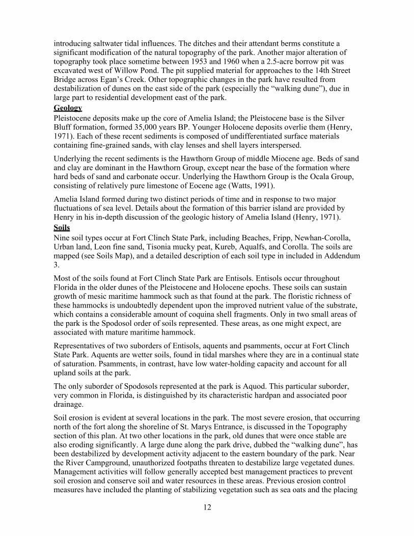
introducing saltwater tidal influences. The ditches and their attendant berms constitute a significant modification of the natural topography of the park. Another major alteration of topography took place sometime between 1953 and 1960 when a 2.5-acre borrow pit was excavated west of Willow Pond. The pit supplied material for approaches to the 14th Street Bridge across Egan’s Creek. Other topographic changes in the park have resulted from destabilization of dunes on the east side of the park (especially the “walking dune”), due in large part to residential development east of the park. Geology Pleistocene deposits make up the core of Amelia Island; the Pleistocene base is the Silver Bluff formation, formed 35,000 years BP. Younger Holocene deposits overlie them (Henry, 1971). Each of these recent sediments is composed of undifferentiated surface materials containing fine-grained sands, with clay lenses and shell layers interspersed. Underlying the recent sediments is the Hawthorn Group of middle Miocene age. Beds of sand and clay are dominant in the Hawthorn Group, except near the base of the formation where hard beds of sand and carbonate occur. Underlying the Hawthorn Group is the Ocala Group, consisting of relatively pure limestone of Eocene age (Watts, 1991). Amelia Island formed during two distinct periods of time and in response to two major fluctuations of sea level. Details about the formation of this barrier island are provided by Henry in his in-depth discussion of the geologic history of Amelia Island (Henry, 1971). Soils Nine soil types occur at Fort Clinch State Park, including Beaches, Fripp, Newhan-Corolla, Urban land, Leon fine sand, Tisonia mucky peat, Kureb, Aqualfs, and Corolla. The soils are mapped (see Soils Map), and a detailed description of each soil type in included in Addendum 3. Most of the soils found at Fort Clinch State Park are Entisols. Entisols occur throughout Florida in the older dunes of the Pleistocene and Holocene epochs. These soils can sustain growth of mesic maritime hammock such as that found at the park. The floristic richness of these hammocks is undoubtedly dependent upon the improved nutrient value of the substrate, which contains a considerable amount of coquina shell fragments. Only in two small areas of the park is the Spodosol order of soils represented. These areas, as one might expect, are associated with mature maritime hammock. Representatives of two suborders of Entisols, aquents and psamments, occur at Fort Clinch State Park. Aquents are wetter soils, found in tidal marshes where they are in a continual state of saturation. Psamments, in contrast, have low water-holding capacity and account for all upland soils at the park. The only suborder of Spodosols represented at the park is Aquod. This particular suborder, very common in Florida, is distinguished by its characteristic hardpan and associated poor drainage. Soil erosion is evident at several locations in the park. The most severe erosion, that occurring north of the fort along the shoreline of St. Marys Entrance, is discussed in the Topography section of this plan. At two other locations in the park, old dunes that were once stable are also eroding significantly. A large dune along the park drive, dubbed the “walking dune”, has been destabilized by development activity adjacent to the eastern boundary of the park. Near the River Campground, unauthorized footpaths threaten to destabilize large vegetated dunes. Management activities will follow generally accepted best management practices to prevent soil erosion and conserve soil and water resources in these areas. Previous erosion control measures have included the planting of stabilizing vegetation such as sea oats and the placing
�������������� �������������������� ����������������� ��
� � � ������������� ��������������� ���������������� ��
��� � ��� ���� ����
�� �!"#�!$% & ���&�' %�#"%�(&�
)�**
)
�+
,
)+
+�
�-
��
�
"�.���)�/�0���1��,�/�� ���� �������2����� ����/�"����� ��������+�/���31��/!���������������������2�� ��������2����� ���-�/�4������������/�"����� �������2�� ���+��/� ��� ���5���/����2����65�������������)��/�'5���/�������� ��������2����� ��)+�/�&65����2������**�/�!�������� �������2�+����7���������������2���������������8����
14
of fences in strategic locations to block or divert foot traffic from erosion prone areas. Minerals No known commercial mineral deposits occur in the area. Hydrology Fort Clinch State Park is located on a barrier island at the eastern edge of the Coastal Lowlands. Bordering the park on the east is the Atlantic Ocean. To the north are Cumberland Sound and St. Marys Entrance (mouth of the St. Marys River), to the northwest are the Amelia River/Intracoastal Waterway and St. Marys River, and to the southwest is the Egan's Creek drainage. The St. Marys River originates in the Okefenokee Swamp of southern Georgia, approximately 125 miles upstream from Cumberland Sound. The drainage area of the St. Marys encompasses almost 1,000 square miles. In the downstream reaches of the river, flow reversals occur twice daily due to ocean tides. The Amelia River, with its main channel dredged to accommodate the Intracoastal Waterway, extends along the western side of Amelia Island for the full length of the island. The river connects with the St. Marys Entrance to the north and with the Nassau River to the south. Numerous small waterways feed the Amelia River, among them Alligator Creek, Jackson Creek, Bells River, Lanceford Creek, Soap Creek, and St. Joseph Creek. These waters are included either in Fort Clinch State Park Aquatic Preserve or in Nassau River-St. Johns River Marshes Aquatic Preserve. Barrier islands in Florida have severely limited water supplies. Residents of the Fernandina Beach area obtain potable groundwater from two major sources: from localized, shallow (less than 50 feet deep) lenses of freshwater that accumulate above layers of saltwater; or from a limestone zone underlying areas subject to saltwater intrusion (below 100 feet). At Fort Clinch State Park, however, the water available in shallow lenses is limited, and sometimes may be completely absent. Three wells at Fort Clinch (N-19, N-18, and N-3) have been tested for water quality since the late 1970s. Well N-19 penetrates the shallow limestone rock zone, N-18 extends to a potable water zone approximately 25 feet below sea level, and N-3 reaches the Floridan aquifer in Ocala limestone (Frazee and McClaugherty, 1979). Testing of groundwater samples from well N-19 indicates that saltwater has intruded laterally from the St. Marys River. In the Fort Clinch area and south towards Old Fernandina, saltwater intrusion is noticeable even in shallow sand wells only 30 feet deep. Monitoring of water levels and chloride concentrations from test wells N-18 and N-19 has occurred periodically since 1978. A report prepared by Frazee and McClaugherty (1979) for the St. Johns River WMD indicated that recessions appear to be longer, and recovery after significant rainfall appears to be less rapid, in the shell-rock zone than in the shallow sand aquifer. The concentration of chlorides in groundwater at Fort Clinch State Park is about 205 mg/1, indicating saltwater intrusion. The decline of groundwater quality in the park resulted in a decision to cap all water supply wells. The Florida Public Utility Company of Fernandina Beach now supplies the park with potable water. The industrial use of water contributes to the depletion of groundwater resources in the area. Large mills located at the northern end of Amelia Island use tremendous amounts of freshwater in the manufacturing process, and may affect aquifer levels. The mills generally shut down for maintenance during a short period in July and a longer period in December of each year. Effluent from local industries and other sources also lowers water quality in adjacent aquatic
15
systems. Extremely high levels of ammonia, probably associated with paper mill discharges (Livingston, 1996), have been detected in the Amelia River. In addition to industrial pollution, non-point source pollution due to the expansion of development along Lofton’s Creek and Highway A1A is contributing significantly to the degradation of waters surrounding Fort Clinch State Park. All waters designated as Class III surface waters are closed to shell fishing because of unacceptable coliform levels. The Nassau County Soil and Water Conservation District is conducting a study to determine the feasibility of re-establishing shellfish harvests in the area. The periodic dredging of Cumberland Sound (mouth of the St. Marys River) to maintain access to the Kings Bay Submarine Base may affect water quality in the area by temporarily increasing turbidity. Another possible source of pollution may be the dumping of wastes by ships passing through the sound. Flood control structures once stood at the 14th Street Bridge, impounding Egan’s Creek. These structures were removed when the bridge was rebuilt around 1960. At that time, a borrow pit was excavated near Willow Pond to supply fill for the bridge reconstruction. Since then, sediments have gradually accumulated in the borrow pit and wetland vegetation has become established. The pit is now an important foraging and roosting site for wading birds, and it may function as a nesting site as well. Mosquito control ditches have considerably altered the natural topography and surface drainage of the park. The park contains an eight-mile network of ditches, excavated in 1957 and 1958 in an effort to eradicate mosquito larvae that developed in low, wet swales among the dunes. As constructed, the ditches connected all low-lying areas of the park and drained westward toward the marshes of Egan’s Creek. With each tide, salt water entered the park through the ditches. The resulting increase in salinity in the swales severely impacted natural wetland vegetation. The ditches, some as deep as 15 feet, also modified the natural hydrology of the swales by intercepting lateral groundwater flow. During the years following construction of the ditches, the local Mosquito Control District periodically used heavy machinery to keep the ditches open and functioning. Considerable damage to vegetation resulted. Lately the Division has restricted the use of machinery in clearing the ditches, but it still allows cleaning by hand. The Mosquito Control District, however, has elected to adopt a hands-off approach, and the ditches and ditch banks appear to be reverting slowly to a more natural state. Perhaps the natural hydrology is also recovering to some extent. Research is needed to determine the current level of hydrological impact and to evaluate methods of restoring natural drainage patterns, wherever practical. Additional research should investigate the origins, the sources of water, and the previous extent of manipulation of Willow Pond. Willow Pond may have been a source of fresh water for an indigo processing facility in the 18th century. Other manipulations of the pond may have occurred during construction of the fort in the mid-1800s and during construction of the park by the Civilian Conservation Corps in the 1930s. Natural Communities The system of classifying natural communities employed in this plan was developed by the Florida Natural Areas Inventory (FNAI) FNAI Descriptions. The premise of this system is that physical factors, such as climate, geology, soil, hydrology and fire frequency generally determine the species composition of an area, and that areas which are similar with respect to these factors will tend to have natural communities with similar species compositions. Obvious differences in species composition can occur, despite similar physical conditions. In other instances, physical factors are substantially different, yet the species compositions are quite similar. For example, coastal strand and scrub--two communities with similar species
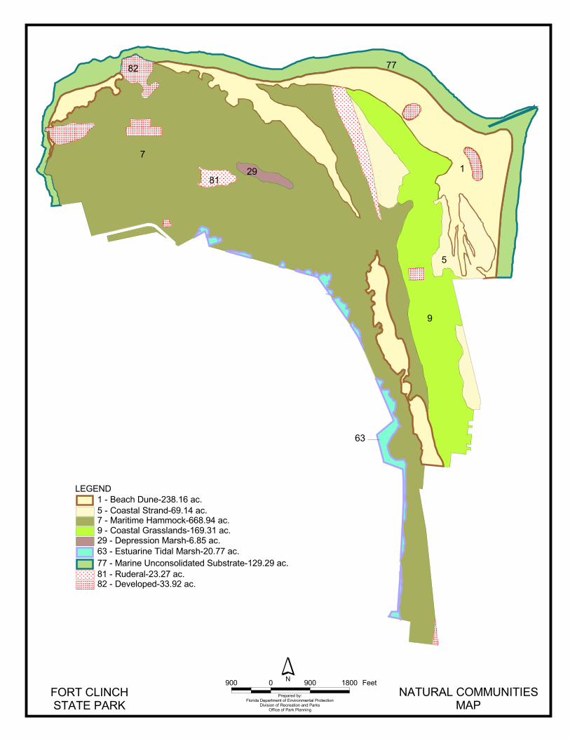
16
compositions--generally have quite different climatic environments, and these necessitate different management programs. The park contains seven distinct natural communities (see Natural Communities Map) in addition to ruderal and developed areas. Park specific assessments of the existing natural communities are provided in the narrative below. A list of plants and animals occurring in the unit is contained in Addendum 4. Beach dune. Beach dunes are typically wind-deposited and are sparsely to densely vegetated with salt-tolerant pioneer species. Though adapted to a harsh environment, dune plants are very vulnerable to human disturbance. The beach dune is usually a very dynamic community due to the unstable nature of active dune fields. Once pioneer vegetation stabilizes a beach dune community, succession to more enduring communities may occur, particularly in areas with long-term shoreline accretion. Beach dunes at Fort Clinch occur in several disjunct areas, the largest of which is adjacent to the current shoreline along the northeastern edge of the park. Shoreline accretion in this area has allowed an extensive area of beach dune to develop. Beach dunes of more limited extent occur along the receding northern shoreline that flanks the fort. An older field of beach dunes occurs in the center of the park along what was once the east shoreline of the north tip of Amelia Island (before construction of the jetties). This older dune area parallels the current northeastern shoreline, but is located up to two-thirds of a mile inland. The shoreline along Cumberland Sound and the St. Marys Entrance is eroding, causing some loss of beach dune and adjacent natural communities. Natural and human impacts on the inlet, discussed in the Topography section of this plan, are largely responsible for the erosion. Renourishment of the beach near the fort has slowed the retreat of the shoreline somewhat, however heavy equipment used during the project caused temporary damage to some of the beach dunes in the area. In April 1982, the park began to prohibit vehicular traffic on the beach. Since that time, vehicular damage to beach vegetation and dunes has decreased dramatically. Boardwalks now extend from the beach campground and from the east and west parking lots through the dunes to the pier and swimming beach. Now that these walkways provide the public with convenient access to points of interest, most of the unauthorized footpaths that once degraded the dunes have disappeared. Coastal strand. Much of the coastal strand community at Fort Clinch is relatively young, occurring on dunes that have recently accreted and stabilized. In several instances, the coastal strand occurs in sheltered pockets within beach dunes. Mosquito ditch construction in the 1950s disturbed several of these sheltered pockets. Coastal strand is an ecotonal community that generally lies between beach dunes and maritime hammock. Establishment of coastal strand scrub occurs only after herbaceous plants have stabilized the dunes. Due to its young age and a history of disturbance, the coastal strand at Fort Clinch differs somewhat from other, more mature coastal strands found further south along the east coast of Florida, where scrub oaks are the dominant vegetation. In some cases, it is very difficult to distinguish between coastal strand and the earlier successional stages of maritime hammock. In the absence of periodic disturbances such as catastrophic storms or fire, coastal strand that is sheltered from salt spray will gradually succeed to maritime hammock. This process has occurred at Fort Clinch, and much of what was once coastal strand is now young maritime hammock. Maritime hammock. The maritime hammock at Fort Clinch is one of the most outstanding
����������������
���������������� ���
��
��
��
�
��
�
��
��
���� � ��� ���� ���� �������� !"
�#$�%���&�����'�(��$)��(*%�$('�(��#� �$��+�%$(&%*%,%$(�$)���+����%$(��(�� ��-,
�))%+��$)� ��-� #�((%(.
��/��&��0�1��+2�&3(�0���4����+4��0��$�,��#�����(�0��4�5��+4��0���%�%'����''$+-0���4�5��+4��0��$�,��#�/��,,#�(�,0���4����+4���0�&����,,%$(���,20�4����+4���0��,�3��%(���%��#���,20��4����+4���0���%(���(+$(,$#%�������3 ,�����0���4����+4���0��3����#0��4����+4���0�&�*�#$���0��4����+4
18
examples of this natural community in the state. Maritime hammock usually occurs as a band of hardwood forest lying inland of the coastal strand community. This community occurs on old dunes that have stabilized long enough to allow growth of a forest. This maritime hammock at Fort Clinch State Park begins in a narrow strip at the southern end of the park and extends some three miles to the northern boundary on Cumberland Sound. About midway into the park, the hammock curves to the west and becomes much wider. Throughout this wider section, the truncated dunes generally run east and west. Dominant canopy species include live oak (Quercus virginiana), southern magnolia (Magnolia grandiflora), American holly (Ilex opaca) and southern red cedar (Juniperus virginiana). Hackberry (Celtis laevigata), red mulberry (Morus rubra), aralia (Aralia spinosa), American beautyberry (Callicarpa americana), ebony spleenwort (Asplenium platyneuron) and dwarf palmetto (Sabal minor) -- all species typically supported by areas high in calcium -- are part of this mesic community. The maritime hammock here also supports a large number of insect-eating birds such as vireos, warblers and flycatchers as well as other animals. Many songbirds migrate along coastal areas and use maritime hammocks for resting, feeding and staging areas during migration. Due to its strategic location at the end of a barrier island, the maritime hammock at Fort Clinch is likely a critical area for migrating songbirds. Historically, some damage to the maritime hammock occurred during the building of the military entrance road in the 1800s. Construction of mosquito control ditches in the late 1950s caused additional damage. Another disturbance was the large borrow pit west of Willow Pond, excavated around 1960 during reconstruction of the 14th Street Bridge. Impacts to maritime hammock from park development are evident in several locations, including park roads, the ranger residences and shop area, and the River Camping Area. The purpose of the mosquito ditches was to eradicate mosquito larvae that hatched in pockets of fresh water in swales located at the bases of dune ridges in the maritime hammock. The ditches allowed tidal flooding from adjacent salt marshes to penetrate deep into the maritime hammock, theoretically eradicating larvae dependent upon the fresh water that collected in the swales. At present, however, tidal waters only flood some of the swales intermittently. In these areas, tidal waters trapped in the swales may form pools of standing water that actually attract breeding mosquitoes. The ditches may significantly alter the natural hydrology of the maritime hammock, presumably by de-watering the hammock through accelerated drainage of fresh water derived from precipitation. Other, more effective methods of mosquito control are now available. The ditches have long outlived their purported usefulness, and the Division should explore feasible means of restoring the disturbed areas, or at the very least, mitigate the hydrological impacts. Erosion and compaction from foot traffic are occurring along the Willow Pond trails, around the River Camping Area, and in the picnic area. In most cases, the erosion problems are a by-product of unauthorized paths created by park visitors on the slopes of stabilized dunes. Coastal grassland. This natural community is also called overwash plain or coastal savannah. Coastal grassland is characterized as a treeless flat land with open barren sand or a sparse to dense ground cover of grasses, prostrate vines, and other pioneer species that are adapted to harsh maritime conditions. Older, more established sites may include scattered trees or small clumps of trees. Coastal grassland is restricted to barrier islands, spits, and similar features where storm waves push sands inland from dunes and offshore areas. The coastal grassland at Fort Clinch occurs on level to low rolling terrain located in the northeastern part of the park, west of the primary and secondary dunes. Typical plants of this
19
community are species such as broomsedge (Andropogon scoparius), pink muhly grass (Muhlenbergia capillaris), croton (Croton glandulosus), camphor weed (Heterotheca subaxillaris), greenbrier (Smilax auriculata), prickly pear cactus (Opuntia stricta) and wax myrtle (Myrica cerifera). Scattered small pockets of scrubby oaks (Quercus geminata) are also present. Gopher tortoises, eastern moles, marsh rabbits, cotton mice, rat snakes and eastern diamondback rattlesnakes occur here as well. By its very nature, this community type is prone to natural disturbance from storm surges and blowouts. Artificial disturbances such as mosquito control ditching and road construction have also impacted several areas of coastal grassland within the park. Vegetation eventually stabilizes most soil disturbances, but disturbance of existing vegetation should be avoided to prevent destabilization of low dunes, which would cause increased wind erosion. Depression marsh. The depression marsh natural community at Fort Clinch includes a series of interconnected freshwater ponds collectively called Willow Pond. Dominant trees of Willow Pond are red bay (Persea borbonia) and Carolina willow (Salix caroliniana). Shrub dominants are elderberry (Sambucus canadensis) and buttonbush (Cephalanthus occidentalis). Duckweed covers these fresh water ponds. Cattails, golden club and pickerel weed are present as well. The origins of Willow Pond are unclear. The pond is located in an interdunal trough. It is known that in 1930 members of the Civilian Conservation Corps stationed at Fort Clinch dredged fill dirt from this area, creating a small oligotrophic lake. Sometime between 1943 and 1953 a large mosquito ditch was excavated from Egan’s Creek north toward the fort. A second ditch was later excavated, connecting the first to the western end of Willow Pond. The effects of these ditches on the hydroperiod of Willow Pond are unknown. A large borrow pit, excavated west of Willow Pond sometime between 1953 and 1960, was located just south of the second ditch. This borrow pit may also affect water levels in Willow Pond. The water levels of Willow Pond currently fluctuate according to the amount of local rainfall and the extent of pumping by local industrial mills. However, the main ponds appear to be spring-fed, and the present depth of the largest pond is unknown. All of the small ponds are in advanced stages of eutrophication, and water depths are generally shallow. Estuarine tidal marsh. Only small strips of this natural community are actually located within the park, but they are contiguous with the Egan's Creek estuarine tidal marsh which totals approximately 600 acres. Acquisition of these 600 acres would definitely benefit the park, not only aesthetically but also from a resource protection perspective. The dominant plant of this community at Fort Clinch State Park is saltmarsh cordgrass (Spartina alterniflora). This species is the major indicator of the low marsh systems of the Northeast Atlantic Coast Region. Unlike the high marshes of the lagoons in Florida’s lower peninsula, where saltgrass (Distichlis spicata) dominates, tides flood this marsh daily. Although low in plant diversity, this estuarine area serves as feeding, cover, and reproductive habitat for a great diversity of animal life such as worms, mussels, oysters, clams, shrimp, crabs, sand dollars, sea urchins, whelks, snails, and fish. Many birds such as herons, egrets, dowitchers, willets, grebes, and ducks occur here. The entire marsh is laced with parallel ditches that intersect Egan's Creek. Along the landward margin of the marsh a major ditch follows the contour, picks up the flow from the interior of the island, and delivers it to the interconnected ditches that empty into the creek. Over the years, the species composition of the marsh has changed from a system primarily dominated by black rush (Juncus roemerianus) to one comprised almost exclusively of saltmarsh

20
cordgrass (Spartina alterniflora). This situation may be the result of increased tidal inundation or some yet unknown factor. Marine unconsolidated substrate. This community is a sparsely vegetated or unvegetated, relatively open area of subtidal, intertidal, and supratidal beach. The substrate is composed mainly of unsolidified sand. The distribution of these sediments largely depends on the wind and water velocities that affect the beach surface. Unconsolidated substrate communities composed chiefly of sand are resilient and demonstrate a good ability to recover from recreational disturbances. Ruderal. Ruderal areas characteristically have had the natural substrate or the biological community overwhelmingly altered because of human activity. Native vegetation is sparse and often replaced by weedy or exotic species. There are two areas in the park identified as ruderal. The first ruderal area is a borrow pit west of Willow Pond. Despite its classification as ruderal, it provides good wildlife habitat, primarily for wading birds. The second ruderal area as is not as easily classified. It consists of a long, narrow, fan-shaped deposition of sand and coquina that extends north from the proximity of the beach access road almost to Cumberland Sound. In early aerial photographs (1943), the area appears as a clearly defined, long triangle terminating in a narrow apex at the southern end, with little or no vegetative cover. Sequential aerials show relatively little colonization by vegetation over the past 50 years. The deposit is topographically higher than the surrounding areas and appears from the soil survey to be of a different soil type (Newhan-Corolla). The origins of this deposit are unclear, but it appears to have been greatly disturbed at some point before 1943. Early records from the dredging of the St. Marys Inlet do not record any upland spoiling of dredged material in this vicinity (Raichle, Bodge, and Olsen, 1997). Further research is needed to determine the origins of this deposit and to outline management actions that may be warranted. Developed. Developed areas consist of natural communities that have been replaced or nearly replaced by structures or permanently cleared areas such as roads, visitor facilities, campgrounds, residences, parking lots or concessions. Designated Species Designated species are those that are listed by the Florida Natural Areas Inventory (FNAI), U.S. Fish and Wildlife Service (USFWS), Florida Fish and Wildlife Conservation Commission (FFWCC), and the Florida Department of Agriculture and Consumer Services (FDACS) as endangered, threatened or of special concern. Addendum 5 contains a list of the designated species and their designated status for this park. Management measures will be addressed later in this plan. Most of the designated plant species at Fort Clinch State Park are orchids, and these occur in the maritime hammock. Many of the designated animal species found at the park are transients that do not actually breed on site. However, several designated animal species use the park as breeding grounds. Loggerhead and green sea turtles nest on the park beaches and require special protection. Historically, least terns also nested on the beaches, but no nesting records exist for recent years. The lack of nesting least terns may be due to loss of nesting habitat on the high beach or to human disturbance during the nesting season. Significant numbers of designated wading and shorebird species use the marshes and beaches of the park as resting and feeding habitat. These species also tend to be vulnerable to human disturbance.

21
The waters offshore Amelia Island serve as a winter calving ground for the endangered northern right whale from December 1 through March 31. The south Georgia-north Florida region has been designated as Critical Habitat for the northern right whale by the National Marine Fisheries Service. The boundaries of the area extend from the shoreline to 15 miles offshore (Raichle, Bodge, and Olsen 1997). Special Natural Features Scenic landscapes abound, not only along the Atlantic beaches but also along the Egan’s Creek salt marshes. Old beach dunes, in a ridge paralleling the park drive, extend from the park entrance north to the St. Marys Inlet. Much of the dune ridge, which attains a maximum height of 40 feet msl, remains relatively barren, and pioneer plant species predominate. The maritime hammock at Fort Clinch State Park is an outstanding remnant of a natural community that was once widespread on Amelia Island and along the Atlantic Coast of Florida, but is unfortunately succumbing rapidly to ever-increasing development pressures.
Cultural Resources Evaluating the condition of cultural resources is accomplished using a three part evaluative scale, expressed as good, fair, and poor. These terms describe the present state of affairs, rather than comparing what exists against the ideal, a newly constructed component. Good describes a condition of structural stability and physical wholeness, where no obvious deterioration other than normal occurs. Fair describes a condition in which there is a discernible decline in condition between inspections, and the wholeness or physical integrity is and continues to be threatened by factors other than normal wear. A fair judgment is cause for concern. Poor describe an unstable condition where there is palpable, accelerating decline, and physical integrity is being compromised quickly. A resource in poor condition suffers obvious declines in physical integrity from year to year. A poor condition suggests immediate action to reestablish physical stability. The Florida Master Site File (FMSF) currently lists seven archaeological and historic sites within Fort Clinch State Park. The park owes its name and prominence to its best-known cultural resource, Fort Clinch. The fort was a tertiary component of the Third, or Totten, System of Defense. Its purpose was to defend the entrance to Cumberland Sound (Nolan 1974; Shepard 1965). Construction work began in 1847 or 1850 (Shepard 1965). It proceeded slowly and in spurts until federal reoccupation of the fort and surrounding reservation in 1862. Most of the construction visible today occurred between 1862 and 1867, although “modern” elements were added during the Spanish American War crisis of 1898 (Shepard 1965; Herndon 1995). The fort remains unfinished. When designed, Fort Clinch was a good example of the defensive advances of the early 19th century. Its brick masonry construction and protective embrasures for cannons and their crews were state-of-the-art until about 1862. In that year, the ease with which the new – and plentiful -- rifled cannons could breach masonry forts made Fort Clinch instantly obsolete. Fort Clinch is a classic public work of the pre-Civil War United States. The construction project brought together men and materials from all over the country in building a fort to defend the burgeoning commerce of the nation. It was -- and may still be -- the largest structure on Amelia Island, although it is not an especially large fortification. Fort Zachary Taylor, located in Key West, is a larger, more complex structure, although its mass was significantly reduced during the late 19th century. Still, Fort Clinch is an impressive and historically significant edifice. Fort Clinch is recorded in the Florida Master Site File as 8NA 80. The National Register of Historic Places listed it on February 23, 1972. Although the park has never been the subject of comprehensive survey, six additional cultural resources are individually recorded. The oldest
22
are 8NA 16, -NA 17, and -NA 48. The first, 8NA 16, is the Quarantine Station Site; 8NA 17 is an unnamed pre-Columbian midden; and 8NA 48 is an unnamed shell heap or mound. Bullen and Griffin identified and recorded these during their surveys of Amelia Island in the mid-1950s. The last may be on or slightly beyond the park boundary. The remaining recorded resources are products of United States government military or civilian activities. The Encampment Site, 8NA 52, is probably a component of a Civil War era army camp. China, other ceramics, and glass objects of the period were recovered. The file for 8NA 53, Fort Clinch Beach is vague. Its map reference appears to include only the beach between the fort and the river, an area that, for the most part no longer exists. It may also refer to the series of brick masonry structures located on the beach west of the fort. The structures, including a well enclosure and several low retaining walls, have been covered by recent depositions of sand by the Army Corps of Engineers. A brick masonry ruin, sometimes called the “Sergeant’s House”, is nearby but higher in the dunes. The Quarantine Point Ballast Dump, 8NA 57, marks a place where ships of the 19th century removed ballast to better distribute cargo. It is a significant site whose existence testifies to the vigorous commerce of Fernandina over an undefined time. The early development of Fort Clinch State Park was a project of the Civilian Conservation Corps (CCC). The original 1930s area of the park itself, as reflected in the formal park plan, is a resource significant to development of public recreational facilities in Florida and the southeastern United States. The plan and its surviving components were among the resources examined in the Survey of New Deal Era Resources in Florida State Parks (1989), hereinafter referred to as the Survey of New Deal Resources. That grant-supported project identified elements of nine state parks planned or constructed by “alphabet agencies” like the CCC, WPA, and NYA. Identified components were recorded but have not been assigned numbers in the FMSF. Among these components are: the camping area latrine (building 4), which is still used as a campground bathhouse; the combination building (building 1), presently designated the Interpretive Center; and a shop area storage building, actually a vehicle shelter (building 15), constructed as a picnic shelter but subsequently moved to its present location. Civilian Conservation Corps activities within Fort Clinch are the basis of all subsequent restorations. The CCC performed considerable work within and near the fort. The Survey of New Deal Era Resources concentrated on “new “construction and did not communicate the extent of repair or restoration work. For example, the survey confirmed restoration or adaptive alteration of the Quartermaster Building (building 5) and the Soldiers’ Barracks (building 6), but did not identify either as a park component constructed by the CCC. Of course, neither building represents original CCC construction. For better or for worse, the work of those young men became an inherent part of the “sweat equity” in the fort. Fortunately, subsequent architectural and historical studies by Shepard (1965), Nolan (1974), and Herndon (1995) have recognized the CCC contribution to preserving the past. One additional resource significant to the history of public works and aids to navigation is known, but remains unrecorded in the FMSF. This is the Oil House complex, a late-19th century brick-masonry structure. The site includes foundations for a fixed beacon structure and for storage tanks to supply illuminating oil to it and to a movable beacon on the beach. The structure, which is designated park building 18, is mislabeled “abandoned lighthouse” on some park maps. The park maintains collections of objects and artifacts. They either make portions of the historic structure appear to be in use or aid rangers and volunteers in interpreting the history of the place. Most of the collections relate directly or implicitly to the fort structure, to activities that took place there, or to the lives of persons who lived or worked at the fort. The
23
collections include objects as disparate as a dismounted Rodman cannon and several cannon mounts, cannon shot, iron artifacts recovered during restoration activities, muskets or rifles, and a selection of construction documents. The remaining collection objects function as natural history interpretive specimens. Various modern reproductions of historic objects, acquired for interpretive use, are not considered part of the park’s collections as defined in Chapter 16, Operations Procedures Manual. RESOURCE MANAGEMENT PROGRAM
Special Management Considerations Timber Management Analysis Chapters 253 and 259, Florida Statutes, require an assessment of the feasibility of managing timber in land management plans for parcels greater than 1,000 acres if the lead agency determines that timber management is not in conflict with the primary management objectives of the land. The feasibility of harvesting timber at this park during the period covered by this plan was considered in context of the Division’s statutory responsibilities, and an analysis of the park’s resource needs and values. The long-term management goal for forest communities in the state park system is to maintain or re-establish old-growth characteristics to the degree practicable, with the exception of early successional communities such as sand pine scrub and coastal strand. During the development of this plan, an analysis was made regarding the feasibility of timber management activities for this park. It was then determined that the primary management objectives of the unit could be met without conducting timber management activities for this management plan cycle. Timber management will be reevaluated during the next udate of this management plan. Additional Considerations The Division has management authority over a 400-foot zone from the edge of mean high water in areas where the park fronts on the Egan’s Creek marshes, the Amelia River, the St. Marys Entrance, and the Atlantic Ocean. Where emergent wetland vegetation exists, the zone extends water-ward 400 feet beyond the vegetation. Within this zone, the park staff will enforce Division regulations. Harvest of any wildlife within this zone, with the exception of fish, is prohibited. The painted bunting (Passerina ciris), a species that nests at Fort Clinch State Park, has been declining in the southeastern United States over the past several decades according to Breeding Bird Survey data (Sauer et al. 1997). Scientists now consider the eastern population of painted bunting at risk due to a number of factors, including loss of optimum breeding habitat and fragmentation of habitat in general. The United States Geological Survey (USGS) is in the fourth year of a six-year study to determine annual survival rates of the painted bunting at various locations in the southeastern Atlantic Coastal states, including Fort Clinch State Park. Preliminary reports seem to indicate that the Fort Clinch population is a significant one (Sykes, Jr. 2001). The park likely plays an important regional role in the population dynamics of the species. In an effort to understand habitat preferences of the painted bunting in the park, the District staff currently supplements the USGS study by conducting annual surveys of painted buntings along established transects within the park. In recognition of the vulnerability of the species, extra precautions should be taken when planning and implementing development in the park, and when planning and siting visitor use activities.

24
Management Needs and Problems Natural Resources 1. Erosion in the coastal zone of Fort Clinch State Park continues to be a significant threat
to the fort, beaches, and dune systems. A. Although recent (May 2000) improvements to the armoring in front of the fort (see
Topography section above) appear to have stabilized the inlet shoreline, periodic maintenance of the groins will still be necessary. Close monitoring of the groin system to ensure proper functioning will also be essential.
B. The inlet shoreline east of the fort eroded considerably in 2002, especially along the north edge of the jetty base. The beach along the inlet will require periodic nourishment, especially in the stretch between the fort and the jetty. The groin field itself will also require periodic nourishment. Nourishment materials dredged from the St. Marys Inlet should be available at no charge to the state as long as the Army Corps of Engineers continues to view Fort Clinch as a “least cost” disposal site.
C. A long-range plan for obtaining beach nourishment material is needed. Some of the recommendations contained in the St. Marys Inlet Management Study may be beneficial to the park; these should receive Division support.
D. District staff in July 2002 initiated a formal monitoring program to track the extent of beach erosion in the park. Periodic monitoring of the shoreline should continue.
E. The Division should address beach erosion problems before they become unmanageable, and undertake restoration where needed.
F. Although primary dunes in the park currently appear to receive adequate protection from human disturbance, continued vigilance against the establishment of unauthorized trails in sensitive dune systems remains necessary.
2. Natural communities in the park need restoration. A. The origins and potential for restoration of the long, narrow ruderal area north of the
beach access road remain undetermined. B. Some natural communities still contain signs of past human disturbance, such as
abandoned roads and old dumpsites. C. Miles of mosquito control ditches penetrate the interior of the park, affecting natural
communities such as maritime hammock, coastal strand, and coastal grassland. 3. The need for regular monitoring and protection of designated species in the park
continues. A. Staff should continue to participate in the Index Nesting Beach program for marine
turtles. B. Least terns historically nested on high beach areas of the park. When high beach areas
of sufficient size appear in the park, staff should persist in efforts to attract least terns to nest there. Staff should also monitor shorebird nesting on a daily basis during the season and document locations of nests, including those of declining species (i.e. Wilson’s plover) that may nest among the dunes.
C. The park should continue to provide an extra measure of protection to nesting/resting shorebirds and nesting marine turtles by excluding domestic dogs and cats from beach and dune areas.
D. Currently it is unknown if listed wading birds use Willow Pond or the borrow-pit pond west of Willow Pond as rookeries, although night herons are known to roost at the borrow pit. Staff should survey the ponds during breeding season to determine their degree of importance to wading birds.
4. The park borders a rapidly expanding urban area, which may affect park resources in a subtle, but detrimental manner. For example, public visitation will likely increase, producing pressures to develop additional facilities within the park, thereby threatening
25
some of the remaining natural areas. A. Additional habitat fragmentation would harm the park’s maritime hammock and
coastal grasslands, natural communities that are rapidly succumbing to development in unprotected areas outside the park.
B. The beach dune community in the interior of the park, east of the park drive, is sparsely vegetated and unstable, and is therefore especially vulnerable to disturbance by the public.
C. Siting of future facilities in previously developed or disturbed areas of the park would increase protection of its remaining, relatively undisturbed natural communities.
D. Despite past surveys, knowledge of the habitat preferences of painted buntings in the park remains incomplete.
E. Increased use of trails in certain natural areas of the park may produce unacceptable levels of wildlife disturbance or damage to vegetation.
5. Residential and industrial development in the Fernandina Beach area may negatively affect land and water resources inside the park.
A. Changes in land use on properties located within the greenline area of concern around Fort Clinch State Park may jeopardize park resources and aesthetics.
B. Environmentally unwise activities or development may occur in estuarine systems near the park.
C. The public may not be sufficiently aware of the nature and inherent value of the natural and cultural resources of the park, or of the vulnerability of those resources to outside threats.
D. The proximity of residential neighborhoods to the park increases the likelihood that exotic plants will successfully invade the park and that domestic animals (dogs and cats) will conduct destructive forays into the park more frequently.
Cultural Resources Cultural resource management at Fort Clinch State Park is primarily concerned with preserving irreplaceable assets, whether invisible archaeological sites or impressive buildings, from adverse impacts for appreciation by present and future park visitors. Effective management depends on judicious application of expertise and funds; therefore, establishing the conditions of the resources is the first step in allocating them. Fort Clinch is among the most endangered heritage resources in the eastern United States. A series of unfortunate events that accelerated loss of the fort beach began in the late 19th century with construction of jetties to improve the inlet into Cumberland Sound. This disrupted the north to south sand flow along the barrier islands. Amelia Island thus starved for waterborne sand while contributing sand to the southward flow beyond the navigation jetties. Subtraction of sand is evident along the Atlantic side of the island, but starvation is even more terribly evident in front of Fort Clinch. Where a beach some 100 yards wide once sloped from the fort to Cumberland Sound, there was until recently no beach. Although the Army Corps of Engineers began depositing dredge sand where the beach had been, a severe storm season usually resulted in loss of most or all the contributed sand. The situation was ameliorated in 2000 through construction of T-groins reinforced with “mattress” structures, which have facilitated deposition of sand on the fort beach. This action has raised the condition of Fort Clinch to fair. Fort Clinch as a collective or single structure is in fair condition. Individual elements within the fort are in conditions ranging from good to poor. These evaluations are based on recurrent or inherent problems involved in managing a 19th century resource whose raison d’être disappeared long ago. These inherent problems include maintenance of a large masonry structure by a smaller staff than the U.S. Army intended to operate the installation. Further,
26
the Army probably did not intend the fort to survive as long as it has: forts are by nature disposable (Shepard 1965, Herndon 1995). Fort Clinch is a seacoast fortification; for more than 120 years, it has been resident on a dynamic shoreline, subjected to a climate that ordinarily produces blown sand, which erodes any object in its vicinity. Recent projects have contributed to the stability of the fort. The first resulted in stabilization and restoration of several important areas of the earthen ramparts, especially the chemin des ronde, the pathway at the toe of the rampart. Work also resulted in improving rainwater drainage, which has helped rehabilitate the Guardhouse; stabilizing and restoring important elements of the 1898 disappearing rifle (cannon) mount; and stabilizing several masonry elements, including fireplaces. A long-term project undertaken by the Friends of Fort Clinch is the gradual replacement of old, deteriorated, and inaccurately designed doors and windows with properly designed units. C.S.O. volunteers designed, acquired proper materials for, and fabricated the doors and windows. This systematic restoration of the weather tight integrity of structures within the fort is among the most important projects of the past 30 years at Fort Clinch. Dedicated funding and grants-in-aid have enabled the Bureau of Design and Recreation Services, working with the Bureau of Natural and Cultural Resources and the park, to replace various roofs in the fort. The replaced roofs include those shared by the Bakery and Blacksmith shops, a roof over the mess kitchens, and the roof of the Quartermaster building. The last included replacing deteriorated modern downspouts and gutters with more historically appropriate elements of greater capacity. Sites 8NA17, -18, and -48 are in unknown condition, as is 8NA 52. The Army Corps of Engineers’ sand deposition has entombed most elements of 8NA 53, except for the Sergeant’s House. Before the sand deposition, most elements of the resource were considered to be in poor condition; looting of artifacts was not uncommon. The Quarantine Point Ballast Dump, 8NA 57, is in poor condition. The site has been thoroughly looted since state acquisition. The surface resources, which included tiles and cobblestones from London and continental ports, are largely depleted. This site is in peril and needs protection. It is the most endangered of the known or recorded resources in the park. The oil house complex is in poor condition. Staff sporadically removes vegetative matter, but there been no regular maintenance beyond that. A bicycle trail was recently routed near this resource, and possible impacts to it are monitored. The camping area latrine is in fair condition. It has been improved and expanded and is maintained for its original use. The combination building is in good condition. In its role as an interpretive center, the building is maintained well; however, planned modifications to expand rest room facilities could adversely affect it. The vehicle shelter / picnic shelter in the maintenance area is in fair condition. Although the structure is well suited to its present role, aggressive maintenance of vehicle shelters is rare; therefore, this is the second most endangered among the modern resources. The condition of the collection of objects is unclear. Historically, staff has not managed the collection according to Florida Park Service criteria, as noted in chapter 16 of the Operations Procedures Manual. The park recently initiated measures to comply with those criteria, however.
Management Objectives The resources administered by the Division are divided into two principal categories: natural resources and cultural resources. The Division primary objective in natural resource management is to maintain and restore, to the extent possible, to the conditions that existed before the ecological disruptions caused by man. The objective for managing cultural resources is to protect these resources from human-related and natural threats. This will arrest
27
deterioration and help preserve the cultural resources for future generations to enjoy. Natural Resources 1. Continue to mitigate coastal erosion at Fort Clinch State Park.
A. Seek funding to conduct necessary periodic maintenance of the groin structures. B. Coordinate with appropriate agencies to secure beach sand for periodic nourishment of
the inlet shoreline at Fort Clinch, including the groin field. C. Continue to evaluate the St. Marys Entrance Inlet Management Study and support
recommendations that would benefit Fort Clinch and Amelia Island State Parks. D. Continue to monitor beach erosion throughout the park according to an established
schedule, preferably using GPS to map the high tide line on the beaches. E. Strive to control beach erosion before it becomes excessive, and restore significantly
eroded areas as needed. F. In dune areas, minimize human-induced erosion by continuing to restrict foot traffic to
boardwalks and by constructing additional barriers as needed to prevent visitors from crossing either active or stabilized dunes.
2. Restore natural communities in the park. A. Research historical alterations of ruderal areas such as the long, linear deposit north of
the beach access road. Determine if restoration would be appropriate, and if so, develop practical restoration measures.
B. Eliminate signs of previous human disturbance in natural areas, with the exception of historical and archaeological resources. Human disturbances would include unnecessary roads and old dumpsites.
C. Seek funds for research to determine the impacts of mosquito control ditches on the hydrology and ecology of natural communities in the park.
3. Continue to monitor and protect designated species. A. Continue to participate in the Index Nesting Beach program for marine turtles.
Conduct daily beach surveys during marine turtle nesting season. B. Continue to monitor shorebird nesting while conducting daily beach surveys for
marine turtles. Document locations of shorebird nests along beaches and in beach dunes.
C. Continue to exclude domestic dogs and cats from park beach and dune areas to protect nesting/resting shorebirds and nesting marine turtles.
D. Survey Willow Pond and the borrow-pit pond for nesting herons and egrets during breeding season.
4. Protect remaining natural areas in the park from unacceptable levels of human impact. A. Protect the old maritime hammock west of the 1880’s shoreline from additional
development impacts. B. Prohibit the public from accessing the unstable beach dune community in the interior
of the park east of the park drive. C. Concentrate future development in previously developed or disturbed areas of the
park. D. Continue to conduct annual surveys of painted buntings within the park along
established transects during breeding season. E. Monitor public use of natural areas to protect natural communities from unacceptable
disturbance or damage. 5. Continue to monitor activities outside the park that may affect land or water resources
within the park, and increase public awareness of the wealth of natural and cultural resources contained within the park.
A. Monitor properties contained within the designated “greenline” of Fort Clinch State Park for proposed changes in land use and for development permit applications.

28
B. Monitor aquatic resources in vicinity of the park for unsuitable development or other inappropriate activities. Report unauthorized dumping of wastes and other pollution to appropriate governmental agencies.
C. Maintain active public relations and environmental education programs to increase public awareness of and support for the resource management objectives of the park.
D. Educate park neighbors about the severity of impact that exotic plants and free-ranging domestic pets have on park resources.
Cultural Resources 1. Continue to identify, document, and catalog cultural resources in the park, and
synthesize a comprehensive overview. A. Survey the entire park, and record cultural resources. B. Continue to document park cultural resources. C. Synthesize a comprehensive overview of the history and prehistory of the park, based
on survey and documentary research. D. Seek funding to develop and implement a master preservation plan for cultural
resources in the park. 2. Continue to protect the cultural resources of the park from deterioration caused by
natural or human forces. A. Review uses of cultural resources and revise as appropriate. B. Track maintenance / repair demands of cultural resources. C. Develop and implement cyclical maintenance programs.
3. Expand opportunities for park staff to receive training relating to management of cultural resources.
4. Interpret park cultural resources and encourage visitors to treat them as significant and valuable legacies from the past.
A. Encourage commemorative activities relating to the Civilian Conservation Corps, and refer to CCC activities in public information releases for other events, such as fishing tournaments.
Management Measures for Natural Resources Hydrology Staff will continue to encourage and participate in the monitoring of aquatic resources in and around Fort Clinch State Park. Staff will seek funding for research to determine the impacts of mosquito control ditches on the hydrology and ecology of natural communities in the park. Such research should also attempt to define the management measures needed, if any, to restore the natural drainage flows that mosquito ditches may have disrupted. Staff will also seek funds to research the origins, source of water supply, and extent of manipulation of the Willow Pond wetlands. Management will comply with best management practices to maintain or improve the existing water quality on site and will take measures to prevent soil erosion or other impacts to water resources. Prescribed Burning The objectives of prescribed burning are to create those conditions that are most natural for a particular community, and to maintain ecological diversity within the unit's natural communities. To meet these objectives, the park is partitioned into burn zones, and burn prescriptions are implemented for each zone. The park burn plan is updated annually to meet current conditions. All prescribed burns are conducted with authorization from the Department of Agriculture and Consumer Services, Division of Forestry (DOF). Wildfire suppression activities will be coordinated between the Division and the DOF. Historically, prescribed burning has not been part of the resource management program at Fort Clinch State Park. According to today’s generally accepted standards, the natural

29
communities that occur in the park do not require periodic fire for their maintenance. If future research happens to change that perception, then the park will consider implementation of an active burn program. Designated Species Protection The welfare of designated species is an important concern of the Division. In many cases, these species will benefit most from proper management of their natural communities. At times, however, additional management measures are needed because of the poor condition of some communities, or because of unusual circumstances that aggravate the particular problems of a species. Properly protecting and managing natural communities should suffice to protect designated plant species at Fort Clinch State Park. Preservation of several of the designated animal species, however, will require management that is much more extensive and protective measures. Fort Clinch State Park participates in Florida’s Marine Turtle Index Nesting Beach Survey. From May 1 through August 31, the park provides daily logs of the nesting activity of marine turtles to the FFWCC’s Florida Marine Research Institute. The park also provides an annual nesting summary to the FFWCC through the Division of Recreation and Parks’ marine turtle program coordinator. The FFWCC’s Bureau of Protected Species Management issues permits for all marine turtle activities conducted at the park. Activities permitted at Fort Clinch State Park include nesting surveys, stranding and salvage activities, nest relocations, and the maintenance and display of preserved specimens. Staff generally avoids relocation of nests unless there is no other alternative. Protective caging of nests is also discouraged. In most cases, nest disturbance by staff is kept to the minimum necessary. FDEP Marine Turtle Conservation Guidelines (FDEP 1996) direct all marine turtle activities at the park. Although least terns have not recently nested within the park, they do nest on beaches further south on Amelia Island. Staff members conducting the daily marine turtle nesting surveys also record all shorebird nesting activity observed. During the pre-nesting season, in the event that least terns are observed congregating and displaying pre-nesting behavior in a particular section of beach, the park will post a least tern nesting area boundary around that section. Park beaches are also important resting and foraging sites for least terns, as well as for many other species of shorebirds. Staff will follow the guidelines and recommendations provided in the Division’s Standard Resource Management Procedure Number 13, Protection of Colonial Breeding Birds, for the protection and management of least terns and other designated shorebird and wading bird species. Staff will adopt setback distances for protection of colonial breeding birds as recommended in Protection of Colonial Breeding Birds and in Rogers and Smith (1995). Natural areas in the park are also attractive to other designated shorebird and wading bird species engaged in resting or feeding activities. There is a high potential for wildlife disturbance where these species interact with humans, particularly in the wetland marsh and beach areas of the park. These species would benefit from an active environmental education program aimed at educating park visitors about the impacts of human disturbance on wildlife. The broad beach area immediately south of the jetty is a very important resting and roosting area for shorebirds. Repeated disturbances by park visitors walking along the shoreline may be detrimental to designated species such as the black skimmer and least, Caspian, royal, and sandwich terns. H. Smith (pers. comm.) suggests that tangential approaches to roosting/resting shorebirds may be less disturbing than direct approaches. Park and district staffs will investigate methods of educating beach users, and the park will consider attempting to route visitors away from resting shorebirds to minimize disturbances.
30
Park management currently prohibits domestic dogs and cats on the park’s beaches and dunes in order to protect nesting shorebirds and marine turtles. Dogs are perhaps the most destructive and disturbing influence on ground-nesting shorebirds. Dogs also prey upon marine turtle eggs and hatchlings. The threat of domestic pets roaming the beach is most severe at night. Although park regulations prohibit pets on the Fort Clinch beaches at all hours, this is particularly hard to enforce or document at night when campers may walk their pets without the likelihood of encountering uniformed personnel. Most of the egg laying and hatching of marine turtles occurs at night. Shorebirds are also vulnerable at night when tending nests. Park staff will continue to monitor beaches for unauthorized incursions by pets, and will document any impacts observed on wildlife species. Worthington’s marsh wren (Cistothorus palustris griseus), a FFWCC Species of Special Concern, may breed in the tidal marshes of Egan’s Creek adjacent to and perhaps within the park. Staff should conduct surveys in breeding season to determine if the bird occurs in the park or possibly even breeds there. Exotic Species Control Exotic species are those plants or animals that are not native to Florida, but were introduced because of human-related activities. Exotics have fewer natural enemies and may have a higher survival rate than do native species, as well. They may also harbor diseases or parasites that significantly affect non-resistant native species. Therefore, the policy of the Division is to remove exotic species from native natural communities. Additions to the exotic species list for Fort Clinch will likely occur as surveys for native plants and animals proceed. Staff should map the locations of exotic plant concentrations at the time of their discovery. This will assist the park in developing a prioritized schedule for treatment of the plants. Accurate identification of species and pinpointing of locations of exotics are important to the long-term success of the exotic removal program. Removal of exotic plants and animals from the park will follow established procedures of the Division of Recreation and Parks. One of the more widespread exotic plants at Fort Clinch is the shrub verbena or lantana (Lantana camara). A very similar plant, but one that is actually a native species, is the lantana (Lantana depressa). This shrub is a designated species found along the northeast coast of Florida, where it has been collected in the maritime hammock at Little Talbot Island State Park. This rare species could also occur at Fort Clinch. Lantana depressa has solid yellow or orange flowers, while Lantana camara has orange and yellow, or purple and yellow, multicolored flowers. Staff treating Lantana camara should be aware of the differences between the two species and should not remove any lantana plants that are not flowering. Problem Species Problem species are defined as native species whose habits create specific management problems or concerns. Occasionally, problem species are also a designated species, such as alligators. The Division will consult and coordinate with appropriate federal, state and local agencies for management of designated species that are considered a threat or problem. Thorny and/or poisonous plants such as prickly pear or poison ivy, and stinging insects such as wasps, may be considered problem species at Fort Clinch State Park in areas where they may pose a hazard to park visitors. Visitors should be warned of the hazards if necessary. In developed areas, staff may trim or remove these species if appropriate. Mosquitoes are controlled in accordance with the approved Arthropod Control Policy for the park.
Management Measures for Cultural Resources The management of cultural resources is often complicated because these resources are
31
irreplaceable and extremely vulnerable to disturbances. The advice of historical and archaeological experts is required in this effort. Approval from Department of State, Division of Historical Resources (DHR) must be obtained before taking any actions, such as development or site improvements that could affect or disturb the cultural resources on state lands (see DHR Cultural Management Statement). Actions that require permits or approval from DHR include development, site excavations or surveys, disturbances of sites or structures, disturbances of the substrate, and any other actions that may affect the integrity of the cultural resources. These actions could damage evidence that would someday be useful to researchers attempting to interpret the past. 1. Update existing materials about recorded cultural resources, and forward the updates to
the Bureau of Natural and Cultural Resources and the Florida Master Site File on a regular basis.
2. Conduct a comprehensive cultural resources survey of the park, at least to level I. The researcher should not concentrate solely on the known periods of great activity (1840s – 1860s and 1930s - 1940s), but seek to understand the prehistory of the present park, as well as the histories of its colonial eras. Survey activities should proceed to level II, including assessment of extremely endangered sites, as necessary.
3. Complete the process of bringing collection objects under management in accordance with chapter 16 of the Operations Procedures Manual.
4. Compile or update maps and files, including periodic photographs, about each recorded resource.
5. Encourage field staff to obtain archaeological monitor training and certification, and facilitate their efforts.
6. Conduct regular in-park training that emphasizes understanding and managing cultural resources as a component of park work.
7. Develop and adopt comprehensive measures to assess degrees of endangerment annually, and protect resources according to the assessments.
8. Adopt standardized methods for making and storing written and photographic records of periodic examinations of cultural resources, and train staff in making and using the records.
9. Adopt periodic maintenance schedules, with specifications for materials used, for all cultural resources.
10. Develop methods for forecasting degrees of wear or endangerment to resources in areas subject to extensive interpretive use, and use such forecasts as major elements in decisions to implement or modify interpretive activities.
11. In cooperation with District resource staff, develop and adopt standard methods for recording the condition, or change in condition, of beach sand and riprap in sensitive areas outside the fort. Retain copies of resulting records.
12. Continue to preserve and restore Fort Clinch, and extend programs of active protection to other resources in the park, such as 8NA57.
13. Implement plans to reuse the vehicle shelter as a picnic shelter. Make as-built drawings of the structure to enable replication.
14. Develop and implement a program to provide temporary signs at project sites to inform visitors about preservation / restoration projects. On each sign, include sources of funding and labor for the project.
Research Needs Natural Resources Any research or other activity that involves the collection of plant or animal species on park property requires a collecting permit from the Department of Environmental Protection.
32
Additional permits from the Florida Fish and Wildlife Conservation Commission, the Department of Agriculture and Consumer Services, or the U.S. Fish and Wildlife Service may also be required. The following research will enhance the ability of the park to manage and interpret natural resources: 1. An investigation of how mosquito ditches have altered natural drainage patterns within
the park, and a determination of what restoration measures might be necessary. 2. Additional plant and animal surveys to develop accurate and complete species lists and
to locate populations of designated species. Mapping needs include locations of designated plant species and sites of shorebird nesting, resting and foraging.
3. Identification and monitoring of coastal erosion patterns through surveys and photo points, in cooperation with the DEP Bureau of Beaches and Wetland Resources and other government entities.
4. Periodic censuses of designated species. 5. Survey for Worthington’s marsh wrens during breeding season. 6. Continued research on the painted bunting and the possible reasons for its decline in
Florida. A continuation of periodic surveys by staff, particularly during the breeding season, and participation in the painted bunting survey project administered by the FFWCC.
7. Determination of whether any of the natural communities at Fort Clinch are actually fire-dependent, and if so, what the natural fire regimes should be.
Cultural Resources Any research or other activity that involves disturbance of soils or sediments or bottoms in flooded or shoreline areas requires a permit or permits from the Division of Historical Resources, Bureau of Archaeological Research. The following research will enhance the ability of the park to manage and interpret cultural resources: 1. A synthesis of land uses of the present-day park area and areas immediately adjacent to
the park in order to enable compilations of chronologies of different land uses. 2. Research to illuminate the effects of federal closure of the fort on activities of the
populace of the area (social, political, and economic activities, particularly in the area of building construction).
3. Research specific to park operations and uses during the CCC and World War II periods.
4. Research about the CCC unit(s) and individual enrollees involved in developing Fort Clinch State Park.
Resource Management Schedule
A priority schedule for conducting all management activities that is based on the purposes for which these lands were acquired, and to enhance the resource values, is contained in Addendum 6. Cost estimates for conducting priority management activities are based on the most cost effective methods and recommendations currently available (see Addendum 6).
Land Management Review Section 259.036, Florida Statutes, established land management review teams to determine whether conservation, preservation, and recreation lands titled in the name of the Board of Trustees of the Internal Improvement Trust Fund (board) are being managed for the purposes for which they were acquired and in accordance with a land management plan adopted pursuant to s. 259.032, the board of trustees, acting through the Department of Environmental

33
Protection (department). The managing agency shall consider the findings and recommendations of the land management review team in finalizing the required update of its management plan. Fort Clinch State Park was subject to a land management review on April 18, 2002. The review team made the following determinations:
1. The land is being managed for the purpose for which it was acquired. 2. The actual management practices, including public access, complied with the
management plan for this site.

35
LAND USE COMPONENT INTRODUCTION Land use planning and park development decisions for the state park system are based on the dual responsibilities of the Division of Recreation and Parks. These responsibilities are to preserve representative examples of original natural Florida and its cultural resources, and to provide outdoor recreation opportunities for Florida's citizens and visitors. The general planning and design process begins with an analysis of the natural and cultural resources of the unit, and then proceeds through the creation of a conceptual land use plan that culminates in the actual design and construction of park facilities. Input to the plan is provided by experts in environmental sciences, cultural resources, park operation and management, through public workshops, and environmental groups. With this approach, the Division objective is to provide quality development for resource-based recreation throughout the state with a high level of sensitivity to the natural and cultural resources at each park. This component of the unit plan includes a brief inventory of the external conditions and the recreational potential of the unit. Existing uses, facilities, special conditions on use, and specific areas within the park that will be given special protection, are identified. The land use component then summarizes the current conceptual land use plan for the park, identifying the existing or proposed activities suited to the resource base of the park. Any new facilities needed to support the proposed activities are described and located in general terms. EXTERNAL CONDITIONS An assessment of the conditions that exist beyond the boundaries of the unit can identify any special development problems or opportunities that exist because of the unit's unique setting or environment. This also provides an opportunity to deal systematically with various planning issues such as location, adjacent land uses, and the park interaction with other facilities. Fort Clinch State Park is located in Nassau County, approximately 35 miles north of the city of Jacksonville in the northeast part of the state. Counties located adjacent to the park are Duval and Baker. The population of Nassau County increased by 31 percent between 1990-2000 and it is expected that it will grow by another 22 percent by 2010. The growth in Nassau County has largely occurred because of the continuing outgrowth of Duval County and the City of Jacksonville. Duval County grew 15 percent between 1990-2000. It is expected that the population will grow by another 12 percent by the year 2010. Baker County grew by 20 percent between 1990-2000 and is expected to grow by another 14 percent between 2000-2010. As of 2000, 22 percent of residents in these counties were in the 0-14 age group, 44 percent in the 15-44 age group, 23 percent in the 45-64 age group, and 11 percent were aged 65 and over (BEBR, University of Florida, 2000). Nearly 1 million people reside within 50 miles of the park (Census 2000). Fort Clinch recorded 182,282 visitors in FY 2002-2003. This represents a net increase of seven percent since FY 1997-98. By Division estimates, visitors to the park in FY 2002-2003 contributed $5,877, 901 in direct economic impact and 117 jobs to the local economy (Florida Park Service, 2003).
Existing Use of Adjacent Lands Fort Clinch State Park is located at the north end of Amelia Island in Nassau County. The park is surrounded by the Atlantic Ocean on the east, by Cumberland Sound on the north, by Amelia River and St. Mary’s River on the northwest and by Egan’s Creek marsh on the
36
southwest. The Fort Clinch State Park Aquatic Preserve also bounds the park along these waterways. The City of Fernandina Beach surrounds the park on the east, west and south. A small easement to the town on the southeast corner (part of Tarpon Avenue) completes the boundaries. Nassau County recently bought land near the northwest boundary of the park with the intention of developing a boat ramp on the Amelia River. The lands surrounding the park and Egan’s Creek marsh are currently being developed with low density residential and some commercial development. The majority of Egan’s Creek marsh has been set aside as conservation lands (City of Fernandina Beach Comprehensive Plan 1990-2005). Vehicular access to Fort Clinch State Park is from Atlantic Avenue. No major improvements to that two-lane highway are scheduled by the current Florida Department of Transportation (FDOT) Five Year Plan. A secondary vehicular access point, from 14th Avenue, is not open to the public. A variety of publicly managed lands are located in close proximity to the park that offer various resource-based recreation opportunities including picnicking, boating, hiking, biking, fishing, swimming, wildlife observation and camping. These public lands include the following: Cumberland Island National Seashore, Amelia Island State Park, Fernandina Plaza Historic State Park, Nassau Sound Fishing Pier State Park, Big Talbot Island State Park, Little Talbot Island State Park, Fort George Island Cultural State Park and the Kingsley Plantation, the Nassau River-St Johns River Marshes Aquatic Preserve, Yellow Bluff Fort Historic State Park, Timucuan Ecological and Historic Preserve, Pumpkin Hill Creek State Buffer Preserve, Theodore Roosevelt Area and Fort Caroline National Memorial, Huguenot Memorial Park, and Kathryn Abbey Hanna Park (see Vicinity Map).
Planned Use of Adjacent Lands Amelia Island has and will continue to experience rapid growth in resident and seasonal population. Large golf and beach resorts such as Amelia Island Plantation have made the area a national and international destination for tourists and new residents. A significant increase in the developed area surrounding the Fort Clinch State Park is inevitable. Future land use changes may affect natural resources and visitor experiences at the park by marring viewsheds, increasing traffic congestion and noise, affecting adjacent wildlife habitats, disrupting hydrologic regimes and creating point and non-point pollution sources within the park's watershed. The projected increases in resident and tourist populations will also generate a greater demand for access to this park. PROPERTY ANALYSIS Effective planning requires a thorough understanding of the unit's natural and cultural resources. This section describes the resource characteristics and existing uses of the property. The unit's recreation resource elements are examined to identify the opportunities and constraints they present for recreational development. Past and present uses are assessed for their effects on the property, compatibility with the site, and relation to the unit's classification.
Recreation Resource Elements This section assesses the unit’s recreation resource elements those physical qualities that, either singly or in certain combinations, supports the various resource-based recreation activities. Breaking down the property into such elements provides a means for measuring the property's capability to support individual recreation activities. This process also analyzes the existing spatial factors that either favor or limit the provision of each activity. Land Area Fort Clinch State Park is located on the northernmost Atlantic barrier islands in Florida,
37
Amelia Island. An incredible diversity of landscapes, from beach dunes to maritime hammock, exists within the state park that provides a variety of recreational and educational opportunities for visitors. Approximately 894 acres of the state park are coastal upland communities and some 37 acres are wetland communities, all of which are home to seven of the biological communities’ common to Florida’s barrier islands. A majority of the coastal uplands (537 acres) is maritime hammock, and is considered one of the most outstanding examples of this community in the state and should continue to be conserved as an intact ecosystem. The developed use areas at Fort Clinch State Park total less than five percent of the park land and are primarily located in the northern half of the park. Shoreline The state park has nearly ten miles of undeveloped shoreline, two miles of which are accessible to park visitors. The beach at Fort Clinch State Park is extremely popular for swimming and sunning activities. Estimated peak use of the beach area is around 1,000 people per day. Willow Pond and the nature trail around it provide a different, more introspective experience of the hydric landscapes in Fort Clinch State Park. The primary threat to the parks’ resources is the continued erosion of the beach and the structural deterioration of Fort Clinch. It is important that the Division continue to monitor this and make efforts to implement a long-term rehabilitation process. Natural Scenery The parks’ biota includes 34 designated plant and animal species with biogeographic significance. This diversity allows for seasonal “watchable wildlife” activities. The most prominent area for this is the beach, which serves as a resting and foraging site for least terns and other shorebird species and as a nesting site for sea turtles. The beach area is also surveyed daily during the summer season for marine turtle nesting activity. The park acts as a gateway on the eastern section of the Great Florida Birding Trail because of its geographic location within the state as well as its diversity of bird habitats and species. Natural Features The significant natural features in the park include both geological and vegetative elements. From a geological point of view, the continuous southward drift of Amelia Island and the resulting changes in the landscape are an incredible educational opportunity. From a vegetative point of view, there are several unique communities such as the beach dunes and maritime hammock. Additional visual features include the undulating landscape of the ancient dunes and large sand dunes, coastal grasslands, Egan’s Creek marsh, Willow Pond and the Atlantic Beaches. The visual resources of the state park are exceptional. The long, winding entrance drive presents a rare opportunity to experience a mature maritime hammock community. The sand dunes and other beach communities are visually accessible, as are parts of the ancient dunes in the hammock area. This combination provides diverse opportunities for nature observation, scenery appreciation, and nature photography. Archaeological and Historical Features Construction of Fort Clinch, an all-masonry fort with casement gun emplacements, began in 1847 and continued through the War Between the States. The introduction of rifled cannons changed the significance attached to this type of brick and stone construction, and Fort Clinch was left in an unfinished state. Construction on the fort proceeded in a sporadic manner through the Spanish-American War. The fort was in use as recently as World War II. Fort Clinch is a designated National Historic Landmark. Other known cultural resources on the site include: the area surrounding Ft. Clinch, the outer light beacon facilities, the earliest portion of the River Camping Area, the docking
38
facilities used during fort construction, the quarantine station/hospital, an old military road, prehistoric middens and camps, and New Deal Era resources. Old maps indicate the locations of these undeveloped cultural resources. Some information is available on each, but no concentrated effort has been made to document their history. The Civilian Conservation Corps/Works Progress Administration (CCC/WPA) played a major role in the development of Fort Clinch as a state park. Under the guidance of the National Park Service, they conducted restoration work on Fort Clinch and developed park roads, buildings and recreational facilities. Although most CCC facilities have been lost, several including the park’s Visitor Center (CCC Concession Building), River Campground restroom (CCC Latrine), and vehicle shelter (CCC Picnic Pavilion) remain in use and are a valuable part of the state park. Pre-historic Indian village sites and mounds have been found on Amelia Island: at Old Town, the Junior High School and the Lighthouse. It is logical to assume that, given the park’s location and resources, some form of settlement or extended seasonal use occurred here. Without a comprehensive archeological survey, it is impossible to know for sure. In addition, since Amelia Island has been constantly occupied since Europeans first arrived in North America, additional historic-era sites may be located on the state park property. The remnants of several old plantations and mills are located on or around Fort Clinch State Park. Again, a survey is needed to determine exact locations and historical chronology.
Assessment of Use All legal boundaries, significant natural features, structures, facilities, roads, trails and easements existing in the unit are delineated on the base map (see Base Map). Specific uses made of the unit are briefly described in the following sections. Past Uses Fort Clinch State Park was owned by US Government between 1842 and 1928. During this period, it served as a military installation, and a military road was built from Old Fernandina to Fort Clinch. This road proceeded on a north-south direction crossing the east-west dune lines, disrupting the natural drainage patterns. Later, 14th Street paralleled the road reinforcing this disruption. The property was declared surplus in 1928 and transferred to private ownership. During this period, dune buggy riding and dune walking was allowed. The denuded and disturbed dunes of the park areas are assumed a direct result of this activity. The park was purchased by the State of Florida in 1936 and developed by the CCC, under guidance from the National Park Service. Recreational Uses Fort Clinch State Park is an important source for resource-based recreation for Amelia Island, northeast Florida and southeast Georgia. Under the Division’s management, development of recreational facilities has occurred primarily at the northern end of the park. The primary recreational activities include saltwater beach activities and fishing, camping, picnicking and visiting the historic Fort. A “Living History” interpretation program is provided at the Fort. During “First Weekend” and special events, the interpretive program is expanded to include reenactments. Additional interpretive programs provided at the park include watchable wildlife, the Great Florida Birding Trail, the various natural features of the park including the rare species that live or rest within the park’s boundaries. The state park has provided hiking and bicycling trails for many years. Currently, two miles of hiking and six miles of bicycling trails are provided at the park. The park is an outstanding resource for environmental education tours and the interpretation of natural systems. It is under-utilized
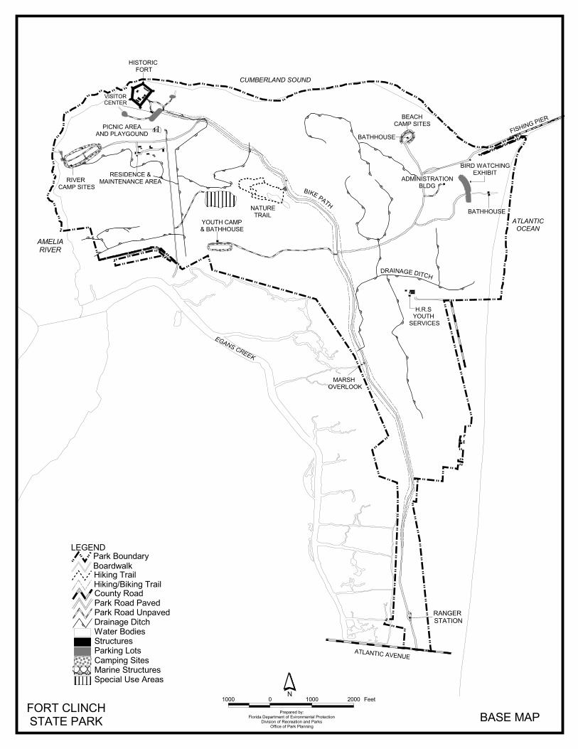
��
��
��
�
��
�
� � � ��
���
��
��
�
��
� � � �� � �
�
�
���
���
� � � �
������ � �
��
�
���
�� �
�
��
�
� � � � �
�������������
� ��� �������
������������������� ��
�������������
���������������������������
������� ���
��������
� ��������������� ��
��������������
������ �������
�������
������ ��
���������������
����������������
�����������������
�������������
�����
������������ �
��������������
���������
����������
�������������
�����������
��������������������
��� ������
�������������������� ������������������ !
�"#�$��������%&�'%�#(��)$�#'&�'%�"���#%�*%$#'�$)$+$#'�#(���*���%$#'��'�����,+
�(($*��#(����,��"�''$'-
./// / ./// 0/// ���%�
�����
���*$�"� +������+���$'���%�1*%1��+��&�$'-��$%�+���,$'-�#%+�%�1*%1��+��%����#�$�+
� ���$'�-���$%*2
�#1'% ��#�����,��#�����)�����,��#��� '��)��
�$,$'-����$"�$,$'-3�$,$'-����$"
�#���4�",���,��#1'���

40
in this regard. Other Uses In the past, the Amelia Island Mosquito Control District maintained ditches throughout the park for mosquito control purposes. These ditches have altered the surface drainage, interrupted the natural dune lines and introduced salt water into hammock areas, altering the adjacent flora. The Florida Department of Corrections sub-leases four cabins located within park boundaries for the Nassau Halfway House, youthful offender facility. This area is separated from the rest of the park and has an independent entrance. A utility easement is located within the property, perpendicular to 14th Street. Protected Zones A protected zone is an area of high sensitivity or outstanding character from which most types of development are excluded as a protective measure. Generally, facilities requiring extensive land alteration or resulting in intensive resource use, such as parking lots, camping areas, shops or maintenance areas, are not permitted in protected zones. Facilities with minimal resource impacts, such as trails, interpretive signs, and boardwalks are generally allowed. All decisions involving the use of protected zones are made on a case-by-case basis after careful site planning and analysis. At Fort Clinch State Park, the beach dune community, all wetland communities and the maritime hammock, with the exception of currently developed areas, have been designated as protected zones as delineated on the Natural Communities Map. Fort Clinch and the area visible from its ramparts is designated a cultural site protected zone. The main park road should be considered a “canopy road” and protected as part of the cultural landscape of the park. Existing Facilities Recreation Facilities Beach Area Beach Camp Area Boardwalks (3) Camp sites (21) Bathhouses (2) Bathhouse Fishing Pier (1600 ft) Interpretive exhibit /birdwatching window Fort Clinch River Camping Area Historic fort complex Camp sites (41) Visitor center Bathhouses (3) Boardwalks (2) Youth Camp Gift shop Picnic Area Trails Picnic shelters (4) Willow Pond Nature trail (1.5 miles) Picnic tables and grills Hammock trail (0.5 miles) Bathhouse Multi-use trail (6 miles) Playground Accessible picnic table and playground Support Facilities Entrance Area Entrance station
Parking Beach area/fishing pier parking (198) Willow Pond trailhead parking (6) Fort Clinch parking (111)
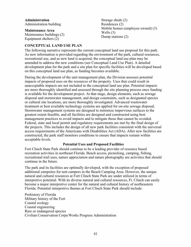
41
Administration Administration building Maintenance Area Maintenance buildings (2) Equipment shelters (2)
Storage sheds (2) Residences (2) Mobile homes (employee owned) (3) Wells (3) Dump stations (2)
CONCEPTUAL LAND USE PLAN The following narrative represents the current conceptual land use proposal for this park. As new information is provided regarding the environment of the park, cultural resources, recreational use, and as new land is acquired, the conceptual land use plan may be amended to address the new conditions (see Conceptual Land Use Plan). A detailed development plan for the park and a site plan for specific facilities will be developed based on this conceptual land use plan, as funding becomes available. During the development of the unit management plan, the Division assesses potential impacts of proposed uses on the resources of the property. Uses that could result in unacceptable impacts are not included in the conceptual land use plan. Potential impacts are more thoroughly identified and assessed through the site planning process once funding is available for the development project. At that stage, design elements, such as sewage disposal and stormwater management, and design constraints, such as designated species or cultural site locations, are more thoroughly investigated. Advanced wastewater treatment or best available technology systems are applied for on-site sewage disposal. Stormwater management systems are designed to minimize impervious surfaces to the greatest extent feasible, and all facilities are designed and constructed using best management practices to avoid impacts and to mitigate those that cannot be avoided. Federal, state and local permit and regulatory requirements are met by the final design of the projects. This includes the design of all new park facilities consistent with the universal access requirements of the Americans with Disabilities Act (ADA). After new facilities are constructed, the park staff monitors conditions to ensure that impacts remain within acceptable levels.
Potential Uses and Proposed Facilities Fort Clinch State Park should continue to be a leading provider of resource based recreation activities in northeast Florida. Beach access, picnicking, camping, fishing, recreational trail uses, nature appreciation and nature photography are activities that should continue in the future. The park and its facilities are optimally developed, with the exception of proposed additional campsites for tent campers in the Beach Camping Area. However, the unique natural and cultural resources at Fort Clinch State Park are under utilized in terms of interpretive potential. With its diverse natural and cultural resources, Ft. Clinch can easily become a major interpretive center for the natural and cultural history of northeastern Florida. Potential interpretive themes at Fort Clinch State Park should include: Prehistory of Florida Military history of the Fort Coastal ecology Coastal engineering Rare or endangered species Civilian Conservation Corps/Works Progress Administration
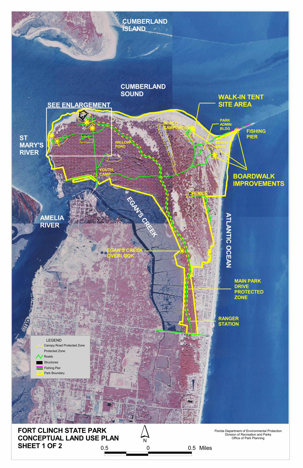
��������������
��
���
���� ������ ������
���� �������
���������� ���
���������������
������������
���� �� ���
�������� ��
��������
� �� ��� ��
����������������
�����
����������
�������
������� ������
���������� �����
�� ��������� ��������������
�
�
�������� ����������
�
�����������������������
������ ����������������������������������������������
���� � ��� �����
���� ���� ������������������� ������������������������� ���� ���� ���
���������� ����� �����
� ������� ���� ��������!���������� �����������"��# ����� �����������"��$�%���
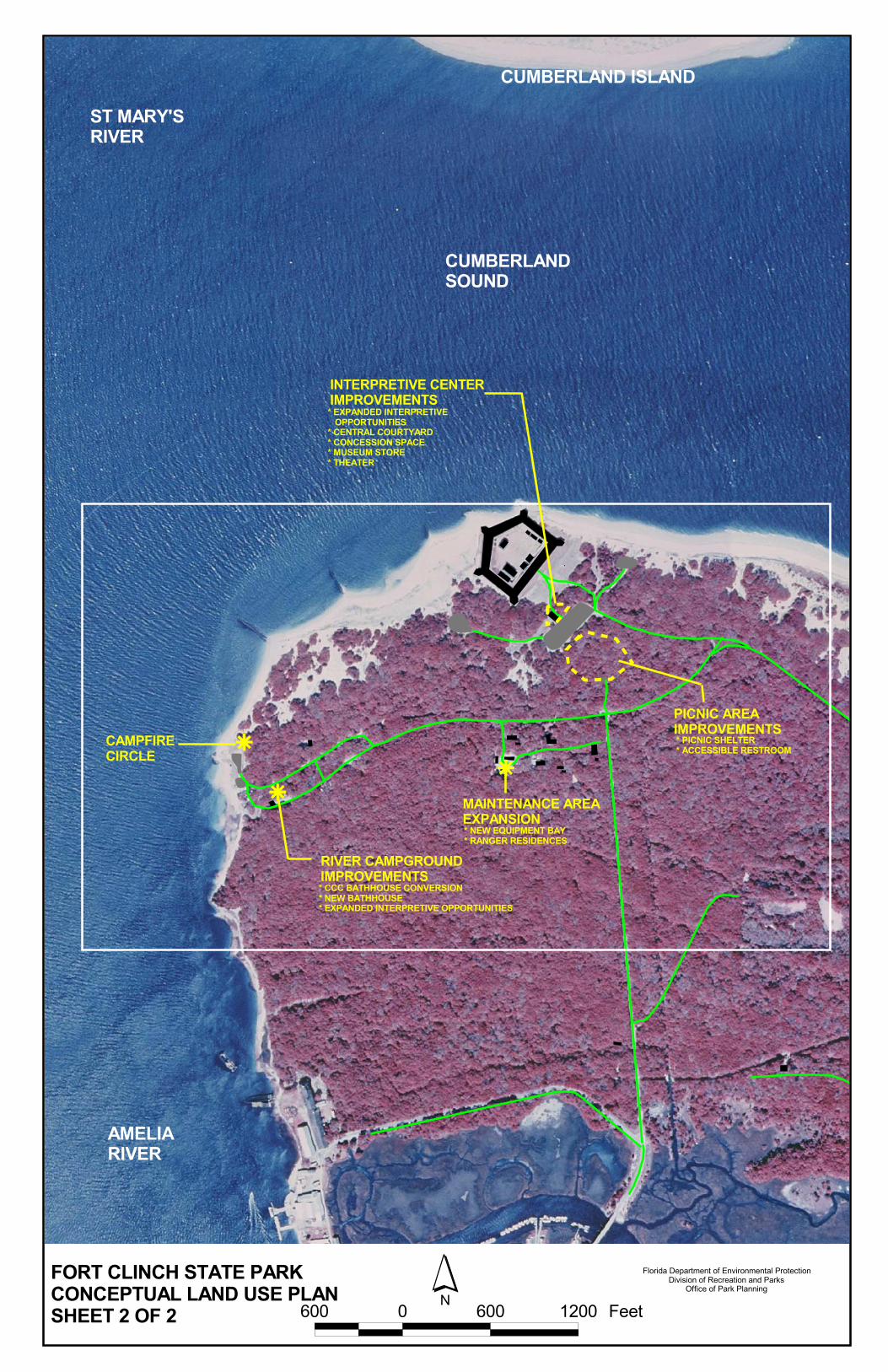
��
�
���������������������
��������� ���������������
��������������
����������������������������
������������������������
����������������������������������������������������������������������
�����������������������������������
���������������������������������������������������������������������������������������������
�������������������������������������������������������
�
������������ ������������� �������������������������������������������
����������������������
������������������������ �������������
��������������
�����������������
����������
�������������
��� � ��� ���� ��
44
An important component of increasing the interpretive potential of Fort Clinch is the renovation of the visitor center. The center, which was originally constructed by the CCC as a kitchen mess hall, has long served as a site interpreting the military history of the fort. A renovation of this visitor center would allow it to more fully interpret the cultural site and other natural and cultural resources in the park, and provide classroom facilities for environmental and cultural resource education programs. Recreation Facilities River campground improvements. The CCC bathhouse should be converted into a covered interpretive display center. This facility would enhance the park visitor’s understanding of the park’s history and ecology through the development of interpretive displays and programs. A new accessible restroom is proposed as a replacement for the CCC era one and should be located in an area to the east of the current one. A campfire circle with benches and fire rings is also proposed for this area. The campfire circle should be located in the area to the north of the campground, near the river, and would serve as another interpretive tool. Beach campground improvements. Up to eight walk-in tent sites should be developed along the road going to the beach campground. These sites should be primitive in nature with two tent sites to an area (separated by native vegetation) with each site consisting of a designated natural-surface tent area, fire ring, and water source, if feasible. Parking for these sites should be located along the roadside, should consist of one parking space per tent site, and should be connected to the tent site via a designated trail. Fort picnic area improvements. A new picnic shelter should be added to the picnic area located near the Fort. A new accessible restroom should be added to the accessible picnic area near the fort. This restroom should consist of a single-unisex stall and should be located next to the parking area. Interpretive Center renovation. The current interpretive center is in need of major renovations to better interpret the history of Fort Clinch. Proposed renovations and additions include a central courtyard, a gift shop, a concession area, and a new theater building that will seat up to 15 people. Egan’s Creek overlook. A boardwalk leading from park drive to the edge of Egan’s Creek marsh should be developed. The boardwalk would create an observation point on the marsh and within view of the lighthouse across Egan’s Creek, and interpret the importance of Egan’s Creek marsh to the natural communities and viewshed of Fort Clinch State Park. Four to six stabilized parking spaces should be provided adjacent to the park drive to facilitate visitor access to the proposed overlook. Support Facilities North beach access parking lot and road improvements. The north beach access parking lot and associated roadway needs to be re-designed and improved. If possible, this road should be constructed with a pervious paving system, similar in fashion to the previous road improvements within the campground. Maintenance area improvements. A new equipment storage bay needs to be added to the existing facilities within the maintenance area. Additional residences. Up to two more residences need to be constructed at the park to ensure that the park’s management staff has adequate housing. These residences should be developed in existing mobile home sites near the maintenance area. Boardwalk improvements. Extensive boardwalk systems throughout the park are worn
45
and in need of replacement including those at the pier, main day use beach area, and beach campground. Consideration of alternate durable materials for walkway replacement should be given to reduce overall maintenance costs and extend boardwalk life. In addition, several additional small picnic shelters should be located along short extensions off the main beach area boardwalk.
Facilities Development Preliminary cost estimates for the following list of proposed facilities are provided in Addendum 6. These cost estimates are based on the most cost-effective construction standards available at this time. The preliminary estimates are provided to assist the Division in budgeting future park improvements, and may be revised as more information is collected through the planning and design processes. 6 Ft. elevated boardwalk Boardwalk platforms & shelters Boardwalk replacement Campfire circle Picnic shelter Visitor Center renovations Stabilized tent sites
3 bay equipment shelter Campsite restroom Ranger residence Parking lot/road improvements Stabilized parking Stabilized pull-offs Unisex restroom
Existing Use and Optimum Carrying Capacity Carrying capacity is an estimate of the number of users a recreation resource or facility can accommodate and still provide a high quality recreational experience and preserve the natural values of the site. The carrying capacity of a unit is determined by identifying the land and water requirements for each recreation activity at the unit, and then applying these requirements to the unit's land and water base. Next, guidelines are applied which estimate the physical capacity of the unit's natural communities to withstand recreational uses without significant degradation. This analysis identifies a range within which the carrying capacity most appropriate to the specific activity, the activity site, and the unit's classification is selected (see Table 1). The optimum carrying capacity for this park is a preliminary estimate of the number of users the unit could accommodate after the current conceptual development program has been implemented. When developed, the proposed new facilities would approximately increase the unit's carrying capacity as shown in Table 1.
Optimum Boundary As additional needs are identified through park use, development, research, and as adjacent land uses change on private properties, modification of the unit's optimum boundary may occur for the enhancement of natural and cultural resources, recreational values, and management efficiency. At this time, no lands are considered surplus to the needs of the park. Identification of lands on the optimum boundary map is solely for planning purposes and not for regulatory purposes. A property’s identification on the optimum boundary map is not meant to be used by any party or other government body to reduce or restrict the lawful right of private landowners. Identification on the map does not empower or require any government entity to impose additional or more restrictive environmental land use or zoning regulations. Identification is not meant to be used as the basis for permit denial or the imposition of permit conditions. The optimum boundary map reflects lands identified for direct management by the Division as part of the park. These parcels may include public as well as privately owned lands that improve the continuity of existing park lands, provide additional natural and

46
Activity/FacilityOne Time Daily
One Time Daily
One Time Daily
CampingStandard 248 248 248 248Tent 32 32 32 32Primitive 100 100 100 100TrailsNature Trail 40 160 40 160Hiking 12 24 12 24Bicycling 60 240 60 240Picknicking 72 144 72 144FishingShore 105 310 105 310Pier 250 500 250 500Swimming 250 500 250 500Fort Visitation 330 1,320 330 1,320
TOTAL 1,467 3,546 32 32 1,499 3,578
Table 1--Existing Use And Optimum Carrying Capacity
Note: The canoe / kayak and fishing facilities are assumed to serve the same recreational user base as the picnic area, therefore, no carrying capacity is determined for them.
Proposed Additional Capacity
Existing Capacity
Estimated Optimum Capacity
cultural resource protection, and/or allow for future expansion of recreational activities. The optimum boundary for Fort Clinch State Park includes the addition of 14 separate areas to the park property. Eleven of these are small upland parcels, totaling 19.75 acres in size. They are scattered along the east length of Egan’s Creek marsh. An additional parcel consisting of the Agricola tract and the old Poggy Plant site, are a natural extension of the parks’ northwestern boundary. The natural communities on the Agricola parcel continue those in park property and serve as a buffer between the park and the industrial activities in the old Poggy Plant. Fernandina Beach and Nassau County are currently pursuing the purchase of the Agricola tract for a new boat ramp facility. Two parcels lie east of the state park. These parcels are located between Fort Clinch State Park and Tarpon Avenue and encompass some highly active dunes, whose destabilization by human activities affects the condition of the park resources. The parks’ viewshed is one of its most recognizable assets. As an integral part of this viewshed, the Tiger Islands should be considered for a conservation easement or purchase.
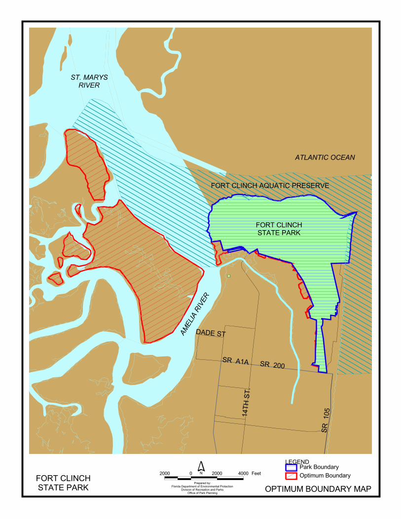
�������
����
���
������������
����
�
�������������������������
�������������������
������������
���������
������� �� ��
������������������� �������������������
�
������� �!"#�$%�& �������'(�)'�%*��)+&�%)(�)'�$���%'�,'&%)
�&+&-&%)�%*��,���'&%)��) ����.-�**&,��%*����.��$�))&)/
���� � ���� ���� ���' ��'&(0(��%0) ��"���.��%0) ��"
��1���


Addendum 1—Acquisition History and Advisory Group Information

Fort Clinch State Park
Acquisition History
A 1 - 1
Purpose and Sequence of Acquisition The State of Florida acquired Fort Clinch State Park to develop, operate, and maintain the property for the outdoor recreation, park, conservation, historic, and related purposes. On September 9, 1935, the State of Florida acquired Fort Clinch State Park using “Old Money”. Fernandina Plaza State Historic Site, which is treated as an independent entity is actually part of Fort Clinch State Park. The site has neither its own lease number nor management. Fernandina Plaza State Historic Site was purchased on December 30, 1941 by the State of Florida from the United States of America for $450; the site became part of Fort Clinch State Park in 1949. The Trustees leased Fort Clinch State Park to the Division of Recreation and Parks. In 1988, the Trustees assigned a new lease number to Fort Clinch State Park without making any changes to the terms and conditions of Lease No. 2324. Hence, Division presently manages Fort Clinch State Park under the new Lease No. 3620; the lease will expire on January 22, 2067. According to the Trustees lease, the Division manages Fort Clinch State Park only for the development, conservation and protection of natural and cultural resources and for resource-based public outdoor recreation, which is compatible with the conservation and protection of the property. Title Interest The Trustees hold fee simple title to Fort Clinch State Park. Special Conditions On Use Fort Clinch State Park is designated single-use to provide resource-based public outdoor recreation and other park related uses. Uses such as water resource development projects, water supply projects, storm-water management projects, and linear facilities and sustainable agriculture and forestry (other than those forest management activities specifically identified in the park’s unit management plan) are not consistent with this plan or the management purposes of the park. Outstanding Reservations Division’s management lease from the Trustees stipulates that all the property be utilized for public outdoor recreation and related purposes. The lease, however, authorizes subleases and agreements with third parties, provided that the agreements do not contravene both the text and the spirit of the lease agreement. Following is a listing of outstanding rights, reservations, and encumbrances which apply to Fort Clinch State Park.
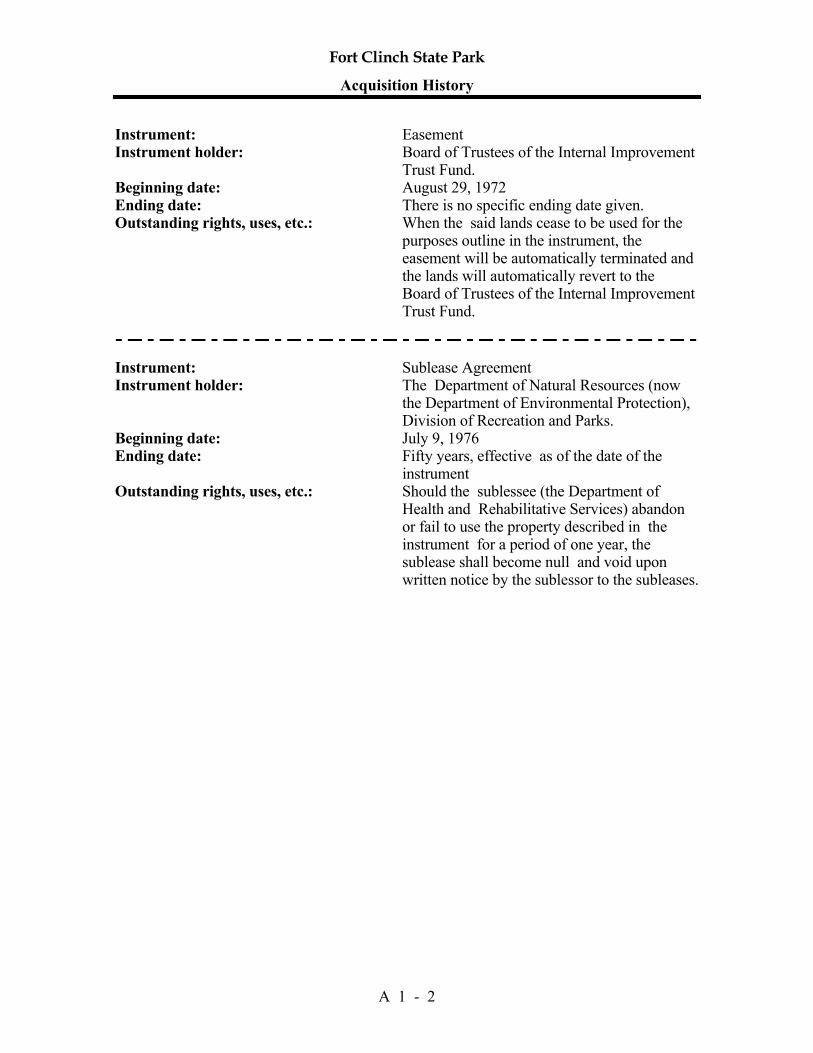
Fort Clinch State Park
Acquisition History
A 1 - 2
Instrument: Easement Instrument holder: Board of Trustees of the Internal Improvement
Trust Fund. Beginning date: August 29, 1972 Ending date: There is no specific ending date given. Outstanding rights, uses, etc.: When the said lands cease to be used for the
purposes outline in the instrument, the easement will be automatically terminated and the lands will automatically revert to the Board of Trustees of the Internal Improvement Trust Fund.
Instrument: Sublease Agreement Instrument holder: The Department of Natural Resources (now
the Department of Environmental Protection), Division of Recreation and Parks.
Beginning date: July 9, 1976 Ending date: Fifty years, effective as of the date of the
instrument Outstanding rights, uses, etc.: Should the sublessee (the Department of
Health and Rehabilitative Services) abandon or fail to use the property described in the instrument for a period of one year, the sublease shall become null and void upon written notice by the sublessor to the subleases.
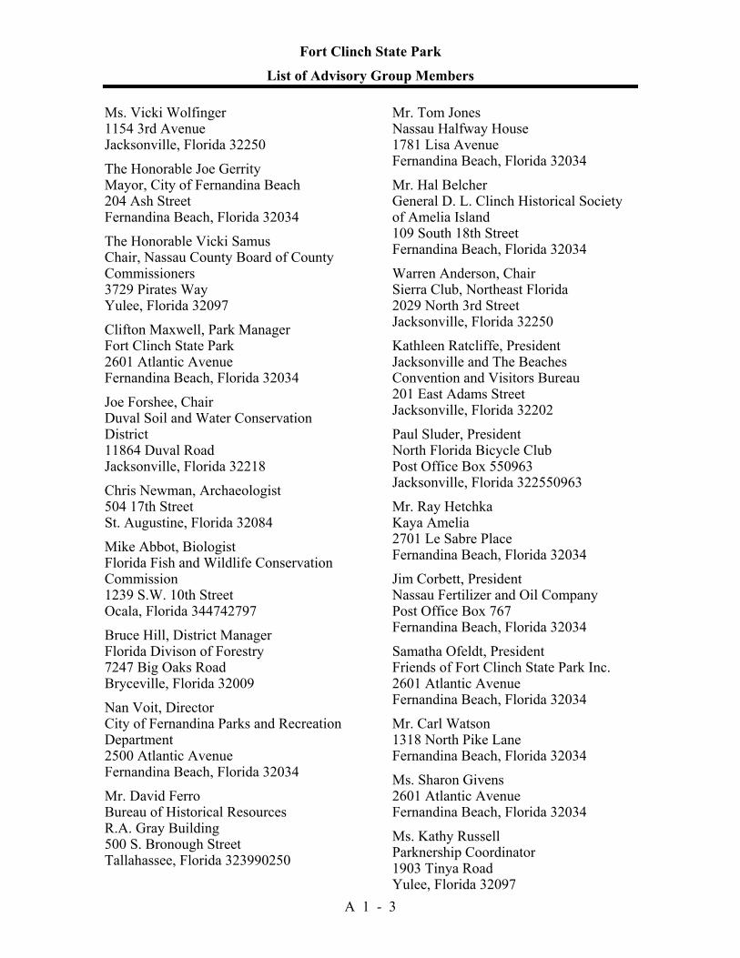
Fort Clinch State Park
List of Advisory Group Members
A 1 - 3
Ms. Vicki Wolfinger 1154 3rd Avenue Jacksonville, Florida 32250 The Honorable Joe Gerrity Mayor, City of Fernandina Beach 204 Ash Street Fernandina Beach, Florida 32034 The Honorable Vicki Samus Chair, Nassau County Board of County Commissioners 3729 Pirates Way Yulee, Florida 32097 Clifton Maxwell, Park Manager Fort Clinch State Park 2601 Atlantic Avenue Fernandina Beach, Florida 32034 Joe Forshee, Chair Duval Soil and Water Conservation District 11864 Duval Road Jacksonville, Florida 32218 Chris Newman, Archaeologist 504 17th Street St. Augustine, Florida 32084 Mike Abbot, Biologist Florida Fish and Wildlife Conservation Commission 1239 S.W. 10th Street Ocala, Florida 344742797 Bruce Hill, District Manager Florida Divison of Forestry 7247 Big Oaks Road Bryceville, Florida 32009 Nan Voit, Director City of Fernandina Parks and Recreation Department 2500 Atlantic Avenue Fernandina Beach, Florida 32034 Mr. David Ferro Bureau of Historical Resources R.A. Gray Building 500 S. Bronough Street Tallahassee, Florida 323990250
Mr. Tom Jones Nassau Halfway House 1781 Lisa Avenue Fernandina Beach, Florida 32034 Mr. Hal Belcher General D. L. Clinch Historical Society of Amelia Island 109 South 18th Street Fernandina Beach, Florida 32034 Warren Anderson, Chair Sierra Club, Northeast Florida 2029 North 3rd Street Jacksonville, Florida 32250 Kathleen Ratcliffe, President Jacksonville and The Beaches Convention and Visitors Bureau 201 East Adams Street Jacksonville, Florida 32202 Paul Sluder, President North Florida Bicycle Club Post Office Box 550963 Jacksonville, Florida 322550963 Mr. Ray Hetchka Kaya Amelia 2701 Le Sabre Place Fernandina Beach, Florida 32034 Jim Corbett, President Nassau Fertilizer and Oil Company Post Office Box 767 Fernandina Beach, Florida 32034 Samatha Ofeldt, President Friends of Fort Clinch State Park Inc. 2601 Atlantic Avenue Fernandina Beach, Florida 32034 Mr. Carl Watson 1318 North Pike Lane Fernandina Beach, Florida 32034 Ms. Sharon Givens 2601 Atlantic Avenue Fernandina Beach, Florida 32034 Ms. Kathy Russell Parknership Coordinator 1903 Tinya Road Yulee, Florida 32097
Fort Clinch State Park
Advisory Group Staff Report
A 1 - 4
The Advisory Group appointed to review the proposed land management plan for Fort Clinch State Park was held at the park office on August 29, 2003. Mr. Mike Abbott, Mr. Bruce Hill, Mr. Walter Gossett, Mr. Warren Anderson, Mr. Robert Sanford, Ms. Kathleen Ratcliffe, Mr. Paul Sluder, Mr. Carl Watson, and Ms. Sharon Givens did not attend. All other appointed Advisory Group members were present. In addition, Ms. Susan Parker and Mrs. Estez Forshee attended the advisory group. Attending staff were John Scafidi, Cliff Maxwell, Ezell Givens, Susie Hetrick, and KC Bloom. Ms. Bloom began the meeting by explaining the purpose of the advisory group and reviewing the meeting agenda. She also provided a brief overview of the Division's planning process and summarized public comments received during the previous evening’s public workshop and written comments submitted by non-attending members of the Advisory Group. She then asked each member of the advisory group to express his or her comments on the plan. Summary Of Advisory Group Comments Ms. Samantha Ofeldt began the meeting by commenting that she thought the plan was well done and represented the goals of the park. Chairwoman Vicki Samus stated that she thought the plan was well written and exciting. She discussed that the opening of a new county boat ramp will help develop interest in the north end of the island and could help promote the park. She provided that Nassau County has a new records building and would like to see more documentation of the park within that facility. She also stated that the staff was very helpful with the county’s barge removal project. Ms. Kathy Russell commented that as a teacher, the park was a valuable resource and the park staff should be commended for a job well done. She stated that she has had many students involved in the park and that she hopes to continue that for many years to come and encouraged the park to keep up its outreach activities to the regional schools. She added that she was thrilled with the plan. Mr. Maxwell responded that education and interpretation is a very important part of the park’s mission and would continue to be stressed. Ms. Chris Newman stated that she keyed in on the cultural resources section of the plan and thought it was well done. She continued that the comprehensive phase 1 cultural resources study would provide valuable information to both the park and the state. She thought the plan was well done. Mr. David Ferro discussed the importance of preserving the cultural resources of the park while realizing the importance of the restoration of natural communities. He stated that he was happy to see both the phase 1 cultural resources study and the cyclical maintenance program in the plan. He continued that old roads and trash pits need to be studied prior to restoration to determine their significance and structures need to be adequately documented. Mr. Ferro believes that a master preservation plan is needed for the park and that the park should seek out funding through the Division of Historic Resources’ grant programs. Mr. Maxwell stated that the park Citizen Support Organization (CSO) had already spent money on a fort restoration plan. He continued that the management plan states that the park will look to compile research about it’s history and will stress cultural resource management over the next 10 years of the management plan cycle. Mr. Hal Belcher stated that he thinks there needs to be a great deal of importance placed on researching and documenting the cultural resources that were once at the park as well as those remaining (i.e. the Amelia lighthouse). He would love to see the marsh overlook associated
Fort Clinch State Park
Advisory Group Staff Report
A 1 - 5
with where the original causeway crossed the marsh. Mr. Maxwell responded that the Division avoided that location due to archaeological concerns along with attempting to not disturb the maritime hammock or the viewshed. Mr. Belcher also was concerned about any documentation done at the Willow Pond site. Mr. Maxwell replied that not much documentation was done there recently however with a possible phase 1 survey and other tools in the plan it was likely that more would be done in the future. Ms. Nan Voit expressed support for the plan. Mr. Jim Corbett provided an overview of the area. He stated that as President of the Nassau Fertilizer and Oil Company and an adjacent landowner, he was pleased that the park worked closely with him to ensure minimal conflicts over the years. He continued that the plan recognizes it’s neighbors and that he was pleased with it. Mr. Ray Hetchka asked about the reason for a timber management section in the plan. Ms. Hetrick replied that it was a legal requirement and could provide protection for the park in the future. Mr. Hetchka also raised some questions about the beach nourishment, specifically in regard to Section 1B & C of the Management Needs and Problems section. Mr. Maxwell replied that the designation of the Fort as a “least cost” site was a positive thing as the Army Corps of Engineers has to place the sand from the dredging of the St. Mary’s inlet onto the park’s beach, thus not costing the park additional money. Mr. Hetchka stated that the plan was well done. Mayor Joe Gerrity stated that the park’s visitation is important to the local economy and that it should continue to be promoted. He supported the plan. Ms. Bloom thanked the Mayor for his support. Mr. Joe Forshee agreed with Mayor Gerrity’s thoughts on continuing to promote the park. He stated that the park staff does a good job in managing the resources and the visitors and that he is proud of both the park and the management. Public Comments Ms. Susan Parker stated that as the heritage tourism coordinator at the Division of Historic Resources regional office, she sees great value in the park for the local community as well as the region. She agreed with both Ms. Newman’s and Mr. Ferro’s comments. The meeting was then adjourned. Staff Recommendation A number of excellent discussions took place during the Advisory Group meeting. With minor revisions, staff recommends approval of the management plan as submitted.


Addendum 2—References Cited

Fort Clinch State Park References Cited
A 2 - 1
Bullen, Ripley, and John Griffin. 1952. Archaeological Survey of Amelia Island, Florida. Florida Anthropologist V (3 & 4): 37-62.
Coastal Engineering Lab. 1958. Coastal Engineering Study at Fort Clinch, University of
Florida, Gainesville. Mimeo. Florida Department of Environmental Protection. 1996. Marine Turtle Conservation
Guidelines. Developed by FMRI and BPSM. 43pp. Frazee, J. M. and D. R. McClaugherty. 1979. Investigation of Ground Water Resources
and Salt Intrusion in the Coastal Areas of Northeast Florida. Technical Report No. 3. St. John's River Water Management District. Prepared in cooperation with the Coastal Plains Regional Commission and Florida Department of Environmental Regulation. Project No. 203150. Mimeo.
Henry, V. J. 1971. Geological History and Development of Amelia Island, Nassau
County, Florida. A Preliminary Ecological Inventory, A Report to the Amelia Island Company, Fernandina Beach. Prepared by Wallace, McHarg, Roberts and Todd, Inc. by J. McCormick and Associates.
Herndon, Joseph, Erik J. Olsen, and William Cary. 1995. Restoration Master Plan for
Historic Fort Clinch. Report produced by Development Management Services for Friends of Fort Clinch, Inc.
Johnston, Sidney, et al. 1989. Survey of New Deal Era Resources in Florida State Parks.
Report produced by Historic Property Associates for the Division of Recreation and Parks.
Layne, J. 1971. Mammals of Amelia Island. A Preliminary Ecological Inventory, A
Report to the Amelia Island Company, Fernandina Beach. Prepared by Wallace, McHarg, Roberts and Todd, Inc. by J. McCormick and Associates.
Livingston, Robert J. 1996. Ecological Study of the Amelia and Nassau River Estuaries.
Analysis of the effects of the Rayonier mill on the Amelia River estuary. Florida Department of Environmental Protection report.
Nolan, T. H. 1974. History of Fort Clinch. Bureau of Historic Sites and Properties, Fl.
Dept. of State, Misc. Project Report Series #27. 68pp + appendices. Parchure, T. M. 1982. St. Marys Entrance Glossary of Inlets Report #11. Florida Sea Grant
College Report #44. 46pp. Patterson, C. P. 1875. Entrance to St. Mary's River and Fernandina Harbor. U. S. Coastal
Survey. (Map) Puri, H. S. and R. O. Vernon. 1959. Summary of the geology of Florida and a guide book
to the classic exposures. Special Publication 5. Florida Geological Survey, Tallahassee.
Raichle, A.W., K.R. Bodge, and E.J. Olsen. 1997. St. Marys Entrance Inlet Management
Plan, Technical Report Draft. Prepared for Nassau Soil and Water Conservation District. 520pp + appendices.
Fort Clinch State Park References Cited
A 2 - 2
Raichle, A.W. and E.J. Olsen. 1998. Fort Clinch Shoreline Stabilization Feasibility Study (draft). Prepared for Florida Department of Environmental Protection, Division of Recreation and Parks. 64pp + appendices.
Rogers, J.A., Jr. and H.T. Smith. 1995. Set-back distances to protect nesting bird colonies
from human disturbance in Florida. Conservation Biology 9(1): 89-99. Sanders, R. W. 1987. Identity of Lantana depressa and L. ovatifolia (Verbenaceae) of
Florida and the Bahamas. Systematic Botany 12:44-60. Shepard, H. E., Jr. 1965. The Construction of Fort Clinch. Prepared for the Florida Board
of Parks and Historic Memorials. Survey of New Deal Era Resources in Florida State Parks. 1989. Cultural Resource Survey
Prepared by Historic Property Associates, Inc. for the Fl. Dept. of Natural Resources and the Fl. Dept. of State. 93pp.
Sykes, Paul W., Jr. 2001. Annual Survival in the Southeastern Atlantic Coastal Breeding
Population of the Painted Bunting. Annual Report prepared for Florida Department of Environmental Protection, Division of Recreation and Parks. 4 pp.
U. S. Army Corps of Engineers. 1984 (Revised March, 1985). Feasibility Report for
Beach Erosion Control on Nassau County Beaches (Amelia Island). Watts, F. C. 1991. Soil Survey of Nassau County. U.S.D.A., Soil Conservation Service in
Cooperation with University of Florida, Institute of Food and Agricultural Sciences, Agricultural Experiment Stations and Soil Science Department, and Florida Department of Agriculture and Consumer Services.

Addendum 3—Soil Descriptions

Fort Clinch State Park
Soil Descriptions
A 3 - 1
(3) Beaches. - Beaches consists of narrow strips of nearly level fine sand along the Atlantic Ocean. These areas are inundated with salt water daily at high tide. This material is a mixture of quartz sand and fragments of shells. It is subject to movement by wind and tide and is bare of vegetation. (5) Fripp fine sand, rolling - This excessively drained, gently rolling to hilly soil is on narrow dune line ridges along the Atlantic Coast. Slopes are smooth to convex and concave. Typically, the surface layer is light grayish brown fine sand four inches thick. The substratum, to a depth of 80 inches or more, is very pale brown fine sand. (12) Newhan-Corolla, rarely flooded, fine sands, rolling - These excessively drained and moderate well and somewhat poorly drained, gently rolling to hilly soils are on narrow dune like ridges along the Atlantic Coast. slopes are convex and concave. Typically, the surface layer of Newhan fine sand is white fine sand about eight inches thick. The underlying material, to a depth of about 80 inches, is very pale brown fine sand. Newhan occurs on the higher elevation with slopes to 80 percent. (17) Urban Land - This Urban land consists of areas that are 75 percent or more covered with streets, houses, commercial buildings, parking lots, shopping centers, industrial parks, airports, and related facilities. (19) Leon Fine Sand, tidal - This very poorly drained, nearly level soil is on narrow salt marshes bordering the flatwoods. Slopes are smooth and range from 0 to 2 percent. Typically, the surface layer is about 26 inches thick. It is dark gray fine sand in the upper part and very dark gray fine sand in the lower part. The subsoil is 14 inches thick. It is dark grayish brown in the upper part and dark brown in the lower part. The subsurface layer is light gray fine sand three inches thick. The second subsoil is dark brown fine sand 15 inches thick. The substratum is dark olive gray fine sand to a depth of 80 inches or more. (28) Tisonia mucky peat, frequently flooded - This poorly drained, nearly level soil occurs in broad tidal marshes. This soil floods daily during high tide. The surface layer is a dark brown mucky peat to approximately 40 inches. Underlying material is a dark olive gray clay to about 65 inches. (30) Kureb-Resota fine sands, rolling - This excessively drained, nearly level to gently sloping soil is on broad upland ridges. Slopes are smooth. Typically, the surface layer is gray fine sand about five inches thick. The subsurface layer is light brownish gray fine sand about 14 inches thick. The subsoil extends to depths of 80 inches or more. It is strong brown fine sand with tongues of light gray fine sand in the upper part; and yellowish brown, brownish yellow, yellow, and very pale brown fine sand in the lower part. (32) Aqualfs, loamy - Aqualfs, loamy consists of gently sloping excavation with short steep side slopes from which soil and geologic material have been removed for use in road construction, foundations, septic tank absorption fields, etc. Most areas of this map unit are abandoned, but excavation is continuing in a few place. Those areas that have been excavated below the normal water table usually contain water and where large enough are mapped as water. Aqualfs loamy do not have an orderly sequence of soil layers. They are
Fort Clinch State Park
Soil Descriptions
A 3 - 2
variable, but usually contain the subsoil and substratum of associated soils. (44) Corolla fine sand, 2 to 6 percent slopes, rarely flooded. - This moderately well and somewhat poorly drained gently sloping to sloping soil is on narrow dune like ridges along the Atlantic Coast. Slopes are convex and concave. Typically, the surface layer is very pale brown fine sand about ten inches thick. The underlying material to a depth of about 80 inches is pale brown and light yellowish brown fine sand in the upper part; light gray fine sand in the lower part.

Addendum 4—Plant And Animal List

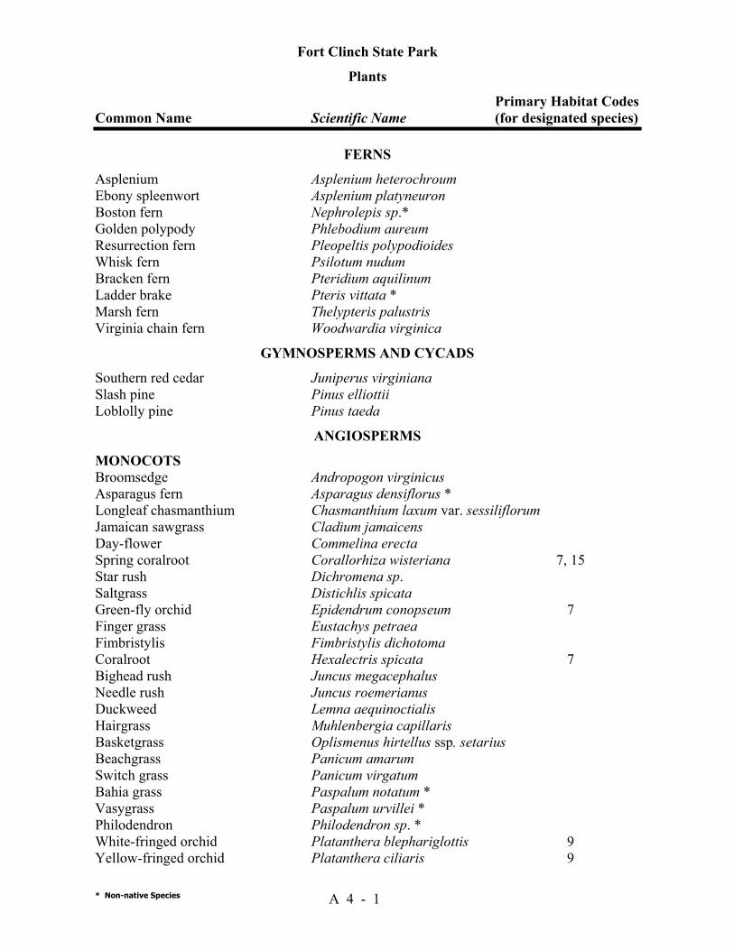
Fort Clinch State Park
Plants Primary Habitat Codes Common Name Scientific Name (for designated species)
* Non-native Species A 4 - 1
FERNS Asplenium Asplenium heterochroum Ebony spleenwort Asplenium platyneuron Boston fern Nephrolepis sp.* Golden polypody Phlebodium aureum Resurrection fern Pleopeltis polypodioides Whisk fern Psilotum nudum Bracken fern Pteridium aquilinum Ladder brake Pteris vittata * Marsh fern Thelypteris palustris Virginia chain fern Woodwardia virginica
GYMNOSPERMS AND CYCADS Southern red cedar Juniperus virginiana Slash pine Pinus elliottii Loblolly pine Pinus taeda
ANGIOSPERMS MONOCOTS Broomsedge Andropogon virginicus Asparagus fern Asparagus densiflorus * Longleaf chasmanthium Chasmanthium laxum var. sessiliflorum Jamaican sawgrass Cladium jamaicens Day-flower Commelina erecta Spring coralroot Corallorhiza wisteriana 7, 15 Star rush Dichromena sp. Saltgrass Distichlis spicata Green-fly orchid Epidendrum conopseum 7 Finger grass Eustachys petraea Fimbristylis Fimbristylis dichotoma Coralroot Hexalectris spicata 7 Bighead rush Juncus megacephalus Needle rush Juncus roemerianus Duckweed Lemna aequinoctialis Hairgrass Muhlenbergia capillaris Basketgrass Oplismenus hirtellus ssp. setarius Beachgrass Panicum amarum Switch grass Panicum virgatum Bahia grass Paspalum notatum * Vasygrass Paspalum urvillei * Philodendron Philodendron sp. * White-fringed orchid Platanthera blephariglottis 9 Yellow-fringed orchid Platanthera ciliaris 9
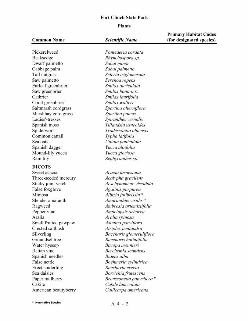
Fort Clinch State Park
Plants Primary Habitat Codes Common Name Scientific Name (for designated species)
* Non-native Species A 4 - 2
Pickerelweed Pontederia cordata Beaksedge Rhynchospora sp. Dwarf palmetto Sabal minor Cabbage palm Sabal palmetto Tall nutgrass Scleria triglomerata Saw palmetto Serenoa repens Earleaf greenbrier Smilax auriculata Saw greenbrier Smilax bona-nox Catbrier Smilax laurifolia Coral greenbrier Smilax walteri Saltmarsh cordgrass Spartina alterniflora Marshhay cord grass Spartina patens Ladies'-tresses Spiranthes vernalis Spanish moss Tillandsia usneoides Spiderwort Tradescantia ohiensis Common cattail Typha latifolia Sea oats Uniola paniculata Spanish dagger Yucca aloifolia Mound-lily yucca Yucca gloriosa Rain lily Zephyranthes sp. DICOTS Sweet acacia Acacia farnesiana Three-seeded mercury Acalypha gracilens Sticky joint vetch Aeschynomene viscidula False foxglove Agalinis purpurea Mimosa Albizia julibrissin * Slender amaranth Amaranthus viridis * Ragweed Ambrosia artemisiifolia Pepper vine Ampelopsis arborea Aralia Aralia spinosa Small fruited pawpaw Asimina parviflora Crested saltbush Atriplex pentandra Silverling Baccharis glomeruliflora Groundsel tree Baccharis halimifolia Water hyssop Bacopa monnieri Rattan vine Berchemia scandens Spanish needles Bidens alba False nettle Boehmeria cylindrica Erect spiderling Boerhavia erecta Sea daisies Borrichia frutescens Paper mulberry Broussonetia papyrifera * Cakile Cakile lanceolata American beautyberry Callicarpa americana
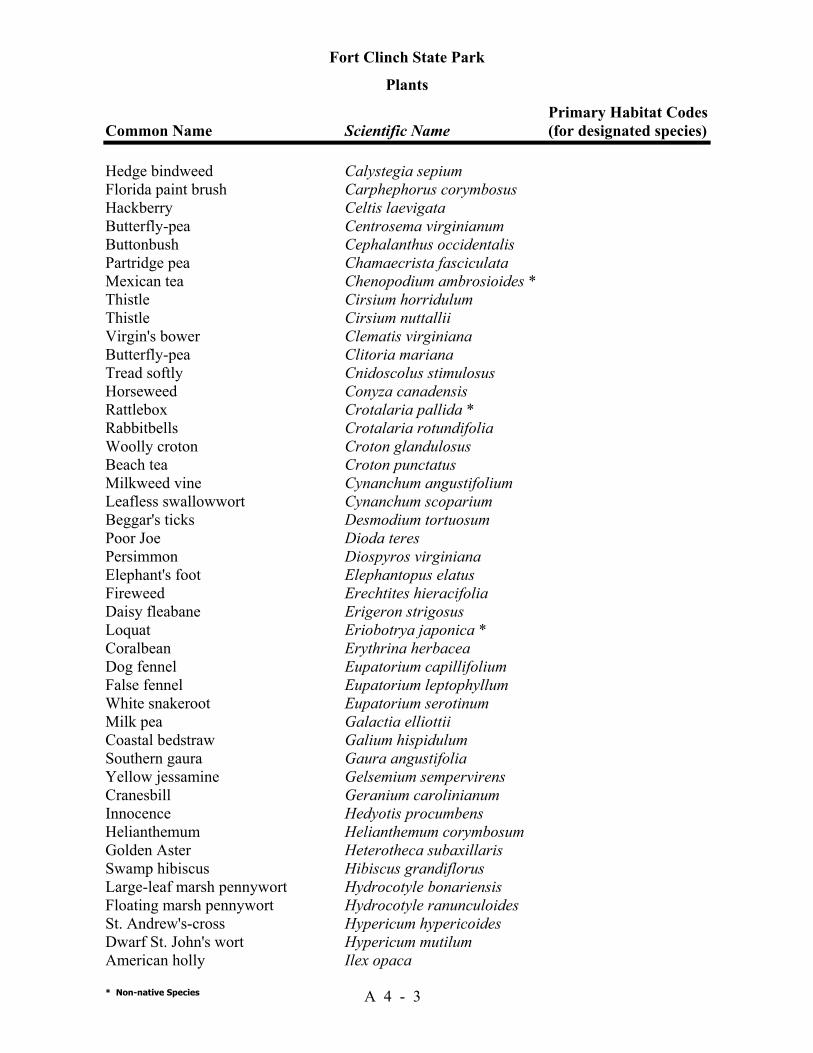
Fort Clinch State Park
Plants Primary Habitat Codes Common Name Scientific Name (for designated species)
* Non-native Species A 4 - 3
Hedge bindweed Calystegia sepium Florida paint brush Carphephorus corymbosus Hackberry Celtis laevigata Butterfly-pea Centrosema virginianum Buttonbush Cephalanthus occidentalis Partridge pea Chamaecrista fasciculata Mexican tea Chenopodium ambrosioides * Thistle Cirsium horridulum Thistle Cirsium nuttallii Virgin's bower Clematis virginiana Butterfly-pea Clitoria mariana Tread softly Cnidoscolus stimulosus Horseweed Conyza canadensis Rattlebox Crotalaria pallida * Rabbitbells Crotalaria rotundifolia Woolly croton Croton glandulosus Beach tea Croton punctatus Milkweed vine Cynanchum angustifolium Leafless swallowwort Cynanchum scoparium Beggar's ticks Desmodium tortuosum Poor Joe Dioda teres Persimmon Diospyros virginiana Elephant's foot Elephantopus elatus Fireweed Erechtites hieracifolia Daisy fleabane Erigeron strigosus Loquat Eriobotrya japonica * Coralbean Erythrina herbacea Dog fennel Eupatorium capillifolium False fennel Eupatorium leptophyllum White snakeroot Eupatorium serotinum Milk pea Galactia elliottii Coastal bedstraw Galium hispidulum Southern gaura Gaura angustifolia Yellow jessamine Gelsemium sempervirens Cranesbill Geranium carolinianum Innocence Hedyotis procumbens Helianthemum Helianthemum corymbosum Golden Aster Heterotheca subaxillaris Swamp hibiscus Hibiscus grandiflorus Large-leaf marsh pennywort Hydrocotyle bonariensis Floating marsh pennywort Hydrocotyle ranunculoides St. Andrew's-cross Hypericum hypericoides Dwarf St. John's wort Hypericum mutilum American holly Ilex opaca
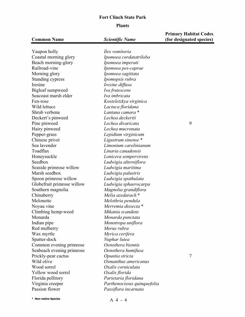
Fort Clinch State Park
Plants Primary Habitat Codes Common Name Scientific Name (for designated species)
* Non-native Species A 4 - 4
Yaupon holly Ilex vomitoria Coastal morning glory Ipomoea cordatatriloba Beach morning-glory Ipomoea imperati Railroad-vine Ipomoea pes-caprae Morning glory Ipomoea sagittata Standing cypress Ipomopsis rubra Iresine Iresine diffusa Bigleaf sumpweed Iva frutescens Seacoast marsh elder Iva imbricata Fen-rose Kosteletzkya virginica Wild lettuce Lactuca floridana Shrub verbena Lantana camara * Deckert’s pinweed Lechea deckertii Pine pinweed Lechea divaricata 9 Hairy pinweed Lechea mucronata Pepper-grass Lepidium virginicum Chinese privet Ligustrum sinense * Sea lavender Limonium carolinianum Toadflax Linaria canadensis Honeysuckle Lonicera sempervirens Seedbox Ludwigia alterniflora Seaside primrose willow Ludwigia maritima Marsh seedbox Ludwigia palustris Spoon primrose willow Ludwigia spathulata Globefruit primrose willow Ludwigia sphaerocarpa Southern magnolia Magnolia grandiflora Chinaberry Melia azedarach * Melonette Melothria pendula Noyau vine Merremia dissecta * Climbing hemp-weed Mikania scandens Monarda Monarda punctata Indian pipe Monotropa uniflora Red mulberry Morus rubra Wax myrtle Myrica cerifera Spatter-dock Nuphar lutea Common evening primrose Oenothera biennis Seabeach evening primrose Oenothera humifusa Prickly-pear cactus Opuntia stricta 7 Wild olive Osmanthus americanus Wood sorrel Oxalis corniculata Yellow wood sorrel Oxalis florida Florida pellitory Parietaria floridana Virginia creeper Parthenocissus quinquefolia Passion flower Passiflora incarnata
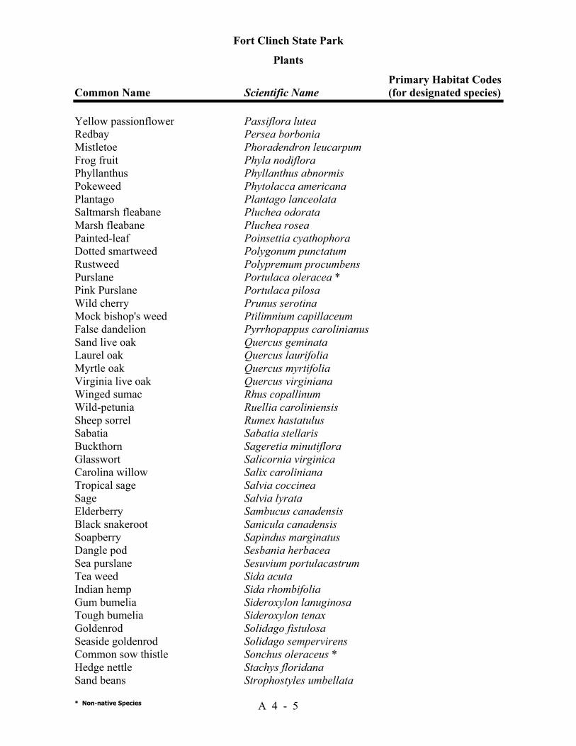
Fort Clinch State Park
Plants Primary Habitat Codes Common Name Scientific Name (for designated species)
* Non-native Species A 4 - 5
Yellow passionflower Passiflora lutea Redbay Persea borbonia Mistletoe Phoradendron leucarpum Frog fruit Phyla nodiflora Phyllanthus Phyllanthus abnormis Pokeweed Phytolacca americana Plantago Plantago lanceolata Saltmarsh fleabane Pluchea odorata Marsh fleabane Pluchea rosea Painted-leaf Poinsettia cyathophora Dotted smartweed Polygonum punctatum Rustweed Polypremum procumbens Purslane Portulaca oleracea * Pink Purslane Portulaca pilosa Wild cherry Prunus serotina Mock bishop's weed Ptilimnium capillaceum False dandelion Pyrrhopappus carolinianus Sand live oak Quercus geminata Laurel oak Quercus laurifolia Myrtle oak Quercus myrtifolia Virginia live oak Quercus virginiana Winged sumac Rhus copallinum Wild-petunia Ruellia caroliniensis Sheep sorrel Rumex hastatulus Sabatia Sabatia stellaris Buckthorn Sageretia minutiflora Glasswort Salicornia virginica Carolina willow Salix caroliniana Tropical sage Salvia coccinea Sage Salvia lyrata Elderberry Sambucus canadensis Black snakeroot Sanicula canadensis Soapberry Sapindus marginatus Dangle pod Sesbania herbacea Sea purslane Sesuvium portulacastrum Tea weed Sida acuta Indian hemp Sida rhombifolia Gum bumelia Sideroxylon lanuginosa Tough bumelia Sideroxylon tenax Goldenrod Solidago fistulosa Seaside goldenrod Solidago sempervirens Common sow thistle Sonchus oleraceus * Hedge nettle Stachys floridana Sand beans Strophostyles umbellata
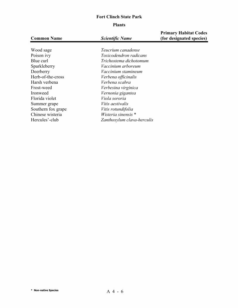
Fort Clinch State Park
Plants Primary Habitat Codes Common Name Scientific Name (for designated species)
* Non-native Species A 4 - 6
Wood sage Teucrium canadense Poison ivy Toxicodendron radicans Blue curl Trichostema dichotomum Sparkleberry Vaccinium arboreum Deerberry Vaccinium stamineum Herb-of-the-cross Verbena officinalis Harsh verbena Verbena scabra Frost-weed Verbesina virginica Ironweed Vernonia gigantea Florida violet Viola sororia Summer grape Vitis aestivalis Southern fox grape Vitis rotundifolia Chinese wisteria Wisteria sinensis * Hercules’-club Zanthoxylum clava-herculis
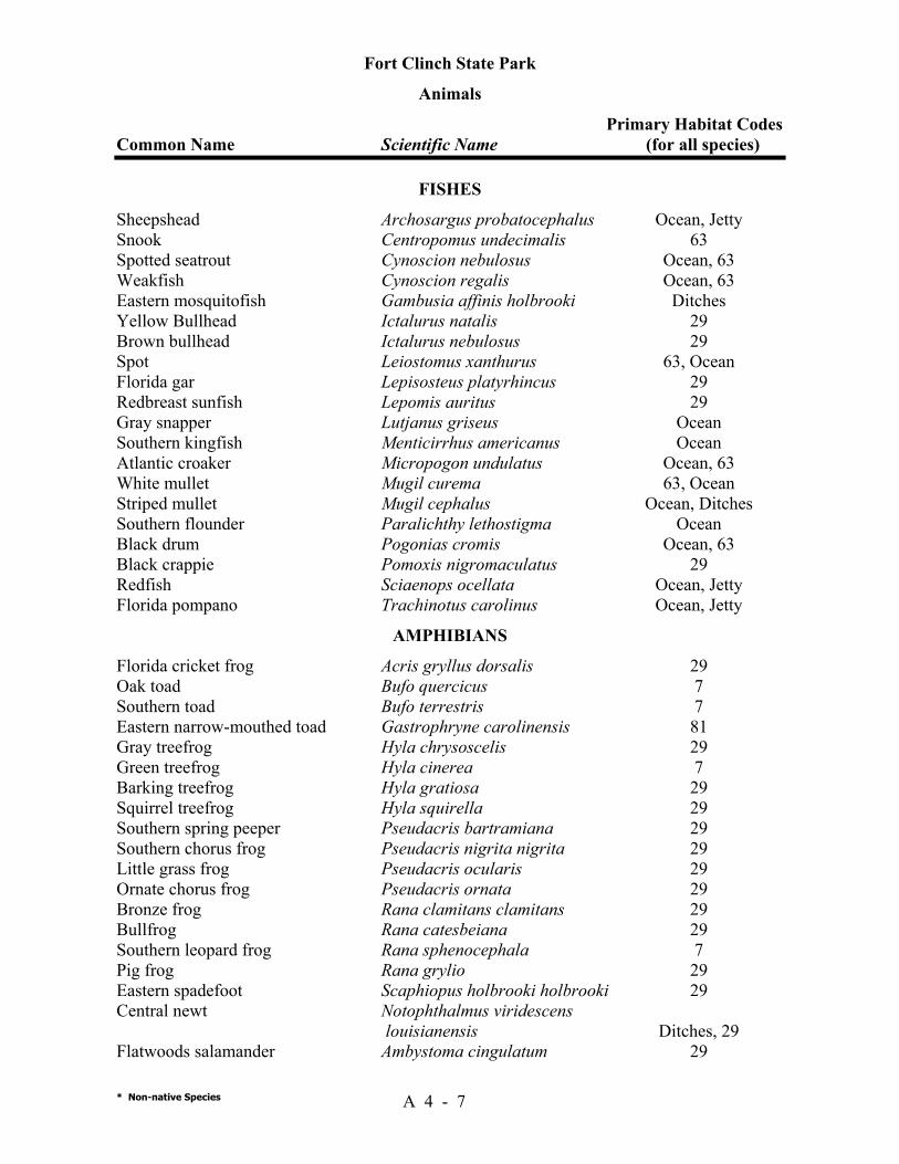
Fort Clinch State Park
Animals Primary Habitat Codes Common Name Scientific Name (for all species)
* Non-native Species A 4 - 7
FISHES Sheepshead Archosargus probatocephalus Ocean, Jetty Snook Centropomus undecimalis 63 Spotted seatrout Cynoscion nebulosus Ocean, 63 Weakfish Cynoscion regalis Ocean, 63 Eastern mosquitofish Gambusia affinis holbrooki Ditches Yellow Bullhead Ictalurus natalis 29 Brown bullhead Ictalurus nebulosus 29 Spot Leiostomus xanthurus 63, Ocean Florida gar Lepisosteus platyrhincus 29 Redbreast sunfish Lepomis auritus 29 Gray snapper Lutjanus griseus Ocean Southern kingfish Menticirrhus americanus Ocean Atlantic croaker Micropogon undulatus Ocean, 63 White mullet Mugil curema 63, Ocean Striped mullet Mugil cephalus Ocean, Ditches Southern flounder Paralichthy lethostigma Ocean Black drum Pogonias cromis Ocean, 63 Black crappie Pomoxis nigromaculatus 29 Redfish Sciaenops ocellata Ocean, Jetty Florida pompano Trachinotus carolinus Ocean, Jetty
AMPHIBIANS Florida cricket frog Acris gryllus dorsalis 29 Oak toad Bufo quercicus 7 Southern toad Bufo terrestris 7 Eastern narrow-mouthed toad Gastrophryne carolinensis 81 Gray treefrog Hyla chrysoscelis 29 Green treefrog Hyla cinerea 7 Barking treefrog Hyla gratiosa 29 Squirrel treefrog Hyla squirella 29 Southern spring peeper Pseudacris bartramiana 29 Southern chorus frog Pseudacris nigrita nigrita 29 Little grass frog Pseudacris ocularis 29 Ornate chorus frog Pseudacris ornata 29 Bronze frog Rana clamitans clamitans 29 Bullfrog Rana catesbeiana 29 Southern leopard frog Rana sphenocephala 7 Pig frog Rana grylio 29 Eastern spadefoot Scaphiopus holbrooki holbrooki 29 Central newt Notophthalmus viridescens louisianensis Ditches, 29 Flatwoods salamander Ambystoma cingulatum 29
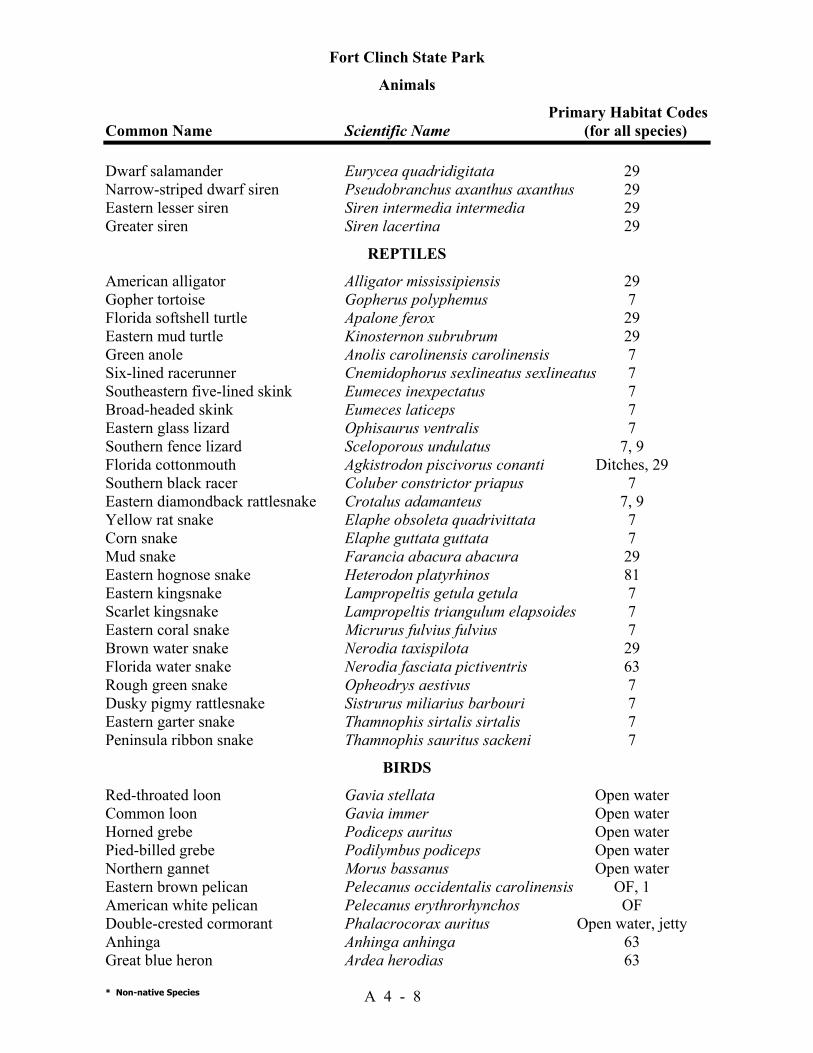
Fort Clinch State Park
Animals Primary Habitat Codes Common Name Scientific Name (for all species)
* Non-native Species A 4 - 8
Dwarf salamander Eurycea quadridigitata 29 Narrow-striped dwarf siren Pseudobranchus axanthus axanthus 29 Eastern lesser siren Siren intermedia intermedia 29 Greater siren Siren lacertina 29
REPTILES American alligator Alligator mississipiensis 29 Gopher tortoise Gopherus polyphemus 7 Florida softshell turtle Apalone ferox 29 Eastern mud turtle Kinosternon subrubrum 29 Green anole Anolis carolinensis carolinensis 7 Six-lined racerunner Cnemidophorus sexlineatus sexlineatus 7 Southeastern five-lined skink Eumeces inexpectatus 7 Broad-headed skink Eumeces laticeps 7 Eastern glass lizard Ophisaurus ventralis 7 Southern fence lizard Sceloporous undulatus 7, 9 Florida cottonmouth Agkistrodon piscivorus conanti Ditches, 29 Southern black racer Coluber constrictor priapus 7 Eastern diamondback rattlesnake Crotalus adamanteus 7, 9 Yellow rat snake Elaphe obsoleta quadrivittata 7 Corn snake Elaphe guttata guttata 7 Mud snake Farancia abacura abacura 29 Eastern hognose snake Heterodon platyrhinos 81 Eastern kingsnake Lampropeltis getula getula 7 Scarlet kingsnake Lampropeltis triangulum elapsoides 7 Eastern coral snake Micrurus fulvius fulvius 7 Brown water snake Nerodia taxispilota 29 Florida water snake Nerodia fasciata pictiventris 63 Rough green snake Opheodrys aestivus 7 Dusky pigmy rattlesnake Sistrurus miliarius barbouri 7 Eastern garter snake Thamnophis sirtalis sirtalis 7 Peninsula ribbon snake Thamnophis sauritus sackeni 7
BIRDS Red-throated loon Gavia stellata Open water Common loon Gavia immer Open water Horned grebe Podiceps auritus Open water Pied-billed grebe Podilymbus podiceps Open water Northern gannet Morus bassanus Open water Eastern brown pelican Pelecanus occidentalis carolinensis OF, 1 American white pelican Pelecanus erythrorhynchos OF Double-crested cormorant Phalacrocorax auritus Open water, jetty Anhinga Anhinga anhinga 63 Great blue heron Ardea herodias 63
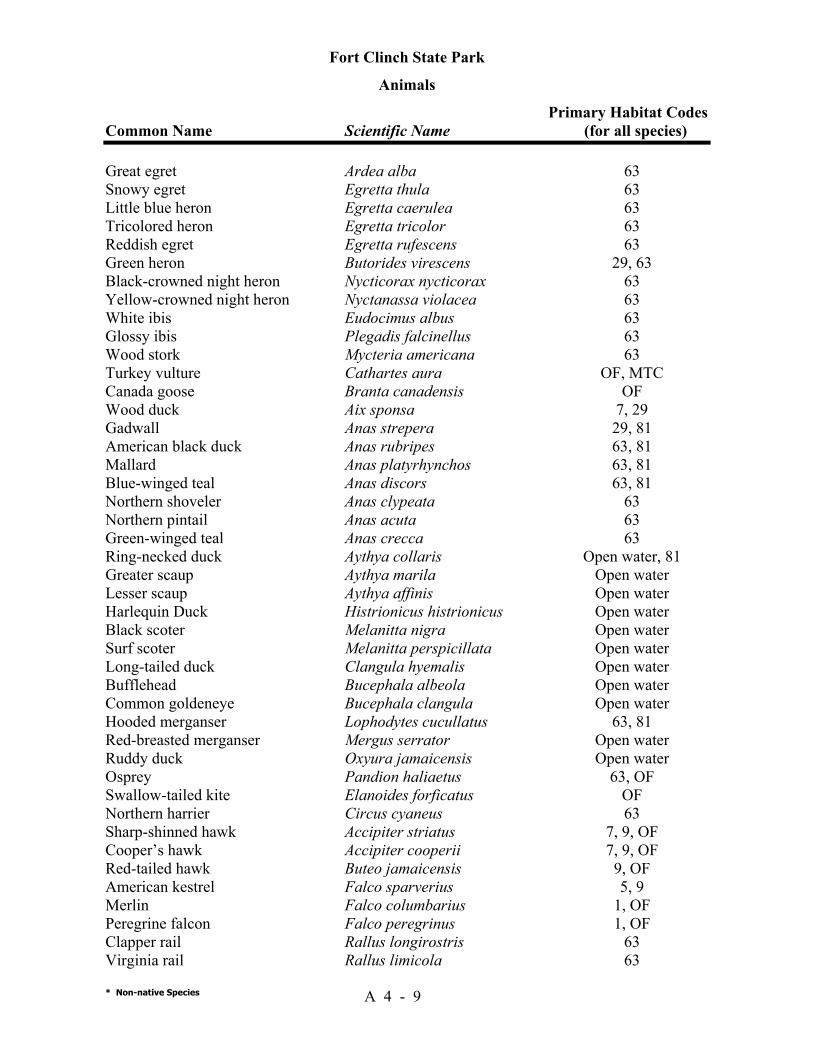
Fort Clinch State Park
Animals Primary Habitat Codes Common Name Scientific Name (for all species)
* Non-native Species A 4 - 9
Great egret Ardea alba 63 Snowy egret Egretta thula 63 Little blue heron Egretta caerulea 63 Tricolored heron Egretta tricolor 63 Reddish egret Egretta rufescens 63 Green heron Butorides virescens 29, 63 Black-crowned night heron Nycticorax nycticorax 63 Yellow-crowned night heron Nyctanassa violacea 63 White ibis Eudocimus albus 63 Glossy ibis Plegadis falcinellus 63 Wood stork Mycteria americana 63 Turkey vulture Cathartes aura OF, MTC Canada goose Branta canadensis OF Wood duck Aix sponsa 7, 29 Gadwall Anas strepera 29, 81 American black duck Anas rubripes 63, 81 Mallard Anas platyrhynchos 63, 81 Blue-winged teal Anas discors 63, 81 Northern shoveler Anas clypeata 63 Northern pintail Anas acuta 63 Green-winged teal Anas crecca 63 Ring-necked duck Aythya collaris Open water, 81 Greater scaup Aythya marila Open water Lesser scaup Aythya affinis Open water Harlequin Duck Histrionicus histrionicus Open water Black scoter Melanitta nigra Open water Surf scoter Melanitta perspicillata Open water Long-tailed duck Clangula hyemalis Open water Bufflehead Bucephala albeola Open water Common goldeneye Bucephala clangula Open water Hooded merganser Lophodytes cucullatus 63, 81 Red-breasted merganser Mergus serrator Open water Ruddy duck Oxyura jamaicensis Open water Osprey Pandion haliaetus 63, OF Swallow-tailed kite Elanoides forficatus OF Northern harrier Circus cyaneus 63 Sharp-shinned hawk Accipiter striatus 7, 9, OF Cooper’s hawk Accipiter cooperii 7, 9, OF Red-tailed hawk Buteo jamaicensis 9, OF American kestrel Falco sparverius 5, 9 Merlin Falco columbarius 1, OF Peregrine falcon Falco peregrinus 1, OF Clapper rail Rallus longirostris 63 Virginia rail Rallus limicola 63
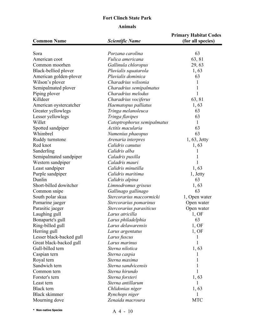
Fort Clinch State Park
Animals Primary Habitat Codes Common Name Scientific Name (for all species)
* Non-native Species A 4 - 10
Sora Porzana carolina 63 American coot Fulica americana 63, 81 Common moorhen Gallinula chloropus 29, 63 Black-bellied plover Pluvialis squatarola 1, 63 American golden-plover Pluvialis dominica 63 Wilson’s plover Charadrius wilsonia 1 Semipalmated plover Charadrius semipalmatus 1 Piping plover Charadrius melodus 1 Killdeer Charadrius vociferus 63, 81 American oystercatcher Haematopus palliatus 1, 63 Greater yellowlegs Tringa melanoleuca 63 Lesser yellowlegs Tringa flavipes 63 Willet Catoptrophorus semipalmatus 1 Spotted sandpiper Actitis macularia 63 Whimbrel Numenius phaeopus 63 Ruddy turnstone Arenaria interpres 1, 63, Jetty Red knot Calidris canutus 1, 63 Sanderling Calidris alba 1 Semipalmated sandpiper Caladris pusilla 1 Western sandpiper Caladris mauri 1 Least sandpiper Calidris minutilla 1, 63 Purple sandpiper Calidris maritima 1, Jetty Dunlin Calidris alpina 63 Short-billed dowitcher Limnodromus griseus 1, 63 Common snipe Gallinago gallinago 63 South polar skua Stercorarius maccormicki 1, Open water Pomarine jaeger Stercorarius pomarinus Open water Parasitic jaeger Stercorarius parasiticus Open water Laughing gull Larus atricilla 1, OF Bonaparte's gull Larus philadelphia 63 Ring-billed gull Larus delawarensis 1, OF Herring gull Larus argentatus 1, OF Lesser black-backed gull Larus fuscus 1 Great black-backed gull Larus marinus 1 Gull-billed tern Sterna nilotica 1, 63 Caspian tern Sterna caspia 1 Royal tern Sterna maxima 1 Sandwich tern Sterna sandvicensis 1 Common tern Sterna hirundo 1 Forster's tern Sterna forsteri 1, 63 Least tern Sterna antillarum 1 Black tern Chlidonias niger 1, 63 Black skimmer Rynchops niger 1 Mourning dove Zenaida macroura MTC
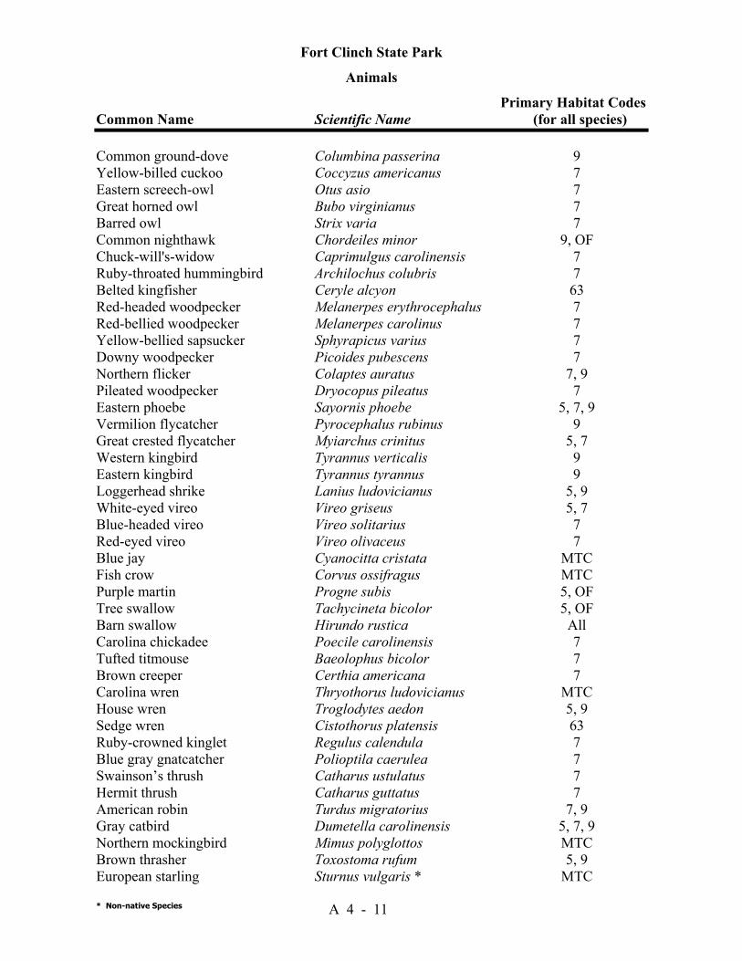
Fort Clinch State Park
Animals Primary Habitat Codes Common Name Scientific Name (for all species)
* Non-native Species A 4 - 11
Common ground-dove Columbina passerina 9 Yellow-billed cuckoo Coccyzus americanus 7 Eastern screech-owl Otus asio 7 Great horned owl Bubo virginianus 7 Barred owl Strix varia 7 Common nighthawk Chordeiles minor 9, OF Chuck-will's-widow Caprimulgus carolinensis 7 Ruby-throated hummingbird Archilochus colubris 7 Belted kingfisher Ceryle alcyon 63 Red-headed woodpecker Melanerpes erythrocephalus 7 Red-bellied woodpecker Melanerpes carolinus 7 Yellow-bellied sapsucker Sphyrapicus varius 7 Downy woodpecker Picoides pubescens 7 Northern flicker Colaptes auratus 7, 9 Pileated woodpecker Dryocopus pileatus 7 Eastern phoebe Sayornis phoebe 5, 7, 9 Vermilion flycatcher Pyrocephalus rubinus 9 Great crested flycatcher Myiarchus crinitus 5, 7 Western kingbird Tyrannus verticalis 9 Eastern kingbird Tyrannus tyrannus 9 Loggerhead shrike Lanius ludovicianus 5, 9 White-eyed vireo Vireo griseus 5, 7 Blue-headed vireo Vireo solitarius 7 Red-eyed vireo Vireo olivaceus 7 Blue jay Cyanocitta cristata MTC Fish crow Corvus ossifragus MTC Purple martin Progne subis 5, OF Tree swallow Tachycineta bicolor 5, OF Barn swallow Hirundo rustica All Carolina chickadee Poecile carolinensis 7 Tufted titmouse Baeolophus bicolor 7 Brown creeper Certhia americana 7 Carolina wren Thryothorus ludovicianus MTC House wren Troglodytes aedon 5, 9 Sedge wren Cistothorus platensis 63 Ruby-crowned kinglet Regulus calendula 7 Blue gray gnatcatcher Polioptila caerulea 7 Swainson’s thrush Catharus ustulatus 7 Hermit thrush Catharus guttatus 7 American robin Turdus migratorius 7, 9 Gray catbird Dumetella carolinensis 5, 7, 9 Northern mockingbird Mimus polyglottos MTC Brown thrasher Toxostoma rufum 5, 9 European starling Sturnus vulgaris * MTC
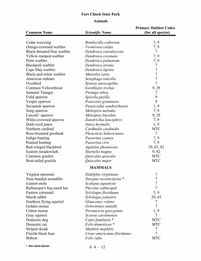
Fort Clinch State Park
Animals Primary Habitat Codes Common Name Scientific Name (for all species)
* Non-native Species A 4 - 12
Cedar waxwing Bombycilla cedrorum 7, 9 Orange-crowned warbler Vermivora celata 7, 9 Black-throated blue warbler Dendroica caerulescens 7 Yellow-rumped warbler Dendroica coronata 7, 9 Palm warbler Dendroica palmarum 7, 9 Blackpoll warbler Dendroica striata 7 Cape May warbler Dendroica tigrina 7 Black-and-white warbler Mniotilta varia 7 American redstart Setophaga ruticilla 7 Ovenbird Seiurus aurocapillus 7 Common Yellowthroat Geothlypis trichas 9, 29 Summer Tanager Piranga rubra 7 Field sparrow Spizella pusilla 9 Vesper sparrow Pooecetes gramineus 9 Savannah sparrow Passerculus sandwichensis 1, 9 Song sparrow Melospiza melodia 7, 9 Lincoln’ sparrow Melospiza lincolnii 9, 29 White-crowned sparrow Zonotrichia leucophrys 7, 9 Dark-eyed junco Junco hyemalis 1, 9 Northern cardinal Cardinalis cardinalis MTC Rose-breasted grosbeak Pheucticus ludovicianus 7 Indigo bunting Passerina cyanea 7, 9 Painted bunting Passerina ciris 7, 9 Red-winged blackbird Agelaius phoeniceus 29, 63, 82 Eastern meadowlark Sturnella magna 9, 82 Common grackle Quiscalus quiscula MTC Boat-tailed grackle Quiscalus major MTC
MAMMALS Virginia opossum Didelphis virginiana 7 Nine-banded armadillo Dasypus novemcinctus * 7 Eastern mole Scalopus aquaticus 7 Rafinesque's big-eared bat Plecotus rafinesquii 7 Eastern cottontail Sylvilagus floridanus 5, 9 Marsh rabbit Sylvilagus palustris 29, 63 Southern flying squirrel Glaucomys volans 7 Golden mouse Ochrotomys nuttalli 7 Cotton mouse Peromyscus gossypinus 1, 9 Gray squirrel Sciurus carolinensis 7 Domestic dog Canis familiaris * MTC Domestic cat Felis domesticus * MTC Striped skunk Mephitis mephitis 7 Florida black bear Ursus americanus floridanus 7 Bobcat Felis rufus MTC
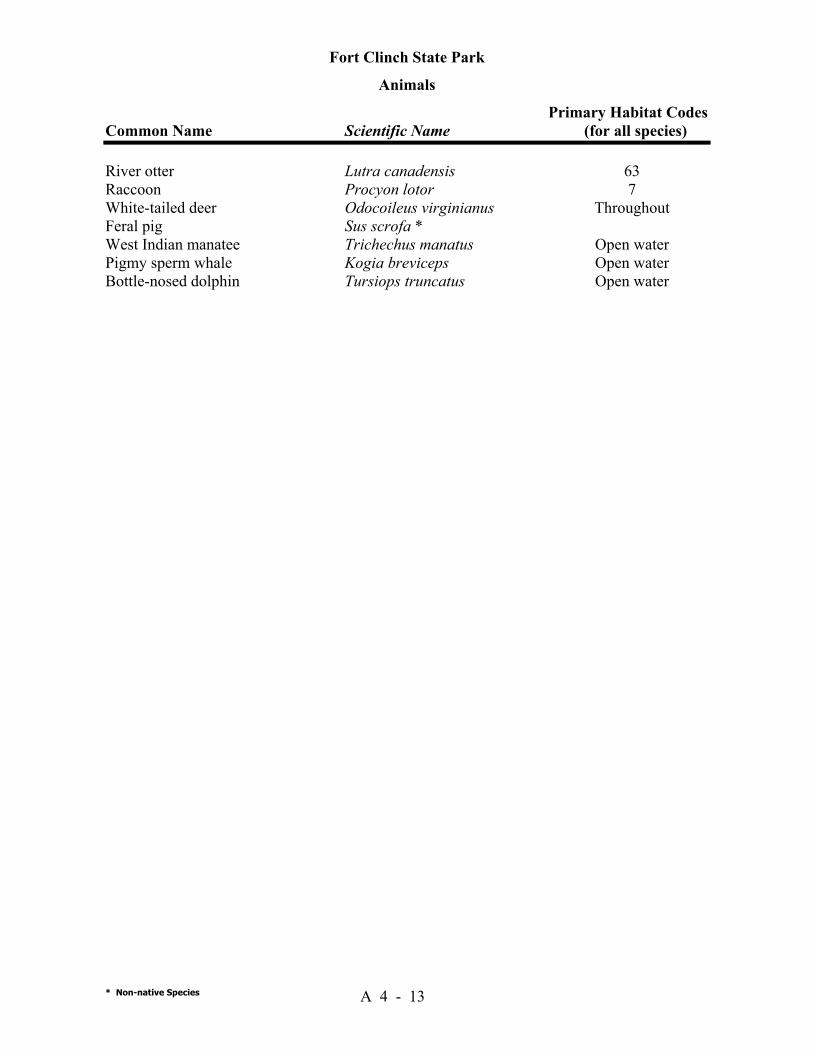
Fort Clinch State Park
Animals Primary Habitat Codes Common Name Scientific Name (for all species)
* Non-native Species A 4 - 13
River otter Lutra canadensis 63 Raccoon Procyon lotor 7 White-tailed deer Odocoileus virginianus Throughout Feral pig Sus scrofa * West Indian manatee Trichechus manatus Open water Pigmy sperm whale Kogia breviceps Open water Bottle-nosed dolphin Tursiops truncatus Open water
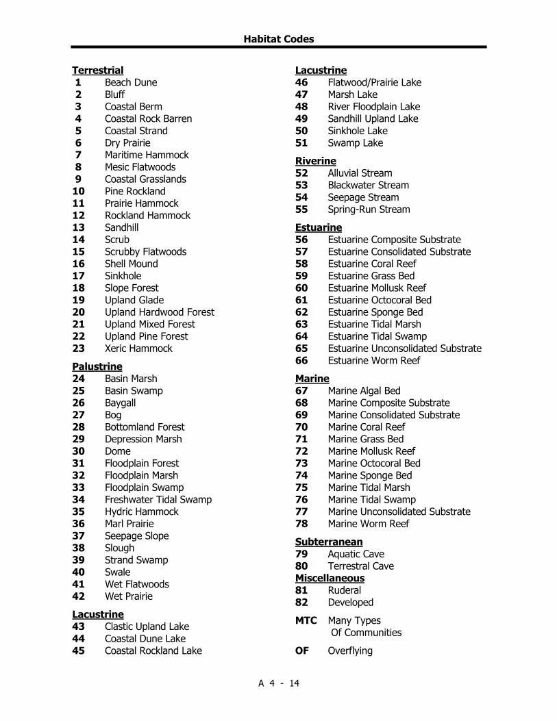
Habitat Codes
A 4 - 14
Terrestrial 1 Beach Dune 2 Bluff 3 Coastal Berm 4 Coastal Rock Barren 5 Coastal Strand 6 Dry Prairie 7 Maritime Hammock 8 Mesic Flatwoods 9 Coastal Grasslands 10 Pine Rockland 11 Prairie Hammock 12 Rockland Hammock 13 Sandhill 14 Scrub 15 Scrubby Flatwoods 16 Shell Mound 17 Sinkhole 18 Slope Forest 19 Upland Glade 20 Upland Hardwood Forest 21 Upland Mixed Forest 22 Upland Pine Forest 23 Xeric Hammock Palustrine 24 Basin Marsh 25 Basin Swamp 26 Baygall 27 Bog 28 Bottomland Forest 29 Depression Marsh 30 Dome 31 Floodplain Forest 32 Floodplain Marsh 33 Floodplain Swamp 34 Freshwater Tidal Swamp 35 Hydric Hammock 36 Marl Prairie 37 Seepage Slope 38 Slough 39 Strand Swamp 40 Swale 41 Wet Flatwoods 42 Wet Prairie Lacustrine 43 Clastic Upland Lake 44 Coastal Dune Lake 45 Coastal Rockland Lake
Lacustrine 46 Flatwood/Prairie Lake 47 Marsh Lake 48 River Floodplain Lake 49 Sandhill Upland Lake 50 Sinkhole Lake 51 Swamp Lake Riverine 52 Alluvial Stream 53 Blackwater Stream 54 Seepage Stream 55 Spring-Run Stream Estuarine 56 Estuarine Composite Substrate 57 Estuarine Consolidated Substrate 58 Estuarine Coral Reef 59 Estuarine Grass Bed 60 Estuarine Mollusk Reef 61 Estuarine Octocoral Bed 62 Estuarine Sponge Bed 63 Estuarine Tidal Marsh 64 Estuarine Tidal Swamp 65 Estuarine Unconsolidated Substrate 66 Estuarine Worm Reef Marine 67 Marine Algal Bed 68 Marine Composite Substrate 69 Marine Consolidated Substrate 70 Marine Coral Reef 71 Marine Grass Bed 72 Marine Mollusk Reef 73 Marine Octocoral Bed 74 Marine Sponge Bed 75 Marine Tidal Marsh 76 Marine Tidal Swamp 77 Marine Unconsolidated Substrate 78 Marine Worm Reef Subterranean 79 Aquatic Cave 80 Terrestral Cave Miscellaneous 81 Ruderal 82 Developed MTC Many Types Of Communities OF Overflying

Addendum 5—Designated Species List

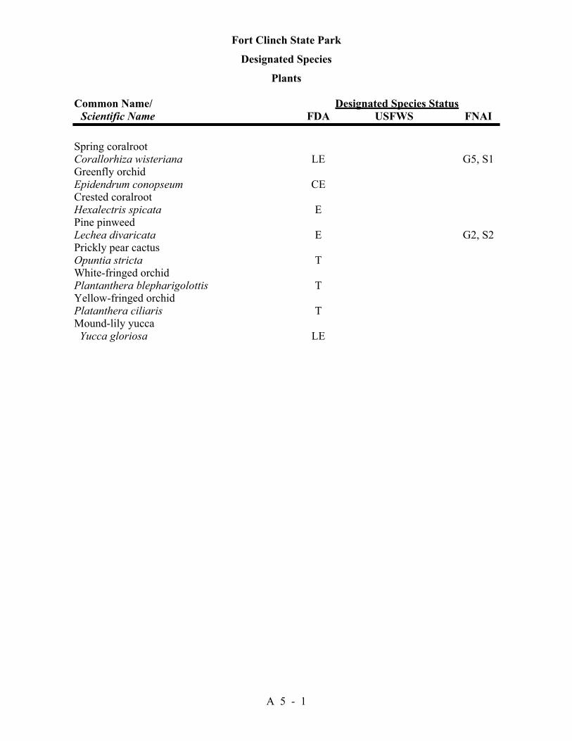
Fort Clinch State Park
Designated Species
Plants Common Name/ Designated Species Status Scientific Name FDA USFWS FNAI
A 5 - 1
Spring coralroot Corallorhiza wisteriana LE G5, S1 Greenfly orchid Epidendrum conopseum CE Crested coralroot Hexalectris spicata E Pine pinweed Lechea divaricata E G2, S2 Prickly pear cactus Opuntia stricta T White-fringed orchid Plantanthera blepharigolottis T Yellow-fringed orchid Platanthera ciliaris T Mound-lily yucca Yucca gloriosa LE
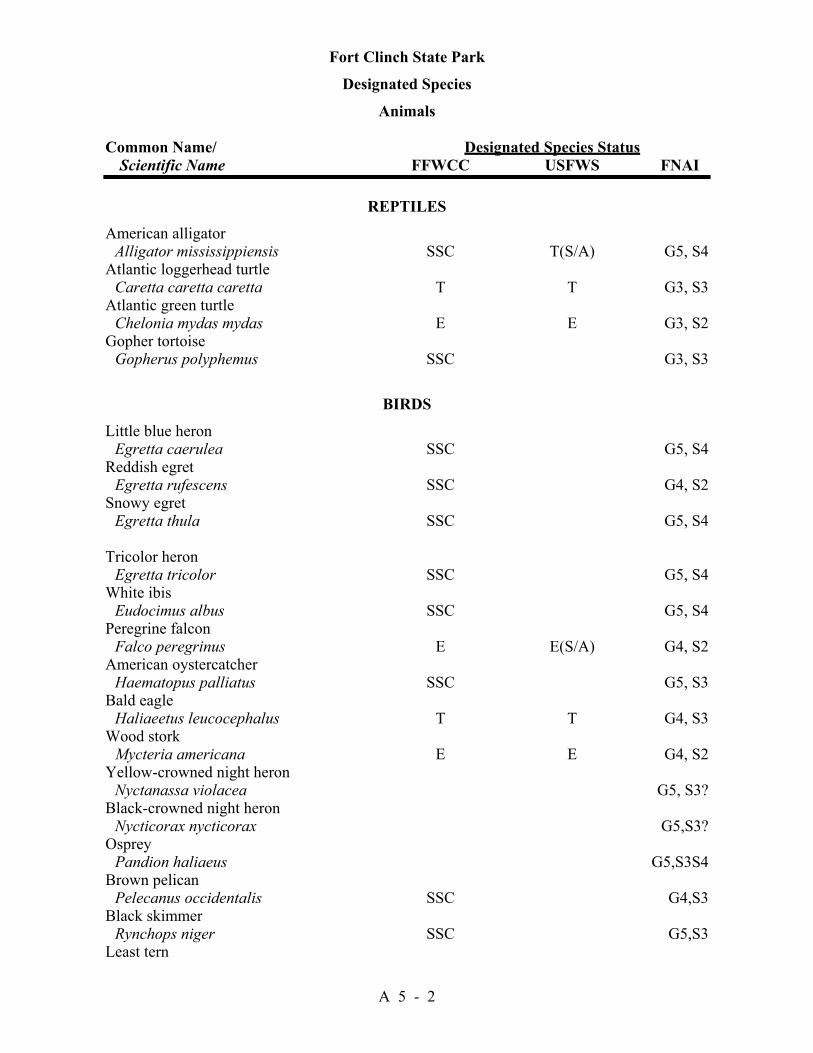
Fort Clinch State Park
Designated Species
Animals Common Name/ Designated Species Status Scientific Name FFWCC USFWS FNAI
A 5 - 2
REPTILES American alligator Alligator mississippiensis SSC T(S/A) G5, S4 Atlantic loggerhead turtle Caretta caretta caretta T T G3, S3 Atlantic green turtle Chelonia mydas mydas E E G3, S2 Gopher tortoise Gopherus polyphemus SSC G3, S3
BIRDS Little blue heron Egretta caerulea SSC G5, S4 Reddish egret Egretta rufescens SSC G4, S2 Snowy egret Egretta thula SSC G5, S4 Tricolor heron Egretta tricolor SSC G5, S4 White ibis Eudocimus albus SSC G5, S4 Peregrine falcon Falco peregrinus E E(S/A) G4, S2 American oystercatcher Haematopus palliatus SSC G5, S3 Bald eagle Haliaeetus leucocephalus T T G4, S3 Wood stork Mycteria americana E E G4, S2 Yellow-crowned night heron Nyctanassa violacea G5, S3? Black-crowned night heron Nycticorax nycticorax G5,S3? Osprey Pandion haliaeus G5,S3S4 Brown pelican Pelecanus occidentalis SSC G4,S3 Black skimmer Rynchops niger SSC G5,S3 Least tern
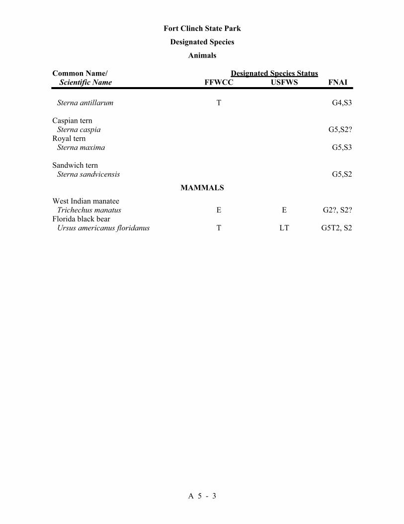
Fort Clinch State Park
Designated Species
Animals Common Name/ Designated Species Status Scientific Name FFWCC USFWS FNAI
A 5 - 3
Sterna antillarum T G4,S3 Caspian tern Sterna caspia G5,S2? Royal tern Sterna maxima G5,S3 Sandwich tern Sterna sandvicensis G5,S2
MAMMALS West Indian manatee Trichechus manatus E E G2?, S2? Florida black bear Ursus americanus floridanus T LT G5T2, S2

Rank Explanations For FNAI Global Rank, FNAI State Rank, Federal Status,
And State Status
A 5 - 4
The Nature Conservancy and the Natural Heritage Program Network (of which FNAI is a part) define an element as any exemplary or rare component of the natural environment, such as a species, natural community, bird rookery, spring, sinkhole, cave, or other ecological feature. An element occurrence (EO) is a single extant habitat that sustains or otherwise contributes to the survival of a population or a distinct, self-sustaining example of a particular element. Using a ranking system developed by The Nature Conservancy and the Natural Heritage Program Network, the Florida Natural Areas Inventory assigns two ranks to each element. The global rank is based on an element's worldwide status; the state rank is based on the status of the element in Florida. Element ranks are based on many factors, the most important ones being estimated number of Element occurrences, estimated abundance (number of individuals for species; area for natural communities), range, estimated adequately protected EOs, relative threat of destruction, and ecological fragility. Federal and State status information is from the U.S. Fish and Wildlife Service; and the Florida Game and Freshwater Fish Commission (animals), and the Florida Department of Agriculture and Consumer Services (plants), respectively.
FNAI GLOBAL RANK DEFINITIONS G1 = Critically imperiled globally because of extreme rarity (5 or fewer occurrences or less than 1000
individuals) or because of extreme vulnerability to extinction due to some natural or man-made factor.
G2 = Imperiled globally because of rarity (6 to 20 occurrences or less than 3000 individuals) or because of vulnerability to extinction due to some natural or man-made factor.
G3 = Either very rare and local throughout its range (21-100 occurrences or less than 10,000 individuals) or found locally in a restricted range or vulnerable to extinction of other factors.
G4 = apparently secure globally (may be rare in parts of range) G5 = demonstrably secure globally GH = of historical occurrence throughout its range, may be rediscovered (e.g., ivory-billed
woodpecker) GX = believed to be extinct throughout range GXC = extirpated from the wild but still known from captivity or cultivation G#? = tentative rank (e.g.,G2?) G#G# = range of rank; insufficient data to assign specific global rank (e.g., G2G3) G#T# = rank of a taxonomic subgroup such as a subspecies or variety; the G portion of the rank refers
to the entire species and the T portion refers to the specific subgroup; numbers have same definition as above (e.g., G3T1)
G#Q = rank of questionable species - ranked as species but questionable whether it is species or subspecies; numbers have same definition as above (e.g., G2Q)
G#T#Q = same as above, but validity as subspecies or variety is questioned. GU = due to lack of information, no rank or range can be assigned (e.g., GUT2). G? = not yet ranked (temporary) S1 = Critically imperiled in Florida because of extreme rarity (5 or fewer occurrences or less than
1000 individuals) or because of extreme vulnerability to extinction due to some natural or man-made factor.
S2 = Imperiled in Florida because of rarity (6 to 20 occurrences or less than 3000 individuals) or because of vulnerability to extinction due to some natural or man-made factor.
S3 = Either very rare and local throughout its range (21-100 occurrences or less than 10,000 individuals) or found locally in a restricted range or vulnerable to extinction of other factors.
S4 = apparently secure in Florida (may be rare in parts of range) S5 = demonstrably secure in Florida SH = of historical occurrence throughout its range, may be rediscovered (e.g., ivory-billed
woodpecker) SX = believed to be extinct throughout range SA = accidental in Florida, i.e., not part of the established biota SE = an exotic species established in Florida may be native elsewhere in North America SN = regularly occurring, but widely and unreliably distributed; sites for conservation hard to
determine SU = due to lack of information, no rank or range can be assigned (e.g., SUT2). S? = not yet ranked (temporary)
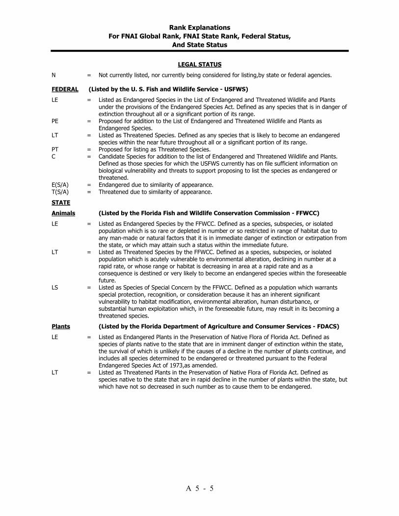
Rank Explanations For FNAI Global Rank, FNAI State Rank, Federal Status,
And State Status
A 5 - 5
LEGAL STATUS N = Not currently listed, nor currently being considered for listing,by state or federal agencies. FEDERAL (Listed by the U. S. Fish and Wildlife Service - USFWS) LE = Listed as Endangered Species in the List of Endangered and Threatened Wildlife and Plants
under the provisions of the Endangered Species Act. Defined as any species that is in danger of extinction throughout all or a significant portion of its range.
PE = Proposed for addition to the List of Endangered and Threatened Wildlife and Plants as Endangered Species.
LT = Listed as Threatened Species. Defined as any species that is likely to become an endangered species within the near future throughout all or a significant portion of its range.
PT = Proposed for listing as Threatened Species. C = Candidate Species for addition to the list of Endangered and Threatened Wildlife and Plants.
Defined as those species for which the USFWS currently has on file sufficient information on biological vulnerability and threats to support proposing to list the species as endangered or threatened.
E(S/A) = Endangered due to similarity of appearance. T(S/A) = Threatened due to similarity of appearance. STATE Animals (Listed by the Florida Fish and Wildlife Conservation Commission - FFWCC) LE = Listed as Endangered Species by the FFWCC. Defined as a species, subspecies, or isolated
population which is so rare or depleted in number or so restricted in range of habitat due to any man-made or natural factors that it is in immediate danger of extinction or extirpation from the state, or which may attain such a status within the immediate future.
LT = Listed as Threatened Species by the FFWCC. Defined as a species, subspecies, or isolated population which is acutely vulnerable to environmental alteration, declining in number at a rapid rate, or whose range or habitat is decreasing in area at a rapid rate and as a consequence is destined or very likely to become an endangered species within the foreseeable future.
LS = Listed as Species of Special Concern by the FFWCC. Defined as a population which warrants special protection, recognition, or consideration because it has an inherent significant vulnerability to habitat modification, environmental alteration, human disturbance, or substantial human exploitation which, in the foreseeable future, may result in its becoming a threatened species.
Plants (Listed by the Florida Department of Agriculture and Consumer Services - FDACS) LE = Listed as Endangered Plants in the Preservation of Native Flora of Florida Act. Defined as
species of plants native to the state that are in imminent danger of extinction within the state, the survival of which is unlikely if the causes of a decline in the number of plants continue, and includes all species determined to be endangered or threatened pursuant to the Federal Endangered Species Act of 1973,as amended.
LT = Listed as Threatened Plants in the Preservation of Native Flora of Florida Act. Defined as species native to the state that are in rapid decline in the number of plants within the state, but which have not so decreased in such number as to cause them to be endangered.


Addendum 6--Priority Schedule And Cost Estimates

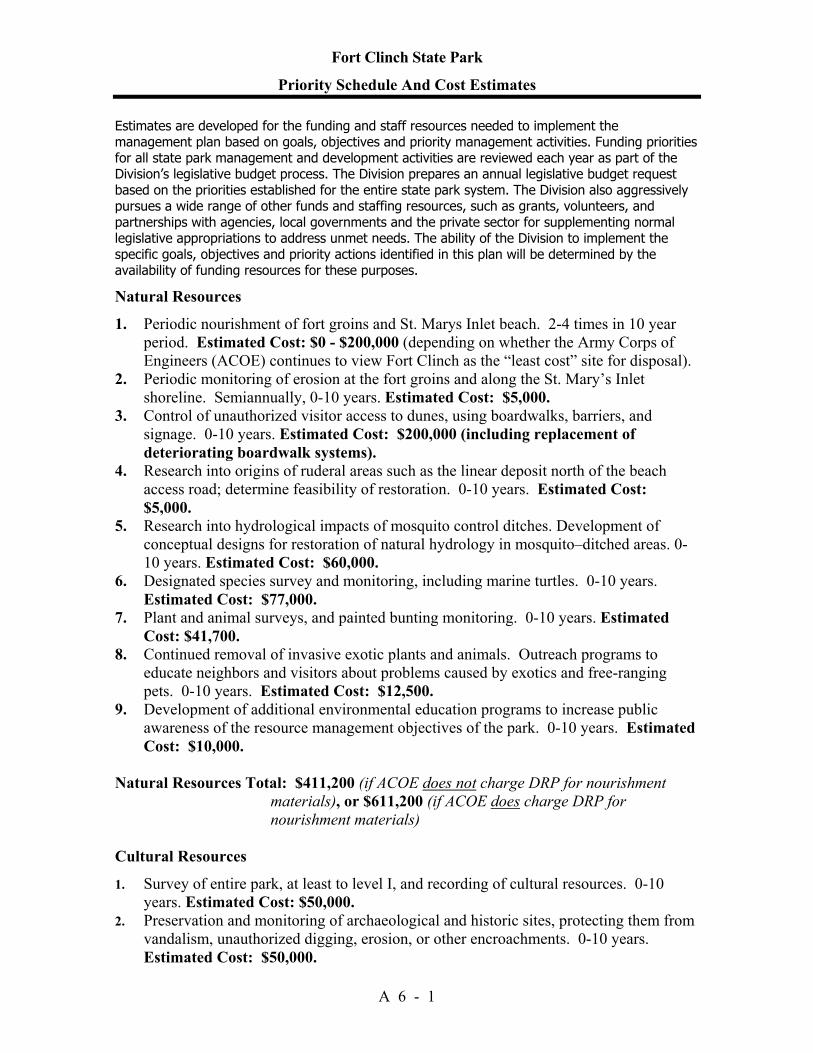
Fort Clinch State Park
Priority Schedule And Cost Estimates
A 6 - 1
Estimates are developed for the funding and staff resources needed to implement the management plan based on goals, objectives and priority management activities. Funding priorities for all state park management and development activities are reviewed each year as part of the Division’s legislative budget process. The Division prepares an annual legislative budget request based on the priorities established for the entire state park system. The Division also aggressively pursues a wide range of other funds and staffing resources, such as grants, volunteers, and partnerships with agencies, local governments and the private sector for supplementing normal legislative appropriations to address unmet needs. The ability of the Division to implement the specific goals, objectives and priority actions identified in this plan will be determined by the availability of funding resources for these purposes. Natural Resources 1. Periodic nourishment of fort groins and St. Marys Inlet beach. 2-4 times in 10 year
period. Estimated Cost: $0 - $200,000 (depending on whether the Army Corps of Engineers (ACOE) continues to view Fort Clinch as the “least cost” site for disposal).
2. Periodic monitoring of erosion at the fort groins and along the St. Mary’s Inlet shoreline. Semiannually, 0-10 years. Estimated Cost: $5,000.
3. Control of unauthorized visitor access to dunes, using boardwalks, barriers, and signage. 0-10 years. Estimated Cost: $200,000 (including replacement of deteriorating boardwalk systems).
4. Research into origins of ruderal areas such as the linear deposit north of the beach access road; determine feasibility of restoration. 0-10 years. Estimated Cost: $5,000.
5. Research into hydrological impacts of mosquito control ditches. Development of conceptual designs for restoration of natural hydrology in mosquito–ditched areas. 0-10 years. Estimated Cost: $60,000.
6. Designated species survey and monitoring, including marine turtles. 0-10 years. Estimated Cost: $77,000.
7. Plant and animal surveys, and painted bunting monitoring. 0-10 years. Estimated Cost: $41,700.
8. Continued removal of invasive exotic plants and animals. Outreach programs to educate neighbors and visitors about problems caused by exotics and free-ranging pets. 0-10 years. Estimated Cost: $12,500.
9. Development of additional environmental education programs to increase public awareness of the resource management objectives of the park. 0-10 years. Estimated Cost: $10,000.
Natural Resources Total: $411,200 (if ACOE does not charge DRP for nourishment
materials), or $611,200 (if ACOE does charge DRP for nourishment materials)
Cultural Resources 1. Survey of entire park, at least to level I, and recording of cultural resources. 0-10
years. Estimated Cost: $50,000. 2. Preservation and monitoring of archaeological and historic sites, protecting them from
vandalism, unauthorized digging, erosion, or other encroachments. 0-10 years. Estimated Cost: $50,000.

Fort Clinch State Park
Priority Schedule And Cost Estimates
A 6 - 2
3. Implementation of programs of cyclical or periodic maintenance for cultural resources. 0-10 years. Estimated Cost: $10,000.
4. Monitoring of historic structures and stabilization as needed. Continuation of repairs to fort. 0-10 years. Estimated Cost: $1,000,000.
5. Research about historical land uses in the area, effects of federal closure of the fort, and park operations during CCC and World War II periods. 0-10 years. Estimated Cost: $15,000.
6. Continued curation of park collections, and additions to the formal Scope of Collections Statement. 0-10 years. Estimated Cost: $50,000 (if out-sourced).
Cultural Resources Total: $ 1,175,000
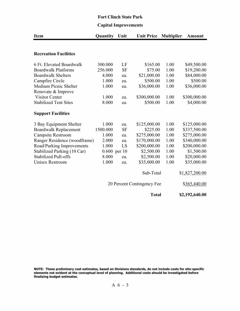
Fort Clinch State Park
Capital Improvements
Item Quantity Unit Unit Price Multiplier Amount
NOTE: These preliminary cost estimates, based on Divisions standards, do not include costs for site-specific elements not evident at the conceptual level of planning. Additional costs should be investigated before finalizing budget estimates.
A 6 - 3
Recreation Facilities 6 Ft. Elevated Boardwalk 300.000 LF $165.00 1.00 $49,500.00 Boardwalk Platforms 256.000 SF $75.00 1.00 $19,200.00 Boardwalk Shelters 4.000 ea. $21,000.00 1.00 $84,000.00 Campfire Circle 1.000 ea. $500.00 1.00 $500.00 Medium Picnic Shelter 1.000 ea. $36,000.00 1.00 $36,000.00 Renovate & Improve Visitor Center 1.000 ea. $300,000.00 1.00 $300,000.00 Stabilized Tent Sites 8.000 ea. $500.00 1.00 $4,000.00 Support Facilities 3 Bay Equipment Shelter 1.000 ea. $125,000.00 1.00 $125,000.00 Boardwalk Replacement 1500.000 SF $225.00 1.00 $337,500.00 Campsite Restroom 1.000 ea. $275,000.00 1.00 $275,000.00 Ranger Residence (woodframe) 2.000 ea. $170,000.00 1.00 $340,000.00 Road/Parking Improvements 1.000 LS $200,000.00 1.00 $200,000.00 Stabilized Parking (10 Car) 0.600 per 10 $2,500.00 1.00 $1,500.00 Stabilized Pull-offs 8.000 ea. $2,500.00 1.00 $20,000.00 Unisex Restroom 1.000 ea. $35,000.00 1.00 $35,000.00 Sub-Total $1,827,200.00 20 Percent Contingency Fee $365,440.00 Total $2,192,640.00

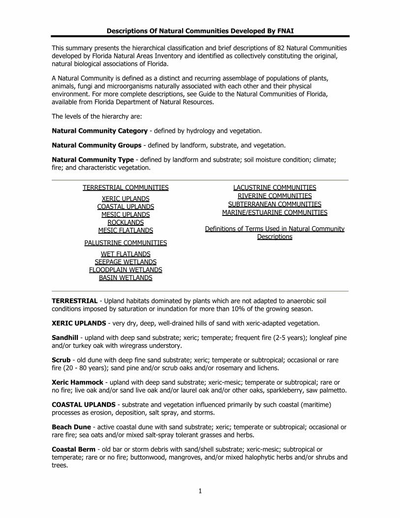
Descriptions Of Natural Communities Developed By FNAI
This summary presents the hierarchical classification and brief descriptions of 82 Natural Communities developed by Florida Natural Areas Inventory and identified as collectively constituting the original, natural biological associations of Florida.
A Natural Community is defined as a distinct and recurring assemblage of populations of plants, animals, fungi and microorganisms naturally associated with each other and their physical environment. For more complete descriptions, see Guide to the Natural Communities of Florida, available from Florida Department of Natural Resources.
The levels of the hierarchy are:
Natural Community Category - defined by hydrology and vegetation.
Natural Community Groups - defined by landform, substrate, and vegetation.
Natural Community Type - defined by landform and substrate; soil moisture condition; climate; fire; and characteristic vegetation.
TERRESTRIAL COMMUNITIES
XERIC UPLANDS COASTAL UPLANDS
MESIC UPLANDS ROCKLANDS
MESIC FLATLANDS
PALUSTRINE COMMUNITIES
WET FLATLANDS SEEPAGE WETLANDS
FLOODPLAIN WETLANDS BASIN WETLANDS
LACUSTRINE COMMUNITIES RIVERINE COMMUNITIES
SUBTERRANEAN COMMUNITIES MARINE/ESTUARINE COMMUNITIES
Definitions of Terms Used in Natural Community
Descriptions
TERRESTRIAL - Upland habitats dominated by plants which are not adapted to anaerobic soil conditions imposed by saturation or inundation for more than 10% of the growing season.
XERIC UPLANDS - very dry, deep, well-drained hills of sand with xeric-adapted vegetation.
Sandhill - upland with deep sand substrate; xeric; temperate; frequent fire (2-5 years); longleaf pine and/or turkey oak with wiregrass understory.
Scrub - old dune with deep fine sand substrate; xeric; temperate or subtropical; occasional or rare fire (20 - 80 years); sand pine and/or scrub oaks and/or rosemary and lichens.
Xeric Hammock - upland with deep sand substrate; xeric-mesic; temperate or subtropical; rare or no fire; live oak and/or sand live oak and/or laurel oak and/or other oaks, sparkleberry, saw palmetto.
COASTAL UPLANDS - substrate and vegetation influenced primarily by such coastal (maritime) processes as erosion, deposition, salt spray, and storms.
Beach Dune - active coastal dune with sand substrate; xeric; temperate or subtropical; occasional or rare fire; sea oats and/or mixed salt-spray tolerant grasses and herbs.
Coastal Berm - old bar or storm debris with sand/shell substrate; xeric-mesic; subtropical or temperate; rare or no fire; buttonwood, mangroves, and/or mixed halophytic herbs and/or shrubs and trees.
1

Descriptions Of Natural Communities Developed By FNAI
Coastal Grassland - coastal flatland with sand substrate; xeric-mesic; subtropical or temperate; occasional fire; grasses, herbs, and shrubs with or without slash pine and/or cabbage palm.
Coastal Rock Barren - flatland with exposed limestone substrate; xeric; subtropical; no fire; algae, mixed halophytic herbs and grasses, and/or cacti and stunted shrubs and trees.
Coastal Strand - stabilized coastal dune with sand substrate; xeric; subtropical or temperate; occasional or rare fire; dense saw palmetto and/or seagrape and/or mixed stunted shrubs, yucca, and cacti.
Maritime Hammock - stabilized coastal dune with sand substrate; xeric-mesic; subtropical or temperate; rare or no fire; mixed hardwoods and/or live oak.
Shell Mound - Indian midden with shell substrate; xeric-mesic; subtropical or temperate; rare or no fire; mixed hardwoods.
MESIC UPLANDS - dry to moist hills of sand with varying amounts of clay, silt or organic material; diverse mixture of broadleaved and needleleaved temperate woody species.
Bluff - steep slope with rock, sand, and/or clay substrate; hydric-xeric; temperate; sparse grasses, herbs and shrubs.
Slope Forest - steep slope on bluff or in sheltered ravine; sand/clay substrate; mesic-hydric; temperate; rare or no fire; magnolia, beech, spruce pine, Shumard oak, Florida maple, mixed hardwoods.
Upland Glade - upland with calcareous rock and/or clay substrate; hydric-xeric; temperate; sparse mixed grasses and herbs with occasional stunted trees and shrubs, e.g., eastern red cedar.
Upland Hardwood Forest - upland with sand/clay and/or calcareous substrate; mesic; temperate; rare or no fire; spruce pine, magnolia, beech, pignut hickory, white oak, and mixed hardwoods.
Upland Mixed Forest - upland with sand/clay substrate; mesic; temperate; rare or no fire; loblolly pine and/or shortleaf pine and/or laurel oak and/or magnolia and spruce pine and/or mixed hardwoods.
Upland Pine Forest - upland with sand/clay substrate; mesic-xeric; temperate; frequent or occasional fire; longleaf pine and/or loblolly pine and/or shortleaf pine, southern red oak, wiregrass.
ROCKLANDS - low, generally flat limestone outcrops with tropical vegetation; or limestone exposed through karst activities with tropical or temperate vegetation.
Pine Rockland - flatland with exposed limestone substrate; mesic-xeric; subtropical; frequent fire; south Florida slash pine, palms and/or hardwoods, and mixed grasses and herbs.
Rockland Hammock - flatland with limestone substrate; mesic; subtropical; rare or no fire; mixed tropical hardwoods, often with live oak.
Sinkhole - karst feature with steep limestone walls; mesic-hydric; subtropical or temperate; no fire; ferns, herbs, shrubs, and hardwoods.
MESIC FLATLANDS - flat, moderately well-drained sandy substrates with admixture of organic material, often with a hard pan.
Dry Prairie - flatland with sand substrate; mesic-xeric; subtropical or temperate; annual or frequent fire; wiregrass, saw palmetto, and mixed grasses and herbs.
Mesic Flatwoods - flatland with sand substrate; mesic; subtropical or temperate; frequent fire; slash
2

Descriptions Of Natural Communities Developed By FNAI
pine and/or longleaf pine with saw palmetto, gallberry and/or wiregrass or cutthroat grass understory.
Prairie Hammock - flatland with sand/organic soil over marl or limestone substrate; mesic; subtropical; occasional or rare fire; live oak and/or cabbage palm.
Scrubby Flatwoods - flatland with sand substrate; xeric-mesic; subtropical or temperate; occasional fire; longleaf pine or slash pine with scrub oaks and wiregrass understory.
PALUSTRINE - Wetlands dominated by plants adapted to anaerobic substrate conditions imposed by substrate saturation or inundation during 10% or more of the growing season. Includes non-tidal wetlands; tidal wetlands with ocean derived salinities less than 0.5 ppt and dominance by salt-intolerant species; small (less than 8 ha), shallow (less than 2 m deep at low water) water bodies without wave-formed or bedrock shoreline; and inland brackish or saline wetlands.
WET FLATLANDS - flat, poorly drained sand, marl or limestone substrates.
Hydric Hammock - lowland with sand/clay/organic soil, often over limestone; mesic-hydric; subtropical or temperate; rare or no fire; water oak, cabbage palm, red cedar, red maple, bays, hackberry, hornbeam, blackgum, needle palm, and mixed hardwoods.
Marl Prairie - flatland with marl over limestone substrate; seasonally inundated; tropical; frequent to no fire; sawgrass, spikerush, and/or mixed grasses, sometimes with dwarf cypress.
Wet Flatwoods - flatland with sand substrate; seasonally inundated; subtropical or temperate; frequent fire; vegetation characterized by slash pine or pond pine and/or cabbage palm with mixed grasses and herbs.
Wet Prairie - flatland with sand substrate; seasonally inundated; subtropical or temperate; annual or frequent fire; maidencane, beakrush, spikerush, wiregrass, pitcher plants, St. John's wort, mixed herbs.
SEEPAGE WETLANDS - sloped or flat sands or peat with high moisture levels maintained by downslope seepage; wetland and mesic woody and/or herbaceous vegetation.
Baygall - wetland with peat substrate at base of slope; maintained by downslope seepage, usually saturated and occasionally inundated; subtropical or temperate; rare or no fire; bays and/or dahoon holly and/or red maple and/or mixed hardwoods.
Seepage Slope - wetland on or at base of slope with organic/sand substrate; maintained by downslope seepage, usually saturated but rarely inundated; subtropical or temperate; frequent or occasional fire; sphagnum moss, mixed grasses and herbs or mixed hydrophytic shrubs.
FLOODPLAIN WETLANDS - flat, alluvial sand or peat substrates associated with flowing water courses and subjected to flooding but not permanent inundation; wetland or mesic woody and herbaceous vegetation.
Bottomland Forest - flatland with sand/clay/organic substrate; occasionally inundated; temperate; rare or no fire; water oak, red maple, beech, magnolia, tuliptree, sweetgum, bays, cabbage palm, and mixed hardwoods.
Floodplain Forest - floodplain with alluvial substrate of sand, silt, clay or organic soil; seasonally inundated; temperate; rare or no fire; diamondleaf oak, overcup oak, water oak, swamp chestnut oak, blue palmetto, cane, and mixed hardwoods.
Floodplain Marsh - floodplain with organic/sand/alluvial substrate; seasonally inundated; subtropical; frequent or occasional fire; maidencane, pickerelweed, sagittaria spp., buttonbush, and mixed emergents.
3
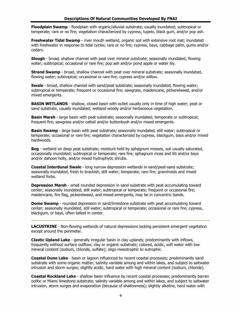
Descriptions Of Natural Communities Developed By FNAI
Floodplain Swamp - floodplain with organic/alluvial substrate; usually inundated; subtropical or temperate; rare or no fire; vegetation characterized by cypress, tupelo, black gum, and/or pop ash.
Freshwater Tidal Swamp - river mouth wetland, organic soil with extensive root mat; inundated with freshwater in response to tidal cycles; rare or no fire; cypress, bays, cabbage palm, gums and/or cedars.
Slough - broad, shallow channel with peat over mineral substrate; seasonally inundated, flowing water; subtropical; occasional or rare fire; pop ash and/or pond apple or water lily.
Strand Swamp - broad, shallow channel with peat over mineral substrate; seasonally inundated, flowing water; subtropical; occasional or rare fire; cypress and/or willow.
Swale - broad, shallow channel with sand/peat substrate; seasonally inundated, flowing water; subtropical or temperate; frequent or occasional fire; sawgrass, maidencane, pickerelweed, and/or mixed emergents.
BASIN WETLANDS - shallow, closed basin with outlet usually only in time of high water; peat or sand substrate, usually inundated; wetland woody and/or herbaceous vegetation.
Basin Marsh - large basin with peat substrate; seasonally inundated; temperate or subtropical; frequent fire; sawgrass and/or cattail and/or buttonbush and/or mixed emergents.
Basin Swamp - large basin with peat substrate; seasonally inundated, still water; subtropical or temperate; occasional or rare fire; vegetation characterized by cypress, blackgum, bays and/or mixed hardwoods.
Bog - wetland on deep peat substrate; moisture held by sphagnum mosses, soil usually saturated, occasionally inundated; subtropical or temperate; rare fire; sphagnum moss and titi and/or bays and/or dahoon holly, and/or mixed hydrophytic shrubs.
Coastal Interdunal Swale - long narrow depression wetlands in sand/peat-sand substrate; seasonally inundated, fresh to brackish, still water; temperate; rare fire; graminoids and mixed wetland forbs.
Depression Marsh - small rounded depression in sand substrate with peat accumulating toward center; seasonally inundated, still water; subtropical or temperate; frequent or occasional fire; maidencane, fire flag, pickerelweed, and mixed emergents, may be in concentric bands.
Dome Swamp - rounded depression in sand/limestone substrate with peat accumulating toward center; seasonally inundated, still water; subtropical or temperate; occasional or rare fire; cypress, blackgum, or bays, often tallest in center.
LACUSTRINE - Non-flowing wetlands of natural depressions lacking persistent emergent vegetation except around the perimeter.
Clastic Upland Lake - generally irregular basin in clay uplands; predominantly with inflows, frequently without surface outflow; clay or organic substrate; colored, acidic, soft water with low mineral content (sodium, chloride, sulfate); oligo-mesotrophic to eutrophic.
Coastal Dune Lake - basin or lagoon influenced by recent coastal processes; predominantly sand substrate with some organic matter; salinity variable among and within lakes, and subject to saltwater intrusion and storm surges; slightly acidic, hard water with high mineral content (sodium, chloride).
Coastal Rockland Lake - shallow basin influence by recent coastal processes; predominantly barren oolitic or Miami limestone substrate; salinity variable among and within lakes, and subject to saltwater intrusion, storm surges and evaporation (because of shallowness); slightly alkaline, hard water with
4
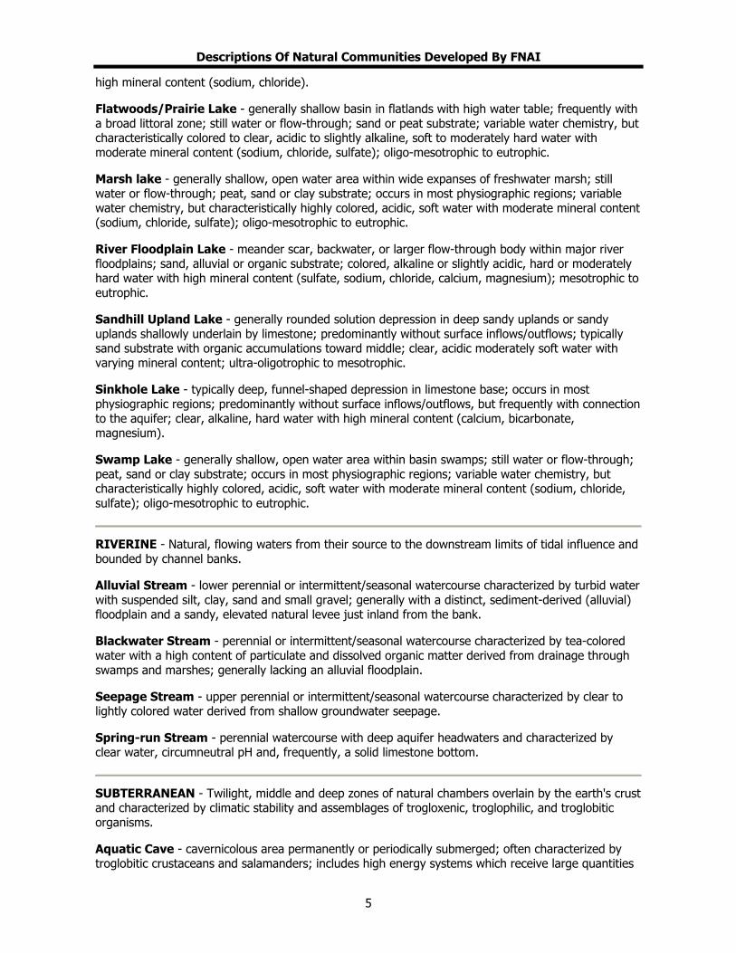
Descriptions Of Natural Communities Developed By FNAI
high mineral content (sodium, chloride).
Flatwoods/Prairie Lake - generally shallow basin in flatlands with high water table; frequently with a broad littoral zone; still water or flow-through; sand or peat substrate; variable water chemistry, but characteristically colored to clear, acidic to slightly alkaline, soft to moderately hard water with moderate mineral content (sodium, chloride, sulfate); oligo-mesotrophic to eutrophic.
Marsh lake - generally shallow, open water area within wide expanses of freshwater marsh; still water or flow-through; peat, sand or clay substrate; occurs in most physiographic regions; variable water chemistry, but characteristically highly colored, acidic, soft water with moderate mineral content (sodium, chloride, sulfate); oligo-mesotrophic to eutrophic.
River Floodplain Lake - meander scar, backwater, or larger flow-through body within major river floodplains; sand, alluvial or organic substrate; colored, alkaline or slightly acidic, hard or moderately hard water with high mineral content (sulfate, sodium, chloride, calcium, magnesium); mesotrophic to eutrophic.
Sandhill Upland Lake - generally rounded solution depression in deep sandy uplands or sandy uplands shallowly underlain by limestone; predominantly without surface inflows/outflows; typically sand substrate with organic accumulations toward middle; clear, acidic moderately soft water with varying mineral content; ultra-oligotrophic to mesotrophic.
Sinkhole Lake - typically deep, funnel-shaped depression in limestone base; occurs in most physiographic regions; predominantly without surface inflows/outflows, but frequently with connection to the aquifer; clear, alkaline, hard water with high mineral content (calcium, bicarbonate, magnesium).
Swamp Lake - generally shallow, open water area within basin swamps; still water or flow-through; peat, sand or clay substrate; occurs in most physiographic regions; variable water chemistry, but characteristically highly colored, acidic, soft water with moderate mineral content (sodium, chloride, sulfate); oligo-mesotrophic to eutrophic.
RIVERINE - Natural, flowing waters from their source to the downstream limits of tidal influence and bounded by channel banks.
Alluvial Stream - lower perennial or intermittent/seasonal watercourse characterized by turbid water with suspended silt, clay, sand and small gravel; generally with a distinct, sediment-derived (alluvial) floodplain and a sandy, elevated natural levee just inland from the bank.
Blackwater Stream - perennial or intermittent/seasonal watercourse characterized by tea-colored water with a high content of particulate and dissolved organic matter derived from drainage through swamps and marshes; generally lacking an alluvial floodplain.
Seepage Stream - upper perennial or intermittent/seasonal watercourse characterized by clear to lightly colored water derived from shallow groundwater seepage.
Spring-run Stream - perennial watercourse with deep aquifer headwaters and characterized by clear water, circumneutral pH and, frequently, a solid limestone bottom.
SUBTERRANEAN - Twilight, middle and deep zones of natural chambers overlain by the earth's crust and characterized by climatic stability and assemblages of trogloxenic, troglophilic, and troglobitic organisms.
Aquatic Cave - cavernicolous area permanently or periodically submerged; often characterized by troglobitic crustaceans and salamanders; includes high energy systems which receive large quantities
5

Descriptions Of Natural Communities Developed By FNAI
of organic detritus and low energy systems.
Terrestrial Cave - cavernicolous area lacking standing water; often characterized by bats, such as Myotis spp., and other terrestrial vertebrates and invertebrates; includes interstitial areas above standing water such as fissures in the ceiling of caves.
MARINE/ESTUARINE (The distinction between the Marine and Estuarine Natural Communities is often subtle, and the natural communities types found under these two community categories have the same descriptions. For these reasons they have been grouped together.) - Subtidal, intertidal and supratidal zones of the sea, landward to the point at which seawater becomes significantly diluted with freshwater inflow from the land.
Consolidated Substrate - expansive subtidal, intertidal and supratidal area composed primarily of nonliving compacted or coherent and relatively hard, naturally formed mass of mineral matter (e.g., coquina limerock and relic reefs); octocorals, sponges, stony corals, nondrift macrophytic algae, blue-green mat-forming algae and seagrasses sparse, if present.
Unconsolidated Substrate - expansive subtidal, intertidal and supratidal area composed primarily of loose mineral matter (e.g., coralgal, gravel, marl, mud, sand and shell); octocorals, sponges, stony corals, nondrift macrophytic algae, blue-green mat-forming algae and seagrasses sparse, if present.
Octocoral Bed - expansive subtidal area occupied primarily by living sessile organisms of the Class Anthozoa, Subclass Octocorallia (e.g., soft corals, horny corals, sea fans, sea whips, and sea pens); sponges, stony corals, nondrift macrophytic algae and seagrasses spares, if present.
Sponge Bed - expansive subtidal area occupied primarily by living sessile organisms of the Phylum Porifera (e.g., sheepswool sponge, Florida loggerhead sponge and branching candle sponge); octocorals, stony corals, nondrift macrophytic algae and seagrasses sparse, if present.
Coral Reef - expansive subtidal area with elevational gradient or relief and occupied primarily by living sessile organisms of the Class Hydrozoa (e.g., fire corals and hydrocorals) and Class Anthozoa, Subclass Zoantharia (e.g., stony corals and black corals); includes deepwater bank reefs, fringing barrier reefs, outer bank reefs and patch reefs, some of which may contain distinct zones of assorted macrophytes, octocorals, & sponges.
Mollusk Reef - substantial subtidal or intertidal area with relief from concentrations of sessile organisms of the Phylum Mollusca, Class Bivalvia (e.g., molluscs, oysters, & worm shells); octocorals, sponges, stony corals, macrophytic algae and seagrasses sparse, if present.
Worm Reef - substantial subtidal or intertidal area with relief from concentrations of sessile, tubicolous organisms of the Phylum Annelida, Class Polychaeta (e.g., chaetopterids and sabellarids); octocorals, sponges, stony corals, macrophytic algae and seagrasses sparse, if present.
Algal Bed - expansive subtidal, intertidal or supratidal area, occupied primarily by attached thallophytic or mat-forming prokaryotic algae (e.g, halimeda, blue-green algae); octocorals, sponges, stony corals and seagrasses sparse, if present.
Grass Bed - expansive subtidal or intertidal area, occupied primarily by rooted vascular macrophytes, (e.g., shoal grass, halophila, widgeon grass, manatee grass and turtle grass); may include various epiphytes and epifauna; octocorals, sponges, stony corals, and attached macrophytic algae sparse, if present.
Composite Substrate - expansive subtidal, intertidal, or supratidal area, occupied primarily by Natural Community elements from more than one Natural Community category (e.g., Grass Bed and Algal Bed species; Octocoral and Algal Bed species); includes both patchy and evenly distributed occurrences.
6
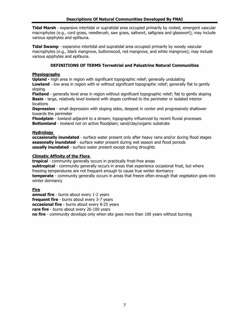
Descriptions Of Natural Communities Developed By FNAI
Tidal Marsh - expansive intertidal or supratidal area occupied primarily by rooted, emergent vascular macrophytes (e.g., cord grass, needlerush, saw grass, saltwort, saltgrass and glasswort); may include various epiphytes and epifauna.
Tidal Swamp - expansive intertidal and supratidal area occupied primarily by woody vascular macrophytes (e.g., black mangrove, buttonwood, red mangrove, and white mangrove); may include various epiphytes and epifauna.
DEFINITIONS OF TERMS Terrestrial and Palustrine Natural Communities
Physiography Upland - high area in region with significant topographic relief; generally undulating Lowland - low area in region with or without significant topographic relief; generally flat to gently sloping Flatland - generally level area in region without significant topographic relief; flat to gently sloping Basin - large, relatively level lowland with slopes confined to the perimeter or isolated interior locations Depression - small depression with sloping sides, deepest in center and progressively shallower towards the perimeter Floodplain - lowland adjacent to a stream; topography influenced by recent fluvial processes Bottomland - lowland not on active floodplain; sand/clay/organic substrate
Hydrology occasionally inundated - surface water present only after heavy rains and/or during flood stages seasonally inundated - surface water present during wet season and flood periods usually inundated - surface water present except during droughts
Climatic Affinity of the Flora tropical - community generally occurs in practically frost-free areas subtropical - community generally occurs in areas that experience occasional frost, but where freezing temperatures are not frequent enough to cause true winter dormancy temperate - community generally occurs in areas that freeze often enough that vegetation goes into winter dormancy
Fire annual fire - burns about every 1-2 years frequent fire - burns about every 3-7 years occasional fire - burns about every 8-25 years rare fire - burns about every 26-100 years no fire - community develops only when site goes more than 100 years without burning
7

Descriptions Of Natural Communities Developed By FNAI
LATIN NAMES OF PLANTS MENTIONED IN NATURAL COMMUNITY DESCRIPTIONS anise - Illicium floridanum bays: swamp bay -Persea palustris gordonia -Gordonia lasianthus sweetbay -Magnolia virgiana beakrush - Rhynchospora spp. beech - Fagus grandifolia blackgum - Nyssa biflora blue palmetto - Sabal minor bluestem - Andropogon spp. buttonbush - Cephalanthus occidentalis cabbage palm - Sabal palmetto cacti - Opuntia and Harrisia spp., predominantly stricta and pentagonus cane - Arundinaria gigantea or A. tecta cattail - Typha spp. cedars: red cedar - Juniperus silicicola white cedar - Chamaecyparis thyoides or C. henryi cladonia - Cladonia spp. cypress - Taxodium distichum dahoon holly - Ilex cassine diamondleaf oak - Quercus laurifolia fire flag - Thalia geniculata Florida maple - Acer barbatum gallberry - Ilex glabra gums: tupelo - Nyssa aquatica blackgum - Nyssa biflora Ogeechee gum - Nyssa ogeche hackberry - Celtis laevigata hornbeam - Carpinus caroliniana laurel oak - Quercus hemisphaerica live oak - Que cus virginiana r
.
ri
loblolly pine - Pinus taeda longleaf pine - Pinus palustris magnolia - Magnolia grandiflora maidencane - Panicum hemitomon needle palm - Rhapidophyllum hystrix
overcup oak - Quercus lyrata pickerel weed - Pontederia cordata or P. lanceolata pignut hickory - Carya glabra pop ash - Fraxinus caroliniana pond apple - Annona glabra pond pine - Pinus serotina pyramid magnolia - Magnolia pyramidata railroad vine - Ipomoea pes-caprae red cedar - Juniperus silicicola red maple - Acer rubrum red oak - Quercus falcata rosemary - Ceratiola ericoides sagittaria - Sagittaria lancifolia sand pine - Pinus clausa saw palmetto - Serenoa repens sawgrass - Cladium jamaicensis scrub oaks - Quercus geminata, Q. chapmanii, Qmyrtifolia,Q. inopina sea oats - Uniola paniculata seagrape - Coccoloba uvifera shortleaf pine - Pinus echinata Shumard oak - Quercus shumardii slash pine - Pinus elliottii sphagnum moss - Sphagnum spp. spikerush - Eleocharis spp. spruce pine - Pinus glabra St. John's wort - Hypericum spp. swamp chestnut oak - Quercus prinus sweetgum - Liquidambar styraciflua titi - Cyrilla racemiflora, and Cliftonia monophylla tuliptree - Liriodendron tulipfera tupelo - Nyssa aquatica turkey oak - Quercus laevis water oak - Quercus nigra waterlily - Nymphaea odorata white cedar - Chamaecypa s thyoides white oak - Quercus alba willow - Salix caroliniana yucca - Yucca aloifolia
8
Management Procedures For Archaeological And Historical Sites And Properties
On State -- Owned Or Controlled Lands (Revised August, 1995)
A. GENERAL DISCUSSION Archaeological and historic sites are defined collectively in 267.021(3), F.S., as "historic properties" or "historic resources." They have several essential characteristics that must be recognized in a management program. First of all, they are a finite and non-renewable resource. Once destroyed, presently existing resources, including buildings, other structures, shipwreck remains, archaeological sites and other objects of antiquity, cannot be renewed or revived. Today, sites in the State of Florida are being destroyed by all kinds of land development, inappropriate land management practices, erosion, looting, and to a minor extent even by well-intentioned professional scientific research (e.g., archaeological excavation). Measures must be taken to ensure that some of these resources will be preserved for future study and appreciation. Secondly, sites are unique because individually they represent the tangible remains of events that occurred at a specific time and place. Thirdly, while sites uniquely reflect localized events, these events and the origin of particular sites are related to conditions and events in other times and places. Sites can be understood properly only in relation to their natural surroundings and the activities of inhabitants of other sites. Managers must be aware of this "systemic" character of historic and archaeological sites. Also, it should be recognized that archaeological sites are time capsules for more than cultural history; they preserve traces of past biotic communities, climate, and other elements of the environment that may be of interest to other scientific disciplines. Finally, the significance of sites, particularly archaeological ones, derives not only from the individual artifacts within them, but equally from the spatial arrangement of those artifacts in both horizontal and vertical planes. When archaeologists excavate, they recover, not merely objects, but also a record of the positions of these objects in relation to one another and their containing matrix (e.g., soil strata). Much information is sacrificed if the so-called "context" of archaeological objects is destroyed or not recovered, and this is what archaeologists are most concerned about when a site is threatened with destruction or damage. The artifacts themselves can be recovered even after a site is heavily disturbed, but the context -- the vertical and horizontal relationships -- cannot. Historic structures also contain a wealth of cultural (socio-economic) data that can be lost if historically sensitive maintenance, restoration or rehabilitation procedures are not implemented, or if they are demolished or extensively altered without appropriate documentation. Lastly, it should not be forgotten that historic structures often have associated potentially significant historic archaeological features that must be considered in land management decisions. B. STATUTORY AUTHORITY Chapter 253, Florida Statutes ("State Lands") directs the preparation of "single-use" or "multiple-use" land management plans for all state-owned lands and state-owned sovereignty submerged lands. In this document, 253.034(4), F.S., specifically requires that "all management plans, whether for single-use or multiple-use properties, shall specifically describe how the managing agency plans to identify, locate, protect and preserve, or otherwise use fragile non-renewable resources, such as archaeological and historic sites, as well as other fragile resources..." Chapter 267, Florida Statutes is the primary historic preservation authority of the state. The importance of protecting and interpreting archaeological and historic sites is recognized in 267.061(1)(a), F.S.:The rich and unique heritage of historic properties in this state, representing more than 10,000 years of human presence, is an important legacy to be valued and conserved for present and future generations. The destruction of these nonrenewable historic resources will engender a significant loss to the state's quality of life, economy, and cultural environment. It is therefore declared to be state policy to:
1
Management Procedures For Archaeological And Historical Sites And Properties
On State -- Owned Or Controlled Lands (Revised August, 1995)
1. Provide leadership in the preservation of the state's historic resources; [and] 2. Administer state-owned or state-controlled historic resources in a spirit of stewardship and
trusteeship;... Responsibilities of the Division of Historical Resources in the Department of State pursuant to 267.061(3), F.S., include the following: 1. Cooperate with federal and state agencies, local Governments, and private organizations and
individuals to direct and conduct a comprehensive statewide survey of historic resources and to maintain an inventory of such responses.
2. Develop a comprehensive statewide historic preservation plan. 3. Identify and nominate eligible properties to the National Register of Historic Places and otherwise
administer applications for listing properties in the National Register of Historic Places. 4. Cooperate with federal and state agencies, local governments, and organizations and individuals
to ensure that historic resources are taken into consideration at all levels of planning and development.
5. Advise and assist, as appropriate, federal and state agencies and local governments in carrying out their historic preservation responsibilities and programs.
6. Carry out on behalf of the state the programs of the National Historic Preservation Act of 1966, as amended, and to establish, maintain, and administer a state historic preservation program meeting the requirements of an approved program and fulfilling the responsibilities of state historic preservation programs as provided in subsection 101(b) of that act.
7. Take such other actions necessary or appropriate to locate, acquire, protect, preserve, operate, interpret, and promote the location, acquisition, protection, preservation, operation, and interpretation of historic resources to foster an appreciation of Florida history and culture. Prior to the acquisition, preservation, interpretation, or operation of a historic property by a state agency, the Division shall be provided a reasonable opportunity to review and comment on the proposed undertaking and shall determine that there exists historic authenticity and a feasible means of providing for the preservation, interpretation and operation of such property.
8. Establish professional standards for the preservation, exclusive of acquisition, of historic resources in state ownership or control.
9. Establish guidelines for state agency responsibilities under subsection (2). Responsibilities of other state agencies of the executive branch, pursuant to 267.061(2), F.S., include: 1. Each state agency of the executive branch having direct or indirect jurisdiction over a proposed
state or state-assisted undertaking shall, in accordance with state policy and prior to the approval of expenditure of any state funds on the undertaking, consider the effect of the undertaking on any historic property that is included in, or eligible for inclusion in, the National Register of Historic Places. Each such agency shall afford the division a reasonable opportunity to comment with regard to such an undertaking.
2. Each state agency of the executive branch shall initiate measures in consultation with the division to assure that where, as a result of state action or assistance carried out by such agency, a historic property is to be demolished or substantially altered in a way that adversely affects the character, form, integrity, or other qualities that contribute to [the] historical, architectural, or archaeological value of the property, timely steps are taken to determine that no feasible and prudent alternative to the proposed demolition or alteration exists, and, where no such alternative is determined to exist, to assure that timely steps are taken either to avoid or mitigate the adverse effects, or to undertake an appropriate archaeological salvage excavation or other recovery action to document the property as it existed prior to demolition or alteration.
3. In consultation with the division [of Historical Resources], each state agency of the executive branch shall establish a program to locate, inventory, and evaluate all historic properties under the agency's ownership or control that appear to qualify for the National Register. Each such agency shall exercise caution to assure that any such historic property is not inadvertently
2

Management Procedures For Archaeological And Historical Sites And Properties
On State -- Owned Or Controlled Lands (Revised August, 1995)
transferred, sold, demolished, substantially altered, or allowed to deteriorate significantly.
4. Each state agency of the executive branch shall assume responsibility for the preservation of historic resources that are owned or controlled by such agency. Prior to acquiring, constructing, or leasing buildings for the purpose of carrying out agency responsibilities, the agency shall use, to the maximum extent feasible, historic properties available to the agency. Each agency shall undertake, consistent with preservation of such properties, the mission of the agency, and the professional standards established pursuant to paragraph (3)(k), any preservation actions necessary to carry out the intent of this paragraph.
5. Each state agency of the executive branch, in seeking to acquire additional space through new construction or lease, shall give preference to the acquisition or use of historic properties when such acquisition or use is determined to be feasible and prudent compared with available alternatives. The acquisition or use of historic properties is considered feasible and prudent if the cost of purchase or lease, the cost of rehabilitation, remodeling, or altering the building to meet compliance standards and the agency's needs, and the projected costs of maintaining the building and providing utilities and other services is less than or equal to the same costs for available alternatives. The agency shall request the division to assist in determining if the acquisition or use of a historic property is feasible and prudent. Within 60 days after making a determination that additional space is needed, the agency shall request the division to assist in identifying buildings within the appropriate geographic area that are historic properties suitable for acquisition or lease by the agency, whether or not such properties are in need of repair, alteration, or addition.
6. Consistent with the agency's mission and authority, all state agencies of the executive branch shall carry out agency programs and projects, including those under which any state assistance is provided, in a manner which is generally sensitive to the preservation of historic properties and shall give consideration to programs and projects which will further the purposes of this section.
Section 267.12 authorizes the Division to establish procedures for the granting of research permits for archaeological and historic site survey or excavation on state-owned or controlled lands, while Section 267.13 establishes penalties for the conduct of such work without first obtaining written permission from the Division of Historical Resources. The Rules of the Department of State, Division of Historical Resources, for research permits for archaeological sites of significance are contained in Chapter 1A-32, F.A.C. Another Florida Statute affecting land management decisions is Chapter 872, F.S. Section 872.02, F.S., pertains to marked grave sites, regardless of age. Many state-owned properties contain old family and other cemeteries with tombstones, crypts, etc. Section 872.05, F.S., pertains to unmarked human burial sites, including prehistoric and historic Indian burial sites. Unauthorized disturbance of both marked and unmarked human burial site is a felony. C. MANAGEMENT POLICY The choice of a management policy for archaeological and historic sites within state-owned or controlled land obviously depends upon a detailed evaluation of the characteristics and conditions of the individual sites and groups of sites within those tracts. This includes an interpretation of the significance (or potential significance) of these sites, in terms of social and political factors, as well as environmental factors. Furthermore, for historic structures architectural significance must be considered, as well as any associated historic landscapes. Sites on privately owned lands are especially vulnerable to destruction, since often times the economic incentives for preservation are low compared to other uses of the land areas involved. Hence, sites in public ownership have a magnified importance, since they are the ones with the best chance of survival over the long run. This is particularly true of sites that are state-owned or controlled, where the basis of management is to provide for land uses that are minimally destructive of resource values.
3
Management Procedures For Archaeological And Historical Sites And Properties
On State -- Owned Or Controlled Lands (Revised August, 1995)
It should be noted that while many archaeological and historical sites are already recorded within state--owned or controlled--lands, the majority of the uplands areas and nearly all of the inundated areas have not been surveyed to locate and assess the significance of such resources. The known sites are, thus, only an incomplete sample of the actual resources - i.e., the number, density, distribution, age, character and condition of archaeological and historic sites - on these tracts. Unfortunately, the lack of specific knowledge of the actual resources prevents formulation of any sort of detailed management or use plan involving decisions about the relative historic value of individual sites. For this reason, a generalized policy of conservation is recommended until the resources have been better addressed. The generalized management policy recommended by the Division of Historical Resources includes the following: 1. State land managers shall coordinate all planned activities involving known archaeological or
historic sites or potential site areas closely with the Division of Historical Resources in order to prevent any kind of disturbance to significant archaeological or historic sites that may exist on the tract. Under 267.061(1)(b), F.S., the Division of Historical Resources is vested with title to archaeological and historic resources abandoned on state lands and is responsible for administration and protection of such resources. The Division will cooperate with the land manager in the management of these resources. Furthermore, provisions of 267.061(2) and 267.13, F.S., combined with those in 267.061(3) and 253.034(4), F.S., require that other managing (or permitting) agencies coordinate their plans with the Division of Historical Resources at a sufficiently early stage to preclude inadvertent damage or destruction to known or potentially occurring, presently unknown archaeological and historic sites. The provisions pertaining to human burial sites must also be followed by state land managers when such remains are known or suspected to be present (see 872.02 and 872.05, F.S., and 1A-44, F.A.C.)
2. Since the actual resources are so poorly known, the potential impact of the managing agency's activities on historic archaeological sites may not be immediately apparent. Special field survey for such sites may be required to identify the potential endangerment as a result of particular management or permitting activities. The Division may perform surveys, as its resources permit, to aid the planning of other state agencies in their management activities, but outside archaeological consultants may have to be retained by the managing agency. This would be especially necessary in the cases of activities contemplating ground disturbance over large areas and unexpected occurrences. It should be noted, however, that in most instances Division staff's knowledge of known and expected site distribution is such that actual field surveys may not be necessary, and the project may be reviewed by submitting a project location map (preferably a 7.5 minute U.S.G.S. Quadrangle map or portion thereof) and project descriptive data, including detailed construction plans. To avoid delays, Division staff should be contacted to discuss specific project documentation review needs.
3. In the case of known significant sites, which may be affected by proposed project activities, the managing agency will generally be expected to alter proposed management or development plans, as necessary, or else make special provisions to minimize or mitigate damage to such sites.
4. If in the course of management activities, or as a result of development or the permitting of dredge activities (see 403.918(2)(6)a, F.S.), it is determined that valuable historic or archaeological sites will be damaged or destroyed, the Division reserves the right, pursuant to 267.061(1)(b), F.S., to require salvage measures to mitigate the destructive impact of such activities to such sites. Such salvage measures would be accomplished before the Division would grant permission for destruction of the affected site areas. The funding needed to implement salvage measures would be the responsibility of the managing agency planning the site destructive activity. Mitigation of historic structures at a minimum involves the preparation of measured drawings and documentary photographs. Mitigation of archaeological resources involves the excavation, analysis and reporting of the project findings and must be planned to
4
Management Procedures For Archaeological And Historical Sites And Properties
On State -- Owned Or Controlled Lands (Revised August, 1995)
occur sufficiently in advance to avoid project construction delays. If these services are to be contracted by the state agency, the selected consultant will need to obtain an Archaeological Research Permit from the Division of Historical Resources, Bureau of Archaeological Research (see 267.12, F.S. and Rules 1A-32 and 1A-46 F.A.C.).
5. For the near future, excavation of non-endangered (i.e., sites not being lost to erosion or development) archaeological site is discouraged. There are many endangered sites in Florida (on both private and public lands) in need of excavation because of the threat of development or other factors. Those within state-owned or controlled lands should be left undisturbed for the present - with particular attention devoted to preventing site looting by "treasure hunters". On the other hand, the archaeological and historic survey of these tracts is encouraged in order to build an inventory of the resources present, and to assess their scientific research potential and historic or architectural significance.
6. The cooperation of land managers in reporting sites to the Division that their field personnel may discover is encouraged. The Division will help inform field personnel from other resource managing agencies about the characteristics and appearance of sites. The Division has initiated a cultural resource management training program to help accomplish this. Upon request the Division will also provide to other agencies archaeological and historical summaries of the known and potentially occurring resources so that information may be incorporated into management plans and public awareness programs (See Management Implementation).
7. Any discovery of instances of looting or unauthorized destruction of sites must be reported to the agent for the Board of Trustees of the Internal Improvement Trust Fund and the Division so that appropriate action may be initiated. When human burial sites are involved, the provisions of 872.02 and 872.05, F. S. and Rule 1A-44, F.A.C., as applicable, must also be followed. Any state agent with law enforcement authority observing individuals or groups clearly and incontrovertibly vandalizing, looting or destroying archaeological or historic sites within state-owned or controlled lands without demonstrable permission from the Division will make arrests and detain those individuals or groups under the provisions of 267.13, 901.15, and 901.21, F.S., and related statutory authority pertaining to such illegal activities on state-owned or controlled lands. County Sheriffs' officers are urged to assist in efforts to stop and/or prevent site looting and destruction.
In addition to the above management policy for archaeological and historic sites on state-owned land, special attention shall be given to those properties listed in the National Register of Historic Places and other significant buildings. The Division recommends that the Secretary of the Interior's Standards for Rehabilitation and Guidelines for Rehabilitating Historic Buildings (Revised 1990) be followed for such sites. The following general standards apply to all treatments undertaken on historically significant properties. 1. A property shall be used for its historic purpose or be placed in a new use that requires minimal
change to the defining characteristics of the building and its site and environment. 2. The historic character of a property shall be retained and preserved. The removal of historic
materials or alterations of features and spaces that characterize a property shall be avoided. 3. Each property shall be recognized as a physical record of its time, place and use. Changes that
create a false sense of historical development, such as adding conjectural features or architectural elements from other buildings, shall not be undertaken.
4. Most properties change over time; those changes that have acquired historic significance in their own right shall be retained and preserved.
5. Distinctive features, finishes, and construction techniques or examples of craftsmanship that characterize a historic property shall be preserved.
6. Deteriorated historic features shall be repaired rather than replaced. Where the severity of deterioration requires replacement of a distinctive feature, the new feature shall match the old in design, color, texture, and other visual qualities and, where possible, materials. Replacement of
5

Management Procedures For Archaeological And Historical Sites And Properties
On State -- Owned Or Controlled Lands (Revised August, 1995)
missing features shall be substantiated by documentary, physical, or pictorial evidence.
7. Chemical or physical treatments, such as sandblasting, that cause damage to historic materials shall not be used. The surface cleaning of structures, if appropriate, shall be undertaken using the gentlest means possible.
8. Significant archaeological resources affected by a project shall be protected and preserved. If such resources must be disturbed, mitigation measures shall be undertaken.
9. New additions, exterior alterations, or related new construction shall not destroy materials that characterize the property. The new work shall be differentiated from the old and shall be compatible with the massing, size, scale, and architectural features to protect the historic integrity of the property and its environment.
10. New additions and adjacent or related new construction shall be undertaken in such a manner that if removed in the future, the essential form and integrity of the historic property and its environment would be unimpaired. (see Secretary of the Interior's Standards for Rehabilitation and Guidelines for Rehabilitating Historic Buildings [Revised 1990]).
Divisions of Historical Resources staff are available for technical assistance for any of the above listed topics. It is encouraged that such assistance be sought as early as possible in the project planning. D. MANAGEMENT IMPLEMENTATION As noted earlier, 253.034(4), F.S., states that "all management plans, whether for single-use or multiple-use properties, shall specifically describe how the managing agency plans to identify, locate, protect and preserve, or otherwise use fragile non-renewable resources, such as archaeological and historic sites..." The following guidelines should help to fulfill that requirement. 1. All land managing agencies should contact the Division and send U.S.G.S. 7.5 minute quadrangle
maps outlining the boundaries of their various properties. 2. The Division will in turn identify site locations on those maps and provide descriptions for known
archaeological and historical sites to the managing agency. 3. Further, the Division may also identify on the maps areas of high archaeological and historic site
location probability within the subject tract. These are only probability zones, and sites may be found outside of these areas. Therefore, actual ground inspections of project areas may still be necessary.
4. The Division will send archaeological field recording forms and historic structure field recording forms to representatives of the agency to facilitate the recording of information on such resources.
5. Land managers will update information on recorded sites and properties. 6. Land managers will supply the Division with new information as it becomes available on
previously unrecorded sites that their staff locate. The following details the kind of information the Division wishes to obtain for any new sites or structures that the land managers may report:
A. Historic Sites
(1) Type of structure (dwelling, church, factory, etc.). (2) Known or estimated age or construction date for each structure and addition. (3) Location of building (identify location on a map of the property, and building placement, i.e.,
detached, row, etc.). (4) General Characteristics: (include photographs if possible) overall shape of plan (rectangle,
"L" "T" "H" "U", etc.); number of stories; number of vertical divisions of bays; construction materials (brick, frame, stone, etc.); wall finish (kind of bond, coursing, shingle, etc.); roof shape.
(5) Specific features including location, number and appearance of: (a) Important decorative elements; (b) Interior features contributing to the character of the building;
6
Management Procedures For Archaeological And Historical Sites And Properties
On State -- Owned Or Controlled Lands (Revised August, 1995)
(c) Number, type, and location of outbuildings, as well as date(s) of construction; (d) Notation if property has been moved; (e) Notation of known alterations to building.
B. Archaeological Sites
(1) Site location (written narrative and mapped location). (2) Cultural affiliation and period. (3) Site type (midden, burial mound, artifact scatter, building rubble, etc.). (4) Threats to site (deterioration, vandalism, etc.). (5) Site size (acreage, square meters, etc.). (6) Artifacts observed on ground surface (pottery, bone, glass, etc.). (7) Description of surrounding environment.
7. No land disturbing activities should be undertaken in areas of known archaeological or historic sites or areas of high site probability without prior review by the Division early in the project planning.
8. Ground disturbing activities may proceed elsewhere but land managers should stop disturbance in the immediate vicinity of artifact finds and notifies the Division if previously unknown archaeological or historic remains are uncovered. The provisions of Chapter 872, F.S., must be followed when human remains are encountered.
9. Excavation and collection of archaeological and historic sites on state lands without a permit from the Division are a violation of state law and shall be reported to a law enforcement officer. The use of metal detectors to search for historic artifacts shall be prohibited on state lands except when authorized in a 1A-32, F.A.C., research permit from the Division.
10. Interpretation and visitation which will increase public understanding and enjoyment of archaeological and historic sites without site destruction or vandalism is strongly encouraged.
11. Development of interpretive programs including trails, signage, kiosks, and exhibits is encouraged and should be coordinated with the Division.
12. Artifacts found or collected on state lands are by law the property of the Division. Land managers shall contact the Division whenever such material is found so that arrangements may be made for recording and conservation. This material, if taken to Tallahassee, can be returned for public display on a long term loan.
E. ADMINISTERING AGENCY Questions relating to the treatment of archaeological and historic resources on state lands may be directed to:
Compliance Review Section Bureau of Historic Preservation Division of Historical Resources
R.A. Gray Building 500 South Bronough Street
Tallahassee, Florida 32399-0250 Contact Person: Susan M. Harp
Historic Preservation Planner Telephone (850) 245-6333
Suncom 205-6333 FAX (850) 245-6437
7