Embed Size (px)
Citation preview

Montana Weather and Road Report
by
Meyer Mohaddes Associates
and
Lisa Ballard
Western Transportation Institute
College of Engineering
Montana State University – Bozeman
Sponsor
Montana Department of Transportation
2701 Prospect Ave.
Helena, MT 59620
October 28, 2003
Montana Weather and Road Report Acknowledgements
ACKNOWLEDGEMENTS Mike Bousliman, Montana Department of Transportation

Montana Weather and Road Report Table of Contents
Western Transportation Institute Page iii
TABLE OF CONTENTS 1. List of Tables ...........................................................................................................................v
2. List of Figures ........................................................................................................................ vi
3. Executive Summary .................................................................................................................1
4. Introduction..............................................................................................................................3
4.1. Definition of RWIS......................................................................................................... 4
5. Methodology............................................................................................................................6
6. Meeting Approach and Methodology ......................................................................................9
6.1. RWIS Requirements ....................................................................................................... 9
6.2. Potential Next Steps/Activities ..................................................................................... 10
7. Meeting Results .....................................................................................................................13
8. Discussion of Results and Future Needs................................................................................15
8.1. Survey Results Analysis ............................................................................................... 16
8.1.1. Training................................................................................................................. 17
8.1.2. Accuracy ............................................................................................................... 20
8.1.3. Current Data.......................................................................................................... 21
8.1.4. Station Location .................................................................................................... 23
8.1.5. Methods of Delivery ............................................................................................. 24
8.1.6. RWIS Display ....................................................................................................... 25
8.1.7. Anti-icing .............................................................................................................. 26
9. Prototype Weather Decision Support Systems For Montana ................................................28
9.1. Product Overview ......................................................................................................... 28
9.1.1. Requirements ........................................................................................................ 28
9.1.2. Functional Description.......................................................................................... 29
9.2. Design and Development.............................................................................................. 29
9.2.1. Product Development Tasks ................................................................................. 30
9.2.2. Database................................................................................................................ 31
9.2.3. Development Issues .............................................................................................. 31
9.3. Next Steps ..................................................................................................................... 32
10. Conclusion .........................................................................................................................33
11. Appendix A: Montana Department of Transportation RWIS Survey Results...................34
12. Appendix B: Operations Guide for Maintenance Field Personnel ....................................50
Montana Weather and Road Report Table of Contents
Western Transportation Institute Page iv
13. Appendix C: Anti-icing Guide for Winter Weather Events...............................................52
13.1. Weather Event: Light Snow Storm........................................................................... 52
13.2. Weather Event: Light Snow Storm with Period(s) of Moderate or Heavy Snow..... 53
13.3. Weather Event: Moderate or Heavy Snow Storm..................................................... 54
13.4. Weather Event: Frost or Black Ice............................................................................ 55
13.5. Weather Event: Freezing Rain Storm ....................................................................... 56
13.6. Weather Event: Sleet Storm...................................................................................... 57
14. Appendix D: Sample MDT Statewide Road Conditions Report .......................................58
15. References..........................................................................................................................61

Montana Weather and Road Report List of Tables
Western Transportation Institute Page v
1. LIST OF TABLES
Table 1: Road Weather Information Requirements ........................................................................ 9
Table 2: Preliminary Requirements Prioritization ........................................................................ 13
Montana Weather and Road Report List of Figures
Western Transportation Institute Page vi
2. LIST OF FIGURES
Figure 1: Example of a Question that Allows Multiple Responses ................................................ 7
Figure 2: Example of a Question that Allows a Single Response .................................................. 7
Figure 3: Rate of Surveys Returned.............................................................................................. 16
Figure 4: Amount of RWIS Training Received by MDT Employees .......................................... 17
Figure 5: Would Additional Training be Useful? ......................................................................... 18
Figure 6: Cross Tabulation Between Questions 19 and 20........................................................... 19
Figure 7: Training Suggestions..................................................................................................... 19
Figure 8: How Often Do You Encounter Inaccurate Data?.......................................................... 20
Figure 9: How Easy is it for You to Obtain Current RWIS Information?.................................... 21
Figure 10: How Often Do You Encounter Data that is Not Current?........................................... 22
Figure 11: Would Relocation or Additional Stations Improve Usefulness?................................. 23
Figure 12: Desirable Methods for Delivery of Weather Information ........................................... 24
Figure 13: What Would Make the Display of RWIS Data More Useful? .................................... 25
Figure 14: What Would Improve Anti-Icing in Your Region?..................................................... 27

Montana Weather and Road Report Executive Summary
Western Transportation Institute Page 1
3. EXECUTIVE SUMMARY
This report documents a recent study of the use of Montana’s Road Weather Information Systems (RWIS) Network. The Montana Department of Transportation (MDT) uses RWIS sensors to evaluate weather conditions as an input for winter maintenance decisions. This report also looks at prototype weather decision support systems for Montana and development of a surface transportation and weather decision support tool and strategic plan for improved highway operations in Montana.
This study looked at how the current network of sensors is being used, what improvements could be made to the network, and if there is a need to incorporate an extensive decision support tool into the current network.
Participants in the study included headquarters and field level MDT maintenance personnel, the Western Transportation Institute (WTI), and Meyer, Mohaddes Associates (MMA). The study consisted of the following steps:
1. Conduct a survey of RWIS network users.
2. Compile and analyze survey results.
3. Evaluate survey results and develop understanding of requirements.
4. Develop list of potential activities aimed at addressing requirements.
5. Conduct a meeting to discuss results, requirements and potential future activities.
6. Document the process and results.
The survey results indicated that the RWIS network is being used; however, a greater level of confidence in the information being provided is needed and the ease with which the systems can be used needs improvement. In addition, the network may be improved with additional RWIS locations, several site relocations, and expanded RWIS site capabilities for individual RWIS sites and the network overall. In particular, MDT’s network will also be increased through training of winter maintenance decision-makers regarding use of the systems and how to apply the information being provided.
Another issue discussed during the study was the use of anti-icing chemicals. Participants indicated that there is a need for a more standardized approach to the use of these chemicals and a need for training in their application. The concept of a standardized approach for the use of anti-icing chemicals leads to the idea of guidance regarding the appropriate response to a variety of winter weather conditions. A system that provides such guidance, a decision support system, could be used to implement and automate a guidance policy on winter maintenance. The flexibility granted to winter maintenance decision-makers can be built into such a system to be compatible with the policy itself.
Expanding and rearranging the RWIS network, educating personnel on the use of RWIS information and anti-icing chemicals, and implementation of a decision support system all, either individually or in any combination, represent significant commitments by MDT. There specific commitments will require a comprehensive approach toward systems integration, which is the key to optimizing the benefits of any compliments of ITS deployments. Commitment of this magnitude and the requirements for effective systems integration call for effective planning and design that incorporates input from the full range of system users; while this planning itself

Montana Weather and Road Report Executive Summary
Western Transportation Institute Page 2
represents a significant commitment, it is worthwhile when viewed with the potential gains in efficiency and accuracy from the RWIS network enhancements in mind.

Montana Weather and Road Report Introduction
Western Transportation Institute Page 3
4. INTRODUCTION
According to the United States Department of Transportation, approximately $2 million are spent on snow and ice control in the United States to manage winter maintenance. The indirect cost is also significant, with 7,000 people losing their lives per year under adverse weather conditions and another 450,000 being injured. In Montana between the years 1994 and 1998 approximately 45 fatal and 7,350 injury related crashes were reported due to poor weather conditions, according to the Montana Highway Patrol.
In order to provide for safe and efficient winter highway maintenance and operations, the Montana Departments of Transportation (MDT) must:
• Know of the current and forecasted road-weather conditions;
• Have confidence that the information is accurate and reliable;
• And then evaluate those conditions so that maintenance staff can allocate resources to manage the conditions.
To help address these issues, MDT has deployed a road-weather information system (RWIS) including 59 environmental sensor stations throughout the state. Maintenance staff also has access to a variety of other sources of information that can be used to help in winter maintenance. However, MDT has found that these different sources of information are not being provided in a format that is fully useful to the maintenance staff. The information is not available through a single interface and is difficult to combine together. Furthermore, data is often shown in tabular form instead of graphical or geographical form and is difficult for the user to process.
To address these issues, a prototype of a Montana Winter Maintenance Decision Support Tool (Montana DSS of MWMDSS) has been developed. This product serves to combine different sources of information for the maintenance decision maker to analyze. It also serves to provide recommended treatment actions based on the user-verified current road and weather conditions. This prototype will be used to demonstrate capabilities to MDT maintenance staff and to solicit further requirements.
The Montana Department of Transportation (MDT) used a network of road environmental sensor stations (ESS) to collect weather data. These stations have been located to provide data at key points along highways maintained by MDT. Data obtained consists of a combination of meteorological elements and roadway conditions. In theory, these data can be used by maintenance personnel to make decisions regarding type and timing of winter maintenance activities in response to changing weather. Across the nation, transportation departments have noted that maintenance personnel armed with timely and accurate weather and roadway information can make better decisions and improve the efficiency of their operations.
These Environmental sensor stations in combination with some compliment of data processing, storage, and management capabilities have traditionally been called Road Weather Information Systems (RWIS) when used in highway applications. Work at the national level aimed at development of uniform protocols has led to the use of this terminology in a different fashion. In keeping with the more traditional convention, this document will use “RWIS” to refer to individual road weather data collection and information processing sites while any group of these deployments will simply be referred to as a “network of RWIS”.

Montana Weather and Road Report Introduction
Western Transportation Institute Page 4
The Western Transportation Institute (WTI) in Bozeman, MDT and Meyer, Mohaddes Associates (MMA) have conducted a study to determine, preliminarily, how the RWIS network in Montana is being used and how the basic functions might be improved. In addition, the study looked at how this network might be enhanced to further assist maintenance personnel in the decision making process. This last component, while a cursory level effort, focused on those maintenance decisions regarding winter weather events and deployment of resources to battle these events. The study contributes to the first phase of a two-phased effort to better utilize the Montana RWIS network. The second phase of this effort will focus on development of decision support tools incorporating RWIS data and meeting National ITS Architecture standards.
The information used to begin the study was collected through an online survey developed by WTI and made available to MDT maintenance personnel. The survey focused on the sources of weather information that personnel accessed in order to understand current weather conditions and to make maintenance decisions in response to the weather. It also focused on what weather information was most helpful and how the weather information influenced the type and timing of response. Details relating to these issues addressed in the survey included ease of information access, usefulness and reliability of forecasts and training.
The survey responses were compiled by WTI and then analyzed by MMA to create a set of requirements governing RWIS use and winter maintenance decision support. These requirements were used at a starting point for a facilitated meeting of MDT Headquarters Maintenance personnel, MDT Lewistown area office within the Billings District, WTI project staff, and MMA team members. This meeting was the primary forum relative to the study for reviewing the survey information, exploring and prioritizing the requirements for an improved RWIS network, and discussing the potential of a decision support system.
This report documents the approach used to conduct the meeting, the methodology of the compilation of the information collected at the meeting, and the results of the meeting discussion and their potential influence on future activities by MDT.
4.1. Definition of RWIS In general, an RWIS contains the following components:
1. Environmental sensor stations (ESS), roadside weather stations that collect road and atmospheric conditions;
2. The communications system;
3. One or more central computers to store and process collected data;
4. A user interface to display processed data;
5. Site-specific weather forecasts using the weather station and the National Weather System forecasts.
RWIS is most commonly used in snow and ice removal operations. Current, accurate road weather data and reliable, site-specific forecasts are vital for anti-icing techniques. When anti-icing, the winter maintenance crew spreads freezing-temperature suppressing chemicals prior to precipitation instead of after. Because this prevents ice from bonding to the road and the chemical does not have to penetrate the layer of ice, this technique has been found to decrease chemical usage, therefore decreasing cost and environmental impact. However, this proactive

Montana Weather and Road Report Introduction
Western Transportation Institute Page 5
approach requires better information about pavement temperatures and forecasted precipitation as compared to traditional de-icing techniques and therefore relies more heavily on RWIS.

Montana Weather and Road Report Methodology
Western Transportation Institute Page 6
5. METHODOLOGY
The purpose of this survey was to determine why Road Weather Information Systems are not being used to their full potential. The survey was designed to get specific answers to the problems. Examples of potential problems are as follows: Has there been enough training on the use of RWIS? Would more training on RWIS help? Is the data obtained from RWIS accurate? Is the data obtained from RWIS current? Specific questions like these were used to pinpoint the problems encountered by MDT personnel when using RWIS. The survey was designed to take approximately 20 minutes while still asking the appropriate questions. The format of the survey was designed to be user-friendly and understandable.
The survey was computer generated so the respondents could simply fill out their surveys on the computer and then submit their responses through e-mail. This eliminated the trouble of mailing out surveys and then waiting for them to be returned. The responses to the surveys were then automatically stored in a Microsoft Access database. This eliminated the time involved with entering the responses by hand along with the errors that occur when typing in each response. The responses were then analyzed in Minitab.
Minitab is statistical software that is capable of performing various tests and statistics on data. One very important feature of Minitab is its ability to do cross tabulations, which correlates the responses from two different questions. For example, to answer the question, “How much training have the employees in Bozeman received compared to the employees in Butte?”, a cross tabulation would be done between Question 19 and Question 24. Question 19 asks,” How much training have you received in obtaining, interpreting, and using the RWIS information.” Question 24 asks the respondent to check the District Office that he/she works in. By performing a cross tabulation between these two questions a more detailed analysis can be performed. For example, one question that can be answered through this cross tabulation is “Of the people that have received no training, where are they from”. Or, conversely, “Of the people from Bozeman, how much training have they received”.
Minitab is also capable of performing simple statistics. Therefore, the means, counts, percentages, and standard deviations were all done by Minitab. Minitab displays these statistics in what is called a “Session Window”. The session window displays the command that was selected and then gives the answer with the proper labels. This enables you to check what Minitab has done.
There are basically three types of questions in the survey. An example of the first type of question is Question 4 (see Figure 1). It states, “If other methods for delivery of weather information were provided, which would be desirable? (Select any that apply)”. This type of question enables the respondent to check more than one option. So, if the respondent wants weather information provided on the Internet and on the radio, he could check both responses. For these questions, the various choices were separated into separate columns in the Access database. So, “Internet” would be one column heading, “Radio” would be another column heading, and so on. Then, if the respondent checked the Internet box, there is a “Yes” marked in the cell under the Internet column. If the respondent did not check the Internet box, then the cell is left empty.

Montana Weather and Road Report Methodology
Western Transportation Institute Page 7
Question 4. If other methods for delivery of weather information were provided, which would be desirable? (Select any that apply)
No other methods are needed
Internet
TV
Radio
Alpha-numeric pagers to deliver brief weather message
Dial-up RWIS voice recording of the current conditions
Other:
Figure 1: Example of a Question that Allows Multiple Responses
The second type of question is one in which the respondent can only mark one response. An example of this type of question is Question 6. (See Figure 2) The question states, “How easy is it for you to obtain current RWIS information?” In this type of question, the person taking the survey is allowed to check only one response. The available choices are “It is always easy”, “I sometimes encounter difficulties”, “I often encounter difficulties”, and “It is always difficult”. This is stored as a 3, 2, 1, or 0, respectively, in Microsoft Access. By storing the response numerically there are more statistical options, such as calculating the mean response for the question.
Question 6. How easy is it for you to obtain current RWIS information?
It is always easy. (3)
I sometimes encounter difficulties. (2)
I often encounter difficulties. (1)
It is always difficult. (0)
Figure 2: Example of a Question that Allows a Single Response
The third type of question is one in which the respondent can give suggestions. An example of this type of question is question 22. It states, “Please provide suggestions to improve the usefulness of the RWIS system.” (See Appendix A) The respondent can then write a suggestion in the text box. These types of questions are more difficult to analyze. Minitab does have the

Montana Weather and Road Report Methodology
Western Transportation Institute Page 8
ability of performing simple statistics on text. Every person, however, has an original comment, so analyzing the text was mainly done by hand. The comments are all listed in the Survey Results. (See Appendix A) The comments were left as quotations, with the exception of some spelling and grammar corrections. Even though the text responses were harder to analyze, they were very informative.
There were a number of respondents that skipped questions or who did not answer some questions. This is stored as a blank in the Access Database. So even though there were 87 surveys returned, there were not always 87 responses to each question. The percentages that are shown in the survey results are out of the people who answered the specific question and not out of the total number of people who returned a survey. This eliminates those respondents who did not know how to answer the question or who just skipped the question all together. This process was followed when calculating other statistics as well, such as the mean and standard deviation.

Montana Weather and Road Report Meeting Approach and Methodology
Western Transportation Institute Page 9
6. MEETING APPROACH AND METHODOLOGY
The purpose of the meeting held on June 12 in Lewistown, was to analyze requirements with a subset of the MDT survey respondents. These requirements were developed prior to the meeting by analyzing the complied results of the WTI survey. The survey was conducted during September 2000. Complied results of the survey can be found in Attachment 1.
6.1. RWIS Requirements Analysis of WTI survey responses resulted in development of a set of requirements for enhancement of winter maintenance decision-making processes. The requirements have been divided into five categories to more clearly show areas of emphasis regarding the survey responses. Table 1 provides the categorized listing of high-level requirements and sub-requirements presented to MDT meeting participants.
Table 1: Road Weather Information Requirements
1.0 Training in RWIS topics should be provided to winter maintenance decision-makers
1.0.1 A refresher course should be offered annually, each fall. 1.0.1.1 Provide training in available source locations of information. 1.0.1.2 RWIS terminology/climatic relationships training shall be provided.
2.0 RWIS stations should improve winter maintenance decisions.
2.0.1 Annual calibration of RWIS stations should be provided to improve accuracy of winter maintenance decisions. (N.4.4) 2.0.2 Annual maintenance will provide current access to RWIS stations improving winter maintenance decisions. (N.4.4) 2.0.3 Additional RWIS stations should be installed to improve winter maintenance decisions. (N.4.7.1)
3.0 Delivery of RWIS information should utilize current communications technologies in addition to current methods: (N.4.10)
3.0.1 RWIS data shall be made available by Dial-up RWIS Voice recordings. 3.0.2 RWIS data shall be made available through internet Display. 3.0.3 RWIS data shall be made available through Radio 3.0.4 RWIS data shall be made available through alphanumeric pagers. 3.0.5 RWIS data shall be made available through Television
4.0 The display of RWIS data should facilitate winter maintenance decision.
4.0.1 Integrating radar images with RWIS data shall be used to facilitate winter maintenance decisions. (N.3.3) 4.0.2 Integrating RWIS data with a map of RWIS sites shall be used to facilitate winter maintenance decisions. (N.3.3) 4.0.3 Estimating road temperatures (Thermal Mapping) for roadways shall be used to facilitate winter maintenance decision. (N.3.8) 4.0.4 RWIS data shall be easy to read and interpret. (N.3.3) 4.0.5 Short-term weather history shall be provided to facilitate winter maintenance decisions.(N.4.9) 4.0.6 Eyewitness accounts of existing road conditions shall be used to facilitate winter maintenance decisions. (N.3.2) 4.0.7 Displaying locations of current accidents can facilitate winter maintenance decisions.(N.3.3) 4.0.8 Historical traffic volumes shall be incorporated in decision support to facilitate winter maintenance decisions.

Montana Weather and Road Report Meeting Approach and Methodology
Western Transportation Institute Page 10
(N.3.3)
5.0 Anti-icing is a new maintenance treatment, and should be improved as a treatment option.
5.0.1 More resources shall be provided to improve anti-icing treatment in each region. 5.0.1.1 More human resources shall be provided to improve anti-icing treatment in each region. 5.0.1.2 More equipment shall be provided to improve anti-icing treatment in each region 5.0.2 Methods to improve the reliability of forecasts should be undertaken to improve anti-icing treatment. 5.0.2.1 More reliable weather forecasts shall be sought to improve anti-icing treatment in each region. (N.3.4) 5.0.2.2 More reliable road surface forecasts shall be sought to improve anti-icing treatment in each region. 5.0.3 More training in the practices of anti-icing shall be provided to improve anti-icing treatment in each region
In addition to the requirements developed from the analysis of the WTI survey, requirements developed at the national level were also reviewed. This review was done to ensure that requirements in Montana were consistent with existing national requirements and that applicable requirements had not been overlooked. Notations such as N.3.4 in parenthesis following the requirements in Table 1 reference particular national requirements from Reference 1.
6.2. Potential Next Steps/Activities The meeting discussion first focused on the requirements identified above. This list was modified and expanded. The final version, presented in Section 3, also shows the results of a voting exercise aimed at establishing a preliminary prioritization for the requirements. The prioritization was an important step because it generated thoughtful consideration of issues such as available funding and the most logical sequence of deployments. The list of requirements was then used to generate discussion regarding potential activities or next steps that might address the requirements. The intent of the discussion was to enhance the understanding of requirements relative to the RWIS network by adding to and improving the list as necessary. In particular, the discussion of potential activities was designed to generate ideas about the next steps in developing a decision support tool. As activities were discussed, the specific requirements that could be addressed by each were noted.
The activities presented are identified below:
1. Planning for Decision Support System (DDS) – This activity would address needed planning for integration of data and the use of road weather information in the decision making process for winter maintenance. The primary issues that will need to be addressed include:
• Identification of data to be integrated (e.g. Radar images, RWIS information potentially including history and mapping, available camera images, pavement data, eyewitness information, accident information, etc.)
• Development of an architecture (framework for planning, defining and integrating systems) that meets national requirements
• Refinement/formalization of procedures regarding response to various road condition and weather events (determine weather condition thresholds to trigger response and identify appropriate response for given conditions, etc.)
• Development of information dissemination approach, format, media, etc.

Montana Weather and Road Report Meeting Approach and Methodology
Western Transportation Institute Page 11
• Define computer requirements to implement DSS
• Identify/select needed support activities and plan timing for implementation
2. Decision Support System Implementation – This activity would develop the database of road weather data and the systems to implement the DSS as planned ensuring compatibility with national requirements where necessary.
3. Thermal Mapping – Conduct thermal mapping statewide and develop correlation with existing RWIS.
4. Additional RWIS/RWIS Relocation – This entails work, using thermal mapping results if available, to develop an RWIS plan identifying needed new sites, relocations and needed capabilities of individual sites. This plan will need to address how new sites and relocations will be integrated (communication, data assimilation, etc.) ensuring compatibility with existing MDT infrastructure, possible new DSS requirements and National ITS Architecture.
5. Centralized RWIS Database – Develop a data clearinghouse for all RWIS data statewide. This activity will need to include computers, software, programming and housing and will need to ensure compatibility with the National ITS Architecture. This effort could be part of the bigger DSS or provide information directly to the DSS.
6. Maintenance and Calibration – Develop a program to ensure annual maintenance and calibration of all RWIS statewide. This could be done by use of state forces or through agreement with a private sector company.
7. Forecasting – Develop specific forecasting needs and contract with private sector entity to provide:
• localized weather forecasts
• pavement temperature forecasts
8. Anti-Icing Initiative – Effort to study anti-icing applications, develop protocols for use statewide, and pursue development of budget items for anti-icing aimed at labor, equipment, and training.
9. Training – Development of a training program aimed at MDT personnel tasked with making winter maintenance decisions.
Topics:
• The Decision Support System
• RWIS – basics of how they work, what they provide, communication technology, central database, maintenance and calibration needs
• Other Sources of Information – what else is available and how to best use it in conjunction with RWIS data and how to find other information
• General Weather/Meterology – terminology and very basic weather information data collection for existing conditions vs. forecasting
• Anti-icing – understanding of technology, how it works, recommendations for use, limitation, etc.

Montana Weather and Road Report Meeting Approach and Methodology
Western Transportation Institute Page 12
These activities were presented and discussed to better understand the requirements and what will be needed to address them. The activities are preliminary and require further development to ensure that the full breadth of requirements is addressed.
Meeting discussion highlighted several issues regarding the future direction of development of the Montana RWIS network. These issues primarily relate to identification of the specific that should be collected, the information that should be provided, and the method used to disseminate the information. The questions will be best addressed by a larger contingent of the end users of the information. This larger group would, of course, first need to gain a thorough understanding of the possible choices and the benefits associated with each. The education and awareness regarding the potential of RWIS and a more comprehensive decision support system is necessarily a first step in systems planning. The importance of this type of planning is compounded by the integration needs of an optimized network of RWIS, data management, and information dissemination.

Montana Weather and Road Report Meeting Results
Western Transportation Institute Page 13
7. MEETING RESULTS
Through the meeting discussion, additional requirements were incorporated into the list. Some discussion alluded to the elimination of several requirements, however, the group elected to leave all of the requirements in place and allow the prioritization activity to effectively reflect the relative importance. This final activity allowed additional reflection on the requirements and helped to capture the concept of prioritization. This activity involved a rudimentary “voting” procedure where the eight MDT meeting participants in attendance were given seven votes and asked to indicate which requirements they felt were most important. Voters could use all their votes on a single requirement or distribute them in any way that they believed appropriate. Results of this activity along with the association between the requirements and the potential activities are shown in Table 2.
Table 2: Preliminary Requirements Prioritization
REQUIREMENTS ACTIVITY (SEE LIST ABOVE) VOTES
1.0 RWIS Training
1.0.1 Annual refresher course 9 Training 3 1.0.1.1 Available information sources 9 Training 3 1.0.1.2 RWIS Terminology and Climate relationships 9 Training
2.0 RWIS Stations
2.0.1 Annual calibration 6 Maintenance and Calibration 2 2.0.2 Annual maintenance 6 Maintenance and Calibration 2.0.3 Additional RWIS stations 4 additional RWIS 9 2.0.4 Relocation of existing RWIS 4 Additional RWIS 7 2.0.5 Planning for RWIS location etc. 4 Additional RWIS 1 2.0.6 Additional features/functionality 4 Additional RWIS 3 2.0.7 Additional sensing 4 Additional RWIS
3.0 RWIS Information
3.0.1 Dial-up recorded message 1, 2 DSS & 5 RWIS Database 3.0.2 Internet 1, 2 DSS & 5 RWIS Database 3 3.0.3 Radio 1, 2 DSS & 5 RWIS Database 1 3.0.4 Pager 1, 2 DSS & 5 RWIS Database 1 3.0.5 Television 1, 2 DSS & 5 RWIS Database
4.0 RWIS Data Integration/ Display Dissemination
4.0.1 Radar Images 4 4.0.2 RWIS location map 1, 2 DSS & 5 RWIS Database 4.0.3 Thermal mapping 4.0.4 Easy interpretation 1, 2 DSS & 5 RWIS Database 2 4.0.5 Short-term weather history 1, 2 DSS & 5 RWIS Database 4.0.6 Eye witness accounts 1, 2 DSS 4.0.7 Current incident information 1, 2 DSS 4.0.8 Traffic volume information 1, 2 DSS 4.0.9 Data from other agency sites 1, 2 DSS 1
4.0.10 Data from other states 1, 2 DSS 4.0.11 Active notifications 1, 2 DSS 5

Montana Weather and Road Report Meeting Results
Western Transportation Institute Page 14
5.0 Anti-icing
5.0.1 Greater resources 8 Anti-icing efforts 1 5.0.1.1 Labor 8 Anti-icing efforts 5.0.1.2 Equipment 8 Anti-icing efforts 2 5.0.2 Forecast reliability 7 Forecasting improvements 7
5.0.2.1 Weather 7 Forecasting improvements 5.0.2.2 Pavement data 7 Forecasting improvements 5.0.3 Training 9 Training 1
While this prioritization method is not scientific and does not reflect input from maintenance personnel throughout the state, it does reveal some areas that may warrant more emphasis.

Montana Weather and Road Report Discussion of Results and Future Needs
Western Transportation Institute Page 15
8. DISCUSSION OF RESULTS AND FUTURE NEEDS
The high priority for additional RWIS deployments and relocation of some of the existing RWIS emphasizes the need for reliable weather information. Although, the RWIS planning did not rank high on the above list, a number of comments during the activity indicated that this seemed implied in the new deployment and relocation activities. It is true also; that the need for relocation of existing RWIS indicates that better planning for initial placement would be beneficial. These issues point to the genuine need for an RWIS planning effort as described in Activity 4 above. Some of the reasons that RWIS network planning is needed are listed below:
• Define the need, location, and priority of additional RWIS sites
• Determine the optimum locations and relocation strategy for existing RWIS sites
• Define the required capabilities of each existing and proposed site
• Develop approach for integration of data from the entire RWIS network
On a more global level, the RWIS planning concept presents an efficient method to ensure that the most useful and accurate road weather information is provided to winter maintenance decision makers in a timely and usable fashion through focusing and prioritizing projects and deployment efforts.
Another topic that stood out in both the voting and the meeting discussion was the need for timely and reliable localized forecast information for both weather and pavement conditions. Intuitively, this information would provide winter maintenance decision-makers with an extremely valuable tool for efficient and effective management of resources. In addition, meeting discussions pointed out the importance of easy access to and merging of multiple types of weather information. Easy access to information will give maintenance personnel a better overall picture of the weather and provides a means to confirm data from individual sources by comparison with a variety of other input from other sources. This underscores the need for an integrated weather information network that is well planned and provides the needed information in a timely fashion. The planning mush provide for a system that uses appropriate methods of dissemination and distributes information in a format that is easy to access and interpret. In addition, such a planning effort will allow the necessary coordination with national level requirements to ensure compatibility within the larger ITS network.
Another issue that was discussed during the meeting was the difference in responses to similar weather events by various decision-makers. While different road segments may require different treatments for a given weather or pavement condition, this difference is generally subtle in comparison with the need for motorists to experience relatively consistent roadway maintenance conditions from one maintenance area to the next. As was noted, this lack of consistency can cause difficulties for drivers and can result in legal issues. To bring a more consistent approach to winter maintenance statewide, a decision support system can provide recommendations to decision-makers. Planning for such a system is imperative to ensure acceptance and use among personnel. It is vital that decision support system planning actively involves system users and solicits their input regarding how the system will function so that the resulting product meets the performance criteria established by the end user.
Training was another requirement that was highlighted. Winter maintenance decision-makers need to have a thorough understanding of the information sources available, how to access the

Montana Weather and Road Report Discussion of Results and Future Needs
Western Transportation Institute Page 16
information, and how to interpret the information. In addition, a more thorough understanding of how the systems, such as RWIS, work will help these personnel to recognize malfunctions, lack of calibration, or bogus information. Training in these and other topics as additional systems come into use is necessary to provide the greatest benefits from the technology applications. Overall, the effort to better understand the requirements surrounding the RWIS network in Montana revealed the importance of continued efforts to make improvements to these systems. The weather and pavement information being provided is valuable and can help to enhance the level and efficiency of winter maintenance on Montana’s highway. Prioritizing the needs based on their urgency and the need to coordinate activities designed to meet the needs can only be accomplished through effective planning. In addition, a variety of ancillary needs exist, such as communication infrastructure and training, which can only be effectively incorporated into an implementation approach through a preliminary planning effort.
8.1. Survey Results Analysis The survey results analysis that follows below does not include all of the questions provided in the survey. An analysis is provided for select questions only. These select questions are considered to have the most important results. A complete survey results tabulation is given in Appendix A.
The survey was sent out on Monday, September 11 at 1:00 p.m. The respondents were instructed to complete the survey and return it by Monday, September 18. On September 18, at 11:20 a.m., there were 74 responses. It was then decided to wait a few more days for some more responses to filter in. The responses were then analyzed on Monday, September 25 when there were 87 responses. Due to deadlines, it was decided that the results would need to be analyzed with the data that was available at that time. September 25 was chosen as the cutoff date because the amount of responses coming in each day was beginning to taper off. (See figure below.) In fact, on September 29, Friday, there were only 4 new responses since Monday, September 25. So, the few responses coming in after September 25 were not analyzed in the survey results.
0
10
20
30
40
50
60
70
80
90
100
11 12 13 15 18 19 20 21 25 29
Day in September
No.
of R
espo
nses
Figure 3: Rate of Surveys Returned
There was a minor problem that was encountered by a bug in the computer-generated survey. The database did not record the second part of question 15. This part of the question asks,

Montana Weather and Road Report Discussion of Results and Future Needs
Western Transportation Institute Page 17
“Regarding local weather forecasts provided by vendors (VAMS): How would you describe local weather forecast timeliness?” The responses were, “Always good”, “Usually good”, “Usually Poor”, and “Always Poor”. The database only recorded the response “Always Good”. So the only result from this question was that 6 people thought that the timeliness was always good. The rest of the data for this question was lost.
8.1.1. Training One of the most interesting results that were found in the survey responses dealt with the issue of training. Question 19 asks, “How much training have you received in obtaining, interpreting, and using RWIS information.” See Figure 4. There were 48% who received “some” training and there were 12% who had not received any training at all. This corresponds to 10 maintenance employees at the Montana Department of Transportation not having any training in RWIS. Yet 12 employees, 14%, stated that they have had a considerable amount of training. The next step was to determine if the employees felt this training was adequate.
Question 19. How much training have you received in obtaining, interpreting, and using the RWIS information?
Frequency Percentage o Considerable amount 12 14% o Some 41 48% o Minimal amount 22 26% o None 10 12%
14%
48%
26%
12%ConsiderableAmount
Some
MinimalAmount
None
Figure 4: Amount of RWIS Training Received by MDT Employees

Montana Weather and Road Report Discussion of Results and Future Needs
Western Transportation Institute Page 18
Question 20 asks, “Do you think that you could use the RIWS to better advantage if you received more training.” See Figure 5. The majority of people (56%) felt that they could use RWIS to better advantage if they received more training. And, surprisingly, 23% did not know whether or not more training would help them use RWIS better. This may be due to the fact that they do not know the potential of RWIS and do not know what more they would learn at a training session.
Question 20. Do you think that you could use the RWIS to better advantage if you received more training?
Frequency Percentage o Yes 48 56% o No 18 21% o Don’t know 20 23%
56%21%
23%Yes
No
Don'tKnow
Figure 5: Would Additional Training be Useful?
A cross tabulation was performed between Question 19 and Question 20 to see how the amount of training the employee has received in the past relates to whether or not the employee believes more training would help. See Figure 6. The result was that of the people that received minimal training, 55% thought that more training would help. Of the people that received some training, 66% thought that more training would help. Thus, the people who received more training wanted more training. This could be due to the fact that they know of the potential of RWIS and would like to use it more to its capability. This trend drops off when looking at those that have received considerable amount of training. However, 17% of the employees who received a considerable amount of training still believe that more training would help and 50% of these employees did not know whether or not it would help.

Montana Weather and Road Report Discussion of Results and Future Needs
Western Transportation Institute Page 19
Cross tabulation between question 19 and question 20. How does the amount of training that an employee has received in the past relate to whether or not the employee believes more training would help?
0 10 20 30 40
None
Some
Trai
ning
Rec
eive
d Don'tKnow
No
Yes
Figure 6: Cross Tabulation Between Questions 19 and 20 Question 21 asks for any suggestions on how to improve training on the use of the RWIS system. See Figure 7. Four people responded that they would like a refresher course in the fall of each year. Two people requested more training, four people requested a refresher course in the fall, and 3 people said that to just provide any training would help. From these comments and responses it is evident that more training needs to be provided. Question 21. Please list any suggestions on how to improve training on use of the RWIS system:
• Have the information in a user-friendly format. • Refresher course in fall (4)
- Refresher course or orientation in October of each year - Have a class at least every fall. - We should have a four-hour refresher course every September. - We need refresher training.
• Need more accurate data. • Hands on, one on one during a storm. • Training needs to be tailored to the specific geographic region. • Cover the basics of the information being provided again like how relative humidity
relates to frost, etc. Cover all of the terms that would be useful to a Maintenance person in the field.
• We need more RWIS sites. • Train people in small groups. • More Training (2)
- We just need some more class time. - More training would help.
• Provide Training (3) - Just any training would help. - Have any training, as I’ve never been to one. - Just provide training.
• More knowledge on what we can access and how to accomplish this. • Educate everyone that has access to these sites.
Figure 7: Training Suggestions

Montana Weather and Road Report Discussion of Results and Future Needs
Western Transportation Institute Page 20
8.1.2. Accuracy Question 11 asks, “How often do you encounter inaccurate data from weather station sites?” See Figure 8. The majority of the people (31%) answered, “I don’t know”. The response could mean two things. First, is that they do not know if the data that they are using is accurate or not. Or, second, that they know when they encounter inaccurate data, but they are not sure how often it occurs. There were 23% of the respondents that answered, “More than once per week”. From these responses there may be a need to further analyze the accuracy of the data that is being received.
Question 11. How often do you encounter inaccurate data from weather station sites?
Frequency Percentage o More than once per day (3) 9 10% o More than once per week (2) 20 23% o More than once per month (1) 15 17% o Less than once per month (0) 15 17% o Don’t know (99) 27 31%
Mean 1.39 SD = 1.034
0 5 10 15 20 25 30
1+ per day
1+ per week
1+ per month
<1 per month
Don't know
Figure 8: How Often Do You Encounter Inaccurate Data?

Montana Weather and Road Report Discussion of Results and Future Needs
Western Transportation Institute Page 21
8.1.3. Current Data Question six states, “How easy is it for you to obtain current RWIS information.” See Figure 9. The results were that 37% thought that it is always easy, 48% said that they sometimes encounter difficulties, 14% said they often encounter difficulties, and only 1% thought that it is always difficult. These responses were stored numerically in the Access database so that the mean and standard deviation could be calculated. The mean is 2.20, which falls in between “I sometimes encounter difficulties” (stored as a 2) and “It is always easy” (stored as a 3). From this data, it seems as if the ease to obtain current data is not a severe problem, yet it could be improved. Encountering difficulties “sometimes” is probably normal.
Question 6. How easy is it for you to obtain current RWIS information?
Frequency Percentage o It is always easy.(3) 31 37% o I sometimes encounter difficulties.(2) 40 48% o I often encounter difficulties.(1) 12 14% o It is always difficult.(0) 1 1%
Mean 2.20 SD = 0.724
37%
48%
14% 1%
AlwaysEasy
SometimesDifficult
OftenDifficult
AlwaysDifficult
Figure 9: How Easy is it for You to Obtain Current RWIS Information?

Montana Weather and Road Report Discussion of Results and Future Needs
Western Transportation Institute Page 22
Question 9 states, “How often do you encounter weather station site data that is not current?” See Figure 10. The largest response, with 35%, was that this is encountered more than once per week. 23% of the respondents did not know how often their data was not current. With, the majority of people responding that they have problems with currency more than once per week, it leads to the possibility that currency is a problem. Question 9. How often do you encounter weather station site data that is not current?
Frequency Percentage o More than once per day (3) 8 9% o More than once per week (2) 30 35% o More than once per month (1) 15 17% o Less than once per month (0) 13 15% o Don’t know (99) 20 23%
Mean 1.50 SD = 0.949
0 5 10 15 20 25 30No. of Responses
1+ per day
1+ per week
1+ per month
<1 per month
Don't know
Figure 10: How Often Do You Encounter Data that is Not Current?
Montana Weather and Road Report Discussion of Results and Future Needs
Western Transportation Institute Page 23
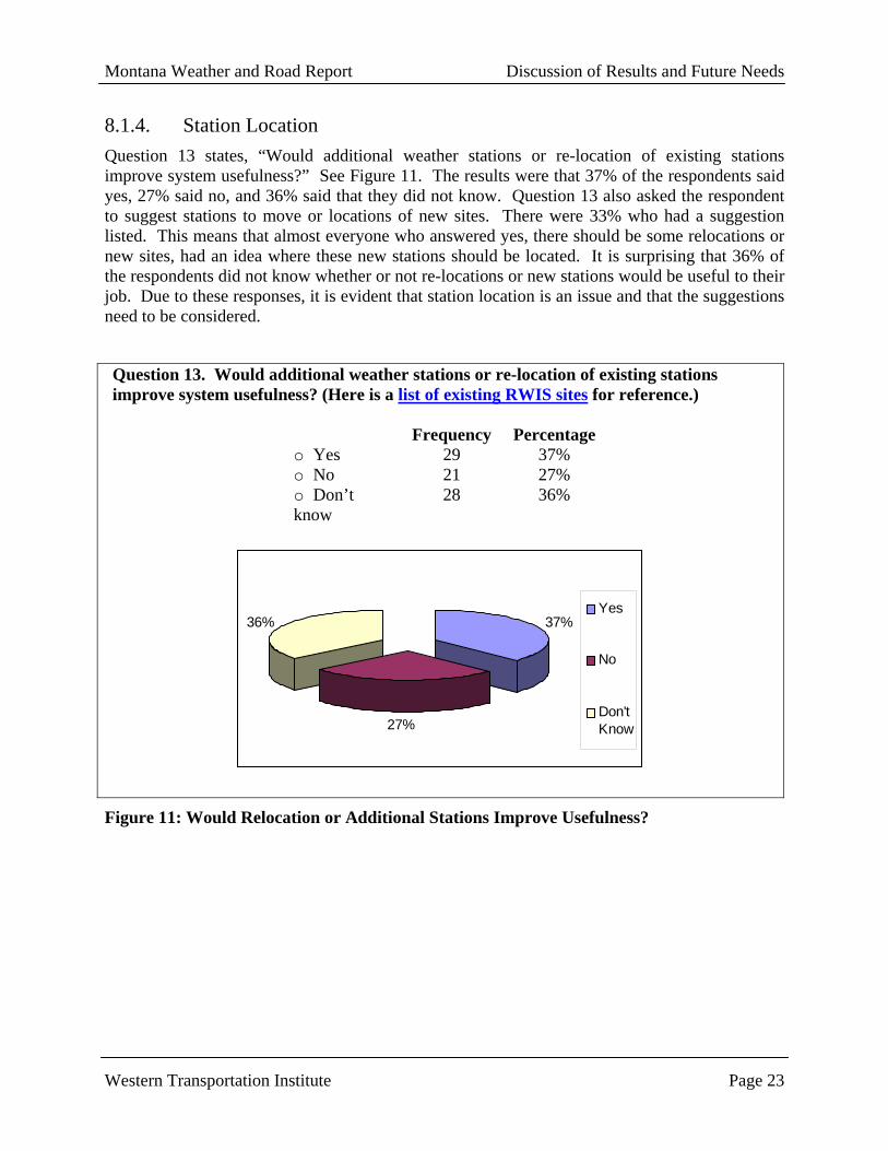
8.1.4. Station Location Question 13 states, “Would additional weather stations or re-location of existing stations improve system usefulness?” See Figure 11. The results were that 37% of the respondents said yes, 27% said no, and 36% said that they did not know. Question 13 also asked the respondent to suggest stations to move or locations of new sites. There were 33% who had a suggestion listed. This means that almost everyone who answered yes, there should be some relocations or new sites, had an idea where these new stations should be located. It is surprising that 36% of the respondents did not know whether or not re-locations or new stations would be useful to their job. Due to these responses, it is evident that station location is an issue and that the suggestions need to be considered.
Question 13. Would additional weather stations or re-location of existing stations improve system usefulness? (Here is a list of existing RWIS sites for reference.)
Frequency Percentageo Yes 29 37% o No 21 27% o Don’t know
28 36%
37%
27%
36%Yes
No
Don'tKnow
Figure 11: Would Relocation or Additional Stations Improve Usefulness?
Montana Weather and Road Report Discussion of Results and Future Needs
Western Transportation Institute Page 24
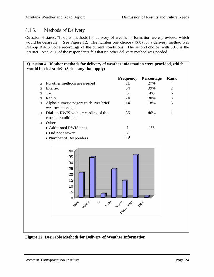
8.1.5. Methods of Delivery Question 4 states, “If other methods for delivery of weather information were provided, which would be desirable.” See Figure 12. The number one choice (46%) for a delivery method was Dial-up RWIS voice recordings of the current conditions. The second choice, with 39% is the Internet. And 27% of the respondents felt that no other delivery method was needed.
Question 4. If other methods for delivery of weather information were provided, which would be desirable? (Select any that apply)
Frequency Percentage Rank No other methods are needed 21 27% 4 Internet 34 39% 2 TV 3 4% 6 Radio 24 30% 3 Alpha-numeric pagers to deliver brief
weather message 14 18% 5
Dial-up RWIS voice recording of the current conditions
36 46% 1
Other: • Additional RWIS sites • Did not answer • Number of Responders
1 8 79
1%
05
10152025303540
None
Intern
et TVRad
io
Pagers
Dial-up
RWIS
Other
Figure 12: Desirable Methods for Delivery of Weather Information
Montana Weather and Road Report Discussion of Results and Future Needs
Western Transportation Institute Page 25
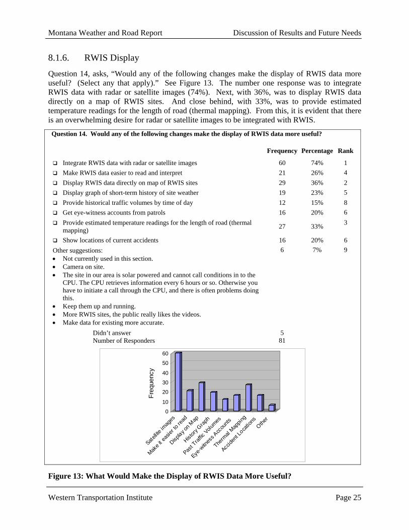
8.1.6. RWIS Display
Question 14, asks, “Would any of the following changes make the display of RWIS data more useful? (Select any that apply).” See Figure 13. The number one response was to integrate RWIS data with radar or satellite images (74%). Next, with 36%, was to display RWIS data directly on a map of RWIS sites. And close behind, with 33%, was to provide estimated temperature readings for the length of road (thermal mapping). From this, it is evident that there is an overwhelming desire for radar or satellite images to be integrated with RWIS.
Question 14. Would any of the following changes make the display of RWIS data more useful? Frequency Percentage Rank
Integrate RWIS data with radar or satellite images 60 74% 1 Make RWIS data easier to read and interpret 21 26% 4 Display RWIS data directly on map of RWIS sites 29 36% 2 Display graph of short-term history of site weather 19 23% 5 Provide historical traffic volumes by time of day 12 15% 8 Get eye-witness accounts from patrols 16 20% 6 Provide estimated temperature readings for the length of road (thermal
mapping) 27 33% 3
Show locations of current accidents 16 20% 6 Other suggestions: • Not currently used in this section. • Camera on site. • The site in our area is solar powered and cannot call conditions in to the
CPU. The CPU retrieves information every 6 hours or so. Otherwise you have to initiate a call through the CPU, and there is often problems doing this.
• Keep them up and running. • More RWIS sites, the public really likes the videos. • Make data for existing more accurate.
6 7% 9
Didn’t answer Number of Responders
5 81
0
10
20
30
40
50
60
Freq
uenc
y
Satellite
imag
es
Make i
t eas
ier to
read
Display o
n Map
History
Grap
h
Past T
raffic
Volumes
Eye-w
itnes
s Acc
ounts
Therm
al Map
ping
Accide
nt Lo
catio
nsOthe
r
Figure 13: What Would Make the Display of RWIS Data More Useful?

Montana Weather and Road Report Discussion of Results and Future Needs
Western Transportation Institute Page 26
8.1.7. Anti-icing Anti-icing is a process that uses chemicals to prevent bonded snow or ice on the roads. Thus, knowing when to apply the chemical to the road is dependent on the weather information provided. The timing of this process is critical. For example, if the chemical is placed on the road in anticipation of a storm and the storm does not happen, then the process has wasted valuable time and money. However, if the maintenance personnel wait too long to apply the chemical and the snow and ice bond to the road before the anti-icing process is started, then the de-icing process must be used. De-icing is the process of removing the snow that has already accumulated on the road. Thus, drivers are traveling on unsafe roads before the plow machines are sent out.
This process is evaluated in Question 18. The question states, “Which of the following would improve anti-icing in your region (Select any that apply).” See Figure 14. Surprisingly, 51% of the respondents checked “more resources (people and equipment)”. This means that the majority of MDT’s maintenance personnel feel that they could improve their anti-icing process if they had the access to more equipment and more employees. The next highest concern is the need for more reliable forecasts, with 48% responding. As mentioned previously, timing is critical to the anti-icing process. Therefore, having reliable and accurate forecasts would better facilitate the decision making process. There were 23% of the maintenance personnel who think that more familiarity with anti-icing practices would improve anti-icing in their region. It seems as if this issue could be resolved with a little more training and/or refresher courses as mentioned previously. From this data, it is evident that the anti-icing process needs to be evaluated. The three main areas of concern (in order of importance) are more resources, more reliable forecasts, and more familiarity with the anti-icing practices.

Montana Weather and Road Report Discussion of Results and Future Needs
Western Transportation Institute Page 27
Question 18. Which of the following would improve anti-icing in your region (select any that apply)?
Frequency Percentage More reliable forecasts. 39 48% More familiarity with anti-icing practices. 19 23% More resources (people and equipment.) 42 51% Not Applicable. 14 17% Other suggestions to improve anti-icing. • Be able to have enough liquid deicer to be able to
prewet. • We have been refused to use liquid deicer by
management. • We need less wind and warmer weather. • One additional truck, we are currently working on this
and should have it this year.
5 6%
Did not answer Total Responders
5 82
Figure 14: What Would Improve Anti-Icing in Your Region?
0 10 20 30 40 50
Reliable Forecasts
Familiarity with anti-icing
More resources
Not Applicable
Other

Montana Weather and Road Report Weather Decision Support Systems for MT
Western Transportation Institute Page 28
9. PROTOTYPE WEATHER DECISION SUPPORT SYSTEMS FOR MONTANA
9.1. Product Overview The prototype Montana Winter Maintenance DSS provides the maintenance decision maker with the necessary information to decide how to treat the roads. It is a map-based system that allows for monitoring of measured RWIS data and reported road conditions.
MWMDSS was developed in ArcView 3.2, a Geographic Information System (GIS) application. Arc View GIS allows the combination of spatial information with tables and databases. It incorporates querying capabilities based both on tabular attributes (e.g., [Name] = “Bozeman”) and spatial attributes (e.g., select all RWIS locations within Gallatin County). It is a highly customizable product with a built in language (Avenue) and many available extensions. Its developer, ESRI, has built a comprehensive web site to assist users with help, on line courses, and user groups.
9.1.1. Requirements Product requirements were derived based on research and survey results. A mind-mapping exercise was used to identify initial requirements and functionality (Figure 15).
MONTANA WINTERMAINTENANCE DSS
upsta
te co
nditio
ns
show alarm
conditions
Show temperature and
wind directio
nMDT Stations
Wea
ther S
tation
s
Alberta
Washington
Idah
o
Stations that meet criteria
Road conditions
Geographic
Queries
Decision Points
Anti-icing
guidelines
MDT Policies
References
Radar/Satellite
images
Weather Conditionsmes
osca
le RWIS
foreca
sts-
NWS
Side of window
Forecasts
Translate to
ArcView
use existing schema Road C
onditions
Bou
ndar
ies
Roads Roadside Equipment
Other M
ap Data
HAR
VMS
???
ConditionsReport
Reports
Use anti-icing
guidelines
Inpu
t scr
een
Recom
mended treatm
entQue
ries
Simple Map
Web Interface
Instru
ment W
arning
sDecision points
Alar
ms
Description of truck
Each district
Status
Maintenance
equipment DB
Num
of t
ruck
s
Other Stations
NW
S fo
reca
st a
lerts
RED: To be completed for IME 534Purple: To be completed by CS studentBlack: "Nice to have" for prototype
Figure 15: Montana Winter Maintenance DDS

Montana Weather and Road Report Weather Decision Support Systems for MT
Western Transportation Institute Page 29
Combined with the information to be provided in the DSS, high-level requirements include:
1. Provide road and weather data in an integrated map environment
2. Access support references from the application
3. Provide trend data for each RWIS site
4. Utilize the FHWA Anti-Icing guidelines to provide recommended treatments
Full requirements for an operational MWMDSS will be developed through meetings with MDT.
9.1.2. Functional Description The MWMDSS includes the built-in capabilities of ArcView with additional functionality. An overview of the capabilities is included in the following paragraphs.
Display of Simulated Real-Time Data Real data was obtained for February 14 – 17, 2001, during which a storm hit Montana and forced road closures in western Montana. The DSS plays back the RWIS data for these three days for twelve of the 59 locations. It depicts the road surface condition, the wind speed, and the direction. It also highlights a site when the site has indicated alarm conditions. The user can get more details about the current conditions by clicking on the icon. The application also includes an example of displaying reported road conditions for I-90 in Gallatin County.
Graph of Trend Conditions A custom tool was developed to allow the user to view the previous eight hours of data for the selected site. The graph shows road surface temperature, air temperature, and dew temperature. The user can also pick a location off the graph to get all data for that point in time.
Access to Reference Documents Through a pull-down menu, the user can open the FHWA Anti-icing guidelines. The current MDT road report based on the playback time can also be opened.
Recommended Treatment Action GUIs
The application includes screens for the use to request recommended actions. The user inputs the treatment location, road surface conditions and temperature trends. The submit button will open a GUI that provides recommended actions. At current time, The GUIs for this are only a shell, and functions will be added in the near future.
9.2. Design and Development The Montana Winter Maintenance DSS prototype was built as a stand-alone application to demonstrate the capabilities of a potential system, to use as a tool in soliciting requirements from potential users, and to serve as the foundation for an operational system. As a prototype, it is designed as a client-side application with no connection to a server. It is contained within ArcView with links to Microsoft Word for displaying reference documents. The product was developed in ArcView 3.2 with the Dialog Designer and Tracking Analyst extensions. Other development tools included Microsoft Excel, Microsoft Notepad, and PaintShop Pro.

Montana Weather and Road Report Weather Decision Support Systems for MT
Western Transportation Institute Page 30
The functionality of ArcView “out of the box” can be enhanced and customized through the use of extensions, GUI customization tools, and custom scripts. The product comes with extensions and sample scripts that need only to be added on. Some of the more powerful and complex extensions, such as the Tracking Analyst, can be purchased. Within ArcView, scripts can be assigned to customized buttons or menu functions.
9.2.1. Product Development Tasks After identifying the desired functions of the prototype, the development included five tasks.
Data Gathering The first task was to gather information. Literature references were already available for anti-icing practices, and a copy of the MDT Winter Maintenance Service Levels memorandum was available. Resources at MDT were able to provide the remaining needed data. For the base map, MDT provided their standard ArcView map data. They were also able to provide data from various sources for the February 14-17, 2001 time period. MDT provided the road conditions report in Word format with the data base used to produce the report. They were also able to download data for twelve RWIS sites.
Standard GIS Project Development Before implementing the decision support component of the project, standard GIS development had to be completed. The base map data obtained from MDT was added to the project and assigned appropriate colors and symbols. Some of the data required translation from latitude-longitude coordinates into the state plane coordinate system. Finally, the RWIS data had to be manipulated into a format appropriate for display in GIS. This required compiling twelve separate RWIS tables, eliminating black rows, assigning a name consistent with the name in the RWIS location table, creating and formatting the date and time column in the correct format, and merging the data with the RWIS location table.
Product Familiarization Significant time was spent to become familiar with the Tracking Analyst extension and Avenue, the ArcView programming language. Tracking Analyst allows ArcView to display and refresh time-dependent data. Its functionality was learned through an online tutorial. Time was also required to learn the proper format for data to be used with the tracking analyst. Upon becoming familiar with the Tracking Analyst, it was used to display the time dependent RWIS data.
The use and application of Avenue required intense study. Avenue is an object-oriented language, and its application is through scripts. Each object has properties where scripts can be executed. For example, a tool button has an updated script, and a click script. To assist in programming, the ArcView help includes a class diagram for each class and information about the properties and allowable requests for each class. The use of an 8-module online course helped in learning more about object-oriented programming, table manipulation, and the use of Avenue.
Customized Scripts While learning Avenue, scripts were developed or downloaded to add the desired functionality to the prototype. The dialog designer was also used to develop custom GUIs.
Montana Weather and Road Report Weather Decision Support Systems for MT
Western Transportation Institute Page 31
Figure 16: Startup Splash
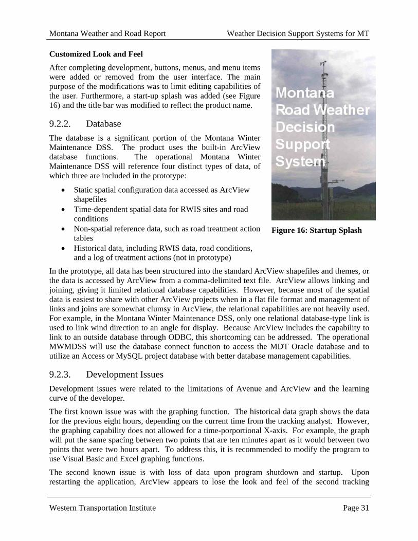
Customized Look and Feel After completing development, buttons, menus, and menu items were added or removed from the user interface. The main purpose of the modifications was to limit editing capabilities of the user. Furthermore, a start-up splash was added (see Figure 16) and the title bar was modified to reflect the product name.
9.2.2. Database The database is a significant portion of the Montana Winter Maintenance DSS. The product uses the built-in ArcView database functions. The operational Montana Winter Maintenance DSS will reference four distinct types of data, of which three are included in the prototype:
• Static spatial configuration data accessed as ArcView shapefiles
• Time-dependent spatial data for RWIS sites and road conditions
• Non-spatial reference data, such as road treatment action tables
• Historical data, including RWIS data, road conditions, and a log of treatment actions (not in prototype)
In the prototype, all data has been structured into the standard ArcView shapefiles and themes, or the data is accessed by ArcView from a comma-delimited text file. ArcView allows linking and joining, giving it limited relational database capabilities. However, because most of the spatial data is easiest to share with other ArcView projects when in a flat file format and management of links and joins are somewhat clumsy in ArcView, the relational capabilities are not heavily used. For example, in the Montana Winter Maintenance DSS, only one relational database-type link is used to link wind direction to an angle for display. Because ArcView includes the capability to link to an outside database through ODBC, this shortcoming can be addressed. The operational MWMDSS will use the database connect function to access the MDT Oracle database and to utilize an Access or MySQL project database with better database management capabilities.
9.2.3. Development Issues Development issues were related to the limitations of Avenue and ArcView and the learning curve of the developer.
The first known issue was with the graphing function. The historical data graph shows the data for the previous eight hours, depending on the current time from the tracking analyst. However, the graphing capability does not allowed for a time-porportional X-axis. For example, the graph will put the same spacing between two points that are ten minutes apart as it would between two points that were two hours apart. To address this, it is recommended to modify the program to use Visual Basic and Excel graphing functions.
The second known issue is with loss of data upon program shutdown and startup. Upon restarting the application, ArcView appears to lose the look and feel of the second tracking

Montana Weather and Road Report Weather Decision Support Systems for MT
Western Transportation Institute Page 32
theme. Currently, this requires that upon startup the table is rejoined to the wind direction angle table and the wind direction legend is loaded into the theme. To work around this, commands will be included in the startup script to execute these actions.
Finally, development of this product was limited by the lack of knowledge of the developer. When the developer knows the Avenue requests, programming is fairly easy. However, the ArcView help functions are limited in their search capabilities and makes finding the proper requests difficult.
9.3. Next Steps The next step in the development of a Montana Winter Maintenance DSS is to refine the prototype to the point where it can be utilized in requirements analysis. Western Transportation Institute will meet with the Lewistown maintenance decision in June to get feedback on the prototype and to solicit requirements for a functioning system. Before that time, the prototype will be improved to include:
• ¾ functional request maintenance actions capabilities • Clean startup capabilities without loss of data • Use of Excel graphing functions instead of ArcView graphs • At least one historical report • Buttons that switch between the different representations of road data • Satellite and radar images • MDT LOS documentation
Ultimately, the hope is to turn this product into a fully functional application. This will require development to interact with the real-time MDT database. Also, it would be desirable to build a web-based version of the application for maintenance staff without ArcView and for the traveling public.
Montana Weather and Road Report Conclusion
Western Transportation Institute Page 33
10. CONCLUSION
Overall, the acceptance to this project seems fairly good. There were a lot of positive comments made and many surveys were returned. However, there were some negative comments made and a relatively high number of people answering “I don’t know” on some questions. This could mean that they really do not know or that they are not taking to time to think about their response.
From the results, it is evident that training is one issue with using RWIS. The majority of MDT maintenance personnel feel that if they had more training that they could use RWIS to better advantage.

Montana Weather and Road Report Appendix A
Western Transportation Institute Page 34
11. APPENDIX A: MONTANA DEPARTMENT OF TRANSPORTATION RWIS SURVEY RESULTS
The following is a tally of the results from the Road Weather Information Survey that was conducted in September 2000. It is important to realize, however, that these results are still in their preliminary stages, and should not be used to formulate any solid conclusions at this time. What appears in the following consists of simple statistics such as percentages, means, frequencies, and occasionally standard deviations. It is our goal to further our statistical analysis so that we can make correlations, define trends, etc.
1. How often do you use the following types of weather information BEFORE making roadway maintenance decisions?
VERY
OFTEN (3)
OCCASIONALLY(2)
RARELY(1)
NEVER – NOT
NEEDED(0)
THIS INFO IS NOT
AVAILABLE(99)
RANK MEAN STANDARD DEVIATION
National Weather Service reports
54% (45)
39% (32)
4% (3)
2% (2)
1% (1) 2 2.46 0.680
Commercial weather forecasts (TV Weather Channel, etc.)
63% (52)
29% (24)
8% (7)
0% (0)
0% (0) 1 2.54 0.650
VAMS, or Contracted weather forecast service reports
10% (8)
21% (17)
25% (20)
16% (13)
27% (21) 4 1.34 0.983
RWIS information
26% (22)
51% (42)
14% (12)
6% (5)
2% (2) 3 2.00 0.822
Other sources used:
• Intellicast.com (2) • Internet-Doppler radar • Internet-NOAA information • Internet weather sources: radar screens, forecasts, etc. (3) • Local Accuweather (Internet) (3) • Local TV Weather Reports • Visual check (2) • Weather underground on the Internet. (2)

Montana Weather and Road Report Appendix A
Western Transportation Institute Page 35
2. How often do you refer to the following types of data to CONFIRM OR CHANGE your original maintenance plans?
VERY
OFTEN (3)
OCCASIONALLY(2)
RARELY(1)
NEVER – NOT
NEEDED(0)
THIS INFO IS NOT
NEEDED (99)
RANK MEAN STANDARD DEVIATION
National Weather Service reports
45% (38)
41% (35)
11% (9)
2% (2)
1% (1) 1 2.30 0.757
Commercial weather forecasts (TV Weather Channel, etc.)
45% (38)
39% (33)
13% (11)
2% (2)
0% (0) 2 2.27 0.782
VAMS or Contracted weather forecast service reports
10% (8)
23% (18)
23% (18)
22% (17)
23% (18) 4 1.28 1.019
RWIS information
21% (18)
39% (33)
29% (25)
11% (9)
0% (0) 3 1.71 0.924
Other sources used:
• Underground weather Internet web sites Internet weather Look out the window Local Accuweather on the Internet (2)

Montana Weather and Road Report Appendix A
Western Transportation Institute Page 36
3. How frequently do you use these methods to obtain weather information for making maintenance decisions?
VERY
OFTEN (3)
OCCASIONALLY(2)
RARELY(1)
NEVER – NOT
NEEDED(0)
THIS INFO IS NOT
AVAILABLE (99)
RANK MEAN STANDARD DEVIATION
Televised weather reports
52% (43)
35% (29)
12% (10)
0% (0)
1% (1) 1 2.40 0.700
Weather radio broadcasts
46% (39)
30% (25)
24% (20)
0% (0)
0% (0) 2 2.23 0.812
Commercial radio weather reports
37% (30)
39% (31)
21% (17)
2% (2)
0% (0) 3 2.11 0.827
Telephone calls 22% (17)
38% (30)
35% (28)
5% (4)
0% (0) 7 1.76 0.851
2-way radio calls 30% (25)
44% (36)
17% (14)
7% (6)
1% (1) 5 1.99 0.887
Alpha-numeric pager
0% (0)
3% (2)
11% (8)
41% (31)
46% (35) 9 0.29 0.559
MDT ‘SCANWEB’ RWIS internet website
27% (23)
42% (36)
24% (20)
7% (6)
0% (0) 6 1.89 0.887
Other internet website
42%
(34) 31% (25)
16% (13)
10% (8)
1% (1) 4 2.06 0.998
Computer, non-internet
6% (4)
14% (10)
29% (20)
44% (31)
7% (5) 8 0.80 0.922
Other means: • Climatological reports (averages) and modified taper charts. • Look out the window.

Montana Weather and Road Report Appendix A
Western Transportation Institute Page 37
4. If other methods for delivery of weather information were provided, which would be desirable? (Select any that apply)
Frequency Percentage Rank No other methods are needed 21 27% 4 Internet 34 39% 2 TV 3 4% 6 Radio 24 30% 3 Alpha-numeric pagers to deliver brief weather message 14 18% 5 Dial-up RWIS voice recording of the current conditions 36 46% 1 Other: • Additional RWIS sites • Did not answer • Number of Responders
1 8
79
1%
5. How useful is the following site-specific information to you in doing your job?
VERY
USEFUL (3)
SOMEWHAT USEFUL
(2)
NOT VERY
USEFUL(1)
NOT AT ALL
USEFUL(0)
THIS INFO IS NOT
AVAILABLE(99)
RANK MEAN STANDARD DEVIATION
Air Temperature 78% (66)
19% (16)
0% (0)
2% (2)
1% (1) 3 2.74 0.583
Wind Speed/Direction
57% (47)
29% (24)
11% (9)
1% (1)
1% (1) 5 2.44 0.742
Pavement Temperature
76% (65)
18% (15)
1% (1)
2% (2)
2% (2) 4 2.72 0.611
Dew Point / Relative Humidity
38% (31)
38% (31)
18% (15)
4% (3)
2% (2) 9 2.13 0.848
Road Subsurface Temperature
55% (47)
27% (23)
9% (8)
5% (4)
4% (3) 6 2.38 0.855
Precipitation / Snowfall
76% (62)
16% (13)
1% (1)
1% (1)
6% (5) 1 2.77 0.535
Road Surface Condition (Dry, Wet, Ice, etc.)
80% (66)
14% (12)
2% (2)
1% (1)
2% (2) 1 2.77 0.554
Freezing-point depressant concentration
34% (29)
39% (33)
15% (13)
5% (4)
7% (6) 10 2.10 0.856
Visibility data 45% (37)
28% (23)
14% (12)
1% (1)
12% (10) 7 2.32 0.797
Video Image 35% (29)
22% (18)
13% (11)
5% (4)
25% (21) 8 2.16 0.944
Other:
• All the above are very useful, but unavailable for this section and weather pattern. • Video would be the ultimate if cost was not a concern.

Montana Weather and Road Report Appendix A
Western Transportation Institute Page 38
6. How easy is it for you to obtain current RWIS information? Frequency Percentage
o It is always easy. (3) 31 37% o I sometimes encounter difficulties. (2) 40 48% o I often encounter difficulties. (1) 12 14% o It is always difficult. (0) 1 1%
Mean 2.20 SD = 0.724
7. How do you usually obtain RWIS information? Frequency Percentage
o Verbally or by notes, from radio room operator or other source 2 2%
o From a computer screen or printout, operated by someone else 2 2%
o From a computer that I operate 79 93% o I usually do not obtain this information 2 2%
8. How often are computer hardware or software problems encountered while trying to obtain RWIS data? Frequency Percentage
o More than once per day (3) 2 2% o More than once per week (2) 24 27% o More than once per month (1) 12 14% o Less than once per month (0) 28 32% o Don’t know (99) 22 25%
Mean 1.00 SD = 0.961
9. How often do you encounter weather station site data that is not current? Frequency Percentage
o More than once per day (3) 8 9% o More than once per week (2) 30 35% o More than once per month (1) 15 17% o Less than once per month (0) 13 15% o Don’t know (99) 20 23%
Mean 1.50 SD = 0.949

Montana Weather and Road Report Appendix A
Western Transportation Institute Page 39
10. What specific roadside locations are prone to having outdated data? Specify location, and what data is typically not current. Here is a list of existing RWIS sites for reference.
• Raynolds Pass (2) • Norris Hill (2) • Yaak Hill (3) • Crystal Creek (4) • Bowmans – usually 2to 4 hours behind • Helmville • Reedpoint • Rosco Hill • Ekalaka • Ninemile (3)
- All Data (1) - Communication problems and all information out dated (1)
• Cootonwood Hill - information is not updated like I would like to see. I sometimes get information
that is 4-8 hours old….sometimes over 8 hours. • Alzada • Lookout Pass (3)
- All Data (1) - Communication problems and all information out dated (1)
• Beaver Hill (2) - Data is usually incorrect (1)
• Lindsay Divide • Loughbourough Hill • Sioux Pass (2)
- Surface conditions not accurate (1) • Cow Creek • Aberdeen • Salteze • Dickey Lake
- I need the weather at the time I log on to find out what is happening to that particular piece of road. Right now it gives 3 hour intervals.
• Musselshell Hill • Judith Gap • Lame Deer Divide • North Dakota, Montana Stateline US #2
- Sometimes it doesn’t update on a regular basis • Two Medicine Bridge (2)
- Sometimes is not current • Bull Mountain Divide • Comertown Turnoff • MacPass

Montana Weather and Road Report Appendix A
Western Transportation Institute Page 40
• Monida (2) - The only one I use is Monida, and there seems to be some on going problems
there - Road conditions do not seem to be accurate
• Billings • Prickly Pear Creek; Sieben • Arrow Creek Hill
- Pavement temps, pavement conditions • Lolo
- Communication problems and all info can be outdated • Miscellaneous (9)
- N/A, Not Sure….etc. (4) - Through the RWIS system, we have updates twice per day from April 15 to
October 15. We then schedule the frequency to either hourly updates or every 3 hours. Our polling times start at either 4:00 AM or 5:00 AM which is just before a schedule shift starts…..
- They are all about the same. - I don’t use the RWIS for gathering information. - I don’t use it that much to know. - I don’t check all the sites all the time, but ever now and then one is down , I call
Mike and let him know. -
11. How often do you encounter inaccurate data from weather station sites? Frequency Percentage
o More than once per day (3) 9 10% o More than once per week (2) 20 23% o More than once per month (1) 15 17% o Less than once per month (0) 15 17% o Don’t know (99) 27 31%
Mean 1.39 SD = 1.034
12. What specific roadside locations are prone to data not being accurate? Specify location, and what data is typically not accurate. Here is a list of existing RWIS sites for reference. • Crystal Creek (2) • Bowmans
- usually 2 to 4 hours behind • Helmville • Flathead River Bridge (Kalispell ) • Ekalaka • Yaak Hill
Montana Weather and Road Report Appendix A
Western Transportation Institute Page 41
• Ninemile (2) - Many times the forecast says snow but we get rain or no precipitation at all,temp's
and amount of snow very to much in the mountains to be very accurate. • Cottonwood Hill (2)
- I-90 MP 261. All readings are sometimes 4-8 hrs. old (1) • Alzada • Beaver Hill • Lindsay Divide • Sioux Pass (2) • Cow Creek • Loughbourough Hill • Aberdeen • Bull Mountain Divide • Norris hill
- Road condition surface • Raynolds pass
- Road condition surface • Boulder Hill
- Is fairly close I check it all the time. I would have no way of knowing about the other sites. The video will be a great help this winter.
• Inverness • Monida
- Conditions show as icy when they are not • Billings • Prickly Pear Creek; Sieben • Miscellaneous Comments (10)
- It isn't the location so much as the information that they give don't match up with weather is doing or its data is different then the storm.
- We do not have many problems with our RWIS sites. The most common problem is related to phone line connections or the local server.
- Weather Forecast - Info collected at 3 hour intervals. We need current conditions at the time we log
on. - N/A, Unknown, None….. etc. (6)
13. Would additional weather stations or re-location of existing stations improve system usefulness? (Here is a list of existing RWIS sites for reference.) Frequency Percentage
o Yes 29 37% o No 21 27% o Don’t know 28 36%

Montana Weather and Road Report Appendix A
Western Transportation Institute Page 42
Please suggest stations to move or location of new sites. • Bozeman Urban Area • Mosby hill east of Winnett. • Would see a useful need for one in the lower Bozeman valley and one in Rocky
Canyon near milepost 316. • Montana HWY. 37 - Mile Post Area of 16 to 18. • Could use a station at the Marias River on I-15. • A real time image would make all sites more useful and reduce the lag time of
traveling to outlying locations. • Bowmans to the top of Missel Hill Mile Post 113.5 on P 24. • Lakeside. • Move to the top of Ninemile Hill. • I-94 MP 163.4 or near this site. Montana 7 at the Fallon County / Wibaux County
line MP 54.7. These would be new sites. • Add a station at I-94 189.8 the Powder River exit, this would give information for the
small weather pattern in the Terry section but wouldn't be very useful to anyone else • I90 M.P. 2.0 • Inez lake area • A new one at Sheep creek P-33 mile marker 37.5 • Secondary 278-Carroll Hill MM 32.4 Primary 46 MM 50 • If St.Regis had a RWIS station Saltese, Plains, and Superior sections could use the
information. • There is need of another pavement monitor on the Loma Hill and a new station site
between Havre and Chinook. • Broadview North , Co. Line • JCT at Rockvale. • US Hwy 2 MP 156.5----167.0------Marias Pass • Some stations south of Garrison would help see the weather coming from the
southwest (wisdom). • Yellow Bay on HWY 35 , and secondary 209. • Hogback • Divide east of Lewistown • Divide east Lewistown Beacon Hill south Grass Range. • New site at Marias Pass. • Montana 141 Avon to Helmville • I think a site at Caroll Hill or Badger Pass ( S-278) would be beneficial to me in
Dillon.

Montana Weather and Road Report Appendix A
Western Transportation Institute Page 43
14. Would any of the following changes make the display of RWIS data more useful? (Select any that apply).
Frequency Percentage Rank
Integrate RWIS data with radar or satellite images 60 74% 1
Make RWIS data easier to read and interpret 21 26% 4
Display RWIS data directly on map of RWIS sites 29 36% 2
Display graph of short-term history of site weather 19 23% 5 Provide historical traffic volumes by time of day 12 15% 8 Get eye-witness accounts from patrols 16 20% 6
Provide estimated temperature readings for the length of road (thermal mapping) 27 33%
3
Show locations of current accidents 16 20% 6 Other suggestions: • Not currently used in this section. • Camera on site. • The site in our area is solar powered and cannot call conditions in to
the CPU. The CPU retrieves information every 6 hours or so. Otherwise you have to initiate a call through the CPU, and there is often problems doing this.
• Keep them up and running. • More RWIS sites, the public really likes the videos. • Make data for existing more accurate.
6 7% 9
Didn’t answer Number of Responders
5 81
15. Regarding local weather forecasts provided by vendors (VAMS):
ALWAYS
GOOD (3)
USUALLY GOOD
(2)
USUALLY POOR
(1)
ALWAYS POOR
(0)
DON’T KNOW
(99) MEAN STANDARD
DEVIATION
How would you describe forecast accuracy?
2% (2)
58% (50)
20% (17)
1% (1)
19% (16) 1.76 0.523
How would you describe local weather forecast timeliness?
(6) **% **% **% **%
How easy are the local weather forecasts to understand?
15% (13)
56% (48)
8% (7)
2% (2)
19% (16) 2.03 0.636
Overall, how would you describe local weather forecasts usefulness?
14% (12)
49% (41)
17% (14)
2% (2)
18% (15) 1.91 0.702
** For this question, the database did not record responses other that “Always Good”

Montana Weather and Road Report Appendix A
Western Transportation Institute Page 44
16. For what time period should forecasts be provided and updated? (check any that apply.)
Frequency Percentage Rank o Hour o 2-4 hours
12 24
14% 28%
Provide a 2 hour forecast, updated every
o 6-12 hours o 12-24 hours o Unspecified
1 0 4
1% 0% 5%
o Total 41 48%
1
o Hour o 2-4 hours o 6-12 hours
4 15 7
5% 17% 8%
Provide a 6 hour forecast, updated every
o 12-24 hours o Unspecified
1 4
1% 5%
o Total 31 36%
4
Provide a 12 hour forecast, updated every
o Hour o 2-4 hours o 6-12 hours o 12-24 hours o Unspecified
4 10 12 5 0
5% 11% 14% 6% 0%
o Total 31 36%
4
Provide a 24 hour forecast, updated every
o Hour o 2-4 hours o 6-12 hours o 12-24 hours o Unspecified
3 11 9 9 2
3% 13% 10% 10% 2%
o Total 34 40%
2
Provide a 3 day forecast, updated every
o Hour o 2-4 hours o 6-12 hours o 12-24 hours o Unspecified
0 2 8
17 2
0% 2% 9%
20% 2%
o Total 29 34%
6
Provide a 5+ day forecast, updated every
o Hour o 2-4 hours o 6-12 hours o 12-24 hours o Unspecified
1 3 3
24 2
1% 3% 3%
28% 2%
o Total 33 38%
3

Montana Weather and Road Report Appendix A
Western Transportation Institute Page 45
17. How often do you use chemical anti-icing treatment of the road prior to the snow accumulation, on the following types of road?
VERY
OFTEN (3)
OCCASIONALLY(2)
RARELY(1)
NEVER(0)
NOT APPLICABLE
(99) RANK MEAN STANDARD
DEVIATION
Interstates 22% (15)
18% (12)
7% (5)
16% (11)
37% (25) 1 1.72 1.202
Primary Highways
25% (20)
28% (23)
14% (11)
20% (16)
14% (11) 2 1.67 1.126
Secondary Highways
5% (4)
23% (17)
21% (16)
32% (24)
19% (14) 4 1.02 0.975
City/County/Local Roads
27% (20)
14% (10)
7% (5)
23% (17)
29% (21) 3 1.63 1.299
No anti-icing (Did not answer, all “never”, all “N/A” = 26
18. Which of the following would improve anti-icing in your region (select any that apply)? Frequency Percentage
More reliable forecasts. 39 48% More familiarity with anti-icing practices. 19 23% More resources (people and equipment.) 42 51% Not Applicable. 14 17% Other suggestions to improve anti-icing. • Be able to have enough liquid deicer to be able to prewet. • We have been refused to use liquid deicer by management. • We need less wind and warmer weather. • One additional truck, we are currently working on this and should have
it this year.
5 6%
Did not answer Total Responders
5 82
19. How much training have you received in obtaining, interpreting, and using the RWIS information? Frequency Percentage
o Considerable amount 12 14% o Some 41 48% o Minimal amount 22 26% o None 10 12%
Other locations: • I don’t find that the forecasts are accurate enough to justify the cost, it may rain instead of snow. • I do not have the equipment for anti-icing at this time but will this fall. • Mostly in the shaded areas and on bridges.
Montana Weather and Road Report Appendix A
Western Transportation Institute Page 46
20. Do you think that you could use the RWIS to better advantage if you received more training? Frequency Percentage
o Yes 48 56%
o No 18 21%
o Don’t know 20 23%
21. Please list any suggestions on how to improve training on use of the RWIS system: • Have the information in a user-friendly format. • Refresher course in fall (4)
- Refresher course or orientation in October of each year - Have a class at least every fall. - We should have a four-hour refresher course every September. - We need refresher training.
• Need more accurate data. • Hands on, one on one during a storm. • Training needs to be tailored to the specific geographic region. • Cover the basics of the information being provided again like how relative
humidity relates to frost, etc. Cover all of the terms that would be useful to a Maintenance person in the field.
• We need more RWIS sites. • Train people in small groups. • More Training (2)
- We just need some more class time. - More training would help.
• Provide Training (3) - Just any training would help. - Have any training, as I’ve never been to one. - Just provide training.
• More knowledge on what we can access and how to accomplish this. • Educate everyone that has access to these sites.
22. Please provide suggestions to improve the usefulness of the RWIS system: • Have accurate forecast to plan work, and anticipate storm events • More RWIS stations. (5)
- We need more RWIS stations. - We need more RWIS stations. - We need more RWIS stations. - We need more RWIS sites: one in the Basin area Elk park would help. - More sites and more cameras.
• As it seems now, it is faster and less trouble is encountered when using the Scan web page and Internet page when accessing RWIS information. It takes too much

Montana Weather and Road Report Appendix A
Western Transportation Institute Page 47
time when racing in to get information from the server. The Internet and Scan web are faster.
• Storm situation training on all phases of storm maintenance. Hands on. • Radar • Prove that it is accurate. Develop an automatically populated form that can be
selected and printed with minimal effort and time requirements. • RWIS gets forecast from NOAA so this is a waste of tax dollars. • If RWIS could provide accurate weather information over a terrain of say 50 mile
radius, it would cover a mtce. Section. As a spot location only, it’s useless. • Thermal mapping • Train everyone that works winter maintenance on the use of it. • Updating information more often. • Corresponding the wind, snow level, and road temperature to how they relate to
road condition. Again, relative humidity and frost correlation. When and how ice forms-treatments to prevent this occurrence.
• If we had more pavement and air temperature sensors in our section we could probably cut down on overtime.
• Sometimes it is hard to access the system. Maybe we need a larger server. • Right now I use it because of curiosity more than a tool for maintenance operation
information. • If we could have our four-day forecast information and satellite and radar
information on the same page it would make it faster for us in the field. • New Contractor (2)
- We need a new contractor, last year the information was useless to me. In previous years I used it constantly.
- I did not like the forecasting service we got last year. It got so that I didn’t use it at all. I relied heavily on DTN.
• Make it easier to use. • Keep them up and running. • List of web addresses. • Keep the sites working. Shorten down time by fixing the problem in a timely
manner. • Have training that is useful to each individual area. • More cameras on the sites that are up and running. • It is just as fast and easier to send a truck out to check the road conditions!!! • Install camera.
23. Please provide any other suggestions on use of weather information with regard to making roadway maintenance decisions:
• We have found that the subsurface and surface temperatures help with chip sealing projects. We do have the public calling and asking what the weather conditions are for different areas.
• Better understanding of how to correlate reports as to the proper time and amounts of deicer to use.

Montana Weather and Road Report Appendix A
Western Transportation Institute Page 48
• Accurate weather information: wind, temperature, snow, rain, and estimated amounts are more desirable in regards to dispatching personnel.
• They need to put more systems in more areas in our part of the country to inform us of the north storms that we get.
• Monitor roadways for sections with specific areas of known snow belts and frequent temperature variances due to elevation or lake effect.
• Check the station out to see why it will show icy when it is froze dry!!! • Contract overlays, crack sealing projects, chip seal projects all are affected by
weather. It would be useful to have accurate forecasts that would cover a weekend and the first tow days of the following week. This would allow Maintenance to order asphalt. . .
• We need an accurate forecast on wind and drifting before applying deicing chemicals, as this is the biggest factor in weather we are helping or hurting the road conditions.
• RWIS located 100 miles apart can’t give me the locally accurate information that I need. In the mountains, the weather, air, and road temperatures vary too much throughout the section. That is why we need more air and road temperature sensors to really take advantage of the. . .
• I use the state map that provides road conditions that are called in at road report time. It is a very useful tool. RWIS is not used at all in my section.
• More frequent updates and always a several day forecast. Making it user-friendly should be top priority.
• Try to get a different contract for the VAMS with easy to read charts and graphics.
• The total winter maintenance workshop sounds great but how much will a person that has only worked one month with the department get out of this class. It seems like they would send someone that has to use this as a valuable tool in the winter. Just . . .
• Cell phones • I use the mini-forecast on projects. • Take the whole RWIS system out, spend the money on more equipment for the
maintenance divisions: i.e. motor patrols, snow blowers, rollers, brooms, bucket trucks, 294 trucks.
• Use reader boards in bad areas like canons and bad curves. • Use of radar imaging that is current for every hour with an easy way of defining
the amount of precipitation. • I look at the site information daily and use it, if its not working I can’t use it. • Have a National weather service office and satellite 1000 feet from section road. • Accurate weather reports and the ability to call up the site. The only way that I
can get the information is through the Intranet.

Montana Weather and Road Report Appendix A
Western Transportation Institute Page 49
24. Please provide the following information:
Frequency Percent
Title or Position
o Maintenance Chief 6 o Superintendent 13 o Field Supervisor 65 o Other (Please describe) 3
o 7% o 15% o 75% o 3%
District Office
o Billings 9 o Bozeman 8 o Butte 8 o Glendive 9 o Great Falls 7 o Havre 10 o Kalispell 11 o Lewistown 7 o Miles City 3 o Missoula 11 o Wolf Point 4
o 10% o 9% o 9% o 10% o 8% o 11% o 13% o 8% o 3% o 13% o 5%

Montana Weather and Road Report Appendix B
Western Transportation Institute Page 50
12. APPENDIX B: OPERATIONS GUIDE FOR MAINTENANCE FIELD PERSONNEL
INTRODUCTION
This appendix is a guide to highway anti-icing operations for maintenance field personnel. Its purpose is to suggest maintenance actions for preventing the formation or development of packed and bonded snow or bonded ice during a variety of winter weather events. It is intended to complement the decision-making and management practices of a systematic anti-icing program so that roads can be efficiently maintained in the best possible condition.
The guidance is based upon the results of four years of anti-icing field testing conducted by 15 State highway agencies and supported by the Strategic Highway Research Program (SHRP) and the Federal Highway Administration (FHWA). It has been augmented with practices developed outside the U.S., where necessary, for completeness. The recommendations are subject to refinement as U.S. highway agencies gain additional experience with anti-icing operations. Final decisions for their implementation rests with management personnel.
GUIDANCE FOR ANTI-ICING OPERATIONS
Guidance for anti-icing operations is presented in Tables 8 to 13 for six distinctive winter weather events. The six events are:
• Light Snow Storm • Light Snow Storm with Period(s) of Moderate or Heavy Snow • Moderate or Heavy Snow Storm • Frost or Black Ice • Freezing Rain Storm • Sleet Storm
The tables suggest the appropriate maintenance action to take during an initial or subsequent (follow-up) anti-icing operation for a given precipitation or icing event. Each action is defined for a range of pavement temperatures and an associated temperature trend. For some events the operation is dependent not only on the pavement temperature and trend, but also upon the pavement surface or the traffic condition at the time of the action. Most of the maintenance actions involve the application of a chemical in either a dry solid, liquid, or prewetted solid form. Application rates (“spread rates”) are given for each chemical form where appropriate. These are suggested values and should be adjusted, if necessary to achieve increased effectiveness or efficiency, for local conditions. The rates given for liquid chemicals are the equivalent dry chemical rates. Application rates in volumetric units such as L/lane-km (or gal/lane-mi) must be calculated from these dry chemical rates for each chemical and concentration.
Comments and notes are given in each table where appropriate to further guide the maintenance field personnel in their anti-icing operations.

Montana Weather and Road Report Appendix B
Western Transportation Institute Page 51
GLOSSARY OF TERMS
Black ice. Popular term for a very thin coating of clear, bubble-free, homogeneous ice which forms on a pavement with a temperature at or slightly above 0oC (32oF) when the temperature of the air in contact with the ground is below the freezing-point of water and small slightly supercooled water droplets deposit on the surface and coalesce (flow together) before freezing.
Dry chemical spread rate. The chemical application rate. For solid applications it is simply the weight of the chemical applied per lane kilometer (or mile). For liquid applications it is the weight of the dry chemical in solution applied per lane kilometer (or mile).
Freezing rain. Supercooled droplets of liquid precipitation falling on a surface whose temperature is below or slightly above freezing, resulting in a hard, slick, generally thick coating of ice commonly called glaze or clear ice. Non-supercooled raindrops falling on a surface whose temperature is well below freezing will also result in glaze.
Frost. Also called hoarfrost. Ice crystals in the form of scales, needles, feathers or fans deposited on surfaces cooled by radiation or by other processes. The deposit may be composed of drops of dew frozen after deposition and of ice formed directly from water vapor at a temperature below 0oC (32oF) (sublimation).
Light snow. Snow falling at the rate of less than 12 mm (1/2 in) per hour; visibility is not affected adversely.
Liquid chemical. A chemical solution; the weight of the dry chemical in solution applied per lane kilometer (or mile) is the chemical application rate – the “dry chemical spread rate” – used in this appendix.
Moderate or heavy snow. Snow falling at a rate of 12 mm (1/2 in) per hour or greater; visibility may be reduced.
Sleet. A mixture of rain and of snow which has been partially melted by falling through an atmosphere with a temperature slightly above freezing.
Slush. Accumulation of snow which lies on an impervious base and is saturated with water in excess of its freely drained capacity. It will not support any weight when stepped or driven on but will “squish” until the base support is reached.

Montana Weather and Road Report Appendix C
Western Transportation Institute Page 52
13. APPENDIX C: ANTI-ICING GUIDE FOR WINTER WEATHER EVENTS
13.1. Weather Event: Light Snow Storm PAVEMENT INITIAL OPERATION SUBSEQUENT OPERATIONS COMMENTS
TEMPERATURE RANGE,
AND TREND
pavement surface at
time of
maintenance action
dry chemical spread rate, kg/lane-km
(lb/lane-mi)
maintenance action
dry chemical spread rate, kg/lane-km
(lb/lane-mi)
initial operation
liquid solid or prewetted
solid
liquid solid or prewetted
solid
Above 0oC (32oF), steady or rising
Dry, wet, slush, or light snow cover
None, see comments
None, see comments
1) Monitor pavement temperature closely for drops toward 0oC (32oF) and below 2) Treat icy patches if needed with chemical at 28 kg/lane-km (100 lb/lane-mi); plow if needed
Above 0oC (32oF), 0oC (32oF) or below is imminent;
Dry Apply liquid or prewetted solid chemical
28 (100)
28 (100)
Plow as needed; reapply liquid or solid chemical when needed
28 (100)
28 (100)
1) Applications will need to be more frequent at lower temperatures and higher snowfall rates 2) It is not advisable to apply a liquid chemical at the indicated spread rate when the pavement
ALSO -7 to 0oC (20 to 32oF), remaining in range
Wet, slush, or light snow cover
Apply liquid or solid chemical
28 (100)
28 (100)
temperature drops below -5oC (23oF) 3) Do not apply liquid chemical onto heavy snow accumulation or packed snow
-10 to -7oC (15 to 20oF), remaining in range
Dry, wet, slush, or light snow cover
Apply prewetted solid chemical
55 (200)
Plow as needed; reapply prewetted solid chemical when needed
55 (200)
If sufficient moisture is present, solid chemical without prewetting can be applied
Below -10oC (15oF), steady or falling
Dry or light snow cover
Plow as needed Plow as needed 1) It is not recommended that chemicals be applied in this temperature range 2) Abrasives can be applied to enhance traction
CHEMICAL APPLICATIONS. (1) Time initial and subsequent chemical applications to prevent deteriorating conditions or development of packed and bonded snow. (2) Apply chemical ahead of traffic rush periods occurring during storm.
PLOWING. If needed, plow before chemical applications so that excess snow, slush, or ice is removed and pavement is wet, slushy, or lightly snow covered when treated.

Montana Weather and Road Report Appendix C
Western Transportation Institute Page 53
13.2. Weather Event: Light Snow Storm with Period(s) of Moderate or Heavy Snow PAVEMENT INITIAL OPERATION SUBSEQUENT OPERATIONS COMMENTS
TEMPERATURE RANGE,
AND TREND
pavement surface at
time of
maintenance action
dry chemical spread rate, kg/lane-km
(lb/lane-mi)
maintenance action
dry chemical spread rate, kg/lane-km
(lb/lane-mi)
initial operation
liquid
solid or prewetted
liquid solid or prewetted solid
solid light snow
heavier snow
light snow
heavier snow
Above 0oC (32oF), steady or rising
Dry, wet, slush, or light snow cover
None, see comments
None, see comments
1) Monitor pavement temperature closely for drops toward 0oC (32oF) and below 2) Treat icy patches if needed with chemical at 28 kg/lane-km (100 lb/lane-mi); plow if needed
Above 0oC (32oF), 0oC (32oF) or below is imminent;
Dry Apply liquid or prewetted solid chemical
28 (100)
28 (100)
Plow as needed; reapply liquid or solid
28 (100)
55 (200)
28 (100)
55 (200)
1) Applications will need to be more frequent at lower temperatures and higher snowfall rates 2) Do not apply liquid chemical onto
ALSO -4 to 0oC (25 to 32oF), remaining in range
Wet, slush, or light snow cover
Apply liquid or solid chemical
28 (100)
28 (100)
chemical when needed
heavy snow accumulation or packed snow 3) After heavier snow periods and during light snow fall, reduce chemical rate to 28 kg/lane-km (100 lb/lane-mi); continue to plow and apply chemicals as needed
-10 to -4oC (15 to 25oF), remaining in range
Dry, wet, slush, or light snow cover
Apply prewetted solid chemical
55 (200)
Plow as needed; reapply prewetted solid chemical when needed
55 (200)
70 (250)
1) If sufficient moisture is present, solid chemical without prewetting can be applied 2) Reduce chemical rate to 55 kg/lane-km (200 lb/lane-mi) after heavier snow periods and during light snow fall; continue to plow and apply chemicals as needed
Below -10oC (15oF), steady or falling
Dry or light snow cover
Plow as needed
Plow as needed 1) It is not recommended that chemicals be applied in this temperature range 2) Abrasives can be applied to enhance traction
CHEMICAL APPLICATIONS. (1) Time initial and subsequent chemical applications to prevent deteriorating conditions or development of packed and bonded snow. (2) Anticipate increases in snowfall intensity. Apply higher rate treatments prior to or at the beginning of heavier snowfall periods to prevent development of packed and bonded snow. (3) Apply chemical ahead of traffic rush periods occurring during storm.
PLOWING. If needed, plow before chemical applications so that excess snow, slush, or ice is removed and pavement is wet, slushy, or lightly snow covered when treated.

Montana Weather and Road Report Appendix C
Western Transportation Institute Page 54
13.3. Weather Event: Moderate or Heavy Snow Storm PAVEMENT INITIAL OPERATION SUBSEQUENT OPERATIONS COMMENTS
TEMPERATURE RANGE,
AND TREND
pavement surface at
time of
maintenance action
dry chemical spread rate, kg/lane-km
(lb/lane-mi)
maintenance action
dry chemical spread rate, kg/lane-km
(lb/lane-mi)
initial operation
liquid
solid or prewetted
solid
liquid solid or prewetted
solid
Above 0oC (32oF), steady or rising
Dry, wet, slush, or light snow cover
None, see comments
None, see comments
1) Monitor pavement temperature closely for drops toward 0oC (32oF) and below 2) Treat icy patches if needed with chemical at 28 kg/lane-km (100 lb/lane-mi); plow if needed
Above 0oC (32oF), 0oC (32oF) or below is imminent;
Dry Apply liquid or prewetted solid chemical
28 (100)
28 (100)
Plow accumulation and reapply liquid or solid
28 (100)
28 (100)
1) If the desired plowing/treatment frequency cannot be maintained, the spread rate can be increased to 55 kg/lane-km (200 lb/lane-mi) to accommodate longer operational cycles
-1 to 0oC (30 to 32oF), remaining in range
Wet,slush, or light snow cover
Apply liquid or solid chemical
28 (100)
28 (100)
chemical as needed
2) Do not apply liquid chemical onto heavy snow accumulation or packed snow
-4 to -1oC(25 to 30oF), remaining in range
Dry Apply liquid or prewetted solid chemical
55 (200)
42-55 (150-200)
Plow accumulation and reapply
55 (200)
55 (200)
1) If the desired plowing/treatment frequency cannot be maintained, the spread rate can be increased to 110 kg/lane-km (400 lb/lane-mi) to accommodate longer
Wet, slush, or light snow cover
Apply liquid or solid chemical
55 (200)
42-55 (150-200)
liquid or solid chemical as needed
operational cycles 2) Do not apply liquid chemical onto heavy snow accumulation or packed snow
-10 to -4oC(15 to 25oF), remaining in range
Dry, wet, slush, or light snow cover
Apply prewetted solid chemical
55 (200)
Plow accumulation and reapply prewetted solid chemical as needed
70 (250)
1) If the desired plowing/treatment frequency cannot be maintained, the spread rate can be increased to 140 kg/lane-km (500 lb/lane-mi) to accommodate longer operational cycles 2) If sufficient moisture is present, solid chemical without prewetting can be applied
Below -10oC(15oF), steady or falling
Dry or light snow cover
Plow as needed
Plow accumulation as needed
1) It is not recommended that chemicals be applied in this temperature range 2) Abrasives can be applied to enhance traction
CHEMICAL APPLICATIONS. (1) Time initial and subsequent chemical applications to prevent deteriorating conditions or development of packed and bonded snow -- timing and frequency of subsequent applications will be determined primarily by plowing requirements. (2) Apply chemical ahead of traffic rush periods occurring during storm.
PLOWING. Plow before chemical applications so that excess snow, slush, or ice is removed and pavement is wet, slushy, or lightly snow covered when treated.

Montana Weather and Road Report Appendix C
Western Transportation Institute Page 55
13.4. Weather Event: Frost or Black Ice PAVEMENT TRAFFIC INITIAL OPERATION SUBSEQUENT OPERATIONS COMMENTS
TEMPERATURE RANGE,
TREND, AND
CONDITION maintenance action
dry chemical spread rate, kg/lane-km
(lb/lane-mi)
maintenance action
dry chemical spread rate, kg/lane-km
(lb/lane-mi)
RELATION TO DEW POINT
liquid
solid or prewetted
solid
liquid solid or prewetted
solid
Above 0oC (32oF), steady or rising
Any level None, see comments
None, see comments
Monitor pavement temperature closely; begin treatment if temperature starts to fall to 0oC (32oF) or below and is at or below dew point
-2 to 2oC (28 to 35oF), remaining in range or falling to 0oC
Traffic rate less than 100 vehicles per h
Apply prewetted solid chemical
7-18 (25-65)
Reapply prewetted solid chemical as needed
7-18 (25-65)
1) Monitor pavement closely; if pavement becomes wet or if thin ice forms, reapply chemical at higher indicated rate 2) Do not apply liquid chemical on ice so thick
(32oF) or below, and equal to or below dew point
Traffic rate greater than 100 vehicles per h
Apply liquid or prewetted solid chemical
7-18 (25-65)
7-18 (25-65)
Reapply liquid or prewetted solid chemical as needed
11-32 (40-115)
7-18 (25-65)
that the pavement can not be seen
-7 to -2oC (20 to 28oF), remaining in range, and equal to or below dew point
Any level Apply liquid or prewetted solid chemical
18-36 (65-130)
18-36 (65-130)
Reapply liquid or prewetted solid chemical when needed
18-36 (65-130)
18-36 (65-130)
1) Monitor pavement closely; if thin ice forms, reapply chemical at higher indicated rate 2) Applications will need to be more frequent at higher levels of condensation; if traffic volumes are not enough to disperse condensation, it may be necessary to increase frequency 3) It is not advisable to apply a liquid chemical at the indicated spread rate when the pavement temperature drops below -5oC (23oF)
-10 to -7oC (15 to 20oF), remaining in range, and equal to or below dew point
Any level Apply prewetted solid chemical
36-55 (130-200)
Reapply prewetted solid chemical when needed
36-55 (130-200)
1) Monitor pavement closely; if thin ice forms, reapply chemical at higher indicated rate 2) Applications will need to be more frequent at higher levels of condensation; if traffic volumes are not enough to disperse condensation, it may be necessary to increase frequency
Below -10oC (15oF), steady or falling
Any level Apply abrasives
Apply abrasives as needed
It is not recommended that chemicals be applied in this temperature range
TIMING. (1) Conduct initial operation in advance of freezing. Apply liquid chemical up to 3 h in advance. Use longer advance times in this range to effect drying when traffic volume is low. Apply prewetted solid 1 to 2 h in advance. (2) In the absence of precipitation, liquid chemical at 21 kg/lane-km (75 lb/lane-mi) has been successful in preventing bridge deck icing when placed up to 4 days before freezing on higher volume roads and 7 days before on lower volume roads.

Montana Weather and Road Report Appendix C
Western Transportation Institute Page 56
13.5. Weather Event: Freezing Rain Storm PAVEMENT INITIAL OPERATION SUBSEQUENT OPERATIONS COMMENTS
TEMPERATURE RANGE,
AND TREND
maintenance action
chemical spread rate, kg/lane-km (lb/lane-mi)
maintenance action
chemical spread rate, kg/lane-km (lb/lane-mi)
Above 0oC (32oF), steady or rising
None, see comments
None, see comments
1) Monitor pavement temperature closely for drops toward 0oC (32oF) and below 2) Treat icy patches if needed with prewetted solid chemical at 21-28 kg/lane-km (75-100 lb/lane-mi)
Above 0oC (32oF), 0oC (32oF) or below is imminent
Apply prewetted solid chemical
21-28 (75-100)
Reapply prewetted solid chemical as needed
21-28 (75-100)
Monitor pavement temperature and precipitation closely
-7 to 0oC (20 to 32oF), remaining in range
Apply prewetted solid chemical
21-70 (75-250)
Reapply prewetted solid chemical as needed
21-70 (75-250)
1) Monitor pavement temperature and precipitation closely 2) Increase spread rate toward higher indicated rate with decrease in pavement temperature or increase in intensity of freezing rainfall 3) Decrease spread rate toward lower indicated rate with increase in pavement temperature or decrease in intensity of freezing rainfall
-10 to -7oC (15 to 20oF), remaining in range
Apply prewetted solid chemical
70-110 (250-400)
Reapply prewetted solid chemical as needed
70-110 (250-400)
1) Monitor precipitation closely 2) Increase spread rate toward higher indicated rate with increase in intensity of freezing rainfall 3) Decrease spread rate toward lower indicated rate with decrease in intensity of freezing rainfall
Below -10oC (15oF), steady or falling
Apply abrasives Apply abrasives as needed
It is not recommended that chemicals be applied in this temperature range
CHEMICAL APPLICATIONS. (1) Time initial and subsequent chemical applications to prevent glaze ice conditions. (2) Apply chemical ahead of traffic rush periods occurring during storm.

Montana Weather and Road Report Appendix C
Western Transportation Institute Page 57
13.6. Weather Event: Sleet Storm PAVEMENT INITIAL OPERATION SUBSEQUENT OPERATIONS COMMENTS
TEMPERATURE RANGE,
AND TREND
maintenance action
chemical spread rate, kg/lane-km (lb/lane-mi)
maintenance action
chemical spread rate, kg/lane-km (lb/lane-mi)
Above 0oC (32oF), steady or rising
None, see comments
None, see comments
1) Monitor pavement temperature closely for drops toward 0oC (32oF) and below 2) Treat icy patches if needed with prewetted solid chemical at 35 kg/lane-km (125 lb/lane-mi)
Above 0oC (32oF), 0oC (32oF) or below is imminent
Apply prewetted solid chemical
35 (125)
Plow as needed, reapply prewetted solid chemical when needed
35 (125)
Monitor pavement temperature and precipitation closely
-2 to 0oC (28 to 32oF), remaining in range
Apply prewetted solid chemical
35-90 (125-325)
Plow as needed, reapply prewetted solid chemical when needed
35-90 (125-325)
1) Monitor pavement temperature and precipitation closely 2) Increase spread rate toward higher indicated rate with increase in sleet intensity 3) Decrease spread rate toward lower indicated rate with decrease in sleet intensity
-10 to -2oC (15 to 28oF), remaining in range
Apply prewetted solid chemical
70-110 (250-400)
Plow as needed, reapply prewetted solid chemical when needed
70-110 (250-400)
1) Monitor precipitation closely 2) Increase spread rate toward higher indicated rate with decrease in pavement temperature or increase in sleet intensity 3) Decrease spread rate toward lower indicated rate with increase in pavement temperature or decrease in sleet intensity
Below -10oC (15oF), steady or falling
Plow as needed Plow as needed 1) It is not recommended that chemicals be applied in this temperature range 2) Abrasives can be applied to enhance traction
CHEMICAL APPLICATIONS. (1) Time initial and subsequent chemical applications to prevent the sleet from bonding to the pavement. (2) Apply chemical ahead of traffic rush periods occurring during storm.

Montana Weather and Road Report Appendix D
Western Transportation Institute Page 58
14. APPENDIX D: SAMPLE MDT STATEWIDE ROAD CONDITIONS REPORT
February 16, 2001
3:30 pm Report
From the Montana Department of Transportation, this is the report of statewide road conditions at 3:30 Friday afternoon February 16, 2001.
Roads across the state are mostly snowcovered to snowpacked and icy with areas of blowing and drifting snow and snowfall in Western, Southwestern and Central Montana.
The forecast for tonight calls mostly cloudy skies with scattered snow showers. West of the continental divide expected areas of heavy snow mainly in the mountains. Lows expected to be 5 below to 5 above zero in Southwestern Montana with lows zero to 15 above elsewhere.
Our Internet homepage address is www.mdt.state.mt.us; then choose Traveler Information.
From 10:00 pm to 6:00 am on weekdays and from 6:00 pm to 6:00 am on weekends and holidays, please refer to your local road reporting phone number for current road conditions. The listing for local numbers is option five following this greeting.
The following information includes all road conditions EXCEPT dry.
Interstates:
I 90, from Lookout Pass to St. Regis is snowpacked and icy with snowfall. From St. Regis to Frenchtown is intermittently snowpacked with wet and icy areas. From Frenchtown to Wye is wet. Continuing to the Bearmouth Interchange is intermittently icy. From the Bearmouth to the Phosphate Junction is snowcovered. From Phosphate to Warm Springs is mostly dry with infrequent snowpack, ice and blowing and drifting snow. Continuing to Butte is mostly dry with infrequent snowcover, snowpack and ice. Over Homestake Pass to Cottonwood Hill is snowcovered with areas of ice, light snowfall and blowing and drifting snow. From Bozeman over Bozeman Pass is intermittently snowpacked. From Bozeman Pass to Springdale is snowcovered with light snowfall and a high wind warning is in effect. From Springdale through Billings to Wyoming is mostly dry with infrequent snowpack, snowcover and ice.
I 15, from 20 miles south of Dillon to Glen is wet. From Glen to 13 miles north of Butte is snowcovered with blowing and drifting snow and light snowfall. From 13 to 30 miles north of Butte is intermittently snowpacked and icy. Over Boulder Hill to 3 miles south of Helena is snowpacked and icy. Continuing through Helena to 48 miles north is intermittently snowpacked and icy with areas of slush. From 48 miles north of Helena to Cascade is snowcovered and icy with light snowfall. From Cascade to Ulm is mostly dry with infrequent areas of snowpack, ice, slush, wet and light snowfall. From Ulm through Great Falls is intermittently icy with light snowfall. Continuing to Vaughn is snowcovered. From Vaughn to Brady is mostly dry with infrequent snowpack and ice along with blowing and drifting snow. Continuing to 16 miles north of Shelby is snowcovered with light snowfall.
I 94, from Billings to 10 miles east of Hysham is wet with area of snowcover. From 17 miles east of Forsyth to 13 miles west of Terry is mostly dry with infrequent snowpack and ice.
Montana Weather and Road Report Appendix D
Western Transportation Institute Page 59
Roads in Western Montana are mostly intermittently snowpacked and icy; please watch for the following:
US 93, Lost Trail Pass is intermittently snowpacked and nearby on MT 43, Chief Joseph Pass, is snowpacked with light snowfall over both passes.
US 12, over Lolo Pass to Lolo is snowpacked and icy with light snowfall.
US 93, from Lost Trail Pass to Missoula is wet with intermittent slush. From Wye to Arlee is intermittently icy. From Arlee to St. Ignatius is wet with light snowfall. From St. Ignatius to Elmo is intermittently snowpacked and icy with areas of slush. From Elmo to 10 miles north of Kalispell has light snowfall. From 10 miles north of Kalispell to Stryker is mostly dry with infrequent ice. Continuing to Canada is mostly dry with infrequent snowpack, ice and snowfall.
MT 200, from Idaho to Ravalli is snowpacked with areas of slush and snowfall.
MT 35, from Polson to 2 miles east of the junction with US 2 is intermittently snowpacked and icy with snowfall. Continuing to Kalispell has light snowfall.
MT 83, from the Clearwater Junction to Condon is snowpacked. Continuing to the junction with MT 35 is intermittently snowpacked with light snowfall.
US 2, from Idaho to Happy’s Inn is snowpacked with light snowfall. From Happy’s Inn to 8 miles west of Kalispell is snowcovered with snowfall. Continuing to the junction with MT 40 has light snowfall. From the junction with MT 40 to Coram is intermittently snowpacked and icy. From Coram over Marias Pass to East Glacier is snowpacked and icy with light snowfall. From East Glacier to Browning is mostly dry with infrequent snowpack, ice and light snowfall.
US 89, from Browning to the Kiowa Junction is mostly dry with infrequent snowpack, ice and light snowfall. Continuing north over the Hudson Bay Divide to Canada is intermittently snowpacked and icy. Chains are required for towing units over the divide.
Roads in Southwestern and Central Montana are mostly intermittently snowpacked and icy with some blowing and drifting snow; please watch for the following:
US 191, from West Yellowstone through the Gallatin Canyon is mostly dry with infrequent snowpack and ice. From Gallatin Canyon to Bozeman is intermittently snowpacked and icy.
US 287, from Ennis to Townsend is mostly dry with infrequent snowpack and ice.
US 12, from Garrison to Avon is snowpacked and icy with blowing and drifting snow. From Avon to MacDonald Pass is mostly dry with infrequent snowpack and ice. Over MacDonald Pass through Helena is snowpacked and icy. From Helena to the Canyon Ferry Turnoff is intermittently snowpacked and icy. From the Canyon Ferry Turnoff to Townsend is mostly dry with infrequent snowpack and ice.
MT 200, from Bonner to west of the junction with MT 141 is snowpacked and icy. From 5 miles west of the junction with MT 141 to Lincoln is intermittently snowpacked and icy with blowing and drifting snow and snowfall. From Lincoln over Rogers Pass to the bottom of the east side is snowpacked and icy with light snowfall and blowing and drifting snow. From the east side of the pass to the junction with US 287 is intermittently snowpacked. Continuing to Simms and Vaughn is snowcovered with scattered snowpack and light snowfall.

Montana Weather and Road Report Appendix D
Western Transportation Institute Page 60
US 89, from White Sulphur Springs to Kings Hill is mostly dry with infrequent snowpack and ice. Continuing north to Neihart is snowpacked, snowcovered and icy with light snowfall.
US 87E, from 16 miles west of Lewistown to the junction with MT 200 and MT 19 is mostly dry with infrequent snowpack, ice and light snowfall along with areas of snowcover and blowing and drifting snow.
US 87N, from Great Falls to 16 miles north is intermittently icy with light snowfall. Continuing north to Box Elder has areas of snowpack.
MT 3, from Billings to the Wheatland/Golden Valley County line is wet with snowcover on the shoulders. Continuing to Great Falls has areas of snowcover, snowpack, ice, shoulder snow and light snowfall.
US 87S, from Billings to the Musselshell County line has snowcovered shoulders. From 14 miles south of Grassrange to the junction with MT 200 and MT 19 is mostly dry with infrequent snowpack, ice and light snowfall.
US 2, from Browning to Ethridge is mostly dry with infrequent snowpack, ice and light snowfall. Continuing to Galata is snowcovered with light snowfall.
US 191, from Lewistown to 19 miles north is mostly dry with infrequent snowpack and ice along with blowing and drifting snow and light snowfall. Continuing north to 17 miles north of the junction with MT 19 has snowcover on the shoulders.
Roads in Eastern Montana are mostly dry with scattered snowpack and ice; please watch for the following:
US 212, from Crow Agency to Lame Deer is mostly dry with infrequent snowpack, ice and light snowfall.
MT 59, from 24 miles northwest of Broadus to Miles City is mostly dry with infrequent snowpack and ice.
US 12, from Baker to North Dakota is mostly dry with infrequent snowpack and ice.
MT 200, from the Fergus/Petroleum County line to 37 miles east of Winnett is mostly dry with infrequent snowpack and ice.
Montana Weather and Road Report References
Western Transportation Institute Page 61
15. REFERENCES
Pisano, Paul and Nelson, Gary, G. Surface Transportation Weather Decision Support Requirements. Draft (truncated) Version 1.0. Washington D.C., January 24, 2000. Pisano, Paul and Nelson, Gary, G. Surface Transportation Weather Decision Support Requirements: Operational Concept Description. Draft Version 2.0. Washington D.C., July 14, 2000. Rockvam, Judith and Xiong, Ia. Review of the Institutional Issues Relating to Road Weather Information Systems (RWIS). Eagan, Minnesota, August 1998. Tabler, Ronald, D. Improving the Wyoming Road Weather Information System. Niwot, Colorado, July 1998.