Embed Size (px)
Citation preview
FORM-T
(See Rule-7(A))
1.0 GENERAL
M/s. Sri. Nagendra Swami Stones Crusher, Proprietor Sri. K. Prasad Rao has applied
for grant of 1st renewal of Quarry Lease application vide reference dated 05.11.2008
for Road Metal, over an extent of 1.012 Ha in Sy No. I/B2 of Kachavaram village,
Ibrahimpatnam Mandal of Krishna District for a period of 15 years after paying the
necessary fee.
Further, ADM & G has inspected the area and reported entire hill consist of
Charnockite and Basalt group of rocks of Eastern Ghat super group of Archean group
of rocks and these rocks are use full for road Metal and Railway Basalt and
construction purpose. As per the Mandal revenue records the Sy. No. 1 of
Kachavaram village , Ibrahimpatnam Mandal, Krishna District is classified as revenue
land and given No objection to grant 1st renewal Quarry Lease for Road Metal over
an extent of 1.012 Ha.
Further, ADM & G, Vijayawada has reported that,the lessee is not having any Mineral
Revenue Dues against the other three leases. Finally, the ADM&G, Vijayawada has
recommended for grant 1st renewal of Quarry Lease for Road Metal , over an extent
of 1.012 Ha. in Sy. No. 1/B2 of Kachavaram village, Ibrahimpatnam Mandal, Krishna
District for a period of 15 years. In favour of M/s. Sri. Nagendra swami Stone Crusher ,
as per the rule of APMMC, 1966. Vide DDM& G 1st Renewal Grant Order Proce. No
786/Q/2009 dated 02.03.2009. The copy of the letter is attached as Annexure-I
Accordingly ,ADM & G is hereby accorded 1st renewal Grant to M/s. Sri. Nagendra
swami Stone Crusher, Proprietor Sri. K. Prasad Rao to commence the quarrying
operations for extraction of Road Metal & Gravel over an extent of 1.012Ha in Sy.
No.1/B2 of Kachavaram village, Ibrahimpatnam Mandal, Krishna district, Andhra
Pradesh State. For further period of 15 years with effect from 08.03.2009 to
07.03.2024 subject to the provision of the Andhra Pradesh Minor Mineral Concession
Rule,1966 and also conditions specified in the original grant order. The copy of the
working order is enclosed as Annexure-II.
The stone quarry is proposed for utilizing the mined aggregate for road metal purpose
only. Apart from this activity no other activity will be involved.
.
i) Name of applicant/lessee: M/s. Sri. Nagendra Swami Stones
Crusher
ii) Address: Proprietor Sri. Kondapalli Prasad Rao,
S/o Kondapalli Devaiah,48-8-15,
Flat-403, BS sastry Residency Opp
Zicon High School Raod, Gunadal
Vijayawada-Urban-520004
Ph. No. 9666558888
District Krishna State Andhra Pradesh
Pin code 520 001 Phone 9666558888
Fax -
Mobile No. 9666558888
Email Id iii) Status of applicant/lessee: Applicant
Private Individual/Co-operative
Association/Private Company/Public Limited Company/Public Sector Undertaking/Joint
Sector, undertaking/Other
Private Individual
iv) Mineral(s) which is/are included in the
prospecting license for fresh grant
Road Metal
v) Mineral (s) which is/are included in the letter of intent/lease deed
Road Metal
vi) Mineral (s) which is the applicant/lessee intends to mine
Road Metal
vii) Name of a person employed under clause (c)
of Sub Rule 1 of Rule 42 of MCDR 1988 Plan
Dr. R.C.Hanumanthu
RQP/DMG/AP/17/2015 H.No.1-1-520, Flat No.501, Prudhvi
Emerald Apartments, Gandhi Nagar, Hyderabad.
Address -
Phone No. - Mobile No. 9849832407
Fax No. - Email.ID -
Designation - Date of appointment -
2.0 LOCATION AND ACCESSIBILITY
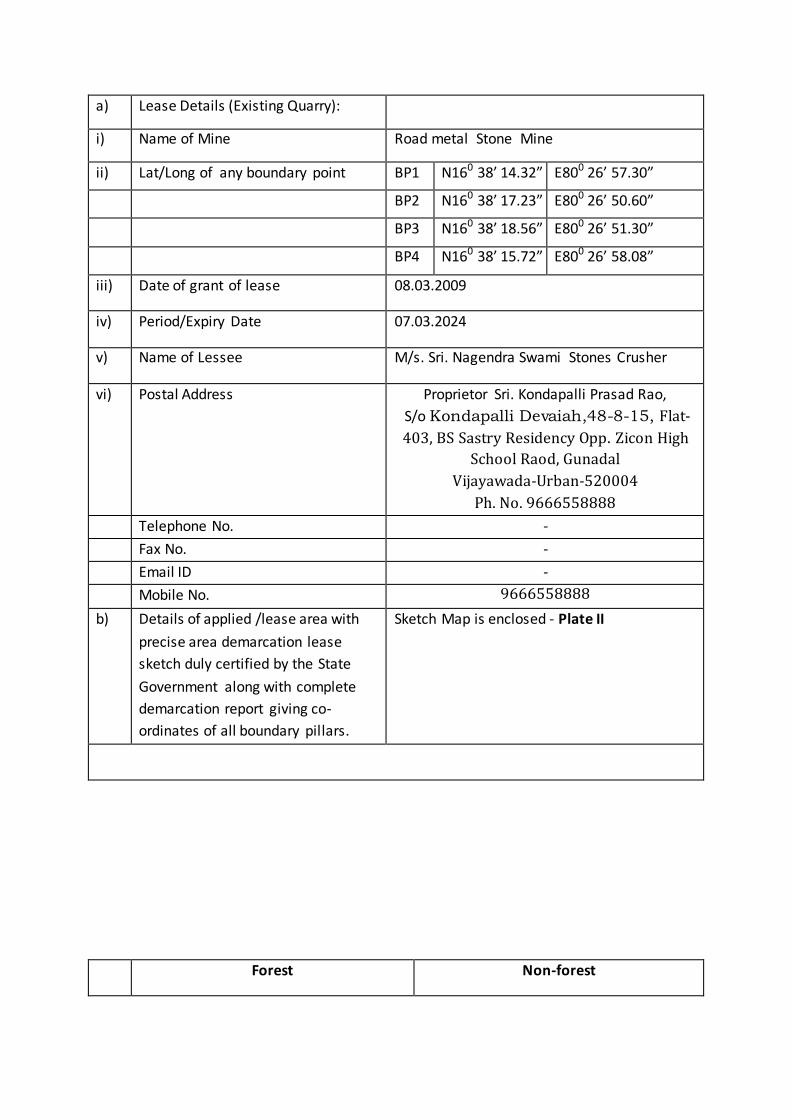
a) Lease Details (Existing Quarry):
i) Name of Mine Road metal Stone Mine
ii) Lat/Long of any boundary point BP1 N160 38’ 14.32” E800 26’ 57.30”
BP2 N160 38’ 17.23” E800 26’ 50.60”
BP3 N160 38’ 18.56” E800 26’ 51.30”
BP4 N160 38’ 15.72” E800 26’ 58.08”
iii) Date of grant of lease 08.03.2009
iv) Period/Expiry Date 07.03.2024
v) Name of Lessee M/s. Sri. Nagendra Swami Stones Crusher
vi) Postal Address Proprietor Sri. Kondapalli Prasad Rao,
S/o Kondapalli Devaiah,48-8-15, Flat-
403, BS Sastry Residency Opp. Zicon High
School Raod, Gunadal
Vijayawada-Urban-520004
Ph. No. 9666558888
Telephone No. -
Fax No. -
Email ID -
Mobile No. 9666558888
b) Details of applied /lease area with
precise area demarcation lease
sketch duly certified by the State
Government along with complete
demarcation report giving co-
ordinates of all boundary pillars.
Sketch Map is enclosed - Plate II
Forest Non-forest

Forest(specify) Division, Range, Beat and
Compartment. : NIL
Waste land :1.012 Ha.
Sy. No.1/B2
i) Total lease area/applied area 1.012 Hectares
ii) District & State Krishna, Andhra Pradesh
iii) Taluka Ibrahimpatnam
iv) Village Kachavaram
v) Whether the area falls under Coastal
Regulation Zone CRZ? if yes details
thereof.
No
Vi) Existing of public road/railway line, if any
nearby and approximate distance
Kachavaram village is 3.40 km and
Kethanakonda Village is 5.00 km from
Quarry
Ibrahimpatnam is 13.50 km from the
quarry lease
vii) Topo-sheet No. with latitude and
longitude of all corner boundary point
pillar
Toposheet No : 65D/10
Latitude & Longitude of the boundary
points are furnished in the surface/
geological Plan Plate -3
viii Attach a general location map showing
area and access routes.
Enclosed - Plate I,
Key Plan on 1:50,000 scale is enclosed
3.0 DETAILS OF APPROVED MINING PLAN / SCHEME OF MINING (ifany)
3.1 Date and reference of earlier approved MP/SOM No Mining Plan is prepared and submitted earlier for mining of Road Metal Quarry.
3.2 Details of last modifications if any (for the previous approved period) of approved
MP/SOM, indicating date of approval, reason for modification
Not applicable
3.3 Give review of earlier approved proposal (if any) in respect of exploration, excavation,
reclamation etc.
Not Applicable
3.4 Give status of compliance of violations pointed out by IBM
Not Applicable.
3.5 Indicate and give details of any suspension /closure/ prohibitory order issued by any Government agency under any rule or Court of law Not Applicable
3.6 In case the MP/SOM is submitted under rules 9 and 10 of the MCDR’88 or under rule 22(4) of the MCR’1960 for approval of modification, specify reason and justification for modification under these rules. Not Applicable
PART-A
1. GENERAL DETAILS OF THE APPLED AREA/ MINING LEASE
BRIEF DESCRIPTION OF TOPOSHRAPHY, DRAINAGE PATTERN, VEGETATION, CLIMATE,
RAINFALL DATA OF THE APPLIED AREA/ MINING LEASE AREA.
Topography: The area is characterized with steep raising topography elevation is 120m
above the general ground level. The highest elevation in the lease area 550m and the
lowest is 430m with respective obituary mean sea level. The general slope direction is
towards Southeastern direction. The surface plan showing the proposed stone quarry
site is given in Plate No- III
Area falls under survey of India Toposheet No: 65 D/10
Drainage Pattern: The drainage pattern is normally observed in this area is Dendritic
type and around the lease area and steep slopes towards south side. The surface run-
off water flows down the slopes and flows outside the lease area through the small
seasonal stream.
Geo-Co-ordinated of the boundary pillars are given in the previous tables, with map
datum WGS-84 datum and Magnetic North.
Topography - Topo Map is enclosed as Plate -I
Vegetation: The entire lease area is broken up land of non-forest area. No cultivation
land or inhabitants is observed in the mining lease.
Climate:
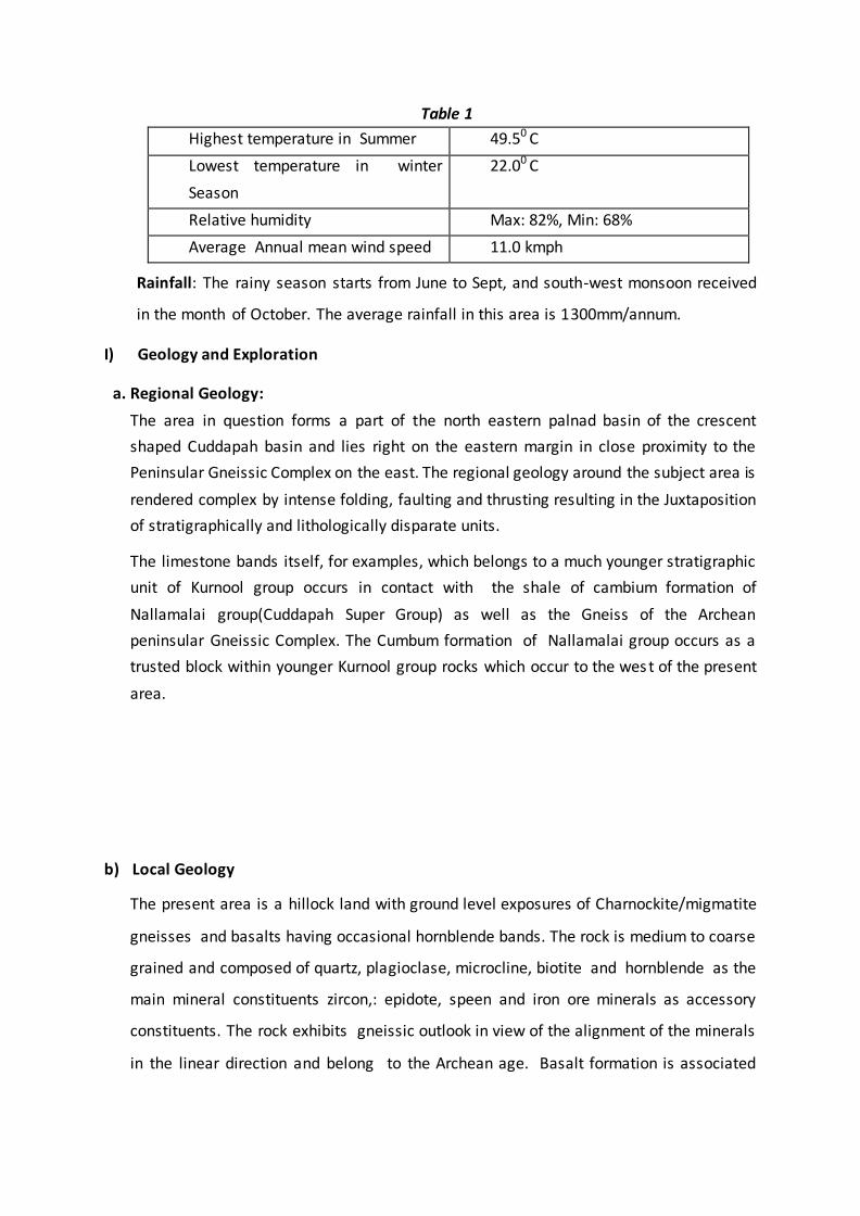
Table 1
Highest temperature in Summer 49.50 C
Lowest temperature in winter
Season
22.00 C
Relative humidity Max: 82%, Min: 68%
Average Annual mean wind speed 11.0 kmph
Rainfall: The rainy season starts from June to Sept, and south-west monsoon received
in the month of October. The average rainfall in this area is 1300mm/annum.
I) Geology and Exploration
a. Regional Geology:
The area in question forms a part of the north eastern palnad basin of the crescent
shaped Cuddapah basin and lies right on the eastern margin in close proximity to the
Peninsular Gneissic Complex on the east. The regional geology around the subject area is
rendered complex by intense folding, faulting and thrusting resulting in the Juxtaposition
of stratigraphically and lithologically disparate units.
The limestone bands itself, for examples, which belongs to a much younger stratigraphic
unit of Kurnool group occurs in contact with the shale of cambium formation of
Nallamalai group(Cuddapah Super Group) as well as the Gneiss of the Archean
peninsular Gneissic Complex. The Cumbum formation of Nallamalai group occurs as a
trusted block within younger Kurnool group rocks which occur to the wes t of the present
area.
b) Local Geology
The present area is a hillock land with ground level exposures of Charnockite/migmatite
gneisses and basalts having occasional hornblende bands. The rock is medium to coarse
grained and composed of quartz, plagioclase, microcline, biotite and hornblende as the
main mineral constituents zircon,: epidote, speen and iron ore minerals as accessory
constituents. The rock exhibits gneissic outlook in view of the alignment of the minerals
in the linear direction and belong to the Archean age. Basalt formation is associated
with medium and thin bands of shale of varying thickness. The thickness of the Basal
formation is around 80 to 100 m
c) Details of Prospecting license holder : Not Applicable
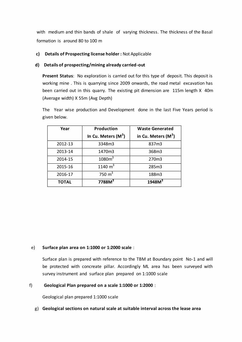
d) Details of prospecting/mining already carried-out
Present Status: No exploration is carried out for this type of deposit. This deposit is
working mine . This is quarrying since 2009 onwards, the road metal excavation has
been carried out in this quarry. The existing pit dimension are 115m length X 40m
(Average width) X 55m (Avg Depth)
The Year wise production and Development done in the last Five Years period is
given below.
Year Production
In Cu. Meters (M3)
Waste Generated
in Cu. Meters (M3)
2012-13 3348m3 837m3
2013-14 1470m3 368m3
2014-15 1080m3 270m3
2015-16 1140 m3 285m3
2016-17 750 m3 188m3
TOTAL 7788M3 1948M3
e) Surface plan area on 1:1000 or 1:2000 scale :
Surface plan is prepared with reference to the TBM at Boundary point No-1 and will
be protected with concreate pillar. Accordingly ML area has been surveyed with
survey instrument and surface plan prepared on 1:1000 scale
f) Geological Plan prepared on a scale 1:1000 or 1:2000 :
Geological plan prepared 1:1000 scale
g) Geological sections on natural scale at suitable interval across the lease area
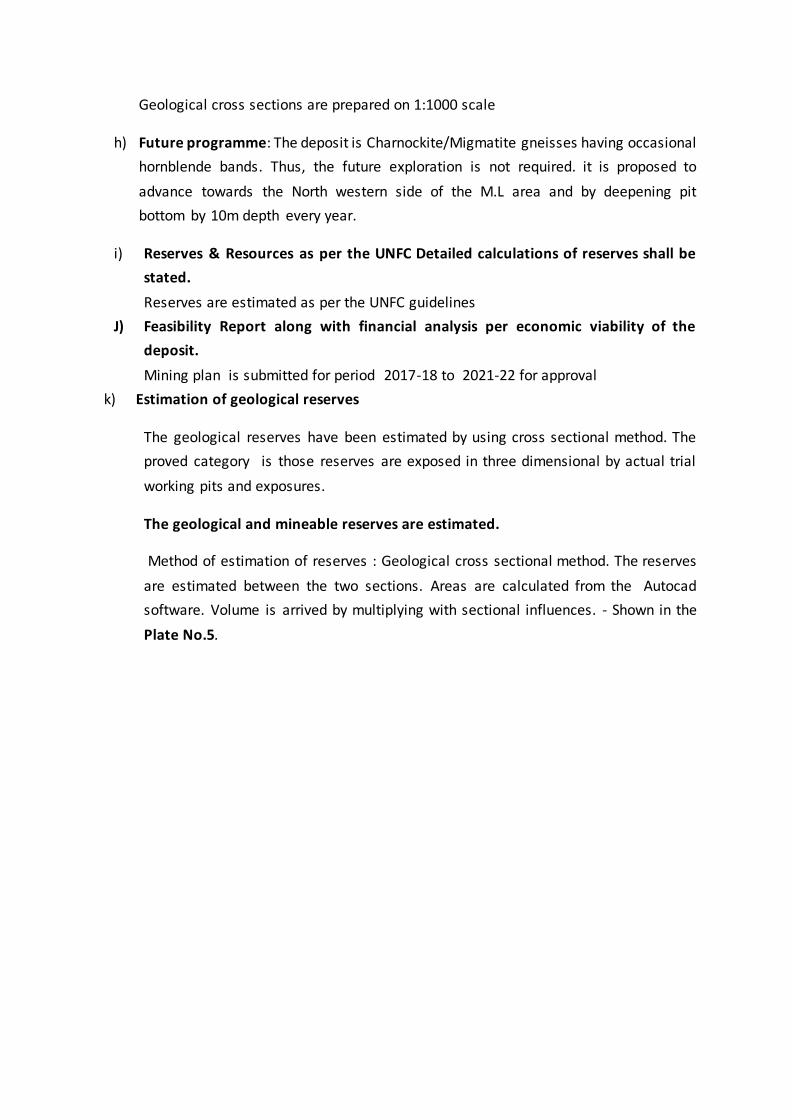
Geological cross sections are prepared on 1:1000 scale
h) Future programme: The deposit is Charnockite/Migmatite gneisses having occasional
hornblende bands. Thus, the future exploration is not required. it is proposed to
advance towards the North western side of the M.L area and by deepening pit
bottom by 10m depth every year.
i) Reserves & Resources as per the UNFC Detailed calculations of reserves shall be
stated.
Reserves are estimated as per the UNFC guidelines
J) Feasibility Report along with financial analysis per economic viability of the
deposit.
Mining plan is submitted for period 2017-18 to 2021-22 for approval
k) Estimation of geological reserves
The geological reserves have been estimated by using cross sectional method. The
proved category is those reserves are exposed in three dimensional by actual trial
working pits and exposures.
The geological and mineable reserves are estimated.
Method of estimation of reserves : Geological cross sectional method. The reserves
are estimated between the two sections. Areas are calculated from the Autocad
software. Volume is arrived by multiplying with sectional influences. - Shown in the
Plate No.5.
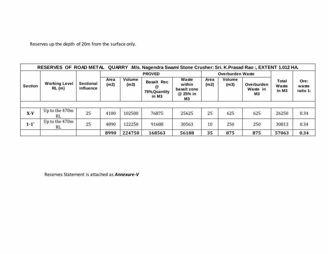
Reserves up the depth of 20m from the surface only.
RESERVES OF ROAD METAL QUARRY :M/s. Nagendra Swami Stone Crusher: Sri. K.Prasad Rao :, EXTENT 1.012 HA.
Section Working Level
RL (m) Sectional influence
PROVED Overburden Waste
Total
Waste In M3
Ore:
waste ratio 1:
Area
(m2)
Volume
(m3) Basalt Rec
@
75%,Quantity in M3
Waste
within basalt zone @ 25% in
M3
Area
(m2)
Volume
(m3) Overburden Waste in
M3
X-Y Up to the 470m
RL 25 4100 102500 76875 25625 25 625 625 26250 0.34
1-1' Up to the 470m
RL 25 4890 122250 91688 30563 10 250 250 30813 0.34
8990 224750 168563 56188 35 875 875 57063 0.34
Reserves Statement is attached as Annexure-V
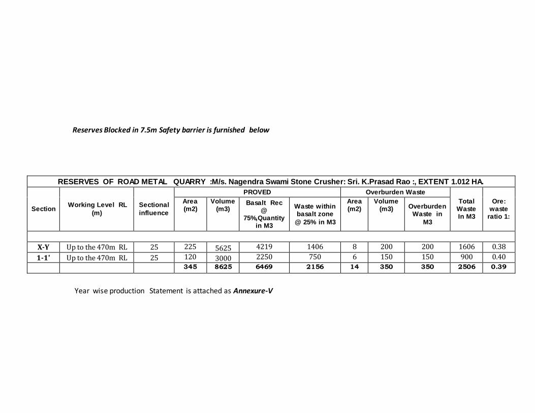
Reserves Blocked in 7.5m Safety barrier is furnished below
RESERVES OF ROAD METAL QUARRY :M/s. Nagendra Swami Stone Crusher: Sri. K.Prasad Rao :, EXTENT 1.012 HA.
Section Working Level RL
(m)
Sectional
influence
PROVED Overburden Waste
Total Waste In M3
Ore: waste
ratio 1:
Area (m2)
Volume (m3)
Basalt Rec @
75%,Quantity in M3
Waste within basalt zone
@ 25% in M3
Area (m2)
Volume (m3) Overburden
Waste in
M3
X-Y Up to the 470m RL 25 225 5625 4219 1406 8 200 200 1606 0.38
1-1' Up to the 470m RL 25 120 3000 2250 750 6 150 150 900 0.40
345 8625 6469 2156 14 350 350 2506 0.39
Year wise production Statement is attached as Annexure-V
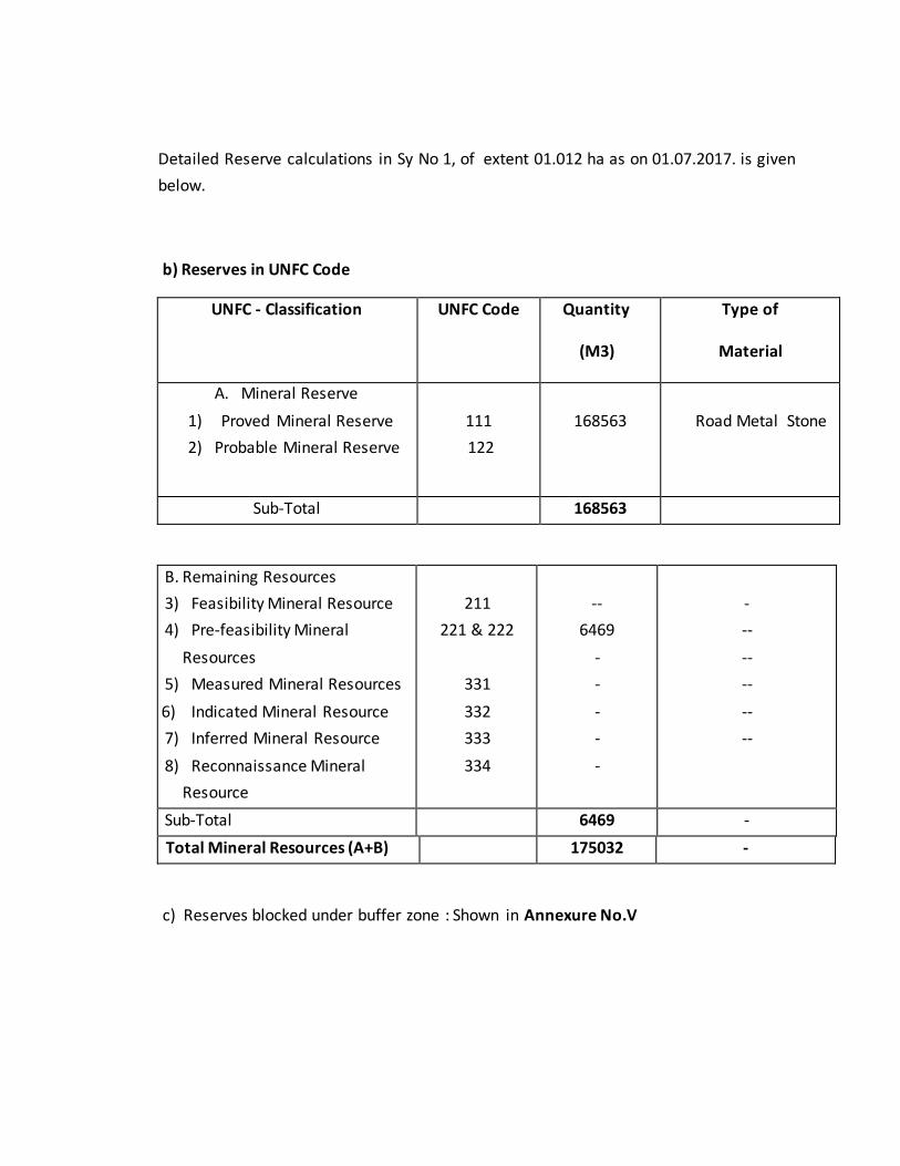
Detailed Reserve calculations in Sy No 1, of extent 01.012 ha as on 01.07.2017. is given
below.
b) Reserves in UNFC Code
UNFC - Classification UNFC Code Quantity
(M3)
Type of
Material
A. Mineral Reserve
1) Proved Mineral Reserve
2) Probable Mineral Reserve
111
122
168563
Road Metal Stone
Sub-Total 168563
B. Remaining Resources
3) Feasibility Mineral Resource
4) Pre-feasibility Mineral
Resources
5) Measured Mineral Resources
6) Indicated Mineral Resource
7) Inferred Mineral Resource
8) Reconnaissance Mineral
Resource
211
221 & 222
331
332
333
334
--
6469
-
-
-
-
-
-
--
--
--
--
--
Sub-Total 6469 -
Total Mineral Resources (A+B) 175032 -
c) Reserves blocked under buffer zone : Shown in Annexure No.V
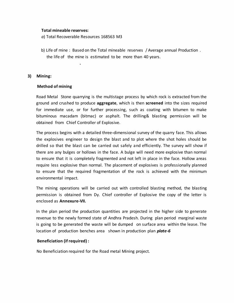
Total mineable reserves:
a) Total Recoverable Resources 168563 M3
b) Life of mine : Based on the Total mineable reserves / Average annual Production .
the life of the mine is estimated to be more than 40 years.
.
3) Mining:
Method of mining
Road Metal Stone quarrying is the multistage process by which rock is extracted from the
ground and crushed to produce aggregate, which is then screened into the sizes required
for immediate use, or for further processing, such as coating with bitumen to make
bituminous macadam (bitmac) or asphalt. The drilling& blasting permission will be
obtained from Chief Controller of Explosive.
The process begins with a detailed three-dimensional survey of the quarry face. This allows
the explosives engineer to design the blast and to plot where the shot holes should be
drilled so that the blast can be carried out safely and efficiently. The survey will show if
there are any bulges or hollows in the face. A bulge will need more explosive than normal
to ensure that it is completely fragmented and not left in place in the face. Hollow areas
require less explosive than normal. The placement of explosives is professionally planned
to ensure that the required fragmentation of the rock is achieved with the minimum
environmental impact.
The mining operations will be carried out with controlled blasting method, the blasting
permission is obtained from Dy. Chief controller of Explosive the copy of the letter is
enclosed as Annexure-VII.
In the plan period the production quantities are projected in the higher side to generate
revenue to the newly formed state of Andhra Pradesh. During plan period marginal waste
is going to be generated the waste will be dumped on surface area within the lease. The
location of production benches area shown in production plan plate-6
Beneficiation (if required) :
No Beneficiation required for the Road metal Mining project.
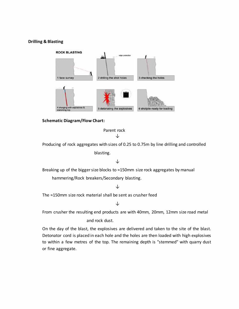
Drilling & Blasting
Schematic Diagram/Flow Chart:
Parent rock ↓
Producing of rock aggregates with sizes of 0.25 to 0.75m by line drilling and controlled
blasting.
↓
Breaking up of the bigger size blocks to ≈150mm size rock aggregates by manual
hammering/Rock breakers/Secondary blasting.
↓
The ≈150mm size rock material shall be sent as crusher feed
↓
From crusher the resulting end products are with 40mm, 20mm, 12mm size road metal
and rock dust.
On the day of the blast, the explosives are delivered and taken to the site of the blast.
Detonator cord is placed in each hole and the holes are then loaded with high explosives
to within a few metres of the top. The remaining depth is "stemmed" with quarry dust
or fine aggregate.
The site is cleared. Sirens are sounded to make sure that everyone nearby is warned.
The detonators are connected to the electric trigger wire and the circuit is checked. A
final safety check is carried out and only when the final all clear is given does the
shotfirer set off the explosives. A single blast can fragment up to 50 to 60 tonnes of
rock.
After the blast, the face and shotpile (sometimes called the muck-heap) are inspected to
check that all the shot holes have fired correctly. The face shovel or loader then tidies
up the shotpile and starts to load the dumper trucks that take the rock to the crusher.
Boulders which are too big to go through the crusher are set to one side for secondary
breaking at a later date. Secondary breaking is typically done using a hydraulic digger
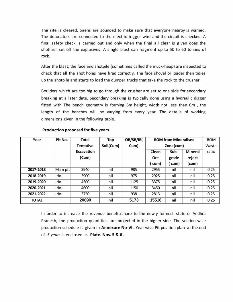
fitted with The bench geometry is forming 6m height, width not less than 6m , the
length of the benches will be varying from every year. The details of working
dimensions given in the following table.
Production proposed for five years.
Year Pit No. Total
Tentative
Excavation
(Cum)
Top
Soil(Cum)
OB/SB/IB(
Cum)
ROM from Mineralised
Zone(cum)
ROM
Waste
ratio Clean
Ore
( cum)
Sub-
grade
( cum)
Mineral
reject
(cum)
2017-2018 Main pit 3940 nil 985 2955 nil nil 0.25
2018-2019 -do- 3900 nil 975 2925 nil nil 0.25
2019-2020 -do- 4500 nil 1125 3375 nil nil 0.25
2020-2021 -do- 4600 nil 1150 3450 nil nil 0.25
2021-2022 -do- 3750 nil 938 2813 nil nil 0.25
TOTAL 20690 nil 5173 15518 nil nil 0.25
In order to increase the revenue benefit/share to the newly formed state of Andhra
Pradesh, the production quantities are projected in the higher side. The section wise
production schedule is given in Annexure No-VI . Year wise Pit position plan at the end
of 5 years is enclosed as Plate. Nos. 5 & 6 .
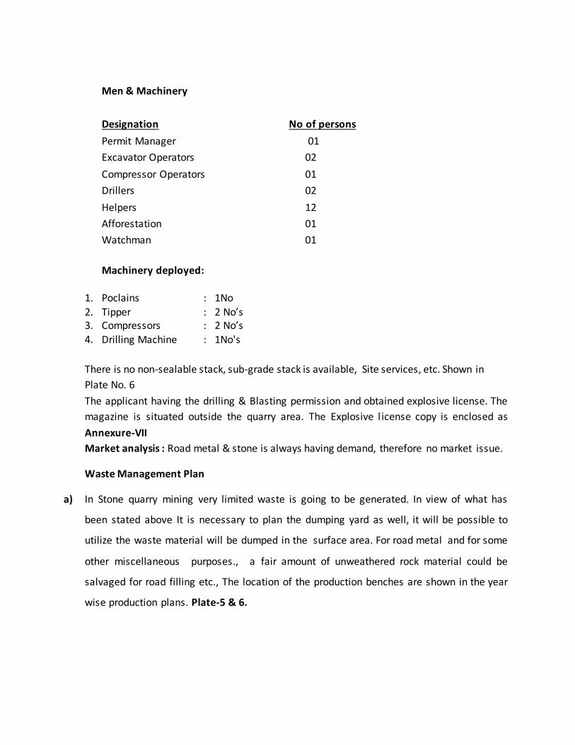
Men & Machinery
Designation No of persons
Permit Manager 01
Excavator Operators 02
Compressor Operators 01
Drillers 02
Helpers 12
Afforestation 01
Watchman 01
Machinery deployed:
1. Poclains : 1No
2. Tipper : 2 No’s 3. Compressors : 2 No’s
4. Drilling Machine : 1No's
There is no non-sealable stack, sub-grade stack is available, Site services, etc. Shown in
Plate No. 6
The applicant having the drilling & Blasting permission and obtained explosive license. The
magazine is situated outside the quarry area. The Explosive l icense copy is enclosed as
Annexure-VII
Market analysis : Road metal & stone is always having demand, therefore no market issue.
Waste Management Plan
a) In Stone quarry mining very limited waste is going to be generated. In view of what has
been stated above It is necessary to plan the dumping yard as well, it will be possible to
utilize the waste material will be dumped in the surface area. For road metal and for some
other miscellaneous purposes., a fair amount of unweathered rock material could be
salvaged for road filling etc., The location of the production benches are shown in the year
wise production plans. Plate-5 & 6.
Thus market exists certainly for partial utilization of the salvaged material from the mine
wasted, thus reducing the quantum of mine waste and the management is aware of this
and will make all efforts for utilization of the mine generated waste to the extent possible.
By this way the handling at a large quantity of solid wastes is exposed to be minimized.
Measures to be adopted for solid waste
The road metal mining is on the sheet rock structure a few feet below ground level. In this
quarry no significant amount of waste was found. Since the whole produce is for crushing to
road metal requirements, the so termed waste also gets crushed and sold. Therefore the
need to store waste does not arise.
Liquid waste (measures to control mine drainage, runoff from waste dumps)
The operation of the mine will not generate any appreciable quantity of liquid waste. The
ground water table in this belt 35 Meter below the surface and since the quarry depth will
not reach up to this depth in the near future, so flooding by ground water is not anticipated.
However during rainy months, there is a possibility of wet conditions developing in the
working pit. This will be minimized, if not altogether eliminated, by adopting digging
trenches all around the quarry lease area to drain off rain water and preventing surface
runoff from entering and flooding working pit. Thus mine drainage can be effectively
managed and the pit kept dry to keep up the production schedule.
b.) Under Ground Mining : Not Applicable
4.0 MINE DRAINAGE
a. Minimum and maximum depth of water table based on observations from nearby wells and water bodies
The prominent dendritic drainage is observed in and around the lease area. General
Ground water table is 35m from the surface.
The depth of the workings shall be maximum of 10.0m from the surface.
b. Minimum and maximum depth of workings
Depth of the working maximum of 30m from surface at the end of life of mine.
c. Quantity and quality of water likely to be encountered, the pumping arrangements and
places where the mine water is finally proposed to be discharged
During the monsoon period, runoff water will be collected outside of lease area.
d. Describe regional and local drainage pattern. Also indicate annual rain fall, catchments
area, and likely quantity of rain water to flow through the lease area, arrangement for
arresting solid wash off etc.
The Dendritic drainage pattern has been observed in the lease area.
5.0 STACKING OF MINERAL REJECT /SUB GRADE MATERIAL AND DISPOSAL OF WASTE
a) Indicate briefly the nature and quantity of top soil, overburden / waste and Mineral Reject to be disposed off
No top soil is present in the lease area. No mineral reject and sub-grade material.
b) The proposed dumping ground within the lease area be proved for presence or absence of mineral and be outside the UPL unless simultaneous backfilling is proposed or purely temporary dumping for a short period is proposed in mineralized area with technical constraints & justification
Waste generated is very minimal the same shall be dumped within the quarry ML area on
surface ground area.
c) Attach a note indicating the manner of disposal of waste, configuration and sequence of year wise build-up of dumps along with the proposals for protective measures
The intercalated waste generated, quartzite schist fines after blasting generated fines. The
waste generated is dumped in surface area. To avoid spillage of waste, plantation has been
carried out along the 7.5m safety barrier zone area.
6.0 USE OF MINERAL AND MINERAL REJECT
No mineral reject specification in the user industry.
7.0 PROCESSING OF ROM AND MINERAL REJECT
Results of any beneficiation investigations conducted and changes made in existing mineral
beneficiation plan and tailing disposals, if any, with benefits expected
No investigations has been conducted. Road metal deposit processing not required.
8.0 Others
a. Site Services
Site services such as Office-cum-First Aid, Rest room, shelters shall be provided in the lessee’s
private land located outside of the lease area to the south-west
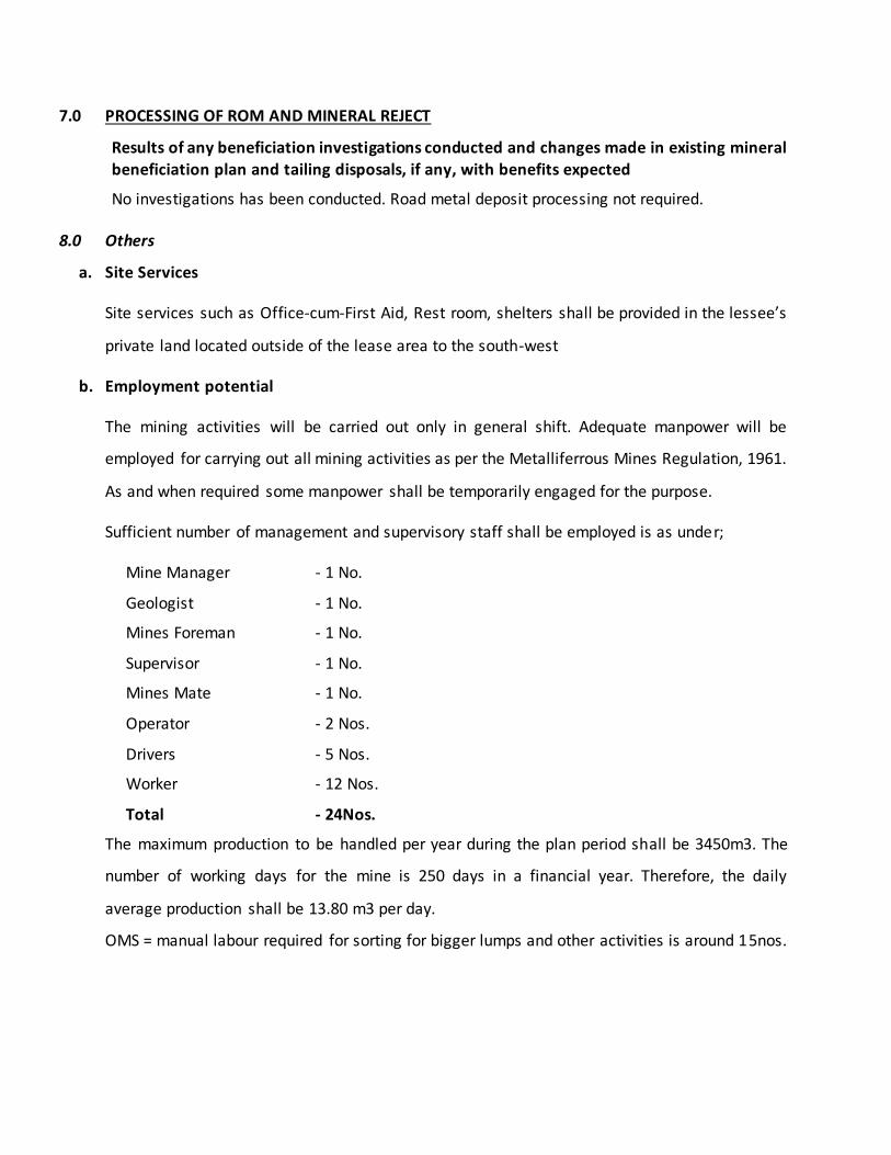
b. Employment potential
The mining activities will be carried out only in general shift. Adequate manpower will be
employed for carrying out all mining activities as per the Metalliferrous Mines Regulation, 1961.
As and when required some manpower shall be temporarily engaged for the purpose.
Sufficient number of management and supervisory staff shall be employed is as under;
Mine Manager - 1 No.
Geologist - 1 No.
Mines Foreman - 1 No.
Supervisor - 1 No.
Mines Mate - 1 No.
Operator - 2 Nos.
Drivers - 5 Nos.
Worker - 12 Nos.
Total - 24Nos.
The maximum production to be handled per year during the plan period shall be 3450m3. The
number of working days for the mine is 250 days in a financial year. Therefore, the daily
average production shall be 13.80 m3 per day.
OMS = manual labour required for sorting for bigger lumps and other activities is around 15nos.
PART-B
PROGRESSIVE MINE CLOSURE PLAN
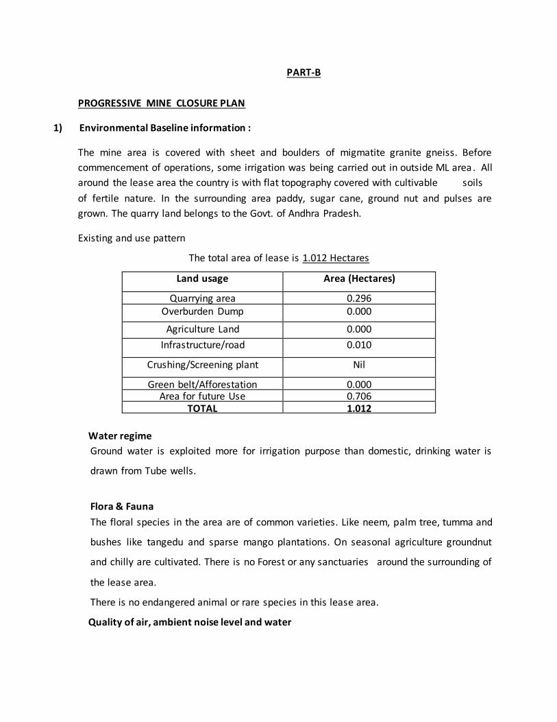
1) Environmental Baseline information :
The mine area is covered with sheet and boulders of migmatite granite gneiss. Before
commencement of operations, some irrigation was being carried out in outside ML area . All
around the lease area the country is with flat topography covered with cultivable soils
of fertile nature. In the surrounding area paddy, sugar cane, ground nut and pulses are
grown. The quarry land belongs to the Govt. of Andhra Pradesh.
Existing and use pattern
The total area of lease is 1.012 Hectares
Land usage Area (Hectares)
Quarrying area 0.296 Overburden Dump 0.000
Agriculture Land 0.000
Infrastructure/road 0.010
Crushing/Screening plant Nil
Green belt/Afforestation 0.000 Area for future Use 0.706
TOTAL 1.012
Water regime
Ground water is exploited more for irrigation purpose than domestic, drinking water is
drawn from Tube wells.
Flora & Fauna
The floral species in the area are of common varieties. Like neem, palm tree, tumma and
bushes like tangedu and sparse mango plantations. On seasonal agriculture groundnut
and chilly are cultivated. There is no Forest or any sanctuaries around the surrounding of
the lease area.
There is no endangered animal or rare species in this lease area.
Quality of air, ambient noise level and water
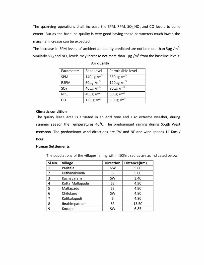
The quarrying operations shall increase the SPM, RPM, SO2,NOx and CO levels to some
extent. But as the baseline quality is very good having these parameters much lower, the
marginal increase can be expected.
The increase in SPM levels of ambient air quality predicted are not be more than 5µg /m3.
Similarly SO2 and NOx levels may increase not more than 1µg /m3 from the baseline levels.
Air quality
Parameters Base level Permissible level
SPM 140µg /m3 360µg /m3
RSPM 60µg /m3 120µg /m3
SO2 40µg /m3 80µg /m3
NOx 40µg /m3 80µg /m3
CO 1.0µg /m3 5.0µg /m3
Climatic condition
The quarry lease area is situated in an arid zone and also extreme weather, during
summer season the Temperatures 460C. The predominant raining during South West
monsoon. The predominant wind directions are SW and NE and wind speeds 11 Kms /
hour.
Human Settlements
The populations of the villages falling within 10Km. radius are as indicated below:
Sl.No. Village Direction Distance(Km) 1 Paritala NW 5.60
2 Kethanakonda S 5.00
3 Kachavaram SW 3.40
4 Kotta Mallapadu SE 4.90
5 Mallapadu SE 4.90 6 Chilukuru SW 4.80
7 Kotikalapudi S 4.80
8 Ibrahimpatnam SE 13.50
9 Kottapeta SW 6.85
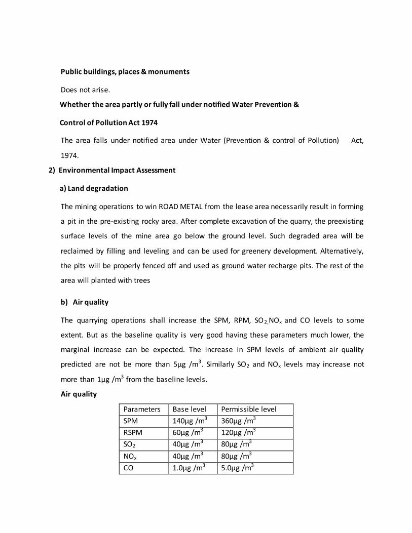
Public buildings, places & monuments
Does not arise.
Whether the area partly or fully fall under notified Water Prevention &
Control of Pollution Act 1974
The area falls under notified area under Water (Prevention & control of Pollution) Act,
1974.
2) Environmental Impact Assessment
a) Land degradation
The mining operations to win ROAD METAL from the lease area necessarily result in forming
a pit in the pre-existing rocky area. After complete excavation of the quarry, the preexisting
surface levels of the mine area go below the ground level. Such degraded area will be
reclaimed by filling and leveling and can be used for greenery development. Alternatively,
the pits will be properly fenced off and used as ground water recharge pits. The rest of the
area will planted with trees
b) Air quality
The quarrying operations shall increase the SPM, RPM, SO2,NOx and CO levels to some
extent. But as the baseline quality is very good having these parameters much lower, the
marginal increase can be expected. The increase in SPM levels of ambient air quality
predicted are not be more than 5µg /m3. Similarly SO2 and NOx levels may increase not
more than 1µg /m3 from the baseline levels.
Air quality
Parameters Base level Permissible level
SPM 140µg /m3 360µg /m3
RSPM 60µg /m3 120µg /m3
SO2 40µg /m3 80µg /m3
NOx 40µg /m3 80µg /m3
CO 1.0µg /m3 5.0µg /m3
c) Remedies proposed for Air quality
Thus the air pollution has an adverse effects upon the health of human beings as well as
ecology. To control the air pollution, green belt around the lease area, offices, all along the
approach and internal roads will be developed in.
The continuous water spraying on the haulage roads. The plants are used as indicators of
pollutants in air and to monitor their concentrations. Closely planted woody plants growing
along the roads help in reducing the contamination of lead front automobiles exhaust.
Pollution control devices such as settling chambers, bag filters need to be used to control
pollution. Roads may be frequently sprayed with water therefore polluted air will not spread
and rise around the mine.
Conduct blasting during less breezy periods.
Properly design blasting operations.
d) Noise levels
Noise level ranges from 60 db due to the use of Heavy Earth moving Machinery. No of
personnel directly affected are the operators of these machines. Otherwise, there is no sound
pollution, in the nearby village which is more than 5 Km from the quarry is not affected by
sound pollution.
Permissible exposure for different period of time is given below:
Remedies proposed for minimizing noise levels:
A machinery function will be stopped if there is no work. Much of the noise may be due to
inefficiency of the machinery. For e.g damaged blades, blunt saws, worn bearing and
sometimes lose metal sheets. These defects will be repaired, then noise level will be minimized
to a greater extent.
A lot of noise can be absorbed by planting trees, and to absorb sound. Ex:- Coniferrous trees
like /Pine, spruce, cedar, yew, etc., and Deciduous trees.
One of the easiest ways to control noise and vibration from heavy vehicles is by maintaining
properly approach and internal roads of mine.
e) Vibration levels
As explained above nearest is village is located 3.40 kms away from lease area. It is proposed to
use gun powder for jackhammer holes blasting. This mode of blasting does not contribute to
much vibrations. Thus the impact of vibrations due to blasting shall be negligible. Periodic
vibration studies will be carried out to know the vibration levels and take appropriate measured
on it.
f) Water Regime
No effect on water regime.
g) Acid Mine Drainage: Not Applicable
h) Surface Subsidence : Not applicable.
i) Socio-economics
Due to this quarry operations there will be some to locals may be employed. By way of direct
employment not less than 15 numbers and indirectly 10 numbers may be employed in allied
mining activities, therefore the existing families can have sustenance.
On development of quarry it will improve transport, communication and power in turn the
Government will also earn revenue which can flow back to improve the facilities of neighboring
locality. The much needed foreign exchange is also earned on export of black granite.
J) Historic Monuments :No Historic monuments , temples within the 10 km radius area.
k) Bio-Diversity : Not applicable.
3.0 Progressive Reclamation Plan
4.0 Mined-Out Land: Describe the proposals to be implemented for reclamation and rehabilitation of mined-out land including the manner in which the actual site of the pit will be restored for future use. The proposals may be supported with yearly plans and sections depicting yearly progress in the activities for land restoration/reclamation/rehabilitation,
afforestation etc, called “Reclamation Plan”.
No reclamation is proposed period of mining scheme as the ore is available at further depth.
However, the in the Safety Barrier Zone and road side area plantation shall be carried out
during the plan period.
5.0 Topsoil Management: The topsoil available at the site and its utilization maybe described.
The area associated with hard rock surfaces such as shale and schist, There is no soil cover in
the mining area. However, any top-soil removed incidental to mining shall be preserved and
used during plantation on the dumps.
6.0 Tailings Dam Management: The steps to be taken for protection and stability of tailing dam,
stabilization of tailing material and its utilization, periodic desilting measures to prevent water pollution from tailings etc, arrangement for surplus water overflow along with detail design, structural stability studies, the embankment seepage loss into the receiving environment and ground water contaminant if any may be described.
Not applicable.
7.0 Disaster Management and Risk Assessment
Mining will be carried-out strictly as per MMR 1961 and all other rules and regulations. Project
proponent is having mobile communication system for quick passing of information if need
arises. The management is committed to identify possible causes for the potential disasters and
draw a code of emergency measures and procedures to deal with such disasters, which is
otherwise also advised by DGMS through their periodic circulars.
Mine is well equipped with communication system like wireless facility. In case of any
minor/major accidents within the mine, the same will be communicated to Mines Manager for
action. At mine level first aid will be provided and person(s) shall be shifted to nearby hospital
at Ibrahimpatnam mandal, having all basic amenities like school, college, hospitals, post &
telegraph, fire station, police station etc., which is at a distance of 13.50 kms from the mine.
Lessee is responsible Key person for the disaster management and he needs to be contacted in
the below mentioned address in case of any disaster.
Managing Partner :
Proprietor Sri. Kondapalli Prasad Rao,
S/o Kondapalli Devaiah,48-8-15, Flat-403, BS Sastry Residency
Gunadal Vijayawada-Urban-520004
Ph. No. 9666558888
8.0 Care and Maintenance during temporary discontinuance
The following specific measures shall be taken in case of temporary discontinuance,
a) Proper and adequate security at the entrance/exit to the mine to prevent entry of
unauthorized person with proper gates under lock.
b) Top edges of the quarry will be fenced off with approved type of fencing.
c) Entrance to the toe of dumps will be blocked.
d) Special security and fire preventing measures will be taken at dangerous
places/explosive magazine etc. e) All the above will be examined by the Mines manager once in a week to ensure that
they are in order.
Items Details Proposed Actual Remarks
Dump
Management
Area afforested (ha) no of sapling planted
cumulative no of plants Cost including
watch and care during the year
7.5m Safety
barrier proposed
for plantation
- -
Management
of Worked out
Benches
Area available for rehabilitation No of
saplings planted in the year
Cumulative no of plants.
Any other method of rehabilitation
Cost including watch and care during the
year
Proposed as per
the plan
- -
Reclamation &
Rehabilitation
by Backfilling
Void Available for backfilling (LxBx D) pit
wise stope wise Void filled by
waste/tailings Afforestation on the
Backfilled area. Rehabilitation by making
water reservoir Any other means(specify)
No Backfilling in
the quarrying
during ensuing
plan period
- -
Rehabilitation
of waste land
within lease.
Area available (ha)
Area rehabilitated
Method of rehabilitation
Not proposed -
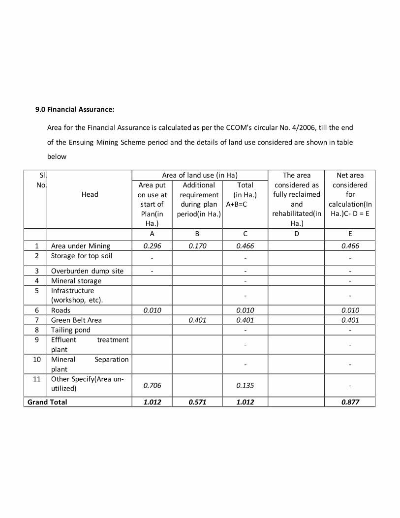
9.0 Financial Assurance:
Area for the Financial Assurance is calculated as per the CCOM’s circular No. 4/2006, till the end
of the Ensuing Mining Scheme period and the details of land use considered are shown in table
below
Sl.
No.
Head
Area of land use (in Ha) The area
considered as fully reclaimed
and rehabilitated(in
Ha.)
Net area
considered for
calculation(In Ha.)C- D = E
Area put
on use at start of
Plan(in Ha.)
Additional
requirement during plan
period(in Ha.)
Total
(in Ha.) A+B=C
A B C D E
1 Area under Mining 0.296 0.170 0.466 0.466
2 Storage for top soil - - -
3 Overburden dump site - - -
4 Mineral storage - - 5 Infrastructure
(workshop, etc). - -
6 Roads 0.010 0.010 0.010
7 Green Belt Area 0.401 0.401 0.401 8 Tailing pond - -
9 Effluent treatment
plant - -
10 Mineral Separation
plant
- -
11 Other Specify(Area un-utilized) 0.706
0.135 -
Grand Total 1.012 0.571 1.012 0.877
Area put to use during scheme period is 0.877Ha. At specified rate of Rs. 1,00,000/- per Ha. for
“B’ Category Other Than Fully Mechanised mine, the financial assurance is Rs.87,700/-.
However Bank guarantee of minimum Rs.1,00,000/- will be submitted in the final copies.
No negative repercussion is envisaged as there will not be any sort of closure in the Plan/
scheme period.
RQP Proprietor
Dr. R.C.Hanumanthu Sri. K. Prasad Rao
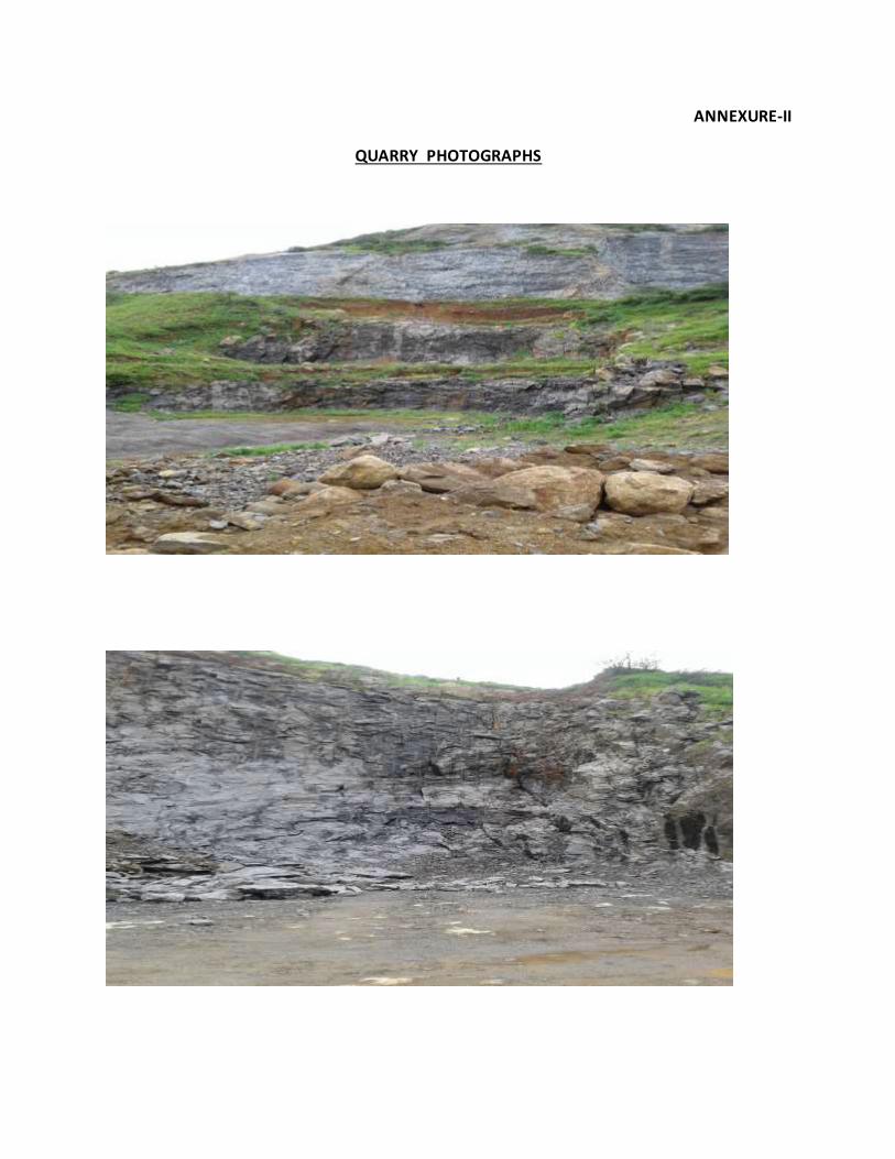
ANNEXURE-II
QUARRY PHOTOGRAPHS