Embed Size (px)
Citation preview
Foreword
The Soil Survey of Malheur, Oregon, Northeastern Part, contains muchinformation useful in any land-planning program. Of prime importance are thepredictions of soil behavior for selected land uses. Also highlighted are limitations orhazards to land uses that are inherent in the soil, improvements needed to overcomethese limitations, and the impact that selected land uses will have on theenvironment.
This soil survey has been prepared for many different users. Farmers,ranchers, foresters, and agronomists can use it to determine the potential of the soiland the management practices required for food and fiber production. Planners,community officials, engineers, developers, builders, and homebuyers can use it toplan land use, select sites for construction, develop soil resources, or identify anyspecial practices that may be needed to insure proper performance.Conservationists, teachers, students, and specialists in recreation, wildlifemanagement, waste disposal, and pollution control can use the soil survey to helpthem understand, protect, and enhance the environment.
Great differences in soil properties can occur even within short distances.Soils may be seasonally wet or subject to flooding. They may be shallow tobedrock. They may be too unstable to be used as a foundation for buildings or.roads. Very clayey or wet soils are poorly suited to septic tank absorption fields. Ahigh water table makes a soil poorly suited to basements or un-derground-installations.
These and many other soil properties that affect land use are described in thissoil survey. Broad areas of soils are shown on the general soil map; the location ofeach kind of soil is shown on detailed soil maps. Each kind of soil in the surveyarea is described, and much information is given about each soil for specific uses.Additional information or assistance in using this publication can be obtained fromthe local office of the Soil Conservation Service or the Cooperative ExtensionService.
This soil survey can be useful in the conservation, development, andproductive use of soil, water, and other resources.
State ConservationistSoil Conservation Service
This is a scanned version of the text of the original Soil Survey report of Malheur County, Oregon, NortheasternPart, issued September 1980. Original tables and maps were deleted. There may be references in the text that referto a table that is not in this document. Updated tables were generated from the NRCS National Soil Information System (NASIS). The soil map data hasbeen digitized and may include updated information. These are available from http://soildatamart.nrcs.usda.gov. Please contact the State Soil Scientist, Natural Resources Conservation Service (formerly Soil ConservationService) for additional information.

Location of Malheur County, Northeastern Part, in Oregon.
SOIL SURVEY OF MALHEUR COUNTY, OREGONNORTHEASTERN PART
By Burrell B. Lovell, Soil Conservation Service
Fieldwork by Burrell B. Lovell, Soil Conservation Service
United States Department of Agriculture, Soil Conservation Service, in
cooperation with the Oregon Agricultural Experiment Station
MALHEUR COUNTY, NORTHEASTERN PART, is inextreme eastern Oregon (see map on facing page). This areais the main concentrated block of irrigated farmland in thecounty and contains the major towns of the county. Vale, thecounty seat, has a population of about 1,750, Ontario has7,742, Nyssa has 2,900, and Adrian has about 170. Thesurvey area covers 226,00 acres, or 353 square miles.
The survey area is in the Snake River Plains ResourceArea. The eastern edge borders the Snake River. TheMalheur and Owyhee Rivers both cross the survey area andjoin the Snake River within the area. All of these riversfurnish irrigation water. The Vale-Oregon and Warm Springsprojects have dams and storage on the Malheur River and itstributaries. The Owyhee Project has a large concrete archstructure on the Owyhee River and supplies water to a majorportion of the land. Snake River water is pumped to where itcan be used. The area surveyed lies below the main irrigationcanals and is on old lake terraces and alluvial valley fill.Elevation ranges from about 2,100 feet along the SnakeRiver at Weiser Annex to about 2,600 feet where theOwyhee main canal starts in the Mitchell Butte area in thesouthern part.
How this survey was made
Soil scientists made this survey to learn what kinds of soilare in the survey area, where they are, and how they can beused. The soil scientists went into the area knowing theylikely would locate many soils they already knew somethingabout and perhaps identify some they had never seen before.They observed the steepness, length, and shape of slopes;the size of streams and the general pattern of drainage; thekinds of native plants or crops; the kinds of rock; and manyfacts about the soils. They dug many holes to expose soilprofiles. A profile is the sequence of natural layers, orhorizons, in a soil; it extends from the surface down into theparent material, which has been changed very little byleaching or by the action of plant roots.
The soil scientists recorded the characteristics of theprofiles they studied, and they compared those profiles withothers in counties nearby and in places more distant. Thus,through correlation, they classed and named the soilsaccording to nationwide, uniform procedures.
After a guide for classifying and naming the soils wasworked out, the soil scientists drew the boundaries of theindividual soils on aerial photographs. These photographsshow woodlands, buildings, field borders, roads, and otherdetails that help in drawing boundaries accurately. The soilmap at the back of this publication was prepared from aerialphotographs.
The areas shown on a soil map are called soil map units.Some map units are made up of one kind of soil, others aremade up of two or more kinds of soil, and a few have little orno soil material at all. Map units are discussed in the sections"General soil map for broad land use planning" and"Descriptions of the soils."
While a soil survey is in progress, samples of soils aretaken as needed for laboratory measurements and forengineering tests. The soils are field tested, andinterpretations of their behavior are modified as necessaryduring the course of the survey. New interpretations areadded to meet local needs, mainly through field observationsof different kinds of soil in different uses under differentlevels of management. Also, data are assembled from othersources, such as test results, records, field experience, andinformation, available from state and local specialists. Forexample, data on crop yields under defined practices areassembled from farm records and from field or plotexperiments on the same kinds of soil.
But only part of a soil survey is done when the soils havebeen named, described, interpreted, and delineated on aerialphotographs and when the laboratory data and other datahave been assembled. The mass of detailed information thenneeds to be organized so that it is readily available to differentgroups of users, among them farmers, managers ofrangeland and woodland, engineers, planners, developers andbuilders, homebuyers, and those seeking recreation.

General soil map for broad land useplanning
The general soil map at the back of this publication shows,in color, map units that have a distinct pattern of soils and ofrelief and drainage. Each map unit is a unique naturallandscape. Typically, a map unit consists of one or moremajor soils and some minor soils. It is named for the majorsoils. The soils making up one unit can occur in other unitsbut in a different pattern.
The general soil map provides a broad perspective of thesoils and landscapes in the survey area. It provides a basisfor comparing the potential of large areas for general kindsof land use. Areas that are, for the most part, suited tocertain kinds of farming or to other land uses can beidentified on the map. Likewise, areas of soils havingproperties that are distinctly unfavorable for certain land usescan be located.
Because of its small scale, the map does not show the kindof soil at a specific site. Thus, it is not suitable for planningthe management of a farm or field or for selecting a site fora road or building or other structure. The kinds of soil in anyone map unit differ from place to place in slope, depth,stoniness, drainage, or other characteristics that affect theirmanagement.
Descriptions of soil map units
1. Powder-Turbyfill-Garbutt
Deep silt loams and fine-sandy loams
This map unit consists of smooth, nearly level soils onbottom lands and fans. These soils formed in recentalluvium. The native vegetation was needlegrass, bluebunchwheatgrass, big sagebrush, rabbitbrush, and forbs. Elevationranges from 2,100 to 2,600 feet. Average annualprecipitation ranges from 8 to 11 inches, and average annualair temperature ranges from 45 degrees to 53 degrees F. Thefrost-free period is 120 to 170 days.
This map unit makes up about 16 percent of the surveyarea. It is about 35 percent Powder soils, 20 percentTurbyfill soils, and 20 percent Garbutt soils. Umapine, Stan-field, Poden, and Kimberly soils and Riverwash make upabout 25 percent.
Powder soils are on stream bottoms and are well drained.They have a surface layer and subsoil of grayish brown siltloam. Depth to bedrock is 60 inches or more.
Turbyfill soils are on stream bottoms and fans and arewell drained. They have a surface layer of pale brown finesandy loam. The underlying material is pale brown and verypale brown fine sandy loam. Depth to bedrock is 60 inchesor more.
Garbutt soils are on stream bottoms and fans and are welldrained. They have a surface layer of very pale brown siltloam. The underlying material is pale brown and very pale
The soils are well suited to sugar beets, potatoes, onions,field corn, sweet corn, small grain, alfalfa seed, vegetableseed, hay, and wildlife habitat. The wildlife is mainly uplandbirds. Food, cover, and water supply control movement andnumber of wildlife.
Runoff is very limited and occurs mainly in spring whenthe soil is frozen beneath the surface. Erosion by runoff isminor, but erosive heads of irrigation water can increasesediment removal and cut vertical banks in the field.
2. Umapine-Stanfield
Very strongly alkali silt loams; some are deep and some aremoderately deep over a hardpan
This map unit consists of smooth, nearly level soils onbottom lands. These soils formed in old alluvium. The nativevegetation was saltgrass, giant wildrye, and greasewood.Elevation ranges from 2,100 to 2,600 feet. Average annualprecipitation ranges from 9 to 11 inches, and the averageannual air temperature ranges from 48 degrees to 54 degreesF. The frost-free period is 110 to 170 days.
This map unit makes up about 17 percent of the surveyarea. It is about 60 percent Umapine soils and 20 percentStanfield soils. Otoole, Poden, Powder, and Ahtanum soilsmake up about 20 percent.
Umapine soils are on stream bottoms and low terraces andare somewhat poorly drained. They are deep silt loam and arevery strongly alkaline to strongly alkaline in the upper part. Awhite salt crust forms on the surface during part of the year.Depth to bedrock is more than 60 inches.
Stanfield soils are on stream bottoms and low terraces andare moderately well drained. They are moderately deep siltloam over a silica-cemented hardpan. They are very stronglyalkaline throughout. A white salt crust forms on the surfaceduring part of the year. Depth to the hardpan is 20 to 40inches. Depth to bedrock is more than 60 inches.
If adequately drained, the soils are suited to pasture, somesmall grain, hay, and wildlife habitat. The wildlife is mainlyupland game birds. Food, cover, and water supply controlmovement and number of wildlife.
Runoff is very limited and occurs mainly in spring whenthe soil is frozen beneath the surface. Erosion by runoff isminor.
3. Feltham-Cencove-Quincy
Deep loamy fine sands and fine sandy loams that are moderatelydeep over gravel and sand
This map unit consists of smooth, rolling soils on terracetops and old dune areas adjacent to the Snake River. Thesesoils formed in eolian and wind-modified alluvial material overold lacustrine material. The native vegetation wasneedlegrass, Indian ricegrass, rabbitbrush, and big sagebrush.Elevation ranges from 2,100 to 2,600 feet.

Average annual precipitation ranges from 8 to 11 inches, andaverage annual air temperature ranges from 50 degrees to 53degrees F. The frost-free period is 150 to 180 days.
This map unit makes up about 3 percent of the surveyarea. It is about 35 percent Feltham soils, 25 percent Cen-cove soils, and 20 percent Quincy soils. Sagehill, Truesdale,Nyssa gravel substratum, and Mesel soils make up about 20percent.
Feltham soils are on terraces and alluvial fans and areexcessively drained. They have a surface layer of brownloamy fine sand. The underlying material is brown and palebrown loamy fine sand and fine sandy loam. Depth tobedrock is more than 60 inches.
Cencove soils are on terraces and are well drained. Theyhave a surface layer of pale brown fine sandy loam. Theunderlying material is brown fine sandy loam to a depth of20 to 40 inches, and below that it is very gravelly sand.Depth to bedrock is more than 60 inches.
Quincy soils are on terraces and are excessively drained.They have a surface layer of dark brown loamy fine sand.The underlying material is brown loamy fine sand. Depth tobedrock is more than 60 inches.
The soils are suited to potatoes, onions, field corn, sweetcorn, small grain, seed production, alfalfa hay, and wildlifehabitat. The wildlife is mainly upland game birds. Food,cover, and water supply control movement and number ofwildlife.
Runoff is slow. Soil blowing occurs in spring when thesoils are dry and bare.
4. Owyhee-Greenleaf
Deep silt loams
This map unit consists of smooth, rolling soils on terraces.These soils formed in loess-capped old lacustrine sediment.The native vegetation was needlegrass, bluebunchwheatgrass, big sagebrush, and rabbitbrush. Elevation rangesfrom 2,100 to 2,500 feet. Average annual precipitationranges from 8 to 10 inches, and average annual airtemperature ranges from 50 degrees to 52 degrees F. Thefrost-free period is 150 to 180 days.
This map unit makes up about 16 percent of the surveyarea. It is about 60 percent Owyhee soils and 20 percentGreenleaf soils. Nyssa, Malheur, Sagehill, and Truesdalesoils and Xeric Torriorthents make up about 20 percent.
Owyhee soils are on medium terraces and are welldrained. They have a surface layer of pale brown silt loam.The upper part of the substratum is white silt loam, and thelower part is light gray, laminated silt loam and very finesandy loam. Depth to bedrock is more than 60 inches.
Greenleaf soils are on low terraces and are well drained.They have a surface layer of light brownish gray silt loam.The subsoil is brown silty clay loam, and the substratum isvery pale brown and light gray, laminated silt loam. Depth tobedrock is more than 60 inches.
Where slope is favorable, the soils are well suited to sugarbeets, potatoes, onions, field corn, sweet corn, small grain,alfalfa seed, vegetable seed, alfalfa hay, and wildlife habitat.The wildlife is mainly upland game birds. Food, cover, andwater supply control movement and number of wildlife.
Runoff is mainly from the steeper Owyhee soils. Erosionby runoff is low to moderate. Using soil- and water-conserving practices on steeper slopes minimizes the hazardof erosion.
5. Nyssa-Virtue
Silt loams that are moderately deep over a hardpan
This map unit consists of smooth, rolling soils on highterraces. These soils formed in loess-capped old lacustrineand alluvial sediments. The native vegetation wasneedlegrass, bluebunch wheatgrass, rabbitbrush, and bigsagebrush. Elevation ranges from 2,100 to 2,600 feet.Average annual precipitation ranges from 9 to 11 inches, andaverage annual air temperature ranges from 48 degrees to 54degrees F. The frost-free period is 110 to 170 days.
This map unit makes up about 30 percent of the surveyarea. It is about 55 percent Nyssa soils and 20 percent Virtuesoils. Owyhee, Truesdale, Frohman, Malheur, and Chilcottsoils and Xeric Torriorthents make up about 25 percent.
Nyssa soils are on terraces and are well drained. Theyhave a surface layer of light brownish gray silt loam. Thesubsoil is pale brown silt loam over a calcium- and silica-cemented hardpan. Depth to the hardpan is 20 to 40 inches.Depth to bedrock is more than 60 inches.
Virtue soils are on high terraces and are well drained. Theyhave a surface layer of light brownish gray and pale brownsilt loam. The subsoil is yellowish brown silty clay loam overa calcium- and silica-cemented hardpan. Depth to thehardpan is 20 to 40 inches. Depth to bedrock is more than60 inches.
Where slope is favorable, the soils are suited to sugarbeets, potatoes, onions, field corn, small grain, alfalfa seed,alfalfa hay, and wildlife habitat. The wildlife is mainly uplandgame birds. Food, cover, and water supply controlmovement and number of wildlife.
Runoff is mainly from the steeper slopes. Erosion byrunoff is low to moderate. Using soil- and water-conservingpractices on steeper slopes minimizes the hazard of erosion.
6. Frohman-Virtue
Silt loams that are shallow and moderately deep over ahardpan
This map unit consists of smooth, rolling soils on terraces.These soils formed in loess-capped old lacustrine and alluvialsediment. The native vegetation was Sandberg bluegrass,bluebunch wheatgrass, rabbitbrush, and big sagebrush.Elevation ranges from 2,100 to 2,600 feet.

Average annual precipitation ranges from 9 to 11 inches, andaverage annual air temperature ranges from 48 degrees to 54degrees F. The frost-free period is 110 to 170 days.
This map unit makes up about 18 percent of the surveyarea. It is about 60 percent Frohman soils and 20 percentVirtue soils. Nyssa, Truesdale, Malheur, and Chilcott soilsand Xeric Torriorthents make up about 20 percent.
Frohman soils are on terraces and are well drained. Theyhave a surface layer and subsoil of light brownish gray siltloam over a silica-cemented hardpan. Depth to the hardpan is10 to 20 inches. Depth to bedrock is 60 inches or more.
Virtue soils are on high terraces and are well drained. Theyhave a surface layer of light brownish gray silt loam. Thesubsoil is yellowish brown silty clay loam over a calcium-and silica-cemented hardpan. Depth to bedrock is more than60 inches.
Where slope is favorable, the soils are suited to smallgrain, alfalfa seed, alfalfa hay, occasionally sugar beets,potatoes, and wildlife habitat. The wildlife is mainly uplandgame birds. Food, cover, and water supply controlmovement and number of wildlife.
Runoff is mainly from the steeper slopes. Erosion byrunoff is moderate to high. Using soil- and water-conservingpractices on steeper slopes minimizes the hazard of erosion.
Descriptions of the soils
This section describes each soil series in detail and eachmap unit in that series briefly. Unless stated otherwise, whatis stated about the soil series holds true for the map units inthat series. Thus, to get full information about any one mapunit, it is necessary to read both the description of the mapunit and the description of the soil series to which it belongs.
An important part of the description of each soil series isthe soil profile, the sequence of layers from the surfacedown to rock or other underlying material. Each seriescontains two descriptions of the profile. The first is brief andin terms familiar to a layman. The second is more detailedand is included for those who need to make thorough andprecise studies of soils. The profile described in the series isrepresentative for map units in that series. If the profile of agiven map unit differs from the one described for the series,these differences are stated in describing the map unit, orthey are differences that are apparent in the name of the mapunit. Color terms are for dry soil unless otherwise stated.
Soils that have a profile that is almost alike make up a soilseries. Except for allowable differences in texture of thesurface layer or of the underlying substratum, all the soils ofa series have major horizons that are similar in composition,thickness, and arrangement in the profile. A soil seriescommonly is named for a town or geographic feature nearthe place where a soil of that series was first observed andmapped.
Soils of one series can differ in texture of the surface layeror in the underlying substratum and in slope, erosion,stoniness, salinity, wetness, or other characteristics thataffect their use. On the basis of such differences, a soilseries is divided into phases. The name of a soil phasecommonly indicates a feature that affects use or manage-ment. For example, Cencove fine sandy loam, 8 to 12 per-cent slopes, is one of several phases within the Cencoveseries.
Some map units are made up of two or more dominantkinds of soil. Such map units are called soil complexes.
A soil complex consists of areas of two or more soils thatare so intricately mixed or so small in size that they cannot beshown separately on the soil map. Each area includes someof each of the two or more dominant soils, and the patternand proportion are somewhat similar in all areas.Nyssa-Malheur silt loams, 0 to 5 percent slopes, is anexample.
Most map units include small, scattered areas of soilsother than those that appear in the name of the map unit.Some of these soils have properties that differ substantiallyfrom those of the dominant soil or soils and thus couldsignificantly affect use and management of the map unit.These soils are described in the description of each map unit.Some of the more unusual or strongly contrasting soils thatare included are identified by a special symbol on the soilmap.
Most mapped areas include places that have little or no soilmaterial and support little or no vegetation. Such places arecalled miscellaneous areas; they are delineated on the soilmap and given descriptive names. Duneland is an example.Some of these areas are too small to be delineated and areidentified by a special symbol on the soil map.
Preceding the name of each map unit is a symbol thatidentifies the map unit on the detailed soil map. At the end ofeach description of a map unit the capability unit in whichthe map unit has been placed is given.
The acreage and proportionate extent of each map unit aregiven in table 1, and additional information on properties,limitations,. capabilities, and potentials for many soil uses isgiven for each kind of soil in other tables in this survey. (See"Summary of tables.") Many of the terms used in describingsoils are defined in the Glossary, and more detailedinformation about the terminology and methods of soilmapping can be found in the Soil Survey Manual (6).
Ahtanum series
The Ahtanum series consists of somewhat poorly drainedsoils that formed on flood plains and low fans in mediumtextured mixed alluvium. Slopes are 0 to 2 percent. Elevationis 2,200 to 2,600 feet. The native vegetation was saltgrass,giant wildrye, and greasewood. Average annual precipitationis 8 to 10 inches, average annual air temperature is 48degrees to 52 degrees F, and the frost-free period is 110 to150 days.

In a representative profile, the surface layer is grayishbrown silt loam about 10 inches thick. The underlyingmaterial is grayish brown silt loam to a depth of 30 inches.Below this is a grayish brown, silica-cemented hardpan. Thesoil is moderately alkaline throughout.
Permeability is moderate above the hardpan and slow tovery slow in the hardpan. Available water capacity is 4 to 6inches. Effective rooting depth is 20 to 40 inches. A seasonalwater table is at a depth of 1 to 2 feet during the irrigationperiod. Rare flooding occurs during spring runoff.
These soils are used for irrigated pasture, hay, occasionalrow crops, and wildlife habitat.
Representative profile of the Ahtanum silt loam about 100feet north of a barn, 20 feet east of a north-south fence inSW1/4SW1/4SW1/4 section 30, T. 16 S., R. 44 E.:
Ap-0 to 6 inches; grayish brown (10YR 5/2) silt loam, very dark brown (10YR 2/2)moist; weak fine subangular blocky structure; slightly hard, friable, sticky andplastic; many fine roots; many fine tubular pores; moderately alkaline; abruptsmooth boundary.
A12-6 to 10 inches; grayish brown (10YR 5/2) silt loam, very dark grayish brown(10YR 3/2) moist; moderate fine subangular blocky structure; slightly hard,friable, sticky and plastic; many fine roots; many fine tubular pores; moderatelyalkaline; abrupt smooth boundary.
C1-10 to 23 inches; grayish brown (10YR 5/2) silt loam, very dark grayish brown(10YR 3/2) moist; weak fine subangular blocky structure; slightly hard, friable,slightly sticky and slightly plastic; many fine roots; many fine tubular pores;moderately calcareous; moderately alkaline; gradual wavy boundary.
C2-23 to 30 inches; grayish brown (10YR 5/2) silt loam, dark brown (10YR 3/3)moist; weak very fine subangular blocky structure; slightly hard, friable, slightlysticky and slightly plastic; many fine roots; many fine tubular pores; 20 percentdurinodes 1/2 inch diameter; moderately alkaline; abrupt wavy boundary.
Ccasim-30 to 32 inches; grayish brown (10YR 5/2) silica-cemented dunpan of siltymaterial, very dark brown (10YR 2/2) moist; massive; strongly cemented; veryhard, very funny nonsticky and nonplastic; very few roots; very few tubularpores; strong effervescence; abrupt wavy boundary.
The A horizon is silt loam that is more than 18 percent clay. It is moderately tostrongly alkaline and high in sodium. The lower part of the C horizon contains 5 to30 percent weakly silica-cemented durinodes 1/4 to 1/2 inch in diameter. Depth to thesilicacemented duripan ranges from 20 to 40 inches but is generally less than 30inches. The duripan may have a root mat on the upper surface.
1-Ahtanum silt loam. This soil is in irregularly shapedareas on low fans and flood plains. Slope are 0 to 2 percent.
Included with this soil in mapping were about 10 percentHarana soils. Also included were about 10 percent soils thatare similar to Ahtanum soils but that are 10 to 20 inches deepto the hardpan.
Runoff is slow, and the hazard of erosion is slight.Capability unit IVw-1.
Baldock series
The Baldock series consists of somewhat poorly drainedsoils that formed on low terraces, fans, and bottom lands inmedium textured alluvium. Slopes are 0 to 2 percent.Elevation is 2,100 to 2,600 feet. The native vegetation was
saltgrass, giant wildrye, rabbitbrush, greasewood, and bigsagebrush. Average annual precipitation is 9 to 11 inches,average annual air temperature is 48 degrees to 52 degrees F,and the frost-free period is 120 to 160 days.
In a representative profile, the surface layer is lightbrownish gray silt loam about 16 inches thick. The subsoil isgrayish brown silt loam about 16 inches thick Thesubstratum is light gray silt loam to a depth of 60 inches ormore. The soil is strongly alkaline above a depth of about 32inches and very strongly alkaline below a depth of 32 inches.
Permeability is moderate to moderately slow. Availablewater capacity is 8 to 10 inches. Effective rooting depth is 60inches or more. A seasonal water table is at a depth of 2 to 3feet during the irrigation period. Rare flooding occurs duringspring runoff.
These soils are used for irrigated pasture, hay, small grain,sugar beets, and wildlife habitat.
Representative profile of Baldock silt loam about 850 feeteast of section corner in the SEl/4SW1/4SW1/4 section 21,T. 17 S., R. 47 E.:
Ap-0 to 9 inches; light brownish gray (10YR 6/2) silt loam, very dark grayish brown(10YR 3/2) moist; moderate medium to fine granular structure; slightly hard,friable, slightly sticky and slightly plastic; few fine roots; many fine irregularpores; moderately calcareous; strongly alkaline; abrupt smooth boundary.
A1-9 to 16 inches; light brownish gray (10YR 6/2) silt loam, very dark grayish brown(10YR 3/2) moist; weak coarse prismatic structure; slightly hard, friable, slightlysticky and slightly plastic; few tine roots; many fine irregular pores; moderatelycalcareous; strongly alkaline; gradual wavy boundary.
B2-16 to 32 inches; grayish brown (10YR 5/2) silt loam; very dark gray (10YR 3/1)moist; few faint yellowish brown (10YR 5/4) mottles, dark brown (10YR 3/3)moist; moderate fine angular blocky structure; hard, firm, sticky and plastic; fewfine roots; many fine tubular pores; moderately calcareous; strongly alkaline;gradual wavy boundary.
Cca-32 to 60 inches; light gray (10YR 7/2) silt loam, brown to dark brown (10YR4/3) moist; massive; slightly hard, friable, slightly sticky and slightly plastic;very few fine roots; few fine tubular pores; strongly calcareous; very stronglyalkaline.
The A horizon is light brownish gray or light gray loam or silt loam. It is morethan 18 percent clay. It is calcareous and moderately alkaline to strongly alkaline. The10- to 40-inch control section is loam or silt loam
2-Baldock silt loam. This soil is in irregularly shapedareas on stream bottoms, alluvial fans, and low terraces.
Included with this soil in mapping were about 10 percentUmapine soils and about 5 percent Stanfield soils.
Runoff is slow, and the hazard of erosion is slight.Capability unit IIIw-1.
Bully series
The Bully series consists of well drained soils that formedon bottom lands and fans in mixed alluvium that is high indiatomaceous material. Slopes are 0 to 2 percent. Elevation is2,500 to 2,700 feet. The native vegetation was giant wildrye,bluebunch wheatgrass, hopsage, and big sagebrush. Averageannual precipitation is 7 to 9
inches, average annual air temperature is 48 degrees to 50degrees F, and the frost-free period is 120 to 150 days.
In a representative profile, the surface layer is light graysilt loam about 9 inches thick. The underlying material islight gray silt loam to a depth of 60 inches or more. The soilis mildly alkaline above a depth of 9 inches and moderatelyalkaline below that depth.
Permeability is moderate. Available water capacity is 10 to12.5 inches. Effective rooting depth is 60 inches or more.
These soils are used for irrigated corn, potatoes, onions,small grain, alfalfa hay, pasture, and wildlife habitat.
Representative profile of Bully silt loam about 1/2 milenorthwest of Harper, 40 feet north and 40 feet east of thesouthwest corner of the SE1/4 section 31, T. 19 S., R. 42E.:
Ap-0 to 9 inches; light gray (10YR 7/2) silt loam, brown (10YR 5/3) moist; weakvery fine granular structure; soft, very friable, slightly sticky and slightly plastic;few roots; many fine round pores; mildly alkaline; abrupt smooth boundary.
C1-9 to 30 inches; light gray (10YR 7/2) silt loam, brown (10YR 5/3) moist;massive; soft, very friable, slightly sticky and slightly plastic; few roots;common fine tubular pores; few white soft diatomite fragments; noncalcareous;moderately alkaline; diffuse wavy boundary.
C2-30 to 60 inches; light gray (10YR 7/2) silt loam, brown (10YR 5/3) moist;massive; soft, very friable, slightly sticky and slightly plastic; few roots; few finetubular pores; few soft diatomite fragments in the matrix, increasing with depth;few thin lenses of very fine sandy loam; noncalcareous; moderately alkaline.
The A and C horizons are silt loam, loam, or very fine sandy loam.Silica-cemented durinodes as large as 1/2 inch in diameter make up 2 to 10 percent ofthe C horizon.
3-Bully silt loam. This soil is in irregularly shaped areason flood plains and fans.
Included with this soil in mapping were about 10 percentPowder soils, about 5 percent Umapine soils, and about 5percent Stanfield soils.
Runoff is slow. The hazard of erosion is severe becauseof the light weight of the soil, its tendency to undercut incorrugations and furrows, and gullies. Capability unit IIe-1.
Cencove series
The Cencove series consists of well drained soils thatformed on medium and low terraces in mixed alluvium.Slopes are 0 to 12 percent. Elevation is 2,200 to 2,500 feet.The native vegetation was Sandberg bluegrass, bluebunchwheatgrass, and big sagebrush. Average annual precipitationis 9 to 11 inches, average annual sir temperature is 50degrees to 52 degrees F, and the frost-free period is 150 to170 days.
In a representative profile, the surface layer is pale brownfine sandy loam about 9 inches thick. The upper part of theunderlying material, to a depth of 24 inches, is brown finesandy loam, and the lower part is very gravelly sand to adepth of 60 inches or more. The soil is mildly alkaline abovea depth of about 9 inches and moderately alkaline below thatdepth.
Permeability is moderately rapid in the upper part and veryrapid in the very gravelly sand. Available water capacity is 4to 6 inches. Effective rooting depth is 20 to 40 inches.
These soils are used for irrigated potatoes, onions, corn,sugar beets, small grain, alfalfa seed, alfalfa hay, pasture, andwildlife habitat.
Representative profile of Cencove fine sandy loam, 0 to 2percent slopes, about 1,320 feet north and 750 feet east ofthe country road, SWl/4SE1/4 section 25, T. 16 S., R. 47 E.:
Ap-0 to 9 inches; pale brown (10YR 6/3) fine sandy loam, very dark grayish brown(10YR 3/2) moist; weak fine granular structure; slightly hard, very friable,nonsticky and nonplastic; many fine roots; many fine irregular pores; mildlyalkaline; abrupt smooth boundary.
C1ca-9 to 16 inches; brown (10YR 5/3) fine sandy loam, very dark grayish brown(10YR 3/2) moist; massive; very friable, slightly hard, nonsticky and slightlyplastic; many fine roots; few fine tubular pores; weakly calcareous; moderatelyalkaline; gradual wavy boundary.
C2ca-16 to 24 inches; brown (10YR 5/3) fine sandy loam, dark brown (10YR 3/3)moist; massive; very friable, slightly sticky and slightly plastic; many fine roots;many fine tubular pores; moderately calcareous; moderately alkaline; abrupt wavyboundary.
IIC3-24 to 60 inches; multicolored very gravelly sand; single grained; loose; weaklycalcareous; gravel coated with lime on lower side; moderately alkaline.
The A horizon has a value of 5 or 6 when dry and a chroma of 2 or 3 when dry ormoist. It is sandy loam or fine sandy loam The Cl and C2 horizons have a value of 5or 6 when dry and a chroma of 2 or 3 when dry or moist. They are fine sandy loam orsandy loam. Depth to the very gravelly sand IIC horizon ranges from 20 to 40 inches.
4A-Cencove fine sandy loam, 0 to 2 percent slopes.This soil is in irregularly shaped areas. It has the profiledescribed as representative of the series.
Included with this soil in mapping were about 5 percentNyssa soils, gravel substratum; about 5 percent Nyssa soils;about 5 percent Sagehill soils; and about 5 percent Truesdalesoils.
Runoff is slow, and the hazard of water erosion is slight.The hazard of soil blowing is moderate. Capability unitIIIs-5.
4B-Cencove fine sandy loam, 2 to 5 percent slopes.This soil is in irregularly shaped areas.
Included with this soil in mapping were about 5 percentNyssa soils, gravel substratum; about 5 percent Nyssa soils;about 5 percent Sagehill soils; and about 5 percent Truesdalesoils.
Runoff is slow, and the hazard of water erosion is slight.The hazard of soil blowing is moderate. Capability unitIIIe-3.
4C-Cencove fine sandy loam, 5 to 8 percent slopes.This soil is in irregularly shaped areas.
Included with this soil in mapping were about 5 percentNyssa soils, gravel substratum; about 5 percent Nyssa soils;and about 5 percent Truesdale soils.
Runoff is medium, and the hazard of water erosion ismoderate. The hazard of soil blowing is moderate. Capabilityunit IIIe-3.
4D-Cencove fine sandy loam, 8 to 12 percent slopes.This soil is in irregularly shaped areas.
Included with this soil in mapping were about 5 percentNyssa soils, gravel substratum; about 5 percent Nyssa soils;and about 5 percent Truesdale soils.
Runoff is medium, and the hazard of water erosion ismoderate. The hazard of soil blowing is moderate. Capabilityunit IVe-2.
Chilcott series
The Chilcott series consists of well drained soils thatformed on undulating high terraces in medium texturedmaterial over a cemented hardpan. Slopes are 2 to 12percent. Elevation is 2,500 to 2,600 feet. The native vegeta-tion was bluebunch wheatgrass, Sandberg bluegrass,cheatgrass, and big sagebrush. Average annual precipitationis 8 to 11 inches, average annual air temperature is 47degrees to 52 degrees F, and the frost-free period is 125 to170 days.
In a representative profile, the surface layer is pale brownsilt loam about 13 inches thick. The upper 5 inches of thesubsoil is brown silty clay, and the lower 9 inches isyellowish brown silty clay loam. The substratum is mainlylight gray silty clay loam to a depth of 37 inches. Asilica-cemented hardpan is at a depth of about 37 inches.The soil is moderately alkaline above a depth of 30 inchesand strongly alkaline between depths of 30 and 37 inches.
Permeability is slow in the subsoil and very slow in thehardpan. Available water capacity is 3 to 6 inches. Effectiverooting depth is 20 to 40 inches.
These soils are used for irrigated small grain, alfalfa seed,alfalfa hay, occasional row crops, and wildlife habitat.
Representative profile of Chilcott silt loam, 2 to 5 percentslopes, about 100 feet east of the road on the north edge ofthe gravel pit in the NWl/4SW1/4SW1/4 section 21, T. 16S., R. 47 E.:
A11-0 to 3 inches; pale brown (10YR 6/3) silt loam, dark brown (10YR 3/3) moist;strong thin platy structure; soft, very friable, slightly sticky and slightly plastic;common fine roots; many fine round pores; moderately alkaline; abrupt smoothboundary.
A12-3 to 13 inches; pale brown (10YR 6/3) silt loam, dark brown (10YR 4/3) moist;weak coarse prismatic structure parting to weak medium subangular blocky; soft,very friable, slightly sticky and slightly plastic; common fine roots; many finetubular pores; moderately alkaline; abrupt smooth boundary.
IIB2t-13 to 18 inches; brown (10YR 5/3) silty clay, brown (10YR 5/3) crushed; verydark grayish brown (10YR 3/2) coatings on ped faces when moist; strong finecolumnar and prismatic structure; very hard, very firm, very sticky and veryplastic; few fine roots; few fine tubular pores; continuous thick clay films on pedfaces and in pores; moderately alkaline; clear wavy boundary.
IIB3t-18 to 27 inches; yellowish brown (10YR 5/4) silty clay loam, brown (10YR5/3) moist; very dark grayish brown (10YR 3/2) coatings on ped faces whenmoist; weak coarse angular blocky structure; hard, firm, sticky and plastic; fewfine roots; few fine tubular pores; common moderately thick clay films on pedfaces and in pores; moderately alkaline; clear wavy boundary.
IIC1-27 to 30 inches; light yellowish brown (10YR 6/4) silty clay loam, darkyellowish brown (10YR 4/4) moist; massive; slightly hard, fria-
ble, sticky and plastic; few fine roots; few fine tubular pores; moderately alkaline;abrupt wavy boundary.
IIC2ca-30 to 37 inches; light gray (10YR 7/2) silty clay loam, dark yel lowish brown(10YR 4/4) moist; massive; slightly hard, friable, sticky and plastic; few fineroots; few fine tubular pores; strongly calcareous; strongly alkaline; abruptsmooth boundary.
IIC3casim-37 to 40 inches; strongly calcium- and silica-cemented duripan.
The A horizon has a value of 5.5 to 6.5 when dry and 3.5 to 4.5 when moist. It issilt loam or very fine sandy loam The Bt horizon is silty clay loam, silty clay, orclay. It is 35 to 50 percent clay and more than 30 percent silt. The depth to calcareousmaterial ranges from about 15 to 30 inches. Depth to the duripan is 20 to 40 inches.Stratified sand and gravel occur under the duripan in most areas.
5B-Chilcott silt loam, 2 to 5 percent slopes. This soil isin irregularly shaped areas on terraces. It has the profiledescribed as representative of the series.
Included with this soil in mapping were about 10 percentMalheur soils, about 10 percent Virtue soils, and about 5percent Nyssa soils.
Runoff is medium, and the hazard of erosion is moderate.Capability unit IIIe-4.
5C-Chilcott silt loam, 5 to 12 percent slopes. This soilis in irregularly shaped areas on terraces.
Included with this soil in mapping were about 10 percentMalheur soils, about 10 percent Virtue soils, and about 5percent Nyssa soils.
Runoff is medium, and the hazard of erosion is moderate.Capability unit IVe-3.
Duneland
6-Duneland. These miscellaneous areas consist of loose,wind drifted sands.
These areas are nearly devoid of vegetation, but some deeprooted shrubs grow. Capability unit VIIIe-1.
Falk Variant
The Falk Variant consists of moderately well drained soilsthat formed on high bottom lands or very low terraces inmixed alluvium. Slopes are 0 to 2 percent. Elevation is 2,100to 2,500 feet. The native vegetation was needlegrass, Indianricegrass, Sandberg bluegrass, and big sagebrush. Averageannual precipitation is 8 to 11 inches, average annual airtemperature is 50 degrees to 52 degrees F, and the frost-freeperiod is 120 to 170 days.
In a representative profile, the surface layer is grayishbrown fine sandy loam about 7 inches thick. The upper partof the underlying material, to a depth of 11 inches, is grayishbrown fine sandy loam; the next part, to a depth of 36inches, is light brownish gray fine sandy loam; and the lowerpart is mottled very gravelly sand to a depth of 62 inches ormore. The soil is moderately alkaline throughout.
Permeability is moderately rapid in the upper part and veryrapid in the very gravelly sand. Available water capacity is 3to 6 inches. Effective rooting depth is 60 inches or more. Aseasonal water table is at a depth of 3 to 4 feet. Rare floodingoccurs during spring runoff.
These soils are used for irrigated row crops, small grain,pasture, and wildlife habitat.
Representative profile of Falk Variant fine sandy loamabout 200 feet west of high-tension power line, 100 feetsouth of the Snake River, SE1/4SW1/4 section 15, T. 18 S.,R. 47 E.:
Ap--0 to 7 inches; grayish brown (10YR 5/2) fine sandy loam, very dark grayishbrown (10YR 3/2) moist; weak fine granular structure; soft, very friable, slightlysticky and slightly plastic; many fine and coarse roots; many fine irregular pores;moderately alkaline; abrupt smooth boundary.
C1-7 to 11 inches; grayish brown (l0YR 5/2) fine sandy loam, very dark grayishbrown (10YR 3/2) moist; weak fine subangular blocky structure; soft, veryfriable, slightly sticky and slightly plastic; many fine and coarse roots; many fineirregular pores; weakly calcareous; moderately alkaline; gradual wavy boundary.
C2-11 to 22 inches; light brownish gray (10YR 6/2) fine sandy loam, grayish brown(10YR 3/2) moist; weak fine subangular blocky structure; soft, very friable,slightly sticky and slightly plastic; many fine roots; many fine irregular pores;moderately calcareous; moderately alkaline; gradual wavy boundary.
C3-22 to 36 inches; light brownish gray (2.5Y 6/2) fine sandy loam, dark grayishbrown (2.5Y 4/2) moist massive; soft, very friable slightly sticky and nonplastic;many fine roots; many fine irregular pores; moderately calcareous; moderatelyalkaline; gradual wavy boundary.
IIC4-26 to 62 inches; mottled very gravelly sand; single grained; loose; calcareous;moderately alkaline.
The A horizon has a value of 5 or 6 when dry and a chroma of 2 or 3 when dryand moist. In places it contains 10 to 20 percent gravel. Depth to very gravelly sandranges from 20 to 40 inches.
7-Falk Variant fine sandy loam. This soil is inirregularly shaped Areas.
Included with this soil in mapping were about 10 percentNotus sandy loam, about 5 percent Cencove fine sandyloam, and about 2 percent Kimberly fine sandy loam.
Runoff is slow, and the hazard of water erosion is slight.The hazard of soil blowing is moderate to high when the soilis disturbed and dry. Capability unit IVw -2.
Feltham series
The Feltham series consists of excessively drained soilsthat formed on terraces and fans in sandy alluvium that hasbeen modified by wind. Slopes are 0 to 12 percent. Elevationis 2,100 to 2,600 feet. The native vegetation wasneedlegrass, Indian ricegrass, rabbitbrush, and, bigsagebrush. Average annual precipitation is 8 to 10 inches,average annual air temperature is 50 degrees to 52 degrees F,and the frost-free period is 150 to 170 days.
In a representative profile, the surface layer is brownloamy fine sand about 10 inches thick. The upper part of theunderlying material, to a depth of 28 inches, is brown loamyfine sand; the middle part, to a depth of 42 inches, is brownfine sandy loam; and the lower part is pale brown loamysand, to a depth of 60 inches or more. The soil is moderatelyalkaline throughout.
Permeability is rapid in the upper 28 inches andmoderately rapid below a depth of 28 inches. Available watercapacity is 3 to 6 inches. Effective rooting depth is 60 inchesor more.
These soils are used for irrigated corn, potatoes, onions,small grain, alfalfa hay, alfalfa seed, and wildlife habitat.
Representative profile of Feltham loamy fine sand, 0 to 2percent slopes, in the NE1/4SW1/4NW1/4 section 24, T. 16S., R. 47 E.:
Ap-0 to 10 inches; brown (10YR 5/3) loamy fine sand, very dark grayish brown(10YR 3/2) moist; weak fine granular structure; slightly hard, very friable,nonsticky and nonplastic; many fine roots; many fine interstitial and tubularpores; moderately alkaline; abrupt smooth boundary.
C1-10 to 28 inches; brown (10YR 5/3) loamy fine sand, very dark grayish brown(10YR 3/2) moist; weak fine subangular blocky structure; slightly hard, veryfriable, nonsticky and nonplastic; many fine roots; many fine interstitial andtubular pores; moderately alkaline; gradual wavy boundary.
C2- 28 to 42 inches; brown (10YR 5/3) fine sandy loam, very dark grayish brown(10YR 3/2) moist; massive; slightly hard, very friable, nonsticky and nonplastic;many fine interstitial pores; moderately alkaline; gradual wavy boundary.
C3-42 to 60 inches; pale brown (10YR 6/3) loamy sand, dark brown (10YR 3/3)moist; massive; slightly hard, very friable, nonsticky and nonplastic; many fineinterstitial pores; moderately alkaline.
The A horizon is brown, grayish brown, or light brownish gray loamy fine sand orsandy loam The soil is loamy fine sand or loamy sand between depths of 10 inchesand 25 to 35 inches. The 10- to 40-inch control section averages loamy fine sand orloamy sand. Depth to stratified moderately coarse textured or medium texturedmaterial is 25 to 35 inches. Some pedons are calcareous below a depth of about 28inches.
8A-Feltham loamy fine sand, 0 to 2 percent slopes.This soil is in irregularly shaped areas. It has the profiledescribed as representative of the series.
Included with this soil in mapping were about 10 percentQuincy soils, about 5 percent Feltham loamy fine sand thathas slopes of 2 to 5 percent, about 5 percent Cencove soils,about 2 percent Feltham Variant loamy fine sand, and about 2percent Feltham sandy loam.
Runoff is slow, .and the hazard of water erosion is slight.The hazard of soil blowing is moderate to severe. Capabilityunit IIIs-5.
8C-Feltham loamy fine sand, 8 to 12 percent slopes.This soil is in irregularly shaped areas. It has a profile similarto the one described as representative of the series, but theunderlying material below a depth of 35 inches is laminatedvery fine sandy loam.
Included with this soil in mapping were about 10 percentQuincy soils, about 5 percent Feltham soils, and about 5percent Feltham Variant loamy fine sand.
Runoff is medium, and the hazard of erosion is moderate.Capability unit IVe-5.
9B-Feltham sandy loam, 2 to 5 percent slopes. This soilis in irregularly shaped areas. It has a profile similar to theone described as representative of the series, but the surfacelayer is sandy loam and the underlying material is loamycoarse sand and coarse sandy loam to a depth of 60 inchesor more.
Included with this soil in mapping were about 10 percentQuincy soils, about 10 percent Cencove soils, about 5percent Feltham loamy fine sand, and about 2 percentFeltham Variant loamy fine sand.
Runoff is slow, and the hazard of water erosion is slight.The hazard of soil blowing is moderate to severe. Capabilityunit IIIe-3.
9C-Feltham sandy loam, 5 to 8 percent slope s. Thissoil is in irregularly shaped areas. It has a profile similar tothe one described as representative of the series, but thesurface layer is sandy loam and the underlying material isloamy coarse sand and coarse sandy loam to a depth of 60inches or more.
Included with this soil in mapping were about 10 percentQuincy soils, about 10 percent Cencove soils, about 2percent Feltham loamy fine sand, and about 2 percentFeltham Variant loamy fine sand.
Runoff is slow, and the hazard of water erosion is slight.The hazard of soil blowing is moderate to severe. Capabilityunit IIIe-3.
9D-Feltham sandy loam, 8 to 12 percent slopes. Thissoil is in irregularly shaped areas. It has a profile similar tothe one described as representative of the series, but thesurface layer is sandy loam and the underlying material isloamy coarse sand and coarse sandy loam to a depth of 60inches or more.
Included with this soil in mapping were about 15 percentCencove soils and about 5 percent Feltham loamy fine sand.
Runoff is medium, and the hazard of erosion is moderate.Capability unit IVe-2.
Feltham Variant
The Feltham Variant consists of excessively drained soilsthat formed on terraces and fans in sandy alluvium that hasbeen modified by wind. Slopes are 0 to 2 percent. Elevationis 2,100 to 2,600 feet. The native vegetation wasneedlegrass, Indian ricegrass, rabbitbrush, and bigsagebrush. Average annual precipitation is 8 to 10 inches,average annual air temperature is 50 degrees to 52 degreesF, and the frost-free period is 150 to 170 days.
In a representative profile, the surface layer is brownloamy fine sand about 5 inches thick. The upper part of theunderlying material, to a depth of 26 inches, is brown andyellowish brown loamy sand; the middle part, to a depth of31 inches, is yellowish brown fine sandy loam; and thelower part is multicolored very gravelly sand to a depth of60 inches or more. The soil is mildly alkaline throughout.
Permeability is moderately rapid in the upper 31 inchesand very rapid in the very gravelly sand. Available watercapacity is 2 to 4 inches. Effective rooting depth is 30 to 40inches.
These soils are used for irrigated corn, potatoes, onions,small grain, alfalfa hay, alfalfa seed, and wildlife habitat.
Representative profile of Feltham Variant loamy fine sandabout 20 feet west of a farm road, 200 feet south of a barnin the NWl/4SE1/4NW1/4 section 19, T. 16 S., R. 48 E.:
Ap-0 to 5 inches; brown (10YR 5/3) loamy fine sand, very dark grayishbrown (10YR 3/2) moist; weak fine granular structure; loose, non-
sticky and nonplastic; many roots; many fine tubular pores; mildly alkaline;abrupt smooth boundary.
C1-5 to 14 inches; brown (10YR 5/3) loamy sand, very dark grayish brown (10YR3/2) moist; massive; slightly hard, friable, nonsticky and nonplastic; many roots;many fine tubular pores; mildly alkaline; gradual wavy boundary.
C2-14 to 26 inches; yellowish brown (10YR 5/4) loamy sand, dark brown (10YR 3/3)moist; massive; loose; nonsticky and nonplastic; many roots; many fine tubularpores; mildly alkaline; gradual wavy boundary.
C3-26 to 31 inches; yellowish brown (10YR 5/4) fine sandy loam, dark brown (10YR3/3) moist; massive; soft, very friable, nonsticky and nonplastic; many roots;irregular pores; slightly calcareous; mildly alkaline; abrupt wavy boundary.
IIC4-31 to 60 inches; multicolored very gravelly sand; single grained; loose; mildlyalkaline.
The A horizon is grayish brown, light grayish brown or brown loamy fine sand.The soil is mildly or moderately alkaline throughout.
10-Feltham Variant loamy fine sand. This soil is inelongated areas. Slopes are 0 to 2 percent.
Included with this soil in mapping were about 5 percentFeltham loamy fine sand and about 5 percent Quincy soils.Also included were about 15 percent soils that are similar toFeltham Variant loamy fine sand but that have slopes of 2 to8 percent.
Runoff is slow, and the hazard of water erosion is slight.The hazard of soil blowing is moderate to severe. Capabilityunit IVs-3.
Frohman series
The Frohman series consists of well drained soils thatformed on high terraces in loess-capped, medium texturedold lacustrine material and very gravelly alluvium. Slopes are0 to 20 percent. Elevation is 2,100 feet to 2,600 feet. Thenative vegetation was bluebunch wheatgrass, Sandbergbluegrass, big sagebrush, and annual forbs. Average annualprecipitation is 9 to 11 inches, average annual air temperatureis 50 degrees to 54 degrees F, and the frost-free period is130 to 170 days.
In a representative profile, the surface layer is lightbrownish gray silt loam about 8 inches thick. The subsoil islight brownish gray silt loam about 4 inches thick. The upperpart of the substratum is a pale brown, silica-cementedhardpan 6 inches thick. Below this hardpan is light gray siltloam 18 inches thick Below this is a hardpan of very gravellysilica-cemented material. The soil is mildly alkaline above adepth of 8 inches and moderately alkaline below a depth of 8inches.
Permeability is moderate above the hardpan and very slowin the hardpan. Available water capacity is 2 to 4 inches.Effective rooting depth is 10 to 20 inches.
These soils are used for irrigated small grain, alfalfa hay,pasture, and wildlife habitat.
Representative profile of the Frohman silt loam, 0 to 2percent slopes, 30 feet north of the country road and 60 feetwest of the center line in the SE1/4SW1/4 section 27, T. 18S., R. 44 E.:
Ap-0 to 8 inches; light brownish gray (10YR 6/2) silt loam, dark grayish brown(10YR 4/2) moist; weak medium platy structure parting

to weak fine subangular blocky; slightly hard, friable, slightly sticky andslightly plastic; many very fine and fine roots; many very fine and fine tubularpores; mildly alkaline; abrupt smooth boundary.
B2-8 to 12 inches; light brownish gray (10YR 6/2) silt loam, dark grayish brown(10YR 4/2) moist; moderate medium prismatic structure; hard, friable, slightlysticky and slightly plastic; many very fine and fine roots; many fine and very finetubular pores; moderately alkaline; abrupt smooth boundary.
C1sim-12 to 18 inches; pale brown (10YR 6/3) indurated duripan of silt loam, darkbrown (10YR 3/3) moist; massive; extremely hard, extremely firm; thin lightgray (10YR 6/1) laminar cappings on the surface of the duripan; root mat onsurface; many very fine tubular pores; moderately alkaline; clear wavy boundary.
C2-18 to 28 inches; light gray (10YR 7/2) silt loam, brown (l0YR 5/3) moist;massive; hard, friable, nonsticky and nonplastic; few very fine tubular pores;moderately alkaline; clear wavy boundary.
C3-28 to 36 inches; light gray (10YR 7/2) silt loam, pale brown (10YR 6/3) moist;massive; hard, friable, nonsticky and nonplastic; few very fine tubular pores;strongly calcareous; moderately alkaline; abrupt smooth boundary.
C4casim-36 to 42 inches; very gravelly indurated duripan; massive; extremely hard,extremely firm; pebbles coated with lime.
The A horizon is light brownish gray or pale brown when dry and very darkgrayish brown, dark grayish brown, or dark brown when moist. The A and Bhorizons above the duripan are silt loam or very fine sandy loam They are less than18 percent clay. Depth to the duripan ranges from 10 to 20 inches. Depth to verygravelly material ranges from 20 to 40 inches. Depth to bedrock is more than 60inches. The underlying very gravelly dunpan is indurated or strongly cemented in theupper few inches and becomes less cemented with depth.
11A-Frohman silt loam, 0 to 2 percent slopes. This soilis in irregularly shaped areas on terraces. It has the profiledescribed as representative of the series.
Included with this soil in mapping were about 2 percentNyssa soils and about 5 percent Virtue soils.
Runoff is slow, and the hazard of erosion is slight.Capability unit IVs-1.
11B-Frohman silt loam, 2 to 5 percent slopes. This soilis in irregularly shaped areas on terraces.
Included with this soil in mapping were about 2 percentNyssa soils and about 5 percent Virtue soils.
Runoff is slow, and the hazard of erosion is slight.Capability unit IVe-1.
11C-Frohman silt loam, 5 to 8 percent slopes. This soilis in irregularly shaped areas on terraces.
Included with this soil in mapping were about 2 percentNyssa soils and about 5 percent Virtue soils.
Runoff is moderate, and the hazard of erosion ismoderate. Capability unit IVe-1.
11D-Frohman silt loam, 8 to 12 percent slopes. Thissoil is in irregularly shaped areas on terraces.
Included with this soil in mapping were about 5 percentVirtue soils and about 2 percent Nyssa soils.
Runoff is moderate, and the hazard of erosion ismoderate. Capability unit IVe-3.
11E-Frohman silt loam, 12 to 20 percent slopes. Thissoil is in irregularly shaped areas on terraces.
Included with this soil in mapping were about 2 percentNyssa soils and about 2 percent Xeric Torriorthents,moderately steep.
Runoff is moderate, and the hazard of erosion is high.Capability unit VIe-1.
Garbutt series
The Garbutt series consists of well drained soils thatformed on fans, bottom lands, and low terraces in mixed,medium textured alluvium. Slopes are 0 to 5 percent.Elevation is 2,100 to 2,400 feet. The native vegetation wasneedlegrass, Sandberg bluegrass, giant wildrye, bigsagebrush, bursage, and fourwing saltbush. Average annualprecipitation is 8 to 10 inches; average annual air temperatureis 51 degrees to 53 degrees F, and the frost-free period is150 to 170 days.
In a representative profile, the surface layer is very palebrown silt loam about 10 inches thick. The underlyingmaterial is pale brown and very pale brown silt loam to adepth of 62 inches. The soil is moderately alkalinethroughout.
Permeability is moderate. Available water capacity is 10 to12 inches. Effective rooting depth is 60 inches or more.
These soils are used for irrigated onions, potatoes, sugarbeets, corn, small grain, alfalfa hay, alfalfa seed, and wildlifehabitat.
Representative profile of Garbutt silt loam, 0 to 2 percentslopes, about 60 feet west of Alkali Creek, 50 feet south ofthe county road in the NW1/4SW1/4 of section 11, T. 22 S.,R. 46 E.:
Ap-0 to 10 inches; very pale brown (10YR 7/3) silt loam, brown (10YR 4/3) moist;weak fine subangular blocky structure parting to weak fine granular; soft, veryfriable, nonsticky and nonplastic; many fine roots; many fine irregular and tubularpores; moderately alkaline; abrupt smooth boundary.
C1-10 to 23 inches; pale brown (10YR 6/3) silt loam, brown (10YR 4/3) moist; weakvery coarse prismatic structure; slightly hard, very friable, nonsticky and slightlyplastic; many fine roots; many fine tubular pores; moderately calcareous;moderately alkaline; gradual wavy boundary.
C2ca-23 to 38 inches; very pale brown (`0YR 7/3) silt loam, brown (`0YR 4/3)moist; massive; slightly hard, very friable, nonsticky and slightly plastic; fewfine roots; few fine tubular pores; moderately calcareous; moderately alkaline;gradual wavy boundary.
C3ca-38 to 62 inches; very pale brown (`0YR 7/3) silt loam, brown (`0YR 5/4)moist; massive; slightly hard, very friable, nonsticky and slightly plastic; fewfine roots; few fine tubular pores; moderately calcareous; moderately alkaline.
The A horizon is dark grayish brown, very pale brown, or white when dry anddark grayish brown, grayish brown, or brown when moist. The 10- to 40-inch controlsection ranges from silt loam to very fine sandy loam, averages 12 to 18 percent clayand less than 15 percent particles coarser than very fine sand, and commonly containsmuch coarse silt. The soil is generally calcareous throughout. Some pedons have nofree lime in the A horizon and very small amounts below, increasing with depth.
12A-Garbutt silt loam, 0 to 2 percent slopes. This soilis in irregularly shaped areas. It has the profile described asrepresentative of the series.
Included with this soil in mapping were about 10 percentUmapine soils, about 10 percent Turbyfill soils, and about 3percent Stanfield soils.
Runoff is slow, and the hazard of erosion is slight.Capability unit I-1.
12B-Garbutt silt loam, 2 to 5 percent slopes. This soilis in irregularly shaped areas.

Included with this soil in mapping were about 10 percentOwyhee soils and about 3 percent Turbyfill soils.
Runoff is slow, and the hazard of erosion is moderate.Capability unit IIe-2.
Greenleaf series
The Greenleaf series consists of well drained soils thatformed on low and medium terraces in loess-capped,medium and fine textured old lacustrine material. Slopes are0 to 5 percent. Elevation is 2,100 to 2,300 feet. The nativevegetation was bluebunch wheatgrass, needlegrass,Sandberg bluegrass, big sagebrush, shadscale, and rabbit-brush. Average annual precipitation is 8 to 10 inches, averageannual air temperature is 50 degrees to 52 degrees F, and thefrost-free period is 150 to 170 days.
In a representative profile, the surface layer is lightbrownish gray silt loam about 8 inches thick. The subsoil islight brownish gray and brown silty clay loam about 23inches thick. The substratum is very pale brown and lightgray silt loam to a depth of 60 inches or more. The soil ismildly alkaline to a depth of 21 inches and moderatelyalkaline below a depth of 21 inches.
Permeability is moderately slow. Available water capacityis 10 to 13 inches. Effective rooting depth is 60 inches ormore.
These soils are used for irrigated onions, potatoes, sugarbeets, corn, small grain, alfalfa hay, alfalfa seed, and wildlifehabitat.
Representative profile of the Greenleaf silt loam, 0 to 2percent slopes, in the SW1/4SW1/4 section 9, T. 16 S., R.47 E.:
Ap-0 to 8 inches; light brownish gray (10YR 6/2) silt loam, dark grayish brown(l0YR 4/2) moist; weak fine granular structure; hard, friable, slightly sticky andplastic; few fine roots; few fine tubular pores; mildly alkaline; abrupt smoothboundary.
B1-8 to 14 inches; light brownish gray (10YR 6/2) silty clay loam, dark grayishbrown (10YR 4/2) moist; weak medium subangular blocky structure; hard,friable, sticky and plastic; few fine roots; few fine tubular pores; mildly alkaline;abrupt wavy boundary.
B21t-14 to 21 inches; brown (10YR 5/3) light silty clay loam, dark brown (10YR3/3) moist; weak coarse prismatic structure parting to moderate mediumsubangular blocky; hard, firm, sticky and very plastic; few fine roots; few finetubular pores; continuous thin clay films on peds; mildly alkaline; gradual wavyboundary.
B22t-21 to 31 inches; brown (10YR 5/3) light silty clay loam, brown to dark brown(10YR 4/3) moist; moderate medium subangular blocky structure; hard, firm,sticky and very plastic; few fine roots; few fine tubular pores; continuous thinclay films on peds; moderately alkaline; abrupt wavy boundary.
C1ca-31 to 36 inches; very pale brown (10YR 7/3) silt loam, pale brown (10YR 6/3)moist; massive; hard, friable, slightly sticky and plastic; few fine roots; few finetubular pores; strongly calcareous; moderately alkaline; abrupt smooth boundary.
C2ca-36 to 60 inches; light gray (10YR 7/2) silt loam, brown to dark brown (10YR6/3) moist; fine and medium platy laminations of old alluvium; hard, friable,sticky and plastic; no roots; few fine irregular pores; moderately alkaline.
The A horizon has a value of 5 to 7 when dry and 3 or 4 when moist and a chromaof 2 or 3 when dry and moist. It is not darker in value than 5.5 when dry and 3.5when moist, both when broken and when rubbed. The Bt horizon averages 22 to 28percent clay and is less than
15 percent particles coarser than very fine sand. It has common thin to nearlycontinuous moderately thick clay films on the faces of peds and walls of pores. Depthto laminated material is 20 to 40 inches.
13A-Greenleaf silt loam, 0 to 2 percent slopes. Thissoil is in large, rounded areas on broad terraces. It has theprofile described as representative of the series.
Included with this soil in mapping were about 5 percentOwyhee soils and about 5 percent Nyssa soils.
Runoff is slow, and the hazard of erosion is slight.Capability unit I-1.
13B-Greenleaf silt loam, 2 to 5 percent slopes. Thissoil is in large, rounded areas on broad terraces.
Included with this soil in mapping were about 5 percentOwyhee soils, about 5 percent Nyssa soils, and about 5percent Greenleaf soils that have slopes of 5 to 12 percent.
Runoff is slow, and the hazard of erosion is moderate.Capability unit IIe-2.
Harana series
The Harana series consists of moderately well drained soilsthat formed on bottom lands in moderately fine textured,mixed alluvium. Slopes are 0 to 2 percent. Elevation is 2,200to 2,600 feet. The native vegetation was giant wildrye,sod-forming bluegrass, big sagebrush, and related forbs.Average annual precipitation is 9 to 11 inches, average annualair temperature is 48 degrees to 52 degrees F, and thefrost-free period is 130 to 160 days.
In a representative profile, the surface layer is dark grayand gray silty clay loam about 24 inches thick. The upperpart of the underlying material, to a depth of 43 inches, isdark gray silty clay loam, and the lower part is black clay toa depth of 60 inches or more. The soil is mildly alkaline to adepth of about 16 inches and moderately alkaline below thatdepth.
Permeability is moderately slow. Available water capacityis 10 to 12 inches. Effective rooting depth is 60 inches ormore. Rare flooding occurs during spring runoff.
These soils are used for irrigated alfalfa hay, small grain,sugar beets, corn, and wildlife habitat.
Representative profile of Harana silty clay loam 60 feetwest of Willow Creek, 600 feet north of the section line(fence line), SW1/4SE1/4SW1/4 section 32, T. 15 S., R. 43E.:
Ap-0 to 8 inches; dark gray (10YR 4/1) silty clay loam, black (10YR 2/1) moist;strong fine granular structure; hard, firm, sticky and plastic; many very fine tomedium roots; many fine irregular pores; mildly alkaline; abrupt smoothboundary.
A11-8 to 16 inches; dark gray (10YR 4/1) silty clay loam, black (10YR 2/1) moist;weak medium blocky structure parting to strong very fine subangular blocky;hard, firm, sticky and plastic; many very fine to medium roots; many very finetubular pores; mildly alkaline; gradual wavy boundary.
A12-16 to 24 inches; gray (10YR 5/1) silty clay loam, black (10YR 2/1) moist;strong very fine subangular blocky structure; very hard, firm, sticky and plastic;many very fine to medium roots; many very fine tubular pores; moderatelyalkaline; gradual wavy boundary.
C1ca-24 to 34 inches; dark gray (10YR 4/1) silty clay loam, black (10YR 2/1) moist;weak very fine subangular blocky structure; very

hard, firm, sticky and plastic; many very fine to medium roots; many very finetubular pores; calcareous, with segregated lime; moderately alkaline; gradualsmooth boundary.
C2-34 to 43 inches; dark gray (10YR 4/1) silty clay loam, black (10YR 2/1) moist;weak very fine subangular blocky structure; very hard, firm, sticky and plastic;many very fine to medium roots; many very fine tubular pores; moderatelyalkaline; gradual wavy boundary.
C3-43 to 60 inches; black (N 2/) clay, black (N 2/) moist; massive; very hard, veryfirm, very sticky and very plastic; few medium roots; few fine irregular pores;moderately alkaline.
The soil is silty clay loam throughout the control section and averages 27 to 35percent clay and less than 15 percent material coarser than very fine sand. The Chorizon below a depth of 40 inches has a value of 2 or 3 when moist and a chroma of1 or less; high chroma mottles are in some pedons. The C horizon below a depth of40 inches is silty clay loam, silty clay; or clay.
14-Harana silt loam. This soil is in regularly shaped areason bottom lands along perennial streams. It has a profilesimilar to the one described as representative of the series,but the surface layer is silt loam 11 to 24 inches thick.
Included with this soil in mapping were about 10 percentHarana silty clay loam; about 5 percent Harana silty clayloam, alkali; about 5 percent Powder soils; and about 5percent Umapine soils.
Runoff is slow, and the hazard of erosion is slight.Capability unit IIc-1.
15-Harana silty clay loam. This soil is in regularlyshaped areas on bottom lands along perennial streams. It hasthe profile described as representative of the series.
Included with this soil in mapping were about 10 percentHarana silt loam; about 5 percent Harana silty clay loam,alkali; about 5 percent Powder soils; and about 5 percentUmapine soils.
Runoff is slow, and the hazard of erosion is slight.Capability unit IIc-1.
16-Harana silty clay loam, alkali. This soil is inregularly shaped areas on bottom lands along perennialstreams. It has a profile similar to the one described asrepresentative of the series, but the surface layer is gray,about 9 inches thick, strongly alkaline, and high inexchangeable sodium.
Included with this soil in mapping were about 10 percentHarana silty clay loam, about 10 percent Umapine soils, andabout 5 percent Harana silt loam.
Runoff is slow, and the hazard of erosion is slight.Capability unit IIIs-3.
Kiesel series
The Kiesel series consists of well drained alkali soils thatformed on low terraces in mixed alluvium. Slopes are 0 to 2percent. Elevation is 2,100 to 2,200 feet. The nativevegetation was saltgrass, greasewood, and rabbitbrush.Average annual precipitation is 9 to 11 inches, averageannual air temperature is 51 degrees to 53 degrees F, and thefrost-free period is 150 to 170 days.
In a representative profile, the surface layer is light graysilt loam about 4 inches thick. The subsoil is light brownishgray and light gray silty clay about 18 inches
thick. The upper part of the substratum is light gray silt loamto a depth of 40 inches, and the lower part is light gray loamand very fine sandy loam to a depth of 60 inches or more.The soil is strongly alkaline in the upper 4 inches and verystrongly alkaline below a depth of 4 inches.
Permeability is slow. Available water capacity is 7 to 9inches. Effective rooting depth is 60 inches or more. Aseasonal water table is at a depth of 3 to 4 feet in spring.
These soils are used mostly for irrigated and subirrigatedpasture and for some alfalfa hay.
Representative profile of Kiesel silt loam 400 feet southand 100 feet west of the section corner in the NEl/4NE1/4 ofsection 8, T. 19 S., R. 47 E.:
A1-0 to 4 inches; light gray (10YR 7/2) silt loam, brown (10YR 4/3) moist; massive;slightly hard, friable, slightly sticky and slightly plastic; few very fine and fineroots; many very tine round pores; weakly calcareous; strongly alkaline; abruptsmooth boundary.
B21t-1 to 7 inches; light brownish gray (10YR 6/2) silty clay, dark grayish brown(10YR 4/2) moist; thin light gray (10YR 7/2) and grayish brown (10YR 5/2) siltcoatings; weak fine prismatic structure parting to moderate fine and mediumsubangular blocky; hard, firm, very sticky and very plastic; common very fineroots; many very fine tubular pores; common thin and few moderately thick clayfilms; strongly calcareous; very strongly alkaline; clear smooth boundary.
B22t-7 to 11 inches; light gray (10YR 7/2) silty clay, brown (10YR 4/3) moist;strong fine subangular blocky structure; hard, firm, sticky and very plastic; manyvery fine roots; common very fine tubular pores; clay films as above; stronglycalcareous; very strongly alkaline; clear smooth boundary.
B23t-11 to 22 inches; light gray (10YR 7/2) silty clay, brown (10YR 4/3) moist;strong fine subangular blocky structure; hard, firm, sticky and very plastic;common very fine roots; many very fine tubular pores; clay films as above;strongly calcareous; very. strongly alkaline; clear smooth boundary.
C1ca-22 to 40 inches; light gray (10YR 7/1) heavy silt loam, brown (10YR 5/3)moist; massive; slightly hard, friable, slightly sticky and plastic; few fine roots;few very fine tubular pores; violently calcareous; very strongly alkaline; clearwavy boundary.
C2ca-10 to 60 inches; light gray (10YR 7/1) loam and very fine sandy loam, brown(10YR 5/3) moist; slightly hard, friable slightly sticky and slightly plastic;strongly calcareous; very strongly alkaline
The A horizon has a value of 6 or 7 when dry and a chroma of 2 or 3 when moist.The B2t horizon is silty clay or clay and contains an average of 40 to 50 percent clay.It contains more than 15 percent exchangeable sodium and has weak prismatic orcolumnar structure parting to moderate or strong subangular blocky structure. The Ccahorizon has a value of 6 or 7 when dry, and a chroma of 1 or 2 when dry and 2 or 3when moist. It is silt loam or silty clay loam in the Clca horizon and silt loam, loam,or very fine sandy loam in the C2ca horizon
17-Kiesel silt loam. This soil is in irregularly shapedareas on low terraces adjacent to the Snake River.
Included with this soil in mapping were about 10 percentBaldock soils, about 5 percent Umapine soils, and about 5percent Stanfield soils.
Runoff is slow, and the hazard of erosion is slight..Capability unit IVs -2.
Kimberly series
The Kimberly series consists of well drained soils thatformed on bottom lands and fans in moderately coarse

textured alluvium. Slopes are 0 to 2 percent. Elevation is2,100 to 2,500 feet. The native vegetation was needlegrass,giant wildrye, big sagebrush, and rabbitbrush. Averageannual precipitation is 8 to 11 inches, average annual airtemperature is 48 degrees to 52 degrees F, and the frost-freeperiod is 130 to 170 days.
In a representative profile the surface layer is grayishbrown fine sandy loam about 8 inches thick. The underlyingmaterial is grayish brown fine sandy loam and sandy loam toa depth of 48 inches. The soil is moderately alkalinethroughout.
Permeability is moderately rapid. Available water, capacityis 6 to 9 inches. Effective rooting depth is 40 to 60 inches ormore. Rare flooding occurs during spring runoff.
These soils are used for irrigated onions, potatoes, sugarbeets, small grain, alfalfa hay, and wildlife habitat.
Representative profile of Kimberly fine sandy loam 50 feetsouth of the first power pole from river irrigation pump and120 feet east of the concrete lined ditch, SEl/4SW1/4NE1/4section 21, T. 18 S., R. 45 E.:
Ap-0 to 8 inches; grayish brown (10YR 5/2) fine sandy loam, very dark grayishbrown (10YR 3/2) moist; weak fine granular structure; soft, very friable,nonsticky and nonplastic; many fine and coarse roots; many fine irregular andtubular pores; moderately alkaline; abrupt smooth boundary.
C1-8 to 35 inches; grayish brown (10YR 5/2) fine sandy loam, very dark grayishbrown (10YR 3/2) moist; massive; soft, very friable, nonsticky and nonplastic;many fine and coarse roots; many fine irregular and tubular pores; moderatelyalkaline; gradual wavy boundary.
C2-35 to 48 inches; grayish brown (10YR 5/2) sandy loam, very dark grayish brown(10YR 3/2) moist; massive; soft, very friable, nonsticky and nonplastic;common coarse roots; few irregular and tubular pores; moderately alkaline.
In some places gravel occurs below a depth of 40 inches, but generally it is belowa depth of 60 inches.
18-Kimberly fine sandy loam. This soil is in irregularlyshaped areas on alluvial bottom lands (fig. 1). Slopes are 0 to2 percent.
Included with this soil in mapping were about 10 percentPowder soils, about 5 percent Poden soils, and about 3percent Umapine soils.
Runoff is slow, and the hazard of erosion is slight.Capability unit I-1.
Malheur series
The Malheur series consists of well drained soils thatformed on old terraces in medium textured material over acemented hardpan. Slopes are 0 to 8 percent. Elevation is2,400 to 2,600 feet. The native vegetation was Thurberneedlegrass, Sandberg bluegrass, sixweeks fescue,bluebunch wheatgrass, and big sagebrush. Average annualprecipitation is 9 to 11 inches, average annual air temperatureis 50 degrees to 54 degrees F, and the frost-free period is140 to 170 days.
In a representative profile, the surface layer is pale brownsilt loam about 9 inches thick The subsoil is brown
silty clay loam about 10 inches thick The upper part of thesubstratum, to a depth of 23 inches, is very pale brown siltloam, and the middle part is an indurated hardpan 3 inchesthick Below the hardpan, the substratum is very pale brownsilt loam to a depth of 42 inches. The soil is moderatelyalkaline to a depth of 15 inches and strongly alkaline below adepth of 15 inches.
Permeability is moderately slow in the subsoil. Thehardpan is impervious or has very slow permeability.Available water capacity is 4 to 8 inches. Effective rootingdepth is 20 to 40 inches.
These soils are used for irrigated small grain, alfalfa hay,pasture, and wildlife habitat.
Representative profile of Malheur silt loam in an area ofNyssa-Malheur silt loams, 0 to 2 percent slopes, in theNE1/4NE1/4SE1/4 section 34, T. 19 S.,1;.. 46 E.:
Ap-0 to 9 inches; pale brown (10YR 6/3) silt loam, dark brown (10YR 4/3) moist;weak fine granular structure; soft, very friable, nonsticky and slightly plastic;many fine roots; many fine round vesicular pores in the upper 1 inch; moderatelyalkaline; abrupt smooth boundary.
B21t-9 to 15 inches; brown (10YR 5/3) silty clay loam, dark brown to brown (10YR4/3) moist; strong fine columnar structure parting to strong fine angular blocky;very hard, firm, sticky and plastic; many fine roots; very few fine tubular pores;continuous thin clay films on ped faces and in pores; moderately alkaline; gradualwavy boundary.
B22t-15 to 19 inches; brown (10YR 5/3) silty clay loam, dark brown (10YR 4/3)moist; strong fine angular blocky structure; very hard, firm, sticky and plastic;few fine roots; very few tine tubular pores; discontinuous thin clay films on pedfads and in pores; strongly alkaline; gradual wavy boundary.
IIC1ca-19 to 23 inches; very pale brown (10YR 7/3) silt loam, grayish brown (10YR5/3) moist; weak fine angular blocky structure, slightly hard, friable, slightlysticky and slightly plastic; few fine roots; few fine tubular pores; stronglyalkaline; abrupt wavy boundary.
IIC2casim-23 to 26 inches; white (10YR 8/2) indurated duripan ; very pale brown(10YR 7/4) moist; platy; continuous silica laminar capping, very stronglycalcareous; abrupt wavy boundary.
IIC3-26 to 42 inches; very pale brown (10YR 7/3) silt loam, grayish brown (10YR5/3) moist; massive; soft, very friable, nonsticky and nonplastic; few fine irregularpores; strongly alkaline.
The A horizon has a value of 6 or 7 when dry and 3 or 4 when moist and a chromaof 2 or 3 when dry and moist. It is silt loam or very fine sandy loam. The B2t horizonhas a value of 5 or 6 when dry and 3 or 4 when moist and a chroma of 2 or 3 when dryand moist. It is silty clay loam that is 27 to 35 percent clay and less than 15 percentmaterial coarser than very fine sand. Depth to the duripan ranges from 20 to 40 inchesbut is generally 22 to 30 inches. Stratified, medium textured lake-laid sediments occurunder the duripan in most areas.
This soil is mapped only in complex with Nyssa soils.
McLoughlin series
The McLoughlin series consists of well drained soils thatformed on fans in mixed alluvium. Slopes are 0 to 8 percent:Elevation is 2,100 to 2,600 feet. The native vegetation wasshadscale, greasewood, saltgrass, and alkaline-tolerant forbs.Average annual precipitation is 8 to 10 inches, average annualair temperature is 48 degrees to 52 degrees F, and thefrost-free period is 120 to 170 days.

In a representative profile, the surface layer is very palebrown silt loam about 9 inches thick. The subsoil is very palebrown silt loam about 11 inches thick. The upper part of thesubstratum, to a depth of 50 inches, is very pale brown lightsilty clay loam, and the lower part is stratified silty clay loamand silt loam to a depth of 60 inches. The soil is moderatelyalkaline to a depth of 9 inches and strongly alkaline below adepth of 9 inches.
Permeability is moderately slow. Available water capacityis 8 to 12 inches. Effective rooting depth is 60 inches ormore.
These soils are used for irrigated small grain, alfalfa hay,pasture, an occasional crop of sugar beets, and wildlifehabitat.
Representative profile of McLoughlin silt loam, 0 to 2percent slopes, about 700 feet north of Succor Creek,channel, NE1/4SE1/4SE1/4 section 2, T. 23 S., R. 46 E.:
Ap1-0 to 3 inches; very pale brown (10YR 7/3) silt loam, dark brown (10YR 4/3)moist; strong thin platy structure; slightly hard, friable, slightly sticky andslightly plastic; many roots; many very fine irregular pores; very weaklycalcareous in spots; moderately alkaline; abrupt smooth boundary.
Ap2-3 to 9 inches; very pale brown (10YR 7/3) silt loam, dark brown (10YR 4/3)moist; moderate fine and medium granular structure; soft, very friable, sticky andplastic; many roots; many very fine irregular pores; very weakly calcareous inspots; moderately alkaline; abrupt smooth boundary.
B2-9 to 20 inches; very pale brown (10YR 7/3) silt loam, dark yellowish brown(10YR 4/4) moist; weak coarse prismatic structure; hard, friable, sticky andplastic; common large roots; common very fine tubular pores; weakly calcareous;strongly alkaline; gradual wavy boundary.
C1ca-20 to 28 inches; very pale brown (10YR 7/3) light silty clay loan, yellowishbrown (10YR 5/4) moist; massive; hard, friable, sticky and plastic; commonlarge roots; common very fine tubular pores; moderately calcareous; stronglyalkaline; gradual wavy boundary.
C2ca-28 to 50 inches; very pale brown (10YR 7/3) light silty clay loam, yellowishbrown (10YR 4/4) moist; massive; hard, friable, sticky and plastic; stronglycalcareous; strongly alkaline; gradual wavy boundary.
C3-50 to 60 inches; stratified silty clay loam and silt loam, similar to above in colorand consistency; massive.
The profile to a depth of 40 inches or more has a value of 6 or 7 when dry, 4 or 5when moist, and a chroma of 3 or 4 when dry and moist. The solum is silt loam,loam, or silty clay loam. It is 18 to 35 percent clay and less than 15 percent fine sandand coarser. Depth to bedrock is more than 60 inches. The solum is stratified withmedium and moderately fine textured alluvium washed from adjacent uplands of siltylacustrine sediments.
19A-McLoughlin silt loam, 0 to 2 percent slopes.This soil is in regularly shaped areas on alluvial fans. It hasthe profile described as representative of the series.
Included with this soil in mapping were about 10 percentGarbutt soils, about 5 percent Stanfield soils, and about 5percent Umapine soils.
Runoff is medium, and the hazard of erosion is moderate.Capability unit IIIs-3.
19B-McLoughlin silt loam, 2 to 5 percent slopes.This soil is in regularly shaped areas on alluvial fans.
Included with this soil in mapping were about 10 percentGarbutt soils.
Runoff is medium, and the hazard of erosion is moderate.Capability unit IIIs-4.
19C-McLoughlin silt loam, 5 to 8 percent slopes. Thissoil is in regularly shaped areas on alluvial fans.
Included with this soil in mapping were about 5 percentMcLoughlin silt loam that has slopes of 8 to 12 percent.
Runoff is medium, and the hazard of erosion is moderateto high. Capability unit IIIs-4.
Notus series
The Notus series consists of moderately well drained orsomewhat poorly drained soils that formed on bottom landsand very low terraces in gravelly sandy alluvium. Slopes are0 to 2 percent. Elevation is 2,200 to 2,500 feet. The nativevegetation was needlegrass, squirreltail, rabbitbrush, and bigsagebrush. Average annual precipitation is 9 to 11 inches.Average annual air temperature is 50 degrees to 52 degreesF, and the frost-free period is 120 to 170 days.
In a representative profile, the surface layer is lightbrownish gray coarse sandy loam about 8 inches thick Thesubstratum is light brownish gray very gravelly loamy coarsesand to a depth of 60 inches. The soil is moderately alkalinethroughout.
Permeability is moderately rapid above a depth of 11inches and very rapid below a depth of 11 inches. Availablewater capacity is 2 to 4 inches. Effective rooting depth is 60inches or more. A seasonal water table is at a depth of 2 to 4feet in summer. Occasional flooding occurs during springrunoff.
These soils are used for irrigated pasture and wildlifehabitat.
Representative profile of Notus coarse sandy loam in anarea of Notus-Falk Variant complex, about 200 feet north ofthe Malheur River, about 200 feet west of the fence alongthe county road in the NW1/4NW1/4 section 16, T. 48 S.,R. 46 E.:
Ap-0 to 8 inches; light brownish gray (10YR 6/2) coarse sandy loam, dark brown(10YR 4/3) moist; weak fine granular structure; loose, very friable, slightlysticky and nonplastic; many fine and coarse roots; many irregular pores;moderately alkaline; abrupt smooth boundary.
C1-8 to 11 inch; light brownish gray (10YR 6/2) coarse sandy loam, dark brown(10YR 4/3) moist; common fine faint dark yellowish brown (10YR 4/4) mantle;massive; soft, very friable, slightly sticky and nonplastic; many fine coarse roots;many irregular pores; moderately alkaline; abrupt wavy boundary.
IIC2-11 to 60 inches; light brownish gray (10YR 6/2) very gravelly loamy coarsesand, dark brown (10YR 4/3) moist; massive; soft, very friable, nonsticky andnonplastic; few coarse roots; many irregular pores; moderately alkaline.
The A horizon has a value of 5 or 6 when dry and a chroma of 2 or 3 when moistand dry. The A horizon is coarse sandy loam or sandy loam and contains 10 to 30percent coarse fragments. The IIC horizon has a value of 5 or 6 when dry and a chromaof 2 or 3 when dry and moist. Texture is loamy coarse sand, loamy sand, or sand andcontains 35 to 80 percent coarse fragments. Depth to the IIC horizon ranges from 10 to20 inches.
20-Notus-Falk Variant complex. This complex consistsof about 50 to 60 percent Notus coarse sandy loam, about 20to 30 percent Falk Variant fine sandy loam,

about 15 percent Kimberly fine sandy loam, and about 5percent Poden silt loam. It is in irregularly shaped areas.
Runoff is slow, and the hazard of erosion by overflowfrom adjacent rivers is severe. Capability unit IVw -2.
Nyssa series
The Nyssa series consists of well drained soils thatformed on terraces in medium textured material over oldlake-laid sediments. Slopes range from 0 to 20 percent butgenerally are less than 8 percent. Elevation is 2,100 to 2,600feet. The native vegetation was needlegrass, Sandbergbluegrass, annual fescue, big sagebrush, shadscale, budsagebrush, and forbs. Average annual precipitation is 9 to 11inches, the average annual air temperature is 50 degrees to54 degrees F, and the frost-free period is 150 to 170 days.
In a representative profile, the surface layer is lightbrownish gray silt loam about 13 inches thick. The subsoil ispale brown silt loam about 7 inches thick. The substratum islight gray silt loam to a depth of 25 inches. Below this is asilica-cemented hardpan about 6 inches thick. Below thehardpan, the substratum is very pale brown laminated siltloam, fine sandy loam, and loam to a depth of 60 inches.The soil is mildly alkaline above a depth of 13 inches, neutralbetween depths of 13 and 20 inches, moderately alkalinebetween depths of 20 and 31 inches, and very stronglyalkaline below a depth of 31 inches.
Permeability is moderate above the hardpan and slow tovery slow in the hardpan and the underlying laminatedsediments. Available water capacity is 4 to 8 inches.Effective rooting depth is 20 to 40 inches.
These soils are used for irrigated onions, potatoes, sugarbeets, small grain, vegetable seeds, alfalfa seed, alfalfa hay,and wildlife habitat.
Representative profile of Nyssa silt loam, 0 to 2 percentslopes, about 80 feet southeast of vertical standpipe turnout,NW1/4SW1/4SW1/4 section 11, T. 20 S., R. 46 E.:
Ap-0 to 13 inches; light brownish gray (10YR 6/2) silt loan, dark grayish brown(10YR 4/2) moist; weak medium granular structure; slightly hard, friable,slightly sticky and slightly plastic; few fine roots; many very fine tubular pores;mildly alkaline; clear smooth boundary.
B2-13 to 20 inches; pale brown (10YR 6/3) silt loam, dark brown (10YR 3/3) moist;weak coarse subangular blocky structure; slightly hard, friable, slightly stickyand slightly plastic; few fine roots; many very fine tubular pores; neutral; clearwavy boundary.
C1casi-20 to 25 inches; light gray (10YR 7/2) silt loam, grayish brown and brown(10YR 5/2 and 5/3) moist; massive; hard, firm, slightly sticky and slightlyplastic; few roots; common very fine tubular pores; 45 percent calcareousdurinodes 1/4 to 1 inch by 1/4 to 1/2 inch; strongly calcareous; moderatelyalkaline; abrupt wavy boundary.
C2casim-25 to 31 inches; light gray (10YR 7/2) indurated duripan of silty material,brown (10YR 5/3) moist; weak very thick platy structure; thin silica-induratedlenses on top of plates with a matting of roots and reddish brown organic matteron top of silica lenses; extremely hard, extremely firm, nonsticky and nonplastic;no roots except for mats on lenses; many very fine and fine tubular pores;strongly calcareous; moderately alkaline; clear wavy boundary.
C3-31 to 60 inches; very pale brown (10YR 7/3) silt loam, fine sandy loam, andloam; laminated; hard; strongly calcareous; very strongly alkaline.
The A horizon has a value of 3 or 4 when moist and a chroma of 2 or 3 when moistor dry. The A and B horizons above the duripan are silt loam or very fine sandy loam.They are less than 18 percent clay and less than 15 percent fine and coarser sand The Aand B horizons above the dunpan are neutral to moderately alkaline and commonlynoncalcareous, but in some pedons the B horizon is weakly calcareous. Depth to theduripan ranges from 20 to 40 inches but is dominantly 20 to 30 inches. Some pedonshave very gravelly coarse sand below the dunpan. Depth to bedrock is more than 60inches.
21A-Nyssa silt loam, 0 to 2 percent slopes. This soil isin irregularly shaped areas on terraces. It has the profiledescribed as representative of the series.
Included with this soil in mapping were about 20 percentsoils that are similar to Nyssa soils but that are 15 to 20inches deep to the hardpan. Also included are about 10percent Owyhee soils; about 5 percent Nyssa soils, gravelsubstratum; about 5 percent Truesdale soils; and about 1percent Virtue soils.
Runoff is slow, and the erosion hazard is slight. Capabilityunit IIIs-1.
21B-Nyssa silt loam, 2 to 5 percent slopes. This soil isin irregularly shaped areas on terraces.
Included with this soil in mapping were about 10 percentsoils that are similar to Nyssa soils but that are 15 to 20inches deep to the hardpan. Also included are about 10percent Owyhee soils; about 5 percent Nyssa soils, gravelsubstratum; about 5 percent Truesdale soils; and about 1percent Virtue soils.
Runoff is slow, and the hazard of erosion is slight.Capability unit IIIe-1.
21C-Nyssa silt loam, 5 to 8 percent slopes. This soil isin irregularly shaped areas on terraces.
Included with this soil in mapping were about 15 percentsoils that are similar to Nyssa soils but that are 15 to 20inches deep to the hardpan. Also included are about 10percent Owyhee soils; about 5 percent Nyssa soils, gravelsubstratum; and about 5 percent Truesdale soils.
Runoff is medium, and the hazard of erosion is moderate.Capability unit IIIe-1.
21D-Nyssa silt loam, 8 to 12 percent slopes. This soil isin irregularly shaped areas on terraces.
Included with this soil in mapping were about 20 percentsoils that are similar to Nyssa soils but that are 15 to 20inches deep to the hardpan. Also included are about 10percent Owyhee soils; about 5 percent Nyssa soils, gravelsubstratum; and about 5 percent Truesdale soils.
Runoff is medium, and the hazard of erosion is moderate.Capability unit IVe-4.
21E-Nyssa silt loam, 12 to 20 percent slopes. This soilis in irregularly shaped areas on terraces.
Included with this soil in mapping were about 25 percentsoils that are similar to Nyssa soils but that are 15 to 20inches deep to the hardpan. Also included are about 10percent Owyhee soils; about 5 percent Nyssa soils, gravelsubstratum; and about 5 percent Truesdale soils.
Runoff is moderate, and the hazard of erosion is moderateto severe. Capability unit VIe-2.

22A-Nyssa silt loam, gravel substratum, 0 to 2 percentslopes. This soil is in irregularly shaped areas on mediumterraces. It has a profile similar to the one described asrepresentative of the series, but very gravelly sand is belowthe hardpan.
Included with this soil in mapping were about 5 percentNyssa soils, about 5 percent Truesdale soils, about 5 percentCencove soils, and about 5 percent Sagehill soils.
Runoff is slow, and the hazard of erosion is slight.Capability unit IIIs-2.
22B-Nyssa silt loam, gravel substratum, 2 to 5 percentslopes. This soil is in irregularly shaped areas on mediumterraces. It has a profile similar to the one described asrepresentative of the series, but very gravelly sand is belowthe hardpan.
Included with this soil in mapping were about 5 percentNyssa soils, about 5 percent Truesdale soils, about 5 percentCencove soils, and about 5 percent Sagehill soils.
Runoff is slow, and the hazard of erosion is slight.Capability unit IIIe-2.
22C-Nyssa silt loam, gravel substratum, 5 to 8 percentslopes. This soil is in irregularly shaped areas on mediumterraces. It has a profile similar to the one described asrepresentative of the series, but very gravelly sand is belowthe hardpan.
Included with this soil in mapping were about 5 percentNyssa soils, about 5 percent Truesdale soils, and about 5percent Cencove soils.
Runoff is medium, and the hazard of erosion is moderate.Capability unit IIIe-2.
22D-Nyssa silt loam, gravel substratum, 8 to 12percent slopes. This soil is in irregularly shaped areas onmedium terraces. It has a profile similar to the one describedas representative of the series, but very gravelly sand isbelow the hardpan.
Included with this soil in mapping were about 5 percentNyssa soils, about 5 percent Truesdale soils, and about 5percent Cencove soils.
Runoff is medium, and the hazard of erosion is moderate.Capability unit IVe-3.
22E-Nyssa silt loam, gravel substratum, 12 to 20percent slopes. This soil is in irregularly shaped areas onmedium terraces. It has a profile similar to the one describedas representative of the series, but very gravelly sand isbelow the hardpan.
Included with this soil in mapping were about 5 percentNyssa soils, about 5 percent Truesdale soils, and about 5percent Cencove soils.
Runoff is medium, and the hazard of erosion is moderate.Capability unit VIe-1.
23A-Nyssa-Malheur silt loams, 0 to 2 percent slopes.This complex consists of about 50 to 60 percent Nyssa siltloam; about 20 to 40 percent Malheur silt loam; about 5percent Virtue soils; about 5 percent Nyssa silt loam, gravelsubstratum; and about 5 percent Owyhee soils. It is inirregularly shaped areas on terraces. Runoff is slow, and thehazard of erosion is slight. Capability unit IIIs-1.
23B-Nyssa-Malheur silt loams, 2 to 5 percent slopes.This complex consists of about 50 to 60 percent Nyssa siltloam; about 20 to 40 percent Malheur silt loam; about 5percent Virtue soils; about 5 percent Nyssa silt loam, gravelsubstratum; and about 5 percent Owyhee soils. It is inirregularly shaped areas on terraces.
Runoff is medium, and the hazard of erosion is moderate.Capability unit IIIe-1.
23C-Nyssa-Malheur silt loams, 5 to 8 percent slopes.This complex consists of about 50 to 60 percent Nyssa siltloam; about 20 to 40 percent Malheur silt loam; about 5percent Virtue soils; about 5 percent Nyssa silt loam, gravelsubstratum; and about 5 percent Owyhee soils. It is inirregularly shaped areas on terraces.
Runoff is medium, and the hazard of erosion is moderate.Capability unit IIIe-1.
Otoole series
The Otoole series consists of somewhat poorly drainedsoils that formed on low terraces in medium texturedalluvium. Slopes are 0 to 2 percent. Elevation is 2,200 to2,600 feet. The native vegetation was saltgrass, giantwildrye, and greasewood. Average annual precipitation is 8 to10 inches, average annual air temperature is 48 degrees to 52degrees F, and the frost-free period is 110 to 150 days.
In a representative profile, the surface layer is pale brownsilt loam about 10 inches thick. The upper part of theunderlying material, to a depth of 17 inches, is very palebrown silt loam, and the lower part is a silica-cementedhardpan. The soil is very strongly alkaline throughout.
Permeability is moderate above the hardpan and very slowin the hardpan. Available water capacity is 1.5 to 3.5 inches.Effective rooting depth is 10 to 20 inches. A seasonal watertable is at a depth of 2 to 4 feet during the irrigation period.
These soils are used for irrigated pasture and wildlifehabitat.
Representative profile of Otoole silt loam about 550 feeteast and 50 feet south of Hope school house in theSW1/4SW1/4 section 5, T. 19 S., R. 44 E.:
A1-0 to 6 inches; pale brown (10YR 6/3) silt loam, dark grayish brown (10YR 4/2)moist; strong fine platy structure; soft, very friable, nonsticky and slightlyplastic; many fine roots; many very fine pores; strongly calcareous; very stronglyalkaline; abrupt smooth boundary.
AC-6 to 10 inches; pale brown (10YR 6/3) silt loam, very dark grayish brown (10YR3/2) moist; massive parting to weak coarse prismatic structure; soft, very friable,nonsticky and slightly plastic; few very fine roots; few very fine and fine tubularpores; strongly calcareous; very strongly alkaline; gradual smooth boundary.
C1-10 to 17 inches; very pale brown (10YR 7/3) silt loam, brown (10YR 4/3) moist;massive; soft matrix containing 50 percent hard durinodes; very friable, nonstickyand slightly plastic; few very fine roots; few very fine and fine tubular pores;strongly calcareous; very strongly alkaline; abrupt smooth boundary.
C2casim-17 to 30 inches; brown (10YR 4/3) silica-cemented duripan; weak thick platystructure; very firrr4 strongly cemented with thin indurated lenses on top ofplates; indurated laminar capping nearly continuous; strongly calcareous; verystrongly alkaline.
The A and AC horizons have a value of 5.5 to 6 when dry and 3 to 4 when moist.They are silt loam or very fine sandy loam The C horizon has a value of 6 or 7 whendry and 3 or 4 when moist and a chroma of 3 when dry or moist. It is silt loam.Content of durinodes ranges from 0 to 60 percent. Depth to the duripan is 10 to 20inches. Depth to bedrock is more than 60 inches and typically is many feet.
24-Otoole silt loam. This soil is in rounded areas on lowterraces.
Included with this soil in mapping were about 10 percentStanfield soils, about 5 percent Umapine soils, and about 2percent Powder soils.
Flooding occurs rarely on this soil. Runoff is slow, andthe hazard of erosion is slight. Capability unit IVw -1.
Owyhee series
The Owyhee series consists of well drained soils thatformed on terraces in loess-capped old lacustrine materials.Slopes range from 0 to 20 percent but are generally less than8 percent. Elevation is 2,100 to 2,500 feet. The nativevegetation was bluebunch wheatgrass, needlegrass,Sandberg bluegrass, big sagebrush, shadscale, and rabbit-brush. Average annual precipitation is 8 to 10 inches,average annual air temperature is 50 degrees to 52 degrees F,and the frost-free period is 150 to 170 days.
In a representative profile, the surface layer is pale brownsilt loam about 10 inches thick. The subsoil is pale brown siltloam about 6 inches thick. The upper part of the substratum,to a depth of 28 inches, is white silt loam, and the lower partis light gray laminated silt loam and very fine sandy loam to adepth of 60 inches. The soil is moderately alkaline above adepth of 28 inches; strongly alkaline between depths of 28and 38 inches, and moderately alkaline below a depth of 38inches.
Permeability is moderate in the upper part and moderatelyslow in the laminated sediments. Available water capacity is9 to 12 inches. Effective rooting depth is 60 inches or more.
These soils are used for irrigated onions, potatoes, sugarbeets, small grain, vegetable seeds, alfalfa seed, alfalfa hay(fig. 2), and wildlife habitat.
Representative profile of Owyhee silt loam, 0 to 2 percentslopes, about 200 feet north and 30 feet east of the sectioncorner, SW1/4SW1/4SW1/4 section 33, T. 20 S., R. 46 E.:
Ap-0 to 10 inches; pale brown (10YR 6/3) silt loam, dark brown to brown (10YR4/3) moist; weak fine granular structure; soft, very friable slightly sticky andslightly plastic; many fine roots; many fine tubular pores; moderately alkaline;abrupt smooth boundary.
B-10 to 16 inches; pale brown (10YR 6/3) silt loam, dark brown to brown (10YR4/3) moist; moderate coarse prismatic structure; slightly hard, very friable,slightly sticky and slightly plastic; many fine roots; many fine tubular pores;moderately alkaline; abrupt wavy boundary.
C1ca-16 to 28 inches; white (10YR 8/2) silt loam, brown (10YR 5/3) moist;massive; hard, firm, nonsticky and nonplastic; few coarse roots; few fine tubularpores; strongly calcareous; moderately alkaline; abrupt wavy boundary.
C2-28 to 38 inches; light gray (10YR 7/2) silt loam, grayish brown (10YR 5/2)moist; laminated lacustrine sediments in moderate medium plates that part toweak fine and medium angular and subangu-
lar blocks; hard, firm, nonsticky and nonplastic; few coarse roots; few mediumtubular pores; moderately calcareous; strongly alkaline; abrupt smooth boundary.
C3-38 to 50 inches; light gray (10YR 7/2) very fine sandy loam, grayish brown(10YR 5/2) moist; laminated lacustrine sediments in weak medium plates thatpart to weak fine and medium angular and subangular blocks; hard, friable,nonsticky and nonplastic; few coarse roots; few medium tubular pores and manyfine irregular pores; moderately calcareous; moderately alkaline; abrupt smoothboundary.
C4-50 to 60 inches; light gray (10YR 7/2) silt loam, yellowish brown (10YR 5/4)moist; laminated lacustrine sediments in weak medium plates that part to weakfine and medium angular and subangular blocks; hard, friable, slightly sticky andslightly plastic; few fine irregular pores; weakly calcareous; moderately alkaline.
The A horizon has a value of 5.5 to 6.5 when dry and 3.5 to 4.5 when moist and achroma of 2 to 3. It is noncalcareous and neutral to moderately alkaline. It is silt loamor loam. The B horizon is noncalcareous to a depth of 12 to 24 inches. The upperboundary of the Cca horizon is below a depth of 16 inches. In places the Cca horizoncontains few or common, hard, firm, rounded nodules of soil material or cicadakrotovinas 0.5 to 0.8 inch in diameter. Depth to the underlying laminated sedimentsranges from about 20 to 35 inches.
25A-Owyhee silt loam, 0 to 2 percent slopes. This soilis in regularly shaped areas on terraces. It has the profiledescribed as representative of the series.
Included with this soil in mapping were about 10 percentNyssa soils, about 5 percent Greenleaf soils, and about 5percent Nyssa silt loam, gravel substratum.
Runoff is slow, and the hazard of erosion is slight.Capability unit I-1.
25B-Owyhee silt loam, 2 to 5 percent slopes. This soilis in regularly shaped areas on terraces.
Included with this soil in mapping were about 10 percentNyssa soils and about 5 percent Nyssa silt loam, gravelsubstratum.
Runoff is slow, and the hazard of erosion is slight.Capability unit IIe-2.
25C-Owyhee silt loam, 5 to 8 percent slopes. This soilis in regularly shaped areas on terraces.
Included with this soil in mapping were about 10 percentNyssa soils and about 5 percent Nyssa silt loam, gravelsubstratum.
Runoff is medium, and the hazard of erosion is moderate.Capability unit IIIe-1.
25D-Owyhee silt loam, 8 to 12 percent slopes. This soilis in regularly shaped areas on terraces.
Included with this soil in mapping were about 10 percentNyssa soils and about 5 percent Nyssa silt loam, gravelsubstratum.
Runoff is medium, and the hazard of erosion is moderate.Capability unit IVe-4.
25E-Owyhee silt loam, 12 to 20 percent slopes. Thissoil is in irregularly shaped areas on terraces.
Included with this soil in mapping were about 10 percentNyssa soils and about 5 percent Nyssa silt loam, gravelsubstratum.
Runoff is rapid, and the hazard of erosion is severe.Capability unit VIe-2.

Poden series
The Poden series consists of well drained and moderatelywell drained soils that formed on flood plains and low fans inmedium textured recent alluvium Slopes are. 0 to 2 percent.Elevation is 2,400 to 2,600 feet. The native vegetation wasgiant wildrye, Sandberg bluegrass, big sagebrush,rabbitbrush, and annual forbs. Average annual precipitation is8 to 11 inches, average annual air temperature is 47 degreesto 52 degrees F, and the frost-free period is 120 to 140 days.
In a representative profile, the surface layer is grayishbrown silt loam about 13 inches thick. The subsoil is grayishbrown silt loam about 9 inches thick The upper part of thesubstratum, to a depth of 30 inches, is grayish brown heavysilt loam, and the lower part is multicolored very gravellysand to a depth of 50 inches. The soil is moderately alkalinethroughout.
Permeability is moderate in the upper part and very rapidin the very gravelly sand. Available water capacity is 4 to 8inches. Effective rooting depth is 40 inches or more. Aseasonal water table is at a depth of 4 to 6 feet during theirrigation period. Rare flooding occurs during spring runoff.
These soils are used for irrigated corn, potatoes, smallgrain, alfalfa hay, pasture, and wildlife habitat.
Representative profile of Poden silt loam about 40 feetnorth of a concrete irrigation control structure,NE1/4SW1/4SW1/4 section 7, T. 20 S., R. 42 E.:
Ap-0 to 7 inches; grayish brown (10YR 5/2) silt loam, very dark brown (10YR 2/2)moist; moderate thin platy structure parting to moderate fine granular; soft, veryfriable, nonsticky and slightly plastic; many fine roots; many very fine irregularpores; moderately alkaline; abrupt smooth boundary.
A12-7 to 13 inches; grayish brown (10YR 5/2) silt loam, very dark grayish brown(10YR 3/2) moist; weak fine and medium subangular blocky structure; hard,friable, slightly sticky and slightly plastic; many roots; many very fine tubularpores; moderately alkaline; gradual wavy boundary.
B2-13 to 22 inches; grayish brown (10YR 5/2) silt loam, very dark grayish brown(10YR 3/2) moist; weak coarse prismatic structure parting to moderate,medium, subangular blocky; slightly hard, friable, slightly sticky and slightlyplastic; many fine roots; many very fine tubular pores; moderately alkaline;gradual wavy boundary.
C1-22 to 30 inches; grayish brown (10YR 5/2) heavy silt loam, very dark grayishbrown (10YR 3/2) moist; massive; hard, friable, sticky and plastic; many roots;few fine tubular pores; moderately alkaline; clear wavy boundary.
IIC2-30 to 50 inches; multicolored very gravelly sand; single grained; loose; fewroots in the upper few inches; many irregular pores; moderately alkaline.
The solum is silt loam, loam, or light silty clay loam Content of clay ranges from18 to 35 percent but is generally less than 25 percent. Depth to very gravelly sandgenerally is 17 to 32 inches but ranges from 15 to 40 inches.
26-Poden silt loam. This soil is in irregularly shapedareas.
Included with this soil in mapping were as much as about10 percent Powder soils.
Runoff is slow, and the hazard of erosion is slight.Capability unit IIs-1.
Powder series
The Powder series consists of well drained soils thatformed on bottom lands and fans in medium texturedalluvium. Slopes are 0 to 2 percent. Elevation is 2,100 to2,600 feet. The native vegetation was bluebunch wheatgrass,giant wildrye, and big sagebrush. Average annualprecipitation is 8 to 11 inches, average annual air temperatureis 48 degrees to 52 degrees F, and the frost-free period is130 to 170 days.
In a representative profile, the surface layer is grayishbrown silt loam about 13 inches thick The subsoil is grayishbrown and light brownish gray silt loam about 20 inchesthick. The substratum is light brownish gray silt loam to adepth of 60 inches. The soil is mildly alkaline above a depthof 33 inches and moderately alkaline below a depth of 33inches.
Permeability is moderate. Available water capacity is 12 to15 inches. Effective rooting depth is 60 inches or more.
These soils are used for irrigated onions, potatoes, sugarbeets, small grain, alfalfa hay, and wildlife habitat.
Representative profile of Powder silt loam in theNW1/4SW1/4 section 36, T. 18 S., R. 44 E.:
Ap-0 to 8 inches; grayish brown (10YR 5/2) silt loam, very dark grayish brown(10YR 3/2) moist; weak fine subangular blocky structure; slightly hard, friable,sticky and plastic; many tine roots; many fine irregular pores; mildly alkaline;abrupt smooth boundary.
A12-8 to 13 inches; grayish brown (10YR 5/2) silt loam, very dark grayish brown(10YR 3/2) moist; weak medium subangular blocky structure; slightly hard,friable, sticky and plastic; many fine roots; many fine tubular pores; mildlyalkaline; gradual wavy boundary.
B21-13 to 21 inches; grayish brown (10YR 5/2) silt loam, very dark grayish brown(10YR 3/2) moist; weak coarse subangular blocky structure; slightly hard,friable, sticky and plastic; many fine roots; many fine tubular pores; mildlyalkaline; gradual wavy boundary.
B22-21 to 33 inches; light brownish gray (10YR 6/2) silt loam, very dark grayishbrown (10YR 3/2) moist; weak coarse prismatic structure; slightly hard, friable,sticky and plastic; few fine roots; many fore tubular pores; mildly alkaline;gradual wavy boundary.
C-33 to 60 inches; light brownish gray (10YR 6/2) silt loam, very dark grayish brown(10YR 3/2) moist; massive; slightly hard, friable, sticky and plastic; very fewroots; few large tubular pores; moderately alkaline.
The A and B21 horizons have a chroma of 2 and 3 when dry and moist. They aresilt loam or loam. In some pedons contrasting texture is below a depth of 40 inchesand gravel is below a depth of 50 inches.
27-Powder silt loam. This soil is in irregularly shapedareas on alluvial bottom lands.
Included with this soil in mapping were about 5 percentKimberly soils, about 5 percent Poden soils, and about 5percent Umapine soils.
Flooding occurs rarely on this soil. Runoff is slow, and thehazard of erosion is slight. Capability unit I-1.
Quincy series
The Quincy series consists of excessively drained soilsthat formed in moderately coarse textured eolian or alluvialmaterial on terraces that have ridged, hummocky, or

duny micro-relief. Slopes are 0 to 5 percent. Elevation is2,100 to 2,500 feet. The native vegetation was needlegrass,Indian ricegrass, shadscale, and rabbitbrush. Average annualprecipitation is 8 to 10 inches, average annual air temperatureis 50 degrees to 53 degrees F, and the frost-free period is150 to 180 days.
In a representative profile, the surface layer is dark brownloamy fine sand about 12 inches thick. The underlyingmaterial is brown loamy fine sand to a depth of 60 inches.The soil is moderately alkaline throughout.
Permeability is rapid. Available water capacity is 3 to 6inches. Effective rooting depth is 60 inches or more.
These soils are used for irrigated small grain, potatoes,alfalfa seed, alfalfa hay, and wildlife habitat.
Representative profile of Quincy loamy fine sand, 0 to 2percent slopes, about 800 feet north of corner, 40 feet eastof the road, SW1/4SW1/4 section 19, T. 16 S., R. 48 E.:
C1-0 to 12 inches; dark brown (10YR 4/3) loamy fine sand, dark brown (10YR 3/3)moist; single grained; loose, nonsticky and nonplastic; many fine roots; manyfine irregular pores; moderately alkaline; gradual wavy boundary.
C2-12 to 60 inches; brown (10YR 5/3) loamy fine sand, very dark grayish brown(10YR 3/2) moist; single grained; loose, nonsticky and nonplastic; many fineroots above 18 inches, few fine roots below 18 inches; many fine irregular pores;moderately alkaline.
The C horizon has a hue of 10YR or 2.5Y, a value of 4 to 7 when dry and 3 or 4when moist, and a chroma of 2 or 3 when dry and moist. Texture of the 10- to40-inch control section ranges from sand to loamy fine sand. Depth to bedrock is morethan 60 inches.
28A-Quincy loamy fine sand, 0 to 2 percent slopes.This soil is in irregularly shaped areas on low terraces. It hasthe profile described as representative of the series.
Included with this soil in mapping were about 10 percentFeltham soils, about 5 percent Cencove soils, and about 5percent Feltham Variant loamy fine sand.
Runoff is slow, and the hazard of water erosion is slight.The hazard of soil blowing is moderate. Capability unitIIIs-5.
28B-Quincy loamy fine sand, 2 to 5 percent slopes.This soil is in irregularly shaped areas on low terraces.
Included with this soil in mapping were about 10 percentFeltham soils, about 5 percent Cencove soils, and about 5percent Feltham Variant loamy fine sand.
Runoff is slow, and the hazard of water erosion is slight.The hazard of soil blowing is moderate. Capability unitIIIs-5.
Riverwash
29-Riverwash. These miscellaneous areas consist of loosesand, gravel, cobblestones, and stones in or near stream bedsor overflow channels below the annual high watermark.These areas are under flowing water once or twice each yearand may be stripped or filled by any flood.
Most riverwash is barren, but in places some sagebrushand annual grasses grow. Capability unit VIIIw-1.
Sagehill series
The Sagehill series consists of well drained soils thatformed on terraces in moderately coarse textured materialover old lacustrine materials. Slopes are 0 to 20 percent.Elevation is 2,100 to 2,600 feet. The native vegetation wasneedlegrass, Indian ricegrass, shadscale, and rabbitbrush.Average annual precipitation is 8 to 10 inches, average annualair temperature is 50 degrees to 54 degrees F, and thefrost-free period is 150 to 170 days.
In a representative profile, the surface layer is lightbrownish gray fine sandy loam about 9 inches thick. Thesubsoil is pale brown fine sandy loam 7 inches thick. Theupper part of the substratum is pale brown and very palebrown fine sandy loam to a depth of 32 inches, and thelower part is very pale brown, laminated very fine sandyloam to a depth of 60 inches. The soil is moderately alkalinein the upper 24 inches and strongly alkaline below a depth of24 inches.
Permeability is moderate. Available water capacity is 5 to 6inches. Effective rooting depth is 60 inches or more.
These soils are used for irrigated onions, potatoes, sugarbeets, small grain, alfalfa seed, alfalfa hay, and wildlifehabitat.
Representative profile of Sagehill fine sandy loam, 0 to 2percent slopes, about 40 feet north of the road on the centerline, SE1/4SE1/4SW1/4 section 24, T. 20 S., R. 46 E.:
Ap-0 to 9 inches; light brownish gray (10YR 6/2) fine sandy loam, dark brown(10YR 3/3) moist; weak fine granular structure; slightly hard, very friable,nonsticky and nonplastic; many fine roots; many fine tubular and irregular pores;moderately alkaline; abrupt smooth boundary.
B2-9 to 16 inches; pale brown (10YR 6/3) fine sandy loam, dark brown to brown(10YR 4/3) moist; weak coarse prismatic structure; slightly hard, very friable,nonsticky and nonplastic; many fine roots; many fine tubular and irregular pores;moderately alkaline; gradual wavy boundary.
C1-16 to 24 inches; pale brown (10YR 6/3) fine sandy loam, dark brown to brown(10YR 4/3) moist; massive; slightly hard, very friable, nonsticky andnonplastic; many fine roots many fine tubular pores; moderately alkaline; gradualwavy boundary.
C2ca-24 to 32 inches; very pale brown (10YR 7/3) fine sandy loan, dark brown tobrown (10YR 4/3) moist; massive; soft, very friable, nonsticky and nonplastic;many fine roots; many fine tubular pores; moderately calcareous; stronglyalkaline; abrupt smooth boundary.
IIC3ca-32 to 60 inches; very pale brown (10YR 8/3) very fine sandy loam, very palebrown (10YR 7/3) moist; laminated sediments; soft, very friable, nonsticky andnonplastic; few fine roots; few fine tubular pores; strongly calcareous; stronglyalkaline.
The A and B horizons have a value of 5 or 6 when dry and 3 to 4 when moist and achroma of 2 or 3 when dry and moist. The C and Cca horizons have a value of 6 to 8when dry and 4 to 7 when moist and a chroma of 2 or 3 when dry and moist. The IIChorizon is very fine sandy loam or silt loam and is laminated into layers 1/16 to 1/4inch thick. The depth to the laminated sediments ranges from about 20 to 35 inches.In places, the laminae have weakly cemented, extremely thin (less than 1 mm), denseand brittle crusts of calcium carbonate or silica, or both, that may be pink, brown, orreddish brown below a root mat. This cementation or glazing is discontinuous, is inthe upper few inches of the laminations, and does not prevent the downward extensionof roots.

30A-Sagehill fine sandy loam, 0 to 2 percent slopes.This soil is in irregularly shaped areas on terraces. It has theprofile described as representative of the series.
Included with this soil in mapping were about 10 percentTruesdale soils, about 5 percent Cencove soils, and about 5percent Nyssa soils.
Runoff is slow, and the hazard of erosion is slight.Capability unit IIs-2.
30B-Sagehill fine sandy loam, 2 to 5 percent slopes.This soil is in irregularly shaped areas on terraces.
Included with this soil in mapping were about 10 percentTruesdale soils, about 5 percent Cencove soils, and about 5percent Nyssa soils.
Runoff is slow, and the erosion hazard is slight. Capabilityunit IIe-2.
30C-Sagehill fine sandy loam, 5 to 8 percent slopes.This soil is in irregularly shaped areas on terraces.
Included with this soil in mapping were about 10 percentTruesdale soils, about 5 percent Cencove soils, and about 5percent Nyssa soils.
Runoff is slow, and the hazard of erosion is moderate.Capability unit IIIe-3.
30E-Sagehill fine sandy loam, 12 to 20 percent slopes.This soil is in irregularly shaped areas on terraces.
Included with this soil in mapping were about 10 percentTruesdale soils, about 5 percent Cencove soils, and about 5percent Nyssa soils.
Runoff is medium, and the hazard of erosion is high.Capability unit VIe-2.
Stanfield series
The Stanfield series consists of moderately well drainedsoils that formed in medium textured old alluvium on lowterraces and bottom lands. Slopes are 0 to 2 percent.Elevation is 2,100 to 2,600 feet. The native vegetation wassaltgrass, giant wildrye, and greasewood. Average annualprecipitation is 9 to 11 inches, average annual air temperatureis 48 degrees to 54 degrees F, and the frost-free period is120 to 170 days.
In a representative profile, the surface layer is very palebrown silt loam about 12 inches thick. The upper part of theunderlying material, to a depth of 22 inches, is very palebrown silt loam, and the lower part is a silica- andcalcium-cemented hardpan. The soil is very strongly alkalinethroughout.
Permeability is moderate above the hardpan and very slowin the hardpan. Available water capacity is 2.5 to 7 inches.Effective rooting depth is 20 to 40 inches.
These soils are used for irrigated and subirrigated pastureand wildlife habitat.
Representative profile of Stanfield silt loam about 3 milessouthwest of Vale, SW1/4NE1/4SE1/4 section 2, T. 19 S.,R. 44 E.:
Ap-0 to 8 inches; very pale brown (10YR 7/3) silt loam, dark brown (10YR 4/3)moist; weak fine subangular blocky structure; soft, very friable, nonsticky andslightly plastic; many fine roots; many fine tubular and irregular pores; stronglycalcareous; very strongly alkaline; abrupt smooth boundary.
AC-8 to 12 inches; very pale brown (10YR 7/3) silt loam, dark brown to brown(10YR 4/3) moist; weak fine subangular blocky structure; soft, very friable,nonsticky and slightly plastic; many fine roots; many fine tubular pores; stronglycalcareous; very strongly alkaline; abrupt smooth boundary.
C1-12 to 22 inches; very pale brown (10YR 7/3) silt loam, dark brown (10YR 4/3)moist; massive; soft, very friable, nonsticky and slightly plastic; common fineroots; few fine tubular pores; 10 to 20 percent calcium coated durinodes 1/4 to3/4 inches in diameter; strongly calcareous; very strongly alkaline; abrupt smoothboundary.
C2casim-22 to 26 inches; very pale brown (10YR 7/3) strongly calciumand silica-cemented duripan, dark brown (l0YR 4/3) moist; stronglycalcareous; very strongly alkaline.
The A, AC, and C horizons have a value of 5.5 to 7 when dry and 3.5 or 4 whenmoist and a chroma of 2 or 3 when dry and moist. They are silt loam or very finesandy loam. The duripan ranges from strongly cemented to indurated but is induratedin some part in every pedon. Depth to the pan ranges from about 20 to 40 inches. Thepan ranges from 4 to 30 inches in thickness, but it is generally 7 to 20 inches thick. Insome pedons there is a series of pans with friable horizons between the pans.
31-Stanfield silt loam. This soil is in irregularly shapedareas on low terraces and bottom lands.
Included with this soil in mapping were about 10 percentUmapine soils and about 5 percent Powder soils.
Runoff is slow, and the hazard of erosion is slight.Capability unit IVw-1.
Truesdale series
The Truesdale series consists of well drained soils thatformed on terraces in moderately coarse textured-materialover old lacustrine sediments. Slopes are 0 to 12 percent.Elevation is 2,200 to 2,600 feet. The native vegetation wasneedlegrass, Sandberg bluegrass, big sagebrush, hopsage,and shadscale. Average annual precipitation is 9 to 11 inches,average annual air temperature is 50 degrees to 54 degrees F,and the frost-free period is 150 to 170 days.
In a representative profile, the surface layer is pale brownand brown fine sandy loam about 13 inches thick. The upperpart of the underlying material is pale brown fine sandy loamto a depth of 26 inches, the middle part is white very finesandy loam to a depth of 36 inches, and the lower part is asilica- and calcium-cemented hardpan. This soil is moderatelyalkaline throughout.
Permeability is moderately rapid above the hardpan andvery slow in the hardpan. Available water capacity is 3 to 6inches. Effective rooting depth is 20 to 40 inches.
These soils are used for irrigated onions, potatoes, sugarbeets, small grain, alfalfa seed, alfalfa hay, and wildlifehabitat.
Representative profile of Truesdale fine sandy loam, 0 to 2percent slopes, 2 1/2 miles south of Ontario, 50 feet west ofwater drop from the ditch going east, SE1/4SE1/4 section29, T. 18 S., R. 47 E.:
Ap1-0 to 5 inches; pale brown (10YR 6/3) fine sandy loam, dark brown (10YR 3/3)moist; weak fine granular structure; soft, very friable, nonsticky and nonplastic;many fine roots; many fine tubular pores; moderately alkaline; abrupt smoothboundary.
Ap2-5 to 13 inches; brown (10YR 5/3) fine sandy loam, dark brown (10YR 3/3)moist; massive; soft, very friable, nonsticky and slightly plastic; many fineroots; many fine tubular pores; moderately alkaline; abrupt smooth boundary.
C1-13 to 26 inches; pale brown (10YR 6/3) fine sandy loam, dark brown (10YR 3/3)moist; massive; soft, very friable, nonsticky and slightly plastic; many fineroots; many fine tubular pores; moderately alkaline; abrupt wavy boundary.
C2ca-26 to 36 inches; white (10YR 8/2) very fine sandy loam, pale brown (10YR 6/3)moist; massive; very hard, very friable, nonsticky and slightly plastic; few fineroots; few fine tubular pores; 10 to 20 percent durinodes 1/4 to 3/4 inch indiameter; strongly calcareous; moderately alkaline; gradual wavy boundary.
C3sicam-36 to 42 inches; pale brown (10YR 6/3) very fine sandy loam, yellowishbrown (10YR 5/4) moist; white (10YR 8/2) coatings; massive; very hard, veryfirm, nonsticky and nonplastic; thin horizontal strongly lime-silica-cementedlenses 1/2 to 3 inches apart, concentrated in upper part; matrix very weaklycemented; few fine tubular pores; strongly calcareous; moderately alkaline.
The A horizon has a value of 5 or 6 when dry and 3 or 4 when moist and a chromaof 2 or 3. The C horizon has a value of 6, 7, or 8 when dry and 3 or 4 when moist.Chroma is 2, 3, or 4. Texture is fine sandy loam or coarse sandy loam. Depth to theduripan ranges from 20 to 40 inches but is generally about 30 inches. The duripanranges from a strongly silica-lime-cemented horizon to a weakly lime-silica-cementedhorizon. The weaker duripans have few very thin strongly cemented lenses in a veryweakly cemented matrix containing 15 to 50 percent very hard nodules, some ofwhich are durinodes.
32A-Truesdale fine sandy loam, 0 to 2 percent slopes.This soil is in irregularly shaped areas on medium and highterraces. It has the profile described as representative of theseries.
Included with this soil in mapping were about 10 percentSagehill soils, about 5 percent Cencove soils, and about 5percent Nyssa soils.
Runoff is slow, and the hazard of erosion is slight.Capability unit IIIs-2.
32B-Truesdale fine sandy loam, 2 to 5 percent slopes.This soil is in irregularly shaped areas on medium and highterraces.
Included with this soil in mapping were about 10 percentSagehill soils, about 5 percent Cencove soils, and about 5percent Nyssa soils.
Runoff is medium, and the hazard of erosion is moderate.Capability unit IIIe-3.
32C-Truesdale fine sandy loam, 5 to 8 percent slopes.This soil is in irregularly shaped areas on medium and highterraces.
Included with this soil in mapping were about 10 percentSagehill soils, about 5 percent Cencove soils, and about 5percent Nyssa soils.
Runoff is medium, and the hazard of erosion is moderate.Capability unit IIIe-3.
32D-Truesdale fine sandy loam, 8 to 12 percentslopes. This soil is in irregularly shaped areas on mediumand high terraces.
Included with this soil in mapping were about 10 percentSagehill soils, about 5 percent Cencove soils, and about 5percent Nyssa soils.
Runoff is medium, and the hazard of erosion is moderate.Capability unit IVe-2.
Turbyfill series
The Turbyfill series consists of well drained soils thatformed on bottom lands and fans in mixed, moderatelycoarse textured alluvium. Slopes are 0 to 5 percent. Elevationis 2,100 to 2,600 feet. The native vegetation was Sandbergbluegrass, giant wildrye, and big sagebrush. Average annualprecipitation is 8 to 11 inches, average annual air temperatureis 47 degrees to 52 degrees F, and the frost-free period is120 to 160 days.
In a representative profile, the surface layer is pale brownfine sandy loam about 6 inches thick. The underlyingmaterial is pale brown and very pale brown fine sandy loamto a depth of 60 inches. The soil is moderately alkalinethroughout.
Permeability is moderately rapid. Available water capacityis 7 to 9 inches. Effective rooting depth is 60 inches or more.
These soils are used for irrigated onions, potatoes, sugarbeets, small grain, alfalfa seed, alfalfa hay, and wildlifehabitat.
Representative profile of Turbyfill fine sandy loam, 0 to 2percent slopes, about 1,400 feet east and 60 feet north ofsection corner, SE1/4SW1/4 section 6, T. 21 S., R. 47 E.:
Ap-0 to 6 inches; pale brown (10YR 6/3) fine sandy loam, very dark grayish brown(10YR 3/2) moist; weak fine granular structure; soft, very friable, nonsticky andnonplastic; many fine and coarse roots; many fine irregular and tubular pores;moderately alkaline; abrupt smooth boundary.
C1-6 to 20 inches; pale brown (10YR 6/3) fine sandy loam, very dark grayish brown(10YR 3/2).moist; massive; soft, very friable, nonsticky and nonplastic; manyfine and coarse roots; many fine irregular and tubular pores; slightly calcareous;moderately alkaline; gradual wavy boundary.
C2ca-20 to 37 inches; pale brown (10YR 6/3) fine sandy loam, dark brown to brown(10YR 4/3) moist; massive; soft, very friable, nonsticky and nonplastic; manyfine and coarse roots; many fine irregular and tubular pores; strongly calcareous;moderately alkaline; gradual wavy boundary.
C3ca-37 to 60 inches; very pale brown (10YR 7/3) fine sandy loam, dark brown tobrown (10YR 4/3) moist; single grained; soft, very friable, nonsticky andnonplastic; few fine roots; many fine irregular pores; strongly calcareous;moderately alkaline.
The A horizon has a value of 5 to 6 when dry and 3 to 5 when moist and a chromaof 2 to 3 when dry and moist. It is fine sandy loam or sandy loam that is less than 18percent clay and less than 15 percent coarse fragments. It is noncalcareous tomoderately calcareous and is neutral to moderately alkaline. The C1 horizon ismoderately to strongly calcareous and moderately alkaline. The Cca horizon hasaccumulations of carbonates but contains less than 15 percent in any layer at least 6inches thick, and it is not cemented.
33A-Turbyfill fine sandy loam, 0 to 2 percent slopes.This soil is in irregularly shaped areas on bottom lands. It hasthe profile described as representative of the series.
Included with this soil in mapping were about 10 percentGarbutt soils, about 5 percent Quincy soils, and about 5percent Cencove soils.
Runoff is slow, and the hazard of erosion is moderate.Capability unit I-1.
33B-Turbyfill fine sandy loam, 2 to 5 percent slopes.This soil is in irregularly shaped areas on bottom lands.

Included with this soil in mapping were about 10 percentGarbutt soils, about 5 percent Quincy soils, and about 5percent Cencove soils.
Runoff is slow, and the hazard of erosion is moderate.Capability unit IIe-2.
Umapine series
The Umapine series consists of somewhat poorly drainedsoils that formed on bottom lands and low terraces inmedium textured old alluvium. Slopes are 0 to 2 percent.Elevation is 2,100 to 2,600 feet. The native vegetation wassaltgrass, giant wildrye, and greasewood. Average annualprecipitation is 9 to 11 inches, average annual air temperatureis 48 degrees to 54 degrees F, and the frost-free period is120 to 170 days.
In a representative profile, the surface layer is pale brownsilt loam about 11 inches thick. The upper part of theunderlying material, to a depth of 23 inches, is very palebrown silt loam, and the lower part is light gray silt loam to adepth of 60 inches. The soil is very strongly alkaline above adepth of 6 inches, strongly alkaline between depths of 6 and23 inches, and moderately alkaline below a depth of 23inches.
Permeability is moderately slow. Available water capacityis 7 to 12 inches. Effective rooting depth is 60 inches ormore. A seasonal water table is at a depth of 2 to 5 feet inwinter and spring. Rare flooding occurs during springrunoff.
These soils are used for irrigated small grain, alfalfa hay,pasture, and wildlife habitat.
Representative profile of Umapine silt loam about 20 feetnortheast of 1/16 corner SE1/4NE1/4 section 1, T. 19 S., R.44 E.:
A11-0 to 2 inches; pale brown (10YR 6/3) silt loam, dark brown (10YR 3/3) moist;weak very fine granular structure; soft, very friable, nonsticky and plastic; manyfine and coarse roots; many fine round pores; strongly calcareous; very stronglyalkaline; abrupt smooth boundary.
A12-2 to 6 inches; pale brown (10YR 6/3) silt loam, dark brown to brown (10YR4/3) moist; strong thin platy structure; soft, very friable, slightly sticky andplastic; many fine and coarse roots; many fine tubular pores; strongly calcareous;very strongly alkaline; abrupt smooth boundary.
A13-6 to 11 inches; pale brown (10YR 6/3) silt loam, dark brown to brown (10YR4/3) moist; moderate thick platy structure; soft, very friable, slightly sticky andplastic; many fine and coarse roots; many fine tubular pores; strongly calcareous;strongly alkaline; gradual wavy boundary.
C1-11 to 23 inches; very pale brown (10YR 7/3) silt loam, dark brown to brown(10YR 4/3) moist; weak coarse prismatic structure; soft, very friable, slightlysticky and plastic; many fine and coarse roots; many fine tubular pores; stronglycalcareous; strongly alkaline; abrupt smooth boundary.
C2-23 to 30 inches; light gray (10YR 7/2) silt loam, dark brown (10YR 3/3) moist;massive; hard, friable, slightly sticky and plastic; few fine roots; few fine tubularpores; 50 percent rounded 1/4- to 1/2inch silica- and calcium-cemented nodules;strongly calcareous; moderately alkaline; gradual wavy boundary.
C3-30 to 60 inches; light gray (10YR 7/2) silt loam, dark brown (10YR 3/3) moist;massive; hard, friable, slightly sticky and plastic; few fine roots; few fine tubularpores; strongly calcareous; moderately alkaline.
The A horizon has a value of 5 or 6 when dry and 4 or 5 when moist and a chromaof 2 to 3. It is silt loam, very fine sandy loam, or fine sandy loam. The upper 40inches is moderately to very strongly alkaline. Content of exchangeable sodiumexceeds 15 percent in the upper 20 inches. These soils are calcareous in all partsbetween depths of 10 and 20 inches.
34-Umapine silt loam. This soil is in irregularly shapedareas on bottom lands and low terraces.
Included with this soil in mapping were about 10 percentStanfield soils and about 5 percent Powder soils.
Runoff is slow, and the hazard of erosion is slight.Capability unit IIIw-1.
Virtue series
The Virtue series consists of well drained soils that formedon terraces in medium textured old alluvial material over acemented hardpan. Slopes range from 0 to 20 percent but aregenerally less than 8 percent. Elevation is 2,300 to 2,600 feet.The native vegetation was bluebunch wheatgrass, Sandbergbluegrass, and big sagebrush. Average annual precipitation is9 to 11 inches, average annual air temperature is 48 degreesto 52 degrees F, frost-free period is 110 to 170 days.
In a representative profile, the surface layer is lightbrownish gray and pale brown silt loam about 14 inchesthick. The subsoil is yellowish brown silty clay loam about12 inches thick. An indurated, silica-lime hardpan is at adepth of about 26 inches. The soil is neutral in the upper 5inches, mildly alkaline between depths of 5 and 24 inches,and moderately alkaline below a depth of 24 inches.
Permeability is moderately slow. Available water capacityis 5 to 8.5 inches. Effective rooting depth is 20 to 40 inches.
These soils are used for irrigated small grain, alfalfa seed,alfalfa hay, occasional row crops, and wildlife habitat.
Representative profile of Virtue silt loam, 0 to 2 percentslopes, about 400 feet west of gravel pit, 200 feet south offence, NW1/4NW1/4 section 12, T. 17 S., R. 43 E.:
A1-0 to 5 inches; light brownish gray (10YR 6/2) silt loam, dark brown (10YR 3/3)moist; moderate fine to medium platy structure; soft, very friable, slightly stickyand slightly plastic; many fine roots; many fine tubular pores; neutral abruptsmooth boundary.
A3-5 to 14 inches; pale brown (10YR 6/3) silt loam, dark brown (10YR 4/3) moist;weak coarse prismatic structure parting to weak medium subangular blocky; soft,very friable, slightly sticky and slightly plastic; many fine roots; many finetubular pores; mildly alkaline; clear smooth boundary.
B21t-14 to 19 inches; yellowish brown (10YR 5/4) silty clay loam, dark brown(10YR 4/3) moist; light gray (10YR 7/2) coatings; moderate medium prismaticstructure parting to moderate fine subangular blocky; hard, firm, sticky andplastic; few coarse roots; few fine tubular pores; few thin clay films on surfaces ofpeds and in pores; mildly alkaline; clear wavy boundary.
B22t-19 to 24 inches; yellowish brown (10YR 5/4) silty clay loam, dark brown(10YR 3/3) moist; moderate medium subangular blocky structure; hard, firm,sticky and plastic; few coarse roots; few fine tubular pores; few thin clay films onsurfaces of peds and in pores; mildly alkaline; clear wavy boundary.

B3t-24 to 26 inches; yellowish brown (10YR 5/4) silty clay loam, dark (10YR 4/3)moist; moderate medium subangular blocky structure; hard, firm, sticky andplastic; very few fine roots; very few fine tubular pores; weakly calcareous;moderately alkaline; abrupt wavy boundary.
Ccasim-26 to 27 inches; very pale brown (10YR 7/3), brown (10YR 5/3) moist;platy; indurated plates with weakly cemented calcareous loam between plates;strongly calcareous; moderately alkaline.
The A horizon has a value of 5 to 6 when dry. It is silt loam or very fine sandyloam. The Bt horizon is silty clay loam and is 27 to 35 percent clay. Depth to theduripan ranges from 20 to 40 inches but generally is 22 to 30 inches. Stratified graveland sand occurs under the duripan in most areas.
35A-Virtue silt loam, 0 to 2 percent slopes. This soil isin irregularly shaped areas on terraces. It has the profiledescribed as representative of the series.
Included with this soil in mapping were about 5 percentNyssa soils, about 5 percent Frohman soils, about 5 percentMalheur soils, and about 2 percent Chilcott soils.
Runoff is medium, and the erosion hazard is slight.Capability unit IIIs-1.
35B-Virtue silt loam, 2 to 5 percent slopes. This soil isin irregularly shaped areas on terraces.
Included with this soil in mapping were about 5 percentNyssa soils, about 5 percent Frohman soils, about 5 percentMalheur soils, and about 2 percent Chilcott soils.
Runoff is medium, and the erosion hazard is moderate.Capability unit IIIe-4.
35C-Virtue silt loam, 5 to 8 percent slopes. This soil isin irregularly shaped areas on terraces.
Included with this soil in mapping were about 5 percentNyssa soils, about 5 percent Frohman soils, about 5 percentMalheur soils, and about 2 percent Chilcott soils.
Runoff is medium, and the hazard of erosion is moderate.Capability unit IIIe-4.
35D-Virtue silt loam, 8 to 12 percent slopes. This soilis in irregularly shaped areas on terraces.
Included with this soil in mapping were about 5 percentNyssa soils, about 5 percent Frohman soils, about 5 percentMalheur soils, and about 2 percent Chilcott soils.
Runoff is medium, and the erosion hazard is moderate.Capability unit IVe-3.
35E-Virtue silt loam, 12 to 20 percent slopes. This soilis in irregularly shaped areas on terraces.
Included with this soil in mapping were about 5 percentNyssa soils, about 5 percent Frohman soils, about 5 percentMalheur soils, and about 2 percent Chilcott soils.
Runoff is rapid, and the hazard of erosion is high.Capability unit VIe-1.
Xeric Torriorthents
36E-Xeric Torriorthents, moderately steep. These soilsconsist of exposed lacustrine material from the Payette,Idaho, and similar geologic formations. Slopes are 5 to 20percent. Geological erosion is severe and has createdbadlands in some of the softer materials.
Most of this mapping unit is nearly barren of vegetation.Capability unit VIIIe-1.
36F-Xeric Torriorthents, very steep. These soils consistof gravelly and silty alluvium that is variable incharacteristics. Slopes are 20 to 60 percent. Areas are alongsidewalls on terrace scarps.
Most of this mapping unit is nearly barren of vegetation.The sparse vegetation consists of hopsage, desert shrubs,and annual weeds and grasses. Capability unit VIIIe-1.
Use and management of the soils
The soil survey is a detailed inventory and evaluation of themost basic resource of the survey area-the soil. It is useful inadjusting land use, including urbanization, to the limitationsand potentials of natural resources and the environment.Also, it can help avoid soil-related failures in uses of the land.
While a soil survey is in progress, soil scientists,conservationists, engineers, and others keep extensive notesabout the nature of the soils and about unique aspects ofbehavior of the soils. These notes include data on erosion,drought damage to specific crops, yield estimates, flooding,the functioning of septic tank disposal systems, and otherfactors affecting the productivity, potential, and limitations ofthe soils under various uses and management. In this way,field experience and measured data on soil properties andperformance are used as a basis for predicting soil behavior.
Information in this section is useful in planning use andmanagement of soils for crops and pasture, rangeland, andwoodland, as sites for buildings, highways and othertransportation systems, sanitary facilities, and parks andother recreation facilities, and for wildlife habitat. From thedata presented, the potential of each soil for specified landuses can be determined, soil limitations to these land uses canbe identified, and costly failures in houses and otherstructures, caused by unfavorable soil properties, can beavoided. A site where soil properties are favorable can beselected, or practices that will overcome the soil limitationscan be planned.
Planners and others using the soil survey can evaluate theimpact of specific land uses on the overall productivity of thesurvey area or other broad planning area and on theenvironment. Productivity and the environment are closelyrelated to the nature of the soil. Plans should maintain orcreate a land-use pattern in harmony with the natural soil.
Contractors can find information that is useful in locatingsources of sand and gravel, roadfill, and topsoil. Otherinformation indicates the presence of bedrock, wetness, orvery firm soil horizons that cause difficulty in excavation.
Health officials, highway officials, engineers, and manyother specialists also can find useful information in this soilsurvey. The safe disposal of wastes, for example, is closelyrelated to properties of the soil. Pavements, sidewalks,campsites, playgrounds, lawns, and trees and shrubs areinfluenced by the nature of the soil.
Crops and pasture
The major management concerns in the use of the soilsfor crops and pasture are described in this section. In ad-dition, the crops or pasture plants best suited to the soil,including some not commonly grown in the survey area, arediscussed; the system of land capability classification usedby the Soil Conservation Service is explained; and theestimated yields of the main crops and hay and pastureplants are presented for each soil.
This section provides information about the overallagricultural potential of the survey area and about themanagement practices that are needed. The information isuseful to equipment dealers, land improvement contractors,fertilizer companies, processing companies, planners,conservationists, and others.
Soil erosion is a major problem on cropland and pasture inthe survey area. If slope is more than 2 percent, erosion is ahazard. Feltham, Frohman, Nyssa, and Owyhee soils, forexample, have slopes of 2 to 20 percent.
Loss of the surface layer through erosion is damaging fortwo reasons. First, productivity is reduced as the surfacelayer is lost and part of the subsoil is incorporated into theplow layer. Loss of the surface layer is especially damagingon soils with a clayey subsoil, such as Greenleaf, Malheur,and Virtue soils, and on soils with a layer in or below thesubsoil that limits the depth of the root zone. Second, soilerosion on farmland results in sediment entering streams.Control of erosion minimizes the pollution of streams bysediment and improves quality of water for municipal use,for recreation, and for fish and wildlife.
Erosion control practices provide protective surfacecover, reduce runoff, and increase infiltration. A croppingsystem that keeps plant cover on the soil for extendedperiods can hold soil erosion losses to amounts that will notreduce the productive capacity of the soils. On livestockfarms, which require pasture and hay, the legume and grassforage crops in the cropping system reduce erosion onsloping land and also provide nitrogen and improve tilth forthe following crop.
Soil blowing is a hazard on the sandy Feltham and Quincysoils. Soil blowing can damage these soils in a few hours ifwinds are strong and the soils are dry and bare of vegetationor surface mulch. Maintaining plant cover, surface mulch, ora rough surface through proper tillage minimizes soil blowingon these soils. Windbreaks of adapted shrubs are effective inreducing soil blowing on the sandy soils.
Information for the design of erosion control practices foreach kind of soil is available from local offices of the SoilConservation Service.
Soil drainage is the major management need on some ofthe acreage used for crops and pasture in the survey area.Some soils are naturally so wet that the production of cropscommon to the area is generally not possible. These arepoorly drained and very poorly drained Baldock and Umapinesoils, which make up about 25,750 acres of the survey area.
Soil fertility is naturally high in most soils of the uplands inthe survey area. All soils are naturally neutral or alkaline. Thesoils on flood plains, such as Powder, Harana, Stanfield, andUmapine soils, range from slightly alkaline to very stronglyalkaline and are naturally higher in plant nutrients than mostupland soils.
Soil tilth is an important factor in the germination of seedsand in the infiltration of water into the soil. Soils with goodtilth are granular and porous. Most of the soils used for cropsin the survey area have a silt loam surface layer that is light incolor and low in content of organic matter. Generally thestructure of such soils is weak, and rainfall causes a crust toform on the surface. The crust is hard when dry, and it isnearly impervious to water. Once the crust forms, it reducesinfiltration and increases runoff. Regular additions of cropresidue, manure, and other organic material can help toimprove soil structure and to reduce crust formation.
The dark-colored Harana soils are clayey, and tilth is aproblem because the soils often stay wet until late in spring.If plowed when wet, they tend to be very cloddy when dry,so a good seedbed is difficult to prepare. Plowing in fallgenerally results in good tilth in spring.
Field crops suited to the soils and climate of the surveyarea include many that are not now commonly grown. Sugarbeets, onions, potatoes, and corn are the row crops. Wheat,barley, and alfalfa hay are the common close-growing crops.Rye, oats, buckwheat, and flax could be grown, and grassseed could be produced from tall wheatgrass, tall fescue, andorchardgrass.
Special crops grown commercially in the survey area arevegetables, small fruits, and nursery plants. A small acreagethroughout the county is used for melons, strawberries,sweet corn, tomatoes, and other vegetables and small fruits.In addition, large areas can be adapted to other special cropssuch as grapes and many vegetables. Apples and peaches arethe most important tree fruits grown in the county.
Capability classification
Capability classification shows, in a general way, thesuitability of soils for most kinds of field crops. The soils areclassed according to their limitations when they are used forfield crops, the risk of damage when they are used, and theway they respond to treatment. The grouping does not takeinto account major and generally expensive landforming thatwould change slope, depth, or other characteristics of thesoils; does not take into consideration possible but unlikelymajor reclamation projects; and does not apply to rice,cranberries, horticultural crops, or other crops that requirespecial management. Capability classification is not asubstitute for interpretations designed to show suitability andlimitations of groups of soils for rangeland, for forest trees,or for engineering purposes.
In the capability system, all kinds of soil are grouped atthree levels: capability class, subclass, and unit. These

levels are defined in the following paragraphs. A survey areamay not have soils of all classes.
Capability classes, the broadest groups, are designated byRoman numerals I through VIII. The numerals indicateprogressively greater limitations and narrower choices forpractical use. The classes are defined as follows:
Class I soils have few limitations that restrict their use.Class II soils have moderate limitations that reduce the
choice of plants or that require moderate conservationpractices.
Class III soils have severe limitations that reduce thechoice of plants, or that require special conservationpractices, or both.
Class IV soils have very severe limitations that reduce thechoice of plants, or that require very careful management, orboth.
Class V soils are not likely to erode but have otherlimitations, impractical to remove, that limit their use.
Class VI soils have severe limitations that make themgenerally unsuitable for cultivation.
Class VII soils have very severe limitations that make themunsuitable for cultivation.
Class VIII soils and landforms have limitations that nearlypreclude their use for commercial crop production.
Capability subclasses are soil groups within one class;they are designated by adding a small letter, e, w, s, or c, tothe class numeral, for example, IIe. The letter e shows thatthe main limitation is risk of erosion unless close-growingplant cover is maintained; w shows that water in or on thesoil interferes with plant growth or cultivation (in some soilsthe wetness can be partly corrected by artificial drainage); sshows that the soil is limited mainly because it is shallow,droughty, or stony; and c, used in only some parts of theUnited States, shows that the chief limitation is climate thatis too cold or too dry.
In class I there are no subclasses because the soils of thisclass have few limitations. Class V contains only thesubclasses indicated by w, s, or c because the soils in class Vare subject to little or no erosion, though they have otherlimitations that restrict their use to pasture, rangeland,woodland, wildlife habitat, or recreation.
The capability unit is identified in the description of eachsoil map unit in the section "Descriptions of the soils."Capability units are soil groups within the subclasses. Thesoils in one capability unit are enough alike to be suited to thesame crops and pasture plants, to require similarmanagement, and to have similar productivity. Thus, thecapability unit is a convenient grouping for making manystatements about management of soils. Capability units aregenerally designated by adding an Arabic numeral to thesubclass symbol, for example, IIe-4 or IIIe-6.
In the following pages, each capability unit in the surveyarea is discussed and suggestions are given for the use andmanagement of the soils in each unit. The names of soilseries represented in each capability unit are named in thedescription of that unit, but this does not mean that all soilsof a given series are in that unit.
Capability unit I-1
This capability unit consists of Garbutt, Greenleaf,Kimberly, Owyhee, Powder, and Turbyfill soils. These arewell drained silt loams and fine sandy loam. Slopes are 0 to 2percent. Annual precipitation is 7 to 11 inches. The frost-freeperiod is 130 to 170 days.
Permeability is moderately rapid to moderately slow.Available water capacity is 6 to 15 inches. Typically, rootspenetrate 40 to 60 inches or more. The organic mattercontent is low to moderately low. Runoff is slow, and thehazard of erosion is slight.
These soils are used for irrigated row crops (fig. 3), smallgrain, hay, pasture, and wildlife habitat.
All crops respond to phosphorus fertilizer and to nitrogen.Organic matter content can be maintained or increased byreturning all crop residue to the soil, by growing crops forgreen manure, and by including pasture and hay crops in thecropping systems.
Continuous row cropping is feasible on these soils ifcommercial fertilizer is used and organic matter content ismaintained by plowing down crop residue. Suitable cropsinclude beets, potatoes, grain, corn, and onions alone or incombination. Less intensive cropping systems which includesmall grain and grass and legumes are also suitable.
Irrigation water can be applied by borders, corrugations,furrows, and sprinklers. In surface irrigation, the length ofruns will vary with texture of the surface layer. Corrugationscommonly are used for close-growing crops, and furrowsare used for row crops (fig. 4). Overirrigation can be avoidedby applying only enough water to wet the soil evenly to therooting depth of the crop. Because these soils are nearlylevel, preparation for irrigation is not difficult.
Capability unit IIe-1
Bully silt loam is the only soil in this capability unit. It iswell drained. Slopes are 0 to 2 percent. Annual precipitationis 7 to 10 inches. The frost-free period is 120 to 150 days.
Permeability is moderate. Available water capacity is 10 to12.5 inches. Typically, roots penetrate 60 inches or more.Runoff is slow, but the hazard of erosion is moderate tosevere because of the light weight of the soil and its tendencyto undercut and gully.
This soil is used for irrigated row crops, small grain, hay,pasture, and wildlife habitat.
All crops respond to phosphorus fertilizer and to nitrogen.Organic matter content can be maintained or increased byreturning all crop residue to the soil, by growing crops forgreen manure, and by including pasture and hay crops in thecropping system.
A suitable cropping system is alfalfa hay for 4 to 7 yearsand an annual crop, such as potatoes, small grain, or corn,for 4 or 5 years. Another suitable cropping system is alfalfaand grass for hay and pasture for 3 to 5 years, then corn,potatoes, and small grain.
Irrigation water can be applied by borders, corrugations,furrows, and sprinkers. Corrugations commonly are used forclose-growing crops, and furrows are used for row crops.Rate of water application is critical because of the lightweight of this soil and its tendency to erode under largeheads of water. Overirrigation can be avoided by applyingonly enough water to wet the soil evenly to the rooting depthof the crop. Because these soils are nearly level, preparationfor irrigation is not difficult.
Capability unit IIe-2
This capability unit consists of Garbutt, Greenleaf,Sagehill, Owyhee, and Turbyfill soils. These are well drainedsilt loams and fine sandy loams. Slopes are 2 to 5 percent.Annual precipitation is 8 to 10 inches. The frost-free periodis 150 to 170 days.
Permeability is moderately rapid to moderately slow.Available water capacity is 5 to 12 inches. Typically, rootspenetrate 60 inches or more. Runoff is slow, and the hazardof erosion is slight to moderate.
These soils are used for irrigated row crops, small grain,hay, pasture, and wildlife habitat.
All crops respond to phosphorus fertilizer and to nitrogen.Organic matter content can be maintained or increased byreturning all crop residue to the soil, by growing crops forgreen manure, and by including pasture and hay crops in thecropping system,
A suitable. cropping system is alfalfa and grass for hay orpasture for 2 to 5 years, corn or sugar beets for 2 to 3years, and small grain for 1 to 3 years. Another suitablecropping system is alfalfa for 2 years, a row crop for 2years, and small grain for 1 year.
Irrigation water can be applied by corrugations, furrows,or sprinklers. Runs should be short because of the hazard oferosion. These soils commonly can be leveled or smoothedfor irrigation without damage.
Capability unit IIs-1
Poden silt loam is the only soil in this capability unit. Thisis a well drained silt loam underlain by very gravelly sand.Slopes are 0 to 2 percent. Annual precipitation is 8 to 11inches. The frost-free period is 110 to 140 days.
Permeability is moderate in the upper part of the profileand very rapid in the underlying very gravelly sand. Availablewater capacity is 4 to 8 inches. Typically, roots penetrate 40inches or more. Runoff is slow, and the hazard of erosion isslight.
This soil is used for some irrigated row crops, small grain,hay, pasture, and wildlife habitat.
All crops respond to phosphorus fertilizer and to nitrogen.Organic matter content can be maintained or increased byreturning all crop residue to the soil, by growing crops forgreen manure, and by including pasture and hay crops in thecropping system.
A suitable cropping system is alfalfa hay for 4 to 7 yearsand an annual crop, such as potatoes, a small grain, or cornfor 4 or 5 years. Another suitable cropping
system is alfalfa and grass for hay or pasture for 3 to 5 years,then corn, potatoes, and small grain.
Irrigation water can be applied by borders, corrugations,furrows, and sprinklers. Corrugations commonly are used forclose-growing crops, and furrows are used for row crops.Overirrigation can be avoided by applying only enough water towet the soil evenly to the rooting depth of the crop. Becausethese soils are nearly level, preparation for irrigation is notdifficult.
Capability unit IIs-2
Sagehill fine sandy loam, 0 to 2 percent slopes, is the onlysoil in this capability unit. This soil is well drained. Slopes are 0to 2 percent. Annual precipitation is 9 to 11 inches. Thefrost-free period is 150 to 170 days.
Permeability is moderate. Available water capacity is 5 to 6inches. Typically, roots penetrate 60 inches or more. Runoff isslow, and the hazard of erosion is slight.
This soil is used for irrigated row crops, small grain, hay,pasture, and wildlife habitat.
All crops respond to phosphorus fertilizer and to nitrogen.Organic matter content can be maintained or increased byreturning all crop residue to the soil, by growing crops forgreen manure, and by including pasture and hay crops in thecropping system.
Continuous row cropping is feasible on these soils ifcommercial fertilizer is used and organic matter content ismaintained by plowing down crop residue. Suitable cropsinclude beets, potatoes, grain, corn, and onions alone or incombination. Less intensive cropping systems which includesmall grain and grass and legumes are also suitable.
Irrigation water can be applied by borders, corrugations,furrows, and sprinklers. Corrugations commonly are used forclose-growing crops, and furrows are used for row crops.Overirrigation can be avoided by applying only enough water towet the soil evenly to the rooting depth of the crop. Becausethese soils are nearly level, preparation for irrigation is notdifficult.
Capability unit IIc-1
This capability unit consists of Harana soils. They aremoderately well drained silt loams and silty clay loams. Slopesare 0 to 2 percent. Annual precipitation is 9 to 11 inches. Thefrost-free period is 130 to 160 days.
Permeability is moderately slow. Available water capacity is10 to 12 inches. Typically, roots penetrate 60 inches or more.Runoff is slow, and the hazard of erosion is slight.
These soils are used for irrigated row crops, small grain, hay,pasture, and wildlife habitat.
All crops respond to phosphorus fertilizer and to nitrogen.Organic matter content can by maintained or increased byreturning all crop residue to the soil, by growing crops forgreen manure, and by including pasture and hay crops in thecropping system.

A suitable cropping system is alfalfa hay for 4 to 7 years,and an annual crop, such as potatoes, small grain, or corn,for 4 or 5 years. Another suitable cropping system is alfalfaand grass for hay or pasture for 3 to 5 years, then corn,potatoes, and small grain.
Irrigation water can be applied by borders, corrugations,furrows, and sprinklers. Corrugations commonly are usedfor close-growing crops, and furrows are used for rowcrops. Overirrigation can be avoided by applying only enoughwater to wet the soil evenly to the rooting depth of the crop.Because these soils are nearly level, preparation for irrigationis not difficult.
Capability unit IIIe-1
This capability unit consists of Malheur, Nyssa, andOwyhee soils. These soils are well drained silt loamsunderlain by a hardpan or by laminated sediments. Slopes are2 to 8 percent. Annual precipitation is 8 to 11 inches. Thefrost-free period is 140 to 170 days.
Permeability is moderate to moderately slow above thehardpan or laminated sediments. Available water capacity is 4to 12 inches. Typically, roots penetrate 20 to 40 inches in thesoils that have a hardpan and 60 inches or more in the soilsunderlain by laminated sediments. Runoff is slow to medium,and the hazard of erosion is slight to moderate.
These soils are used for irrigated row crops, small grain,hay, pasture, and wildlife habitat.
All crops respond to phosphorus fertilizer and to nitrogen.Organic matter content can be maintained or increased byreturning all crop residue to the soil, by growing crops forgreen manure, and by including pasture and hay crops in thecropping systems.
A suitable cropping system is alfalfa and grass for hay for3 to 7 years and corn or small grain for 2 years, followed bya new seeding of alfalfa.
Irrigation water can be applied by corrugations, furrows,and sprinklers (fig. 5). Runs should be short and streamsshould be small on these soils because of the hazard oferosion. These soils commonly can be leveled or smoothedfor irrigation without damage. Soils that are less than 20inches deep over a hardpan after land smoothing or levelingshould be subsoiled to assure a uniform rooting depththroughout the field.
Capability unit IIIe-2
This capability unit consists of Nyssa soils. These are welldrained silt loams that have a hardpan and a very gravellysand substratum beneath the hardpan. Slopes are 2 to 8percent. Annual precipitation is 8 to 10 inches. Thefrost-free period is 150 to 170 days.
Permeability is moderate above the hardpan. Availablewater capacity is 4 to 8 inches. Typically, roots penetrate 20to 40 inches. Runoff is slow, and the hazard of erosion isslight to moderate.
These soils are used for some irrigated row crops, smallgrain, hay, pasture, and wildlife habitat.
All crops respond to phosphorus fertilizer and to nitrogen.Organic matter content can be maintained or increased byreturning all crop residue to the soil, by growing crops forgreen manure, and by including pasture and hay crops in thecropping system.
A suitable cropping system is alfalfa and grass for hay for3 to 7 years and corn or small grain for 2 years, followed bya new seeding of alfalfa.
Irrigation water can be applied by corrugations, furrows,and sprinklers. Runs should be short and streams should besmall on these soils because of the hazard of erosion. Thesesoils commonly can be leveled or smoothed for irrigation.Deep cuts expose the very gravelly sand substratum inplaces.
Capability unit IIIe-3
This capability unit consists of Cencove, Feltham, Sagehill,and Truesdale soils. These are well drained and excessivelydrained fine sandy loams underlain by a hard, pan, stratifiedsediments, laminated sediments, or a very gravelly sandsubstratum. Slopes are 2 to 8 percent. Annual precipitation is9 to 11 inches. The frost-free period is 150 to 170 days.
Permeability is moderately rapid above the hardpan andabove the very gravelly sand substratum, rapid above thestratified sediments, and moderate above the laminatedsediments. Available water capacity is 3 to 6 inches.Typically, roots penetrate 20 to 40 inches in the soils thathave a hardpan or a very gravelly sand substratum and 60inches or more in the soils that are underlain by stratified orlaminated sediments. Runoff is slow to moderate, and thehazard of erosion is slight to moderate.
These soils are used for some irrigated row crops, smallgrain, hay, pasture, and wildlife habitat.
All crops respond to phosphorus fertilizer and to nitrogen.Organic matter content can be maintained or increased byreturning all crop residue to the soil, by growing crops forgreen manure, and by including pasture and hay crops in thecropping system.
A suitable cropping system is alfalfa and grass for hay for3 to 7 years and corn or small grain for 2 years followed bya new seeding of alfalfa.
Irrigation water can be applied by corrugations, furrows,and sprinklers. Runs should be short and streams should besmall on these soils because of the hazard of erosion. Thesesoils commonly can be leveled or smoothed for irrigationwithout damage. Soils that are less than 20 inches deep overa hardpan after leveling or smoothing should be subsoiled toassure a uniform rooting depth throughout the field. On soilsthat have a very gravelly sand substratum, deep cuts shouldbe avoided in leveling or additional cover material should beprovided for backfilling.

Capability unit IIIe-4
This capability unit consists of Chilcott and Virtue soils.These are well drained silt loams that have a silty clay or siltyclay loam subsoil over a hardpan. Slopes are 2 to 8 percent.Annual precipitation is 8 to 11 inches. The frost-free periodis 110 to 170 days.
Permeability is moderately slow to slow above thehardpan. Available water capacity is 3 to 8.5 inches.Typically, roots penetrate 20 to 40 inches. Runoff ismedium, and the hazard of erosion is slight to moderate.
These soils are used for some irrigated row crops, smallgrain, hay, pasture, and wildlife habitat.
All crops respond to phosphorus fertilizer and to nitrogen.Organic matter content can be maintained or increased byreturning all crop residue to the soil, by growing crops forgreen manure, and by including pasture and hay crops in thecropping system.
A suitable cropping system is legumes and grass for 3 to 8years and small grain for 1 to 2 years.
Irrigation water can be applied by corrugations, furrows,and sprinklers. Runs should be short and streams should besmall on these soils because of the hazard of erosion. Thesesoils commonly can be leveled or smoothed for irrigation. Inplaces, deep cuts expose stratified sand and gravel depositsthat underlie the hardpan. Deep plowing to mix the subsoiland the surface layer is beneficial in most places.
Capability unit IIIw-1
This capability unit consists of Baldock and Umapinesoils. These are somewhat poorly drained silt loams. Slopesare 0 to 2 percent. Annual precipitation is 9 to 11 inches.The frost-free period is 120 to 170 days.
Permeability is moderate to moderately slow. Availablewater capacity is 7 to 12 inches. Typically, roots penetrate60 inches or more. Runoff is slow, and the hazard of erosionis slight.
These soils are used for hay, pasture, and wildlife habitat.The soils in this unit are moderately to very strongly saline
and alkaline. If drained and leached of salts and alkali, thesoils in this unit are well suited to irrigated corn, sugar beets,potatoes, onions, small grains, alfalfa and grasses.. Duringearly stages of reclamation, tall wheatgrass, barley, or sugarbeets can be grown.
Practices are needed to drain the soils, to maintain fertilityand organic matter content, and to leach harmful salts andalkali. All crops respond to phosphorus fertilizer and tonitrogen. Organic matter content can be maintained orincreased by returning all crop residue to the soil, bygrowing crops for green manure, and by including pastureand hay crops in the cropping systems.
Continuous row cropping is feasible on these soils ifcommercial fertilizer is used and organic matter content ismaintained by plowing down crop residue. Less intensivecropping systems which include small grains and grass andlegumes are also suitable.
Irrigation water can be applied by borders, corrugations,and furrows. The length of runs varies according to textureof the surface layer. Corrugations commonly are used forclose-growing crops, and furrows are used for row crops.Overirrigation can be avoided by applying only enough waterto wet the soil evenly to the rooting depth of the crop.Because these soils are nearly level, preparation for irrigationis not difficult.
Capability unit IIIs-1
This capability unit consists of Malheur, Nyssa, and Virtuesoils. These are well drained silt loams underlain by ahardpan. Slopes are 0 to 2 percent. Annual precipitation is 8to 11 inches. The frost-free period is 110 to 170 days.
Permeability is moderate to moderately slow above thehardpan. Available water capacity is 4 to 8.5 inches.Typically, roots penetrate 20 to 40 inches. Runoff is slow,and the hazard of erosion is slight.
These soils are used for some irrigated row crops, smallgrain, hay, pasture, and wildlife habitat.
All crops respond to phosphorus fertilizer and to nitrogen.Organic matter content can be maintained or increased byreturning all crop residue to the soil, by growing crops forgreen manure, and by including pasture and hay crops in thecropping systems. Organic matter content can be maintainedor increased by plowing down crop residue.
A suitable cropping system is alfalfa and grass for hay orpasture for 5 to 7 years, corn or sugar beets for 2 to 4 years,and small grain for 1 to 3 years. Another suitable croppingsystem is alfalfa for 2 years, a row crop for 2 years, andsmall grain for 1 year.
Irrigation water can be applied by borders, corrugations,furrows, and sprinklers. Corrugations commonly are used for close-growing crops, and furrows are used for rowcrops. Overirrigation can be avoided by applying only enoughwater to wet the soil evenly to the rooting depth of the crop.Because these soils are nearly level, preparation for irrigationis not difficult. In places, deep cuts expose stratified sandand gravel deposits that underlie the hardpan. Deep plowingof the Malheur and Virtue soils to mix the subsoil and thesurface layer is beneficial in most places (fig. 6).
Capability unit IIIs-2
This capability unit consists of Nyssa and Truesdale soils.These are well drained silt loams and fine sandy loams thathave a hardpan and a very gravelly sand substratum beneaththe hardpan. Slopes are 0 to 2 percent. Annual precipitation is8 to 11 inches. The frost-free period is 150 to 170 days.
Permeability is moderate to moderately rapid above thehardpan. Available water capacity is 3 to 8 inches. Typically,roots penetrate 20 to 40 inches. Runoff is slow, and thehazard of erosion is slight.
These soils are used for some irrigated row crops, smallgrain, hay, pasture, and wildlife habitat.

All crops respond to phosphorus fertilizer and to nitrogen.Organic matter content can be maintained or increased byreturning all crop residue to the soil, by growing crops forgreen manure, and by including pasture and hay crops in thecropping system.
Row cropping is feasible on these soils if commercialfertilizer is used and organic matter content is maintained byplowing down crop residue. Suitable crops include sugarbeets, potatoes, grain, corn, and onions alone or incombination. Less intensive cropping systems which includesmall grains and grass and legumes are also suitable.
Irrigation water can be applied by borders, corrugations,furrows, and sprinklers. The length of runs vary accordingto the texture of the surface layer. Corrugations commonlyare used for close-growing crops, and furrows are used forrow crops. Overirrigation can be avoided by applying onlyenough water to wet the soil evenly to the rooting depth ofthe crop. Because these soils are nearly level, preparation forirrigation is not difficult. In places, deep cuts exposestratified sand and gravel deposits that underlie the hardpan.
Capability unit IIIs-3
This capability unit consists of Harana and McLoughlinsoils. These are moderately well drained and well drainedsilty clay loams and silt loams. Slopes are 0 to 2 percent.Annual precipitation is 8 to 11 inches. The frost-free periodis 120 to 170 days.
Permeability is moderately slow. Available water capacityis 8 to 12 inches. Typically, roots penetrate 60 inches ormore. Runoff is slow to medium, and the hazard of erosionis slight to moderate.
These soils are used for some irrigated row crops, smallgrain, hay, pasture, and wildlife habitat.
The soils in this unit are moderately to very strongly salineand alkaline. If leached of salts and alkali, the soils in thisunit are suited to irrigated corn, sugar beets, small grains,alfalfa, and grasses. During the early stages of reclamation,tall wheatgrass, barley, or sugar beets can be grown. Duringlater stages, alfalfa, corn, small grain, and vegetables can begrown.
Practices are needed to maintain fertility and organicmatter content and to leach harmful salts and alkali. All,crops respond to phosphorus fertilizer and to nitrogen.Organic matter content can be maintained or increased byreturning all crop residue to the soil, by growing crops forgreen manure, and by including pasture and hay crops in thecropping system.
Continuous row cropping is feasible on these soils ifcommercial fertilizer is used and organic matter content ismaintained by plowing down crop residue. Less intensivecropping systems which include small grains and grass andlegumes are also suitable.
Irrigation water can be applied by borders, corrugations,furrows, and sprinklers. Corrugations are commonly usedfor close-growing crops, and furrows are used for
row crops. These soils commonly can be leveled orsmoothed for irrigation without damage. Over-irrigation canbe avoided by applying only enough water to wet the soilevenly to the rooting depth of the crop.
Capability unit III-s
This capability unit consists of McLoughlin soils. Theseare well drained silt loams. Slopes are 2 to 8 percent. Annualprecipitation is 8 to 10 inches. The frost-free period is 120 to170 days.
Permeability is moderately slow. Available water capacityis 8 to 12 inches. Typically, roots penetrate 60 inches ormore. Runoff is slow to medium, and the hazard of erosionis slight to moderate.
These soils are used for some irrigated row crops, smallgrain, hay, pasture, and wildlife habitat.
The soils are moderately to very strongly saline andalkaline. If leached of salts and alkali, the soils in this unit aresuited to irrigated small grain, corn, alfalfa, and pasture. Allcrops respond to nitrogen and to phosphorus. Organic mattercontent can be maintained or increased by returning all cropresidue to the soil, by growing crops for green manure, andby including pasture and hay crops in the cropping system.
Irrigation water can be applied by corrugations or fur-rows. Runs should be short and streams should be small onthese soils because of the hazard of erosion. These soilscommonly can be leveled or smoothed for irrigation withoutdamage. Overirrigation can be avoided by applying onlyenough water to wet the soil evenly to the rooting depth ofthe crop.
Capability unit IIIs-5
This capability unit consists of Cencove, Feltham, FelthamVariant, and Quincy soils. These are well drained toexcessively drained fine sandy loams, loamy fine sands, andsandy loams. Slopes are 0 to 8 percent. Annual precipitationis 7 to 10 inches. The frost-free period is 150 to 180 days.
Permeability is moderately rapid to rapid in the upper partof the profile and moderately rapid to very rapid in the lowerpart. Available water capacity is 3 to 8 inches. Rootspenetrate 20 to 60 inches or more. Runoff is slow, and thehazard of water erosion is slight. The hazard of soil blowingis severe.
All crops respond to phosphorus fertilizer and to nitrogen.Organic matter content can be maintained or increased byreturning all crop residue to the soil, by growing crops forgreen manure, and by including pasture and hay crops in thecropping system.
A suitable cropping system on the level soils is alfalfa andgrass for 4 to 6 years, corn for 1 year, and small grain for 1year. Another suitable system on the level soils is small grainfor 2 years and potatoes for 1 year. Sloping soils should bekept in alfalfa and grass with an occasional crop of smallgrain to clean up the field.

Irrigating these soils is difficult because water intake isvery rapid and large streams cause erosion. Irrigation watercan be applied by sprinklers, corrugations, or furrows.Sprinklers can be used for all crops. If a surface irrigationsystem is used, runs should be short and streams should besmall to reduce erosion. Some type of cover should bemaintained through winter to reduce soil blowing.
Capability unit IVe-1
This capability unit consists of Frohman soils. These arewell drained silt loams that are underlain by a hardpan.Slopes are 2 to 8 percent. Annual precipitation is 9 to 11inches. The frost-free period is 130 to 170 days.
Permeability is moderate above the hardpan. Availablewater capacity is 2 to 4 inches. Typically, roots penetrate 10to 20 inches. Runoff is slow to moderate, and the hazard oferosion is slight to moderate.
These soils are used for some irrigated row crops, smallgrain, hay, pasture, and wildlife habitat.
A suitable cropping system is legumes and grass for 3 to 8years and small grain for 1 to 2 years.
Irrigation water can be applied by corrugations orsprinklers. Runs should be short and streams should be smallon the sloping soils because of the hazard of erosion. Thesesoils can be leveled or smoothed for irrigation, but gravellymaterial is at a depth of 20 to 40 inches in places and may beexposed by leveling. In most places, subsoiling to break thehardpan assures a uniform rooting depth and increases thewater holding capacity of the soils.
Capability unit IVe-2
This capability unit consists of Cencove, Truesdale, andFeltham soils. These are well drained fine sandy loams thathave a hardpan or a very gravelly sand substratum and sandyloams that have a loamy coarse sand substratum. Slopes are8 to 12 percent. Annual precipitation is 9 to 11 inches. Thefrost-free period is 150 to 170 days.
Permeability is mainly moderately rapid. Available watercapacity is 3 to 6 inches. Roots penetrate 20 to 40 inches inthe Cencove and Truesdale soils and 60 inches or more inthe Feltham soils. Runoff is medium, and the hazard oferosion is moderate.
These soils are used for irrigated small grain, hay, pasture,and wildlife habitat.
All crops respond to phosphorus fertilizer and to nitrogen.Organic matter content can be maintained or increased byreturning all crop residue to the soil, by growing crops forgreen manure, and by including pasture and hay crops in thecropping system.
A suitable cropping system is alfalfa and grass for 3 to 7years. and small grain for 1 year, followed by a new seedingof alfalfa.
Irrigating these soils is difficult because water intake israpid and large streams cause erosion. Irrigation water canbe applied by sprinklers or corrugations. Sprinklers
can be used for all crops. If a surface irrigation system isused, runs should be short and streams should be small toreduce water erosion. Some type of cover should bemaintained through winter to reduce soil blowing. These soilscommonly can be leveled or smoothed for irrigation. Inplaces, deep cuts expose stratified sand and gravel deposits.
Capability unit IVe-3
This capability unit consists of Chilcott, Frohman, Nyssa,and Virtue soils. These soils are well drained silt loams thathave a hardpan. Slopes are 5 to 12 percent. Annualprecipitation is 9 to 11 inches. The frost-free period is 110 to170 days.
Permeability is moderate to slow above the hardpan.Available water capacity is 2 to 8.5 inches. Typically, rootspenetrate 10 to 40 inches. Runoff is medium, and the hazardof erosion is moderate.
These soils are used for irrigated small grain, hay, pasture,and wildlife habitat.
All crops respond to phosphorus fertilizer and to nitrogen.Organic matter content can be maintained or increased byreturning all crop residue to the soil, by growing crops forgreen manure, and by including pasture and hay crops in thecropping systems.
A suitable cropping system is legumes and grass for 4 to 8years and small grain for 1 to 2 years.
Irrigation water can be applied by corrugations orsprinklers. Runs should be small because of the hazard oferosion. These soils can be smoothed to control waterflow,but leveling is very difficult. In many places gravelly sandymaterial is below the hardpan and may be exposed bysmoothing. Subsoiling is possible on Frohman and Nyssasoils to assure a uniform rooting depth; however, Virtue soilshave a silty clay loam subsoil that reseals during irrigation, sosubsoiling would become a yearly operation.
Capability unit IVe-4
This capability unit consists of Nyssa and Owyhee soils.These are well drained silt loams that have a hardpan or areunderlain by laminated lacustrine sediments. Slopes are 8 to12 percent. Annual precipitation is 8 to 11 inches. Thefrost-free period is 150 to 180 days.
Permeability is moderate above the hardpan or thelaminated sediments. Available water capacity is 4 to 12inches. Typically, roots penetrate 20 to 40 inches in the soilsthat have a hardpan and 60 inches or more in the soils thatare underlain by laminated sediments. Runoff is medium, andthe hazard of erosion is moderate.
These soils are used for irrigated small grain, hay, pasture,and wildlife habitat.
All crops respond to phosphorus fertilizer and to nitrogen.Organic matter content can be maintained or increased byreturning all crop residue to the soil, by growing crops forgreen manure, and by including pasture and hay crops in thecropping system.

A suitable cropping system is alfalfa and grass for 5 to 7years and small grain for 2 years, followed by a new seedingof alfalfa.
Irrigation water can be applied by corrugations orsprinklers. Runs should be short and streams should be smallon the sloping soils because of the hazard of erosion. Thesesoils commonly can be leveled or smoothed for irrigationwithout damage. Soils that are less than 20 inches deep overa hardpan after smoothing or leveling should be subsoiled toassure a uniform rooting depth throughout the field. Thesesoils are suitable for deep cuts and fills.
Capability unit IVe-5
Only Feltham loamy fine sand, 8 to 12 percent slopes, is inthis capability unit. It is excessively drained. Annualprecipitation is 8 to 10 inches. The frost-free period is 150 to170 days.
Permeability is rapid in the upper part of the profile andmoderately rapid in the lower part. Available water capacityis 3 to 6 inches. Typically, roots penetrate 60 inches ormore. Runoff is slow, and the hazard of water erosion ismoderate. The hazard of soil blowing is severe.
These soils are used for irrigated small grain, hay, pasture,and wildlife habitat.
All crops respond to phosphorus fertilizer and to nitrogen.Organic matter content can be maintained or increased byreturning all crop residue to the soil, by growing crops forgreen manure, and by including pasture and hay crops in thecropping system.
A suitable cropping system is alfalfa and grass for 5 to 7years and an occasional crop of small grain before reseeding.
Irrigating this soil is difficult because water intake is veryrapid and large streams cause erosion. Irrigation water canbe applied by sprinklers or corrugations. Sprinklers can beused for all crops. If a surface irrigation system is used, runsshould be short and streams should be small to reduce watererosion. Some type of cover should be maintained throughwinter to reduce soil blowing.
Capability unit IVw-1
This capability unit consists of Ahtanum, Otoole, andStanfield soils. These are somewhat poorly drained silt loamsthat have a hardpan. They are strongly saline-alkali. Slopesare 0 to 2 percent. Annual precipitation is 8 to 11 inches.The frost-free period is 110 to 170 days.
Permeability is moderate above the hardpan. Availablewater capacity is 1.5 to 7 inches. Typically, roots penetrate10 to 40 inches. Runoff is slow, and the hazard of erosion isslight.
These soils are used for hay, pasture, and wildlife habitat.If leached of harmful salts and alkali, these soils can be
used for crops. Tall wheatgrass and other alkali-tolerantgrasses should be continuously grown during the early
stages of reclamation. Alfalfa and sugar beets grow well onsoils that have been reclaimed. Crops respond well tonitrogen and phosphorus fertilizer.
The soils in this unit are difficult to reclaim, and drainagesystems must be carefully maintained. Use of soilamendments such as gypsum or sulfur and deep subsoiling toincrease rooting depth and shatter the hardpan facilitate theremoval of salts and alkali. Organic matter content can bemaintained or increased by use of legumes and grasses.
Irrigation water can be applied by borders, corrugations,furrows, and sprinklers. Corrugations commonly are usedfor close-growing crops, and furrows are used for rowcrops. Overirrigation can be avoided by applying only enoughwater to wet the soil evenly to the rooting depth of the crop.
Capability unit IVw-2
This capability unit consists of Notus and Falk Variantsoils. These are moderately well drained and somewhatpoorly drained coarse sandy loams and fine sandy loams thatare underlain by very gravelly sand or very gravelly loamycoarse sand. Slopes are 0 to 2 percent. Annual precipitationis 8 to 11 inches. The frost-free period is 120 to 170 days.
Permeability is moderately rapid in the upper part of theprofile and very rapid in the underlying gravelly sandymaterial. Available water capacity is 2 to 6 inches. Typically,roots penetrate 60 inches or more. Runoff is slow, and thehazard of erosion is slight.
These soils are used for some irrigated row crops, alfalfahay, small grain, pasture, and wildlife habitat.
All crops respond to phosphorus fertilizer and to nitrogen.Organic matter content can be maintained or increased byreturning all crop residue to the soil, by growing crops forgreen manure, and by including pasture and hay crops in thecropping systems.
A suitable cropping system is alfalfa and grass hay for 5 to7 years and small grain for 1 to 2 years.
Irrigation water can be applied by corrugations, furrows,borders, or sprinklers. Irrigation runs will be short becauseof the rapid permeability in the substratum. These soils aresubject to overflow during spring runoff and must beprotected if leveled. These soils can be smoothed and leveled.Gravel and cobblestones are in the soil in places and may beexposed by leveling. A high water table occurs in spring andreduces rooting depth for some crops. Subirrigation canincrease saline-alkali content of the soils if continued formany years without surface irrigation.
Capability unit IVs-1
Only Frohman silt loam, 0 to 2 percent slopes, is in thiscapability unit. It is well drained and has a hardpan. Slopesare 0 to 2 percent. Annual precipitation is 9 to 11 inches. Thefrost-free period is 130 to 170 days.

Permeability is moderate above the hardpan. Availablewater capacity is 2 to 4 inches. Typically, roots penetrate 10to 20 inches. Runoff is slow, and the hazard of erosion isslight.
This soil is used for small grain, hay, pasture, and wildlifehabitat.
All crops respond to phosphorus fertilizer and to nitrogen.Organic matter content can be maintained or increased byreturning all crop residue to the soil, by growing crops forgreen manure, and by including pasture and hay crops in thecropping systems.
A suitable cropping system is alfalfa and grass for hay orpasture for 5 to 7 years and corn or small grain for 1 to 2years, followed by a new seeding of alfalfa.
Irrigation water can be applied by borders, corrugations,furrows, or sprinklers. Overirrigation can be avoided byapplying only enough water to wet the soil evenly to therooting depth of the crop. Because this soil is nearly level,preparation for irrigation is not difficult. Gravelly material isbelow the hardpan and may be exposed by deep cuts.Subsoiling to shatter the hardpan assures uniform rootingdepth for plants.
Capability unit IVs-2
Only Kiesel silt loam is in this capability unit. This welldrained soil has a silty clay subsoil. Slopes are 0 to 2percent. Annual precipitation is 9 to 11 inches. Thefrost-free period is 150 to 170 days.
Permeability is slow. Available water capacity is 7 to 9inches. Typically, roots penetrate 60 inches or more. Runoffis slow, and the hazard of erosion is slight.
This soil is used for irrigated hay, pasture, and wildlifehabitat.
The soil is strongly to very strongly saline and alkaline. Ifdrained and leached of salts and alkali, the soil in this unit issuited to irrigated alfalfa and grass hay, sugar beets, andsmall grain. During early stages of reclamation, tallwheatgrass, barley, or sugar beets can be grown. Duringlater stages, alfalfa, corn, and small grain can be grown.
Practices are needed to adequately drain the soil, tomaintain fertility and organic matter content, and to leachharmful salts and alkali. All crops respond to phosphorusfertilizer and to nitrogen. Organic matter content can bemaintained or increased by returning all crop residue to thesoil, by growing crops for green manure, and by includingpasture and hay crops in the cropping systems.
A suitable cropping system on reclaimed soil is legumesand grass hay or pasture for 3 to 5 years, sugar beets orcorn for 2 to 4 years, and small grain for 2 to 5 years.
Irrigation water can be applied, by borders, corrugations,and furrows. Corrugations commonly are used forclose-growing crops, and furrows are used for row crops.Overirrigation can be avoided by applying only enough waterto wet the soil evenly to the rooting depth of the crop.Because this soil is nearly level, preparation for irrigation isnot difficult.
Capability unit IVs-3
Only Feltham Variant loamy fine sand is in this capabilityunit. This soil is excessively drained and is underlain by verygravelly sand. Slopes are 0 to 2 percent. Annual precipitationis 8 to 10 inches. The frost-free period is 150 to 170 days.
Permeability is moderately rapid in the upper part of theprofile and very rapid in the underlying very gravelly sand.Available water capacity is 2 to 4 inches. Typically, rootspenetrate 30 to 40 inches. Runoff is slow, and the hazard ofwater erosion is slight. The hazard of soil blowing is severe.
This soil is used for some irrigated row crops, small grain,hay, pasture, and wildlife habitat.
All crops respond to phosphorus fertilizer and to nitrogen.Organic matter content can be maintained or increased byreturning all crop residue to the soil, by growing crops forgreen manure, and by including pasture and hay crops in thecropping system.
A suitable cropping system is alfalfa and grass for 4 to 6years, corn for 1 year, and small grain for 1 year. Anothersuitable system is small grain for 2 years and potatoes for 1year.
Irrigating this soil is difficult because water intake is veryrapid and large streams cause erosion. Irrigation water canbe applied by sprinklers, corrugations, or furrows: Sprinklerscan be used for all crops. If a surface irrigation system isused, runs should be short and streams should be small toreduce water erosion. Some type of cover should bemaintained through winter to reduce soil blowing.
Capability unit VIe-1
This capability unit consists of Frohman, Nyssa, andVirtue soils. These are well drained silt loams that have ahardpan. Slopes are 12 to 20 percent. Annual precipitation is9 to 11 inches. The frost free period is 110 to 170 days.
Permeability is moderate or moderately slow above thehardpan. Available water capacity is 2 to 7 inches. Typically,roots penetrate 10 to 40 inches. Runoff is medium to rapid,and the hazard of erosion is moderate to severe.
These soils are used for irrigated hay, pasture, and wildlifehabitat.
These soils are suited to irrigated pasture and hay. Theyare not suited to cultivated crops, but small grain can begrown occasionally to reestablish plant cover, hay, orpasture. Crops respond well to nitrogen and phosphorusfertilizer. Permanent cover crops are needed to controlerosion. All residue should be left on the ground to helpmaintain organic matter content.
Irrigation water can be applied by corrugations orsprinklers. Runs should be short and streams should be smallon these soils because of the hazard of erosion. These soilsare too steep and too shallow over a hardpan to be smoothedor leveled successfully.
Capability unit VIe-2
This capability unit consists of Nyssa, Owyhee, andSagehill soils. These are well drained silt loams and finesandy loams underlain by a hardpan or by laminatedsediments. Slopes are 12 to 20 percent. Annual precipitationis 8 to 11 inches. The frost-free period is 150 to 170 days.
Permeability is moderate above the hardpan or thelaminated sediments. Available water capacity is 4 to 12inches. Typically, roots penetrate 20 to 40 inches in the soilsunderlain by a hardpan and 60 inches or more in the soilsunderlain by laminated sediments. Runoff is medium torapid, and the hazard of erosion is moderate to severe.
These soils are used for irrigated hay, pasture, and wildlifehabitat.
These soils are suited to irrigated pasture and hay. Theyare not suited to cultivated crops, but small grain can begrown occasionally to reestablish plant cover, hay, orpasture. Crops respond well to nitrogen and phosphorusfertilizer.
Irrigation water can be applied by corrugations orsprinklers. Runs should be short and streams should be smallon these soils because of the hazard of erosion. These soilscan be leveled, if necessary, with large cuts and fills.
Capability unit VIIIe-1
This capability unit consists of Duneland and XericTorriorthents. These are well drained to excessively drainedsoils and soil materials. Slopes are 0 to 60 percent. Annualprecipitation is 8 to 11 inches The frost-free period is 150 to170 days.
Permeability is very slow to very rapid. Available watercapacity is 0 to 3 inches. Typically, roots penetrate only infractures in the Torriorthents and 40 to 60 inches or more inDuneland. Runoff is very slow to very rapid, and thehazards of soil blowing and water erosion are slight tosevere.
These soils or soil materials are used for wildlife habitat.They also provide a source of material for highway andother construction and a source of water.
Capability unit VIIIw-1
This capability unit consists of Riverwash. Drainage,materials, and vegetation are variable. Riverwash is subject tooverflow when water level is high and is extremely droughtywhen water level is low. During each overflow, newdeposits are received or some material is removed.
Riverwash is used for wildlife habitat and recreation.
Yields per acre
The average yields per acre that can be expected of theprincipal crops under a high level of management are shownin table 2. In any given year, yields may be higher or lowerthan those indicated in the table because of variations inrainfall and other climatic factors. Absence
of an estimated yield indicates that the soil is not suited to thecrop or the crop is not commonly grown on the soil or that agiven crop is not commonly irrigated.
The estimated yields were based mainly on the experienceand records of farmers, conservationists, and extensionagents. Results of field trials and demonstrations and availableyield data from nearby counties were also considered.
The yields were estimated assuming that the latest soil andcrop management practices were used. Hay and pastureyields were estimated for the most productive varieties ofgrasses and legumes suited to the climate and the soil. A fewfarmers may be obtaining average yields higher than thoseshown in table 2.
The management needed to achieve the indicated yields ofthe various crops depends on the kind of soil and the crop.Such management provides drainage, erosion control, andprotection from flooding; the proper planting and seedingrates; suitable high-yielding crop varieties; appropriate tillagepractices, including time of tillage and seedbed preparationand tilling when soil moisture is favorable; control of weeds,plant diseases, and harmful insects; favorable soil reactionand optimum levels of nitrogen, phosphorus, potassium, andtrace elements for each crop; effective use of crop residues,barnyard manure, and green-manure crops; harvesting cropswith the smallest possible loss; and timeliness of allfieldwork.
The estimated yields reflect the productive capacity of thesoils for each of the principal crops. Yields are likely toincrease as new production technology is developed. Theproductivity of a given soil compared with that of other soils,however, is not likely to change.
Crops other than those shown in table 2 are grown in thesurvey area, but estimated yields are not included because theacreage of these crops is small. The local offices of the SoilConservation Service and the Cooperative Extension Servicecan provide information about the management concerns andproductivity of the soils for these crops.
Wildlife habitat
Fishing in the survey area is mostly for warm water fishsuch as crappie, smallmouth and largemouth bass, catfish,and a few rainbow trout in special areas. The impoundmentwaters are stocked with trout, crappie, and bass.
Hunting in the survey area is good for migrating waterfowland for game birds such as ring-necked pheasant, Californiaquail, and some Hungarian partridge. The many irrigationcanals, ditches, and small ponds scattered throughout thearea provide nesting and resting spots for waterfowl. Grainstubble fields, harvested field corn, and standing corn attractmany migratory birds in fall.
Soils directly affect the kind and amount of vegetation thatis available to wildlife as food and cover, and they affect theconstruction of water impoundments. The kind

and abundance of wildlife that populate an area dependlargely on the amount and distribution of food, cover, andwater. If any one of these elements is missing, is inadequate,or is inaccessible, wildlife either are scarce or do not inhabitthe area.
If the soils have the potential, wildlife habitat can becreated or improved by planting appropriate vegetation, bymaintaining the existing plant cover, or by helping the naturalestablishment of desirable plants.
In table 3, the soils in the survey area are rated accordingto their potential to support the main kinds of wildlife habitatin the area. This information can be used in planning forparks, wildlife refuges, nature study areas, and otherdevelopments for wildlife; selecting areas that are suitable forwildlife; selecting soils that are suitable for creating,improving, or maintaining specific elements of wildlifehabitat; and determining the intensity of management neededfor each element of the habitat.
The potential of the soil is rated good, fair, poor, or verypoor. A rating of good means that the element of wildlifehabitat or the kind of habitat is easily created, improved, ormaintained. Few or no limitations affect management, andsatisfactory results can be expected if the soil is used for thedesignated purpose. A rating of fair means that the elementof wildlife habitat or kind of habitat can be created,improved, or maintained in most places. Moderately intensivemanagement is required for satisfactory results. A rating ofpoor means that limitations are severe for the designatedelement or kind of wildlife habitat. Habitat can be created,improved, or maintained in most places, but management isdifficult and must be intensive. A rating of very poor meansthat restrictions for the element of wildlife habitat or kind ofhabitat are very severe and that unsatisfactory results can beexpected. Wildlife habitat is impractical or even impossible tocreate, improve, or maintain on soils having such a rating.
The elements of wildlife habitat are briefly described in thefollowing paragraphs.
Grain and seed crops are seed-producing annuals used bywildlife. The major soil properties that affect the growth ofgrain and seed crops are depth of the root zone, texture ofthe surface layer, available water capacity, wetness, slope,surface stoniness, and flood hazard. Soil temperature andsoil moisture are also considerations.
Grasses and legumes are domestic perennial grasses andherbaceous legumes that are planted for wildlife food andcover. Major soil properties that affect the growth of grassesand legumes are depth of the root zone, texture of thesurface layer, available water capacity, wetness, surfacestoniness, flood hazard, and slope. Soil temperature and soilmoisture are also considerations.
Wild herbaceous plants are native or naturally establishedgrasses and forbs, including weeds, that provide food andcover for wildlife. Major soil properties that affect thegrowth of these plants are depth of the root zone, texture ofthe surface layer, available water capaci-
ty, wetness, surface stoniness, and flood hazard. Soiltemperature and soil moisture are also considerations.
Shrubs are bushy woody plants that produce fruit, buds,twigs, bark, or foliage used by wildlife or that provide coverand shade for some species of wildlife. Major soil propertiesthat affect the growth of shrubs are depth of the root zone,available water capacity, salinity, and moisture.
Wetland plants are annual and perennial wild herbaceousplants that grow on moist or wet sites, exclusive ofsubmerged or floating aquatics. They produce food or coverfor wildlife that use wetland as habitat. Major soil propertiesaffecting wetland plants are texture of the surface layer,wetness, reaction, salinity, slope, and surface stoniness.
Shallow water areas are bodies of water that have anaverage depth of less than 5 feet and that are useful towildlife. They can be naturally wet areas, or they can becreated by dams or levees or by water-control structures inmarshes or streams. Major soil properties affecting shallowwater areas are depth to bedrock, wetness, surfacestoniness, slope, and permeability. The availability of adependable water supply is important if water areas are to bedeveloped. Examples of shallow water areas are marshes,waterfowl feeding areas, and ponds.
The kinds of wildlife habitat are briefly described in thefollowing paragraphs.
Openland habitat consists of cropland, pasture, meadows,and areas that are overgrown with grasses, herbs, shrubs,and vines. These areas produce grain and seed crops,grasses and legumes, and wild herbaceous plants. The kindsof wildlife attracted to these areas include bobwhite quail,pheasant, meadowlark, field sparrow, cottontail rabbit, andred fox.
Wetland habitat consists of open, marshy or swampy,shallow water areas where water-tolerant plants grow. Someof the wildlife attracted to such areas are ducks, geese,herons, shore birds, muskrat, mink, and beaver.
Rangeland habitat consists of areas of wild herbaceousplants and shrubs. Wildlife attracted to rangeland includeantelope, white-tailed deer, desert mule deer, sage grouse,meadowlark, and lark bunting.
Recreation
The soils of the survey area are rated in table 4 accordingto limitations that affect their suitability for recreation uses.The ratings are based on such restrictive soil features asflooding, wetness, slope, and texture of the surface layer.Not considered in these ratings, but important in evaluating asite, are location and accessibility of the area, size and shapeof the area and its scenic quality, the ability of the soil tosupport vegetation, access to water, potential waterimpoundment sites available, and either access to publicsewerlines or capacity of the soil to absorb septic tankeffluent. Soils subject to flooding are limited, in varyingdegree, for recreation use by the duration and intensity offlooding and the season when flood-
ing occurs. Onsite assessment of height, duration, intensity,and frequency of flooding is essential in planning recreationfacilities.
The degree of the limitation of the soils is expressed asslight, moderate, or severe. Slight means that the soilproperties are generally favorable and that the limitations areminor and easily overcome. Moderate means that thelimitations can be overcome or alleviated by planning, design,or special maintenance. Severe means that soil properties areunfavorable and that limitations can be offset only by costlysoil reclamation, special design, intensive maintenance,limited use, or by a combination of these measures.
The information in table 4 can be supplemented byinformation in other parts of this survey. Especially helpfulare interpretations for septic tank absorption fields, given intable 5, and interpretations for dwellings without basementsand for local roads and streets, given in table 6.
Camp areas require such site preparation as shaping andleveling for tent and parking areas, stabilizing roads andintensively used areas, and installing sanitary facilities andutility lines. Camp areas are subject to heavy foot traffic andsome vehicular traffic. The best soils for this use have mildslopes and are not wet or subject to flooding during theperiod of use. The surface has few or no stones or boulders,absorbs rainfall readily but remains firm, and is not dustywhen dry. Strong slopes and stones or boulders can greatlyincrease the cost of constructing camping sites.
Picnic areas are subject to heavy foot traffic. Mostvehicular traffic is confined to access roads and parkingareas. The best soils for use as picnic areas are firm whenwet, are not dusty when dry, are not subject to floodingduring the period of use, and do not have slopes or stones orboulders that will increase the cost of shaping sites or ofbuilding access roads and parking areas.
Playgrounds require soils that can withstand intensive foottraffic. The best soils are almost level and are not wet orsubject to flooding during the season of use. The surface isfree of stones or boulders, is firm after rains, and is notdusty when dry. If shaping is required to obtain a uniformgrade, the depth of the soil over bedrock or hardpan shouldbe enough to allow necessary grading.
Paths and trails for walling, horseback riding, bicycling,and other uses should require little or no cutting and filling.The best soils for this use are those that are not wet, arefirm after rains, are not dusty when dry, and are not subjectto flooding more than once during the annual period of use.They should have moderate slopes and have few or nostones or boulders on the surface.
Engineering
This section provides information about the use of soilsfor building sites, sanitary facilities, construction material,and water management. Among those who can benefit fromthis information are engineers, landowners, commu-
nity planners, town and city managers, land developers,builders, contractors, and farmers and ranchers.
The ratings in the engineering tables are based on test dataand estimated data in the "Soil properties" section. Theratings were determined jointly by soil scientists andengineers of the Soil Conservation Service using knownrelationships between the soil properties and the behavior ofsoils in various engineering uses.
Among the soil properties and site conditions identified bya soil survey and used in determining the ratings in thissection were grain-size distribution, liquid limit, plasticityindex, soil reaction, depth to bedrock, hardness of bedrockthat is within 5 or 6 feet of the surface, soil wetness, depthto a seasonal high water table, slope, likelihood of flooding,natural soil structure or aggregation, in-place soil density,and geologic origin of the soil material. Where pertinent, dataabout kinds of clay minerals, mineralogy of the sand and siltfractions, and the kind of absorbed cations were alsoconsidered.
On the basis of information assembled about soilproperties, ranges of values can be estimated for erodibility,permeability, corrosivity, shrink-swell potential, availablewater capacity, shear strength, compressibility, slopestability, and other factors of expected soil behavior inengineering uses. As appropriate, these values can be appliedto each major horizon of each soil or to the entire profile.
These factors of soil behavior affect construction andmaintenance of roads, airport runways, pipelines, foundationsfor small buildings, ponds and small dams, irrigation projects,drainage systems, sewage and refuse disposal systems, andother engineering works. The ranges of values can be used to(1) select potential residential, commercial, industrial, andrecreational areas; (2) make preliminary estimates pertinent toconstruction in a particular area; (3) evaluate alternativeroutes for roads, streets, highways, pipelines, andunderground cables; (4) evaluate alternative sites for locationof sanitary landfills, onsite sewage disposal systems, andother waste disposal facilities; (5) plan detailed onsiteinvestigations of soils and geology; (6) find sources of gravel,sand, clay, and topsoil; (7) plan farm drainage systems,irrigation systems, ponds, terraces, and other structures forsoil and water conservation; (8) relate performance ofstructures already built to the properties of the kinds of soilon which they are built so that performance of similar struc-tures on the same or a similar soil in other locations can bepredicted; and (9) predict the trafficability of soils forcross-country movement of vehicles and constructionequipment.
Data presented in this section are useful for land-useplanning and for choosing alternative practices or generaldesigns that will overcome unfavorable soil properties andminimize soil-related failures. Limitations to the use of thesedata, however, should be well understood. First, the data aregenerally not presented for soil material below a depth of 5or 6 feet. Also, because of the scale of the detailed map inthis soil survey, small areas

of soils that differ from the dominant soil may be included inmapping. Thus, these data do not eliminate the need foronsite investigations, testing, and analysis by personnelhaving expertise in the specific use contemplated.
The information is presented mainly in tables. Table 6shows, for each kind of soil, the degree and kind oflimitations for building site development; table 5, for sanitaryfacilities; and table 8, for water management. Table 7 showsthe suitability of each kind of soil as a source of constructionmaterials.
The information in the tables,, along with the soil map, thesoil descriptions, and other data provided in this survey, canbe used to make additional interpretations and to constructinterpretive maps for specific uses of land.
Some of the terms used in this soil survey have a specialmeaning in soil science. Many of these terms are defined inthe Glossary.
Sanitary facilities
Favorable soil properties and site features are needed forproper functioning of septic tank absorption fields, sewagelagoons, and sanitary landfills. The nature of the soil isimportant in selecting sits for these facilities and inidentifying limiting soil properties and site features to beconsidered in design and installation. Also, those soilproperties that affect ease of excavation or installation ofthese facilities will be of interest to contractors and localofficials. Table 5 shows the degree and kind of limitations ofeach soil for such uses and for use of the soil as daily coverfor landfills. It is important to observe local ordinances andregulations.
If the degree of soil limitation is expressed as slight, soilsare generally favorable for the specified use and limitationsare minor and easily overcome; if moderate, soil propertiesor site features are unfavorable for the specified use, butlimitations can be overcome by special planning and design;and if severe, soil properties or site features are sounfavorable or difficult to overcome that major soilreclamation, special designs, or intensive maintenance isrequired. Soil suitability is rated by the terms good, fair, andpoor, which mean about the same as slight, moderate, andsevere.
Septic tank absorption fields are subsurface systems oftile or perforated pipe that distribute effluent from a septictank into the natural soil.. Only the soil horizons betweendepths of 18 and 72 inches are evaluated for this use. Thesoil properties and site features considered are those thataffect the absorption of the effluent and those that affect theconstruction of the system.
Properties and features that affect absorption of theeffluent are permeability, depth to seasonal high water table,depth to bedrock, and susceptibility to flooding. Stones,boulders, and shallowness to bedrock interfere withinstallation. Excessive slope can cause lateral seepage andsurfacing of the effluent. Also, soil erosion and soil slippageare hazards if absorption fields are installed on sloping soils.
In some soils, loose sand and gravel or fractured bedrockis less than 4 feet below the tile lines. In these soils theabsorption field does not adequately filter the effluent, andground water in the area may be contaminated.
On many of the soils that have moderate or severelimitations for use as septic tank absorption fields, a systemto lower the seasonal water table can be installed or the sizeof the absorption field can be increased so that performanceis satisfactory.
Sewage lagoons are shallow ponds constructed to holdsewage while aerobic bacteria decompose the solid and liquidwastes. Lagoons have a nearly level floor and cut slopes orembankments of compacted soil material. Aerobic lagoonsgenerally are designed to hold sewage within a depth of 2 to5 feet. Nearly impervious soil material for the lagoon floorand sides is required to minimize seepage and contaminationof ground water. Soils that are very high in content oforganic matter and those that have cobbles, stones, orboulders are not suitable. Unless the soil has very slowpermeability, contamination of ground water is a hazardwhere the seasonal high water table is above the level of thelagoon floor. In soils where the water table is seasonally high,seepage of ground water into the lagoon can seriously reducethe lagoon's capacity for liquid waste. Slope, depth tobedrock, and susceptibility to flooding also affect thesuitability of sites for sewage lagoons or the cost ofconstruction. Shear strength and permeability of compactedsoil material affect the performance of embankments.
Sanitary landfill is a method of disposing of solid wasteby placing refuse in successive layers either in excavatedtrenches or on the surface of the soil. The waste is spread,compacted, and covered daily with a thin layer of soilmaterial. Landfill areas are subject to heavy vehicular traffic.Risk of polluting ground water and trafficability affect thesuitability of a soil for this use. The best soils have a loamyor silty texture, have moderate to slow permeability, are deepto a seasonal water table, and are not subject to flooding.Clayey soils are likely to be sticky and difficult to spread.Sandy or gravelly soils generally have rapid permeability,which might allow noxious liquids to contaminate groundwater. Soil wetness can be a limitation, because operatingheavy equipment on a wet soil is difficult. Seepage into therefuse increases the risk of pollution of ground water.
Ease of excavation affects the suitability of a soil for thetrench type of landfill. A suitable soil is deep to bedrock andfree of large stones and boulders. If the seasonal water tableis high, water will seep into trenches.
Unless otherwise stated, the limitations in table 5 apply onlyto the soil material within a depth of about 6 feet. If thetrench is deeper, a limitation of slight or moderate may not bevalid. Site investigation is needed before a site is selected.
Daily cover for landfill should be soil that is easy toexcavate and spread over the compacted fill in wet and

dry periods. Soils that are loamy or silty and free of stonesor boulders are better than other soils. Clayey soils may besticky and difficult to spread; sandy soils may be subject tosoil blowing.
The soils selected for final cover of landfills should besuitable for growing plants. Of all the horizons, the A horizonin most soils has the best workability, more organic matter,and the best potential for growing plants. Thus, for either thearea- or trench-type landfill, stockpiling material from the Ahorizon for use as the surface layer of the final cover isdesirable.
If it is necessary to bring in soil material for daily or finalcover, thickness of suitable soil material available and depthto a seasonal high water table in soils surrounding the sitesshould be evaluated. Other factors to be evaluated are thosethat affect reclamation of the borrow areas. These factorsinclude slope, erodibility, and potential for plant growth.
Building site development
The degree and kind of soil limitations that affect shallowexcavations, dwellings with and without basements, smallcommercial buildings, and local roads and streets areindicated in table 6. A slight limitation indicates that soilproperties generally are favorable for the specified use; anylimitation is minor and easily overcome. A moderatelimitation indicates that soil properties and site features areunfavorable for the specked use, but the limitations can beovercome or minimized by special planning and design. Asevere limitation indicates that one or more soil properties orsite features are so unfavorable or difficult to overcome thata major increase in construction effort, special design, orintensive maintenance is required. For some soils ratedsevere, such costly measures may not be feasible.
Shallow excavations are made for pipelines, sewerlines,communications and power transmission lines, basements,open ditches, and cemeteries. Such digging or trenching isinfluenced by soil wetness caused by a seasonal high watertable; the texture and consistence of soils; the tendency ofsoils to cave in or slough; and the presence of very firm,dense soil layers, bedrock, or large stones. In addition,excavations are affected by slope of the soil and theprobability of flooding. Ratings do not apply to soil horizonsbelow a depth of 6 feet unless otherwise noted.
In the soil series descriptions, the consistence of each soilhorizon is given, and the presence of very firm or extremelyfirm horizons, usually difficult to excavate, is indicated.
Dwellings and small commercial buildings referred to intable 6 are built on undisturbed soil and have foundation loadsof a dwelling no more than three stories high. Separateratings are made for small commercial buildings withoutbasements and for dwellings with and without basements.For such structures, soils should be sufficiently stable thatcracking or subsidence of the structure from settling orshear failure of the foundation does not
occur. These ratings were determined from estimates of theshear strength, compressibility, and shrink-swell potential ofthe soil. Soil texture, plasticity and in-place density, potentialfrost action, soil wetness, and depth to a seasonal high watertable were also considered. Soil wetness and depth to aseasonal high water table indicate potential difficulty inproviding adequate drainage for basements, lawns, andgardens. Depth to bedrock, slope; and large stones in or onthe soil are also important considerations in the choice ofsites for these structures and were considered in determiningthe ratings. Susceptibility to flooding is a serious hazard.
Local roads and streets referred to in table 6 have anall-weather surface that can carry light to medium traffic allyear. They consist of a subgrade of the underlying soilmaterial; a base of gravel, crushed rock fragments, or soilmaterial stabilized with lime or cement; and a flexible or rigidsurface, commonly asphalt or concrete. The roads aregraded with soil material at hand, and most cuts and fills areless than 6 feet deep.
The load supporting capacity and the stability of the soil aswell as the quantity and workability of fill material availableare important in design and construction of roads and streets.The classifications of the soil and the soil texture, density,shrink-swell potential, and potential frost action are indicatorsof the traffic supporting capacity used in making the ratings.Soil wetness, flooding, slope, depth to hard rock or verycompact layers, and content of large stones affect stabilityand ease of excavation.
Construction materials
The suitability of each soil as a source of roadfill, sand,gravel, and topsoil is indicated in table 7 by ratings of good,fair, or poor. The texture, thickness, and organic-mattercontent of each soil horizon are important factors in ratingsoils for use as construction material. Each soil is evaluatedto the depth observed, generally about 6 feet.
Roadfill is soil material used in embankments for roads.Soils are evaluated as a source of roadfill for lowembankments, which generally are less than 6 feet high andless exacting in design than high embankments. The ratingsreflect the ease of excavating and working the material andthe expected performance of the material where it has beencompacted and adequately drained. The performance of soilafter it is stabilized with lime or cement is not considered inthe ratings, but information about some of the soil propertiesthat influence such performance is given in the descriptionsof the soil series.
The ratings apply to the soil material between the Ahorizon and a depth of 5 to 6 feet. It is assumed that soilhorizons will be mixed during excavation and spreading.Many soils have horizons of contrasting suitability withintheir profile. The estimated engineering properties in table 9provide specific information about the nature of eachhorizon. This information can help determine the suitability ofeach horizon for roadfill.

Soils rated good are coarse grained. They have lowshrink-swell potential, low frost action potential, and fewcobbles and stones. They are at least moderately well drainedand have slopes of 15 percent or less. Soils rated fair have aplasticity index of less than 15 and have other limitingfeatures, such as moderate shrink-swell potential, moderatelysteep slopes, wetness, or many stones. If the thickness ofsuitable material is less than 3 feet, the entire soil is ratedpoor.
Sand and gravel are used in great quantities in many kindsof construction. The ratings in table 7 provide guidance as towhere to look for probable sources and are based on theprobability that soils in a given area contain sizable quantitiesof sand or gravel. A soil rated good or fair has a layer ofsuitable material at least 3 feet thick, the top of which iswithin a depth of 6 feet. Coarse fragments of soft bedrockmaterial, such as shale and siltstone, are not considered to besand and gravel. Fine-grained soils are not suitable sources ofsand and gravel.
The ratings do not take into account depth to the watertable or other factors that affect excavation of the material.Descriptions of grain size, kinds of minerals, reaction, andstratification are given in the soil series descriptions and intable 9.
Topsoil is used in areas where vegetation is to beestablished and maintained. Suitability is affected mainly bythe ease of working and spreading the soil material inpreparing a seedbed and by the ability of the soil material tosupport plantlife. Also considered is the damage that canresult at the area from which the topsoil is taken.
The ease of excavation is influenced by the thickness ofsuitable material, wetness, slope, and amount of stones. Theability of the soil to support plantlife is determined bytexture, structure, and the amount of soluble salts or toxicsubstances. Organic matter in the A1 or Ap horizon greatlyincreases the absorption and retention of moisture andnutrients. Therefore, the soil material from these horizonsshould be carefully preserved for later use.
Soils rated good have at least 16 inches of friable loamymaterial at their surface. They are free of stones andcobbles, are low in content of gravel, and have gentle slopes.They are low in soluble salts that can limit or prevent plantgrowth. They are naturally fertile or respond well tofertilizer. They are not so wet that excavation is difficultduring most of the year.
Soils rated fair are loose sandy soils or firm loamy orclayey soils in which the suitable material is only 8 to 16inches thick or soils that have appreciable amounts of gravel,stones, or soluble salt.
Soils rated poor are very sandy soils or very firm clayeysoils; soils that have suitable layers less than 8 inches thick;soils that have large amounts of gravel, stones, or solublesalt; steep soils; and poorly drained soils.
Although a rating of good is not based entirely on highcontent of organic matter, a surface horizon is generallypreferred for topsoil because of its organic -matter content.This horizon is designated as A1 or Ap in the soil se-
ries descriptions. The absorption and retention of moistureand nutrients for plant growth are greatly increased byorganic matter.
Water management
Many soil properties and site features that affect watermanagement practices have been identified in this soil survey.In table 8 the site features that affect use are indicated foreach kind of soil. This information is significant in planning,installing, and maintaining water control structures.
Pond reservoir areas hold water behind a dam orembankment. Soils best suited to this use have a low seepagepotential, which is determined by permeability and the depthto fractured or permeable bedrock or other permeablematerial.
Embankments, dikes, and levees require soil material thatis resistant to seepage, erosion, and piping and has favorablestability, shrink-swell potential, shear strength, andcompaction characteristics. Large stones and organic matterin a soil downgrade the suitability of a soil for use inembankments, dikes, and levees.
Drainage of soil is affected by such soil properties aspermeability; texture; depth to bedrock, hardpan, or otherlayers that affect the rate of water movement; depth to thewater table; slope; stability of ditchbanks; susceptibility toflooding; salinity and alkalinity; and availability of outlets fordrainage.
Irrigation is affected by such features as slope,susceptibility to flooding, hazards of water erosion and soilblowing, texture, presence of salts and alkali, depth of rootzone, rate of water intake at the surface, permeability of thesoil below the surface layer, available water capacity, needfor drainage, and depth to the water table.
Terraces and diversions are embankments or acombination of channels and ridges constructed across aslope to intercept runoff. They allow water to soak into thesoil or flow slowly to an outlet. Features that affect suitabilityof a soil for terraces are uniformity and steepness of slope;depth to bedrock, hardpan, or other unfavorable material;large stones; permeability; ease of establishing vegetation;and resistance to water erosion, soil blowing, soil slipping,and piping.
Grassed waterways are constructed to channel runoff tooutlets at a nonerosive velocity. Features that affect the useof soils for waterways are slope, permeability, erodibility,wetness, and suitability for permanent vegetation.
Soil properties
Extensive data about soil properties are summarized on thefollowing pages. The two main sources of these data are themany thousands of soil borings made during the course ofthe survey and the laboratory analyses of selected soilsamples from typical profiles.
In making soil borings during field mapping, soil scientistscan identify several important soil properties.

They note the seasonal soil moisture condition or thepresence of free water and its depth. For each horizon in theprofile, they note the thickness and color of the soil material;the texture, or amount of clay, silt, sand, and gravel or othercoarse fragments; the structure, or the natural pattern ofcracks and pores in the undisturbed soil; and the consistenceof the soil material in place under the existing soil moistureconditions. They record the depth of plant roots, determinethe pH or reaction of the soil, and identify any freecarbonates.
Samples of soil material are analyzed in the laboratory toverify the field estimates of soil properties and to determineall major properties of key soils, especially properties thatcannot be estimated accurately by field observation.Laboratory analyses are not conducted for all soil series inthe survey area, but laboratory data for many soil series nottested are available from nearby survey areas.
The available field and laboratory data are summarized intables. The tables give the estimated range of engineeringproperties, the engineering classifications, and the physicaland chemical properties of each major horizon of each soil inthe survey area. They also present data about pertinent soiland water features.
Engineering properties
Table 9 gives estimates of engineering properties andclassifications for the major horizons of each soil in thesurvey area.
Most soils have, within the upper 5 or 6 feet, horizons ofcontrasting properties. Table 9 gives information for each ofthese contrasting horizons in a typical profile. Depth to theupper and lower boundaries of each horizon is indicated.More information about the range in depth and about otherproperties in each horizon is given for each soil series in thesection "Descriptions of the soils."
Texture is described in table 9 in the standard terms usedby the U.S. Department of Agriculture. These terms aredefined according to percentages of sand, silt, and clay insoil material that is less than 2 millimeters in diameter."Loam," for example, is soil material that is 7 to 27 percentclay, 28 to 50 percent silt, and less than 52 percent sand. If asoil contains gravel or other particles coarser than sand, anappropriate modifier is added, for example, "gravelly loam."Other texture terms are defined in the Glossary.
The two systems commonly used in classifying soils forengineering use are the Unified Soil Classification System(Unified) (2, 5) and the system adopted by the AmericanAssociation of State Highway and Transportation Officials(AASHTO) (1, 5).
The Unified system classifies soils according to propertiesthat affect their use as construction material. Soils areclassified according to grain-size distribution of the fractionless than 3 inches in diameter, plasticity index, liquid limit,and organic -matter content. Soils are grouped into 15classes-eight classes of coarse-grained soils,
identified as GW, GP, GM, GC, SW, SP, SM, and SC; sixclasses of fine-grained soils, identified as ML, CL, OL, MH,CH, and OH; and one class of highly organic soils, identifiedas Pt. Soils on the borderline between two classes have adual classification symbol, for example, CL-ML.
The AASHTO system classifies soils according to thoseproperties that affect their use in highway construction andmaintenance. In this system a mineral soil is classified in oneof seven basic groups ranging from A-1 through A-7 on thebasis of grain-size distribution, liquid limit, and plasticityindex. Soils in group A-1 are coarse grained and low incontent of fines. At the other extreme, in group A-7 arefine-grained soils. Highly organic soils are classified in groupA-8 on the basis of visual inspection.
Also in table 9 the percentage, by weight, of rockfragments more than 3 inches in diameter is estimated foreach major horizon. These estimates are determined mainlyby observing volume percentage in the field and thenconverting that, by formula, to weight percentage.
Percentage of the soil material less than 3 inches indiameter that passes each of four sieves (U.S. standard) isestimated for each major horizon. The estimates are based ontests of soils that were sampled in the survey area and innearby areas and on field estimates from many borings madeduring the survey.
Liquid limit and plasticity index indicate the effect ofwater on the strength and consistence of soil. These indexesare used in both the Unified and AASHTO soil classificationsystems. They are also-used as indicators in making generalpredictions of soil behavior. Range in liquid limit and inplasticity index is estimated on the basis of test data from thesurvey area or from nearby areas and on observations of themany soil borings made during the survey.
In some surveys, the estimates are rounded to the nearest5 percent. Thus, if the ranges of gradation and Atterburglimits extend a marginal amount across classificationboundaries (1 or 2 percent), the classification in the marginalzone is omitted.
Physical and chemical properties
Table 10 shows estimated values for several soilcharacteristics and features that affect behavior of soils inengineering uses. These estimates are given for each majorhorizon, at the depths indicated, in the typical pedon of eachsoil. The estimates are based on field observations and ontest data for these and similar soils.
Permeability is estimated on the basis of knownrelationships among the soil characteristics observed in thefield-particularly soil structure, porosity, and gradation ortexture-that influence the downward movement of water inthe soil. The estimates are for vertical water movement whenthe soil is saturated. Not considered in the estimates is lateralseepage or such transient soil features as plowpans andsurface crusts. Permeability of the
soil is an important factor to be considered in planning anddesigning drainage systems, in evaluating the potential ofsoils for septic tank systems and other waste disposalsystems, and in many other aspects of land use andmanagement.
Available water capacity is rated on the basis of soilcharacteristics that influence the ability of the soil to holdwater and make it available to plants. Importantcharacteristics are content of organic matter, soil texture,and soil structure. Shallow-rooted plants are not likely to usethe available water from the deeper soil horizons. Availablewater capacity is an important factor in the choice of plantsor crops to be grown and in the design of irrigation systems.It is commonly expressed as inches of water per inch of soil.
Soil reaction is expressed as range in pH values. Therange in pH of each major horizon is based on many fieldchecks. For many soils, the values have been verified bylaboratory analyses. Soil reaction is important in selecting thecrops, ornamental plants, or other plants to be grown; inevaluating soil amendments for fertility and stabilization; andin evaluating the corrosivity of soils.
Salinity is expressed as the electrical conductivity of thesaturation extract, in millimhos per centimeter at 25 degreesC. Estimates are based on field and laboratory measurementsat representative sites of the nonirrigated soils. The salinity ofindividual irrigated fields is affected by the quality of theirrigation water and by the frequency of water application.Hence; the salinity of individual fields can differ greatly fromthe value given in table 10. Salinity affects the suitability of asoil for crop production, its stability when used as aconstruction material, and its potential to corrode metal' andconcrete.
Shrink-swell potential depends mainly on the amount andkind of clay in the soil. Laboratory measurements of theswelling of undisturbed clods were made for many soils. Forothers the swelling was estimated on the basis of the kindand amount of clay in the soil and on measurements ofsimilar soils. The size of the load and the magnitude of thechange in soil moisture content also influence the swelling ofsoils. Shrinking and swelling of some soils can cause damageto building foundations, basement walls, roads, and otherstructures unless special designs are used. A highshrink-swell potential indicates that special design and addedexpense may be required if the planned use of the soil willnot tolerate large volume changes.
Risk of corrosion pertains to potential soil-inducedchemical action that dissolves or weakens uncoated steel orconcrete. The rate of corrosion of uncoated steel is related tosoil moisture, particle-size distribution, total acidity, andelectrical conductivity of the soil material. The rate ofcorrosion of concrete is based mainly on the sulfate content,texture, and acidity of the soil. Protective measures for steelor more resistant concrete help to avoid or minimize damageresulting from the corrosion. Uncoated steel intersecting soilboundaries or soil horizons is more susceptible to corrosionthan an installa-
tion that is entirely within one kind of soil or within one soilhorizon.
Erosion factors are used to predict the erodibility of a soiland its tolerance to erosion in relation to specific kinds ofland, use and treatment. The soil erodibility factor (K) is ameasure of the susceptibility of the soil to erosion by water.Soils having the highest K values are the most erodible. Kvalues range from 0.10 to 0.64. To estimate annual soil lossper acre, the K value of a soil is modified by factorsrepresenting plant cover, grade and length of slope,management practices, and climate. The soil-loss tolerancefactor (T) is the maximum rate of soil erosion, whether fromrainfall or soil blowing, that can occur without reducing cropproduction or environmental quality. The rate is expressed intons of soil loss per acre per year.
Wind erodibility groups are made up of soils that havesimilar properties that affect their resistance to soil blowing ifcultivated. The groups are used to predict the susceptibilityof soil to blowing and the amount of soil lost as a result ofblowing. Soils are grouped according to the followingdistinctions:
1. Sands, coarse sands, fine sands, and very fine sands.These soils are extremely erodible, so vegetation is difficultto establish. They are generally not suitable for crops.
2. Loamy sands, loamy fine sands, and loamy very finesands. These soils are very highly erodible, but crops can begrown if intensive measures to control soil blowing are used.
3. Sandy loams, coarse sandy loams, fine sandy loams,and very fine sandy loams. These soils are highly erodible,but crops can be grown if intensive measures to control soilblowing are used.
4L. Calcareous loamy soils that are less than 35 percentclay and more than 5 percent finely divided calciumcarbonate. These soils are erodible, but crops can be grownif intensive measures to control soil blowing are used.
4. Clays, silty clays, clay loams, and silty clay loams thatare more than 35 percent clay. These soils are moderatelyerodible, but crops can be grown if measures to control soilblowing are used.
5. Loamy soils that are less than 18 percent clay and lessthan 5 percent finely divided calcium carbonate and sandyclay loams and sandy clays that are less than 5 percent finelydivided calcium carbonate. These soils are slightly erodible,but crops can be grown if measures to control soil blowingare used.
6. Loamy soils that are 18 to 35 percent clay and less than5 percent finely divided calcium carbonate, except silty clayloams. These soils are very slightly erodible, and crops caneasily be grown.
7. Silty clay loams that are less than 35 percent clay andless than 5 percent finely divided calcium carbonate. Thesesoils are very slightly erodible, and crops can easily begrown.
8. Stony or gravelly soils and other soils not subject to soilblowing.
Soil and water features
Table 11 contains information helpful in planning land usesand engineering projects that are likely to be affected by soiland water features.
Hydrologic soil groups are used to estimate runoff fromprecipitation. Soils not protected by vegetation are placed inone of four groups on the basis of the intake of water afterthe soils have been wetted and have received precipitationfrom long-duration storms.
The four hydrologic soil groups are:Group A. Soils having a high infiltration rate (low runoff
potential) when thoroughly wet. These consist chiefly ofdeep, well drained to excessively drained sands or gravels.These soils have a high rate of water transmission.
Group B. Soils having a moderate infiltration rate whenthoroughly wet. These consist chiefly of moderately deep ordeep, moderately well drained or well drained soils that havemoderately fine texture to moderately coarse texture. Thesesoils have a moderate rate of water transmission.
Group C. Soils having a slow infiltration rate whenthoroughly wet. These consist chiefly of soils that have alayer that impedes the downward movement of water orsoils that have moderately fine texture or fine texture. Thesesoils have a slow rate of water transmission.
Group D. Soils having a very slow infiltration rate (highrunoff potential) when thoroughly wet. These consist chieflyof clay soils that have a high shrink-swell potential, soils thathave a permanent high water table, soils that have a claypanor clay layer at or near the surface, and soils that are shallowover nearly impervious material. These soils have a veryslow rate of water transmission.
Flooding is the temporary covering of soil with waterfrom overflowing streams, with runoff from adjacent slopes,and by tides. Water standing for short periods after rains orafter snow melts is not considered flooding, nor is water inswamps and marshes. Flooding is rated in general terms thatdescribe the frequency of flooding and the time of yearwhen flooding is most likely. The ratings are based onevidence in the soil profile of the effects of flooding, namelythin strata of gravel, sand, silt, or, in places, clay depositedby floodwater; irregular decrease in organic -matter contentwith increasing depth; and absence of distinctive soilhorizons that form in soils of the area that are not subject toflooding. The ratings are also based on local informationabout floodwater levels in the area and the extent of floodingand on information that relates the position of each soil onthe landscape to historic floods.
The generalized description of flood hazards is of value inland-use planning and provides a valid basis for land-userestrictions. The soil data are less specific, however, thanthose provided by detailed engineering surveys that delineateflood-prone areas at specific flood frequency levels.
High water table is the highest level of a saturated zonemore than 6 inches thick for a continuous period of morethan 2 weeks during most years. The depth to a seasonal highwater table applies to undrained soils. Estimates are basedmainly on the relationship between grayish colors or mottlesin the soil and the depth to free water observed in manyborings made during the course of the soil survey. Indicatedin table 11 are the depth to the seasonal high water table; thekind of water table, that is, perched, artesian, or apparent;and the months of the year that the water table commonly ishigh. Only saturated zones above a depth of 5 or 6 feet areindicated.
Information about the seasonal high water table helps inassessing the need for specially designed foundations, theneed for specific kinds of drainage systems, and the need forfooting drains to insure dry basements. Such information isalso needed to decide whether or not construction ofbasements is feasible and to determine how septic tankabsorption fields and other underground installations willfunction. Also, a seasonal high water table affects ease ofexcavation.
Depth to bedrock is shown for all soils that are underlainby bedrock at a depth of 5 to 6 feet or less. For many soils,the limited depth to bedrock is a part of the definition of thesoil series. The depths shown are based on measurementsmade in many soil borings and on other observations duringthe mapping of the soils. The kind of bedrock and itshardness as related to ease of excavation is also shown.Rippable bedrock can be excavated with a single-toothripping attachment on a 200-horsepower tractor, but hardbedrock generally requires blasting.
Cemented pans are hard subsurface layers, within a depthof 5 or 6 feet, that are strongly compacted (indurated). Suchpans cause difficulty in excavation. The hardness of pans issimilar to that of bedrock. A rippable pan can be excavated,but a hard pan generally requires blasting.
Potential frost action refers to the likelihood of damage topavements and other structures by frost heaving and low soilstrength after thawing. Frost action results from themovement of soil moisture into the freezing temperature zonein the soil, which causes ice lenses to form. Soil texture,temperature, moisture content, porosity, permeability, andcontent of organic matter are the most important soilproperties that affect frost action. It is assumed that the soilis not covered by insulating vegetation or snow and is notartificially drained. Silty and clayey soils that have a highwater table in winter are most susceptible to frost action.Well drained very gravelly or sandy soils are the leastsusceptible.
Formation, morphology, andclassification of the soils
In this section, the factors that have affected the formationand composition of the soils in the survey area are described,and some important morphological features are

discussed. The last part of the section deals with theclassification of the soils of the survey area.
Formation of the soils
Soil is formed by weathering and other processes that acton parent material. The characteristics of the soil at anygiven point depend mainly on five factors: parent material,climate, plants and animals, relief, and time.
The active factors that gradually form a soil from parentmaterial are climate and plant and animal life. Relief stronglyinfluences natural drainage, aeration, runoff, erosion, andexposure to sun and wind and therefore influences theeffectiveness of the active soil-forming factors. Generally,soil formation is complex. Each factor interacts with others,and slowly but constantly they bring about changes. A soilpasses slowly through stages that can be considered asyouth, maturity, and old age. Therefore, the character andthickness of a soil depend on the intensity of thesoil-forming processes, the length of time during which thevarious processes have acted, and the resistance of theparent material to change.
At any stage in its history, a soil may be affected bymechanical agencies and use by man. The original surfacelayer may be wholly or partly removed by erosion and thematerial beneath be exposed. A new surface layer thenbegins to form. Whether or not erosion benefits the growthof plants depends on the rate of erosion and on the supply ofplant nutrients available in the new surface layer. Normalgeologic erosion can benefit the soil; accelerated erosioncaused by improper use of the land can severely limit the useof the land for many years. Grading, shaping, and leveling ofland by man rearrange the soil horizons and interrupt theeffects of soil-forming factors. Irrigating a soil when itnormally is dry has the effect of placing the soil in a differentclimatic zone. Drainage by ditch or tile drains counteractsthe effects of relief and climate, thereby changing therelationship among the soil-forming factors. Applyingamendments and chemicals affects the chemical compositionof the soil and the plant and animal life.
The five soil-forming factors are discussed in theparagraphs that follow.
Climate
The effects of climate are expressed both directly in soilformation and indirectly through control of the kinds andamount of native vegetation. The climate of this area ismainly semiarid. Most of the annual precipitation falls inwinter.
In this survey area temperature in winter is so low that thesoils are frozen for long periods. During these periods manyprocesses of soil formation completely stop. The upper fewinches of the soil is frozen for some period during winter,and daily freezing and thawing are common. Summertemperatures are hot. Average annual air temperature isnormally 47 degrees to 54 degrees F.
Under natural conditions, the amount and distribution ofprecipitation are such that most soils become thoroughly dryin some part of the solum for at least 60 days in most years.Average annual precipitation is 8 to 11 inches. Theprecipitation is concentrated mainly between October andJune. Precipitation is spotty and scant in summer, and it isoften lost to evaporation. Rainfall is insufficient to leach thesoils strongly.
Organisms
The natural vegetation on well drained soils is mainlyThurber needlegrass, Sandberg bluegrass, big sagebrush,hopsage, and saltbush. These soils have an A horizon that isabout 4 to 8 inches thick, and they have about 1 percentorganic matter.
Soils that are not well drained have different native plantsfrom the plants common on well drained soils. On the floodplains of streams, grasses, big sagebrush, and greasewoodgrow in various combinations.
Animals and insects that burrow in the soil also influencethe kinds of soil that form, but probably have less influencethan plants on the soils of this survey area.
Gopher activity is common in silty or loamy soils that arerelatively free of stones.
Parent material
Parent material is the unconsolidated mass in which a soilforms. It determines the chemical and mineralogicalcomposition of the soil. The soils in this area formed influvial and lacustrine sediments and in eolian materials.
Eolian materials are of two kinds: sands near the floodplains of the Snake River and calcareous loess on the higherterraces. Feltham soils formed in sandy materials, andGreenleaf, Malheur, and Virtue soils formed in silty loess.
Fluvial sediments consist of unconsolidated clay, silt, sand,and gravel mixed in varying proportions. These materialswere derived mostly from rhyolite, quartz monzonite, diorite,and arkose; they also contain some basalt. The most recentdeposits are along flood plains and on very low terraces.Older sediments are on terraces above the flood plains. Theolder sediments consist of clay, silt, sand, and gravel andcontain some limy cementing material, mostly, caliche. Thesoils that formed in the older sediments generally are welldrained, have a moderately developed profile, and are loess inthe upper part. Chilcott and Frohman soils formed in thistype of material. Soils that formed in the recent sedimentsgenerally have a weakly developed profile, are mediumtextured or moderately coarse textured, and are somewhatpoorly drained. Baldock and Umapine soils formed in recentfluvial sediments.
Recent silty lacustrine sediments that have a loess mantleoccur on medium and low terraces near Adrian, Nyssa,Ontario, and Weiser Annex. Greenleaf, Nyssa, and Owyheesoils formed in these sediments. These soils are well drainedand silty, and they have a weakly to moderately developedprofile.
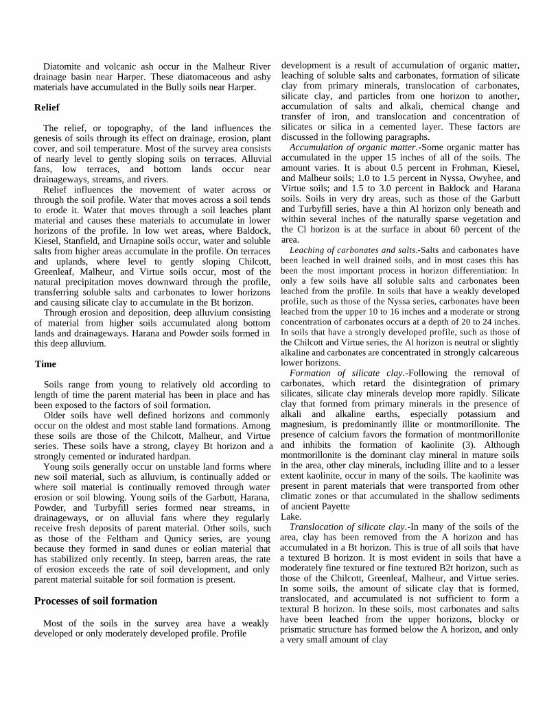
Diatomite and volcanic ash occur in the Malheur Riverdrainage basin near Harper. These diatomaceous and ashymaterials have accumulated in the Bully soils near Harper.
Relief
The relief, or topography, of the land influences thegenesis of soils through its effect on drainage, erosion, plantcover, and soil temperature. Most of the survey area consistsof nearly level to gently sloping soils on terraces. Alluvialfans, low terraces, and bottom lands occur neardrainageways, streams, and rivers.
Relief influences the movement of water across orthrough the soil profile. Water that moves across a soil tendsto erode it. Water that moves through a soil leaches plantmaterial and causes these materials to accumulate in lowerhorizons of the profile. In low wet areas, where Baldock,Kiesel, Stanfield, and Urnapine soils occur, water and solublesalts from higher areas accumulate in the profile. On terracesand uplands, where level to gently sloping Chilcott,Greenleaf, Malheur, and Virtue soils occur, most of thenatural precipitation moves downward through the profile,transferring soluble salts and carbonates to lower horizonsand causing silicate clay to accumulate in the Bt horizon.
Through erosion and deposition, deep alluvium consistingof material from higher soils accumulated along bottomlands and drainageways. Harana and Powder soils formed inthis deep alluvium.
Time
Soils range from young to relatively old according tolength of time the parent material has been in place and hasbeen exposed to the factors of soil formation.
Older soils have well defined horizons and commonlyoccur on the oldest and most stable land formations. Amongthese soils are those of the Chilcott, Malheur, and Virtueseries. These soils have a strong, clayey Bt horizon and astrongly cemented or indurated hardpan.
Young soils generally occur on unstable land forms wherenew soil material, such as alluvium, is continually added orwhere soil material is continually removed through watererosion or soil blowing. Young soils of the Garbutt, Harana,Powder, and Turbyfill series formed near streams, indrainageways, or on alluvial fans where they regularlyreceive fresh deposits of parent material. Other soils, suchas those of the Feltham and Qunicy series, are youngbecause they formed in sand dunes or eolian material thathas stabilized only recently. In steep, barren areas, the rateof erosion exceeds the rate of soil development, and onlyparent material suitable for soil formation is present.
Processes of soil formation
Most of the soils in the survey area have a weaklydeveloped or only moderately developed profile. Profile
development is a result of accumulation of organic matter,leaching of soluble salts and carbonates, formation of silicateclay from primary minerals, translocation of carbonates,silicate clay, and particles from one horizon to another,accumulation of salts and alkali, chemical change andtransfer of iron, and translocation and concentration ofsilicates or silica in a cemented layer. These factors arediscussed in the following paragraphs.
Accumulation of organic matter.-Some organic matter hasaccumulated in the upper 15 inches of all of the soils. Theamount varies. It is about 0.5 percent in Frohman, Kiesel,and Malheur soils; 1.0 to 1.5 percent in Nyssa, Owyhee, andVirtue soils; and 1.5 to 3.0 percent in Baldock and Haranasoils. Soils in very dry areas, such as those of the Garbuttand Turbyfill series, have a thin Al horizon only beneath andwithin several inches of the naturally sparse vegetation andthe Cl horizon is at the surface in about 60 percent of thearea.
Leaching of carbonates and salts.-Salts and carbonates havebeen leached in well drained soils, and in most cases this hasbeen the most important process in horizon differentiation: Inonly a few soils have all soluble salts and carbonates beenleached from the profile. In soils that have a weakly developedprofile, such as those of the Nyssa series, carbonates have beenleached from the upper 10 to 16 inches and a moderate or strongconcentration of carbonates occurs at a depth of 20 to 24 inches.In soils that have a strongly developed profile, such as those ofthe Chilcott and Virtue series, the Al horizon is neutral or slightlyalkaline and carbonates are concentrated in strongly calcareouslower horizons.
Formation of silicate clay.-Following the removal ofcarbonates, which retard the disintegration of primarysilicates, silicate clay minerals develop more rapidly. Silicateclay that formed from primary minerals in the presence ofalkali and alkaline earths, especially potassium andmagnesium, is predominantly illite or montmorillonite. Thepresence of calcium favors the formation of montmorilloniteand inhibits the formation of kaolinite (3). Althoughmontmorillonite is the dominant clay mineral in mature soilsin the area, other clay minerals, including illite and to a lesserextent kaolinite, occur in many of the soils. The kaolinite waspresent in parent materials that were transported from otherclimatic zones or that accumulated in the shallow sedimentsof ancient PayetteLake.
Translocation of silicate clay.-In many of the soils of thearea, clay has been removed from the A horizon and hasaccumulated in a Bt horizon. This is true of all soils that havea textured B horizon. It is most evident in soils that have amoderately fine textured or fine textured B2t horizon, such asthose of the Chilcott, Greenleaf, Malheur, and Virtue series.In some soils, the amount of silicate clay that is formed,translocated, and accumulated is not sufficient to form atextural B horizon. In these soils, most carbonates and saltshave been leached from the upper horizons, blocky orprismatic structure has formed below the A horizon, and onlya very small amount of clay

has accumulated. Under these conditions, a cambic horizonforms where not enough clay has accumulated to form a Bthorizon. Owyhee soils have a cambic horizon.
Accumulation of salts and alkali.-Saline-alkali soils formwhere ground water moves upward through the profile.Soluble salts and carbonates move upward with the waterand are deposited in the upper horizons when waterevaporates. Examples of saline-alkali soils are in theStanfield, Otoole, and Umapine series.
Transfer of iron.-Where reduced under conditions of pooraeration, iron usually becomes mobile. In well drained soils itmay move out of the soil in ground water. In poorly drainedsoils it remains in the horizon where it originated or movesonly to a nearby horizon. Alternate wetting and drying ofthese horizons causes part of this iron to reoxidize and tocongregate as mottles, such as the distinct reddish brown orbrown mottles in Baldock soils. However, in poorly drainedsoils in which salts, carbonates, and exchangeable sodiumhave .accumulated, the iron is relatively insoluble. Becausethe soils are alkaline, the iron does not move or congregate.For example, in Otoole, Stanfield, and Umapine soils,mottling is less than normal for soils that are as wet and asshallow to ground water as these soils are.
Formation of cemented layers.-Translocated silicates orsilica and carbonates combine to form weakly cementednodules of soil material in weakly developed profiles andstrongly cemented durinodes and duripans in moderately andstrongly developed profiles. In well drained soils of the area,nodules of soil material occur in the horizon that has themaximum accumulation of carbonates. In places, nodulesalso occur in adjacent horizons. The nodules make up verylittle to more than 50 percent, by volume, of the horizon inwhich they occur. Weakly cemented nodules slake whenwet. Strongly cemented nodules remain firm when soakedalternately in concentrated sodium hydroxide andhydrochloric acid. Most of the nodules consist of soilmaterial that filled holes occupied by cicada pupae (4). Thewalls of the holes were partly solidified by compaction andwere weakly cemented by organic secretions. As carbonatesand silicates accumulate, the horizon became more stronglycemented. This horizon is weakly cemented in Owyhee soilsand is moderately cemented in Nyssa soils. In Chilcott andVirtue soils it forms a strongly, cemented or induratedduripan.
Classification
The system of soil classification currently used wasadopted by the National Cooperative Soil Survey in 1965.Readers interested in further details about the system shouldrefer to "Soil taxonomy" (7).
The system of classification has six categories. Beginningwith the broadest, these categories are the order, suborder,great group, subgroup, family, and series. In this system theclassification is based on the different soil properties that canbe observed in the field or those
that can be inferred either from other properties that areobservable in the field or from the combined data of soilscience and other disciplines. The properties selected for thehigher categories are the result of soil genesis or of factorsthat affect soil genesis. In table 12, the soils of the surveyarea are classed according to the system. Categories of thesystem are discussed in the following paragraphs.
ORDER. Ten soil orders are recognized as classes in thesystem. The properties used to differentiate among orders arethose that reflect the kind and degree of dominantsoil-forming processes that have taken place. Each order isidentified by a word ending in sol. An example is Entisol.
SUBORDER. Each order is divided into suborders basedprimarily on properties that influence soil genesis and areimportant to plant growth or that are selected to reflect themost important variables within the orders. The last syllablein the name of a suborder indicates the order. An example isAquent (Aqu, meaning water, plus ent, from Entisol).
GREAT GROUP. Each suborder is divided into greatgroups on the basis of close similarities in kind, arrangement,and degree of expression of pedogenic horizons; soilmoisture and temperature regimes; and base status. Eachgreat group is identified by the name of a suborder and aprefix that suggests something about the properties of thesoil. An example is Haplaquents (Hapl, meaning simplehorizons, plus aquent, the suborder of Entisols that have anaquic moisture regime).
SUBGROUP. Each great group may be divided into threekinds of subgroup: the central (typic) concept of the greatgroups, which is not necessarily the most extensivesubgroup; the intergrades, or transitional forms to otherorders, suborders, or great group; and the extragrades,which have some properties that are representative of thegreat group but do not indicate transitions to any otherknown kind of soil. Each subgroup is identified by one ormore adjectives preceding the name of the great group. Theadjective Typic identifies the subgroup that is thought totypify the great group. An example is Typic Haplaquents.
FAMILY. Families are established within a subgroup onthe basis of similar physical and chemical properties thataffect management. Among the properties considered inhorizons of major biological activity below plow depth areparticle-size distribution, mineral content, temperatureregime, thickness of the soil penetrable by roots,consistence, moisture equivalent, soil slope, and permanentcracks. A family name consists of the name of a subgroupand a series of adjectives. The adjectives are the class namesfor the soil properties used as family differentiae. An exampleis fine-loamy, mixed, nonacid, mesic, Typic Haplaquents.
SERIES. The series consists of soils that formed in aparticular kind of material and have horizons that, except fortexture of the surface soil or of the underlying substratum,are similar in differentiating characteristics and

in arrangement in the soil profile. Among thesecharacteristics are color, texture, structure, reaction,consistence, and mineral and chemical composition.
General nature of the area
This section discusses the settlement and the relief anddrainage of the area. It also describes the climate.
Settlement
Hudson's Bay trappers and various mountain men traveledthrough this area in 1812. The Oregon Trail was establishedthrough Vale in 1843 and this was the start of settlement inthe survey area. Farming was first restricted to land adjacentto the streams. This land was irrigated with water lifted bywaterwheels or intercepted by small diversion structures.Improvements came with time and need; companies andprojects were formed. The Nevada Ditch was one of thefirst major projects. It diverted water from the Malheur Riverjust east of Vale. The Warm Springs Irrigation District wasformed in 1916, and an arch structure dam was built on theMiddle Fork of the Malheur River above Riverside in 1919.The Vale-Oregon Project, constructed by the Bureau ofReclamation, took over the Warm Springs Dam and did addi-tional work, on it. In 1938 the Bureau constructed theAgency Dam, which impounds water on the North Fork ofthe Malheur River 15 miles upstream from Juntura. BullyCreek Dam was constructed in 1963. On the Owyhee River,water was diverted into ditches or lifted by waterwheels untilthe Bureau of Reclamation constructed the Owyhee Dam.The Owyhee Dam and canal systems was started in 1928and the first water was delivered in 1935. These combinedprojects provide water for more than 200,000 acres of land.
Industries connected with agriculture have developedthroughout the area: Commercial plants in Nyssa and Ontarioprocess sugar beets, potatoes, and corn. Marketing facilitiesfor potatoes, onions, and grain are located in all areas.Alfalfa hay is grown in rotation on some of the steeper soilsand helps to maintain some of the beef industry in MalheurCounty. Climatic conditions are such that specialty cropscan be and are raised. Seed is produced for alfalfa, carrots,lettuce, radishes, and onions. Mint is raised for oil. Hops aregrown on a small acreage. Feed lots for beef productionhave been increasing, and corn for silage is grown in allparts of the area. There is room for additional industries inthe area, but most of the water potential has been reached.
Relief and drainage
The survey area includes land along parts of the Snake,Malheur, and Owyhee Rivers-the alluvial bottom landsand adjacent stream and lake terraces up to the elevation ofthe Owyhee Main Canal, which is about 2,600 feet at
Mitchell Butte on the south and 2,400 feet on the north endabove Dead Ox Flat. These terraces are mostly level but aredissected with many small and large drainageways withgently sloping to very steep escarpments.
In general, age and development of soils in this area areclosely related to height above and distance from the threemajor rivers that flow through or bound the area. The soilsnearest the rivers show the least profile development but maybe mottled or show effects of salts and alkali. As heightincreases to the terrace tops, so does the profile developmentand cementation of a hardpan. The least soil depth and moststrongly developed hardpans occur at the highest elevationsalong the Owyhee Main Canal.
Distribution of sand and clay in soils has a pattern fromsouth to north. The majority of soils with the most clay areon the north end of the survey area.
The Snake River flows north from where it enters thecounty from Idaho and swings back east before turning northand forming the common boundary between Oregon andIdaho. The Malheur River flows from west to east and picksup the waters of Bully and Willow Creeks at Vale. TheOwyhee River drains from the south and flows through thearea only a short distance before it empties into the SnakeRiver. These three major rivers and their tributaries supplywater for most of the irrigation projects within the area'scanal systems.
Climate
In Malheur County summer is hot, especially at lowerelevations, and winter is cold. Precipitation is normally lightat lower elevations during all months of the year, and thesoils are mainly used for range. At higher elevations,precipitation is much greater and snow accumulates toconsiderable depths. Much of the snowmelt irrigates crops innearby valleys.
Table 13 gives data on temperature and precipitation forthe survey area, as recorded at Malheur Branch ExperimentStation for the period 1951 to 1974. Table 14 shows probabledates of the first freeze in fall and the last freeze in spring.Table 15 provides data on length of the growing season.
In winter the average temperature is 31 degrees F, and theaverage daily minimum temperature is 24 degrees. Thelowest temperature on record, which occurred at MalheurBranch Experiment Station on January 23, 1962, is -26degrees. In summer the average temperature is 72 degrees,and the average daily maximum temperature is 88 degrees.The highest recorded temperature, which occurred onAugust 4, 1961, is 108 degrees.
Growing degree days, shown in table 13, are equivalent to"heat units." During the month, growing degree daysaccumulate by the amount that the average temperature eachday exceeds a base temperature (40 degrees F). The normalmonthly accumulation is used to schedule single orsuccessive plantings of a crop between the last freeze inspring and the first freeze in fall.
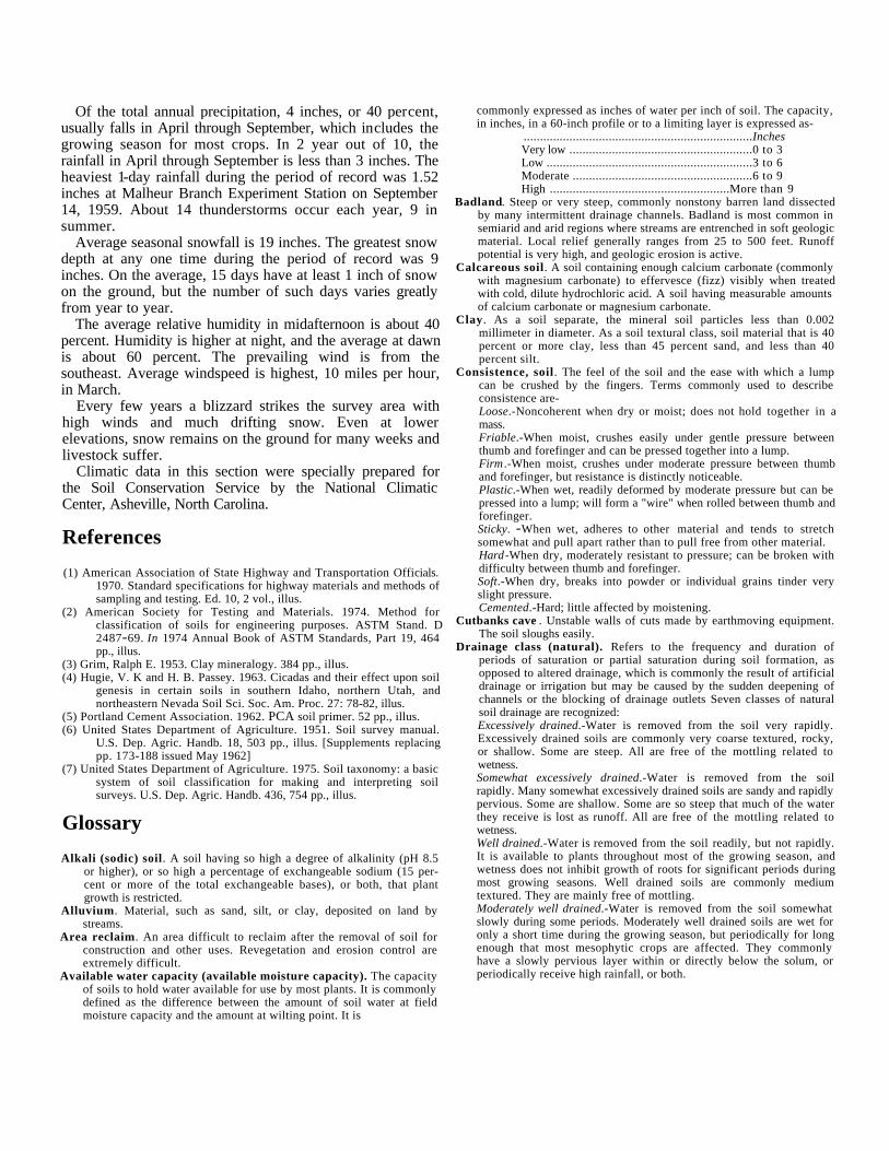
Of the total annual precipitation, 4 inches, or 40 percent,usually falls in April through September, which includes thegrowing season for most crops. In 2 year out of 10, therainfall in April through September is less than 3 inches. Theheaviest 1-day rainfall during the period of record was 1.52inches at Malheur Branch Experiment Station on September14, 1959. About 14 thunderstorms occur each year, 9 insummer.
Average seasonal snowfall is 19 inches. The greatest snowdepth at any one time during the period of record was 9inches. On the average, 15 days have at least 1 inch of snowon the ground, but the number of such days varies greatlyfrom year to year.
The average relative humidity in midafternoon is about 40percent. Humidity is higher at night, and the average at dawnis about 60 percent. The prevailing wind is from thesoutheast. Average windspeed is highest, 10 miles per hour,in March.
Every few years a blizzard strikes the survey area withhigh winds and much drifting snow. Even at lowerelevations, snow remains on the ground for many weeks andlivestock suffer.
Climatic data in this section were specially prepared forthe Soil Conservation Service by the National ClimaticCenter, Asheville, North Carolina.
References
(1) American Association of State Highway and Transportation Officials.1970. Standard specifications for highway materials and methods ofsampling and testing. Ed. 10, 2 vol., illus.
(2) American Society for Testing and Materials. 1974. Method forclassification of soils for engineering purposes. ASTM Stand. D2487-69. In 1974 Annual Book of ASTM Standards, Part 19, 464pp., illus.
(3) Grim, Ralph E. 1953. Clay mineralogy. 384 pp., illus.(4) Hugie, V. K and H. B. Passey. 1963. Cicadas and their effect upon soil
genesis in certain soils in southern Idaho, northern Utah, andnortheastern Nevada Soil Sci. Soc. Am. Proc. 27: 78-82, illus.
(5) Portland Cement Association. 1962. PCA soil primer. 52 pp., illus.(6) United States Department of Agriculture. 1951. Soil survey manual.
U.S. Dep. Agric. Handb. 18, 503 pp., illus. [Supplements replacingpp. 173-188 issued May 1962]
(7) United States Department of Agriculture. 1975. Soil taxonomy: a basicsystem of soil classification for making and interpreting soilsurveys. U.S. Dep. Agric. Handb. 436, 754 pp., illus.
Glossary
Alkali (sodic) soil. A soil having so high a degree of alkalinity (pH 8.5or higher), or so high a percentage of exchangeable sodium (15 per-cent or more of the total exchangeable bases), or both, that plantgrowth is restricted.
Alluvium. Material, such as sand, silt, or clay, deposited on land bystreams.
Area reclaim. An area difficult to reclaim after the removal of soil forconstruction and other uses. Revegetation and erosion control areextremely difficult.
Available water capacity (available moisture capacity). The capacityof soils to hold water available for use by most plants. It is commonlydefined as the difference between the amount of soil water at fieldmoisture capacity and the amount at wilting point. It is
commonly expressed as inches of water per inch of soil. The capacity,in inches, in a 60-inch profile or to a limiting layer is expressed as-
......................................................................InchesVery low ........................................................0 to 3Low ...............................................................3 to 6Moderate .......................................................6 to 9High .......................................................More than 9
Badland. Steep or very steep, commonly nonstony barren land dissectedby many intermittent drainage channels. Badland is most common insemiarid and arid regions where streams are entrenched in soft geologicmaterial. Local relief generally ranges from 25 to 500 feet. Runoffpotential is very high, and geologic erosion is active.
Calcareous soil. A soil containing enough calcium carbonate (commonlywith magnesium carbonate) to effervesce (fizz) visibly when treatedwith cold, dilute hydrochloric acid. A soil having measurable amountsof calcium carbonate or magnesium carbonate.
Clay. As a soil separate, the mineral soil particles less than 0.002millimeter in diameter. As a soil textural class, soil material that is 40percent or more clay, less than 45 percent sand, and less than 40percent silt.
Consistence, soil. The feel of the soil and the ease with which a lumpcan be crushed by the fingers. Terms commonly used to describeconsistence are-Loose.-Noncoherent when dry or moist; does not hold together in amass.Friable.-When moist, crushes easily under gentle pressure betweenthumb and forefinger and can be pressed together into a lump.Firm .-When moist, crushes under moderate pressure between thumband forefinger, but resistance is distinctly noticeable.Plastic.-When wet, readily deformed by moderate pressure but can bepressed into a lump; will form a "wire" when rolled between thumb andforefinger.Sticky. -When wet, adheres to other material and tends to stretchsomewhat and pull apart rather than to pull free from other material.Hard-When dry, moderately resistant to pressure; can be broken withdifficulty between thumb and forefinger.Soft.-When dry, breaks into powder or individual grains tinder veryslight pressure.Cemented.-Hard; little affected by moistening.
Cutbanks cave . Unstable walls of cuts made by earthmoving equipment.The soil sloughs easily.
Drainage class (natural). Refers to the frequency and duration ofperiods of saturation or partial saturation during soil formation, asopposed to altered drainage, which is commonly the result of artificialdrainage or irrigation but may be caused by the sudden deepening ofchannels or the blocking of drainage outlets Seven classes of naturalsoil drainage are recognized:Excessively drained.-Water is removed from the soil very rapidly.Excessively drained soils are commonly very coarse textured, rocky,or shallow. Some are steep. All are free of the mottling related towetness.Somewhat excessively drained.-Water is removed from the soilrapidly. Many somewhat excessively drained soils are sandy and rapidlypervious. Some are shallow. Some are so steep that much of the waterthey receive is lost as runoff. All are free of the mottling related towetness.Well drained.-Water is removed from the soil readily, but not rapidly.It is available to plants throughout most of the growing season, andwetness does not inhibit growth of roots for significant periods duringmost growing seasons. Well drained soils are commonly mediumtextured. They are mainly free of mottling.Moderately well drained.-Water is removed from the soil somewhatslowly during some periods. Moderately well drained soils are wet foronly a short time during the growing season, but periodically for longenough that most mesophytic crops are affected. They commonlyhave a slowly pervious layer within or directly below the solum, orperiodically receive high rainfall, or both.
Somewhat poorly drained.-Water is removed slowly enough that thesoil is wet for significant periods during the growing season. Wetnessmarkedly restricts the growth of mesophytic crops unless artificialdrainage is provided. Somewhat poorly drained soils commonly have aslowly pervious layer, a high water table, additional water fromseepage, nearly continuous rainfall, or a combination of these.Poorly drained. -Water is removed so slowly that the soil is saturatedperiodically during the growing season or remains wet for long periods.Free water is commonly at or near the surface for long enough duringthe growing season that most mesophytic crops cannot be grownunless the soil is artificially drained. The soil is not continuouslysaturated in layers directly below plow depth. Poor drainage resultsfrom a high water table, a slowly pervious layer within the profile,seepage, nearly continuous rainfall, or a combination of these.Very poorly drained.-Water is removed from the soil so slowly thatfree water remains at or on the surface during most of the growingseason. Unless the soil is artificially drained, most mesophytic cropscannot be grown Very poorly drained soils are commonly level ordepressed and are frequently ponded Yet, where rainfall is high andnearly continuous, they can have moderate or high slope gradients, asfor example in "hillpeats" and "climatic moors."
Eolian soil material. Earthy parent material accumulated through windaction; commonly refers to sandy material in dunes or to loess inblankets on the surface.
Erosion. The wearing away of the land surface by running water, wind, ice,or other geologic agents and by such processes as gravitational creep.Erosion (geologic). Erosion caused by geologic processes acting overlong geologic periods and resulting in the wearing away of mountainsand the building up of such landscape features as flood plains andcoastal plains. Synonym: natural erosion.Erosion (accelerated). Erosion much more rapid than geologicerosion, mainly as a result of the activities of man or other animals orof a catastrophe in nature, for example, fine, that exposes a baresurface.
Excess fines. Excess silt and clay. The soil does not provide a source ofgravel or sand for construction purposes.
Excess salts. Excess water soluble salts. Excessive salts restrict the growthof most plants.
Flooding. The temporary covering of soil with water from overflowingstreams, runoff from adjacent slopes, and tides. Frequency, duration,and probable dates of occurrence are estimated. Frequency is expressedas none, rare, occasional, and frequent. None means that flooding isnot probable; rare that it is unlikely but possible under unusual weatherconditions; occasional that it occurs on an average of once or less in2 years; and frequent that it occurs on an average of more than oncein 2 years. Duration is expressed as very brief if less than 2 days, briefif 2 to 7 days, and long if more than 7 days. Probable dates areexpressed in months; November-May, for example, means thatflooding can occur during the period November through May. Waterstanding for short periods after rainfall or commonly coveringswamps and marshes is not considered flooding.
Frost action. Freezing and thawing of soil moisture. Frost action candamage structures and plant roots.
Hardpan. A hardened or cemented soil horizon, or layer. The soilmaterial is sandy, loamy, or clayey and is cemented by iron oxide,silica, calcium carbonate, or other substance.
Horizon, soil. A layer of soil, approximately parallel to the surface, hav-ing distinct characteristics produced by soil-forming processes. Themajor horizons of mineral soil are as follows:O horizon.-An organic layer, fresh arid decaying plant residue, at thesurface of a mineral soil.A horizon.-The mineral horizon, formed or forming at or near thesurface, in which an accumulation of humified organic matter is mixedwith the mineral material. Also, a plowed surface horizon most ofwhich was originally part of a B horizonA2 horizon.-A mineral horizon, mainly a residual concentration ofsand and silt high in content of resistant minerals as a result of the lossof silicate clay, iron, aluminum, or a combination of these.
B horizon.-The mineral horizon below an A horizon. The B horizon isin part a layer of change from the overlying A to the underlying Chorizon. The B horizon also has distinctive characteristics caused (1)by accumulation of clay, sesquioxides, humus, or a combination ofthese; (2) by prismatic or blocky structure; (3) by redder or brownercolors than those in the A horizon; or (4) by a combination of these.The combined A and B horizons are generally called the solum, or truesoil. If a soil lacks a B horizon, the A horizon alone is the solumC horizon.-The mineral horizon or layer, excluding indurated bedrock,that is little affected by soil-forming processes and does not have theproperties typical of the A or B horizon. The material of a C horizonmay be either like or unlike that from which the solum is presumed tohave formed. If the material is known to differ from that in the solumthe Roman numeral II precedes the letter C.R layer.-Consolidated rock beneath the soil. The rock commonlyunderlies a C horizon, but can be directly below an A or a B horizon.
Irrigation. Application of water to soils to assist in production of crops.Methods of irrigation are-Border.-Water is applied at the upper end of a strip in which thelateral flow of water is controlled by small earth ridges called borderdikes, or borders.Basin.-Water is applied rapidly to nearly level plains surrounded bylevees or dikes.Controlled flooding.-Water is released at intervals from closely spacedfield ditches and distributed uniformly over the field.Corrugation.-Water is applied to small, closely spaced furrows orditches in fields of close-growing crops or in orchards so that it flowsin only one direction.Furrow.-Water is applied in small ditches made by cultivationimplements. Furrows are used for tree and row crops.Sprinkler.-Water is sprayed over the soil surface through pipes ornozzles from a pressure systemSubirrigation.-Water is applied in open ditches or tile lines until thewater table is raised enough to wet the soil.Wild flooding.-Water, released at high points, is allowed to flow ontoan area without controlled distribution.
Loam. Soil material that is 7 to 27 percent clay particles, 28 to 50 per-cent silt particles, and less than 52 percent sand particles.
Low strength . Inadequate strength for supporting loads.Mottling, soil. Irregular spots of different colors that vary in number and
size. Mottling generally indicates poor aeration and impeded drainage.Descriptive terms are as follows: abundance-few, common, and many;size-fine, medium, and coarse; and contrast-faint, distinct, andprominent. The size measurements are of the diameter along thegreatest dimension. Fine indicates less than 5 millimeters (about 02inch); medium , from 5 to 15 millimeters (about 02 to 0.6 inch); andcoarse, more than 15 millimeters (about 0.6 inch).
Percs slowly. The slow movement of water through the soil adverselyaffecting the specified use.
Permeability. The quality that enables the soil to transmit water or air,measured as the number of inches per hour that water moves throughthe soil. Terms describing permeability are very slow (less than 0.06inch), slow (0.06 to 020 inch), moderately slow (02 to 0.6 inch),moderate (0.6 to 2.0 inches), moderately rapid (2.0 to 6.0 inches),rapid (6.0 to 20 inches), and very rapid (more than 20 inches).
Piping. Moving water forma subsurface tunnels or pipelike cavities in thesoil.
Poor outlets. Surface or subsurface drainage outlets difficult or expensiveto install.
Reaction, soil. The degree of acidity or alkalinity of a soil, expressed inpH values. A soil that tests to pH 7.0 is described as precisely neutralin reaction because it is neither acid nor alkaline. The degree of acidityor alkalinity is expressed as-

.................................................................... pHExtremely acid .......................................Below 4.5Very strongly acid .................................. 4.5 to 5.0Strongly acid .......................................... 5.1 to 5.5Medium acid ........................................... 5.6 to 6.0Slightly acid ............................................ 6.1 to 6.5Neutral .................................................... 6.6 to 7.3Mildly alkaline ....................................... 7.4 to 7.8Moderately alkaline ................................ 7.9 to 8.4Strongly alkaline .................................... 8.5 to 9.0Very strongly alkaline .........................9.1 and higher
Rooting depth . Shallow root zone. The soil is shallow over a layer thatgreatly restricts roots. See Root zone.
Saline-alkali soil. A soil that contains a harmful concentration of saltsand exchangeable sodium; contains harmful salts and is strongly al-kaline; or contains harmful salts and exchangeable sodium and is verystrongly alkaline. The salts, exchangeable sodium, and alkalinereaction are in the soil in such location that growth of most cropplants is less than normal.
Saline soil . A soil containing soluble salts in an amount that impairsgrowth of plants. A saline soil does not contain excess exchangeablesodium.
Sand. As a soil separate, individual rock or mineral fragments from 0.05millimeter to 2.0 millimeters in diameter. Most sand grains consist ofquartz. As a soil textural class, a soil that is 85 percent or more sandand not more than 10 percent clay.
Seepage . The rapid movement of water through the soil. Seepageadversely affects the speed use.
Shrink-swell. The shrinking of soil when dry and the swelling when wet.Shrinking and swelling can damage roads, dams, building foundations,and other structures. It can also damage plant roots.
Silica. A combination of silicon and oxygen. The mineral form is calledquartz.
Silt. As a soil separate, individual rninenal particles that range in diameterfrom the upper linut of clay (0.002-millimeter) to the lower limit ofvery fine sand (0.05 millimeter). As a soil textural class, soil that is 80percent or more silt and less than 12 percent clay.
Small stones. Rock fragments 3 to 10 inches (7.5 to 25 centimeters) indiameter. Small stones adversely affect the specified use.
Soil. A natural, three-dimensional body at the earth's surface that iscapable of supporting plants and has properties resulting from theintegrated effect of climate and living matter acting on earthy parentmaterial, as conditioned by relief over periods of time.
Subsoil. Technically, the B horizon; roughly, the part of the solum belowplow depth
Subsoiling. Tilling a soil below normal plow depth, ordinarily to shattera hardpan or claypan.
Texture, soil. The relative proportions of sand, silt, and clay particles in amass of soil. The basic textural classes, in order of increasingproportion of fine particles, are sand, loamy sand, sandy loam, loam,silt, silt loam, sandy clay loam, clay loam, silty clay loam, sandy clay,silty clay, and clay. The sand, loamy sand, and sandy loam classes maybe further divided by specifying "coarse;' .`fine," or "very fine."
Thin layer. Otherwise suitable soil material too thin for the specified use.Topsoil (engineering). Presumably a fertile soil or soil material, or one
that responds to fertilization, ordinarily rich in organic matter, usedto topdress roadbanks, lawns, and gardens.
Unstable fill. Risk of caving or sloughing in banks of fill material.Variant, soil. A soil having properties sufficiently different from those of
other known soils to justify a new series name, but the limitedgeographic soil area does not justify creation of a new series.
Water table. The upper limit of the soil or underlying rock material thatis wholly saturated with water.Water table, apparent. A thick zone of free water in the soil. Anapparent water table is indicated by the level at which water stands inan uncased borehole after adequate time is allowed for adjustment inthe surrounding soil.Water table, artesian. A water table under hydrostatic head, generallybeneath an impermeable layer. When this layer is penetrated, thewater level rises in an uncased borehole.Water table, perched. A water table standing above an unsaturatedzone. In places an upper, or perched, water table is separated from alower one by a dry zone.

Illustrations
Figure 1.-Kimberly fine sandy loam on bottom land in foreground. Slopes are 0 to 2 percent. Crops areirrigated corn and potatoes. In background is a Nyssa silt loam in irrigated alfalfa and corn.
Figure 2.-Irrigated alfalfa for hay and seed in an area of Owyhee and Nyssa soils inforeground.
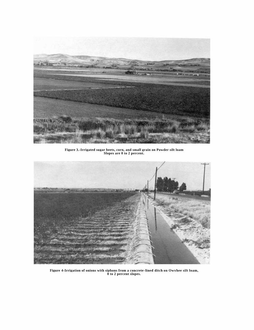
Figure 3.-Irrigated sugar beets, corn, and small grain on Powder silt loam,Slopes are 0 to 2 percent.
Figure 4-Irrigation of onions with siphons from a concrete -lined ditch on Owyhee silt loam,0 to 2 percent slopes.

Figure 5.-Irrigation of sugar beets from underground pipeline and gated pipe on Nyssa-Malheur silt loams,2 to 5 percent slopes.
Figure 6.-Deep plowing to a depth of 36 to 40 inches of Nyssa-Malheur silt loams, 0 to 2 percent slopesDeep plowing mixes the subsoil and the surface layer of the Malheur soil, improving structure,
tilth, and water intake rate.