Embed Size (px)
Citation preview

FOREWORD
Department of Ocean Development (DOD) expressed a
desire to bring out a short illustrated booklet on ocean sciences
for the information of the general public. It also wanted the
booklet to be printed initially in the five languages of English,
Hindi, Kannada, Marathi and Telugu.
The Geological Society of India has as one of its main
objectives, the popularization of science, but for various reasons
it has not been possible to promote this line of activity. The
suggestion from the DOD has come at the right time and plodded
the Society into action. After pooling all available resources, the
Society has now been able to prepare the first booklet on ‘Oceans’.
Prof. K.V. Subbarao of the Indian Institute of Technology,
Mumbai, Dr. R. Shankar, Department of Marine Geology,
Mangalore University and a few others have taken special interest
and it is my pleasant duty to express the grateful thanks of the
Society to all of them. We sincerely trust that the booklet will
excite the interest of school going children and make them take
greater interest in ocean exploration and the development of its
resources.
(B.P. Radhakrishna)President, Geological Society of India

“I seem to have been only like a boy playing on the seashore,
and diverting myself in now and then finding a smoother
pebble or a prettier shell than ordinary, whilst the great ocean
of truth lay all undiscovered before me.”
- Sir Isac Newton
1642-1727, British Scientist, Mathematician0

Foreword 1
Know more about oceans 4
How are oceans important to us? 5
Sea-floor spreading and drifting continents 6
Ocean-floor 8
Study of the oceans 10
Do ocean water masses move? 12
Economic potential of the oceans 13
Owners and users of resources 14
Mineral wealth of the oceans 15Manganese nodules 15Oil & Gas 17Placer deposits 18Phosphorite deposits 18Salt 19Why is the seawater salty 19
Oceans as a source of food 20
Medicines and Sea vegetables from the oceans 21
Coral reefs 22
Energy from the oceans 23
Life in the oceans 24
Marine sediments 24
Can we know the climates of the past? 25
Heritage in the oceans 26
Are our oceans polluted? 27
Does the benevolent ocean get furious? 28
Antarctica 29
Satellite oceanography 30
Career opportunities 31
Save the Oceans! 32
Glossary 33
Amazing facts about the Oceans 35
Epilogue 36
Research team and Acknowledgments
Story of the Oceans
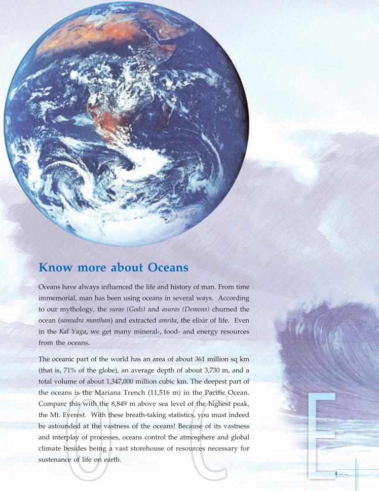
Know more about OceansOceans have always influenced the life and history of man. From time
immemorial, man has been using oceans in several ways. According
to our mythology, the suras (Gods) and asuras (Demons) churned the
ocean (samudra manthan) and extracted amrita, the elixir of life. Even
in the Kal Yuga, we get many mineral-, food- and energy resources
from the oceans.
The oceanic part of the world has an area of about 361 million sq km
(that is, 71% of the globe), an average depth of about 3,730 m, and a
total volume of about 1,347,000 million cubic km. The deepest part of
the oceans is the Mariana Trench (11,516 m) in the Pacific Ocean.
Compare this with the 8,849 m above sea level of the highest peak,
the Mt. Everest. With these breath-taking statistics, you must indeed
be astounded at the vastness of the oceans! Because of its vastness
and interplay of processes, oceans control the atmosphere and global
climate besides being a vast storehouse of resources necessary for
sustenance of life on earth.
4 ... ..

How are Oceans important to us?Oceans are a huge storehouse of resources like minerals (metals, oil,
natural gas, chemicals etc.), food (fish, prawns, lobsters etc.) and
energy (waves, water currents, tides etc.). We have been using oceans
for transporting goods (in ships and oil tankers) and for recreation
purposes (beaches, water sports etc.). We have also been using oceans
to dump all municipal waste, industrial effluents, pesticides used in
agriculture etc. resulting from activities of the ever-growing
population.
In addition, oceans control weather and
climate and thus considerably influence the
environment. Even the quality of air that we
breathe depends greatly on the interaction
between the oceans and the atmosphere.
Oceans have served as channels of adventure
and discovery. From expeditions to seas far
and near, we have understood how Mother
Earth works, how the sea-floor is formed and,
how parts of the continents have moved
thousands of kilometers over a long period.
Thus, there are many reasons to study the
oceans and benefit from it.
Off-shore oil platform
... .. 5
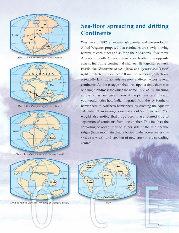
Sea-floor spreading and driftingContinentsWay back in 1912, a German astronomer and meteorologist,
Alfred Wegener proposed that continents are slowly moving
relative to each other and shifting their positions. If we move
Africa and South America near to each other, the opposite
coasts, including continental shelves fit together so well.
Fossils like Glossopteris (a plant fossil) and Lystrosaurus (a fossil
reptile), which were extinct 200 million years ago, which are
essentially land inhabitants are now scattered across several
continents. All these suggest that once upon a time, there was
one single landmass for which the name PANGAEA - meaning
all Earth- has been given. Look at the pictures carefully and
you would notice how India migrated from the icy Southern
hemisphere to Northern hemisphere by crossing the equator
calculated at an average speed of about 5 cm per year! You
would also notice that huge oceans are formed due to
separation of continents from one another. This involves the
spreading of ocean-floor on either side of the mid-oceanic
ridges (huge mountain chains buried under ocean water - see
figure on page no.8) and creation of new crust at the spreading
centres.
About 225 million years ago(Triassic Period)
About 200 million years ago(Jurassic Period)
About 135 million years ago (Cretaceous Period)
About 65 million years ago (beginning of Paleogene Period) Today
Equator
PA
NG
AE
A
L A U R A S I A
GONDWANALAND
TETHYSSEA
Equator
Equator
Equator EquatorSouthAmerica
Africa
Asia
India
Austra-lia
NorthAmerica
6 ... ..
India
India
India
India
Antarctica

The Pieces of the Puzzle
Earth's crust is like a gigantic puzzle
made up of a dozen or so pieces. The
map shows the shapes and locations
of these pieces, and the directions in
which they move. Most earthquakes
and volcanoes occur where plates
collide.
AFRICA
INDIA
ANTARCTICA
SOUTH AMERICA AUSTRALIA
Fossil remains of
Cynognathus, a
Triassic land reptile
approximately
3m long.
Fossil remains of the freshwater
reptile Mesosaurus.
Fossil remains of
the fern
Glossopteris,
found in all of the
southern conti-
nents, show that
they were once
joined.
Fossil evidence of the
Triassic land reptile
Lystrosaurus.
... .. 7
If the continents are joined together (about 200 million years ago) we can also trace certain
fossils of plants and animals across the continents as shown in the above figure as coloured
bands. This is one of the outstanding contribution of Snider-Pellegrini and Wegener.
It is the break-up of PANGAEA, a large rigid slab- a plate, into many plates and their drifting
away due to tectonics - an internal dynamic force, that has led to the present disposition of the
continents. This process is called plate tectonics, a concept which was introduced some 40
years ago. Continents are made up of more than one plate, along with parts of ocean basins.
The map shows the shapes and locations of these plates and the directions in which they
move. Most earthquakes and volcanoes occur where plates collide.
Plate boundaries
Direction of plate movement
Volcanoes
Earthquake zones
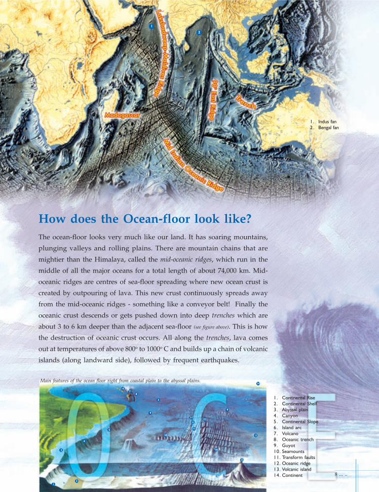
How does the Ocean-floor look like?The ocean-floor looks very much like our land. It has soaring mountains,
plunging valleys and rolling plains. There are mountain chains that are
mightier than the Himalaya, called the mid-oceanic ridges, which run in the
middle of all the major oceans for a total length of about 74,000 km. Mid-
oceanic ridges are centres of sea-floor spreading where new ocean crust is
created by outpouring of lava. This new crust continuously spreads away
from the mid-oceanic ridges - something like a conveyor belt! Finally the
oceanic crust descends or gets pushed down into deep trenches which are
about 3 to 6 km deeper than the adjacent sea-floor (see figure above). This is how
the destruction of oceanic crust occurs. All along the trenches, lava comes
out at temperatures of above 800o to 1000o C and builds up a chain of volcanic
islands (along landward side), followed by frequent earthquakes.
8 ... ..
1. Continental Rise
2. Continental Shelf
3. Abyssal plain
4. Canyon
5. Continental Slope
6. Island arc
7. Volcano
8. Oceanic trench
9. Guyot
10. Seamounts
11. Transform faults
12. Oceanic ridge
13. Volcanic island
14. Continent
1
2
3
3
3
4
5
67
8
9
9
10
11
11
11
12
10
13
14
2
1. Indus fan
2. Bengal fan
1
Main features of the ocean floor right from coastal plain to the abyssal plains.
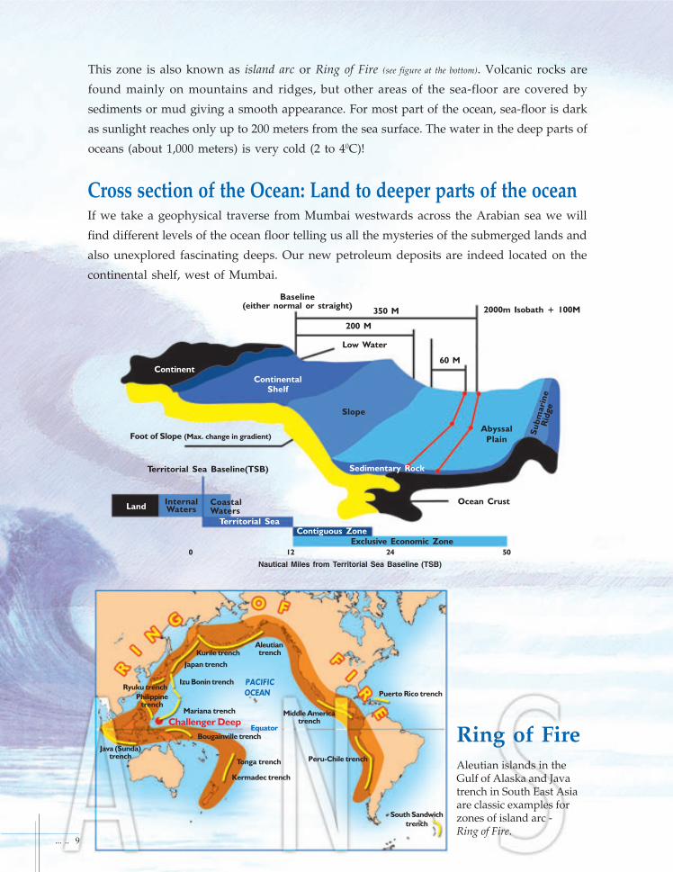
Foot of Slope (Max. change in gradient)
Territorial Sea Baseline(TSB)
InternalWaters
CoastalWaters
Territorial Sea
ContinentContinental
Shelf
Ocean Crust
Slope
Abyssal
Plain
Sedimentary Rock
Su
bm
ari
ne
Rid
ge
Contiguous Zone
Exclusive Economic Zone
Baseline(either normal or straight)
Low Water
Nautical Miles from Territorial Sea Baseline (TSB)
2000m Isobath + 100M
60 M
200 M
350 M
South Sandwich
trench
Peru-Chile trench
Puerto Rico trench
Middle Americatrench
Tonga trench
Kermadec trench
Bougainville trench
Java (Sunda)trench
Challenger Deep
Mariana trench
Philippinetrench
Ryuku trenchIzu Bonin trench
Japan trench
Kurile trenchAleutian trench
Equator Ring of FireAleutian islands in theGulf of Alaska and Javatrench in South East Asiaare classic examples forzones of island arc -Ring of Fire.
Land
0
Cross section of the Ocean: Land to deeper parts of the oceanIf we take a geophysical traverse from Mumbai westwards across the Arabian sea we will
find different levels of the ocean floor telling us all the mysteries of the submerged lands and
also unexplored fascinating deeps. Our new petroleum deposits are indeed located on the
continental shelf, west of Mumbai.
... .. 9
This zone is also known as island arc or Ring of Fire (see figure at the bottom). Volcanic rocks are
found mainly on mountains and ridges, but other areas of the sea-floor are covered by
sediments or mud giving a smooth appearance. For most part of the ocean, sea-floor is dark
as sunlight reaches only up to 200 meters from the sea surface. The water in the deep parts of
oceans (about 1,000 meters) is very cold (2 to 40C)!
12 24
PACIFIC
OCEAN
50

How do scientists study the Oceans?A well-equipped research ship is the most important mobile research
station required to study the sea. Looking at the oceans extending up
to the horizon is both amazing and interesting. As the ship moves
away from the coast towards the deeper part of the ocean, the muddy/
greenish colour turns to a deep blue colour and dolphins and flying
fish may be seen jumping out of water. Rough weather can sometimes
make the scientists on board the ship feel sea-sick. But the voyage is
generally adventurous and challenging.
Ocean scientists known as oceanographers map the sea-floor features
by using an echo sounder. It emits sound pulses from the ship towards
the bottom from where they are reflected to the surface, and the time
taken is recorded. Knowing the velocity of sound in ocean water, they
find out the water depth below the ship. Present day multi-beam echo
sounders provide wide coverage of the sea-floor depths simultaneously.
A side-scan sonar deployed at shallow water depths gives a picture of
the features of the sea-floor and sunken ships and similar objects.
What lies beneath the sea-floor? Sound of different frequencies can
penetrate through the sea-floor, get reflected and come back to the
1. Coastal Research Vessel
2. Crawler
3. Deep Water Data Buoy
4. Floating OTEC Plant
5. Island
6. Remotely operable vehicle
7. Sub-bottom Profiling
8. Wave Energy Plant
1
2
3
4
5
8
6
7
10 ... ..

ship. Through such seismic investigations, scientists are able to
figure out what materials are there below and what their
structures are.
Scientists use a specially designed grab to collect samples from
the sea-floor sediment or mud. Long, cylindrical samples (cores)
of sediments are obtained using a corer.
A sediment trap is used to “trap” sediment particles that are
settling through sea water. They provide information on the
processes going on in the water column.
Nets are used to capture relatively small organisms that live
at/near the sea surface. Scientists study the types and
abundances of these organisms and understand their ecology.
Measuring properties of water at various depths in the ocean
helps in understanding how ocean water moves at different
depths. This can be done by lowering instruments from the
sea surface to sea-bottom, which continuously measure the
temperature, salinity and other properties of seawater.
Scientists go down the sea in ‘submersibles’ to directly observe
seafloor features and make various other observations of marine
life and nature of sediments.
Side-scan sonar
Net monitor Receiver
... .. 11
1
23
4
5
6
7
8
1. The pilot guides the submersible using
these hand controls.
2. These powerful lights help the pilot to
find his way.
3. This part is see-through, so the pilot
can look around.
4. Deep Flight gets its power from ten
batteries (five along each side).
5. Bottles filled with oxygen allow the
pilot to breathe.
6. These wings don't move. They keep
the submersible steady in the water.
7. Engines, called thrusters, turn the
propellers.
8. Propellers spin around quickly, pushing
the submersible forward.
Fans : (see top fig. on page 8) It is interesting to note that in the Bay of Bengal, there is a huge fan called
"Bengal Fan" which is made up of sediments brought in by the Ganges and Brahmaputra rivers.
This is considered to extend for nearly 3000 km with a maximum width of about 1400 km. Similarly,
the Arabian sea is fed by voluminous sediments by the mighty Indus river draining the Himalayan
ranges. The sediment thickness exceeds 10 km and covers nearly 1500 km in length with a width
of about 960 km. This beautiful structure in the Arabian sea is known as "Indus Fan".
Submersible
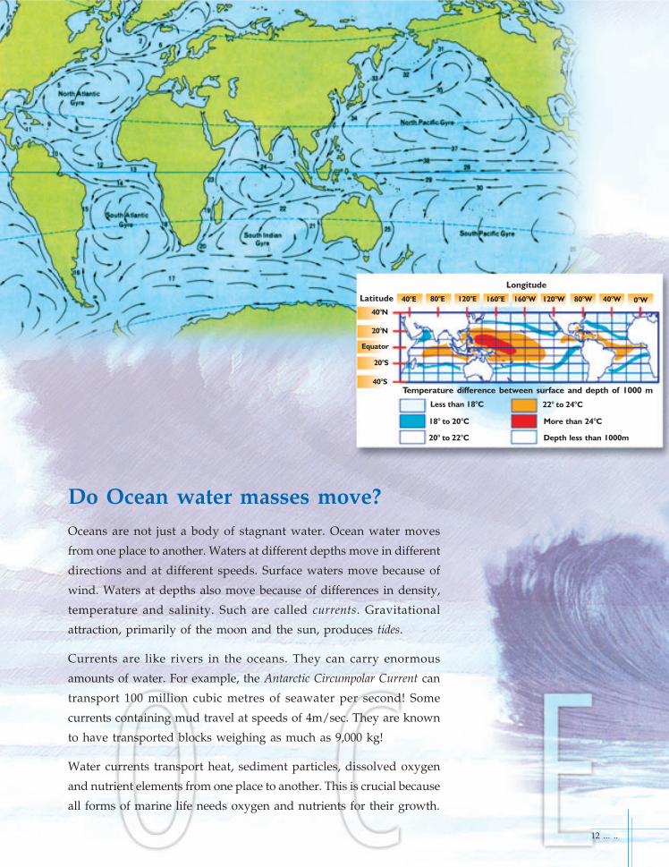
Do Ocean water masses move?Oceans are not just a body of stagnant water. Ocean water moves
from one place to another. Waters at different depths move in different
directions and at different speeds. Surface waters move because of
wind. Waters at depths also move because of differences in density,
temperature and salinity. Such are called currents. Gravitational
attraction, primarily of the moon and the sun, produces tides.
Currents are like rivers in the oceans. They can carry enormous
amounts of water. For example, the Antarctic Circumpolar Current can
transport 100 million cubic metres of seawater per second! Some
currents containing mud travel at speeds of 4m/sec. They are known
to have transported blocks weighing as much as 9,000 kg!
Water currents transport heat, sediment particles, dissolved oxygen
and nutrient elements from one place to another. This is crucial because
all forms of marine life needs oxygen and nutrients for their growth.
Longitude
Latitude
40°N
20°N
Equator
20°S
40°S
40°E 80°E 120°E 160°E 160°W 120°W 80°W 40°W 0°W
Temperature difference between surface and depth of 1000 m
Less than 18°C
18° to 20°C
20° to 22°C
22° to 24°C
More than 24°C
Depth less than 1000m
12 ... ..

Do the Oceans hold any economicpotential?Oceans contain a wide spectrum of mineral, energy- and food
resources. They are the earth's biggest storehouse of minerals including
oil and gas. Although these are available on land, our demand for
resources has been rising continuously because of rapid increase in
world population and demand for comforts and amenities. Besides,
mineral resources are not renewable, once mined and used, they are
lost. To form again, it takes several millions of years and this is the
reason why they are known as "non-renewable" resources.
... .. 13
1. These floats stop the rig from
sinking.
2. Cables with anchors on them stop
the rig from moving.
3. This pipe goes into the seabed as
far as the oil. The oil is then
pumped up.
Oil
Seabed
3
2
1
Floating Oil Rig

Who owns these resources and whocan utilize them?The United Nations held three conferences (between 1967 and 1982)
on this aspect and finally the United Nations Convention on the Law of
the Sea was signed in 1982. The Convention laid down rules and
regulations to rationally manage oceanic resources and conserve them
for future generations. The oceans have been divided into several
zones: Territorial sea (12 nautical miles (n.m.) from coastline), Exclusive
Economic Zone (EEZ; 200 n.m. from coastline ; see sketch below), and the
International Area of the Seabed (beyond the EEZ). Coastal nations have
exclusive rights to explore and exploit all the resources within their
respective EEZ’s. Resources in the international area are a common
heritage of mankind.
India has an EEZ of
2 million sq km, which
is 2/3 of our land area.
Sri Lanka
Kakinada
Visakhapatnam
Mumbai
Ratnagiri
Marmagoa
Chennai
Exclusive Economic Zone
Andaman
and
Nicobar Islands
Mangalore
KochiTuticorin
Vizhinjam
Kanyakumari
Veraval
KandlaKolkata
Bhubaneswar
INDIA
14 ... ..
Lakshadweep
Islands
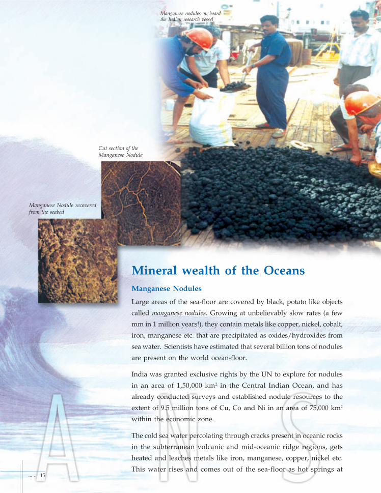
Mineral wealth of the OceansManganese Nodules
Large areas of the sea-floor are covered by black, potato like objects
called manganese nodules. Growing at unbelievably slow rates (a few
mm in 1 million years!), they contain metals like copper, nickel, cobalt,
iron, manganese etc. that are precipitated as oxides/hydroxides from
sea water. Scientists have estimated that several billion tons of nodules
are present on the world ocean-floor.
India was granted exclusive rights by the UN to explore for nodules
in an area of 1,50,000 km2 in the Central Indian Ocean, and has
already conducted surveys and established nodule resources to the
extent of 9.5 million tons of Cu, Co and Ni in an area of 75,000 km2
within the economic zone.
The cold sea water percolating through cracks present in oceanic rocks
in the subterranean volcanic and mid-oceanic ridge regions, gets
heated and leaches metals like iron, manganese, copper, nickel etc.
This water rises and comes out of the sea-floor as hot springs at
Manganese Nodule recoveredfrom the seabed
Cut section of theManganese Nodule
Manganese nodules on boardthe Indian research vessel
... .. 15

temperatures of up to 380o C! The dissolved metals are precipitated
sometimes in the cracks of rocks to form metal sulphide ores.
Sometimes chimneys of sulphide materials exist on the sea-floor.
There are also several types of animals living in such warm
environments. Life at these great depths (approximately 2500m)
where sun light does not reach, is sustained by chemosynthesis, in
which energy during chemical reactions is used for synthesizing
food by microbes. For example, thermophilic bacteria, generally
found in the hot spring areas of the sea-floor, can tolerate high
temperatures (thermo=heat; philic=loving). These bacteria are
eaten by bigger animals and they, in turn, are eaten by still bigger
animals and so on. That’s how the food chain is established here.
Underwater hot spring areas are home to many new species that
were not known to man earlier.
Some times the dissolved metals are precipitated in the water
column as metal sulphides or oxides. On settling to the sea-bottom,
the precipitates form layers of sediment, rich in metals. Rich deposits
of such metalliferous sediments are found in the Red Sea. One of
them contains 100 million tons of metalliferous sediments in which
2.5 million tons of Zn, 0.5 million tons of Cu, 9000 tons of Au and
other metals are present.
Contents of the Manganese Nodule
Metal rich material from the hot springs area
Cobalt0.3% Titanium
0.5%Barium0.5%
Others0.7%
Calcium 3.8 %
Aluminium 6.3%
Manganese 11.5%
Water 15.3%
Oxygen 20.4%
Silica 20.7%
Iron 20.0%
16 ... ..
A colony of tube worms clusteredaround an ocean floor hot spring

Patra
Mid TaptiDiu
KodinarUmrat -1
North Tapti
South Tapti
SuratHazira
Daman
Mumbai
Uran
Alibag
Murud
Shrivardhan
Ratna
Heera
Neelam
Panna
Bassein
Mukta
LEGEND
Oil Field
Gas Field
Location MapWestern Offshore Oil & Gas fields
Oil and GasOcean sediments are repository of vast oil
(petroleum) and natural gas deposits. They form
when organic matter of dead micro-organisms is
buried by mud on the sea-floor. Due to high
temperatures and pressures at great depths, this
organic matter is converted into oil and natural gas.
India has several offshore oil and gas fields in
Bombay High, Gulf of Cambay, Cauvery, Krishna-
Godavari and Mahanadi basins.
Gas Hydrate
At low temperatures and high pressures, natural
gas (methane) gets into water molecules to form gas
hydrate, a relatively newly discovered mineral
deposit that occurs in ocean sediments. One cubic
meter of gas hydrate, when brought to the surface
is expected to yield 164 cubic meters of natural gas!.
This can be done and utilised as a future resource.
... .. 17
Delhi
K.G.BASIN
I N D I A
Mumbai
Chennai
Bay ofBengal
Palakolluwell
Modi well
Vijayawada
Krish
na R
iver Bay o
f Ben
gal
200 met
ers d
epth
conto
ur lin
e
Machilipatnam
Nizampatnam
Kakinada
Bay
Amalapuram
Tanuku
God
avari River
Rajahmundry
Location MapKrishna Godavari (K.G.)
Onshore & OffshoreOil & Gas fields
Nizampatnam
bay
Narsapur
WESTERNOFFSHORE
Oil & Gas fields
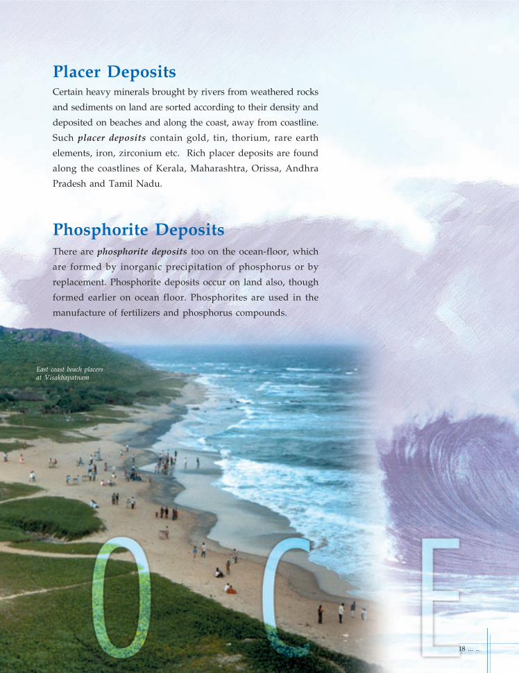
Placer DepositsCertain heavy minerals brought by rivers from weathered rocks
and sediments on land are sorted according to their density and
deposited on beaches and along the coast, away from coastline.
Such placer deposits contain gold, tin, thorium, rare earth
elements, iron, zirconium etc. Rich placer deposits are found
along the coastlines of Kerala, Maharashtra, Orissa, Andhra
Pradesh and Tamil Nadu.
Phosphorite DepositsThere are phosphorite deposits too on the ocean-floor, which
are formed by inorganic precipitation of phosphorus or by
replacement. Phosphorite deposits occur on land also, though
formed earlier on ocean floor. Phosphorites are used in the
manufacture of fertilizers and phosphorus compounds.
East coast beach placersat Visakhapatnam
18 ... ..

SaltSea-water contributes bulk of the salt which mankind uses.Salt is one of the main resources recovered by man sinceearly times. Each cubic mile of sea water weighsapproximately 4.7 billion tons and holds 166 million tons ofdissolved solids, comprising 140 million tons of commonsalt (sodium chloride) and 25 million tons of magnesiumsalts besides others.
Why is the sea water salty?The sea-water is salty because it contains dissolved salts.
Salinity, or the salt content of sea-water is about 3.5%. Most
significant constituent of the salts is table salt or sodium
chloride. Where does all the salt in the sea come from? When
rocks are weathered on the continents, salt and other
chemicals are dissolved by rainwater and carried by rivers
to the oceans. After millions of years, much salt has
accumulated in the oceans by breaking down of mountain
ranges and scoured by several rivers during the past millions
of years. Very little is taken out by natural processess or by
man which makes the sea-water ever salty.
Eleven Major Constituents account
for more than 99% of the salt
content of normal seawater. Many
are present in solution in the form of
free ions. The overall salinity of sea
water may vary regionally and with
depth, but the rat io of the
constituents remains constant.
Salt farmingWest coast of India
Trace elements 0.01%
Flouride (F-) 0.003%
Strontium(Sr++) 0.04%
Boric acid (H2BO
3) 0.07%
Bromide(Br- ) 0.19%
Bicarbonate (HCO-
3) 0.41%
Potassium(K+) 1.10%
Calcium(Ca++) 1.16%
Magnesium(Mg++) 3.69%
Sulfate(SO4
--) 7.69%
Sodium(Na+) 30.61%
Chloride(Cl-) 55.04%
... .. 19

Oceans as a source of foodIndeed oceans are primary source of staple food to large coastalcommunities. A large number of finfish and shellfish includingshrimps, lobsters, squid, cuttlefish, prawn etc. are harvestedalong the entire coastline. Our nation is in the front rank ofglobal fish production. The country’s estimated potential forproduction is about 3.93 million tonnes of fish and shellfish.India is a major exporter of sea food items like squid, cuttlefish,lobster and a variety of fish, besides shrimp. Export of marineproducts amounted to 2,90,000 tonnes valued at Rs. 3501 croresin 1995-96 and has increased to 4,24,000 tonnes valued at Rs.5957 crores in 2001-2002.
Acoustic surveys (using echo sounder) have been used in recenttimes to locate dense populations of fish. The country hasinitiated a multi-disciplinary and multi-institutionalprogramme aimed at making an assessment of the marine living
resources beyond 70m water depth.
Mariculture
Mariculture is an alternative for increasing the production ofover-harvested or depleted stocks. Creation of artificial reefsand sea-farming projects are good for replenishing resourcesthat are degraded.
A rich haul of finfish
Studies on Deep Ocean Water Mariculture
Zone of High Primary Productivity
Experiments show increasedphytoplankton biomass in
surface seawater mixed withdeep seawater in 1:1 ratio as
compared to surface seawater
Nutrient rich cold deep sea water
SEA FLOOR
20 ... ..

Medicinal drugs
Medicinal plant
Medicines and Sea vegetablesfrom the OceanAbout 30% of the faunal and floral species of our planet inhabitin the sea. It is believed that life originated in oceans. Somecompounds extracted from marine organisms have shown tobe anti-viral, anti-tumour, anti-biotic and may be developedinto drugs.
Exploration and recovery of such drugs are one of theimportant goals of our marine exploration programme.
Sea vegetables are used as food, animal feeds, dyes, medicinesand cosmetics. Sea weeds (algae) are rich in protein - higherthan even in meat, and highly enriched in calcium (higher thanin milk).
These are also used as a possible prevention against cancer,blood pressure and other illnesses. Some of the well knownsea vegetables are arame, bladderwrack, dulse, hijiki, kelp, kombu,nori and wakame.
... .. 21
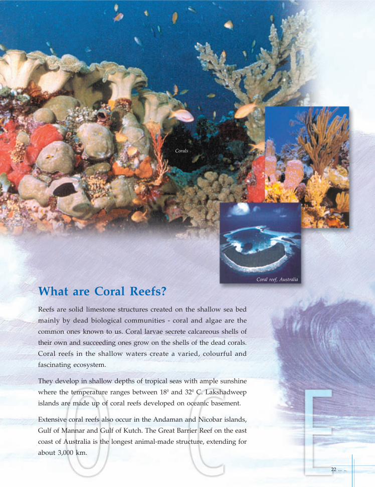
What are Coral Reefs?Reefs are solid limestone structures created on the shallow sea bed
mainly by dead biological communities - coral and algae are the
common ones known to us. Coral larvae secrete calcareous shells of
their own and succeeding ones grow on the shells of the dead corals.
Coral reefs in the shallow waters create a varied, colourful and
fascinating ecosystem.
They develop in shallow depths of tropical seas with ample sunshine
where the temperature ranges between 180 and 320 C. Lakshadweep
islands are made up of coral reefs developed on oceanic basement.
Extensive coral reefs also occur in the Andaman and Nicobar islands,
Gulf of Mannar and Gulf of Kutch. The Great Barrier Reef on the east
coast of Australia is the longest animal-made structure, extending for
about 3,000 km.
Corals
Coral reef, Australia
22 ... ..

Energy from the OceansOcean Thermal Energy Conversion
In the present day conditions of severe power shortage, it is important
to develop alternate non-conventional energy resources. Oceans offer
a variety of environments for the production of energy, which are
renewable and non-polluting.
Using cold sea-bottom water and warm surface water, it is possible to
harness energy. Such a programme is called Ocean Thermal Energy
Conversion (OTEC). Ocean is a large collector of solar energy which is
mainly responsible for generating currents. India will be deploying
very soon a 1-Megawatt floating OTEC technology demonstration
pilot plant, 60 km off Tuticorin in Tamil Nadu.
Wind blowing across the ocean surface produces waves. Ocean waves
can be used to produce electrical energy. This is made possible using
the temperature difference between warm surface water and cold
deep water. A small wave energy plant has been installed
at Vizhinjam in Kerala.
Sea level rises and falls mainly due to gravitational attraction
of the Sun and the Moon. These are called tides. As a result,
sea water gushes into rivers during high tide and goes back
to the ocean during low tide twice everyday. By constructing
a dam, water can be stored during high tide and on its
flowing back to the ocean can be made to run turbines for
producing electricity.
... .. 23
Seabed
The surface of the sea is
often windy. Big windmills,
called wind turbines, could be
attached to the seabed and
used to make electricity from
the wind.
Wind blowing across the sea
turns the windmill blades.
The spinning blades power a
machine called a turbine
inside the windmill, which
produces electricity.
Wind Power

Life in the OceansLife originated in the oceans. Marine scientists are carrying outresearch on sediments from hot spring areas to understand how lifeoriginated on the Earth. Oceans have supported life in a variety offorms - from microscopic algae to gigantic blue whales. Of an estimated30 million species of flora and fauna on our planet, oceans contribute
to nearly 20% (about 5,00,000 species).
What are marine sediments made up of?Mud or sediment that covers large areas of the ocean floor is made upof (1) clays and sands brought by rivers, (2) the shells and organicmatter of dead organisms that once lived in sea surface waters, (3)chemical compounds that are precipitated from sea water, (4) particlesthat form near hot spring areas and (5) sediments formed from thedisintegration and decomposition of ocean floor rocks. About 3.8million tons of dust from outer space is estimated to reach the oceanfloor every year.
Certain parts of the sea-floor contain large amounts of calcareous(CaCO3) and siliceous (SiO2) shells, which are useful to man. Inaddition to having economic value, marine sediments enable us tounderstand the conditions under which they were laid down on thesea floor.
Microscopic calcium carbonateshells of organisms
Diatoms with silica shells
24 ... ..
Crystals in ocean sediments

Can we know the climates of the past?Yes, this is what some marine scientists attempt. Because of widespreadpollution by industries, automobiles etc., large amounts of carbon dioxide(CO2) and certain other gases are being added to the atmosphere. Thesegases allow solar heat to come in but do not allow the heat to go back toouter space resulting in the green house effect.
The CO2 level has increased by ~30% since 1800’s (from 280 to 360 partsper million; for short, ppm). It is predicted to amount to ~560-1000 ppmby 2100 AD. This will have an effect on the volume of sea-water and riseof sea level.
If the present trend of CO2 emission continues, the earth’s health wouldbe greatly affected, and the consequences may be disastrous. By the endof the present century, global atmospheric temperature may rise by anaverage of 1.4-5.8o C and the sea level by 9-88 cm (10-20 cm rise in thelast century). There will be frequent storms. Global climate will changeand so will the agricultural pattern. To make and improve such predictionsit is necessary to know variations in the past climate. Study of changes oftemperature of the oceans becomes a matter of utmost importance.
Climatic conditions related to temperature, rainfall etc., during the lastone hundred years are known from instruments. We can also get a certainamount of information from historical data. But how to know theconditions of the distant past, is a crucial question.
Marine sediment samples provide an excellent window into the climatichistory. The remains of marine organisms embedded in them, the type ofclay minerals present and the chemical composition of sediments giveinformation on the age of the sediment and how the climate was whenthe sediment was deposited. In this way, oceanographers havereconstructed climatic and oceanographic conditions of the past severalmillion years!
Studies of marine sediment cores have revealed interesting informationof the past climate. About 11,000 years ago, the sea level was lower by100 m or even more. The earth’s climate fluctuated between cold andwarm with periodicities of 23000, 41000 and 100000 years. Severe climaticconditions that wiped off dinosaurs that once roamed on the earth’ssurface are recorded in marine sediments.
Deep sea sediment core.. note different layers of sand, shale, sandstone, limestone withorganic remains!
The absence of oxygen causes refractory parts of the organic debris to be leftundecomposed and the sediment to remain undisturbed in the annual layers. The dark
layers are the densest and represent winter sedimentations. The lighter and less denselayers are composed of diatoms and represent spring and summer sedimentation.
1890 year
1900
1910
1920
1930
1940
1950
1960
... .. 25
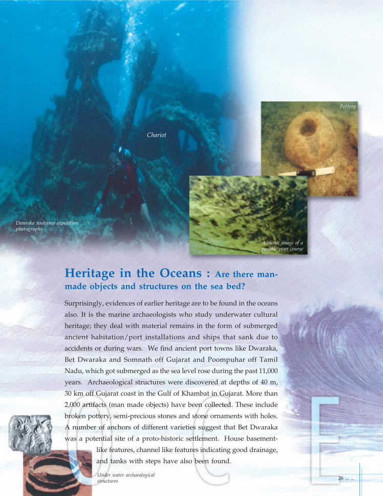
Heritage in the Oceans : Are there man-made objects and structures on the sea bed?
Surprisingly, evidences of earlier heritage are to be found in the oceans
also. It is the marine archaeologists who study underwater cultural
heritage; they deal with material remains in the form of submerged
ancient habitation/port installations and ships that sank due to
accidents or during wars. We find ancient port towns like Dwaraka,
Bet Dwaraka and Somnath off Gujarat and Poompuhar off Tamil
Nadu, which got submerged as the sea level rose during the past 11,000
years. Archaeological structures were discovered at depths of 40 m,
30 km off Gujarat coast in the Gulf of Khambat in Gujarat. More than
2,000 artifacts (man made objects) have been collected. These include
broken pottery, semi-precious stones and stone ornaments with holes.
A number of anchors of different varieties suggest that Bet Dwaraka
was a potential site of a proto-historic settlement. House basement-
like features, channel like features indicating good drainage,
and tanks with steps have also been found.
Dwaraka undersea expeditionphotographs
Chariot
Under water archaeologicalstructures
Acoustic image of apossible river course
Pottery
26 ... ..
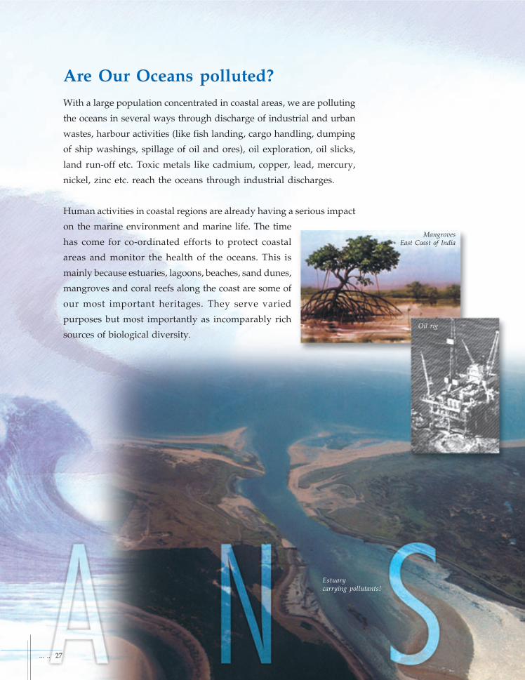
Are Our Oceans polluted?With a large population concentrated in coastal areas, we are polluting
the oceans in several ways through discharge of industrial and urban
wastes, harbour activities (like fish landing, cargo handling, dumping
of ship washings, spillage of oil and ores), oil exploration, oil slicks,
land run-off etc. Toxic metals like cadmium, copper, lead, mercury,
nickel, zinc etc. reach the oceans through industrial discharges.
Human activities in coastal regions are already having a serious impact
on the marine environment and marine life. The time
has come for co-ordinated efforts to protect coastal
areas and monitor the health of the oceans. This is
mainly because estuaries, lagoons, beaches, sand dunes,
mangroves and coral reefs along the coast are some of
our most important heritages. They serve varied
purposes but most importantly as incomparably rich
sources of biological diversity.
MangrovesEast Coast of India
Oil rig
Estuarycarrying pollutants!
... .. 27

Does the benevolent Ocean get furious?During monsoon, winds are strong, producing huge waves. Whenthey strike the coast, the waves cause considerable damage to propertyand life and erode beaches. This is called coastal erosion that is prevalentin many coastal areas. Often, man-made structures near ports andharbours add to the problem of coastal erosion.
Tsunamis are large, rapidly moving ocean waves triggered by a majordisturbance of the ocean floor. They are usually caused by anearthquake but sometimes can be produced by submarine landslidesor volcanic eruptions. These waves typically travel at speeds of about600 mph. As they reach shallow water, the waves slow down butgreatly increase in height (3-20m), and thedistance between them shrinks. Theycause enormous damage to coastalpopulation and property.
Violent volcanic eruptions in the oceanssometimes send out materials rangingfrom boulders to fine ash. Fine particlesgo up to several kilometers and aretransported around the globe. Forexample, the 1883 Krakatoa volcanicexplosion in Indonesia released so muchdust into the atmosphere that the earthwas plunged into darkness for severaldays!
Explosive volcano
TSUNAMIAs the TSUNAMI
approaches the shore,the water column pilesup increasing the wave
height to dramaticproportions
Sea Floor
5 hours after Earthquake 10 hours after Earthquake
17 hours after earthquake 22 hours after earthquake
28 ... ..
Tsunami damage, Alaska
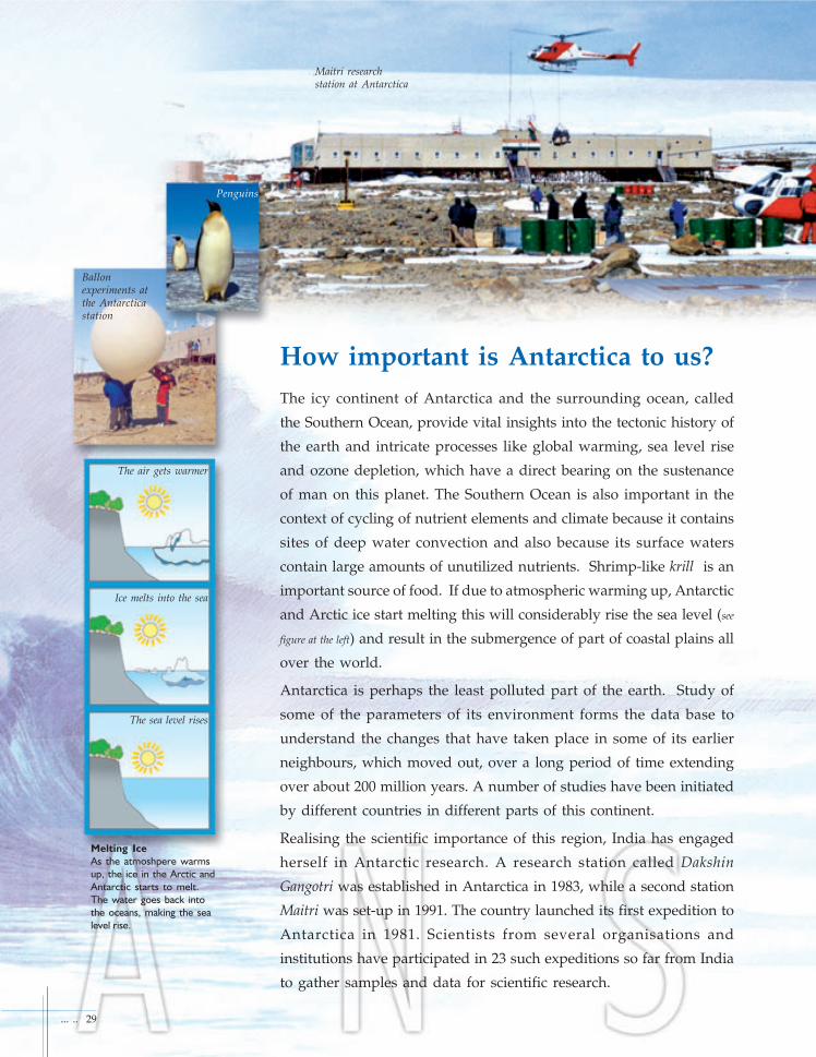
How important is Antarctica to us?The icy continent of Antarctica and the surrounding ocean, called
the Southern Ocean, provide vital insights into the tectonic history of
the earth and intricate processes like global warming, sea level rise
and ozone depletion, which have a direct bearing on the sustenance
of man on this planet. The Southern Ocean is also important in the
context of cycling of nutrient elements and climate because it contains
sites of deep water convection and also because its surface waters
contain large amounts of unutilized nutrients. Shrimp-like krill is an
important source of food. If due to atmospheric warming up, Antarctic
and Arctic ice start melting this will considerably rise the sea level (see
figure at the left) and result in the submergence of part of coastal plains all
over the world.
Antarctica is perhaps the least polluted part of the earth. Study of
some of the parameters of its environment forms the data base to
understand the changes that have taken place in some of its earlier
neighbours, which moved out, over a long period of time extending
over about 200 million years. A number of studies have been initiated
by different countries in different parts of this continent.
Realising the scientific importance of this region, India has engaged
herself in Antarctic research. A research station called Dakshin
Gangotri was established in Antarctica in 1983, while a second station
Maitri was set-up in 1991. The country launched its first expedition to
Antarctica in 1981. Scientists from several organisations and
institutions have participated in 23 such expeditions so far from India
to gather samples and data for scientific research.
Ballonexperiments atthe Antarcticastation
Maitri researchstation at Antarctica
Penguins
... .. 29
The air gets warmer
Ice melts into the sea
The sea level rises
Melting Ice
As the atmoshpere warms
up, the ice in the Arctic and
Antarctic starts to melt.
The water goes back into
the oceans, making the sea
level rise.

What is Satellite Oceanography?Satellite Oceanography is the study of the oceans using satellite
imageries. The digital reflectance data obtained by special sensors of
the Landsat, SPOT, Indian Remote Sensing (IRS) and other satellites
are processed to get varied pictures of the ocean surface to interpret
the temperature, chlorophyll content, salinity, turbidity etc. and also
to demarcate areas of abundant fish and other faunal population,
ocean currents, oil slicks etc. Temporal data help in the periodic
monitoring of the different parameters.
30 ... ..
National Institute ofOceanography, Goa
National Institute ofOcean Technology , Chennai
CSMCRI -
Central Salt and Marine Chemical Research
Institute, Bhavanager
INCOIS -
Indian National Centre for Ocean Information
Centre, Hyderabad
Delhi
Mumbai
HyderabadVisakhapatnam
Berhampur
Kharagpur
Kolkata
ChennaiAnna
Tanjore
Kochi
Thiruvananthapuram
Mangalore
Panaji (GOA)
Bhavnagar
GSI
OSTC
OSTC
OSTC
OSTC
NIOT
OSTC
INCOISNGRI
CIFE
CSMCRI
OSTC
OSTCNIO
OSTC
CMLRE
CMFRIOSTC
CESS... .. 31
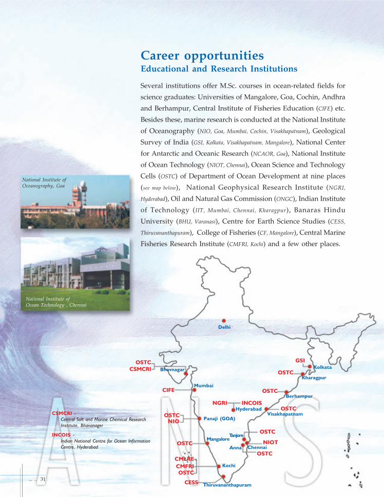
Career opportunitiesEducational and Research Institutions
Several institutions offer M.Sc. courses in ocean-related fields for
science graduates: Universities of Mangalore, Goa, Cochin, Andhra
and Berhampur, Central Institute of Fisheries Education (CIFE) etc.
Besides these, marine research is conducted at the National Institute
of Oceanography (NIO, Goa, Mumbai, Cochin, Visakhapatnam), Geological
Survey of India (GSI, Kolkata, Visakhapatnam, Mangalore), National Center
for Antarctic and Oceanic Research (NCAOR, Goa), National Institute
of Ocean Technology (NIOT, Chennai), Ocean Science and Technology
Cells (OSTC) of Department of Ocean Development at nine places
(see map below), National Geophysical Research Institute (NGRI,
Hyderabad), Oil and Natural Gas Commission (ONGC), Indian Institute
of Technology (IIT, Mumbai, Chennai, Kharagpur), Banaras Hindu
University (BHU, Varanasi), Centre for Earth Science Studies (CESS,
Thiruvananthapuram), College of Fisheries (CF, Mangalore), Central Marine
Fisheries Research Institute (CMFRI, Kochi) and a few other places.
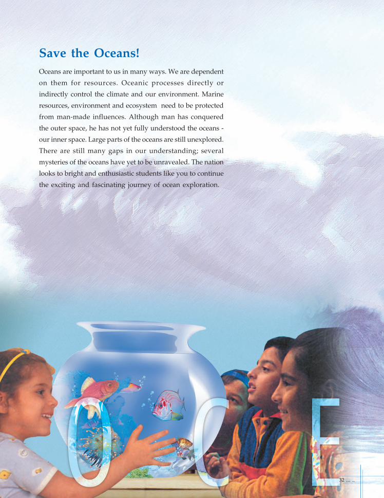
Save the Oceans!Oceans are important to us in many ways. We are dependent
on them for resources. Oceanic processes directly or
indirectly control the climate and our environment. Marine
resources, environment and ecosystem need to be protected
from man-made influences. Although man has conquered
the outer space, he has not yet fully understood the oceans -
our inner space. Large parts of the oceans are still unexplored.
There are still many gaps in our understanding; several
mysteries of the oceans have yet to be unravealed. The nation
looks to bright and enthusiastic students like you to continue
the exciting and fascinating journey of ocean exploration.
32 ... ..

Grab
An instrument used for collecting samples of surface sediments
from the ocean floor.
Greenhouse effect
The effect of atmospheric carbon dioxide and other gases that
allow solar radiation to pass through but prevent the long -
wavelength radiation from going out to space, thus increasing
atmospheric temperature. It is similar to the effect in a greenhouse
that is used to grow plants in temperate regions. Hence the
term “greenhouse effect”.
International Area of the Seabed
The area of the sea-floor beyond the Exclusive Economic Zone.
Lava
Molten rock material that is brought up to the surface by a
volcano or along a fissure.
Magma
Molten rock material that is below the earth’s surface.
Mid-oceanic ridges
Submarine mountain chains that run in the middle of all the
major oceans. They are characterised by volcanic and earthquake
activity. (see fig.4)
Multibeam echo sounder
An instrument that uses a number of individual narrow beams
of sonic energy to get a detailed and accurate topographic map of
the seafloor.
Acoustic methods
Methods that use propagation of sound waves for various
studies.
Bathymetry
Measurement of ocean water depth.
Continental margin
The ocean floor adjacent to continents including shelf, slope
and rise.
Continental shelf
The shallow gently sloping sea-floor extending from the shoreline
to a zone where the slope markedly increases.
Crust
The outermost layer of the earth. Its thickness is about 10 km
beneath the oceans and 30-35 km beneath the continents.
Currents
Currents, more specifically, ocean currents are ocean water
masses that move from one part of the ocean to another. They
move at different water depths and are due to winds, and
differences in temperature and density of sea water.
Earthquake
A violent disturbance at the earth's crust or mantle felt and/or
recorded above the ground.
Ecology
The study of how living creatures interact in the environment.
Echo-sounder
An instrument used for measuring ocean water depths using
sound energy.
Erosion
The transport of rocky or weathered material by ice or water or
wind.
Estuary
The mouth of a river where fresh water from the river and sea
water mix.
Exclusive Economic Zone (EEZ)
An area extending up to 200 nautical miles from coastline. A
coastal nation has sovereign rights over the mineral resources
of this region.
Fault
A fracture (in a rock) along which the two blocks of rock have
moved relative to each other. (see fig. 2)
Fossil
An imprint of an animal or plant preserved in sedimentary
rocks.
Gas hydrate
A deposit that forms when molecules of natural gas are locked
up in a water molecule at high pressure and low temperature.
At surface temperature and pressure, it expands 164 times.
... .. 33
0 Kilometres
10
20
30
40
50
60
70
80
Oceanic crust Continetal crust
Mantle (Density 3.40)
GraniticMetamorphic layer(Density 2.60)
M-discontinuity
Basic Layer (Density 3.00)(?amphibolite)
Layer 2 Oceanic(Density 3.00) Layer 3 Crust
(Density 3.00)
Strike-slip fault
Normal FaultReverse fault
Glossary
Fig. - 2
Fig. - 1
(see figs.1 & 3)

Nautical mile
It is equal to 1.15 statutory mile or 1852m or 1.852 km
Nutrients
Elements other than carbon, hydrogen and oxygen that are
required for the synthesis of organic matter. Common
nutrients are nitrates and phosphates.
Oceanography
Study of the oceans/seas
Ocean trench
A narrow, deep depression on the sea-floor, usually several
thousand kilometers long and up to 10 km deeper than the
adjacent seafloor. Here, the oceanic plate goes down beneath
the adjacent plate. (see fig.3)
Placer minerals
Minerals with high specific gravity and high resistance to
chemical weathering which are deposited in rivers, lakes,
beaches and near shore regions. They contain many valuable
elements like thorium, rare earth elements, titanium,
zirconium and iron. Placer deposits found in offshore regions
and as raised beaches indicate sea level changes.
Phosphorite
A mineral deposit found in more than 1000 m water depth,
which contains phosphorus and rare earth elements.
Radiation
Transport of energy from one region to another without a
medium i.e., heating of the earth by the sun's rays.
Salinity
The amount of dissolved salt present in seawater expressed in
parts per thousand.
Sea
An enclosed or semi-enclosed body of saline water that is
large compared to most estuaries and embayments but small
compared to oceans.
Sea-floor spreading
A process that is driven by sea-floor volcanism whereby oceanic
crust is created (at mid-oceanic ridges) and destroyed (at the
trenches). The spreading is recognised by investigations on
magnetic polarity. (see fig.4 )
Seismic investigations
Investigations that are carried out to find out the structure of
sediments / rocks beneath the seafloor.
Seismic
Related to earthquake or vibrations of the earth.
Seismic waves
Waves that are generated by earthquakes or man-made
explosions.
Side scan sonar
An instrument that is towed behind a ship at shallow water
depths to obtain information on sea-floor features. (see fig. on
page 11)
Submersible
An underwater vehicle (manned or unmanned) equipped
with instruments to collect samples and data of the sea-floor
and water column. (see fig. on page 11)
Tonne
Equal to 0.984 tpm (1000 kgm)
United Nations Convention on the Law of the Sea (UNCLOS)
UNCLOS sets out the rules and regulations pertaining to the
utilization of oceanic mineral resources and to the preservations
of the marine environment.
Volcanoes
A vent or fissure on the earth’s surface or sea-floor thorugh
which lava comes out.
34 ... ..
Oceanic crust
Tre
nc
h
Continetnal crust
Volc
anic
arc
Lithosphere
Asthenosphere
Lithosphere
Oceanic Continental Convergence - Fig. - 3
Normal magnetic polarity
Reversed magnetic polarity Mid-oceanic ridge
Zone of magma injection, cooling,and "locking in" of magnetic polarity
Observedmagnetic profilefrom oceano-graphic survey
Calculatedmagnetic profileassuming seafloorspreading
Age beforepresent(million of years)
Present4 3 2 1 1 2 3 4
Lithosphere
Fig. - 4
Amazing facts about the Oceans
... .. 35
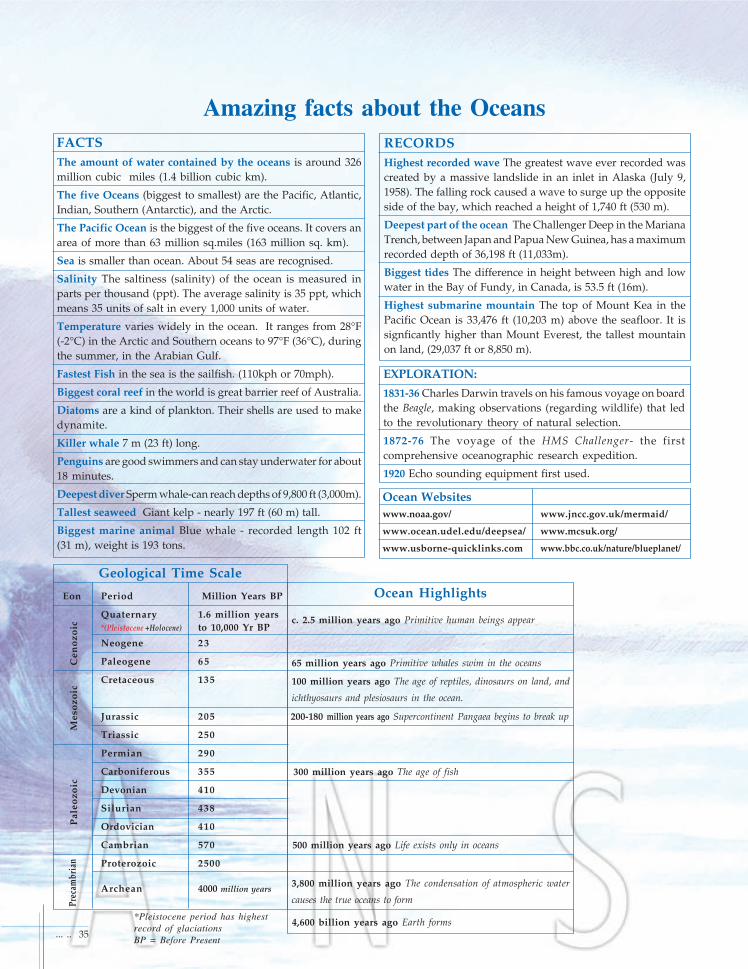
FACTSThe amount of water contained by the oceans is around 326million cubic miles (1.4 billion cubic km).
The five Oceans (biggest to smallest) are the Pacific, Atlantic,Indian, Southern (Antarctic), and the Arctic.
The Pacific Ocean is the biggest of the five oceans. It covers anarea of more than 63 million sq.miles (163 million sq. km).
Sea is smaller than ocean. About 54 seas are recognised.
Salinity The saltiness (salinity) of the ocean is measured inparts per thousand (ppt). The average salinity is 35 ppt, whichmeans 35 units of salt in every 1,000 units of water.
Temperature varies widely in the ocean. It ranges from 28°F(-2°C) in the Arctic and Southern oceans to 97°F (36°C), duringthe summer, in the Arabian Gulf.
Fastest Fish in the sea is the sailfish. (110kph or 70mph).
Biggest coral reef in the world is great barrier reef of Australia.
Diatoms are a kind of plankton. Their shells are used to makedynamite.
Killer whale 7 m (23 ft) long.
Penguins are good swimmers and can stay underwater for about18 minutes.
Deepest diver Sperm whale-can reach depths of 9,800 ft (3,000m).
Tallest seaweed Giant kelp - nearly 197 ft (60 m) tall.
Biggest marine animal Blue whale - recorded length 102 ft(31 m), weight is 193 tons.
RECORDSHighest recorded wave The greatest wave ever recorded wascreated by a massive landslide in an inlet in Alaska (July 9,1958). The falling rock caused a wave to surge up the oppositeside of the bay, which reached a height of 1,740 ft (530 m).
Deepest part of the ocean The Challenger Deep in the MarianaTrench, between Japan and Papua New Guinea, has a maximumrecorded depth of 36,198 ft (11,033m).
Biggest tides The difference in height between high and lowwater in the Bay of Fundy, in Canada, is 53.5 ft (16m).
Highest submarine mountain The top of Mount Kea in thePacific Ocean is 33,476 ft (10,203 m) above the seafloor. It issignficantly higher than Mount Everest, the tallest mountainon land, (29,037 ft or 8,850 m).
Eon Period Million Years BP
Quaternary 1.6 million years*(Pleistocene +Holocene) to 10,000 Yr BP
Neogene 23
Paleogene 65
Cretaceous 135
Jurassic 205
Triassic 250
Permian 290
Carboniferous 355
Devonian 410
Silurian 438
Ordovician 410
Cambrian 570
Proterozoic 2500
Archean 4000 million years
Geological Time Scale
Prec
ambr
ian
Pal
eozo
icM
esoz
oic
Cen
ozoi
c c. 2.5 million years ago Primitive human beings appear
65 million years ago Primitive whales swim in the oceans
100 million years ago The age of reptiles, dinosaurs on land, and
ichthyosaurs and plesiosaurs in the ocean.
200-180 million years ago Supercontinent Pangaea begins to break up
300 million years ago The age of fish
500 million years ago Life exists only in oceans
3,800 million years ago The condensation of atmospheric water
causes the true oceans to form
4,600 billion years ago Earth forms
Ocean Highlights
Ocean Websiteswww.noaa.gov/ www.jncc.gov.uk/mermaid/
www.ocean.udel.edu/deepsea/ www.mcsuk.org/
www.usborne-quicklinks.com www.bbc.co.uk/nature/blueplanet/
EXPLORATION:
1831-36 Charles Darwin travels on his famous voyage on boardthe Beagle, making observations (regarding wildlife) that ledto the revolutionary theory of natural selection.
1872-76 The voyage of the HMS Challenger- the firstcomprehensive oceanographic research expedition.
1920 Echo sounding equipment first used.
*Pleistocene period has highestrecord of glaciationsBP = Before Present

E P I L O G U EDear Friends,
Our country is gifted with vast oceans around us and the
resources are indeed enormous! With the passage of time, we
shall depend more and more on our oceans for food, energy
and transportation.
Oceans have remained a mystery for long. However, with the
advent of multi-disciplinary ocean sciences and technologies,
our understanding of various interesting and amazing
processes, which influence oceans, is improving.
Compiling wide ranging aspects of ocean in a lucid and
illustrative form demands significant efforts, sincerity and
dedication. Many colleagues have put in their ideas and this
booklet is an outcome of their untiring efforts. My special thanks
are due to Prof. K.V. Subbarao and the Geological Society of
India.
Through this booklet, an attempt is made to stimulate younger
generation and attract them to learn about oceans.
10th September 2003
36 ... ..
Harsh GuptaSecretary
Department of Ocean Development