Embed Size (px)
Citation preview
December 2011
Forestry Schemes Manual

Forest Service
Department of Agriculture, Food and the Marine,
Johnstown Castle Estate
Co. Wexford
Tel: 053-9160200
E-mail: [email protected]
Web: www.agriculture.gov.ie/forestservice
i
TABLE OF CONTENTS
1. Introduction
2. Application process for Afforestation Scheme. Forest Environment
Protection Scheme and Native Woodland (Establishment) Scheme
2.1 Application for pre-planting approval – Form 1
2.2 Application for 1st instalment grant and 1
st premium – Form 2
2.3 Application for 2nd
instalment grant – Form 3
2.4 Application for subsequent premium payments – Form 4
2.5 Rules for reduction/withholding of payments
2.6 Registered Foresters and Forestry Companies
2.7 Responsibility for forest management
3. Premium Payment Considerations
3.1 Summary
3.2 Farmer rate
3.3 Income calculation considerations for farmer rate
3.4 Non farmer rate
4. Ownership
4.1 Proof of ownership
4.2 Commonage
4.3 Leases
4.4 Joint management
4.5 Constraints on ownership
4.6 Change of ownership
5. Grant and Premium Categories (GPC) and rates
5.1 General
5.2 Plantations
5.3 Plots
5.4 Fixed grant rates
5.5 Premium levels
5.6 Examples of plantation payment calculations
5.7 Planting of Alder in GPC 5, 6 and 7
6. General Site Requirements
6.1 Agricultural land
6.2 Commercial crop
6.3 Access
6.4 Minimum area
6.5 Minimum width
7. Unplanted areas, biodiversity and setback distances
7.1 Eligibility as an ABE
7.2 Mapping and recording ABE features
7.3 Mapping and recording ABE plots
7.4 Grant aiding ABE plots
7.5 Biodiversity map legend
7.6 Setback/corridor width conventions
1
2
2
3
5
6
6
7
8
9
9
9
9
10
11
11
11
11
12
12
13
15
15
15
16
17
18
19
21
22
22
22
22
23
23
24
24
25
26
26
26
26
ii
8. ESB power lines
8.1 Unplanted corridors
8.2 Claiming compensation
8.3 Compensation levels
8.4 Mapping of ESB lines
9. Silvicultural standards
9.1 Species selection
9.2 Soil analysis
9.3 Provenance selection
9.4 EU Forest Reproductive Material Regulations
9.5 EU Plant Health Regulations
9.6 Conifer mixtures
9.7 Drainage
9.8 Woody vegetation clearing and burning
9.9 Ground cultivation
9.10 Stocking and spacing
9.11 Plant quality
9.12 Plant handling
9.13 Lifting and planting dates
9.14 Fertiliser application
9.15 Fencing
9.16 Fire
9.17 Weed control
9.18 Standards
10. Mapping
11. Environmental Protection and Controls – Consultation Process
11.1 Overview
11.2 Public consultation process
11.3 Appeals process
11.4 Environmental Impact Assessment (EIA)
11.5 Appropriate Assessment Procedure
11.6 European Communities (Forest Consent and Assessment) Regulations
2011
11.7 Forest road approval system: Guidance for seeking approval
12. Penalty system
12.1 Imposition of a penalty
12.2 Appeals procedure
12.3 Schedule of penalties
12.4 Cross compliance checking procedures and premium and grant
payment
13. Interaction of Afforestation schemes with Agriculture schemes
13.1 REPS (Rural Environmental Protection Scheme)
13.2 Application for approval of sites containing REPS habitats
13.3 Early Retirement Scheme
13.4 Single Farm Payment 2001 and forestry
14. Forestry Schemes
29
29
30
30
30
31
31
35
36
38
40
41
42
45
46
48
49
50
51
53
57
59
61
61
68
69
69
76
76
77
77
78
80
82
82
82
83
86
87
87
87
87
87
89
iii
APPENDICES
1. Provenance Declaration Form
2. Mandate of Grants
3. Mandate of Grant (sample form)
4. Sample Management Plan Yr 5 to Yr10
5. Sample Management Plan Yr10 to Yr20
6. Sample Management Plan Yr 5 to Yr 10 (blank)
7. Sample Management Plan Yr 10 to Yr 20 (blank)
8. Certification of land transfer
9. Certificate of Title
10. Commonage Consent Form
11. Joint Management Consent Form
12. Release of Turbary Rights Consent Form
13. Release of Grazing Rights Consent Form
14. Land types for afforestation
15. Note on Shell Marl
16. Soil sampling procedures
17. Sample collection for foliar analysis
18. Protocol for determination of the acid sensitivity of surface water in the
context of afforestation
19. Statement of total costs
20. Statement of costs
21. Areas potentially sensitive to fisheries
22. Archaeology
23. Standard Annuity Table
24. IS436 fencing certificates
90
91
92
93
95
97
99
101
102
103
104
106
107
108
111
112
116
119
125
126
127
130
131
132
1
CHAPTER 1
Introduction
The Forest Service of the Department of Agriculture, Food and the Marine is Ireland‟s national
forest authority. It is responsible for, inter alia, national forest policy, promotion of private
forestry, administration of forest consent system and forestry support schemes, forest health and
protection, control of felling and promotion of research in forestry and forest products.
The objective of the Forest Service is to “develop forestry to a scale and in a manner which
maximises its contribution to the national economic and social wellbeing on a sustainable basis
and which is compatible with the protection of the environment”.
The Forestry Schemes Manual sets out clearly and concisely the procedures and operational
standards required for the various forestry support schemes as described in the scheme
documents administered by the Forest Service of the Department of Agriculture, Food and the
Marine. These scheme documents are available on the Departments website. The Manual
complements, and should be read in conjunction with, the National Forest Standard, the Code of
Best Forest Practice and the suite of environmental guidelines published by the Department
relating to Archaeology, Biodiversity, Landscape, Water Quality, Aerial Fertilisation,
Harvesting, Forest Protection and Forest Recreation. Adherence to these publications is a
condition of all grant schemes and aims to ensure that all timber produced in Ireland is derived
from sustainably managed forests and that State investment in forestry is protected.
The Forestry Development Programme is funded by the State under the National Development
Plan 2007-2013
2
Chapter 2
Application Process for the Afforestation Scheme, Forest Environment
Protection Scheme and Native Woodland (Establishment) Scheme
All proposed afforestation developments must receive the prior written approval of the Forest
Service.
It is an offence to undertake afforestation with the prior approval of the Minister. Any
afforestation development which proceeds without such approval will not be eligible for
grant assistance.
Following completion of the works, formal applications for payment of the Afforestation Grant
(1st and 2
nd Instalments) and Premiums must be made by the applicant.
2.1 Application for Pre-planting Approval - Form 1
All Form 1 applications must be completed and signed by the applicant (pages 1-2) and a
qualified forester (pages 3-6) whose name is included on the Register of Foresters and Forestry
Companies. This Register is available on the Department‟s website or on request from the
Forest Service. The following enclosures must accompany the application:
Form 1
Site Location Map
Certified Species Map
Biodiversity Map
Fencing Map (if applicable)
Test results for levels of Calcium carbonate CaCO3 (if applicable) – see Appendix 18.
Drainage Survey report – see Chapter 9
Soil Analysis report – see Chapter 9 and Appendix 16
The application is processed by the Forest Service and assigned a unique Forest Service
reference number known as “Contract No.”. An Online facility, called iNET, for the submission
of a Form 1 is also available and all registered foresters have been notified of the required
procedure. Registered foresters can register to use iNET by logging onto the Department‟s
website www.agriculture.gov.ie.
Form 1 applications go through the following procedures:
The application is referred to the relevant Forestry Inspector for assessment and
recommendations.
If there are any environmental considerations identified, the application is simultaneously
referred to the relevant prescribed body as detailed in Chapter 11.
Notice of all applications for approval is published on the Department‟s website and
anybody may make a submission on the proposed development within 28 days.
If the proposed development is greater than 25 hectares the application is automatically
referred to the relevant Local Authority for their observations. Sites below this threshold
may also be referred to Local Authorities depending on their location and landscape
sensitivity, as detailed in Chapter 11.
3
If the site is greater than 50 hectares, an Environmental Impact Statement must
accompany the Form 1.
Following issue of technical approval a separate application must be made on Form 1a
for financial approval, to be followed by notification of substantive commencement of
work (Form 1b) and completion of work (Form 1c).
Note: A “technical approval” confirms that the proposed afforestation project complies, in
principle, with the conditions of the scheme and is eligible for a grant, subject to the availability
of funds and completion of the project in compliance with the terms and conditions of the
scheme. A separate application for “financial approval” must be submitted before the planting
work commences if the applicant wishes to proceed with the project and apply for a grant.
Financial approval will only be granted if there are sufficient funds available.
The referrals described above are initiated simultaneously. The time frame for these
consultations is shown in table 19 in Chapter 11.
If a registered forester fails to identify specific considerations, the referrals may be delayed until
the application is returned from the Forestry Inspector. Also note the Forest Service Penalty
System, Chapter 12.
Changes to Specifications
You are reminded that no significant and material change can be made to specifications, as
approved, without first being agreed by the relevant Forestry Inspector. In general, the main
specification changes relate to species, plots and boundaries. All proposed species and plot
boundary changes must be submitted to Approvals Section on a revised certified species map and
include a revised plot table i.e. page 5 of the Form1. Where significant changes to species and/or
plot locations are proposed, further consultation with prescribed bodies may be required.
There is no requirement to contact the Forest Service where a number of approved plots are
excluded, i.e. the owner decides to plant less than the approved area.
2.2 Application for 1st instalment Grant and 1st Premium – Form 2
The 1st instalment of the Afforestation Grant and 1st Premium are due for payment upon
successful completion of the initial site operations and submission of a completed Form 2.
The application must be completed and signed, at the time of submission, by both the applicant
and the registered forester to whom pre-planting approval issued.
If the applicant carries out the development works, the registered forester who completed the
Form 1 must complete the Form 2 application to confirm that the works have been carried out in
accordance with the Form 1 specifications and Forest Service standards.
No Form 2 will be processed for grant payment if the company who carried out the work is
different from that which received approval at Form 1 stage, unless specific prior written
approval has been given by the Forest Service.
The following enclosures must be submitted with the application:
Certified Species map
4
Biodiversity map
Statement of Costs (where applicable for cost based schemes )
Current Tax Clearance Certificate(s) for applicant and forester and a C2 Certificate for
contractor(s) used
Provenance Declaration Forms for all species planted - see Chapter 9 and Appendix 1
A valid mandate, if the grant is mandated to a Registered Forester / Forestry Company -
see Appendices 2 and 3.
Documentary evidence of farming income where the farmer rate of premium is being
claimed – see Chapter 3.
Proof of ownership – see Chapter 4
Applications for 1st instalment grant may be subject to site inspections by the Forest Service to
ensure the plantation has been established to the required standard.
If the documentation is complete and the site inspection confirms the works have been carried
out in compliance with the Scheme, the Afforestation Grant and 1st Premium will be paid.
2.2.1 Statement of Costs
The Afforestation Schemes are administered under the fixed-rate grant system and statements of
costs are not required. Applicants must detail the area claimed per Grant and Premium Category
(as described in Chapter 5) and if claiming a fencing grant, the fence length and type erected.
Details of the fixed-rate grant system are outlined in the Forest Service Circular of June 2008 –
Introduction of Fixed-Rate Grant. The fixed-rate grant system also applies to the thinning and
tending element of the revised Woodland Improvement Scheme.
The following schemes require a detailed statement of costs;
Reconstitution Scheme
Forest Roads Scheme
Native Woodland Conservation Scheme
NeighbourWood Scheme
Woodland Improvement Scheme
Reforestation Scheme
High Pruning of Conifers
The formation costs to year 4 to be claimed at Form 2 stage, where 75% will be paid at the 1st
instalment and 25% will be paid at the 2nd
instalment.
Invoice(s) are required for the cost of the works carried out. The cost of works must be broken
down by the specific operations and quantified as per application form, see Appendix 19.
Where the applicant carried out the works, he/she must provide a statement of the costs claimed
for his/her own labour (see Appendix 20).
Costs of registered foresters associated with their salaries, wages, consultancy, supervision and
including profit element must be included in the allowance for overheads.
The recommended allowable overhead is up to 30%.
5
2.3 Application for 2nd instalment grant – Form 3
Payment of the 2nd instalment afforestation grant is due 4 years after the completion date of the
plantation. Applications for 2nd
instalment grant may be subject to a site inspection by a Forestry
Inspector to ensure the plantation has been established and managed to the required standard.
The application for payment of the 2nd
instalment afforestation grant (Form 3) must be
completed and signed by the applicant and a registered forester. The Form 3 will be posted to
the applicant by the Forest Service at the appropriate time.
If the entire plantation is up to the required standard, and all scheme conditions have been met,
the grant will be paid.
Payment of the 2nd
Instalment grant will be postponed on sites which have been damaged by fire
and/or wind until they have been successfully reconstituted and one full growing season has
passed. The Forest Service will assess reconstituted sites 4 years after planting.
2.3.1 Forest Management Plans
All grant beneficiaries must submit a Forest Management Plan for Year 5 to Year 10 at Form 3
stage for (i) plantations which are 10 hectares or greater, and (ii) for broadleaf plantations which
are 5 hectares or greater. Any application for 2nd
instalment afforestation grant which is not
accompanied by a Forest Management Plan will be returned to the applicant.
A Forest Management Plan provides a general outline of how the forest will be managed and
what operations will be required and undertaken over a specified time period.
When plantations are 10 years old, and before payment of the 11th
and subsequent premiums, a
Forest Management Plan for Year 11 to Year 20 must be submitted detailing proposed
management from year 11 to year 20.
Examples of both plans are given in the Appendices 4 to 7. A Forest Management Plan must be
prepared by a registered forester.
The following details must be included in the management plan for years 5 to 10:
Current Crop details
Estimated age of first thinning and clearfell age per plot or sub compartment
Management Checklist
A fire plan (refer to Forest Protection Guidelines for further information)
A declaration must be signed at Form 3 stage by the applicant stating that at year 10 a
subsequent management plan will be provided.
Any other comments / details relevant to the status of the contract / plantation.
The following details must be included in the management plan for years 11 to 20
Updated certified species map
Revised estimated age of first thinning and clearfell age per plot or sub compartment (this
should be supplied even where first thinning age is post year 20)
Management Checklist
Top height and yield class assessment
Road requirements
Any other comments / details relevant to the status of the contract / plantation.

6
In addition to the above details forest owners may collect additional information in order to
facilitate forest certification. Requirements for forest certification are available from the relevant
certifying bodies.
2.3.2 Fire Plan and Map
The Forest Protection Guidelines provide information on fire plans which are required as part of a
management plan at 2nd
instalment stage. A Location Map is an important element of the Fire
Plan and should show the following:
Assembly point, (e.g. local landmark or crossroads).
Access routes.
Reservoir or waterpoint.
Firebreaks.
Adjoining forests.
Phone numbers of the key Fire Plan personnel should also be recorded on the map, for example :
Fire Brigade.
Garda Station.
Caretaker.
Neighbour.
Company Forester.
Forest Owner
Submission of a fire plan at 2nd
Instalment stage is required for all plantations greater than 10
hectares. Forest owners in high fire risk areas should ensure that appropriate fire plans are in
place irrespective of the area of the plantation,
See Chapter 9 for procedures for notification of fire damaged plantation (section 9.16).
2.4 Application for subsequent Premium Payments - Form 4
The farmer rate of premium is payable for a period of 20 years and the non-farmer rate for a
period of 15 years. All premiums after the 1st premium are applied for by completing a Form 4
which is sent to the applicant annually by the Forest Service. At the time of application, the
plantation must be to the standard required by the scheme. At the end of year 10, the applicant
must submit an updated management plan and species map for the following 10 years. The
eleventh and subsequent premiums are dependent on the applicant providing the Department
with a Forest Management Plan prior to the eleventh premium payment. Any application for the
11th
annual premium which is not accompanied by a Forest Management Plan will be returned to
the applicant.
2.5 Rules for reduction/withholding of payments
2.5.1 Tax Clearance
In the case of payments totalling €10,000 or more in a 12 month period, the applicant will be
required, for each payment, to produce either a valid tax clearance certificate or C2 certificate.
No payments totalling €10,000 or more in a 12 month period may be made to an individual,
company or other body without a current tax clearance certificate or C2 certificate.
7
2.5.2 1st Instalment Grants
If part of the total planted area fails inspection, the applicant must carry out remedial work
within the current planting season (if practical) and resubmit the entire Form 2 application.
2.5.3 2nd Instalment Grants
2nd
Instalment grants will be paid only when the entire plantation is up to the required standard.
If part of the plantation fails inspection, payment will be withheld on the entire area until the
remedial works are carried out and the plantation is established to the required standard. If, in the
opinion of the Forest Service, the plantation has not been maintained to the standard as set out in
this document, the scheduled penalty will apply. See Chapter 12.
However, where the Forest Service decides that it is not possible to bring the plantation, or part
thereof, up to the required standard, no further payment will be made for that area. Where the
grant, or part thereof, is not to be paid, the Forest Service may also require repayment of the
amount paid in respect of the plantation or in respect of the area that does not meet the required
standard.
2.5.4 Premiums
Where the Forest Service is of the opinion that a plantation does not meet the required standard,
premium payments may be suspended. Where remedial works are prescribed by the Department,
the applicant will be given a time scale for these works to be completed. Payments may continue
to be withheld until the Forest Service is satisfied that the prescribed works have been carried
out. However, where the Forest Service decides that it is not possible to bring the plantation, or
part thereof, up to the required standard, no further payment will be made for that area. Where
the remaining annual premiums cease to be paid or are reduced, the Forest Service may also
require repayment of the grants and premiums paid in respect of the plantation or of the area that
is not up the required standard.
Notwithstanding the above, if payment of the 2nd
instalment grant is withheld for any reason, the
Forest Service may, at its discretion, continue to pay premiums up to and including the 6th
premium. However, if remedial works are outstanding when the 7th
premium is applied for, or
the 2nd
instalment grant application (Form 3) has not been submitted, the remaining premium
payments will be withheld. These will not be paid until the specified works have been
completed to the satisfaction of the Forest Service.
The Forest Service carries out random forest inspections and if plantations are not managed in
accordance with the rules of the schemes, premiums may be withheld or reduced in line with the
approach outlined above and penalties may be applied. See Chapter 12.
2.6 Registered Foresters and Forestry Companies
The applicant and a forester whose name is included on the Register of Foresters and Forestry
Companies must complete Form 1, Form 2, and Form 3 applications. Any application not
signed by the applicant and registered forester will not be accepted.
Foresters and forestry companies who wish to be included on the Register of Foresters and
Forestry Companies must complete an application form, available from the Forest Service. All
registered foresters must sign an undertaking that they have read, fully understand, and will
comply with the terms and conditions for the registration of foresters and forestry companies. In
addition, they must have Professional Indemnity Insurance of at least €500,000.

8
2.7 Responsibility for forest management
Responsibility for the successful establishment and management of forests rests with the
applicant. Failure by the applicant‟s forester to complete work to the required standards, and the
remedying of this situation, is a matter between the applicant and the forester; the Department is
not party to any agreement between the applicant and the forester. The Department will not be
held liable for any issue that arises regardless of whether the site had received a Departmental
Inspection or not.
9
CHAPTER 3
Premium Payment Considerations
3.1 Summary
Premiums are payable only in respect of plantations which qualify for afforestation grants, or an
establishment grant under the Native Woodland Scheme. The annual premium is payable
following the approval of the 1st Instalment of the afforestation grant.
There are two rates of premium payable - the farmer rate and the non-farmer rate.
All premium applicants must:
(i) Be over 18 years of age and
(ii) Hold a Personal Public Service (PPS) Number.
3.2 Farmer Rate
The farmer rate of premium is payable to applicants who fulfil the qualification conditions set
out below and is payable for a period of twenty years.
An applicant for the farmer rate of premium must supply evidence of farming activity in one of
the following forms:
i) An active REPS registration number, Herd number or registration under the
Bovine Tuberculosis Eradication Scheme or other scheme operated by the
Department of Agriculture, Food and the Marine. An „active‟ registration
means an applicant has been a beneficiary under the particular scheme in the
year of the forest plantation‟s completion or in one of the three preceding years.
OR
ii) Documentary evidence that at least 25% of an applicant‟s income was derived
from farming in the State in the year of the forestry plantation‟s completion or
in one of the three preceding years.
Documentary evidence of farming income, for the purposes of 3(ii) above, must be supplied in
one of the following forms:
i) A tax assessment showing that farming income amounted to at least 25% of
total income for the relevant year
OR
ii) An income assessment and declaration form, TF1, completed and stamped by
the local Teagasc Land Use Advisor or TF2 completed and stamped by an
agricultural consultant who is a member of the Agricultural Consultants
Association, demonstrating that at least 25% of total income is derived from
farming.
3.3 Income calculation considerations for farmer rate
The following conditions attach to calculating income for qualification for the farmer rate of
premium:
10
i) The income of the applicant only is used in the calculation. A spouse‟s income
is not included in the calculation unless the application for premium is made in
both names.
ii) Farming income includes agricultural aids, premiums and subsidies.
iii) Farmer forest premiums may be included as farming income provided the
applicant has other farming income.
iv) Land letting on the less than 11-month basis (conacre) may be included as
farming income provided the applicant has other farming income.
v) All Social Welfare payments, pensions/disability benefits, are excluded from
gross income.
An applicant who has already been assessed and qualified as a farmer under the existing scheme
or the RDP Afforestation Scheme 2000 – 2006 or the CAP Premium Scheme 1993 – 1999 or the
Farmer Premium Scheme 1989-1992, does not have to be re-assessed in respect of applications for
new plantations under the Scheme.
An applicant who has participated in the Farm Retirement Scheme cannot be classified as a farmer
in respect of a plantation completed after the date of retirement, unless all payments received
under that scheme have been repaid to the Department and the conditions outlined above are met.
3.4 Non farmer rate
The non-farmer rate of premium is payable to applicants who do not fulfil the qualification
conditions set out in section 3.2 above and is payable for a period of 15 years.
11
CHAPTER 4
Ownership
In order to qualify for Afforestation Grants and Premiums, the applicant(s) must own, lease or be
in joint management of the lands proposed for planting. All applicants must provide
documentary evidence of ownership, leasing or joint management. It is in the interests of the
applicant to establish the availability of this documentation before lodging an application for
approval.
No grant or premium can be paid until the applicant has provided satisfactory documentation to
confirm that they own, lease or are in joint management of the lands in question.
4.1 Proof of Ownership
In cases where the applicant is the registered owner of the lands he/she must provide a copy of
the Folio documents and Filed Plan (folio map) identifying the applicant as the owner.
If an applicant has recently acquired the lands and is in the process of registering ownership with
the Property Registration Authority, the following documentation may be submitted:
Folio and folio map in the name of the vendor/transferor, plus
o Deed of Transfer with Stamp duty paid, or
o Unstamped Deed plus the Department's Certification of Land Transfer signed and
stamped by a solicitor. (see Appendix 8),
In exceptional circumstances, an applicant may submit a Certificate of Title with a map showing
the area of the plantation, both of which must be signed and stamped by a Solicitor (see
Appendix 9). Acceptance of a Certificate of Title will be at the discretion of the Department,
who may seek additional information to corroborate the certification.
4.2 Commonage
In cases of commonages, a Commonage Consent Form (see Appendix 10) may be submitted
allowing one of the owners to apply for the afforestation grant. Documentary evidence, as
defined in 4.1 above, identifying all the owners of the commonage is required. Each of the
commonage owners is entitled to apply for premiums and will be assessed individually as to their
eligibility. All Commonage Consent Forms must be witnessed and stamped by a solicitor.
4.3 Leases
In cases where an applicant is leasing lands, he/she may be eligible to receive afforestation
grants and premiums. The following documentation must be provided:
(a) Copy of the folio documents and File Plan (folio map), or other
documentation as described at 4.1 above, identifying the owner of the lands,
and
(b) Copy of the Lease.
The Lease must comply with the following requirements:
12
i. The Lease must be stamped by the Revenue Commissioners or registered with the
Property Registration Authority,
ii. The Lease must be signed and dated and witnessed independently in a solicitor's
office.
iii. The duration of the term of the Lease must be at least 40 years, i.e. approximating the
crop rotation of the trees.
iv. If the Lease covers an area in excess of 21 hectares, it must be shown as a burden on
the folio – or a new folio may be raised for the leased area.
v. The lessee (the applicant for grants & premiums) must be the beneficiary of the
annual premiums.
vi. The Lease must specify who is to be the beneficiary(s) of the timber crop. At least
50% of the value of crop must accrue to the applicant.
vii. The monetary cost of the lease must be stated. In the event that this amount is not the
commercial rate for leasing the land, an explanation must be provided.
4.4 Joint Management
A joint management arrangement may be made only between immediate family members,
namely, husband and wife, sons, daughters, parents, brothers and sisters. The owner of the lands
may give consent to an immediate family member who is jointly managing the lands to claim the
afforestation grant and premiums. The owner foregoes the right to these payments. In these
cases the documentation required is:
(c) Documentary evidence, as defined in 4.1 above, identifying the owner/s of the
planted lands.
(d) A joint management consent form (see Appendix 11) completed by the
owner/s of the lands and the applicant.
The owner of the land and the applicant are both liable for the repayment of grants and premiums
paid if the applicant fails to abide by the conditions of the scheme or in the event of sale or
transfer of ownership during the 20 year term of the scheme.
Owners who wish to use the Joint Management facility must comply with the tax clearance
requirements.
A joint management arrangement may be cancelled at any time provided the owner takes over
the obligations of the scheme or, repays all grant and premium moneys already paid or, enters
into a new joint management arrangement with another member of the immediate family willing
to jointly manage the plantation to Forest Service standards and take over the obligations and
benefits of the scheme. Any such change should be notified to the Change of Applicant Section
(see 4.6 below).
4.5 Constraints on ownership
The Forest Service cannot give approval for afforestation in respect of lands on which
13
turbary rights
grazing rights, or
rights of way
exist unless documentary evidence is submitted showing that all such rights have been
relinquished, or the area upon which the constraint exists is excluded from the application.
Standard forms for the relinquishment of turbary and grazing rights are provided at Appendices
12 and 13.
Tree planting is not permitted on a Right of Way and such areas should be excluded from
proposed plantations.
4.6 Change of Ownership
The Forest Service must be notified if there is a change of ownership of a grant -aided plantation
during the term of the contract (normally twenty years). The original applicant provided signed
Undertakings (on Form 2) when he/she claimed payment of the 1st grant & 1st premium,
including an undertaking to notify the Forest Service in advance of any proposal to sell or
transfer ownership of any or all of the afforested land and to repay all grants and premiums
received if this condition or any of the terms of the scheme were breached.
Likewise, the Forest Service should be notified as soon as possible if the death occurs of the
owner or joint owner of a grant-aided plantation, so that arrangements can be put in place to
continue payment of grants and premiums to the new owner(s).
Once a change of ownership is notified to the Department, payments will be suspended until
registration of the new applicant(s) has been finalised. Any arrears accruing may be claimed at
that stage provided the documentation needed to register the new owner(s) are received in the
Department at least one year before the expiry of the term of the premium scheme.
The documents required at change of ownership stage broadly coincide with those required to
claim the 1st premium, viz. proof of ownership and a new signed commitment (on Form 5) to
take over the obligations of the scheme. In addition, the new owner(s) must provide evidence of
the reason for the change of ownership / change of applicant and the date of that event.
Payment of annual premiums is always subject to satisfactory maintenance of the plantation to
Forest Service standards, availability of funds in each financial year and compliance with the tax
clearance regulations.
If the previous owner was in receipt of a farmer rate of premium in respect of a plantation that is
subsequently transferred/inherited, the new owner may also be eligible to the farmer rate of
premium provided he/she satisfies the eligibility criteria for farmer rate of premium set out in
Part IV of the Guide to Change of Ownership (available on the Department's website).
If the previous owner was paid a premium at the (lower) non-farmer rate, this rate will continue
to apply to that plantation. The rate of premium cannot be increased, even if the new owner
satisfies the eligibility criteria for farmer rate of premium.
A detailed Guide on Change of Ownership of grant-aided plantations is available on the
Department's website www.agriculture.gov.ie/forestservice
After the term of the contract ends the only continuing restriction on the land-owners use of the
property are those applying under the Forestry Act 1946 which controls the felling of trees.

14
Owners shall contact the Felling Licence Section of the Department before undertaking any
felling or tree clearing operations. The provisions of the Forestry Act 1946 apply whether or not
the owner participated in a grant scheme.
The Minister retains an interest in all grant-aided plantations and would like to see that forest
owners achieve optimum returns from their own, and the State‟s, investment in forestry. Forest
owners are encouraged to make and maintain contact with their local Teagasc Forestry Advisor
and also with their chosen Forestry company or Consultant. A list of registered foresters and
forestry companies in available from the Department. Forest owners are encouraged to continue
active management of the plantation. At the appropriate stage, thinnings from the plantation
may provide a cash crop for stake wood or wood-energy. In the longer term, thinning a
plantation will help to optimise the return at final harvesting stage by helping the forest grow to
its full potential.
15
CHAPTER 5
Grant and Premium Categories (GPC‟s) and Rates
5.1 General
To decide on the grant and premium rates applicable to any plantation, the application area must
comply with plantation rules 1 and 2 below. Only plots within each plantation which comply
with one of the GPCs listed can be considered for grant aid.
For details of GPC‟s in the Native Woodland (Establishment) Scheme, refer to the Native
Woodland Manual (2011) available from the Forest Service.
5.2 Plantations
A proposed plantation for the purpose of the afforestation scheme is a plot (defined below) or
number of plots on the same holding and contained on a single application planted in a single
planting season. The rules below refer to the species composition that relate to grant and
premium payments.
Only Plantations that comply with rules 1 and 2 below are eligible for grant aid.
Plantation Rules Rule 1 - 10% broadleaves
Plantations on improved / enclosed land must contain a minimum of 10% broadleaves, site permitting.
The 10% broadleaf requirement can consist of broadleaves planted in plots of minimum width or additional
broadleaves planted for landscape and environmental reasons.
Rule 2 - 10% Diverse conifers
Where conifers constitute all or part of a plantation, the conifers must contain a minimum of 10% diverse
conifers (i.e. approved conifer species other than Sitka spruce, lodgepole pine)
In intimately mixed plots the diverse conifer species may be substituted by broadleaves as listed in Chapter 9,
Table 7 of this Manual, and birch and rowan, planted in groups. These broadleaves must be silviculturally
suited to the site. Broadleaves adjacent to roads and watercourses may also form part of this 10%
requirement.
Rule 1 and 2 can be satisfied in plantations comprising only of GPC 3 plots in the Afforestation Scheme
where 10% additional broadleaves are planted for environment and landscape reasons e.g. riparian zones,
road or boundary margins. Plantations in the FEPS scheme must have broadleaves planted making up at least
10% of the area where they comply with the minimum width rules
Refer to examples of plantations which comply with rules 1 and 2 shown at the end of this chapter. These
examples refer to the Afforestation Scheme only.
The Forest Biodiversity Guidelines require that in plantations greater than 10 hectares, areas of
biodiversity enhancement (ABE‟s) should comprise 15 % of the area. Where plantations are less
than 10 hectares, the open space element of ABE‟s should be designed in conjunction with
neighbouring land use and may be reduced. For more information on ABEs refer to Chapter 7
and the Forest Service Forest Biodiversity guidelines.
16
5.3 Plots
Each plot within a plantation must conform with one of the following Grant and Premium
Categories (GPCs) if it is to receive grant aid. Plots cannot be combined for premium purposes.
GPC 1 - Unenclosed land (Applicable to unenclosed land)
All approved broadleaves and conifers planted on unenclosed land receive the unenclosed grant
and premium rates for all afforestation schemes.
GPC 2 - Sitka spruce/lodgepole pine (Applicable to enclosed/improved land)
This plot is made up of Sitka spruce or lodgepole pine. For landscape purposes it may be
appropriate to introduce a small number of other species into this plot. (Note : This plot on its
own as a plantation is not grant aided because it does not conform with plantation rules 1 and 2
above, but can be a component of a plantation that conforms with the plantation rules (see
example 1 and 2)
GPC 3 - 10% diverse mix (Applicable to enclosed/improved land)
This plot is made up of an intimate mix of Sitka spruce or lodgepole pine and a suitable diverse
conifer (e.g. Douglas fir or western red cedar). The diverse conifer content must be at least 10%.
This 10% mix can be made up of trees intimately mixed through the plantation, trees planted in
groups through the plantation or a combination of both. The diverse conifer species in this
intimate mix may be substituted by suitable broadleaves, site permitting.
GPC 4 - Diverse (Applicable to enclosed/improved land)
This plot is made up of acceptable conifer species other than Sitka spruce and lodgepole pine.
GPC 5 - Broadleaf (Applicable to enclosed/improved land)
This plot is made up of acceptable broadleaves such as ash, sycamore, cherry.
GPC 6 - Oak (Applicable to enclosed/improved land)
This plot is made up of pure oak and/or an oak planted in mixture with a nurse species. The only
conifers acceptable as a nurse species are Scots pine and European larch. (See section 9.10
„Stocking and Spacing‟)
GPC 7 - Beech (Applicable to enclosed/improved land)
This plot is made up of pure beech and/or beech planted in mixture with a nurse species. The
only conifers acceptable as a nurse species are Scots pine and European larch. (See section 9.10
„Stocking and Spacing‟)
GPC8- Alder
This plot is mainly made up of pure alder.
Areas of Biodiversity Enhancement (A.B.E.s) eligibility for grant and premium is defined in
Chapter 7
17
5.4 Fixed Grant Rates
Table 1. Afforestation/FEPS/NWS (Establishment) Scheme Grant Rates effective 1
st January 2011
GPC 1
st Grant
€/ha
2nd
Grant
€/ha
Total
€/ha
Additional
Fencing
Allocation
€/ha
IS436
(Alternative
Fencing
Allocation
€/ha
Non IS436)
Total
Available
Funding
€/ha
1-Unenclosed* 1500 500 2000 400 350 2400
2-Sitka spruce
/ lodgepole
pine
2200 700 2900 400 350 3300
3-10%
Diverse
2250 750 3000 400 350 3400
4-Diverse 2500 800 3300 400 350 3700
5-
Broadleaves*
3600 1100 4700 500 450 5200
6-Oak* 3800 1200 5000 500 450 5500
7-Beech 3800 1200 5000 500 450 5500
8-Alder* 2400 800 3200 500 450 3700 *Grant rates applicable to NWS establishment scheme
The afforestation grant is available as a fixed grant in respect of costs incurred in the
establishment of a plantation. It is payable in two fixed grants as outlined above.
An additional fencing allowance is payable subject to the linear metres erected and limited to
100m/ha based on the area enclosed and protected by the fence. The fencing allocation grant is
paid at the same time as the 1st Instalment. To qualify for the higher IS436 grant rates all fencing
posts claimed in the 100m/ha allowance must be certified to this standard. All fencing claims
will be capped at €50,000 per plantation.
Deer Fencing Maximum Allocation: (Deer fencing caps are set at 150m/ha)
Upgrade to deer fencing:
€975/ha for all GPCs (non IS436)
€1050/ha for all GPCs (IS436)
New deer, deer/rabbit fencing:
€1,800/ha for all GPCs (non IS436).
€1950/ha for all GPCs. (IS436)
18
5.5 Premium levels
Afforestation/FEPS/NWS (Establishment)
Table 2. Premium Rates ( new approvals) effective 1
st January 2011
GPC
Farmer
€/ha
non Farmer
€/ha
1-Unenclosed 155 126
2-Sitka spruce / lodgepole
pine
369 181
3-10% Diverse 427 181
4-Diverse 454 181
5-Broadleaves 481 195
6-Oak 515 195
7-Beech 515 195
8-Alder 481 195
FEPS - Forest Environment Protection Scheme (2011)
In addition to the Afforestation premiums, farmers who qualify for FEPS are eligible to an
additional premium payable for up to 5 years, provided they remain in REPS. For farms up to 30
hectares in size, a minimum area of 5 hectares must be planted. For farms over 30 hectares in
size, a minimum of 8 hectares must be planted. The applicable rates are listed in the table below
FEPS Premium (€/afforested hectare) – Annual Payment Years 1-5
Total Farm Area
(including area
planted)
<30 hectares
<30 hectares
> 30 hectares
Area planted >5 ha and <8 ha >8 ha >8ha
GPC 1, 3-8 150 200 200
Premiums
Premium payments are made annually. The applicant is supplied with a Form 4 annually. The
applicant fills in this form and returns it to the Forest Service and payment is made shortly
afterwards. (See Chapter 2, Application Process).
The annual forestry premium received under the Afforestation Premium Scheme is exempt from
Income Tax but is subject to the Universal Social Charge and liable for self-employed PRSI
contribution.
Applicants are advised to contact their local tax office for definitive advice on any tax, USC or
PRSI matters.
5.6 Examples of Plantation Payment Calculations
The following examples of proposed plantations demonstrate how the plantation and plot rules
will apply to the paying of grants and premiums. The examples shown are based on the criteria
that every plantation must comply with each of the two plantation rules and each plot within a
plantation must conform to a Grant and Premium Category (GPC).
19
Example 1
Plot 1. Sitka spruce
Plot 2. Douglas fir
Plot 3. Hybrid larch
Plot 4. Oak/EL Site suitable for broadleaves
Plot
No.
GPC Area Total Grant Farmer
Premium
1 GPC 2 4.2 ha € 13,860 (4.2 x 3300) €,1549.80 (4.2 x 369)
2 GPC 4 6.8 ha € 25,160 (6.8 x 3,700) € 3,087.20 (6.8 x 454)
3 GPC 4 4.0 ha € 14,800 (4.0 x 3,700) € 1,816.00 (4.0 x454)
4 GPC 6 5.5 ha € 30,250 (5.5 x 5,500) € 2,832.50 (5.5 x 515)
€ 84,070 € 9,285.50 20.5 ha
Example 2
Plot 1. Sitka spruce
Site suitable for broadleaves
Plot
No.
GPC Area Total
Grant Farmer
Premium
1 GPC 2 20.5 €00.00 €00.00
No grant or premium is payable on this plantation as the plantation does
not comply with plantation rules 1 and 2.
Example 3
Plot 1. SS/WRC (90:10)
Plot 2. Scots pine
Site not suitable for broadleaves
Plot
No.
GPC Area Total
Grant Farmer
Premium
1 GPC 3 11.0 ha € 37,400 (11.0 x 3,400) € 4,697 (11 x 427)
2 GPC 4 9.5 ha € 35,150 (9.5 x 3,700) € 4,313 (9.5 x 454)
€ 72,550 € 9,010
Note plantation complies as site is not suitable for 10% broadleaves
20.5ha
20
Example 4
Plot 1. Oak/Beech (50:50)
Plot 2. SS/Syc (50:50)
Site suitable for broadleaves
Plot
No.
GPC Area Total Grant Farmer
Premium
1 None 11.0 ha €00.00 €00.00
2 None 9.5 ha €00.00 €00.00
This plantation does not qualify for grant aid as neither of the plots are
approved mixtures and neither plot corresponds to a Grant Premium
Category (GPC).
Example 5
Plot 1. Douglas fir
Plot
No.
GPC Area Total
Grant Farmer
Premium
1 GPC 4 20.5 €00.00 €00.00
No grant or premium is payable on this plantation as the plantation does not comply with plantation rule 1. This site requires the planting of 10% broadleaves to be grant aided. If the site was not suitable for broadleaves this site would be grant aided.
Site suitable for broadleaves
Example 6
Plot 1. Sitka spruce/
Adb in groups
Site suitable for broadleaves
Plot
No.
GPC Area Total
Grant Farmer
Premium
1 GPC 3 20.5 €69,700 (20.5x3400) €8753.5 (20.5x427)
Grant and premium is payable on this plantation as the plantation does
comply with plantation rules 1 and 2. 10% of site planted with broadleaves
21
5.7 Planting of Alder in GPC 5, 6 and 7
This section outlines the use of alder in small groups planted in localised areas within ash,
sycamore, oak and beech plots claimed as GPC 5, 6 and 7 under the Afforestation and FEPS
Schemes.
GPC 5, 6 and 7
Alder can be included in these GPC‟s where it meets the following conditions
Is planted in small groups in localised moist wet areas or adjoining aquatic zones
Does not comprise more than 10% of the plot area
Planted in groups that are less than 0.1 ha in size
Intimately mixed and less than 10% of the plot area on sites requiring a nurse species
Planted at spacing‟s applicable for the claimed GPC i.e. all trees must be planted at
3,300/ha for GPC5,6 and 7 and 2500/ha for GPC1,2,3 and 4
Alder must not be planted in soils where water is stagnant.
Groups of alder equal to or greater than 0.1 ha must be plotted and claimed as GPC8.
In addition to the above rules, GPC 6 and 7 plots must contain oak or beech with the capacity to
form at least 70% of the canopy at maturity when combined with other additional broadleaves or
nurse species. However the alder component, if applicable, cannot exceed 10% of the plot area.
These species percentages will apply to all applications approved after 1st September 2011 and
all sites not yet planted.
22
CHAPTER 6
General Site Requirements
6.1 Agricultural land
The term “afforestation” means the planting of land not previously under forest. The
Afforestation Grant Scheme is applicable to agricultural land only. Agricultural land has been
defined (EU Commission decision 83/461/EEC of 4 July 1983) as any one of the following:
1. Arable land (cereals, dried and fresh vegetables, potatoes, sugar beet, forage roots and
tubers, industrial crops, crops under glass, flowers and ornamental plants, forage plants,
seeds and seedlings) and fallow land
2. Kitchen gardens
3. Permanent pasture and meadow
4. Permanent crops (fruit and berry plantations, citrus plantations, olive plantations,
vineyards, nurseries).
5. Land which has been used for agricultural purposes (including extensive) in recent years
The Forest Service has defined recent years as 5 years for the purpose of the Afforestation Grant
Schemes
Lands in other uses such as turbary (turf cutting), amenity, golf courses and other non agriculture
activities are not entitled to grant aid under the afforestation grant schemes. In some instances
other schemes such as the Woodland Improvement Scheme and the Neighbourwood and Native
Woodland Scheme, may be applicable. For the purposes of the Afforestation Schemes, former
Christmas trees farms will also be considered for approval.
6.2 Commercial Crop
Both conifer and broadleaf sites which are proposed for planting must be capable of producing a
commercial sawlog crop of wood. Commercial wood is defined as timber suitable for industrial
end use.
The land must be capable of producing yield class 4 for oak or beech or at least yield class 14 for
Sitka spruce using normal forestry practices. The use of Sitka spruce as an indicator recognises
that other conifers may not achieve this production on the same site.
6.3 Access
6.3.1 Ownership of Access
The applicant must own or have written permission, certified by a solicitor, to use or have right
of way on the access route to the plantation. Where the owner‟s site is land locked, access to a
public road should be sought and written permission to use an access road should be provided to
the Forest Service.
6.3.2 Adequate Access
It is essential that a landowner is aware that he/she will require adequate access from a public
road to the proposed plantation to establish, manage and harvest the crop and accommodate
forestry traffic in an unrestricted manner. Where adequate access does not already exist, the
access must be capable of being upgraded to the required Forest Service road standard at
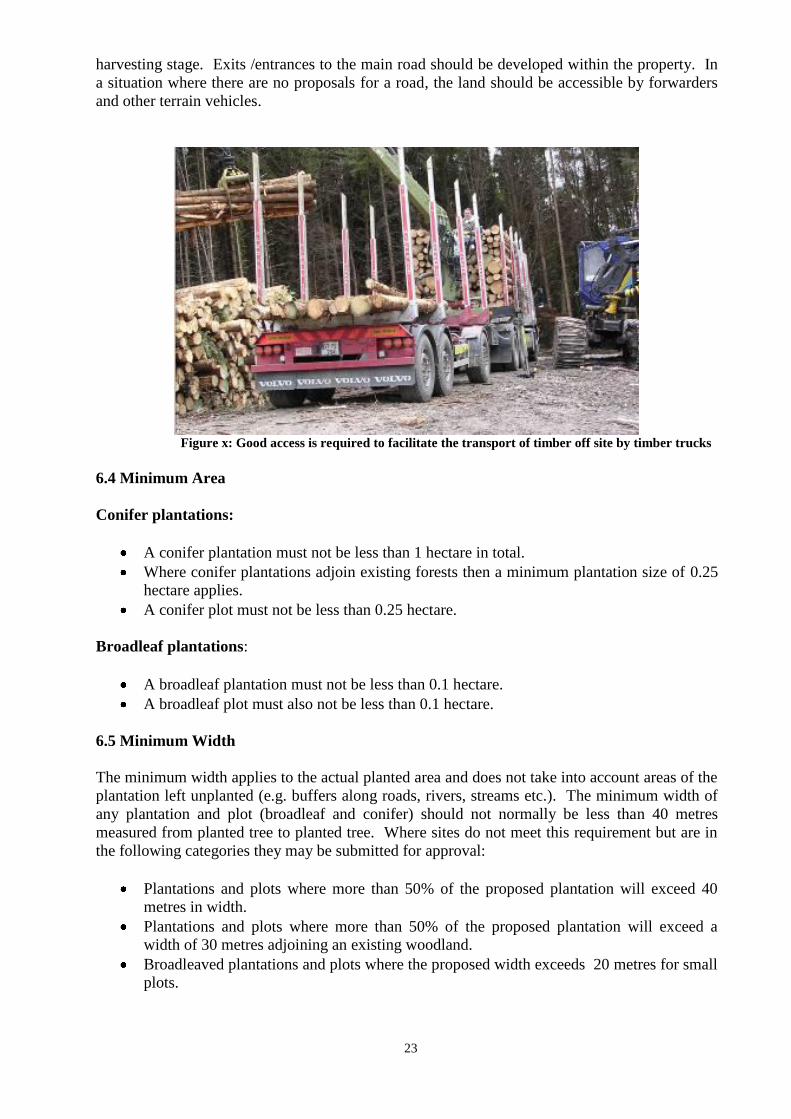
23
harvesting stage. Exits /entrances to the main road should be developed within the property. In
a situation where there are no proposals for a road, the land should be accessible by forwarders
and other terrain vehicles.
Figure x: Good access is required to facilitate the transport of timber off site by timber trucks
6.4 Minimum Area
Conifer plantations:
A conifer plantation must not be less than 1 hectare in total.
Where conifer plantations adjoin existing forests then a minimum plantation size of 0.25
hectare applies.
A conifer plot must not be less than 0.25 hectare.
Broadleaf plantations:
A broadleaf plantation must not be less than 0.1 hectare.
A broadleaf plot must also not be less than 0.1 hectare.
6.5 Minimum Width
The minimum width applies to the actual planted area and does not take into account areas of the
plantation left unplanted (e.g. buffers along roads, rivers, streams etc.). The minimum width of
any plantation and plot (broadleaf and conifer) should not normally be less than 40 metres
measured from planted tree to planted tree. Where sites do not meet this requirement but are in
the following categories they may be submitted for approval:
Plantations and plots where more than 50% of the proposed plantation will exceed 40
metres in width.
Plantations and plots where more than 50% of the proposed plantation will exceed a
width of 30 metres adjoining an existing woodland.
Broadleaved plantations and plots where the proposed width exceeds 20 metres for small
plots.
24
CHAPTER 7
Unplanted Areas, Biodiversity and Setback distances
Areas for Biodiversity Enhancement (ABEs) as described in the Forest Biodiversity Guidelines
are comprised of open spaces and retained habitat. Their function is to conserve and encourage
the development of diverse habitats, native flora and fauna, and biodiversity.
The Forest Biodiversity Guidelines require that ABEs would comprise approximately 15% of
individual grant aided afforestation projects which are greater than 10 hectares. In sites less than
10 hectares in area, the open space element of ABEs should be designed in conjunction with
neighbouring land use and may be reduced.
7.1 Eligibility as an ABE
The following table outlines areas left unplanted in forest plantations and indicates which are
eligible as ABEs in individual projects and their eligibility for grants and premiums.
Table 3 Eligibility of Areas for ABE‟s, grants and premiums Areas ABE Grant Premium
Open space for landscape and biodiversity Yes * **
Hedgerows Yes * **
Scrub Yes * **
Buffer zones along aquatic zones Yes * **
Archaeological sites and their exclusion zones Yes * **
Created lakes/reservoirs Yes * **
Former REPS habitats Yes * **
Public road setback areas Yes * **
Railway setback strip Yes * **
Ridelines and drains Yes * **
Internal roads and turning bay setback areas Yes * **
Unplantable areas *** No No
Shallow, rocky soils *** * **
Rock and scree *** No No
Aquatic zones (area occupied by lake/ river) *** No No
Forest. (Conifer High Forest and Broadleaf High Forest - this includes
newly planted areas with conventional stocking densities.)
No No No
Dwelling house/associated building setback area Yes * **
Rights of way held by third party No No No
Areas with turbary or grazing rights held by a third party No No No
Major water mains *** No No
Power line corridors *** No No
Gas line *** No No
Public road No No No * An ABE of plot size is eligible for grant aid if it has been subject to work and legitimate costs in the afforestation of the project.
** An ABE is subject to premium if it adheres to the definition of utilised agricultural area (Commission Regulation (EC) No.1750/1999)
prior to the commencement of the associated afforestation. *** These areas can be included as ABEs if in the view of the Forest Service it has sufficient biodiversity value but is not subject to grant
aid or premium.
Where ABEs add up to more than 15% of the total area the following calculation must be
applied.
Payment area = Actual planted area X 100
85
25
For example, a 10 hectare application adjacent to a river has a combined unplanted area of 4
hectares. The 4 hectare area comprises the setback distance from the river, areas associated with
internal hedgerows and a 60 metre setback distance from a dwelling. In this example the
formula is applied as illustrated
Payment area = Planted Area of 6 ha x 100 = 7.06 hectares
85
In this case the eligible claimed area is 7.06 hectares and not 10 hectares. Over declaration of
area will result in grant and premium recoupment and can result in additional penalties being
applied
Criteria for Eligibility
Areas chosen as ABEs should represent the best areas for biodiversity enhancement within a
forest. While protecting biodiversity outside of the forest area is desirable and encouraged, it is
not within the scope of the afforestation schemes to grant aid in excess of 15% of the eligible and
planted area. The clarification below attempts to explain the Forest Biodiversity Guidelines to
help maximise the biodiversity benefit of ABEs.
ABE‟s are areas suitable for planting where the potential for a commercial forest crop is
foregone for the purpose of retaining open spaces and habitats for biodiversity.
The area occupied by linear features (e.g. hedgerows, public road setbacks etc.) or point
features (e.g. archaeological sites) must be accurately assessed and noted on the
biodiversity map. This area must be added to any plot sized ABE area to give a total
ABE area.
ABE‟s must be an integral part of the proposed forest area.
ABE‟s must be situated where they provide the best opportunity for enhancing the
biodiversity within the forest area while also protecting watercourses and archaeological
sites through the use of buffer and exclusion zones.
Existing forests (conifer and broadleaf), or parts of existing forests, may not be used as
ABEs. To be deemed a forest it must have a minimum area of 0.1 hectare and a
minimum width of 20m. Other tree covered areas with smaller dimensions to a forest
may be included as ABE.
Note: In the FEPS scheme, and in SPAs designated for the protection of the Hen Harrier,
the biodiversity requirement can increase to 20%, subject to approval.
7.2 Mapping and recording ABE Features
The Forestry Schemes Mapping Standards (2011) describe the requirements for mapping ABE
areas.
It is often not practical to map linear or spot features such as hedgerows or individual trees on
maps of scale 1:5000. However, where practical, features should be lettered and recorded on the
map legend. For grant and premium purposes these features follow normal practice of adopting
the Grant and Premium Category (GPC) in which they are situated. Features that may be
26
incorporated as part of the ABE, but are not subject to grant aid or to premium, should be
excluded from the plot area.
7.3 Mapping and recording ABE Plots
An ABE of plot size should be mapped and recorded as a plot in the map legend. In this instance
a plot will have a minimum width of 30metres. The abbreviation “Bio” should be used in the
species column on forms 1 and 2 and on the map legends. The GPC should be that of the largest
adjoining planted plot.
7.4 Grant aiding ABE plots
An ABE of plot size, as defined above, is eligible to grant. The GPC of the ABE should be that
of the largest adjoining planted plot.
7.5 Biodiversity Map Legend
The Forestry Schemes Mapping Standards (2011) describe the requirements for mapping ABE
areas.
An ABE must be included as an intrinsic part of the individual grant aided afforestation project
and must be protected and fenced as part of the project.
The maximum grant aided area of ABE in afforestation projects continues to be 15% of total
area eligible for grant and premium.
If a site, such as an intensively farmed area, does not contain sufficient retained habitat, the
planting of native trees and shrubs, either in widely spaced groups or at wide spacing, may fulfil
the retained habitat obligation – see the section entitled “Open Space” in the Forest Biodiversity
Guidelines.
7.6 Setback/corridor width Conventions.
The principle for setback distances differs between planting and existing trees.
Existing trees;
If existing trees did not breach the setback distances applicable at the time they were planted, the
setback distances set out in this Manual do not apply to them. This does not preclude a special
condition being made in relation to individual projects.
Planted trees:
Planting in this case refers to the planting of trees for all schemes whether Afforesation, FEPS,
Native Woodland Establishment and Conservation, reforestation, woodland improvement,
reconstitution etc. In these cases all the setback distances apply.
Failure to adhere to the appropriate setback distances may result in grant aid being refused and/or
penalties being applied.
Public road setback strip
A setback strip of 10m for broadleaves and 20m for conifers, measured to the surfaced edge of
the public road, applies. In conifer plantations the strip 10m to 20m from the road should be
27
planted with broadleaves and not left unplanted. This distance is an average distance for single
applications and should vary to take account of good landscaping practices.
Dwelling Houses/associated buildings setback areas
The setback distance from dwelling houses and associated buildings is 60m, or 30m where
written consent of the owner is granted prior to approval, must be observed. Set back distance is
most critical when a building is surrounded by forest on two sides or more. Where adjoining
properties are 0.2 hectares or less, planting should be kept back 30m from the property boundary.
Rights of way held by parties other than the owner
This varies but is normally no more than a corridor of 5m or as set out in the Folio document.
Major Water mains (Local Authority or Group Scheme)
A corridor of 15m applies.
Gas line
A corridor of 15m applies where the gas line has been installed prior to planting. A corridor of
up to 30m applies where the gas line was installed after the area was planted. Forestry grants
and premiums must be repaid in respect of the area deforested.
There is an agreement between Irish Farmers Association and Bord Gáis Éireann on
compensation for gas pipeline wayleaves through forestry. For further information, contact Bord
Gáis Éireann or Irish Farmers Association.
ESB corridors (see also Chapter 7)
The following corridors apply:
Power line
type
Corridor width
(centred)
Low voltage
(230/400V)
none (clearance from
branches and tree tops
only)
10 kV and
38 kV
20 m
110 kV 61 m
220 kV 68 m
400 kV 74 m
Wind Turbines
A minimum 30m setback must be observed in the case of new afforestation around pre-existing
turbines. This setback distance may be increased on a case by case basis during the consultation
process. Where the plantation pre-dates the installation of wind turbines, permission of the
Forest Service is required before any trees are removed. Forestry grants and premiums may have
to be repaid in respect of areas deforested.
The Forest Service policy on the Granting of Felling Licences for Wind Farm Developments
may also effect decisions in relation to afforestation.
28
Ridelines
Normally 6m wide.
Internal roads & turning bays etc.
Normally 15m corridor.
Drains, Hedges, Created lakes/reservoirs, Current REPS habitats
Varies.
Firebreaks
6m wide fuel free zone.
Railway setback strips
20 metres.
Points of Water Abstraction
If there are pump houses or substantial tank type reservoirs, then the setback distance should be
30m (as for buildings and permanent structures - it is not necessary to obtain the owner‟s
consent). If they are wells or boreholes the minimum setback distance for all work should be as
per the buffer zone width outlined in the Forestry and Water Quality Guidelines. Tree planting
setback should be such that it is equal to the ultimate falling distance of the species (25m for
commercial conifers and broadleaves 25m). Birch, rowan, sally etc. can be up to the buffer zone
width.
29
CHAPTER 8
ESB Power Lines
This Chapter has been agreed with the ESB and complies with the IFA/ESB agreement of
7th September 1992. It gives guidelines on how to deal with ESB lines in forestry and
allows for each case to be examined on an individual basis. Landowners reserve the right
to negotiate their own deal with the ESB.
8.1 Unplanted Corridors
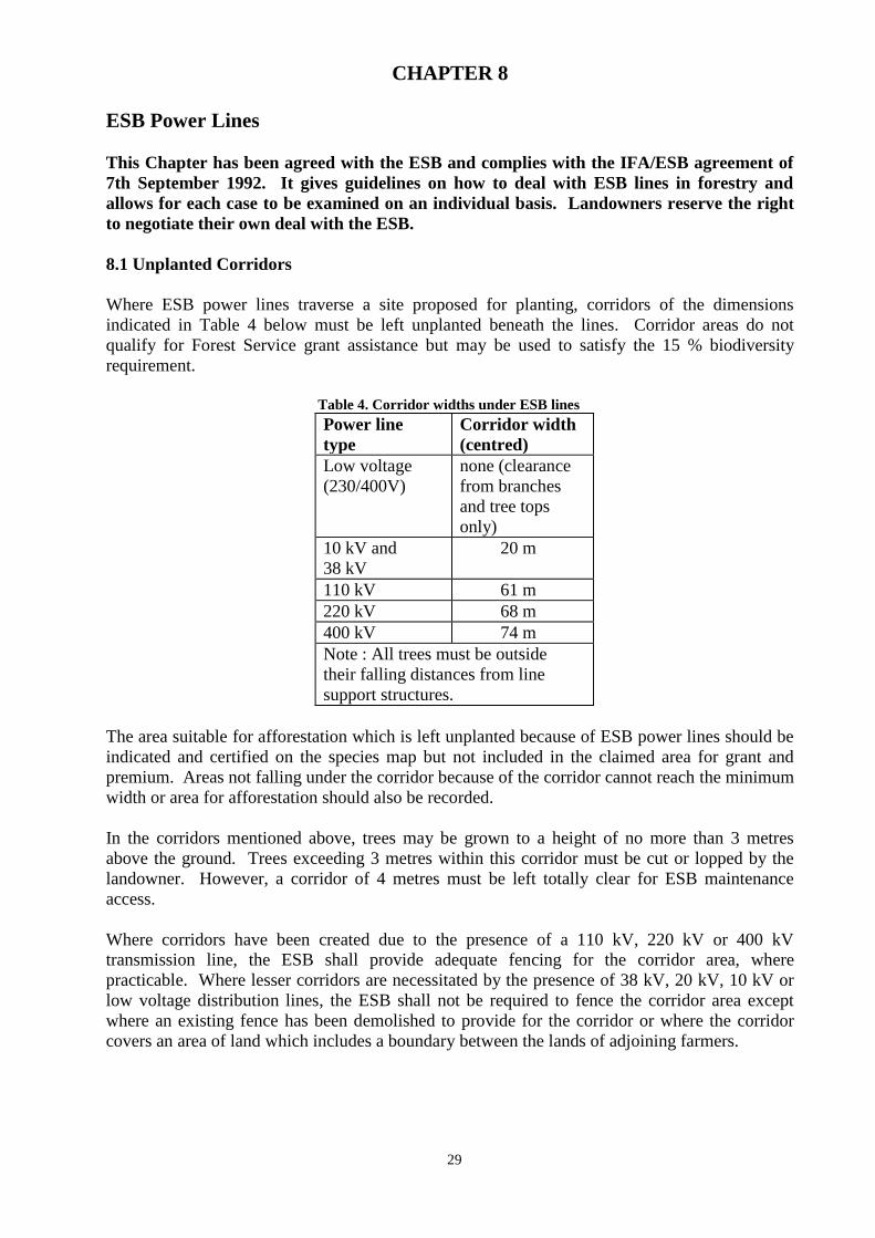
Where ESB power lines traverse a site proposed for planting, corridors of the dimensions
indicated in Table 4 below must be left unplanted beneath the lines. Corridor areas do not
qualify for Forest Service grant assistance but may be used to satisfy the 15 % biodiversity
requirement.
Table 4. Corridor widths under ESB lines
Power line
type
Corridor width
(centred)
Low voltage
(230/400V)
none (clearance
from branches
and tree tops
only)
10 kV and
38 kV
20 m
110 kV 61 m
220 kV 68 m
400 kV 74 m
Note : All trees must be outside
their falling distances from line
support structures.
The area suitable for afforestation which is left unplanted because of ESB power lines should be
indicated and certified on the species map but not included in the claimed area for grant and
premium. Areas not falling under the corridor because of the corridor cannot reach the minimum
width or area for afforestation should also be recorded.
In the corridors mentioned above, trees may be grown to a height of no more than 3 metres
above the ground. Trees exceeding 3 metres within this corridor must be cut or lopped by the
landowner. However, a corridor of 4 metres must be left totally clear for ESB maintenance
access.
Where corridors have been created due to the presence of a 110 kV, 220 kV or 400 kV
transmission line, the ESB shall provide adequate fencing for the corridor area, where
practicable. Where lesser corridors are necessitated by the presence of 38 kV, 20 kV, 10 kV or
low voltage distribution lines, the ESB shall not be required to fence the corridor area except
where an existing fence has been demolished to provide for the corridor or where the corridor
covers an area of land which includes a boundary between the lands of adjoining farmers.
30
8.2 Claiming Compensation
Applications for compensation from the ESB for loss of forest premium can be made for areas
suitable for afforestation but left unplanted as a result of the presence of an ESB line. These
applications for compensation must be made before planting, to enable the ESB to exercise its
option, if it so desires, of diverting the overhead line. Where grant-aided afforestation has to be
removed to allow for the installation of power lines grants and premiums already paid will be
recovered from the landowner by the Forest Service. Compensation may be claimed from the
ESB in respect of the amounts repaid to the Forest Service.
To claim compensation the ESB will require the following:
1. Completed application form (Application for Compensation for loss of Tree Planting
Rights, Appendix 12).
2. Proof of grant approval letter and Ordnance Survey map.
3. Proof of Forest Premium loss (available on request from the Forest Service).
4. Agreement to grant an easement on the lands in question.
All claims for compensation should be processed initially through the local ESB office or ESB
Regional office. No compensation will be paid until after the site has been planted.
8.3 Compensation levels
75% of land value
Where a landowner has recently purchased land for the purpose of afforestation, and where the
ESB has notified the landowner that part of the land may not be planted due to the presence or
the planned presence of an electricity line, the ESB shall, in the first instance, agree to pay the
landowner an amount equivalent to 75% of the purchase price of the affected area where the
price of the affected area is deemed to be pro rata to that of the remainder. The amount is
payable on foot of an easement, following bona-fide intent to proceed and receipt of notification
of afforestation grant approval.
Where the landowner proposes to plant an area which has not been recently purchased, a sum
equivalent to 75% of the value of the land shall be paid by the ESB. The value of the land is that
which would have prevailed had the land been recently purchased.
Compensation for loss of premium
In addition to this, premium based compensation is also payable by the ESB to the landowner.
Methods of calculation are based on a standard annuity table, see Appendix 23, taking into
account the premium rate, number of years and interest rate. Payment is capitalised as a once off
payment.
8.4 Mapping of ESB lines
The Forestry Schemes Mapping Standards outline requirements for mapping power lines. All
applications affected by power lines must be mapped as per these standards
31
CHAPTER 9
Silvicultural Standards
The maintenance of high silvicultural standards compatible with the protection of our
environment is of paramount importance. The following standards and specifications indicate
the minimum acceptable for grant aid under the various grant schemes and should be read in
conjunction with the Code of Best Forest Practice and the suite of environmental guidelines.
Responsibility for the successful establishment and management of forests rests with the
applicant. The Department will not be held liable for any issue that arises regardless of whether
the site had received a Departmental Inspection or not.
9.1 Species Selection
A prerequisite for grant aid is that the site is capable of producing a commercial crop of wood
and it is necessary to carry out a proper assessment of site, soil and species suitability in order to
establish this. Yield class is a measure of the average rate of growth of forests measured in cubic
metres of commercial timber per hectare per year (M3/ha.yr), assuming the crop will be grown
on to the age of maximum mean annual increment. In certain areas the presence of high
populations of deer and grey squirrel may also limit species choice.
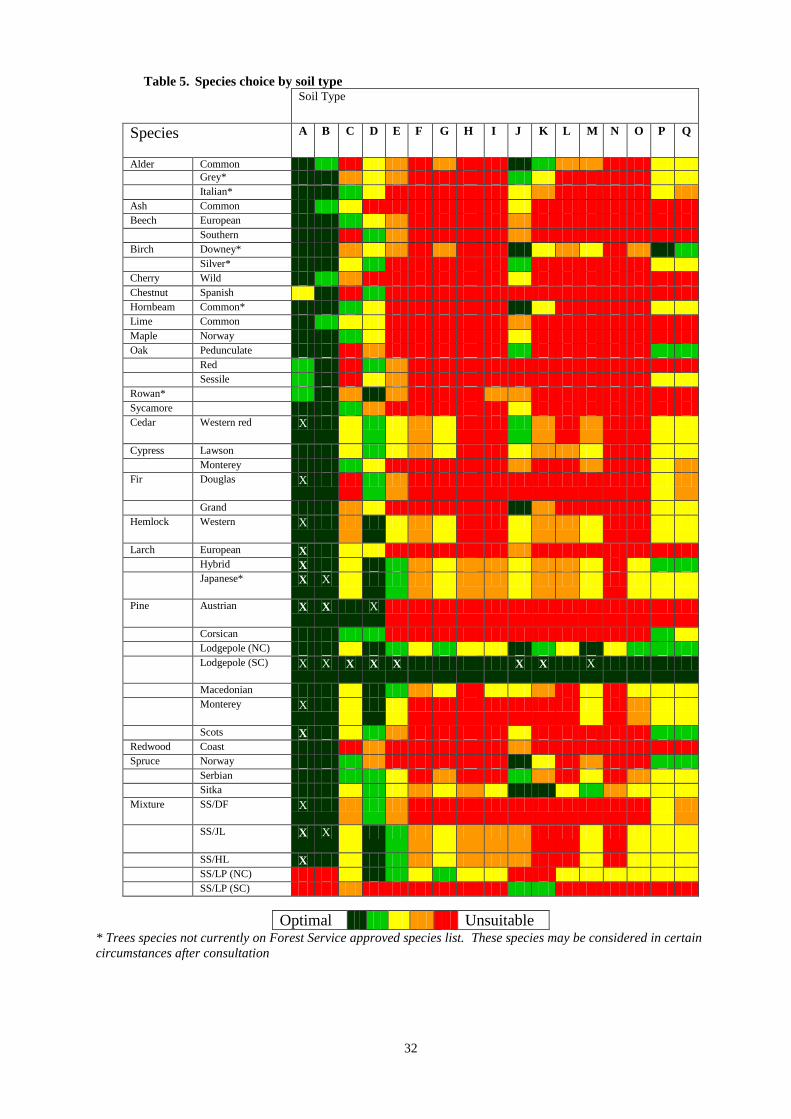
Tables 5 and 6 are extracts from „A Guide to Forest Tree Species Selection and Silviculture in
Ireland” (Horgan, Keane, McCarthy, Lally and Thompson), COFORD 2004. The Guide is
available from the Forest Service and is recommended reading (while not necessarily Forest
Service policy) for foresters involved in species selection and forest management. The tables
are not intended as a „quick fix‟ and should not be read in isolation. When read in
conjunction with other chapters in the Guide, they provide a sound basis for species
selection.
Table 5 colour codes the suitability of a species or mixture from „optimal‟ to „unsuitable‟. Using
this colour code, certain species can be disregarded immediately as not being suitable for a
particular site. The species which are deemed more suitable can then be evaluated, based on
additional information (susceptibility to frost, exposure, etc.) from Table 6.
For reforestation sites on many podsols and peaty podsolised gleys, the potentially suitable
species range may be expanded due to the ameliorative effect of the previous crop. In addition,
it should be noted from Table 5 that some species might grow too rapidly on certain fertile sites,
leading to coarse growth, poor form or instability. The suggested combinations of site and
species where this may occur are marked in the Table by an X.
32
Table 5. Species choice by soil type
Soil Type
Species A B C D E F G H I J K L M N O P Q
Alder Common
Grey* Italian* Ash Common Beech European Southern Birch Downey* Silver* Cherry Wild Chestnut Spanish Hornbeam Common* Lime Common Maple Norway Oak Pedunculate Red Sessile Rowan* Sycamore Cedar Western red X
Cypress Lawson Monterey Fir Douglas X
Grand Hemlock Western X
Larch European X Hybrid X Japanese* X X
Pine Austrian X X X
Corsican Lodgepole (NC) Lodgepole (SC) X X X X X X X X
Macedonian Monterey X
Scots X Redwood Coast Spruce Norway Serbian Sitka Mixture SS/DF X
SS/JL X X
SS/HL X SS/LP (NC) SS/LP (SC)
Optimal Unsuitable * Trees species not currently on Forest Service approved species list. These species may be considered in certain
circumstances after consultation
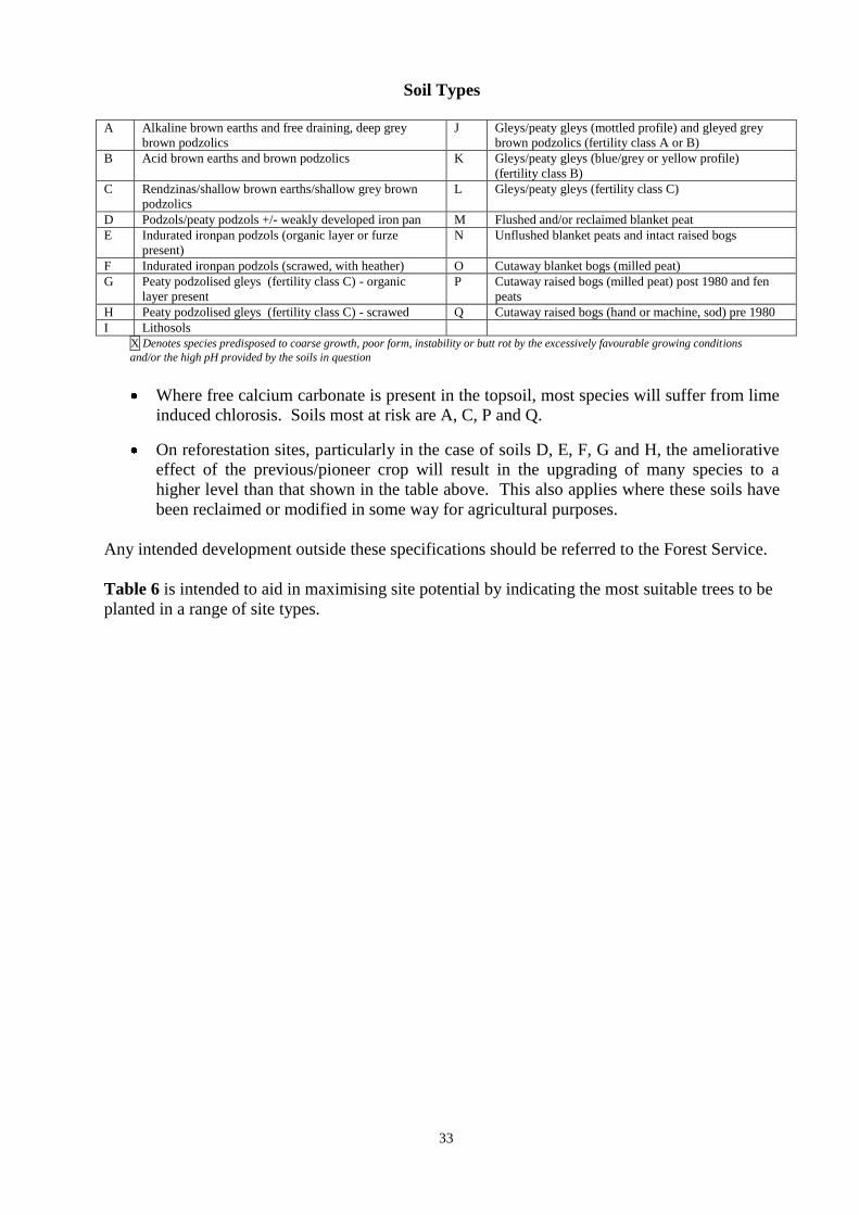
33
Soil Types
A Alkaline brown earths and free draining, deep grey
brown podzolics
J Gleys/peaty gleys (mottled profile) and gleyed grey
brown podzolics (fertility class A or B)
B Acid brown earths and brown podzolics K Gleys/peaty gleys (blue/grey or yellow profile)
(fertility class B)
C Rendzinas/shallow brown earths/shallow grey brown
podzolics
L Gleys/peaty gleys (fertility class C)
D Podzols/peaty podzols +/- weakly developed iron pan M Flushed and/or reclaimed blanket peat
E Indurated ironpan podzols (organic layer or furze
present)
N Unflushed blanket peats and intact raised bogs
F Indurated ironpan podzols (scrawed, with heather) O Cutaway blanket bogs (milled peat)
G Peaty podzolised gleys (fertility class C) - organic
layer present
P Cutaway raised bogs (milled peat) post 1980 and fen
peats
H Peaty podzolised gleys (fertility class C) - scrawed Q Cutaway raised bogs (hand or machine, sod) pre 1980
I Lithosols
X Denotes species predisposed to coarse growth, poor form, instability or butt rot by the excessively favourable growing conditions
and/or the high pH provided by the soils in question
Where free calcium carbonate is present in the topsoil, most species will suffer from lime
induced chlorosis. Soils most at risk are A, C, P and Q.
On reforestation sites, particularly in the case of soils D, E, F, G and H, the ameliorative
effect of the previous/pioneer crop will result in the upgrading of many species to a
higher level than that shown in the table above. This also applies where these soils have
been reclaimed or modified in some way for agricultural purposes.
Any intended development outside these specifications should be referred to the Forest Service.
Table 6 is intended to aid in maximising site potential by indicating the most suitable trees to be
planted in a range of site types.
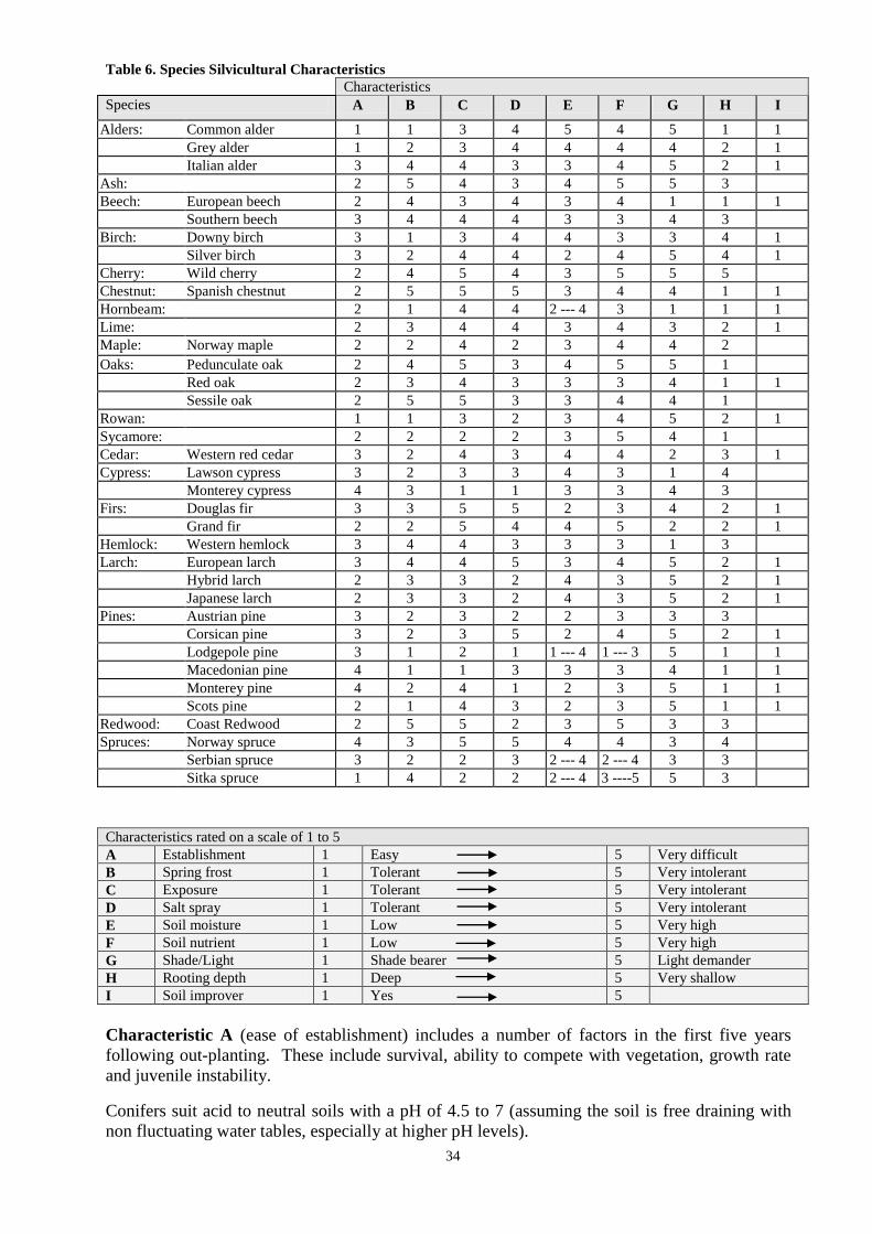
34
Table 6. Species Silvicultural Characteristics
Characteristics
Species A B C D E F G H I
Alders: Common alder 1 1 3 4 5 4 5 1 1
Grey alder 1 2 3 4 4 4 4 2 1
Italian alder 3 4 4 3 3 4 5 2 1
Ash: 2 5 4 3 4 5 5 3
Beech: European beech 2 4 3 4 3 4 1 1 1
Southern beech 3 4 4 4 3 3 4 3
Birch: Downy birch 3 1 3 4 4 3 3 4 1
Silver birch 3 2 4 4 2 4 5 4 1
Cherry: Wild cherry 2 4 5 4 3 5 5 5
Chestnut: Spanish chestnut 2 5 5 5 3 4 4 1 1
Hornbeam: 2 1 4 4 2 --- 4 3 1 1 1
Lime: 2 3 4 4 3 4 3 2 1
Maple: Norway maple 2 2 4 2 3 4 4 2
Oaks: Pedunculate oak 2 4 5 3 4 5 5 1
Red oak 2 3 4 3 3 3 4 1 1
Sessile oak 2 5 5 3 3 4 4 1
Rowan: 1 1 3 2 3 4 5 2 1
Sycamore: 2 2 2 2 3 5 4 1
Cedar: Western red cedar 3 2 4 3 4 4 2 3 1
Cypress: Lawson cypress 3 2 3 3 4 3 1 4
Monterey cypress 4 3 1 1 3 3 4 3
Firs: Douglas fir 3 3 5 5 2 3 4 2 1
Grand fir 2 2 5 4 4 5 2 2 1
Hemlock: Western hemlock 3 4 4 3 3 3 1 3
Larch: European larch 3 4 4 5 3 4 5 2 1
Hybrid larch 2 3 3 2 4 3 5 2 1
Japanese larch 2 3 3 2 4 3 5 2 1
Pines: Austrian pine 3 2 3 2 2 3 3 3
Corsican pine 3 2 3 5 2 4 5 2 1
Lodgepole pine 3 1 2 1 1 --- 4 1 --- 3 5 1 1
Macedonian pine 4 1 1 3 3 3 4 1 1
Monterey pine 4 2 4 1 2 3 5 1 1
Scots pine 2 1 4 3 2 3 5 1 1
Redwood: Coast Redwood 2 5 5 2 3 5 3 3
Spruces: Norway spruce 4 3 5 5 4 4 3 4
Serbian spruce 3 2 2 3 2 --- 4 2 --- 4 3 3
Sitka spruce 1 4 2 2 2 --- 4 3 ----5 5 3
Characteristics rated on a scale of 1 to 5
A Establishment 1 Easy 5 Very difficult
B Spring frost 1 Tolerant 5 Very intolerant
C Exposure 1 Tolerant 5 Very intolerant
D Salt spray 1 Tolerant 5 Very intolerant
E Soil moisture 1 Low 5 Very high
F Soil nutrient 1 Low 5 Very high
G Shade/Light 1 Shade bearer 5 Light demander
H Rooting depth 1 Deep 5 Very shallow
I Soil improver 1 Yes 5
Characteristic A (ease of establishment) includes a number of factors in the first five years
following out-planting. These include survival, ability to compete with vegetation, growth rate
and juvenile instability.
Conifers suit acid to neutral soils with a pH of 4.5 to 7 (assuming the soil is free draining with
non fluctuating water tables, especially at higher pH levels).
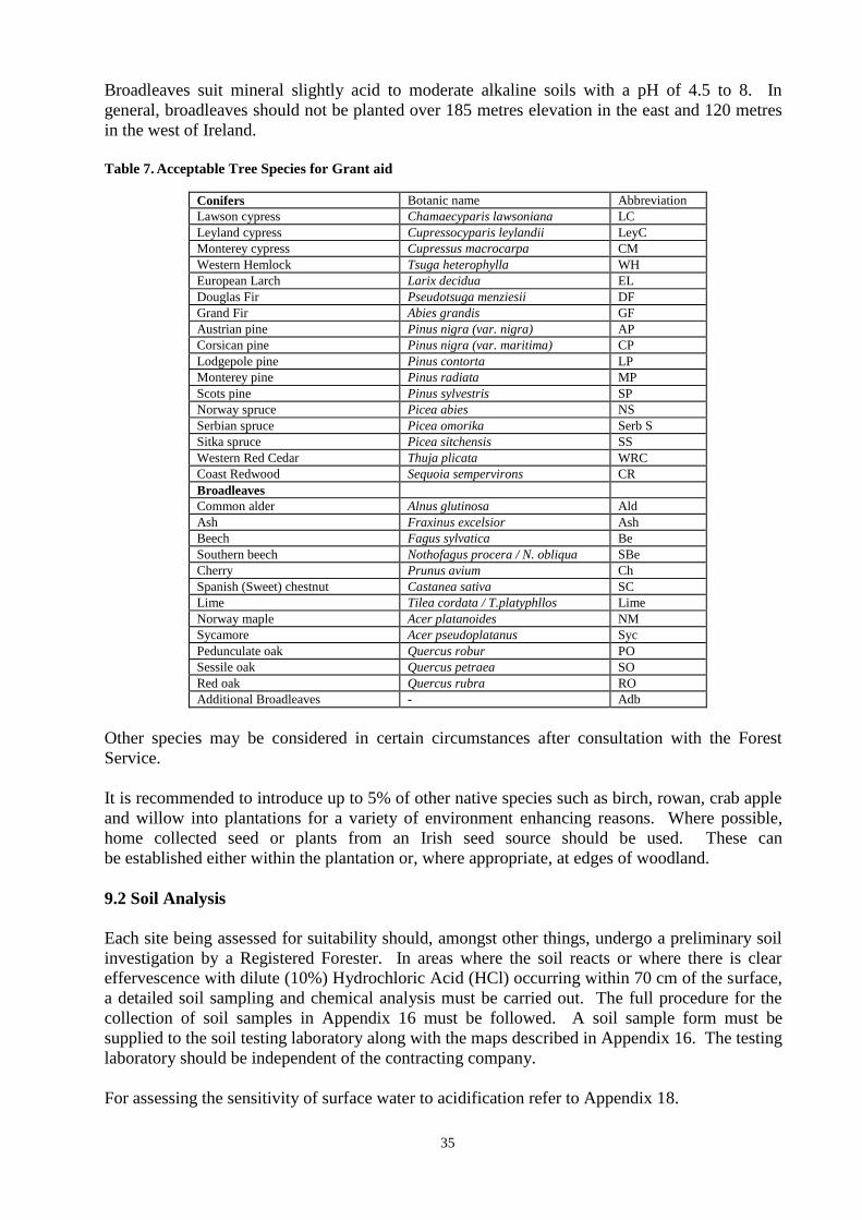
35
Broadleaves suit mineral slightly acid to moderate alkaline soils with a pH of 4.5 to 8. In
general, broadleaves should not be planted over 185 metres elevation in the east and 120 metres
in the west of Ireland.
Table 7. Acceptable Tree Species for Grant aid
Conifers Botanic name Abbreviation
Lawson cypress Chamaecyparis lawsoniana LC
Leyland cypress Cupressocyparis leylandii LeyC
Monterey cypress Cupressus macrocarpa CM
Western Hemlock Tsuga heterophylla WH
European Larch Larix decidua EL
Douglas Fir Pseudotsuga menziesii DF
Grand Fir Abies grandis GF
Austrian pine Pinus nigra (var. nigra) AP
Corsican pine Pinus nigra (var. maritima) CP
Lodgepole pine Pinus contorta LP
Monterey pine Pinus radiata MP
Scots pine Pinus sylvestris SP
Norway spruce Picea abies NS
Serbian spruce Picea omorika Serb S
Sitka spruce Picea sitchensis SS
Western Red Cedar Thuja plicata WRC
Coast Redwood Sequoia sempervirons CR
Broadleaves
Common alder Alnus glutinosa Ald
Ash Fraxinus excelsior Ash
Beech Fagus sylvatica Be
Southern beech Nothofagus procera / N. obliqua SBe
Cherry Prunus avium Ch
Spanish (Sweet) chestnut Castanea sativa SC
Lime Tilea cordata / T.platyphllos Lime
Norway maple Acer platanoides NM
Sycamore Acer pseudoplatanus Syc
Pedunculate oak Quercus robur PO
Sessile oak Quercus petraea SO
Red oak Quercus rubra RO
Additional Broadleaves - Adb
Other species may be considered in certain circumstances after consultation with the Forest
Service.
It is recommended to introduce up to 5% of other native species such as birch, rowan, crab apple
and willow into plantations for a variety of environment enhancing reasons. Where possible,
home collected seed or plants from an Irish seed source should be used. These can
be established either within the plantation or, where appropriate, at edges of woodland.
9.2 Soil Analysis
Each site being assessed for suitability should, amongst other things, undergo a preliminary soil
investigation by a Registered Forester. In areas where the soil reacts or where there is clear
effervescence with dilute (10%) Hydrochloric Acid (HCl) occurring within 70 cm of the surface,
a detailed soil sampling and chemical analysis must be carried out. The full procedure for the
collection of soil samples in Appendix 16 must be followed. A soil sample form must be
supplied to the soil testing laboratory along with the maps described in Appendix 16. The testing
laboratory should be independent of the contracting company.
For assessing the sensitivity of surface water to acidification refer to Appendix 18.

36
9.3 Provenance Selection
9.3.1 Accepted Seed Origins/Provenances
Accepted seed origins/provenances for planting material are listed in Table 8.
Where possible, home collected seed from registered seed stands should be used and applicants
are encouraged to ask first for plants from Irish seed.
Only the origins/provenances in Table 8 will be approved for grant aid. Applicants must check
with, and seek written approval from, the Forest Service before purchasing plants with
origins/provenances other than those listed and registered material in a category “Source
Identified”. Otherwise full responsibility for replacement and compensation, including loss of
increment, rests with the applicant, registered forester or forestry company.
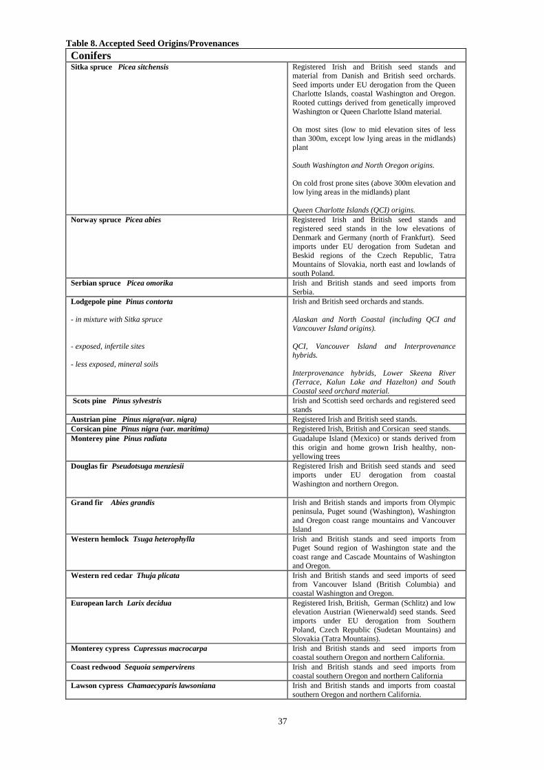
37
Table 8. Accepted Seed Origins/Provenances
Conifers Sitka spruce Picea sitchensis
Registered Irish and British seed stands and
material from Danish and British seed orchards.
Seed imports under EU derogation from the Queen
Charlotte Islands, coastal Washington and Oregon.
Rooted cuttings derived from genetically improved
Washington or Queen Charlotte Island material.
On most sites (low to mid elevation sites of less
than 300m, except low lying areas in the midlands)
plant
South Washington and North Oregon origins.
On cold frost prone sites (above 300m elevation and
low lying areas in the midlands) plant
Queen Charlotte Islands (QCI) origins.
Norway spruce Picea abies Registered Irish and British seed stands and
registered seed stands in the low elevations of
Denmark and Germany (north of Frankfurt). Seed
imports under EU derogation from Sudetan and
Beskid regions of the Czech Republic, Tatra
Mountains of Slovakia, north east and lowlands of
south Poland.
Serbian spruce Picea omorika Irish and British stands and seed imports from
Serbia.
Lodgepole pine Pinus contorta
- in mixture with Sitka spruce
- exposed, infertile sites
- less exposed, mineral soils
Irish and British seed orchards and stands.
Alaskan and North Coastal (including QCI and
Vancouver Island origins).
QCI, Vancouver Island and Interprovenance
hybrids.
Interprovenance hybrids, Lower Skeena River
(Terrace, Kalun Lake and Hazelton) and South
Coastal seed orchard material.
Scots pine Pinus sylvestris Irish and Scottish seed orchards and registered seed
stands
Austrian pine Pinus nigra(var. nigra) Registered Irish and British seed stands.
Corsican pine Pinus nigra (var. maritima) Registered Irish, British and Corsican seed stands.
Monterey pine Pinus radiata Guadalupe Island (Mexico) or stands derived from
this origin and home grown Irish healthy, non-
yellowing trees
Douglas fir Pseudotsuga menziesii
Registered Irish and British seed stands and seed
imports under EU derogation from coastal
Washington and northern Oregon.
Grand fir Abies grandis Irish and British stands and imports from Olympic
peninsula, Puget sound (Washington), Washington
and Oregon coast range mountains and Vancouver
Island
Western hemlock Tsuga heterophylla Irish and British stands and seed imports from
Puget Sound region of Washington state and the
coast range and Cascade Mountains of Washington
and Oregon.
Western red cedar Thuja plicata Irish and British stands and seed imports of seed
from Vancouver Island (British Columbia) and
coastal Washington and Oregon.
European larch Larix decidua Registered Irish, British, German (Schlitz) and low
elevation Austrian (Wienerwald) seed stands. Seed
imports under EU derogation from Southern
Poland, Czech Republic (Sudetan Mountains) and
Slovakia (Tatra Mountains).
Monterey cypress Cupressus macrocarpa Irish and British stands and seed imports from
coastal southern Oregon and northern California.
Coast redwood Sequoia sempervirens Irish and British stands and seed imports from
coastal southern Oregon and northern California
Lawson cypress Chamaecyparis lawsoniana Irish and British stands and imports from coastal
southern Oregon and northern California.
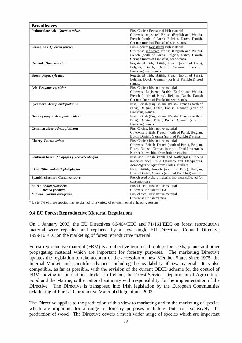
38
Broadleaves
Pedunculate oak Quercus robur First Choice: Registered Irish material
Otherwise registered British (English and Welsh),
French (north of Paris), Belgian, Dutch, Danish,
German (north of Frankfurt) seed stands.
Sessile oak Quercus petraea First Choice: Registered Irish material.
Otherwise registered British (English and Welsh),
French (north of Paris), Belgian, Dutch, Danish,
German (north of Frankfurt) seed stands.
Red oak Quercus rubra Registered Irish, British, French (north of Paris),
Belgian, Dutch, Danish, German (north of
Frankfurt) seed stands..
Beech Fagus sylvatica Registered Irish, British, French (north of Paris),
Belgian, Dutch, German (north of Frankfurt) seed
stands.
Ash Fraxinus excelsior First Choice: Irish native material.
Otherwise Registered British (English and Welsh),
French (north of Paris), Belgian, Dutch, Danish
German (north of Frankfurt) seed stands
Sycamore Acer pseudoplatanus Irish, British (English and Welsh), French (north of
Paris), Belgian, Dutch, Danish, German (north of
Frankfurt) stands.
Norway maple Acer platanoides Irish, British (English and Welsh), French (north of
Paris), Belgian, Dutch, Danish, German (north of
Frankfurt) stands
Common alder Alnus glutinosa First Choice: Irish native material.
Otherwise British, French (north of Paris), Belgian,
Dutch, Danish, German (north of Frankfurt) stands
Cherry Prunus avium First Choice: Irish native material.
Otherwise British, French (north of Paris), Belgian,
Dutch, Danish, German (north of Frankfurt) stands
Not seeds resulting from fruit processing.
Southern beech Notofagus procera/N.obliqua Irish and British stands and Nothofagus procera
imported from Chile (Malleco and Llanquihue).
Nothofagus obliqua from Chile (Frutillar)
Lime Tilia cordata/T.platyphyllos Irish, British, French (north of Paris), Belgian,
Dutch, Danish, German (north of Frankfurt) stands.
Spanish chestnut Castanea sativa French seed orchard material (not nuts collected for
consumption )
*Birch Betula pubescens
Betula pendula
First choice: Irish native material
Otherwise British material
*Rowan Sorbus aucuparia First choice: Irish native material
Otherwise British material
* Up to 5% of these species may be planted for a variety of environmental enhancing reasons
9.4 EU Forest Reproductive Material Regulations
On 1 January 2003, the EU Directives 66/404/EEC and 71/161/EEC on forest reproductive
material were repealed and replaced by a new single EU Directive, Council Directive
1999/105/EC on the marketing of forest reproductive material.
Forest reproductive material (FRM) is a collective term used to describe seeds, plants and other
propagating material which are important for forestry purposes. The marketing Directive
updates the legislation to take account of the accession of new Member States since 1975, the
Internal Market, and scientific advances including the availability of new material. It is also
compatible, as far as possible, with the revision of the current OECD scheme for the control of
FRM moving in international trade. In Ireland, the Forest Service, Department of Agriculture,
Food and the Marine, is the national authority with responsibility for the implementation of the
Directive. The Directive is transposed into Irish legislation by the European Communities
(Marketing of Forest Reproductive Material) Regulations 2002.
The Directive applies to the production with a view to marketing and to the marketing of species
which are important for a range of forestry purposes including, but not exclusively, the
production of wood. The Directive covers a much wider range of species which are important
39
for forestry in Ireland including, ash, alder, birch, sycamore, cherry and lodgepole pine.
Significantly, a new category of material “Source Identified” is included. This is FRM derived
from basic material which may be either a seed source or stand located within a single region of
provenance. This will allow collection and marketing of seed from outside of “Selected”
registered sources subject to official control and labelling.
A key principle of the Directive is that FRM remains clearly identifiable through the entire
process from collection to delivery to the end user. Under the Directive there is a legal
requirement for suppliers of FRM throughout the EU to be officially registered. All seed
collectors, seed suppliers, nurseries, plant suppliers/brokers etc. must be registered with the
Forest Service. All seed collections must be notified in advance following which a Master
Certificate of Provenance will be issued. Seed and plants should only be purchased from
registered suppliers and material must be accompanied by an approved Supplier‟s Document.
These rules provide traceability and assurance to the end user regarding the origin and suitability
of the planting stock. Details of the provenance/origin of planted material also provides an
essential forest management record.
For the purpose of the Forest Service grant schemes, all planted material must be covered by a
Supplier‟s Document in the format of a Provenance Declaration Form.
A Provenance Declaration Form – Supplier‟s Document (see Appendix 1) must be completed
for all the species listed in Table 8. Only the origins/provenances listed in this table are
acceptable.
Part A of the Provenance Declaration Form is completed by the Nursery/Supplier supplying the
plants. The Nursery/Supplier must declare that the origin/provenance complies with the accepted
list of Origins/Provenances (Table 8).
Part A of the Provenance Declaration Form and the associated plants should only be
accepted from a supplying nursery/plant broker if the form is fully completed, including,
where applicable, the full Plant Passport plant health details. Where the Provenance
Declaration Form accompanying the plants is a copy, the original must be forwarded by
the nursery/plant broker as soon as possible.
Part A of the Provenance Declaration Form can only be completed by nurseries or plant
brokers registered in Ireland. If importing plants from outside Ireland, the nursery or plant
supplier in Ireland is required to be officially registered with the Forest Service under the
EU Forest Reproductive Material Regulations and for regulated species under the EU
Plant Health Regulations. In these cases Part A is completed by the importer.
Part B of the form is completed by the Contractor or Applicant applying for the grant
In all cases, the Contractor or Applicant must submit the original signed Part B. The Contractor
or Applicant must declare that the original provenance details are correct.
Tick “Part A is an Original” when the original non-photocopied Part A is submitted
Tick “Part A is a photocopy” when the plants covered by Part A have been planted in more than
one grant application/contract. The original non-photocopied Part A must be available for
inspection.
Tick “This Provenance Declaration Form accounts for: All of the trees planted of the above
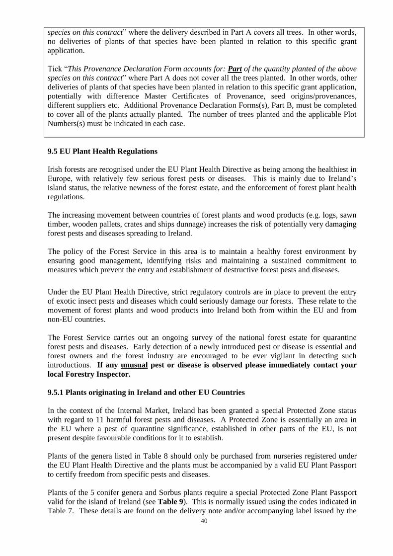
40
species on this contract” where the delivery described in Part A covers all trees. In other words,
no deliveries of plants of that species have been planted in relation to this specific grant
application.
Tick “This Provenance Declaration Form accounts for: Part of the quantity planted of the above
species on this contract” where Part A does not cover all the trees planted. In other words, other
deliveries of plants of that species have been planted in relation to this specific grant application,
potentially with difference Master Certificates of Provenance, seed origins/provenances,
different suppliers etc. Additional Provenance Declaration Forms(s), Part B, must be completed
to cover all of the plants actually planted. The number of trees planted and the applicable Plot
Numbers(s) must be indicated in each case.
9.5 EU Plant Health Regulations
Irish forests are recognised under the EU Plant Health Directive as being among the healthiest in
Europe, with relatively few serious forest pests or diseases. This is mainly due to Ireland‟s
island status, the relative newness of the forest estate, and the enforcement of forest plant health
regulations.
The increasing movement between countries of forest plants and wood products (e.g. logs, sawn
timber, wooden pallets, crates and ships dunnage) increases the risk of potentially very damaging
forest pests and diseases spreading to Ireland.
The policy of the Forest Service in this area is to maintain a healthy forest environment by
ensuring good management, identifying risks and maintaining a sustained commitment to
measures which prevent the entry and establishment of destructive forest pests and diseases.
Under the EU Plant Health Directive, strict regulatory controls are in place to prevent the entry
of exotic insect pests and diseases which could seriously damage our forests. These relate to the
movement of forest plants and wood products into Ireland both from within the EU and from
non-EU countries.
The Forest Service carries out an ongoing survey of the national forest estate for quarantine
forest pests and diseases. Early detection of a newly introduced pest or disease is essential and
forest owners and the forest industry are encouraged to be ever vigilant in detecting such
introductions. If any unusual pest or disease is observed please immediately contact your
local Forestry Inspector.
9.5.1 Plants originating in Ireland and other EU Countries
In the context of the Internal Market, Ireland has been granted a special Protected Zone status
with regard to 11 harmful forest pests and diseases. A Protected Zone is essentially an area in
the EU where a pest of quarantine significance, established in other parts of the EU, is not
present despite favourable conditions for it to establish.
Plants of the genera listed in Table 8 should only be purchased from nurseries registered under
the EU Plant Health Directive and the plants must be accompanied by a valid EU Plant Passport
to certify freedom from specific pests and diseases.
Plants of the 5 conifer genera and Sorbus plants require a special Protected Zone Plant Passport
valid for the island of Ireland (see Table 9). This is normally issued using the codes indicated in
Table 7. These details are found on the delivery note and/or accompanying label issued by the
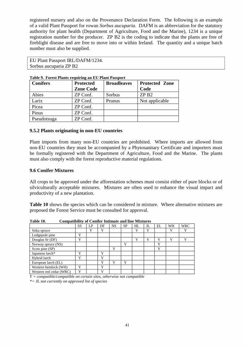
41
registered nursery and also on the Provenance Declaration Form. The following is an example
of a valid Plant Passport for rowan Sorbus aucuparia. DAFM is an abbreviation for the statutory
authority for plant health (Department of Agriculture, Food and the Marine), 1234 is a unique
registration number for the producer. ZP B2 is the coding to indicate that the plants are free of
fireblight disease and are free to move into or within Ireland. The quantity and a unique batch
number must also be supplied.
EU Plant Passport IRL/DAFM/1234.
Sorbus aucuparia ZP B2
Table 9. Forest Plants requiring an EU Plant Passport
Conifers Protected
Zone Code
Broadleaves Protected Zone
Code
Abies ZP Conf. Sorbus ZP B2
Larix ZP Conf. Prunus Not applicable
Picea ZP Conf.
Pinus ZP Conf.
Pseudotsuga ZP Conf.
9.5.2 Plants originating in non-EU countries
Plant imports from many non-EU countries are prohibited. Where imports are allowed from
non-EU countries they must be accompanied by a Phytosanitary Certificate and importers must
be formally registered with the Department of Agriculture, Food and the Marine. The plants
must also comply with the forest reproductive material regulations.
9.6 Conifer Mixtures
All crops to be approved under the afforestation schemes must consist either of pure blocks or of
silviculturally acceptable mixtures. Mixtures are often used to enhance the visual impact and
productivity of a new plantation.
Table 10 shows the species which can be considered in mixture. Where alternative mixtures are
proposed the Forest Service must be consulted for approval.
Table 10. Compatibility of Conifer Intimate and line Mixtures
SS LP DF NS SP HL JL EL WH WRC
Sitka spruce Y Y Y Y Y Y
Lodgepole pine Y
Douglas fir (DF) Y Y Y Y Y Y
Norway spruce (NS) Y Y
Scots pine (SP) Y Y
Japanese larch* Y Y
Hybrid larch Y Y
European larch (EL) Y Y Y
Western hemlock (WH) Y Y
Western red cedar (WRC) Y Y
Y = compatible/compatible on certain sites, otherwise not compatible
*= JL not currently on approved list of species
42
9.7 Drainage
9.7.1 General Drainage Objectives
Drainage has a direct bearing on the economic, environmental and social potential of the forest
for the full rotation and beyond. A site which cannot be adequately drained should not be
submitted for pre-planting approval or payment.
Conifers should have a minimum free draining rooting depth of 45-60cm throughout the
year.
Broadleaf species require a greater depth.
Root structure should radiate in all directions on the horizontal plane.
It is important not to impair harvesting efficiency by creating obstacles.
Drainage should not impair site access and should be designed in conjunction with the
road network.
Traditional drainage routes must be respected and maintained.
The Ordinance Survey 6” map series (1:10,560) can provide a source of information on low
lying areas which were liable to flooding historically. These areas must be silviculturally and
environmentally capable of establishing a crop to full rotation, if submitted for approval. The
website www.floodmaps.ie can also provide useful information on existing flood history in
certain catchments.
Buffer zones and exclusion zones must be considered when designing a forest. A buffer zone is
an area where forest operations are curtailed and which is managed for environmental protection
and enhancement. Within a buffer zone, natural ground vegetation is allowed to develop with
additional planting of suitable riparian tree species (pit planted). An exclusion zone excludes all
operations (see, for example, the Forestry and Archaeology Guidelines).
In most cases, slope will allow for drainage channels to taper out or be connected to an
interceptor drain rather than enter a buffer zone. However on flat sites, or those with low slopes,
it will be necessary to connect drains into the aquatic zone. This may be done only where it will
not result in sediment or any pollutants entering the aquatic zone.
9.7.2 „Flat‟ difficult to drain areas
All drainage channels, slope allowing, should taper out before entering the buffer zone. The
objective is to ensure that sediment does not enter the aquatic zone. The buffer zone filters the
water of sediment and decreases nutrient exports, if any, from the site.
However on flat sites this is not feasible, as the site would not be drained. In these cases it will
be necessary that the drains would connect up to the aquatic zone, provided it can be assured that
sediment will not enter the aquatic zone. There should be no erosion risk on these flat sites or, if
there is, sediment traps will negate the risk. On some sites it may be feasible and desirable to
close the drain either fully or partially after successful drainage and crop establishment
A drainage survey should be carried out in flat areas or where there are doubts about the
drainability of a site and this should be submitted at Form 1 stage. This survey should be carried
out by a qualified Surveyor or Engineer at the appropriate time of the year to take account of
raised water tables. The Drainage Survey should include:
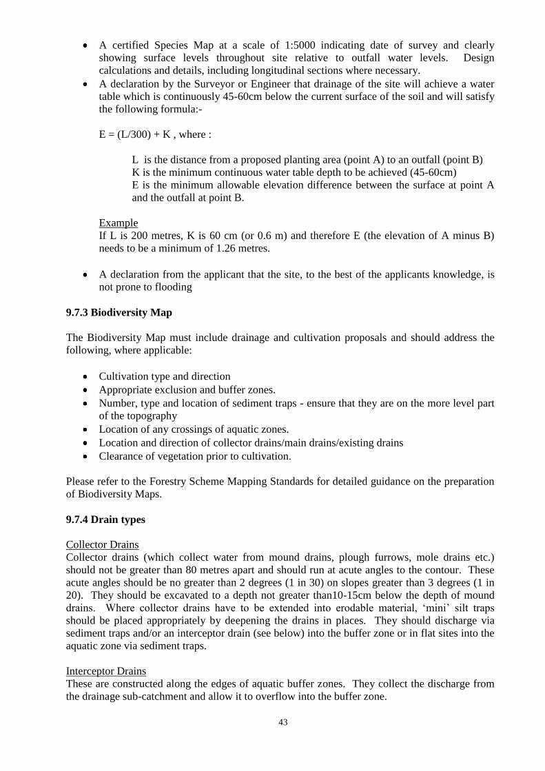
43
A certified Species Map at a scale of 1:5000 indicating date of survey and clearly
showing surface levels throughout site relative to outfall water levels. Design
calculations and details, including longitudinal sections where necessary.
A declaration by the Surveyor or Engineer that drainage of the site will achieve a water
table which is continuously 45-60cm below the current surface of the soil and will satisfy
the following formula:-
E = (L/300) + K , where :
L is the distance from a proposed planting area (point A) to an outfall (point B)
K is the minimum continuous water table depth to be achieved (45-60cm)
E is the minimum allowable elevation difference between the surface at point A
and the outfall at point B.
Example
If L is 200 metres, K is 60 cm (or 0.6 m) and therefore E (the elevation of A minus B)
needs to be a minimum of 1.26 metres.
A declaration from the applicant that the site, to the best of the applicants knowledge, is
not prone to flooding
9.7.3 Biodiversity Map
The Biodiversity Map must include drainage and cultivation proposals and should address the
following, where applicable:
Cultivation type and direction
Appropriate exclusion and buffer zones.
Number, type and location of sediment traps - ensure that they are on the more level part
of the topography
Location of any crossings of aquatic zones.
Location and direction of collector drains/main drains/existing drains
Clearance of vegetation prior to cultivation.
Please refer to the Forestry Scheme Mapping Standards for detailed guidance on the preparation
of Biodiversity Maps.
9.7.4 Drain types
Collector Drains
Collector drains (which collect water from mound drains, plough furrows, mole drains etc.)
should not be greater than 80 metres apart and should run at acute angles to the contour. These
acute angles should be no greater than 2 degrees (1 in 30) on slopes greater than 3 degrees (1 in
20). They should be excavated to a depth not greater than10-15cm below the depth of mound
drains. Where collector drains have to be extended into erodable material, „mini‟ silt traps
should be placed appropriately by deepening the drains in places. They should discharge via
sediment traps and/or an interceptor drain (see below) into the buffer zone or in flat sites into the
aquatic zone via sediment traps.
Interceptor Drains
These are constructed along the edges of aquatic buffer zones. They collect the discharge from
the drainage sub-catchment and allow it to overflow into the buffer zone.
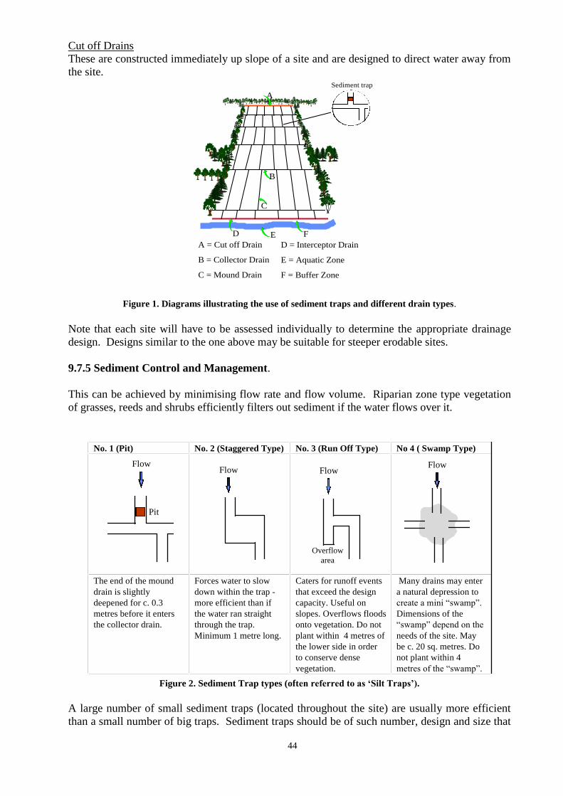
44
Cut off Drains
These are constructed immediately up slope of a site and are designed to direct water away from
the site.
A
B
C
D E
A = Cut off Drain
B = Collector Drain
C = Mound Drain
F
D = Interceptor Drain
E = Aquatic Zone
F = Buffer Zone
Sediment trap
Figure 1. Diagrams illustrating the use of sediment traps and different drain types.
Note that each site will have to be assessed individually to determine the appropriate drainage
design. Designs similar to the one above may be suitable for steeper erodable sites.
9.7.5 Sediment Control and Management.
This can be achieved by minimising flow rate and flow volume. Riparian zone type vegetation
of grasses, reeds and shrubs efficiently filters out sediment if the water flows over it.
Pit
FlowFlow Flow
Flow
No. 1 (Pit) No. 2 (Staggered Type) No. 3 (Run Off Type) No 4 ( Swamp Type)
The end of the mound
drain is slightly
deepened for c. 0.3
metres before it enters
the collector drain.
Forces water to slow
down within the trap -
more efficient than if
the water ran straight
through the trap.
Minimum 1 metre long.
Caters for runoff events
that exceed the design
capacity. Useful on
slopes. Overflows floods
onto vegetation. Do not
plant within 4 metres of
the lower side in order
to conserve dense
vegetation.
Many drains may enter
a natural depression to
create a mini “swamp”.
Dimensions of the
“swamp” depend on the
needs of the site. May
be c. 20 sq. metres. Do
not plant within 4
metres of the “swamp”.
Overflow
area
Figure 2. Sediment Trap types (often referred to as „Silt Traps‟).
A large number of small sediment traps (located throughout the site) are usually more efficient
than a small number of big traps. Sediment traps should be of such number, design and size that
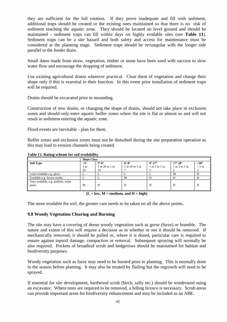
45
they are sufficient for the full rotation. If they prove inadequate and fill with sediment,
additional traps should be created or the existing ones maintained so that there is no risk of
sediment reaching the aquatic zone. They should be located on level ground and should be
maintained - sediment traps can fill within days on highly erodable sites (see Table 11).
Sediment traps can be a site hazard and both safety and access for maintenance must be
considered at the planning stage. Sediment traps should be rectangular with the longer side
parallel to the feeder drain.
Small dams made from straw, vegetation, timber or stone have been used with success to slow
water flow and encourage the dropping of sediment.
Use existing agricultural drains wherever practical. Clear them of vegetation and change their
shape only if this is essential to their function. In this event prior installation of sediment traps
will be required.
Drains should be excavated prior to mounding.
Construction of new drains, or changing the shape of drains, should not take place in exclusion
zones and should only enter aquatic buffer zones where the site is flat or almost so and will not
result in sediment entering the aquatic zone.
Flood events are inevitable - plan for them.
Buffer zones and exclusion zones must not be disturbed during the site preparation operation as
this may lead to erosion channels being created.
Table 11. Rating scheme for soil erodability
Slope Class
Soil Type <3º
1 in
20
3º-6º
1 in 20 to 1 in
10
6º-8º
1 in 10 to 1 in
7
8º-17º
1 in 7 to 1 in
3
17º-30º
1 in 3 to 1 in
2
>30º
> 1 in
2
Least erodable e.g. gleys L L L L M H
Erodable e.g. brown earths L L M H H H
Very erodable, e.g. podsols, some peats
M
H
H
H
H
H
(L = low, M = medium, and H = high)
The more erodable the soil, the greater care needs to be taken on all the above points.
9.8 Woody Vegetation Clearing and Burning
The site may have a covering of dense woody vegetation such as gorse (furze) or bramble. The
nature and extent of this will require a decision as to whether or not it should be removed. If
mechanically removed, it should be pulled or, where it is dozed, particular care is required to
ensure against topsoil damage, compaction or removal. Subsequent spraying will normally be
also required. Pockets of broadleaf scrub and hedgerows should be maintained for habitat and
biodiversity purposes.
Woody vegetation such as furze may need to be burned prior to planting. This is normally done
in the season before planting. It may also be treated by flailing but the regrowth will need to be
sprayed.
If essential for site development, hardwood scrub (birch, sally etc.) should be windrowed using
an excavator. Where trees are required to be removed, a felling licence is necessary. Scrub areas
can provide important areas for biodiversity enhancement and may be included as an ABE.
46
Burning and destruction of vegetation is regulated by the Wildlife Act 1976, as amended by the
Wildlife Act 2000.
Landowners are prohibited from burning vegetation on land not yet cultivated, between
1st March and 31st August of any given year.
It is prohibited to burn vegetation within one mile of a wood without giving notice to the
Garda, Local Authority and the forest owner. In addition, it is prohibited to light a fire
which may ignite vegetation within one mile of a wood.
Fines for breaches of the Act range from €635 to €63,490 and prison terms from 3
months to 2 years, or both a fine and a prison term. Any person engaged in illegal
burning may also be held responsible for any injury or damage caused by the fire.
Landowners should also note that under Good Agricultural and Environmental Conditions
(GAEC) associated with cross-compliance, the burning of growing vegetation on cultivated or
non-cultivated land (including permanent pasture), without approval, is prohibited and could lead
to penalties under the Direct Payment Schemes.
More information on current legislation can be obtained at www.oireachtas.ie.
9.9 Ground Cultivation
9.9.1 Cultivation Methods
Soil Type
Recommended Cultivation
Carboniferous Surface Water Gleys derived from
carboniferous drift and Peaty Gleys and Podsolised
Gleys with less than 20cm of peat remaining
Mound on slopes less than 5 degrees.
Mole Plough on slopes greater than 5
degrees
Peaty Gleys, Podsolised Gleys and Peaty Podsols with
more than 20cm peat and blanket peat
Mound
Peaty podsols, peat depth less than 20cm
Rip
Surface water gleys with adequate slope Mole
Mound
Old red sandstone
Mound
Brown Earths and other free draining mineral soils
with indicated iron pan
Rip
Brown Earths and other free draining mineral soils Rip
Scarify
Double furrow agricultural plough
where ground permits
Suitable soil types and site conditions Mechanical planting is considered
47
9.9.2 Mounding
Mound Drains
Mound drains should be dug using a V-shaped bucket.
Recommended Bucket Specification - conventional winged mounding bucket may be
used for collector drains.
On sites with slopes greater than 4o (1 in 15) the mound drains should run in the direction
of max slope and should be fed into collector drains spaced 50 - 80 m apart and aligned at
a max slope of 2o
(1 in 30). This ensures the slow removal of water from the site
avoiding erosion.
Depth of mound drains is dependent on soil quality for mounding and should not be more
than 45cm in depth in mineral soils and 60cm in peat soils.
Mound drains should normally be spaced 12m apart, but can range from 8-16m
depending on soil, hydrology and moisture condition and to an adequate depth to serve
the drainage over the life of the crop.
In exceptional circumstances, drainage spacing may be greater where soil depth permits
and natural drainage is not a problem.
Collector drains should be excavated to a depth and size capable of collecting water from
mound drains (normally 40cm-60cm deep).
Design drain gradients so that erosion during storms is avoided, i.e. avoid long runs and
use collector drains and sediment traps (see figures 1 and 2).
Separate site and road drainage systems where possible.
Use buffer zones between drain ends and watercourses.
Mounds
Mound rows at 2 metre spacing except where otherwise stated by the Forest Service.
Spacing to be adjusted within rows rather than between rows.
Mound size should be a minimum of 45cm x 45cm x 15cm high to a maximum of 60cm
x 60cm x 20cm high and clearly identifiable.
Mounds should be placed at a minimum of 50cms from the drain edge.
An intimate mix of soil should be used from top to bottom to ensure good planting
medium for each mound.
Avoid excessive subsoil, particularly on limestone derived soils.
Inverted scrap mounds should be considered on steep slopes and free draining soils to
avoid erosion.
A period of settlement after cultivation is required before planting.
On shallow soils where mound material is limited, supplement mounds taken from drain
with scrap mounds taken from the side of the drains.
9.9.3 Ripping
Rip at 2m spacing to 45cm depth using twin ripper tines.
The tines should have wings fitted at bottom to ensure maximum disruption.
In exceptional circumstances, deeper ripping may be necessary in order to break up
consolidated soil layers or deep pans.
Site collector drains should be excavated at spacing of 50m in order to collect water
running in rips and to prevent risk of erosion and /or flooding of headland or adjacent
land. In easily erodable sites, e.g. old red sandstone areas, closer drain spacing should be
considered and be aligned at a slope of 2º (1 in 30).
Depth of collector drains should be 55-60cm.
48
9.9.4 Moling
Mole at 2m spacing.
Install mole drains at a depth of 45cm.
Use collector drain with sloped side walls spaced 50-80cm apart and to a depth of 55-
60cm.
Mole plough type - moling units are directly mounted on low ground pressure machines.
Where a ball and chain is used for mole drains, the size of the ball should be
approximately 10cm diameter.
9.9.5 Scarifying
Scarifying should not be considered in shallow soils.
Scarify to a depth of 10 to 20cm.
Collector drains to be installed as required. On sites with slopes greater than 4o
(1 in 15),
especially in ORS derived soils, space collector drains at 50m apart and align at a slope
of 2o (1 in 30).
Planting area to be cleared of vegetation for an average width of 60cm.
9.9.6 Agricultural Ploughing (double furrow)
Agricultural Ploughing should only be carried out on free draining agricultural soils with
no compaction layer.
Plough using a double furrow plough to depth of 20cm at 2m apart
(Plough using a double furrow plough with a rip attachment has been shown to be
effective)
Planting area (double furrow) to be vegetation free for a width of 80cm.
Plant on the sod furthest from the furrow or between the two sods, ensuring no air
pockets
Install collector drains as required at 80m apart on slopes greater than 4º ( 1 in 15),
especially on easily erodable soils.
9.9.7 Planting Machines
Suitable for good free draining agricultural land.
Tine designed to ensure that there is appropriate disruption of the soil profile.
Care should be exercised to ensure that the slit opened by the planting machine is closed
properly.
9.9.8 Pit Planting
Pit planting is suitable for mineral or old woodland sites. It may also be appropriate for steep
slopes where other types of preparation may lead to sediment run off.
9.10 Stocking and Spacing
Table 12 represents the minimum spacing and stocking requirements for all species at initial
planting stage. Only sites that are planted at these stocking levels or greater should be submitted
for 1st instalment payment.
49
Table 12. Minimum stocking and spacing for conifers and broadleaves
Species
Spacing Stocking/ha
LP pure 1.8m X 1.8m 3,100
All other Conifers 2.0m X 2.0m 2,500
Oak pure 2.0 m X 1.5m 3,300
Oak/nurse mix 10 lines of oak and one line of nurse
species
- Oak 2.0m X 1.5m
- nurse 2.0m X 1.5m
3,300
Beech pure 2.0 m X 1.5m 3,300
Beech/nurse mix 10 lines of beech and one line of nurse
species
- Oak 2.0m X 1.5m
- nurse 2.0m X 1.5m
3300
Ash, Sycamore and
other broadleaves
2.0m X 1.5m 3,300
Alder 2.0 m x 2.0 m 2,500
9.11 Plant Quality
Transplants (planting stock) must have the characteristics of plants in accordance with the
following definition:-
(a) A straight stem with a definite leader.
(b) A well balanced foliage with a good fibrous root system.
(c) A specified height to provide for size above ground when planted.
(d) A specified root collar diameter to provide for hardiness.
(e) Age must not exceed a specified maximum.
Transplants should be within the quality limits set out in Table 13 and 14 below.
Table 13. Broadleaves - Quality limits for transplants
Species Max. age (Yrs) Min. Collar Diameter (mm)
Stem Height (cm)
Ash
3
4
7
12
50-75
60-90
Oak/Spanish chestnut/Beech 4
4
5
6
7
9
45 75
55-70
70-85
Sycamore 3 7 45-75
Alder 3 4 30-60
Other broadleaves 5 4 40-75
50
Table 14. Conifers - Quality limits for transplants
Species Max. age (Yrs) Min. Collar Diameter (mm)
Stem Height (cm)
SS 4 6 (4*) 31-65 (20-30*)
NS 4 6 (4*) 31-50 (20-30*)
LP 2 3 10-20
SP 3 4 20-40
CP 3 3 10-30
EL, HL 3 5 35-60
DF 4 8 40-60
WRC/WH/OC 4 4 25-45
(*) These are Size 2 Category Plants and apply only to SS and NS. They are suitable for sites without the potential
for the vigorous growth of competing vegetation, provided the site is not liable to frost.
9.12 Plant Handling and Planting
Good plant handling is as important as plant quality. The following should be observed.
9.12.1 General Plant Handling Issues
Co-ordination and timing of plant deliveries from nursery to planting site is essential to
ensure that the health of the plants is maintained.
Non bagged plants, and plants removed from bags, should be trenched-in on the planting
site as soon as possible.
Plants should not be left with roots exposed and should be stored/trenched in the shade.
Cold storage plants should be planted within two weeks of removal from cold store.
Containerised plants should not be allowed to dry out on site.
9.12.2 Using Co-extruded plastic bags
Bagged plants should be bagged in nurseries using co-extruded bags. The trees should be
bagged in dry conditions free of excess soil.
The date of lifting in the nursery should be known. The week in which the plants are
lifted is usually indicated on the labels attached to the bags.
Plants in co-extruded bags should be stored in the shade.
Plants should not normally remain in bags for longer than 4 weeks after lifting in the
nursery, but this period should be reduced to 2 weeks for those lifted early or late in the
season.
Plant condition should be checked 2 weeks after receipt on the planting site. This period
should be reduced to a week during the early and late parts of the lifting season. If there
is evidence of heating, plant immediately. Leave bags slightly open to allow cooling
without excessive drying.
Bags showing evidence of damage should be repaired with heavy duty tape or placed
inside another new bag.
Litter warning
It is against the law to litter.
Do not submit an application for payment until all packaging including planting bags,
fertiliser bags herbicide containers etc. are removed from the site and disposed of in an
environmentally responsible manner. Burning of plastic containers and bags is not
acceptable. Note Forest Service penalty for dumping.
51
9.12.3 Planting Methods
Trees must be planted correctly to provide optimum conditions for successful establishment.
The main forms of planting are described below.
Slit planting
A spade is used to make a vertical slit in the ground. The trees roots are carefully positioned in
the slit to ensure that roots are equally spaced in the vertical slit created. The slit is closed and
firmed up ensuring the tree is vertical and upright. It is important to ensure that roots are not
bent over which can lead to poor development, e.g. J root. This form of planting can be suitable
for ribbons, mounds and ripped ground.
Angle notch
A spade is used to cut a T or L-shaped slit in the ground. The spade is used to lift the slit and the
trees roots placed underneath to ensure good root distribution without causing damage. The slit
is closed and firmed up to ensure that stem is left vertical and upright.
Pit planting
A spade is used to dig a hole and the trees roots placed in the centre. Soil is placed around the
tree and firmed in, ensuring that it is upright and straight. This form of planting can be used in
sensitive sites where no ground preparation has taken place.
9.12.4 Planting Position
Trees must be planted and positioned on top of mounds or ribbons and beside rips. It is
important to ensure that trees are planted vertical and upright to reduce the incidence of bad form
on the lower stem. Position the roots in the slit to ensure good distribution, which will lessen the
potential for badly formed roots and stems, e.g. J- roots, basal sweep.
9.13 Lifting and Planting Dates
Provided that the handling guidelines listed above are adhered to, and morphological quality and
size is acceptable, the planting stock should be in good condition at time of planting. In addition
to the risk of plant mortality, shoot dieback is a common response to poor handling/planting
practices. Recommended periods of planting for several species are given in Figure 3.
The success of transplants after planting depends on plant quality and post planting
environmental conditions. During the period of „Less certainty‟ (see Figure 3 below) the
likelihood of success will vary with plant dormancy level at the time of lifting and post planting
conditions. Planting should be carried out soon after the plants arrive on the site to minimise
these effects.
Cold Store Plants
Plants from cold storage can be used to extend the planting season to late April / early May.
Planting cold stored plants late in the planting season can be risky as the risk of drought
increases. Results have shown that where cold stored plants have been planted late in the
planting season the height increment was reduced, especially for larch.
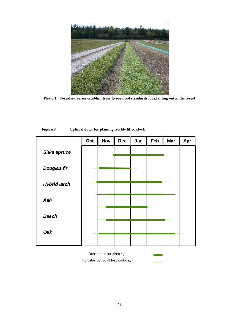
52
Photo 1 : Forest nurseries establish trees to required standards for planting out in the forest
Figure 3. Optimal dates for planting freshly lifted stock
Oct Nov Dec Jan Feb Mar Apr
Best period for planting
Indicates period of less certainty
Sitka spruce Douglas fir Hybrid larch Ash Beech Oak Sycamore
53
9.14 Fertiliser Application
9.14.1 General.
Apply fertiliser manually after cultivation to afforestation sites avoiding drains, buffer
zones, areas within 20 metres of aquatic zones and waterlogged areas.
Fertiliser should not be applied during or immediately after periods of heavy rainfall. It
is best applied in early summer and not outside the period April to August.
Subsequent application of fertiliser should be undertaken following a prescription
resulting from a chemical analysis of foliar samples. Observe the Forestry and Water
Quality Guidelines, in particular the section on Fertiliser Application and Storage (Page
7) and Forestry and Aerial Fertiliser Guidelines (where applicable).
All fertiliser should be applied broadcast and evenly distributed.
Correct time of application between the months of April to August inclusive.
Apply after planting.
Do not apply fertiliser to waterlogged soil.
Do not apply during or after heavy rainfall.
9.14.2 Phosphate
Phosphorous applications in forestry must ensure that, while trees have sufficient phosphorus for
sustainable growth, water quality or habitats are not damaged by phosphorous eutrophication.
Forests are sometimes located in areas where naturally nutrient poor water bodies are vulnerable
to enrichment if even small amounts of nutrients are discharged into them. Forest owners,
foresters, managers and contractors must ensure that enrichment of waters does not result from
their actions.
Phosphorous deficiency in trees can be characterised by
Poor height growth
Dull green colour on needles
Reduced needle length
Sparse foliage
Correct phosphorous management in forestry entails correct fertiliser application in terms of rate
and timing and prevention of sedimentation of aquatic zones.
The following sets out phosphorous requirements for Sitka spruce at establishment time and
should not be exceeded during the establishment of that species. It is a guide for other species.
Table 15: Phosphate Requirements
Site Type Rate of Application of
Granulated Rock Phosphate (approx 11% P)
Ungranulated Rock Phosphate (approx 14% P)
Enclosed/Improved fields
recently farmed
None
Former agricultural land
not recently worked
250 kg./ha.
Unenclosed land 350 kg./ha. (on very poor sites, two applications may be necessary,
350 kg/ha. at establishment and a second application of 250 kg/ha.
as required.)
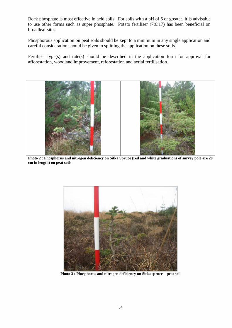
54
Rock phosphate is most effective in acid soils. For soils with a pH of 6 or greater, it is advisable
to use other forms such as super phosphate. Potato fertiliser (7:6:17) has been beneficial on
broadleaf sites.
Phosphorous application on peat soils should be kept to a minimum in any single application and
careful consideration should be given to splitting the application on these soils.
Fertiliser type(s) and rate(s) should be described in the application form for approval for
afforestation, woodland improvement, reforestation and aerial fertilisation.
Photo 2 : Phosphorus and nitrogen deficiency on Sitka Spruce (red and white graduations of survey pole are 20
cm in length) on peat soils
Photo 3 : Phosphorus and nitrogen deficiency on Sitka spruce – peat soil
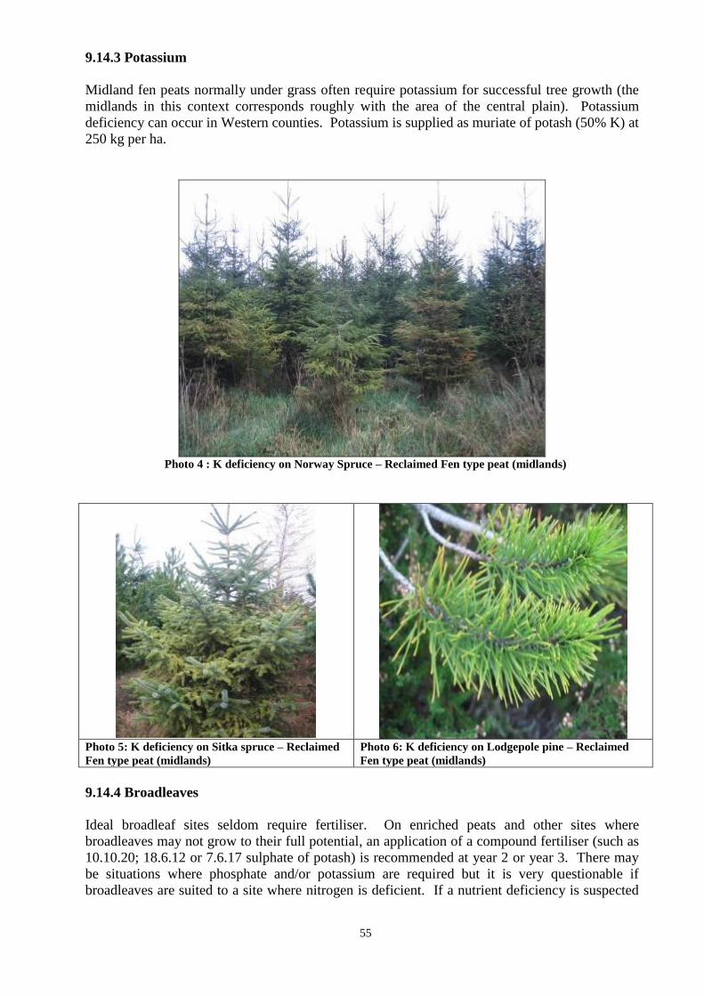
55
9.14.3 Potassium
Midland fen peats normally under grass often require potassium for successful tree growth (the
midlands in this context corresponds roughly with the area of the central plain). Potassium
deficiency can occur in Western counties. Potassium is supplied as muriate of potash (50% K) at
250 kg per ha.
Photo 4 : K deficiency on Norway Spruce – Reclaimed Fen type peat (midlands)
Photo 5: K deficiency on Sitka spruce – Reclaimed
Fen type peat (midlands)
Photo 6: K deficiency on Lodgepole pine – Reclaimed
Fen type peat (midlands)
9.14.4 Broadleaves
Ideal broadleaf sites seldom require fertiliser. On enriched peats and other sites where
broadleaves may not grow to their full potential, an application of a compound fertiliser (such as
10.10.20; 18.6.12 or 7.6.17 sulphate of potash) is recommended at year 2 or year 3. There may
be situations where phosphate and/or potassium are required but it is very questionable if
broadleaves are suited to a site where nitrogen is deficient. If a nutrient deficiency is suspected
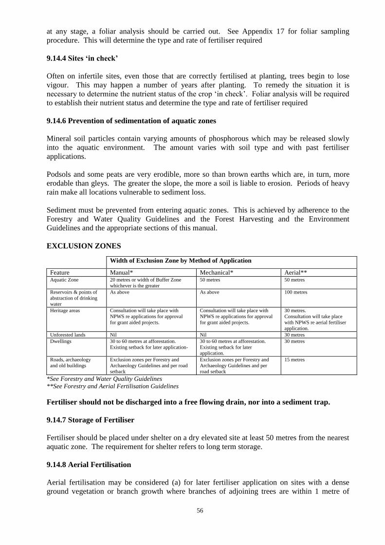
56
at any stage, a foliar analysis should be carried out. See Appendix 17 for foliar sampling
procedure. This will determine the type and rate of fertiliser required
9.14.4 Sites „in check‟
Often on infertile sites, even those that are correctly fertilised at planting, trees begin to lose
vigour. This may happen a number of years after planting. To remedy the situation it is
necessary to determine the nutrient status of the crop „in check‟. Foliar analysis will be required
to establish their nutrient status and determine the type and rate of fertiliser required
9.14.6 Prevention of sedimentation of aquatic zones
Mineral soil particles contain varying amounts of phosphorous which may be released slowly
into the aquatic environment. The amount varies with soil type and with past fertiliser
applications.
Podsols and some peats are very erodible, more so than brown earths which are, in turn, more
erodable than gleys. The greater the slope, the more a soil is liable to erosion. Periods of heavy
rain make all locations vulnerable to sediment loss.
Sediment must be prevented from entering aquatic zones. This is achieved by adherence to the
Forestry and Water Quality Guidelines and the Forest Harvesting and the Environment
Guidelines and the appropriate sections of this manual.
EXCLUSION ZONES
Width of Exclusion Zone by Method of Application
Feature Manual* Mechanical* Aerial** Aquatic Zone 20 metres or width of Buffer Zone
whichever is the greater
50 metres 50 metres
Reservoirs & points of
abstraction of drinking water
As above As above 100 metres
Heritage areas Consultation will take place with
NPWS re applications for approval
for grant aided projects.
Consultation will take place with
NPWS re applications for approval
for grant aided projects.
30 metres.
Consultation will take place
with NPWS re aerial fertiliser application.
Unforested lands Nil Nil 30 metres
Dwellings 30 to 60 metres at afforestation.
Existing setback for later application-
30 to 60 metres at afforestation.
Existing setback for later application.
30 metres
Roads, archaeology
and old buildings
Exclusion zones per Forestry and
Archaeology Guidelines and per road
setback
Exclusion zones per Forestry and
Archaeology Guidelines and per
road setback
15 metres
*See Forestry and Water Quality Guidelines
**See Forestry and Aerial Fertilisation Guidelines
Fertiliser should not be discharged into a free flowing drain, nor into a sediment trap.
9.14.7 Storage of Fertiliser
Fertiliser should be placed under shelter on a dry elevated site at least 50 metres from the nearest
aquatic zone. The requirement for shelter refers to long term storage.
9.14.8 Aerial Fertilisation
Aerial fertilisation may be considered (a) for later fertiliser application on sites with a dense
ground vegetation or branch growth where branches of adjoining trees are within 1 metre of
57
touching each other or, (b) for initial fertilisation of mineral sites which have no cultivation
drains.
Prior approval must be obtained from the Forest Service for aerial fertilisation.
The European Communities (Aerial Fertilisation) (Forestry) Regulations 2006 (S.I. No. 592 of
2006), as amended, provide a statutory basis for licensing aerial fertilisation. Applicants may
apply for a licence to the Forest Service. Details on the application procedure, the consultation
process and the operational requirements, are described in the FORESTRY AND AERIAL
FERTILISATION GUIDELINES and are available from the Forest Service.
9.15 Fencing
9.15.1 General
Plantations must be fully protected from the time of planting. Where fencing is involved, it must
be to the Irish Standard 436:2001 to claim the higher rates of grant aid. Copies of this standard
are available from the National Standards of Ireland (NSAI).
There is no requirement to duplicate existing stock proof fences, substantial walls, or other stock
proof boundaries with additional fencing. Adequate access to plantations for management
purposes can be provided using styles and or secured temporary openings in fence lines. There
is no requirement or additional funding to provide gates to all plots. All existing fences and
boundaries must be to a standard which can exclude domestic stock and protect the growing
crop. If plots require rabbit fencing, the entire area to be protected must be enclosed with a
rabbit proof fence. Tree guards for rabbit and hare protection can be used for small areas
otherwise protected from livestock. These must be to such a height that the rabbits or hares
cannot damage the tops of the trees (normally 75cm high tree guards are sufficient)
Stiles must be erected at access points to all plantations and designed and maintained to
allow safe access.
Electric fencing is not acceptable unless supplementing the specifications given in Table 16.
9.15.2 Fencing wire and netting
The wire used must be to the following International Standards.
I.S. EN 10223-1 Steel wire and wire products for fences – Part 1: Zinc and zinc-
alloy coated steel barbed wire
I.S. EN 10223-5 Steel wire and wire products for fences – Part 5: Steel wire woven
hinged joint and knotted mesh fencing
I.S. 126 Galvanised Fencing Wire.
Other netting and wire requirements include the following:
The mesh in rabbit netting should not exceed 32mm (1.25”). 19 gauge wire is
recommended. No weaker than 21 gauge wire should be used.
Rectangular mesh netting or chain link fencing for sheep should not exceed 15cms x
20cms (6” x 8”).
Plain wire of single strand mild steel should be 4mm in diameter.
Barbed wire consists of two line wires of 2.5mm mild steel or two line wires of 1.6mm
high tensile steel having 4 point barbs at intervals between 75mm and 85mm.
Use galvanised staples made from 4mm diameter wire and 38mm (1.5”) long.
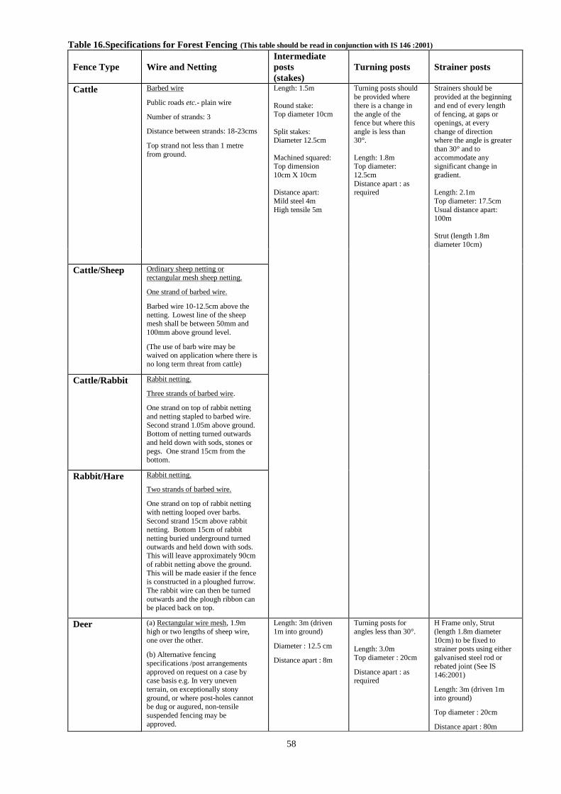
58
Table 16.Specifications for Forest Fencing (This table should be read in conjunction with IS 146 :2001)
Fence Type
Wire and Netting
Intermediate
posts
(stakes)
Turning posts
Strainer posts
Cattle Barbed wire
Public roads etc.- plain wire
Number of strands: 3
Distance between strands: 18-23cms
Top strand not less than 1 metre
from ground.
Length: 1.5m
Round stake: Top diameter 10cm
Split stakes: Diameter 12.5cm
Machined squared: Top dimension
10cm X 10cm
Distance apart:
Mild steel 4m
High tensile 5m
Turning posts should
be provided where
there is a change in the angle of the
fence but where this
angle is less than 30°.
Length: 1.8m Top diameter:
12.5cm
Distance apart : as required
Strainers should be
provided at the beginning
and end of every length of fencing, at gaps or
openings, at every
change of direction where the angle is greater
than 30° and to
accommodate any significant change in
gradient.
Length: 2.1m
Top diameter: 17.5cm
Usual distance apart: 100m
Strut (length 1.8m diameter 10cm)
Cattle/Sheep
Ordinary sheep netting or
rectangular mesh sheep netting.
One strand of barbed wire.
Barbed wire 10-12.5cm above the
netting. Lowest line of the sheep mesh shall be between 50mm and
100mm above ground level.
(The use of barb wire may be waived on application where there is
no long term threat from cattle)
Cattle/Rabbit
Rabbit netting.
Three strands of barbed wire.
One strand on top of rabbit netting
and netting stapled to barbed wire.
Second strand 1.05m above ground. Bottom of netting turned outwards
and held down with sods, stones or
pegs. One strand 15cm from the bottom.
Rabbit/Hare
Rabbit netting.
Two strands of barbed wire.
One strand on top of rabbit netting
with netting looped over barbs.
Second strand 15cm above rabbit netting. Bottom 15cm of rabbit
netting buried underground turned
outwards and held down with sods. This will leave approximately 90cm
of rabbit netting above the ground.
This will be made easier if the fence
is constructed in a ploughed furrow.
The rabbit wire can then be turned
outwards and the plough ribbon can be placed back on top.
Deer
(a) Rectangular wire mesh, 1.9m
high or two lengths of sheep wire,
one over the other.
(b) Alternative fencing
specifications /post arrangements
approved on request on a case by case basis e.g. In very uneven
terrain, on exceptionally stony
ground, or where post-holes cannot be dug or augured, non-tensile
suspended fencing may be
approved.
Length: 3m (driven
1m into ground)
Diameter : 12.5 cm
Distance apart : 8m
Turning posts for
angles less than 30°.
Length: 3.0m
Top diameter : 20cm
Distance apart : as required
H Frame only, Strut
(length 1.8m diameter
10cm) to be fixed to strainer posts using either
galvanised steel rod or
rebated joint (See IS 146:2001)
Length: 3m (driven 1m
into ground)
Top diameter : 20cm
Distance apart : 80m
59
Fixed Grant System – IS436 Fencing Certified
To qualify for the higher IS436 grant rates, all fencing posts claimed in the 100 metre per hectare
allowance must be certified to this standard. Where part of the 100 metre per hectare allowance
claim contains non IS436 material the entire allowance will be assessed at the non IS436 grant
rate.
An IS436 Fencing Post Certificate must be completed in full and attached to the Form 2. A
sample certificate is attached in Appendix 24 for your information, with explanatory notes.
Mapping
All applications for grant aid must be clearly identified, outlining the location of each fence type
and with measured length erected in metres on a separate “Fencing Map” as described in the
revised Mapping Standards. The map must clearly state which grant is being claimed, i.e.
“Certified IS 436” or “Non Certified IS436”. The post and wire arrangements for Forest
Fencing is outlined in Table 16, applies to all fences erected on afforestation sites.
9.16 Fire
The potential fire risk to proposed plantations in high fire risk areas should be assessed and
methods to reduce risks devised, described and implemented. This is a requirement for grant
approval. The presence of any flammable vegetation, such as purple moor grass, furze and
heather, is a strong indication that a firebreak is required. Firebreaks need regular maintenance
where a fire risk exists.
Firebreaks should constitute a fuel free zone of 6m in width and should normally be placed along
the external boundaries of plantations. However, in blocks of 60 ha or more, internal firebreaks,
roads or other fuel free zones should be considered. Most fires spread from adjoining lands into
forests and for that reason firebreaks are most often on the forest boundary. However they are an
intensive form of soil disturbance so it is important to depart from the boundary when
constructing them if archaeological, water quality, biodiversity or other issues demand. In these
instances, the appropriate buffer and exclusion zones must be observed and the firebreak must be
made the required distance back from the features. Landscape considerations may also dictate
that part or all of the firebreak should depart from the forest boundary and be made inside the
forest.
Large forest properties (>60 ha), where there is a fire risk, should be served by reservoirs as an
aid to fire control. The acceptable specification for a reservoir is a minimum capacity of 22,700
litres (5000 Gallons).
A reservoir should be fully operational during fire danger periods and easily accessible to
vehicles. All reservoirs should be adequately fenced.
NOTE: The Forest Service does not provide funding for reconstitution following damage to
forests by fire. Forest owners who fail to reconstitute a damaged plantation will be
considered a breach of contract and repayment of all grants and premiums will be
required and further premium payments will be stopped on the relevant plantation.
60
THE FOREST SERVICE STRONGLY RECOMMENDS THAT FOREST OWNERS
ENSURE THAT THEY HAVE ADEQUATE INSURANCE IN THE EVENT OF A FIRE,
INCLUDING THE COST OF RECONSTITUTION
Procedure for reporting fire damage to forest plantations In the springs of 2010 and 2011 significant damage was caused to the national forest estate as a
result of wildfires. Many forest owners incurred considerable losses as a result of these fires,
which destroyed valuable timber resources.
Obligation of Forest Owners Beneficiaries of afforestation grants and premiums are obliged to maintain and protect their forest
for a period of up to 20 years from the date the grant was paid. This means that there is an
obligation on the beneficiary to replant where the forest is damaged by fire.
Failure to adequately protect and maintain a grant aided forest can result in cessation of premium
payment and may, ultimately, result in recoupment of all grant and premium monies received,
unless remedial work is satisfactorily carried out.
If your forest is damaged by fire you must follow the procedures set out below.
1 Submit a Reconstitution Notification Form 1: Application for Approval form as
quickly as possible. This form is used (i) to inform the Department that the forest has been
damaged (ii) to provide details of the work required to reconstitute (replant) the site and
(iii) to obtain the approval of the Forest Service to carry out the proposed reconstitution
works. The forest owner completes pages 1 and 2 of the form, while pages 3 and 4 must
be completed by a Forester. A map of the site clearly identifying the damaged area, along
with any proposed changes in species, prepared and signed by the Forester, must
accompany the Form 1.
Note: Forestry premium payments may be suspended until the reconstitution works have
been completed, depending on the extent of the damage.
If the plan is acceptable to the Forest Service, the forest owner will be notified in writing
to proceed with the reconstitution works.
2 When the reconstitution works have been completed, a Form 2: Reconstitution
Notification Form should be submitted to the Department. The forest owner completes
pages 1, 2 and 3 of the form, while pages 4 and 5 must be completed by a Forester. A
certified Species Map, prepared and signed by the Forester, must accompany the Form 2.
3 The forest will be liable for further inspection by the Department 4 years after the
reconstitution works are completed and a Form 3: Reconstitution Notification Form will
be posted to the forest owner for completion and return, in advance of the inspection.
The Forest Service strongly recommends that the following cost effective steps should be
implemented in order to address the risk of fire damage to your forest:
Consider the financial consequences of fire damage – it is the responsibility of each forest
owner to ensure that adequate insurance, including for reconstitution costs, is in place
Firebreaks should be well maintained and checked at least once a year
Have a Fire Plan and review it regularly – list key contact numbers and discuss procedures
with family members

61
Raise awareness with your neighbours so that people are not careless in the vicinity of the
forest – make sure they are aware of the legal ban on the burning of growing vegetation on
uncultivated land between 1 March and 31 August each year
Landowners who set fires to burn vegetation are obliged to give you (and the Gardaí)
written notice if they intend to burn within a mile of your forest and you are entitled to
object by counter notice (within three days)
Take responsibility by reporting any suspicious activity to the Gardai
The prompt reporting of forest fires is essential and for this purpose a dedicated email address
[email protected] has been allocated. You can also report fires during normal
working hours by phoning lo-call number 1890 200 509 or in writing to Forestry Division (Forest
Fires), Department of Agriculture, Food and the Marine, Johnstown Castle Estate, Wexford.
Any information submitted will be treated in the strictest confidence. However, it should be noted
that the Department is subject to the provisions of the Freedom of Information (FOI) Acts.
For further information on to http://www.agriculture.gov.ie/forestservice/landandforestfires
9.17 Weed Control
Weeds reduce both the survival and height growth of trees by competing for light, moisture and
nutrients. It has been demonstrated that the most effective and efficient means of controlling
weeds is by the use of herbicides. By controlling vegetation in a 1m diameter spot (or 1m
wide band) around the base of trees in the initial 4 years, successful establishment to Forest
Service standards should be achieved.
Weed control should be undertaken in accordance with the booklet „Guidelines for the use of
Herbicides in forestry‟ published by Coillte Teoranta on behalf of the Forest Service.
Please note that the use of chemicals is governed by the Health and Safety at Work Act 2005 and
users should be familiar with manufacturer‟s instructions.
9.18 Standards
9.18.1 General
Applications submitted for pre-approval and grant payment must adhere to standards outlined in
the following documents and guidelines, which are a condition of approval;
Forestry Schemes Manual
Current Scheme Document
Forestry Schemes Mapping Standards
Forestry and Water Quality Guidelines
Forest Biodiversity Guidelines
Forestry and the Landscape Guidelines
Forest Harvesting and the Environment Guidelines
Forestry and Archaeology Guidelines
Forest Road Manual: Guidelines for the Design, Construction and Management of Forest
Roads (COFORD, 2005)
Code of Best Forest Practice - Ireland
Forestry and Freshwater Pearl Mussel Requirements: Site Assessment and Mitigation
Measures
62
Registered Foresters and applicants must ensure that applications are complete and are within the
scope of the scheme. A site inspection by Registered Foresters is mandatory at all stages, i.e.
Form 1, 2 and 3. The following sections provide a summary of requirements at each stage of the
approval and grant payment process. Specific scheme requirements are detailed in the Scheme
Documents available on the Department‟s website.
Pre-approval (Form 1)
Applications submitted for approval must include and adhere to the following
Application form fully completed
Species proposed are silvicultural and environmentally suited to the site
Applicants declaration completed, dated and signed
Registered Foresters declaration completed, dated and signed
Certified Species Map and species plot table completed in accordance with Forestry
Schemes Mapping Standards
Biodiversity Map completed in accordance with Mapping Standards
Fencing Map
Forest Road Map (Roads Scheme)
Forest Road Specification (Roads Scheme)
Inventory Details (Road Scheme)
Scheduled of Proposed Costs/Operations (Roads, Reconstitution, Native Woodland
Conservation Schemes)
All areas ineligible for aid excluded from claimed area, e.g. areas of shell marl
GPC categories correctly identified and mapped, e.g. GPC1
Calcium carbonate test results submitted ( if applicable)
Drainage Survey Report attached ( if applicable)
Soil Analysis Report attached ( if applicable)
Environmental Impact Statement attached (if applicable)
Payment (Form 2)
Applications submitted for payment of a 1st Instalment grant must include and adhere to the
following
Application form fully completed
Applicants declaration completed, dated and signed
Registered Foresters declaration completed, dated and signed
Planted forest complies with the Forestry Schemes Manual, environmental guidelines,
schemes documents outlined above, approval letter and additional specific approval
conditions, if applicable
Certified Species Map and species plot table completed in accordance with Forestry
Schemes Mapping Standards
Forest Road Map (Roads Scheme)
Biodiversity Map completed in accordance with Mapping Standards
Fencing Map and claimed length in accordance with Mapping Standards and
requirements
Provenance Declaration forms completed for all species, as required
Tax Clearance Certificates
Valid Mandate (if applicable)
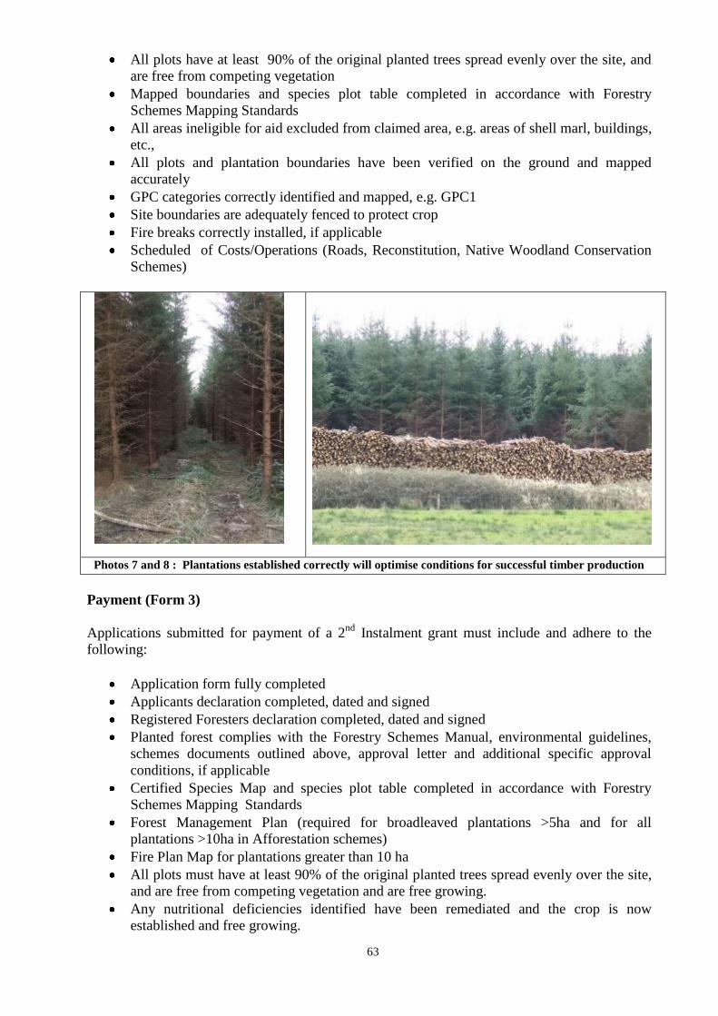
63
All plots have at least 90% of the original planted trees spread evenly over the site, and
are free from competing vegetation
Mapped boundaries and species plot table completed in accordance with Forestry
Schemes Mapping Standards
All areas ineligible for aid excluded from claimed area, e.g. areas of shell marl, buildings,
etc.,
All plots and plantation boundaries have been verified on the ground and mapped
accurately
GPC categories correctly identified and mapped, e.g. GPC1
Site boundaries are adequately fenced to protect crop
Fire breaks correctly installed, if applicable
Scheduled of Costs/Operations (Roads, Reconstitution, Native Woodland Conservation
Schemes)
Photos 7 and 8 : Plantations established correctly will optimise conditions for successful timber production
Payment (Form 3)
Applications submitted for payment of a 2nd
Instalment grant must include and adhere to the
following:
Application form fully completed
Applicants declaration completed, dated and signed
Registered Foresters declaration completed, dated and signed
Planted forest complies with the Forestry Schemes Manual, environmental guidelines,
schemes documents outlined above, approval letter and additional specific approval
conditions, if applicable
Certified Species Map and species plot table completed in accordance with Forestry
Schemes Mapping Standards
Forest Management Plan (required for broadleaved plantations >5ha and for all
plantations >10ha in Afforestation schemes)
Fire Plan Map for plantations greater than 10 ha
All plots must have at least 90% of the original planted trees spread evenly over the site,
and are free from competing vegetation and are free growing.
Any nutritional deficiencies identified have been remediated and the crop is now
established and free growing.
64
Broadleaves shaped as described in this manual (see section 9.18.5)
Mapped boundaries and species plot table completed in accordance with Forestry
Schemes Mapping Standards
All areas ineligible for aid excluded from claimed area, e.g. areas of shell marl, buildings,
etc.,
All plots and plantation boundaries have been verified on the ground and mapped
accurately
GPC categories correctly identified and mapped, e.g. GPC1
Site boundaries are adequately fenced to protect crop
Installed fire breaks and silt traps maintained
Only when the entire plantation is established satisfactorily should a Form 3 be submitted for
payment. Where part of the plantation is not up to standard, the applicant should not submit a
Form 3. Any Form 3 submitted that falls into this category will not be paid.
9.18.2 Fertility
Plantations where trees are showing signs of nutrient deficiency should not be submitted for 2nd
instalment payment. In such cases, a foliar analysis should be undertaken to determine the
fertiliser type and rate to be applied. The site should then be fertilised accordingly and,
following a successful response to the application of fertiliser, the site should then be submitted
for 2nd instalment payment.
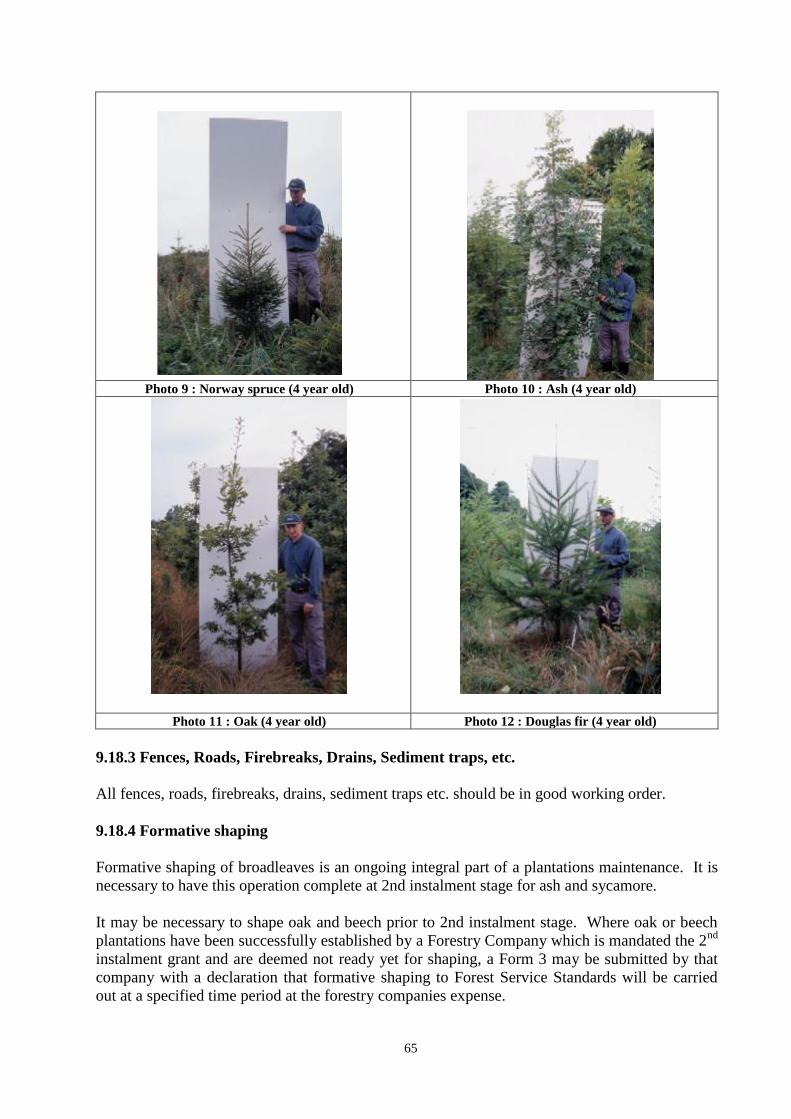
65
Photo 9 : Norway spruce (4 year old) Photo 10 : Ash (4 year old)
Photo 11 : Oak (4 year old) Photo 12 : Douglas fir (4 year old)
9.18.3 Fences, Roads, Firebreaks, Drains, Sediment traps, etc.
All fences, roads, firebreaks, drains, sediment traps etc. should be in good working order.
9.18.4 Formative shaping
Formative shaping of broadleaves is an ongoing integral part of a plantations maintenance. It is
necessary to have this operation complete at 2nd instalment stage for ash and sycamore.
It may be necessary to shape oak and beech prior to 2nd instalment stage. Where oak or beech
plantations have been successfully established by a Forestry Company which is mandated the 2nd
instalment grant and are deemed not ready yet for shaping, a Form 3 may be submitted by that
company with a declaration that formative shaping to Forest Service Standards will be carried
out at a specified time period at the forestry companies expense.
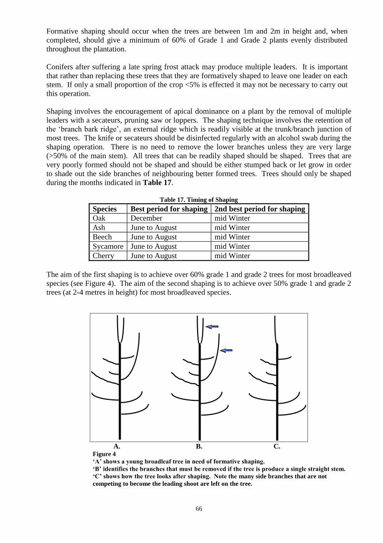
66
Formative shaping should occur when the trees are between 1m and 2m in height and, when
completed, should give a minimum of 60% of Grade 1 and Grade 2 plants evenly distributed
throughout the plantation.
Conifers after suffering a late spring frost attack may produce multiple leaders. It is important
that rather than replacing these trees that they are formatively shaped to leave one leader on each
stem. If only a small proportion of the crop <5% is effected it may not be necessary to carry out
this operation.
Shaping involves the encouragement of apical dominance on a plant by the removal of multiple
leaders with a secateurs, pruning saw or loppers. The shaping technique involves the retention of
the „branch bark ridge‟, an external ridge which is readily visible at the trunk/branch junction of
most trees. The knife or secateurs should be disinfected regularly with an alcohol swab during the
shaping operation. There is no need to remove the lower branches unless they are very large
(>50% of the main stem). All trees that can be readily shaped should be shaped. Trees that are
very poorly formed should not be shaped and should be either stumped back or let grow in order
to shade out the side branches of neighbouring better formed trees. Trees should only be shaped
during the months indicated in Table 17.
Table 17. Timing of Shaping
Species Best period for shaping 2nd best period for shaping
Oak December mid Winter
Ash June to August mid Winter
Beech June to August mid Winter
Sycamore June to August mid Winter
Cherry June to August mid Winter
The aim of the first shaping is to achieve over 60% grade 1 and grade 2 trees for most broadleaved
species (see Figure 4). The aim of the second shaping is to achieve over 50% grade 1 and grade 2
trees (at 2-4 metres in height) for most broadleaved species.
A. B. C.
Figure 4
„A‟ shows a young broadleaf tree in need of formative shaping.
„B‟ identifies the branches that must be removed if the tree is produce a single straight stem.
„C‟ shows how the tree looks after shaping. Note the many side branches that are not
competing to become the leading shoot are left on the tree.
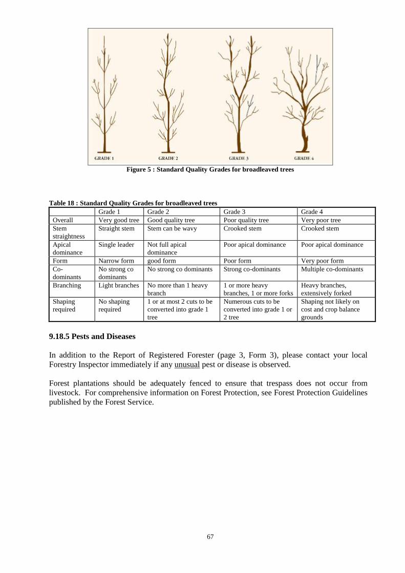
67
Figure 5 : Standard Quality Grades for broadleaved trees
Table 18 : Standard Quality Grades for broadleaved trees
Grade 1 Grade 2 Grade 3 Grade 4
Overall Very good tree Good quality tree Poor quality tree Very poor tree
Stem
straightness
Straight stem Stem can be wavy Crooked stem Crooked stem
Apical
dominance
Single leader Not full apical
dominance
Poor apical dominance Poor apical dominance
Form Narrow form good form Poor form Very poor form
Co-
dominants
No strong co
dominants
No strong co dominants Strong co-dominants Multiple co-dominants
Branching Light branches No more than 1 heavy
branch
1 or more heavy
branches, 1 or more forks
Heavy branches,
extensively forked
Shaping
required
No shaping
required
1 or at most 2 cuts to be
converted into grade 1
tree
Numerous cuts to be
converted into grade 1 or
2 tree
Shaping not likely on
cost and crop balance
grounds
9.18.5 Pests and Diseases
In addition to the Report of Registered Forester (page 3, Form 3), please contact your local
Forestry Inspector immediately if any unusual pest or disease is observed.
Forest plantations should be adequately fenced to ensure that trespass does not occur from
livestock. For comprehensive information on Forest Protection, see Forest Protection Guidelines
published by the Forest Service.

68
CHAPTER 10
Mapping
Please refer to the Forestry Schemes Mapping Standards available on the Departments website -
http://www.agriculture.gov.ie/forestservice/
69
CHAPTER 11
Environmental Protection and Controls - Consultation Process.
11.1 Overview
The Forest Service places great emphasis on a careful evaluation of the environmental
implications of any afforestation proposal. Cases which give rise to particular environmental
concerns should be dealt with on the basis of the sub-threshold EIA process, the Appropriate
Assessment Procedure and the consultation process outlined in this chapter. At development
planning stage (Form 1 stage) all environmental considerations must be identified and plans
drawn up with these in mind. Following approval of the application, work must be carried out as
detailed in the application to ensure environmental best practice. The Forest Service,
Department of Agriculture, Food and the Marine, has published the following set of guidelines:
Forestry and Water Quality
Forestry and the Landscape
Forestry and Archaeology
Forestry Biodiversity
Forestry and Aerial Fertilisation
Forest Harvesting and the Environment
Forest Protection
Forestry and Freshwater Pearl Mussel Requirements
Forestry and Otter
Forestry and Kerry Slug
The National Forest Standard, published by the Forest Service, outlines criteria and indicators
relating to the national implementation of Sustainable Forest Management. Also the Code of
Best Forest Practice - Ireland (the Code) describes, for each forest operation, the best
operational practice and potential adverse impacts and is available from the Forest Service.
Failure to comply with the Code and the Guidelines (applicable at the time of approval) may
result in grant and premiums being withheld and or penalties applied.
Environmental protection and control in relation to the Forest Service grant and premium
schemes are achieved by the following:
Planning and design of each project in accordance with the Code and the Guidelines.
EIA sub-threshold screening process
Appropriate Assessment Procedure
Consultation process with prescribed bodies.
Public consultation process
Appeals procedure.
Forest Service inspections
The European Communities (Forest Consent and Assessment) Regulations (S.I. No. 558 of
2010) give legal basis to the consultation process that the Forest Service uses with prescribed
bodies and the public in relation to specific environmentally sensitive sites. Table 19 outlines
the environmental considerations and the appropriate prescribed consultation bodies.
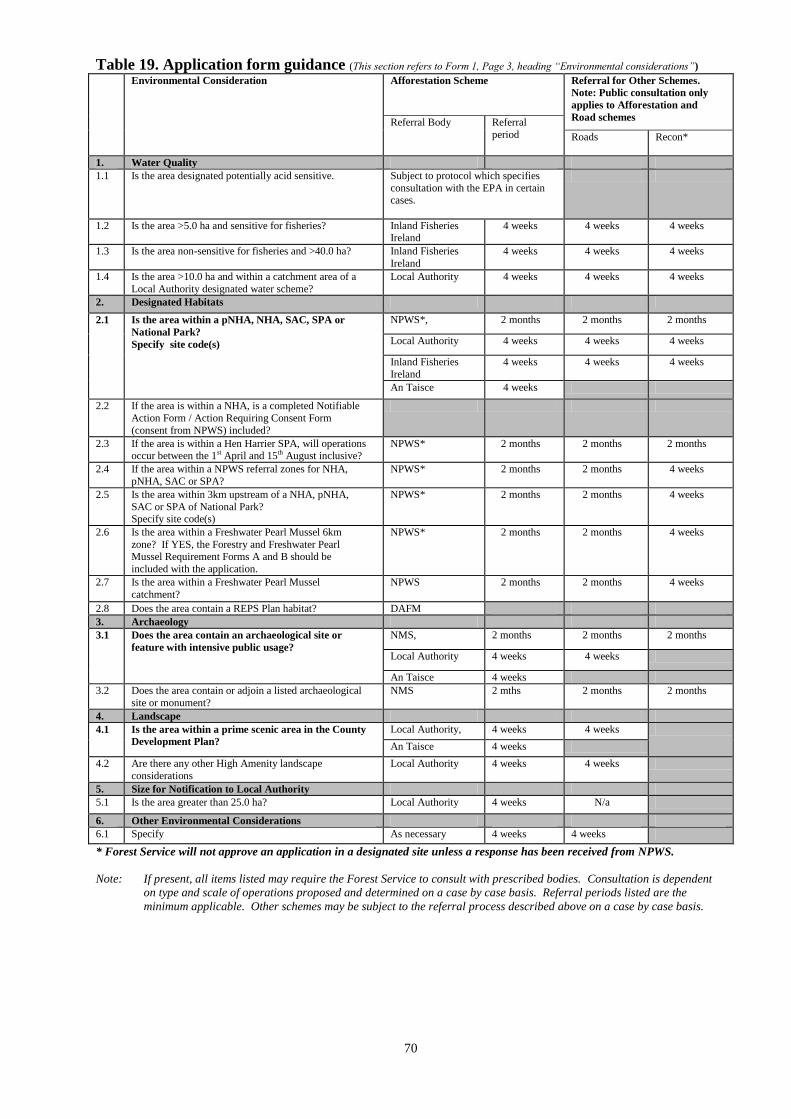
70
Table 19. Application form guidance (This section refers to Form 1, Page 3, heading “Environmental considerations”)
Environmental Consideration Afforestation Scheme Referral for Other Schemes.
Note: Public consultation only
applies to Afforestation and
Road schemes Referral Body Referral
period Roads Recon*
1. Water Quality
1.1 Is the area designated potentially acid sensitive.
Subject to protocol which specifies
consultation with the EPA in certain cases.
1.2 Is the area >5.0 ha and sensitive for fisheries? Inland Fisheries Ireland
4 weeks 4 weeks 4 weeks
1.3 Is the area non-sensitive for fisheries and >40.0 ha? Inland Fisheries
Ireland
4 weeks 4 weeks 4 weeks
1.4 Is the area >10.0 ha and within a catchment area of a
Local Authority designated water scheme?
Local Authority 4 weeks 4 weeks 4 weeks
2. Designated Habitats
2.1 Is the area within a pNHA, NHA, SAC, SPA or
National Park?
Specify site code(s)
NPWS*, 2 months 2 months 2 months
Local Authority 4 weeks 4 weeks 4 weeks
Inland Fisheries
Ireland
4 weeks 4 weeks 4 weeks
An Taisce 4 weeks
2.2 If the area is within a NHA, is a completed Notifiable
Action Form / Action Requiring Consent Form
(consent from NPWS) included?
2.3 If the area is within a Hen Harrier SPA, will operations occur between the 1st April and 15th August inclusive?
NPWS* 2 months 2 months 2 months
2.4 If the area within a NPWS referral zones for NHA,
pNHA, SAC or SPA?
NPWS* 2 months 2 months 4 weeks
2.5 Is the area within 3km upstream of a NHA, pNHA,
SAC or SPA of National Park? Specify site code(s)
NPWS* 2 months 2 months 4 weeks
2.6 Is the area within a Freshwater Pearl Mussel 6km
zone? If YES, the Forestry and Freshwater Pearl Mussel Requirement Forms A and B should be
included with the application.
NPWS* 2 months 2 months 4 weeks
2.7 Is the area within a Freshwater Pearl Mussel
catchment?
NPWS 2 months 2 months 4 weeks
2.8 Does the area contain a REPS Plan habitat? DAFM
3. Archaeology
3.1 Does the area contain an archaeological site or
feature with intensive public usage?
NMS, 2 months 2 months 2 months
Local Authority 4 weeks 4 weeks
An Taisce 4 weeks
3.2 Does the area contain or adjoin a listed archaeological
site or monument?
NMS
2 mths 2 months 2 months
4. Landscape
4.1 Is the area within a prime scenic area in the County
Development Plan?
Local Authority, 4 weeks 4 weeks
An Taisce 4 weeks
4.2 Are there any other High Amenity landscape
considerations
Local Authority 4 weeks 4 weeks
5. Size for Notification to Local Authority
5.1 Is the area greater than 25.0 ha? Local Authority 4 weeks N/a
6. Other Environmental Considerations
6.1 Specify As necessary 4 weeks 4 weeks
* Forest Service will not approve an application in a designated site unless a response has been received from NPWS.
Note: If present, all items listed may require the Forest Service to consult with prescribed bodies. Consultation is dependent
on type and scale of operations proposed and determined on a case by case basis. Referral periods listed are the
minimum applicable. Other schemes may be subject to the referral process described above on a case by case basis.
71
Explanatory Notes in Relation to Form 1
Water quality
Q 1.1 Is the area designated potentially acid sensitive by the Forest Service?
Where proposed planting sites fall into areas designated as acid sensitive by the
Department, the water sampling and testing protocol must be consulted and, where
appropriate, question 1.1 should be ticked in the yes column. The 6‟‟ Ordnance Survey
(scale 1:10,560) map numbers that have been designated in this way are listed in
Appendix 18.
Where a site is completely free draining with no aquatic zones and therefore cannot
provide water samples for testing, it is necessary to establish whether there is an aquatic
zone or zones on the same holding (area covered by same folio) down slope from the
proposed planting site. If such an aquatic zone exists on the same holding, then sampling
and testing for Calcium carbonate (CaCO3) must be the carried out in that zone. If no
aquatic zone exists on the holding down slope of the proposed planting site, the protocol
does not apply and normal approval procedures apply for that site, subject to inspection
and confirmation of such by the Forestry Inspector.
Q 1.2 Is the area > 5 ha and sensitive for fisheries ?
Where all three bullet points below are satisfied, Q1.2 should be ticked in the yes column
one (or more) aquatic zone(s) (lake, river, or stream shown on a 6‟‟ Ordnance
Survey Map, scale 1;10560m or the rivers dataset on iNET) traverses or is
adjacent to the proposed planting site
the proposed planting site is in an area designated as sensitive to fisheries by
Inland Fisheries Ireland
the proposed planting site is greater than 5 hectares.
Registered foresters or applicants may arrange for a notice commenting on the proposed
afforestation, and signed by an authorised officer of Inland Fisheries Ireland, to
accompany the application in these instances. Otherwise the Forest Service will carry out
all necessary consultations. Areas which may be sensitive to fisheries are listed in
Appendix 21.
Q 1.3 Is the area non-sensitive for fisheries and > 40.0 ha?
Where all three bullet points below are satisfied, Q1.3 should be ticked in the yes column
one (or more) aquatic zone(s) (lake, river, or stream shown on a 6‟‟ Ordnance
Survey Map, scale 1;10560m, or the rivers dataset on iNET) traverses or is
adjacent to the proposed planting site
the proposed planting site does not fall into an area designated as sensitive to
fisheries by Inland Fisheries Ireland
the proposed planting site is greater than 40 hectares.
72
Registered Foresters or applicants may arrange for a notice, signed by an authorised
officer of Inland Fisheries Ireland, commenting on the proposed afforestation to
accompany the application in these instances. Otherwise the Forest Service will carry out
all necessary consultations.
Q 1.4 Is the area > 10.0 ha and within a catchment area of a Local Authority designated
water scheme?
Where the proposed planting site falls within a catchment area of a water scheme
designated as sensitive to forestry in the County Development Plan and is greater than 10
hectares, question 1.4 should be ticked in the yes column.
Note; It is necessary to adhere to the Forestry and Water Quality Guidelines on all
sites, including those that do not have an aquatic zone.
Designated habitats
Q 2.1 Is the area within a NHA, pNHA, SAC, SPA, or National Park? Specify site code(s).
Where the proposed planting site falls within a Natural Heritage Area (NHA), proposed
Natural Heritage Area (pNHA), Special Area of Conservation (SAC), Special Protection
Area (SPA) or National Park, question 2.1 should be ticked in the “yes” column. A note
must be made of the site code or name associated with the NHA, pNHA, SAC, SPA or
National Park.
The European Communities (Natural Habitats) Regulations, 1997, (S.I. No. 94/1997) (as
amended) transposed the Habitats Directive (92/43/EEC) into Irish National law. These
Regulations, and the European Communities (Birds and Natural Habitats) (Control of
Recreational Activities) Regulations 2010, were consolidated in the recently published
European Communities (Birds and Natural Habitats) Regulations 2011 (S.I. No. 477 of
2011).
The Habitats Directive provides for the establishment of Natura 2000 sites which are
composed of Special Areas of Conservation (SACs) and Special Protection Areas
(SPAs). Further information on designated sites in Ireland is available on the National
Parks and Wildlife Service website (www.npws.ie).
All applications within areas designated as a NHA, pNHA, SAC, SPA or National Park
must be referred to NPWS for their observations.
Q 2.2 If the area is within a NHA, is a completed Notifiable Action Form/Action
Requiring Consent Form (consent from National Parks and Wildlife Service)
included?
Where the proposed planting is within a NHA, a completed Notifiable Action Form must
be included with the application to the Forest Service and Q2.2 should be ticked in the
“yes” column.
A dual consent process exists for the planting or cutting of trees within Natural Heritage
Areas (NHAs). Therefore an applicant must obtain both the consent of the Minister of
Arts, Heritage and the Gaeltacht and the Minister for Agriculture, Food and the Marine.
The consent of the Minister of Arts, Heritage and the Gaeltacht is obtained by submitting
a Notifiable Action Form/Action Requiring Consent Form (i.e. Application for
73
permission to carry out an operation or activity on a site to which the Wildlife
(Amendment) Act 2000 (Section 19) applies) to National Parks and Wildlife Service,
who complete the form and return it to the applicant. The Notifiable Action Form is
available to download on the NPWS website (www.npws.ie).
Q2.3 If the area is within a Hen Harrier SPA, will operations occur between the 1st of
April and the 15th of August inclusive?
The Hen Harrier nesting season is from the 1st of April to the 15
th of August inclusive.
Where the proposed planting will occur between those dates, question 2.3 should be
ticked in the “yes” column.
If mechanical operations are to occur in this time period there is the potential to disturb
nesting Hen Harriers and a habitat and/or bird survey maybe required.
Q2.4 Is the area within a NPWS referral zone for NHA, pNHA, SAC or SPA? Specify site
code(s).
Where the proposed planting site is within a NPWS referral zone (0.5km referral zone or
3km referral zone - upstream and with hydrological connectivity) for a NHA, pNHA,
SAC or SPA, question 2.4 should be ticked in the “yes” column. The Forest Service will
refer these applications to NPWS for their observations.
Please note that it is an offence to contravene the European Communities (Birds and
Natural Habitats) Regulations 2011 (S.I. 477 of 2011) and a person may be liable;
o on summary conviction to a Class A fine or imprisonment for a term not
exceeding six months or both or
o on conviction on indictment , to a fine not exceeding €500,000 or
imprisonment for a term not exceeding three years or both.
See also Forest Service Penalty System Chapter 12.
Q2.5 Is the area within 3 km upstream of a NHA, pNHA, SAC, SPA, or National Park?
Specify site code(s).
Where the proposed planting site falls within 3 km upstream of a NHA, pNHA, SAC,
SPA, or National Park, question 2.5 should be ticked in the “yes” column. The answer to
this question will help inform the answer to Q2.4 (i.e. determining whether applications
within the NPWS 3 km referral zone are upstream).
Q2.6 Is the area within a Freshwater Pearl Mussel 6km zone? If YES, the Forestry and
Freshwater Pearl Mussel Requirements Forms A and B should be included with the
application.
The Forestry and Freshwater Pearl Mussel (FPM) Requirements were published in 2008
and apply to all impacting forest operations within the catchments of FPM populations in
rivers designated Special Areas of Conservation for the species (27FPM populations, 19
SACs). Table 4 of the Requirements outlines various catchment sensitivities and
specifies the correct element of the Requirements to be applied in each particular
instance.
74
If an application is within a FPM 6km zone and the Requirements apply, Form A (FPM
Site Assessment – Site Description) and Form B (FPM Site Assessment – Mitigation
Measures) must be submitted with the application. The Forestry and FPM Requirements
are available on the Forest Service website:
http://www.agriculture.gov.ie/forestservice/environmentalinformation/
Q2.7 Is the area within a Freshwater Pearl Mussel catchment?
If an application is within the FPM catchment, but not within the FPM 6km zone, the
Forestry and FPM Requirements only apply if:
o the application increases the total cumulative area of an operation in a 3
year period to >10% of the FPM catchment
o afforestation application >50ha
o clearfelling >25ha.
Q 2.8 Does the area contain a current REPS habitat?
Where the proposed planting site contains a current REPS habitat, question 2.8 should be
ticked in the “yes” column. Please refer to Chapter 13 for further information.
Q 3.1 Does the area contain an archaeological site or feature with intensive public usage?
Where the proposed planting site contains an archaeological site or feature with intensive
public usage, question 3.1 should be ticked in the “yes” column and the location of the
site appropriately marked on the Biodiversity Map. Although not required, a speedier
processing of the application may be facilitated if the archaeological site‟s Record of
Monument and Places (RMP) number is included in the Biodiversity Map Legend or a
photocopy of the original Record of Monument and Places (RMP) map included with the
Form 1.
Q 3.2 Does the area contain or adjoin a listed archaeological site or monument?
Where the proposed planting site contains or adjoins a listed archaeological site or
monument, or an unlisted but suspected archaeological site, question 3.2 should be ticked
in the “yes” column and the location of the site appropriately marked on the Biodiversity
Map. Although not required, a speedier processing of the application may be facilitated
if the archaeological site‟s Record of Monument and Places (RMP) number is included in
the Biodiversity Map Legend or a photocopy of the original Record of Monument and
Places (RMP) map included with the Form 1.
Damage to archaeological sites is irreversible. The constraints relating to such sites are
summarised in the Forestry and Archaeological Guidelines published by the Forest
Service. Details of the public venues for inspecting Record of Monument and Places
(RMP) maps identifying the locations of these sites are available from NMS, DAHG. See
Appendix 22.
The Forestry and Archaeological Guidelines also summarise the actions and reporting
procedures that must follow any archaeological find in the course of forestry work, as
well as the exclusion zones to be observed around non-archaeological sites.
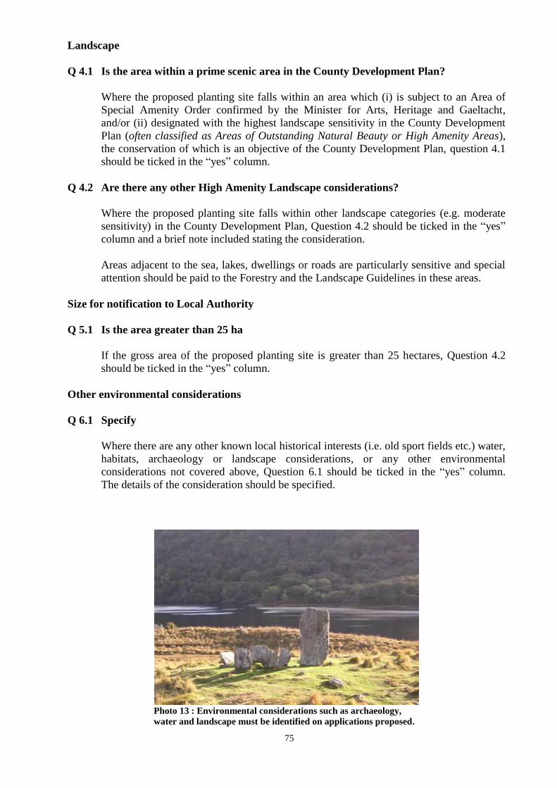
75
Landscape
Q 4.1 Is the area within a prime scenic area in the County Development Plan?
Where the proposed planting site falls within an area which (i) is subject to an Area of
Special Amenity Order confirmed by the Minister for Arts, Heritage and Gaeltacht,
and/or (ii) designated with the highest landscape sensitivity in the County Development
Plan (often classified as Areas of Outstanding Natural Beauty or High Amenity Areas),
the conservation of which is an objective of the County Development Plan, question 4.1
should be ticked in the “yes” column.
Q 4.2 Are there any other High Amenity Landscape considerations?
Where the proposed planting site falls within other landscape categories (e.g. moderate
sensitivity) in the County Development Plan, Question 4.2 should be ticked in the “yes”
column and a brief note included stating the consideration.
Areas adjacent to the sea, lakes, dwellings or roads are particularly sensitive and special
attention should be paid to the Forestry and the Landscape Guidelines in these areas.
Size for notification to Local Authority
Q 5.1 Is the area greater than 25 ha
If the gross area of the proposed planting site is greater than 25 hectares, Question 4.2
should be ticked in the “yes” column.
Other environmental considerations
Q 6.1 Specify
Where there are any other known local historical interests (i.e. old sport fields etc.) water,
habitats, archaeology or landscape considerations, or any other environmental
considerations not covered above, Question 6.1 should be ticked in the “yes” column.
The details of the consideration should be specified.
Photo 13 : Environmental considerations such as archaeology,
water and landscape must be identified on applications proposed.
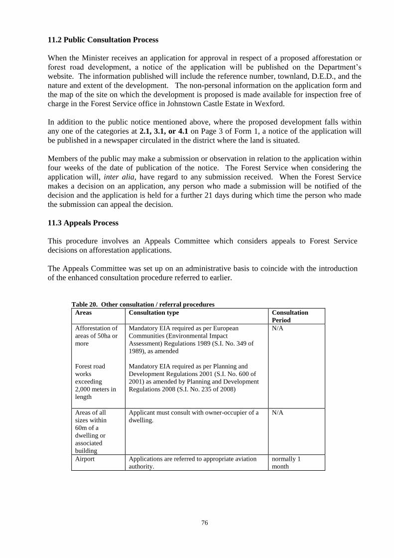
76
11.2 Public Consultation Process
When the Minister receives an application for approval in respect of a proposed afforestation or
forest road development, a notice of the application will be published on the Department‟s
website. The information published will include the reference number, townland, D.E.D., and the
nature and extent of the development. The non-personal information on the application form and
the map of the site on which the development is proposed is made available for inspection free of
charge in the Forest Service office in Johnstown Castle Estate in Wexford.
In addition to the public notice mentioned above, where the proposed development falls within
any one of the categories at 2.1, 3.1, or 4.1 on Page 3 of Form 1, a notice of the application will
be published in a newspaper circulated in the district where the land is situated.
Members of the public may make a submission or observation in relation to the application within
four weeks of the date of publication of the notice. The Forest Service when considering the
application will, inter alia, have regard to any submission received. When the Forest Service
makes a decision on an application, any person who made a submission will be notified of the
decision and the application is held for a further 21 days during which time the person who made
the submission can appeal the decision.
11.3 Appeals Process
This procedure involves an Appeals Committee which considers appeals to Forest Service
decisions on afforestation applications.
The Appeals Committee was set up on an administrative basis to coincide with the introduction
of the enhanced consultation procedure referred to earlier.
Table 20. Other consultation / referral procedures
Areas Consultation type Consultation
Period
Afforestation of
areas of 50ha or
more
Forest road
works
exceeding
2,000 meters in
length
Mandatory EIA required as per European
Communities (Environmental Impact
Assessment) Regulations 1989 (S.I. No. 349 of
1989), as amended
Mandatory EIA required as per Planning and
Development Regulations 2001 (S.I. No. 600 of
2001) as amended by Planning and Development
Regulations 2008 (S.I. No. 235 of 2008)
N/A
Areas of all
sizes within
60m of a
dwelling or
associated
building
Applicant must consult with owner-occupier of a
dwelling.
N/A
Airport Applications are referred to appropriate aviation
authority.
normally 1
month
77
11.4 Environmental Impact Assessment (EIA)
The EIA Directive (Directive 37/335/EEC) requires that certain types of development must be
assessed to determine the likely environmental effect of the development before consent can be
granted.
The type of development projects which are covered by the EIA Directive are listed in the Annex
I and II of the Directive and includes, inter alia, initial afforestation, deforestation and
construction of roads (Annex II).
An Environmental Impact Statement (EIS) is a statement of the effects, if any, which the
proposed development, if carried out, would have on the environment. An Environmental
Impact Assessment (EIA) is the process of examining the environmental effects of the proposed
development (including aspects at design stage, preparation and evaluation) by a competent
authority before deciding to approve the EIS or not, and the public response to that decision.
(Note: Approval of the EIS does not constitute approval for consent, grant aid or licence.)
The forest consent system operated by the Forest Service provides for an environmental impact
assessment to be carried out in certain cases, in accordance with the EIA Directive. The
transposing legal instrument in the Irish context is the European Communities (Forest Consent
and Assessment) Regulations 2010 (S.I. No. 558 of 2010) which designates the Minister for
Agriculture, Food and the Marine [Forest Service] as the Competent Authority [as defined in the
Directive] in such cases.
Under Irish legislation, EIA is mandatory for the following forestry schemes:
Initial afforestation which would involve an area of 50 hectares or more (S.I. 349 of 1989,
as amended by S.I. 538 of 2001)
Private roads which would exceed 2,000 meters in length (S.I. 600 of 2001, as amended by
S.I. No. 235 of 2008)
Under S.I. 558 of 2010 all applications for approval to carry out afforestation and forest road
construction projects above the mandatory thresholds listed above must be accompanied by an
EIS to enable the Minister to undertake an EIA of the project.
In addition, the Regulations provide that all afforestation and forest road construction projects
below the mandatory thresholds must be screened for EIA by the Forest Service and, where a
proposed sub-threshold development is considered likely to have a significant environmental
effect, the Minister will request the developer to submit an EIS to enable an EIA to be undertaken.
11.5 Appropriate Assessment Procedure
The Habitats Directive (92/43/EEC) and Birds Directive (2009/147/EC) set out various
procedures and obligations regarding nature conservation management in EU Member States,
with a strong focus on Natura 2000 sites, i.e. Special Areas of Conservation (SACs) and Special
Protection Areas (SPAs). A key protective measure required is to undertake an appropriate
assessment to ensure that any possible nature conservation impacts on a Natura site arising from
a plan or project are considered, before a decision is taken to grant (or refuse) consent for the
plan or project.
There are four stages to the Appropriate Assessment Procedure namely:
Stage 1 Screening
Stage 2 Appropriate Assessment
78
Stage 3 Alternative Solutions
Stage 4 Imperative Reasons of Overriding Public Interest (IROPI)
The Forest Service Appropriate Assessment Procedure (AAP) applies to applications for Forest
Service grant schemes, licences and consents in respect of forestry operations within Natura sites
(SAC or SPA) or within the NPWS 0.5 km or 3 km (with hydrological connectivity) referral
zone of Natura sites. Further information is available in the Forest Service Appropriate
Assessment Procedure Information Note (see Forest Service website).
11.6 European Communities (Forest Consent and Assessment) Regulations 2010
The European Communities (Forest Consent and Assessment) Regulations 2010 (S.I. No.
558 of 2010) were signed into law with effect from 14th
October 2010.
The Regulations update and replace Part 5 of the European Communities (Environmental Impact
Assessment) (Amendment) Regulations 2001 (S.I. No. 538 of 2001) (which have been revoked),
to take account of Ireland‟s obligations under the Directive 85/337/EC (EIA Directive), as
amended.
All persons operating in the forestry sector should familiarise themselves with the provisions of
the Regulations. They can be purchased from the Government Publications Sales Office or can
be viewed at www.irishstatutebook.ie.
The Regulations largely restate the previous provisions contained in S.I. No. 538 of 2001 and
introduce a number of new provisions in relation to forest road projects and public participation
in the decision making process, along with the introduction of a number of offences and
penalties for breaches of the Regulations.
The main changes are summarised below:
a. Obligation to obtain approval
The obligation to obtain the prior approval of the Minister for Agriculture, Food and the Marine
in respect of afforestation (which was required under S.I. No. 538 of 2001) has been extended to
include “forest road works”.
“forest road works” is defined as “the construction of a forest road or works ancillary to such
construction (whether or not such construction involves the removal of trees), but not where such
construction consists of the provision of access to a public road”.
“afforestation” is defined “the conversion of land to a forest with a minimum area of 0.1
hectares and tree crown cover of more than 20 per cent of the total area, or the potential to
achieve this cover at maturity”
It should be noted that the approval of the Minister is required for ALL afforestation and forest
road construction projects, whether grant aided or not.
Note: The Regulation has no impact on afforestation and forest road construction projects with
prior approval under grant support schemes operated by the Department. The existing
environmental assessment and approval procedures which are applied to those Schemes will
satisfy the requirements of the Regulations.

79
Further guidance in relation to approval procedures for forest road projects is provided in
section 11.7
b. Public Consultation
The Regulations place a statutory obligation on the Minister to notify the public of all
applications received and allow the public a minimum of 4 weeks in which to make a
submission.
c. Offences
The Regulation introduces a number of offences, including offences for undertaking
afforestation or forest road construction projects without the approval of the Minister.
d. Penalties
A person who commits an offence under the Regulations is liable to prosecution and may face
fines of up €5,000 on summary conviction or up to €250,000 on conviction on indictment
e. Directions in respect of certain work
If a development is undertaken without prior approval, the Minister is empowered to direct the
landowner to (i) in respect of afforestation, to remove trees planted and (ii) in respect of forest
road works, to remove the forest road, and (iii) to restore the land to its condition prior to the
commencement of the development.
Further information
Enquiries in relation to the operation of Regulations should be made in writing (by post of e-
mail) to:
Approvals Section,
Forest Service,
Department of Agriculture, Food and the Marine,
Johnstown Castle Estate,
Co. Wexford
E-mail: [email protected]
80
11.7 Forest Road Approval System: Guidance for seeking approval for the construction of
forest roads
Provisions have been introduced to provide a statutory basis for ensuring that forest road
construction projects are assessed in accordance with the requirements of the EIA Directive and
are only approved if they will not have a significant environmental impact.
Forest Road Grant Scheme
For forest road works approved under the Forest Road Grant Scheme, the existing environmental
assessment and approval procedures operated under the Scheme, will satisfy the requirements of
the Regulations as EIA screening and the prior approval of the Minister are already conditions of
the Scheme.
The requirement for an EIA for any road construction project equal to or greater than 2,000
metres remains in place.
Other Forest Road projects
Where no grant assistance is being sought in respect of a new forest road development, the
developer will need to ensure that the project is undertaken in compliance with the Regulations
and that, where required, the prior approval of the Minister is obtained for the development.
Applications for approval of non grant-aided forest road developments are being facilitated via
the existing IFORIS iNET system.
Definition of “forest road works”
Under the Regulation,
- „forest road works’ is defined as “the construction of a forest road or works ancillary to
such construction (whether or not such construction involves the removal of tree) but not
where such construction consists of the provision of access to a public road”.
- „forest road’ is defined as “a road (other than a public road) that serves a forest”
The Regulations apply to all new forest road construction projects and works ancillary to such
construction, whether or not a grant is being sought for the development.
It is considered that the following activities do not fall within the scope of the Regulation and do
not, therefore, require the prior approval of the Minister:
a. Construction of forest roads (including works ancillary to such construction) where the works commenced
before 14th
October 2010,
b. Upgrade or repair to existing roads and works ancillary to such upgrade or repair,
c. Construction of tracks and paths (less than 2.9 metres wide) to facilitate forest management and other forest
activities (but not including new forest roads constructed to a standard which would allow the haulage of
timber by lorries)
d. Construction of stacking areas (see note below)
e. Construction of turntables (see note below)
f. Construction of lay-bys (see note below)
g. Construction of culverts (see note below)
h. Tree felling to facilitate or enable road works - This felling is subject to the Forestry Act 1946
i. Construction of roads constructed for reasons other than to serve a forest (e.g. to serve a wind farm) Note:
Permission under the Planning and Development Act 2000 may be required for such roads.
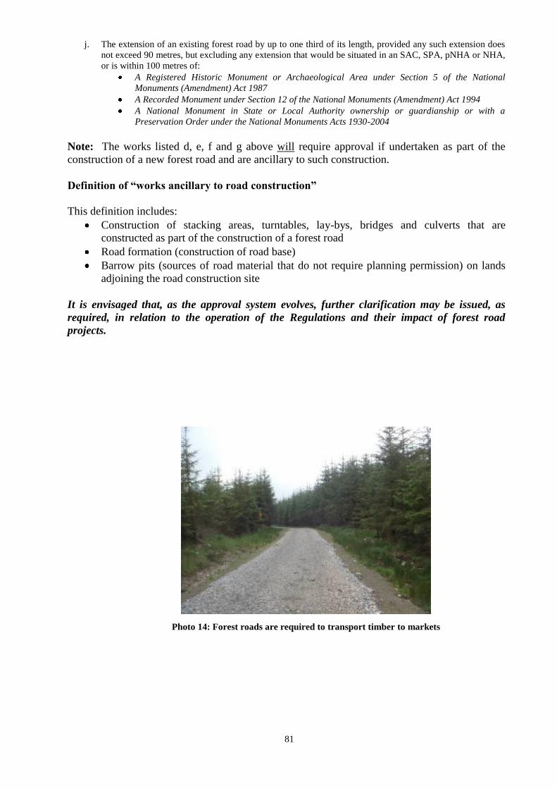
81
j. The extension of an existing forest road by up to one third of its length, provided any such extension does
not exceed 90 metres, but excluding any extension that would be situated in an SAC, SPA, pNHA or NHA,
or is within 100 metres of:
A Registered Historic Monument or Archaeological Area under Section 5 of the National
Monuments (Amendment) Act 1987
A Recorded Monument under Section 12 of the National Monuments (Amendment) Act 1994
A National Monument in State or Local Authority ownership or guardianship or with a
Preservation Order under the National Monuments Acts 1930-2004
Note: The works listed d, e, f and g above will require approval if undertaken as part of the
construction of a new forest road and are ancillary to such construction.
Definition of “works ancillary to road construction”
This definition includes:
Construction of stacking areas, turntables, lay-bys, bridges and culverts that are
constructed as part of the construction of a forest road
Road formation (construction of road base)
Barrow pits (sources of road material that do not require planning permission) on lands
adjoining the road construction site
It is envisaged that, as the approval system evolves, further clarification may be issued, as
required, in relation to the operation of the Regulations and their impact of forest road
projects.
Photo 14: Forest roads are required to transport timber to markets
82
CHAPTER 12
Penalty System
Guidelines for the imposition of penalties under the Afforestation Grant and Premium Schemes
are outlined below. These penalties apply to plantations approved for grant aid on or after 1st
January 2001.
12.1 Imposition of a Penalty
The decision to impose a penalty will be taken at Assistant Principal level by the Grants and
Premiums Section of the Forest Service, following the recommendation of the Forestry
Inspectorate at the level of Regional Inspector (Grade 1).
Such decision is final, but may be appealed to the Appeals Committee.
The Forest Service fully accepts the concept of partnership, co-operation, and consultation
between the Forestry Inspectorate and the registered foresters and forestry companies to achieve
best forestry practice. The Forestry Inspectorate will be delegated discretionary powers to allow
minor defects, or any related matter, in respect of a plantation to be remedied and no penalty
shall apply at that stage.
The applicant, or his or her agent, will be regarded as the principal person or body in respect of
which a grant penalty will be imposed. The nominated recipient of the annual forestry premium
will be regarded as the principal person or body in respect of which a premium penalty will be
imposed.
As a general rule, in any case where a penalty has been imposed, it will be necessary to have
remedial action taken, where possible, in respect of that element of the plantation which was the
subject of the penalty.
The principle of proportionality will apply. Where practical, any penalty imposed will be in
direct proportion to the alleged breach of the conditions of the scheme.
The Forest Service reserves the right to offset the amount of any penalty imposed against any
subsequent payment due to the person against whom the original penalty was imposed. Such
offsetting will only take place not earlier than 30 days following a written request for remission
of the amount due in respect of the penalty and following, where appropriate, determination of
the matter under the Forest Service appeals procedure.
Compliance with any letter of approval issued by the Forest Service will not result in the
imposition of any penalty.
12.2 Appeals Procedure
The principle of transparency will apply to the imposition of penalties. Where the Forest Service
decides to impose a penalty, the applicant/agent will be advised that it is proposed to impose a
penalty and given full details. He or she will be afforded at least one month to make
representations to the Minister as to why the penalty should not be imposed, and/or take remedial
action where possible. If it is decided to impose the penalty, the applicant/agent has the right to
appeal the decision to the Forest Service Appeals Committee whose decision will be binding,
subject to any further recourse to the Office of the Ombudsman and/or normal legal recourse.
Records relating to decisions taken in respect of the imposition of penalties may be available for
83
examination subject to the terms of the Freedom of Information Act 1997. The Appeals
Committee was set up on an administrative basis to coincide with the introduction of the
enhanced consultation procedures described in Chapter 11.
12.3 Schedule of Penalties
Area over-declared
Detailed procedures regarding the imposition of penalties with regard to area over-claimed are
available from the Forest Service.
Penalty as % of Afforestation Grant
Failure to exclude areas which are ineligible for aid
-unplanted areas up to 20%
-ESB lines up to 20%
-gas mains up to 20%
Failure to identify unenclosed and enclosed area correctly up to 20%
Failure to comply with environmental guidelines up to 100%
Failure to comply with specific supplementary up to 25 %
environmental conditions
-water/fisheries up to 25%
-NHA‟s/SAC‟s up to 25%
-sites and monuments up to 25%
-scenic areas up to 25%
-distance from roads/dwellings up to 25%
-other up to 25%
Failure to comply with conditions/governing
-chemical application up to 20%
-fertiliser application up to 20%
-disposal of waste/rubbish up to 20%
-hazardous fencing up to 20%
-mounding up to 20%
-silt traps up to 20%
Incorrect species selection up to 100% or
replacement
Failure to maintain plantation as % of 2nd
Instalment Grant
-at first inspection up to 20%
-at second inspection up to 100%
Failure to maintain fences beyond as % of Annual Premium the second instalment stage up to 20%
Domestic Stock damage up to 20%
84
Failure to control invasive scrub/furze past
2nd instalment stage up to 20%
Dumping up to 10%
Over declaration of eligible road length greater than 20% up to 100%
Failure to comply with conditions of approval letter up to 100%
Provision of a false statement, false information or false claim up to 100%
Details regarding the above penalties are explained below.
12.3.1 Area over-declared
Detailed procedures regarding the imposition of penalties with regard to area over claim are
available from the Forest Service.
12.3.2 Failure to exclude areas which are ineligible for aid
Unplanted areas
ESB Lines
Gas mains
Where it is found that there has been a failure to exclude those areas and where the Forest
Service has established the mapping and ground supervision was not carried out by the approved
forester or company in a professional manner, the scheduled penalty shall apply.
12.3.3 Failure to identify unenclosed and enclosed lands correctly
The Forest Service is satisfied that it can be clearly indicated when a site has been improved.
The climax vegetation and undisturbed soil profile will clearly indicate unenclosed land. The
Forest Service is satisfied that it is only in rare cases where a misinterpretation between enclosed
and unenclosed land could occur and that such cases should, in the normal course, have been the
subject of consultation with the Forest Service. Where land has been incorrectly classified on a
grant claim as a result of the registered forester or company not acting in a professional manner,
the scheduled penalty shall apply. No penalty shall apply where, the Forestry Inspector having
identified an apparent wrong classification, the forester amends the application immediately.
12.3.4 Failure to comply with environmental guidelines
In any situation where failure to comply with environmental guidelines results in permanent or
serious damage to the environment, particularly, but not exclusively, in respect of archaeological
sites and monuments or aquatic habitats, the scheduled penalty of non payment of grant or
premium payments will apply.
85
12.3.5 Failure to comply with specific supplementary environmental conditions
The guidelines referred to above set out specific conditions, breaches of which could possibly be
remedied. Examples of these breaches include :
failure to maintain the correct buffer zone from watercourses in respect of both ground
preparation and planting
failure to maintain the correct buffer zone from boundaries of NHA‟s, SAC‟s , SPAs and
archaeological sites and monuments
failure to apply the requisite planting set-back distances from roads and dwelling houses
non adherence to the development plan or species plan submitted with the original
application, or disregarding specific environmental conditions imposed in the Forest
Service letter of approval.
Where the Forest Service has established that any of the above, or similar breaches of
environmental conditions, occurred as a result of the registered forester or company not acting in
a professional manner, the scheduled penalty shall apply.
12.3.6 Failure to comply with conditions governing the following:-
Chemical application
Chemicals should be applied according to the manufacturer‟s instructions and in accordance with
the Forest Service Forestry and Water Quality Guidelines.
Fertiliser application
Fertiliser application should be in accordance with the Forest Service Forestry and Water Quality
Guidelines.
Disposal of Waste/Rubbish
The disposal of, for example, plastic fertiliser bags, plastic plant bags and oil containers, must be
to the standard as specified in the Rural Environment Protection Scheme (REPS) as administered
by the Department of Agriculture, Food and the Marine.
Hazardous Fencing
Fencing wire should be below head height or below neck height in respect of barbed wire. All
tiebacks should be placed inside the planting site.
Mounding
Mounding should be in accordance with the submitted cultivation plan or in accordance with
good forestry practice in terms of direction, spacing density and depth as set out earlier in this
Manual.
86
Silt Traps
Silt traps must be laid down as specified earlier in this manual and should not be left in a
dangerous condition or placed in an inappropriate location.
Where the Forest Service has established that failure to comply with any of the conditions
governing the above was as a result of incorrect or negligent practice by the applicant/agent, the
scheduled penalties will apply.
12.3.7 Incorrect Species Selection
The capability of a site to produce a commercial crop should not be extended. There should not
be any deviation from the species as set out in Chapter 9, unless approved in advance by a
Forestry Inspector. In any situation where an incorrect species has been selected as a result of
the approved forester or company not acting in a professional manner, the scheduled penalty of
no grant or premium payments will apply to that area.
12.3.8 Failure to maintain Plantation
If, in the opinion of the Forest Service, the plantation has not been maintained to the standard as
set out in this document, the scheduled penalty of up to 20% of the second instalment grant will
apply. However, the Forest Service will allow for the Form 3 to be resubmitted where a specific
period of time is required to allow for establishment and no penalty will apply. If remedial
action is not carried out after an appropriate time, the scheduled penalty of up to 100% (i.e. non-
payment of the appropriate 2nd
instalment grant) will apply.
12.3.9 Premium Penalties
Any penalties imposed in cases where the second instalment grant has already been paid, will be
applied to the annual premium.
In any case where the Forest Service is of the opinion that the landowner has failed to maintain
fences, thereby causing damage by stock, or where the landowner has failed to control invasion
of scrub and/or furze, the scheduled penalty will apply to the annual premium until such time as
the deficiency has been corrected. The scheduled penalty will similarly apply where the Forest
Service is of the opinion that the landowner has been responsible for dumping, or allowing the
dumping, of waste on the site.
If, for the purposes of obtaining aid under the Scheme, an applicant or person acting on their
behalf, knowingly makes a false or misleading statement or withholds information, the aid given
shall be reimbursed or withheld. The Minister reserves the right to exclude such a person from
further participation in grant aided schemes.
12.4 Cross Compliance Checking Procedures and Premium and Grant Payment
As an accredited EU paying agency, the Department of Agriculture, Food and Marine is obliged
to carry out checks and controls on all applications. Detailed documents setting out the
requirements and penalties applicable for each area based scheme is available from the relevant
section of the Department. Contact details and further information are available on the
Department‟s website.
87
CHAPTER 13
Interaction of Afforestation Scheme with Agriculture Schemes
13.1 REPS (Rural Environmental Protection Scheme)
The REPS Scheme was closed to new applicants in April 2009. However, a significant number
of applicants successfully entered REPS 4 whose participation in that Scheme will continue up to
the end of 2015. The Forest Environment Protection Scheme remains an option for these
participants for as long as they remain in REPS.
A REPS participant is free to plant land without incurring any REPS penalties. However he/she
will not receive REPS payments on the planted lands but will be entitled to afforestation grants
and premiums. A change in land use to forestry during the period of the REPS plan will
necessitate a revision of the REPS Plan. REPS payments will not be made for the calendar year
in which the land is planted.
13.2 Application for approval of sites containing REPS habitats
If the site proposed for afforestation contains a REPS habitat (Question 2.3 on page 3 of Form 1
is ticked „yes‟) the registered forester must state type of habitat and provide a copy of the REPS
Plan map. The Department‟s REPS section must agree that a habitat can be planted before the
area can be considered for afforestation.
Further information regarding REPS may be obtained from REPS Section, Department of
Agriculture, Food and the Marine, Johnstown Castle Estate, Co. Wexford (053-9163400).
13.3 Early Retirement Scheme (ERS)
The Early Retirement Scheme (ERS) is now closed to new entrants. However, the following
general rules apply to participants who retired under that Scheme.
A transferor (i.e. the farmer retiring under ERS) who already had forest land planted before
retiring from farming and is entitled to a forestry premium may retain that land and continue to
receive the premium. If this forest land is transferred with the holding, the transferee who
obtains it can apply for the premium (see section 4.6 for further information on change of
ownership).
13.4 Single Farm Payment 2011 and Forestry
Following changes to EU Regulations governing the Single Payment System, land which was
afforested since 2009 is eligible to draw down a SPS payment provided that the afforested land
meets the following requirements:
The land to be afforested was declared on a 2008 SPS application form;
The applicant who declared that land on a 2008 SPS application form was paid under the
2008 Single Payment Scheme;
The land to be afforested was eligible to draw down an SPS payment in 2008;
Applicants who afforest part of their holding from 2009 onwards, and wish to benefit
from the Single Payment, must retain at least 10% of the eligible hectares declared in 2008
(by the applicant or their predecessor) in an agricultural activity subject to a minimum of 3
hectares.

88
If the applicant is a new entrant to farming, the minimum area to be retained in an
agricultural activity will be fixed by the Department on a case by case basis.
Applicants who wish to benefit from the Single Payment on afforested land must be the
person or persons in joint management of receipt of afforestation premium. This applies to
members of the same family.
The afforested land meets all the requirements of the Afforestation Grant and Premium
Scheme, FEPS or the Native Woodland Establishment Scheme;
Eligible forestry parcels that are declared on SPS applications to activate entitlements
will also be subject to cross-compliance requirements.
Consolidation of newly afforested land is no longer required.
89
CHAPTER 14
Forestry Schemes
The Forest Service provides a number of schemes targeted at expanding and developing the
forest estate. These schemes are described on the Department of Agriculture, Food and the
Marine‟s website and must be read in conjunction with this Manual, Code of Best Forest
Practice, associated guidelines and industry circulars, which are a requirement of approval and
grant aid.
The Department‟s website can be accessed from the link below
http://www.agriculture.gov.ie/forestservice/
The level of funding available for each scheme will be determined by the budgetary allocation
provided in any particular year. Information on the current funding status for each scheme is
available from the Department.
The following schemes documents are available on the Department‟s website which you must
read prior to making an application;
Afforestation Scheme
Forest Environment Protection Scheme (FEPS)
Native Woodland Establishment Scheme*
Forest Roads Scheme
Woodland Improvement (Thinning and Tending only)
Reconstitution Scheme
NeighbourWood Scheme*
Native Woodland Conservation Scheme*
*Scheme documents for these schemes are available in the form of a manual which is available on the DAFM
website

90
APPENDIX 1 PROVENANCE DECLARATION FORM (For use with Forest Service Grant Schemes) PART A Supplier‟s Document (To be completed by the Nursery/Supplier -Issued in accordance with Council Directive 1999/105/EC)
Supplier‟s Official Registration Number: Supplier‟s Document Number:
Species: Common Name: ____________________________ Botanical Name: ______________________________________________________ _
Master Certificate of Provenance Number : ________________________ Country of Issue: _________________________________________
Note: The Master Certificate of Provenance Number refers to the number of the original seed Certificate of Provenance issued by a designated National Regulatory
Authority.
Provenance Details : Country: ________________________ Provenance: ______________________________________________________ ____
Origin: Indigenous Unknown If Non-Indigenous: Country: _________________ Region:____________________________________
Category: Source Identified Selected Qualified/ Untested Seed Orchard Tested Less stringent requirements/Derogation
Type of Basic Material: Seed source Stand Seed Orchard Parents of families Clone Clonal mixture
National Register Reference or identity code for region of provenance: ______________________________________________________________
Purpose: Multifunctional forestry Other specific purposes (please indicate) ___________________________________________________
Length of time in nursery and production type: ________________________________________________________________________________
Unique identity/batch no. assigned by the Supplier: _____________ Quantity dispatched: _______________ Date of Dispatch: _______________
Name and Address of Purchaser: ___________________________________________________________________________________________
______________________________________________________________________________________________________________________
Delivery Address (if different): _____________________________________________________________________________________________
Plant Passport Details (where applicable): EU Plant Passport IRL/DAF /Registration Number: ________ PZ Code: ____________
Replacement Passport Details: Country: _______ Reg. No: ________ Batch No:_______
It is hereby declared that all of the above details are correct, that the origin/provenance complies with the accepted origin/provenance list in the Forest
Service Forestry Schemes Manual and/or the Native Woodland Scheme Manual , and that where applicable the original Supplier‟s document is
available for inspection. Name and address of Nursery/Supplier: _____________________________________________________________________________
_____________________________________________________________________________________________________________
Authorised Person: __________________________________________
Authorised Person‟s signature: _________________________________
Date: ______________________________________________________
******************************************************************************************
PART B To be completed by the Contractor/Applicant
Applicant‟s Name: ___________________________________________________
PART A is an Original: PART A is a Photocopy:
This Provenance Declaration Form accounts for:
All of the trees planted of the above species on this contract: Part of the quantity planted of the above species on this contract:
If Part indicate the number planted and complete a separate Provenance Declaration Form for the remainder:
If Part state the Plot Number(s) applicable to this Provenance Declaration Form:
It is hereby declared that all of the above provenance details for the above contract are correct and that where the Nursery/Supplier Declaration (Part A) is a copy the
original is available for inspection.
Applicant‟s signature: ___________________________________________________
or
Name of Contractor: ___________________________________________________
Contractor‟s Authorised Person: __________________________________________
Authorised Person‟s signature: ___________________________________________
Date: ________________________________________________________________ Version: 21/2/03
Contractor Stamp (where applicable)
Contract No:
Nursery/Supplier Stamp
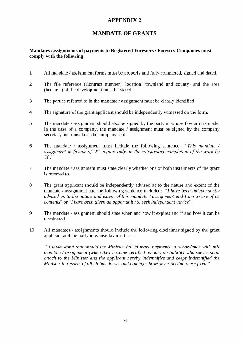
91
APPENDIX 2
MANDATE OF GRANTS
Mandates /assignments of payments to Registered Foresters / Forestry Companies must
comply with the following:
1 All mandate / assignment forms must be properly and fully completed, signed and dated.
2 The file reference (Contract number), location (townland and county) and the area
(hectares) of the development must be stated.
3 The parties referred to in the mandate / assignment must be clearly identified.
4 The signature of the grant applicant should be independently witnessed on the form.
5 The mandate / assignment should also be signed by the party in whose favour it is made.
In the case of a company, the mandate / assignment must be signed by the company
secretary and must bear the company seal.
6 The mandate / assignment must include the following sentence:- “This mandate /
assignment in favour of „X‟ applies only on the satisfactory completion of the work by
„X‟.”
7 The mandate / assignment must state clearly whether one or both instalments of the grant
is referred to.
8 The grant applicant should be independently advised as to the nature and extent of the
mandate / assignment and the following sentence included:- “I have been independently
advised as to the nature and extent of this mandate / assignment and I am aware of its
contents” or “I have been given an opportunity to seek independent advice”.
9 The mandate / assignment should state when and how it expires and if and how it can be
terminated.
10 All mandates / assignments should include the following disclaimer signed by the grant
applicant and the party in whose favour it is:-
“ I understand that should the Minister fail to make payments in accordance with this
mandate / assignment (when they become certified as due) no liability whatsoever shall
attach to the Minister and the applicant hereby indemnifies and keeps indemnified the
Minister in respect of all claims, losses and damages howsoever arising there from.”
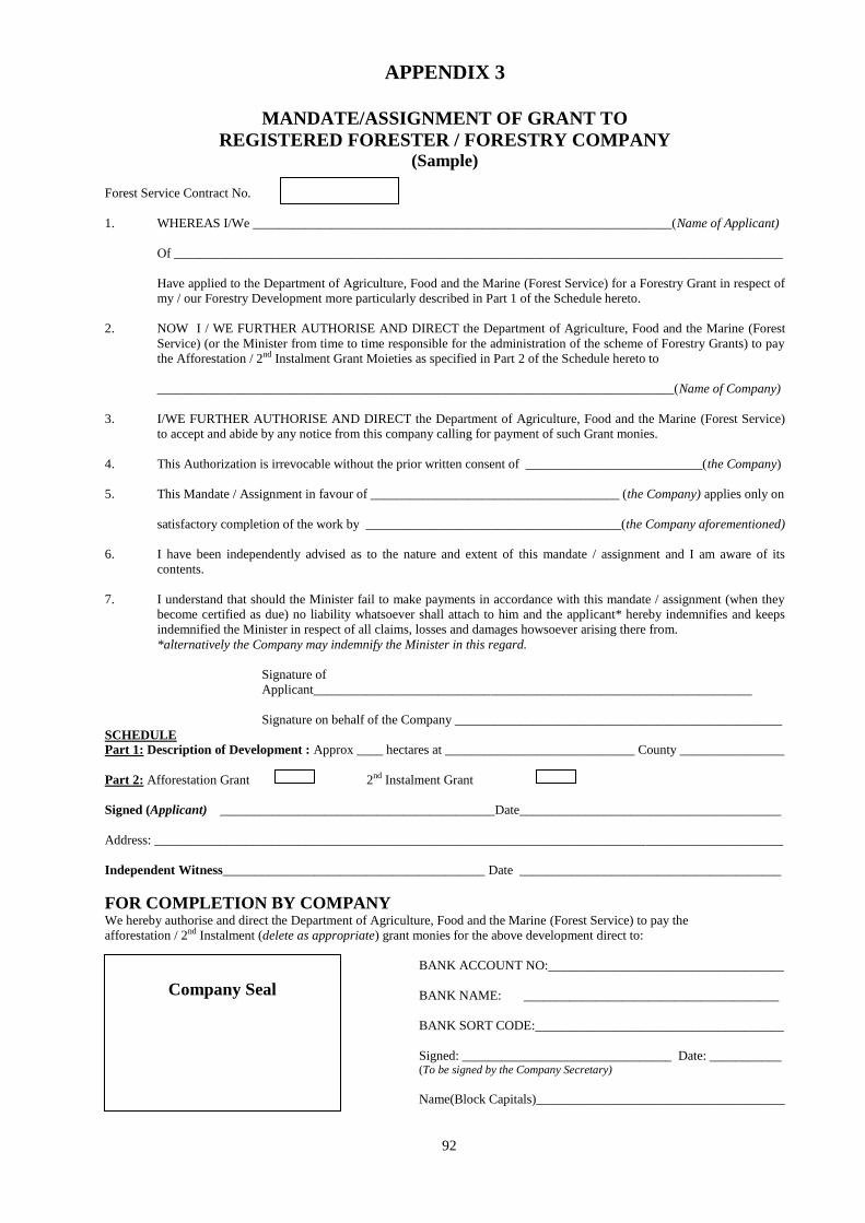
92
APPENDIX 3
MANDATE/ASSIGNMENT OF GRANT TO
REGISTERED FORESTER / FORESTRY COMPANY (Sample)
Forest Service Contract No.
1. WHEREAS I/We ________________________________________________________________(Name of Applicant)
Of _____________________________________________________________________________________________
Have applied to the Department of Agriculture, Food and the Marine (Forest Service) for a Forestry Grant in respect of
my / our Forestry Development more particularly described in Part 1 of the Schedule hereto.
2. NOW I / WE FURTHER AUTHORISE AND DIRECT the Department of Agriculture, Food and the Marine (Forest
Service) (or the Minister from time to time responsible for the administration of the scheme of Forestry Grants) to pay
the Afforestation / 2nd Instalment Grant Moieties as specified in Part 2 of the Schedule hereto to
_______________________________________________________________________________(Name of Company)
3. I/WE FURTHER AUTHORISE AND DIRECT the Department of Agriculture, Food and the Marine (Forest Service)
to accept and abide by any notice from this company calling for payment of such Grant monies.
4. This Authorization is irrevocable without the prior written consent of ___________________________(the Company)
5. This Mandate / Assignment in favour of ______________________________________ (the Company) applies only on
satisfactory completion of the work by _______________________________________(the Company aforementioned)
6. I have been independently advised as to the nature and extent of this mandate / assignment and I am aware of its
contents.
7. I understand that should the Minister fail to make payments in accordance with this mandate / assignment (when they
become certified as due) no liability whatsoever shall attach to him and the applicant* hereby indemnifies and keeps
indemnified the Minister in respect of all claims, losses and damages howsoever arising there from.
*alternatively the Company may indemnify the Minister in this regard.
Signature of
Applicant___________________________________________________________________
Signature on behalf of the Company __________________________________________________
SCHEDULE
Part 1: Description of Development : Approx ____ hectares at _____________________________ County ________________
Part 2: Afforestation Grant 2nd Instalment Grant
Signed (Applicant) __________________________________________Date________________________________________
Address: ________________________________________________________________________________________________
Independent Witness________________________________________ Date ________________________________________
FOR COMPLETION BY COMPANY
We hereby authorise and direct the Department of Agriculture, Food and the Marine (Forest Service) to pay the
afforestation / 2nd Instalment (delete as appropriate) grant monies for the above development direct to:
BANK ACCOUNT NO:____________________________________
BANK NAME: _______________________________________
_______________________
BaBA BANK SORT CODE:______________________________________
SORT
Signed: ________________________________ Date: ___________ (To be signed by the Company Secretary)
Name(Block Capitals)______________________________________
Company Seal
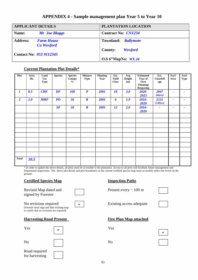
93
APPENDIX 4 - Sample management plan Year 5 to Year 10
APPLICANT DETAILS PLANTATION LOCATION
Name: Mr Joe Bloggs Contract No: CN1234
Address: Farm House
Co Wexford
Contact No: 053 9112345
Townland: Ballymote
County: Wexford
O.S 6”MapNo: WX 24
Current Plantation Plot Details*
* In order to update the above details, all plots must be accessible in the plantation. Access to all plots will facilitate future management and Department inspections. The above plot details and plot boundaries on the current certified species map must accurately reflect the forest on the
ground.
Certified Species Map Inspection Paths
Revised Map dated and Present every ~ 100 m
signed by Forester
No revisions required Existing access adequate (Forester must sign and date existing map
to certify that no revisions are required)
Harvesting Road Present Fire Plan Map attached
Yes Yes
No No
Road required
for harvesting
Plot Area
Ha
Land
Use
Type
Species Species
Canopy
%
Mixture
Type
Planting
Year
Est.
Yield
Class
Avg
Height
(m)
Estimated
Year of
First
Thinning/
Respacing
Est.
Clearfell
age
Excl
Area
Excl
Type
1 8.5 CHF DF 100 P 2001 18 3.8 2020-
2023
2047 (46yrs)
- -
2 2.0 MHF PO 50 R 2001 6 1.9 2016-
2020
2131 (130yrs)
- -
SP 50 R 2001 12 2.0 2016-
2020
- - -
Total 10.5

94
MANAGEMENT CHECKLIST YEAR 5 to 10
The following management operations and decisions should be addressed
over the next 10 years Yes No N/A
Check weed growth on established sites and control if necessary
Maintain fences, drains and silt traps
Maintain firebreaks and access tracks
Vermin Control
Monitor crops for signs of insect and fungal damage and take
appropriate action if necessary
Carry out foliar analysis and apply fertiliser if necessary
If access is not adequate, install and maintain inspection paths at
100m intervals to monitor crops performance
Formative shaping of broadleaves where required
Monitor growth rates of conifers in broadleaves mixtures.
Assess stocking rates and volume of crop and prepare for thinning.
First thinning usually takes place between 18 and 25 years of age,
depending on species.
Apply to the Forest Service for a general felling license before
tending/thinning
Remember to revise management plan and resumit for years 10 - 20
Other
GENERAL COMMENTS
Deer culling is taking place in surrounding fields to prevent browsing damage which is
currently localised in northern section of crop
I have joined a local timber producer group with the aim of marketing timber in the future and
to explore certification to a recognised forest management standard
Declaration by Registered Forester I declare that I have carried out a field assessment to prepare this management plan and have correctly recorded and
updated all species, areas and plot boundaries on the attached certified species map.
Foresters Name John Forester BAgrSC Goodtrees Ltd
Date of Field
Assessment
1/11/2005
Foresters Signature John Forester Date of Report 3/11/2005
Forest Owners Name John Farmer
Forest Owners
Signature John Farmer Date 4/11/2005
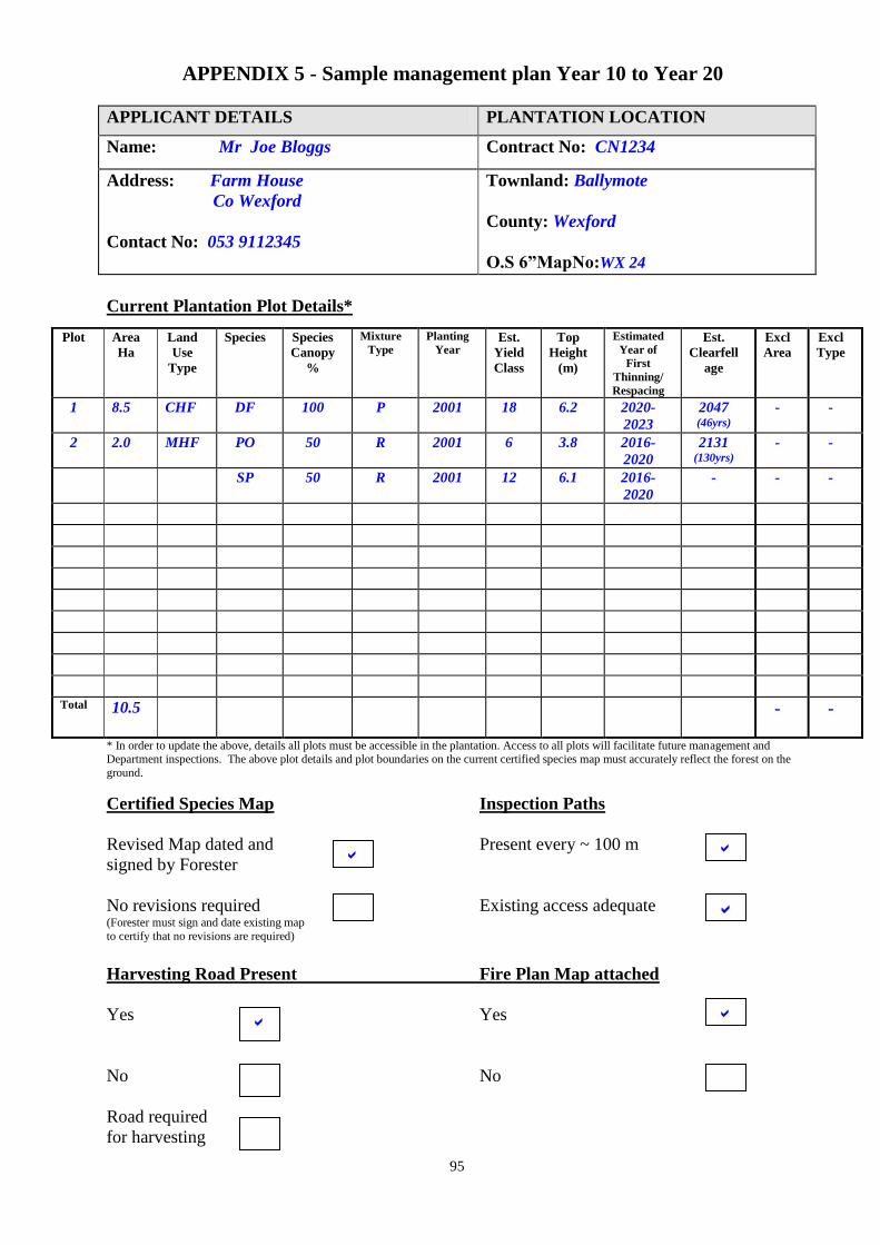
95
APPENDIX 5 - Sample management plan Year 10 to Year 20
APPLICANT DETAILS PLANTATION LOCATION
Name: Mr Joe Bloggs Contract No: CN1234
Address: Farm House
Co Wexford
Contact No: 053 9112345
Townland: Ballymote
County: Wexford
O.S 6”MapNo:WX 24
Current Plantation Plot Details*
* In order to update the above, details all plots must be accessible in the plantation. Access to all plots will facilitate future management and Department inspections. The above plot details and plot boundaries on the current certified species map must accurately reflect the forest on the
ground.
Certified Species Map Inspection Paths
Revised Map dated and Present every ~ 100 m
signed by Forester
No revisions required Existing access adequate (Forester must sign and date existing map
to certify that no revisions are required)
Harvesting Road Present Fire Plan Map attached
Yes Yes
No No
Road required
for harvesting
Plot Area
Ha
Land
Use
Type
Species Species
Canopy
%
Mixture
Type Planting
Year Est.
Yield
Class
Top
Height
(m)
Estimated
Year of
First
Thinning/ Respacing
Est.
Clearfell
age
Excl
Area
Excl
Type
1 8.5 CHF DF 100 P 2001 18 6.2 2020-
2023
2047 (46yrs)
- -
2 2.0 MHF PO 50 R 2001 6 3.8 2016-
2020
2131 (130yrs)
- -
SP 50 R 2001 12 6.1 2016-
2020
- - -
Total 10.5 - -

96
MANAGEMENT CHECKLIST YEAR 10 to 20
The following management operations and decisions should be addressed
over the next 10 years Yes No N/A
Maintain fences, drains and silt traps
Maintain firebreaks and access tracks
Monitor crops for signs of insect and fungal damage and take
appropriate action if necessary
Carry out foliar analysis and apply fertiliser if necessary
If access is not adequate, install and maintain inspection paths at
100m intervals to monitor crops performance
Monitor growth rates of conifers in broadleaves mixtures. Decide
to remove or partly remove conifers from mixtures before
broadleaves are suppressed. Tending of broadleaves may also be
required.
Assess stocking rates and volume of crop and prepare for thinning.
First thinning usually takes place between 18 and 25 years of age
depending on species.
Apply to the Forest Service for a general felling license before
thinning
Market timber for sale and monitor volume removed. Owners
should consider a cooperative approach when thinning. Larger
volumes will improve the sale and marketing of timber. Advice is
available from a number of organisations. Contact Forest Service
for more details
Assess need for a harvesting road and construct if necessary
Repair Roads after harvesting
Other
GENERAL COMMENTS
Broadleaved/ conifer mixtures will be monitored over the next 10 years. Where Scots pine is
competing with and suppressing oak, the mixture will respaced favouring the oak.
A General Felling Licence covering all potential tree felling over the next 10 years has been
received from the Forest Service and is valid for 5 years.
Declaration by Registered Forester I declare that I have carried out a field assessment to prepare this management plan and have correctly recorded and
updated all species, areas and plot boundaries on the attached certified species map.
Foresters Name John Forester BAgrSC Goodtrees Ltd
Date of Field
Assessment
20/11/2011
Foresters Signature John Forester Date of Report 30/11/2011
Forest Owners Name John Farmer
Forest Owners
Signature John Farmer Date 30/11/2011

97
APPENDIX 6 - Sample management plan Year 5 to Year 10
APPLICANT DETAILS PLANTATION LOCATION
Name: Contract No:
Address:
Contact No:
Townland:
County:
O.S 6”MapNo:
Current Plantation Plot Details*
* In order to update the above, details all plots must be accessible in the plantation. Access to all plots will facilitate future management and
Department inspections. The above plot details and plot boundaries on the current certified species map must accurately reflect the forest on the
ground.
Certified Species Map Inspection Paths
Revised Map dated and Present every ~ 100 m
signed by Forester
No revisions required Existing access adequate (Forester must sign and date existing map
to certify that no revisions are required)
Harvesting Road Present
Yes
No
Road required
for harvesting
Plot Area
Ha
Land
Use
Type
Species Species
Canopy
%
Mixture
Type
Planting
Year
Est.
Yield
Class
Avg
Height
(m)
Estimated
Year of
First
Thinning/
Respacing
Est.
Clearfell
age
Excl
Area
Excl
Type
Total

98
MANAGEMENT CHECKLIST YEAR 5 to 10
The following management operations and decisions should be addressed
over the next 10 years Yes No N/A
Check weed growth on established sites and control if necessary
Maintain fences, drains and silt traps
Maintain firebreaks and access tracks
Vermin Control
Monitor crops for signs of insect and fungal damage and take
appropriate action if necessary
Carry out foliar analysis and apply fertiliser if necessary
If access is not adequate, install and maintain inspection paths at 100m
intervals to monitor crops performance
Formative shaping of broadleaves where required
Monitor growth rates of conifers in broadleaves mixtures.
Assess stocking rates and volume of crop and prepare for thinning. First
thinning usually takes place between 18 and 25 years of age depending
on species.
Apply to the Forest Service for a general felling license before
tending/thinning
Remember to revise management plan and resumit for years 10 - 20
Other
GENERAL COMMENTS
Declaration by Registered Forester
I declare that I have carried out a field assessment to prepare this management plan and have correctly recorded and
updated all species, areas and plot boundaries on the attached certified species map.
Foresters Name Date of Field
Assessment
Foresters Signature Date of Report
Forest Owners Name
Forest Owners Signature
Date
99
APPENDIX 7 - Sample management plan Year 10 to Year 20
APPLICANT DETAILS PLANTATION LOCATION
Name: Contract No:
Address:
Contact No:
Townland:
County:
O.S 6”MapNo:
Current Plantation Plot Details*
* In order to update the above, details all plots must be accessible in the plantation. Access to all plots will facilitate future management and
Department inspections. The above plot details and plot boundaries on the current certified species map must accurately reflect the forest on the ground.
Certified Species Map Inspection Paths
Revised Map dated and Present every ~ 100 m
signed by Forester
No revisions required Existing access adequate (Forester must sign and date existing map
to certify that no revisions are required)
Harvesting Road Present Fire Plan Map attached
Yes Yes
No No
Road required
for harvesting
Plot Area
Ha
Land
Use
Type
Species Species
Canopy
%
Mixture
Type
Planting
Year
Est.
Yield
Class
Avg
Height
(m)
Estimated
Year of
First
Thinning/
Respacing
Est.
Clearfell
age
Excl
Area
Excl
Type
Total
100
MANAGEMENT CHECKLIST YEAR 10 to 20
The following management operations and decisions should be addressed
over the next 10 years Yes No N/A
Maintain fences ,drains and silt traps
Maintain firebreaks and access tracks
Monitor crops for signs of insect and fungal damage and take
appropriate action if necessary
Carry out foliar analysis and apply fertiliser if necessary
If access is not adequate install and maintain inspection paths at 100m
intervals to monitor crops performance
Monitor growth rates of conifers in broadleaves mixtures. Decide to
remove or partly remove conifers from mixtures before broadleaves are
suppressed. Tending of broadleaves may also be required.
Assess stocking rates and volume of crop and prepare for thinning. First
thinning usually takes place between 18 and 25 years of age depending
on species.
Apply to the Forest Service for a general felling license before thinning
Market timber for sale and monitor volume removed. Owners should
consider a cooperative approach when thinning. Larger volumes will
improve the sale and marketing of timber. Advice is available from a
number of organisations. Contact Forest Service for more details
Assess need for a harvesting road and construct if necessary
Repair Roads after harvesting
Other
GENERAL COMMENTS
Declaration by Registered Forester
I declare that I have carried out a field assessment to prepare this management plan and have correctly recorded and
updated all species, areas and plot boundaries on the attached certified species map.
Foresters Name Date of Field
Assessment
Foresters Signature Date of Report
Forest Owners Name
Forest Owners Signature Date
101
APPENDIX 8
CERTIFICATION OF LAND TRANSFER (to be completed by a Solicitor)
To: Minister for Agriculture, Food & the Marine
Forest Service Contract Ref
The transfer of lands in Folio(s) ________________________________, County ___________________
from ______________________________________ to ________________________________________
was effected on _____________________ (see attached copy of Deed of Transfer and Map)
I hereby certify that:
The Deed of Transfer* / Assent & Application* has been submitted to the Revenue Commissioners for
stamping and I undertake to submit it to the Property Registration Authority of Ireland for registration in
the current owner‟s name as soon as it is returned by the Revenue Commissioners.
Or
The Deed of Transfer* / Assent & Application* has been submitted to the Property Registration Authority
of Ireland for registration in the current owners name.
* Please delete as appropriate and Please tick appropriate box above
I undertake to forward certified copies of Folio(s) registered in the name of the new owner(s) to the Forest
Service as soon as they become available.
My/Our firm currently holds Professional Indemnity Insurance Cover with a qualified Insurer as defined
under Statutory Instrument No. 312 of 1995.
Signed ________________________________________________
Solicitor for Purchaser
Name of Solicitor _______________________________________________
Name of Firm _________________________________________________
Date: _________________________________________________
Solicitor Stamp
102
APPENDIX 9
CERTIFICATE OF TITLE for forestry lands transferred within a family
(To be completed by a Solicitor)
To: Minister for Agriculture, Food and the Marine Contract No.
Forest Service
Name(s) of Clients: _________________________________________________________________
Address: _________________________________________________________________
Location of Property: Townland(s): ____________________________________________________
County: ____________________________________________________
I hereby certify that:
1. All the lands indicated on the attached map, which I have signed and stamped, with
boundaries marked in red are
Registered in Folio no(s)______________________________________________________________
Or
Registered with the Registry of Deeds ___________________________________________________
2. Folio / Ownership registration is presently in the name/s of _________________________________
Relationship of named landowner to client ________________________________________________
3. The lands are not subject to Turbary or Grazing rights or Rights of Way
4. My Client (s) _________________________________________________________________ is (are)
(i) the registered owner(s) of the lands;
(ii) the person(s) entitled to be registered as owner(s) of the lands;
Please tick appropriate box
I hereby undertake to furnish evidence of Title to the Department of Agriculture, Food and the Marine
(Forest Service) when it becomes available, if requested.
My/Our firm currently holds Professional Indemnity Insurance Cover with a qualified Insurer as defined under
Statutory Instrument No. 312 of 1995.
I/we give this certificate for the benefit of the Forest Service only.
Signature of Solicitor:________________________________________
Name of Solicitor: ________________________________________
Name of Firm: ________________________________________
Date: ________________________________________
Solicitor
Stamp

103
APPENDIX 10
COMMONAGE CONSENT FORM
To: Minister for Agriculture, Food and the Marine
We, the undersigned, are the registered owners of the Commonage property described in the Schedule
below.
Name Address Signature Date
We hereby consent to the application made to the Forest Service for an Afforestation Grant* in respect of
the parcel of land(s) described in the schedule below on our behalf by -
Name :
Address :
County :
*Note: Each of the owners of commonage may apply for payment of forest premium in his/her own behalf
SCHEDULE
Area (ha)
Townland(s)
District Electoral Division
County
Folio Number(s)
Registry of Deeds
The commonage property is described in the schedule above and delineated on the map
attached with the boundaries marked in red.
Signed and Sealed in my presence _________________________________Date_____________
(Signature of Solicitor)
Name of Solicitor ______________________________________
Address : ______________________________________
Solicitor‟s stamp
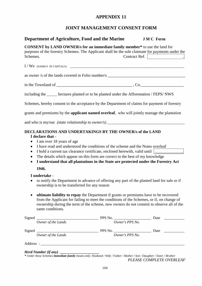
104
APPENDIX 11
JOINT MANAGEMENT CONSENT FORM
Department of Agriculture, Food and the Marine J M C Form
CONSENT by LAND OWNER/s for an immediate family member* to use the land for
purposes of the forestry Schemes. The Applicant shall be the sole claimant for payments under the
Schemes. Contract Ref. .
I / We (NAME/S IN CAPITALS) ________________________________________________________
as owner /s of the lands covered in Folio number/s ______________________________________
in the Townland of _____________________________________ , Co._____________________
including the _____ hectares planted or to be planted under the Afforestation / FEPS/ NWS
Schemes, hereby consent to the acceptance by the Department of claims for payment of forestry
grants and premiums by the applicant named overleaf, who will jointly manage the plantation
and who is my/our (state relationship to owner/s) ______________________________________
DECLARATIONS AND UNDERTAKINGS BY THE OWNER/s of the LAND
I declare that -
I am over 18 years of age
I have read and understood the conditions of the scheme and the Notes overleaf
I hold a current tax clearance certificate, enclosed herewith, valid until ______________
The details which appear on this form are correct to the best of my knowledge
I understand that all plantations in the State are protected under the Forestry Act
1946.
I undertake -
to notify the Department in advance of offering any part of the planted land for sale or if
ownership is to be transferred for any reason
ultimate liability to repay the Department if grants or premiums have to be recovered
from the Applicant for failing to meet the conditions of the Schemes, or if, on change of
ownership during the term of the scheme, new owners do not commit to observe all of the
same conditions.
Signed _________________________________ PPS No. ____________________ Date ___________
Owner of the Lands Owner's PPS No.
Signed _________________________________ PPS No. ____________________ Date ___________
Owner of the Lands Owner's PPS No.
Address : _____________________________________________________________________________
Herd Number (if any) _____________________ * Under these Schemes immediate family means only: Husband / Wife / Father / Mother / Son / Daughter / Sister / Brother
PLEASE COMPLETE OVERLEAF

105
Applicant (the joint manager who will claim the grants & premiums in his / her own name)
Name _________________________________________________________________________
Address_______________________________________________________________________
______________________________________________________________________________
Herd No. ______________________________
Notes
1. A separate JMC Form is to be completed by each owner named on the folio/s, except for joint full
owners who should use a single JMC form.
2. JMC arrangements are allowed only between members of the immediate family of the landowner/s
defined for these schemes as only: Husband / Wife / Father / Mother / Son / Daughter / Sister /
Brother
3. The person named as Joint Manager will be registered as Applicant under the Scheme(s). As such, all
correspondence and claim forms will issue to him /her. The Department will not normally contact the land-
owner/s, except in the case of debt being declared against the Applicant for breach of the Scheme(s).
4. The land owners shall be ultimately liable for any debts incurred under the schemes by the Applicant if
the Applicant fails to repay such debts. Debts due to the Department may be recovered by offsetting them
against payments due to the customer under any other scheme administered by the Department.
5. Land owner/s who wish to end a Joint Management arrangement should give written notice to the
Department. Such termination will be accepted only if the land owner/s sign the necessary commitment to
take over the obligations of the scheme to maintain the plantation for the remainder of the term and to
repay all grants and premiums already paid in the event of breach of the terms of the scheme.
6. No ineligible claim for payment on the afforested area may be made under other area-based
schemes.
As this Consent to Payment involves matters of legal title it must be witnessed by your Solicitor.
Witness ___________________________________________ Date ________________
Solicitor‟s signature
Name ___________________________________________
Name of Firm ___________________________________________
Address ___________________________________________
___________________________________________
Solicitor‟s stamp

106
APPENDIX 12
RELEASE OF TURBARY RIGHTS CONSENT FORM
To be completed by the holder/s of turbary rights to enable the registered owner/s to afforest the land under the
Forest Service Grants and Premiums Scheme
I, __________________________________________________________________ (Holder of the Turbary Rights)
Address ______________________________________________________________________________________
County ______________________________________________________________________________________
being the successor in title of ____________________________________________ to whom the turbary rights
over the property described in the Schedule hereto were allocated by the Congested Districts Board for Ireland in or
around the year 1817 hereby TRANSFER, ASSIGN AND RELEASE all my right title estate and interest in and to
the said turbary rights to
Name _______________________________________________________________________________________
Address _____________________________________________________________________________________
County ______________________________________________________________________________________
who is the registered owner of the property described in Folio No. ___________________________ of the Register
of County ________________________.
SCHEDULE
ALL THAT part of the lands of ___________________________________( townland) more particularly described
and delineated on the map thereof annexed hereto and thereon edged yellow and numbered ____________________
Signed and Sealed by the said ________________________________________________________________
(Holder/s of Turbary Rights)
Dated this ________________ day of __________________________________________ , in the year _________ .
As this consent form concerns legal title to lands it must be witnessed by a Solicitor.
Witness __________________________________________________ Date _______________________________
Signature of Solicitor
Solicitor‟s Name___________________________________________________
Name of Firm _____________________________________________________
Address _________________________________________________________
County _________________________________________________________
Solicitor‟s stamp

107
APPENDIX 13
RELEASE OF GRAZING RIGHTS CONSENT FORM
To be completed by the holder/s of grazing rights to enable the registered owner/s to afforest the land under the
Forest Service Grants and Premiums Scheme
I, ________________________________________________________________ (Holder of the Grazing Rights)
Address ____________________________________________________________________________________
County ____________________________________________________________________________________
being the successor in title of ____________________________________________ to whom the grazing rights
over the property described in the Schedule hereto were allocated by the Congested Districts Board for Ireland in or
around the year 1817 hereby TRANSFER, ASSIGN AND RELEASE all my right title estate and interest in and to
the said grazing rights to
Name ______________________________________________________________________________________
Address ___________________________________________________________________________________
County ____________________________________________________________________________________
who is the registered owner of the property described in Folio No. _______________________________ of the
Register of County ________________________.
SCHEDULE
ALL THAT part of the lands of ___________________________________( townland) more particularly described
and delineated on the map thereof annexed hereto and thereon edged yellow and numbered ____________________
Signed and Sealed by the said ________________________________________________________________
(Holder/s of Grazing Rights)
Dated this _____________ day of _______________________________________ , in the year _______________
As this consent form concerns legal title to lands it must be witnessed by a Solicitor.
Witness _____________________________________________________ Date ____________________________
Signature of Solicitor
Solicitor‟s Name_________________________________________
Name of Firm __________________________________________
Address ______________________________________________
County ______________________________________________
Solicitor‟s stamp
108
APPENDIX 14
LAND TYPES FOR AFFORESTATION
Introduction
Forest Service afforestation schemes (Afforestation Scheme, Forest Environment Protection
Scheme and Native Woodland (Establishment) Scheme) provide premiums to incentivise the
planting of agricultural land. The different rates of premium available under these schemes
reflect differences in existing levels of agricultural output associated with land quality.
Agricultural land in Ireland can be broadly divided into two types: (i) enclosed/improved land
and (ii) unenclosed/unimproved land. While most land will clearly be in one type or the other,
borderline cases will arise. These borderline cases must be ascribed to one or the other type,
based on which of the following definitions most applies.
Enclosed/Improved (E/I) land
The E/I land type generally includes land that is enclosed and improved for agricultural use by
cultivation and manuring, and which is completely surrounded by man-made boundaries. These
lands are usually shown as being enclosed on 6 inch Ordinance Survey maps (1:10,560), and this
can be indicative of existing agricultural use.
E/I land includes land that has been under intensive agricultural use since prior to 1st January
2004 and carries vegetation predominately of pasture grasses and herbaceous plants. On wet
soils, there may be a high proportion of rushes. E/I land is typically associated with fertile soil
types suitable for a wide range of tree species, and will normally have a plough layer in the soil
profile, i.e. a distinctive dark surface horizon in which organic matter has been incorporated with
mineral matter. Vegetation on E/I land will typically be that associated with commercial
agricultural use, e.g. pasture, grass-herb, grass-rush, tillage crops.
This land type may also include grass lands which have partly reverted to bracken and furze.
Recent tillage land would also be included in this type. E/I land type does not normally require
phosphorus fertiliser for successful tree growth. Enclosed agricultural land on midland fen peats
currently in grass may require an application of potassium and is eligible to be considered as E/I
land.
E/I land can be considered for Grant & Premium Categories (GPCs) 2 to 8. The higher rates of
premium associated with these GPCs reflect the existing levels of agricultural output forgone if
these lands were afforested.
Unenclosed/Unimproved (U/U) land
U/U land is normally associated with peat soils or other poor soils and includes areas that have
not been cultivated or brought under intensive commercial agricultural use successfully over a
sustained period. These lands are generally used for extensive grazing and have low levels of
existing agricultural productivity. In practice, almost all land not classifiable as E/I will be U/U
land.
The U/U land type generally includes sites with natural vegetation associated with heath land or
peat land, e.g. Purple Moor Grass (Molinia caerulea),Cross Leaved Heath (Erica tetralix), Ling
heather (Caluna vulgaris), Moss (Sphagnum and Hylocomium spp.), Cotton grass (Eriophorum
109
vaginatum), Deergrass (Trichophorum caespitosum), Black bog rush (Shoenus nigricans),
Bilberry (Vaccinium spp.), Sedge (Carex spp.), Bog Myrtle (Myrica gale). The presence and
distribution of certain species are indicative of a site‟s low fertility. Land which met the
definition of E/I above at some point in the past but which has since reverted or is reverting to
the original natural vegetation (excluding rushes / bracken / gorse in fields enclosed by banks,
walls or ditches) in most of the sward will also be classified as U/U land.
As phosphorus is often deficient on U/U land, this land type will normally require an application
of phosphorus fertiliser at establishment for successful tree growth.
Former U/U land that has been modified (e.g. by ploughing, re-seeding, fertilising, by enclosing
by fencing) since 1st January 2004 may not be classified as E/I land for the purpose of the
Department‟s afforestation schemes.
U/U land can be considered for GPC 1. The premium rate associated with GPC 1 reflects the
current low levels of agricultural output forgone if these lands were afforested.
Lands not eligible for grant aid (under GPC 1 to 8)
For the purposes of the afforestation schemes, E/I land or U/U land generally not eligible for
grant aid under any GPC on silvicultural or environmental grounds include the following:
High elevation areas over 300 m above sea level in the west and over 400 m above sea
level in the east of Ireland
Infertile blanket and midland raised bogs, e.g. vegetation predominately consisting of
heather (Calluna vulgaris), bog cotton (Eriophorum vaginatum), deergrass
(Trichophorum caespitosum-formerly called Scirpus cespitosus) and sphagnum, and also vegetation
– often pool studded. Also containing sundews (Drosera rotundifolia) and Bog asphodel
(Narthecium ossifragum)
Unmodified raised bogs.
Designated blanket and raised bogs.
Plots with rock outcrop and associated shallow soils in excess of 25% of the plot area.
Severely exposed sites and some sea facing locations.
All areas outlined in the Forestry Schemes Manual as being ineligible for grant aid, e.g.
shell marl or sites which cannot be adequately drained.
Sites not capable of producing a commercial crop of timber. The land must be capable of
producing at least yield class 14 for Sitka spruce. The use of Sitka spruce as an indicator
species recognises that other conifers may not achieve the same level of production on
the same site.
Very poor U/U sites where a standard application of phosphorus fertiliser (e.g. 350 kg/ha
GRP) at the time of establishment is unlikely to provide sufficient phosphorus input to
bring the forest to full rotation. (A split application not exceeding a total of 400 kg /ha
GRP would be acceptable instead, within the establishment period).
Sites where it is not practical to access or construct forest roads to facilitate the
harvesting of timber to a suitable public road network. Cooperative roads and shared
access routes may allow difficult sites to be considered for approval on application.
Non-agricultural land (e.g. golf courses, turbary).
Mapping conventions
The Forest Service mapping conventions apply to all afforestation applications submitted for
consent or grant aid. Any U/U area 0.2 ha or greater must be mapped and numbered as a

110
separate plot and claimed as GPC 1. For example, a 2.0 ha area containing a section of 0.2 ha of
U/U land and 1.8 ha of E/I land must be mapped as two separate plots. Areas of a land type less
than 0.2 ha should be ascribed the neighbouring land type.
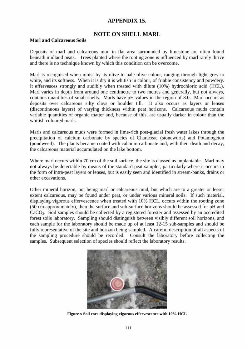
111
APPENDIX 15.
NOTE ON SHELL MARL Marl and Calcareous Soils
Deposits of marl and calcareous mud in flat area surrounded by limestone are often found
beneath midland peats. Trees planted where the rooting zone is influenced by marl rarely thrive
and there is no technique known by which this condition can be overcome.
Marl is recognised when moist by its olive to pale olive colour, ranging through light grey to
white, and its softness. When it is dry it is whitish in colour, of friable consistency and powdery.
It effervesces strongly and audibly when treated with dilute (10%) hydrochloric acid (HCL).
Marl varies in depth from around one centimetre to two metres and generally, but not always,
contains quantities of small shells. Marls have pH values in the region of 8.0. Marl occurs as
deposits over calcareous silty clays or boulder till. It also occurs as layers or lenses
(discontinuous layers) of varying thickness within peat horizons. Calcareous muds contain
variable quantities of organic matter and, because of this, are usually darker in colour than the
whitish coloured marls.
Marls and calcareous muds were formed in lime-rich post-glacial fresh water lakes through the
precipitation of calcium carbonate by species of Characeae (stoneworts) and Potamogeton
(pondweed). The plants became coated with calcium carbonate and, with their death and decay,
the calcareous material accumulated on the lake bottom.
Where marl occurs within 70 cm of the soil surface, the site is classed as unplantable. Marl may
not always be detectable by means of the standard peat sampler, particularly where it occurs in
the form of intra-peat layers or lenses, but is easily seen and identified in stream-banks, drains or
other excavations.
Other mineral horizon, not being marl or calcareous mud, but which are to a greater or lesser
extent calcareous, may be found under peat, or under various mineral soils. If such material,
displaying vigorous effervescence when treated with 10% HCL, occurs within the rooting zone
(50 cm approximately), then the surface and sub-surface horizons should be assessed for pH and
CaCO3. Soil samples should be collected by a registered forester and assessed by an accredited
forest soils laboratory. Sampling should distinguish between visibly different soil horizons, and
each sample for the laboratory should be made up of at least 12-15 sub-samples and should be
fully representative of the site and horizon being sampled. A careful description of all aspects of
the sampling procedure should be recorded. Consult the laboratory before collecting the
samples. Subsequent selection of species should reflect the laboratory results.
Figure x Soil core displaying vigorous effervescence with 10% HCL
112
APPENDIX 16
SOIL SAMPLING PROCEDURES
1. The area to be sampled should be divided into homogeneous soil sampling units (SSU)
based on soil type, distinct differences in vegetation or obvious site boundaries. Note that
each SSU should be sampled separately.
2. The total area under the proposal should be marked on an 6 “ OS map or 1:5,000 scale,
clearly indicating the pattern of sampling and which samples are representative of the
SSU(s) sampled.
3. For each SSU, if there are clearly defined soil horizons evident, sample each horizon
separately. Otherwise, take separate samples from the layers 0-20cm (surface) and 20–
40cm (sub- surface).
4. From each horizon or layer, collect samples from at least 12–15 locations within the SSU.
Each of these is treated as a sub-sample.
5. Record the depth of any apparent calcareous layer in the soil profile.
6. Collect the sub- samples by travelling across the area to be sampled using a zigzag or “S”
shaped route. All sampling locations should be identified on ½ “ OS map, if available.
7. Making sure to keep the samples from the different horizon or layers separate, combine the
12–15 sub–samples from the same horizon or layer in a large clean bag and mix
thoroughly. Clearly label the sample bags with an indelible black marker. Repeat this
process for each horizon or layer sampled.
8. For each horizon or layer, take a portion of the mixed sub-samples, at least 100g, and
submit to the laboratory with the completed sample background form (see below).
9. The samples should be assessed in the laboratory for at least pH (in water), calcium (after
extraction with 2.5 % acetic acid and reported on a dry weight basis @ 105 degrees C) and
free CaCO3.
10. Sampling should be done preferably by a registered forester, who is fully acquainted with
the recognised and accepted forestry soil sampling techniques.
11. A brief interpretative and advisory report is required, based on the laboratory test report
received on the submitted samples, assessing site suitability for commercial forest
planting, species recommendations and site cultivation/drainage requirements signed by a
professional forest nutrition & soil expert.
12. The following information must be forwarded to Forest Service, Johnstown Castle, Co
Wexford;
A copy of the fully completed soil sampling form and the soil sampling map showing
the sampling areas or units. Each sample must be related to a plot number and each
zone of sampling clearly identified.
A copy of the laboratory soil analysis report plus advisory report.
13. The procedures, as outlined above, do not cover highly disturbed soil types, e.g. land fill,
or where there has been extensive reclamation, levelling, drainage or disturbance of some
kind. In such instances, the sampler will need to consult with a forest soil and nutrition
expert on the best soil sampling procedures to be adopted. Contact details for specialist
consultancy services on forest soils and nutrition are provided below.
Explanatory Notes
If the crop fails or does not perform satisfactorily and this performance is shown to be related to
soil conditions, then the soil sampling procedures and analysis will be questioned. The
responsibility rests with the land owner, the site developer, soil sampler and the soil analysis
laboratory. Because of the possibility of crop failure, it is recommended that an independent third
party take the initial soil samples.
113
Where considered necessary, the Forest Service may conduct its own independent site
investigation, including soil sampling and testing of the problematic site. Should the review
findings be at variance with the initial assessment conducted by the land owner, he/she will be
advised by the Forest Service.
The “Terms &Conditions For the Registration of Foresters and Forestry Companies” detail
various sanctions which may be applied if an application, and accompanying information, was not
in accordance with scheme requirements, guidelines and procedures.
Furthermore if, in the opinion of Forest Service, the land does not have the potential to produce a
crop of minimum YC 14 Sitka Spruce, grant aid and premiums will have to be refunded to the
Department.
The following forest soil laboratory offers a soil analysis service.
Coillte Laboratories
Church Road
Newtownmountkennedy
Co Wicklow
Tel: 01-2011111
The Forest Service will accept other accredited laboratories which carry out analysis soils using
the preferred Macaulay Extraction method i.e. extraction using with 2.5% Acetic Acid and
reported on a dry weight basis @105 degrees C.
Specialist Consultancy Services on Forest Soils and Nutrition are available from the following
contacts: Dr. Michael Carey, M.S.I.F. Richard MacCarthy, BSc(For.), MSc(For.), PhD.
Forestry & Management Consultant Specialist Consultant in Forest Soils, Nutrition & Environment
Furze Lodge 31 Sidmonton Gardens
Newcastle Bray
Greystones Co. Wicklow
Co. Wicklow
Tel: 01 2811217 Tel: 01 2867902
Mob: 087 2381060 Mob: 086 2481847
Fax: 01 2811217 Fax: 01 2811217
E-mail: [email protected] E-mail: [email protected]
Other specialist consultants‟ in Forest Soils and Nutrition can contact the Forest Service for
inclusion in subsequent editions of this manual.
114
SOIL SAMPLING FORM
CLIENT DETAILS
Name & Address (client receiving report/Invoice)
Telephone No. Email: Mobile No.
Your Reference Contract No.
Sampled by Date Sampled
Townland OS Grid Ref.
Name of Registered Forester Name & Address of land Owner (if different):
SITE DETAILS
Is it currently planted? Year planted? What species?
Area: (Ha)
Dominant
Ground Vegetation
Grass [ ] Grass/Rush [ ] Sedge rush [ ] Bracken/Briar [ ] Molinia/Calluna [ ]
Eriophorum/Heather [ ] Other [ ]
Aspect: (facing N,S,E,W, or flat) Elevation: (1) ft or
(2) m
PREVIOUS LAND USE
Farming Practices before
Previous Crop
Fertilised/limed Yes/No Year Type/Rate
Reclaimed Yes/No Year Type
SOIL SAMPLING DEPTHS
Topsoil depth: (cm) SUBSOIL DEPTH: (CM)
Situation 1. Depth to Calcareous material in mineral (i.e. absence of peat) soils (cm))
1 2 3 4 5 6 7 8 9 10 11 12 13 14 15 16 .
Situation 2. Depth of Peat over Calcareous material Depth to Calcareous material (cm)
1 2 3 4 5 6 7 8 9 10 11 12 13 14 15 16 .
ANY OTHER COMMENTS
115
SITE DETAILS: (TICK AS APPROPRIATE)
TOPOGRAPHY SOIL TYPE
CALCAREOUS MATERIAL EXPOSURE
Flat Brown Earth Shell Marl Very exposed
Concave Brown Podsolic Marl (shells) Mod. exposed
Convex Podsoil Till Mod. sheltered
Bottom-slope Podsoil+pan Course (+boulders) Sheltered
Mid-slope Lithosol Fine (-boulders)
Top-slope Peaty Gley Esker
Gley
Blanket Bog
Raised Bog
Fen peat over calcareous
SITE FERTILITY* SOIL DRAINAGE SITE SUBJECT TO
Class A [ ]
Class B [ ]
Class C [ ] Class X [ ]
Present Potential [ ] Poor [ ]
[ ] Mod. [ ]
[ ] Good [ ]
Out fall? Yes [ ] No [ ]
Flooding [ ]
Frost [ ]
*EXPLANATION OF SITE FERTILITY
Class A: *Fields and ornamental ground*. These are areas, which have been in intensive agricultural use up to relatively recent times, so that they carry
characteristic agricultural vegetation (pasture grasses and herbaceous plants, often with high proportion of rushes. They are among the most fertile site
types. Class B:*Furze or whin*. These are sites that were once enclosed by banks, walls or ditches. This indicates that at one time they were considered
sufficiently fertile to justify bringing them under agricultural use, and were probably cultivated. The class would include all long-abandoned agricultural
land (indicated by the presence of Ulex or bracken). It might also be extended, on the basis of local knowledge, and experience, to include unenclosed areas on mineral soils derived from parent materials of shale, mica-schist or granitic origin.
Class C:*Rough pasture, with or without cropping rock*. These are areas of unenclosed ground, which have never been cultivated or brought under any
form of intensive agricultural use. Sites to include are those on unenclosed land, usually upland or bogland, carrying typical unimproved heath land or peat land vegetation.
Class X:*Woodland*. Sites to be included are coniferous, broadleaved and mixed woodland.
LABORATORY TESTS: TICK THE TEST THAT YOU REQUIRE ON YOUR SOIL SAMPLE
pH, Calcium, Free Lime test: For the purpose of determining site suitability and species selection for forestry
pH, Calcium, Magnesium, Potassium, Phosphorus, Free Lime test:
For the purpose of determining growth problems and preparing fertiliser prescriptions
pH, Calcium, Magnesium, Potassium, Phosphorus, Free Lime Test, % Organic Matter:
For the purpose of screening nursery soils.
Do you require a consultation report?
*Please note that a “topsoil” and a “subsoil” constitutes two samples.
SEND SAMPLES TO: Coillte Laboratories
Church Road
Newtownmountkennedy,
Co. Wicklow.
Tel: 01 2011111
116
APPENDIX 17
SAMPLE COLLECTION FOR FOLIAR ANALYSIS
Foliage nutrient levels vary with the season of the year and position of foliage in the crown.
Therefore sampling should follow rigid guidelines.
1. Conifer foliage samples should be collected during the dormant season, ideally in the
period from mid-November to the end of December but can be extended to the end of
February at the very latest.
2. Broadleaves and deciduous conifers should be sampled in August after shoot growth has
terminated and before the onset of colour change.
3. Foliage samples should be collected from the current season‟s growth on secondary
branches and from the upper third of the tree.
4. Collect sub-samples from at least 20 trees that are representative of the area proposed to be
fertilised.
5. Combine the sub-samples to form a single sample for analysis.
6. Place sub-samples in a clean, labelled, plastic bag and send to a professional laboratory
specialising in foliar analysis.
7. The foliage should be tested for at least nitrogen, phosphorus and potassium content.
8. Growers should use the same laboratory over a stands rotation, as laboratories use
differing analytical tests and report results in different ways.
9. A fertiliser prescription, based on the laboratory test report, must be prepared by an
experienced forestry consultant advising on the most suitable fertiliser and application rate
required.
10. The following information must be sent to the Forest Service
Copy of Foliar sampling form completed
Results of Foliar Analysis for N, P and K
Recommendation
o Type of fertiliser(s)
o Concentration of fertiliser
o Rates of application per hectare (ha)
11. Foliar Analysis in support of an application for an Aerial Fertilisation Licence must also
include supporting documentation as outlined in the Forestry and Aerial Fertilisation
Guidelines and the European Communities (Aerial Fertilisation) (Forestry) Regulations
(S.I. No. 592 of 2006), as amended.
117
FOLIAGE SAMPLING SITE/CROP FORM
ONE FORM TO BE COMPLETED PER SAMPLE
CLIENT DETAILS(client receiving report/Invoice)
Surname
First Name (s) Mr [ ] Ms [ ]
Address (postal)
Telephone No. Mobile No. E-mail
Address
:
Contract No.
Area (ha)
Name of
Registered Forester Name/Address of Landowner (if different):
SAMPLE/SITE DETAILS
County Townland(s) O.S. 6” Map No.
Species for
analysis
Year planted Forest
type
Mixed [ ]
Pure [ ]
Mixtures (if applicable)
1st Species
2nd species Intimate [ ]
Non Intimate [ ]
Dominant
Ground Vegetation
Grass [ ] Grass/Rush [ ] Sedge rush [ ] Bracken/Briar [ ]
Molinia/Calluna [ ] Eriophorum/Heather [ ] Other [ ]
Aspect N [ ] S [ ] E [ ] W [ ] Neutral [ ] Elevation (m)
CROP HISTORY
Herbicide/fertiliser Yes [ ] No [ ] N/A [ ] YEAR(S) TYPE
RATE
RATE
RATE
Suspected cause(s)
Herbicide [ ] Frost [ ] Nutrient [ ] Aphid [ ]
other (specify) [ ] _____________________________________
ANY COMMENTS
118
FILL IN AS APPROPRIATE, TICK AS APPROPRIATE
% of Crop
Type
Pre-thicket [ ]
Thicket [ ]
Irregular [ ]
Thriftiness (%)
Healthy [ ]
Mod. Unthrifty[ ]
Very unthrifty [ ]
Yellow [ ]
Dead tops [ ]
In check [ ]
*Site
Fertility
A [ ]
B [ ]
C [ ]
X [ ]
Soil Type
Brown Earth [ ]
Podsoil [ ]
Gley [ ]
Alluvium [ ]
Lithosol [ ]
Coastal sand [ ]
Blanket peat [ ]
Raised peat [ ]
Fen peat [ ]
Fen/Marl [ ]
Soil
Drainage
Poor [ ]
Moderate [ ]
Good [ ]
Exposure
V.exposed [ ]
Mod.
Exposed [ ]
Mod.
Sheltered [ ]
Sheltered [ ]
EXPLANATION OF SITE FERTILITY Class A: *Fields and ornamental ground*. These are areas which have been in intensive agricultural use
up to relatively recent times so that they carry characteristic agricultural vegetation (pasture grasses and
herbaceous plants), often with high proportion of rushes. They are among the most fertile site types.
Class B:*Furze or whin*. These are sites that were once enclosed by banks, walls or ditches. This
indicates that at one time they were considered sufficiently fertile to justify bringing them under
agricultural use, and were probably cultivated. The class would include all long-abandoned agricultural
land (indicated by the presence of Ulex or bracken). It might also be extended, on the basis of local
knowledge and experience, to include unenclosed areas on mineral soils derived from parent materials of
shale, mica-schist or granitic origin.
Class C:*Rough pasture, with or without cropping rock*. These are areas of unenclosed ground, which
have never been cultivated or brought under any form of intensive agricultural use. Sites to include are
those on unenclosed land, usually upland or bogland, carrying typical unimproved heath land or peat land
vegetation.
Class X:*Woodland*. Sites to be included are coniferous, broadleaved and mixed woodland.
LABORATORY TESTS: TICK THE TEST THAT YOU REQUIRE ON YOUR FOLIAGE SAMPLE 1. Nitrogen, Phosphorus & Potassium, e.g. for the purpose of determining [ ]
growth problems and preparing fertiliser prescriptions.
2. Nitrogen, Phosphorus, Potassium, Calcium & Magnesium, e.g. for [ ]
nutrient assessment of Christmas Trees.
3. Nitrogen, Phosphorus, Potassium, Calcium, Magnesium & Trace elements, [ ]
e.g. for nursery plant production.
SEND DETAILS TO: Coillte Laboratories
Church Road
Newtownmountkennedy,
Co. Wicklow.
Tel: 01 2011111
119
APPENDIX 18
Protocol for the determination of the acid sensitivity of Surface water
in the context of Afforestation
Applications for grant aid for afforestation in areas outlined on maps of acid-sensitivity as being
acid-sensitive, and included in the list of County O.S. maps scale 1: 10560, require an
assessment of acid sensitivity for all areas which are the subject of grant aid applications. These
procedures also apply to afforestation applications received for approval / consent under the
European Communities (Forest Consent and Assessment) Regulations, 2010 (S.I. No. 558 of
2010).
This sensitivity of the water to acidic inputs is to be determined by the measurement of
alkalinity.
Sampling and analysis shall be carried out on a minimum of four occasions at intervals not
greater than four weeks in the period February to May inclusive. The analysis will be carried out
by a Laboratory, independent of the applicant, and participating currently in relevant national or
international inter-comparison exercises. Samples to be taken from, and measurements to be
made on, all watercourses shown on Ordnance Survey 6" Maps within the area of the proposed
afforestation.
Sampling procedures are outlined below.
Alkalinity to be measured using the Gran Titration Method.
The minimum acid-sensitivity measured will determine the overall sensitivity of the site.
There will be no afforestation in areas where the minimum alkalinity of the run-off water is <8
mg CaCO3 l-1
.
Where the minimum alkalinity of the run-off water is in the range 8–15mg CaCO3 l-1
, full, partial
or no afforestation may be allowed, following discussion and agreement between the
Environmental Protection Agency, the Forest Service of the Department of Agriculture, Food
and the Marine and Inland Fisheries Ireland (formerly the Regional Fisheries Board).
Afforestation may be approved in areas where the minimum alkalinity of the run-off water,
measured in the above manner, is >15 mg CaCO3 l-1
.
Any attempt to change the chemical composition of the water taken, or to be taken, for
analysis by the addition of material(s) designed to so do, will immediately render the
application void.
The results of the analysis of all samples carried out in the context of this protocol shall be
available to the applicant, the Forest Service of the Department of Agriculture, Food and the
Marine, Inland Fisheries Ireland, the appropriate Local Authority and Environmental Protection
Agency.
Persons taking water samples must notify the Forestry Inspector prior to sampling stating the
location, proposed date and time of sampling. The Forest Service may take additional samples to
compare with alkalinity results submitted with each application. Water samples submitted
without prior notification will not be accepted and repeat sampling will be required.
120
Samples not taken in accordance with the procedures outlined in this document must not be
submitted.
Potentially Acid Sensitive Areas.
The following list of 6 inch O.S. sheet reference areas have been identified as acid sensitive.
Wicklow O.S. sheet nos. 7 and 8
11 to 13 inclusive
17 to 19 ………..
23 to 25 ……….
29 to 31 ……….
33 to 36 ……….
39 and 40 ……..
Kerry O. S. sheet nos. 56
62 to 64 inclusive
69 to 72 ………..
78 to 83 ………..
87 to 92 ………..
96 to 100 ……….
105 to 107 ……..
Clare O.S. sheet nos. Southern half 31 and 32
All 39 to 41 inclusive
Northern half 48 and 49
Offaly O. S. sheet nos. Southern half 16
All 23 and 24
Galway O.S. sheet nos. 9 to 13 inclusive
21 to 27 ………
34 to 40 ………
48 to 55 ………
62 to 68 ………
75 to 81 ………
89 to 93 ……….
Sligo O.S. sheet nos. 24 and 25
Donegal O.S. sheet nos. 34 to 36 inclusive
41 to 44 ……….
49 to 51 ……….
57 to 60 ……….
67 to 69 ……….
77
121
122
Sampling procedure for Rivers and Streams
Equipment Required
1. Six inch (6”) map, or 1:5000 of area to be sampled.
2. Waterproof notebook and record sheets.
3. GPS, if available.
4. 2 L HDPE Plastic Sample bottles. The number of bottles determined by the number of
sampling points plus some additional spare bottles. For the initial sampling, the sampler
should examine the 6” map outlining the proposed development and count the number of
sampling points. This should indicate the number of bottles required. For subsequent
sampling, samples should be taken at the same points as the initial sampling. 5. Sampling bucket with rope.
6. Funnel.
7. Disposable gloves.
8. Waterproof markers.
9. Adequate protective clothing and footwear.
10. Coolbox.
Before leaving the work station or laboratory ensure that you: 1. Have sufficient information on the location of sampling area to ensure that sample(s)
is/are taken from correct watercourses at exact location.
2. Have a map of the area to be sampled, of an adequate scale and sufficient detail to ensure
easy direction to the exact location where water sampling is to be carried out.
3. Request permission of land-owner to enter onto land and inform landowners of your
purpose to take samples.
4. Have an adequate number of new sampling bottles, including some spare bottles.
5. Have enough field sheets to record details of sampling site.
6. Are familiar with safety regulations and procedures dealing with the taking of water
samples.
On arrival at the sampling Area
1. Confirm correct location
2. Advise landowner of your presence and request permission to sample.
3. Confirm, with landowner(s), the area of the proposed plantation.
4. Advise landowner of approximate time of return.
On arrival at the sampling location
1. Observe area of proposed plantation, compare with map and identify sampling locations.
2. Proceed to first sampling location.
3. Record co-ordinates with GPS, if available, otherwise mark clearly on map.
4. Label sample bottle with the Stream/River name, sample number, location, date and time
using a permanent water-resistant marker.
5. Using a plastic bucket (and rope to lower the bucket into the river where necessary) take
up a sample. Rinse the bucket with the sample and empty it. Repeat this procedure at
least twice, more times when necessary.
6. Facing upstream and in mid-channel where river/stream in shallow (less than 50cm
deep), otherwise at side of stream or off a bridge, lower the bucket into the water and take
up a sample of the water. Make sure that water flowing into bucket does not contain
sediment from river disturbed by feet. Sample should be taken upstream of point of their
entry to river.
123
7. Rinse the (2-litre) sample bottle and funnel thoroughly (three times) with the water from
the bucket, then fill the bottle with the water remaining in the bucket. Ensure you fill the
bottle leaving only 1 – 2 cm headroom.
8. Place lid tightly on the bottle. Squeeze the bottle to ensure there are no leaks present.
9. Recheck that the labelling on the bottles is correct.
10. Place the sample bottles into their relevant crates.
11. Each time a water sample is taken, a field sheet should be completed (see sample below).
Note the Stream/River name (if any, otherwise mark clearly on map), sample number,
location, date and time that the sample was taken on the field sheet.
12. Between sampling and dispatch, all samples must be kept cool and in the dark. Do not
leave samples in the car/van where they are liable to become warm. Dispatch samples
together with field sheet(s) to laboratory for immediate analysis.
At all times use common sense.
Primarily use a course of action to ensure personal safety.
Be mindful not to contaminate sample by allowing sedimentary or material other than the
water flowing in the river into the sampling bucket and the sample bottle. No smoking is
allowed on site.
At all times avoid body contact with water intended for analysis.
Alkalinity Testing Laboratories BHP Laboratories Ltd.
New Road
Thomond Gate
Co. Limerick
Tel: 061-455399
Coillte Teoranta
Coillte Laboratories
Church Road
Netownmountkennedy
Co. Wicklow
Tel: 01-2011111
Southern Scientific Services Ltd
Dunrine
Killarney
County Kerry
Tel: 064-33922
TMS Environment L.td
53 Broomhill Drive
Tallaght
Dublin 24
Tel: 01-4626710
Fitz Scientific
Unit 35
Boyne Business Park
Drogheda
Co Louth
Tel: 041-9845440
Other laboratories :
Water samples can be submitted to any
laboratories accredited by the Irish National
Accreditation Board to undertake water
testing in compliance with the International
Standard ISO/IEC 17025:2005.

124
Water Sampling Field Sheet
Applicant
Contract No.
County
6” OS No.
Townland
Sample No. Date collected Tome of collection Water temperature
Co Remarks
Weather conditions on date of collection
General weather, recent conditions
Comments
Samples collected by: _______________________________________
Signature
State Name: _______________________________________ BLOCK CAPITALS
Date: _______________________________________
125
APPENDIX 19
STATEMENT OF TOTAL COSTS
There is no requirement to submit a statement of costs under the Fixed Grant Scheme for the
Afforestation Scheme, Forest Environment Protection Scheme (FEPS) and Native Woodland
(Establishment) Scheme. The fixed grant scheme also applies to the tending and thinning
element of the Woodland Improvement Scheme.
For all cost based schemes, the “Costs of Works Carried Out” table must be completed in the
Form 2 grant application. Please refer to the scheme documents for more detail. The following
schemes are cost based
Reconstitution Scheme
Forest Roads Scheme
Native Woodland Conservation Scheme
NeighbourWood Scheme
Woodland Improvement Scheme (excluding thinning and tending element)
Reforestation Scheme
High Pruning of Conifers

126
APPENDIX 20
STATEMENT OF COSTS
(Applicant‟s costs)
All applicants who have completed work themselves must complete this statement of costs.
Contract Number:
Townland:
County:
Name:
Address:
Scheme name:
Detailed Description
of Works Carried
out:
Please complete the boxes below:
Hourly rate for labour: €
Total number of hours worked:
Total labour costs: €
Please sign and date this form:
Applicant‟s signature: ____________________________ Date: __________________
Please note that materials supplied and work carried out by Contractors must be invoiced separately.
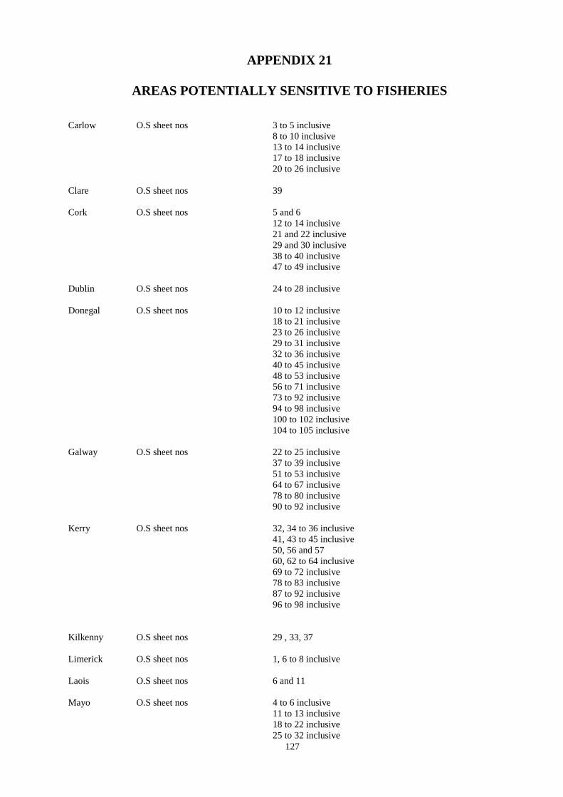
127
APPENDIX 21
AREAS POTENTIALLY SENSITIVE TO FISHERIES
Carlow O.S sheet nos 3 to 5 inclusive
8 to 10 inclusive
13 to 14 inclusive
17 to 18 inclusive
20 to 26 inclusive
Clare O.S sheet nos 39
Cork O.S sheet nos 5 and 6
12 to 14 inclusive
21 and 22 inclusive
29 and 30 inclusive
38 to 40 inclusive
47 to 49 inclusive
Dublin O.S sheet nos 24 to 28 inclusive
Donegal O.S sheet nos 10 to 12 inclusive
18 to 21 inclusive
23 to 26 inclusive
29 to 31 inclusive
32 to 36 inclusive
40 to 45 inclusive
48 to 53 inclusive
56 to 71 inclusive
73 to 92 inclusive
94 to 98 inclusive
100 to 102 inclusive
104 to 105 inclusive
Galway O.S sheet nos 22 to 25 inclusive
37 to 39 inclusive
51 to 53 inclusive
64 to 67 inclusive
78 to 80 inclusive
90 to 92 inclusive
Kerry O.S sheet nos 32, 34 to 36 inclusive
41, 43 to 45 inclusive
50, 56 and 57
60, 62 to 64 inclusive
69 to 72 inclusive
78 to 83 inclusive
87 to 92 inclusive
96 to 98 inclusive
Kilkenny O.S sheet nos 29 , 33, 37
Limerick O.S sheet nos 1, 6 to 8 inclusive
Laois O.S sheet nos 6 and 11
Mayo O.S sheet nos 4 to 6 inclusive
11 to 13 inclusive
18 to 22 inclusive
25 to 32 inclusive
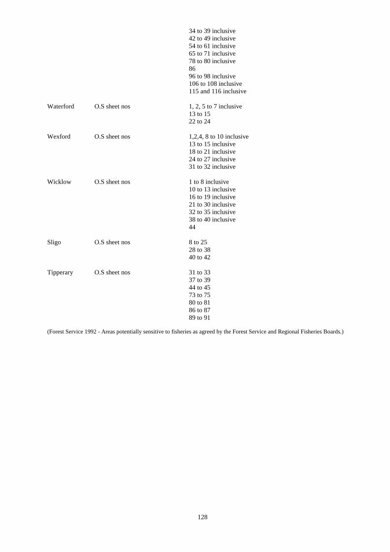
128
34 to 39 inclusive
42 to 49 inclusive
54 to 61 inclusive
65 to 71 inclusive
78 to 80 inclusive
86
96 to 98 inclusive
106 to 108 inclusive
115 and 116 inclusive
Waterford O.S sheet nos 1, 2, 5 to 7 inclusive
13 to 15
22 to 24
Wexford O.S sheet nos 1,2,4, 8 to 10 inclusive
13 to 15 inclusive
18 to 21 inclusive
24 to 27 inclusive
31 to 32 inclusive
Wicklow O.S sheet nos 1 to 8 inclusive
10 to 13 inclusive
16 to 19 inclusive
21 to 30 inclusive
32 to 35 inclusive
38 to 40 inclusive
44
Sligo O.S sheet nos 8 to 25
28 to 38
40 to 42
Tipperary O.S sheet nos 31 to 33
37 to 39
44 to 45
73 to 75
80 to 81
86 to 87
89 to 91
(Forest Service 1992 - Areas potentially sensitive to fisheries as agreed by the Forest Service and Regional Fisheries Boards.)
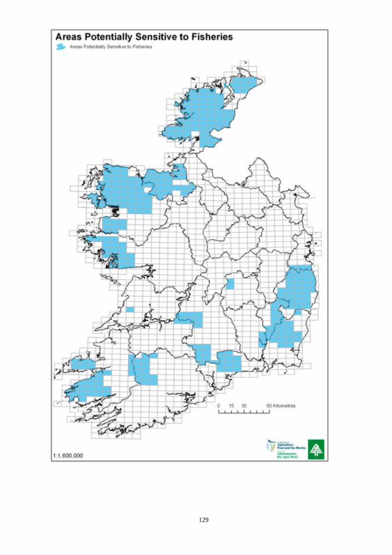
129

130
APPENDIX 22
ARCHAEOLOGY
Scheduled venues to view Record of Monuments and Places
In accordance with relevant regulations made under the National Monuments Acts 1930-2004,
lists of, and maps showing, monuments protected under Section 12 of the National Monuments
(Amendment) Act, 1994 (i.e. monuments and places included in the Record of Monuments and
Places) are available for inspection by members of the public during normal opening hours at a
variety of venues. These include local authority planning offices, county libraries, and various
Teagasc offices.
There are also a number of other ways in which monuments may be protected under the National
Monuments Acts, in addition to the Record of Monuments and Places. Monuments may also be
entered in the Register of Historic Monuments (under Section 5 of the National Monuments
(Amendment) Act 1987), be in the Ownership or in the Guardianship of a Local Authority or the
Minister for Arts, Heritage and the Gaeltacht, or the subject to a Preservation Order or
Temporary Preservation Order made by the Minister.
If further information on any of these topics is required it is advisable to contact National
Monuments Service directly:
National Monuments Service,
Department of Arts, Heritage and the Gaeltacht,
Room G50,
Custom House,
Dublin 1.
Email: [email protected]
Phone: +353 (0)1 888 2178
Fax: +353 (0)1 888 2689
Web: http://www.ahg.gov.ie/en/Heritage/Archaeology-NationalMonumentsService/
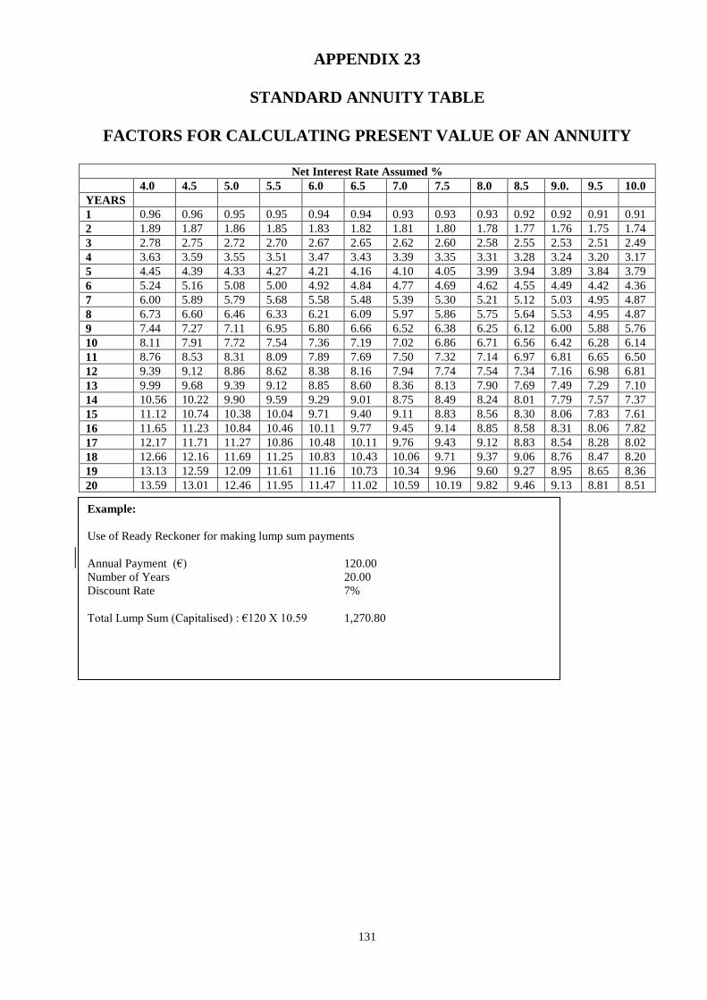
131
APPENDIX 23
STANDARD ANNUITY TABLE
FACTORS FOR CALCULATING PRESENT VALUE OF AN ANNUITY
Net Interest Rate Assumed %
4.0 4.5 5.0 5.5 6.0 6.5 7.0 7.5 8.0 8.5 9.0. 9.5 10.0
YEARS
1 0.96 0.96 0.95 0.95 0.94 0.94 0.93 0.93 0.93 0.92 0.92 0.91 0.91
2 1.89 1.87 1.86 1.85 1.83 1.82 1.81 1.80 1.78 1.77 1.76 1.75 1.74
3 2.78 2.75 2.72 2.70 2.67 2.65 2.62 2.60 2.58 2.55 2.53 2.51 2.49
4 3.63 3.59 3.55 3.51 3.47 3.43 3.39 3.35 3.31 3.28 3.24 3.20 3.17
5 4.45 4.39 4.33 4.27 4.21 4.16 4.10 4.05 3.99 3.94 3.89 3.84 3.79
6 5.24 5.16 5.08 5.00 4.92 4.84 4.77 4.69 4.62 4.55 4.49 4.42 4.36
7 6.00 5.89 5.79 5.68 5.58 5.48 5.39 5.30 5.21 5.12 5.03 4.95 4.87
8 6.73 6.60 6.46 6.33 6.21 6.09 5.97 5.86 5.75 5.64 5.53 4.95 4.87
9 7.44 7.27 7.11 6.95 6.80 6.66 6.52 6.38 6.25 6.12 6.00 5.88 5.76
10 8.11 7.91 7.72 7.54 7.36 7.19 7.02 6.86 6.71 6.56 6.42 6.28 6.14
11 8.76 8.53 8.31 8.09 7.89 7.69 7.50 7.32 7.14 6.97 6.81 6.65 6.50
12 9.39 9.12 8.86 8.62 8.38 8.16 7.94 7.74 7.54 7.34 7.16 6.98 6.81
13 9.99 9.68 9.39 9.12 8.85 8.60 8.36 8.13 7.90 7.69 7.49 7.29 7.10
14 10.56 10.22 9.90 9.59 9.29 9.01 8.75 8.49 8.24 8.01 7.79 7.57 7.37
15 11.12 10.74 10.38 10.04 9.71 9.40 9.11 8.83 8.56 8.30 8.06 7.83 7.61
16 11.65 11.23 10.84 10.46 10.11 9.77 9.45 9.14 8.85 8.58 8.31 8.06 7.82
17 12.17 11.71 11.27 10.86 10.48 10.11 9.76 9.43 9.12 8.83 8.54 8.28 8.02
18 12.66 12.16 11.69 11.25 10.83 10.43 10.06 9.71 9.37 9.06 8.76 8.47 8.20
19 13.13 12.59 12.09 11.61 11.16 10.73 10.34 9.96 9.60 9.27 8.95 8.65 8.36
20 13.59 13.01 12.46 11.95 11.47 11.02 10.59 10.19 9.82 9.46 9.13 8.81 8.51
SUPPLIED
Example:
Use of Ready Reckoner for making lump sum payments
Annual Payment (€) 120.00
Number of Years 20.00
Discount Rate 7%
Total Lump Sum (Capitalised) : €120 X 10.59 1,270.80

132
APPENDIX 24
IS436 Fencing Certificates
A sample IS436 Fencing Certificate is provided below.
Only companies that are certified by the National Standards Authority of Ireland (NSAI) to produce IS436
are entitled to reproduce this certificate.
The certificate is to be produced in duplicate, with the stake IS436 registration holder holding the original
copy, and supplying the second copy to the person/company purchasing the posts. Manufactures of NSAI
fencing materials shall obtain numbers for each certificate directly from the Department of Agriculture,
Food and the Marine, Specialist Unit, Specialist Farm Services Environment and Evaluation Division,
Pavilion A, Grattan Business Centre, Dublin Road, Portlaoise, Co. Laois. This replicates the same process
as administered by the DAFM Farm Fencing Scheme.
All NASI registered suppliers of timber certified to IS436 will contact DAFM directly for certificate
numbers.
Registered suppliers of IS436 timber fencing are available on the National Standards Authority of Ireland‟s
website www.nsai.ie/Our-Services/Certification/Company-Registration-Search.aspx

133
SAMPLE IS436 FENCING POST CERTIFICATE
Cert No: (Numbers to be obtained from DAFM)
Section A: (To be completed by post manufacturer)
Manufacturer‟s Name: Manufacturer‟s Registration No:
Manufacturer‟s Address:
Name of company post supplied to:
Address of company post supplied to:
Bale
No.
No. of posts in
bale
Post dimensions
(mm)
Bale
No.
No. of posts in
bale
Post dimensions
(mm)
Signed: ____________________ Date: ___________
Status: _____________________________________
Company Stamp:
Section B: (To be completed by Fencing contractor / supplier of post to farmer)
Suppliers Name:
Suppliers Address:
Farmers Name:
Farmers Address:
Site address
Bale No. No. of posts in
bale
Post dimensions
(mm)
Bale No. No. of posts in
bale
Post dimensions
(mm)
Signed: ___________________ Date: _______
Status: ________________________________
Company Stamp: