Embed Size (px)
Citation preview
Forestry Data Model User Guide Version 2.0
January, 2013
Table of Contents
Introduction .................................................................................................................................................. 1
Advantages of Using a Geodatabase ............................................................................................................ 1
Subtypes and Domains.................................................................................................................................. 2
Subtypes ................................................................................................................................................ 2
Domains ................................................................................................................................................ 3
The Forestry Data Model .............................................................................................................................. 3
Migrating to the Forestry Data Model .......................................................................................................... 5
Step 1: Data Migration Matrix .............................................................................................................. 5
Step 2: Prepare Source Data ................................................................................................................. 6
Step 3: Data Migration .......................................................................................................................... 9
Feedback ..................................................................................................................................................... 12
Importing Additional Feature Classes to the Forestry Geodatabase .......................................................... 12
1
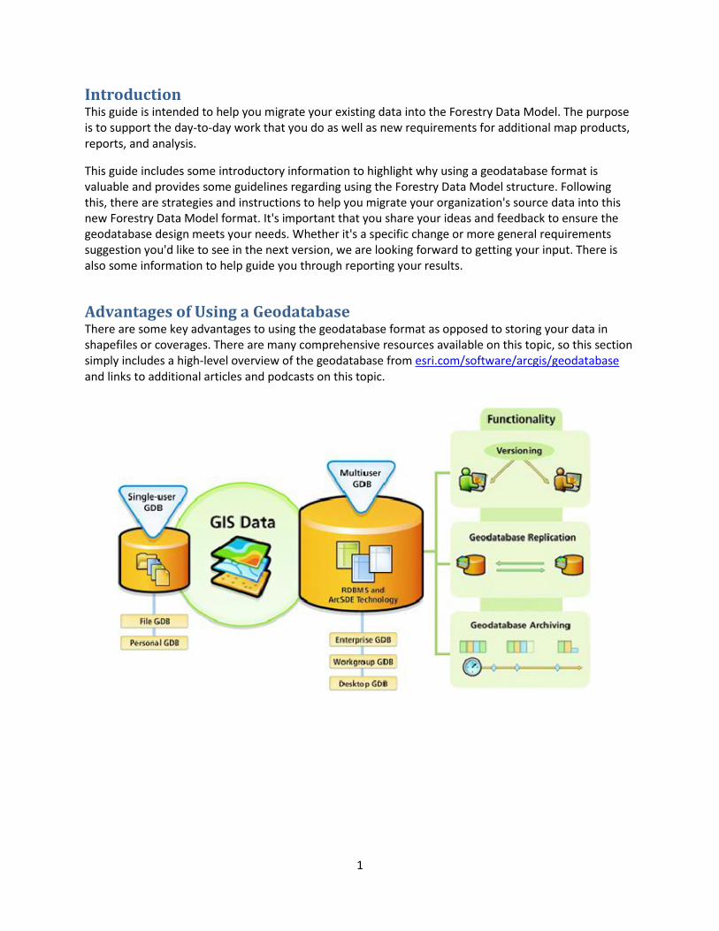
Introduction This guide is intended to help you migrate your existing data into the Forestry Data Model. The purpose is to support the day-to-day work that you do as well as new requirements for additional map products, reports, and analysis.
This guide includes some introductory information to highlight why using a geodatabase format is valuable and provides some guidelines regarding using the Forestry Data Model structure. Following this, there are strategies and instructions to help you migrate your organization's source data into this new Forestry Data Model format. It's important that you share your ideas and feedback to ensure the geodatabase design meets your needs. Whether it's a specific change or more general requirements suggestion you'd like to see in the next version, we are looking forward to getting your input. There is also some information to help guide you through reporting your results.
Advantages of Using a Geodatabase There are some key advantages to using the geodatabase format as opposed to storing your data in shapefiles or coverages. There are many comprehensive resources available on this topic, so this section simply includes a high-level overview of the geodatabase from esri.com/software/arcgis/geodatabase and links to additional articles and podcasts on this topic.
2
The geodatabase offers you the ability to do the following:
■ Store a rich collection of spatial data in a centralized location ■ Apply sophisticated rules and relationships to the data ■ Define advanced geospatial relational models (e.g., topologies, networks) ■ Maintain integrity of spatial data with a consistent, accurate database ■ Work within a multiuser access and editing environment ■ Integrate spatial data with other IT databases ■ Easily scale your storage solution ■ Support custom features and behavior ■ Leverage your spatial data to its full potential
Some additional resources for more information about the geodatabase are below:
video.arcgis.com/watch/95/geodatabase-essentials-part-1-an-introduction-to-the-geodatabase
video.arcgis.com/watch/101/geodatabase-essentials-part-2-_dash _-an-introduction-to-arcsde-geodatabases
Subtypes and Domains Once you upgrade to the geodatabase you get the added benefits of using subtypes. The subsections below give a brief description of each:
Subtypes Subtypes are a subset of features in a feature class, or objects in a table, that share the same attributes. They are used as a method to categorize your data, eliminating repetitive data entry and ensuring data consistency.
Subtypes allow you to do the following:
■ Increase the performance of the geodatabase by representing a variety of real-world objects as a subset of features in a given feature class instead of creating new feature classes for each object (For example, the forest roads in a forest roads feature class could be categorized into two subtypes: public roads and private roads.)
■ Set a default value that will automatically be applied when creating new features (For example, a subtype for trail access type can be created and defined so that whenever a trail is added to the feature class, its access type is automatically set to private.)
■ Apply coded or ranged domains to features, enabling you to constrain input information to a valid set of values (For example, the trails cover type can have a coded domain for restricting them to be asphalt, gravel, or dirt.)
Some additional resources providing more information about subtypes can be found here: help.arcgis.com/en/arcgisdesktop/10.0/help/index.html#/Working_with_subtypes /005r00000002000000/ help.arcgis.com/en/arcgisdesktop/10.0/help/index.html#/Creating_subtypes /005r00000003000000/
3
Domains Attribute domains are used to constrain the values allowed in any particular attribute for a table or feature class and are often referred to as the list of acceptable values. In other words, the field will not accept a value that is not in that domain. If the features in a feature class or nonspatial objects in a table have been grouped into subtypes, then different attribute domains can also be assigned to each of the subtypes.
More information about domains and the different types of domains can be found here:
help.arcgis.com/en/arcgisdesktop/10.0/help/index.html#//001s00000001000000.htm
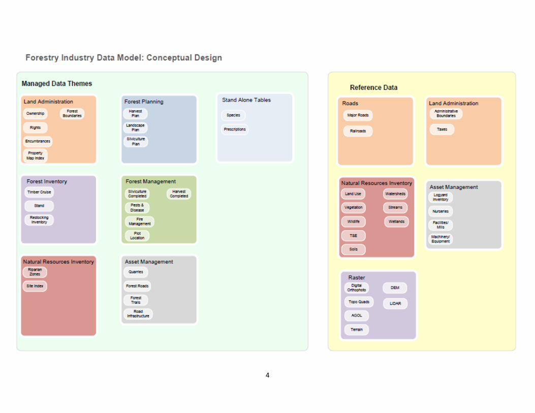
The Forestry Data Model A conceptual high-level diagram of the Forestry Data Model is below (A complete logical diagram is included in the review package):
4
5
Migrating to the Forestry Data Model Migrating data into the Forestry Data Model can be broken down into three steps:
1. Design a matrix to indicate how source data maps into the target Forestry Data Model. 2. Prepare your source data to simplify the data migration process. 3. Migrate your source data into the Forestry Data Model using the Simple Data Loader in
ArcCatalog. Note: An alternative option is to use ModelBuilder or the Data Interoperability extension to build an automated tool to complete steps 2 and 3. This would be preferable when you envision needing to perform iterative updates to the data migration process or perform the data migration multiple times. In this guide, the focus is on the simplest and most efficient way to get some sample data into the geodatabase, so these topics are not covered.
Step 1: Data Migration Matrix The first step in the data migration process is to identify and document how your source data will map to the target Forestry Data Model in a Data Migration Matrix. This requires an understanding of the types, formats, and structure of the source data maintained by your organization and in the target Forestry Data Model.
At a minimum, this matrix identifies which source shapefiles, coverages, feature classes, and tables will be migrated to which target feature classes and tables. It may also include notes on additional ways the data is to be manipulated during the data migration such as filtering data that meets specified criteria or mapping attribute values. During this process, you will likely find that some of your organization's data aligns very closely with the Forestry Data Model and will be very simple to migrate. In other scenarios, you may find that you have the types of information captured in the Forestry Data Model but that your data is in a different format or structure. Both of these scenarios are captured in the Data Migration Matrix. Note that it's acceptable if you do not have all the features or attributes that are included in the Forestry Data Model—those simply won't be included in the data migration. If you have additional types of features or attributes that are not included in the current version of the model, please include that in your feedback.
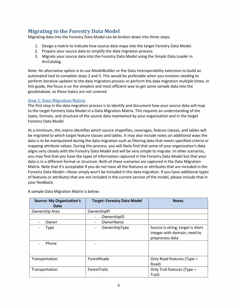
A sample Data Migration Matrix is below:
Source: My Organization's Data
Target: Forestry Data Model Notes
Ownership Area OwnershipPl - OwnershipID
- Owner - OwnerName - Type - OwnershipType Source is string; target is short
integer with domain; need to preprocess data
- Phone -
Transportation ForestRoads Only Road features (Type = Road)
Transportation ForestTrails Only Trail features (Type = Trail)
6
It's not important that the documentation is complete, but the process of filling in the data migration matrix will help you define the work required in steps 2 and 3.
Tip: To fill out this matrix, try creating some new data in the target geodatabase using the ArcMap editing tools. This will help you learn more about the structure and format of the Forestry Data Model and how your data could be translated to this new format.
Step 2: Prepare Source Data The second step in the data migration process is to preprocess data so that it can be loaded into the geodatabase using the Simple Data Loader. Some basic requirements apply:
■ Source and Target geometry types must be identical or compatible. For example, you cannot load a point shapefile into a polygon feature class.
■ Source and Target field types must be identical or compatible. For example, you cannot load
string values into a short integer field. ■ Source data values and characteristics should adhere to rules specified in the Forestry Data
Model. For example, where a subtype or domain is applied to a field, the values in the source data must match the codes included in that subtype or domain to be migrated correctly. Note: This rule is not enforced by the Simple Data Loader tool.
In cases where the above requirements are not met for your source data, some preprocessing is required. Primarily, this will involve adding new fields to your source data and calculating values to match the structure and format of the Forestry Data Model.
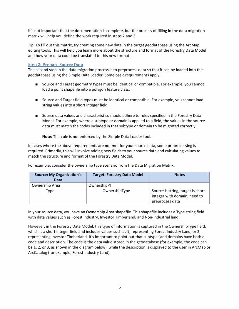
For example, consider the ownership type scenario from the Data Migration Matrix:
In your source data, you have an Ownership Area shapefile. This shapefile includes a Type string field with data values such as Forest Industry, Investor Timberland, and Non-Industrial land.
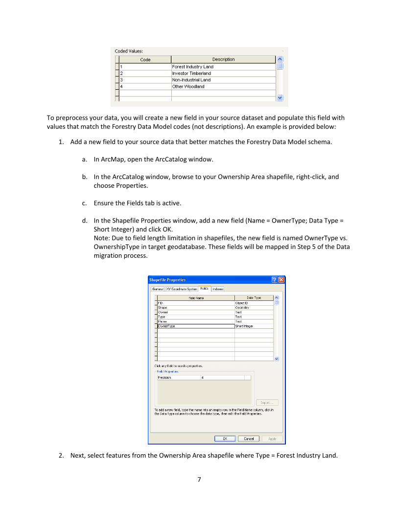
However, in the Forestry Data Model, this type of information is captured in the OwnershipType field, which is a short integer field and includes values such as 1, representing Forest Industry Land, or 2, representing Investor Timberland. It's important to point out that subtypes and domains have both a code and description. The code is the data value stored in the geodatabase (for example, the code can be 1, 2, or 3, as shown in the diagram below), while the description is displayed to the user in ArcMap or ArcCatalog (for example, Forest Industry Land).
Source: My Organization's Data
Target: Forestry Data Model Notes
Ownership Area OwnershipPl - Type - OwnershipType Source is string; target is short
integer with domain; need to preprocess data
7
To preprocess your data, you will create a new field in your source dataset and populate this field with values that match the Forestry Data Model codes (not descriptions). An example is provided below:
1. Add a new field to your source data that better matches the Forestry Data Model schema.
a. In ArcMap, open the ArcCatalog window. b. In the ArcCatalog window, browse to your Ownership Area shapefile, right-click, and
choose Properties. c. Ensure the Fields tab is active. d. In the Shapefile Properties window, add a new field (Name = OwnerType; Data Type =
Short Integer) and click OK. Note: Due to field length limitation in shapefiles, the new field is named OwnerType vs. OwnershipType in target geodatabase. These fields will be mapped in Step 5 of the Data migration process.
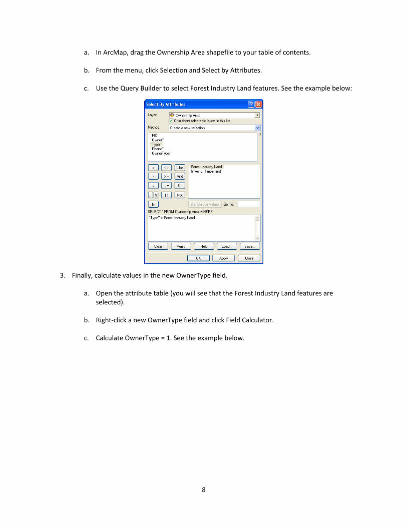
2. Next, select features from the Ownership Area shapefile where Type = Forest Industry Land.
8
a. In ArcMap, drag the Ownership Area shapefile to your table of contents. b. From the menu, click Selection and Select by Attributes. c. Use the Query Builder to select Forest Industry Land features. See the example below:
3. Finally, calculate values in the new OwnerType field.
a. Open the attribute table (you will see that the Forest Industry Land features are selected).
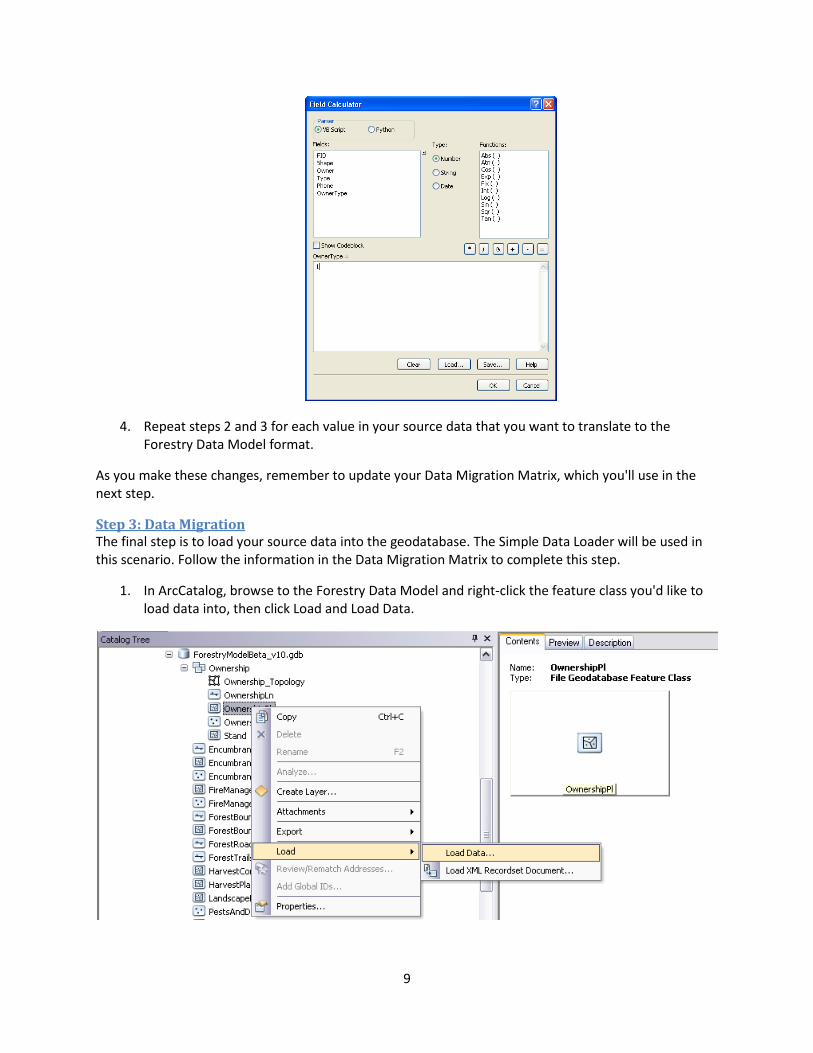
b. Right-click a new OwnerType field and click Field Calculator. c. Calculate OwnerType = 1. See the example below.
9
4. Repeat steps 2 and 3 for each value in your source data that you want to translate to the Forestry Data Model format.
As you make these changes, remember to update your Data Migration Matrix, which you'll use in the next step.
Step 3: Data Migration The final step is to load your source data into the geodatabase. The Simple Data Loader will be used in this scenario. Follow the information in the Data Migration Matrix to complete this step.
1. In ArcCatalog, browse to the Forestry Data Model and right-click the feature class you'd like to load data into, then click Load and Load Data.
10
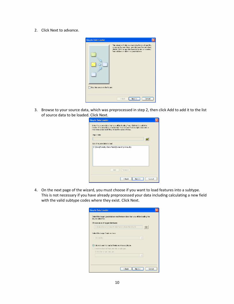
2. Click Next to advance.
3. Browse to your source data, which was preprocessed in step 2, then click Add to add it to the list of source data to be loaded. Click Next.
4. On the next page of the wizard, you must choose if you want to load features into a subtype. This is not necessary if you have already preprocessed your data including calculating a new field with the valid subtype codes where they exist. Click Next.
11
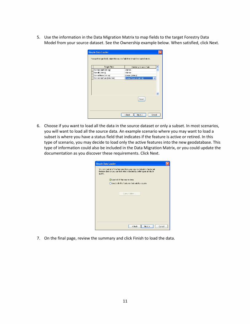
5. Use the information in the Data Migration Matrix to map fields to the target Forestry Data
Model from your source dataset. See the Ownership example below. When satisfied, click Next.
6. Choose if you want to load all the data in the source dataset or only a subset. In most scenarios, you will want to load all the source data. An example scenario where you may want to load a subset is where you have a status field that indicates if the feature is active or retired. In this type of scenario, you may decide to load only the active features into the new geodatabase. This type of information could also be included in the Data Migration Matrix, or you could update the documentation as you discover these requirements. Click Next.
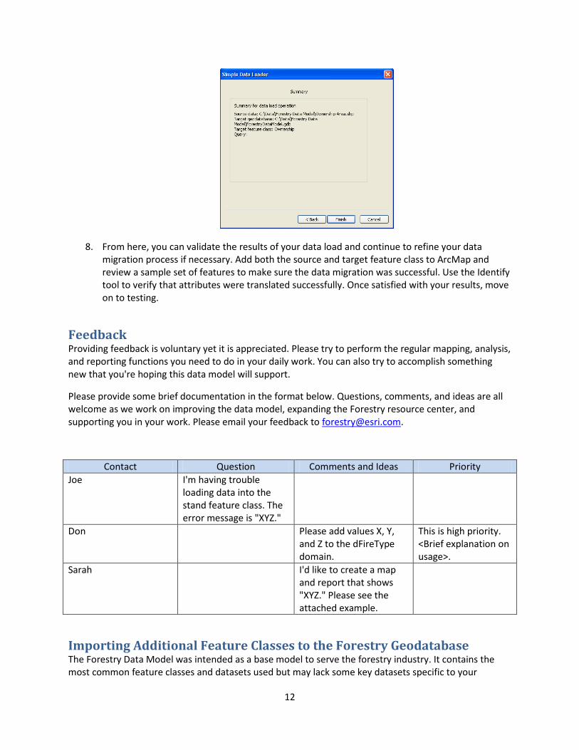
7. On the final page, review the summary and click Finish to load the data.
12
8. From here, you can validate the results of your data load and continue to refine your data migration process if necessary. Add both the source and target feature class to ArcMap and review a sample set of features to make sure the data migration was successful. Use the Identify tool to verify that attributes were translated successfully. Once satisfied with your results, move on to testing.
Feedback Providing feedback is voluntary yet it is appreciated. Please try to perform the regular mapping, analysis, and reporting functions you need to do in your daily work. You can also try to accomplish something new that you're hoping this data model will support.
Please provide some brief documentation in the format below. Questions, comments, and ideas are all welcome as we work on improving the data model, expanding the Forestry resource center, and supporting you in your work. Please email your feedback to [email protected].
Contact Question Comments and Ideas Priority Joe I'm having trouble
loading data into the stand feature class. The error message is "XYZ."
Don Please add values X, Y, and Z to the dFireType domain.
This is high priority. <Brief explanation on usage>.
Sarah I'd like to create a map and report that shows "XYZ." Please see the attached example.
Importing Additional Feature Classes to the Forestry Geodatabase The Forestry Data Model was intended as a base model to serve the forestry industry. It contains the most common feature classes and datasets used but may lack some key datasets specific to your

13
organization or datasets typically used as reference data. The following links provide some information regarding the ways you can extend the data model. This includes importing shapefiles, coverages, CAD data, or feature classes that you may have in an existing geodatabase:
help.arcgis.com/en/arcgisdesktop/10.0/help/index.html#/About_importing_feature_classes /003n00000045000000/
help.arcgis.com/en/arcgisdesktop/10.0/help/index.html#/Importing_a_feature_class_multiple /003n00000047000000/
help.arcgis.com/en/arcgisdesktop/10.0/help/index.html#/An_overview_of_the_To_Geodatabase _toolset/00120000001w000000/