Embed Size (px)
Citation preview

J. FOR. SCI., 62, 2016 (6): 253–263 253
JOURNAL OF FOREST SCIENCE, 62, 2016 (6): 253–263
doi: 10.17221/42/2015-JFS
Forest park site selection based on a Fuzzy analytic hierarchy process framework (Case study: the Galegol Basin, Lorestan province, Iran)
A. Salehnasab1, J. Feghi1, A. Danekar2, J. Soosani3, A. Dastranj4
1Department of Forestry and Forest Economics, Faculty of Natural Resources, University of Tehran, Karaj, Iran
2Department of Environmental Science, Faculty of Natural Resources, University of Tehran, Karaj, Iran
3Department of Natural Resources and Forestry, Faculty of Natural Resources, Lorestan University, Khorramābād, Iran
4Department of Watershed Management, Faculty of Natural Resources, University of Hormozgan, Hormozgan, Iran
ABSTRACT: The aim of this study is to solve the forest park site selection problem using a Fuzzy analytic hierarchy pro-cess (FAHP) framework in the Galegol Basin, Lorestan province, Iran. The Delphi screening method was used to select the most relevant criteria and sub-criteria to the forest park problem. Using the FAHP weighting approach, the weight of each criterion and sub-criterion was calculated. Then, the suitability map of forest park location was mapped by the weighted linear combination (WLC) method. The results revealed that 7 criteria (climate, water resources, physiography, landscape, vegetation cover, wildlife and economic criteria) and 16 sub-criteria received the required values and can be involved into the decision-making process of the forest park site selection problem. Using the derived weights of sub-criteria by FAHP and the WLC method, the final results showed that most of the study area is moderately suitable for the forest park loca-tion problem. The results of this study can be valuable in the planning of local forest park and future land use planning.
Keywords: suitability map; weighted linear combination; criteria; decision-making; Delphi method
Sustainable development is concerned with ac-knowledging economic, social and environmental development aspects, providing for the current needs of society without damaging the well-being of future generations (Eriksson, Lidstrom 2013). Nowadays, ecotourism is the fastest growing sector of the world’s largest service industry and it has a strong connection with sustainable tourism while sustainability depends on the relationship between tourism and environment (Bunruamkaew, Mu-rayama 2011). Suitable management for ecotour-ism development is essential in order to conserve and maintain the biological richness as well as economic upliftment of the local people. In addi-tion, ecotourism can be defined as an opportunity to promote the values in the protected areas and
to finance related stakeholders (Ok 2006). As with all types of developments, ecotourism has positive and negative effects on the environment, culture and economics of society. One of the main strate-gies to minimize the negative impacts and enhance the positive effects of the ecotourism is proper land use planning with regard to the natural capacity and environmental criterion of a given region. Eco-tourism development along with the land environ-mental capabilities as an effective strategy plays a key role in sustainable development, promotion of human welfare and maintaining of natural resourc-es balance. Ecotourism in the form of forest park is the most extensive mode of the forest manage-ment planning. Principally, the selection of forest park location has not been based on scientific and

254 J. FOR. SCI., 62, 2016 (6): 253–263
technical criteria and indicators and in most cases it has been influenced by personal interests. There-fore, this problem has brought many problems dealing with the stability of forest park functions. Hence, locating suitable areas for the establishment of forest parks is especially important with regard to effective criteria and indicators. The term “forest park” was defined by the Forest and Range Organi-zation of Iran and is specifically applicable to Iran. The forest park is a vast natural area when some parts of it are virgin and untouched by humans and that is managed by the government with rec-reational function, watershed conservation, fodder production, and so on (FROI 2010).
The site selection is a spatial analysis process that is extremely important in reducing costs and launching vari ous activities. For this reason, the implementation of executive projects plays an important role. Today, regarding the ability of geographical information systems (GISs) in the management and analysis of spatial data, a good situation has been provided for doing spatial analy-ses such as locating the forest parks. In relation to locating different areas using GIS capabilities and also combining them with decision-making tech-niques, a lot of research has been conducted in this field. Multi-criteria analysis (MCA) was used to lo-cate the most suitable area for forest management planning such as urban forestry (Van Elegem et al. 2002; Gul et al. 2006), forest parks (Sharifi et al. 2002; Zucca et al. 2008), community forest manage-ment (Khadka, Vacik 2014). Minagawa and Tanaka (1998) used GIS to locate areas suitable for tourism development in Indonesia. Zhou et al. (2005) found that the multi-attribute utility theory in conjunc-
tion with analytic hierarchy process (AHP) is suit-able for most application areas.
The present study uses a Fuzzy analytic hierarchy process (FAHP) framework for the problem of for-est park site selection in Lorestan province, Iran.
MATERIAL AND METHODS
Study area. The Galegol Basin located between 33°10'' and 33°20'' east longitudes and 48°10'' and 48°20'' north latitudes, in the central part of Lores-tan province, Iran, covers approximately 9,491 ha (Fig. 1). The topography of the area is mountainous without plain or flat lands. It has attractive land-scapes and natural attractions including springs, caves, rivers and forest covers.
Criteria and indicators development. In general, criteria define the essential elements or principles against which a thing or issue is judged. One that adds the meaning to a principle without itself be-ing a direct measure of performance (Stork et al. 1997). An indicator is any component of the relevant management systems used to infer attributes and criteria. Indicators are usually quantitative aspects of criteria and changes of indicators are monitored over time. The greater the number of selected indi-cators, the more difficult and costly will be the feasi-bility and their implementation. Evaluation criteria are divided into two categories. Direct criteria from literature sources that are directly related to the giv-en ecotourism problem and have been reported in scientific resources. Indirect ones are used for better understanding and configuring of a related criterion. To identify and develop criteria and indicators, in-
Fig. 1. The Galegol Basin study area in the Lorestan Province, Iran

J. FOR. SCI., 62, 2016 (6): 253–263 255
structions on the country’s political and economic objectives must be considered. The next thing on the set criteria and indicators is the full understand-ing of the target region properties such as social, cultural, economic and environmental dimensions. Therefore by taking into account these two tips, the appropriate criteria and indicators of a subject and study area can be reached. In this study, a compre-hension checklist of criteria and sub-criteria is de-veloped (Salehnasab 2013).
Delphi screening stage. A survey of opinions and comments can be a useful way in the selection of cri-teria for the spatial location of sites. In this approach, expert groups can be created for the determination of a criterion that must be included in a decision analysis. The Delphi screening method is a structured communication technique originally developed as a systematic, interactive forecasting method which re-lies on a panel of experts and is well suited as a means and method for consensus-building by using a series of questionnaires to collect data from a panel of se-lected subjects (Dalkey, Helmer 1963). Based on the questionnaire, the importance of each criterion is ranked by numerical values. The “better” value is from the point of view of an expert that participates in the survey and filled in the questionnaire. Anony-mous response, iteration and controlled feedback and finally statistical group response are the main compo-nents of the Delphi method (Hsu et al. 2010). The re-sults of the Delphi questionnaires are used to calculate the mean criterion importance degree (CID) and the mean percent of CID indices as follows (Eqs 1 and 2):
(1)
where:xi – initial importance degree of each criterion (1, 3, 5,
7 and 9) in the questioner; based on these values (1, 3, 5, 7 and 9), respondents determined the initial importance of each criterion, 1 denotes the lowest importance and 9 shows the highest importance),
N – number of questionnaire recipients,n – number of recipients that vote the xi of each cri-
terion.
(2)
where:PC – mean percent of CID,zi – weighted score.
Based on these indices, a possibility of selecting rel-evant criteria among many of them will be provided.
Fuzzy analytic hierarchy process weighting stage. Making decisions in the presence of multi-ple criteria (often conflict) is complex. A compen-
satory approach to deal with multi-criteria deci-sion-making problems is the AHP scoring method that was originally introduced by Saaty (1997). To convey the decision maker’s preference, scores in a pairwise comparison between different cri-teria are used. This traditional method has some limitations to deal with multi-criteria decision-making problems. First, this method deals with an unbalanced scale of judgment. Second, the AHP method ignores the uncertainty associated with the judgment. Third, ranking in this method is imprecise (Kabir, Hasin 2011). Therefore, an extension of the AHP method, called FAHP, was used to overcome the above-mentioned limita-tions of the traditional AHP method. In fact, AHP based weighted maps were standardized by the FAHP method. At first, Buckley (1985) devel-oped the analysis of FAHP. Chang’s extent analy-sis is one of the approaches to solution processes of FAHP methodology (Celik et al. 2009). In this approach, triangular fuzzy numbers are used for a pairwise comparison by the FAHP method. Here, we briefly describe the theoretical principle of the approach.
Assumption 1: suppose, M to be a triangular fuzzy number with the membership function below (Eq. 3):
(3)
where:x – independent variable,l – lower value of the support of M (l ≤ m),m – modal value,u – upper value of the support of M (m ≤ u).
Then, operational laws between M1 = (l1, m1, u1) and M2 = (l2, m2, u2) triangular fuzzy numbers can be written as Eq. 4:
M1 + M2 = (l1 + l2, m1 + m2, u1 + u2),M1 × M2 = (l1l2, m1m2, u1u2), (4)(λ, λ, λ)M1 = (λl1, λm1, λu1), λ > 0,M1
–1 ≈ (1/u1, 1/m1, 1/l1)where:λ – element of real numbers.
Assumption 2: let X = {x1, x2, x3, …, xn} and G = {u1, u2, u3, …, un} represent object and goal sets, respectively. Then, according to Chang’s extent analysis, values of the m extent analysis for each goal (gi) can be denoted by:
4
participates in the survey and filled in the questionnaire. Anonymous response, iteration and
controlled feedback and finally statistical group response are the main components of the Delphi
method (HSU et al. 2010). The results of the Delphi questionnaires are used to calculate the
percentage and degree of criterion importance numerical indices as follows (Eqs 1 and 2):
N)nx(
CID i∑ ×= (1)
where:
CID – mean criterion importance degree,
xi – initial importance degree of each criterion (1, 3, 5, 7 and 9) in the questioner; based on
these values (1, 3, 5, 7 and 9), respondents determined the initial importance of each criterion, 1
denotes the lowest importance and 9 shows the highest importance),
N – number of questionnaire recipients,
n – number of recipients that vote the xi of each criterion.
100N
zPC i ×= ∑ (2)
where:
PC – mean percent of CID,
zi – is the weighted score
×
∑n
xx
i
i .
Based on these indices, a possibility of selecting relevant criteria among many of them will be
provided.
Fuzzy analytic hierarchy process weighting stage. Making decisions in the presence of
multiple criteria (often conflict) is complex. A compensatory approach to deal with multi-criteria
decision-making problems is the AHP scoring method that was originally introduced by SAATY
(1997). To convey the decision maker’s preference, scores in a pairwise comparison between
different criteria are used. This traditional method has some limitations to deal with multi-criteria
decision-making problems. First, this method deals with an unbalanced scale of judgment.
Second, the AHP method ignores the uncertainty associated with the judgment. Third, ranking in
this method is imprecise (KABIR, HASIN 2011). Therefore, an extension of the AHP method,
called FAHP, was used to overcome the above-mentioned limitations of the traditional AHP
zi
N
4
participates in the survey and filled in the questionnaire. Anonymous response, iteration and
controlled feedback and finally statistical group response are the main components of the Delphi
method (HSU et al. 2010). The results of the Delphi questionnaires are used to calculate the
percentage and degree of criterion importance numerical indices as follows (Eqs 1 and 2):
N)nx(
CID i∑ ×= (1)
where:
CID – mean criterion importance degree,
xi – initial importance degree of each criterion (1, 3, 5, 7 and 9) in the questioner; based on
these values (1, 3, 5, 7 and 9), respondents determined the initial importance of each criterion, 1
denotes the lowest importance and 9 shows the highest importance),
N – number of questionnaire recipients,
n – number of recipients that vote the xi of each criterion.
100N
zPC i ×= ∑ (2)
where:
PC – mean percent of CID,
zi – is the weighted score
×
∑n
xx
i
i .
Based on these indices, a possibility of selecting relevant criteria among many of them will be
provided.
Fuzzy analytic hierarchy process weighting stage. Making decisions in the presence of
multiple criteria (often conflict) is complex. A compensatory approach to deal with multi-criteria
decision-making problems is the AHP scoring method that was originally introduced by SAATY
(1997). To convey the decision maker’s preference, scores in a pairwise comparison between
different criteria are used. This traditional method has some limitations to deal with multi-criteria
decision-making problems. First, this method deals with an unbalanced scale of judgment.
Second, the AHP method ignores the uncertainty associated with the judgment. Third, ranking in
this method is imprecise (KABIR, HASIN 2011). Therefore, an extension of the AHP method,
called FAHP, was used to overcome the above-mentioned limitations of the traditional AHP
Nxi n
5
method. In fact, AHP based weighted maps were standardized by the FAHP method. At first,
BUCKLEY (1985) developed the analysis of FAHP. Chang’s extent analysis is one of the
approaches to solution processes of FAHP methodology (CELIK et al. 2009). In this approach,
triangular fuzzy numbers are used for a pairwise comparison by the FAHP method. Here, we
briefly describe the theoretical principle of the approach.
Assumption 1: suppose, M to be a triangular fuzzy number with the membership function below
(Eq. 3):
≤
≤≤
≤≤
≤
=
xu0,
uxm,u-mu-x
mxl,l-ml-x
lx0,
m,u)l,(x;Triangular (3)
where:
x – ?,
l – lower value of the support of M (l ≤ m),
m – modal value,
u – upper value of the support of M (m ≤ u).
Then, operational laws between M1 = (l1, m1, u1) and M2 = (l2, m2, u2) triangular fuzzy numbers
can be written as Eq. 4:
M1 + M2 = (l1 + l2, m1 + m2, u1 + u2),
M1 × M2 = (l1l2, m1m2, u1u2), (4)
(λ, λ, λ)M1 = (λl1, λm1, λu1), λ > 0,
M1–1 ≈ (1/u1, 1/m1, 1/l1)
where:
λ – ?.
Assumption 2: let X = {x1, x2, x3, …, xn}and G = {u1, u2, u3, …, un} represent object and goal sets,
respectively. Then, according to Chang’s extent analysis, values of the m extent analysis for each
goal (gi) can be denoted by:
jg
2g
1g
iiiM,,M,M 2
where:
i = 1, 2, 3, …, n,
–
–
––

256 J. FOR. SCI., 62, 2016 (6): 253–263
where:i = 1, 2, 3, …, n,j = 1, 2, 3, …, m.
Assumption 3: the value of fuzzy synthetic extent (Si) of the i-th object is presented by Eq. 5:
(5)
With the above-mentioned assumptions and Si calculations, the degree of magnitude M1 to M2 can be obtained by the following relation (Eq. 6):
(M1 ≥ M2) = 1, if: m1 ≥ m2 (6) (M2 ≥ M1) = hgt(M1 ∩ M2)where:hgt – height of a fuzzy set A, hgt(A) is defined by hgt(A)
= supremum {A(x) |x ∈ X|}. If hgt(A) = 1, then A is called normalized.
Consequently, the degree for a triangular fuzzy number to be greater than k ones (Mi (i = 1, 2, 3, k) is dedicated by Eq. 7:
(M ≥ M1, M2, M3, …, Mk) = [(M ≥ M1) and (M ≥ M2) and (M ≥ M3) and … and (M ≥ Mk)] (7)
Then, the weight vectors of indices (W(xi)) are given by Eq. 8:
W(xi) = min { (Si ≥ Sk)}, k = 1, 2, 3, …, k ≠ 1 (8)
Weighted linear combination (WLC) based site selection stage. Because of different scales of the map layers involved into the MCA analysis, it is necessary that the values of layers be transformed to comparable scales. There are some methods to make input map layers comparable. According to the types of information for creating the map lay-ers, three approaches were developed for assigning new scales: deterministic, probabilistic or fuzzy (Malczewski 1999). Here a fuzzy approach was used for standardizing the input map layers. The fuzzy logic theory gives the multi criteria evalua-tion (MCE) process more flexibility and takes into account the continuity and uncertainty (Dashti et al. 2013). Here, a simple linear scaling as expressed below is used (Eq. 9):
xi = [(Ri – Rmin)/(Rmax – Rmin)] × standardized range (9)
where:R – raw score of the input map layer.
This equation gives the option of standardizing factors to either a 0–1 scale or a 0–255 byte scale
for the input map layer. Since, the MCE process has been optimized for speed using a 0–255 level standardization, the latter scale was used for the standardization stage (Eastman 2009). Then, the standardized maps with their related weights from the Fuzzy analytic hierarchy process analysis were combined based on the WLC technique (Ayalew et al. 2005). The weighted linear combination mod-el is one of the most widely used decision rules that are often applied in suitability and site selection analysis problems. Easy to implement and under-stand are the primary reasons for its popularity (Malczewski 2000). The mathematical expres-sion of the WLC model as Eq. 10:
(10)
where:wj – weight of map layer j,rj – map j transformed into the comparable scale,n – total number of map layers involved into the WLC
analysis,rj(xi) – value function for the jth attribute, xi = (xi1, xi2, ..., xin),rij – attribute transformed into the comparable scale.
Up to this stage, the WLC final map of suitability would provide a scattered spatial pattern of adja-cent cells. Therefore, adjacent cells were grouped into zones (areas < 20 ha eliminated) and their ar-eas were calculated. Finally, the average of the suit-ability of a certain zone calculates as follows (Leao et al. 2004; Eq. 11):
(11)
where:Sz – average land suitability of zone z,(Li)z – cells i of zone z,nz – number of cells of zone z.
RESULTS
Criteria and indicators development stage
As mentioned in the previous section, choosing ap-propriate criteria and indicators for the forest park se-lection problem is the main and first step of this type of studies. Hence, we extract the main criteria and indicators by a comprehension and precise literature review. Based on 28 literature reviews, we developed three groups of criteria: physical, biological and socio-economic. Also, 10 criteria and 36 sub-criteria were identified (Fig. 2). It is noteworthy that this figure is presented only as a general checklist and based on the condition of the studied area, 7 criteria (climate,
7
This equation gives the option of standardizing factors to either a 0–1 scale or a 0–255 byte scale
for the input map layer. Since, the MCE process has been optimized for speed using a 0–255
level standardization, the latter scale was used for the standardization stage (EASTMAN 2009).
Then, the standardized maps with their related weights from the Fuzzy analytic hierarchy process
analysis were combined based on the WLC technique (AYALEW et al. 2005). The weighted linear
combination model is one of the most widely used decision rules that are often applied in
suitability and site selection analysis problems. Easy to implement and understand are the
primary reasons for its popularity (MALCZEWSKI 2000). The mathematical expression of the
WLC model as Eq. 10:
∑ ∑==n
j
n
jijjijji rwxrwxV )()( , ∑ = 1jw (10)
where:
wi – weight of map layer i,
ri – map i transformed into the comparable scale,
n – total number of map layers involved into the WLC analysis,
rj(xi) – value function for the jth attribute,
xi = (xi1, xi2, ..., xin),
rij – attribute transformed into the comparable scale.
Up to this stage, the WLC final map of suitability would provide a scattered spatial pattern of
adjacent cells. Therefore, adjacent cells were grouped into zones (areas < 20 ha eliminated) and
their areas were calculated. Finally, the average of the suitability of a certain zone calculates as
follows (LEAO et al. 2004; Eq. 11):
z
ziz n
)L(S ∑= (11)
where:
Sz – average land suitability of zone z,
(Li)z – cells i of zone z,
nz – number of cells of zone z.
RESULTS
Criteria and indicators development stage
5
method. In fact, AHP based weighted maps were standardized by the FAHP method. At first,
BUCKLEY (1985) developed the analysis of FAHP. Chang’s extent analysis is one of the
approaches to solution processes of FAHP methodology (CELIK et al. 2009). In this approach,
triangular fuzzy numbers are used for a pairwise comparison by the FAHP method. Here, we
briefly describe the theoretical principle of the approach.
Assumption 1: suppose, M to be a triangular fuzzy number with the membership function below
(Eq. 3):
≤
≤≤
≤≤
≤
=
xu0,
uxm,u-mu-x
mxl,l-ml-x
lx0,
m,u)l,(x;Triangular (3)
where:
x – ?,
l – lower value of the support of M (l ≤ m),
m – modal value,
u – upper value of the support of M (m ≤ u).
Then, operational laws between M1 = (l1, m1, u1) and M2 = (l2, m2, u2) triangular fuzzy numbers
can be written as Eq. 4:
M1 + M2 = (l1 + l2, m1 + m2, u1 + u2),
M1 × M2 = (l1l2, m1m2, u1u2), (4)
(λ, λ, λ)M1 = (λl1, λm1, λu1), λ > 0,
M1–1 ≈ (1/u1, 1/m1, 1/l1)
where:
λ – ?.
Assumption 2: let X = {x1, x2, x3, …, xn}and G = {u1, u2, u3, …, un} represent object and goal sets,
respectively. Then, according to Chang’s extent analysis, values of the m extent analysis for each
goal (gi) can be denoted by:
jg
2g
1g
iiiM,,M,M 2
where:
i = 1, 2, 3, …, n,
21
7
This equation gives the option of standardizing factors to either a 0–1 scale or a 0–255 byte scale
for the input map layer. Since, the MCE process has been optimized for speed using a 0–255
level standardization, the latter scale was used for the standardization stage (EASTMAN 2009).
Then, the standardized maps with their related weights from the Fuzzy analytic hierarchy process
analysis were combined based on the WLC technique (AYALEW et al. 2005). The weighted linear
combination model is one of the most widely used decision rules that are often applied in
suitability and site selection analysis problems. Easy to implement and understand are the
primary reasons for its popularity (MALCZEWSKI 2000). The mathematical expression of the
WLC model as Eq. 10:
∑ ∑==n
j
n
jijjijji rwxrwxV )()( , ∑ = 1jw (10)
where:
wi – weight of map layer i,
ri – map i transformed into the comparable scale,
n – total number of map layers involved into the WLC analysis,
rj(xi) – value function for the jth attribute,
xi = (xi1, xi2, ..., xin),
rij – attribute transformed into the comparable scale.
Up to this stage, the WLC final map of suitability would provide a scattered spatial pattern of
adjacent cells. Therefore, adjacent cells were grouped into zones (areas < 20 ha eliminated) and
their areas were calculated. Finally, the average of the suitability of a certain zone calculates as
follows (LEAO et al. 2004; Eq. 11):
z
ziz n
)L(S ∑= (11)
where:
Sz – average land suitability of zone z,
(Li)z – cells i of zone z,
nz – number of cells of zone z.
RESULTS
Criteria and indicators development stage
( )
6
j = 1, 2, 3, …, m.
Assumption 3: the value of fuzzy synthetic extent (Si) of the i-th object is presented by Eq. 5:
∑ ∑∑=
−
= =
=
m
1j
1n
1i
m
1j
jg
jgi
ii
MMS (5)
With the above-mentioned assumptions and Si calculations, the degree of magnitude M1 to M2
can be obtained by the following relation (Eq. 6):
V(M1 ≥ M2) = 1, if: m1 ≥ m2 (6)
V(M2 ≥ M1) = hgt(M1 ∩ M2)
where:
V – ?,
hgt – the height of a fuzzy set A, hgt(A) is defined by hgt(A) = supremum {A(x) |x ϵ X|}. If
hgt(A) = 1, then A is called normalized.
Consequently, the degree for a triangular fuzzy number to be greater than k ones (Mi (i = 1, 2, 3,
k) dedicated by Eq. 7:
V(M ≥ M1, M2, M3, …, Mk) = V[(M ≥ M1) and (M ≥ M2) and (M ≥ M3) and … and (M ≥ Mk)]
(7)
Then, the weight vectors of indices (W(xi)) are given by Eq. 8:
W(xi) = min {V(Si ≥ Sk)}, k = 1, 2, 3, …, k ≠ 1 (8)
Weighted linear combination (WLC) based site selection stage. Because of different scales of
the map layers involved into the MCA analysis, it is necessary that the values of layers be
transformed to comparable scales. There are some methods to make input map layers
comparable. According to the types of information for creating the map layers, three approaches
were developed for assigning new scales: deterministic, probabilistic or fuzzy (MALCZEWSKI
1999). Here a fuzzy approach was used for standardizing the input map layers. The fuzzy logic
theory gives the MCE process more flexibility and takes into account the continuity and
uncertainty (DASHTI et al. 2013). Here, a simple linear scaling as expressed below is used (Eq. 9):
xi = [(Ri – Rmin)/(Rmax – Rmin)] × standardized range (9)
where:
R – raw score of the input map layer.
1 1 1
–1
�(𝑀𝑀1 ≥ 𝑀𝑀2) = 1
�(𝑀𝑀1 ≥ 𝑀𝑀2) = 1
�(𝑀𝑀1 ≥ 𝑀𝑀2) = 1 �(𝑀𝑀1 ≥ 𝑀𝑀2) = 1
�(𝑀𝑀1 ≥ 𝑀𝑀2) = 1
�(𝑀𝑀1 ≥ 𝑀𝑀2) = 1

J. FOR. SCI., 62, 2016 (6): 253–263 257
water resources, physiography, landscape, vegetation cover, wildlife and economic criteria) were selected to perform the Delphi screening stage (a sample of Del-phi questionnaire is presented in Appendix).
Delphi screening stage
According to the carried out investigations, opin-ions of experts and different aspects of the study
Fig. 2. Group criteria, criteria, sub-criteria and indicators derived from reviewing different literature sources
258 J. FOR. SCI., 62, 2016 (6): 253–263
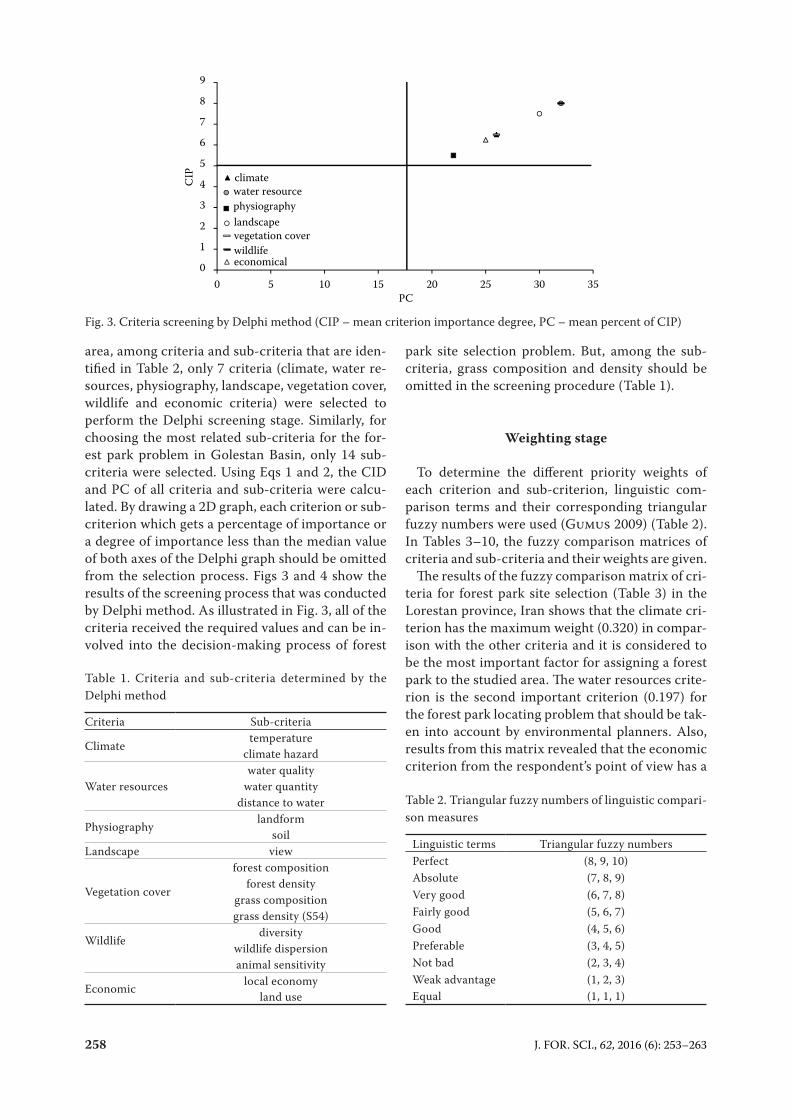
area, among criteria and sub-criteria that are iden-tified in Table 2, only 7 criteria (climate, water re-sources, physiography, landscape, vegetation cover, wildlife and economic criteria) were selected to perform the Delphi screening stage. Similarly, for choosing the most related sub-criteria for the for-est park problem in Golestan Basin, only 14 sub-criteria were selected. Using Eqs 1 and 2, the CID and PC of all criteria and sub-criteria were calcu-lated. By drawing a 2D graph, each criterion or sub-criterion which gets a percentage of importance or a degree of importance less than the median value of both axes of the Delphi graph should be omitted from the selection process. Figs 3 and 4 show the results of the screening process that was conducted by Delphi method. As illustrated in Fig. 3, all of the criteria received the required values and can be in-volved into the decision-making process of forest
park site selection problem. But, among the sub-criteria, grass composition and density should be omitted in the screening procedure (Table 1).
Weighting stage
To determine the different priority weights of each criterion and sub-criterion, linguistic com-parison terms and their corresponding triangular fuzzy numbers were used (Gumus 2009) (Table 2). In Tables 3–10, the fuzzy comparison matrices of criteria and sub-criteria and their weights are given.
The results of the fuzzy comparison matrix of cri-teria for forest park site selection (Table 3) in the Lorestan province, Iran shows that the climate cri-terion has the maximum weight (0.320) in compar-ison with the other criteria and it is considered to be the most important factor for assigning a forest park to the studied area. The water resources crite-rion is the second important criterion (0.197) for the forest park locating problem that should be tak-en into account by environmental planners. Also, results from this matrix revealed that the economic criterion from the respondent’s point of view has a
Table 1. Criteria and sub-criteria determined by the Delphi method
Criteria Sub-criteria
Climatetemperature
climate hazard
Water resourceswater quality
water quantity distance to water
Physiographylandform
soilLandscape view
Vegetation cover
forest compositionforest density
grass compositiongrass density (S54)
Wildlifediversity
wildlife dispersionanimal sensitivity
Economic local economyland use
Table 2. Triangular fuzzy numbers of linguistic compari-son measures
Linguistic terms Triangular fuzzy numbersPerfect (8, 9, 10)Absolute (7, 8, 9)Very good (6, 7, 8)Fairly good (5, 6, 7)Good (4, 5, 6)Preferable (3, 4, 5)Not bad (2, 3, 4)Weak advantage (1, 2, 3)Equal (1, 1, 1)
0
1
2
3
4
5
6
7
8
9
0 5 10 15 20 25 30 35
CIP
PC
climatewater resourcephysiographylandscapevegetation coverwildlifeeconomical
Fig. 3. Criteria screening by Delphi method (CIP – mean criterion importance degree, PC – mean percent of CIP)

J. FOR. SCI., 62, 2016 (6): 253–263 259
lower priority (0.070) to design a forest park in the studied area. The results of the fuzzy comparison matrix of each sub-criterion with respect to each criterion are given in Tables 3–10. For instance, the weights of the sub-criteria of water resources crite-rion indicate that the importance of water quality, water quantity and distance to water sub-criteria is 0.721, 0.197 and 0.082, respectively.
Weighted linear combination based site selection map
The map of forest park site suitability using the WLC method is given in Fig. 5. According to this analysis, the study area classified into three suitability classes includes high suitability, moderate suitability and low suitability. The area of each class was calculated
Table 3. Criteria of the fuzzy comparison matrix
C1 C2 C3 C4 C5 C6 C7 WeightC1 (1, 1, 1) (2, 2.5, 3) (1, 1.5, 2) (1, 1, 1) (0.5, 1, 1.5) (0.5, 0.4, 0.33) (0.67, 0.5, 0.4) 0.320C2 (1, 1, 1) (0.28, 0.25, 0.22) (0.4, 0.23, 0.28) (1, 0.67, 0.5) (0.22, 0.2, 0.18) (0.25, 0.22, 0.2) 0.197C3 (1, 1, 1) (0.5, 1, 1.5) (2, 2.5, 3) (2, 1, 0.67) (1, 1, 1) 0.144C4 (1, 1, 1) (1, 1.5, 2) (0.67, 0.5, 0.4) (1, 0.67, 0.5) 0.112C5 (1, 1, 1) (0.33, 0.28, 0.25) (0.4, 0.33, 0.28) 0.084C6 (1, 1, 1) (1, 1, 1) 0.072C7 (1, 1, 1) 0.070
criteria determined by Delphi method: C1 – climate, C2 – water resources, C3 – physiography, C4 – landscape, C5 – veg-etation cover, C6 – wildlife, C7 – economic
0
1
2
3
4
5
6
7
8
9
CIP
temperatureclimate hazardwater qualitywater quantitydistance to waterlandformsoilviewforest compositionforest densitygrass densitygrass compositionplant sensivityanimal sensivitydiversitywildlife dispersionlocal economylanduse
0 5 10 15 20 25 30 35PC
Fig. 4. Sub-criteria screening by Delphi method (CIP – mean criterion importance degree, PC – mean percent of CIP)
Fig. 5. Map of suitability for the forest park site selection in Galegol Basin, Lorestan province, Iran

260 J. FOR. SCI., 62, 2016 (6): 253–263
as 3,762.62, 4,328.61 and 1,399.77 ha, respectively. In fact, most of the study area is moderately suitable for the forest park location problem. Also, the result of zonal land suitability corresponds to high suitability class presented in Table 11. Accordingly, 5 zones were created in terms of 0–255 scale.
DISCUSSION
Better decision-making quality is achieved by more thought. When the land use planning task such as forest park site location is carried out in the context of MCE process, a checklist of crite-ria and sub-criteria gives a general background of what we have currently. The checklist shows what is important and outlines an approach and can be adapted to the variety of regions (Anonymous 1995). Hence, in this study a comprehension list of
Table 4. The fuzzy comparison matrix of climate sub-criteria
S11 S12 WeightS11 (1, 1, 1) (4.5, 5, 5.5) 0.83S12 (0.22, 0.2, 0.18) (1, 1, 1) 0.17
sub-criteria determined by Delphi method: S11 – tempera-ture, S12 – climate hazard
Table 5. The fuzzy comparison matrix of water resources sub-criteria
S21 S22 S23 WeightS21 (1, 1, 1) (4.5, 5, 5.5) (7, 7.5, 8) 0.721S22 (0.22, 0.2, 0.18) (1, 1, 1) (2, 2.5, 3) 0.197S23 (0.14, 0.13, 0.12) (0.5, 0.4, 0.33) (1, 1, 1) 0.082
sub-criteria determined by Delphi method: S21 – water qual-ity, S22 – water quantity, S23 – distance to water
Table 6. The fuzzy comparison matrix of physiography sub-criteria
S31 S32 WeightS31 (1, 1, 1) (4.5, 5, 5.5) 0.83S32 (0.22, 0.2, 0.18) (1, 1, 1) 0.17
sub-criteria determined by Delphi method: S31 – landform, S32 – soil
Table 7. The fuzzy comparison matrix of landscape sub-criteria
S41 WeightS41 (1, 1, 1) 1
sub-criterion determined by Delphi method: S41 – view
Table 8. The fuzzy comparison matrix of vegetation cover sub-criteria
S51 S52 S53 WeightS51 (1, 1, 1) (3.5, 4, 4.5) (6, 6.5, 7) 0.69S52 (0.28, 0.25, 0.22) (1, 1, 1) (2, 2.5, 3) 0.22S53 (0.17, 0.15, 0.14) (0.5, 0.4, 0.33) (1, 1, 1) 0.09
sub-criteria determined by Delphi method: S51 – forest composition, S52 – forest density, S53 – grass composition
Table 9. The fuzzy comparison matrix of wildlife sub-criteria
S61 S62 S63 WeightS61 (1, 1, 1) (1, 1.5, 2) (3, 3.5, 4) 0.529S62 (0.1, 0.75, 0.5) (1, 1, 1) (1, 1.5, 2) 0.288S63 (0.33, 0.28, 0.25) (0.1, 0.75, 0.5) (1, 1, 1) 0.183
sub-criteria determined by Delphi method: S61 – diversity, S62 – wildlife dispersion, S63 – animal sensitivity
Table 10. The fuzzy comparison matrix of economic sub-criteria
S71 S72 WeightS71 (1, 1, 1) (2, 2.5, 3) 0.71S72 (0.5, 0.4, 0.33) (1, 1, 1) 0.29
sub-criteria determined by Delphi method: S71 – local economy, S72 – land use
Table 11. Average land suitability of Galegol Basin, Lorestan province, Iran, for the forest park problem
Zone Area (ha) Average land suitability1 115.95 179.222 178.34 180.453 201.71 183.424 322.33 178.435 240.59 174.37
criteria and sub-criteria through various sources is provided (Fig. 2).
In this study, a set of criteria and sub-criteria was identified by the Delphi screening approach for the forest park site location problem in Galegol Basin, Lo-restan province, Iran (Figs 3 and 4, Table 1). Totally, 15 experts participated in the Delphi survey. The Del-phi method is thought to obtain a consensus among individuals who have the special knowledge of an is-sue of interest, in contrast to opinion polls which use a random choice of participants and lack the opinion feedback (FÜrst et al. 2010). Also, this method of screening provides a suitable way of bridging the gap between regional analysis and its incorporation into public policy (Miller 1993). Based on this analysis,

J. FOR. SCI., 62, 2016 (6): 253–263 261
all of the 7 criteria (climate, water resources, physi-ography, landscape, vegetation cover, wildlife and economic criteria) received the required values and were involved into the decision-making process of the forest park site selection problem. On the other hand, the grass composition and density sub-criteria were omitted from the primarily 18 sub-criteria imported to the Delphi screening process, because these crite-ria have received the lowest percentage of importance and degree of importance values in comparison with the other sub-criteria. The most important sub-cri-teria related to the forest park locating problem were temperature (0.83), water quality (0.721), land form (0.83), forest composition (0.69), diversity (0.52) and local economy (0.71). Overall, the results of the FAHP weighting method in this study delineate that physical aspects of the studied region are the most determi-nant agents to locate the forest park. In Lawal et al. (2011), water bodies and green spaces were consid-ered for locating recreational areas. Also, in Piran et al. (2013), it is concluded that vegetation cover and water resources are most important in the selection of the forest park location. Since, in the AHP meth-od, the subjective descriptions of reviewers’ deci-sions often correspond to an exact value, the possible benefits of handling vagueness in judgments during the conversion of verbal scales into a numeric scale (Ishizaka 2014). To make the analysis results more reasonable, using the fuzzy set theory to deal with the problems of fuzziness is very important.
Performing a complex multiple criteria problem without spatial analytical and visualization tools could be computationally challenging. Hence, this study presented a framework for the planning process using GIS and FAHP for the forest park locating prob-lem and its outputs can be valuable in the planning of local forest park and future land use planning.
APPENDIX
First round of Delphi questionnaire
On behalf of the University of Tehran, I have the honour to invite you to participate in the first round of a study to select relevant forest park cri-teria. Here, based on scientific resources I list some of them. Please modify or complete this list.
We appreciate your willingness to participate in this initiative.
Sincerely yours,Abotaleb Salehnasab
Ph.D. student of Department of Forestry and Forest Economics, University of Tehran
1. Participant’s background:Name:Address:Phone:My primary employment is in:Government Agency □Non-Government Organization □University □Other □
2. Years of experience in the following fields:Forest management -------Landscape management -------GIS -------Forest ecology -------Tourism -------Forest socioeconomic issues -------
3. Proposed group criteria for the forest park site selection (please extend this to criteria, sub-crite-ria, and indicators):Group criteria Criteria Sub-criteria Indicators
Physical
climateprecipitationtemperature
wind
water resources distancequantity
landscapeview
natural attraction
Biological
vegetation cover diversity
habitat sensitivity
physical instability
species dependence
Socioeco-nomic
economiclocal
economy
land use
social security number of crimes
Second round of Delphi questionnaire
On behalf of the University of Tehran, I have the honour to invite you to participate in the second round of a study to select relevant forest park crite-ria. Here, based on scientific resources and the first round of the questionnaire I list them as criteria, sub-criteria and indicators. Please determine their initial importance degree based on the ranking or-der below:
Unimportant = 1Less important = 3Important = 5Highly important = 7Very highly important = 9

262 J. FOR. SCI., 62, 2016 (6): 253–263
Table 1. Initial importance degree of criteria
CriteriaInitial importance ranks
1 3 5 7 9ClimateWater resourcesLandscapePhysiographyVegetation coverWildlifeHabitatEconomicSocial and culturalMigrationCultural and historicalSocial securityManagerial
Table 2. Initial importance degree of sub-criteria
Sub-criteriaInitial importance ranks
1 3 5 7 9PrecipitationTemperatureHumidityWindRadiationNatural hazardDistanceQuantityQualityViewNatural attractionLandformSoilDiversityForest densityForest compositionGrass densityGrass compositionDistributionExtentDiversityPopulationDispersionPests and diseasesSensitivityDiversityLocal economyLanduseSatisfactionPopulationMigration in or outDistance to cultural and historical placeNumber of crimesThreatening factorsVisitor managementLegal supportTourism infrastructureRecreational importance
Table 3. Initial importance degree of indicators
IndicatorsInitial importance ranks
1 3 5 7 9View angleView distanceAesthetic attractionElevationAspectSlopeTypeHydrologyPhysical propertiesBiological propertiesChemical propertiesErosionPhysical instabilitySpecies dependenceLocal dependence, local incomeAvailable similar parksDistance to incompatible land usesDistance to public accommodationArea of patches devoid of land usesDistance to access roadsDistance to conservative patchesLand valueTouristsLocal communitiesDomestic touristsTouristsSoil erosion or pollutionSpecies or ecosystem vulnerabilityEnvironmental hazardsCarrying capacityMeasuring usage intensityHabitat conservation historySpecies conservation historyFacilitiesAccommodationRecreational facilitiesTourists opinions
R e f e r e n c e s
Anonymous (1995): Park design guidelines and data. Available at http://www.env.gov.bc.ca/bcparks/operations/design_guide-lines.pdf
Ayalew L., Yamagishi H., Marui H., Kanno T. (2005): Landslides in Sado Island of Japan: Part II. GIS-based susceptibility mapping with comparisons of results from two methods and verifications. Engineering Geology, 81: 432–445.
Buckley J.J. (1985): Fuzzy hierarchical analysis. Fuzzy Sets and Systems, 17: 233–247.
Bunruamkaew K., Murayama Y. (2011): Site suitability evalua-tion for ecotourism using GIS & AHP: A case study of Surat

J. FOR. SCI., 62, 2016 (6): 253–263 263
Thani Province, Thailand. Procedia – Social and Behavioral Sciences, 21: 269–278.
Celik M., Er I., Ozok A. (2009): Application of fuzzy extended AHP methodology on shipping registry selection: The case of turkish maritime industry. Expert Systems with Applica-tions, 36: 190–198.
Dalkey N., Helmer O. (1963): An experimental application of the Delphi method to the use of experts. Management Sci-ence, 9: 458–467.
Dashti S., Monavari S.M., Hosseini S.M., Riazi B., Momeni M. (2013): Application of GIS, AHP, Fuzzy and WLC in island ecotourism development (Case study of Qeshm Island, Iran). Life Science Journal, 10: 1274–1282.
Eastman R. J. (2009): Guide to GIS and Image Processing, Manual Version 16.00. Worcester, Clark University: 342.
Eriksson F., Lidstorm M. (2013): Sustainable Development in Ecotourism: Tour Operators Managing the Economic, Social and Environmental Concerns of Sustainable Development in Costa Rica. Umeå, Umeå School of Business and Econom-ics: 109.
Fürst C., König H., Pietzsch K., Ende H.P., Makeschin F. (2010): Pimp your landscape – a generic approach for integrating regional stakeholder needs into land use planning. Ecology and Society, 15: 1–25.
FROI (2010): Technical report No. 12: Forest based ecotour-ism. Tehran, Forest and Range Organization of Iran Press: 100. (in Persian)
Gul A., Gezer A., Kane B. (2006): Multi-criteria analysis for locating new urban forests: An example from Isparta, Turkey. Urban Forestry & Urban Greening, 5: 57–71.
Gumus A.T. (2009): Evaluation of hazardous waste transporta-tion firms by using a two step Fuzzy-AHP and TOPSIS meth-odology. Expert Systems with Applications, 36: 4067–4074.
Hsu Y.L, Lee C.H., Kreng V.B. (2010): The application of Fuzzy Delphi method and Fuzzy AHP in lubricant regenerative technology selection. Expert Systems with Applications, 37: 419–425.
Ishizaka A. (2014): Comparison of fuzzy logic, AHP, FAHP and Hybrid Fuzzy AHP for new supplier selection and its perfor-mance analysis. International Journal of Integrated Supply Management, 9: 1–22.
Kabir G., Hasin M.A.A. (2011): Comparative analysis of AHP and Fuzzy AHP models for multicriteria inventory classifica-tion. International Journal of Fuzzy Logic Systems, 1: 1–16.
Khadka C., Vacik H. (2014): Use of multi-criteria analysis (MCA) for supporting community forest management. iForest – Bio-geosciences and Forestry, 5: 60–71.
Lawal D.U., Matori A.N., Chandio I.A., Balogun A.L. (2011): Framework for recreational park suitability sites. International Journal of Civil and Environmental Engineering, 11: 82–93.
Leao S., Bishop I., Evans D. (2004): Spatial-temporal model for demand and allocation of waste landfills in growing urban regions. Computers, Environment and Urban Systems, 28: 353–385.
Malczewski J. (1999): GIS and Multicriteria Decision Analysis. Toronto, John Wiley & Sons, Inc.: 392.
Malczewski J. (2000): On the use of weighted linear combina-tion method in GIS: Common and best practice approaches. Transactions in GIS, 4: 5–22.
Miller M.M. (1993): Enhancing regional analysis with the Delphi method. Review of Regional Studies, 23: 191–212.
Minagawa Y., Tanaka N. (1998): Application of geographic information systems in tourism management. Journal of Sustainable Tourism, 7: 77–92.
Ok K. (2006): Multiple criteria activity selection for ecotourism planning in Igneada, Turkey. Turkish Journal of Agriculture and Forestry, 30: 153–164.
Piran H., Maleknia R., Akbari H., Soosani J., Karami O. (2013): Site selection for local forest park using analytic hierarchy process and geographic information system (case study: Badreh County). International Research Journal of Applied and Basic Sciences, 6: 930–935.
Saaty T. L. (1997): That is not the analytic hierarchy process: What the AHP is and what it is not. Journal of Multicriteria Decision Analysis, 6: 324–335.
Salehnasab A. (2013): Site selection forest park using GIS and FAHP method. [MSc Thesis.] Tehran, University of Tehran: 103.
Sharifi M.A., van den Toorn W., Rico A., Emmanuel M. (2002): Application of GIS and multicriteria evaluation in locating sustainable boundary between the Tunari National Park and Cochabamba City (Bolivia). Journal of Multi-criteria Decision Analysis, 11: 151–164.
Stork N.E., Boyle T.J.B., Dale V., Eeley H., Finegan B., Lawes M., Manokaran N., Prabhu R., Soberon J. (1997): Criteria and Indicators for Assessing the Sustainability of Forest Manage-ment: Conservation of Biodiversity. CIFOR Working Paper No. 17. Bogor, CIFOR: 35.
Van Elegem B., Embo T., Muys B., Lust N. (2002): A methodol-ogy to select the best locations for new urban forests using multicriteria analysis. Forestry, 75: 13–23.
Zhou P., Ang B.W., Poh K.L. (2006): Decision analysis in en-ergy and environmental modeling: An update. Industrial & Systems Engineering Reviews of National University of Singapore, 31: 2268–2286.
Zucca A., Sharifi A.M., Fabbri A.G. (2008): Application of spatial multi-criteria analysis to site selection for a local park: A case study in the Bergamo Province, Italy. Journal of Environmental Management, 88: 752–769.
Received for publication April 25, 2015 Accepted after corrections May 23, 2016
Corresponding author:
Abotaleb Salehnasab, MSc, University of Tehran, Faculty of Natural Resources, Department of Forestry and Forest Economics, Emamzadeh Hasan Street, 00982 Karaj, Iran; e-mail: [email protected]
![A Fuzzy Decision Making Method in Developing ......fuzzy analytic hierarchy process. Fuzzy set theory that was introduced by Zadeh[16] and the developed fuzzy mathematical models were](https://img.pdfslide.us/doc/110x75/6024e9e6c8d405567b784a1f/a-fuzzy-decision-making-method-in-developing-fuzzy-analytic-hierarchy-process.jpg)


![Research Article Evaluating Green Performance of Suppliers via Analytic … · 2019. 7. 31. · system [ ], analytic hierarchy process (AHP) [ ], fuzzy AHP [, ], a hybrid fuzzy analytic](https://img.pdfslide.us/doc/110x75/610ee938b5ee15308e034f46/research-article-evaluating-green-performance-of-suppliers-via-analytic-2019-7.jpg)


![INTERVAL TELKOMNIKAteknik.trunojoyo.ac.id/penelitiandosen/Yeni...selection [1 1], Fuzzy analytic hierarchy process with Fuzzy type-2 interval sets [12], hybrid Received October 13,](https://img.pdfslide.us/doc/110x75/612783e2a6ed1f3f557b1f64/interval-selection-1-1-fuzzy-analytic-hierarchy-process-with-fuzzy-type-2.jpg)