Embed Size (px)
Citation preview

Cc panel 0503.ppt 1
Weyerhaeuser Pembina Timberlands
Forest Management and Watershed Values
Presentation to the NSWA Headwaters Educational Forum Feb 5, 2015

Cc panel 0503.ppt 2

Cc panel 0503.ppt 3

Cc panel 0503.ppt 4

Cc panel 0503.ppt 5
Green Zone Activities/Events • Fire, mountain pine beetle, storms, forest succession • Timber harvesting
• Sustainable forest management • <1% of forest area under tenure harvested annually • Prompt reforestation to regulated Free-To-Grow standards
• Oil & gas • Well sites, pipelines, roads, facilities
• Gravel • Grazing • Recreation • Community development

Cc panel 0503.ppt 6
Broad Picture of North Saskatchewan Region Green Zone • Diverse forest region (sub-alpine to foothills to parkland),
coniferous to the west/higher and mixedwoods to the east • Fire has predominantly shaped the forest with natural fire cycles of 45 – 80 years, but current forest is overmature (120+ years) • 50% of landscape is managed forest for timber (balance is
protection, “non-productive”, other land uses) • 50 - 75,000 ha. grazing dispositions • >000’s of well sites and facilities • Average 2-3 km. / km2 (wide range) of lineal developments • Land withdrawals in ‘000’s ha. per year • Increasing recreation use (long weekend = 000s !!)
Cc panel 0503.ppt 7
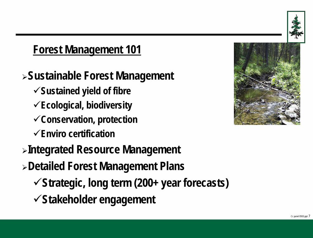
Forest Management 101
Sustainable Forest Management Sustained yield of fibre Ecological, biodiversity Conservation, protection Enviro certification
Integrated Resource Management Detailed Forest Management Plans Strategic, long term (200+ year forecasts) Stakeholder engagement

Cc panel 0503.ppt 8
Land & Forest Inventory

Cc panel 0503.ppt 9
Yield
0
20
40
60
80
100
120
140
160
180
0 10 20 30 40 50 60 70 80 90 100 110 120 130 140 150 160 170 180 190 200
Age
Volu
me
(m3/
ha)

Cc panel 0503.ppt 10
Forest Management Strategies • Sustainable consistent flow of timber
• Land management (energy, ag, recreation) • Ecological / habitat
• Watershed protection • Silviculture regimes • Stakeholder engagement (Aboriginal, resource users)

Cc panel 0503.ppt 11
Harvest Design - Criteria Aesthetics Wildlife
Watershed
Timber
Logistics
Ecological
Reforestation
Cc panel 0503.ppt 12
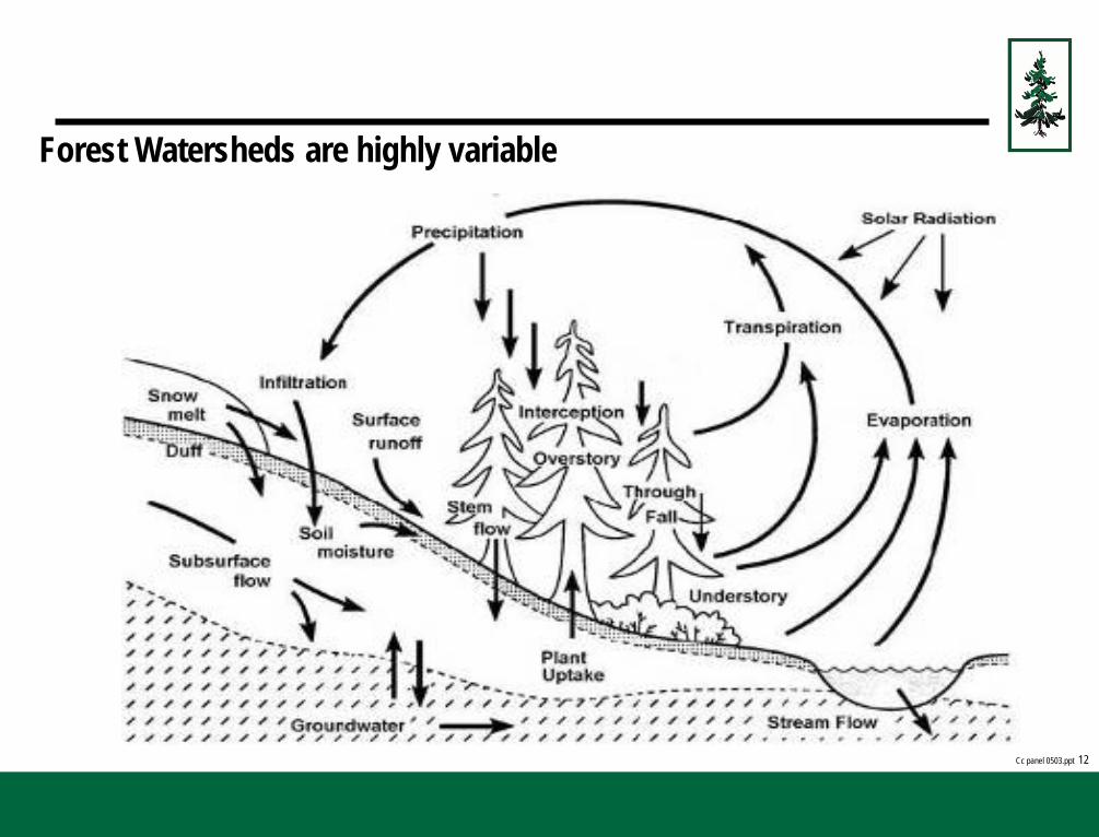
Forest Watersheds are highly variable

Cc panel 0503.ppt 13
Forest Hydrology • Simplified long term water balance expression Q = P – ET
• Storage capacity, interception, groundwater fluxes minor • Few studies on paired watersheds
• Watershed classification • Topographic divides (vs. phreatic or groundwater) & predictive mapping
tools • Stream order (Strahler class 4 and higher)
• Streamflow - Foothills vs. Boreal Forest • Snow vs. summer rain, annual precipitation, ET potential • Storage capacity (landscape, wet area “sponges”) • Peak flows and recurrence intervals (extrapolation, deduction) • Effective discharge vs. storm events

Cc panel 0503.ppt 14
Annual Hydrographs Nordegg R. 2002 (875 km2) Saultaux R. 2000 (2600 km2)
0102030405060708090
0-Ja
n
30-J
an
29-F
eb
30-M
ar
29-A
pr
29-M
ay
28-J
un
28-J
ul
27-A
ug
26-S
ep
26-O
ct
25-N
ov
25-D
ec
Time - Days
Stre
amflo
w m
3 /sec
Nordegg - 2002 Saulteaux River - 2000

Cc panel 0503.ppt 15
Annual Water Yields Saultaux R and Nordegg River
0
50
100
150
200
250
300
350
400
1971
1972
1973
1974
1975
1976
1977
1978
1979
1980
1981
1982
1983
1984
1985
1986
1987
1988
1989
1990
1991
1992
1993
1994
1995
1996
1997
1998
1999
2000
2001
2002
2003
2004
2005
Time
Wat
er Y
ield
are
a m
m
Saultaux Water Yield Nordeg Water Yield

Cc panel 0503.ppt 16
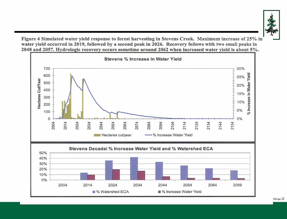
Watershed Management – Impacts on Water Yield Timber harvesting & water yield:
• Timber removal = reduced ET, reduced interception, increased run-off / stream flow (peak flow metric)
• Cooler, drier Alberta climate = less effect • Greatest impact is immediately after timber harvesting, hydrologic
recovery follows forest regeneration as measured by leaf area (speculative but aspen 15 – 25 years, Lodgepole pine 25 – 50 years)
• Greatest / significant impact occurs in small watersheds where watershed response depends on % area harvested

Cc panel 0503.ppt 17
Timber harvesting & water yield (cont’d): • Watersheds recover from disturbance providing the disturbance is
within thresholds and the forest grows back • Forest harvesting and reforestation is modeled by watershed over
rotation cycles to determine maximum levels of disturbance / forest harvesting temporally and spatially = Equivalent Cut Area (ECA) • Watershed specific qualitative factors used in step analysis e.g.
slope, soil conditions, critical habitats • Other models can be used as needed e.g. WRENNS • Constrains harvesting levels and patterns
• Generally used threshold for watershed protection is maximum 20 - 25% ECA at any point in time (case study references )

Cc panel 0503.ppt 18

Cc panel 0503.ppt 19
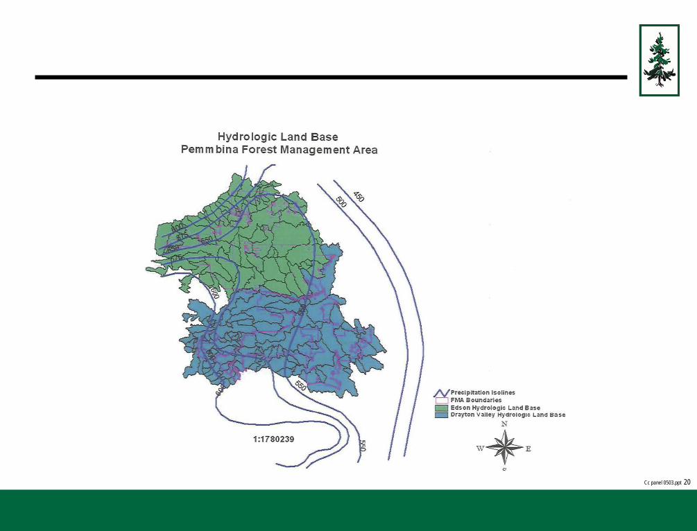
Cc panel 0503.ppt 20
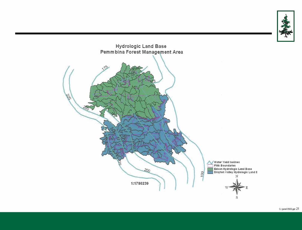
Cc panel 0503.ppt 21
Cc panel 0503.ppt 22

Cc panel 0503.ppt 23
Watershed Management – Impacts on Water Quality • Roads and stream crossings
• Sedimentation • Stream flow • Habitat (water temp, substrate, dissolved oxygen, nutrients, cover),
fishing pressures (access control, regulations) • Non-forested area (grazing, roads, pipelines, leases, etc.) increasing • Difficulty in monitoring non-point sources of sedimentation
• Landscape / cumulative effects • Natural variance as the benchmark • Chronic low level vs. acute events

Cc panel 0503.ppt 24
Watersource Protection • Road construction (temp) & stream crossing design & construction
guidelines / standards (bridges preferred) • Aquatic environment assessments on critical crossings • Stream Crossings erosion control standards, ongoing monitoring &
inspections, maintenance plans • Erosion potential vs. sediment monitoring
• Treed “buffers” on water source areas • Timing restrictions i.e. frozen conditions only • Reclamation and restoration planning • Detailed site planning for water source & sensitive soils (e.g. Wet Areas
Mapping & LiDar)

Cc panel 0503.ppt 25
Route selection

Cc panel 0503.ppt 26
Regulatory Framework Provincial
• Presence of fish & critical habitat (or potential of) trigger • Road & stream crossings guidelines and disposition conditions (below the Reg
line), critical habitat • Wetland Policy
Federal • DFO
• Permitted developments vs. Operating Guidelines • “Deposition of deleterious material”
• Nav Waters • Amendments to ease pressure for triggering CCEA, defining navigable

Cc panel 0503.ppt 27
Watershed Management (cont’d) Future Strategic: • Better methods to map watershed / watersource areas • Challenges to modeling (research):
• Anthropogenic vs. natural variability? • Referencing “pre/undisturbed” watersheds • Stream valuations
• Natural disturbance events (MPB, fire, severe weather) • Climate change and changes to forest cover • Larger scale cooperative (e.g. Ducks Unlimited project, Foothills Stream
Xing Assoc, fish critical habitat inventories) • Integrated Land Management to manage cumulative footprint & footstep

Cc panel 0503.ppt 28
Summary: • Watersheds recover as long as the forest grows back and the
disturbance is within thresholds • Timber harvesting under sustainable forest management has little
impact on higher order (larger) watersheds • Natural disturbances / events / trends important • Roads and crossings!! Integrated Land Management • Keeping the Green Zone green (with trees)

Cc panel 0503.ppt 29