Embed Size (px)
Citation preview

Forest Classification & Motor Route Designation Plan
for the
Nemadji State Forest
Final Draft June 7, 2006
MINNESOTA DEPARTMENT OF NATURAL RESOURCES

Nemadji State Forest Access Plan Page 1 of 21 07 June 2006
DNR Interdisciplinary Planning Team Forest classification and motor route designation efforts in the Nemadji State Forest were undertaken by the Sandstone Area Field OHV Project Team (hereinafter the ‘Sandstone Team’). The Sandstone Team is composed of:
Rick Dunkley Forestry (Chair) Kevin Arends Trails & Waterways Rita Frenzel Enforcement Rich Staffon Wildlife Bruce Carlson Ecological Services Hannah Texler Ecological Services (last part of process)
Other DNR staff who participated in this evaluation process and provided various support include: Dave Johnson Wildlife Joe Alberio Trails & Waterways Joe Russell Trails & Waterways Dave Pauly Wildlife Dean Paron Fisheries Mike Tronrud Management Information Services Bill Johnson Trails & Waterways
Nemadji State Forest Access Plan Page 2 of 21 07 June 2006
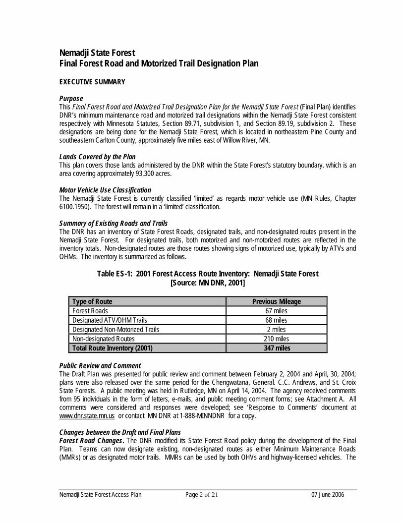
Nemadji State Forest Final Forest Road and Motorized Trail Designation Plan EXECUTIVE SUMMARY Purpose This Final Forest Road and Motorized Trail Designation Plan for the Nemadji State Forest (Final Plan) identifies DNR’s minimum maintenance road and motorized trail designations within the Nemadji State Forest consistent respectively with Minnesota Statutes, Section 89.71, subdivision 1, and Section 89.19, subdivision 2. These designations are being done for the Nemadji State Forest, which is located in northeastern Pine County and southeastern Carlton County, approximately five miles east of Willow River, MN. Lands Covered by the Plan This plan covers those lands administered by the DNR within the State Forest’s statutory boundary, which is an area covering approximately 93,300 acres. Motor Vehicle Use Classification The Nemadji State Forest is currently classified ‘limited’ as regards motor vehicle use (MN Rules, Chapter 6100.1950). The forest will remain in a ‘limited’ classification. Summary of Existing Roads and Trails The DNR has an inventory of State Forest Roads, designated trails, and non-designated routes present in the Nemadji State Forest. For designated trails, both motorized and non-motorized routes are reflected in the inventory totals. Non-designated routes are those routes showing signs of motorized use, typically by ATVs and OHMs. The inventory is summarized as follows.
Table ES-1: 2001 Forest Access Route Inventory: Nemadji State Forest [Source: MN DNR, 2001]
Type of Route Previous Mileage Forest Roads 67 miles Designated ATV/OHM Trails 68 miles Designated Non-Motorized Trails 2 miles Non-designated Routes 210 miles Total Route Inventory (2001) 347 miles
Public Review and Comment The Draft Plan was presented for public review and comment between February 2, 2004 and April, 30, 2004; plans were also released over the same period for the Chengwatana, General. C.C. Andrews, and St. Croix State Forests. A public meeting was held in Rutledge, MN on April 14, 2004. The agency received comments from 95 individuals in the form of letters, e-mails, and public meeting comment forms; see Attachment A. All comments were considered and responses were developed; see ‘Response to Comments’ document at www.dnr.state.mn.us or contact MN DNR at 1-888-MINNDNR for a copy. Changes between the Draft and Final Plans Forest Road Changes. The DNR modified its State Forest Road policy during the development of the Final Plan. Teams can now designate existing, non-designated routes as either Minimum Maintenance Roads (MMRs) or as designated motor trails. MMRs can be used by both OHVs and highway-licensed vehicles. The

Nemadji State Forest Access Plan Page 3 of 21 07 June 2006
Final Plan includes both SFR System and MMR forest road designations and undesignations for the Nemadji State Forest. ORV Trail Development Recommendations. Future ORV trail development was discussed. Development of these trails, which do not currently exist, will be explored and presented to the Area Team for consideration. Proposals may be in the form of DNR Unit or Grant-In-Aid trails. However, because these trails do not currently exist, they cannot be designated pursuant to this exercise, nor do they enjoy temporary exemption from environmental review requirements as stipulated in MN Laws 2003, Chap. 128, Art. 1, Sect. 168 (as amended). Corrections & Clarifications. The Final Plan contains a number of corrections to the forest inventory identified during the planning process, and it clarifies various planning aspects (e.g., forest classification, hunting exceptions) that reviewers found confusing or unexplained in the draft text. More detailed descriptions were also added in other areas of the report in order to improve clarity and readability, as suggested by reviewers. Profile of Final Forest Road and Motorized Trail Designations The proposed designations presented in the Draft Plan were subjected to public review and comment. The Sandstone Team considered the public comments and other available information to develop this final forest road and motorized trail designation plan. The following table summarizes the forest road and motorized trail designations identified in the Final Plan.
Table ES-2: Forest Road and Trail Designation Change Summary Nemadji State Forest [Source: MN DNR, 2006]
Type of Route Previous
Mileage Final
Mileage Change (miles)
Forest Roads [all] 67.3 57.7 -9.6 mi. System Roads 30.3 30.3 No Chg. Minimum Maintenance Roads 35.8 27.4 -8.4 mi. Designated OHV Trails [Total All Uses] 68.0 121.0 +53.0 mi. OHM [Only] 22.7 22.7 No Chg. ATV / OHM [Only] 52.1 121.0 +68.9 mi. ORV [Only] 0.0 0.0 No Chg. OHV Allowed Routes [Total All Uses] 135.3 201.4 +66.1 mi. Designated Non-Motor Trails 2.0 2.0 No Chg. Non-designated Routes 209.5 152.1 -57.4 mi. Total Inventory: 2001 / 2006 346.8 mi. 355.5 mi. +8.7 mi.
Commissioner’s Designations and Final Plan Implementation Forest road and motorized trail designations will occur via a series of Orders signed by the Commissioner of Natural Resources, which will be published in the State Register. The Final Plans, final maps, ‘Response to Comments’ document and Commissioner’s Orders can be found at www.dnr.state.mn.us on or after the publication date. Contact MN DNR at 1-888-MINNDNR for copies of any of these materials. The effective date for the forest road and motorized trail designations is December 31, 2006. The DNR will use the time between the order publication date and the effective date to improve and sign designated routes, and to close non-designated routes. Any designated routes presently unable to sustain the intended uses will be closed temporarily pending the necessary improvements.

Nemadji State Forest Access Plan Page 4 of 21 07 June 2006
Nemadji State Forest Forest Classification & Motor Route Designation Plan
Table of Contents Page Executive Summary 2 Table of Contents 4 Purpose 6 Nemadji State Forest: Lands Covered by this Plan 6 Forest Classification & Motor Vehicle Use 8 Background Managed Forest Lands Limited Forest Lands Closed Forest Lands Nemadji State Forest Classification Off-Trail Riding Prohibitions and Exceptions Forest Roads and Trails 9 State Forest Roads (SFRs & MMRs) Designated Recreational Trails Non-designated Routes Forest Road and Trail Designation Process 10 Draft Plan Draft Plan Public Review & Comment Final Plan Forest Roads and Trails in the Nemadji State Forest 11 Forest Inventory Previous Designations 11 State Forest Roads Designated Recreational Trails Non-designated Routes New Road & Trail Designations 12 State Forest Roads Designated Recreational Trails (motor & non-motor) Non-designated Routes Summary of Proposed Changes Differences between the Draft and Final Plans 14 DNR Forest Road Policy Change Correction to the Hunting Exception Text in the Draft Plan Corrections to the Tables, Maps & Final Route Mileages [Con’t next page]

Nemadji State Forest Access Plan Page 5 of 21 07 June 2006
Implementation of the Final Plan 15 Forest Road and Motorized Trail Designations Site-Level Repair and Improvements Effective Date of the Designation Order LIST OF TABLES PAGE Table ES-1: Existing Road / Trail Inventory 2 Table ES-2: Road / Trail Designation Summary 3 Table 1: Native Plant Communities 7 Table 2: Inventoried State Forest Roads 11 Table 3: Existing Road / Trail Inventory 12 Table 4: State Forest Road (Un)designations 13 Table 5: Final Road / Trail Designation Summary 14 APPENDICES Appendix A: Classification of State Forest Lands [MN Statues] 17 Appendix B: Forest Land Classification Criteria & Process [MN Rules] 18 Appendix C: Hunting / Trapping Exceptions [MN Statutes] 19 Appendix D: Summary of Rare Plant / Animal Species 20 LIST OF MAPS [Not Attached – Incorporated by Reference] Map: Highway Licensed Vehicle (HLV) Routes, Nemadji State Forest Map: All-Terrain Vehicle (ATV) Routes, Nemadji State Forest Map: Off-Highway Motorcycle (OHM) Routes, Nemadji State Forest Map: Off-Road Vehicle (ORV) Routes, Nemadji State Forest

Nemadji State Forest Access Plan Page 6 of 21 07 June 2006
Nemadji State Forest Final Off-Highway Vehicle Trail Designation Plan PURPOSE This Final Off-Highway Vehicle Trail Designation Plan (Final Plan) identifies DNR’s motorized trail designations for the Nemadji State Forest. Minnesota Statutes direct the Commissioner of Natural Resources to (un)designate State Forest Roads and Recreational Trails by written order published in the State Register. Non-designated routes, not specifically designated for a road or trail use, will no longer be open or available for most motorized uses (except pursuant to MS Chapt. 84.926). The Final Plan was developed in response to public comments generated by the review of the preceding Draft Off-Highway Vehicle Trail Designation Plan (Draft Plan). The Draft Plan was released for public comment and review on February 2, 2004. The designations are presented in this Final Plan along with general information about the state forest, lands covered by the plan, motorized use classification, the existing route inventory, public involvement, and plan implementation. Vehicle types addressed in this plan include All-Terrain Vehicles (ATVs), Off-Highway Motorcycles (OHMs), and Off-Road Vehicles (ORVs). Highway licensed vehicles (HLVs) are also subject to Final Plan’s forest road designations. Snowmobiles are not considered off-highway vehicles and are unaffected by this plan or the resulting Commissioner’s Orders that implement it’s final direction. NEMADJI STATE FOREST: LANDS COVERED BY THIS PLAN Location. The Nemadji State Forest is located in northeastern Pine County and southeastern Carlton County, approximately 14 miles east of Willow River. This forest straddles the Minnesota-Wisconsin boundary. The forest can be reached by traveling east via county highways joining State Highway 23 near the towns of Askov, Bruno, Kerrick, Duquette, and Holyoke. Land Ownership. There are 96,100 acres within the statutory boundary of the Nemadji State Forest. The DNR administers 93,300 acres. The remaining acres are mostly privately owned with some county ownership. This plan covers those lands administered by the DNR within the State Forest’s statutory boundary. Pine County assisted with DNR’s OHV-related planning efforts and will be consulted on an ongoing basis. History & Land-Use. At the start of the 20th Century, this area was the scene of heavy logging activity. The Nemadji, Willow, and Tamarack rivers transported pine logs to sawmills as far away as Superior, Wisconsin and Stillwater, Minnesota. As the pine was depleted, smaller logger camps produced railroad ties, cedar shingles, barrel staves, pulpwood, and fuel wood. Settlers later moved in to farm the land and numerous large fires eventually swept through and burned most of the area. The Legislature established the Nemadji State Forest in 1935. The name ‘Nemadji’ is due to the fact that a portion of the forest lies within the Nemadji River watershed. Most of the land was eventually forfeited for non-payment of taxes. Under agreement with the State 50% of the gross receipts from the forest are returned to Pine and Carlton Counties. The Black Lake Bog Scientific & Natural Area, which was established in 1990, covers 1,414 acres in the eastern portion of the Nemadji.
Geology & Soils. The topography of the Nemadji State Forest varies from gently rolling upland with large swamp areas in the south to steep stream valleys and elongated swamps protruding into the forest in the northeast. The soils vary from sand to sandy loam to red clay and organic peat. Clay soils in the northern part of the forest (lacusterine deposits of Glacial Lake Duluth) are highly susceptible to erosion and soil slumping. These soils are generally unsuited to (any type of) vehicular travel along unsurfaced routes.

Nemadji State Forest Access Plan Page 7 of 21 07 June 2006
Numerous small streams meander through the forest and beaver ponds dot the landscape. The northern third drains into Lake Superior while the southern two-thirds are in the St. Croix River watershed. Wetlands cover a majority of the forest, and are especially prevalent in the eastern part of the forest. Aspen, birch, northern hardwoods, spruce, and balsam fir stands comprise the upland forest. The lowland forest contains black spruce, tamarack, white cedar, and lowland hardwoods. Ecological Classification System. The Nemadji State Forest lies within the Laurentian Mixed Forest Province. Most of the forest is in the Western Superior Uplands Section and the Mille Lacs Uplands Subsection. The Mille Lacs Uplands are divided into the Duxbury, Bruno and Nickerson Moraine Land Type Associations (Appendix D). A small portion of the northern edge of the Nemadji State Forest is in an old glacial lake bed that occurs along the south and west shores of Lake Superior, mostly in Wisconsin. This area is part of the Southern Superior Uplands Section, the Glacial Lake Superior Plain Subsection, and the Duesler Lake Plain LTA. Vegetation About 38,000 acres of the Nemadji State Forest is included in sites of high to outstanding biodiversity significance on preliminary maps by the Minnesota County Biological Survey. These sites contain a wide range of native plant communities, stands designated as old-growth forests, and 1,414 acres within the Black Lake Bog State Scientific and Natural Area. Plant communities include forests in both Mesic Hardwood and Fire-Dependent Systems in the upland areas, and a diverse array of wetlands that include Forested Rich Peatland, Open Rich Peatland, Acid Peatland, Wet Forest, and Wet Meadow/Carr Systems. The following table lists the native plant communities documented in the state forest to date. Mapping of these native plant communities has not yet been completed.
Table 1. Native Plant Communities in Nemadji State Forest, [Source: MN DNR, 2006] [ See Appendix D for more information on rare plant and animal species found the the Nemadji ]
Native Plant Community Type
Old Growth Represented
Uplands Red Oak / Sugar Maple / Basswood (Bluebead Lily) Forest yes Aspen / Birch / Basswood Forest Sugar Maple / Baswood (Bluebead Lily ) Forest yes Black Ash / Basswood Forest yes Aspen / Birch / Red Maple Forest Aspen / Birch Forest Wetlands Bog Birch / Alder Shore Fen Graminoid Rich Fen (Basin) Graminoid Sphagnum Rich Fen (Basin) Graminoid Poor Fen (Water Track) White Cedar Swamp (North-Central) Alder Swamp Low Shrub Bog Black Spruce Bog Lowland White Cedar Forest (Northern) yes Willow / Dogwood Shrub Swamp Sedge Meadow

Nemadji State Forest Access Plan Page 8 of 21 07 June 2006
Recreation Facilities. Outdoor recreation facilities include the Gafvert Campground, the Gandy Dancer State Trail, a variety of state forest trails, and a portion of the Willard Munger State Trail East. The Gafvert Campground and Day Use Area is located on Pickerel Lake. There are 9 campsites with fire rings, tables, outdoor toilets, and a water pump. The adjacent day use area includes a picnic area, water access site, and trail head for the Nemadji State Forest trail system. The Gandy Dancer Trail is a multipurpose, multi-jurisdictional trail built on an abandoned railroad grade. Primary use in the Nemadji State Forest is by snowmobile, ATV and for logging access. Various multi-purpose trails cross the Nemadji forest. These trails are marked and groomed for snowmobiling in the winter. Upland portions of these winter trail systems can be used for hiking and horseback riding in the summer. The Willard Munger State Trail- East crosses the Nemadji State Forest and is a multipurpose trail that may eventually connect the Twin Cities with Duluth. Primary uses of the trail are hiking and snowmobiling with portions usable for horseback riding. ATVs and OHMs are permitted along selected segments of the trail. A number of Grant-in-Aid (GIA) snowmobile, ATV and OHM trails traverse and connect to trails within the forest. DNR Trails & Waterways Staff work closely with these trail user clubs on trail maintenance and signing. Non-Motor Areas. The Black Lake Bog Scientific & Natural Area (SNA) is located between the Gandy Dancer Trail and the Wisconsin border in the east-central portion of the forest. The Nemadji-East Forest Management Compartment is an area of 10,000 acres of large wetlands located near the Black Lake Bog SNA in the eastern portion of the forest . Management direction for this compartment is described in the Moose Lake Area Forest Management Plan (1985). It strongly discourages, but does not prohibit motorized recreational use of the SNA. FOREST CLASSIFICATION & MOTOR VEHICLE USE Background On September 3, 1998 the Commissioner of Natural Resources issued a memorandum establishing interim (motor use) classifications for all State Forests. The interim classifications were in effect until January 1, 2000, when the classifications were finalized. Changes to the classification of State Forests, with respect to motor vehicle use, must follow the process outlined in MN Rules Chap. 6100.1950, subp. 1–4. The three motor vehicle use classifications are as follows:
‘Managed’ Forest Lands. On forest lands classified as managed, a person may operate a motor vehicle only on forest roads and forest trails that are not posted and designated closed and in areas that are posted and designated to allow motor vehicle use, subject to specified limitations and exceptions. (Managed option available only in state forests located north of US Hwy 2). ‘Limited’ Forest Lands. On forest lands classified as limited, a person may operate a motor vehicle only on forest roads that are not posted and designated closed and on forest trails or areas that are posted and designated to allow motor vehicle use, subject to specified limitations and exceptions. ‘Closed’ Forest Lands. No person shall operate a motor vehicle or snowmobile on forest lands classified as closed, unless on frozen public waters where operation is not otherwise prohibited. Motor vehicles that are licensed for use on public highways may be operated on forest roads that are not posted or gated closed. Snowmobiles may operate on designated trails.
Legislation enacted in 2003, amended in 2005, requires the DNR to review the classification of all 56 state forests and to modify the classification of these state forests as appropriate (See Appendix A-C).

Nemadji State Forest Access Plan Page 9 of 21 07 June 2006
Nemadji State Forest Classification The Nemadji State Forest was assigned a “limited” classification in 2000. The forest will retain the limited classification under this Final Plan. Under the limited classification, only roads and trails that are designated and signed ‘open’ may be used by motor vehicles. This provision will be enforced (for the first time) beginning December 31, 2006, which is the plan’s effective date. The Sandstone Team did not propose changing the classification to ‘closed’ because motorized access to and use of the Nemadji is well-established. Hundreds of miles of existing road and trail are heavily used by forest visitors. The team did recommend limiting motorized access to specific units within the forest, and was instrumental in creating a management plan for one such area of Old Growth Forest. All inventoried routes were evaluated during this process, and those judged sustainable for continued motor use have been designated under this plan. Should conditions change, the forest’s classification can be re-evaluated and changed. FOREST ROADS AND TRAILS The State Forest Road Policy requires that the commissioner administer a system of forest roads and trails that provide ‘adequate’ access to state forest lands for their management, protection, and for development of those lands and their resources consistent with state forest resource management policy.(MS Chap. 89.002, Subd. 3). This policy has been implemented through development of a system of forest roads and trails. Forest roads may be (un)designated by Commissioner’s Order published in the State Register. State Forest Roads State Forest Roads are generally one or two-lane roads with native soil or gravel surfaces. They are not public roadways, and the DNR (or counties for forest roads occurring on their ownerships) is not considered a public road authority. State Forest Roads are, however, generally open to use by Highway-Licensed Vehicles (HLVs) and all three types of OHVs, unless temporarily or seasonally closed to some or all motorized uses. State Forest Roads provide useful connecting routes and access to forest lands. OHV users share State Forest Roads with highway vehicles and other motorized and non-motorized recreational users. It should be noted that under existing State Forest rules any highway-licensed vehicle (e.g., pickup, SUV, car, motorcycle) operated on a designated trail must have a valid ORV or OHM registration sticker. SFRs & MMRs. The DNR Division of Forestry classifies its roads as either: System Forest Roads (SFRs) or Minimum Maintenance Roads (MMRs). System Roads are the major arterial roads in the forest that provide forest management access, recreational access, and may be connected to the state, county, or township public road systems. These roads are used at least on a weekly basis and often used on a daily basis. MMRs are used for forest management access on an intermittent, or as needed, basis. These roads may or may not be gated and closed during certain times of the year. Closures occur at the discretion of the Area Forester. These roads will not be maintained at a level where low clearance HLVs can routinely travel on them. Road Closures. Temporary or seasonal closures are possible at any time for public safety or natural resource protection reasons. Temporary closures of forest roads or areas are done by closing gates, erecting barriers, or posting a notice that the road or entire forest is closed to some or all uses. The public is informed of the closures and their duration through the news media and via the DNR website. Natural resource managers have the authority to close forest roads on a temporary or emergency basis to:
• protect the road or trail during wet periods. • prevent wildfires during dry periods. • limit access while natural resource management activities are being conducted. • separate incompatible uses. • protect public safety or sensitive natural areas.

Nemadji State Forest Access Plan Page 10 of 21 07 June 2006
Designated Recreational Trails Designated recreational trails provide access to the State Forests for a range of purposes, both recreational and utilitarian. They are intended to accommodate the majority of OHV use, and may include regional corridor trails or local loop systems with associated support facilities (e.g., parking or staging area, toilets, trailhead, day-use picnic site). These trails have designated primary uses, are well signed, monitored, maintained, and are mapped and listed in DNR recreation publications. Trail maps are available by contacting the DNR. State Trails are developed under the provisions of Minnesota’s Outdoor Recreation Act (MS Chap. 86A) and have specific legislative authorization. They undergo a planning and public involvement process that results in an approved Master Plan. These are often substantial projects that can traverse multiple ownerships and may connect more than one state forest. Unit Trails are DNR constructed trails, typically within a state forest, that may link to other trails providing opportunities for destination travel. They often accommodate substantial mixed-use or all-season traffic. Grant-In-Aid (GIA) Trails are a partnership between DNR, a governmental sponsor and a local club. Trail clubs enter into agreements with their sponsor and DNR to perform the work necessary to develop and maintain specific segments of trail. Clubs are reimbursed for time and materials via the local government sponsor. These trails often traverse various public and private land ownerships and are not limited to state forest lands. Non-Designated Routes Non-designated Routes may be former (i.e., closed) logging roads, skid trails, abandoned snowmobile trails, illegal user-created trails, or other historic travel routes. Some access private property or hunting areas. These routes are not signed or maintained. Under the limited forest classification, it is illegal to operate motor vehicles on these routes, except for certain hunting and trapping purposes (Appendix C). Non-designated routes often dead-end, and most receive light, infrequent use, while others receive heavy use and abuse both from recreational OHV riders, and from licensed hunters and trappers who may legally ride non-designated routes (ATVs or HLVs), and may even travel off-trail (ATVs only) for legitimate hunting or trapping purposes, including big game retrieval. Seasonal use, pursuant to this exception, is still subject to statutory prohibitions on erosion, rutting, or damage to trees, growing crops or wetlands that apply to all state lands. FOREST ROAD & TRAIL DESIGNATION PROCESS Draft Plan. The Sandstone Team evaluated the forest route inventory and developed recommendations for proposed motorized trail designations. These recommendations were provided in the Draft Off-Highway Vehicle Trail Designation Plan for the Nemadji State Forest. Draft recommendations focused exclusively on non-designated routes that showed evidence of ongoing motorized use. Those routes deemed ‘sustainable’ under environmental screening criteria were proposed for an “open” designation. Those routes that did not appear sustainable, were proposed to retain their ‘non-designated’ status, effectively closing them to future motorized use under the limited forest classification. Draft Plan Public Comment and Review. The Draft Plan was presented for public comment and review on February 2, 2004. It was offered in conjunction with similar plans for the Chengwatana, General C.C. Andrews, and St. Croix State Forests (all in Pine Co.). A public informational meeting was held in Rutledge, MN on April 14, 2004. The draft plan and meeting were noticed in the State Register, the Pine County Courier, in a statewide press release, and through DNR’s website. Copies of the document were made available upon request. The public comment and review period ended April 30, 2004. Final Plan. This Final Plan identifies those routes: 1) Designated as a forest road; 2) Designated as a motorized recreational trail, and: 3) Not designated as either a forest road or trail. It also includes background

Nemadji State Forest Access Plan Page 11 of 21 07 June 2006
information on the Nemadji State Forest, including its’ forest road and trail system, the forest classification and route designation process, new forest road and trail designations; and plan implementation. A companion document, the “Response to Public Comments” summarizes public comments received by DNR on the Draft Plan. This document, organized by topic and response, is available at www.dnr.state.mn.us. It includes comments and responses for all four Pine County State Forests (Nemadji, St. Croix, Chengwatana and General C.C. Andrews). Contact the DNR at 1-888-MINNDNR for copies of any of these materials. See the section entitled Changes Between the Draft Plan and Final Plan (Pg. 14) to see how public comments influenced preliminary recommendations contained in the Draft Plan. FOREST ROADS & TRAILS IN THE NEMADJI STATE FOREST Forest Inventory. The forest road and trail designations identified in the Final Plan are based on an inventory of State Forest Roads, Designated Motor and Non-Motor Trails, and Non-designated Routes that occur in the Nemadji State Forest. Approximately 340.9 miles of various types of routes are captured in the forest inventory. Previous Designations - State Forest Roads Prior to adoption of this plan, approximately 67 miles of State Forest Road served the Nemadji State Forest. All three types of OHVs and HLVs are allowed to travel these roads subject to seasonal or temporary road closures. [See Table 2.]
Table 2: Previous State Forest Roads: Nemadji State Forest, [Source: MN DNR, 2006]
Road Number Road Name Road Class SFR 3 Beldon System SFR 4 Net Lake System SFR 4A Campground Road MMR SFR 4C South Extension System SFR 47 Grouse MMR SFR 4B Bigtooth Ridge MMR SFR 5 Park System SFR 5A Park Spur A MMR SFR 5C Park Spur C MMR SFR 5D Park Spur D MMR SFR 5F Aspen MMR SFR 876 Potlatch MMR SFR 5G Park Spur G MMR SFR 5K Park Spur K MMR SFR 226 Harlis System SFR 226B Little Net Spur MMR SFR 226A Gandy Connection MMR SFR 5T Park Tamarack MMR Total Length = 67.3 miles

Nemadji State Forest Access Plan Page 12 of 21 07 June 2006
Previously Designated Recreational Trails Designated Motorized Trails. According to the 2001 inventory, the Nemadji State Forest contained about 52.1 miles of motorized trails designated for ATV/OHM use, with an additional 22.7 miles of OHM-only designated trails. No trails have been designated exclusively for ORV use in this state forest. Designated Non-Motorized Trails. There were approximately 2 miles of trail designated for hiking and skiing in the Nemadji State Forest in 2001. These trails are associated with the Gafvert Campground Site. Non-Designated Routes The 2001 inventory of non-designated routes (routes showing evidence of motorized use) revealed about 210 miles of routes within the Nemadji State Forest. Note that this inventory estimate did not include non-motor routes (no evidence of motorized use) such as hunter walking paths. Non-designated routes are generally unavailable for motorized use in a limited forest, except for certain hunting and trapping purposes set forth under MN Stat. Chap. 84.926 (See Appendix C). The latest inventory of State Forest Roads, designated recreational trails, and forest access routes is depicted in Final Plan maps which are available at www.dnr.state.mn.us or by contacting the DNR. These maps are hereby incorporated into this plan by reference. See Table 3 (below) for a summary of the routes previously existing in the Nemadji State Forest.
Table 3: 2001 Forest Access Route Inventory: Nemadji State Forest, [Source: MN DNR, 2001]
Type of Route Previous Mileage Forest Roads 67 miles Designated ATV / OHM Trails 68 miles Non-designated Motor Routes 210 miles Designated Non-Motorized Trails 2 miles Total Inventory (2001) : 347 miles
NEW FOREST ROAD & TRAIL DESIGNATIONS State Forest Roads. Implementation of the Final Plan will result in 57.7 miles of state forest road in the Nemadji State Forest. Tables 4 and 5 summarizes final changes to the forest road system under this plan. Designated Motorized Trails. The Final Plan identifies approximately 68.9 miles of previously non-designated routes for designation as shared ATV / OHM trail. The result will be a total of 121.0 miles of trail available to OHMs, with 22.7 miles of this total open exclusively to OHM use. ATVs will also be permitted on a total of 121.0 miles of designated motorized trail. No ATV-only or ORV-only trail designations occur under the Final Plan. This Final Plan does not change use of the Willard Munger State Trail East. A court-ordered Environmental Review must be completed before any changes may be made to the motorized use profile of this trail. Designated Non-Motorized Trails. No change is proposed to the designated non-motorized trail inventory at this time. This leaves approximately 2 miles of managed trail available for hiking, walking hunter and skiing purposes. Non-designated Routes. Approximately 152.1 miles of non-designated routes remain non-designated under this Final Plan for the Nemadji State Forest. These routes will be effectively closed to regular vehicular use under the limited forest classification, except pursuant to the hunting / trapping exceptions in MS Chap. 84.926.

Nemadji State Forest Access Plan Page 13 of 21 07 June 2006
(Appendix C). Whether the non-designated routes persist into the future is uncertain. Absent substantial foot or motor vehicle traffic, many of these routes may revegetate and disappear over two or three growing seasons.
Table 4: Final Forest Roads: Nemadji State Forest, [Source: MN DNR, 2006]
Road Number Road Name Previous Classification Final Status SFR 3 Beldon System Retained SFR 3A Beldon Town Non-designated New MMR SFR 3B Gandy Dancer North Non-designated New MMR SFR 4 Net Lake System Retained SFR 4A Campground Road MMR Retained SFR 4A-1 Net Lake East Non-designated MMR SFR 4C South Extension System Retained SFR 47 Grouse MMR Retained SFR 4B Bigtooth Ridge MMR Retained SFR 5 Park System Retained SFR 5A Park Spur A MMR Non-designated SFR 5C Park Spur C MMR Non-designated SFR 5D Park Spur D MMR Non-designated SFR 5F Aspen MMR Retained SFR 876 Potlatch MMR Retained SFR 5G Park Spur G MMR Non-designated SFR 5K Park Spur K MMR Non-designated SFR 226 Harlis System Retained SFR 226B Little Net Spur Non-designated New MMR SFR 226A Gandy Connection MMR Retained SFR 5T Park Tamarack MMR Non-designated
Total Length: 57.7 miles Future Motor Trail Development. The Willard Munger State Trail East traverses the Nemadji State Forest. Approximately 2 miles of this state trail are currently designated for ATV / OHM use. The Off-Highway Vehicle System Plan for Pine and Southern Carlton Counties (DNR, 1998) proposed designating the remaining 24 miles of this trail for ATV / OHM use. However, any changes to the motorized use of the Willard Munger State Trail East in the Nemadji State Forest will require that an Environmental Assessment Worksheet be prepared pursuant to an order rendered by the Minnesota State Court of Appeals on October 1, 2002; See [State of MN Court of Appeals, CX-02-404, C8-02-420, C5-02-441]. ORV Trail Possibilities. Comments were received during the 60-day public review period asking that opportunities for ORV use be expanded. The Commissioner’s Office agrees that this is a legitimate request, but one that could not be fulfilled within the context of the existing route inventory. During the course of this exercise, the Sandstone Team did examine the possibility of developing short, non-technical ORV touring trails primarily located in existing gravel pits along the Potlatch Forest Road (also part of the Munger Trail) and along the Park Forest Road. The Team acknowledges that some opportunity may exist on these disturbed sites to craft ORV (only) touring routes that off-road enthusiasts might find enjoyable. Even longer routes might even be possible if sections of snowmobile trail were incorporated into the ORV trail design.

Nemadji State Forest Access Plan Page 14 of 21 07 June 2006
Any future ORV trail proposals, would be subjected to internal DNR interdisciplinary scrutiny, and to applicable Environmental Quality Board Rules for the environmental review of recreational trail projects [MN Rules 4410.4300]. No such trails are authorized or implied by this Final Plan. Summary of Final Changes Table 4 (below) provides a summary of the final forest road and trail designations for the Nemadji State Forest.. The inventory of State Forest Roads, designated recreational trails, and forest access routes is depicted in Final Plan maps which are available at www.dnr.state.mn.us or by contacting the DNR. These maps are hereby incorporated into this plan by reference.
Table 5. Summary of Road & Trail Designations in the Nemadji State Forest. Source: Forest Access Route Unpublished Data, 2006. DNR DRS. Generated using ArcView extension.
Summary Report Final Plan
Category Miles of Road & Trail Total Inventoried Routes 355.5 Miles Total ATV/OHM Trails 121.0 Miles All-Terrain Vehicle Only 0.0 Miles
All All-Terrain Vehicle Routes 178.7 Miles Off-Highway Motorcycle Only Routes 22.7 Miles
All Off-highway Motorcycle Routes 201.4 Miles Off-Road Vehicle Only Routes 0.0 Miles All Off-Road Vehicle Routes 57.7 Miles
All Highway Licensed Vehicle Routes 57.7 Miles
Non-Motor Trails 2.0 Miles Gated Road or Trail Miles None
Total Motorized Routes 201.4 Miles
Total Non-Designated Routes 152.1 Miles System State Forest Roads 30.3 Miles
Minimum Maint. State Forest Roads 27.4 Miles
DIFFERENCES BETWEEN THE DRAFT PLAN AND FINAL PLAN The Final Plan differs from earlier drafts in several key areas which are outlined below. Forest Road Policy Changes. The Draft Plan did not propose any changes to designated forest roads. However, modification of the DNR Forest Road Classification System in May 2004 provided the newly developed MMR classification option for team consideration. Armed with this new option, the Sandstone Team revisited earlier forest road determinations, especially for those routes being considered for recreational trail designation. Routes were re-examined pursuant to this policy change, and in response to public comments calling for improved road and trail access. Non-motorized recreationists who use HLVs to access the forest also benefit from the MMR designations; because these routes link to remote (non-motorized) areas that provide a quieter, more primitive recreation experience.

Nemadji State Forest Access Plan Page 15 of 21 07 June 2006
The Sandstone Team concluded that both forest road undesignations and new designations were warranted; the net result was an approximately seven-mile reduction in forest roads in the Nemadji State Forest. Because many of these roads were already seasonally gated, this change will do little to reduce forest access options for ORVs and HLVs from what exists currently. The change in forest road designations between the Draft Plan and Final Plan is not considered significant. All routes receiving the new forest road designations had previously been considered as possible ATV / OHM trails. Unlike an ATV/OHM trail designation, designation as a forest road enables ORVs and HLVs to use the route as well. Conversely, all but one segment of forest road undergoing undesignation was, in turn designated as a new motorized trail, thus retaining legal use by ATVs and OHMs. Although the final plan results in a net-reduction in available forest road mileage within the forest, good overall vehicular access is maintained. The MMR designation preserves many of these routes with a long history of use by hunters and others, but brings with it improved maintenance, management and needed regular repairs. Designated Motorized Trails. The Draft Plan proposed 59 miles of motorized ATV / OHM trail designation while the Final Plan includes 68.9 miles of (formerly non-designated) route designations. This 11-mile increase is not considered a significant departure from the original proposal. It is due primarily to refinements in the forest road inventory, added forest road undesignations, and due consideration of public comments. ORV Trail Development Recommendations. Although neither version of the plan included any ORV (only) road or trail mileage, discussion has been added regarding suggested future ORV trail development options. Development of these trails, which do not now exist, will be explored by DNR Area Staff in coming years. They could be developed as either DNR Unit or grant-in-aid trails. However, because they do not now exist, they cannot be designated pursuant to this exercise, nor do they enjoy the temporary exemption from environmental review requirements as stipulated in [MN Laws 2003, Chap. 128, Art. 1, Sect. 168 (as amended)]. Correction to the Hunting Exception Text in the Draft Plan. The Draft Plan made references to ATV use pursuant to the hunting / trapping ‘exception’. These provisions of MS 84.926 are presented in Appendix C (as modified in 2005). These ‘exceptions’ now allow for the legal use of non-designated routes by ATVs and HLVs by licensed hunters and trappers during established seasons, and permit ATVs to travel off-trail for these same purposes. Corrections to Tables & Maps. The Final Plan contains corrections to the tables and maps presented in the Draft Plan. Improvements resulted from field checking and reinventory in response to public comments. The summary tables are the best available estimate of road and trail mileages; the estimates will continue to improve as site-level detail becomes better known. Maps Incorporated by Reference. The inventory of State Forest Roads, designated recreational trails, and forest access routes is depicted in Final Plan maps which are available at www.dnr.state.mn.us or by contacting the DNR. These maps are hereby incorporated into this plan by reference. IMPLEMENTATION OF THE FINAL PLAN Forest Road and Motorized Trail Designations The Commissioner’s Orders which implement this plan will appear in the State Register on April 10, 2006. All road and trail designations take effect on December 31, 2006. The orders incorporate by reference the Final Plan and maps. Required Site-Level Repairs & Improvements. Upon issuance and publication of the Commissioner’s Orders, DNR will move to implement the (un)designations. Implementation-related activity will involve posting the

Nemadji State Forest Access Plan Page 16 of 21 07 June 2006
necessary signs to inform forest users of permitted or designated uses, and notice of temporary route closures for needed repair or improvement. Some designated routes may require minor reroutes, trail hardening, or culvert resizing prior to being opened to general public use. Effective Date of the Designation Order December 31, 2006 is the effective date for the forest road and motorized trail designations identified in this final plan. Implementation work will begin immediately. Any motorized road or trail identified in the plan not ready to support designated uses will be temporarily closed pending necessary repairs or improvements. Copies of this and other Pine County Plans, maps, Response to Comments Documents, and of the Commissioner’s Final Forest Classification & Road/Trail Designation Orders, may be downloaded at www.dnr.state.mn.us. Copies may also be obtained by contacting the DNR c/o 500 Lafayette Road, St. Paul, MN 55155, or by calling 651/296-6157 (locally) or Toll Free 1-888-MINNDNR.

Nemadji State Forest Access Plan Page 17 of 21 07 June 2006
APPENDIX A
Classification of Forest Lands [ MN Laws 2005, 1st Special Session, Chapter 1, Article 2 ]
Sec. 152. Laws 2003, chapter 128, article 1, section 167, subdivision 1, is amended to read: * Sec. 167. [FOREST LAND OFF-HIGHWAY VEHICLE USE RECLASSIFICATION.] Subdivision 1. [FOREST CLASSIFICATION STATUS REVIEW.] (a) By December 31, 2006, the commissioner of natural resources shall complete a review of the forest classification status of all state forests classified as managed or limited, all forest lands under the authority of the commissioner as defined in Minnesota Statutes, section 89.001, subdivision 13, and lands managed by the commissioner under Minnesota Statutes, section 282.011. The review must be conducted on a forest-by-forest and area-by-area basis in accordance with the process and criteria under Minnesota Rules, part 6100.1950. Except as provided in paragraph (d), after each forest is reviewed, the commissioner must change its status to limited or closed, and must provide a similar status for each of the other areas subject to review under this section after each individual review is completed. (b) If the commissioner determines on January 1, 2005, that the review required under this section cannot be completed by December 31, 2006, the completion date for the review shall be extended to December 31, 2008. By January 15, 2005, the commissioner shall report to the chairs of the legislative committees with jurisdiction over natural resources policy and finance regarding the status of the process required by this section. (c) Until December 31, 2010, the state forests and areas subject to review under this section are exempt from Minnesota Statutes, section 84.777, unless an individual forest or area has been classified as limited or closed. (d) Notwithstanding the restrictions in paragraph (a), and Minnesota Statutes, section 84.777, all forest lands under the authority of the commissioner as defined in Minnesota Statutes, section 89.001, subdivision 13, and lands managed by the commissioner under Minnesota Statutes, section 282.011, that are north of U.S. Highway 2 shall maintain their present classification unless the commissioner reclassifies the lands under Minnesota Rules, part 6100.1950. The commissioner shall provide for seasonal trail closures when conditions warrant them. By December 31, 2008, the commissioner shall complete the review and designate trails on forest lands north of Highway 2 as provided in this section. [*Ed. Note: Underlining denotes new language added following the 2005 legislative session] Copyright 2005 by the Office of Revisor of Statutes, State of Minnesota.

Nemadji State Forest Access Plan Page 18 of 21 07 June 2006
APPENDIX B
Minnesota Rules, Chapter 6100.1950 Forest Land Classification
6100.1950 MOTOR VEHICLES AND SNOWMOBILES; FOREST LANDS. Subpart 1. Classified forest lands. The operation of motor vehicles and snowmobiles on forest lands classified by the commissioner for purposes of motor vehicle use according to subpart 2 and Minnesota Statutes, section 89.002, is regulated according to items A to C.
A. On forest lands classified as managed, a person may operate a motor vehicle only on forest roads and forest trails that are not posted and designated closed and in areas that are posted and designated to allow motor vehicle use, subject to the limitations and exceptions in this part. B. On forest lands classified as limited, a person may operate a motor vehicle only on forest roads that are not posted and designated closed and on forest trails or areas that are posted and designated to allow motor vehicle use, subject to the limitations and exceptions in this part. C. No person shall operate a motor vehicle or snowmobile on forest lands classified as closed, unless on frozen public waters where operation is not otherwise prohibited. Motor vehicles that are licensed for use on public highways may be operated on forest roads that are not posted or gated closed. Snowmobiles may operate on designated trails.
Subp. 2.Criteria for classification. The following criteria shall be considered when classifying forest lands for motor vehicle use:
A. resource sensitivity and management objectives; B. resource impact by motorized and nonmotorized use, including erosion, rutting, and impacts on vegetation, wildlife, air, water, or natural habitats; C. motorized and nonmotorized recreational opportunity in area; D. user needs, such as trails, parking, signs, and access; E. the degree and trend of motor vehicle use in the area; F. the degree and trend of nonmotor vehicle use in the area; G. competing interests among different user groups; and H. public safety and law enforcement concerns.
Subp. 3. Notice and public meeting. Before changing the classification of forest lands for motor vehicle use, the commissioner shall provide notice and a public meeting according to items A to C.
A. A public meeting shall be held in the county where the largest portion of the forest lands are located to provide information to and receive comment from the public regarding the proposed classification change. B. Sixty days before the public meeting, notice of the proposed classification change shall be published in legal newspapers that serve the counties in which the lands are located and in a statewide Department of Natural Resources news release and in the State Register. The notice shall include a summary of the proposed action, a request for public comment, and notice of the public meeting. C. Twenty-one days before the public meeting, notice of the meeting shall be announced in a statewide Department of Natural Resources news release.
Subp. 4. Commissioner's decision. The commissioner shall make a decision about the proposed classification change after considering the criteria listed in subpart 2 and any public comment received and explaining how the nature and magnitude of the criteria and comments relate to the classification. STAT AUTH: MS s 14.045; 14.388; 84.03; 85.052; 85.053; 85.20; 86A.05; 86A.06; 89.031; 89.19 to 89.21; 89.71 HIST: 24 SR 208; 25 SR 782; 27 SR 27. Copyright 2005 by the Office of Revisor of Statutes, State of Minnesota.

Nemadji State Forest Access Plan Page 19 of 21 07 June 2006
APPENDIX C
Minnesota Statutes 2005, Chapter 84.926 Hunting / Trapping Exceptions
84.926 Vehicle use on public lands; exceptions. Subd. 1. Exception by permit. Notwithstanding sections 84.773, subdivision 1, and 84.777, on a case by case basis, the commissioner may issue a permit authorizing a person to operate an off-highway vehicle on individual public trails under the commissioner's jurisdiction during specified times and for specified purposes. Subd. 2. All-terrain vehicles; managed or limited forests; off trail. Notwithstanding section 84.777, but subject to the commissioner's authority under subdivision 5, on state forest lands classified as managed or limited, other than the Richard J. Dorer Memorial Hardwood Forest, a person may use an all-terrain vehicle off forest trails or forest roads when: (1) hunting big game or transporting or installing hunting stands during October, November, and December, when in possession of a valid big game hunting license; (2) retrieving big game in September, when in possession of a valid big game hunting license; (3) tending traps during an open trapping season for protected furbearers, when in possession of a valid trapping license; or (4) trapping minnows, when in possession of a valid minnow dealer, private fish hatchery, or aquatic farm license. Subd. 3. All-terrain vehicles; closed forests; hunting. Notwithstanding section 84.777, the commissioner may determine whether all-terrain vehicles are allowed on specific forest roads, on state forest lands classified as closed, for the purpose of hunting big game during an open big game season. The determination shall be by written order as published in the State Register and is exempt from chapter 14. Section 14.386 does not apply. Subd. 4. Off-road and all-terrain vehicles; limited or managed forests; trails. Notwithstanding section 84.777, but subject to the commissioner's authority under subdivision 5, on state forest lands classified as limited or managed, other than the Richard J. Dorer Memorial Hardwood Forest, a person may use vehicles registered under chapter 168 or section 84.798 or 84.922 on forest trails that are not designated for a specific use when: (1) hunting big game or transporting or installing hunting stands during October, November, and December, when in possession of a valid big game hunting license; (2) retrieving big game in September, when in possession of a valid big game hunting license; (3) tending traps during an open trapping season for protected furbearers, when in possession of a valid trapping license; or (4) trapping minnows, when in possession of a valid minnow dealer, private fish hatchery, or aquatic farm license. Subd. 5. Limitations on off-trail and undesignated trail use. The commissioner may designate areas on state forest lands that are not subject to the exceptions provided in subdivisions 2 and 4. Such designations are not subject to the rulemaking provisions of chapter 14 and section 14.386 does not apply. Before designating such areas, the commissioner shall hold a public meeting in the county where the largest portion of the forest lands are located to provide information to and receive comment from the public regarding the proposed designation. Sixty days before the public meeting, notice of the proposed designation shall be published in the legal newspapers that serve the counties in which the lands are located, in a statewide Department of Natural Resources news release, and in the State Register. HIST: 1984 c 647 s 5; 1986 c 444; 2003 c 128 art 1 s 31; 1Sp2005 c 1 art 2 s 45 Copyright 2005 by the Office of Revisor of Statutes, State of Minnesota.

Nemadji State Forest Access Plan Page 20 of 21 07 June 2006
APPENDIX D
Summary of Rare Plant & Animal Species Nemadji State Forest
(by Hannah Texler, Regional Plant Ecologist, DNR Ecological Services)
Ecological Classification System (ECS) Province: - Laurentian Mixed Forest Sections: Mostly Western Superior Uplands; small portion of northern edge is in the Southern Superior Uplands Subsections: Mille Lacs Uplands (in the Western Superior Uplands Section); Glacial Lake Superior Plain (in the Southern Superior Uplands Section) Land Type Associations(LTAs): Duxbury Moraine, Bruno Moraine, Nickerson Moraine (in the Western Superior Uplands); Duesler Lake Plain (in the Glacial Lake Superior Plain Subsection)
Sites of Outstanding or High Biodiversity Significance, Nemadji State Forest (May 9, 2006)
Rare Plant & Animal Species in Nemadji State Forest
Common Name
Scientific Name State Rarity Status
Animals Four-toed salamander Hemidachtylium scutatum Special Concern Spotted salamander Ambystoma maculata Non Plants blunt-lobed grapefern Botrychium oneidenses Endangered triangle moonwort Botrychium lanceolatum Threatened least moonwort Botrychium simplex Special Concern white adder's-mouth Malaxis monophyllos Special Concern eastern hemlock Tsuga canadensis Special Concern slender naiad Najas gracilima Special Concern
Site Number Site Name Biodiversity Significance Rank
Acres
137 Black Lake Bog Outstanding 3560 141 Belden Swamp Outstanding 7523 140 Ludwig Unit Outstanding 1488 145 McDermott North Outstanding 9943 134 Cranberry Lake High 4877 135 Nickerson Hardwoods High 4189 139 Nickerson 32 High 1372 138 Belden West High 2082 143 Belden Hardwoods South High 845 147 (?) Swamp High 1217 130 Kerrick Swamp East High 700 (approx. ac. in SF)
TOTAL 37,796

Nemadji State Forest Access Plan Page 21 of 21 07 June 2006
Common Name
Scientific Name State Rarity Status
Vasey's pondweed Potamageton vaseyi Special Concern white baneberry Actaea pachypoda Non matricary grapefern Botrychium matricarifolium Non three-stamened waterwort Elatine triandra Non halberd-leaved tearthumb Polygonum arifolium Non NOTE: Breeding populations of eastern timber wolves, Canadian lynx and trumpeter swans are thought to exist in both the Nemadji and St. Croix State Forests. Grey owls, hawk owls, and boreal owls also made extensive use of both forest during the recent (2005-06’) winter invasion into Minnesota. (Dave Pauley, Area Wildlife Supv.) NemPlan.doc 07 June 06