Embed Size (px)
Citation preview
Trail Design Guidelines for Portland’s Park System
May 2009
Commissioner Nick FishDirector Zari Santner
Trail Design GuidelinesRegional Trails, Natural Areas and Developed ParksApril 2009
PP&R Trail Guidelines Coordination Team Robin Grimwade, Manager, Corporate Strategy, Marketing & Business Development
Brett Horner, Strategic Projects ManagerGregg S. Everhart, Senior Planner/Project Manager
Trail Design Guidelines Contributors and ReviewersBruce Barbarasch, THPRDLynn BarlowSusan Barthel, BESJanet Bebb, MetroApril Bertelsen, PBOTRichard BoschWill BrozyShannon Buono, BOPTonia Burns, NCPRDMary Anne Cassin, MetroRic Catron, GreshamJonathan David, GreshamJennifer Devlin, BESSue Donaldson
Portland Parks & Recreation1120 SW Fifth Avenue, Suite 1302Portland, Oregon 97204(503) 823-PLAYwww.PortlandParks.org
Bob DowningKim Freeman, BDSPatty FreemanPeggy GlascockLisa Goorjian, Vancouver/ Clark County ParksNancy GronowskiGreg HawleyGary HillBrett HornerP.J. McGuireMichelle Healy, NCPRDDawn Hottenroth, BESMart Hughes
Marie Johnson, BESDeb LevGeorge LozovoyFred NilsenClaire Puchy, BESMike Reed, BESEmily RothAlex SalazarJim SjulinRod Wojtanik, Metro
Production/EditingJoan HallquistColleen Keyes
Contents
Portland Parks & Recreation
Introduction ...............................................................................................1
Trails in Parks 2020 Vision Plan .................................................................1
Need for Trail Standards ...........................................................................2
Trail Design Guidelines ............................................................................2
Trail Design Philosophy ............................................................................4
Accessibility ...............................................................................................5
Street Rights-of-Way ................................................................................7
Trail Type Matrix Introduction .................................................................7
Accessibility Table .....................................................................................8
Trail Design, Construction, and Maintenance .........................................9
Trail Type Matrix .....................................................................................11
Trail Type A - Hiking (high challenge) ...................................................13
Trail Type B - Hiking (moderate challenge) ...........................................15
Trail Type C - Hiking (accessible) ..........................................................17
Trail Type D - Walking ...........................................................................18
Trail Type E - Exercise / Fitness (track) .................................................21
Trail Type F - Biking ...............................................................................23
Trail Type G - Mountain Biking .............................................................25
Trail Type H - Cyclo Cross .....................................................................27
Trail Type I - Equestrian .........................................................................29
Trail Type J - Hiking and Mountain Biking ...........................................31
Trail Type K - Hiking and Equestrian ...................................................33
Trail Type L - Walking and Biking .........................................................35
Trail Type M - Walking, Biking, and Equestrian ....................................37
Trail Type N - Fire and Maintenance .....................................................39
Trail Detail 01 - Cribbed Steps ...............................................................41
Trail Detail 02 - Timber Steps ................................................................43
Trail Detail 03 - Boardwalk .....................................................................45
Trail Detail 04 - Wood Bridge ................................................................47
Trail Detail 05 - Wood Bridge with Railing ...........................................49
Trail Detail 06 - Erosion Control at Bridge ...........................................51
Trail Detail 07 - Trail with Swale and Culvert .......................................53
Trail Detail 08 - Causeway ......................................................................55
Trail Detail 09 - Trail with Infiltration Trench .......................................57
Trail Detail 10 - Trail on Levee ..............................................................59
Trail Detail 11 - Soft-Surface Switchback on Levee ..............................61
Trail Detail 12 - Porous Asphalt Trail .....................................................63
Trail Detail 13 - Signs .............................................................................65
Trail Detail 14 - Alignment Tread Crests ...............................................67
Trail Detail 15 - Alignment Tread Dips ..................................................69
Trail Detail 16 - Removable Bollard .......................................................71
Trail Detail 17 - Cribbed Retaining Wall ...............................................73
Appendix A - References ........................................................................75

Portland Parks & Recreation 1
IntroductionTrails are an integral part of our park and recreation system. They are used by people of all ages and abilities to exercise, relax, socialize, view wildlife, and travel to destinations such as school and work. Portland Parks & Recreation (PP&R) is committed to providing trails throughout Portland in response to local, state, and national studies indicating high demand for walking and biking. PP&R interprets the term ‘trail’ broadly to include sidewalks around parks, park pathways, sidewalks, and enhanced paths on green streets, as well as unpaved pathways in natural resource areas and regional multi-modal trails.
Trails in Parks 2020 Vision PlanOne of the goals of Parks 2020 Vision is to “create an interconnected regional and local system of paths and walks to make Portland ‘The Walking City of the West.’” This would provide safe and convenient access between parks, natural areas, and recreation facilities and connect them with residential areas, civic institutions, and businesses. The Vision identified trails as PP&R’s most heavily used resource. Completing specific regional trails, and adding more miles of soft-surface trails and other green connectors were key objectives.
The trails section in the appendix of Parks 2020 Vision noted that trails are places and connectors that traverse a variety of ownerships and environments, from remote forests to the Central City. It recognized multiple values: recreational, transportation, aesthetic, scenic, environmental, and economic. However, the trail system was acknowledged to have many gaps and lack of connectivity that limited its usability. Insufficient capacity, where older trail segments are too narrow for current, not to mention future, use was also identified as a problem.
Trail Design
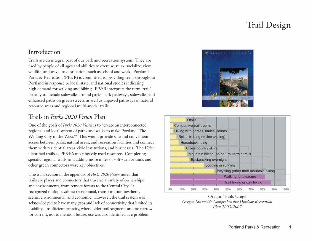
OtherCompetitive trail eventsHiking with horses, mules, llamas
Roller-blading (in-line skating)Horseback riding
Cross-country skiingMountain biking (on natural terrain trails
Backpacking overnightJogging or running
Bicycling (other than mountain bikingWalking for pleasureTrail hiking or day hiking
Oregon Trails Usage Oregon Statewide Comprehensive Outdoor Recreation
Plan 2003-2007
Trail Design
Need for Trail StandardsThe Parks 2020 Vision plan identified “no trail standards” as an issue. It noted that trail standards are lacking for the many trail types, sizes, and materials needed in different settings. Impacts to sensitive habitat and stormwater quality and quantity must be considered. The specific recommendation “Develop trail standards for the different conditions and needs” recommended that PP&R: • Develop standards for the different trail types in the 40-Mile Loop
system and for non-Loop sites.• Include other bureaus, agencies, and adjoining jurisdictions in developing
trail standards. Encourage other agencies and jurisdictions to adopt similar standards and trail alignments.
• Rebuild trail sections to meet the revised standards as funding is available.
• Develop and implement a consistent, regional trail signage program to enable users to better utilize the system.
Trail Design GuidelinesSince the Vision was published in 2001, more trail segments have been constructed in a variety of settings for different users. The existing system and its gaps have been documented in PP&R’s geographic information system (GIS), revealing a diverse range of widths and trail materials. Although some of the older trails are clearly ‘substandard,’ there are so many special settings and constraints that setting standards is too limiting. Instead, these ‘design guidelines’ establish a range of materials and widths so that trail designers can design trails more flexibly. This will guide PP&R staff in the design of trails and pathways in the entire parks system: regional trails, developed parks, and natural areas. It will also guide consultants, developers, and volunteer groups
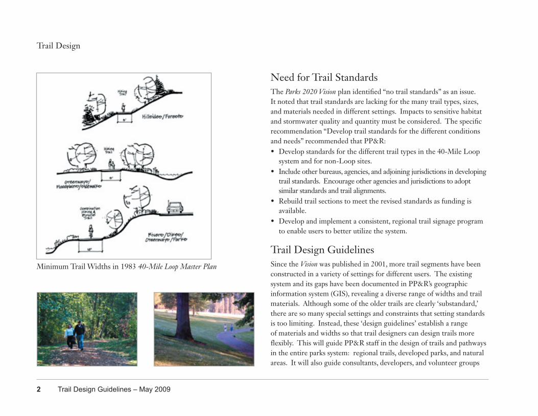
Minimum Trail Widths in 1983 40-Mile Loop Master Plan
2 Trail Design Guidelines – May 2009
Portland Parks & Recreation 3
that build trails, whether designing a narrow footpath through a woodland, an exercise circuit in a lawn area or a waterfront promenade. Although not intended as a maintenance guide, it should also be useful for volunteer trail building projects.
Design PhilosophySiting and design of every trail requires consideration of four main goals: safety, connectivity, response to location, and diversity of users.
1. Safety is the top concern. Ideally, cars and trucks alongside or crossing a trail should be minimized. If the trail parallels a roadway, separate bicycle and pedestrian space is preferred unless there are few vehicles and low travel speed. Higher speed and traffic volumes decrease users’ perception of safety and tend to discourage less experienced users. Although parked cars sometimes slow traffic by making the street seem more narrow, there is danger of opening doors into bicyclists. Visibility is particularly important at intersections with roads and in natural areas, but design principles for crime prevention should be applied to all projects. Different trail users also travel at differing speeds, which can cause conflicts and accidents. In some sites, trail markers designate trails for use by hikers, bikers and/or equestrians; in others we urge everyone to ‘share the path.’ In corridors of high density (such as the Willamette Greenway in South Waterfront) a biking trail can be used in combination with a walking trail to form a dual trail to separate slower speed “feet” from higher speed “wheels.” Additional education and enforcement are needed.
2. Connectivity is important because trail length makes longer trips possible, increasing usefulness for commuting and exercise. Trails also connect gaps in the on-street pedestrian network. Trails should have multiple access points from the surrounding system of sidewalks, other
Trail Design
FOUR MAIN GOALS FOR TRAIL DESIGN
1. SAFETY • 1st Choice - Separate trail from vehicles • 2nd Choice - Minimize vehicle crossings of trail • 3rd Choice - If trail co-exists with road then choose route with
lower speed and volume • Design for visibility and crime prevention in all settings
2. CONNECTIVITY • Connected lengths of trails make longer trips possible,
increasing usefulness for commuting and exercise • Provide trail access points and connect trails to bicycle and
pedestrian network in City rights-of-way
3. CONTEXT • Trail changes to meet opportunities and constraints of its
surroundings
4. DIVERSITY • Provide range of trails to meet needs of all ages and abilities so
everyone benefits, including those with disabilities
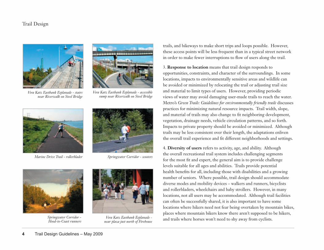
trails, and bikeways to make short trips and loops possible. However, these access points will be less frequent than in a typical street network in order to make fewer interruptions to flow of users along the trail.
3. Response to location means that trail design responds to opportunities, constraints, and character of the surroundings. In some locations, impacts to environmentally sensitive areas and wildlife can be avoided or minimized by relocating the trail or adjusting trail size and material to limit types of users. However, providing periodic views of water may avoid damaging user-made trails to reach the water. Metro’s Green Trails: Guidelines for environmentally friendly trails discusses practices for minimizing natural resource impacts. Trail width, slope, and material of trails may also change to fit neighboring development, vegetation, drainage needs, vehicle circulation patterns, and so forth. Impacts to private property should be avoided or minimized. Although trails may be less consistent over their length, the adaptations enliven the overall trail experience and fit different neighborhoods and settings.
4. Diversity of users refers to activity, age, and ability. Although the overall recreational trail system includes challenging segments for the most fit and expert, the general aim is to provide challenge levels suitable for all ages and abilities. Trails provide potential health benefits for all, including those with disabilities and a growing number of seniors. Where possible, trail design should accommodate diverse modes and mobility devices – walkers and runners, bicyclists and rollerbladers, wheelchairs and baby strollers. However, in many locations, not all users may be accommodated. Although trail facilities can often be successfully shared, it is also important to have some locations where hikers need not fear being overtaken by mountain bikes, places where mountain bikers know there aren’t supposed to be hikers, and trails where horses won’t need to shy away from cyclists.
Trail Design
Vera Katz Eastbank Esplanade - stairs near Riverwalk on Steel Bridge
Vera Katz Eastbank Esplanade - accessible ramp near Riverwalk on Steel Bridge
Marine Drive Trail - rollerblader Springwater Corridor - scooters
Springwater Corridor - Hood-to-Coast runners
Vera Katz Eastbank Esplanade - near plaza just north of Firehouse
4 Trail Design Guidelines – May 2009
Portland Parks & Recreation 5
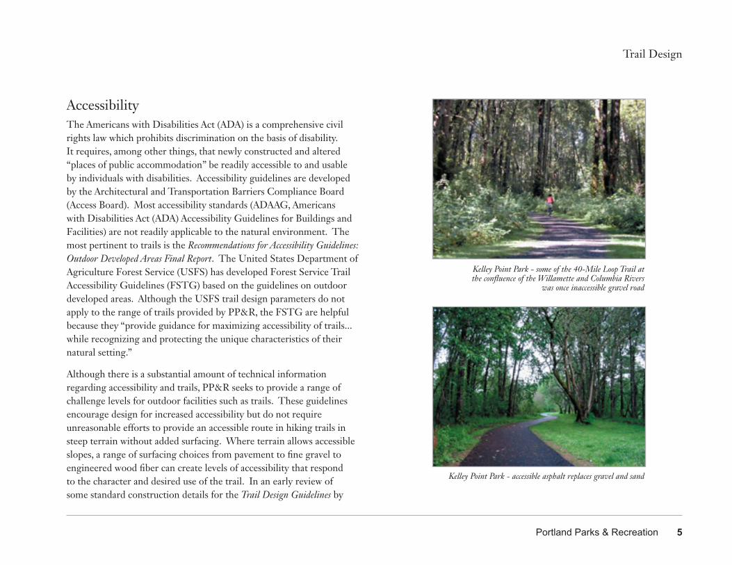
AccessibilityThe Americans with Disabilities Act (ADA) is a comprehensive civil rights law which prohibits discrimination on the basis of disability. It requires, among other things, that newly constructed and altered “places of public accommodation” be readily accessible to and usable by individuals with disabilities. Accessibility guidelines are developed by the Architectural and Transportation Barriers Compliance Board (Access Board). Most accessibility standards (ADAAG, Americans with Disabilities Act (ADA) Accessibility Guidelines for Buildings and Facilities) are not readily applicable to the natural environment. The most pertinent to trails is the Recommendations for Accessibility Guidelines: Outdoor Developed Areas Final Report. The United States Department of Agriculture Forest Service (USFS) has developed Forest Service Trail Accessibility Guidelines (FSTG) based on the guidelines on outdoor developed areas. Although the USFS trail design parameters do not apply to the range of trails provided by PP&R, the FSTG are helpful because they “provide guidance for maximizing accessibility of trails...while recognizing and protecting the unique characteristics of their natural setting.”
Although there is a substantial amount of technical information regarding accessibility and trails, PP&R seeks to provide a range of challenge levels for outdoor facilities such as trails. These guidelines encourage design for increased accessibility but do not require unreasonable efforts to provide an accessible route in hiking trails in steep terrain without added surfacing. Where terrain allows accessible slopes, a range of surfacing choices from pavement to fine gravel to engineered wood fiber can create levels of accessibility that respond to the character and desired use of the trail. In an early review of some standard construction details for the Trail Design Guidelines by
Trail Design
Kelley Point Park - some of the 40-Mile Loop Trail at the confluence of the Willamette and Columbia Rivers
was once inaccessible gravel road
Kelley Point Park - accessible asphalt replaces gravel and sand
6 Trail Design Guidelines – May 2009
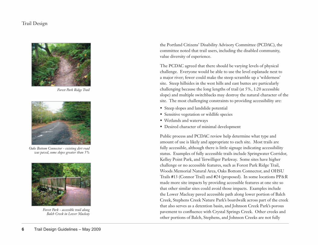
the Portland Citizens’ Disability Advisory Committee (PCDAC), the committee noted that trail users, including the disabled community, value diversity of experience.
The PCDAC agreed that there should be varying levels of physical challenge. Everyone would be able to use the level esplanade next to a major river; fewer could make the steep scramble up a ‘wilderness’ site. Steep hillsides in the west hills and east buttes are particularly challenging because the long lengths of trail (at 5%, 1:20 accessible slope) and multiple switchbacks may destroy the natural character of the site. The most challenging constraints to providing accessibility are:
• Steep slopes and landslide potential• Sensitive vegetation or wildlife species• Wetlands and waterways• Desired character of minimal development
Public process and PCDAC review help determine what type and amount of use is likely and appropriate to each site. Most trails are fully accessible, although there is little signage indicating accessibility status. Examples of fully accessible trails include Springwater Corridor, Kelley Point Park, and Terwilliger Parkway. Some sites have higher challenge or no accessible features, such as Forest Park Ridge Trail, Woods Memorial Natural Area, Oaks Bottom Connector, and OHSU Trails #13 (Connor Trail) and #24 (proposed). In some locations PP&R made more site impacts by providing accessible features at one site so that other similar sites could avoid those impacts. Examples include the Lower Macleay paved accessible path along lower portion of Balch Creek, Stephens Creek Nature Park’s boardwalk across part of the creek that also serves as a detention basin, and Johnson Creek Park’s porous pavement to confluence with Crystal Springs Creek. Other creeks and other portions of Balch, Stephens, and Johnson Creeks are not fully
Trail Design
Forest Park Ridge Trail
Oaks Bottom Connector - existing dirt road was paved, some slopes greater than 5%
Forest Park - accessible trail alongBalch Creek in Lower Macleay
Portland Parks & Recreation 7
Trail Design
accessible. Unfortunately, nearly every trail in the PP&R system needs improvements in edge protection, wayfinding, and accessible signage.
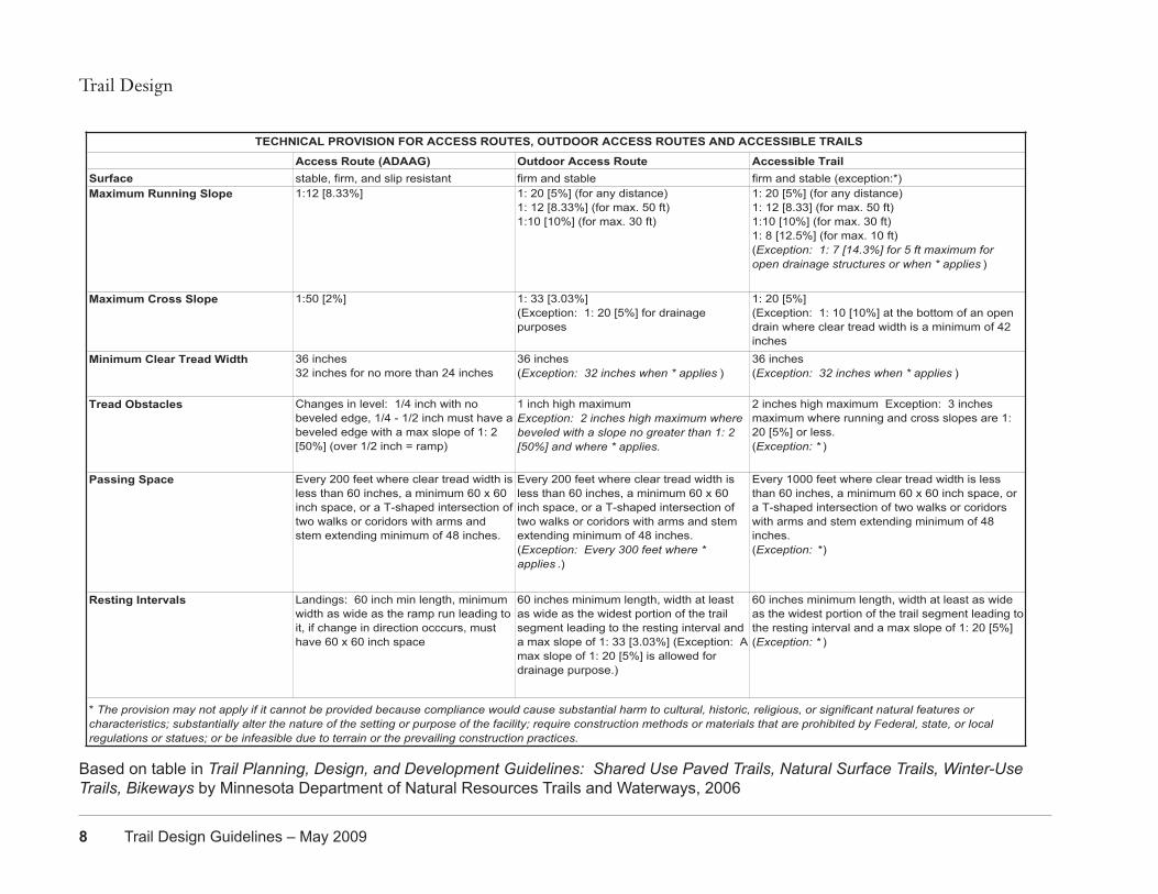
The Technical Provisions for Access Routes, Outdoor Access Routes, and Accessible Trails table (page 8) gives the technical details of ADAAG and the Outdoor Developed Areas guidelines. ‘Access routes’ (ADAAG) relate to the built environment where all routes must meet accessibility requirements. ‘Outdoor access routes’ are in outdoor environments, e.g., parks where reasonable access is required, such as between a parking lot and a playground. ‘Accessible trails’ are those trails that meet the USFS guidelines. All refer to newly constructed or altered trails, not retroactively to existing trails. ‘Alteration’ differs from ‘maintenance’ by changing the trail from its original condition. Exceptions to the technical provisions can be made in certain situations.
Technical provisions for outdoor access routes and accessible trails may not apply if it cannot be provided because compliance would:
• cause substantial harm to cultural, historic, religious or significant natural features or characteristics;
• substantially alter the nature of the setting or purpose of the facility;
• require construction methods or materials that are prohibited by Federal, state or local regulations or statutes; or
• be infeasible due to terrain or prevailing construction practices
Street Rights-of-WayThe Portland Bureau of Transportation (PBOT) manages the public street right-of-way in Portland. Many park sidewalks and/or edges of parks and natural areas are within the right-of-way; PBOT should be consulted regarding design standards and permits for development in rights-of-way adjacent to PP&R property. The most current guidance regarding accessibility that pertains to public right-of-way (Revised DRAFT Public Rights-of-Way Accessibility Guidelines (PROWAG)) permits the grade of a pedestrian access route within a sidewalk to be as steep as the grade of the adjoining roadway. In some areas of steep terrain, this allows ‘accessible’ sidewalks to be steeper than accessible trails.
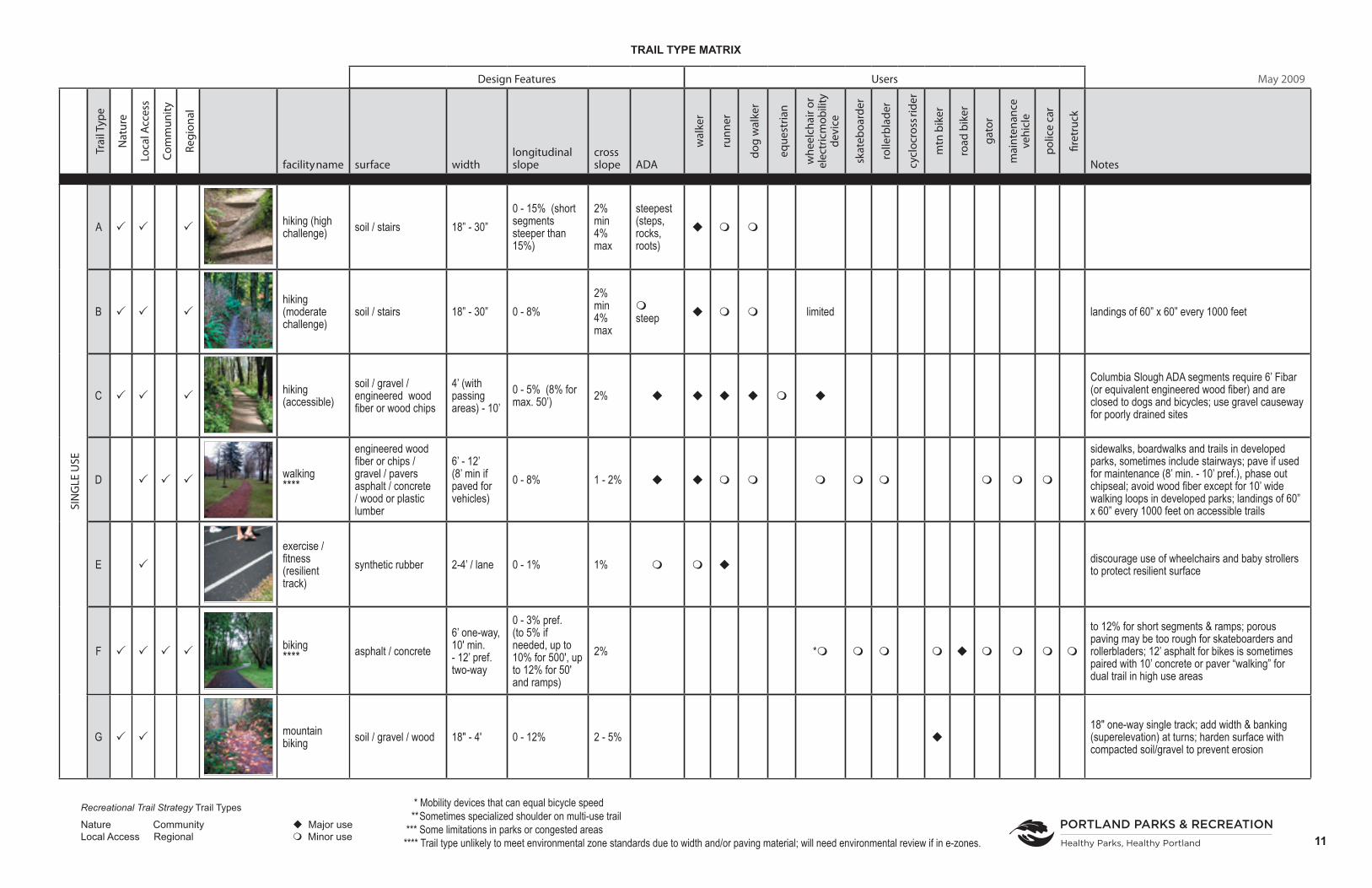
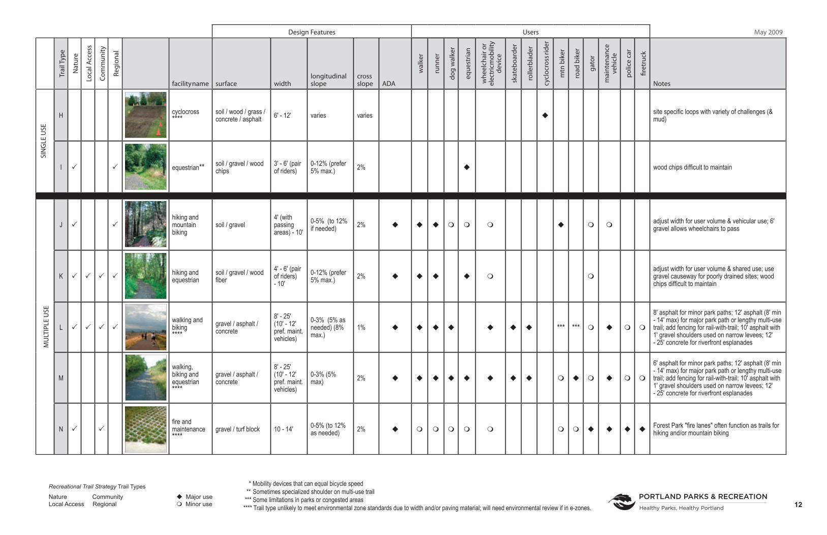
Trail Type Matrix IntroductionPP&R trail types (page 11 and 12) are based on trail user activity. The first section outlines trail types with single users. The second section outlines trail types shared by different types of trail users. Some basic design features (surface, width, longitudinal and cross-slope, accessibility) and notes are included. Individual sheets on each trail type provide a definition, describe users and materials, and show photograph(s) and typical detail. Some trail types can be built of several materials so other details are also referenced. Ranges of width or longitudinal and cross-slope allow flexibility to respond to site conditions and expected intensity of use.
Trail Design, Construction, and MaintenanceDescriptions, charts, photographs, and construction details cannot convey the complete reality of selecting, designing, and building a trail that is appropriate for a site and its intended users. Trained designers and experience are essential for success. The following information
8 Trail Design Guidelines – May 2009
Trail Design
Based on table in Trail Planning, Design, and Development Guidelines: Shared Use Paved Trails, Natural Surface Trails, Winter-Use Trails, Bikeways by Minnesota Department of Natural Resources Trails and Waterways, 2006
Access Route (ADAAG) Outdoor Access Route Accessible Trail
Surface stable, firm, and slip resistant firm and stable firm and stable (exception:*)Maximum Running Slope 1:12 [8.33%] 1: 20 [5%] (for any distance)
1: 12 [8.33%] (for max. 50 ft)1:10 [10%] (for max. 30 ft)
1: 20 [5%] (for any distance)1: 12 [8.33] (for max. 50 ft)1:10 [10%] (for max. 30 ft)1: 8 [12.5%] (for max. 10 ft)(Exception: 1: 7 [14.3%] for 5 ft maximum for open drainage structures or when * applies )
Maximum Cross Slope 1:50 [2%] 1: 33 [3.03%] (Exception: 1: 20 [5%] for drainage purposes
1: 20 [5%](Exception: 1: 10 [10%] at the bottom of an open drain where clear tread width is a minimum of 42 inches
Minimum Clear Tread Width 36 inches32 inches for no more than 24 inches
36 inches(Exception: 32 inches when * applies )
36 inches(Exception: 32 inches when * applies )
Tread Obstacles Changes in level: 1/4 inch with no beveled edge, 1/4 - 1/2 inch must have a beveled edge with a max slope of 1: 2 [50%] (over 1/2 inch = ramp)
1 inch high maximumException: 2 inches high maximum where beveled with a slope no greater than 1: 2 [50%] and where * applies.
2 inches high maximum Exception: 3 inches maximum where running and cross slopes are 1: 20 [5%] or less.(Exception: * )
Passing Space Every 200 feet where clear tread width is less than 60 inches, a minimum 60 x 60 inch space, or a T-shaped intersection of two walks or coridors with arms and stem extending minimum of 48 inches.
Every 200 feet where clear tread width is less than 60 inches, a minimum 60 x 60 inch space, or a T-shaped intersection of two walks or coridors with arms and stem extending minimum of 48 inches.(Exception: Every 300 feet where * applies .)
Every 1000 feet where clear tread width is less than 60 inches, a minimum 60 x 60 inch space, or a T-shaped intersection of two walks or coridors with arms and stem extending minimum of 48 inches.(Exception: *)
Resting Intervals Landings: 60 inch min length, minimum width as wide as the ramp run leading to it, if change in direction occcurs, must have 60 x 60 inch space
60 inches minimum length, width at least as wide as the widest portion of the trail segment leading to the resting interval and a max slope of 1: 33 [3.03%] (Exception: A max slope of 1: 20 [5%] is allowed for drainage purpose.)
60 inches minimum length, width at least as wide as the widest portion of the trail segment leading to the resting interval and a max slope of 1: 20 [5%](Exception: * )
* The provision may not apply if it cannot be provided because compliance would cause substantial harm to cultural, historic, religious, or significant natural features or characteristics; substantially alter the nature of the setting or purpose of the facility; require construction methods or materials that are prohibited by Federal, state, or local regulations or statues; or be infeasible due to terrain or the prevailing construction practices.
TECHNICAL PROVISION FOR ACCESS ROUTES, OUTDOOR ACCESS ROUTES AND ACCESSIBLE TRAILS

Portland Parks & Recreation 9
addresses some practical matters involved in design, construction, and maintenance of trails.
PermitsMost trail projects will need land use review and many will require building permits. Projects in environmental zones, crossing drainageways, and along creeks and rivers will all be more complex. Staff at the Bureau of Development Services and appropriate state and federal agencies should be contacted early in the planning process. Adequate funds should be budgeted for application and permit fees.
Erosion ControlSpecific erosion and sediment control solutions have not been added to these details. This should be done when a construction management plan is developed and makes site specific edits to trail cross-sections and/or adds specific erosion control details to plan drawings. Additional information is included in the project specifications.
Grading and DrainageRanges of longitudinal slope (along length of trail) and cross-slope are provided for different trail types. However, consideration of soil, surface water movement, and site hydrology will help determine appropriate trail alignment with crowned or side slope, swales, and/or rolling grade. Water is a valuable asset in the landscape but needs careful management to not cause problems on trails.
Vegetation Clearing DistancesThe figures for vertical and horizontal clearance shown in the Trail Types and illustrated in Trail Details apply to woody plants. The actual
cleared distance may be wider during construction due to cutting and filling on slopes. Generally, native herbaceous vegetation will repopulate sloped areas in natural areas not worn by passage of feet or wheels. Staff and/or volunteers should monitor for and manage any non-native invasive plants that appear. Trails in many developed parks will be bounded by mowed grass. When trails pass through landscapes with groundcover, shrubs, and trees, they should be sited to provide adequate visibility and enough space for plant growth.
Vehicle UsagePP&R staff use a wide range of vehicles in park and natural area sites. In some locations, utility and security companies, fire, and police may also access trails. Since driving or parking on soil or turf compacts it, trail widths should be adequate for the largest vehicle anticipated. Where regular park maintenance is provided, additional width or turnouts are needed for trail users to pass a parked vehicle. Designers must also provide adequate turning radius and pavement strength. Bureau of Development Services uses load standard of 100 psi (pounds per square inch) while the American Association of State Highway and Transportation Officials (AASHTO) uses 60 psi. Avoid siting benches, tables, lights, drinking fountains, and similar site furniture on the inside of curves where vehicles are more likely to damage them. PP&R electricians use a large boom truck to access park lights or buildings for maintenance and repairs. Maintenance staff use large dump trucks. Urban Forestry crews provide both regular and emergency maintenance with boom trucks.
Wood PreservativesThe question of using native, rot-resistant woods versus a variety of wood preservatives and/or plastic lumber arouses fierce debates.
Trail Design

10 Trail Design Guidelines – May 2009
PP&R has included its most current details, but note the materials and preservatives are subject to change. Research continues on the effects of various substances on wildlife, fish, aquatic life, and humans so staff will address the topic with each design.
Trail MaintenanceTrails wear out and types and numbers of users can change over time. Adjustments may be necessary through major maintenance, realignment or reconstruction. Seasonal maintenance techniques and schedules are not included in these Trail Design Guidelines. However, the Trail Details can provide basis for restoring slopes, surfaces, and vegetation clearances or improving management of water.
Trail Design
PP&R Vehicles Length / wheel base Width Height Weight Turning RadiusFreightliner FL60 150” wheelbase 11’ 20,000 lbsSix-Yard Dump Truck 160” wheelbase 9’ - 6” 10’ - 6” 35,000 lbs (loaded) 22’ O&M boom truck (for unloading “deep” cans) smaller than six-yard dump truck
20’ above trash cans
Urban Forestry Crane Truck 34’ w/24’ wheelbase 98” 13’Fire Bureau ApparatusPumper 31’-3” w/184” wheelbase 9’ - 10” 10’ - 4” 37,660 23’Brush Unit 20’-5” w/143” wheelbase 8’ 8’ - 3” 17,500 51’ outside wall to wallWater Tender 28’ - 8” w/195” wheelbase 9’ - 10” 10’ - 7” 51,940 31’ - 7”Aerial (Tractor and Trailer) 53’ - 10” overall length
tractor = 140” wheelbase trailer = 305” wheelbase
9’ - 10” 11’ - 6” 58,000 15’ -7”
Design Features Users May 2009
Trai
l Typ
e
Nat
ure
Loca
l Acc
ess
Com
mun
ity
Regi
onal
facility name surface widthlongitudinal slope
cross slope ADA
wal
ker
runn
er
dog
wal
ker
eque
stria
n
whe
elch
air o
r el
ectr
ic m
obili
ty
devi
ce
skat
eboa
rder
rolle
rbla
der
cycl
ocro
ss ri
der
mtn
bik
er
road
bik
er
gato
r
mai
nten
ance
ve
hicl
e
polic
e ca
r
firet
ruck
Notes
SIN
GLE
USE
A hiking (high challenge) soil / stairs 18” - 30”
0 - 15% (short segments steeper than 15%)
2% min4% max
steepest (steps, rocks, roots)
B hiking (moderate challenge)
soil / stairs 18” - 30” 0 - 8% 2% min4% max
steep limited landings of 60” x 60” every 1000 feet
C hiking (accessible)
soil / gravel / engineered wood fiber or wood chips
4’ (with passing areas) - 10’
0 - 5% (8% for max. 50’) 2%
Columbia Slough ADA segments require 6’ Fibar (or equivalent engineered wood fiber) and are closed to dogs and bicycles; use gravel causeway for poorly drained sites
D walking ****
engineered wood fiber or chips / gravel / pavers asphalt / concrete / wood or plastic lumber
6’ - 12’ (8’ min if paved forvehicles)
0 - 8% 1 - 2%
sidewalks, boardwalks and trails in developed parks, sometimes include stairways; pave if used for maintenance (8’ min. - 10’ pref.), phase out chipseal; avoid wood fiber except for 10’ wide walking loops in developed parks; landings of 60” x 60” every 1000 feet on accessible trails
E
exercise / fitness (resilient track)
synthetic rubber 2-4’ / lane 0 - 1% 1% discourage use of wheelchairs and baby strollers to protect resilient surface
F biking**** asphalt / concrete
6’ one-way, 10' min. - 12’ pref. two-way
0 - 3% pref.(to 5% if needed, up to 10% for 500', up to 12% for 50' and ramps)
2% *
to 12% for short segments & ramps; porous paving may be too rough for skateboarders and rollerbladers; 12’ asphalt for bikes is sometimes paired with 10’ concrete or paver “walking” for dual trail in high use areas
G mountain biking soil / gravel / wood 18" - 4' 0 - 12% 2 - 5%
18" one-way single track; add width & banking (superelevation) at turns; harden surface with compacted soil/gravel to prevent erosion
TRAIL TYPE MATRIX
Recreational Trail Strategy Trail Types
Nature Community Major useLocal Access Regional Minor use
* Mobility devices that can equal bicycle speed ** Sometimes specialized shoulder on multi-use trail *** Some limitations in parks or congested areas**** Trail type unlikely to meet environmental zone standards due to width and/or paving material; will need environmental review if in e-zones. 11
Design Features Users May 2009
Trai
l Typ
e
Nat
ure
Loca
l Acc
ess
Com
mun
ity
Regi
onal
facility name surface widthlongitudinal slope
cross slope ADA
wal
ker
runn
er
dog
wal
ker
eque
stria
n
whe
elch
air o
r el
ectr
ic m
obili
ty
devi
ce
skat
eboa
rder
rolle
rbla
der
cycl
ocro
ss ri
der
mtn
bik
er
road
bik
er
gato
r
mai
nten
ance
ve
hicl
e
polic
e ca
r
firet
ruck
Notes
SIN
GLE
USE
H cyclocross****
soil / wood / grass / concrete / asphalt 6' - 12' varies varies site specific loops with variety of challenges (&
mud)
I equestrian** soil / gravel / wood chips
3' - 6' (pair of riders)
0-12% (prefer 5% max.) 2% wood chips difficult to maintain
MU
LTIP
LE U
SE
J hiking and mountain biking
soil / gravel 4' (with passing areas) - 10'
0-5% (to 12% if needed) 2% adjust width for user volume & vehicular use; 6'
gravel allows wheelchairs to pass
K hiking and equestrian
soil / gravel / wood fiber
4' - 6' (pair of riders) - 10'
0-12% (prefer 5% max.) 2%
adjust width for user volume & shared use; use gravel causeway for poorly drained sites; wood chips difficult to maintain
L walking and biking****
gravel / asphalt / concrete
8' - 25' (10' - 12' pref. maint. vehicles)
0-3% (5% as needed) (8% max.)
1% *** ***
8' asphalt for minor park paths; 12' asphalt (8' min - 14' max) for major park path or lengthy multi-use trail; add fencing for rail-with-trail; 10' asphalt with 1' gravel shoulders used on narrow levees; 12' - 25' concrete for riverfront esplanades
Mwalking, biking and equestrian****
gravel / asphalt / concrete
8' - 25' (10' - 12' pref. maint. vehicles)
0-3% (5% max) 2%
6' asphalt for minor park paths; 12' asphalt (8' min - 14' max) for major park path or lengthy multi-use trail; add fencing for rail-with-trail; 10' asphalt with 1' gravel shoulders used on narrow levees; 12' - 25' concrete for riverfront esplanades
N fire and maintenance****
gravel / turf block 10 - 14' 0-5% (to 12% as needed) 2% Forest Park "fire lanes" often function as trails for
hiking and/or mountain biking
Recreational Trail Strategy Trail Types
Nature Community Major useLocal Access Regional Minor use
* Mobility devices that can equal bicycle speed ** Sometimes specialized shoulder on multi-use trail *** Some limitations in parks or congested areas**** Trail type unlikely to meet environmental zone standards due to width and/or paving material; will need environmental review if in e-zones. 12
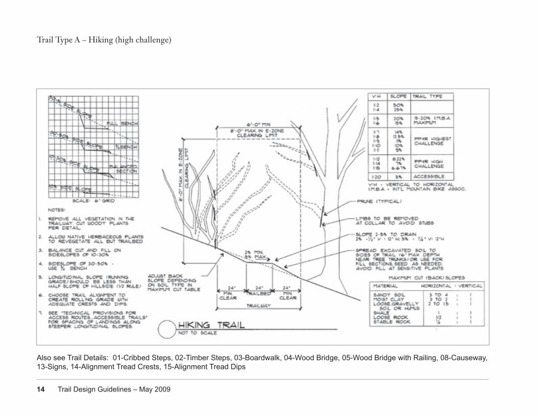
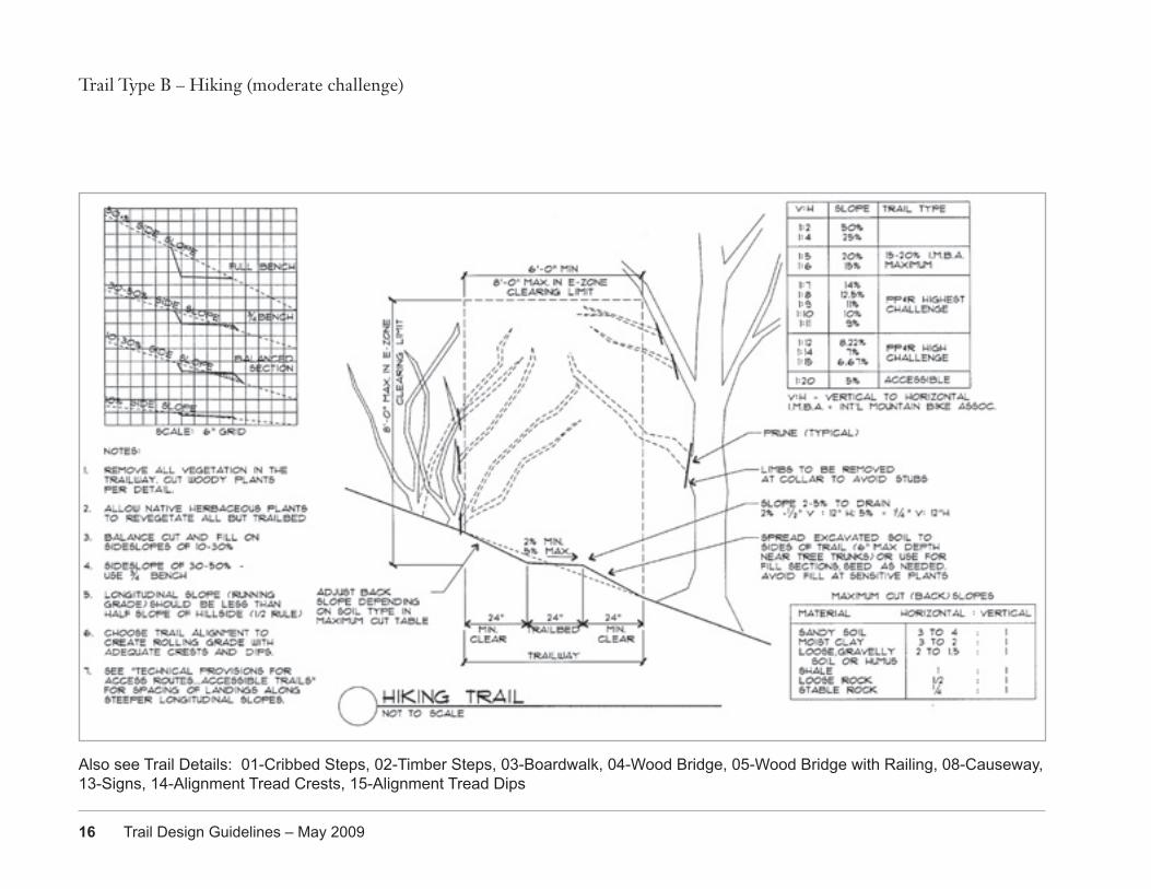
Portland Parks & Recreation 13
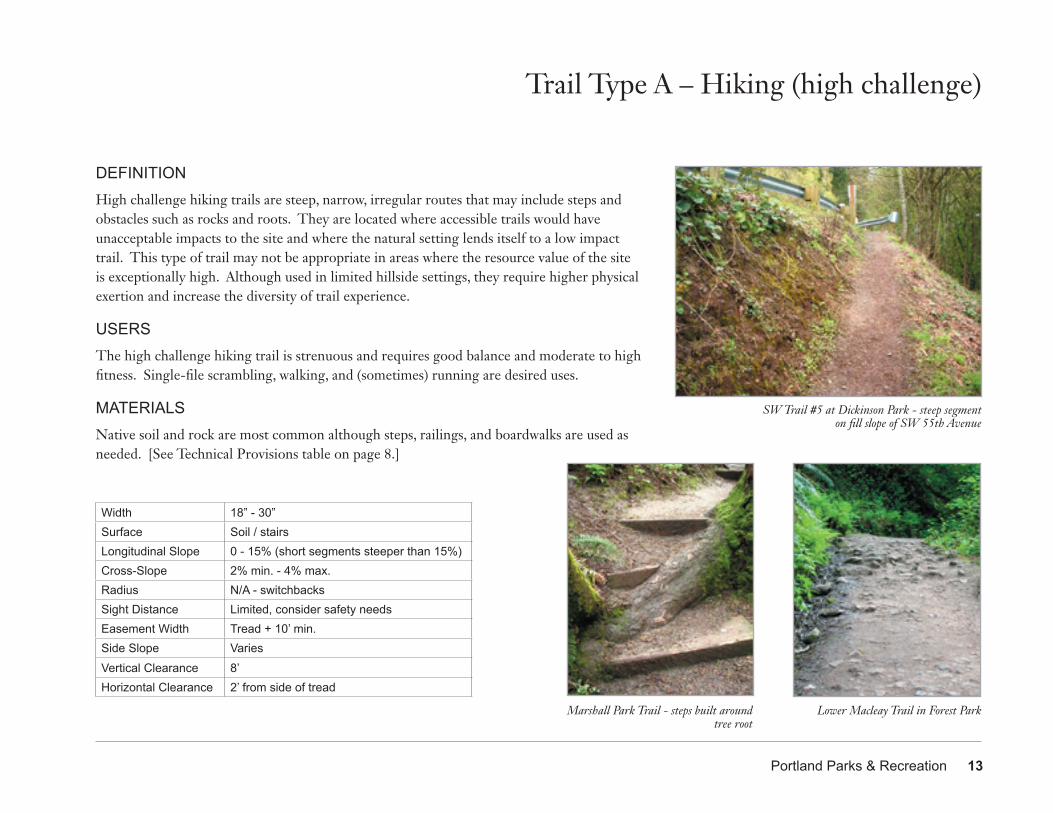
DEFINITIONHigh challenge hiking trails are steep, narrow, irregular routes that may include steps and obstacles such as rocks and roots. They are located where accessible trails would have unacceptable impacts to the site and where the natural setting lends itself to a low impact trail. This type of trail may not be appropriate in areas where the resource value of the site is exceptionally high. Although used in limited hillside settings, they require higher physical exertion and increase the diversity of trail experience.
USERSThe high challenge hiking trail is strenuous and requires good balance and moderate to high fitness. Single-file scrambling, walking, and (sometimes) running are desired uses.
MATERIALSNative soil and rock are most common although steps, railings, and boardwalks are used as needed. [See Technical Provisions table on page 8.]
Trail Type A – Hiking (high challenge)
Width 18” - 30”Surface Soil / stairsLongitudinal Slope 0 - 15% (short segments steeper than 15%)Cross-Slope 2% min. - 4% max.Radius N/A - switchbacksSight Distance Limited, consider safety needsEasement Width Tread + 10’ min.Side Slope VariesVertical Clearance 8’Horizontal Clearance 2’ from side of tread
SW Trail #5 at Dickinson Park - steep segment on fill slope of SW 55th Avenue
Marshall Park Trail - steps built around tree root
Lower Macleay Trail in Forest Park
14 Trail Design Guidelines – May 2009
Trail Type A – Hiking (high challenge)
Also see Trail Details: 01-Cribbed Steps, 02-Timber Steps, 03-Boardwalk, 04-Wood Bridge, 05-Wood Bridge with Railing, 08-Causeway, 13-Signs, 14-Alignment Tread Crests, 15-Alignment Tread Dips
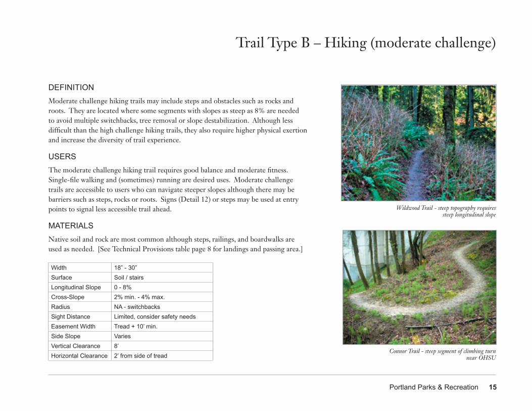
Portland Parks & Recreation 15
DEFINITIONModerate challenge hiking trails may include steps and obstacles such as rocks and roots. They are located where some segments with slopes as steep as 8% are needed to avoid multiple switchbacks, tree removal or slope destabilization. Although less difficult than the high challenge hiking trails, they also require higher physical exertion and increase the diversity of trail experience.
USERSThe moderate challenge hiking trail requires good balance and moderate fitness. Single-file walking and (sometimes) running are desired uses. Moderate challenge trails are accessible to users who can navigate steeper slopes although there may be barriers such as steps, rocks or roots. Signs (Detail 12) or steps may be used at entry points to signal less accessible trail ahead.
MATERIALSNative soil and rock are most common although steps, railings, and boardwalks are used as needed. [See Technical Provisions table page 8 for landings and passing area.]
Trail Type B – Hiking (moderate challenge)
Wildwood Trail - steep topography requires steep longitudinal slope
Connor Trail - steep segment of climbing turnnear OHSU
Width 18” - 30”Surface Soil / stairsLongitudinal Slope 0 - 8%Cross-Slope 2% min. - 4% max.Radius NA - switchbacksSight Distance Limited, consider safety needsEasement Width Tread + 10’ min.Side Slope VariesVertical Clearance 8’Horizontal Clearance 2’ from side of tread
16 Trail Design Guidelines – May 2009
Trail Type B – Hiking (moderate challenge)
Also see Trail Details: 01-Cribbed Steps, 02-Timber Steps, 03-Boardwalk, 04-Wood Bridge, 05-Wood Bridge with Railing, 08-Causeway, 13-Signs, 14-Alignment Tread Crests, 15-Alignment Tread Dips
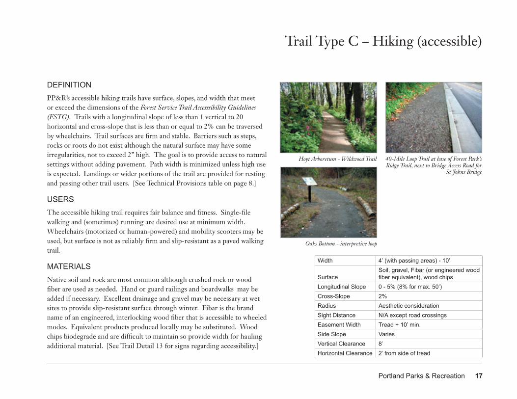
Portland Parks & Recreation 17
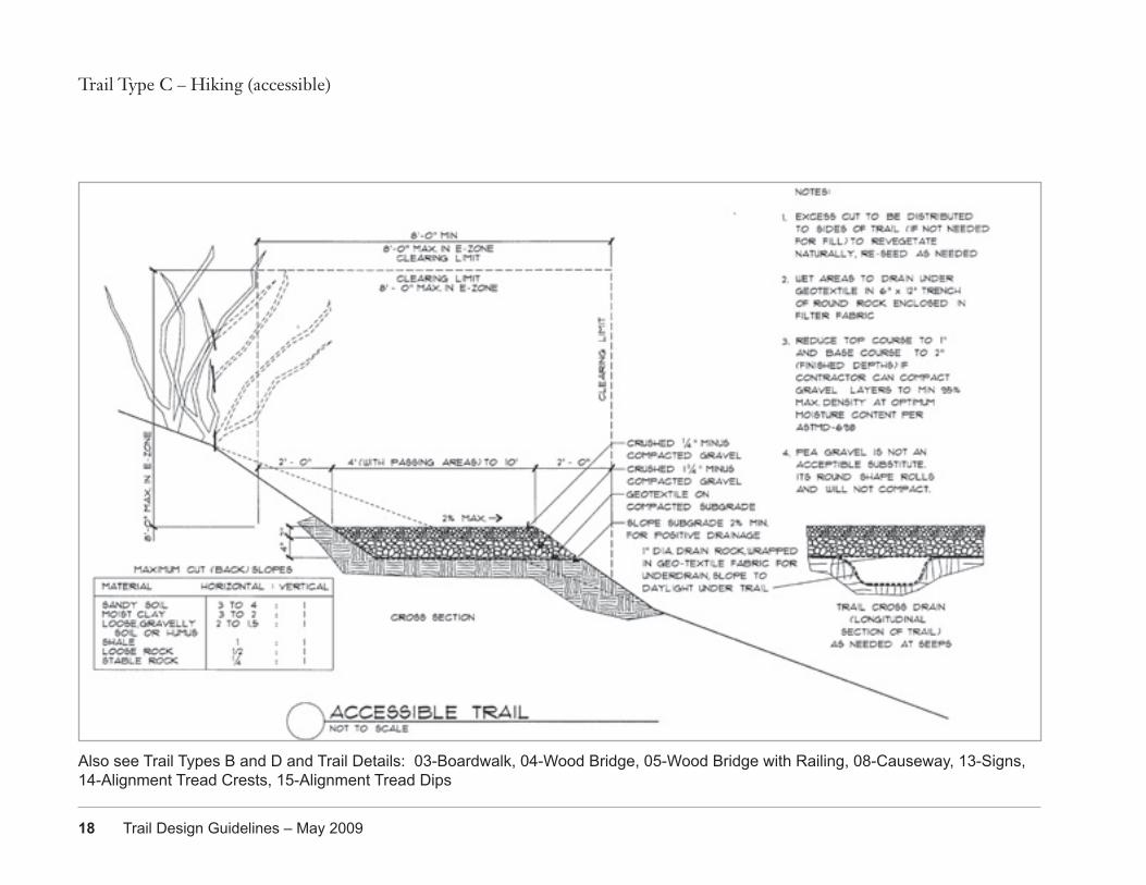
DEFINITIONPP&R’s accessible hiking trails have surface, slopes, and width that meet or exceed the dimensions of the Forest Service Trail Accesssibility Guidelines (FSTG). Trails with a longitudinal slope of less than 1 vertical to 20 horizontal and cross-slope that is less than or equal to 2% can be traversed by wheelchairs. Trail surfaces are firm and stable. Barriers such as steps, rocks or roots do not exist although the natural surface may have some irregularities, not to exceed 2” high. The goal is to provide access to natural settings without adding pavement. Path width is minimized unless high use is expected. Landings or wider portions of the trail are provided for resting and passing other trail users. [See Technical Provisions table on page 8.]
USERSThe accessible hiking trail requires fair balance and fitness. Single-file walking and (sometimes) running are desired use at minimum width. Wheelchairs (motorized or human-powered) and mobility scooters may be used, but surface is not as reliably firm and slip-resistant as a paved walking trail.
MATERIALSNative soil and rock are most common although crushed rock or wood fiber are used as needed. Hand or guard railings and boardwalks may be added if necessary. Excellent drainage and gravel may be necessary at wet sites to provide slip-resistant surface through winter. Fibar is the brand name of an engineered, interlocking wood fiber that is accessible to wheeled modes. Equivalent products produced locally may be substituted. Wood chips biodegrade and are difficult to maintain so provide width for hauling additional material. [See Trail Detail 13 for signs regarding accessibility.]
Trail Type C – Hiking (accessible)
Hoyt Arboretum - Wildwood Trail
Width 4’ (with passing areas) - 10’
SurfaceSoil, gravel, Fibar (or engineered wood fiber equivalent), wood chips
Longitudinal Slope 0 - 5% (8% for max. 50’)Cross-Slope 2% Radius Aesthetic considerationSight Distance N/A except road crossingsEasement Width Tread + 10’ min.Side Slope VariesVertical Clearance 8’Horizontal Clearance 2’ from side of tread
40-Mile Loop Trail at base of Forest Park’s Ridge Trail, next to Bridge Access Road for
St Johns Bridge
Oaks Bottom - interpretive loop
18 Trail Design Guidelines – May 2009
Trail Type C – Hiking (accessible)
Also see Trail Types B and D and Trail Details: 03-Boardwalk, 04-Wood Bridge, 05-Wood Bridge with Railing, 08-Causeway, 13-Signs, 14-Alignment Tread Crests, 15-Alignment Tread Dips
Portland Parks & Recreation 19
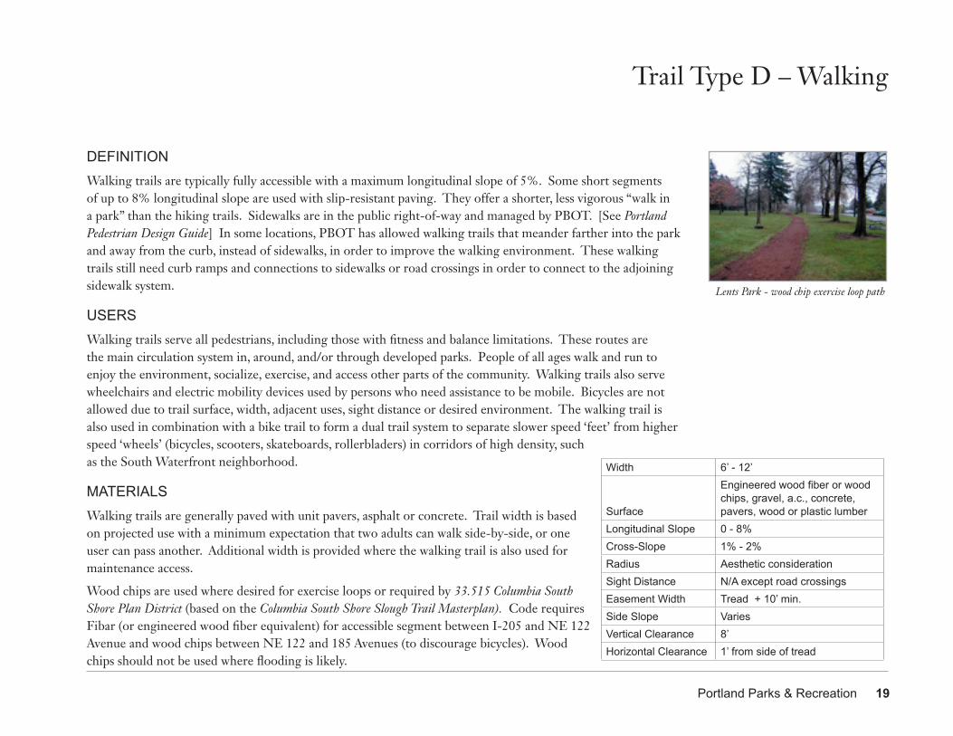
DEFINITIONWalking trails are typically fully accessible with a maximum longitudinal slope of 5%. Some short segments of up to 8% longitudinal slope are used with slip-resistant paving. They offer a shorter, less vigorous “walk in a park” than the hiking trails. Sidewalks are in the public right-of-way and managed by PBOT. [See Portland Pedestrian Design Guide] In some locations, PBOT has allowed walking trails that meander farther into the park and away from the curb, instead of sidewalks, in order to improve the walking environment. These walking trails still need curb ramps and connections to sidewalks or road crossings in order to connect to the adjoining sidewalk system.
USERSWalking trails serve all pedestrians, including those with fitness and balance limitations. These routes are the main circulation system in, around, and/or through developed parks. People of all ages walk and run to enjoy the environment, socialize, exercise, and access other parts of the community. Walking trails also serve wheelchairs and electric mobility devices used by persons who need assistance to be mobile. Bicycles are not allowed due to trail surface, width, adjacent uses, sight distance or desired environment. The walking trail is also used in combination with a bike trail to form a dual trail system to separate slower speed ‘feet’ from higher speed ‘wheels’ (bicycles, scooters, skateboards, rollerbladers) in corridors of high density, such as the South Waterfront neighborhood.
MATERIALSWalking trails are generally paved with unit pavers, asphalt or concrete. Trail width is based on projected use with a minimum expectation that two adults can walk side-by-side, or one user can pass another. Additional width is provided where the walking trail is also used for maintenance access.
Wood chips are used where desired for exercise loops or required by 33.515 Columbia South Shore Plan District (based on the Columbia South Shore Slough Trail Masterplan). Code requires Fibar (or engineered wood fiber equivalent) for accessible segment between I-205 and NE 122 Avenue and wood chips between NE 122 and 185 Avenues (to discourage bicycles). Wood chips should not be used where flooding is likely.
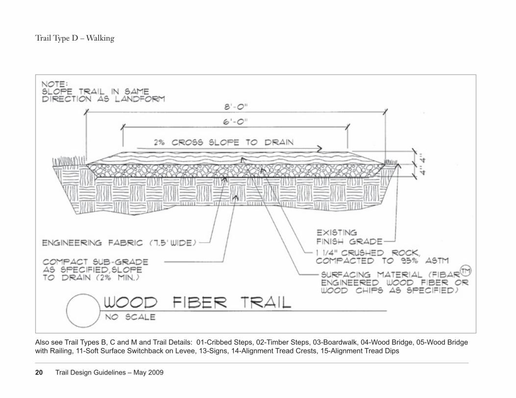
Trail Type D – Walking
Width 6’ - 12’
Surface
Engineered wood fiber or wood chips, gravel, a.c., concrete, pavers, wood or plastic lumber
Longitudinal Slope 0 - 8% Cross-Slope 1% - 2%Radius Aesthetic considerationSight Distance N/A except road crossingsEasement Width Tread + 10’ min.Side Slope VariesVertical Clearance 8’Horizontal Clearance 1’ from side of tread
Lents Park - wood chip exercise loop path
20 Trail Design Guidelines – May 2009
Trail Type D – Walking
Also see Trail Types B, C and M and Trail Details: 01-Cribbed Steps, 02-Timber Steps, 03-Boardwalk, 04-Wood Bridge, 05-Wood Bridge with Railing, 11-Soft Surface Switchback on Levee, 13-Signs, 14-Alignment Tread Crests, 15-Alignment Tread Dips
Portland Parks & Recreation 21
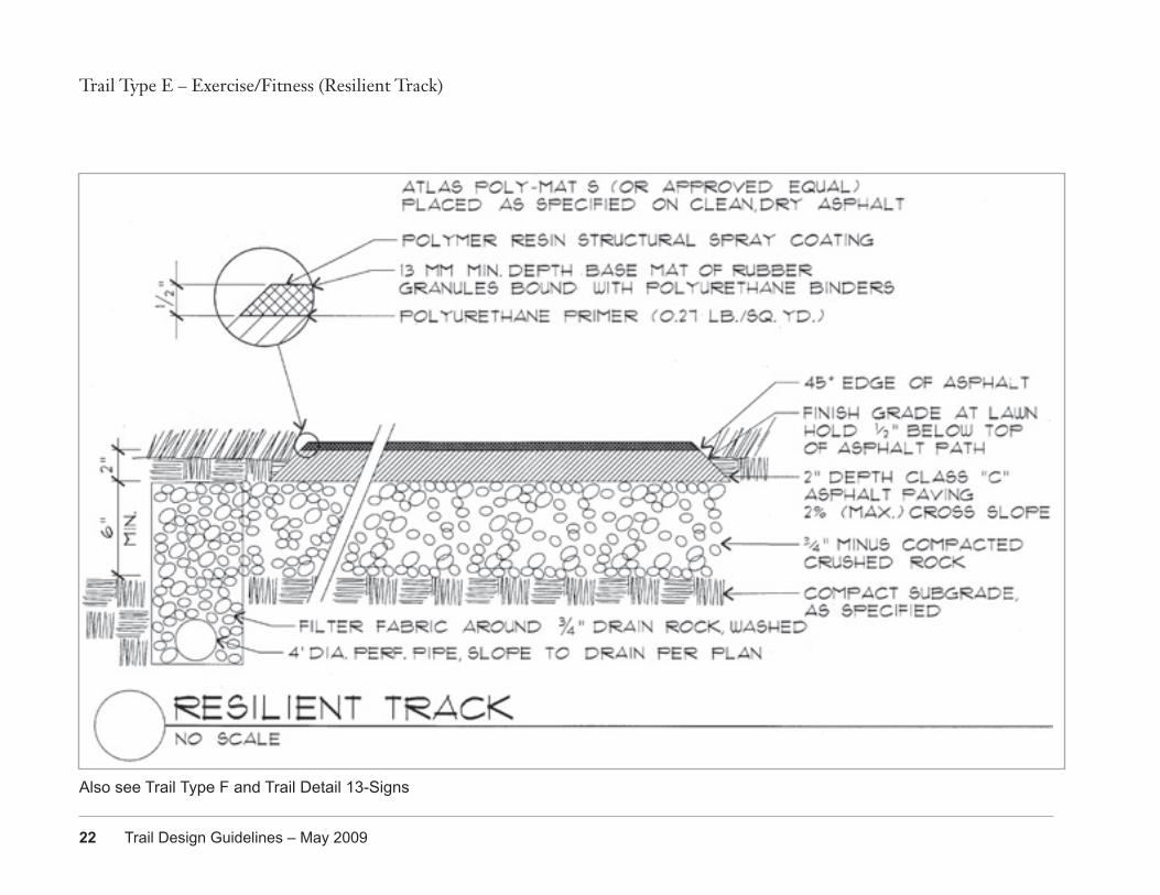
DEFINITIONExercise/fitness tracks are resilient surfaces developed primarily for competitive track events and training. They also serve for non-competitive walking, jogging, and running. Tracks are precisely engineered to be virtually flat with enough slope to shed rainfall. There are currently no resilient surfaces along narrow linear routes, although demand paths of hardened earth frequently develop next to asphalt or concrete walking (such as Laurelhurst Park), or walking and biking trails (such as Terwilliger Trail).
USERSExercise/fitness trails are designed for competitive runners. Although the track may sometimes be scheduled for track and field events, there are frequent walkers, joggers, and/or runners who are encouraged to use the outer lanes in order to balance wear of racers on inner lanes. Wheelchairs, bicycles, and baby strollers are not allowed in order to preserve the resilient surface.
MATERIALSExercise/fitness tracks are synthetic rubber (sometimes recycled athletic shoes) over an asphalt base. The number of lanes is based on projected use with a minimum of six lanes. Surface and/or subsurface drain systems ensure that runoff from adjacent areas is intercepted before reaching resilient surface.
Trail Type E – Exercise/Fitness (Resilient Track)
Width 2’ - 4’ if developed as linear routeSurface Synthetic rubber over a.c. or concreteLongitudinal Slope 0 - 1%Cross-Slope 1% Radius Use standard oval dimensions for trackSight Distance N/AEasement Width As neededSide Slope 0%Vertical Clearance 8’Horizontal Clearance Mowed grass next to tread
Duniway Track Laurelhurst Park - “runners’ rut”
22 Trail Design Guidelines – May 2009
Trail Type E – Exercise/Fitness (Resilient Track)
Also see Trail Type F and Trail Detail 13-Signs
Portland Parks & Recreation 23
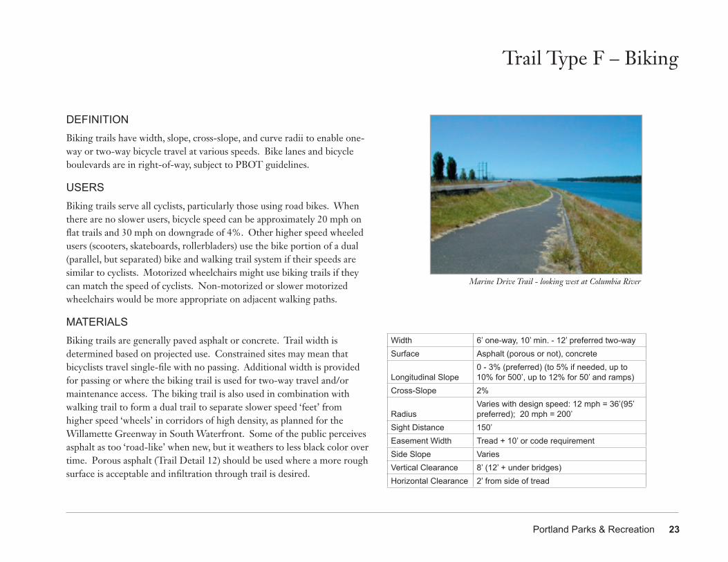
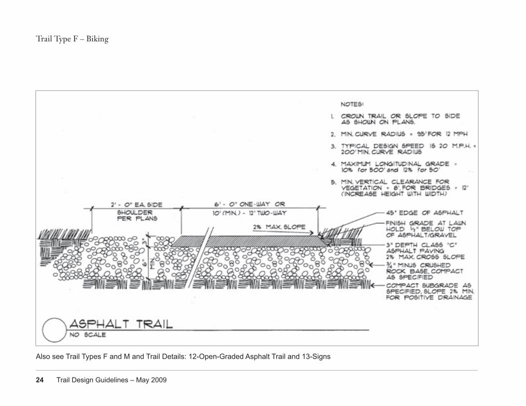
DEFINITIONBiking trails have width, slope, cross-slope, and curve radii to enable one-way or two-way bicycle travel at various speeds. Bike lanes and bicycle boulevards are in right-of-way, subject to PBOT guidelines.
USERSBiking trails serve all cyclists, particularly those using road bikes. When there are no slower users, bicycle speed can be approximately 20 mph on flat trails and 30 mph on downgrade of 4%. Other higher speed wheeled users (scooters, skateboards, rollerbladers) use the bike portion of a dual (parallel, but separated) bike and walking trail system if their speeds are similar to cyclists. Motorized wheelchairs might use biking trails if they can match the speed of cyclists. Non-motorized or slower motorized wheelchairs would be more appropriate on adjacent walking paths.
MATERIALSBiking trails are generally paved asphalt or concrete. Trail width is determined based on projected use. Constrained sites may mean that bicyclists travel single-file with no passing. Additional width is provided for passing or where the biking trail is used for two-way travel and/or maintenance access. The biking trail is also used in combination with walking trail to form a dual trail to separate slower speed ‘feet’ from higher speed ‘wheels’ in corridors of high density, as planned for the Willamette Greenway in South Waterfront. Some of the public perceives asphalt as too ‘road-like’ when new, but it weathers to less black color over time. Porous asphalt (Trail Detail 12) should be used where a more rough surface is acceptable and infiltration through trail is desired.
Trail Type F – Biking
Width 6’ one-way, 10’ min. - 12’ preferred two-waySurface Asphalt (porous or not), concrete
Longitudinal Slope0 - 3% (preferred) (to 5% if needed, up to 10% for 500’, up to 12% for 50’ and ramps)
Cross-Slope 2%
RadiusVaries with design speed: 12 mph = 36’(95’ preferred); 20 mph = 200’
Sight Distance 150’Easement Width Tread + 10’ or code requirementSide Slope VariesVertical Clearance 8’ (12’ + under bridges)Horizontal Clearance 2’ from side of tread
Marine Drive Trail - looking west at Columbia River
24 Trail Design Guidelines – May 2009
Trail Type F – Biking
Also see Trail Types F and M and Trail Details: 12-Open-Graded Asphalt Trail and 13-Signs
Portland Parks & Recreation 25
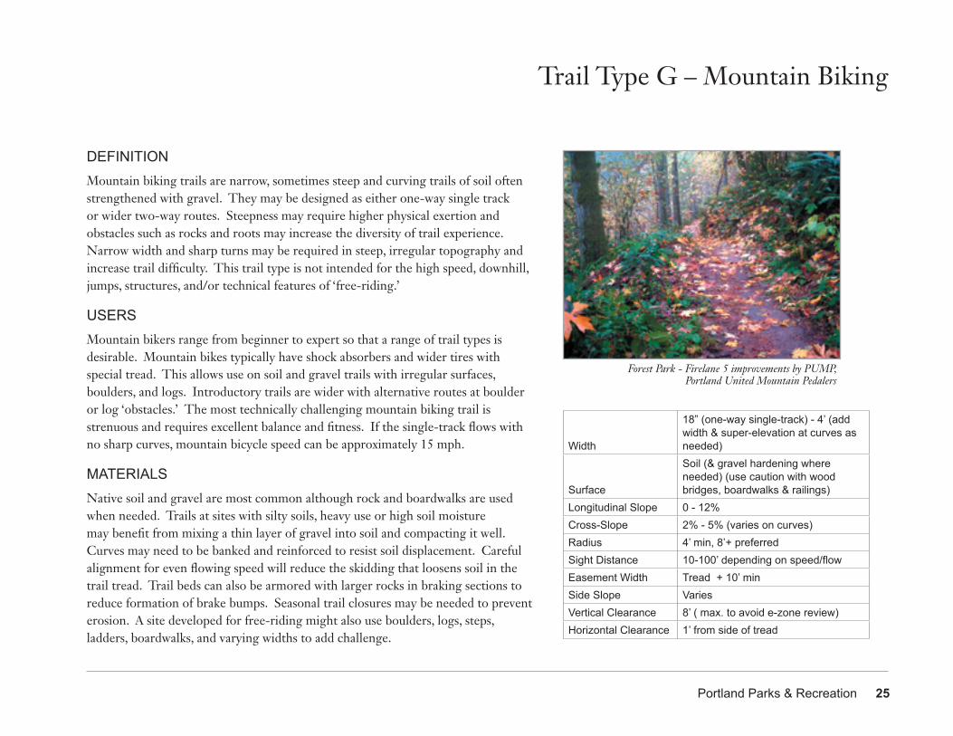
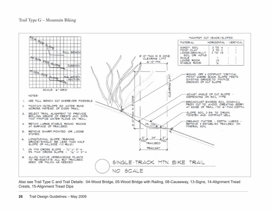
DEFINITIONMountain biking trails are narrow, sometimes steep and curving trails of soil often strengthened with gravel. They may be designed as either one-way single track or wider two-way routes. Steepness may require higher physical exertion and obstacles such as rocks and roots may increase the diversity of trail experience. Narrow width and sharp turns may be required in steep, irregular topography and increase trail difficulty. This trail type is not intended for the high speed, downhill, jumps, structures, and/or technical features of ‘free-riding.’
USERSMountain bikers range from beginner to expert so that a range of trail types is desirable. Mountain bikes typically have shock absorbers and wider tires with special tread. This allows use on soil and gravel trails with irregular surfaces, boulders, and logs. Introductory trails are wider with alternative routes at boulder or log ‘obstacles.’ The most technically challenging mountain biking trail is strenuous and requires excellent balance and fitness. If the single-track flows with no sharp curves, mountain bicycle speed can be approximately 15 mph.
MATERIALSNative soil and gravel are most common although rock and boardwalks are used when needed. Trails at sites with silty soils, heavy use or high soil moisture may benefit from mixing a thin layer of gravel into soil and compacting it well. Curves may need to be banked and reinforced to resist soil displacement. Careful alignment for even flowing speed will reduce the skidding that loosens soil in the trail tread. Trail beds can also be armored with larger rocks in braking sections to reduce formation of brake bumps. Seasonal trail closures may be needed to prevent erosion. A site developed for free-riding might also use boulders, logs, steps, ladders, boardwalks, and varying widths to add challenge.
Trail Type G – Mountain Biking
Width
18” (one-way single-track) - 4’ (add width & super-elevation at curves as needed)
Surface
Soil (& gravel hardening where needed) (use caution with wood bridges, boardwalks & railings)
Longitudinal Slope 0 - 12%Cross-Slope 2% - 5% (varies on curves)Radius 4’ min, 8’+ preferredSight Distance 10-100’ depending on speed/flowEasement Width Tread + 10’ minSide Slope VariesVertical Clearance 8’ ( max. to avoid e-zone review)Horizontal Clearance 1’ from side of tread
Forest Park - Firelane 5 improvements by PUMP, Portland United Mountain Pedalers
26 Trail Design Guidelines – May 2009
Trail Type G – Mountain Biking
Also see Trail Type C and Trail Details: 04-Wood Bridge, 05-Wood Bridge with Railing, 08-Causeway, 13-Signs, 14-Alignment Tread Crests, 15-Alignment Tread Dips
Portland Parks & Recreation 27
DEFINITIONAccording to Wikipedia and cyclo cross regulations, cyclo cross is a form of bicycle racing. Races take place typically in the autumn and winter, and consist of many laps of a short (1.5 – 2 miles) course featuring pavement, wooded trails, grass, steep hills, and obstacles requiring the rider to quickly dismount, carry the bike while navigating the obstruction, and remount in one motion. Races for senior categories are generally between 30 minutes and an hour long, with the distance varying depending on the ground conditions, which often become muddy.
USERSCyclo cross bicycles are similar to racing bicycles but have special tread and brakes needed for muddy conditions. Cyclo cross racing requires aerobic endurance and strong bike-handling skills. Different classes of men, women, children, and masters compete against one another.
MATERIALSNative soil and turf are the most common course surfaces and wet conditions tend to generate mud. Careful design and/or maintenance is required to avoid erosion and to repair the course after the cyclo cross season.
SITESCyclo cross events at both Creston and Pier Parks were phased out due to impacts to the sites and surrounding neighborhoods. The November 2008 Cycle Cross Crusade event held outside the track at Portland International Raceway had approximately 1,300 participants plus additional spectators. Potential new sites will need access, adequate parking, and funding for restoration and should minimize impact on natural resources. Sites such as Gateway Green might be developed as practice course if funding were secured for maintenance.
Trail Type H – Cyclo Cross
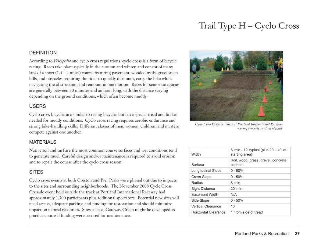
Cyclo Cross Crusade course at Portland International Raceway - using concrete vault as obstacle
Width6’ min - 12’ typical (plus 20’ - 40’ at starting area)
SurfaceSoil, wood, grass, gravel, concrete, asphalt
Longitudinal Slope 0 - 60%
Cross-Slope 0 - 50%Radius 8’ min.Sight Distance 20’ min.Easement Width N/ASide Slope 0 - 50%Vertical Clearance 10’ Horizontal Clearance 1’ from side of tread
28 Trail Design Guidelines – May 2009
Trail Type H – Cyclo Cross
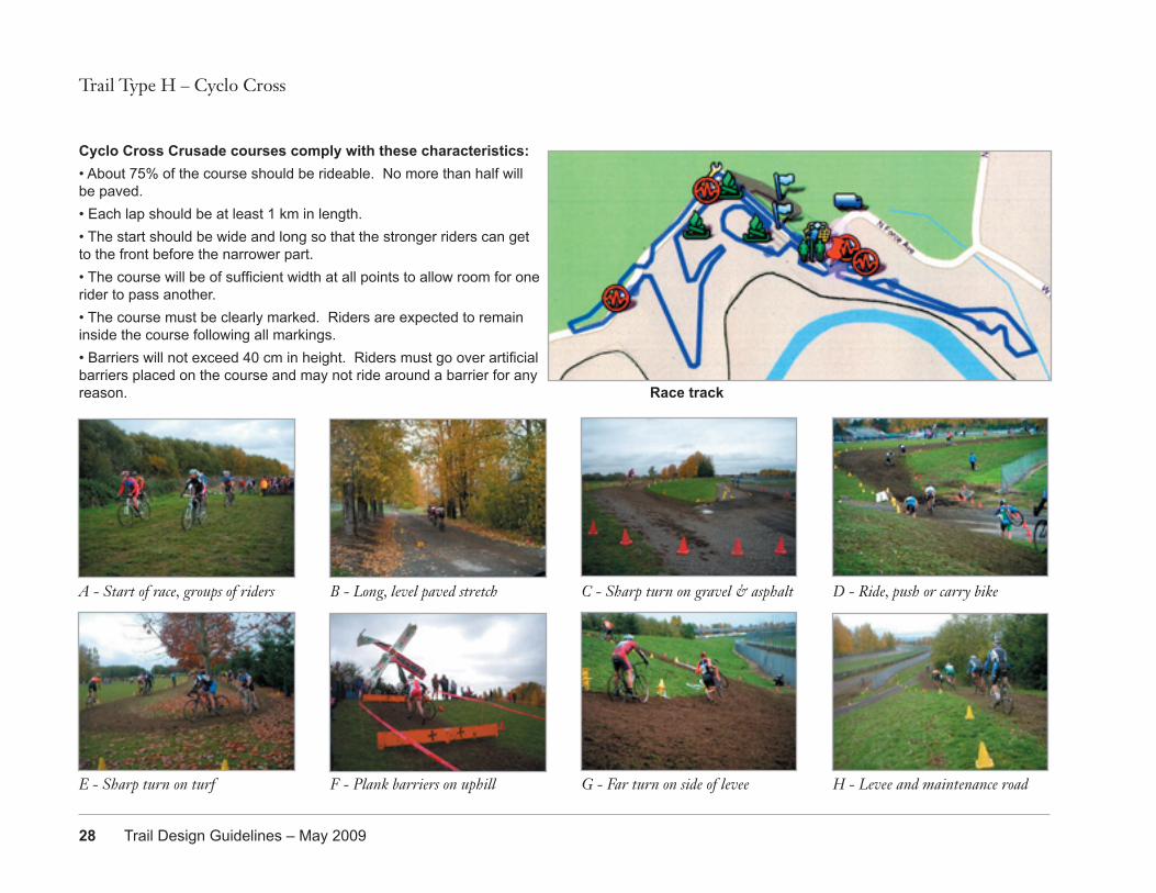
Cyclo Cross Crusade courses comply with these characteristics:• About 75% of the course should be rideable. No more than half will be paved.• Each lap should be at least 1 km in length.• The start should be wide and long so that the stronger riders can get to the front before the narrower part.• The course will be of sufficient width at all points to allow room for one rider to pass another.• The course must be clearly marked. Riders are expected to remain inside the course following all markings. • Barriers will not exceed 40 cm in height. Riders must go over artificial barriers placed on the course and may not ride around a barrier for any reason.
A - Start of race, groups of riders B - Long, level paved stretch C - Sharp turn on gravel & asphalt D - Ride, push or carry bike
E - Sharp turn on turf F - Plank barriers on uphill G - Far turn on side of levee H - Levee and maintenance road
Race track
Portland Parks & Recreation 29
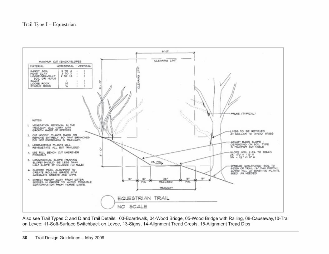
DEFINITIONEquestrian trails serve horseback riders. Horses prefer soil surfaces and require wider and higher clear areas than people on foot or wheels. There are some sites or regional trails in which a separate equestrian-only route could be developed.
USERSEquestrians currently share some trails in Forest Park and Powell Butte Nature Park with hikers, and the Springwater Corridor with walkers, runners, and bicyclists. Horses have good peripheral vision, but the location of their eyes causes a 5’ wide blind spot directly in front. They often travel at about 4-6 mph. Bicycles are specifically not allowed in order to not startle more nervous horses.
MATERIALSEquestrian trails are generally soil or gravel. Horse riders often request wood chips, but this is difficult to maintain. The Gresham portion of the Springwater Corridor has some wood chip segments, which are occasionally maintained by equestrian user groups. Additional vertical clearance is needed in forested areas. Where there are creek crossings or narrow trail corridors, equestrians must share walking and biking trails and bridges with other users. Special care should be taken to direct runoff (that may be contaminated by horse droppings) away from water bodies. See Equestrian Design Guidelines for Trails, Trailheads & Campgrounds by Jan Hancock, Jeff Engelmann, Jim Coffman & Kim Vander Hoek. Seasonal trail closures may be needed to prevent erosion.
Trail Type I – Equestrian
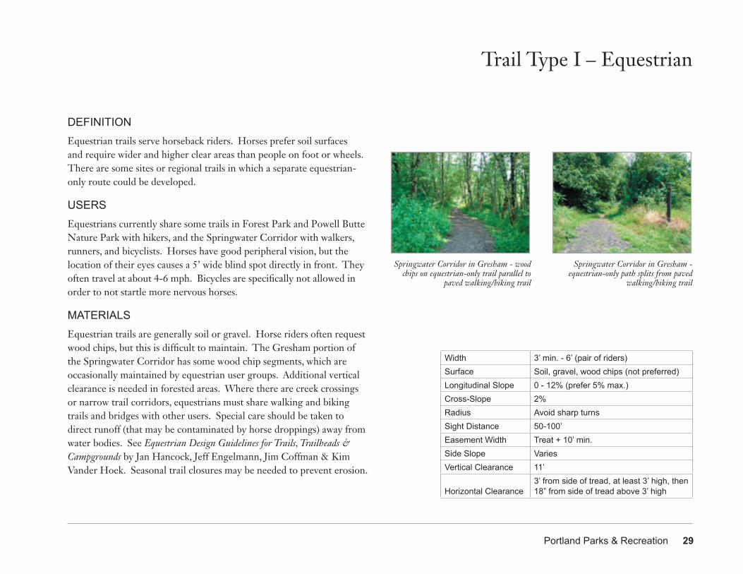
Springwater Corridor in Gresham - equestrian-only path splits from paved
walking/biking trail
Springwater Corridor in Gresham - wood chips on equestrian-only trail parallel to
paved walking/biking trail
Width 3’ min. - 6’ (pair of riders)Surface Soil, gravel, wood chips (not preferred)Longitudinal Slope 0 - 12% (prefer 5% max.)Cross-Slope 2% Radius Avoid sharp turnsSight Distance 50-100’Easement Width Treat + 10’ min.Side Slope VariesVertical Clearance 11’
Horizontal Clearance3’ from side of tread, at least 3’ high, then 18” from side of tread above 3’ high
30 Trail Design Guidelines – May 2009
Trail Type I – Equestrian
Also see Trail Types C and D and Trail Details: 03-Boardwalk, 04-Wood Bridge, 05-Wood Bridge with Railing, 08-Causeway,10-Trail on Levee; 11-Soft-Surface Switchback on Levee, 13-Signs, 14-Alignment Tread Crests, 15-Alignment Tread Dips
Portland Parks & Recreation 31
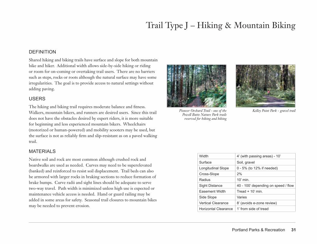
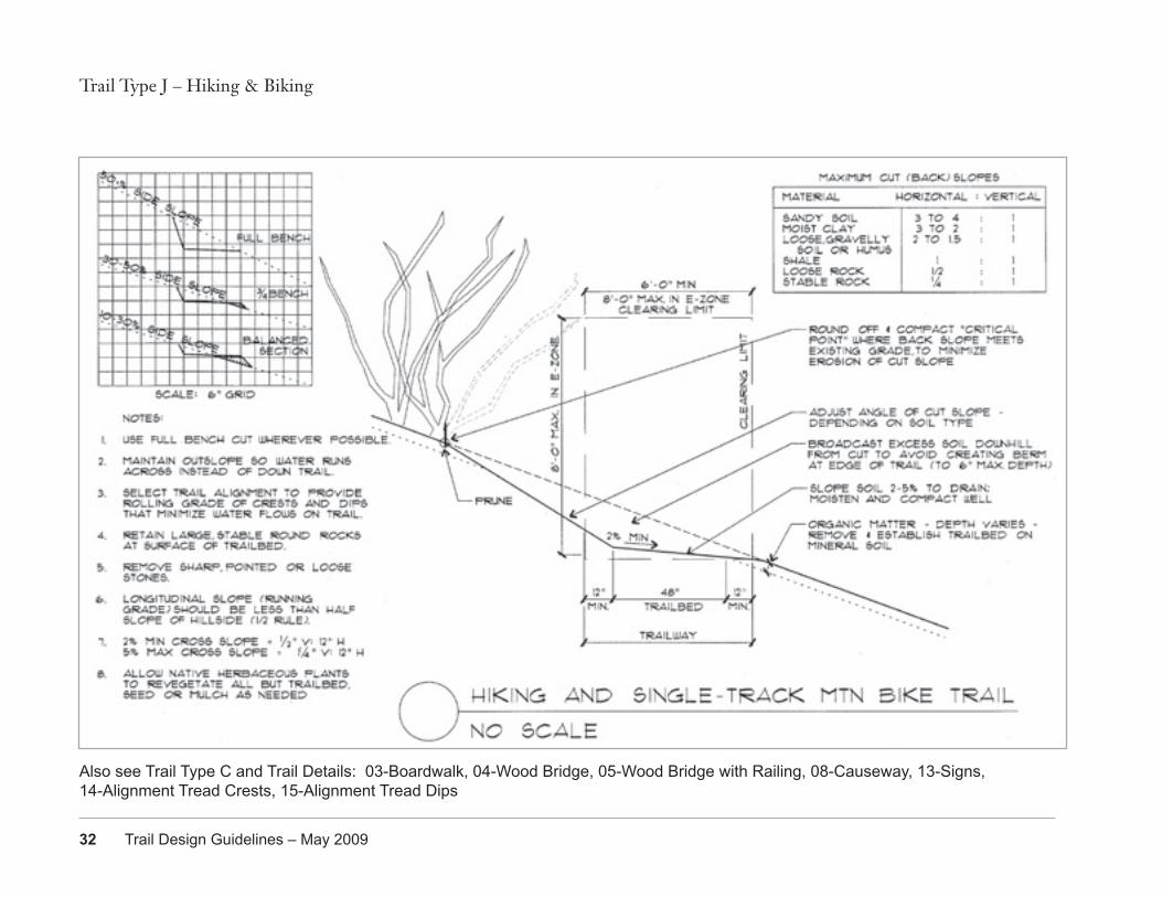
DEFINITIONShared hiking and biking trails have surface and slope for both mountain bike and hiker. Additional width allows side-by-side hiking or riding or room for on-coming or overtaking trail users. There are no barriers such as steps, rocks or roots although the natural surface may have some irregularities. The goal is to provide access to natural settings without adding paving.
USERSThe hiking and biking trail requires moderate balance and fitness. Walkers, mountain bikers, and runners are desired users. Since this trail does not have the obstacles desired by expert riders, it is more suitable for beginning and less experienced mountain bikers. Wheelchairs (motorized or human-powered) and mobility scooters may be used, but the surface is not as reliably firm and slip-resistant as on a paved walking trail.
MATERIALSNative soil and rock are most common although crushed rock and boardwalks are used as needed. Curves may need to be superelevated (banked) and reinforced to resist soil displacement. Trail beds can also be armored with larger rocks in braking sections to reduce formation of brake bumps. Curve radii and sight lines should be adequate to serve two-way travel. Path width is minimized unless high use is expected or maintenance vehicle access is needed. Hand or guard railing may be added in some areas for safety. Seasonal trail closures to mountain bikes may be needed to prevent erosion.
Trail Type J – Hiking & Mountain Biking
Width 4’ (with passing areas) - 10’
Surface Soil, gravelLongitudinal Slope 0 - 5% (to 12% if needed)Cross-Slope 2% Radius 10’ min.Sight Distance 40 - 100’ depending on speed / flowEasement Width Tread + 10’ min.Side Slope VariesVertical Clearance 8’ (avoids e-zone review)Horizontal Clearance 1’ from side of tread
Kelley Point Park - gravel trailPioneer Orchard Trail - one of the Powell Butte Nature Park trails
reserved for hiking and biking
32 Trail Design Guidelines – May 2009
Trail Type J – Hiking & Biking
Also see Trail Type C and Trail Details: 03-Boardwalk, 04-Wood Bridge, 05-Wood Bridge with Railing, 08-Causeway, 13-Signs, 14-Alignment Tread Crests, 15-Alignment Tread Dips
Portland Parks & Recreation 33
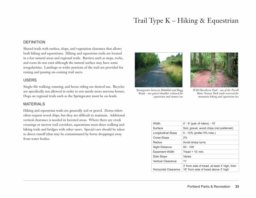
DEFINITIONShared trails with surface, slope, and vegetation clearance that allows both hiking and equestrians. Hiking and equestrian trails are located in a few natural areas and regional trails. Barriers such as steps, rocks, and roots do not exist although the natural surface may have some irregularities. Landings or wider portions of the trail are provided for resting and passing on-coming trail users.
USERSSingle-file walking, running, and horse riding are desired use. Bicycles are specifically not allowed in order to not startle more nervous horses. Dogs on regional trails such as the Springwater must be on-leash.
MATERIALSHiking and equestrian trails are generally soil or gravel. Horse riders often request wood chips, but they are difficult to maintain. Additional vertical clearance is needed in forested areas. Where there are creek crossings or narrow trail corridors, equestrians must share walking and biking trails and bridges with other users. Special care should be taken to direct runoff (that may be contaminated by horse droppings) away from water bodies.
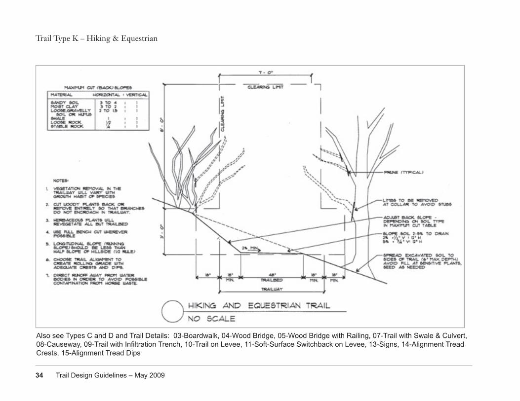
Trail Type K – Hiking & Equestrian
Width 4’ - 6’ (pair of riders) - 10’Surface Soil, gravel, wood chips (not preferred)Longitudinal Slope 0 - 12% (prefer 5% max.)Cross-Slope 2% Radius Avoid sharp turnsSight Distance 50 - 100’Easement Width Tread + 10’ min.Side Slope VariesVertical Clearance 11’
Horizontal Clearance3’ from side of tread, at least 3’ high, then 18” from side of tread above 3’ high
Wild Hawthorn Trail - one of the Powell Butte Nature Park trails reserved for mountain biking and equestrian use
Springwater between Palmblad and Rugg Roads - one gravel shoulder widened for
equestrian and runner use
34 Trail Design Guidelines – May 2009
Trail Type K – Hiking & Equestrian
Also see Types C and D and Trail Details: 03-Boardwalk, 04-Wood Bridge, 05-Wood Bridge with Railing, 07-Trail with Swale & Culvert, 08-Causeway, 09-Trail with Infiltration Trench, 10-Trail on Levee, 11-Soft-Surface Switchback on Levee, 13-Signs, 14-Alignment Tread Crests, 15-Alignment Tread Dips
Portland Parks & Recreation 35
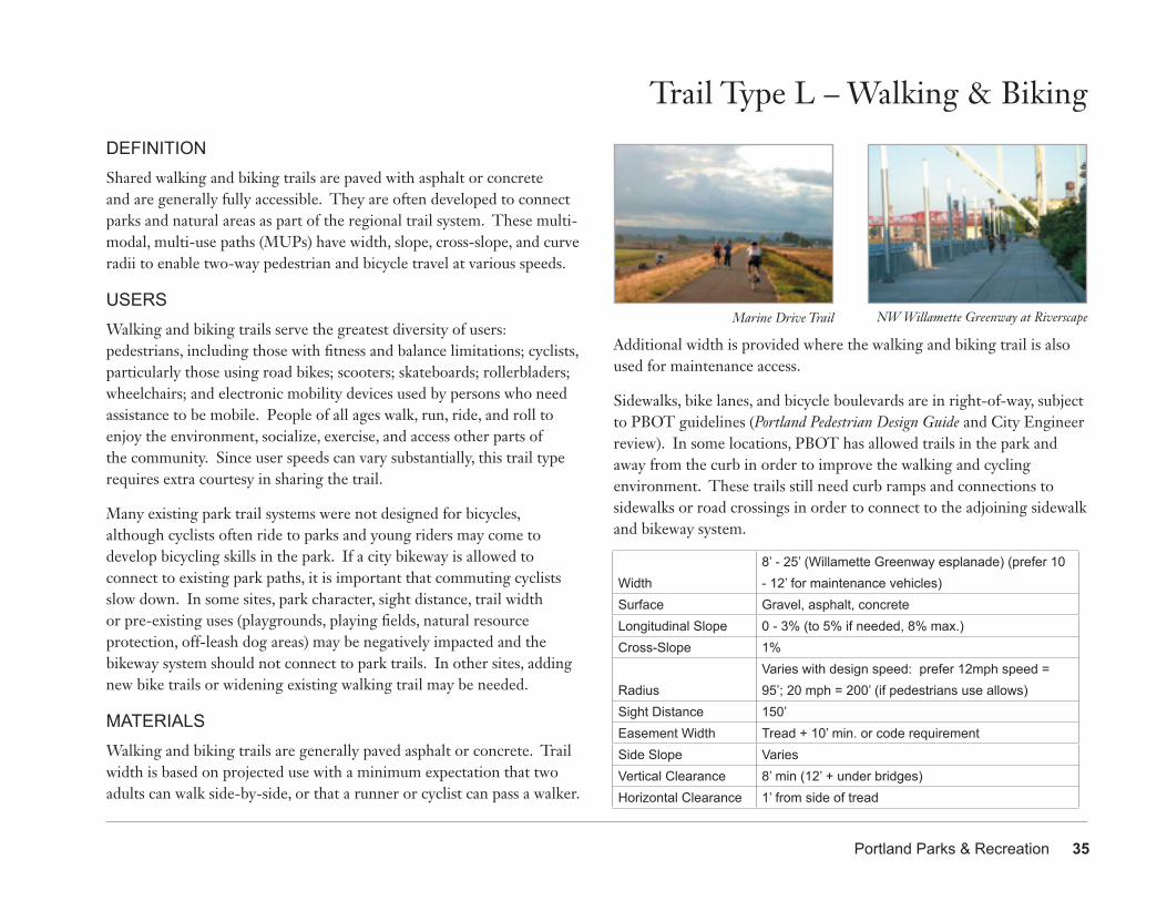
DEFINITIONShared walking and biking trails are paved with asphalt or concrete and are generally fully accessible. They are often developed to connect parks and natural areas as part of the regional trail system. These multi-modal, multi-use paths (MUPs) have width, slope, cross-slope, and curve radii to enable two-way pedestrian and bicycle travel at various speeds.
USERSWalking and biking trails serve the greatest diversity of users: pedestrians, including those with fitness and balance limitations; cyclists, particularly those using road bikes; scooters; skateboards; rollerbladers; wheelchairs; and electronic mobility devices used by persons who need assistance to be mobile. People of all ages walk, run, ride, and roll to enjoy the environment, socialize, exercise, and access other parts of the community. Since user speeds can vary substantially, this trail type requires extra courtesy in sharing the trail.
Many existing park trail systems were not designed for bicycles, although cyclists often ride to parks and young riders may come to develop bicycling skills in the park. If a city bikeway is allowed to connect to existing park paths, it is important that commuting cyclists slow down. In some sites, park character, sight distance, trail width or pre-existing uses (playgrounds, playing fields, natural resource protection, off-leash dog areas) may be negatively impacted and the bikeway system should not connect to park trails. In other sites, adding new bike trails or widening existing walking trail may be needed.
MATERIALSWalking and biking trails are generally paved asphalt or concrete. Trail width is based on projected use with a minimum expectation that two adults can walk side-by-side, or that a runner or cyclist can pass a walker.
Trail Type L – Walking & Biking
Additional width is provided where the walking and biking trail is also used for maintenance access.
Sidewalks, bike lanes, and bicycle boulevards are in right-of-way, subject to PBOT guidelines (Portland Pedestrian Design Guide and City Engineer review). In some locations, PBOT has allowed trails in the park and away from the curb in order to improve the walking and cycling environment. These trails still need curb ramps and connections to sidewalks or road crossings in order to connect to the adjoining sidewalk and bikeway system.
Width8’ - 25’ (Willamette Greenway esplanade) (prefer 10 - 12’ for maintenance vehicles)
Surface Gravel, asphalt, concreteLongitudinal Slope 0 - 3% (to 5% if needed, 8% max.)Cross-Slope 1%
RadiusVaries with design speed: prefer 12mph speed = 95’; 20 mph = 200’ (if pedestrians use allows)
Sight Distance 150’Easement Width Tread + 10’ min. or code requirementSide Slope VariesVertical Clearance 8’ min (12’ + under bridges)Horizontal Clearance 1’ from side of tread
Marine Drive Trail NW Willamette Greenway at Riverscape
36 Trail Design Guidelines – May 2009
Trail Type L – Walking & Biking
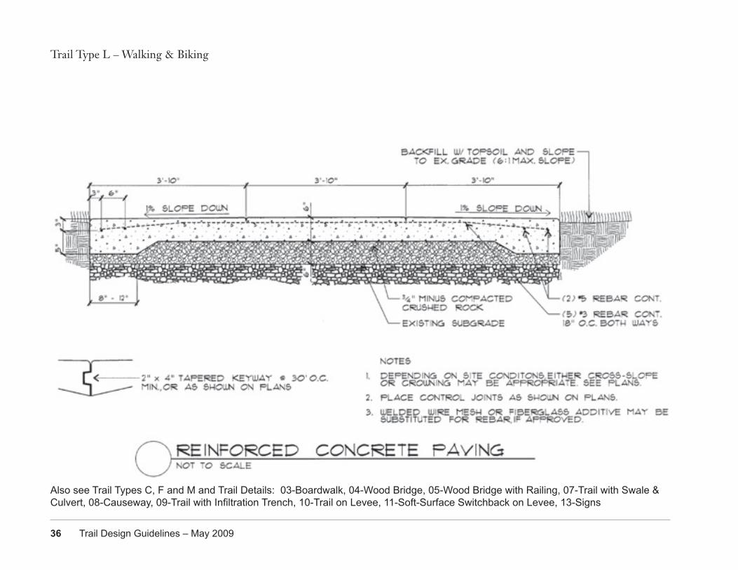
Also see Trail Types C, F and M and Trail Details: 03-Boardwalk, 04-Wood Bridge, 05-Wood Bridge with Railing, 07-Trail with Swale & Culvert, 08-Causeway, 09-Trail with Infiltration Trench, 10-Trail on Levee, 11-Soft-Surface Switchback on Levee, 13-Signs
Portland Parks & Recreation 37
DEFINITIONShared walking, biking, and equestrian trails are paved with asphalt or concrete and have gravel shoulders. The maximum longitudinal slope of 1 vertical to 20 horizontal (5%) is fully accessible. They are often developed to connect parks and natural areas as part of the regional trail system. These multi-modal, multi-use paths (MUPs) have width, slope, cross-slope, and curve radii to enable two-way pedestrian, bicycle, and equestrian travel at various speeds. Equestrians use either pavement or shoulder, typically using the trails in rural segments that have fewer road crossings.
USERSWalking, biking, and equestrian trails serve the greatest diversity of users: pedestrians, including those with fitness and balance limitations; cyclists, particular those using road bikes; scooters; skateboards; rollerbladers; wheelchairs and electric mobility devices used by persons who need assistance to be mobile; and equestrians. People of all ages walk, run, ride, and roll to enjoy the environment, socialize, exercise, and access other parts of the community. Since user speeds can vary substantially, this trail type requires extra courtesy in sharing the trail.
MATERIALSWalking, biking, and equestrian trails are generally paved asphalt or concrete. Trail width is based on projected use with a minimum expectation that two adults can walk side-by-side, or that a runner or cyclist can pass a walker. Gravel shoulders on asphalt trails are used by equestrians, especially when at least one side is widened. Additional width is provided where the trail is also used for maintenance access. Special care should be taken to direct runoff (that may be contaminated by horse droppings) away from water bodies. Seasonal trail closures to mountain bikes and equestrians may be needed to prevent erosion.
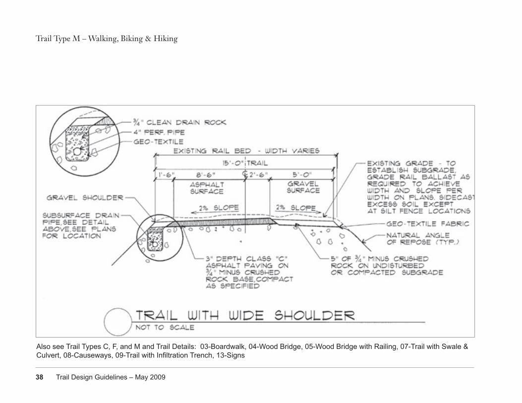
Trail Type M – Walking, Biking & Equestrian
Width8’ - 25’ (prefer 10 - 12’ for maintenance vehicles)
Surface Gravel, asphalt, concreteLongitudinal Slope 0 - 3% (5% max.)Cross-Slope 2%
Radius
Varies with design speed: prefer 12mph speed = 95’; 20 mph = 200’ (if pedestrians and equestrian use allows)
Sight Distance 150’Easement Width Tread + 10’ min. or code requirementSide Slope VariesVertical Clearance 11’
Horizontal Clearance3’ from side of tread, at least 3’ high, then18” from side of tread above 3’ high
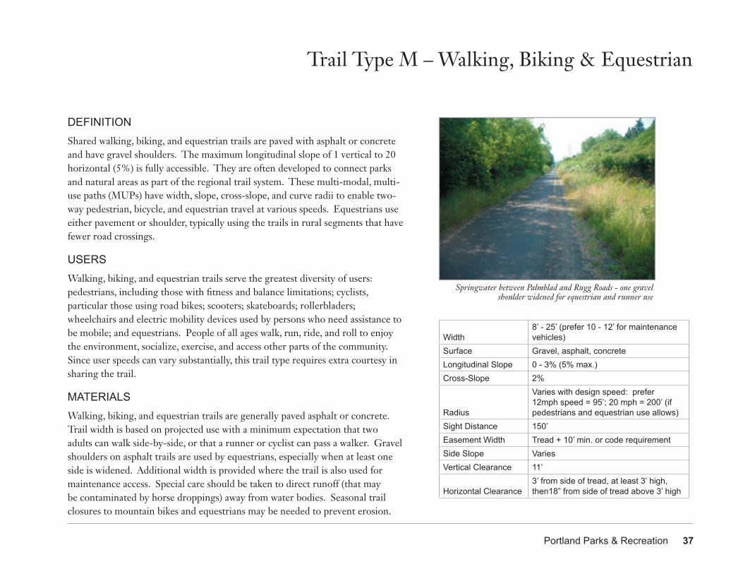
Springwater between Palmblad and Rugg Roads - one gravel shoulder widened for equestrian and runner use
38 Trail Design Guidelines – May 2009
Trail Type M – Walking, Biking & Hiking
Also see Trail Types C, F, and M and Trail Details: 03-Boardwalk, 04-Wood Bridge, 05-Wood Bridge with Railing, 07-Trail with Swale & Culvert, 08-Causeways, 09-Trail with Infiltration Trench, 13-Signs
Portland Parks & Recreation 39
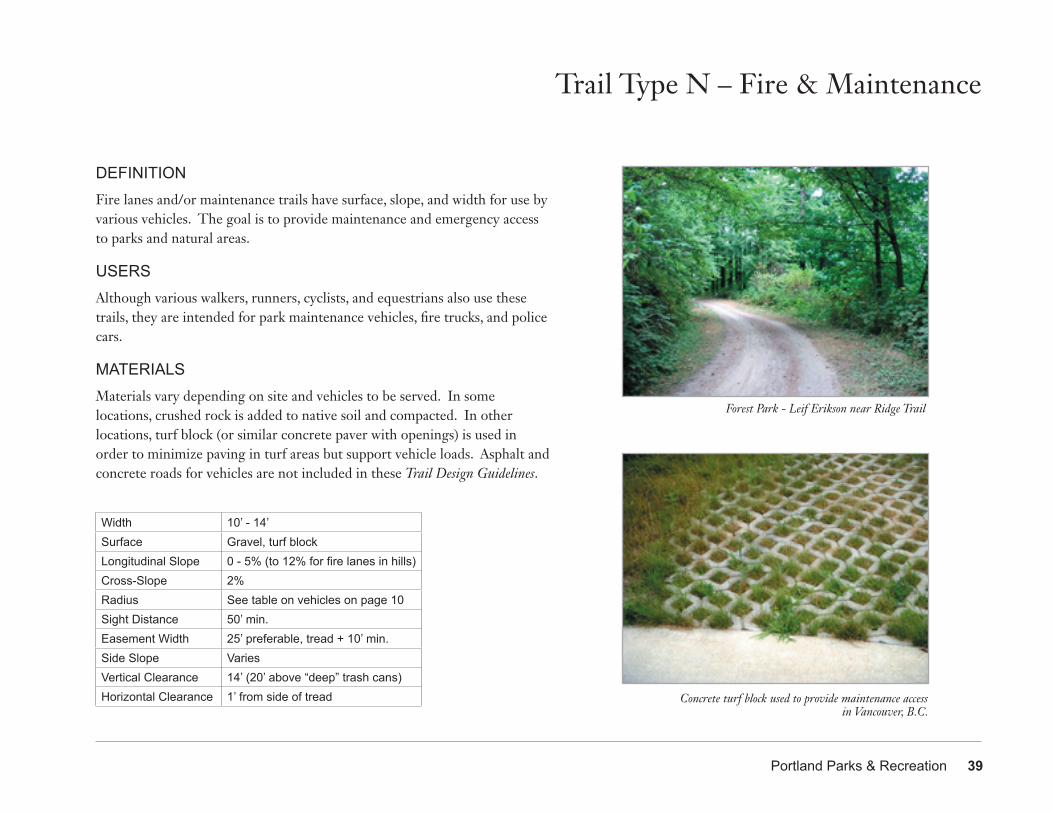
DEFINITIONFire lanes and/or maintenance trails have surface, slope, and width for use by various vehicles. The goal is to provide maintenance and emergency access to parks and natural areas.
USERSAlthough various walkers, runners, cyclists, and equestrians also use these trails, they are intended for park maintenance vehicles, fire trucks, and police cars.
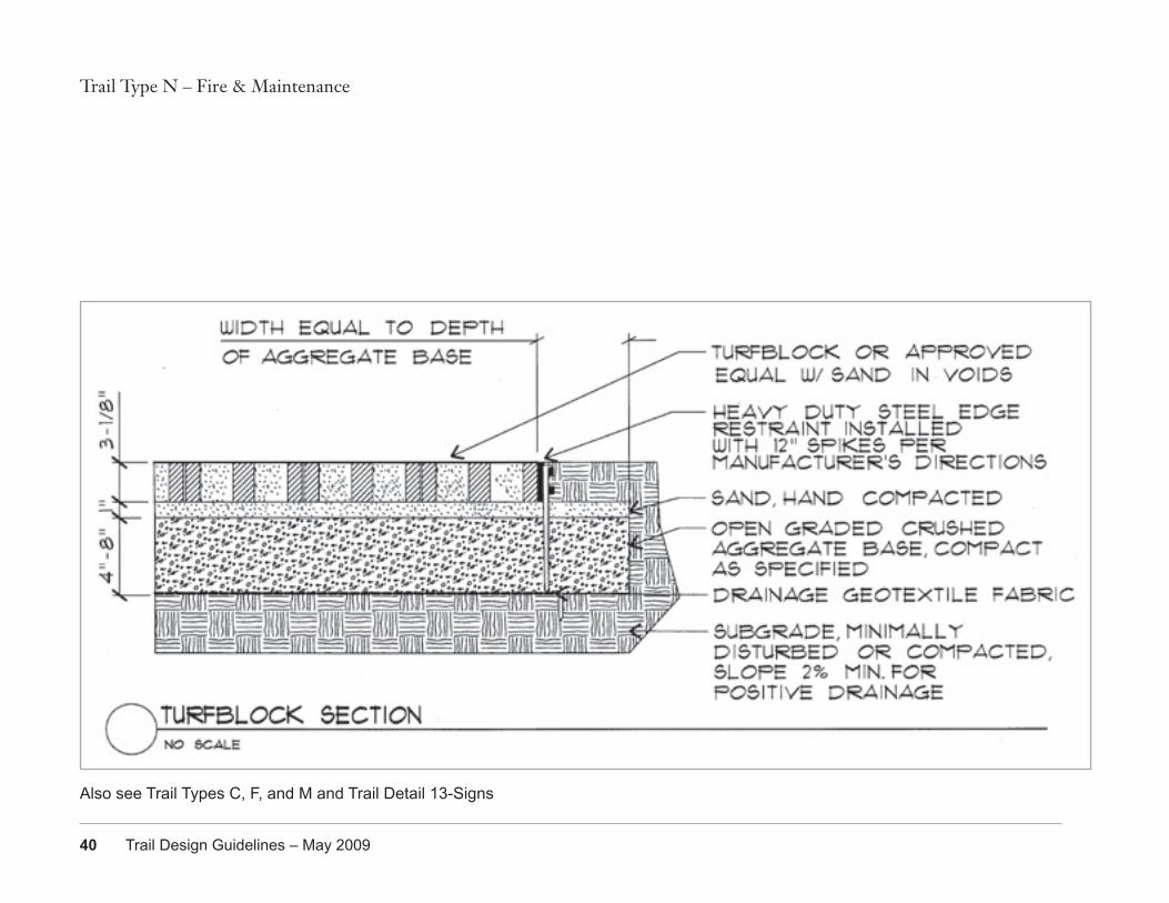
MATERIALSMaterials vary depending on site and vehicles to be served. In some locations, crushed rock is added to native soil and compacted. In other locations, turf block (or similar concrete paver with openings) is used in order to minimize paving in turf areas but support vehicle loads. Asphalt and concrete roads for vehicles are not included in these Trail Design Guidelines.
Trail Type N – Fire & Maintenance
Forest Park - Leif Erikson near Ridge Trail
Concrete turf block used to provide maintenance access in Vancouver, B.C.
Width 10’ - 14’Surface Gravel, turf blockLongitudinal Slope 0 - 5% (to 12% for fire lanes in hills)Cross-Slope 2%Radius See table on vehicles on page 10Sight Distance 50’ min.Easement Width 25’ preferable, tread + 10’ min.Side Slope VariesVertical Clearance 14’ (20’ above “deep” trash cans)Horizontal Clearance 1’ from side of tread
40 Trail Design Guidelines – May 2009
Trail Type N – Fire & Maintenance
Also see Trail Types C, F, and M and Trail Detail 13-Signs
Portland Parks & Recreation 41
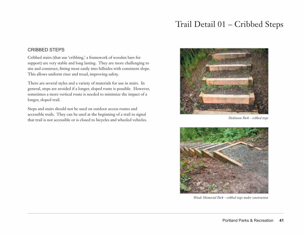
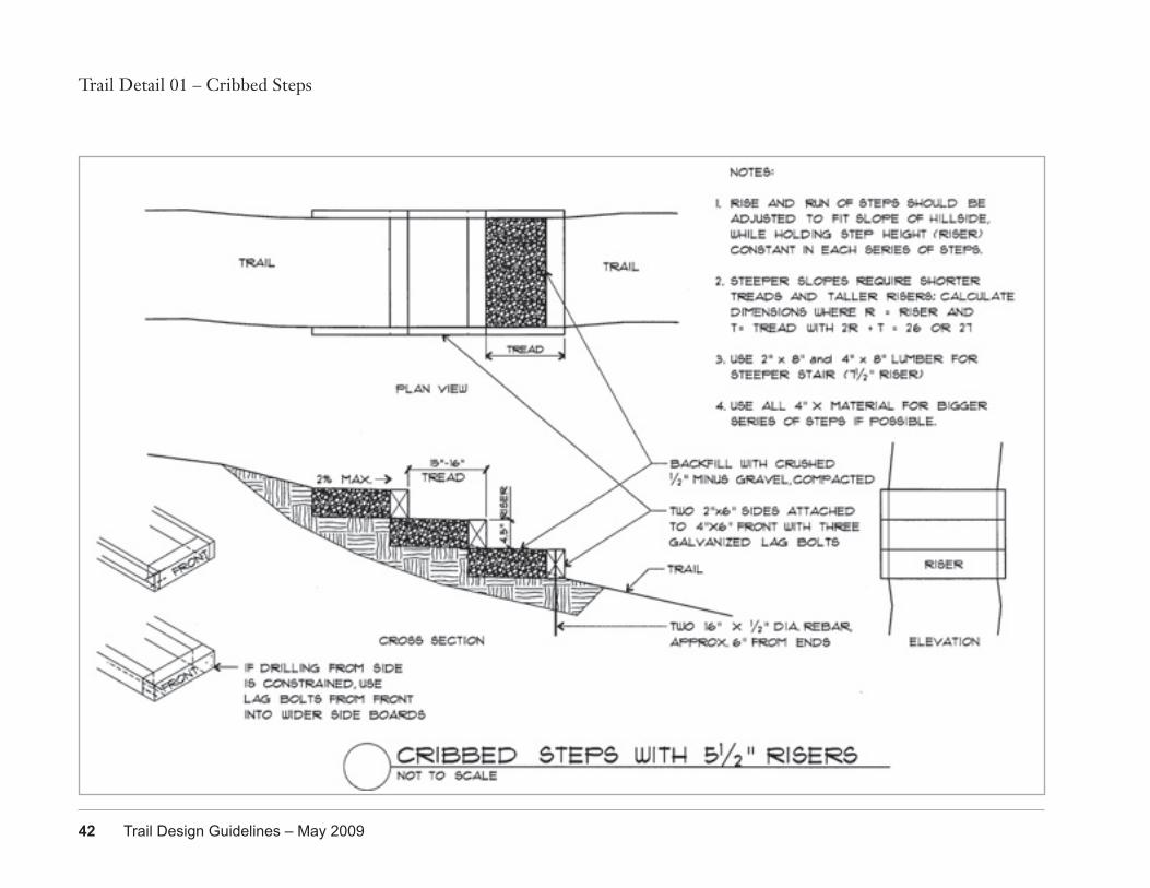
CRIBBED STEPSCribbed stairs (that use ‘cribbing,’ a framework of wooden bars for support) are very stable and long lasting. They are more challenging to site and construct, fitting most easily into hillsides with consistent slope. This allows uniform riser and tread, improving safety.
There are several styles and a variety of materials for use in stairs. In general, steps are avoided if a longer, sloped route is possible. However, sometimes a more vertical route is needed to minimize the impact of a longer, sloped trail.
Steps and stairs should not be used on outdoor access routes and accessible trails. They can be used at the beginning of a trail to signal that trail is not accessible or is closed to bicycles and wheeled vehicles.
Woods Memorial Park - cribbed steps under construction
Trail Detail 01 – Cribbed Steps
Dickinson Park - cribbed steps
42 Trail Design Guidelines – May 2009
Trail Detail 01 – Cribbed Steps
Portland Parks & Recreation 43
Trail Detail 02 – Timber Steps
Raz-Baack crossing at Stephens Creek Nature Park - timber steps
Mt Tabor Park - timber steps
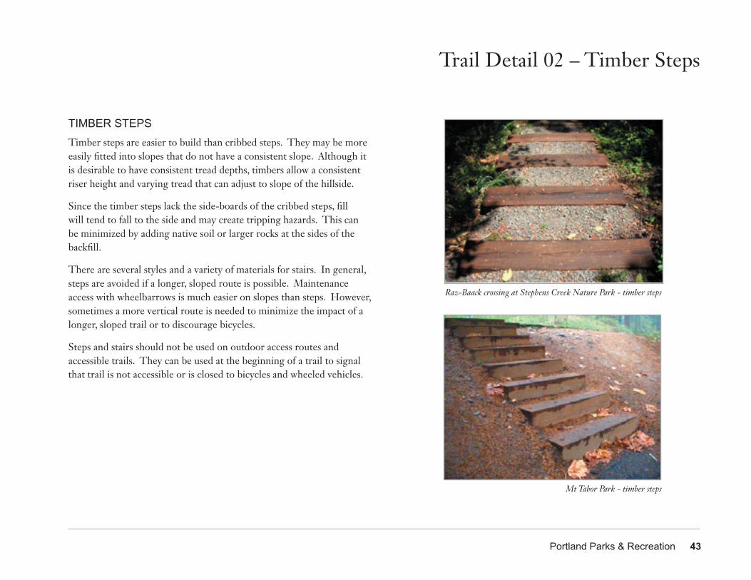
TIMBER STEPSTimber steps are easier to build than cribbed steps. They may be more easily fitted into slopes that do not have a consistent slope. Although it is desirable to have consistent tread depths, timbers allow a consistent riser height and varying tread that can adjust to slope of the hillside.
Since the timber steps lack the side-boards of the cribbed steps, fill will tend to fall to the side and may create tripping hazards. This can be minimized by adding native soil or larger rocks at the sides of the backfill.
There are several styles and a variety of materials for stairs. In general, steps are avoided if a longer, sloped route is possible. Maintenance access with wheelbarrows is much easier on slopes than steps. However, sometimes a more vertical route is needed to minimize the impact of a longer, sloped trail or to discourage bicycles.
Steps and stairs should not be used on outdoor access routes and accessible trails. They can be used at the beginning of a trail to signal that trail is not accessible or is closed to bicycles and wheeled vehicles.
44 Trail Design Guidelines – May 2009
Trail Detail 02 – Timber Steps
Portland Parks & Recreation 45
Trail Detail 03 – Boardwalk
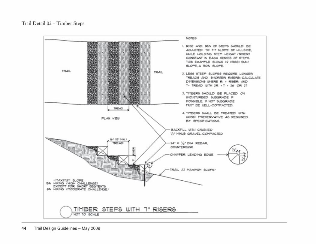
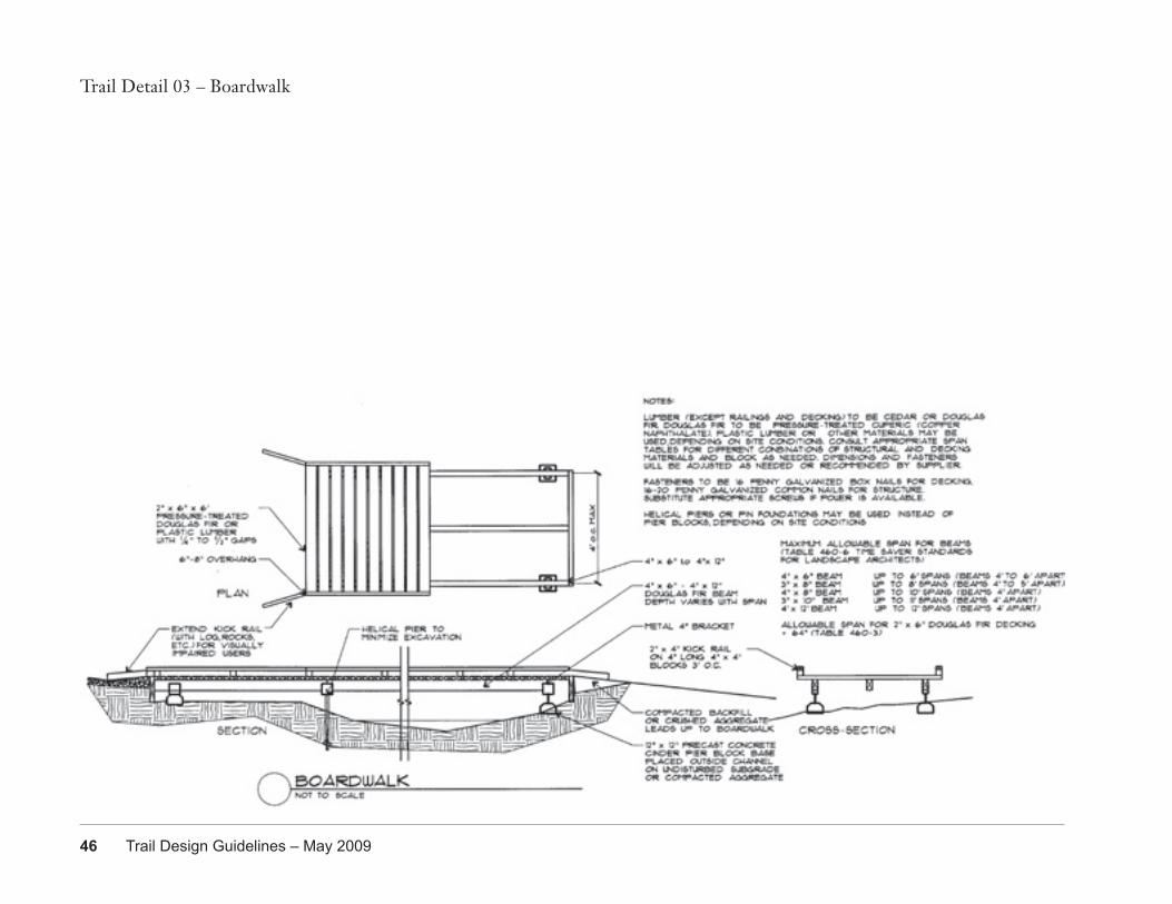
BOARDWALKBoardwalks are used to span unavoidable wet areas or depressions. They also can be used to provide trail in areas where grading and filling might harm tree roots or create trail surface that wildlife such as amphibians will not cross. Footings vary depending on soil conditions. Plastic lumber is more expensive than wood but very long-lasting for deck boards. Its heavier weight can help avoid floating in sites that flood and the pronounced texture can reduce slippery surfaces. Check test results on new products to find the least slippery product and maintain as recommended.
Wood surfaces in shaded or moist sites may become slick or even grow moss. This can be managed by attaching 1/2” hardware cloth (wire mesh), especially where boardwalks follow creek grade. Fasten with 1 1/2” heavy-duty staples approximately 8 - 12” apart. Upper side of mesh should have wires perpendicular to direction of travel. Ends of hardware cloth should be tucked between deck boards or lapped over sides and stapled every 4 - 6”. Paint with sand texture may also help, depending on site conditions. An annual cleaning (after autumn leaves fall) is recommended. A kick rail is particularly important along accessible trails where it helps people using canes or wheelchairs stay on the structure.
Raz-Baack crossing at Stephens Creek Nature Park- boardwalk with plastic lumber decking
Stephens Creek Nature Park - side view of boardwalk structure
46 Trail Design Guidelines – May 2009
Trail Detail 03 – Boardwalk
Portland Parks & Recreation 47
Trail Detail 04 – Wood Bridge
Forest Park Ridge Trail
Raz-Baack crossing at Stephens Creek Nature Park - bridge pier block and beam
Forest Park Ridge Trail
Woods Park SW Urban Trail #7 - step up limits accessibility
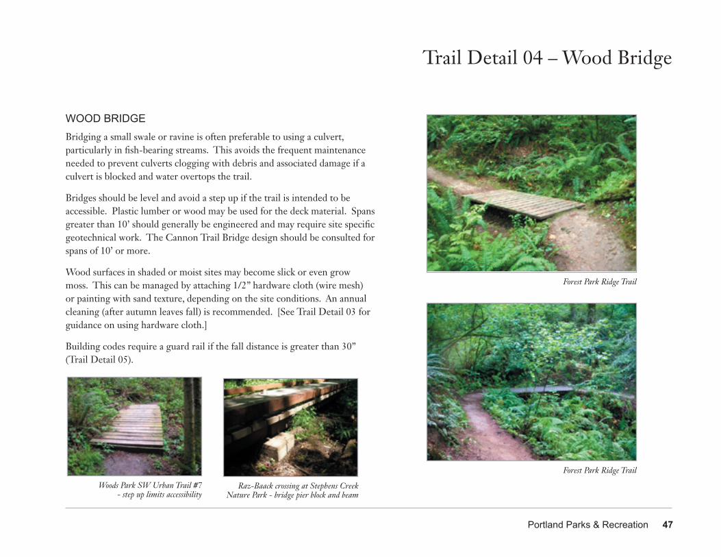
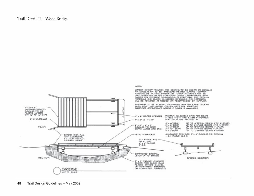
WOOD BRIDGEBridging a small swale or ravine is often preferable to using a culvert, particularly in fish-bearing streams. This avoids the frequent maintenance needed to prevent culverts clogging with debris and associated damage if a culvert is blocked and water overtops the trail.
Bridges should be level and avoid a step up if the trail is intended to be accessible. Plastic lumber or wood may be used for the deck material. Spans greater than 10’ should generally be engineered and may require site specific geotechnical work. The Cannon Trail Bridge design should be consulted for spans of 10’ or more.
Wood surfaces in shaded or moist sites may become slick or even grow moss. This can be managed by attaching 1/2” hardware cloth (wire mesh) or painting with sand texture, depending on the site conditions. An annual cleaning (after autumn leaves fall) is recommended. [See Trail Detail 03 for guidance on using hardware cloth.]
Building codes require a guard rail if the fall distance is greater than 30” (Trail Detail 05).
48 Trail Design Guidelines – May 2009
Trail Detail 04 – Wood Bridge
Portland Parks & Recreation 49
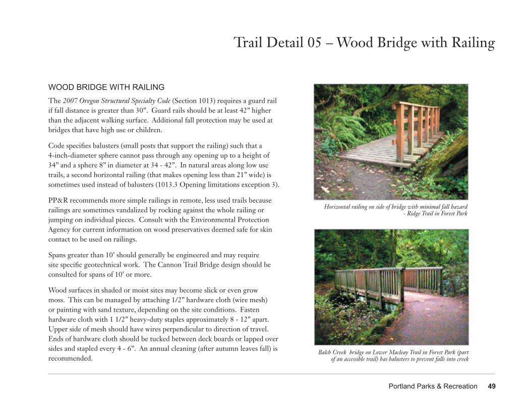
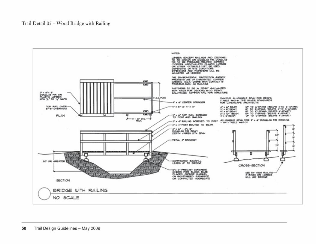
WOOD BRIDGE WITH RAILINGThe 2007 Oregon Structural Specialty Code (Section 1013) requires a guard rail if fall distance is greater than 30”. Guard rails should be at least 42” higher than the adjacent walking surface. Additional fall protection may be used at bridges that have high use or children.
Code specifies balusters (small posts that support the railing) such that a 4-inch-diameter sphere cannot pass through any opening up to a height of 34” and a sphere 8” in diameter at 34 - 42”. In natural areas along low use trails, a second horizontal railing (that makes opening less than 21” wide) is sometimes used instead of balusters (1013.3 Opening limitations exception 3).
PP&R recommends more simple railings in remote, less used trails because railings are sometimes vandalized by rocking against the whole railing or jumping on individual pieces. Consult with the Environmental Protection Agency for current information on wood preservatives deemed safe for skin contact to be used on railings.
Spans greater than 10’ should generally be engineered and may require site specific geotechnical work. The Cannon Trail Bridge design should be consulted for spans of 10’ or more.
Wood surfaces in shaded or moist sites may become slick or even grow moss. This can be managed by attaching 1/2” hardware cloth (wire mesh) or painting with sand texture, depending on the site conditions. Fasten hardware cloth with 1 1/2” heavy-duty staples approximately 8 - 12” apart. Upper side of mesh should have wires perpendicular to direction of travel. Ends of hardware cloth should be tucked between deck boards or lapped over sides and stapled every 4 - 6”. An annual cleaning (after autumn leaves fall) is recommended.
Trail Detail 05 – Wood Bridge with Railing
Horizontal railing on side of bridge with minimal fall hazard - Ridge Trail in Forest Park
Balch Creek bridge on Lower Macleay Trail in Forest Park (part of an accessible trail) has balusters to prevent falls into creek
50 Trail Design Guidelines – May 2009
Trail Detail 05 – Wood Bridge with Railing

Portland Parks & Recreation 51
Trail Detail 06 – Erosion Control at Bridge
Woods Memorial Natural Area - silt fence between Woods Creek and trail relocation farther from waterway
Woods Memorial Natural Area - straw wattles and mulch protect Woods Creek from restoration planting and trail improvements
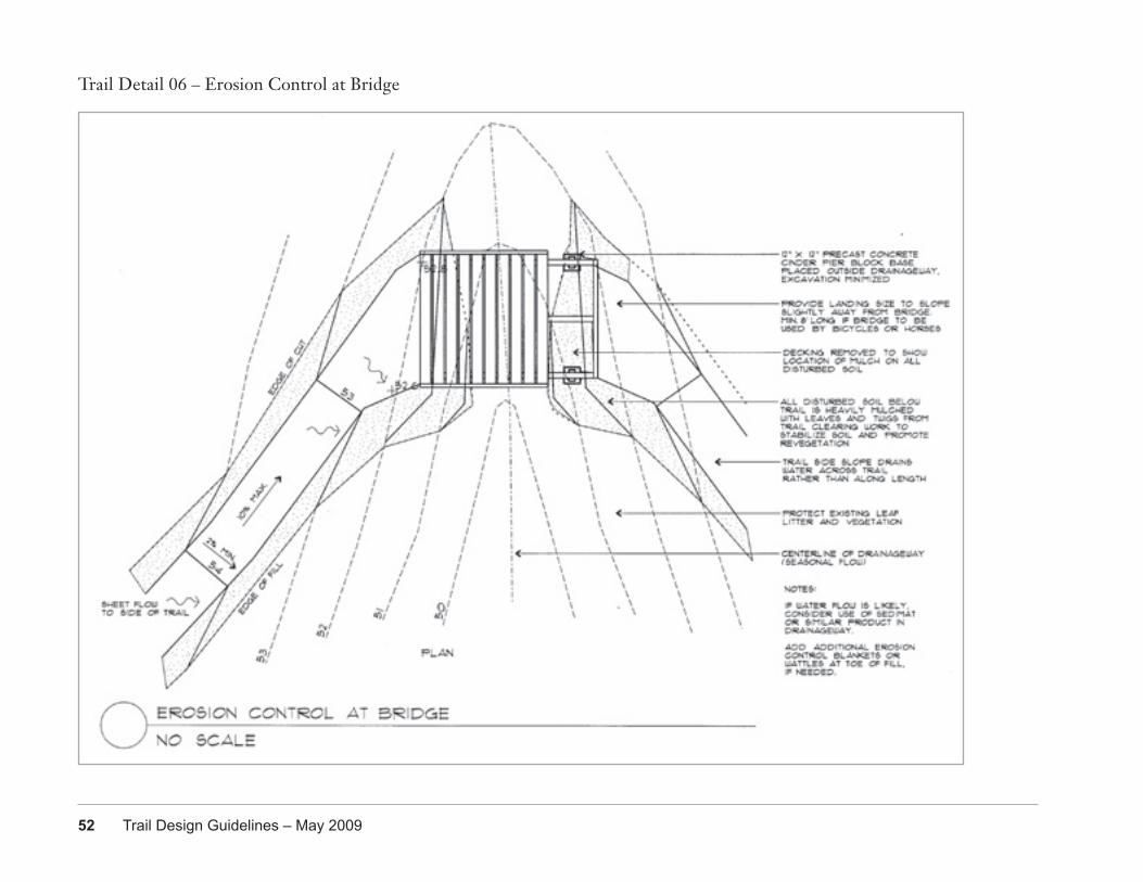
Silt fence at base of timber steps protecting Woods Creek
EROSION CONTROL AT FENCETrail construction uses typical erosion control methods (silt fence, fiber rolls and wattles, mulch, surface roughening) and City of Portland standard details. In some instances, native groundcovers and duff in a forest setting are an existing ‘vegetated buffer’ as described in the Portland Erosion and Sediment Control Manual. The native groundcovers or mowed grass on the side slopes of levees also infiltrate runoff.
This detail supplements the Wood Bridge (Trail Detail 05) details. Additional erosion control methods will be added during the design process for sites with streams, but these techniques protect drainageways with small or infrequent flows.
52 Trail Design Guidelines – May 2009
Trail Detail 06 – Erosion Control at Bridge
Portland Parks & Recreation 53
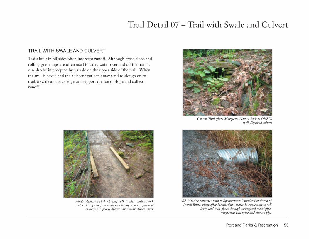
Trail Detail 07 – Trail with Swale and Culvert
TRAIL WITH SWALE AND CULVERTTrails built in hillsides often intercept runoff. Although cross-slope and rolling grade dips are often used to carry water over and off the trail, it can also be intercepted by a swale on the upper side of the trail. When the trail is paved and the adjacent cut bank may tend to slough on to trail, a swale and rock edge can support the toe of slope and collect runoff.
SE 146 Ave connector path to Springwater Corridor (southwest of Powell Butte) right after installation - water in swale next to rail
berm and trail flows through corrugated metal pipe,vegetation will grow and obscure pipe
Woods Memorial Park - hiking path (under construction), intercepting runoff in swale and piping under segment of
causeway in poorly drained area near Woods Creek
Connor Trail (from Marquam Nature Park to OHSU)- well-disguised culvert
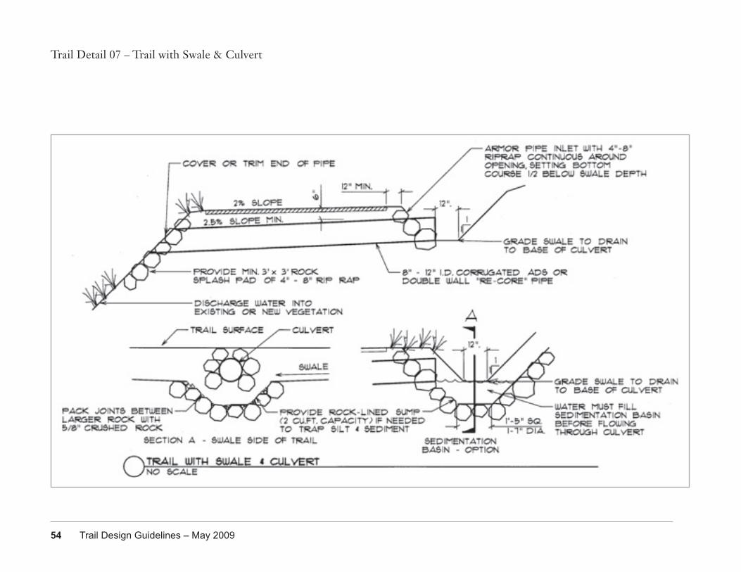
54 Trail Design Guidelines – May 2009
Trail Detail 07 – Trail with Swale & Culvert
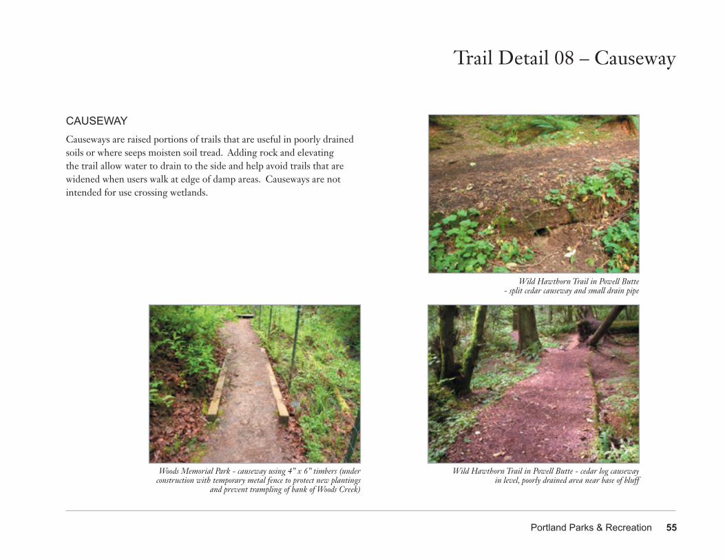
Portland Parks & Recreation 55
Trail Detail 08 – Causeway
CAUSEWAYCauseways are raised portions of trails that are useful in poorly drained soils or where seeps moisten soil tread. Adding rock and elevating the trail allow water to drain to the side and help avoid trails that are widened when users walk at edge of damp areas. Causeways are not intended for use crossing wetlands.
Woods Memorial Park - causeway using 4” x 6” timbers (under construction with temporary metal fence to protect new plantings
and prevent trampling of bank of Woods Creek)
Wild Hawthorn Trail in Powell Butte- split cedar causeway and small drain pipe
Wild Hawthorn Trail in Powell Butte - cedar log causeway in level, poorly drained area near base of bluff
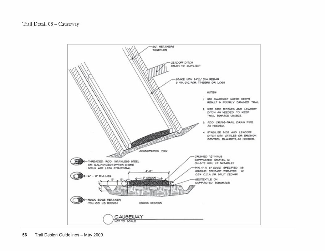
Trail Detail 08 – Causeway
56 Trail Design Guidelines – May 2009
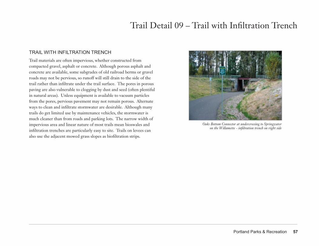
Portland Parks & Recreation 57
TRAIL WITH INFILTRATION TRENCHTrail materials are often impervious, whether constructed from compacted gravel, asphalt or concrete. Although porous asphalt and concrete are available, some subgrades of old railroad berms or gravel roads may not be pervious, so runoff will still drain to the side of the trail rather than infiltrate under the trail surface. The pores in porous paving are also vulnerable to clogging by dust and seed (often plentiful in natural areas). Unless equipment is available to vacuum particles from the pores, pervious pavement may not remain porous. Alternate ways to clean and infiltrate stormwater are desirable. Although many trails do get limited use by maintenance vehicles, the stormwater is much cleaner than from roads and parking lots. The narrow width of impervious area and linear nature of most trails mean bioswales and infiltration trenches are particularly easy to site. Trails on levees can also use the adjacent mowed grass slopes as biofiltration strips.
Trail Detail 09 – Trail with Infiltration Trench
Oaks Bottom Connector at undercrossing to Springwater on the Willamette - infiltration trench on right side
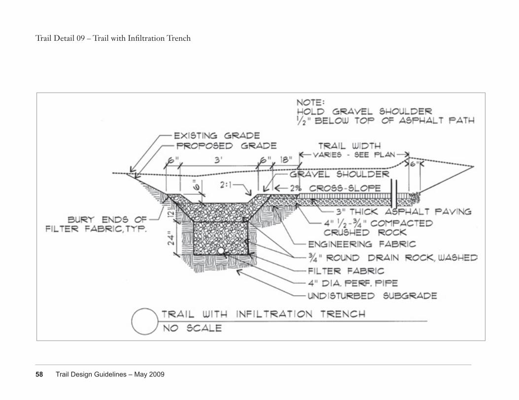
58 Trail Design Guidelines – May 2009
Trail Detail 09 – Trail with Infiltration Trench
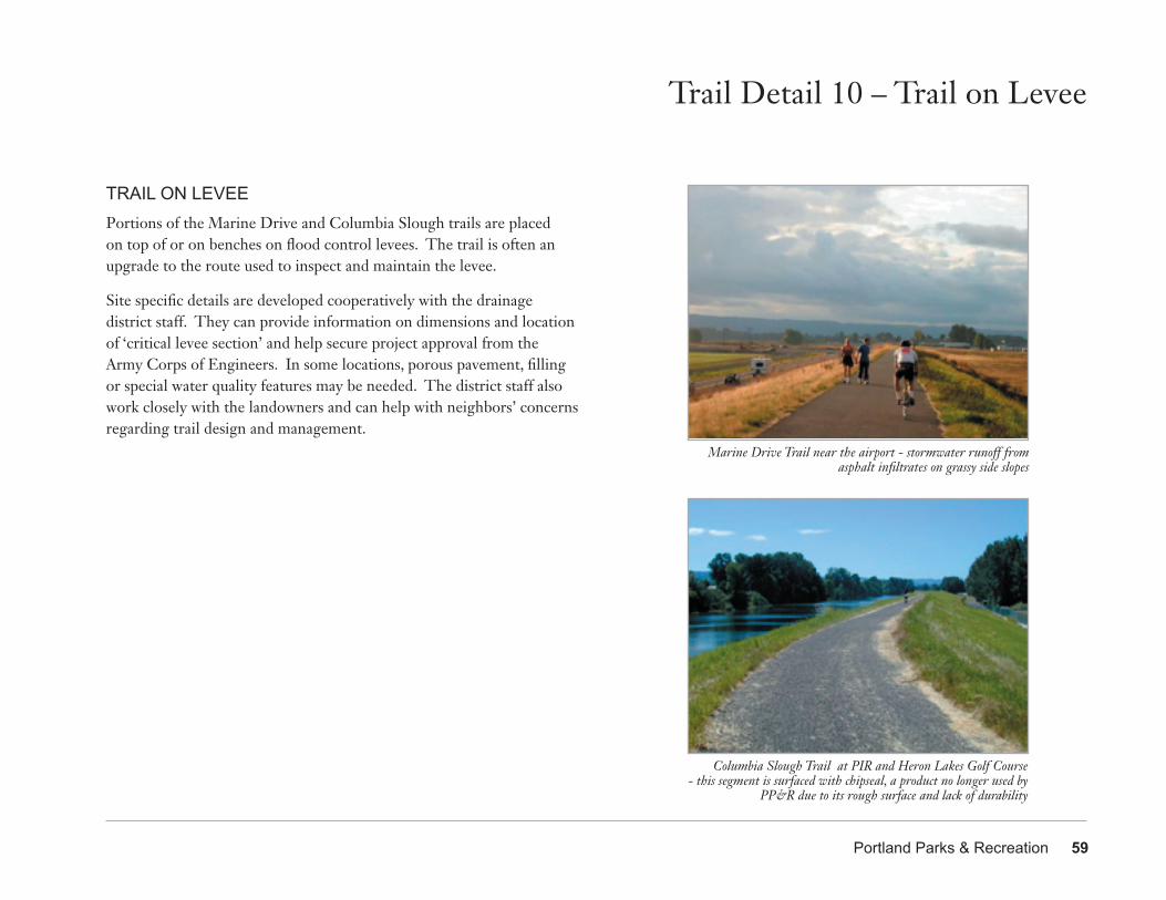
Portland Parks & Recreation 59
TRAIL ON LEVEEPortions of the Marine Drive and Columbia Slough trails are placed on top of or on benches on flood control levees. The trail is often an upgrade to the route used to inspect and maintain the levee.
Site specific details are developed cooperatively with the drainage district staff. They can provide information on dimensions and location of ‘critical levee section’ and help secure project approval from the Army Corps of Engineers. In some locations, porous pavement, filling or special water quality features may be needed. The district staff also work closely with the landowners and can help with neighbors’ concerns regarding trail design and management.
Columbia Slough Trail at PIR and Heron Lakes Golf Course- this segment is surfaced with chipseal, a product no longer used by
PP&R due to its rough surface and lack of durability
Trail Detail 10 – Trail on Levee
Marine Drive Trail near the airport - stormwater runoff from asphalt infiltrates on grassy side slopes
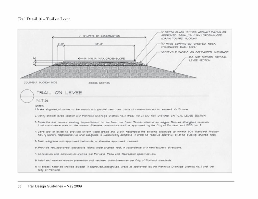
60 Trail Design Guidelines – May 2009
Trail Detail 10 – Trail on Levee
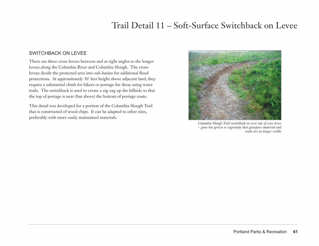
Portland Parks & Recreation 61
Columbia Slough Trail switchback on west side of cross-levee- grass has grown so vigorously that grasspave material and
swale are no longer visible
Trail Detail 11 – Soft-Surface Switchback on Levee
SWITCHBACK ON LEVEEThere are three cross-levees between and at right angles to the longer levees along the Columbia River and Columbia Slough. The cross-levees divide the protected area into sub-basins for additional flood protections. At approximately 30’ feet height above adjacent land, they require a substantial climb for hikers or portage for those using water trails. The switchback is used to create a zig-zag up the hillside so that the top of portage is near (but above) the bottom of portage route.
This detail was developed for a portion of the Columbia Slough Trail that is constructed of wood chips. It can be adapted to other sites, preferably with more easily maintained materials.
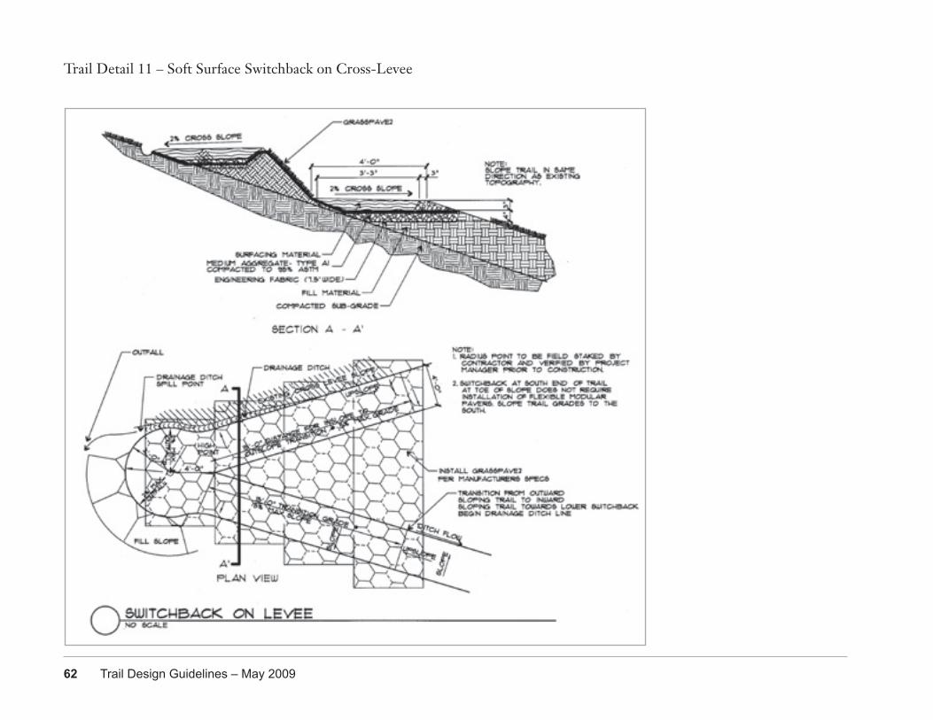
62 Trail Design Guidelines – May 2009
Trail Detail 11 – Soft Surface Switchback on Cross-Levee
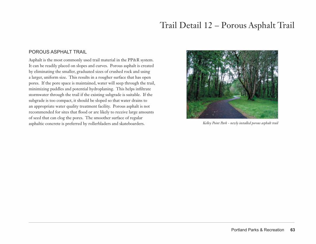
Portland Parks & Recreation 63
Trail Detail 12 – Porous Asphalt Trail
Kelley Point Park - newly installed porous asphalt trail
POROUS ASPHALT TRAILAsphalt is the most commonly used trail material in the PP&R system. It can be readily placed on slopes and curves. Porous asphalt is created by eliminating the smaller, graduated sizes of crushed rock and using a larger, uniform size. This results in a rougher surface that has open pores. If the pore space is maintained, water will seep through the trail, minimizing puddles and potential hydroplaning. This helps infiltrate stormwater through the trail if the existing subgrade is suitable. If the subgrade is too compact, it should be sloped so that water drains to an appropriate water quality treatment facility. Porous asphalt is not recommended for sites that flood or are likely to receive large amounts of seed that can clog the pores. The smoother surface of regular asphaltic concrete is preferred by rollerbladers and skateboarders.
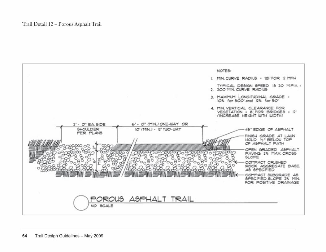
64 Trail Design Guidelines – May 2009
Trail Detail 12 – Porous Asphalt Trail
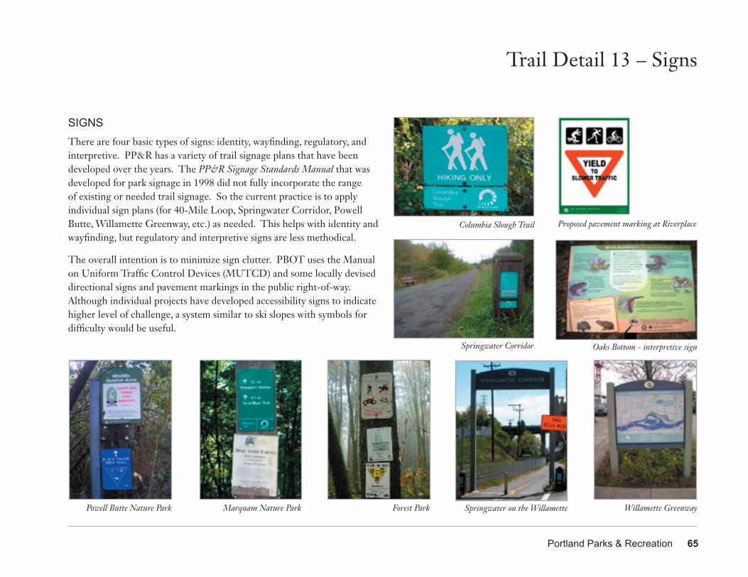
Portland Parks & Recreation 65
Trail Detail 13 – Signs
SIGNSThere are four basic types of signs: identity, wayfinding, regulatory, and interpretive. PP&R has a variety of trail signage plans that have been developed over the years. The PP&R Signage Standards Manual that was developed for park signage in 1998 did not fully incorporate the range of existing or needed trail signage. So the current practice is to apply individual sign plans (for 40-Mile Loop, Springwater Corridor, Powell Butte, Willamette Greenway, etc.) as needed. This helps with identity and wayfinding, but regulatory and interpretive signs are less methodical.
The overall intention is to minimize sign clutter. PBOT uses the Manual on Uniform Traffic Control Devices (MUTCD) and some locally devised directional signs and pavement markings in the public right-of-way. Although individual projects have developed accessibility signs to indicate higher level of challenge, a system similar to ski slopes with symbols for difficulty would be useful.
Powell Butte Nature Park Marquam Nature Park Forest Park Springwater on the Willamette Willamette Greenway
Springwater Corridor
Columbia Slough Trail Proposed pavement marking at Riverplace
Oaks Bottom - interpretive sign
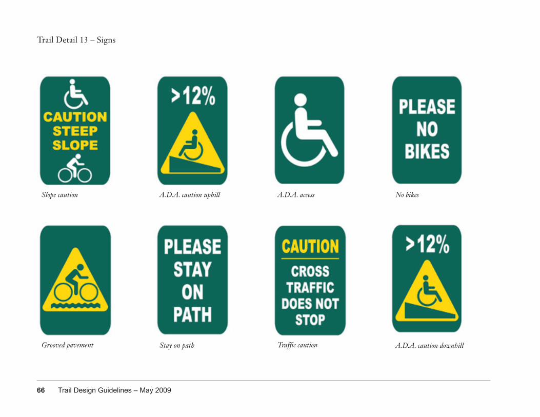
66 Trail Design Guidelines – May 2009
Trail Detail 13 – Signs
Slope caution
Grooved pavement
A.D.A. caution uphill
A.D.A. caution downhill
A.D.A. access No bikes
Stay on path Traffic caution
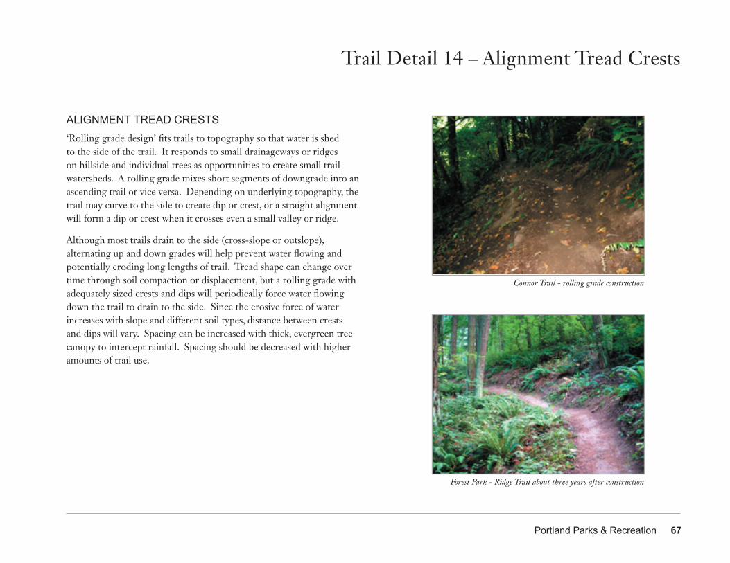
Portland Parks & Recreation 67
Trail Detail 14 – Alignment Tread Crests
ALIGNMENT TREAD CRESTS‘Rolling grade design’ fits trails to topography so that water is shed to the side of the trail. It responds to small drainageways or ridges on hillside and individual trees as opportunities to create small trail watersheds. A rolling grade mixes short segments of downgrade into an ascending trail or vice versa. Depending on underlying topography, the trail may curve to the side to create dip or crest, or a straight alignment will form a dip or crest when it crosses even a small valley or ridge.
Although most trails drain to the side (cross-slope or outslope), alternating up and down grades will help prevent water flowing and potentially eroding long lengths of trail. Tread shape can change over time through soil compaction or displacement, but a rolling grade with adequately sized crests and dips will periodically force water flowing down the trail to drain to the side. Since the erosive force of water increases with slope and different soil types, distance between crests and dips will vary. Spacing can be increased with thick, evergreen tree canopy to intercept rainfall. Spacing should be decreased with higher amounts of trail use.
Connor Trail - rolling grade construction
Forest Park - Ridge Trail about three years after construction
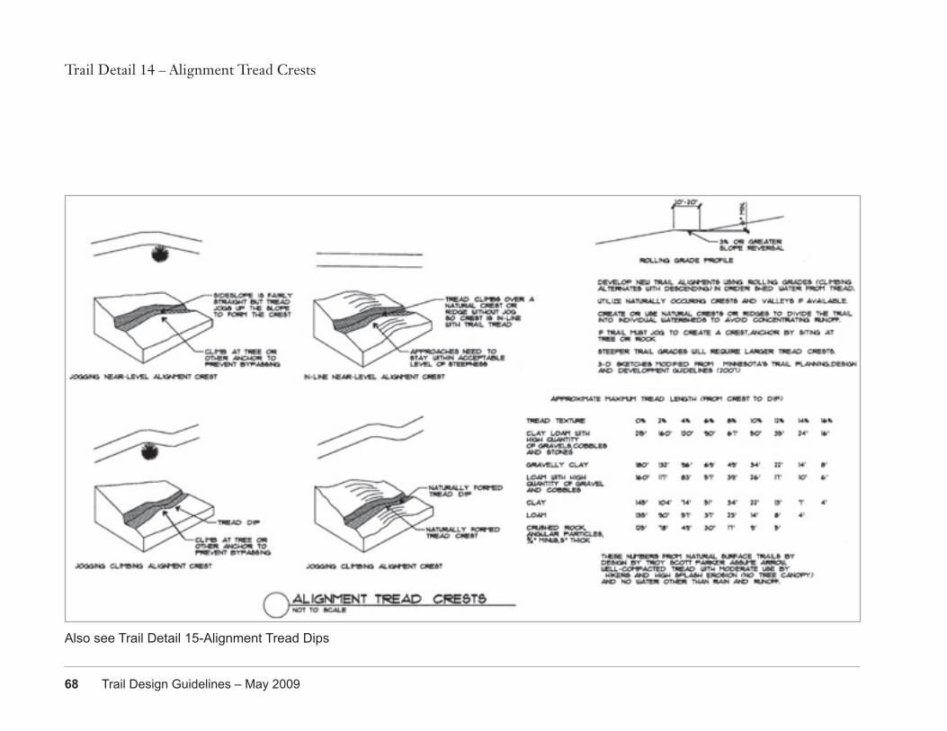
68 Trail Design Guidelines – May 2009
Trail Detail 14 – Alignment Tread Crests
Also see Trail Detail 15-Alignment Tread Dips
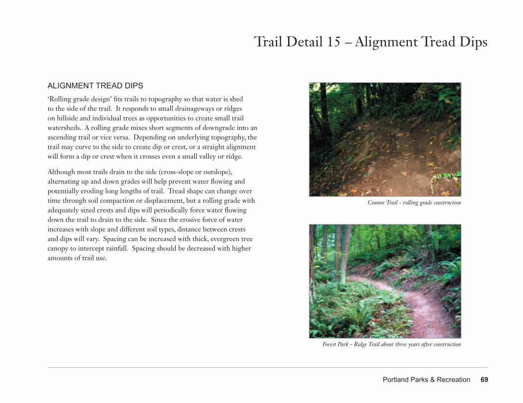
Portland Parks & Recreation 69
Trail Detail 15 – Alignment Tread Dips
ALIGNMENT TREAD DIPS‘Rolling grade design’ fits trails to topography so that water is shed to the side of the trail. It responds to small drainageways or ridges on hillside and individual trees as opportunities to create small trail watersheds. A rolling grade mixes short segments of downgrade into an ascending trail or vice versa. Depending on underlying topography, the trail may curve to the side to create dip or crest, or a straight alignment will form a dip or crest when it crosses even a small valley or ridge.
Although most trails drain to the side (cross-slope or outslope), alternating up and down grades will help prevent water flowing and potentially eroding long lengths of trail. Tread shape can change over time through soil compaction or displacement, but a rolling grade with adequately sized crests and dips will periodically force water flowing down the trail to drain to the side. Since the erosive force of water increases with slope and different soil types, distance between crests and dips will vary. Spacing can be increased with thick, evergreen tree canopy to intercept rainfall. Spacing should be decreased with higher amounts of trail use.
Connor Trail - rolling grade construction
Forest Park - Ridge Trail about three years after construction
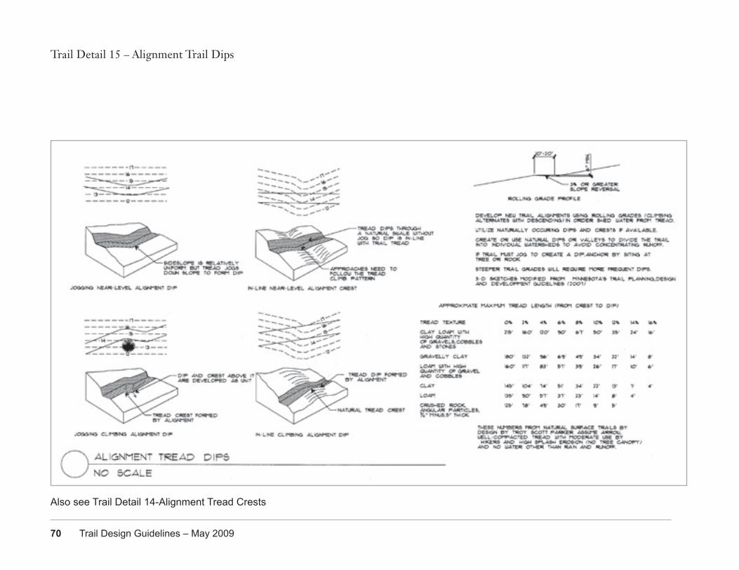
70 Trail Design Guidelines – May 2009
Trail Detail 15 – Alignment Trail Dips
Also see Trail Detail 14-Alignment Tread Crests
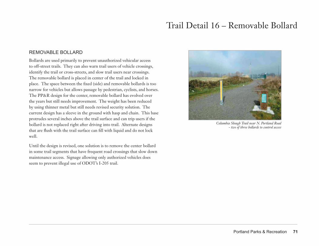
Portland Parks & Recreation 71
Trail Detail 16 – Removable Bollard
REMOVABLE BOLLARDBollards are used primarily to prevent unauthorized vehicular access to off-street trails. They can also warn trail users of vehicle crossings, identify the trail or cross-streets, and slow trail users near crossings. The removable bollard is placed in center of the trail and locked in place. The space between the fixed (side) and removable bollards is too narrow for vehicles but allows passage by pedestrian, cyclists, and horses. The PP&R design for the center, removable bollard has evolved over the years but still needs improvement. The weight has been reduced by using thinner metal but still needs revised security solution. The current design has a sleeve in the ground with hasp and chain. This base protrudes several inches above the trail surface and can trip users if the bollard is not replaced right after driving into trail. Alternate designs that are flush with the trail surface can fill with liquid and do not lock well.
Until the design is revised, one solution is to remove the center bollard in some trail segments that have frequent road crossings that slow down maintenance access. Signage allowing only authorized vehicles does seem to prevent illegal use of ODOT’s I-205 trail.
Columbia Slough Trail near N. Portland Road - two of three bollards to control access
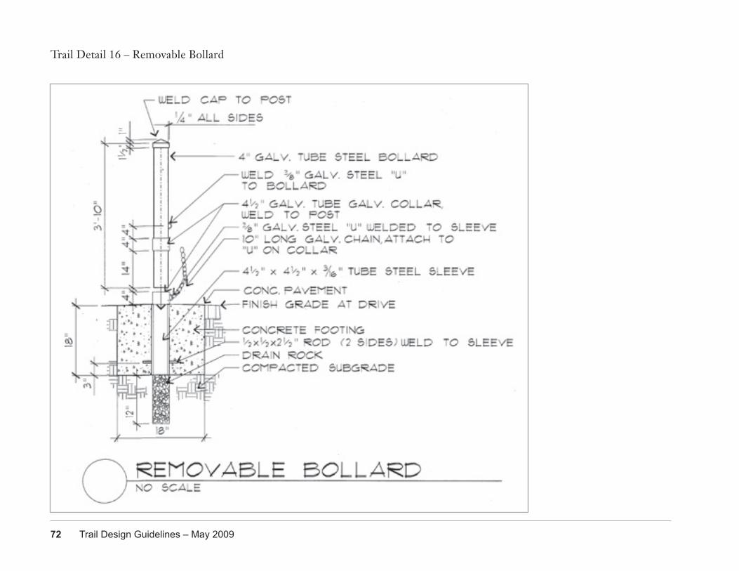
72 Trail Design Guidelines – May 2009
Trail Detail 16 – Removable Bollard
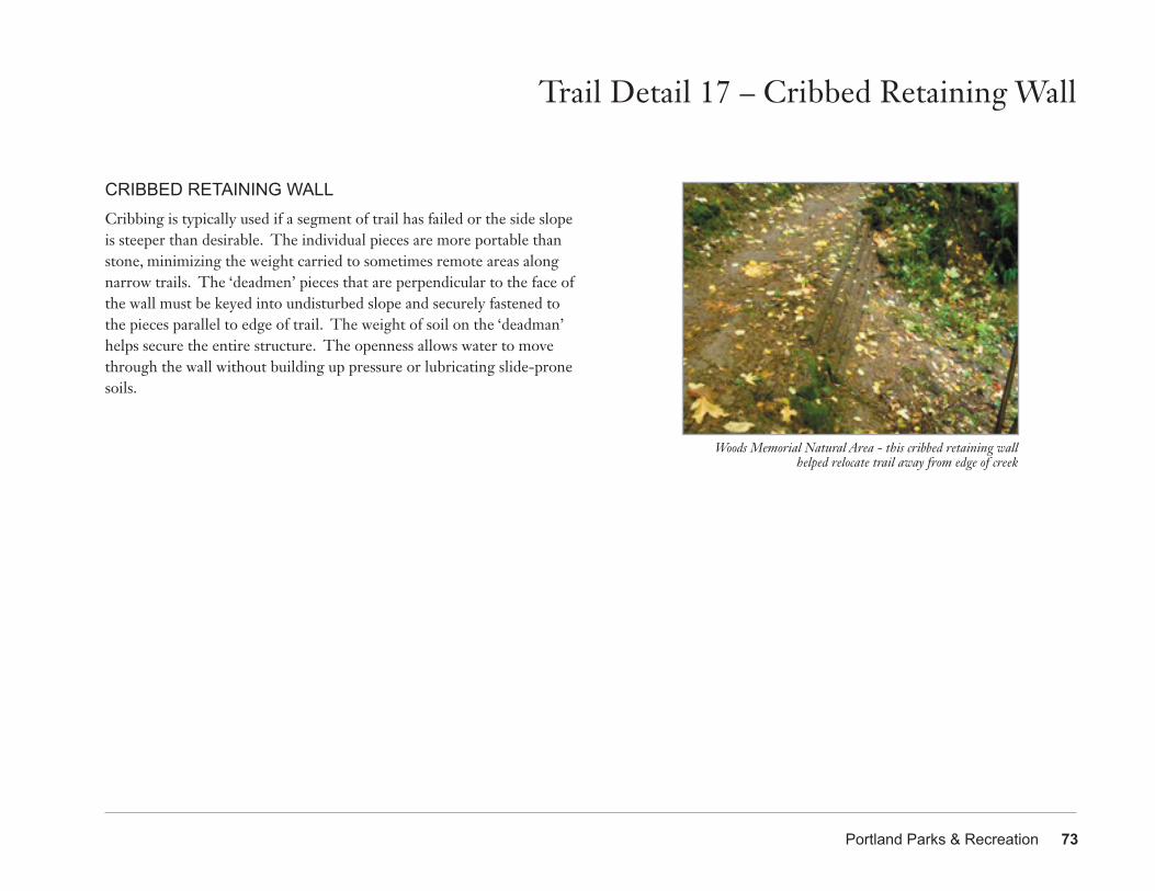
Portland Parks & Recreation 73
Trail Detail 17 – Cribbed Retaining Wall
CRIBBED RETAINING WALLCribbing is typically used if a segment of trail has failed or the side slope is steeper than desirable. The individual pieces are more portable than stone, minimizing the weight carried to sometimes remote areas along narrow trails. The ‘deadmen’ pieces that are perpendicular to the face of the wall must be keyed into undisturbed slope and securely fastened to the pieces parallel to edge of trail. The weight of soil on the ‘deadman’ helps secure the entire structure. The openness allows water to move through the wall without building up pressure or lubricating slide-prone soils.
Woods Memorial Natural Area - this cribbed retaining wall helped relocate trail away from edge of creek
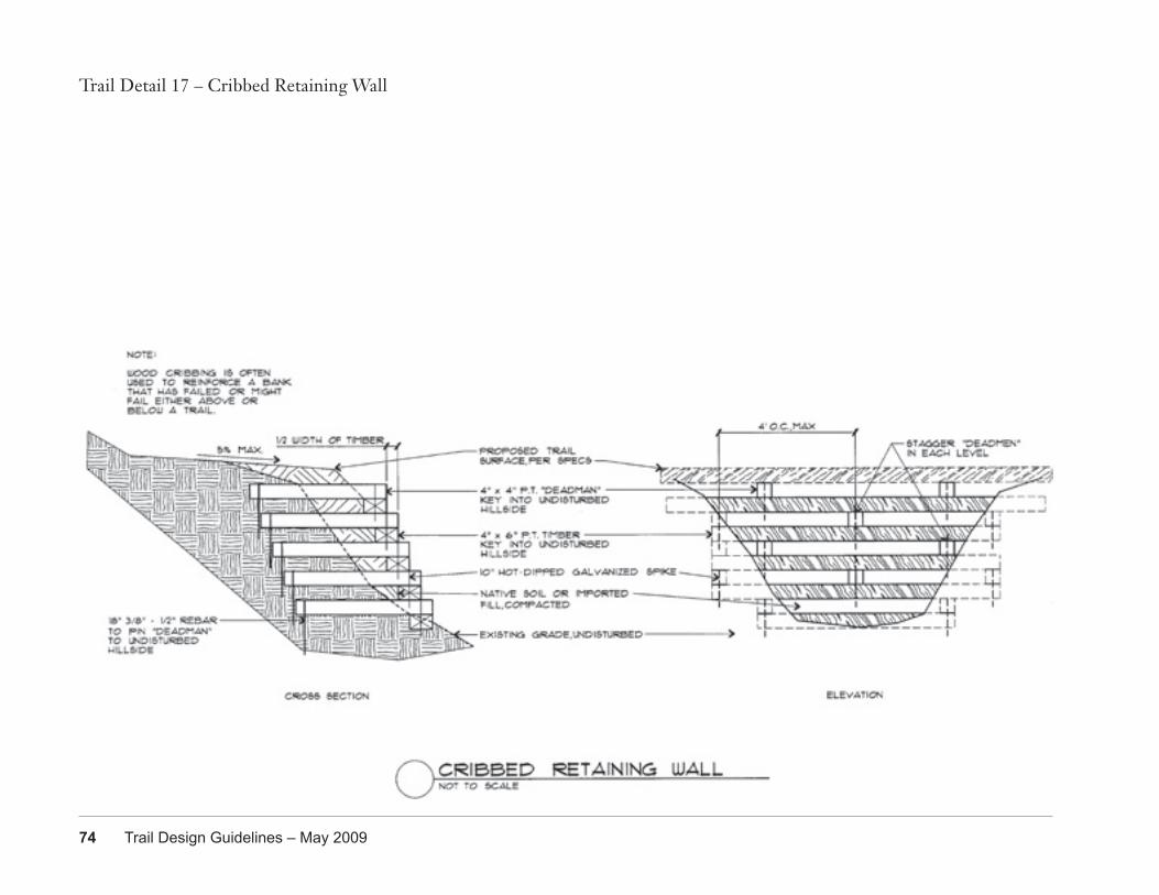
74 Trail Design Guidelines – May 2009
Trail Detail 17 – Cribbed Retaining Wall
Portland Parks & Recreation 75
Appendix A – References
REFERENCES2007 Oregon Structural Specialty Code (based on the 2006 International Building Code), State of Oregon, January 2007
2020 Refinement Plan on Portland’s Trails and Natural Areas, Portland Parks and Recreation, October 2003
40-Mile Loop Master Plan, David Evans and Associates, Inc., May 1983
Accessibility Guidelines for Outdoor Developed Areas: Final Report, Regulatory Negotiation Committee on Accessibility Guidelines for Outdoor Developed Areas, September 1999
Americans with Disabilities Act (ADA) Accessibility Guidelines for Buildings and Facilities, Access Board, 2002
Americans with Disabilities Act Transition Plan, Bureau of Parks & Recreation, April 1993
Bicycle Master Plan: Making Bicycling an Integral Part of Daily Life in Portland, City of Portland Bureau of Transportation, May 1996
Columbia South Shore Slough Trail Masterplan: Staff Recommendations to City Council, Portland Parks and Recreation - Bureau of Planning - Portland Development Commission, July 2, 1993
Columbia South Shore Slough Trail Permit & Construction Handbook, Bureau of Planning, October 1995
Erosion and Sediment Control Manual, City of Portland, March 2008
Forty Mile Loop Signing Guidelines, Mayer/Reed, September 1991
[Forty Mile Loop] Trail Segment Sign Schedule, Mayer/Reed, September 1991
Green Trails: Guidelines for environmentally friendly trails, Metro, 2004
Oregon Statewide Comprehensive Outdoor Recreation Plan 2003-2007, Oregon Parks and Recreation Department
Oregon Trails 2005 - 2014: Non-Motorized Trails Plan, Oregon State Parks, February 2005
Parks 2020 Vision, Portland Parks and Recreation, July 2001
Parks 2020 Vision Appendix, Portland Parks and Recreation, July 2001
Portland Parks and Recreation Signage Standards Manual, Mayer/Reed, October 1998
Portland Pedestrian Design Guide, City of Portland Bureau of Transportation Engineering & Development Pedestrian Transportation Program, October 1998
Proposed Architectural Barriers Act Accessibility Guidelines for Outdoor Developed Areas [in Federal Register], Architectural and Transportation Barriers Compliance Board, June 2007
Revised DRAFT Public Rights-of-Way Accessibility Guidelines (PROWAG), U.S. Access Board, November 2005
Swan Island TMA Trails Action Plan: Connecting the Bluff to the Willamette River, Alta Planning + Design, January 2004
76 Trail Design Guidelines – May 2009
References
Springwater Corridor Master Plan, Portland Parks and Recreation, November 1992
Trail Planning, Design, and Development Guidelines: Shared Use Paved Trails, Natural Surface Trails, Winter-Use Trails, Bikeways, Minnesota Department of Natural Resources Trails and Waterways, 2006
Trails for the Twenty-First Century: Planning, Design, and Management Manual for Multi-Use Trails (Second Edition), Charles A. Flink, Kristine Olka and Robert M. Searns, Rails-to-Trails Conservancy, 2001
Trails Plan for the Tualatin Hills Park & Recreation District, Alta Planning + Design
Transportation System Plan, Portland Bureau of Transportation, October 2002
Standard Specifications for Construction of Trails, USDA Forest Service Engineering Staff, June 1984
Universal Access to Outdoor Recreation: A Design Guide, PLAE, Inc., 1993
USFS Trail Design Parameters, United States Department of Agriculture Forest Service, June 2002
Willamette Greenway Plan, Bureau of Planning, November 1987
Willamette Greenway Trail Signing Program, Mayer/Reed, December 1987