Embed Size (px)
Citation preview

ASX / MEDIA RELEASE
1
5 September 2014
ST GEORGE IDENTIFIES SIGNIFICANT VMS PROSPECT AT EAST LAVERTON
HIGHLIGHTS:
New VMS (volcanic massive sulphide) prospect identified at East Laverton
A significant zinc and copper sulphide interval intersected at the Desert Dragon prospect
Sulphide mineralisation is associated with large and complex electromagnetic (EM) conductive response that is only partly explored
A priority target in the Phase 2 drilling programme, scheduled for early October 2014
VMS POTENTIAL AT EAST LAVERTON St George Mining Limited (ASX: SGQ) (‘St George Mining’ or ‘the Company’) is pleased to provide further information regarding the new VMS (volcanic massive sulphide) prospect identified at the Company’s 100% owned East Laverton Property in Western Australia. VMS potential at the East Laverton Property was highlighted through the results of the 2012 reconnaissance drilling completed by BHP Billiton Nickel West as part of the previous Project Dragon farm‐in arrangement. That drilling intersected thick metal‐rich and sulphide‐rich sediments with elevated levels of zinc (Zn) and copper (Cu) mineralisation. The sulphide units intersected by the drilling were up to 90 metres thick with mineralisation grading up to 4460 ppm Zn and 1400ppm Cu. The very significant thicknesses of these mineral‐rich sediments indicated potential for substantial VMS‐style Cu‐Zn mineralisation. The presence of both komatiite hosted nickel sulphide mineralisation and VMS hosted base metal at East Laverton is consistent with the genetic relationship that exists between these styles of mineralisation. Volcanic massive sulphide lenses are an important source of crustal sulphur which is required for the formation of nickel sulphide deposits. The genetic relationship between nickel sulphide and VMS mineralisation means that preserved VMS deposits would typically be hosted by rocks away from the main ultramafic belt. The VMS potential at East Laverton is now further supported by the DDD011 intersection of banded zinc and copper sulphides; see Figure 1. St George Mining Executive Chairman, John Prineas, said: “This is an exciting development which backs up our great confidence in the potential for a range of metal discoveries at East Laverton in addition to the proven nickel prospectivity there. “We are really looking forward to returning there in October for the next round of drilling as we continue to define the great exploration opportunity we have at East Laverton.” NEW VMS PROSPECT AT DESERT DRAGON Drill hole DDD011 was completed in the Phase 1 nickel sulphide drilling programme. The objective of this hole was to test EM conductor Dragon 2, which forms part of the Desert Dragon prospect.
For
per
sona
l use
onl
y
ASX / MEDIA RELEASE
2
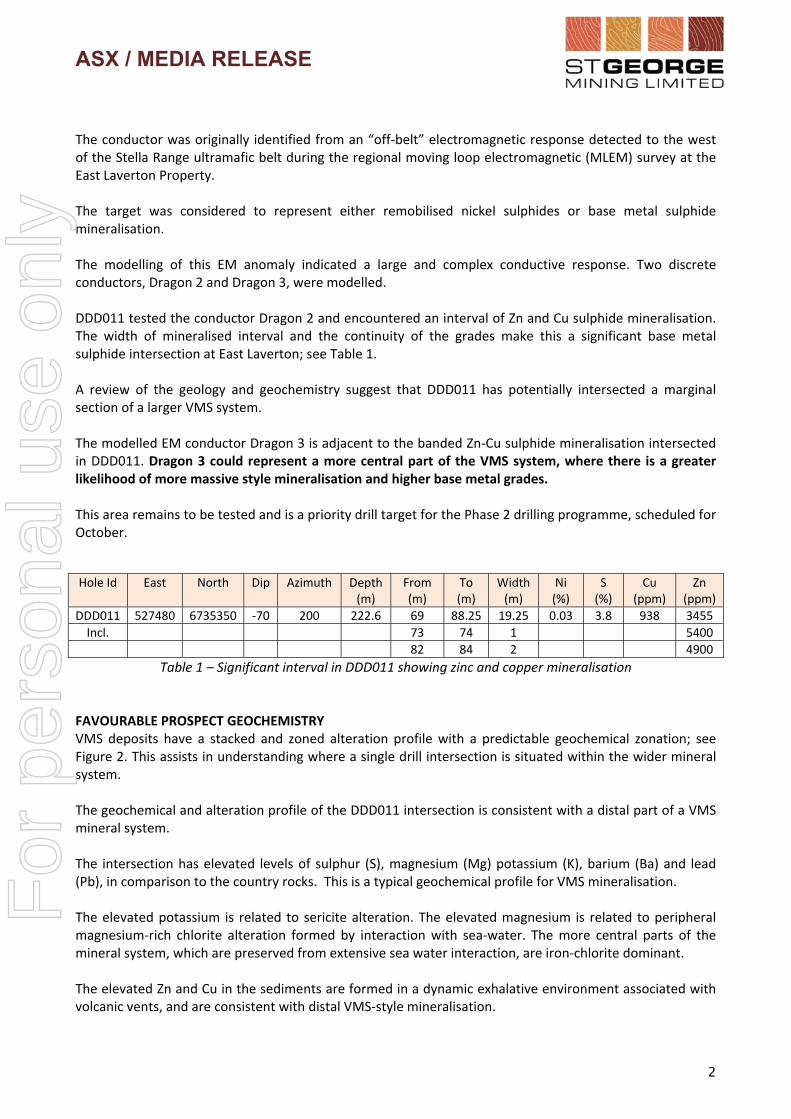
The conductor was originally identified from an “off‐belt” electromagnetic response detected to the west of the Stella Range ultramafic belt during the regional moving loop electromagnetic (MLEM) survey at the East Laverton Property. The target was considered to represent either remobilised nickel sulphides or base metal sulphide mineralisation. The modelling of this EM anomaly indicated a large and complex conductive response. Two discrete conductors, Dragon 2 and Dragon 3, were modelled. DDD011 tested the conductor Dragon 2 and encountered an interval of Zn and Cu sulphide mineralisation. The width of mineralised interval and the continuity of the grades make this a significant base metal sulphide intersection at East Laverton; see Table 1. A review of the geology and geochemistry suggest that DDD011 has potentially intersected a marginal section of a larger VMS system. The modelled EM conductor Dragon 3 is adjacent to the banded Zn‐Cu sulphide mineralisation intersected in DDD011. Dragon 3 could represent a more central part of the VMS system, where there is a greater likelihood of more massive style mineralisation and higher base metal grades. This area remains to be tested and is a priority drill target for the Phase 2 drilling programme, scheduled for October.
Hole Id East North Dip Azimuth Depth (m)
From (m)
To (m)
Width (m)
Ni (%)
S (%)
Cu (ppm)
Zn (ppm)
DDD011 527480 6735350 ‐70 200 222.6 69 88.25 19.25 0.03 3.8 938 3455
Incl. 73 74 1 5400
82 84 2 4900
Table 1 – Significant interval in DDD011 showing zinc and copper mineralisation FAVOURABLE PROSPECT GEOCHEMISTRY VMS deposits have a stacked and zoned alteration profile with a predictable geochemical zonation; see Figure 2. This assists in understanding where a single drill intersection is situated within the wider mineral system. The geochemical and alteration profile of the DDD011 intersection is consistent with a distal part of a VMS mineral system. The intersection has elevated levels of sulphur (S), magnesium (Mg) potassium (K), barium (Ba) and lead (Pb), in comparison to the country rocks. This is a typical geochemical profile for VMS mineralisation. The elevated potassium is related to sericite alteration. The elevated magnesium is related to peripheral magnesium‐rich chlorite alteration formed by interaction with sea‐water. The more central parts of the mineral system, which are preserved from extensive sea water interaction, are iron‐chlorite dominant. The elevated Zn and Cu in the sediments are formed in a dynamic exhalative environment associated with volcanic vents, and are consistent with distal VMS‐style mineralisation.
For
per
sona
l use
onl
y

ASX / MEDIA RELEASE
3
Figure 1 – Core (wet) from DDD011 that contains the Zn‐Cu mineralised zone. The metal‐rich sulphide bands are visible in the core.
Figure 2 ‐ Conceptual section through a VMS deposit showing typical mineralised zones. Drill hole DDD011 is
consistent with a marginal section of the VMS system.
For
per
sona
l use
onl
y

ASX / MEDIA RELEASE
4
REFERENCES “District to Camp Controls of the Genesis of Komatiite‐Hosted Nickel Sulfide Deposits” M. Fiorentini, S. Beresford, M. Barley, P. Duuring, A. Bekker, N. Rosengren, R Cas, and J Hronsky Economic Geology (2012) Vol. 107, No 5, pages 781 ‐ 796 For further information, please contact:
John Prineas Executive Chairman St George Mining Limited (+61) 411 421 253 [email protected]
Competent Person Statement: The information in this report that relates to Exploration Targets, Exploration Results, Mineral Resources or Ore Reserves is based on information compiled by Mr Timothy Hronsky, a Competent Person who is a Member of The Australasian Institute of Mining and Metallurgy. Mr Hronsky is employed by Essential Risk Solutions Ltd which has been retained by St George Mining Limited to provide technical advice on mineral projects. Mr Hronsky has sufficient experience that is relevant to the style of mineralisation and type of deposit under consideration and to the activity being undertaken to qualify as a Competent Person as defined in the 2012 Edition of the ‘Australasian Code for Reporting of Exploration Results, Mineral Resources and Ore Reserves’. Mr Hronsky consents to the inclusion in the report of the matters based on his information in the form and context in which it appears. The Company confirms that it is not aware of any new information or data that materially affects the information included in any original market announcements referred to in this report, and that all material assumptions and technical parameters underpinning the announcements continue to apply and have not materially changed. The Company confirms that the form and context in which the Competent Person’s findings are presented have not been materially modified from the original market announcements. The information in this announcement that relates to Exploration Results and Mineral Resources as defined in the 2004 edition of the ‘Australasian Code for Reporting of Exploration Results, Mineral Resources and Ore Reserves’ is based on information compiled by Mr Hronsky. Mr Hronsky is a member of the Australasian Institute of Mining and Metallurgy has sufficient experience, which is relevant to the style of mineralisation and type of deposit under consideration and to the activity, which he is undertaking. This qualifies Mr Hronsky as a “Competent Person” as defined in the 2004 edition of the ‘Australasian Code for Reporting of Exploration Results, Mineral Resources and Ore Reserves’. Mr Hronsky consents to the inclusion of information in this announcement in the form and context in which it appears.
Colin HayProfessional Public Relations (+61) 08 9388 0944 mob 0404 683 355 [email protected]
For
per
sona
l use
onl
y

1
The following section is provided for compliance with requirements for the reporting of exploration results under the JORC Code, 2012 Edition.
Section 1 Sampling Techniques and Data
(Criteria in this section apply to all succeeding sections)
Criteria JORC Code explanation Commentary
Sampling techniques
Nature and quality of sampling (eg cut channels, random chips, or specific specialised industry standard measurement tools appropriate to the minerals under investigation, such as down hole gamma sondes, or handheld XRF instruments, etc). These examples should not be taken as limiting the broad meaning of sampling.
This ASX Release dated 5 September 2014 reports on interim exploration results from the Company’s 2014 nickel sulphide drilling campaign, a targeted drilling programme to test electromagnetic (EM) conductors and other high quality targets for massive nickel sulphide mineralisation.
Drilling is being undertaken by DDH1 Drilling Pty Ltd using a Sandvik 1200 Multipurpose truck mounted drill rig. This rig has capability for diamond core, reverse circulation (RC) and mud rotary drilling.
The initial drilling programme is planned to include diamond core holes with RC pre‐collars and follow‐up RC holes. The holes are angled to grid east at a dip of ‐60 degrees to optimally intersect the modelled EM plates and potential zones of mineralisation.
The actual holes to be completed will be subject to ongoing management of the drilling programme based on ground conditions and exploration results.
Diamond Core Sampling: The core is removed from the drill rig and laid out for initial analysis in the field. The core is measured and marked up at 1m intervals against the drillers blocks, which are themselves checked against the drillers log books where required. The visible structural features on the core are measured against the core‐orientation lines.
Onsite XRF analysis is conducted using a hand‐held Olympus Innov‐X Spectrum Analyser. The XRF analysis is used to systematically review diamond drill core, with a single reading taken every metre, except in the case of core loss. These results are only used for onsite interpretation and preliminary base metal assessment subject to final geochemical analysis by laboratory assays.
The sections of the core that are selected for assaying are marked up and recorded on a “cut‐sheet” which provides a control on the intervals that will be cut and sampled at a duly certified assay laboratory, SGS Laboratories. Core is prepared for analysis at 1m intervals or at lesser intervals of geological significance. Core is cut in half lengthways and then numbered samples are taken as per the “cut‐sheet”.
Diamond core provides high quality samples that are logged for lithological, structural, geotechnical, density and other attributes. Sampling is carried out under QAQC procedures as per industry best practice.
RC Sampling: All samples from the RC drilling are taken as 1m samples. Samples are sent to SGS Laboratories for assaying.
Appropriate QAQC samples (standards, blanks and duplicates) were inserted into the sequences as per industry best practice.
In this programme the multi‐purpose diamond and RC drill rig did not have an industry standard splitter attached to facilitate collection of samples. RC samples were taken manually in the most representative way. Should any sample return any values that are anomalous, then a portable riffle splitter will be utilised to select another representative sample for assaying from the bulk sample of RC chips retained by the Company.
Onsite XRF analysis is conducted on the fines from RC chips using a hand‐held Olympus Innov‐X Spectrum Analyser. These results are
For
per
sona
l use
onl
y

2
Criteria JORC Code explanation Commentary
only used for onsite interpretation and preliminary base metal assessment subject to final geochemical analysis by laboratory assays.
Down‐hole electromagnetic (DHEM) survey: A DHEM survey has been completed for certain diamond holes. The DHEM survey is designed and managed by Newexco Services Pty Ltd, with field work contracted to Bushgum Holdings Pty Ltd.
Key specifications of the DHEM survey are:
System: Atlantis (analogue)
Components: A, U, V
Component direction:
Ba – Parallel to hole axis, positive up hole.
Bu – Perpendicular to hole axis: toward 12 o’ clock when
looking down hole.
Bv – Perpendicular to hole axis: toward 9 o’ clock when
looking down hole.
Include reference to measures taken to ensure sample representivity and the appropriate calibration of any measurement tools or systems used.
Diamond Core Sampling: For diamond core samples, certified sample standards were added as every 25th sample. Core recovery calculations are made through a reconciliation of the actual core and the driller’s records. Downhole surveys of dip and azimuth were conducted using a single shot camera every 30m to detect deviations of the hole from the planned dip and azimuth. The drill‐hole collar locations were recorded using a hand held GPS, which has an accuracy of +/‐ 5m. At a later date the drill‐hole collar will be surveyed to a greater degree of accuracy.
RC Sampling: For RC drill samples, geological logging of RC chips is completed at site with representative chips being stored in drill chip trays. Downhole surveys of dip and azimuth follow the same protocol as for diamond core holes.
DHEM Survey: For the DHEM survey, the polarity of each component is checked to ensure the system was set up using the correct component orientations. The hole position is corrected for trajectory using orientation survey data.
Aspects of the determination of mineralisation that are Material to the Public Report.
In cases where ‘industry standard’ work has been done this would be relatively simple (eg ‘reverse circulation drilling was used to obtain 1 m samples from which 3 kg was pulverised to produce a 30 g charge for fire assay’). In other cases more explanation may be required, such as where there is coarse gold that has inherent sampling problems. Unusual commodities or mineralisation types (eg submarine nodules) may warrant disclosure of detailed information.
Diamond Core Sampling: Core is drilled with HQ and NQ2 size and sampled as half core to produce a bulk sample for analysis. Intervals vary from 0.3 – 1m maximum and are selected with an emphasis on geological control.
Assays are completed at SGS Laboratories in Perth. Samples are sent to SGS where they are crushed to 6 mm and then pulverised to 75 microns. A 30 g charge of the sample is fire assayed for gold, platinum and palladium. The detection range for gold is 1 – 2000 ppbAu, and 0.5 – 2000 ppb for platinum and palladium. This is believed to be an appropriate detection level for these elements within this specific mineral environment. However, should Au, Pt or Pd levels reported exceed these levels an additional assay method will be used to re‐test samples.
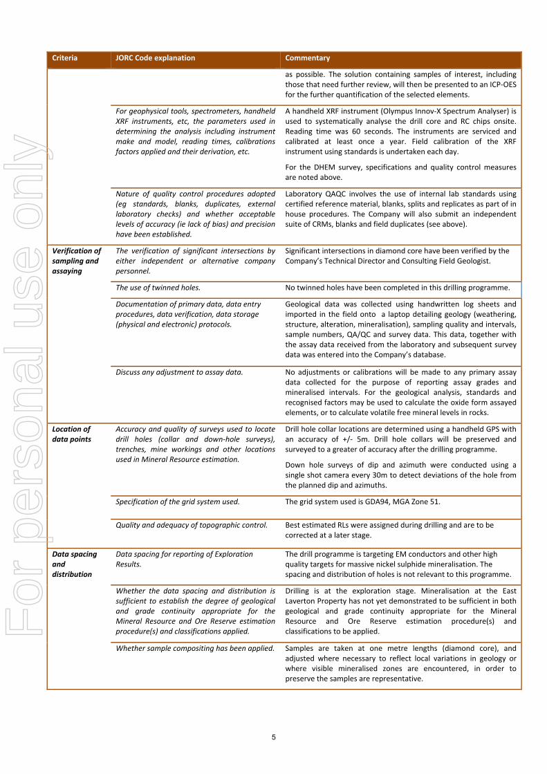
All other metals will be analysed using an acid digest and an ICP finish. The sample is digested with nitric, hydrochloric, hydrofluoric and perchloric acids to effect as near to total solubility of the sample as possible. The solution containing samples of interest, including those that need further review, will then be presented to an ICP‐OES for the further quantification of the selected elements.
RC Sampling: A 1m composite sample is taken from the bulk sample of RC chips that may weigh in excess of 40 kg. Assay preparation by SGS follows the same protocol as for diamond core sampling.
For
per
sona
l use
onl
y

3
Criteria JORC Code explanation Commentary
Drilling techniques
Drill type (eg core, reverse circulation, open‐hole hammer, rotary air blast, auger, Bangka, sonic, etc) and details (eg core diameter, triple or standard tube, depth of diamond tails, face‐sampling bit or other type, whether core is oriented and if so, by what method, etc).
Diamond Core Sampling: The collars of the diamond holes were drilled using RC drilling down through the regolith to the point of refusal or to a level considered geologically significant to change to core. The hole was then continued using HQ diamond core until the drillers determined that a change to NQ2 coring was required.
The core is oriented and marked by the drillers. The core is oriented using ACT Mk II electric core orientation.
RC Sampling: The RC drilling uses a 140 mm diameter face hammer tool. High capacity air compressors on the drill rig are used to ensure a continuously sealed and high pressure system during drilling to maximise the recovery of the drill cuttings, and to ensure chips remain dry to the maximum extent possible.
Drill sample recovery
Method of recording and assessing core and chip sample recoveries and results assessed.
Diamond Core Sampling: Diamond core recoveries/core loss are recorded during drilling and reconciled during the core processing and geological logging. No significant sample recovery problems are thought to have occurred in any holes drilled to date. There has been a notable and consistent competency encountered in the rocks during drilling.
RC Sampling: RC samples are visually checked for recovery, moisture and contamination. Geological logging is completed at site with representative RC chips stored in chip trays.
Diamond Core Sampling: Depths are checked against the depth on the core blocks and rod counts are routinely carried out by the drillers. Core loss was recorded by St George geologists and sampling intervals were not carried through core loss.
RC Sampling: Samples are normally collected using a cone and riffle splitter. However, in this programme, the multi‐purpose diamond and RC drill rig did not have an industry standard splitter attached. RC samples were taken manually in the most representative way. If any sample returns any values that are anomalous, then a portable riffle splitter will be utilised to select another representative sample for assaying from the bulk sample of RC chips retained by the Company.
Measures taken to maximise sample recovery and ensure representative nature of the samples.
Whether a relationship exists between sample recovery and grade and whether sample bias may have occurred due to preferential loss/gain of fine/coarse material.
To date, no detailed analysis to determine the relationship between sample recovery and grade has been undertaken for this drill programme. This analysis will be conducted following any economic discovery.
The use of diamond drilling capturing whole rock cores reduces errors associated with varying size fraction loss of the sample. Very competent rocks have been recovered to date.
The nature of magmatic sulphide distribution hosted by the competent and consistent rocks hosting any mineralised intervals are considered to significantly reduce any possible issue of sample bias due to material loss or gain.
Logging Whether core and chip samples have been geologically and geotechnically logged to a level of detail to support appropriate Mineral Resource estimation, mining studies and metallurgical studies.
Geological logging is carried out on all diamond core and RC drill holes with lithology, alteration, mineralisation, structure and veining recorded.
Whether logging is qualitative or quantitative in nature. Core (or costean, channel, etc) photography.
Logging of diamond core and RC samples recorded lithology, mineralogy, mineralisation, structures (core only), weathering, colour and other noticeable features. Core was photographed in both dry and wet form.
For
per
sona
l use
onl
y

4
Criteria JORC Code explanation Commentary
The total length and percentage of the relevant intersections logged.
All drill holes were geologically logged in full and detailed litho‐geochemical information was collected by the field XRF unit. The data relating to the elements analysed is used to determine further information regarding the detailed rock composition.
Sub‐sampling techniques and sample preparation
If core, whether cut or sawn and whether quarter, half or all core taken.
The HQ and NQ2 core is cut in half length ways in Kalgoorlie using an automatic core saw. All samples are collected from the same side of the core. The half‐core samples are submitted to SGS for analysis.
If non‐core, whether riffled, tube sampled, rotary split, etc and whether sampled wet or dry.
RC samples were taken manually in the most representative way as the multi‐purpose drill rig did not have a riffle splitter to facilitate collection of samples. If any sample returns any values that are deemed anomalous, then a portable riffle splitter will be utilised to select another representative sample for assaying from the bulk sample of RC chips retained by the Company. RC samples are collected in dry form.
For all sample types, the nature, quality and appropriateness of the sample preparation technique.
Diamond Core Sampling: Diamond core was drilled with HQ and NQ2 size and sampled as complete half core to produce a bulk sample for analysis. Intervals selected varied from 0.3 – 1m (maximum) with a strong geological control (as is possible in diamond core) to ensure grades are representative, i.e. remove any bias through projecting assay grades beyond appropriate geological boundaries.
Assay preparation procedures ensure the entire sample is pulverised to 75 microns before the sub‐sample is taken. This removes the potential for the significant sub‐sampling bias that can be introduced at this stage.
RC Sampling: Sample preparation for RC chips is the same as for diamond core.
Quality control procedures adopted for all sub‐sampling stages to maximise representivity of samples.
Diamond Core Sampling: Drill core is cut in half lengthways and the total half‐core submitted as the sample. This meets industry standards where 50% of the total sample taken from the diamond core is submitted.
RC Sampling: Field QC procedures maximise representivity of RC samples and involve the use of certified reference material as assay standards, along with blanks, duplicates and barren washes.
Measures taken to ensure that the sampling is representative of the in situ material collected, including for instance results for field duplicate/second‐half sampling.
Diamond Core Sampling: The retention of the remaining half‐core is an important control as it allows assay values to be determined against the actual geology; and where required a quarter core sample may be submitted for assurance. No resampling of quarter core or duplicates has been done at this stage of the project.
RC Sampling: Field duplicates were taken on 1m composites for RC samples.
Whether sample sizes are appropriate to the grain size of the material being sampled.
The sample sizes are considered to be appropriate to correctly represent the sulphide mineralisation at the East Laverton Property based on: the style of mineralisation (massive and disseminated sulphides), the thickness and consistency of the intersections and the sampling methodology.
Quality of assay data and laboratory tests
The nature, quality and appropriateness of the assaying and laboratory procedures used and whether the technique is considered partial or total.
For both diamond core and RC sampling, a 30 gram sample will be fire assayed for gold, platinum and palladium. The detection range for gold is 1 – 2000 ppbAu, and 0.5 – 2000 ppb for platinum and palladium. This is believed to be an appropriate detection level for the levels of these elements within this specific mineral environment. However, should Au, Pt or Pd levels reported exceed these levels; an alternative assay method will be selected.
All other metals will be analysed using an acid digest and an ICP finish. The sample is digested with nitric, hydrochloric, hydrofluoric and perchloric acids to effect as near to total solubility of the sample
For
per
sona
l use
onl
y
5
Criteria JORC Code explanation Commentary
as possible. The solution containing samples of interest, including those that need further review, will then be presented to an ICP‐OES for the further quantification of the selected elements.
For geophysical tools, spectrometers, handheld XRF instruments, etc, the parameters used in determining the analysis including instrument make and model, reading times, calibrations factors applied and their derivation, etc.
A handheld XRF instrument (Olympus Innov‐X Spectrum Analyser) is used to systematically analyse the drill core and RC chips onsite. Reading time was 60 seconds. The instruments are serviced and calibrated at least once a year. Field calibration of the XRF instrument using standards is undertaken each day.
For the DHEM survey, specifications and quality control measures are noted above.
Nature of quality control procedures adopted (eg standards, blanks, duplicates, external laboratory checks) and whether acceptable levels of accuracy (ie lack of bias) and precision have been established.
Laboratory QAQC involves the use of internal lab standards using certified reference material, blanks, splits and replicates as part of in house procedures. The Company will also submit an independent suite of CRMs, blanks and field duplicates (see above).
Verification of sampling and assaying
The verification of significant intersections by either independent or alternative company personnel.
Significant intersections in diamond core have been verified by the Company’s Technical Director and Consulting Field Geologist.
The use of twinned holes. No twinned holes have been completed in this drilling programme.
Documentation of primary data, data entry procedures, data verification, data storage (physical and electronic) protocols.
Geological data was collected using handwritten log sheets and imported in the field onto a laptop detailing geology (weathering, structure, alteration, mineralisation), sampling quality and intervals, sample numbers, QA/QC and survey data. This data, together with the assay data received from the laboratory and subsequent survey data was entered into the Company’s database.
Discuss any adjustment to assay data. No adjustments or calibrations will be made to any primary assay data collected for the purpose of reporting assay grades and mineralised intervals. For the geological analysis, standards and recognised factors may be used to calculate the oxide form assayed elements, or to calculate volatile free mineral levels in rocks.
Location of data points
Accuracy and quality of surveys used to locate drill holes (collar and down‐hole surveys), trenches, mine workings and other locations used in Mineral Resource estimation.
Drill hole collar locations are determined using a handheld GPS with an accuracy of +/‐ 5m. Drill hole collars will be preserved and surveyed to a greater of accuracy after the drilling programme.
Down hole surveys of dip and azimuth were conducted using a single shot camera every 30m to detect deviations of the hole from the planned dip and azimuths.
Specification of the grid system used. The grid system used is GDA94, MGA Zone 51.
Quality and adequacy of topographic control. Best estimated RLs were assigned during drilling and are to be corrected at a later stage.
Data spacing and distribution
Data spacing for reporting of Exploration Results.
The drill programme is targeting EM conductors and other high quality targets for massive nickel sulphide mineralisation. The spacing and distribution of holes is not relevant to this programme.
Whether the data spacing and distribution is sufficient to establish the degree of geological and grade continuity appropriate for the Mineral Resource and Ore Reserve estimation procedure(s) and classifications applied.
Drilling is at the exploration stage. Mineralisation at the East Laverton Property has not yet demonstrated to be sufficient in both geological and grade continuity appropriate for the Mineral Resource and Ore Reserve estimation procedure(s) and classifications to be applied.
Whether sample compositing has been applied. Samples are taken at one metre lengths (diamond core), and adjusted where necessary to reflect local variations in geology or where visible mineralised zones are encountered, in order to preserve the samples are representative.
For
per
sona
l use
onl
y

6
Criteria JORC Code explanation Commentary
Orientation of data in relation to geological structure
Whether the orientation of sampling achieves unbiased sampling of possible structures and the extent to which this is known, considering the deposit type.
The diamond core holes are drilled towards 060 at an angle of ‐60 degrees to intersect the modelled mineralised zones at a near perpendicular orientation. However, the orientation of key structures may be locally variable and any relationship to mineralisation at has yet to be identified.
If the relationship between the drilling orientation and the orientation of key mineralised structures is considered to have introduced a sampling bias, this should be assessed and reported if material.
No orientation based sampling bias has been identified in the data to date.
Sample security
The measures taken to ensure sample security. Chain of Custody is managed by the Company until samples pass to a duly certified assay laboratory for subsampling and assaying. The cut‐core trays and RC sample bags are stored on secure sites and delivered to the assay laboratory by the Company or a competent agent. When in transit, they are kept in locked premises. Transport logs have been set up to track the progress of samples. The chain of custody passes upon delivery of the samples to the assay laboratory. For diamond core, a predetermined “cut sheet” serves as a tracking tool and provides a further control for any subsequent checks.
Audits or reviews
The results of any audits or reviews of sampling techniques and data.
Sampling techniques and procedures are regularly reviewed internally, as is data. To date, no external audits have been completed on the drilling programme.
Section 2 Reporting of Exploration Results (Criteria listed in section 1 will also apply to this section where relevant)
Criteria JORC Code explanation Commentary
Mineral Tenement and Land Status
Type, name/reference number, location and ownership including agreements or material issues with third parties including joint ventures, partnerships, overriding royalties, native title interests, historical sites, wilderness or national park and environmental settings.
The security of the tenure held at the time of reporting along with any known impediments to obtaining a licence to operate in the area.
Phase 1 of the 2014 nickel sulphide drilling programme included prospects located within Exploration Licences E39/1467, E39/1229, E39/1667, E39/1520, E39/985, E39/981, E39/982 and E39/1064.
Each tenement is 100% owned by Desert Fox Resources Pty Ltd, a wholly owned subsidiary of St George Mining. Certain tenements are subject to a 2% Net Smelter Royalty in favour of a third party.
None of the tenements are the subject of a native title claim. No environmentally sensitive sites have been identified at any of the tenements.
The tenements are in good standing and no known impediments exist.
Exploration Done by Other Parties
Acknowledgment and appraisal of exploration by other parties.
In 2012, BHP Billiton Nickel West Pty Ltd (Nickel West) completed a reconnaissance RC (reverse circulation) drilling programme at the East Laverton Property as part of the Project Dragon farm‐in arrangement between Nickel West and the Company. That farm‐in arrangement has been terminated. The drilling programme comprised 35 RC holes for 8,560m drilled. The results from the Nickel West drilling programme were reported by the Company in its ASX Release dated 25 October 2012 “Drill Results at Project Dragon”. Drilling intersected primary nickel sulphide mineralisation and established the presence of fertile, high MgO ultramafic sequences at the East Laverton Property. Prior to the Project Dragon drilling programme, there was no systematic exploration for nickel sulphides at the East Laverton Property. Historical exploration in the region was dominated by shallow RAB and aircore drilling, much of which had been incompletely sampled, assayed, and logged. This early work was focused on gold rather than nickel sulphide exploration.
For
per
sona
l use
onl
y

7
Criteria JORC Code explanation Commentary
Geology Deposit type, geological setting and style of mineralisation
The Company’s East Laverton Property located in the NE corner of the Eastern Goldfields Province of the Archean Yilgarn Craton. The project area is proximally located to the Burtville‐Yarmana terrane boundary and the paleo‐cratonic marginal setting is consistent with the extensive komatiites and carbonatite magmatism found on the property. The area is largely covered by Permian glaciogene sediments (Patterson Formation), which area is subsequently overlain by a thinner veneer of more recent sediments and aeolian sands. As a result the geological knowledge of the belt has previously been largely inferred from gravity and magnetic data and locally verified by drill‐hole information and multi‐element soil geochemical surveys. The drilling at the East Laverton Property has confirmed extensive strike lengths of high‐MgO olivine‐rich rocks across three major ultramafic belts. Ultramafic rocks of this composition are known to host high grade nickel sulphides.
Drill hole information
A summary of all information material to the
understanding of the exploration results
including tabulation of the following
information for all Material drill holes:
• Easting and northing of the drill hole collar
•Elevation or RL (Reduced Level – elevation
above sea level in meters) of the drill hole collar
• Dip and azimuth of the hole
• Down hole length and interception depth
• Hole length
Refer to tabulations in the body of this announcement. Information regarding exploration results from Project Dragon can be found in the Company’s ASX Release dated 25 October 2012 “Drill Results at Project Dragon” which is available to view on www.stgm.com.au. Table 1 to this 2012 JORC Section contains drill hole information on DRAC35, DRAC38 and DDNRC002 which were the first drill holes at the East Laverton Property to identify nickel sulphides.
Data aggregation methods
In reporting Exploration Results, weighting averaging techniques, maximum and/or minimum grade truncations (e.g. cutting of high grades) and cut‐off grades are usually Material and should be stated.
No top‐cuts have been applied. A nominal 0.15% Ni lower cut‐off is applied unless otherwise indicated.
Where aggregated intercepts incorporate short lengths of high grade results and longer lengths of low grade results, the procedure used for such aggregation should be stated and some typical examples of such aggregations should be shown in detail.
High grade massive sulphide intervals internal to broader zones of sulphide mineralisation are reported as included intervals.
The assumptions used for any reporting of metal equivalent values should be clearly stated.
No metal equivalent values are used for reporting exploration results.
Relationship between mineralisation widths and intercept lengths
These relationships are particularly important in the reporting of exploration results.If the geometry of the mineralisation with respect to the drill hole angle is known, its nature should be reported. If it is not known and only the down hole lengths are reported, there should be a clear statement to this effect (e.g. ‘down hole length, true width not known’).
The geometry of the mineralisation is not yet known due to insufficient deep drilling in the targeted area.
Diagrams Appropriate maps and sections (with scales) and tabulations of intercepts should be included for any significant discovery being reported. These should include, but not be limited to a plane view of drill hole collar locations and appropriate sectional views.
Maps will be included with any announcement of any significant discovery, following review of assay results from the drilling programme.
For
per
sona
l use
onl
y

8
Criteria JORC Code explanation Commentary
Balanced Reporting
Where comprehensive reporting of all Exploration Results is not practical, representative reporting of both low and high grades and/or widths should be practiced to avoid misleading reporting of Exploration Results.
A comprehensive report on the drill holes is provided based on laboratory assays received. A balanced report on the exploration results is contained in the body of the ASX Release.
References to anomalous levels of any element identified by XRF analysis means that the element is present at a level that exceeds the level to be normally expected for that element in that geological setting.
The determinations made using a mobile XRF unit are geochemical in nature. This mode of sampling seeks to define anomalous sample populations against background, rather than absolute sample values as in laboratory assays.
A more definitive report on any anomalous levels of any element is provided once laboratory assays for the drill holes are received.
Other substantive exploration data
Other exploration data, if meaningful and material, should be reported including (but not limited to): geological observation; geophysical survey results; geochemical survey results; bulk samples – size and method of treatment; metallurgical test results; bulk density, groundwater, geotechnical and rock characteristics; potential deleterious or contaminating substances.
All meaningful and material information has been included in the body of the text. No metallurgical or mineralogical assessments have been completed.
Further Work The nature and scale of planned further work (e.g. tests for lateral extensions or depth extensions or large – scale step – out drilling).
Diagrams clearly highlighting the areas of possible extensions, including the main geological interpretations and future drilling areas, provided this information is not commercially sensitive.
A discussion of further exploration work is contained in the body of the ASX Release.
HOLE ID NORTHING (m)
EASTING (m)
DIP (deg)
AZM (deg)
DEPTH (m)
FROM (m)
TO (m)
WIDTH (m)
Ni (%)
Cu (ppm)
Pt+Pd (ppb)
DRAC35 6739401 527150 ‐60 250 244 100 118 18 0.40 342 197
100 104 4 0.57 366 294
112 114 2 0.51 584 281
DRAC38 6733696 530786 ‐60 250 298 108 138 30 0.31 10 31
132 138 6 0.48 40 48
132 134 2 0.62 92 53
DDNRC002 6742718 523717 ‐60 59 246 53 60 7 0.54
53 55 2 1.08
Table 1 to 2012 JORC Section – Significant intersections in DRAC35, DRAC38 and DDNRC002.
These historical holes are the first identification of nickel sulphides at the East Laverton Property. For further details on DRAC35 and DRAC38, see the ASX Release dated 25 October 2012 “Drill Results at Project Dragon”. For further details on DDNRC002, see the ASX Release dated 11 April 2013 “St George Provides Exploration Update”. These ASX Releases
are available to view on the Company’s website at www.stgm.om.au
For
per
sona
l use
onl
y